Summary - River Cam · Cam: Madgate Slade, Saffron Walden and Audley End overspill loop ditch...
16
1 SURVEY OF HIMALAYAN BALSAM IN THE CAM CATCHMENT 2019 Summary At a Cam Valley Forum (CVF) meeting in September 2018 with the local Environment Agency coordinator, it was decided that a catchment-wide survey of Himalayan Balsam was needed in order to update the records database and to record abundance, so that any options taken up to remove Balsam in 2020 and beyond would be based on sound information. The CVF survey’s primary objective was to locate the uppermost incidence of Balsam in the Cam, Granta, Rhee and their tributaries. It is believed this was successfully achieved, with the caveat that observer records from other, significant locations may yet be received although this is unlikely. On the Cam, huge stands of Balsam were located at Sparrow Hill (TL521364) north of Newport, and on the Madgate Slade and in adjacent overspill ditches at Saffron Walden (TL531383). On the Granta, huge numbers in the SSSI site ‘Alder Carr’ were confirmed at Hildersham, and a few small patches were located on the river just upriver of this site. Most of the Bourn Brook is under the aegis of the Wildlife Trust BCN, CCV (Cambridge Conservation Volunteers and the CRT (Countryside Restoration Trust) and the distribution is fully known. CVF survey and mapping on the Bourn Brook stopped at the point upstream where their operations cease, and between there and the Cam (Byron’s Pool) there were extensive stands. Balsam on the Bin Brook could not be found above the Coton Nature Reserve at TL414582. Within the reserve plants were abundant. Balsam appears to be absent from the Rhee. Balsam was located at many more sites than are currently recorded in the CPERC and NBN databases, and in which abundance was noted for only 27% records (excluding Bourn Brook) submitted to CPERC and for none to NBN from Essex. Significant records from the survey will be added to the databases. Further surveying in 2020 is required to ensure that a significant stand of Balsam has not been overlooked. Those with professional expertise in Balsam removal state that the uppermost plants in a watercourse must first and foremost be removed before any major attempts are made to reduce incidence further downstream. With good survey data now at hand, the options to target any or all significant Balsam locations with resources can be discussed. A status map is available on the Cam Valley Forum website here https://camvalleyforum.uk/balsam-status/
Transcript of Summary - River Cam · Cam: Madgate Slade, Saffron Walden and Audley End overspill loop ditch...

1
SURVEY OF HIMALAYAN BALSAM IN THE
CAM CATCHMENT 2019
Summary
At a Cam Valley Forum (CVF) meeting in September 2018 with the local Environment Agency
coordinator, it was decided that a catchment-wide survey of Himalayan Balsam was needed in order
to update the records database and to record abundance, so that any options taken up to remove
Balsam in 2020 and beyond would be based on sound information. The CVF survey’s primary
objective was to locate the uppermost incidence of Balsam in the Cam, Granta, Rhee and their
tributaries. It is believed this was successfully achieved, with the caveat that observer records from
other, significant locations may yet be received although this is unlikely.
On the Cam, huge stands of Balsam were located at Sparrow Hill (TL521364) north of Newport, and
on the Madgate Slade and in adjacent overspill ditches at Saffron Walden (TL531383). On the
Granta, huge numbers in the SSSI site ‘Alder Carr’ were confirmed at Hildersham, and a few small
patches were located on the river just upriver of this site. Most of the Bourn Brook is under the aegis
of the Wildlife Trust BCN, CCV (Cambridge Conservation Volunteers and the CRT (Countryside
Restoration Trust) and the distribution is fully known. CVF survey and mapping on the Bourn Brook
stopped at the point upstream where their operations cease, and between there and the Cam (Byron’s
Pool) there were extensive stands. Balsam on the Bin Brook could not be found above the Coton
Nature Reserve at TL414582. Within the reserve plants were abundant. Balsam appears to be absent
from the Rhee.
Balsam was located at many more sites than are currently recorded in the CPERC and NBN databases,
and in which abundance was noted for only 27% records (excluding Bourn Brook) submitted to
CPERC and for none to NBN from Essex. Significant records from the survey will be added to the
databases.
Further surveying in 2020 is required to ensure that a significant stand of Balsam has not been
overlooked.
Those with professional expertise in Balsam removal state that the uppermost plants in a watercourse
must first and foremost be removed before any major attempts are made to reduce incidence further
downstream. With good survey data now at hand, the options to target any or all significant Balsam
locations with resources can be discussed.
A status map is available on the Cam Valley Forum website here
https://camvalleyforum.uk/balsam-status/

2
Background
Himalayan Balsam is an extremely invasive non-native annual plant. It grows well in moist and
semi-shaded damp places, predominantly on the soft banksides of slow-moving watercourses.
Where it becomes dominant it can cause environmental problems:
• reduces biodiversity
• can choke waterways leading to flooding
• competes with native flowers for pollinating insects–especially bees.
• killed by frosts, it leaves ground bare and vulnerable to erosion leading to bank loss and unwanted sediment in the water.
A workshop on invasive plants was organised by Sam Sweeney of the Environment Agency on 5th
September 2018 so that CVF could put its views forward on management of alien invasive plants in
the Cam catchment, with Guy Belcher, Dan Weaver, Anne Miller, John Terry, and Mike Foley
attending. CVF, already involved in management of Floating Pennywort (Hydrocotyle
ranunculoides), suggested that Himalayan Balsam (Impatiens glandulifera) would be a good
candidate for action in parts of the catchment where the Wildlife Trust BCN, the Wildlife Trust
Essex and others were not currently involved. It was agreed that Balsam would be surveyed in
2019. Based on the findings, CVF would liaise with catchment partnerships and other organisations,
and local volunteer groups, with the intention of stimulating removal at targeted sites, within the
constraints of funding and volunteer worker resources.
The incidence, and especially the abundance, of Balsam are poorly documented except for Ruth
Hawksley of the Wildlife Trust’s BCN (WTBCN) ongoing project on the Bourn Brook. Both
WTBCN and WT Essex (Darren Tansley) state that Balsam needs first and foremost to be removed
from the uppermost incidence in a watercourse, because long-distance dispersal occurs by seed
carried down the watercourse. It is important therefore that any survey should locate the uppermost
plants.

3
Method
The survey was done mostly by Mike Foley (CVF) with inputs from Ruth Hawksley, Rob Mungovan
(Wild Trout Trust), and Charles Burret (English Heritage). The start date was 19th June, most of the
survey was in August / mid-September and a few sites were visited in October. Below is a map of
the major rivers and tributaries in the Cam Catchment
Cam Catchment – main watercourses

4
Of the above, the following rivers and tributaries were surveyed, Clayhithe (TL501644, near
Waterbeach) being the furthest point on the Cam downriver.
Cam from Clayhithe up to Widdington (head), Wicken Water, Debden Water, Wendon Brook,
Madgate Slade, King’s Ditch (Saffron Walden), Fulfen Slade, unnamed watercourse through
Wendens Ambo to Building end (TL435375), unnamed watercourse (Ickleton), Bin Brook, Bourn
Brook (lower end to Byron’s Pool), Coldham’s Brook.
Granta, confluence with Cam at Stapleford up to Castle Camps and also the watercourse Bartlow to
Streetly End (also named ‘Granta’ on some maps), River Bourn (various).
Rhee, Hauxton Junction (confluence with the Cam) up to Ashwell Springs (infrequent point
surveying with telescope upriver from Haslingfield), Mel, Shep, Hoffer Brook. More extensive
coverage of the Rhee and its tributaries is undertaken by Rob Mungovan during his Wild Trout Trust
and conservation activities.
Away from public footpaths, bridges and other public areas, permission was first sought from
riparian landowners before walking along watercourses, a necessary course of action as some
stretches on which Balsam was found were on private land and not observable from public areas. Up
to c.2km stretches were walked before returning to the car to resume surveying further along. Along
some sections of the Cam, Debden Water and Wicken Water plants were looked for by walking on
their dry beds.
The use of binoculars and telescope was necessary to confirm the identity of some more inaccessible
plants; however confirmation of Balsam or the main confusion species Great Willowherb
(Epilobium hirsutum) sometimes relied on closer observations.
The abundance of Balsam was assessed by the number of plants / size of stands / dominance
(approaching a monoculture) along a stretch of watercourse. A reduced form of the “ACFOR” scale
was used.
Abundant ……………………………………..A few stands > 5m long or many stands per 100m Common……………………………………… Several patches each of 20+ plants per 100m Occasional…………………………………….One or two small stands of c. 6-20 plants per 100m

5
Results
An interactive Google Map of the Cam Catchment survey can be viewed via this link.
https://camvalleyforum.uk/balsam-status/
The abundance is colour coded. Balsam is distributed and patches are maintained by self-seeding
along many kms of the Cam and Granta. This was generally known already from database records.
The uppermost incidences of Balsam in the various watercourses are shown below.
Cam: Sparrows End, north of Newport, Cam loop
Cam: Madgate Slade, Saffron Walden and Audley End overspill loop ditch
Audley End overspill loop ditch, 24th June 2019

6
Audley End overspill loop ditch, more open section. Note lady of normal height in distance

7
Granta: Hildersham – Alder Carr SSSI and a short section of river above the road bridge
Bin Brook: Coton CPPF Nature Reserve
Purple – abundant distribution; orange – common; grey - occasional

8
Discussion
The survey records have yet to be submitted to CPERC and NBN. The CPERC and NBN records in
the following maps were obtained in November 2018 and February 2019 resp. In a recent extraction
from the NBN database, no additional records have been noted for the Cam section in Essex.
CPERC records in Cambs were more extensive than those at NBN.
Some records appear to be well away from watercourses. The reason for a record not being located
precisely on a watercourse is that many locations have been recorded at the tetrad level or higher. It
is important when viewing the interactive maps to check the precision of each record, as it varies
from 10m to 10km. Some records were submitted at a monad level so that a section of the river
could be commented on rather than just a single point.
The incidence and abundance of Balsam in the Cam Catchment can be put into context by mapping
all NBN records from the 100km square TL (many records from Beds were excluded to simplify
formatting the map).
NBN records at February 2019 within the 100km square TL (excluding many Beds records)

9
CPERC records at 2018_11_30 for Cambridgeshire
https://drive.google.com/open?id=1hy66CzXoA4MHL3jSbLgFzqiOzYAWRFeE&usp=sharing
Within Cambridgeshire including the unitary authority of Peterborough, 1061 records had been
submitted to CPERC by 2018, including 722 from the Bourn Brook many of which were Ruth
Hawksley’s GPS point-site surveys. Very few were located on the Cam north of Cambridge.
Some CPERC records are pre-2000 and many are around 9 nine years old.

10
Map of records in NBN database at 2019_02_18, in hectad TL43, 53, and part-54
https://drive.google.com/open?id=1PHVZrQGt0G_Y8ylZkPPNVczh9mDWMt-_&usp=sharing
These NBN records are mostly from 2006 to 2011, with none after 2013 and none show abundance.
Following up on the two records encircled on the map, the areas were searched but no Balsam was
found.

11
Practical fieldwork to remove Balsam – 2020 and beyond
• The growth stages of the Balsam plant dictate when bashing can take place without causing
more harm than good.
Late February and March: many Balsam seedlings emerge, some late germinators
May–June: rapid shoot extension
Late June - late September: flowering period
August: start of seed pods ripening; explosive release of seeds mainly to September / mid-
October, usually most have been released by the first frost.
The period of bashing is mostly early June to early August. Plants can be successfully pulled
when small but at least two visits must be made in a season.
• It is necessary to focus first on the uppermost incidence only, and work down. After two or
three years there should be a real reduction – and a psychological boost to volunteers which
enthuses them to do repeated years, not to be underestimated.
• Eight years of bashing at Bourn Brook have been needed to reach a stage where it is close to
eradication in long stretches of the upper and middle part.
• It may be necessary to manage large patches downriver in specific areas if they have local
ecological importance and there are good volunteer resources; however, expect to find
resurgence due to recolonisation from seed sources further upstream.
• Glyphosate applications may be useful in some situations.
• Employment of professional contractors to remove dense stands using brush cutters should be
considered.
• There is no point in bashing at a site for a single season. At least three years’ effort and,
more likely 8+ years, will be needed to achieve acceptable results to make the project over a
reasonable stretch of watercourse time- and cost- effective.
• Even if successful, removing the uppermost Balsam must be part of a planned approach to the
entire river.
• Some casual bashing once or twice in a season without properly removal the plants can
actually increase the problem for the next year, as does bashing too late in the season when
too many seed pods are formed (seed can continue to ripen on plants severed from the roots
and left on the bank).
• In 2020 WTBCN will continue to focus on Balsam control on the Bourn Brook, and with
CCV, will extend it further towards the Cam, where CVF will join in and continue the
removal to Byron’s Pool.
Mike Foley 19th January 2020 [email protected] docref 19033

12
Relevant publications
Review of the Work on the Non-Native Invasive Species Himalayan Balsam (Impatiens
glandulifera) along the River Flit during 2011
https://www.bedscape.org.uk/BRMC/newsite/docs/bedslife/species%20docs/balsam%20repo
rt%202011%20abridged%20version.pdf
Himalayan Balsam and Other Non-Native Invasive Species on the River Flit [2017]
https://www.wildlifebcn.org/sites/default/files/2018-05/2017_anglian_water_report_beds.pdf
Bourn Brook Water Vole and Invasive Plants Survey Spring 2019Ruth Hawksley, Irena
Przeczkova, Siân Williams, Lucy Wilson
https://www.wildlifebcn.org/sites/default/files/2019-
06/Bourn%20Brook%20Survey%20Report%202019_0.pdf
River Rhee Invasive Plants and Water Vole Survey, Section 1, Spring 2013
https://www.guildenmorden.gov.uk/wp-
content/uploads/2017/12/RheeSurveyReport2013Sect1Email.pdf
No invasive plants were found on the River Rhee or the River Shep. There is also a garden
with Himalayan balsam near the River Mel (but not on the banks).
https://www.wildlifebcn.org/sites/default/files/2019-06/Bourn%20Brook%20Survey%20Report%202019_0.pdf
13
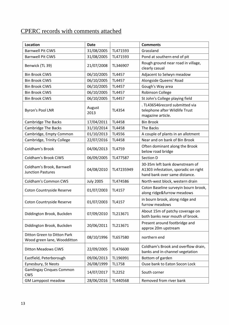
CPERC records with comments attached
Location Date Comments
Barnwell Pit CiWS 31/08/2005 TL471593 Grassland
Barnwell Pit CiWS 31/08/2005 TL471593 Pond at southern end of pit
Benwick (TL 39) 21/07/2008 TL346907 Rough ground near road in village, clearly casual
Bin Brook CiWS 06/10/2005 TL4457 Adjacent to Selwyn meadow
Bin Brook CiWS 06/10/2005 TL4457 Alongside Queens' Road
Bin Brook CiWS 06/10/2005 TL4457 Gough's Way area
Bin Brook CiWS 06/10/2005 TL4457 Robinson College
Bin Brook CiWS 06/10/2005 TL4457 St John's College playing field
Byron's Pool LNR August 2013
TL4354 . TL436546record submitted via telephone after Wildlife Trust magazine article.
Cambridge The Backs 17/04/2011 TL4458 Bin Brook
Cambridge The Backs 31/10/2014 TL4458 The Backs
Cambridge, Empty Common 01/10/2013 TL4556 A couple of plants in an allotment
Cambridge, Trinity College 22/07/2016 TL4458 Near and on bank of Bin Brook
Coldham's Brook 04/06/2013 TL4759 Often dominant along the Brook below road bridge
Coldham's Brook CiWS 06/09/2005 TL477587 Section D
Coldham's Brook, Barnwell Junction Pastures
04/08/2010 TL47235949 30-35m left bank downstream of A1303 infestation, sporadic on right hand bank over same distance.
Coldham's Common CWS July 2005 TL474586 North-west block, western drain
Coton Countryside Reserve 01/07/2003 TL4157 Coton Baseline surveyin bourn brook, along ridge&furrow meadows
Coton Countryside Reserve 01/07/2003 TL4157 in bourn brook, along ridge and furrow meadows
Diddington Brook, Buckden 07/09/2010 TL213671 About 15m of patchy coverage on both banks near mouth of brook.
Diddington Brook, Buckden 20/06/2011 TL213671 Present around footbridge and approx 20m upstream
Ditton Green to Ditton Park Wood green lane, Woodditton
08/10/1996 TL657580 northern end
Ditton Meadows CiWS 22/09/2005 TL476600 Coldham's Brook and overflow drain, banks and in-channel vegetation
Eastfield, Peterborough 09/06/2013 TL196991 Bottom of garden
Eynesbury, St Neots 26/08/1999 TL1758 Ouse bank to Eaton Socon Lock
Gamlingay Cinques Common CWS
14/07/2017 TL2252 South corner
GM Lamppost meadow 28/06/2016 TL440568 Removed from river bank

14
Grantchester August 2013
TL4355 Mill Pond. TL435551record submitted via telephone after Wildlife Trust magazine article.
Great Abington 03/08/2011 TL5249 River bank
Hen Brook, St Neots 30/06/2011 TL1959 Sparse Himalayan Balsam on the Hen Brook in St Neots between NGR TL1981158825 to TL1899059387.
Hildersham 21/04/2011 TL5448 Alder Carr
Kingston 06/08/2013 TL35665569 big stand seen in field, not pulled
Kingston 30/06/2013 TL347560 Not done last year - lots
Kingston 27/10/2001 TL358553 several plants
Little Eversden 30/08/2008 TL35 Bourn brook
Lode 02/09/1993 TL522627 Ditch bank. 1 or 2 plants.
Logan's meadow 30/06/2013 TL464592 One plant, which was eradicated
Maxey Cut, Maxey 17/08/2010 TF121069 both banks
Melbourn 14/08/2004 TF3844 probable escape from garden
Meldreth 30/05/2013 TL37614629 RMRG has asked owner to keep HB at top end of garden away from river
Over 10/09/2010 TL363714 Overcote. Right bank of drain on landward side of flood bank.
Over 04/10/2009 TL364715 Side of drain
Pampisford 27/06/2011 TL4874847464 Numerous plants on both banks 50m each side of this point
Paradise LNR 19/07/2005 TL445571 Swamp clearing and surrounding willow carr, and alder carr
Parson Drove 09/08/2012 TF366084 L shaped ditch covered in Himalayan. TF36680843
River Cam 28/06/2016 TL4355 Most removed from river bank
River Cam, Duxford 27/06/2011 TL4823546190 Numerous plants all along drain 90m each side of this point (TL4817546124 to TL4830646237)
River Cam, Duxford 27/06/2011 TL4817646133 Numerous plants on left bank 20m each side of this point
River Cam, Duxford 27/06/2011 TL4851246832 Sporadic plants on both banks 200m each side of this point (TL4845846666 to TL4840046932)
River Cam, Great Chesterford 28/07/2010 TL5039642674 20m downstream of Footbridge on both banks, continuous on right, semicontinuous on left.
River Cam, Great Chesterford 14/06/2011 TL5039442673 Large stands of Hb along both banks both upstream and downstream of the footbridge, extensive.
River Cam, Great Chesterford 27/06/2011 TL5020442884 Numerous plants on both banks 60m each side of this point
River Cam, Great Chesterford 12/10/2010 TL5039442672 Present on both banks

15
River Cam, Hauxton 21/09/2010 TL429529 Lots along river banks 50m either side of this point
River Cam, Hinxton 20/07/2010 TL4946844548 Lots along river banks 50m either side of this point
River Cam, Hinxton 06/09/2010 TL4951144624 Lots along river banks 50m either side of this point
River Cam, Hinxton 24/06/2011 TL4932045161 Numerous plants all along drain (50m each side of this point)
River Cam, Ickleton 27/06/2011 TL4972244277 Left bank
River Cam, Ickleton 27/06/2011 TL4959444364 Left bank
River Cam, Ickleton 27/06/2011 TL4985643247 Numerous plants on both banks 150m each side of this point (TL4987043119 to TL4985943380)
River Cam, Sawston 27/06/2011 TL4654449649 Both banks
River Cam, Sawston 06/09/2010 TL467506 Lots along river banks 50m either side of this point
River Cam, Sawston 27/06/2011 TL480484 Numerous plants on both banks 40m each side of this point
River Cam, Whittlesford 01/09/2010 TL477484
Footbridge at Whittlesford. Intermittent patches, mainly on right bank, and downstream for at least 100m.
River Cam, Whittlesford 27/06/2011 TL4763048733 Left bank
River Cam, Whittlesford 27/06/2011 TL4716449268 Left bank
River Cam, Whittlesford 06/09/2010 TL4780148562 Lots along river banks 50m either side of this point
River Granta, Hildersham 03/08/2010 TL5468548484 Uniform distribution along length of right hand bank for approx 20m
River Granta, Little Abington 13/09/2011 TL524491 From TL524491 to TL526492 a couple of plants seen. Local Group to target next year in conjunction with WT.
River Granta, Stapleford 10/05/2010 TL4751 From Bury Farm in Stapleford (grid ref) to Linton Road Bridge (TL560469). Patchy distribution
River Great Ouse, Brampton 05/09/2010 TL227706 Multiple plants on left bank from lock to old rail bridge (approx. 1km)
River Great Ouse, Brampton 10/08/2010 TL226706 Upstream GOBA mooring Brampton left bank
River Great Ouse, Buckden 20/06/2011 TL214672 Patches of HB on both banks, intermittent from road bridge upstream for approx. 100m
River Great Ouse, Fenstanton 20/08/2010 TL3256070298 Present on the right hand bank just upstream of the new guided bus route bridge (Ouse viaduct)

16
River Great Ouse, Godmanchester
10/08/2010 TL2306670547 Single plant. 100m downstream of rail bridge on right bank.
River Great Ouse, Great Paxton 30/09/1986 TL205634 abundant
River Great Ouse, St Ives 22/06/2011 TL313705 Lock at St Ives invert site, on right hand bank
River Kennett 24/08/2017 TL7068 River bed dry
River Nene, Ailsworth 17/08/2012 TL108976 Approximately 10m stretch along river bank
Shepreth 2012 TL39314706
Reported by unknown member of the public at the Bourn Free/River Rhee project open meeting 2013-02-21
Shepreth 14/07/2011 TL393470 Small bank of himalayan balsam alongside ditch at corner of road.
Shepreth 30/09/2004 TL393470 well-established in ditch on E side of road close to houses
Stourbridge Common TL46q 14/07/2009 TL4760 In Coldham's Brook - pulled up
Streetly End 13/08/1994 TL615481 2 large plants 1 pink; 1 purple. S side of rd.with Urtica.
The Sweards, Kingston 14/09/2001 TL355557 plentiful along Bourn Brook
Toft 06/08/2013 TL35655572 Few plants in the ditch
Toft 06/08/2013 TL35655576 More HB upstream not cleared, first field bashed.
Toft Golf Course July 2013 TL36645498 Balsam removed from ditch, visible from track on the way in.
Wenden Brook, Chrishall 21/07/2011 TL445383 Along approx. 80m of bank
West Cambridge 19/07/2014 TL4358 Bin Brook by Sylvester Road