
SUMMARY ENVIRONMENTAL IMPACT … environmental impact assessment hebei roads development project in...
28
SUMMARY ENVIRONMENTAL IMPACT ASSESSMENT HEBEI ROADS DEVELOPMENT PROJECT IN THE PEOPLE’S REPUBLIC OF CHINA July 1997
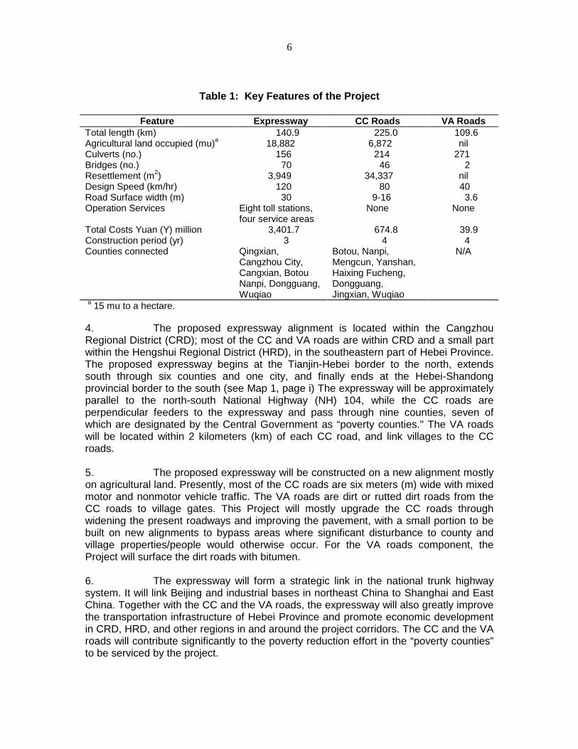
Transcript of SUMMARY ENVIRONMENTAL IMPACT … environmental impact assessment hebei roads development project in...
SUMMARY ENVIRONMENTAL IMPACT ASSESSMENT
HEBEI ROADS DEVELOPMENT PROJECT
IN THE
PEOPLE’S REPUBLIC OF CHINA
July 1997

2
CURRENCY EQUIVALENTS(as of 5 June 1997)
Currency Unit — Yuan (Y)Y1.00 = $0.120605$1.00 = Y8.2915
The exchange rate of the Yuan is determined under a floating exchange rate system. Inthis report, a rate of $1.00 = Y8.2915, the rate prevailing at the time of appraisal of theproject has been used.
ABBREVIATIONS
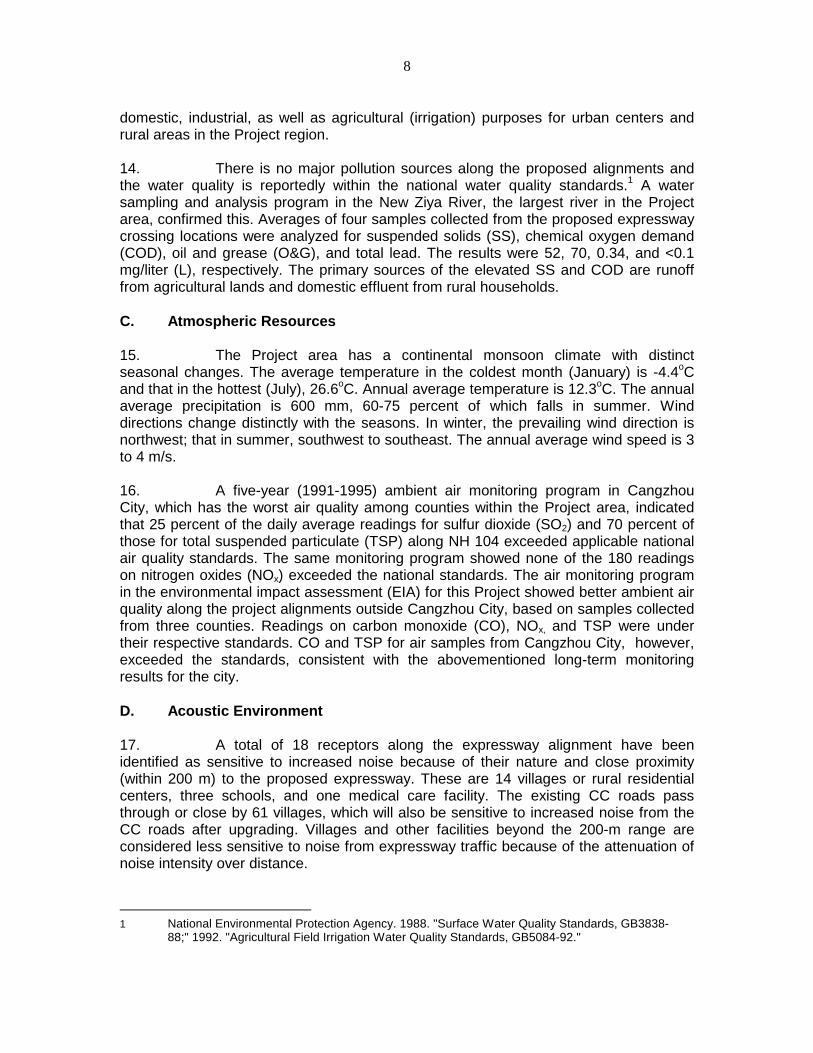
ADB — The Asian Development BankBSHAD — Beijing-Shanghai Highway (Hebei Section) Administration
DivisionCC — County ConnectorCO — Carbon MonoxideCOD — Chemical Oxygen DemandCRD — Cangzhou Regional DistrictEA — Executing AgencyEIA — Environmental Impact AssessmentEPB — Environmental Protection BureauGDP — Gross Domestic ProductHPCD — Hebei Provincial Communications DepartmentHRD — Hengshui Regional DistrictHRI — Highway Research Institute, Ministry of CommunicationsIFILPO — International Financial Institution Loan Project OfficeMOC — Ministry of CommunicationsN/A — Not ApplicableNEPA — National Environmental Protection AgencyNH — National HighwayNOX — Nitrogen OxideO&G — Oil and GreaseRAP — Resettlement Action PlanSEIA — Summary Environmental Impact AssessmentSO2 — Sulfur DioxideSS — Suspended SolidsTSP — Total Suspended ParticulateVA — Village Access
WEIGHTS AND MEASURES
dB(A) — Decibel (Absolute)m/s — Meter per Secondmg/kg — Milligrams per kilogrammg/L — Milligrams per Litermg/m3 — Milligrams per Cubic Metermu — Unit for area commonly used in China; 15 mu to a hectare

3
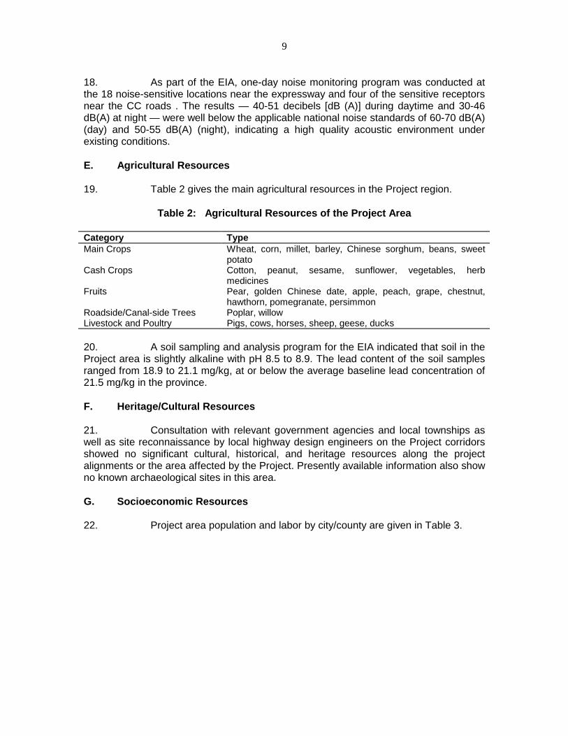
t/yr — Ton/Year

4
CONTENTS
Page
MAP i
I. INTRODUCTION 1
II. DESCRIPTION OF THE PROJECT 1
III. DESCRIPTION OF THE ENVIRONMENT
A. Landform and GeologyB. Aquatic ResourcesC. Atmospheric ResourcesD. Acoustic EnvironmentE. Agricultural ResourcesF. Heritage/Cultural ResourcesG. Socioeconomic Resources
3
3344555
IV. ANTICIPATED ENVIRONMENTAL IMPACTS ANDMITIGATION MEASURES
A. Land ResourcesB. Aquatic EnvironmentC. NoiseD. Atmospheric EnvironmentE. Socioeconomic ImpactsF. Transportation of Hazardous MaterialsG. Indirect Developments
7
79
1113141617
V. ALTERNATIVES 17
VI. COST-BENEFIT ANALYSIS 18
VII. INSTITUTIONAL REQUIREMENT AND ENVIRONMENTALMONITORING PROGRAM 19
VIII. PUBLIC INVOLVEMENT 22
IX. CONCLUSIONS 23
APPENDIX

5
I. INTRODUCTION
1. This Summary Environmental Impact Assessment (SEIA) report isprimarily based on information contained in the Project environmental impactassessment (EIA) reports1 and report addendum prepared by the Highway ResearchInstitute (HRI), the Ministry of Communications (MOC). Additional information wasobtained through a series of meetings with local environmental, socioeconomic, andresettlement specialists; project planners and design engineers; and officers from theInternational Financial Institution Loan Project Office (IFILPO) of the Hebei ProvincialCommunications Department (HPCD), which is the Executing Agency (EA) for thisProject. Direct observations during site visits to the Project area further improvedunderstanding of the general project setting and physical conditions of the surroundingenvironment. The SEIA also draws information from the Resettlement Action Plan2
(RAP), project Feasibility Study Report,3 and project Social Background Survey Report4prepared by local specialists, and reports review and assessment by the internationalconsultant. Data contained in these referenced reports were updated, whereappropriate, when the SEIA was prepared.
2. The EIA reports were prepared using methodologies consistent withrelevant guidelines set out by the National Environmental Protection Agency (NEPA)and MOC. This is a widely accepted practice in environmental assessment for projectspartially funded by international financial institutions such as the Asian DevelopmentBank (ADB).
II. DESCRIPTION OF THE PROJECT
3. The Project has three components: the four-lane, limited-access Beijing-Shanghai expressway, Hebei Section; the two-lane county connector (CC) roads, whichwill be three parallel segments intersecting the expressway; and the one-lane,multisegment village access (VA) roads, which will connect 169 poverty villages to theCC roads. Key features of the Project components are summarized in Table 1.
1 Highway Research Institute, the Ministry of Communication, 1996 "Environmental Impact
Assessment, People’s Republic of China, Beijing-Shanghai Highway, Hebei Section Expressway; Aid-the-Poor Connecting Line Botou-Haifeng Section; Fucheng-Qiantongzhen Section; and Jinxian-Wuqiao Section."
2 HPCD, 1997 "Resettlement Action Plan, Beijing-Shanghai Highway, Qingxian to Wuqiao Expressway."
3 Hebei Institute of Social Sciences, 1997 "Hebei Roads Development Project Participatory Poverty Assessment and Participatory Monitoring Research" (draft)
4 Hebei Provincial Communications Planning and Design Institute. 1996. "Beijing-Shanghai Highway Section in Hebei Province Project Feasibility Study Report."
6
Table 1: Key Features of the Project
Feature Expressway CC Roads VA RoadsTotal length (km) 140.9 225.0 109.6Agricultural land occupied (mu)a 18,882 6,872 nilCulverts (no.) 156 214 271Bridges (no.) 70 46 2Resettlement (m2) 3,949 34,337 nilDesign Speed (km/hr) 120 80 40Road Surface width (m) 30 9-16 3.6Operation Services Eight toll stations,
four service areasNone None
Total Costs Yuan (Y) million 3,401.7 674.8 39.9Construction period (yr) 3 4 4Counties connected Qingxian,
Cangzhou City,Cangxian, BotouNanpi, Dongguang,Wuqiao
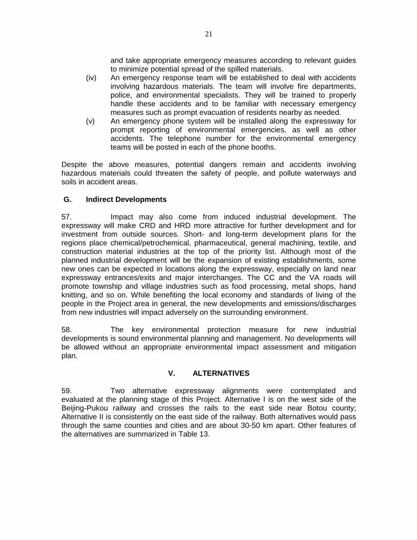
Botou, Nanpi,Mengcun, Yanshan,Haixing Fucheng,Dongguang,Jingxian, Wuqiao
N/A
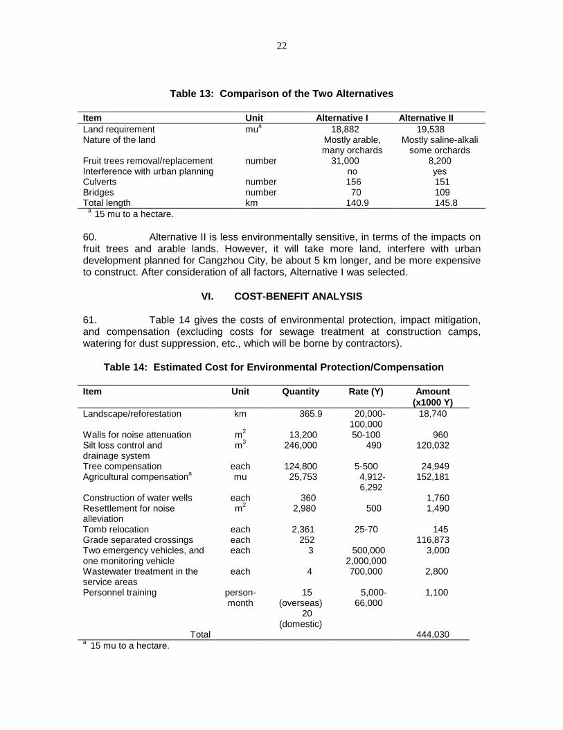
a 15 mu to a hectare.
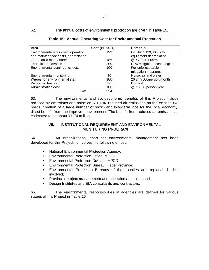
4. The proposed expressway alignment is located within the CangzhouRegional District (CRD); most of the CC and VA roads are within CRD and a small partwithin the Hengshui Regional District (HRD), in the southeastern part of Hebei Province.The proposed expressway begins at the Tianjin-Hebei border to the north, extendssouth through six counties and one city, and finally ends at the Hebei-Shandongprovincial border to the south (see Map 1, page i) The expressway will be approximatelyparallel to the north-south National Highway (NH) 104, while the CC roads areperpendicular feeders to the expressway and pass through nine counties, seven ofwhich are designated by the Central Government as “poverty counties." The VA roadswill be located within 2 kilometers (km) of each CC road, and link villages to the CCroads.
5. The proposed expressway will be constructed on a new alignment mostlyon agricultural land. Presently, most of the CC roads are six meters (m) wide with mixedmotor and nonmotor vehicle traffic. The VA roads are dirt or rutted dirt roads from theCC roads to village gates. This Project will mostly upgrade the CC roads throughwidening the present roadways and improving the pavement, with a small portion to bebuilt on new alignments to bypass areas where significant disturbance to county andvillage properties/people would otherwise occur. For the VA roads component, theProject will surface the dirt roads with bitumen.
6. The expressway will form a strategic link in the national trunk highwaysystem. It will link Beijing and industrial bases in northeast China to Shanghai and EastChina. Together with the CC and the VA roads, the expressway will also greatly improvethe transportation infrastructure of Hebei Province and promote economic developmentin CRD, HRD, and other regions in and around the project corridors. The CC and the VAroads will contribute significantly to the poverty reduction effort in the “poverty counties”to be serviced by the project.

7
7. The loan to the Project is scheduled to be approved by ADB’s Board inNovember 1997. The construction is scheduled to start in mid-1998 and to be completedin three years for the expressway and four years for the CC and the VA roads.
III. DESCRIPTION OF THE ENVIRONMENT
A. Landform and Geology
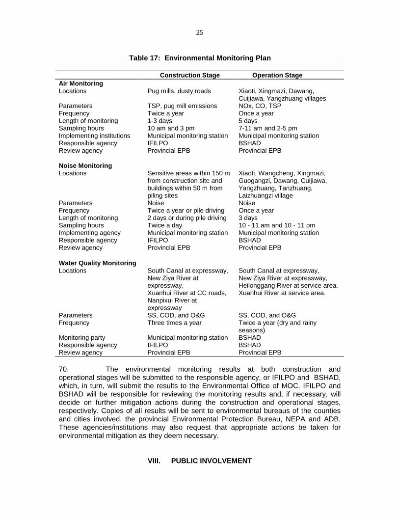
8. The Project area is located at the eastern part of the North China Plain,with elevations ranging from 4 to 30 m above sea level. The area is mostly flat with anatural gradient of no greater than 0.05 percent. The underlying geology ischaracterized by Quaternary structure, and the soil is mostly clay and sandy clay, muchof which is saline and soggy.
9. The Project area is close to the Cangdong Fault Zone with deep earthcrust. Over the last 300 years, this region has had on record three earthquakes at aRichter scale of 5 or higher. According to the latest seismological classification of PRCby the State Earthquake Bureau, the Cangdong area is classified as 7 on theearthquake intensity scale.
10. A remarkable landform feature in the Project area is the very widefloodplains (up to 2.5 km wide). The waterways are dry in most of their widths duringyears of normal rainfall, but nevertheless require long expressway structures across thefloodplain widths.
B. Aquatic Resources
11. The Project area, located in the lower part of the Haihe River basin, iscrisscrossed by rivers, canals, and ditches, including the landmark South Canal (GrandCanal). The Canal is generally parallel to, but will be crossed twice by, the proposedexpressway alignment and by the three segments of the CC roads. The surface waterbodies in the region are characterized by low to nil flows in the dry season to relativelyhigh water flows in the rainy season, usually in summer. Since all major rivers in thisarea have hydrology control facilities upstream, the flows in these rivers and thetributaries and irrigation ditches originating from them are therefore regulated primarilyby the need for flood control and irrigation. Silt settles in the river channels in this areabecause of the flat gradient when the rivers reach the area.
12. The surface water bodies in the Project area are used mostly for flooddischarge and irrigation. According to Government monitoring and survey records, thereare no known fishery resources in these water bodies except the South Canal, which isreported to have a small amount of crucian, grass and silver carps, snakehead, andsoft-shelled turtles. The South Canal was a waterway for seasonal navigation by smallvessels. It is understood that navigation in the canal will be resumed in the future. Thereis no other use for surface water in this area.
13. The Project area hydrogeology is characterized by weathered rocks withhigh salt contents in shallow water layers, typically 2 to 7 m below grade. Water fromthese layers has little use in domestic or agricultural activities. Deep aquifers, typicallylocated 30 to 50 m below grade or deeper, are the primary water sources for most
8
domestic, industrial, as well as agricultural (irrigation) purposes for urban centers andrural areas in the Project region.
14. There is no major pollution sources along the proposed alignments andthe water quality is reportedly within the national water quality standards.1 A watersampling and analysis program in the New Ziya River, the largest river in the Projectarea, confirmed this. Averages of four samples collected from the proposed expresswaycrossing locations were analyzed for suspended solids (SS), chemical oxygen demand(COD), oil and grease (O&G), and total lead. The results were 52, 70, 0.34, and <0.1mg/liter (L), respectively. The primary sources of the elevated SS and COD are runofffrom agricultural lands and domestic effluent from rural households.
C. Atmospheric Resources
15. The Project area has a continental monsoon climate with distinctseasonal changes. The average temperature in the coldest month (January) is -4.4oCand that in the hottest (July), 26.6oC. Annual average temperature is 12.3oC. The annualaverage precipitation is 600 mm, 60-75 percent of which falls in summer. Winddirections change distinctly with the seasons. In winter, the prevailing wind direction isnorthwest; that in summer, southwest to southeast. The annual average wind speed is 3to 4 m/s.
16. A five-year (1991-1995) ambient air monitoring program in CangzhouCity, which has the worst air quality among counties within the Project area, indicatedthat 25 percent of the daily average readings for sulfur dioxide (SO2) and 70 percent ofthose for total suspended particulate (TSP) along NH 104 exceeded applicable nationalair quality standards. The same monitoring program showed none of the 180 readingson nitrogen oxides (NOx) exceeded the national standards. The air monitoring programin the environmental impact assessment (EIA) for this Project showed better ambient airquality along the project alignments outside Cangzhou City, based on samples collectedfrom three counties. Readings on carbon monoxide (CO), NOx, and TSP were undertheir respective standards. CO and TSP for air samples from Cangzhou City, however,exceeded the standards, consistent with the abovementioned long-term monitoringresults for the city.
D. Acoustic Environment
17. A total of 18 receptors along the expressway alignment have beenidentified as sensitive to increased noise because of their nature and close proximity(within 200 m) to the proposed expressway. These are 14 villages or rural residentialcenters, three schools, and one medical care facility. The existing CC roads passthrough or close by 61 villages, which will also be sensitive to increased noise from theCC roads after upgrading. Villages and other facilities beyond the 200-m range areconsidered less sensitive to noise from expressway traffic because of the attenuation ofnoise intensity over distance.
1 National Environmental Protection Agency. 1988. "Surface Water Quality Standards, GB3838-
88;" 1992. "Agricultural Field Irrigation Water Quality Standards, GB5084-92."
9
18. As part of the EIA, one-day noise monitoring program was conducted atthe 18 noise-sensitive locations near the expressway and four of the sensitive receptorsnear the CC roads . The results — 40-51 decibels [dB (A)] during daytime and 30-46dB(A) at night — were well below the applicable national noise standards of 60-70 dB(A)(day) and 50-55 dB(A) (night), indicating a high quality acoustic environment underexisting conditions.
E. Agricultural Resources
19. Table 2 gives the main agricultural resources in the Project region.
Table 2: Agricultural Resources of the Project Area
Category TypeMain Crops Wheat, corn, millet, barley, Chinese sorghum, beans, sweet
potatoCash Crops Cotton, peanut, sesame, sunflower, vegetables, herb
medicinesFruits Pear, golden Chinese date, apple, peach, grape, chestnut,
hawthorn, pomegranate, persimmonRoadside/Canal-side Trees Poplar, willowLivestock and Poultry Pigs, cows, horses, sheep, geese, ducks
20. A soil sampling and analysis program for the EIA indicated that soil in theProject area is slightly alkaline with pH 8.5 to 8.9. The lead content of the soil samplesranged from 18.9 to 21.1 mg/kg, at or below the average baseline lead concentration of21.5 mg/kg in the province.
F. Heritage/Cultural Resources
21. Consultation with relevant government agencies and local townships aswell as site reconnaissance by local highway design engineers on the Project corridorsshowed no significant cultural, historical, and heritage resources along the projectalignments or the area affected by the Project. Presently available information also showno known archaeological sites in this area.
G. Socioeconomic Resources
22. Project area population and labor by city/county are given in Table 3.

10
Table 3: Project Area Population
City/County
Population(x1000)
RuralPopulation(x1000)
PopulationDensity(1/km2)
RuralLaborForce(x1000)
Labor inAgriculture(%)
LaborinLivestock(%)
Labor inCommerce& Industry(%)
Cangzhou 389 94 1921 - - - -Qingxian 363 326 375 142 85 2.0 12.0Cangxian 636 616 416 51 82 3.0 15.0Botou 523 430 520 160 80 4.0 16.0Nanpi 335 299 421 126 87 2.0 11.0Dongguang 330 305 471 141 90 2.5 7.5Wuqiao 270 246 448 124 81 4.0 15.0Mengcun 168 155 427 73 68 6.0 26.0Yanshan 382 361 480 169 85 3.0 12.0Haixing 195 169 233 78 72 4.0 24.0Fucheng 323 297 464 122 64 2.0 34.0Jingxian 481 446 407 203 75 3.0 22.0
23. Major rural socioeconomic indicators are in Table 4.
Table 4: Main Socioeconomic Indicators of the Project Area
City/County
Average FarmersIncome (Y/cap/yr)
Cultivated Land(x1000 mu)a
Average CultivatedLand (mu/rural cap) a
AgriculturalIncome(Y/mu) a
Cangzhou 1127 - - -Qingxian 1327 852 2.61 402Cangxian 1265 1241 2.18 312Botou 1272 951 2.21 561Nanpi 914 705 2.36 417Dongguang 1098 738 2.42 358Wuqiao 1151 585 2.38 568Mengcun 988 312 2.01 365Yanshan 734 728 2.02 288Haixing 837 437 2.59 266Fucheng 858 684 2.30 517Jingxian 960 1193 2.67 425a 15 mu to a hectare.
In addition, CRD as a whole enjoyed an economic growth of 12.3 percent per year onaverage between 1979 and 1994, and HRD, 8.4 percent, significantly higher than and atpar with the provincial average, respectively. By 1994, the total gross domestic product(GDP) in CRD and HRD had reached, respectively, Y16.98 billion and 11.92 billion;annual industrial output, Y27.9 billion and Y19.7 billion; and annual agricultural output,Y8.1 billion and Y6.0 billion.1
1 Hebei Statistics Bureau. 1995. "Hebei Statistics Yearbook."

11
24. Primary socioeconomic services in the Project area in Table 5.
Table 5: Main Socioeconomic Services of the CRD Area
Services Scale/LevelEducation 2 colleges, 263 middle/high schools, 5,309 elementary schools, 98%
villages have at least one school.Medical Care 12,253 hospital beds, 1.4 medical professionals/1,000 people; 9% of
villages have medical care.Telephones 2 phone sets per 100 people in CRD; 62% of the villages are connected
by phone.Transportation Beijing-Shanghai railway, numerous local rail lines, 1,490 km of roads with
Class III or higher classification, and approximately 2,500 km of Class IVtownship level roads. One medium size airport is planned.
Market Average of 1.5 market gatherings per rural township, permanentmarkets/department stores in all towns and counties
Tourism Wuqiao Acrobatic World (foreign visitors in 1994: 3,926; annual revenuefrom foreign tourists: $112,000), Cangzhou iron lion (over 1,000 years old)
IV. ANTICIPATED ENVIRONMENTAL IMPACTS AND MITIGATION MEASURES
A. Land Resources
1. Agricultural Land
25. The proposed expressway will occupy a total of 18,882 mu and the CCroads, 6,872 mu of agricultural land. The occupied land represents about 0.24 percentof the total cultivated land in CRD and HRD. In the Project area, agricultural land isjointly owned by all farmers in a village. If certain land is converted for other uses, theremaining agricultural land would be redistributed among all the farmers in the village,i.e., the whole village shares the impact of land loss collectively. Table 6 shows thelevels of land loss impact in the affected area.
Table 6: Agricultural Land Affected by the Project
City/Country AffectedPopulation(x1,000)
Total AffectedCultivated Land(x1000 mu)a
AverageCultivated Land(mu/farmer) a
CultivatedLand to beLost to theProject (mu)a
Average LandLoss(mu/farmer) a
LandLossper Farmer(%)
Qingxian 213 514 2.41 5311 0.025 1.0Cangxian 77 160 2.08 3311 0.043 2.1Botou 20 36 1.85 948 0.048 2.6Nanpi 77 161 2.10 3908 0.051 2.4Dongguang 89 253 2.84 5059 0.057 2.0Wuqiao 119 298 2.50 2647 0.022 0.9Mengcun 25 40 1.61 597 0.024 1.5Yanshan 23 40 1.74 973 0.043 2.4Haixing 12 27 2.20 1574 0.131 6.0Fucheng 42 97 2.30 934 0.022 1.0Jingxian 122 255 2.09 492 0.004 0.3a15 mu to a hectare.
12
26. To mitigate the impact, 60,000 trees and 60,000 bushes will be plantedon both sides of the expressway, and 3,748 mu will be seeded to grass theembankment. This represents 20 percent of the total land to be occupied by theexpressway. An estimated Y14.1 million is required for the expressway landscape plan.Over 112,000 trees will also be planted along the CC roads at an estimated cost ofY4.64 million, compensating for 12 percent of the green field lost to the CC roads. Asthe lost cultivated land cannot be recovered elsewhere, affected farmers will becompensated between Y5,000 and Y6,000/mu. The money is expected to be used toincrease unit output on the remaining farmland (such as improving existing irrigationsystems, planting part of the land to high-yielding cash crops, etc.) to offset the lostproduction and revenue. After mitigation measures, a net 15,134 mu of green field willbe lost to the expressway and 6,031 mu to the CC roads. With impact shared by allfarmers in the affected villages, the highest land loss impact will be about 0.1 mu/farmeror 6 percent of the land they own (see Table 6). Impacts on agricultural output andrevenue, are expected to be insignificant after compensation.
2. Soil
27. A motor vehicle lead emission model projected that by the year 2019,lead concentrations in the soil within 1 km of the proposed project alignments will be up33 mg/kg through accumulated increase of motor vehicle emissions. Although this is analmost 60 percent increase from the existing baseline lead concentrations in the soil, itwill still be far below the 300 mg/kg limit set by applicable national standards.1
28. The impact of motor vehicle emissions to the soil will be insignificant, andno specific mitigation measure is necessary. In fact, the impact to the soil is expected tobe of little relevance as the PRC Government has recently announced a plan to ban theuse of leaded gasoline in PRC by the year 2000.
3. Siltation
29. The proposed expressway embankment will be 3.7 m above grade; theCC road embankment, 0.5-1.3 m; and the VA roads will have no embankment. Most ofthe required 21.14 million m3 fill material will be excavated on site, creating ditches onboth sides of the roadways. Surface erosion and silt runoff may occur on the bareembankment, and unprotected slopes during heavy rainfall. Total silt erosion due to theProject is estimated to be about 1,900 tons/yr during construction and nil duringoperation when the landscaping is finished. Because of the flat terrain, the lost silt isexpected to settle in side ditches, which are designed for surface water runoff from theProject.
30. The roadway embankment slopes will be grassed and treed soon afterthe expressway is completed. Land disturbance will be limited to the construction period.Erosion and silt runoff during road operation will be negligible.
1 Ministry of Communications. 1997. "Specifications for Environment Impact Assessment of
Highways."
13
4. Construction Materials
31. Gravel used in Project construction will be purchased from commercialgravel pits in Hebei and neighboring Shandong Provinces, beyond the control of the EA.It is understood that the cost for environmental protection and site reclamation at thegravel pits will be included in the sales price. The coal burning residual/bottom ash,which has been used widely in PRC for highway construction and for other Hebeihighway projects, will be used as a subgrade material. Chemical analysis showed thatthe material is chemically stable and poses little risk to groundwater. In the field,groundwater samples collected near the bottom-ash subsurfaced Shanghai-Jiaxinexpressway after two years operation showed that, except for manganese, all waterquality parameters were within the national drinking water standards.1 Moreover, sinceshallow groundwater aquifers in the Project area are alkaline and saline and thus havelittle use, they are not environmentally sensitive. The use of bottom ash will, in fact,benefit the environment by reducing the need for excavation of other filling materials andalleviating ash disposal problems from coal-burning power plants. However, bottom ashtransportation can generate airborne dust enroute to the construction sites.
32. The EA will accept bids for construction materials only from suppliers withsound environmental management programs and reclamation plans, where applicable.Bottom ash will be watered to 40 percent moisture content and/or covered duringtransportation. The residual impact related to bottom ash will be insignificant.
B. Aquatic Environment
1. Hydrology
33. The construction of bridge piers will reduce the cross-sectional area ofthe river channels for flood discharge. As a result, water levels in the rivers upstreamfrom the bridges will increase up to 50 cm, reducing the free board of the river dikes upto 5.6 km from the bridges during design floods. The Project will have virtually no impacton hydrology and flood discharge/control because the bridges are designed for 100- to300-year floods, while the dikes (built long before this Project) were designed for 50-year floods. Floods will overflow the dikes before the bridges show impact on hydrology.In-water construction activities such as piling and concrete bridge piers grouting will bedone in dry season when little water is in the rivers. When steel cofferdams must beused during rainy season for in-water construction, the crosssection of the riverbeds willbe further reduced. However, unless major floods occur during pier construction, therewill be no impact on flood control.
2. Water Wells
34. A total of 52 water wells primarily used for irrigation are located on theexpressway alignment. For each of the wells to be buried by the expressway, two will bebuilt at the same depth on both sides of the expressway to eliminate the impact. Inaddition, 237 wells located near the proposed alignment will be cut off by theexpressway from the agricultural land on the opposite side of the expressway. Similar tothe compensation for the occupied wells, 237 wells will be drilled to the same depth at 1 National Environmental Protection Agency. 1985. "Drinking Water Standards, GB5749-85."

14
appropriate locations. On the CC roads, 71 water wells to be lost and replaced with thesame number of new wells on the same side of the roads where the wells are currentlylocated. The residual impact will be nil. The total cost for well relocation and new wellconstruction is estimated to be Y1.76 million. These wells will be drilled at the same timethat the expressway is constructed.
3. Water Quality
35. During the construction stage, silt from disturbed soil and in-riverconstruction activities may result in increased suspended solids (SS) in riversimmediately downstream from the expressway, and duck/fish ponds and water wellsnear the VA roads. Such impacts will be temporary and limited to small areasdownstream, but can affect a large portion of an adjacent fish pond. Construction campswill generate domestic effluent of 60 L per person per day on average, and totalwastewater in the largest camp may be up to 60,000 L per day. If discharged directlyinto natural water bodies, the domestic effluent from construction camps would raiseCOD concentrations by about 1.2 mg/L in large rivers and up to 34.7 mg/L in smallerstreams. During the operational stage, small quantities of sediment and dripping oil andgrease from the road surface may be washed out and discharged to nearby surfacewater bodies as runoff during the rainy season. As this would also be the season whenthe rivers have their highest flow rates, the impact to water quality will be small. The twosurface stations will generate effluent containing COD, SS, and O&G. The effluent willeventually be discharged to the Helongguang and Xuanhui Rivers, respectively, year-round.
36. All contractors will be required to build septic tanks at their constructioncamps as part of the construction contracts. This will remove approximately 40-50percent of the COD and 50-70 percent of the SS. During construction, contractors willalso be required to have sound environmental management programs for the storage ofhazardous materials, solid waste collection and disposal, and environmentalcontingency plans. Surface runoff to fish ponds and drinking water wells by the VAroads will be intercepted to prevent impact on these water bodies. The residual impacton water quality during construction will basically be short-term increases in SSconcentrations in the rivers immediately downstream from the expressway. In the SouthCanal, increased SS may drive the fish population, away from the impacted area; butthe impact will dissipate soon after the construction terminates. Septic tanks will be builtin the four service areas as an integral part of these facilities. The wastewater treatmentsystems are estimated to cost Y2.8 million. The two receiving water bodies may beimpacted in terms of increased COD and SS by the final discharges from the servicearea septic tanks during dry season when river flows are minimum. Long-term impactson water quality in other rivers in the Project area during expressway operation will below. During construction and operation, water quality in the major rivers and the SouthCanal will be monitored for SS, COD, and O&G to confirm the result of the impactassessment.

15
C. Noise
1. During Construction
37. The main noise sources during construction are construction machinery,which generate noise at levels from 76 dB(A) to 98 dB(A) measured 5 m from runningmachines. At about 100 m, the noise levels are expected to reduce to levels within thedaytime national noise standards of 70 dB(A). The noise will have an impact mostly onconstruction workers and residents living within 100 meters from the construction sites.
38. To mitigate noise, no machines will be allowed to work at night. Duringthe day, noisy stationary machines such as power generators, concrete mixers, pugmills, etc., will be located at least 300 m leeward to sensitive receptors. With thesemeasures, the residents living within 100 m from the project sites, excluding those whowill be relocated, will still be affected by increased noise sometimes to levels exceedingthe national standards. The impact will be limited to daytime and will be completely goneonce construction activities stop.
2. During Operation
39. The US Federal Highway Administration (FHWA) noise model was usedto forecast noise levels to be generated by the Project during three operation years. Thenational noise standards of 60-70 dB(A) for daytime and 50-55 dB(A) for nighttime wereused as threshold values for significant noise impact. The isolines of these noisethresholds forecast by the model (distance in m to the curb of the expressway or the CCroads) are given in Table 7.
Table 7: Distance from the Project Where Noise is at the National NoiseThresholds
Future Operational Year Daytime (m) Nighttime (m)Expressway CC Roads Expressway CC Roads
Year 2000 10 <10 to 10 80 to 100 20 to 40Year 2010 30 to 40 <10 to 20 150 to 170 30 to 60Year 2019 50 to 60 10 to 20 180 to 200 50 to 80
The noise impact will be long term and increase over time as traffic volume on theproject roads increases. Table 7 shows that areas to be affected significantly byincreased traffic noise will be larger at nighttime than at daytime. The noise levelsexceeding the standards and the number of sensitive receptors exposed to higher thanthe standard noise levels are given in Table 8.
16
Table 8: Extent of Noise Impact by Expressway/CC Roads
Operational Time Daytime NighttimeLevelsExceeding theStandards bydB(A)
Receptors (no.)withExceeded NoiseLevels
LevelsExceeding theStandards bydB(A)
Receptors (no.)withExceeded NoiseLevels
Early Years < 3/nil 2/0 1-6/0.6-3.4 13/7Near Future 2-5/0.9 12/2 3-9.5/3-5.8 17/7Future 2-7/2.5 15/2 4-12/4.6-7.6 18/7
There will be very low traffic on VA roads. Noise impact during VA road operations willbe negligible.
40. Three groups of mitigation measures are planned based on the extent ofnoise levels above the national standards. These measures, their estimated costs, andresidual impact after taking the measures are in Table 9.
Table 9: Mitigation to Noise Impact
Levels Exceeding theStandards by dB(A)
MitigationMeasures
Estimated Costs Residual Impact
< 3 None None Noise levels exceedingthe standards up to 3dB(A)
3 to 9 Increase the height/construct new brickwalls to 4 m aroundhouses affected.
13,200 m2 @Y50-100/m2 ortotal Y960,000
Reduce noise levels by5-15 dB(A). Residualnoise exceeding thestandards up to 4dB(A).
> 9 Relocate. 2,980 m2@Y500/m2
or total ofY1.49 million
Nil
In addition, some sections of the CC roads will be diverted from the existing alignmentsto bypass downtown areas of two counties, one township, and several villages to avoidincreased noise as well as resettlement, traffic hazards, and other adverse impacts.Other mitigation measures such as tree planting, double glazed windows, and excludingfuture development from the affected zones (200 m from project alignments) will betaken to further reduce the noise impact. Nevertheless, the incremental increase ofnoise at sensitive receptors will be apparent — from rural baseline noise levels ofaround 50 dB(A) during daytime and 40 dB(A) or lower at night up to 70 to 75 dB(A)during daytime and 65 at night. This will permanently expose some receptors to noiselevels exceeding the national noise standards even after the preceding mitigationmeasures.
41. A positive impact is that much of the through traffic and the long- distanceregional traffic on NH 104, which runs approximately parallel to the proposedexpressway, will divert to the expressway once it is completed. As a result, the noiselevel from NH 104 is expected to be about 6 dB(A) lower than the present level,
17
benefiting an estimated 144,000 urban and rural residents, as well as schools, medicalcare facilities, and other institutions. Residents in the counties, townships, and villagescurrently intersected by CC roads will also benefit when the new CC roads bypass theseareas.
D. Atmospheric Environment
1. During Construction
42. The primary air emissions during project construction will be from pugmills and airborne dust from construction truck movements. Air monitoring for similarhighway projects in the same region indicated that at 100 m leeward to the source,concentrations of pug mill emissions were up to 1.2 to 1.7 mg/m3 and dust (as TSP)from truck traffic 20 mg/m3 ; contaminated areas could reach 150 m leeward.
43. To mitigate the impact on the atmosphere during construction, pug millswill be located at least 300 m from residential and other sensitive receptors, and coveredwhere possible. The residual impact of pug mill emissions will be negligible except toconstruction workers. During dry season and in sensitive areas, hauling roads will bewatered to suppress dust. The residual impact of airborne dust will be limited to smallareas close to truck roads and terminated shortly after the end of truck traffic.
2. During Operation
44. A model using the Gaussian Equation was applied to forecast aircontamination for Class D Atmospheric Stability during project operation. The results for50 m from the alignment are in Table 10.
Table 10: Air Contamination (at 50 meters) During Expressway and CC RoadsOperation
Operation Year NOx (mg/m3) Peak Hour Daily Average
CO (mg/m3)Peak Hour Daily Average
Expressway2000 0.021 - 0.034 0.017 - 0.028 0.054 - 0.087 0.044 - 0.0702010 0.047 - 0.069 0.038 - 0.060 0.118 - 0.174 0.095 - 0.1402019 0.057 - 0.099 0.046 - 0.079 0.143 - 0.227 0.115 - 0.200
CC Roads2000 0.019 - 0.032 0.017 - 0.029 1.05 - 2.36 0.79 -1.062010 0.027 - 0.051 0.024 - 0.045 1.07 - 2.30 0.80 -1.082019 0.034 - 0.065 0.029 - 0.057 1.08 - 2.42 0.81 -1.10
The modeling results indicate that CO concentrations will be below the nationalstandards beyond 10 m from the expressway in the year 2019. The model forecasts thatNOx concentration (daily average) will slightly exceed the standards for one receptor inthe year 2010 and for five in 2019. None of the forecast parameters exceed thestandards for the CC roads. Long-term air quality monitoring is needed to confirm the airmodeling forecasts for the Project area. Because of the low traffic and the absence ofsensitive receptors nearby, the VA roads will have negligible air quality impact.

18
45. Although areas adjacent to the expressway and that now have noemission sources will be adversely affected, air quality will be improved from a regionalperspective. An early study1 in North PRC showed that light motor vehicles driven 80percent of the time at 100 km/h and 20 percent acceleration/deceleration — the likelyscenario on the expressway — will reduce CO emissions by 47 percent, hydrocarbons(HC) by 48 percent, and NOx by 35 percent compared with vehicles driven 40 percent at100 km/h and 30 percent at 50 km/h and 30 percent acceleration/deceleration as istypical on NH 104. In addition, much of the motor vehicle emissions will be moved fromthe NH 104 corridor to the less populous expressway corridor. The improved ambient airquality will directly benefit over 144,000 people who live along NH 104, 54 km of whichpass through urban and densely populated areas. Similarly, the upgrading of theexisting CC roads will increase motor vehicle speeds and reduceacceleration/deceleration on the roads. The new alignments will bypass the downtownareas of two counties, one township, and several villages intersected by the present CCroads. Thus, the reduced air emissions will benefit over 88,000 people residing on bothsides of the CC roads.
E. Socioeconomic Impacts
1. Agricultural Land and Rural Community Severance
46. The fully fenced, limited-access expressway will separate certainfarmland from farmers and some villages from one another on both sides of thealignment. It will limit the access of certain farmers to their fields and certain ruralresidents to schools, markets, services, and relatives and friends. About 80 villages and60,000-80,000 rural residents throughout the Project area will be affected.
47. A total of 223 crossings (see Table 11) will be constructed under theexpressway or an average of 1 every 600 m. The total estimated cost of these crossingsis about Y117 million. The majority of the crossings are designed to be at existing roadsand meet the need for agricultural and social activities. The crossings will eliminate theimpact of land and community severance, except that pedestrians who otherwise couldwalk to their destinations through the field will have to walk no more than 300 m onaverage to one of the crossings. Also, some farmland originally cultivated as one parcelwill be split into two.
1 Post Buckley International. 1994. "Air Quality and Vehicle Emissions in Liaoning Province,
PRC."

19
Table 11: Expressway Crossings
Grade Design Criteria(width x height, m)
Designed Functions Number
Class I 8 x 4 Motor vehicles 11Class II 6 x 3.5 Tractors and agricultural vehicles 105Class III 4 x 3 Pedestrians 107
2. Revenue from Orchard Operation
48. The impact on income for farmers who will lose their fruit trees to theexpressway and the proposed compensation are given in Table 12. In addition, 19,560fruit trees and 17,500 regular trees will be removed because of the CC roads. The totalcompensation of Y7.11 million will be used to replace the lost trees. Upgrading the VAroads will not involve tree replacement.
Table 12: Impact on and Compensation for Fruit Trees (Expressway)
Type of Tree Quantity UnitRevenue
(Y/yr)
Total Revenue(Y/yr)
Compensation(Y/tree)
TotalCompensation (Y)
Saplings 38,047 nil nil 5 190,235Young 15,892 80 1,263,000 200 3,175,800Mature 28,743 300 8,623,000 500 14,371,500Non-fruit 5,002 nil nil 20 100,040
49. It usually takes about 1-2 years for saplings to bear fruit and another 2-3years for them to mature to full production capacity. Farmers who will lose fruit trees willbe affected in terms of reduced fruit yields and revenues for up to 5 years.
3. Traffic
50. The existing traffic on the CC and VA road will be restricted during theupgrading. Both motor vehicle and nonmotor vehicle traffic will be affected for up to sixmonths on the CC roads. For 169 villages, upgrading of their roads will reduce accessfor up to one month.
51. During construction, traffic will be detoured to other existing roads or toadjacent temporary dirt roads to be built, where needed. Traffic will be slowed becauseof the poorer quality of the detour roads and/or longer distance. There will also beincreased air emissions and airborne dust on the roads for the detoured traffic. Theresidual impact will last during construction and will vanish once construction iscompleted.

20
4. Tombs
52. Expressway alignment and widening of the CC roads will bury 2,361tombs that belong to rural families in adjacent villages. None of the tombs have anyarchaeological value.
53. Affected families will be offered other sites in the same area to relocatethe tombs and Y25-70 each to cover the relocation cost. As long as new sites for therelocation are appropriate, the residual impact will be small.
5. Economic Development
54. The Project will improve infrastructure in the region and make the areamore attractive to outside investments. Economic benefits will also include higherefficiency in transport of local raw materials (minerals, agricultural produce such asfruits, etc.) and finished goods to local and outside markets. More tangible andimmediate benefits will be increased employment opportunities directly related toproject construction and operation. Of an estimated 11 million labor-days required forexpressway construction, 50 percent is expected to come from the local labor force. Asto the two other road components, almost 100 percent of the 2.7 million labor-daysrequired for CC roads and 0.4 million for VA roads construction will be supplied by thelocal labor force. Of the labor requirements for VA roads construction, 80-90 percent willcome directly from seasonal labor of the “poverty villages.” Indirect employment relatedto services, vendors, etc. will generate additional income-earning opportunities duringthe construction period. In the operational stage, an estimated total of 800-1,200permanent employment positions related to highway maintenance, services, toll stationoperation, policing, management, etc. and additional indirect employment positions willbe created in the region.
F. Transportation of Hazardous Materials
55. With oil and gas production and petrochemical industry establishments inthe Cangzhou area, it is anticipated that 15 percent of all heavy truck traffic on theexpressway will involve transportation of hazardous materials. Accidents involvingtrucks carrying these materials could result in explosions, fires, or spills, impactingadversely on the safety of residents nearby, other motor vehicles and their passengerson the expressway, and the surrounding environment.
56. Planned mitigation measures are the following.
(i) Individuals (drivers, etc.) transporting hazardous materials will beexamined when entering the expressway to ensure possession ofappropriate operation permits. Vehicles will be inspected to ensureappropriate marks and equipment.
(ii) Vehicle operators will be forbidden to smoke cigarettes while with thevehicles, and will be warned through appropriate signs for traffic safetywhile passing rivers, villages, and other sensitive areas.
(iii) When accidents occur, vehicle operators will be required to reportimmediately to public security (the police) and the environmental authority
21
and take appropriate emergency measures according to relevant guidesto minimize potential spread of the spilled materials.
(iv) An emergency response team will be established to deal with accidentsinvolving hazardous materials. The team will involve fire departments,police, and environmental specialists. They will be trained to properlyhandle these accidents and to be familiar with necessary emergencymeasures such as prompt evacuation of residents nearby as needed.
(v) An emergency phone system will be installed along the expressway forprompt reporting of environmental emergencies, as well as otheraccidents. The telephone number for the environmental emergencyteams will be posted in each of the phone booths.
Despite the above measures, potential dangers remain and accidents involvinghazardous materials could threaten the safety of people, and pollute waterways andsoils in accident areas.
G. Indirect Developments
57. Impact may also come from induced industrial development. Theexpressway will make CRD and HRD more attractive for further development and forinvestment from outside sources. Short- and long-term development plans for theregions place chemical/petrochemical, pharmaceutical, general machining, textile, andconstruction material industries at the top of the priority list. Although most of theplanned industrial development will be the expansion of existing establishments, somenew ones can be expected in locations along the expressway, especially on land nearexpressway entrances/exits and major interchanges. The CC and the VA roads willpromote township and village industries such as food processing, metal shops, handknitting, and so on. While benefiting the local economy and standards of living of thepeople in the Project area in general, the new developments and emissions/dischargesfrom new industries will impact adversely on the surrounding environment.
58. The key environmental protection measure for new industrialdevelopments is sound environmental planning and management. No developments willbe allowed without an appropriate environmental impact assessment and mitigationplan.
V. ALTERNATIVES
59. Two alternative expressway alignments were contemplated andevaluated at the planning stage of this Project. Alternative I is on the west side of theBeijing-Pukou railway and crosses the rails to the east side near Botou county;Alternative II is consistently on the east side of the railway. Both alternatives would passthrough the same counties and cities and are about 30-50 km apart. Other features ofthe alternatives are summarized in Table 13.
22
Table 13: Comparison of the Two Alternatives
Item Unit Alternative I Alternative IILand requirement mua 18,882 19,538Nature of the land Mostly arable,
many orchardsMostly saline-alkali
some orchardsFruit trees removal/replacement number 31,000 8,200Interference with urban planning no yesCulverts number 156 151Bridges number 70 109Total length km 140.9 145.8 a 15 mu to a hectare.
60. Alternative II is less environmentally sensitive, in terms of the impacts onfruit trees and arable lands. However, it will take more land, interfere with urbandevelopment planned for Cangzhou City, be about 5 km longer, and be more expensiveto construct. After consideration of all factors, Alternative I was selected.
VI. COST-BENEFIT ANALYSIS
61. Table 14 gives the costs of environmental protection, impact mitigation,and compensation (excluding costs for sewage treatment at construction camps,watering for dust suppression, etc., which will be borne by contractors).
Table 14: Estimated Cost for Environmental Protection/Compensation
Item Unit Quantity Rate (Y) Amount(x1000 Y)
Landscape/reforestation km 365.9 20,000-100,000
18,740
Walls for noise attenuation m2 13,200 50-100 960Silt loss control anddrainage system
m3 246,000 490 120,032
Tree compensation each 124,800 5-500 24,949Agricultural compensationa mu 25,753 4,912-
6,292152,181
Construction of water wells each 360 1,760Resettlement for noisealleviation
m2 2,980 500 1,490
Tomb relocation each 2,361 25-70 145Grade separated crossings each 252 116,873Two emergency vehicles, andone monitoring vehicle
each 3 500,0002,000,000
3,000
Wastewater treatment in theservice areas
each 4 700,000 2,800
Personnel training person-month
15(overseas)
20(domestic)
5,000- 66,000
1,100
Total 444,030a 15 mu to a hectare.
23
62. The annual costs of environmental protection are given in Table 15.
Table 15: Annual Operating Cost for Environmental Protection
Item Cost (x1000 Y) RemarksEnvironmental equipment operationand maintenance costs, depreciation
199 Of which 139,000 is forequipment depreciation
Green area maintenance 185 @ Y200-1000/kmTechnical renovation 200 New mitigation technologiesEnvironmental contingency cost 100 For unforeseeable
mitigation measuresEnvironmental monitoring 30 Noise, air and waterWages for environmental staff 100 20 @ Y500/person/monthPersonnel training 10 DomesticAdministration cost 100 @ Y5000/person/year
Total 924
63. The environmental and socioeconomic benefits of this Project includereduced air emissions and noise on NH 104, reduced air emissions on the existing CCroads, creation of a large number of short- and long-term jobs for the local economy,direct benefit from the improved environment. The benefit from reduced air emissions isestimated to be about Y1.74 million.
VII. INSTITUTIONAL REQUIREMENT AND ENVIRONMENTAL MONITORING PROGRAM
64. An organizational chart for environmental management has beendeveloped for this Project. It involves the following offices:
• National Environmental Protection Agency;• Environmental Protection Office, MOC;• Environmental Protection Division, HPCD;• Environmental Protection Bureau, Hebei Province;• Environmental Protection Bureaus of the counties and regional districts
involved;• Provincial project management and operation agencies; and• Design Institutes and EIA consultants and contractors.
65. The environmental responsibilities of agencies are defined for variousstages of this Project in Table 16.

24
Table 16: Environmental Responsibilities
Project Stage ResponsibleAgencies/Organizations
Staff Size Responsibilities
Design Design Institute 1 Incorporation of mitigationmeasures into engineering design
Design IFILPO 2 Review and approval ofenvironmental measures
Tendering Contractors N/A Include environmentalmanagement programs in the bids
Construction Contractors 1 full timepersonneleach
Supervise implementation ofenvironmental measures
Construction IFILPO 2 Environmental monitoring andperiodical environmental inspection
Operation BS HighwayAdministration Div.
2(planned)
Environmental management andenvironmental monitoring
66. There are two part-time environmental staff in IFILPO (the agencyresponsible for construction), and two are planned for the Beijing-Shanghai Highway(Hebei Section) Administration Division (BSHAD, the organization responsible foroperation). Environmental monitoring will be carried out by the CRD’s monitoring stationduring construction and by BSHAD during operation. The monitoring station has ten full-time environmental technicians and six units of air and noise monitoring equipment.BSHAD and the monitoring station’s environmental staff have not been involved in, andtherefore lack experience with, environmental management for highway constructionand operations. These technicians as well as some management staff will receivetraining, both domestic and overseas, in environmental monitoring, interpretation ofmonitoring results, mitigation planning, environmental policy making, and otherenvironmental management techniques.
67. Training for 15 person-months overseas and 20 person-months incountry is proposed for the environmental staff. Overseas training will involve fivepersons: one senior manager, two technicians from BSHAD, one technician from themonitoring station, and one from the emergency response team. Upon their return,these five technicians will act as primary resources for domestic training for other staff ofthe monitoring station and the emergency response team. The total cost for the trainingis estimated at Y1.1 million.
68. A mobile environmental monitoring vehicle, capable of insitu air and noisemonitoring and/or sampling, will be purchased for BSHAD for the monitoring programduring operation. The procurement plan includes two emergency response vehicles,capable of handling hazardous waste spills. The estimated total cost for the vehicles isY3 million.
69. The environmental monitoring program is described in Table 17.
25
Table 17: Environmental Monitoring Plan
Construction Stage Operation StageAir MonitoringLocations Pug mills, dusty roads Xiaoti, Xingmazi, Dawang,
Cuijiawa, Yangzhuang villagesParameters TSP, pug mill emissions NOx, CO, TSPFrequency Twice a year Once a yearLength of monitoring 1-3 days 5 daysSampling hours 10 am and 3 pm 7-11 am and 2-5 pmImplementing institutions Municipal monitoring station Municipal monitoring stationResponsible agency IFILPO BSHADReview agency Provincial EPB Provincial EPB
Noise MonitoringLocations Sensitive areas within 150 m
from construction site andbuildings within 50 m frompiling sites
Xiaoti, Wangcheng, Xingmazi,Guogangzi, Dawang, Cuijiawa,Yangzhuang, Tanzhuang,Laizhuangzi village
Parameters Noise NoiseFrequency Twice a year or pile driving Once a yearLength of monitoring 2 days or during pile driving 3 daysSampling hours Twice a day 10 - 11 am and 10 - 11 pmImplementing agency Municipal monitoring station Municipal monitoring stationResponsible agency IFILPO BSHADReview agency Provincial EPB Provincial EPB
Water Quality MonitoringLocations South Canal at expressway,
New Ziya River atexpressway,Xuanhui River at CC roads,Nanpixui River atexpressway
South Canal at expressway,New Ziya River at expressway,Heilonggang River at service area,Xuanhui River at service area.
Parameters SS, COD, and O&G SS, COD, and O&GFrequency Three times a year Twice a year (dry and rainy
seasons)Monitoring party Municipal monitoring station BSHADResponsible agency IFILPO BSHADReview agency Provincial EPB Provincial EPB
70. The environmental monitoring results at both construction andoperational stages will be submitted to the responsible agency, or IFILPO and BSHAD,which, in turn, will submit the results to the Environmental Office of MOC. IFILPO andBSHAD will be responsible for reviewing the monitoring results and, if necessary, willdecide on further mitigation actions during the construction and operational stages,respectively. Copies of all results will be sent to environmental bureaus of the countiesand cities involved, the provincial Environmental Protection Bureau, NEPA and ADB.These agencies/institutions may also request that appropriate actions be taken forenvironmental mitigation as they deem necessary.
VIII. PUBLIC INVOLVEMENT
26
71. The first of the two-part public participation program for the expresswaycomponent consisted of a series of meetings held 7-10 August 1996. Attending were 40representatives from 28 such organizations as communications, agriculture, land,hydrology, climate, and environmental bureaus of all the counties and cities where theexpressway will pass. The objective of the meetings was to solicit comments andopinions on the project from the perspective of the participating agencies.
72. The other part of the public participation program was a public opinionpoll. A questionnaire on the Project, designed by the EIA team together with HPCD, wasdistributed to the potentially affected public between 6 and 26 September 1996 for theexpressway and CC roads components, and between 15-17 April 1997 for the VA roadscomponent. Farmers, workers, government officials, and teachers were among thosewho gave their opinions on the Project through the questionnaire. Returnedquestionnaires were 151 for the expressway, 90 for the CC roads, and 53 for the VAroads. Limited direct consultation with affected villagers on the VA and the CC roadswere also made during site visits in April 1997.
73. The results of the public meetings and the completed questionnaires,showed the following major public opinions and concerns on the Project.
• All who returned the questionnaire supported the Project and considered it anecessity to promote economic development and reduce poverty in theregion.
• The vast majority expressed their willingness to accept the land acquisitionand resettlement plan. However, those who would be affected wanted thecompensation and land acquisition costs to be fair, to comply with relevantstate and provincial policies, and to be paid on time and in full, instead of inmany installments.
• The primary environmental concerns included the loss of green field,protection of water wells, and traffic noise.
• The existing infrastructure, such as roads, bridge, hydro facilities, power,etc., should be well protected and repaired if damaged during construction.
• Sufficient expressway crossings should be provided to villages on both sidesof the expressway for their outings and visits to other places.
• There should be sufficient culverts under the VA roads for irrigation.• Dongguang, Haixi, Yanshan, Mengcui, Nanpi, Fucheng, and Jingxian are
“poverty counties." They wish to receive special support, such as financialsupport, for their part of the CC roads.
74. The majority of the issues raised through the public participation programhave been appropriately addressed during the EIA and mitigation planning. Specificmitigation measures have been designed to avoid or minimize the adverse impactsabout which people are most concerned, with specific implementing timetables andbudgets. Concerns that are beyond the scope of the EIA, such as resettlement plan(see Appendix 1) and protection of existing infrastructures during construction, havebeen conveyed to relevant authorities.
IX. CONCLUSIONS
27
75. The fully fenced, limited-access Beijing-Shanghai Expressway HebeiSection will lower transportation cost and reduce travel time. The CC and the VA roadswill provide a significant aid to the poor in the “poverty villages” through greatly improvedaccess to marketplaces. The expressway will serve as part of the national highwaynetwork and, together with the CC and the VA roads, significantly improve the regionalinfrastructure, making the region more attractive to further development and outsideinvestments. The construction and operation of the Project will bring a large number ofdirect and induced employment opportunities to the local economy.
76. From the regional perspective, the Project will significantly reduce motorvehicle emissions as a result of improved motor vehicle engine efficiency whenoperating on the expressway. As much of the traffic on NH 104 will be diverted to theexpressway, noise levels are expected to be reduced by about 6 dB(A). An estimated144,000 or more people as well as schools, hospitals, and other sensitive receptors nearthe highway will directly benefit from the improved air and acoustic environments. Thereduced emissions from motor vehicles on the upgraded CC roads will benefit anadditional 88,000 people living near the CC road corridors.
77. The adverse impacts generated by the expressway will be avoided orreduced to insignificant levels through appropriate mitigation and compensationmeasures. Such measures include a reforestation and landscape program along theproject alignments to compensate for about 18 percent of green field lost to the project,construction of 223 grade separated crossings under the expressway to mitigateagricultural field and rural community severance, construction of wastewater treatmentfacilities in service areas, increases in the height of residential property perimeter wallsto attenuate noise levels; building of temporary roads to minimize the effect on the trafficduring upgrading of the CC and the VA road; development of sound environmentalprograms during construction to mitigate such impacts as noise, dust and silt runoff; andestablishment of environmental emergency teams to minimize impacts of motor vehicleaccidents involving hazardous materials.
78. Some adverse impacts, while mitigated to acceptable levels, will still benoticeable. These include a permanent net loss of about 21,165 mu of agricultural land,two to five years time required to completely replace the lost yields of fruit trees,increased noise to mostly rural residents living near the project alignments, temporaryobstruction and detouring of traffic on the CC and the VA roads during construction, andaccidental releases of hazardous materials from tanker trucks on the expressway.
79. To ensure the protection of the environment from anticipated adverseimpacts and to decide whether to take further actions for impact mitigation whereneeded, noise, air quality, and water quality will be monitored during construction andoperation. The monitoring stations will be located in sensitive areas such as villages,schools, hospitals, and rivers.
28
Appendix 1
BRIEF SUMMARY OF RESETTLEMENT PLANNING
1. Resettlement action planning under the Project is covered by fiveResettlement Action Plans (RAPs) for the main alignment for the Beijing-ShanghaiExpressway, the Botou-Haifeng connecting road, the Fucheng-Dongguang connectingroad, the Dongguang-Qiantongzhen connecting road, and the Jingxian-Wuqiaoconnecting road. The total cost of the resettlement package is about Y177 million orabout $21.4 million. The bulk of the amount will be for land acquisition, fruit treecompensation, and relocation of utilities. The bigger portion (about 74 percent)represents resettlement costs for the main expressway.
2. The national and provincial laws and regulations on resettlement in PRCnow substantially meet the requirements of international funding agencies. The structureand content of the RAPs basically follow models provided by such funding agencies asthe World Bank and the Asian Development Bank. Major sections are devoted to theproject background, project effect, legal framework, cost estimates, resettlement andrecovery planning, organizational structure, participation and consultation processes,monitoring, reporting, and grievance and appeal. Considerable detail is provided intables in the RAP. For example, in addition to a list of the affected population,information is provided on such specific vulnerable groups as families headed bywomen, the elderly, the disabled, the very poor, and national minorities. In the case ofthis Project, of the total population to be resettled or to lose land, the vulnerable groupsare only marginally affected.
3. The main expressway accounts for the bulk of the land to be acquired forthe Project (about 75 percent) and the fruit trees to be lost (about 80 percent). Themajority of the housing to be lost will be on the Fuchen-Dongguang connecting road.The highest impact on the poor will be on the Jingxian-Wuqiao connecting road becauseof the need to take land for the new alignments planned. In each case, the preliminaryplanning for alignments has taken into account the impact on the population. Wherepossible, villages have been avoided and less populated areas have been selected.
4. Compensation rates have been based on standard national guidelinesand regulations. Payments for land taken will be made to the villages, which hold andallocate land on behalf of the state to individual farmers. Payments for housing or suchinvestments as trees and fences will be made directly to the farmers. Details on suchcompensation are provided in the RAPs. Planning is also keyed to the start-up dates forconstruction on each of the sections of roadworks.