Suggestions for Prefield and Postfield Research … for Prefield and Postfield Research Supporting...
27
Suggestions for Prefield and Postfield Research Supporting Archaeological Surveys of CDF Projects by: Brian D. Dillon, Daniel G. Foster, Linda C. Pollack and J. Charles Whatford Revised Date: June 12, 2006 Editorial Note: This article was first written in 1993 for use in CDF’s Certified Archaeological Surveyor training program. It was revised in 1999, in 2003, and again in 2006 to better reflect current procedures and provide Foresters and other Resource Professionals with more detailed guidance on how to complete this important research for CDF projects. The term “CDF Projects” as used in this paper includes Timber Harvesting Plans (THPs) subject to the Forest Practice Rules and all other projects initiated by the California Department of Forestry and Fire Protection. Purpose and Authority: The best way to begin this paper is to review the Forest Practice Rule requirement for prefield research. 14 CCR 929.1, 949.1, 969.1(a)(4) reads as follows: The RPF or RPF’s Supervised Designee shall ensure that research is conducted prior to the field survey, including review of appropriate literature and contacting knowledgeable individuals, concerning potential archaeological or historical sites occurring on the property. Readers should recognize this rule applies to all THPs. Through CDF policy and procedures (Foster 2003) this rule applies to all other CDF projects as well. The purpose of this paper is to provide detailed guidance on how to complete the task, and to explain why it is a critical element for successful cultural resource survey work. INTRODUCTION Prior to conducting an archaeological survey of a proposed CDF project area, the archaeological investigator must conduct prefield research. The following suggestions were developed so as to assist CDF project managers, RPFs, and other archaeologically trained resource professionals during cultural resource reviews of CDF projects. A few of the procedures discussed are required, but the vast majority are optional, to be employed on an elective, selective, basis. This article does not attempt to identify all aspects of prefield and postfield research that might be appropriate for all California archaeological surveys, but rather, focuses on those tasks and sources of information for investigators working on typical CDF projects. Several related disciplines need to be considered in any discussion of prefield research in cultural resources context; these are archaeology, ethnology, and history. In the context of our present discussion, archaeology simply refers to the prehistoric component, in essence those traces of our state’s earliest Indian inhabitants, knowable only through scientific archaeological methods; ethnology refers to any and all written sources of information on living Indians; whereas history
Transcript of Suggestions for Prefield and Postfield Research … for Prefield and Postfield Research Supporting...

Suggestions for Prefield and Postfield Research Supporting Archaeological Surveys of CDF Projects
by:
Brian D. Dillon, Daniel G. Foster, Linda C. Pollack and J. Charles Whatford
Revised Date: June 12, 2006
Editorial Note: This article was first written in 1993 for use in CDF’s Certified Archaeological Surveyor training program. It was revised in 1999, in 2003, and again in 2006 to better reflect current procedures and provide Foresters and other Resource Professionals with more detailed guidance on how to complete this important research for CDF projects. The term “CDF Projects” as used in this paper includes Timber Harvesting Plans (THPs) subject to the Forest Practice Rules and all other projects initiated by the California Department of Forestry and Fire Protection. Purpose and Authority: The best way to begin this paper is to review the Forest Practice Rule requirement for prefield research. 14 CCR 929.1, 949.1, 969.1(a)(4) reads as follows:
The RPF or RPF’s Supervised Designee shall ensure that research is conducted prior to the field survey, including review of appropriate literature and contacting knowledgeable individuals, concerning potential archaeological or historical sites occurring on the property.
Readers should recognize this rule applies to all THPs. Through CDF policy and procedures (Foster 2003) this rule applies to all other CDF projects as well. The purpose of this paper is to provide detailed guidance on how to complete the task, and to explain why it is a critical element for successful cultural resource survey work.
INTRODUCTION
Prior to conducting an archaeological survey of a proposed CDF project area, the archaeological investigator must conduct prefield research. The following suggestions were developed so as to assist CDF project managers, RPFs, and other archaeologically trained resource professionals during cultural resource reviews of CDF projects. A few of the procedures discussed are required, but the vast majority are optional, to be employed on an elective, selective, basis. This article does not attempt to identify all aspects of prefield and postfield research that might be appropriate for all California archaeological surveys, but rather, focuses on those tasks and sources of information for investigators working on typical CDF projects. Several related disciplines need to be considered in any discussion of prefield research in cultural resources context; these are archaeology, ethnology, and history. In the context of our present discussion, archaeology simply refers to the prehistoric component, in essence those traces of our state’s earliest Indian inhabitants, knowable only through scientific archaeological methods; ethnology refers to any and all written sources of information on living Indians; whereas history
Dillon, Foster, Pollack and Whatford -- Suggestions for Prefield and Postfield Research 2
refers to any and all written sources on the state’s non-Indian populations. California archaeology, ethnology and history are all comparatively simple research disciplines where only a little bit of work can result in very big rewards. Field researchers doing CDF survey projects cannot afford to ignore or downplay any one of these three research areas in favor of any other, for all are equally important. The three areas of course overlap and blur somewhat; we need to be concerned with historical archaeology, for example, as many if not most historic encampments, homesteads, etc., may have gone unnoticed and unrecorded by the historians of the time. Our expectation is that, once the field researcher has obtained a current archaeological record search from the local Information Center, and has done his or her best to contact the local California Indians as required by the CDF rules, then he or she will pursue potential sources of historical information either as prefield or postfield research. This is required for all CDF projects but the intensity of the effort will be variable on a project-by-project basis as appropriate according to the demands of the project and the time available. Most of us are familiar with the old newspaper reporter’s credo, that to understand any situation, you have to focus on the What, Where, When, How, Who and Why. These six basic questions obviously apply to any and all archaeological, historical, and ethnographic research, and should therefore guide your field survey as you undertake it: What happened in the past within your survey area? What physical evidence remains there for you to find? Where precisely is that physical evidence located? When was that physical evidence laid down? How did that physical evidence come to be where it was found? How was it modified or changed from the time it was laid down? Who was responsible for making, moving, or modifying that physical evidence? And, finally, Why is it there in the first place? The answers to many if not most of these questions will not be obvious to the field researcher unless he or she spends some time doing prefield research. Prefield research prepares the field surveyor to recognize the previously un-recognizable; prehistoric and historic archaeological sites and artifacts, or locations of ethnographic significance. Similarly, answers to at least some of the above questions cannot be achieved until some postfield research is done as a follow-up to the field survey. This is because you cannot accurately interpret something specific nor put it into clear archaeological or historical context until you have actually found it in the field. In other words, you have to know it is there before you can begin to figure out what it is and what to call it. Prefield research is necessary, for it is the only way by which a field researcher can obtain a basic familiarity with what is out there waiting to be found before he or she actually goes into the field. Turning untrained or uninformed archaeological surveyors loose in the woods has a predictable, perhaps even inevitable, result: little or nothing gets discovered. And, even if anything does get found under such circumstances, such finds tend to remain mysterious and unexplained, of unknown age and significance. If you don’t know what you are looking for, the odds are pretty good that you will walk right past it. So, in this respect, the Boy Scouts have the correct idea: Be Prepared. The following comments are therefore offered as a means of preparing field researchers to recognize and interpret cultural resources that may have, up until now, been unfamiliar to them. Prefield research is not intended to distract the forester from doing forestry, nor to bog him or her down in endless detail and minutiae, but to prepare him or her to maximize the efficiency of the necessarily limited field time doing the archaeological
Dillon, Foster, Pollack and Whatford -- Suggestions for Prefield and Postfield Research 3
survey that is a precondition of other land management activities or extractive industries such as timber harvesting.
1: ARCHAEOLOGICAL REVIEW
The initial step in any prefield research is required under the CDF rules for any formal archaeological survey. You must complete a current archaeological records check with the appropriate Information Center (IC) of the California Historical Resource Information System (CHRIS). CDF has developed forms and procedures for conducting such records checks, and these are posted (http://www.indiana.edu/~e472/cdf/checks/reqform.doc) on the CDF web site. Your records check request must be submitted on the correct form and accompanied by a map that displays the boundaries of your proposed project. The only acceptable mapping medium is that portion of the appropriate USGS 7.5’ quad map or maps that your project area resides upon. The Information Centers will compare your proposed project area with their own official archaeological records for the county they are responsible for so as to determine whether or not the land has been previously surveyed, and, if so, whether or not archaeological sites or resources have been recorded upon it. The IC will then provide you with information on those archaeological or historical sites known or suspected to exist within or adjacent to your project area, and information about the degree to which it may have been previously surveyed for archaeological sites. The IC will also check all additional ethnographic and historic-period information housed at the IC and deliver a response letter summarizing the records search results, listing references consulted, with a sensitivity assessment that indicates areas which are most likely to contain cultural resources and the reasons why. In light of the time and cost limitations of the formal record search, normally performed by others on a paid basis, the place to start with any of your own prefield research on California prehistory is the CDF training manual (Foster, et. al, 2005) issued to all students who have taken the CDF archaeological training over the past two decades. Similarly, additional information can be obtained from the CDF Archaeology Program web pages at http://www.indiana.edu/~e472/cdf/ . The CDF reference works do not have all of the answers, but nevertheless offer many useful suggestions for research directions to take and guide the field surveyor towards many potential sources of information above and beyond those provided by the formal record search. A basic exposure to California Archaeology may be obtained through recourse to standard published sources on California archaeology. Of comparatively recent vintage are Moratto’s (1984) outstanding effort, which takes a particularistic slant on the state’s prehistory, and Chartkoff and Chartkoff’s (1984) treatment of the same subject, which provides much less specific detail in its search for regional commonalities. In addition to these two stand-alone volumes are the several chapters devoted to prehistory in the Handbook of North American Indians, Volume 8: California (Heizer, ed., 1978). Heizer and Elsasser (1977) provide an essential bibliographical reference source on the archaeology of California, organized internally by subject (Rock Art, Trade and Trails, etc.) and by geographical area (North Coast Ranges, Northeastern Plateau, etc.) within the state. Most of the references contained within this remarkable volume are familiar to those who have obtained academic degrees in either archaeology or ethnology, but are exactly the kinds of things that do not appear in standard archaeological record searches performed by the regional offices, which tend instead to concentrate on recent EIR-type information.
Dillon, Foster, Pollack and Whatford -- Suggestions for Prefield and Postfield Research 4
Prior to going into the field, you should review archaeological investigation reports for the general area of your survey. These can include survey reports or excavation reports for individual sites, or more general reviews of local archaeological patterns based upon work at multiple sites. See if an overview document is available for your survey area. Such reports typically offer a review of the previous archaeological work completed in the area, a discussion of local cultural chronology, present descriptions and sometimes even illustrations of typical artifact assemblages, the types of sites found, and site location patterns. If the formal record search does not provide you with copies of, or references to, such reports, contact a CDF Archaeologist for suggestions and assistance in obtaining them. You should also review the site records for the closest prehistoric sites to your project area. Find out who recorded them, when they were recorded, the nature of the project that initiated the survey, and what kinds of cultural resources were recorded upon them. Look for site location patterning and the types of artifacts or features being recorded. Site records made for adjacent properties, or even for your own survey area, can be a useful guide to the nature and number of cultural resources you can expect to find. But, don’t presume that the total range of site types or numbers of sites has been exhausted by those sites already recorded, for you yourself may just find sites of a type previously unrecorded on your own survey. If the CDF project is adjacent to public lands such as a National Forest, a State or National Park unit, or BLM property, call the appropriate agency and consult with the agency archaeologist with jurisdiction over those public lands. Listings of such archaeologists are to be found in your CDF training manual (Foster, et. al, 2005). You may request a supplemental record search from the local BLM or USFS archaeologist, for many times these people are aware of archaeological or historical sites or have access to reports or information not available from the CHRIS Information Centers. As local experts, they also can often provide useful information concerning local site types and local site location patterns. And, don’t forget to check with CDF so as to see if CDF archaeologists have not already completed research at or near your own research location. Many of the CDF state forests have been studied archaeologically, and reports on their prehistory, history, and ethnology have been published and are available for purchase from Coyote Press at www.coyotepress.com. To pull up a complete listing of all 30 reports in the CDF Archaeological Reports series when visiting that web site, which includes the price, enter the word Forestry in Quick Search and select Find it.
2: ETHNOGRAPHIC REVIEW
As with the formal archaeological record search performed by one of the CHRIS Information Centers, contacting local Native American tribal groups and individuals listed on the current Native American Contact List is mandatory under the CDF rules for compliance with archaeological regulations on CDF projects or those subject to CDF review and approval. The contact list (http://www.indiana.edu/~e472/cdf/contacts/NACL.htm) is maintained by CDF with the assistance of the Native American Heritage Commission (NAHC) and is available on the Native American Contacts page at the CDF Archaeology Program Web Site. In addition to sending written notices, it is advisable to attempt to meet directly with these groups and individuals to develop a positive working relationship. You should discuss the proposed project with them and find out if there are any concerns to be addressed. Request information from them concerning any archaeological or cultural sites that may exist within the area. There may be traditional

Dillon, Foster, Pollack and Whatford -- Suggestions for Prefield and Postfield Research 5
cultural sites of importance such as gathering areas, special trees, prayer sites, trails, etc. that may or may not have archaeological remains present. One of the required contacts for every county is the NAHC. By mailing the project notification to the NAHC you will initiate a check of their Sacred Lands file. It is suggested that you telephone that office to confirm results and seek assistance for further investigations should the NAHC identify a potential sacred site in or near the CDF project area.
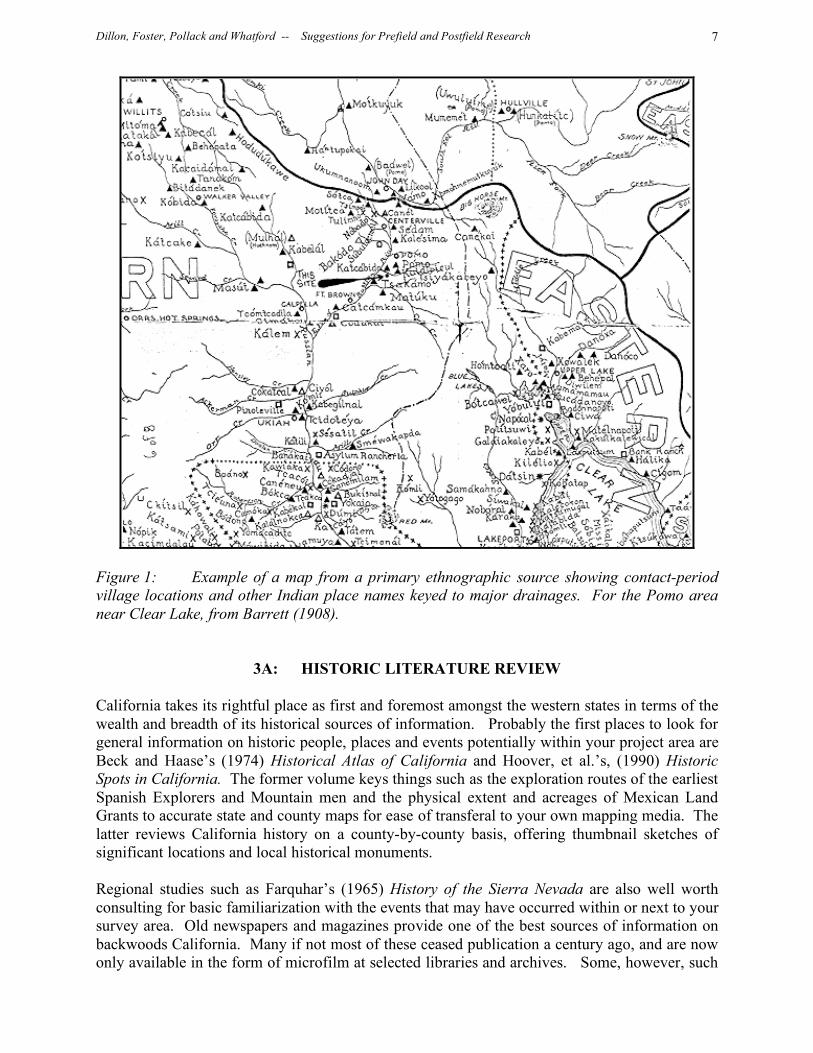
Above and beyond the basic requirement of Native American contact, expanding your ethnographic knowledge about the area to be surveyed will help to make better sense of any information received about its past or present California native inhabitants, and its potential significance to them. The place to start is with Alfred Louis Kroeber’s (1925) Handbook of the Indians of California. This encyclopedic volume attempts to characterize every Indian tribe within the state, and all subsequent ethnographic research in California is built upon this outstanding foundation. Largely because of the work of A.L. Kroeber and his turn-of-the-century associates at UC Berkeley, few states have had as much intensive ethnographic research and publication as California. Early ethnographers typically mapped many tribal villages and local landmarks by their Indian names, and sometimes produced area maps of fantastic detail and accuracy. One such map (Figure 1) is offered as an example of what might be learned from a little ethnographic prefield research. So, if you survey your project area, find “nothing” and report same, but only after your report is in the review process learn that a major Indian village was mapped within it 90+ years ago, considerable doubts will be expressed about the accuracy of your own survey. Such embarrassment is best prevented through a little prefield research on the California Indian tribe or tribes known to have occupied the vicinity of your survey area. Lest it be thought that ethnographic research was only a thing of the past, this work continues today in some parts of our state. Much more recent, and perhaps even broader in scope and scale, is the Handbook of North American Indians, Volume 8: California (Heizer, ed., 1978) which again treat California Indians on a tribe-by-tribe basis as does Kroeber. A major contribution of this later volume are the many excellent photographs, line drawings, and maps showing tribal boundaries and possible contact-period Indian village locations. Bean and Vane (1990) provide a useful, albeit now somewhat dated, listing of sources of ethnographic information on California Indian groups on a California county-by-county basis. These include University, public and private research libraries, historical societies, small public and private museums, archives, outposts of City, County, State and Federal agencies such as parks, cultural centers, Indian reservations, Indian outreach programs, and so forth and so on. The authors go on to list similar research resources on national and international levels, which might also occasionally be of utility to local researchers. By the 1990s, the California Indian Library Collections (CILCs) began being built at various northern California county libraries by the California Indian Project at the Lowie (now the Phoebe Hearst) Museum of Anthropology at the University of California (UC), Berkeley. Each CILC was designed to consist of materials on the indigenous Indian culture(s) of that county. Each CILC is legally owned and curated by the county library and culturally and morally owned by the local Tribes. Original plans for the CILCs were to involve, for the one year before a CILC was installed, a committee of librarians and Native people working together in each county to develop a working partnership for permanently management and use of the CILC.
Dillon, Foster, Pollack and Whatford -- Suggestions for Prefield and Postfield Research 6
Each CILC includes copies of written, photographic and audio materials. The written materials include published books, out-of-print books, journal articles, field notes, government documents, monographs, pamphlets, maps, and similar types of materials. Photographic materials include copies of the Phoebe Hearst Museum’s vast photographic collection on Native California, which consists of approximately 10,000 negatives. The CILC audio collection includes copies of two large archival collections: the Museum’s collection thousands of hours of early California Indian music and the Language Laboratory’s audio collection of thousands of hours of post-World War II language and music recordings from Native California. Materials included in the CILCs also consist of copies of materials from the various archives, museums, and libraries at UC Berkeley, the largest single repository of materials from Native California. By 1989 the CILCs had been installed at Lake, Fresno and Madera Counties. Once these were established at the libraries in those counties, local Native and non-Native people added to those collections by donating family photos, rare documents, and so on. Although the original goal of the California Indian Project was to establish CILCs at each of the 58 California county libraries by 1995, due to funding shortfalls there are presently CILCs at only the following 20 California county libraries: Butte, Colusa, Del Norte, Fresno, Glenn, Humboldt, Lake, Lassen, Madera, Marin, Modoc, Plumas, Shasta, Siskiyou, Sonoma, Tehama, Trinity, Yolo and Yuba. In addition to these county-based CILCs, the California Room at the California State Library in Sacramento [(916) 654-0176] has a duplicate copy of each of these CILCs. The CILCs at the State Library have been catalogued and are searchable via the Internet. By now the CILCs at the various county libraries listed above should have been catalogued as well and should likewise be Internet-searchable. To find out if a county not on this list has received its CILC, call the County Library. Finally, California is fortunate in having its very own scholarly publication series devoted to California Indian archaeology, ethnology, and history, the Journal of California Anthropology (1974-1979), subsequently renamed and expanded in scope as the Journal of California and Great Basin Anthropology (1979-present). Ongoing research amongst surviving California Indian groups, publication of long-unpublished early ethnographic information, and early historical accounts of California Indians by non-Indians make this series uniquely valuable to anyone conducting ethnographic research in California.
Dillon, Foster, Pollack and Whatford -- Suggestions for Prefield and Postfield Research 7
Figure 1: Example of a map from a primary ethnographic source showing contact-period village locations and other Indian place names keyed to major drainages. For the Pomo area near Clear Lake, from Barrett (1908).
3A: HISTORIC LITERATURE REVIEW California takes its rightful place as first and foremost amongst the western states in terms of the wealth and breadth of its historical sources of information. Probably the first places to look for general information on historic people, places and events potentially within your project area are Beck and Haase’s (1974) Historical Atlas of California and Hoover, et al.’s, (1990) Historic Spots in California. The former volume keys things such as the exploration routes of the earliest Spanish Explorers and Mountain men and the physical extent and acreages of Mexican Land Grants to accurate state and county maps for ease of transferal to your own mapping media. The latter reviews California history on a county-by-county basis, offering thumbnail sketches of significant locations and local historical monuments. Regional studies such as Farquhar’s (1965) History of the Sierra Nevada are also well worth consulting for basic familiarization with the events that may have occurred within or next to your survey area. Old newspapers and magazines provide one of the best sources of information on backwoods California. Many if not most of these ceased publication a century ago, and are now only available in the form of microfilm at selected libraries and archives. Some, however, such
Dillon, Foster, Pollack and Whatford -- Suggestions for Prefield and Postfield Research 8
as the remarkable, heavily illustrated Hutchings’ California Magazine, offered between 1856 and 1861, have been reprinted, at least in part, in facsimile form (Olmsted, 1962) and can be easily accessed. Historical archaeology is concerned as much with old and sometimes now-vanished technology as it is with the people and places involved; a familiarity with historic tools and working methods is therefore essential prior to field study. The CDF training manual, presently in two-volume form, is the cumulative result of over 15 years of constant revision and improvement (Foster, et. al, 2005) and contains numerous specific topical guides to the recognition of historic items as diverse as solder-top tin cans and wire cut nails. CDF has also published a single volume containing three topical papers on common kinds of historical technology typically encountered on California survey projects: these include firearms technology (B. Dillon, 1995a), mining technology (B. Dillon, 1995b) and logging technology (Dillon and Dillon, 1995). And, CDF continues to offer reference works on historical archaeological topics, most recently Waechter, et. al.’s (2006) How Old is “Old”? guide to the recognition of historic sites and artifacts. Additional sources of information on historical technology as it may be encountered in California ranges from very early to very late. Russell’s (1967) Firearms, Traps and Tools of the Mountain Men is the standard work on this subject, and may prove invaluable if you come up with a rusty axe-head with a tree grown up around it on your survey, and would like to know if it dates to 1830 or to 1930. Similarly, those rusted fragments of broken cast-iron or “Franklin” stove bearing the “Acme Rover” brand name you find at that undated potential homestead on your survey may not in fact be of Gold Rush age, provided that you take the trouble to look on page 641 of your 1908 Sears, Roebuck Mail Order Catalogue reprint (Schroeder, 1969) where you will find it listed for sale for only $6.75. Or, if that rusted percussion gun barrel you find on that mountaintop bears an unfamiliar maker’s mark, you might just find a reference to the craftsman who made it in 1850’s San Francisco, or Marysville, or 1860’s Yreka in Shelton’s (1977) inventory of early California gunsmiths. Mining technology is ably explained through text and delightful line drawings by Young (1970) in his outstanding book Western Mining. In many cases, the kinds of working scars on sidewalls can indicate what kinds of tools were used in cutting into the mountainside, and, correspondingly, simply knowing what technology was employed in hardrock mining allows one to make a dating estimate of fair accuracy. And, lest anyone think that all early “advanced technology” in historic California was necessarily imported, one can examine the birth of heavy industry in California (R. Dillon, 1984) by the Donahue brothers of San Francisco, who began with a simple blacksmith’s shop in 1849. Before the Donahues, every length of log chain or crosscut saw, or for that matter, every axe head or the bar-stock even for making wagon tires, had to be imported either from the East Coast, coming around the Horn in a six-month voyage. The Donahues changed all of that. They added a gasworks to their blacksmith shop in 1852, and in short order built the very first boiler works, modern machine shop, and iron foundry anywhere on the entire Pacific Coast of North, Central and South America. Before too long the Donahues and their Union Ironworks were making the first locomotives and iron rails on the Pacific Coast as well as the first ship boilers and steam engines. All of this was done primarily so as to supply the constantly increasing demands of the mining and lumbering industries in the California hinterland, and the odds are pretty good that any very early iron artifacts found at any mining or logging site in much of California might have been made by the Donahue brothers possibly as early as the 1850’s or ‘60’s.
Dillon, Foster, Pollack and Whatford -- Suggestions for Prefield and Postfield Research 9
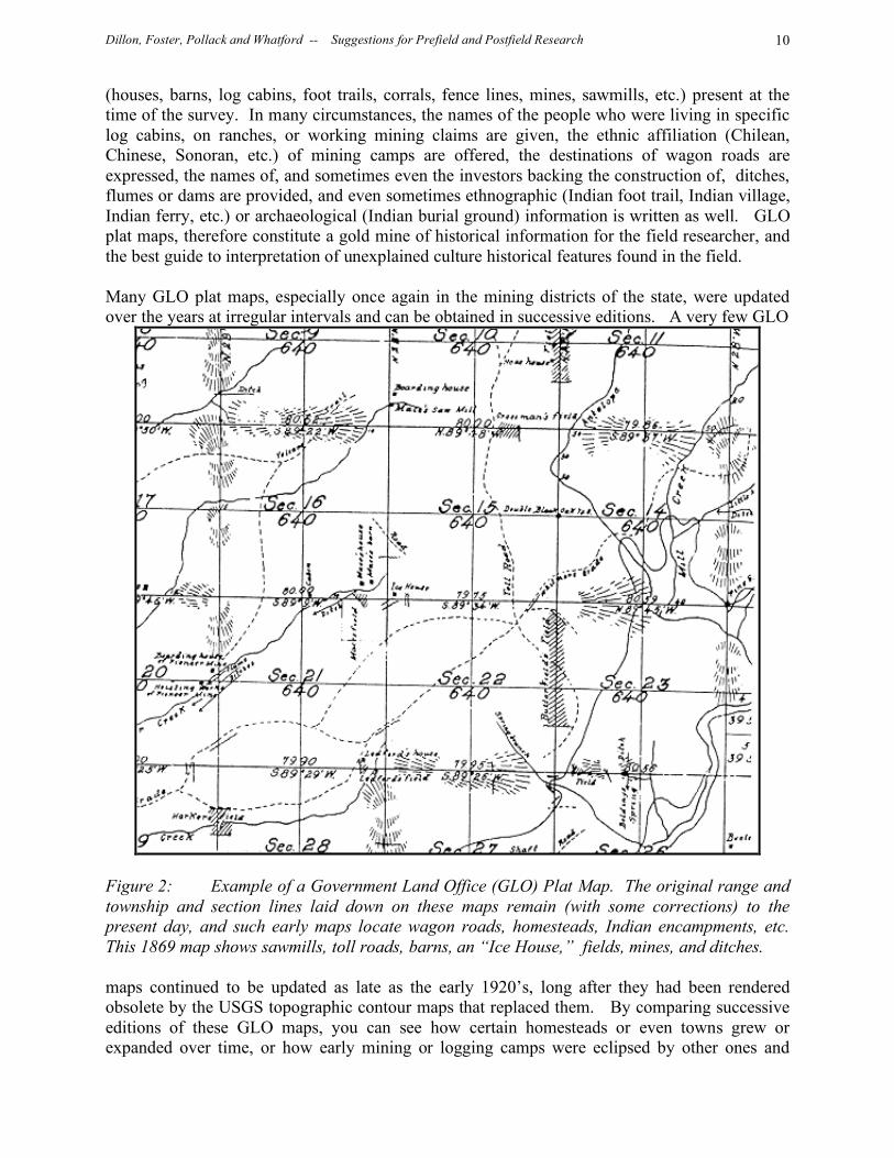
3B: HISTORIC MAP REVIEW Prior to going into the field, you should plot your project area on an original USGS 7.5 minute quad map, one showing all appropriate vegetation shading and topographic contours. Study the topography, vegetation, hydrology, aspect, place names, forest openings, etc. and then, on a clean Xerox copy of that same map, highlight those areas you believe most likely to contain sites. Make sure that your on-foot survey includes intensive coverage of all circled areas, in addition to adequate coverage of the remaining areas. But don’t stop there, with only the most recent map of your study area, for historic maps provide one of the most valuable sources of both prefield and postfield research information about local history, ethnology, and even archaeology. The modern USGS maps which all officially-sanctioned archaeological surveying in California must be keyed to are the 7.5 minute series, or 1: 24,000 scale. These 7.5 minute maps have now completely replaced the earlier USGS 15 minute, or 1: 62,500 scale, maps that were standard for more than half a century. The old 15 minute topographic maps themselves replaced earlier 30 minute topographic quads, and the 30 minute maps replaced the earliest generation of California maps, the old, original GLO sheets that made no pretence at topographic accuracy, yet which incorporate the greatest amount of historical and ethnographic information of any of the California map series. Many historic maps can be obtained in facsimile or in blueprint form from the National Archives, from the California State Library, or from map collections in city and county libraries or archives. Few if any of the earliest maps of California are in English, but in Spanish, French, or even Russian- most have been reproduced and their notations translated for ease of use by modern researchers. Of paramount interest to all California researchers are the maps made by Fray Francisco Garces in the 1760’s and ‘70’s, showing the layout of the Sierra Nevada, the Tehachapis, and other interior features with any degree of accuracy for the first time. Equally fascinating are the maps of Duflot de Mofras of the 1820’s, showing the Russian buildings at Fort Ross, the Sonoma County coastline, and many other recognizable features, many with Russian names that passed from use almost two centuries ago. Most of the English-language historic maps of California date from the Gold Rush period or later. Some of these are important mainly as a record of when local streams and/or mountains got their names, or at least first had their names cartographically recorded. A wonderful example of an early California map in English is the E.O.C. Ord Topographical Sketch of the Gold and Quicksilver District of California, dated July 25th, 1848, which attempts to locate and confirm every location within California up to that time where gold had been found. Some of these early maps are of supreme importance to researchers working in specific parts of our state. Anybody doing research in the Warner Mountains of Modoc County, for example, cannot help but be intrigued by Lieutenant Williamson’s (US Topographical Engineers) map of “Captain Warner’s Exploring Party in the Sacramento Valley, and Sierra Nevada, 1849” which ends with the cryptic notation at its northeastern margin “Capt. Warner killed [here] by Indians, Sept. 26, 1849”. Beginning as early as the 1850’s in the Mother Lode country, principally as the result of concerns over ownership of mining claims or water rights and the accurate placement of same, the Government Land Office (GLO) began mapping California. These plat maps (Figure 2) typically show a single range and township, subdivided into sections, with most of the major hydrologic features superimposed. They also show in most cases many of the cultural features
Dillon, Foster, Pollack and Whatford -- Suggestions for Prefield and Postfield Research 10
(houses, barns, log cabins, foot trails, corrals, fence lines, mines, sawmills, etc.) present at the time of the survey. In many circumstances, the names of the people who were living in specific log cabins, on ranches, or working mining claims are given, the ethnic affiliation (Chilean, Chinese, Sonoran, etc.) of mining camps are offered, the destinations of wagon roads are expressed, the names of, and sometimes even the investors backing the construction of, ditches, flumes or dams are provided, and even sometimes ethnographic (Indian foot trail, Indian village, Indian ferry, etc.) or archaeological (Indian burial ground) information is written as well. GLO plat maps, therefore constitute a gold mine of historical information for the field researcher, and the best guide to interpretation of unexplained culture historical features found in the field. Many GLO plat maps, especially once again in the mining districts of the state, were updated over the years at irregular intervals and can be obtained in successive editions. A very few GLO
Figure 2: Example of a Government Land Office (GLO) Plat Map. The original range and township and section lines laid down on these maps remain (with some corrections) to the present day, and such early maps locate wagon roads, homesteads, Indian encampments, etc. This 1869 map shows sawmills, toll roads, barns, an “Ice House,” fields, mines, and ditches. maps continued to be updated as late as the early 1920’s, long after they had been rendered obsolete by the USGS topographic contour maps that replaced them. By comparing successive editions of these GLO maps, you can see how certain homesteads or even towns grew or expanded over time, or how early mining or logging camps were eclipsed by other ones and

Dillon, Foster, Pollack and Whatford -- Suggestions for Prefield and Postfield Research 11
subsequently abandoned. In many cases, by comparing the different editions of the same GLO plat map, you can confidently state when a given historic site came into being, and when it stopped being used. If your prefield research with GLO maps reveals any historic features within your own survey area, a careful search should be made for any surviving remnants and for any unmapped associated features or artifacts. And, the surveyor's notes that accompanied the plats are also usually available and may also be reviewed. The GLO surveyor’s notes, many of which have been converted to typescript from the original hand-written form, are full of observations that didn’t, for one reason or another, make it onto the final map. GLO plat maps and records may be obtained through the mail or in person at the Bureau of Land Management Office of Survey Records, Room West 1605, 2800 Cottage Way, Sacramento, California 95825. Call first; the telephone number is (916) 978-4330. The cost is $1.10 per plat (24’ X 36”). Historic GLO plat maps are also kept at many of the Information Centers, and some of these offices might be able to provide a copy of a relevant portion, upon request, as part of CDF Project Records Check. Even maps much later than the old GLO series can be of immense historical and sometimes of ethnographic value, for they often record features long since vanished and now “invisible” out in the field, or long since diminished in their integrity, or which have simply vanished from more recent maps. The earliest 15 minute maps date to the 1890’s in California, and can show then-occupied places that have subsequently become ghost towns: the 1898 15 minute Mount Diablo Quadrangle, for example, shows the small mining town of Somersville as the largest settlement on the northern half of the map, with its own railroad running to it. A later, 1943, edition of the same map shows nothing at this location at all, except a dead end road, as if Somersville had never existed. Conversely, some of those early 15 minute maps, such as the 1901 Carquinez sheet, reveal the locations of long-vanished prehistoric shell mounds around the margins of Suisun Bay: where the contour lines close for no apparent reason out on, or adjacent to, the tidal mudflats, the only explanation is an Indian shellmound of some height and bulk. And such archaeological features detectable through closed contours on such early topographic maps are not limited to coastal shell middens: the 1916 1: 62,500 scale Byron quad sheet, surveyed in 1911, shows numbers of earthen mounds in the San Joaquin Delta area that can only represent abandoned prehistoric Indian villages, with local placenames (Indian Slough, for example) doing nothing to diminish the likelihood of this interpretation. Earlier USGS maps appearing at the latter part of the 19th and early part of the 20th centuries employed scales and in formats that long ceased to be used. For example, some early maps up to the ‘teens were issued in 1: 31,680 scale, not quite equivalent to our modern 7.5” maps, while others made by the military along USGS lines simply showed as blank areas of little or no interest to the national defense concerns of the time. An interesting series of maps of the California coastal strip dating from around 1915 through the early 1920’s at 1: 62,500 scale were produced by the US Army Corps of Engineers for the US Army’s Coastal Artillery Command. These very accurately show the shoreline, offshore rocks and ocean depths, but only a single mile’s worth of detailed topographic contours inland. Even more unusually, these US Army Tactical Maps have gridlines superimposed, not from R/T section lines, UTM divisions, or any other such mundane source, but a 5000 yard (3 mile) grid for artillery fire spotting and correction. Many obsolete 30 minute (1: 125,000) scale maps dating to the turn of the century reveal historic features that may be missing from later maps or of uncertain dating on them: the
Dillon, Foster, Pollack and Whatford -- Suggestions for Prefield and Postfield Research 12
1903 Mt. Pinos 30 minute quadrangle, for example, reveals five structures in Mutau Flat in four different sections, establishing occupation for all five at the time of the 1901 survey resulting in this map’s creation. Since successive editions of the same map tend to incorporate cumulative changes occurring over time, it is educational to review progressively later versions so as to see which historic features have “dropped of the map” over the years. Their traces may still be there on the ground, despite the lack of references to them on more recent editions of the same map. And, as urban and suburban sprawl continues on in California, the velocity of such urbanization can often be measured simply by comparing two identical maps of different editions: a case in point are the 1947 vs 1975 editions of the USGS 1:250,000 scale Los Angeles maps. The 1947 edition shows now densely-populated desert and mountain areas as completely unpopulated. The mossy redwood split-rail fence you find running along part of one of your section lines with mature trees growing up around and even through it remains unexplained no longer if you find, on your GLO plat map, the notation that a homestead existed there 130 years ago. If you are lucky, the plat map will even show the location of the cabin associated, the family plot cemetery, and give the name of the family involved. And, the short stretch of sunken dirt wagon road or even narrow mule trail encountered in the middle of the forest with 80 foot tall trees growing up from its bed may seem hard to interpret, until one checks the 1891 USGS 30 minute Big Trees Quadrangle, which clearly shows the routes of old wagon roads and horse or mule trails originally laid down in the 1850’s, but abandoned by the 1920’s as the automobile came to demand easier grades. And, one never knows what may lurk on even the most mundane of early maps; the Thomas Brothers undated but circa 1930 map of Monterey, Carmel, Pacific Grove, Pebble Beach and Asilomar shows virtually all of Pebble Beach as subdivided into lots with acreages calculated, and not yet built upon, with the cryptic reference to a Deserted Indian Village just to the east of 17 Mile Drive and Western Way. Finally, while not maps per se, aerial photographs can be very useful in locating or interpreting historic, ethnographic, or even archaeological sites or features during pre- or postfield research. Frequently, air photos taken some time after a given area was mapped will reveal things that don’t show up on the map because they only minimally post-date that map. Or, they may reveal things considered too insignificant to include on the map, such as short sections of narrow wagon road that lead nowhere, old, overgrown clearings that were once homesteader’s fields but now are mapped as a uniform vegetation type, and so forth and so on. As with maps, the earlier the Air Photo, the better, for those dating to the 1940’s or even earlier may show historic structures still standing that have long since fallen down, or been burned over, etc.
3C: COUNTY HISTORIES Most California counties had “mugbook” histories written for them in the 1880’s, and while these provide fascinating glimpses of the farms, orchards, lumber yards, and sawmills of the period, they are hardly encyclopedic nor all-inclusive in their coverage. Each typically begins with a thumbnail sketch of the county’s history, then provides specific inventories and often panoramic views of the spreads of the wealthiest landowners and their portraits as well. Hardly altruistic history, instead these were thinly veiled 19th century subscription “who’s whos”; you had to pay the author/publisher so much in order to get a mention in one of these books, so much more to commission a drawing of your property (which of course, increased its resale value) and
Dillon, Foster, Pollack and Whatford -- Suggestions for Prefield and Postfield Research 13
more still in order to commission a black and white portrait. One example of these, the History of Eldorado County, California (Sioli, 1883) opens with the Spanish Colonial Period, proceeds to the Mexican Period, moves on directly to the Gold Rush, and then describes the mines, roads, farms, even the “secret societies” of the county. It then provides thumbnail sketches of local towns and mining camps (Murderer’s Bar, Mosquito Valley, etc.) and ends with dozens of short biographical sketches of prominent citizens, at least some of whom might have been connected with just about any backwoods part of Eldorado county through farming, ranching, or lumbering that a modern CDF surveyor might venture to more than a hundred years later. In more recent years, most California counties have had more modern histories written, some of which tend to follow the earlier pattern of subsidized, full or multi-page entries by contemporary business concerns desiring a “plug” at the end of the book in order to pay for the preceding chapters of local history. Verardo and Verardo’s (1987) Restless Paradise, Santa Cruz County: An Illustrated History is typical of such offerings. Lawson’s (1986) Redding and Shasta County: Gateway to the Cascades details a different county but the same format- a final chapter of local business ads. Mace’s (1993) Between the Rivers: A History of Early Calaveras County, California on the other hand, eschews the internal advertising and instead contains numerous short vignettes of local historical interest, each focused upon a specific part of the county. Most of the short chapters contain maps, indicating just exactly where the action described took place.
3D: TOWN HISTORIES AND GHOST TOWNS The basic source on vanished settlements within our state is Miller’s (1978) Ghost Towns of California. Primarily devoted to old mining settlements, nevertheless lumber camps, milltowns, and even abandoned or moribund agricultural settlements are also included. The volume is well-illustrated with old lithographs and photographs, both historical and modern. The listings are alphabetical by name of the “ghost town” rather than by geographic area or by county, so if you don’t know the actual name of the abandoned high elevation mining camp on your THP, you may have to do some literary “digging” before you find a named candidate that might apply to your own survey situation. Many small towns of historical significance in California have been “written up” by local historians, who often do not simply limit their discourse to “in-town” biographical history, but expand their coverage to the surrounding farmland, woods, or mining districts as well. Recent, and random, examples from opposite ends of the state include LeMenager’s (1992) history of Julian City and the Cuyamaca country of highland San Diego County, and Jackson’s (undated) Daily Journal of Mendocino City from 1852-1938. The former provides abundant information about the earliest settlements of the area, vanished mines and mining towns, early settlers and events through separate “vignette” sections, while the latter takes the unique approach of running through the daily calendar and reviewing locally significant events which occurred on that date (i.e.: for March 20th, we find entries for 1857, 1895, 1910, etc., etc.). And, researchers of California’s hinterland should not be too quick to bypass the histories of their state’s major cities, for it was in such places as San Francisco and Los Angeles that most of the literate people lived, or at least visited, who took the trouble to write things down, where many of the earliest newspapers were published, and where some of the earliest libraries and archives were founded. Harris Newmark’s (1984) Sixty Years in Southern California is therefore not so much just an early history of Los Angeles as it is an eyewitness account of the
Dillon, Foster, Pollack and Whatford -- Suggestions for Prefield and Postfield Research 14
development of the entire State of California’s southern half, including comments on mining, logging, transportation, town foundings, etc., from the time of Newmark’s arrival in 1853 up until he concludes his story in 1913. Newmark knew everybody and wrote about everybody, from the Pico brothers to Phineas Banning; his book is meticulously indexed and in it one can almost always find an interesting comment about just about any place in Southern California one may find oneself working in.
3E: PLACENAME RESEARCH Placename research can be particularly fruitful, and the first step is typically to review the maps for your study area and note any and all placenames. Placenames may be simply personal names (i.e. Harris Mountain), Indian words (Tamalpais), descriptive terms (Hardscrabble Gulch) and so forth and so on, but all of them can sometimes provide clues to the local history, ethnology, and sometimes even archaeology of backwoods California. The standard reference work on California placenames is the volume of the same name by Gudde and Bright (1998). This remarkable book lists towns, mountain peaks, deserted lumber camps, intermittent streams, even dried-up springs by name and sets them firmly into geographical and historical context. More specific works are available, sometimes on a county-by-county basis (cf: Clark, 1986, for Santa Cruz County Place Names) or for specific geographic areas (i.e: the Mother Lode Country, the North Coast Ranges, etc. A stand-alone volume by Browning (1991) Place Names of the Sierra Nevada is not so much in-depth history as an index of placenames keyed to the appropriate USGS 15’ or 7.5’ quad sheets. As such, it provides a useful key towards locating which map a given location of historical interest might be located upon, something missing from just about every other historical publication or document. Many if not most old placenames never end up on published maps, and this is where talking to old-timers, local Indians, or other informed people can be quite productive.
3F: HISTORICAL SOCIETIES Regional historical societies all have quarterly newsletters or publications that can be of great utility to field surveyors in California. One of the oldest and most respected of these is the California Historical Society Quarterly, based out of San Francisco, and in publication since the early 1920’s. While the former organization and its journal covers the entire state, a second such body and its publication, the Historical Society of Southern California, founded in 1891, and its Southern California Quarterly focuses on the southern half of the state. One of the best California historical publications is the California Territorial Quarterly, formerly the Dogtown Territorial Quarterly, based out of Paradise, California. This outstanding little quarterly typically lists at the back of each issue, all known “California Historical Societies, Museums and Research Groups,” with hours of operation, contact telephone numbers, and, where available, internet addresses. Of more general geographic focus is the Western History Association, based at Utah State University, which has had occasional coverage of California topics in its Western Historical Quarterly since the early 1960’s. California County historical societies typically publish either annual reports or “yearbooks”, quarterly newsletters, magazines, or even special publications on topics of local historical

Dillon, Foster, Pollack and Whatford -- Suggestions for Prefield and Postfield Research 15
interest. For example, if you live and work in or adjacent to Siskiyou County, you should know that the Siskiyou County Historical Society has published its Siskiyou Pioneer report series since its inception in 1945, and at least one such volume may just contain a writeup of the long-forgotten milltown, ranch, or mining camp within your study area. County or even City Historical Society publications run the gamut from “newspaper format” offerings such as Las Calaveras, the Calaveras County Historical Society Newsletter, all the way to very slick and professional, book-bound offerings such as the Journal of San Diego History, the publication of the San Diego Historical Society. Every one of these local historical societies have archives of unpublished documents, maps, diaries, historical photographs, and so forth and so on: typically they are housed in the county libraries or courthouses. County historical societies are also the best place to get in contact with local “old timers” who may have essential information about your study area, and who might be unreachable through any other means. Typically, such folks are eager to share what they know, and have sometimes been waiting for years to run into someone who might just be interested in that part of the woods where their grandfather was a logger, a homesteader, or a rancher. Local tax assessor’s offices sometimes also have records going back well into the 19th century, and chain of title research can often reveal the names of the earliest historic occupants of a given property being surveyed, even if abandoned for a century or more. Often the members of the local historical society have already researched such county archives, and can offer invaluable advice about what they contain. Obviously, much if not most research work done in conjunction with local historical societies will be more appropriate to postfield research than to your prefield investigations. So, once you come up with an old family name associated with that abandoned sawmill, homestead, or cemetery you found during the course of your survey, run it by the local historical society and see if you get a “hit”. Doing so beats going through the telephone book, and calling that name at random in the hopes of finding a local, living descendant.
3G: HISTORIC TRAILS Historians interested in the early routes to and through California have been particularly active in recent years, both in finding and publishing the diaries of individual argonauts, in creating “biographies” of the specific trails themselves, as well as in mapping and marking the many trails to and through our fair state. In the former context only a few examples need suffice: Stewart’s (1962) The California Trail: An Epic with Many Heroes is a classic work, detailing all of the various overland routes to California from the eastern states, both before and during the Gold Rush. From our perspective, however, the bulk of the book is of only marginal interest, for most of the “mileage” expended on each route lies outside of California. Benjamin Butler Harris’ The Gila Trail to California (R. Dillon, 1960) recounts adventures along the route favored by southerners heading for the California gold fields, including observations made in abandoned California Indian villages, comments about then-abundant game (tule elk, for example) now unfortunately locally extinct, and, of course, of the many now-vanished California gold camps of the late 1840’s and early 1850’s. At the other end of the state, the much older Siskiyou Trail (R. Dillon, 1975) entered California from the Oregon Country to the north. This route was made famous by the Hudson’s Bay trappers that regularly invaded Mexican California in search of pelts, and brought the catastrophic disease against which the California Indian populations had no natural immunity. Charles K. Graydon’s Trail of the First Wagons Over the

Dillon, Foster, Pollack and Whatford -- Suggestions for Prefield and Postfield Research 16
Sierra Nevada (1986) is a very useful reference for the northern Sierra Nevada which contains detailed maps, in 1:24,000 scale, showing trail locations. In addition to such scholarly works on specific trails ending in California are those which take the form of annotated atlases, detailed reference works which both trace the actual routes of travel and index specific locations to historical events, personalities, and published and unpublished documentary sources. An example of such ongoing research is Helfrich and Hunt’s (1984) Emigrant Trails West which not only provides maps, but contemporary photographs as well for ease in orientation and relocation. And, don’t neglect to review the GLO plat maps once again for portions of emigrant trails that in some cases were still in use when the surveys for those maps were made.
3H: HISTORIC PHOTOGRAPHS AND OTHER PICTORIALS Historical photographs are moments frozen in time. Everything present at the moment the exposure was taken, regardless of whether or not it later was removed or disappeared, is still there and is still visible. So, particularly in the context of postfield research, historic photo review is a useful tool in historic reconstruction and interpretation. California attracted a few photographers as early as the Gold Rush who recorded daguerrotype or albumin images when photography was barely a decade old and still experimental. Professional photographers of later decades in California often expanded their interests and coverage from the standard “studio portrait” fare (that tended to pay most of the bills) into the state’s hinterland, recording long-vanished landscapes and technologies that can often explain better than any other source of information the fragmentary traces of what can be seen today on field surveys. Carleton Watkins (Nickel, 1999) settled in San Francisco and began taking photographs in California in the mid-1850’s. By the early 1860’s he was recording, besides shipwrecks on the San Francisco seacoast, the New Almaden quicksilver mines and the Yosemite Valley, early logging camps and sawmills on the Mendocino County Coast, and Pomo Indian semi-subterranean earth houses. By the 1870’s he was photographing giant wooden dams impounding water for mining and logging flumes and ditches in the high Sierra, and hydraulic mining in the northern Mother Lode. As late as the early 1890’s, Watkins was making panoramic views of entire California rivers artificially taken out of their beds, routed through man-made flumes so that placer mining could be done on their exposed bottoms, or detailed exposures of teams of Butte County Chinese miners 40 feet down in open pits feeding ore from wheelbarrows into conveyor-driven lifts. A.W. Ericson (Palmquist, 1975) came to California much later, ca. 1869, and worked as a logger in Trinidad before opening a store and eventually becoming a photographer around 1883. For more than 40 years, until his death in 1927, Ericson became the premier woods photographer of northwestern California, his action photos of loggers felling the forest giants attracting world-wide attention. More important for any historical study of logging methods are his recordings of old logging camps, oxteams, narrow-gauge railway logging efforts, and lumber lighters being filled with milled wood via slings offshore. All California anthropologists are indebted to Ericson for his rare and uniquely valuable ethnographic photographs of northwestern California Indians, including the famous series made of the white deerskin dance as practiced by the Yurok, Karuk and Hupa peoples of the Klamath and Trinity River country, and of his contemporary California Indian portraits.
Dillon, Foster, Pollack and Whatford -- Suggestions for Prefield and Postfield Research 17
But, for every well-known Ericson or Watkins photograph of historical significance, there must be hundreds of equal importance residing in family photo albums, inside frames hanging on walls of fourth or fifth-generation California family houses, or lying undeveloped as negatives in old shoeboxes inside steamer trunks in California attics. Historical photo collections can be found in every major library within the state, at most universities, and within most historical society archives. Oil paintings, watercolors, ink or pencil sketches may “freeze” a moment of history as well or even better than the camera can, yet because of the problems inherent in their duplication, may not be well known or even exist outside of the museums or special collections within which they reside. In some cases, the historical value of such art works has been recognized, and they have been republished in easily accessible form, the best such recent example being the spectacular Art of the Gold Rush (Driesbach, et. al, 1998). In this volume we find such offerings as John W. Audubon’s water colors of 1849 mining camps where every dwelling is a canvas tent, the beautiful oil paintings of Charles Nahl of early 1850’s California miners at work and at play in the mother lode country and even of an impromptu miner’s burial beneath the ponderosa pines of the high sierra, water colors by G. H. Burgess of mining activities and daily scenes from the early 1850’s incorporating California Indians, and so forth and so on. As with historical photographs, the numbers of oil paintings, watercolors, and ink sketches that have been reproduced in books is very small compared to those of historical significance still in private or public ownership that await discovery by the determined researcher. Some television documentary programs can be of great research value, are worth watching more than once and, in fact, can be obtained in videotaped form. As early moving pictures slowly become, in some cases, sources of historical information, we can expect some documentaries to achieve “research resource” status, especially when leading California historians contribute to their writing and ensure their accuracy. A case in point is the recent American Experience (2004) one hour videotape on the building of the Golden Gate Bridge, the completion of which, in 1937, is the event accounted by most authorities as ushering in California’s modern period. If a single picture can be said to be worth a thousand words, then a single segment of 80-year old moving picture showing vanished technologies, such as steam donkey logging, or felling forest giants with two-man misery whips, are worth a thousand photographs. Anybody working in the woods, be they foresters, archaeologists, or any other resource professional, should take the trouble to find and watch such gems as Bullwhackers, Catskinners and other Timberbeasts (Shannon, 1993) which puts the people back into the historic forest landscape and recreates historic logging practices with greater ease and facility than hundreds of pages of writing ever could. In fact, some early motion-picture footage is invaluable as the sole remaining means of preserving and recording of now-vanished technology and working methods. But, don’t expect to find anything at all through the mass media of film, videotape, or television that will relate specifically to what is present or absent on your own little 200 acre study parcel: you still must answer these questions yourself.
3I: LOGGING AND RAILROAD LOGGING HISTORIES
Depending upon your research area, a local logging history may already have been written about it. These tend to be either the story of a single company, almost invariably tied to its own railroad line, usually now vanished, or of a specific logging region. Most are plentifully

Dillon, Foster, Pollack and Whatford -- Suggestions for Prefield and Postfield Research 18
illustrated with historic photographs and maps, and some are even indexed as to place names and principal participants. One of the most prolific writer of such tomes was Ralph W. Andrews, who produced a steady stream of them during 1950’s and ‘60’s, many reprinted repeatedly since the 1980’s. Andrews’ books tend to be little more than collections of historic photographs with informative captions, and often have little unifying them in terms of geography, yet anyone interested in the history of logging in California should take a look at them. And, sometimes, you can even find a hundred-year old photograph of the burnt sawmill you have identified within your survey area, complete down to the names of the mustachioed mill hands posing in front of the giant logs being milled, between the covers of one of them. Andrews (1954) kicks off his series with This Was Logging which mainly is devoted to providing captions to the Washington State photographs of Darius Kinsey, but with brief forays into California. Andrews’ second (1956) book was Glory Days of Logging, and involves Siskiyou and Mendocino County logging only in “hit and run” fashion, again being devoted mainly to lumbering to the north. Next up, Andrews’ (1957) This Was Sawmilling discusses early mills in Siskiyou, Humboldt and Mendocino Counties, California, but mainly is devoted to sawmilling in Oregon, Washington, and British Columbia. Andrews’ (1968) Timber: Toil and Trouble in the Big Woods mainly concerns British Columbia, Washington and Oregon, but is useful for many historical photographs of sawpit or elevated frame whipsawing, which was how all Spanish Colonial and most Mexican Colonial period lumber production was done in California. Andrews’ Redwood Classic (1985) jumps all over California, with brief stops in Sonoma, Mendocino, Humboldt and Del Norte Counties, and occasional forays into Tulare, Fresno and even Santa Cruz and Santa Clara Counties: it is the most “Californian” of all his volumes. One of the earliest railroads in the world built at least in part to respond to logging interests was the Northwestern Pacific Line, serving Duncan’s Mills and other Sonoma and Marin County logging operations of the 1860’s and 1870’s. An early book on this line, peripherally involving the logging operations it was routed to, is Redwood Railways (1956) by Kneiss. A much more elaborate work on the same line, the Northwestern Pacific Railroad: Redwood Empire Route, came eight years later (1964) by Stindt and Dunscomb. This latter work is heavy on rolling stock, and light on logging, but accurate maps and historic photos show much of the now-vanished standard-gauge route. Also devoted to the North Coast Ranges of Mendocino, Humboldt, and Del Norte Counties is Carranco’s Redwood Lumber Industry (1982), which focuses upon felling the forest giants in the pre-chainsaw days. Two useful appendices, listing the sawmills of Humboldt and Mendocino Counties, their founding dates, owners and years of operation, round out the volume. Carranco and Labbe (1989) some years later expand the earlier offering with Logging the Redwoods, which seems more a means of offering additional historic photographs of North Coast range historic logging into descriptive captions that wouldn’t fit in the previous work than it does an entirely new book. Ted Wurm (1986) wrote an excellent account of the Caspar, South Fork, and Eastern Railway system in what is now the Jackson Demonstration State Forest in Mendocino County. Polkinghorn’s (1984) Pino Grande: Logging Railroads of the Michigan-California Lumber Co details the innovative central Sierrra Nevada logging operations on the Georgetown Divide of
Dillon, Foster, Pollack and Whatford -- Suggestions for Prefield and Postfield Research 19
Eldorado County that emphasized railroad logging early on. More importantly, it brings back to life the absolutely unique long-distance cable lumber transport system spanning the American River gorge that put California logging technology head and shoulders above that of any other area on the face of the earth. Logging in the southern Sierra Nevada is covered by Johnston’s (1968) Thunder in the Mountains book on the Madera Sugar Pine Company, which built one of the longest lumber flumes in the world, more than 50 miles from the high Sierra logging and rough milling operations down to the San Joaquin Valley floor where the finishing mill was built at Madera. An even longer flume (over 60 miles) was eventually built to the south, terminating at Sanger. Moving squarely back to southern Sierra Nevada railroad logging, Deane’s (1960) Sierra Railway documents the impact of this important line on the development of the logging industry of Tuolumne, Sonora, and Calaveras Counties. When you find an old narrow-gauge railroad grade on your field survey, it is much better to be able to relate it to a known logging railroad operation with firmly established dates of operation than to simply identify it as “railroad grade.” For the Cascade Mountains of Lassen and Plumas Counties, Hanft’s (1980) Red River volume traces the history of the lumber company of that name, as well as the logging railroads that served the the Westwood mill. Hanft’s (1971) earlier work is Pine Across the Mountain, the fascinating story of the McCloud River Lumber Company and the McCloud River Railroad that served it in Siskiyou, Modoc and Shasta Counties. Floyd Otter’s (1963) Men of Mammoth Forest is a detailed account of logging history and Native American settlements in the vicinity of Mountain Home Demonstration State Forest of Tulare County. And, lest we think that California logging (or at least lumber transport) was all strictly terrestrial, there are a few excellent works out there documenting the extensive coastal lumber trade, primarily between the Mendocino County mills and the San Francisco Bay area. One such book is McNairn and Mullen’s (1945) Ships of the Redwood Coast which lists not only the shipping lines and companies involved in this trade, but also the names of the actual vessels and their captains as well. Maritime lumber shipping helped change California logging operations from a local into an international business. After all, if you could mill redwood lumber right at a coastal mill and sling it out on cables to a lumber schooner, or, later, steamer, making regular trips through the Golden Gate, then why not then load such lumber onto vessels heading for places with either no standing timber or no milling capabilities of their own, such as pacific islands or the deserts of coastal South America? And, in fact, such was done, so that by the 1880’s much of Iolani Palace in Honolulu was being built out of California redwood shipped from Mendocino County, and by the 1890’s virtually all railroads being built to and over the Andes Mountains in Peru were riding on California redwood rails.
3J: “OLD TIMERS” ACCOUNTS AND INTERVIEWS
If all history, in the ultimate assessment, is biographical, then the most basic source of historical information for backwoods California is to be found in the eyewitness accounts of early explorers, travelers, and settlers, or in the more recent reminiscences of elderly people who were present long ago when now-vanished towns, camps, or technologies were fresh and vibrant. In some cases, a hundred-year old man who worked in the very mine or at the very sawmill you have found on your survey can be located; in others, that person’s son or daughter still retains the manuscript he wrote about “my 50 years in the woods” and will gladly share its contents with you. For the early 19th century, many if not most of the “diary” accounts written by long-dead
Dillon, Foster, Pollack and Whatford -- Suggestions for Prefield and Postfield Research 20
eyewitnesses can also provide our earliest historical information about California Indians in various parts of the state and are of particular importance because of the catastrophic population loss amongst Indian peoples long before the trained ethnographers arrived, often more than a half-century afterwards. Only a few examples of contemporary “old timers” or eyewitness accounts need be cited. Encyclopedic in coverage, and influential far beyond its author’s expectations was What I Saw in California, by Edwin Bryant (1848), who came west in 1846, was a participant in the Mexican War in California, and then went back east in June, 1847. He published his book just in time for the announcement of the discovery of Gold in California, and it quickly became a best-seller and the unofficial “guide” that most of the English-speaking world tried to get hold of before making the trek to the Pacific Coast. George Nidever (Ellison, 1937) was a mountain man and beaver trapper who first made his way to New Mexico, and then on to Mexican California in 1833 with the Walker party. Nidever married into a Californio family, and lived as a Mexican citizen in California until the time of the Mexican War, when he joined Fremont’s party. He worked as a miner for a while, and is perhaps best known in ethnographic circles as the rescuer of the Lone Woman of San Nicholas Island in 1852. J. Ross Browne (R. Dillon, 1965) was a traveler, sketch artist, and sometime confidential US Government Agent in California from 1849 onwards through the Nevada silver rush of the early 1860’s, writing many humorous and informative accounts for “back east” magazines which he illustrated with his own ink sketches of Gold Rush California towns and backwoods camps. At least two books (Browne, 1959; 1961) assembled from his 1860’s articles have been published, which bring the vanished California of the later Gold Rush years vividly to life. William H. Brewer (1966), like Browne, was a government employee, but of a different stripe: a trained geologist and cartographer, he was a member of the California State Geological Survey’s Whitney exploration party that ranged through all parts of California from 1860 through 1864. In addition to making maps, running survey lines, and climbing mountains, Brewer kept a diary full of wonderful observations about the California people and places he encountered. Up and Down California in 1860-1864 was first published in 1930, and has been almost continuously in print ever since. Regardless of where you live or are doing survey work in our fair state, it is a reasonably safe bet that Brewer was not only there 140 years ago, but also had something to say about the place. One of the most remarkable books to come out of California is Frank Latta’s Tailholt Tales (1976) a recounting of extensive interviews held with Thomas Jefferson Mayfield, who was adopted by the Yokuts Indians of the San Joaquin Valley and Southern Sierra Nevada foothill belt as a small boy in 1850 and who lived with them for many years. “Uncle Jeff” Mayfield consequently lived in two worlds, and we are fortunate that Frank Latta found him in the mid-1920’s and that he consented to be interviewed repeatedly so that his story could be told. And, of course, you can add Richard Henry Dana, Mark Twain, Bret Harte, and many others to the list of observers and eyewitnesses of 19th-century California. As with most other documentary sources discussed in this paper, many more old timer’s accounts exist in unpublished, manuscript form in archives or in desk drawers in private homes than have ever been typed up and published in book form. Many if not most such accounts eventually end up

Dillon, Foster, Pollack and Whatford -- Suggestions for Prefield and Postfield Research 21
down at the local historical society; the key is finding someone there who has both read them, and knows what they contain so that you can access the one most pertinent to your own research. But, don’t assume that all old-timer’s accounts have been written down, for plenty still exist only in the memories of that 99-year old man or 88-year old woman who lives halfway up the dirt road to your project area, and whose house you have driven your pickup by at least a half-dozen times while doing your woods work. This person may just be waiting for you to come along so that he or she can tell stories about what was important to them so long ago, stories that have not been told for 40, 50, or even 60 years, stories that will never be told again unless you find such informant as soon as you can. The History and Prehistory of any given area, at first, may seem unknowable and mysterious. Backwoods researchers may often be surprised to learn that, no matter how far off the beaten track they go, there usually is somebody who has made that very area their life’s work. Such people are usually elderly and have a long-term personal connection with the valley, mountain, vanished town or logging camp you are interested in. They often have scores of old photographs, maps, and other kinds of information about the study area they are willing to share, they also almost invariably are not connected to the internet, and are hard to find. Finding such people is probably the most difficult and at the same time the most rewarding of all of the different kinds of postfield research you can do. Such informants may include the current landowner, of his or her oldest living relative, a previous landowner, a property manager, logger, area resident, or any individual who may know about or have done work on the property. Oftentimes these individuals can lead you right to sites that might otherwise be overlooked during the archaeological survey, or can show you collections from such sites useful to assess their relative significance and antiquity.
CONCLUSION Our intent in writing the present article is not to suggest that foresters and other resource professionals stop doing forestry and become full-time historians, archaeologists, or ethnographers. Instead, it is simply to make available to resource specialists conducting cultural resource surveys of timber harvesting plans or other CDF projects a guide from which their own limited research ventures into culture history might be launched. The preceding recommendations are not all-inclusive of every possible line of research, nor will all or even many of them be warranted for most projects. Very few projects might benefit from the application of every one of the preceding suggestions; fewer projects still will benefit from none of them; but the vast majority of CDF survey projects will benefit from those few suggestions out of the total range that seem to best fit that particular project. If archaeological research can be analogized to a sandwich, then the formal archaeological field survey is the meat in the middle, and the prefield and postfield research take the form of the bread on either side of it. So now, if you have completed all of your prefield research, you have requested and received your formal record search and you have contacted the local Indians and gotten feedback from them, and if you have done your on-foot walkover of your survey area, you may have come up with finds that defy easy interpretation. One or two of your discoveries are obviously of historic age, but you don’t know what they represent in terms of function or even their precise dating. Another may be so perplexing that you cannot determine whether or not it is
Dillon, Foster, Pollack and Whatford -- Suggestions for Prefield and Postfield Research 22
prehistoric, historic, or the creation of modern Indians. This is where postfield research can help you. If prefield research is geared towards facilitating discovery, then postfield research has as its most basic goal interpretation. At this juncture, the long if not learned discourse laid down in the preceding pages will begin to make much more sense than it did when you read it before you headed out to the field. If at first glace the long preceding list of prefield and postfield research suggestions seems over long or even daunting, it should be remembered that this is only a response to the depth and breadth of information available for California archaeology, ethnology, and history. This richness probably exceeds that available for at least several of our neighboring states in combination, and is, for good or for bad, the “research price we pay” for living and working in the most archaeologically and ethnographically diverse of all western states, and in the California that, almost from the outset, was the driving force in western US history.
REFERENCES CITED American Experience
2004 PBS Home Video: Golden Gate Bridge. WGBH, Boston, MA. Andrews, Ralph W.
1954 This Was Logging. Superior Publishing Company, Seattle, WA.. [1984 Reprint by Schiffer Publishing, Ltd. West Chester, PA.]
1956 Glory Days of Logging. Superior Publishing Company, Seattle, W.A.
1957 This Was Sawmilling. Bonanza Books, New York.
1968 Timber: Toil and Trouble in the Big Woods. Superior Publishing Company, Seattle, WA. [1984 Reprint by Schiffer Publishing, Ltd. West Chester, PA.]
1985 Redwood Classic. Schiffer Publishing, Ltd. West Chester, PA. Barrett, Samuel A.
1908 The Ethno-geography of the Pomo and Neighboring Indians. University of California Publications in American Archaeology and Ethnology, Vol. 6: 1-245.
Bean, Lowell John, and Sylvia Brakke Vane
1990 California Indians: Primary Resources: A Guide to Manuscripts, Documents, Serials, Music and Illustrations. Revised Edition. Ballena Press Anthropological Papers, No. 36. Menlo Park, CA.
Beck, Warren A. and Ynez D. Haase
1974 Historical Atlas of California. University of Oklahoma Press, Norman, OK.
Brewer, William H. 1966 Up and Down California in 1860-1864. University of California Press,
Berkeley, CA.

Dillon, Foster, Pollack and Whatford -- Suggestions for Prefield and Postfield Research 23
Browne, J. Ross 1959 A Peep at Washoe- Washoe Revisited: Two humorous accounts of trips
made by J. Ross Browne from California to Virginia City, Nevada, in 1860 and 1863. Paisano Press, Balboa Island, CA.
1961 J. Ross Browne’s Illustrated Mining Adventures, California & Nevada,
1863-1865. Paisano Press, Balboa Island, CA. Browning, Peter
1991 Place Names of the Sierra Nevada: From Abbot to Zumwalt. Wilderness Press, Berkeley.
Bryant, Edwin
1848 What I saw in California. G. Appleton, Philadelphia, PA. [Reprinted, 1985, University of Nebraska Press, Lincoln, NE.
Carranco, Lynwood 1982 Redwood Lumber Industry. Golden West Books, San Marino, CA. Carranco, Lynwood, and John T. Labbe 1989 Logging the Redwoods. Caxton Printers, Ltd., Caldwell, ID Chartkoff, Joseph L. and Kerry Kona Chartkoff
1984 The Archaeology of California. Stanford University Press, Stanford, CA. Clark, Donald Thomas
1986 Santa Cruz County Place Names: A Geographical Dictionary. Santa Cruz Historical Society, Santa Cruz, CA.
Deane, Dorothy Newell 1960 Sierra Railway. Howell-North, Berkeley, CA. Dillon, Brian D.
1992 Archaeological and Historical Survey of Soquel Demonstration State Forest, Santa Cruz County, California. CDF Archaeological Reports, No. 6, Sacramento, CA.
1995a Firearms and Cartridges as Historical Evidence in California. In
Timberland Historical Archaeology Notes, CDF Archaeological Reports No. 16: 1-112. Sacramento, CA.
1995b California Gold Rush Mining and Refining Methods. In Timberland
Historical Archaeology Notes, CDF Archaeological Reports No. 16: 113-129. Sacramento, CA.
Dillon, Brian D. and Richard H. Dillon
1995 A Brief History of Logging in California. In Timberland Historical Archaeology Notes, CDF Archaeological Reports No. 16: 130-197. Sacramento, CA.
Dillon, Foster, Pollack and Whatford -- Suggestions for Prefield and Postfield Research 24
Dillon, Richard H.
1960 The Gila Trail: The Texas Argonauts and the California Gold Rush, by Benjamin Butler Harris. University of Oklahoma Press, Norman, OK.
1965 J. Ross Browne: Confidential Agent in Old California. University of
Oklahoma Press, Norman, OK. 1975 Siskiyou Trail: The Hudson’s Bay Fur Company Route to California.
McGraw-Hill Book Company, New York 1984 Iron Men: Peter, James and Michael Donahue, California’s Industrial
Pioneers. James Stevenson, Publisher, Fairfield, CA. Driesbach, Janice T., Harvey L. Jones and Katherine Church Holland
1998 Art of the Gold Rush. Oakland Museum, Crocker Art Museum, and the University of California Press, Berkeley, CA.
Ellison, William Henry
1937 The Life and Adventures of George Nidever, 1802-1883. University of California Press, Berkeley, 1937.
Farquhar, Francis P.
1965 History of the Sierra Nevada. University of California Press, Berkeley, CA.
Foster, Daniel G.
2003 Archaeological Review Procedures for CDF Projects. CDF, Sacramento, CA. Also available on-line at: http://www.indiana.edu/~e472/cdf/assistcdf/archrevprocedures.doc
Foster, Daniel, et. al.
2005 Reference Manual and Study Guide for the CDF Archaeological Training Program. Two Volumes, Sacramento, CA.
Graydon, Charles K.
1986 Trail of the First Wagons Over the Sierra Nevada. The Patrice Press, St. Louis, Missouri.
Gudde, Erwin G. and William Bright
1998 California Place Names: The Origin and Etymology of Current Geographical Names. [Fourth, Revised, Edition]. University of California Press, Berkeley.
Hanft, Robert M.
1971 Pine Across the Mountain: California’s McCloud River Railroad. Trans-Anglo Books, Glendale, CA.
Dillon, Foster, Pollack and Whatford -- Suggestions for Prefield and Postfield Research 25
1980 Red River: Paul Bunyan’s Own Lumber Company and its Railroads. California State University, Chico, CA.
Heizer, Robert F. (ed.)
1978 Handbook of North American Indians, Vol. 8: California. Smithsonian Institution, Washington, D.C.
Heizer, Robert F. and Albert B. Elsasser
1977 A Bibliography of California Indians: Archaeology, Ethnography, Indian History. Garland Publishing, Inc. New York.
Helfrich, Devere and Helen, and Thomas Hunt
1984 Emigrant Trails West: A Guide to Trail Markers Placed by Trails West, Inc., Along the California, Applegate, Lassen and Noble’s Emigrant Trails in Idaho, Nevada, and California. Craft Printers, Klamath Falls, OR.
Hoover, Mildred Brooke, Hero Eugene Rensch, Ethel Grace Rensch, William N. Abeloe, and Douglas E. Kyle
1990 Historic Spots in California 4th Ed. Stanford University Press, Stanford, CA.
Jackson, Joseph Henry
1949 Gold Rush Album: To California in ’49. The Complete Story of the Greatest Treasure-Hunt in History. 352 First Hand Pictures. Bonanza Books, New York.
Jackson, W. Francis
(no date) Mendocino City: A Daily Journal- 1852-1938. Mendocino Historical Research, Inc., Mendocino, CA.
Johnston, Hank
1968 Thunder in the Mountains: The Life and Times of the Madera Sugar Pine Company. Trans-Anglo Books, Glendale, CA.
Kroeber, Alfred Louis
1925 Handbook of the Indians of California. Bureau of American Ethnology, Smithsonian Institution, Bulletin 78. Washington, D.C. [Dover Reprint, 1976].
Latta, Frank F.
1976 Tailholt Tales. Bear State Books, Santa Cruz, CA. Lawson, John D.
1986 Redding and Shasta County: Gateway to the Cascades. Windsor Publications, Inc., Northridge, CA.
LeMenager, Charles R.
1992 Julian City and Cuyamaca Country: A History and Guide to the Past and Present. Eagle Peak Publishing Company, Ramona, CA.
Dillon, Foster, Pollack and Whatford -- Suggestions for Prefield and Postfield Research 26
Mace, O. Henry
1993 Between the Rivers: A History of Early Calaveras County, California. Cenotto Publications, Jackson, CA.
McNairn, Jack and Jerry MacMullen
1945 Ships of the Redwood Coast. Stanford University Press, Stanford, CA. Miller, Donald C.
1978 Ghost Towns of California. Pruett Publishing Company, Boulder, CO. Moratto, Michael J. 1984 California Archaeology. Academic Press, Orlando, FL. Nickel, Douglas R.
1999 Carleton Watkins: The Art of Perception. San Francisco Museum of Modern Art, Harry N. Abrams, Publishers, New York.
Olmsted, Roger R., Ed.
1962 Scenes of Wonder and Curiosity from Hutchings’ California Magazine, 1856-1861, Embellished by three hundred engravings of California life and scenery. Howell-North, Berkeley, CA.
Otter, Floyd L.
1963 The Men of Mammoth Forest: A Hundred-year History of a Sequoia Forest and its People in Tulare County, California. Edward Brothers, Inc. Ann Arbor, Michigan.
Palmquist, Peter E.
1975 Fine California Views: The Photographs of A.W. Ericson. Interface California Corporation, Eureka, CA.
Polkinghorn, R. S.
1984 Pino Grande: Logging Railroads of the Michigan-California Lumber Co. R/Robb Ltd. Union City, CA.
Russell, Carl P.
1967 Firearms, Traps, & Tools of the Mountain Men. University of New Mexico Press, Albuquerque, NM.
Schroeder, Joseph J., Jr.
1969 Sears, Roebuck & Co. 1908 Catalogue No. 117: The Great Price Maker. Follett Publishing Company, Chicago, IL.
Shannon, T.R.
1994 Bullwhackers, Catskinners and other Timberbeasts: Harvesting the Big Timber. The Story of West Coast Logging. Steam Power Forever Video, Mokelumne Hill, CA.

Dillon, Foster, Pollack and Whatford -- Suggestions for Prefield and Postfield Research 27
Shelton, Lawrence P.
1977 California Gunsmiths: 1846-1900. Far West Publishers, Fair Oaks, CA. Sioli, Paolo
1883 Historical Souvenir of Eldorado County, California, with Illustrations and Biographical Sketches of its Prominent Men and Pioneers. Oakland, CA.
Verardo, Jennie Dennis and Denzil Verardo
1987 Restless Paradise, Santa Cruz County : An Illustrated History. Windsor Publications, Northridge, CA.
Waechter, Sharon A., Judith Marvin, and Dan Foster
2006 How Old is “Old”? Recognizing Historic Sites and Artifacts. CDF, Sacramento, CA. Also available on-line at: http://www.indiana.edu/~e472/cdf/suggest/old/
Wurm, Ted
1986 Mallets on the Mendocino Coast: Caspar Lumber Company, Railroads, and Steamships. Trans-Anglo Books, Glendale, CA.
Young, Otis E., Jr.
1970 Western Mining: An Informal Account of Precious-Metals Prospecting, Placering, Lode Mining, and Milling on the American Frontier from Spanish Times to 1893. University of Oklahoma Press, Norman, OK.