Sudan’s Policy towards Traditional Livestock...
38
1 Sudan’s Policy towards Traditional Livestock Migration Routes (Darfur States Case) Draft Report on Evaluation of the Intervention of the Administrative Committee for Stock Routes Delineation- Darfur States Prepared by Pastoral Society Sudan, Khartoum For The World Initiative for Sustainable Pastoralism (WISP) July 2007
Transcript of Sudan’s Policy towards Traditional Livestock...
1
Sudan’s Policy towards Traditional Livestock Migration
Routes
(Darfur States Case)
Draft Report on Evaluation of the Intervention of the Administrative Committee for Stock Routes Delineation- Darfur States
Prepared by Pastoral Society Sudan, Khartoum
For The World Initiative for Sustainable Pastoralism (WISP)
July 2007
2
Acknowledgement Pastoralism Society of Sudan (PAS) would like to acknowledge the immense efforts of the IUCN – The World Conservation Union, The World Initiative for Sustainable Pastoralism Project (WISP) which provided Technical and organizational support for the study.
Furthermore, thanks go to Dr. Jonathan Davies, Global Coordinator, WISP, for his commendable guidance, directives, inputs and amendments at all stages of this work.
In addition PAS highly appreciates the efforts of Mr. Martin Muteti technical consultant, for insuring some consistency and coherency to the draft report.
Acknowledgements extend to FAO collaboration and funding of this study.
PAS Also recognizes the contribution of the taskforce team in collecting the data and preparing their genuine report.
Also acknowledgement goes to Mr. Adam Ibraheim Khalil ACRD DS Technical Consultant and Haroon Adam Haroon ACRD sd Secretary for the valuable information and assistance and Mr. AbdelRahman Ahmed Khatir who successfully executed the map of the new established routes.
Special thanks to Mrs. Fatima Shoeib Hussein, for conducting the participatory field survey in the study area.
Thanks also extended to the Administrative Committee for Routes Delineation – South Darfur State (ACRD-sd), Native Administration, Pastoralists Union (PU), Route Committees, Farmers’ Union (FU), Farmers,and pastoralists met during the study for their facilitation.
3
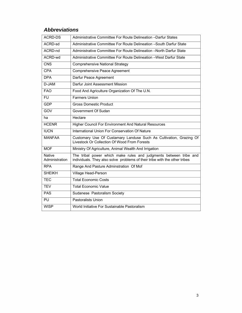
Abbreviations ACRD-DS Administrative Committee For Route Delineation –Darfur States
ACRD-sd Administrative Committee For Route Delineation –South Darfur State
ACRD-nd Administrative Committee For Route Delineation –North Darfur State
ACRD-wd Administrative Committee For Route Delineation –West Darfur State
CNS Comprehensive National Strategy
CPA Comprehensive Peace Agreement
DPA Darfur Peace Agreement
D-JAM Darfur Joint Assessment Mission
FAO Food And Agriculture Organization Of The U.N.
FU Farmers Uniion
GDP Gross Domestic Product
GOV Government Of Sudan
ha Hectare
HCENR Higher Council For Environment And Natural Resources
IUCN International Union For Conservation Of Nature
MANFAA Customary Use Of Custamary Landuse Such As Cultivation, Grazing Of Livestock Or Collection Of Wood From Forests
MOF Ministry Of Agriculture, Animal Wealth And Irrigation
Native Administration
The tribal power which make rules and judgments between tribe and individuals. They also solve problems of their tribe with the other tribes
RPA Range And Pasture Adminstration Of Mof
SHEIKH Village Head-Person
TEC Total Economic Costs
TEV Total Economic Value
PAS Sudanese Pastoralism Society
PU Pastoralists Union
WISP World Initiative For Sustainable Pastoralism
4
Table of Contents Executive Summary ................................................................................................................. 5
Background to the Sudan Policy Study .................................................................................... 8
Methodology ............................................................................................................................ 8
Country Background ................................................................................................................ 8
Sudan Features .................................................................................................................... 8
Greater Darfur Features ....................................................................................................... 9
Nomadism in Sudan ........................................................................................................... 13
The Change Drivers ............................................................................................................... 14
Policies, Legislation and Institutions ................................................................................... 14
Environment ....................................................................................................................... 15
The Intervention ..................................................................................................................... 18
The committee .................................................................................................................... 18
Implementation Methodology.............................................................................................. 19
Outcomes of the Administrative Committee for Routes Delineation .................................... 21
Costs and Benefits ............................................................................................................. 23
Change Motivation ................................................................................................................. 26
Factors Influencing the Process ......................................................................................... 26
Human Resource (Farmers & Pastoralists) Capabilities ..................................................... 26
Change Requirements ........................................................................................................ 27
Lessons Learned ................................................................................................................ 28
Conclusion and Recommendations ........................................................................................ 28
Conclusions ........................................................................................................................ 28
Recommendations ............................................................................................................. 29
References ............................................................................................................................ 31
Annexes ................................................................................................................................. 32
5
Executive Summary Sudan is one of the sub-Saharian countries ranging from hyper-arid ecosystems in the north to the dry sub-humid areas in the south. The country extends from nearly latitude 4º in the South to more than 22º in the North, and the associated rainfall variations from 0 mm to more than 1000 mm results in the existence of several distinct ecological zones.
Sudan has a largely rural economy and the population in the rural areas relies heavily on natural resources for subsistence (cultivation of marginal lands, dependence on wood-fuel, use of extensive rangelands) and thus the risk of land degradation is serious. Land is a vital issue to all rural communities and it is the means for survival and a source of individual and tribal pride. The struggle for land rights, access and control of resources remain a major source of conflict and in the country. Many natural resource-based conflicts arise between the different land users.
Darfur features
The population of Darfur has increased substantially during the last 50 years and in the last three decades Darfur region has witnessed a significant population movement within the Region and to other Regions and neighbouring countries. The increase in population has been accompanied by an increased need for natural resources leading to pressure on these resources and their misuse and overuse. Additionally, deterioration of the environment due to the droughts and desertification puts even more pressure on the natural resources.
The land tenure systems in Darfur have evolved over the years driven by the changes in the political, natural, social and economic situation in addition to the increasing in human and animal populations. The land use systems in Darfur are divided into four major systems:
1. Qoz/Wadi farming of North and South Darfur.
2. Mixed farming in Jebel Marra area, with terracing and concentration of runoff water to allow simple irrigation.
3. Camel-based pastoralism in the North: the three major groups of camel nomads are the Zagahwa, Meidob and Al Rizeigat Alshmaliya
4. Cattle pastoralism dominates in the south where the dominant groups are the Baggara, such as Rizeigat, Habbaniya ,Beni Halba, Taaysha .
Pastoralism in Sudan
Pastoralism in Sudan is a land use type practiced extensively all over the country, as dictated by rainfall intensity and distribution. Pastoralism in Darfur is widely believed to be responsible for environmental degradation and extensive use of land is misconceived by many as a wasteful socio-economic adaptation. “Over-grazing” is accordingly pointed to as the primary cause of the disruption of the ecological balance.
The Pastoral sector contributes much to the economy of the Sudan but it receives little attention. Natural hazards and human activities have led to resource degradation and conflicts between the different land users. The situation in Darfur was much aggravated due to blockage of stock routes and lack of access to the traditional grazing lands leading to conflicts between farmers and pastoralists. This situation entailed the intervention of the Government through the so called Administrative Committee for Routes Delineation – Darfur States (ACRD-DS) to tackle the problem, with the objective of demarcation and mapping of the stock routes, solution of problems encountered and execution of development activities. Delineation of the routes was carried out successfully, accompanied by amendment of existing laws and local orders that govern rangelands use, social services, and compensations to farmers whose land was taken to develop the livestock routes or for range improvement.
Due to many factors such as the increase in animal numbers, insecurity, provision of water sources, expansion of other agricultural systems, and general resource degradation, many tribal groups, especially camel owners of North Darfur, seek grazing resources outside their recognized tribal territory. A major problem for these groups has been the recurrent droughts and the deterioration of pasture areas which has forced them to stay longer in the southern part of South Darfur, thus competing with other groups and leading to frictions and conflicts.
6
The intervention
In March 2005 Presidential Decree No. 20/2005 established an Administrative Committee for Route Delineation–Darfur States (ACRD-DS), whose role is to demarcate the transhumance routes and prepare project proposals for services and development along those routes. The chairman of the ACRD-DS established three supporting committees at the three States of Greater Darfur; North, West and South Darfur. Each committee was formed of multidisciplinary members from all the concerned stakeholders and had a similar mandate to the ACRD-DS. The Administrative Committee for Stock Route Delineation – South-Darfur (ACRD-sd) covered the concerned decision at the level of South Darfur State.
For the ACRD-sd to implement its mandate it executed two consultative workshops, established the necessary technical committees that concerned with routes demarcation, and made use of the 1996 law that organizes farming and herding. The recommendations of these workshops were used as a primary source to accomplish the following:
1. Preparation of project proposal for services/development activities along the routes;
2. Demarcation of the stock routes by fixing land-marks at intervals of 1-3 km apart.
Outcomes of the intervention
The government attitude has started to change towards encouraging local community participation in development interventions. The positive effect of these interventions is mainly reflected in the livestock Routes Delineation. According to the technical consultant of the Committee, eight main routes and thirty seven branches, amounting to 2299 km in length, were designated for demarcation during the first year. However, the actual demarcation was delineation of six routes totalling 1443 km in length (equivalent to 62%) with another one under construction to make the total 1574 km(68.5%). Routes were demarcated with posts at intervals of 1-3 km, set 150 metres apart. Farms that fell within the routes (part or whole) were compensated in cash. Services were provided, including ten schools for nomads and the construction of fire grids to protect the rangelands against seasonal fires. Other developments such as water points have been incorporation within the country’s 5 years action plan (2007-2011). During transhumance, pastoralists are accompanied by police personnel, an Administrative Officer, the Native Administration, and a veterinarian.
Amendment of Existing laws and Local Orders include the revision and amendment of the Organization of Farming and Herding Law (1996) South Darfur State (amended 2005), revision and amendment of the Local Order No.1/96 that deals with protection and improvement of the range lands in Idd ELfursan Locality, and South Darfur Legislative Council Decree No.(17/2005) which deals with coordination between MOA, the (ACRD-sd), the local authorities, Native Administration and Survey Department in routes delineation.
This study examined impacts on the capabilities of farmers and pastoralists and concluded that:
Pastoralists possess the ability to organize themselves, and to identify and prioritize their social and economic development needs;
In spite of the absence of veterinary services, pastoralists are self-reliant in purchasing and using medicines and vaccines.
Nomads have access to Radio and they are well integrated to the market economy.
Pastoralists show that new bottom up approaches can be initiated by nomads themselves, but this requires investment in education, awareness raising and training.
Representation of Pastoralist Union in the Compensation Committee at the Locality level and in the field team has a positive impact in mitigating the bitter feeling of the pastoralists and helps build relationships between herders and farmers.
Pastoralists are represented in the National Assembly as well as States Legislation Councils and they are aiming for true representation and criteria for selection.
Summary of Conclusions
Nomads in the Sudan are a heterogonous group, and the differences stem from their different geographical, regional and local ecosystems.
7
The attitude of decision makers towards pastoralists need to be changed and they need to become more environmentally aware.
Route demarcation comes with positive environmental impacts upon the herders and farmers at household and community levels and reduces conflict along the routes.
Better estimation of the values of pastoralism and the costs and benefits of these interventions is needed.
Short comings include the weak participation of farmers and herders and the lack of adequate financial support.
Neither pastoral nor farmers unions have representation in the Compensation Committee but individual members are represented.
Better coordination is needed between the pastoralist and farmers unions.
Recommendations
For consolidation and sustainability of the work, consideration should be given to:
Establishing follow-up and monitoring and evaluation mechanisms.
Extension work among the grass root.
Formation of Resource Management Organizations at village, clan/tribe and State level composed of key stakeholders with responsibility for designing, implementing, and managing natural resource development activities.
Creation of Route Patrolling Teams to supervise and monitor the situation along the routes before the movement of the pastoralists commences.
Strengthening the participation of beneficiaries at the grass root level
Improving the collection and use of reliable data and information.
The delineated routes should be officially registered and directly linked to State Range and Pasture Administration which in the future should be responsible for management and improvement and should be the body to refer to in case of violation.
The Higher Committee should consider allocating a development fund for financing proposals raised by the community (Development Committees) and should not rely entirely on government, but should seek financial support from other organizations e.g. U.N. Agencies, NGOs, etc.
8
Background to the Sudan Policy Study This project has been prepared in partnership with the World Initiative for Sustainable Pastoralism (WISP): a project of the Global Environment Facility, Implemented by UNDP and executed by IUCN. The study contributes to WISP’s core work to build an enabling environment for pastoral sustainable rangeland management through enhanced local-level advocacy based on sound knowledge management on the impact of current policies on pastoralism. the Sudan case study is focused on the national policy towards Traditional Livestock Migration Routes (Darfur States Case). The study evaluates the success of the intervention carried by The Administrative Committee for Routes Delineation - Darfur States (ACRD-DS) and the impact this has had on the wier pastoralist environment.
This study contributes to WISP’s efforts to demonstrate that, given an enabling policy environment, pastoralists can be the best custodians of the drylands environment. To test this assumption, the following were examined:
Policies or practices that have had positive environmental outcomes;
The nature of those environmental outcomes;
The processes led to their adoption and their impact.
Methodology This study was executed by the Pastoral Association Sudan (PAS) using the following tools:
1. Data collection
a. Secondary data were collected from literature, official documents and records, the internet, focus group discussions, and semi-structured informal interviews
b. Primary data were collected through a field survey which, based on the report of ACRD-DS, was conducted in South Darfur State. A Rapid Rural Appraisal approach was used to collect data from different stakeholders using group meetings, discussion tools and observations.
A report from the technical consultant of ACRD-DS gave access to the following information:
How and why ACRD-DS was initiated
Pre-exiting situation
Maps of delineated and demarcated stock routes
The laws, amendments and orders
The social services provided
Range rehabilitation
Cost/ benefit of the work
An expert forum will be convened to review the analysis and to develop policy messages, consisting of a number of experts (natural resource, range specialists, economists and parliaments). This meeting will take place immediately after the acceptance of the draft report to discuss and explore the development of policy briefs.
A media forum will be convened after the policy messages are agreed.
Country Background
Sudan Features
Sudan is one of the Sub-Saharan countries, ranging from hyper-arid ecosystems in the north to dry sub-humid areas in the south. The country extends from approximately latitude 40 in the South to 220 in the North, and the associated rainfall variations range from 0 mm to more than 1000 mm per annum, which creates several distinct ecological zones.
Sudan’s population has grown from 10.26 million in 1956 to 25.6 million in 1993, and in 2004 the country’s population was estimated at over 35 million, with an annual growth rate
9
increased from 1.9% to 2.7%. According to the fourth national census (1993), population density per square kilometre is estimated to be 10.2 persons. This figure, however, proves to be a misleading indicator when population distribution is considered. In Sudan, a great deal of land is desert, semi-desert, or simply non-arable: when land area is limited to that which has some potential arability, measures of population density increase to 31.4 persons/km2, and go as high as 370 persons/ km2 when considering land presently cultivated. About 35% of the population resides adjacent to the Nile, and parts of the North of Sudan are becoming depopulated with the shrinking nomadic population in the drought-prone north, and the harsh desert conditions from 12°N to 16°N.
Sudan’s population is predominantly rural (65.5%), and 70% of this population is categorised as poor. They are involved predominantly in rainfed agriculture, woodcutting, internal trade in forest products and nomadic and semi nomadic livestock production in the natural forests and rangelands. Agriculture is the backbone of the national economy with about 80% of the people engaged in crop and animal production. This makes millions of people in the country directly dependent on natural resources for their livelihood and employment.
The heavy reliance on natural resources for subsistence means that land degradation is often encountered, and land management is a vital issue for all rural communities: it is the means of survival and a source of individual and tribal pride. The struggle for land rights, and access and control of resources, remains a major reason for conflict and is behind much of the struggle for social justice in Sudan. Many natural resources based conflicts arise between the different land users.
The arid and semi-arid ecosystems of the central part of Sudan are of a significant importance, since these ecosystems are the home for two thirds of the population and support most of the country’s economic activities, including most of the country’s crop and animal production. They also provide the major Sudanese agricultural exports such as oil seeds, cotton, meat, gum Arabic and medicinal and aromatic plants. The heavy dependence of Sudanese economy on natural resources is reflected in the contribution of the agricultural sector in Sudan GDP, which stood at 33.9% to 49.8% during the period 1991/92 to 1999, to over 36.6% in 2005.
In the Sudan the federal system or decentralization process which took place in 1995 is one of the most important factors that affect natural resource management (see annex 3: Administrative Map of Sudan). So far the federal system has adverse impacts on the natural resources and environmental and ecological issues were not taken into account when the states were identified. This resulted in imbalances in the distribution of natural resources, nd where some states have abundant resources, others lack them. Constitutional Decree No. 12 issued in 1995 assigned jurisdiction over agriculture, lands, State forests, livestock and wildlife to States, but little attention is given to natural resources improvement and management.
Sudan with its large area and diversified ecosystems reflects different types of land use (Annex4: Estimations of land use in Sudan), and the intensive use of the available resources has led to the appearance of the problem of desertification. In Sudan, desertification is regarded as the most critical environmental threat and posses a real constraint to sustainable agricultural development. The severe droughts that struck Sudan from 1967-73 and 1982-84, in addition to the droughts of the late eighties with their great impact on the natural resource, led to famine and human displacement.
Greater Darfur Features
The Darfur Region was incorporated into modern Sudan only in 1916. It has borders with Libya, Chad and the Central Africa Republic, where the colonial boundaries cut across the human frontiers of ethnic and linguistic groups. Ecology is dominated by desert in the north, the Jebel Marra Mountain in the centre and rich savannah in the south. Range productivity varies from 0.8 tons/feddan1 in the North to 25 tons/feddan in the South.
1 A Feddan is the area measurement unit which equals 0.42 hectare
10
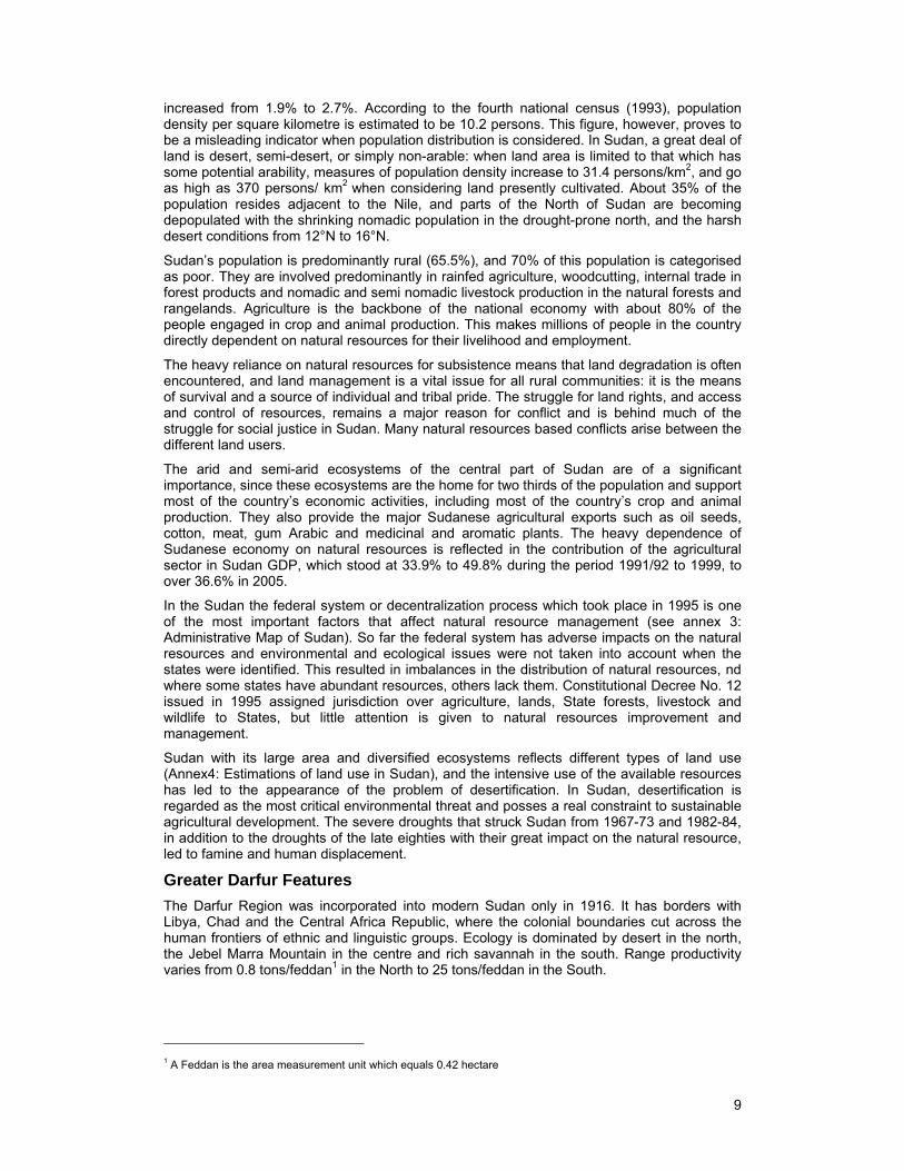
Darfur ecological classification2
The population of Darfur has increased substantially during the last 50 years (see Table 1) and in the last three decades the region has witnessed a significant population movement, both within the Region and with other Regions or even to the neighbouring countries. Simultaneously, it has received an influx of migrants from neighbouring countries, and in particular Chad. The spatial distribution of the population is largely determined by the natural resource endowment, and cultural and historical factors. However, recently political upheavals have enormously affected the population distribution. These various demographic pressures will bring an increasing demand on the already-depleted natural resources.
Table 1: Greater Darfur population and population density3
Year Population Density: Person/ km2 1956 1,080,000 3 1973 1,340,000 4 1983 3,500,000 10 1993 5,600,000 15 2003 6,480,000 18
2 Darfur Joint Assessment Mission (D-JAM), 2006: Status of Natural Resources and the Environment 3 Population figure, Department of Statistics, Central Bureau of Statistics
11
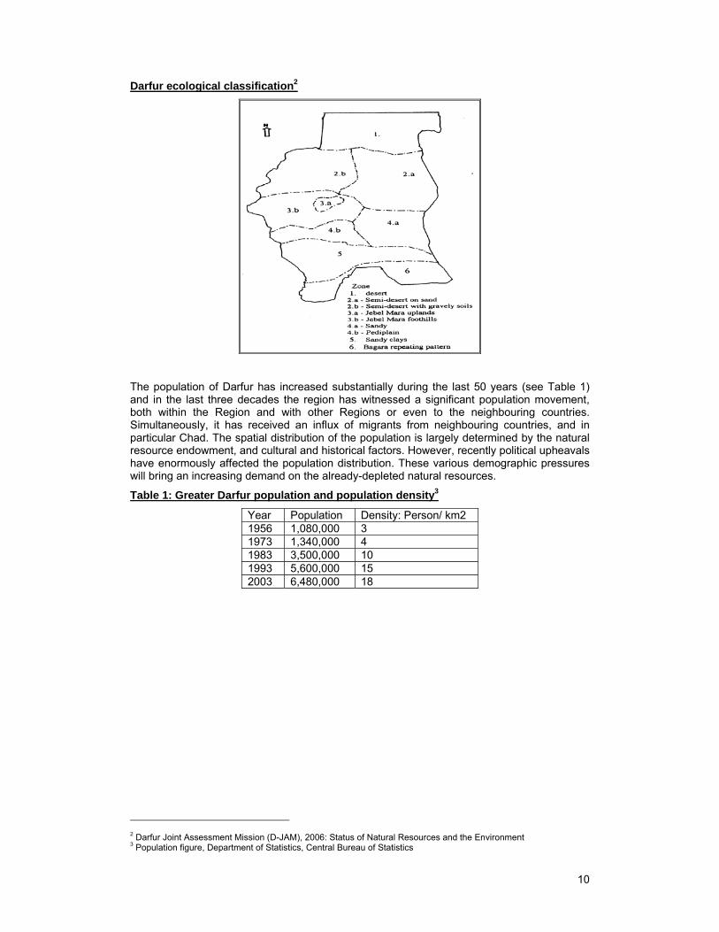
Figure 1: population data (insert new chart with reference)
Greater Darfur Population and population density
0
1000000
2000000
3000000
4000000
5000000
6000000
7000000
12345
years(1956-2003)
po
pu
lati
n
0
2
4
6
8
10
12
14
16
18
20
population density
Year
Population
Density: Person/ km2
The increase in population is accompanied by an increase in the need for natural resources and a concomitant increase in resource misuse and overuse. On the other hand the deterioration of the environment is also partly due to the consequences of drought, which results in increasing pressures on scarce natural resources.
The average increase in population in Darfur is estimated at about 4%, with great variation in density in certain areas, while the National population increase is around 3%. Generally, the population is concentrated in a belt between 11 ْ and 14ْ north. North of this belt, towards 16 ْ north the decreasing annual rainfall reduces the importance of agricultural activities, and nomadism based on camels, goats and sheep is the dominant subsistence activity, whereas to the south cattle husbandry dominates. Among the pastoral groups not everybody is actually involved in animal-rearing, and many households combine animal-rearing with cultivation, and yet others have taken up urban based occupations, without cutting their links to their home areas. The same is true for cultivators, some of whom (for instance in eastern Darfur) have gone into sheep farming for export, using hired herders.
The land use systems in Darfur as shown in Table 2 are divided into four major systems:
1. The Qoz4 /Wadi5 farming of North and South Darfur, both being similar in household based millet cultivation and animal keeping, but with the more reliable rains in the south permitting larger and more stable yields, and more variable crops;
2. In Jebel Marra area mixed farming is the main economic occupation where terracing and concentration of runoff water allow simple irrigation systems to work. People cultivate millet (Pennisetum typhoidium) and sorghum (Sorghum spp), combined with irrigated citrus, vegetables and small quantities of wheat (Triticum oesstivum) and groundnut (Archis hypogaea).
The pastoral systems in the region vary along a north south axis;
3. The pastoralists in the north are mainly camel owners. Three major groups of camel nomads to the north are Zagahwa, Meidob and AlRizeigat Alshmaliya
4. Cattle pastoralism dominates in the south. The dominant cattle nomads in the south are the Baggara such as Rizeigat, Habbaniya ,Beni Halba and Taaysha
4 Stabilized sand dunes 5 Seasonal water course
12
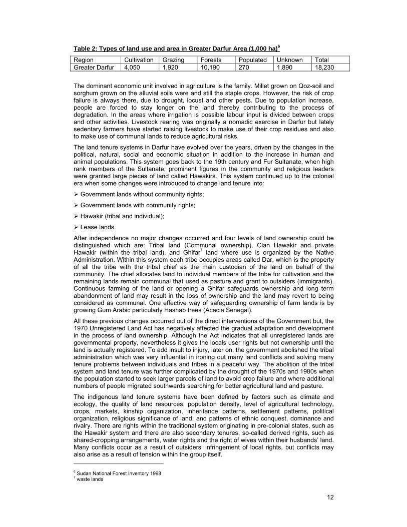
Table 2: Types of land use and area in Greater Darfur Area (1,000 ha)6
Region Cultivation Grazing Forests Populated Unknown Total Greater Darfur 4,050 1,920 10,190 270 1,890 18,230
The dominant economic unit involved in agriculture is the family. Millet grown on Qoz-soil and sorghum grown on the alluvial soils were and still the staple crops. However, the risk of crop failure is always there, due to drought, locust and other pests. Due to population increase, people are forced to stay longer on the land thereby contributing to the process of degradation. In the areas where irrigation is possible labour input is divided between crops and other activities. Livestock rearing was originally a nomadic exercise in Darfur but lately sedentary farmers have started raising livestock to make use of their crop residues and also to make use of communal lands to reduce agricultural risks.
The land tenure systems in Darfur have evolved over the years, driven by the changes in the political, natural, social and economic situation in addition to the increase in human and animal populations. This system goes back to the 19th century and Fur Sultanate, when high rank members of the Sultanate, prominent figures in the community and religious leaders were granted large pieces of land called Hawakirs. This system continued up to the colonial era when some changes were introduced to change land tenure into:
Government lands without community rights;
Government lands with community rights;
Hawakir (tribal and individual);
Lease lands.
After independence no major changes occurred and four levels of land ownership could be distinguished which are: Tribal land (Communal ownership), Clan Hawakir and private Hawakir (within the tribal land), and Ghifar7 land where use is organized by the Native Administration. Within this system each tribe occupies areas called Dar, which is the property of all the tribe with the tribal chief as the main custodian of the land on behalf of the community. The chief allocates land to individual members of the tribe for cultivation and the remaining lands remain communal that used as pasture and grant to outsiders (immigrants). Continuous farming of the land or opening a Ghifar safeguards ownership and long term abandonment of land may result in the loss of ownership and the land may revert to being considered as communal. One effective way of safeguarding ownership of farm lands is by growing Gum Arabic particularly Hashab trees (Acacia Senegal).
All these previous changes occurred out of the direct interventions of the Government but, the 1970 Unregistered Land Act has negatively affected the gradual adaptation and development in the process of land ownership. Although the Act indicates that all unregistered lands are governmental property, nevertheless it gives the locals user rights but not ownership until the land is actually registered. To add insult to injury, later on, the government abolished the tribal administration which was very influential in ironing out many land conflicts and solving many tenure problems between individuals and tribes in a peaceful way. The abolition of the tribal system and land tenure was further complicated by the drought of the 1970s and 1980s when the population started to seek larger parcels of land to avoid crop failure and where additional numbers of people migrated southwards searching for better agricultural land and pasture.
The indigenous land tenure systems have been defined by factors such as climate and ecology, the quality of land resources, population density, level of agricultural technology, crops, markets, kinship organization, inheritance patterns, settlement patterns, political organization, religious significance of land, and patterns of ethnic conquest, dominance and rivalry. There are rights within the traditional system originating in pre-colonial states, such as the Hawakir system and there are also secondary tenures, so-called derived rights, such as shared-cropping arrangements, water rights and the right of wives within their husbands’ land. Many conflicts occur as a result of outsiders’ infringement of local rights, but conflicts may also arise as a result of tension within the group itself.
6 Sudan National Forest Inventory 1998 7 waste lands
13
For both farmers and pastoralists such rights are usually understandable as being very concrete and located in time and space. The time dimension shows how units are established and how rights are acquired over the generations, with the outcome that agreements are based on a complex arrangement of local compromises, of situational give and take, rather than strict rule enforcement. This personal basis is important because land tenure changes often start as individual deviance from the norms, as we see in the early establishment of gardens on communal lands, introducing elements of private ownership rights that later can be developed. Such customs have been dynamic and could have changed with use and time to develop fully secure rights if it were not for the unsuccessful interventions of government.
Nomadism in Sudan
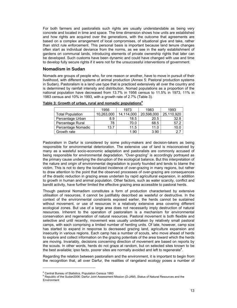
Nomads are groups of people who, for one reason or another, have to move in pursuit of their livelihood, with different systems of animal production (Annex 5: Pastoral production systems in Sudan). Pastoralism is a land use type that is practiced extensively all over the country and is determined by rainfall intensity and distribution. Nomad populations as a proportion of the national population have decreased from 13.7% in 1956 census to 11.5% in 1973, 11% in 1983 census and 10% in 1993, with a growth rate of 2.7% (Table 3).
Table 3: Growth of urban, rural and nomadic populations8
1956 1973 1983 1993 Total Population 10,263,000 14,114,000 20,598,000 25,110,920 Percentage Urban 8.9 18.5 20.5 32.8 Percentage Rural 78 70.0 68.5 57.2 Percentage Nomadic 13.7 11.5 11.0 10.0 Growth rate 1.90 3.90 2.7
Pastoralism in Darfur is considered by some policy-makers and decision-takers as being responsible for environmental deterioration. The extensive use of land is misconceived by many as a wasteful socio-economic adaptation and pastoralists are commonly accused of being responsible for environmental degradation. “Over-grazing” is accordingly portrayed as the primary cause underlying the disruption of the ecological balance. But this interpretation of the nature and origin of environmental degradation is poorly founded and tends to blame the victim. This is not to deny the localized incidence of over-grazing in many regions, but rather to draw attention to the point that the observed processes of over-grazing are consequences of the drastic reduction in grazing areas underlain by rapid agricultural expansion, in addition to growth in human and animal population. Other factors, such as water scarcity, conflict and bandit activity, have further limited the effective grazing area accessible to pastoral herds.
Though pastoral Nomadism constitutes a form of production characterised by extensive utilisation of resources, it cannot be justifiably described as wasteful or destructive. In the context of the environmental constraints exposed earlier, the herds cannot be sustained without movement, or use of resources in a relatively extensive area covering different ecological zones. But use of a large area does not necessarily imply destruction of natural resources. Inherent to the operation of pastoralism is a mechanism for environmental conservation and regeneration of natural resources. Pastoral movement is both flexible and selective and until recently, movement was usually undertaken by relatively small pastoral camps, with each comprising a limited number of herding units. Of late, however, camp size has started to expand in response to decreased grazing land, agriculture expansion and insecurity in various regions. Each camp has a number of scouts, who move ahead of herds to explore and collect information on the grazing potentials of the area toward which the herds are moving. Invariably, decisions concerning direction of movement are based on reports by the scouts. In other words, herds do not graze at random, but on selected sites known to be the best available; ipso facto, poorer sites are normally avoided and left to regenerate9.
Regarding the relation between pastoralism and the environment, it is important to begin from the recognition that, all over Darfur, the realities of rangeland ecology poses a number of
8 Central Bureau of Statistics, Population Census 1993 9 Republic of the Sudan2006: Darfur Joint Assessment Mission (D-JAM) ,Status of Natural Resources and the Environment
14
serious constraints on the permanent settlement of herds. Among these constraints are the seasonal fluctuations in the supply of the essential inputs of pastoral production: water and forage. There are also other region-specific adverse environmental features and the seasonal fluctuations, combined with varied adverse environmental features, necessitate nomadic movement, varying in direction, distance and duration depending on the region and the type of animal bred that is suited to the local conditions.
Creation of watering points solve some problems but often create others. To relieve pressure on both water and grazing around the watering centres, pastoralists tended to disperse widely in their respective regions during the rainy season to make use of both the water pools formed by the rain and the extensive grazing area rendered inaccessible because of water shortage.
Various types of pastoral movement emerged in the rangelands as adaptations to the ecological constraints. These movements ranged from "pure Nomadism", typically involving camel breeding and long distance movement, to forms of transhumance involving cattle, sheep and goats, and entailing relatively shorter migrations. Even sedentary cultivators often find it necessary to move during the dry season with their village-based small herds.
The Change Drivers
Policies, Legislation and Institutions
Policies
Sudan’s development plans and programs have stressed the importance of increased agricultural production, but only few tackled rationally the balance between agricultural development and natural resource management. As a result Sudan’s natural resources receive least attention and have seriously deteriorated. This deterioration has been caused by activities such as mechanized farming, shifting cultivation, tree cutting for charcoal, firewood consumption and construction.
Periodic drought intensified the negative impact of these land management practices and large areas of Sudan have been left idle for agricultural and pastoral production, the full impact depending on whether this degradation is permanent or temporary. As a result, trends in land degradation have become a major concern for the government, yet solutions are hampered by the lack of an integrated land use policy.
Recent development policies have called for rational use of natural resources and environmental protection such as the 4-years salvation plan (1989/92) with its major objective in relation to natural resources as combating desertification and drought mitigation, through range rehabilitation and forestry development. The ten year Comprehensive National Strategy (CNS) 1992-2002 has special emphasis on the environment and its conservation with the main objective of achieving food security, appropriate use of natural resources and sustainable development, poverty eradication, mitigation of drought effects and desertification control. In 1990’s, since ratifying and signing the UN Conventions on environment, Sudan has undertaken strategies and policies aimed more coherently at sustainable development. However, the implementation of the CNS (1992-2002) has been far below the expectations and there were inherent contradictions in the components of the strategy. Recently the Sudan embarked on a 25-year strategy (2002-2027) with similar objectives.
Sudan has no clear-cut policy directed towards the development and improvement of traditional animal husbandry, or catering for social welfare of the pastoral communities. Sammani and A.Salih (2006), writing on Sudan’s initiatives for nomadic settlement, highlighted the following facts:
1. Nomads’ settlement has remained a policy of all different political regimes, and the issue has remained consistent because of its relevance to land planning for agriculture.
2. Top-down approaches in all these policies has been the rule, and nomads themselves were absentees.
Legislation
Land tenure systems in Sudan are complicated and consequently their role for optimum utilization of natural resources is confused and ineffective. The scope of land tenure as
15
defined by Section 3 of the Land Settlement and Registration Act 1925 include registered rights for the people for cultivation and other recognized customary rights (rights of passage, access to water resources, etc). The land tenure system greatly influences the exploitation of natural resources and Article 4 (1) of the 1970 unregistered Land Act of Sudan states that "all land of any kind whether waste, forest, occupied or unoccupied, which is not registered before the commencement of this Act shall, on such commencement, be the property of the Government and shall be deemed to have been registered as such, as if the provisions of the Land Settlement and Registration Act, 1925, have been duly complied with". This means that unregistered land is state owned, but local people have usufruct rights. This applies to rangelands and other uncultivated or non-residential lands. Although the customary systems of land tenure define the use of communal lands to some extent, the scarcity of land-based resources and the inappropriateness of some development policies have led to conflicts over land use. Through introduction of the Islamic principle of Manfaa (usufruct rights) by the provisions of the Civil Transactions Act 1984, unregistered benefits in land are recognized and protected.
Rules and regulations protecting the environment as a whole are available, but actually need to be activated. The Sudan government is aiming to set up relevant bodies for the proper management of natural resources to safeguard against tribal conflicts with emphasis on specific role for tribal leaders. Laws and regulations that support institutions working in the field of natural resources generally, and rangelands management in particular, are characterized by lack of harmony due to un clear conceptualisation. Regulations related to land acquisition and ownership and grazing rights are found within Land Laws while those related to range protection are imbedded within Investment and Forest Laws. The noticeable disorder within the laws and ordinances regulating range resource utilization means that they are still issued locally at State level and lack National interest.
Institutions
The Institutions concerned with the Pastoral Sector in South Darfur State are:
Native Administration systems, recognized as legitimate institutional mechanism for conflict resolution and transformation based on the indigenous mediation (Judiyia) system. This local mechanism of conflict management has been more effective but the situation has been significantly confused after the abolition of Native Administration system in 1971. The system was back again in 1980 but with apparent weakness.
Nomad's Commission in South Darfur, established by State Decree Number (6) in 2006 to shoulder the responsibility for the development and improvement of the pastoral sector.
Abbala Local Council in North Darfur (kutum), one of the administrative units established mainly to take care of camel nomad (Abbala) affairs in North Darfur.
Environment
Rangelands
Vegetation distribution in Sudan is mainly influenced by rainfall and soil type, although the only available classification up to now is that of Harrison and Jackson (1958). Efforts have been made recently through the Afri-cover Project GCP/RAF/287/ITA to map the land cover of East Africa, using the “land cover classification system” (LCCS) developed by the FAO.
Sudan has been classified (Harrison and Jackson, 1958) into six vegetation zones that reflect the country's soil and climatic diversity:
Dessert Zone: (0 – 75 mm);
Semi dessert: (75 – 300 mm);
Low Rainfall woodland Savannah: (300 – 800 mm);
High Rainfall woodland Savannah: (800 – 1.800 mm);
Flood region;
Montane Vegetation: (500 – 2,000 mm).
16
The Darfur region stretches from the desert in the north to the savannah in the south, interrupted midway by Jebel Marra volcanic plateau which boasts more rainfall and more fertile soil than the other areas. The region's people include farmers growing sorghum, millet, groundnuts and tomatoes, and nomadic pastoralists. Since the 1970s, climate change has accelerated desertification, adding pressure on North Darfur nomads to move southward. North Darfur is sub-divided into desert and semi-desert and Southern Darfur comprised of Low Rainfall Woodland Savannah and associated areas such as the Hill Catena and Baggara repeating pattern. This categorizing is closely associated with plant species which favour specific climatic zones. It has been reported that the basic vegetation cover still exists in most areas and the complete disappearance and extinction of all species has not been reported. However, overuse and misuse activities such as heavy grazing especially around watering points, water shortage and over cutting of trees in addition to drought and over population of both man and animals have reduced the densities of plant species.
In addition to the shrinking of natural resources in Darfur and the expanding population, a major cause of natural resource degradation is the weak environmental policies and regulations and the weak capacity to manage the environment. Although the Sudan Environment Act of 2001 provides some guidance for environmental management, the weak implementation of the Act and the poor enforcement capacity leaves a lot to be done.
The situation highlighted above has resulted in serious environmental impacts, summarized as below:
Reduction of rangeland area and blockage of the stock migration routes;
Shift in botanical composition and diverse forage species;
Reduction of forage production per unit area as a result of land deterioration.
These impacts have in turn resulted in several adverse secondary impacts such as
Soil erosion;
Land degradation;
Desertification in some cases.
These in addition to Illegal practices (Zareibat AlHawa10) have led to bloody conflicts between farmers and herders that used to be solved traditionally but are now politically aggravated to be out of control.
Environmental Threats and Hotspots
Between 1956 and 2003 the population of Darfur increased six fold from 1.08 millions to 6.48 millions, and nomads account for 20 percent. Population density increased from 3 persons/km2 in 1956 to 18 persons/km2 in 2003. This population increase in addition to climatic land degradation and anthropogenic degradation highlighted the environmental threats in the whole of Darfur and manifested themselves clearly in a number of hotspots where the environment is fragile and the pressure is greatest. The main causes of land degradation are:
Increase of area under cultivation
Expansion of farming in areas of limited rainfall
Uncontrolled use of rangelands
Extensive tree cutting
Water shortage.
In the Darfur region rangeland, which is a communal entity, extends from the extreme dry desert to flood zones with its marshy and muddy conditions. However, the carrying capacity of the rangelands has greatly changed and in Northern Darfur, as an example, during the late 1950s (Harrison and Jackson 1958) the carrying capacity was reported as 14.3 animal units
10 Fenced area in the pasture established intentionally by farmers to provide feed for their animals and trap animals to get compensated for crop damage.
17
per square mile per year, whereas a recent survey carried by Range and Pasture Administration 2001/2002 indicated that it is now only 9 animal units per square mile per.
Natural Resources Conflicts and the Environment
The environmental situation in Darfur has produced several types of conflicts, for example, the expansion of cultivation on the Qoz, together with an accumulation of animals in the same area, has produced over cultivation, overgrazing and deforestation. However, the situation is also affected by other factors. The various periods of drought have affected the areas of north Darfur badly, pushing people towards towns, and also southwards into the Qoz and Gardud11 belts already under pressure. The civil war in South Sudan has created pressure from the south, blocking the dry season migrations of the nomads at Bahr el Arab and other areas, and making them stay longer on the Qoz and Gardud areas. The lack of reliable and up-to-date information on the natural resources and the environment and the absence of any land use plans for Darfur mean that economic development is implemented in an ad-hoc, piece meal and reactive mode. This could be one of the reasons that lead to conflicts over natural resources.
Water resources in particular and natural resources in general are believed to be underlying much of the conflict in Darfur. As indicated above, water in Darfur is a limiting factor affecting economic development and contributing negatively to the wellbeing of the population. This becomes even more drastic noting that water resources are becoming less and less available and the need for water is increasing. At present, many livestock watering points have been engulfed by farms resulting in more pressure on the rainy season for grazing areas a matter that led to range deterioration and dominance of annuals in these areas.
The issue of land degradation, soil erosion and desertification is another resource conflict problem. The net effect of these problems for a rural economy such as Darfur is reduced capacity for food production and deteriorating environment leading to devastating human crisis including famines. Deforestation in Darfur is both a cause and an effect of the conflict.
Regular grazing migrations are a key management strategy in Darfur’s nomadic pastoral systems, with movements between wet and dry season grazing areas denoted by clear routes. The migration routes are north-south, with southward movements in the dry season and northward movements in the rainy season. Each tribe has its own routes with a certain stopping sites along these routes known as Manazil and Sawani12. Due to many factors such as an increase in animal number, prevalence of insecurity, provision of water sources, expansion of other agricultural systems, and general resource deterioration, many tribal groups, especially camel owners of North Darfur, seek grazing resources outside their recognized tribal territory. The major problem for these groups has been the recurrent droughts in the area. On the last 30 years they have witnessed a long dry period that forced some people towards towns, where they ended up as dependents, whilst others have engaged in cultivation as a supplementary activity. The deterioration of pasture areas has made pastoralists stay longer in the southern part of South Darfur, thus competing with other groups and hence creating new frictions and conflicts.
Conflicts between farmers and herders occur due to the demand for resources such as land and water. The conflicts mainly occur in the autumn season along nomadic corridors during transhumance. The reasons for these conflicts aggressions include:
Intersection of cultivated land and livestock routes and blocking of route in some cases;
Trespassing of herds on cultivated land;
Scarcity of the natural resources;
The herders (mainly camel owners) not adhering to specific routes for their movement;
Shortage of water in rangelands in summer;
Establishment of Zareibat Al Hawa;
11 Impermeable hard surface clay soil 12 Manazil and Sawani are the Arabic names for the nomad’s temporary camping sites, Sawani are bigger in area than Manazil which are overnight stay sites.
18
Cultivation around water sources.
When these conflicts occur they are usually resolved through the following indigenous and statutory institutions:
Judiyya or Ajawid13 (the elderly, the wise and the impartial who are versed in customs and traditions selected from both fighting parties);
Native administration (tribal leadership);
Reconciliation conferences;
The law courts.
At present these institutions failed to reach solution in many cases as the source of conflicts, such as blockage of routes and grazing sites, has not been removed.
Potentiality and Positive Environmental Effects
A Higher Council for Environment and Natural Resources (HCENR) was established in 1992 with the mandate of coordinating activities pertaining to the environment and developing policies and strategies in this regard. The HCENR has links with the environmental councils established in some states and is in charge of the three International Framework Conventions (Climate change, Desertification and Biodiversity) and implementing three strategic projects: Support for Strategic Planning for Sustainable Environment Development; National Biodiversity Strategy and Action Plan and; Climate Change. These strategies together with the National Action Plan for combating desertification and mitigating the effects of drought have been harmonized through a newly formulated project entitled “Strengthening the Government of Sudan for the Formulation of a National Strategy for Sustainable Development”. This action is supported by the promulgation of the Environment Conservation Act 2001, which provides a policy and institutional framework for the conservation of the environment and natural resources. However; environmental management remains characterized by weak implementation.
The Intervention of CRRD-ds
The committee
According to local observations, any solution to the conflict in Darfur – from the nomadic perspective – has to include an agreement on the designated North-South Migration Routes (Annex 6a: Darfur Migration Routes Map and Annex 6b: South Darfur Migration Routes Map). Agreement is also required over the opportunity for semi-nomadic groups to have some sort of homeland with basic services, and sustained reconciliation efforts to restore the trust between nomadic and farming communities.
In March 2005 Presidential Decree No. 20/2005 was issued to establish an Administrative Committee for Route Delineation – Darfur States (ACRD-DS). Decree No. 20/2005 had emerged because Darfur is a war-torn region and it is an attempt from the Government to put an end to the conflicts. The Decree was developed by a multidisciplinary team that was intended to represent all stakeholders. The mandate of the ACRD-DS is:
1. To define the administrative principles that stop frictions between the farmers and herders throughout Darfur States, with the consideration of:
a. The historical rights and traditions that prevailing among the communities.
b. The change that occurred due to the imbalance in demography and its impact upon land ownership between the farmers and the herders.
2. Arrangement of livestock routes to cope with emerging situations such as increased livestock numbers or increased cultivation area.
Table 4: Higher Committee (ACRD-DS)
Name and title Position Remarks Eltayeb A.Mokhtar Chairman Major General Police
13 Mediation; which is a established tradition in northern Sudan
19
Dr..Ibrahiem Abu Ouf Member Ex. Minster, Social Affairs Elmek. Yousif Adlan Member Chief of Fonj Tribe (Blue Nile State) General Director of Ministry of agriculture Member Three States level General Director of Min. of Physical Planning Member Three States level Farmer Union Representative (Rep) Member Three States level pastoralists Union Rep Member Three States level Police Force Rep Member Three States level
The role of the ACRD-DS is to demarcate the animal routes and to prepare project proposals for services and development along the routes. To facilitate the implementation of the ACRD-DS mandate, the chairman of the ACRD-DS established three supporting committees in the three states of Greater Darfur; North, West and South. Each committee is formed of multidisciplinary members from all the concerned stakeholders and has a similar mandate to the ACRD-DS. The composition of the Committees is as follows:
Table 5: ACRD-DS (State Level)
Title PositionState General Director of MOA Chairman State General Director of MOPP Deputy State Farmer Union Representative (Rep) Member State pastoralists Union Rep Member State Police Force Rep Member State Range Director, MOA Secretary
Table 6: Technical Committees (State Level)
Title Position State survey services Director Chairman Natural Resource Director of MOA Deputy Local Government Manger Member Director of National Corporation of Water Member State Police Force Representative (Rep) Member Department of Animal Wealth Rep Secretary State Director Irrigation Department Member local administration Rep Member Ministry of Education Rep Member Nomads Commission Rep Member State Range and Pasture Administration Director Member Nyala polytechnic College Rep Member Veterinary Research Rep Member
Implementation Methodology
Geographical Scope of Assessment
The study aimed to assess the work in the three states of Greater Darfur (North, West, and South). Due to the fact that the approved budget could not allow conducting assessments for the three states, South Darfur was chosen because it is the most suitable as it is the State where the bulk of the work has been done by The ACRD-DS. Also at this time of the year, at the end of March (dry season), it is the only place where all land users (farmers and pastoralists) could be reached. Furthermore, it is the most secure state in Darfur.
Approach
The construction of the ACRD-sd built upon the representation of the decision-makers at state government level. At the level of South Darfur State, The ACRD-DS chairman further established Route Committees at the nine Localities. The mandate of these committees is:
1. To amend, supervise, and remove obstacles from animal routes and any other short stay places;
20
2. To estimate the compensation for affected partier part.
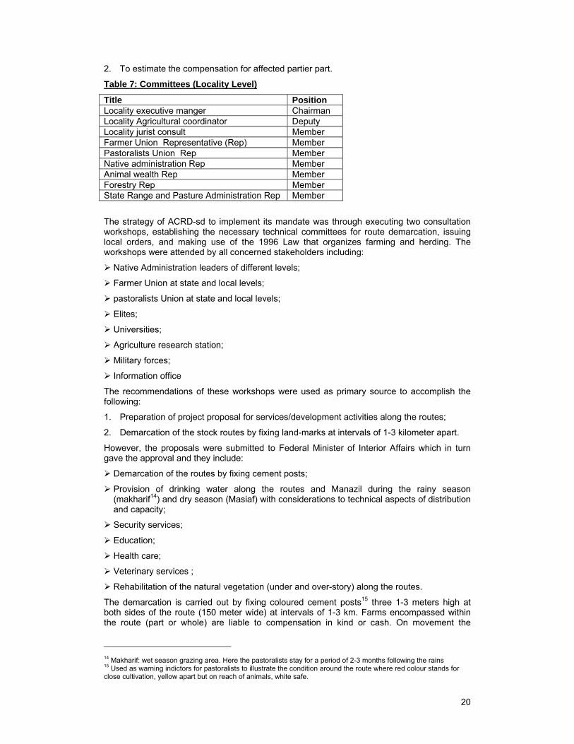
Table 7: Committees (Locality Level)
Title Position Locality executive manger Chairman Locality Agricultural coordinator Deputy Locality jurist consult Member Farmer Union Representative (Rep) Member Pastoralists Union Rep Member Native administration Rep Member Animal wealth Rep Member Forestry Rep Member State Range and Pasture Administration Rep Member
The strategy of ACRD-sd to implement its mandate was through executing two consultation workshops, establishing the necessary technical committees for route demarcation, issuing local orders, and making use of the 1996 Law that organizes farming and herding. The workshops were attended by all concerned stakeholders including:
Native Administration leaders of different levels;
Farmer Union at state and local levels;
pastoralists Union at state and local levels;
Elites;
Universities;
Agriculture research station;
Military forces;
Information office
The recommendations of these workshops were used as primary source to accomplish the following:
1. Preparation of project proposal for services/development activities along the routes;
2. Demarcation of the stock routes by fixing land-marks at intervals of 1-3 kilometer apart.
However, the proposals were submitted to Federal Minister of Interior Affairs which in turn gave the approval and they include:
Demarcation of the routes by fixing cement posts;
Provision of drinking water along the routes and Manazil during the rainy season (makharif14) and dry season (Masiaf) with considerations to technical aspects of distribution and capacity;
Security services;
Education;
Health care;
Veterinary services ;
Rehabilitation of the natural vegetation (under and over-story) along the routes.
The demarcation is carried out by fixing coloured cement posts15 three 1-3 meters high at both sides of the route (150 meter wide) at intervals of 1-3 km. Farms encompassed within the route (part or whole) are liable to compensation in kind or cash. On movement the
14 Makharif: wet season grazing area. Here the pastoralists stay for a period of 2-3 months following the rains 15 Used as warning indictors for pastoralists to illustrate the condition around the route where red colour stands for close cultivation, yellow apart but on reach of animals, white safe.

21
pastoralists are accompanied by police personnel, Administrative Officer, and a veterinarian16. In the demarcation process all concerned stakeholders should be present.
Table 8: Main Delineated Routes ACRD-sd
Route Name Length km
Proposed Combined Intervention Year of execution
Totah 220 Provision of water and rehabilitation of 9 water points (WP). Range rehabilitation: water spreading, fodder planting (at 3 sites) and range reseeding. Education: establishment of 6 primary schools. Veterinary services at 2 sites.
2005
Domayia- Dar Falatta
245 Provision of water and rehabilitation of 8 WP Range rehabilitation and protection : fodder planting (2 sites ), range reseeding(9 sites) Education: establishment of 6 primary schools. Vet. Services: establishment of two mobile Vet. hospitals and 2 animal breeding centers. Security Services (SS): establishment of police points at two areas
2005
Wadi Hawer-Dar Taaisha
420 Provision of water: drilling of 6 surface wells, 3 deep wells , and 3 hand pumps. Excavation of 6 hafiers Range rehabilitation: range reseeding around Sawani, and organization of range extension programmes. Education: establishment of 8 schools Vet. serv. : establishment of 4 mobile Vet hospitals and training programmes Security Services (SS): establishment of police points at two sites
2005
Samaha 132 2005 Dar Alsalam (Eastern route)
57 2005
Bigera Shailah 250 2006 Buram route is under demarcation
250 2007
Total 1574 Dehail Dabi 2008 Slaim -Wadaaa - 2008
Outcomes of the Administrative Committee for Routes Delineation
Delineation of the livestock routes
The government attitude has started to change towards encouraging local communities' participation in development interventions. The outcome of this is mainly reflected in the livestock Routes Delineation. According to the consultancy carried out by the technical consultant of ACRD-DS during the first year, eight main routes and thirty seven branches were targeted in Greater Darfur amounting to a total of 2299km. However; the actual achievement was delineation of only six routes totalling 1443 km in length (equivalent to 62%) in addition to another route under construction (Buram17 route 250 km ), which will bring the total length to 1574 km (68.5%) (Annex 7: Darfur Migration Routes Map). 472 coloured cement posts were used at intervals of 1-3 km. and farms that were encompassed within the routes (part or whole) were compensated in cash18.
16 Veterinarian is government employee (Department of Animal Health) and the services are provided through a mobile clinic. 17 Buram is interior route, i.e. out of the eight main routes. 18 They are mainly agro pastoralists, from different tribes, in KAS area.
22
Services
Education: at the beginning of 2007 ten primary schools were established out of the twenty planned, whilst the remaining ones have been incorporated within the National 5 Year Action Plan.
Range protection: fire-line grids were constructed through participation of Localities, local communities and State Range and Pasture Administration during 2006 at the end of the wet season to reduce fire hazards.
Range rehabilitation: Green fodder production was carried out at the RAP nursery.
Other Services: to be implemented in the coming development budgets (2007-2011) as they have been incorporated within the Country 5 years Action Plan.
Amendment of Existing laws and Local Orders
The amendment of the existing laws and local orders that govern rangelands use includes:
1. Revision and amendment of the Farming and Herding Organization Law (1996) South Darfur State (amended 2005). The objectives of the Law are:
a. Maintain equal rights of pastoralists and farmers to utilize the available natural resources;
b. Conservation and protection of natural resources;
c. Ensure safe livestock movement during transhumance;
d. The amended Law contains five articles:
i. Article one: Definition of Terms
ii. Article two: States the Obligations of the citizens (farmers and nomads)
iii. Article three: States the Obligation of the nomads scouts
iv. Article four: States general Judgments
v. Article five: States, Infringement, Penalties and Sanctions
2. Revision and amendment of the Local Order No.1/96, which deals with protection and improvement of the range lands in Idd ELfursan Locality.
3. South Darfur Legislature Council issued the Decree No. (17/2005) that deals with coordination between MOA, the Committee (ACRD- sd), local authorities, Native Administration and Survey Department in routes delineation.
Compensation
The Compensation applies to farmers whose land became part of the route or Sawani. The value of compensation was determined by locality committees and the Native administration (Omda or Sheikh) based on different criteria such as geographical location, type of the crop and productivity, soil type (clay or sandy soil). For example, one Mukhamus19 (1.25 Feddan) in sandy soil compensated was by 50,000SD (US%200), and one Mukhamus in clay soil is compensated by 70,000SD (US$ 280).
The compensation was made in the Kas Locality which is one of the places where the cattle route demarcation finished with the increase in the width of the route from 100m to 150m. The farmers who are compensated in cash then have to rent other land for farming (70,000 SD per feddan in clay soil, and 50,000 SD20 in sandy soil).
Implementation Constraints
Lack of reliable means of transportation.
High expenses of the posts fixation.
19 Local Measurement for Agricultural Land that equal to 1.25 feddan (one feddan equals 1.38 acre) 20 SD stand for Sudanese Dinar (by 30/6/2007 it was replaced with the new currency Sudanese Geneih “SDG”). 100 SD = 1 SDG
23
Lack of harmony between technical and military teams.
Climatic problems (rains) led to delay in delineation of the eastern route.
Weak coordination between Ministry of Agriculture and Ministry of Physical Planning.
Insufficient financial support and incentives for compensation.
Lack of real partnerships between Government institutions and NGOs.
Lack of incentives for committees at Localities.
Insecurity especially in North and West Darfur.
Costs and Benefits
Although range management provides long-term benefits, it is a costly practice and the economic benefit is important to understand. The issue of proper valuation of all goods and services (products and other benefits) from rangeland has been debated for a very long time and has become an important aspect in the context of mobilizing resources for sustainable range management. It has been argued that benefits from rangelands are grossly undervalued which affects the willingness of society or government to allocate adequate resources for their management21. Rangelands provide a wide range of goods and services, some of which are public goods with no developed markets or indirect goods and services, and hence they are easily undervalued. Furthermore, a significant proportion of transactions take place in the informal sector or are used in the subsistence economy, and hence are overlooked in national accounting.
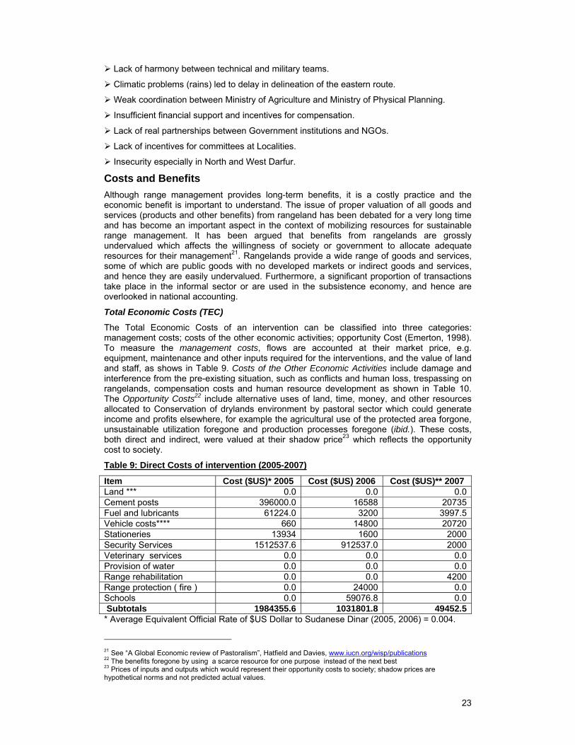
Total Economic Costs (TEC)
The Total Economic Costs of an intervention can be classified into three categories: management costs; costs of the other economic activities; opportunity Cost (Emerton, 1998). To measure the management costs, flows are accounted at their market price, e.g. equipment, maintenance and other inputs required for the interventions, and the value of land and staff, as shows in Table 9. Costs of the Other Economic Activities include damage and interference from the pre-existing situation, such as conflicts and human loss, trespassing on rangelands, compensation costs and human resource development as shown in Table 10. The Opportunity Costs22 include alternative uses of land, time, money, and other resources allocated to Conservation of drylands environment by pastoral sector which could generate income and profits elsewhere, for example the agricultural use of the protected area forgone, unsustainable utilization foregone and production processes foregone (ibid.). These costs, both direct and indirect, were valued at their shadow price23 which reflects the opportunity cost to society.
Table 9: Direct Costs of intervention (2005-2007)
Item Cost ($US)* 2005 Cost ($US) 2006 Cost ($US)** 2007Land *** 0.0 0.0 0.0Cement posts 396000.0 16588 20735Fuel and lubricants 61224.0 3200 3997.5Vehicle costs**** 660 14800 20720Stationeries 13934 1600 2000Security Services 1512537.6 912537.0 2000Veterinary services 0.0 0.0 0.0Provision of water 0.0 0.0 0.0Range rehabilitation 0.0 0.0 4200Range protection ( fire ) 0.0 24000 0.0Schools 0.0 59076.8 0.0 Subtotals 1984355.6 1031801.8 49452.5* Average Equivalent Official Rate of $US Dollar to Sudanese Dinar (2005, 2006) = 0.004.
21 See “A Global Economic review of Pastoralism”, Hatfield and Davies, www.iucn.org/wisp/publications 22 The benefits foregone by using a scarce resource for one purpose instead of the next best 23 Prices of inputs and outputs which would represent their opportunity costs to society; shadow prices are hypothetical norms and not predicted actual values.
24
** Average Equivalent Official Rate of $US Dollar to Sudanese Dinar (2007) = 0.005.
*** land has economic value ,but rangeland was open for communal use therefore its value is uncounted.
**** State Police and MOA Vehicles
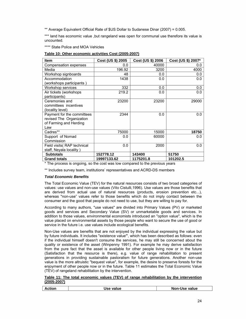
Table 10: Other economic activities Cost (2005-2007)
Item Cost (US $) 2005 Cost (US $) 2006 Cost (US $) 2007*Compensation expenses 0.0 40000 0.0Media 196.92 3200 4000Workshop signboards 48 0.0 0.0Accommodation (workshops participants )
1438 0.0 0.0
Workshop services 332 0.0 0.0Air tickets (workshops participants)
219.2 0.0 0.0
Ceremonies and committees incentives (locality level)
23200 23200 29000
Payment for the committees revised The Organization of Farming and Herding Law
2344 0.0 0.0
Cadres** 75000 15000 18750Support of Nomad Commission
0.0 60000 0.0
Field visits( RAP technical staff, Neyala locality )
0.0 2000 0.0
Subtotals 152778.12 143400 51750 Grand totals 19997133.62 1175201.8 101202.5 * The process is ongoing, so the cost was low compared to the previous years
** Includes survey team, institutions’ representatives and ACRD-DS members
Total Economic Benefits
The Total Economic Value (TEV) for the natural resources consists of two broad categories of values: use values and non-use values (Vito Cistulli,1996). Use values are those benefits that are derived from actual use of natural resources (products, erosion prevention etc...), whereas "non-use” values refer to those benefits which do not imply contact between the consumer and the good that people do not need to use, but they are willing to pay for.
According to many authors, "use values" are divided into Primary Values (PV) or marketed goods and services and Secondary Value (SV) or unmarketable goods and services. In addition to those values, environmental economists introduced an "option value", which is the value placed on environmental assets by those people who want to secure the use of good or service in the future i.e. use values include ecological benefits.
Non-Use values are benefits that are not enjoyed by the individual expressing the value but by future individuals. It includes "existence value"', which has been described as follows: even if the individual himself doesn't consume the services, he may still be concerned about the quality or existence of the asset (Winpenny 1991). For example he may derive satisfaction from the pure fact that the asset is available for other people living now or in the future (Satisfaction that the resource is there), e.g. value of range rehabilitation to present generations in providing sustainable pastoralism for future generations. Another non-use value is the more altruistic "bequest value", for example, the desire to preserve forests for the enjoyment of other people now or in the future. Table 11 estimates the Total Economic Value (TEV) of rangeland rehabilitation by the intervention.
Table 11: The total economic values (TEV) of range rehabilitation by the intervention (2005-2007)
Action Use value Non-Use value
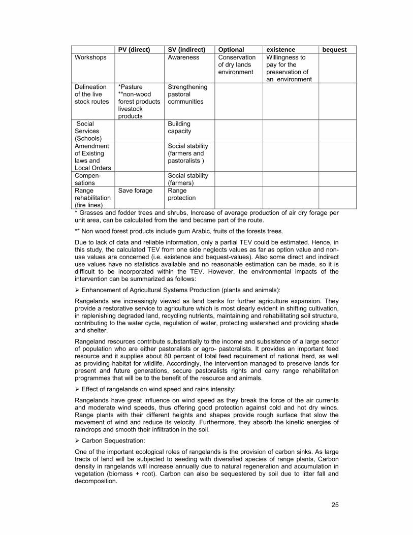
25
PV (direct) SV (indirect) Optional existence bequestWorkshops Awareness Conservation
of dry lands environment
Willingness to pay for the preservation of an environment
Delineation of the live stock routes
*Pasture **non-wood forest products livestock products
Strengthening pastoral communities
Social Services (Schools)
Building capacity
Amendment of Existing laws and Local Orders
Social stability (farmers and pastoralists )
Compen-sations
Social stability (farmers)
Range rehabilitation (fire lines)
Save forage Range protection
* Grasses and fodder trees and shrubs, Increase of average production of air dry forage per unit area, can be calculated from the land became part of the route.
** Non wood forest products include gum Arabic, fruits of the forests trees.
Due to lack of data and reliable information, only a partial TEV could be estimated. Hence, in this study, the calculated TEV from one side neglects values as far as option value and non-use values are concerned (i.e. existence and bequest-values). Also some direct and indirect use values have no statistics available and no reasonable estimation can be made, so it is difficult to be incorporated within the TEV. However, the environmental impacts of the intervention can be summarized as follows:
Enhancement of Agricultural Systems Production (plants and animals):
Rangelands are increasingly viewed as land banks for further agriculture expansion. They provide a restorative service to agriculture which is most clearly evident in shifting cultivation, in replenishing degraded land, recycling nutrients, maintaining and rehabilitating soil structure, contributing to the water cycle, regulation of water, protecting watershed and providing shade and shelter.
Rangeland resources contribute substantially to the income and subsistence of a large sector of population who are either pastoralists or agro- pastoralists. It provides an important feed resource and it supplies about 80 percent of total feed requirement of national herd, as well as providing habitat for wildlife. Accordingly, the intervention managed to preserve lands for present and future generations, secure pastoralists rights and carry range rehabilitation programmes that will be to the benefit of the resource and animals.
Effect of rangelands on wind speed and rains intensity:
Rangelands have great influence on wind speed as they break the force of the air currents and moderate wind speeds, thus offering good protection against cold and hot dry winds. Range plants with their different heights and shapes provide rough surface that slow the movement of wind and reduce its velocity. Furthermore, they absorb the kinetic energies of raindrops and smooth their infiltration in the soil.
Carbon Sequestration:
One of the important ecological roles of rangelands is the provision of carbon sinks. As large tracts of land will be subjected to seeding with diversified species of range plants, Carbon density in rangelands will increase annually due to natural regeneration and accumulation in vegetation (biomass + root). Carbon can also be sequestered by soil due to litter fall and decomposition.
26
Environmental awareness:
The workshops conducted created environmental awareness among the different resource users to the extent that local communities are taking part in the control of wild fires and the conservation of environment.
Social:
The amendments of laws and development of local orders governing use in addition to compensation against the loss of cropping land helped to secure the rights of different resource users which are reflected in proper use of the resource and reduction of conflicts.
Change Motivation
Factors Influencing the Process of the intervention
The region has been marred by all types of ethnic and tribal violent conflict and convening reconciliation conferences to resolve them have become the rule rather than exception: for example, six reconciliation conferences were held in the year 1991 alone. The 1989 reconciliation conference between Fur (Farmers) and some nomadic tribes resulted in formation of multi-disciplinary technical committee, which was mandated to survey the animal routes all over Darfur States. The committee adopted eleven main routes (those routes end in Bahar Al Arab, Central African Republic and Chad) each of length ranging 450-600 kilometres. Eight of these routes lie within South Darfur State: three from west Nyala to Kas town and five from west Nyala to Eldain town. The committee also surveyed and adopted 35 inter-state routes (branches).
The efforts to stop the conflicts and frictions continue by:
In 1996 the Governor (Wali) of Darfur issued a Law to organize farming and herding in South Darfur State. Although the Law stated the obligations that should be followed by the farmers and the herders, issues such as the width of the route, type of compensation, compensation value, and when agricultural by-products are allowed for use by pastoralists required the law to be amended.
Local Order No. 1/1996 was issued by the executive director of Idd Al Fursan Locality for the protection and improvement of the natural pasture within the Locality.
In March 2005 Presidential Decree No. 20/2005 was issued to establish an Administrative Committee for Route Delineation–Darfur States (ACRD-DS).
In 2005 the Chairman of ACRD-DS issued Decree No. 1/2005 to establish a technical committee to revise the Farming and Herding Organization Law (1996) South Darfur State. One of the major amendments was to increase in the width of the corridors from 100 meters to 150 meters.
Establishment of the Nomads Commission to tackle the Pastoral Affairs in 2006.
Comprehensive Peace Agreement 2005 (CPA), Chapter III – Article 2 of CPA stipulates: the Parties agree that the regulation of the Land tenure, usage and exercise of right in land is to a concurrent competency exercised by appropriate levels of government and there shall be established Land Commissions with specified functions including recommendations pertaining to land reform policies and recognition of customary right or law.
Human Resource (Farmers & Pastoralists) Capabilities
Rapid Appraisal technique was used during the field survey of this assessment, to collect information from relevant stakeholders: The ACRD-SD, Route Committee, Pastoralists, Farmers, Pastoralists’ Union, Farmers’ Union, and Native Administration. The information was collected mainly at Nyala Locality and Kas Locality to check ACRD-sd activities. This approach was used to enable the implementer to secure the engagement of pastoralists in subsequent advocacy and implementation. The research concluded the following facts:
The pastoralists possess the ability to organize themselves, identify and prioritize their actual needs for social and economic development, for example they identify education as a social priority and they advocate for the set up of boarding schools.
27
In spite of the absence of veterinary services, pastoralists are self-reliant in purchasing and using medicines and vaccines.
Nomads are provided with radios and they are accustomed to the market economy.
The way nomadic groups are moving indicates that a bottom up approach can be initiated by nomads themselves for a more sustainable development.
Representation of PU in the Compensation Committee at the Locality level and in the field team has a positive impact on local resentments by pastoralists and increases their willingness to participate. Furthermore, involvement of the pastoralists in the Compensation Committee formed at the village level has strengthened their decision taking and brought them closer to other partners (farmers).
The pastoralists are represented in the National Assembly as well as States Legislation Councils and they are aiming for true representation and criteria for selection.
Change Requirements
Sudan’s policy for peace building, environmental conservation and protecting the rights of marginalized and vulnerable land users (pastoralists and farmers) requires the following:
Coordination of the efforts between government and NGOs to adopt integrated development polices at local, national and regional levels.
Government and NGOs at national level should prioritise the provision of funds for water resources development, range rehabilitation, and other interventions along the routes and the pastoral areas.
Project planning and design should be based on investment maps and resource inventories.
The establishment of the National Land Commission specified in the Comprehensive Peace Agreement (CPA), to conduct mediation in land-based conflicts resolution between concerned parties.
Development of land use guide map to harmonize the Land Commission structure and the Sudanese Constitution.
Darfur Peace Agreement Implementation.
Empowerment of pastoralists to enable them to carry out their role, for example through:
o Extension messages by using drama and other means:
To inform herders of the laws, Decrees and Orders for organising farming and herding.
Training herders in pro-pastoral animal production technologies and practices.
Training the herders on how to check the quality of the medicine, how to use it and how to access simple veterinary services.
o Education:
Availability of boarding schools for nomads’ education, and literacy classes for elders.
o Stakeholders participation
To restore the fire lines to protect natural pasture.
To improve/increase the area of pasture by broadcasting improved seeds.
Investment on water provision by drilling of under-ground water along the way to Khartoum State harvesting will help in solving the problem of water provision.
28
Lessons Learned
Achieving a peaceful settlement to resource based conflicts in Darfur will have direct impacts on the rehabilitation and protection of the environment as the process was associated with development interventions.
The Sudanese government has adopted policies that have improved security and assured ease of movement in the grazing areas and hence this may initiate adoption by similar affected areas. Thus a successful policy can assist further in developing models of appropriate approaches for pastoral development in the Sudan.
A participatory approach and an effort to assure the representation of pastoralists at different levels of committees contributed to the positive policy changes and gave the marginalized pastoral groups an effective voice in influencing decisions that affect their lives.
NGOs’ direct involvement in the policy agenda is very important as they are of the view that sustainable development policies must be modified to capture regional and national capabilities and opportunities.
Conclusion and Recommendations
Conclusions
ACRD-sd: the Route Committee demarcated the routes with the new width 150 meter (according to the law amendments) instead of the old one (100) meter at the expense of farms areas, without surveying the actual reliable human and animal population.
There is no follow-up mechanism to check sustainability and sound implementation of the activities. The farmers at grass-root level were neither informed of the demarcation nor became part of the implementation. The land-marks were fixed as if the demarcation of the route is new and not old. Such cases were solved by the native administration through re-allocation of the land-marks to the correct places.
Route demarcation came with a positive environmental impact upon the herders and farmers at household and community levels. It reduced the conflict between them both along the routes and at Manazil and Sawani.
Grassroots Participation: participation of the beneficiaries (whether pastoralists or farmers) at the grass root level was weak, especially in the process of posts fixation and they were not part of the ACRD-sd demarcation process and only heard about it from the radio.
Nomads in the Sudan are heterogonous groups, the differences are stemming from their different geographical, regional and local ecosystems. However, pastoralism is an important livelihood system and the attitude of decision makers towards pastoralists need to be changed. Through time, pastoralists have come to possess accumulated knowledge of the ecology of the resources utilized and the animals raised.
Unions: Although The FU at the Locality level has a representative in the Routes Committee who should accompany the Routes Committee to the site, participation at the field level is weak. They are not fully aware of the field demarcation activity and are not always available at the sites. Some farmers are not convinced of the ACRD-sd work. The PU at the Locality level has a representative in the Routes Committee who should accompany the Routes Committee to the site.
Neither unions have representation in the Compensation Committee but individual members have representation. This committee is formed at village level and when damage occurs the committee meets to estimate the damage and the fine (cash or in-kind). The decision of this committee is final and usually respected as the concerned parties are represented. The South Darfur State FU mentioned that frictions do occur between the farmers and herders due to shortage of water resources and expansion of farms into the animal routes, but such problems are still resolved through traditional mechanisms.
Native administration: The native administration is represented effectively in the ACRD-sd, but it was not accompanying the Routes Committee during the field demarcation so a lot of technical faults occurred. Later sheikhs intervened and re-corrected the situation of the posts.
29
The new law for Native Administration gives it legal authorization and formation of local courts, and sheikhs are provided with armed guards and monthly salary. This law prohibits any illegal practices along the animal routes or at Manazil and Sawani.
To regulate the issuing of Agricultural Land License, the Ministry of Agriculture in South Darfur State produced a Conflict–Free Form that should be signed by all the concerned to confirm that the land is free of conflicts before final actions taken.
The most important outcome of all this work is that authority at its highest level (the Presidency) came to understand and believe the importance of the pastoral sector and the economic and social role it could play if due attention is given to proper policies and plans.
Costs and benefits: Despite high costs of route delineation in terms of money the policy output was profitable in term of environmental conservation and range resource improvement and management. Intervention has significantly achieved its objectives, and in particular the involvement of all stakeholders.
Recommendations
Strengthen the participation of beneficiaries at the grass root level (whether pastoralists or farmers) especially in the process of posts fixation, which should be the responsibility of both Parties and not just of hired labour.
Ensure there is reliable data and information and asses the present situation, especially in the field of natural resources and population number and distribution.
Darfur is dissected by many seasonal water courses (Wadi) carrying huge amount of water that mostly goes waste. Special consideration should be directed towards the use of water harvesting and spreading techniques to aid in range improvement and diversification of crop production and combat desertification.
The delineated routes should be officially registered and directly linked to State Range and Pasture Administration which in the future should carry the responsibility of management and improvement and the body to refer to in case of violation.
The Higher Committee at the State or Locality level needs to be restructured to incorporate units or offices such as Extension, Monitoring and evaluation and Community development, to overcome the lack of specific follow-up and monitoring.
Extension should be the backbone of this work if success and sustainability are to be achieved. In Darfur like many rural places in Sudan, land is still looked at as community property governed by customary rules and it is not easy to convince communities of the need to share this resource with others.
Create Resource Management Organizations or any form of local institution, at all levels up to Locality and State level, empowering all parts of the community (including women). The beneficiaries should be directly involved in implementation and management.
The Higher Committee should allocate a development fund to finance intervention proposals raised by the community (Development Committees) and this should not rely entirely on government but should seek financial support from other organizations e.g. U.N. Agencies, NGOs, etc.
Formation of the Route Patrolling Teams at each route section, to observe the situation along the routes before movement of nomads and to report violations to Locality Committees, will help to avoid conflicts. These teams should be composed of pastoralists scouts, Native Administration, and farmers, or should at least adopt and legalise the old system of Pastoralists Scout (Mandoub).
Assess the status of surface and ground water resources and avail water for human and animals as well as crop production.
Considering the lessons learned from past experiences, new policies, modalities and approaches need to be developed and a new outlook with clear and defined objectives is needed. In this regard, a common vision must be developed through knowledge and dialogue, and more discussions and research are needed to develop programmes and inputs.

30
Raise the environmental awareness among decision makers.
Develop coordination mechanisms between the PU and FU and other land users.
A better means of valuing pastoralism and recognising the costs and benefits of interventions will be beneficial both to the future of these interventions and for attracting other government and private sector investments in pastoral areas.
31
References Amira, A.M., Salih, and Sawsan Khair El Seed, 2003. Study on Forest Valuation and Investment in Sustainable Forest Management in Sudan, submitted to F.A.O
Abedel Rahim, S. Kh., 1996. “Economic evaluation of Range improvement by seeding the case of Malwia programme, Kassala State”. M. Sc. Thesis, Institute of Environmental Studies, University of Khartoum.
Cistulli, V., 1996. “Economic Valuation of Environmental Goods and Services: Basic concepts”. Paper presented to workshop of Strengthening Sustainability Issues & Environmental Considerations in Agricultural Policy Analysis & Project Planning. FAO Regional Office for Near East, Friedrish Ebert and University of Khartoum.
Ellatifi, M., 2002. “Valuation Attempt of the Moroccan forests’ outputs”.
Harrison, N.M. and Jackson, J.K., 1958. Ecological Classification of the Vegetation of the Sudan. Forest Department, Bull No. 2, New Series, Khartoum.
Petry, F., 1995. “Sustainability issues in agricultural and rural development policies” Vol. 1: Trainee’s reader. FAO
PAS, 2007. Report on the Evaluation of the Intervention of Administrative Committee for Stock Route Delineation of Darfur, Field Survey.
PAS, 2007. Report on the Evaluation of the Intervention of Administrative Committee for Stock Route Delineation of Darfur, Technical Consultant
Republic of the Sudan 2006. Darfur Joint Assessment Mission (D-JAM), Status of Natural Resources and the Environment.
RPA, 2007. annual reports
Republic of the Sudan, 2006. Darfur ,Joint Assessment Mission (D-JAM),Status of Natural Resources and the Environment
UNDP (United Nations Development Programme) Sudan, 2006. Nomads Settlement in Sudan, Experiences ,Lessons and Future Prospects
UNDP (United Nations Development Programme) Sudan, 2003. Roots of Conflict in North Kordofan, North Darfur and Sobat Basin of Upper Nile State
Winpenny, J. T., 1991. ‘Values for the environment’. A guide to economic appraisal. Overseas Development Institute. London: HMSO.
32
Annexes Annex 1: PAS Brief
Pastoralism Society (PAS)
Is a non-governmental society established by initiation from voluntary oriented group of persons who are concerned with the development and improvement of the pastoral community
Goal
The goal of PAS is the improvement and development of the pastoral sector
Objectives
Disseminate environmental awareness.
Link the segments of the pastoral sector with their resources.
Strengthen the role of the pastoral women and ensure their active participation.
Disseminate peace culture among the pastoral community.
Work to improve and develop the pastoral sector in collaboration with government institutions and related local and international organization.
Initiate the pastoral sector to rationalize the resources use.
Methods
Provision of reliable statistics on the pastoral sector and related fields through surveys and field trips.
Capacity building through conduction of workshops, seminars and educational and awareness raising symposiums with especial emphasis to women.
Dissemination of the pastoral sector culture and heritage by arranging for exhibits and popular gatherings and production of manuals and handouts.
Conduction of social and developmental studies.
Seek financial support for women income generating activities.
Target groups
The society is mainly targeting the pastoral sector as a source and user and aims at securing social peace and security among all fractions of the pastoral groups (Nomads, transhumance & sedentary groups) especially natural disasters affected ones
Executed activity
Institutional capacity building training workshop, targeted fifteen pastoral union members from 7 states, during 27-29/12/2005
Pastoral gathering day Oxfam GB, UNDP-3/5/2006.
Awareness on Comprehensive Peace and eastern peace Agreements Feb.2007- kassal state
Training of trainers to advocate peace building Feb.2007- kassal state
Impact of current policies on pastoralism WISP (on going)
Proposed activities include
Socio -economic Survey Study of Pastoralists in Khartoum State ¤ Manuals and handouts: production of manuals and handouts in the fields of the range management extension, fires and rangeland, seed collection by CBOs
Monthly pastoral forum to discuss different aspects related to the pastoral sector.
Awareness on Comprehensive Peace and Eastern Peace Agreements at 4 Localities of Kassla state.
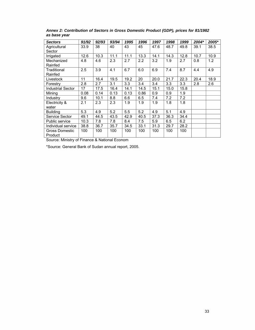
33
Annex 2: Contribution of Sectors in Gross Domestic Product (GDP), prices for 81/1982 as base year
Sectors 91/92 92/93 93/94 1995 1996 1997 1998 1999 2004* 2005*Agricultural Sector
33.9 38 40 43 45 47.6 48.7 49.8 39.1 38.5
Irrigated 12.6 10.3 11.1 11.1 13.3 14.1 14.3 12.8 10.7 10.9 Mechanized Rainfed
4.8 4.6 2.3 2.7 2.2 3.2 1.9 2.7 0.8 1.2
Traditional Rainfed
2.5 3.9 4.1 6.7 6.0 6.9 7.4 8.7 4.4 4.9
Livestock 11 16.4 19.5 19.2 20 20.0 21.7 22.3 20.4 18.9Forestry 2.8 2.7 3.1 3.3 3.4 3.4 3.3 3.3 2.8 2.6 Industrial Sector 17 17.5 16.4 14.1 14.5 15.1 15.0 15.8 Mining 0.08 0.14 0.13 0.13 0.86 0.9 0.9 1.9 Industry 9.6 10.1 8.8 6.6 6.5 7.4 7.2 7.2 Electricity & water
2.1 2.3 2.3 1.9 1.9 1.9 1.8 1.8
Building 5.3 4.9 5.2 5.5 5.2 4.9 5.1 4.9 Service Sector 49.1 44.5 43.5 42.9 40.5 37.3 36.3 34.4 Public service 10.3 7.8 7.8 8.4 7.5 5.9 6.5 6.2 Individual service 38.8 36.7 35.7 34.5 33.1 31.3 29.7 28.2 Gross Domestic Product
100 100 100 100 100 100 100 100
Source: Ministry of Finance & National Econom
*Source: General Bank of Sudan annual report, 2005.
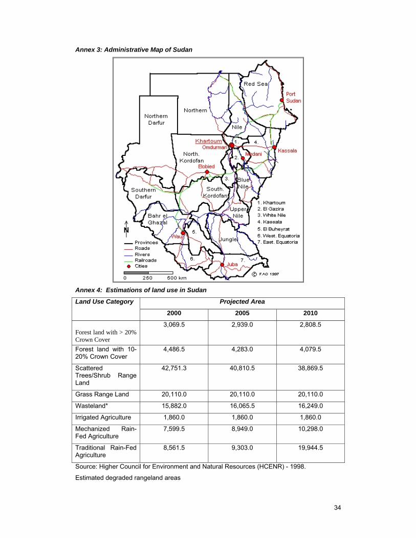
34
Annex 3: Administrative Map of Sudan
Annex 4: Estimations of land use in Sudan
Land Use Category Projected Area
2000 2005 2010
Forest land with > 20% Crown Cover
3,069.5 2,939.0 2,808.5
Forest land with 10-20% Crown Cover
4,486.5 4,283.0 4,079.5
Scattered Trees/Shrub Range Land
42,751.3 40,810.5 38,869.5
Grass Range Land 20,110.0 20,110.0 20,110.0
Wasteland* 15,882.0 16,065.5 16,249.0
Irrigated Agriculture 1,860.0 1,860.0 1,860.0
Mechanized Rain-Fed Agriculture
7,599.5 8,949.0 10,298.0
Traditional Rain-Fed Agriculture
8,561.5 9,303.0 19,944.5
Source: Higher Council for Environment and Natural Resources (HCENR) - 1998.
Estimated degraded rangeland areas
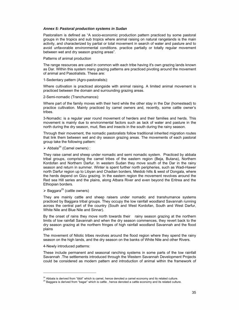
35
Annex 5: Pastoral production systems in Sudan
Pastoralism is defined as “A socio-economic production pattern practiced by some pastoral groups in the tropics and sub tropics where animal raising on natural rangelands is the main activity, and characterized by partial or total movement in search of water and pasture and to avoid unfavorable environmental conditions. practice partially or totally regular movement between wet and dry season grazing areas”.
Patterns of animal production
The range resources are used in common with each tribe having it's own grazing lands known as Dar. Within this system many grazing patterns are practiced pivoting around the movement of animal and Pasotralists. These are:
1-Sedentary pattern (Agro-pastoralists):
Where cultivation is practiced alongside with animal raising. A limited animal movement is practiced between the domain and surrounding grazing areas.
2-Semi-nomadic (Tranchumance):
Where part of the family moves with their herd while the other stay in the Dar (homestead) to practice cultivation. Mainly practiced by camel owners and, recently, some cattle owner’s tribes.
3-Nomadic: is a regular year round movement of herders and their families and herds. This movement is mainly due to environmental factors such as lack of water and pasture in the north during the dry season, mud, flies and insects in the south during the rainy season.
Through their movement, the nomadic pastoralists follow traditional inherited migration routes that link them between wet and dry season grazing areas. The movements of each pastoral group take the following pattern:
Abbala24 (Camel owners) :
They raise camel and sheep under nomadic and semi nomadic system. Practiced by abbala tribal groups, comprising the camel tribes of the eastern region (Beja, Butana), Northern Kordofan and Northern Darfur. In western Sudan they move south of the Dar in the rainy season and return in summer. Winter is spent further north peripheries, such as Wadi-Hawer north Darfur region up to Libyan and Chadian borders, Meidob hills & west of Dongala, where the herds depend on Gizu grazing. In the eastern region the movement revolves around the Red sea Hill series and the plains, along Atbara River and even beyond the Eritrea and the Ethiopian borders.
Baggara25 (cattle owners)
They are mainly cattle and sheep raisers under nomadic and transhumance systems practiced by Baggara tribal groups. They occupy the low rainfall woodland Savannah running across the central part of the country (South and West Kordofan, South and West Darfur, White Nile and Blue Nile and Sinnar).
By the onset of rains they move north towards their rainy season grazing at the northern limits of low rainfall Savannah and when the dry season commences, they revert back to the dry season grazing at the northern fringes of high rainfall woodland Savannah and the flood plains
The movement of Nilotic tribes revolves around the flood region where they spend the rainy season on the high lands, and the dry season on the banks of White Nile and other Rivers.
4-Newly introduced patterns:
These include permanent and seasonal ranching systems in some parts of the low rainfall Savannah .The settlements introduced through the Western Savannah Development Projects could be considered as modern pattern and introduction of animal within the framework of
24 Abbala is derived from “ibbil” which is camel, hence denoted a camel economy and its related culture. 25 Baggara is derived from “bagar” which is cattle , hence denoted a cattle economy and its related culture.
36
mechanized areas in the southern peripheries of Butana region, to benefit from the agricultural by- products constitutes an other form of grazing pattern.
5-Range utilization across country borders
Due to the communal pastoral system in the Sudan, some tribal groups used to migrate beyond the political boundaries of the adjacent countries such as Central Africa, Ethiopia and Eritrea etc. searching for water and pasture. this type of nomadic grazing may lead to transmission of diseases, introduction of invaders and poisonous plants that may be reflected in animal production and environment. However these adverse environmental impacts such as resource degradation resulted in tribal conflicts between and/or among tribal groups.
Annex 6a: Darfur Migration Routes Map
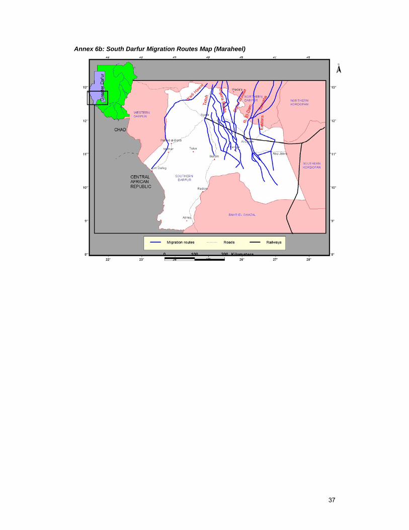
37
Annex 6b: South Darfur Migration Routes Map (Maraheel)
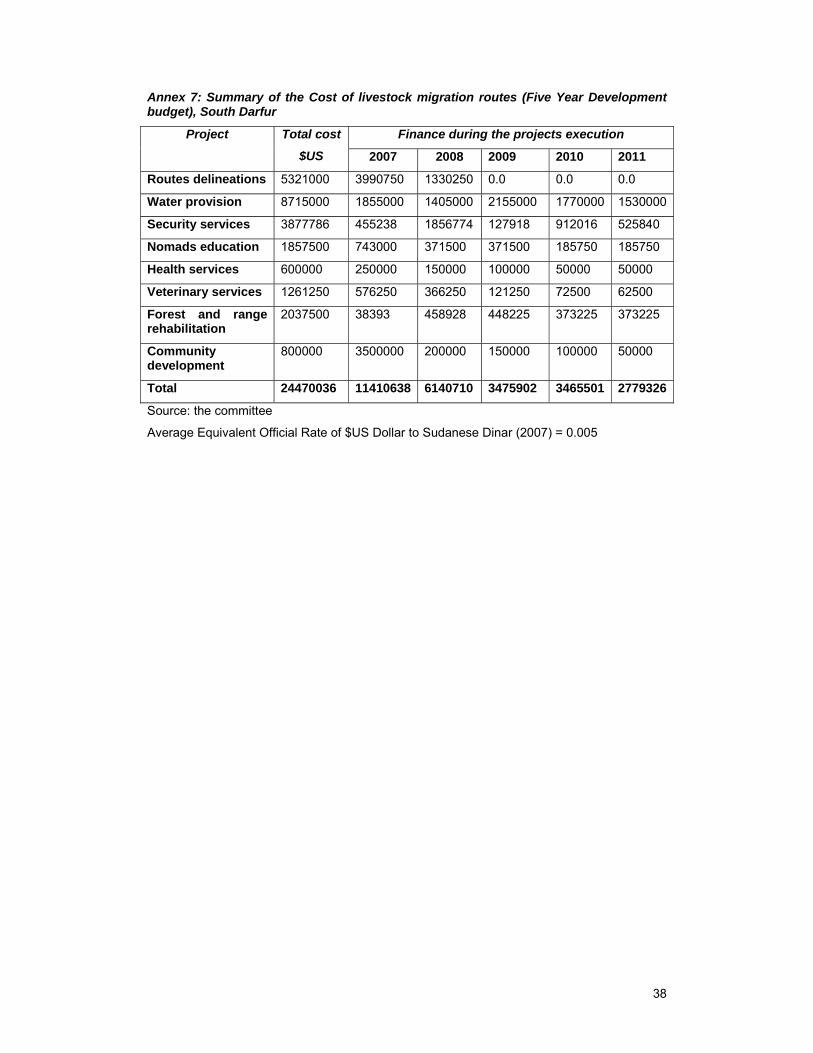
38
Annex 7: Summary of the Cost of livestock migration routes (Five Year Development budget), South Darfur
Project Total cost
$US
Finance during the projects execution
2007 2008 2009 2010 2011
Routes delineations 5321000 3990750 1330250 0.0 0.0 0.0
Water provision 8715000 1855000 1405000 2155000 1770000 1530000
Security services 3877786 455238 1856774 127918 912016 525840
Nomads education 1857500 743000 371500 371500 185750 185750
Health services 600000 250000 150000 100000 50000 50000
Veterinary services 1261250 576250 366250 121250 72500 62500
Forest and range rehabilitation
2037500 38393 458928 448225 373225 373225
Community development
800000 3500000 200000 150000 100000 50000
Total 24470036 11410638 6140710 3475902 3465501 2779326
Source: the committee
Average Equivalent Official Rate of $US Dollar to Sudanese Dinar (2007) = 0.005