Successes and Failures in Urban Development of Ankara
20
ICONARP ICONARP International Journal of Architecture and Planning Volume 1, Issue 2, pp:132-151. ISSN: 2147-9380 available online at: www.iconarp.com International Journal of Architecture and Planning Abstract Ankara, the capital of Turkey, represents a modern model city built in the Republican period after 1923. The majority of the countries’ population resides in this city after İstanbul and political, social and economic functions are mostly clustered in the urban zone. After 1940s, the city changed dramatically. Its population grew enormously and the city expanded through conversion of agricultural lands in the west. In addition, political and educational developments produced a significant population of officials and students within the city. This paper focuses on patterns of settlement in Ankara from ancient times to today and explains these from developments in the urban planning perspective. It concludes that the global shopping malls and local transport- landuse policies together with the structure of housing market have directed the city to car-oriented sprawled development without an identity, encouraged the development of gated communities in the city. It Successes and Failures in Urban Development of Ankara Özge YALÇINER ERCOŞKUN Keywords: Ankara, Urban Planning, Car- Oriented policies, Transformation, Urban Sustainability Özge YALÇINER ERCOŞKUN, Doç.Dr. Gazi Üniversitesi Mimarlık Fakültesi, Şehir ve Bölge Planlama Bölümü, Ankara. [email protected]
Transcript of Successes and Failures in Urban Development of Ankara

ICO
NA
RP
ICONARP International Journal of Architecture and Planning
Volume 1, Issue 2, pp:132-151. ISSN: 2147-9380
available online at: www.iconarp.com
Inte
rnat
ion
al J
ou
rnal
of
Arc
hit
ectu
re a
nd
Pla
nn
ing
Abstract
Ankara, the capital of Turkey, represents a modern model city built in
the Republican period after 1923. The majority of the countries’
population resides in this city after İstanbul and political, social and
economic functions are mostly clustered in the urban zone. After 1940s,
the city changed dramatically. Its population grew enormously and the
city expanded through conversion of agricultural lands in the west. In
addition, political and educational developments produced a significant
population of officials and students within the city. This paper focuses
on patterns of settlement in Ankara from ancient times to today and
explains these from developments in the urban planning perspective. It
concludes that the global shopping malls and local transport- landuse
policies together with the structure of housing market have directed
the city to car-oriented sprawled development without an identity,
encouraged the development of gated communities in the city. It
Successes and Failures in
Urban Development of
Ankara Özge YALÇINER ERCOŞKUN
Keywords:
Ankara, Urban Planning, Car-
Oriented policies, Transformation,
Urban Sustainability
Özge YALÇINER ERCOŞKUN, Doç.Dr. Gazi Üniversitesi Mimarlık Fakültesi, Şehir ve Bölge Planlama Bölümü, Ankara. [email protected]

Özge YALÇINER ERCOŞKUN
Inte
rnat
ion
al J
ou
rnal
of
Arc
hit
ectu
re a
nd
Pla
nn
ing
concludes by posing the question whether this may change in the future
and more mixed use can be expected.
Özet
Türkiye’nin başkenti Ankara, 1923’te Cumhuriyetin kurulmasıyla
modern kentin simgesi olmuştur. İstanbul’dan sonra ülke nüfusunun
çoğunluğunun yaşadığı kentte politik, sosyal ve ekonomik işlevler
kentsel bölgede kümelenmiştir. 1940’lardan sonra kent, dramatik
olarak değişmiştir. Nüfusu çok fazla artmış ve kent batıdaki tarım
alanlarına doğru yayılmıştır. Politik ve eğitimsel gelişmeler kente
memur ve öğrenci nüfusunu çekmiştir. Bu makale Ankara’nın antik
zamandan günümüze olan kentsel yerleşme desenine odaklanmakta ve
kent planlama perspektifinden gelişimini anlatmaktadır. Küresel
alışveriş merkezleri ve yerel toplu taşım-arazi kullanımı politikaları,
beraberce konut piyasasını yönlendirerek araba odaklı, yayılmacı,
kimliksiz bir kent haline getirmiş, kentte kapalı sitelerin gelişimini
desteklemiştir. Makale bunun gelecekte değişerek daha fazla karma
kullanımın görülmesini temenni ederek sonuçlanmaktadır.
INTRODUCTION
Ankara is the capital of Turkey and the country's second
largest city after Istanbul (Figure 1). The city is located at
39°52'30" North, 32°52' East, about 351 km to the southeast of
Istanbul. The city has a population of 4,630,735 in 2012 (greater
city muncipality border), which includes nine districts under the
city's administration (TUIK ADNKS, 2012).
Figure 1.
The city of Ankara lies in the center of Anatolia on the
edge of the high Anatolian Plateau with an altitude of 850 m
(Figure 2). The city is mainly situated in the bowl-like
topographical structure surrounded by mountains on three sides
and opening as a plain towards the west. The historical center of
Ankara is situated upon a steep and rocky hill, which rises 150 m
above the plain on the left bank of the Ankara Stream. Ankara
features cold winters and hot dry summers. Because of Ankara's
high altitude and its dry summers, night temperatures in the
summer months are cool. Although situated in one of the driest
Figure 1. Location of Ankara in Turkey and Ankara Province with its districts (google maps)
Army
Typewritten Text
Army
Typewritten Text
133
Army
Typewritten Text
Army
Typewritten Text

Successes and Failures in Urban Development of Ankara
Inte
rnat
ion
al J
ou
rnal
of
Arc
hit
ectu
re a
nd
Pla
nn
ing
places of Turkey and surrounded mostly by steppe vegetation
except for the forested areas on the southern periphery, Ankara
can be considered a green city in terms of green areas per
inhabitant, which is 17 m2 per capita (Ankara Greater City
Municipality website). Centrally located in Anatolia, Ankara is an
important commercial and service city. It is the center of the
Turkish Government, and houses all foreign embassies. It is an
important crossroads of trade, strategically located at the centre
of Turkey's highway and railway networks, and serves as the
marketing centre for the surrounding agricultural area.
Figure 2.
AN URBAN HISTORY OF ANKARA
Archaeological explorations show that Ankara has been
inhabited since the Old Stone Age (Buluç, 1991). The earliest
document about the physical appearance of Ankara is the sketch
of Dernshaw drawn in 1555. It is seen from this sketch that
Ankara was an open city settled on the plain surrounding the hill
where a castle was placed (Aktüre, 1992).
It is a very old city with various Hittite, Phrygian,
Hellenistic, Roman, Byzantine, and Ottoman archaeological sites.
The hill which overlooks the city is crowned by the ruins of the
old castle (Figure 3). There are remains of Hellenistic, Roman
and Byzantine architecture; the remarkable ones are the Temple
of Augustus and Rome, Roman Bath and Column of Julian. The
region's history can be traced back to the Bronze Age Hatti
civilization, which was succeeded in the 2nd millennium BC by
the Hittites, in the 10th century BC by the Phrygians, and later by
the Lydians, Persians, Greeks, Galatians, Romans, Byzantines, and
Turks (the Seljuks, the Ottoman Empire and Turkey) (Tunçer,
2001).
Figure 2. Ankara urban map with topography (google maps)
Army
Typewritten Text
Army
Typewritten Text
134
Army
Typewritten Text
Army
Typewritten Text

Özge YALÇINER ERCOŞKUN
Inte
rnat
ion
al J
ou
rnal
of
Arc
hit
ectu
re a
nd
Pla
nn
ing
Figure 3.
The foundations of the Ankara citadel were laid by the Galatians
and completed by the Romans. The Byzantines and Seljuks
further made restorations and additions. The area around and
inside the citadel, being the oldest part of Ankara, contains many
fine examples of traditional architecture. Many restored
traditional Turkish houses inside the citadel area have found
new life as restaurants, serving local cuisine (Figure 4).
Figure 4.
Anıtkabir is located on a hill, Anıttepe quarter of the city,
where the mausoleum of Mustafa Kemal Atatürk, founder of the
Figure 3. Ankara citadel
Figure 4. Hamamönü district, a traditional urban pattern near citadel
Army
Typewritten Text
Army
Typewritten Text
135
Army
Typewritten Text
Army
Typewritten Text
Army
Typewritten Text
Army
Typewritten Text
Army
Typewritten Text
Army
Typewritten Text

Successes and Failures in Urban Development of Ankara
Inte
rnat
ion
al J
ou
rnal
of
Arc
hit
ectu
re a
nd
Pla
nn
ing
Republic of Turkey, stands (Figure 5). Ankara Ethnography
Museum presents a fine collection of folkloric artifacts. Museum
of Anatolian Civilizations situated at the entrance of Ankara
Castle houses a collection of Paleolithic, Neolithic, Hatti, Hittite,
Lydian, Phrygian, Urartian, and Roman treasures. State Art and
Sculpture Museum houses a rich collection of Turkish art from
the late 19th century to the present day. War of Independence
Museum, the first Parliament building, houses various photos,
items and wax figures of former presidents.
Figure 5.
The importance of Ankara changed to great extent at the
beginning of the 1920’s; as it became the capital of Turkish
Republic in 1923 (Bademli, 1985). It was a small town of no
importance when it was made the capital of Turkey. It was a
strategic and symbolic decision that Ankara represented new
and comtemporary future (Bayraktar et al., 2008).
After Ankara became the capital of the newly founded
Republic of Turkey, new development divided the city into an old
section, called Ulus, and a new section, called Yenişehir (Figure 6
and 7). Ancient buildings reflecting Byzantine, Ottoman and early
Republican history and narrow streets mark the old section. The
new section, now centered on Kızılay, has the remarks of a
modern city: wide streets, hotels, theaters, shopping malls, and
high-rises. Government offices and foreign embassies are also
located in the new section. Turkish State Opera and Ballet, State
Theatres, concert halls serve the city with many venues. The city
hosts several annual theater, music and film festivals. A
contemporary art museum is newly opened in the city center
Figure 5. Anıtkabir
Army
Typewritten Text
Army
Typewritten Text
136
Army
Typewritten Text

Özge YALÇINER ERCOŞKUN
Inte
rnat
ion
al J
ou
rnal
of
Arc
hit
ectu
re a
nd
Pla
nn
ing
that their buildings were transformed from old wagon
production spaces.
Figure 6.
Figure 7.
DEMOGRAPHICS
City of Ankara has a population of 4,306,105 (2009) of
which 2,146,755 are men and 2,159,350 are women. The
metropolitan municipality contains the central part of the city
and the remaining 9 districts under its jurisdiction.
Figure 6. Kızılay, Atatürk Boulevard and Güven Park in 1930s (Sağdıç, 2002)
Figure 7. Ulus city center in 1930s
(Sağdıç, 2002)
Army
Typewritten Text
Army
Typewritten Text
137
Army
Typewritten Text

Successes and Failures in Urban Development of Ankara
Inte
rnat
ion
al J
ou
rnal
of
Arc
hit
ectu
re a
nd
Pla
nn
ing
The urban population of Ankara increased rapidly after
being a capital (Table 1). From 1920s to 2000s, population
increased more than 100 times because of service sector.
Societal and spatial structure changed parallel to this
development. Ankara was a small town inhabiting 30,000 people
in 1923, its population rised to 74,553 in 1927. The population
was over 2,500,000 in 1990 and 3,000,000 in 2000. The
municipality borders were enlarged after this date.
Tablo 1.
Population of Ankara (TUIK Statistics)
Year Population
2012 4,630,735
2011 4,550,662
2010 4,431,719
2009 4,306,105
2000 3,356,877
1990 2,584,594
1985 2,304,166
1970 1,236,152
1965 905,660
1960 650,067
1955 451,241
1950 288,536
1940 157,242
1927 74,553
The migration reason of young people between 15 and 24
can be explained as university students, soldiers and job seekers.
The denser districts are Çankaya and Altındağ over 2800
inhabitants per square kilometer. The average family size is 3.69.
The unemployment rate is 11% in the city. The main sectors are
service (70.4%), agriculture (16.2%) and industry (13.4%)
(Ankara Greater Mucipality 2023 Plan Report, 2009). Ankara
inhabits many universities. These include 11 universities, several
of them being among the most reputable in the country. Ankara
is the center of technoparks after 2001 Technopark Law. 5
technoparks next to Middle East Technical, Bilkent, Ankara, Gazi
and Hacettepe Universities provides R&D activities in their large
campuses (Ministry of Industry and Commerce website).
PLANNING STRUCTURES OF ANKARA
For the increasing population, Lörcher prepared a local
plan, opening a new settlement area in 1925. This was the first
attempt in realising the development of the city on new lands,
apart from the old city; creating a dual structure (Bademli,
1987). The increase in the population caused changes in the
Army
Typewritten Text
Army
Typewritten Text
138
Army
Typewritten Text
Army
Typewritten Text
Army
Typewritten Text
Özge YALÇINER ERCOŞKUN
Inte
rnat
ion
al J
ou
rnal
of
Arc
hit
ectu
re a
nd
Pla
nn
ing
intensity in the old city, thus new development areas began to
evolve towards the south of the old city. “Within this era there is
no frame that would determine and guide development and
integrate the old and new settlement areas” (Tankut, 1993:44)
thus, the need for a development plan for this rapidly growing
city was obvious. Since being the capital Ankara has lived seven
planning experiences. These seven plans till now are:
1. Lörcher Plan (1925)
2. Jansen Plan (1928)
3. Uybadin-Yücel Plan (1957)
4. Metropolitan Planning Office Plan (1970)
5. Ankara 2015 Structure Plan of METU (1985)
6. 2025 Plan of Ankara Greater City Municipality (1996)
7. 2023 Ankara Development Plan of Ankara Greater City
Municipality (2007)
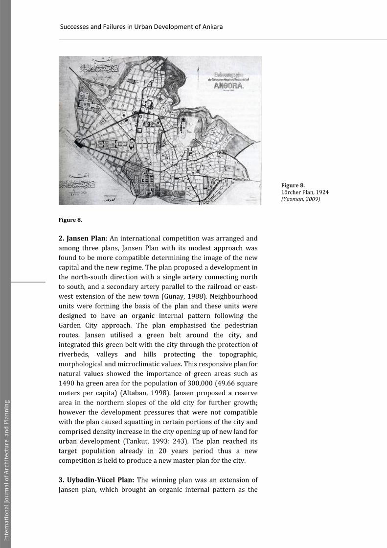
1.Lörcher Plan (1925): Lörcher made a plan for old city-Ulus in
1924 and he prepared a second plan for new city- Kızılay in 1925
for the next 5 years in those dates (Figure 8). His idea was to
build main boulevards and squares representing new capital and
public spaces. Old city was protected and new city was directed
to Çankaya in the south. Lörcher connected two parts with
station-parliament-citadel axis. The squares were the focus in
this axis. Zafer Square was the space of culture with theaters and
cinemas. Millet Square was a green and open space with a
mosque and bath. Cumhuriyet Square was an administrative
space with new ministry buildings (Cengizkan, 2002). Lörcher
plan was rejected without any reason but the main boulevards
and public space ideology were remained. Cumhuriyet Square
renamed as Kızılay Square which become the city center. New
city concept was protected and public interest in the west view
was legalized in the next years (Sargın, 2009). Turkish
Revolution struggled with monarchy. It was reflected in the built
environment. New capital with new administrative buildings,
designing for people, reforming society with city planning and
reflecting revolution idea on the city space was the main
principle. Governmental buildings were constructed in Ankara
with geometrical shapes, new material and production methods
(Baslo, Yürekli, 2009).
Army
Typewritten Text
Army
Typewritten Text
139
Army
Typewritten Text
Army
Typewritten Text
Successes and Failures in Urban Development of Ankara
Inte
rnat
ion
al J
ou
rnal
of
Arc
hit
ectu
re a
nd
Pla
nn
ing
Figure 8.
2. Jansen Plan: An international competition was arranged and
among three plans, Jansen Plan with its modest approach was
found to be more compatible determining the image of the new
capital and the new regime. The plan proposed a development in
the north-south direction with a single artery connecting north
to south, and a secondary artery parallel to the railroad or east-
west extension of the new town (Günay, 1988). Neighbourhood
units were forming the basis of the plan and these units were
designed to have an organic internal pattern following the
Garden City approach. The plan emphasised the pedestrian
routes. Jansen utilised a green belt around the city, and
integrated this green belt with the city through the protection of
riverbeds, valleys and hills protecting the topographic,
morphological and microclimatic values. This responsive plan for
natural values showed the importance of green areas such as
1490 ha green area for the population of 300,000 (49.66 square
meters per capita) (Altaban, 1998). Jansen proposed a reserve
area in the northern slopes of the old city for further growth;
however the development pressures that were not compatible
with the plan caused squatting in certain portions of the city and
comprised density increase in the city opening up of new land for
urban development (Tankut, 1993: 243). The plan reached its
target population already in 20 years period thus a new
competition is held to produce a new master plan for the city.
3. Uybadin-Yücel Plan: The winning plan was an extension of
Jansen plan, which brought an organic internal pattern as the
Figure 8. Lörcher Plan, 1924 (Yazman, 2009)
Army
Typewritten Text
Army
Typewritten Text
140
Army
Typewritten Text
Army
Typewritten Text

Özge YALÇINER ERCOŞKUN
Inte
rnat
ion
al J
ou
rnal
of
Arc
hit
ectu
re a
nd
Pla
nn
ing
follower of the Garden City tradition. It emphasised the north-
south axis and the limits of development reached to higher
altitudes. A contribution of the plan was the peripheral road in
the west of the city connecting to other arteries as intercity
highway network (Günay, 1988). Jansen’s determination of the
new city as the administrative centre caused the development
jump into the southern part of the city. The old city expanded its
central functions, and the major artery, which was proposed
towards south axis, gained too much importance with residential
and commercial functions in the new city (AMNPB, 1977). The
plan remained insufficient in bringing solutions to the problems
of the city and failed in providing a form and structure of the city
to guide further development (Bademli, 1987). In the 1960s, it
was disturbed by local plans aiming at density increases. The
increments in building densities brought an overloaded
population in the plan area. The idea of low-density garden city
was used to create a high density, dull and monotonous city
(Günay, 1988). The first skyscraper of Turkey was constructed in
1964 in Kızılay Square (İlkay, 2008). The city in this era,
continued to grow in an oil-drop form and environmental
problems like air pollution emerged in the late 1960s. The
continuous increase in population and development pressures
necessitated a new plan.
4. Metropolitan Planning Office Plan-1990 Master Plan: The
new plan which has recently been the legal document directed
the development towards the western corridor including the
squatter prevention zones, new housing developments and
industrial zones (Bademli, 1987). During this plan period, the
city spread continuously over the higher edges of the bowl-like
entity and also exceeded outside the bowl to the valleys around
it. The city extended along its boundaries in every direction and
at the same time linear growth along the main roads to the city
came into existence in the last decades. In order to overcome the
disadvantages of the centralised macroform, new planning
strategies directed the growth along axes; most densely along
western corridor.
5. Ankara-2015 Structure Plan of METU: After the four plans,
Ankara-2015 plan which was prepared by academicians of
Middle East Technical University (METU) brought a different
perspective to the growth of the city. Decentralization was
determined as the primary aim for the future developments of
Ankara in this plan. The population estimations for 30 years
period showed that, the city would double and would reach to a
population of 5 millions, so it was no more feasible to
concentrate this population in compact form. Günay (1988:46)
Army
Typewritten Text
Army
Typewritten Text
141
Army
Typewritten Text
Army
Typewritten Text

Successes and Failures in Urban Development of Ankara
Inte
rnat
ion
al J
ou
rnal
of
Arc
hit
ectu
re a
nd
Pla
nn
ing
states “the new form is based on six growth directions where
geographically suitable western corridor is still the bulkiest. In
between the growth directions, green belts are proposed”. The
new plan proposed a parallel system to the existing road
network to provide new hierarchy in the transportation. With
this structure plan, the dense structure of the city was being
decentralized and an axial development structure was aimed
(Ceylan, 2003). From 1985 to 1997, city macroform of Ankara
has expanded to higher altitudes of surrounding mountains to
the north, southeast, and to valley bottoms and basin floors to
the west and southwest. The continuous expanding after 1985
has reached to unsuitable lands by unplanned squatter
developments settled on periphery of planned development and
cheap land markets.
6. 2025 Plan of Ankara Greater City Municipality: The 2025
master plan, prepared by Ankara Greater City Municipality but
not become a legal document, enlarges the city towards the
limits of the ring road, even goes beyond the ring road in the
northwest direction. At the plan, especially in the areas between
the ring road and the city were suggested new settlements,
forestation and recreational uses. With the plan, it is aimed that,
the expected population for the year 2025 would be 6.5 million,
which is quite high for the city whose population increase is
slowed down since 1990s. The areas including the universities
towards the south are defined as huge green areas of the city and
natural valleys and mountains in the south are offered as tourism
recreation centres. Although the plan determines conservation
areas and defines the methods for preserving the Metropolitan
Area, some of the proposed residential developments like in
southwest development may results in unsustainable
development due to the excess land development in the
ecologically sensitive areas (Ercoşkun et al., 2005).
7.2023 Ankara Development Plan of Ankara Greater City
Municipality: The 2023 master plan, 1/25000 scale, prepared
by Ankara Greater City Municipality became a legal document in
2007 (Figure 9). City gained a plan after 15 years. Fragmented
plans and regeneration projects brought many residential areas
and legalized unplanned settlements in the periphery in recent
years. This plan offered new sub-plans in the thematic areas of
CBD, transportation and environment. A good inventory has
been built under the headings of history, urban form,
demography and social life. Five main planning corridors
regarding water basins and development zones, also strategic
sub-centers, special projects areas have been defined in this plan
Army
Typewritten Text
Army
Typewritten Text
142
Army
Typewritten Text
Army
Typewritten Text

Özge YALÇINER ERCOŞKUN
Inte
rnat
ion
al J
ou
rnal
of
Arc
hit
ectu
re a
nd
Pla
nn
ing
which should be supported by detailed local plans and designs
(Ankara Greater Mucipality 2023 Plan Report, 2009).
Figure 9.
ENVIRONMENTAL, ECONOMIC AND SOCIAL SUSTAINABILITY
Lörcher puts public spaces and squares and axial
development for the city core in his plan. The Jansen plan
proposes a compact organic development form and the Uybadin-
Yücel plan shapes the city core together with two former plans.
The plan of Metropolitan Office brings linear extensions over the
existing compact form. However, 2015 METU plan proposes a
different approach bringing decentralization. Although the plan
proposes a decentralized form, the rapid increase in population
fills the transition areas with illegal settlements thus causes an
oil drop development. The 2025 plan of the Greater Municipality
proposes excess development areas. Lörcher plan was only a
pinpoint in the 2023 plan that city sprawled more than 30 times.
Although the studies of 2023 plan aim a participatory ecological
and strategic approach, ongoing city actions in the short term,
come from top to bottom, and seem to continue to damage the
ecological areas, agricultural lands, valleys and water resources
with suburbanization and wrong transportation policies.
In regard to the urban sustainability in Ankara; it is seen
that because of the rapid population growth and insufficient
guidance of the development plans, Ankara has developed in an
oil-drop form expanding in the west and northwest. Within the
environmental approach, such an oil-drop development has
caused loss of natural areas and valleys like Dikmen,
Portakalçiçeği, Kavaklıdere and Bentderesi which were the lungs
of the city. The sprawl brought more energy consumption. It is
seen that energy savings can rise up to 150 percent in cities by
changing the form, size, residential density and the location of
Figure 9. 2023 Ankara Development Plan
of Ankara Greater City
Municipality
(Ankara Greater City Municipality
website)
Army
Typewritten Text
Army
Typewritten Text
143
Army
Typewritten Text

Successes and Failures in Urban Development of Ankara
Inte
rnat
ion
al J
ou
rnal
of
Arc
hit
ectu
re a
nd
Pla
nn
ing
activities (Leitmann, 1999). The changing form of the city has not
been efficiently supported by the transportation systems.
Especially, the quality and quantity of public transportation
system in Ankara have become insufficient, so the percentage of
the usage of private cars has increased gradually. This has caused
lots of environmental problems like air, water and noise
pollution and traffic congestion. Besides, the green areas in
Ankara have decreased because of rapidly growing population
and the density increment in the city centre. Consequently, the
quality of life reduces and urban sustainability of the city runs a
risk. However, in the recent years local authorities have realised
that green areas need to be given extra attention to ensure a
better quality of life in their cities. Thus, they try to increase this
ratio by activating new projects in the urban periphery.
From the point of view of economic consideration,
Ankara as being the service centre of Turkey continuously has
been attracting population. The development of the city in the
oil-drop form increases the cost of infrastructure. In contrast to
the rapid increase in population, the development of land is quite
slow that causes illegal settlements especially in the fringes. The
density increment in the centre of the city and the land demand
especially in the western corridor increase the land prices and
urban land rant. As a result, it is seen that Ankara has become
one of the cities with the highest land prices in Turkey. The
linear development of the city towards west causes linear
commercial and public activities along two main highways and
the formation of shopping malls in the new development areas.
This development trend goes towards a polycentric urban
structure.
With the 27 km of sprawl from the city center to the west,
many new residential areas have emerged in southwest and
northwest parts. Northwest districts have middle income and
southwest districts have high income inhabitants. Such
decentralised housing policies bring a social segregation in
Ankara. Also, zoning of residential areas has protected the
privacy in these areas. Coming to the social interaction, it can be
found in the main city centre, in the urban square with meeting
and shopping activities. Also there are some cultural facilities in
the city centre like cinemas, theater and some festivals.
SUCCESSES AND FAILURES ON URBAN DEVELOPMENT
Infrastructure and Transportation
Much of Turkey suffered one of its driest years in 2007.
Ankara had serious water shortage and experts criticized the
policies and actions of the Greater Ankara Municipality in solving
the problem as political. The municipality provided water from
two dams, built upon the Kızılırmak River, as an urgent solution
Army
Typewritten Text
Army
Typewritten Text
144
Army
Typewritten Text
Army
Typewritten Text

Özge YALÇINER ERCOŞKUN
Inte
rnat
ion
al J
ou
rnal
of
Arc
hit
ectu
re a
nd
Pla
nn
ing
to the problem. However, Ankara residents faced to consume
unsafe and more expensive water as a result of the Kızılırmak
project where the river is dangerously contaminated and cannot
be treated with the existing technology. Today, citizens cannot
trust and have to buy demijohn water served to the doors.
Considering transportation system, the landuse variables
that may influence Ankara’s transportation structure are listed in
Table 2. Car ownership is 0.168. In transport planning studies of
Ankara, car ownership level is used as an indicator of the income
level.
Table 2.
Ankara’s transportation structure (EGO, 2009)
During the last 50 years’ urbanization process in Ankara,
many transportation problems have appeared. In the 1930’s,
population was about 90.000 and automobile trips consisted the
15% of total trips. Today, automobile trips have a significant role
in urban transport. The number of total motorized trips is
952.077 in the peak hour in Ankara. The occupancy rate of
private cars and taxis is about 1.6 people/per vehicle. The most
important trip purpose is going to work and it holds 61% of the
total motorized trips (Öcalır et al., 2010). Particularly Ankara has
been home to extensive road programmes that increased road
capacities and constructed grade separated junctions, resulting
in increased traffic speeds and significantly deteriorated travel
conditions for pedestrians and cyclists. The municipality is
criticized because of car-oriented policies and high public
transport fees.
The Electricity, Gas, Bus General Directorate (EGO)
operates the Ankara Metro and other forms of public
transportation. Ankara is currently served by suburban rail and
two subway lines with about 300,000 total daily commuters, and
three additional subway lines are under construction.
Green Areas
Ankara has lost valleys replaced by high rise housing
developments but many parks established in the early years of
the Republic remain. The most important of these parks are:
Gençlik Park (main urban park from Republican period) (Uludağ,
1998), the Botanical Garden, Seğmenler Park, Anayasa Park,
Kuğulu Park, Abdi İpekçi Park, Güven Park, Kurtuluş Park,
Altınpark. The main aim of the Republic was to change ummah
ideology and to create citizenship. The space of the citizen was
Population Labour force Number of private cars
4,306,105 1,285,139 688,750
Army
Typewritten Text
Army
Typewritten Text
145
Army
Typewritten Text
Army
Typewritten Text

Successes and Failures in Urban Development of Ankara
Inte
rnat
ion
al J
ou
rnal
of
Arc
hit
ectu
re a
nd
Pla
nn
ing
the public space since Roman times. All revolutions brought with
the Republic for the new citizen and his city. A transformation
was aimed from appearance to behaviors. Contemporary city
spaces were shaped with city parks, city clubs etc. Gençlik Park
in Ankara symbolized this idea. However, today, there is an
implementation in the parks which should be used for picnic and
barbeque places opposite to the idea of contemporary citizens
(Çağıl, 2007). It becomes clear that some drastic measures need
to be taken for the general upgrading of services and facilities in
parks (Oğuz, 2000).
Atatürk Forest Farm and Zoo is an expansive recreational
farming area (1471 ha) which houses a zoo, several small
agricultural farms, greenhouses, restaurants, a dairy farm and a
brewery (Tekel et al., 2005). It is a pleasant place to spend a day
with family. There is also a replica of the house where Atatürk
was born in Thessaloniki, Greece. Visitors of the farm can taste
famous products such as ice cream, fresh dairy products and
kebaps in the cafés. However, Greater City Municipality of
Ankara prepared a plan for this large area in 2007 and many
opposite ideas came up. A safari park, lots of commercial
facilities and new traffic roads were on debate and today roads
are being built.
Housing Developments and Shopping Malls High income people living in the city center and in the
gated community tend to avoid the same areas of Ankara, all of
which are low-income districts or squatter areas. Spatial
segregation has long been present with invisible boundaries.
Economic restructuring, urban transformation created gated
communities as a new form of spatial segregation for high
income people (Erkip, 2010). Cooperatives or sites developed by
large construction firms formed gated communities in Çayyolu,
Beysukent, Yaşamkent etc. Sub-centers were not planned and
there was lack of public spaces in these development areas.
Ankara has important experiences with squatter
(gecekondu) areas and their transformation processes.
Gecekondu areas located in close to the city centre in Ankara.
The central gecekondu areas were on rough topography. In the
later stages of urban development, after 1950s the gecekondu
areas formed a belt around the city centre with the expansion of
urban form. These constituted avoided areas in the city like
Mamak, Çinçin etc. In order to solve the problems of gecekondu
areas and to achieve rapid urban transformation on a mass scale,
transformation in gecekondu areas was first included in the
Improvement and Development Laws. They became important
implementation tools for transformation of gecekondu areas.
After the 1980s, Ankara Greater City Municipality prepared and
Army
Typewritten Text
Army
Typewritten Text
146
Army
Typewritten Text
Army
Typewritten Text

Özge YALÇINER ERCOŞKUN
Inte
rnat
ion
al J
ou
rnal
of
Arc
hit
ectu
re a
nd
Pla
nn
ing
implemented various ‘gecekondu transformation projects’.
Today, the preparation process of improvement plans has been
finished for almost all gecekondu areas in Ankara, the
implementation of transformation projects continues (Köroğlu,
Ercoşkun, 2006).
There are 7 urban transformation projects coordinated
by Greater City Municipality of Ankara (North Ankara City
Entrance, Güneykent, Çukurambar, Nasreddin Hoca, Batıkent I-II,
Çayyolu), 4 projects in Çankaya (Dikmen I-V, Geçak), 5 in
Altındağ (Ulus, Atilla-Aktaş, Gültepe-Çinçin, Ankara old city
center), 1 in Sincan, 2 in Yenimahalle (Demetevler, Şentepe) and
12 in Mamak (Doğukent, Araplar, Durali Alıç, Gaz Maske, Yatık
Musluk, Hüseyin Gazi, İmrahor, Kazım Orbay, South Bayındır,
Samsun Road, 50. Yıl, Ekin quarter). Beyond Greater City
Municipality of Ankara, the others are owned by private
ownership and organized by the consortium of the municipality,
The Mass Housing Directorate of Turkey (TOKİ) and private
sector (Güzey, 2009). Most of the projects’ aim is to change the
negative fabric of squatter settlements and create housing for
middle and high income groups. Only Ulus and Ankara old city
centre are the conservation projects and they aim to increase
prestige in the areas. 6100 ha of land are being regenerated in
the municipality border after 2004.
Urban transformation and regeneration is developing as
a tool in the re-gaining the squatter housing areas. However,
discussions focus on the exclusion of the present residents,
increase in the prices of land, inability to control urban
development (Güzey, 2009). Furthermore, single-recipe
applications overlook the differences between urban areas and
thus harm the agricultural and natural areas. For this, increasing
the participatory eco-planning processes, involving the
stakeholders to the process is a way and there is need for
intervention to plot scale applications of the developers and
architects to direct and establish an urban design in the area
(Köroğlu, Ercoşkun, 2006).
Parallel to the boom of transformation projects, fast
paced growth of the number of shopping centers has an impact
on allocation of retailing activities in cities. Most stores selling
national and international brands, located at city centers have
moved to shopping centers, leaving these areas deprived. This
puts an economic strain on most of the local retailers located in
city centers. In Ankara, there have not been comprehensive plans
and projects to promote shopping street vitality and viability
since the 1990s, and public spaces with this potential are often
ignored. The amount of shopping center leasable area per 1000
persons is the highest in Ankara in Turkey (Soysal, 2008), mostly
due to 1) its socio-economic structure, which is mainly
Army
Typewritten Text
Army
Typewritten Text
147
Army
Typewritten Text
Army
Typewritten Text

Successes and Failures in Urban Development of Ankara
Inte
rnat
ion
al J
ou
rnal
of
Arc
hit
ectu
re a
nd
Pla
nn
ing
composed of public officials and university students, creating a
relatively stable economic system, convenient for shopping
center investments, and 2) the encouragement of shopping
center construction by the Greater Municipality of Ankara. In
2012, 36 shopping centers exist in the city and citizens prefer
these centers for easy parking and leisure activities.
FUTURE DEVELOPMENTS
Ankara Greater Municipality forecasts population of
5.445.803 in 2023. The migration from rural to city will be
decreased and semi-rural areas will gain importance. The
population will settle to west and southwest areas. The sub-
centers will be the strategic attraction points (Ankara Greater
Mucipality 2023 Plan Report, 2009).
Large land areas where squatters live in Ankara have
become attractive and offer potential for constructing large
development complexes as gentrified neighborhoods and new
consumption places operated by under the new global economy.
The government seems to prefer to follow a more marketbased
open economic policy by supporting private construction sector
and private construction firms. However, the high interest rates
and lack of financial support by the government makes it
impossible for the poor households and even the lower-middle
income households to own a house. The mass housing projects of
the TOKİ has to be considered at this point that public sector as
the big housing producers should show more effort to fulfill the
increasing demand of the urban poor. However, the large scale
constructions in Ankara, mass housing projects have an effect to
increase the house prices (Akpınar, 2008). There are 15 housing
projects of TOKİ whose construction finished. The number of 49
housing projects is under construction, named as North Ankara
City Entrance, Eryaman and Sincan suburban areas in the north-
west, Turkuaz and Yapracık in the west axis (TOKİ website).
There are M2, M3 and M4 metro line constructions which
will serve to these residential areas. First is from city center to
suburban areas in the west (Kızılay- Çayyolu 2). Second line is an
extension from a suburban area to other one near to the industry
areas in the north-west (Batıkent, Sincan, Törekent) and the
third one connects commercial and office development to major
housing areas to the north (Tandoğan- Keçiören) (EGO website).
However, the metro projects are expected to finish in 2016.
Lastly, for the shopping malls, Turkey’s Council of
Shopping Centers states that the shopping center total space
grew from the current 4.5 million square meters to 5.5 million
square meters by the end of 2009, or early 2010 in the country
(Hürriyet, 2010). However, two shopping centers (plus 36) are
on the way and almost every district has a luxury shopping
Army
Typewritten Text
Army
Typewritten Text
148
Army
Typewritten Text

Özge YALÇINER ERCOŞKUN
Inte
rnat
ion
al J
ou
rnal
of
Arc
hit
ectu
re a
nd
Pla
nn
ing
center in Ankara. Beyond global big box investmens, citizens
need revitalized shopping streets and open air activities which
municipality disregards.
CONCLUSION
As a result, lower levels of economic development,
smaller urban budgets, and shortages of environmental
infrastructures, shelter and basic services in developing
countries have resulted in a different pattern of urban
development and environmental degradation which looks as
unsustainable. Similarly for Ankara, when environmental, social
and economic approaches are evaluated the development seems
quite unsustainable. However, urban sustainability could be
achieved by applying sustainable principles by eco-planning. A
strong emphasis should be given to urban management. There
may be a shift away from development planning on controlling
and limiting development towards participatory eco-planning
using proactive and flexible measured based on a consensus of
city interests. They should be incorporated within existing
structures like strategic plans for the CBD and periphery, urban
transport strategies, urban regeneration, urban compaction,
suburbanization etc. Polycentric cities whose centres contain
mix-use land pattern and connect to different subcentres by
effective and environmentally sound public transport
infrastructure should also be encouraged within metropolitan
areas where the central cities are unable to function efficiently if
they retain their original monocentric spatial structures.
Environmental issues should be integrated into the planning
system on spatial, land use, energy and transport dimensions
considering economic and social decisions. Sustainability
principles should be incorporated into effective implementation
on the city to build a city vision.
KAYNAKLAR
Akçura, T. (1971). Ankara - Türkiye Cumhuriyeti’nin Başkenti Hakkında Monografik Bir Araştırma. ODTÜ, Ankara.
Akpınar, F. (2008). “Class dimension of housing inequalities in the new era of liberalization: a case study in Ankara”, METU JFA 25:2,pp. 39-69.
Aktüre, S. (1992). Osmanlı döneminde Ankara’nın ticaret merkezi hanlar bölgesi, in Şahin, N. (Ed), Ankara Konuşmaları. TMMOB Chamber of Architects, Ankara Branch, Ankara.
Altaban, Ö. (1998). 75 Yılda Değişen Kent ve Mimarlık, Tarih Vakfı
Yayınları, İstanbul.
Army
Typewritten Text
Army
Typewritten Text
149
Army
Typewritten Text
Army
Typewritten Text

Successes and Failures in Urban Development of Ankara
Inte
rnat
ion
al J
ou
rnal
of
Arc
hit
ectu
re a
nd
Pla
nn
ing
AMNPB (1977). Ankara Metropoliten Nazım Plan Bürosu Raporu,
pp. 321-322.
Ankara Greater Mucipality 2023 Plan Report, 2009, http://www.ankara.bel.tr/AbbSayfalari/ABB_Nazim_Plani/ABB_nazim_plani.aspx
Ankara Greater City Municipality website, http://www.ankara.bel.tr
Bademli, R. (1985). “1920-40 döneminde Ankara’nın yazgısını etkileyen tutumlar”, Mimarlık Journal 121, pp.10-16.
Bademli, R. (1987). Ankara’da kent planlama deneyi ve ulaşılan sonuçlar, in Tekeli, İ. (Ed) Ankara 1985’ten 2015’e. Ajans İletişim, Ankara.
Baslo, M. A.; Yürekli, F. (2009). “Bir devrim mekanı: Ankara”, İTÜ Dergisi/A 8(2), pp. 121-132.
Bayraktar, N.; Tekel, A.; Ercoşkun, Ö.Y. (2008). “An evaluation and classification of urban furniture on Ankara Ataturk Boulevard and relation with urban identity”, Journal of Gazi University Engineering and Architecture Faculty 23(1),pp. 105-118.
Buluç, S. (1991). “İlkçağda Ankara”, Ankara Dergisi 2,13-22. Cengizkan, A. (2002). 1924-25 Lörcher Planı: Ankara’nın İlk Planı,
Arkadaş Yayınları, Ankara. Ceylan, A. (2003). Structural tools in the making of cities: form as
a development control mechanism, unpublished Msc thesis, METU, Ankara.
Çağıl, İ. (2007). Baykan Günay ile Ankara Üzerine, http://www.arkitera.com/s74-baykan-gunay-ile-ankara-uzerine.html, 04/05/2010
EGO 2009 website, http://web.ego.gov.tr/inc/newsread.asp?id=265
Ercoşkun, Ö.Y.; Varol, Ç.; Gürer, N. (2005). “From a planned capital to a scattered urban form: analysing sustainability of Ankara”, SB05 The 2005 World Sustainable Building Conference Proceedings CD, Tokyo.
Erkip, F. (2010). “Community and neighborhood relations in Ankara: an urban–suburban contrast”, Cities 27, pp.96-102.
Hürriyet, 01/05/2010, http://www.hurriyet.com.tr/english/finance/11137233.asp
İlkay, Y. (2008). “Kızılay Meydanı’nın politik-sembolik anlamı: 1960-1964 yılları”, Mülkiye Dergisi 261, Ankara.
Günay, B. (1988). “Our generation of planners, the hopes, the fears, the facts; case study: Ankara”, Scupad 88, 20th Anniversary Meeting, Salzburg.
Güzey, Ö. (2009.) “Urban regeneration and increased competitive power: Ankara in an era of globalization”, Cities 26,pp. 27-37.
Köroğlu, B.A.; Ercoşkun, Ö.Y. (2006). “Urban transformation: a case study on Çukurambar”, Ankara, Gazi University Journal of Science 19(3),pp. 173-183.
Leitmann, J. (1999). Sustaining Cities: Environmental Planning and Management in Urban Design, McGraw Hill Professional Architecture, USA.
Army
Typewritten Text
Army
Typewritten Text
150
Army
Typewritten Text
Army
Typewritten Text

Özge YALÇINER ERCOŞKUN
Inte
rnat
ion
al J
ou
rnal
of
Arc
hit
ectu
re a
nd
Pla
nn
ing
Ministry of Industry and Commerce website, http://www.sanayi.gov.tr, 04/05/2010
Oğuz, D. (2000). “User surveys of Ankara's urban parks”, Landscape and Urban Planning 52, pp.165-171.
Öcalır, E.V.; Ercoşkun, Ö.Y.; Tür, R. (2010). “An integrated model of GIS and fuzzy-logic (FMOTS) for location decisions of taxicab stands”, Expert Systems With Applications 37, pp.4892-4901.
Sağdıç, O. (2002). Once upon a time Ankara, Ankara Greater City Municipality Publication, Ankara.
Sargın, G.A. (2009). “Öncül kamusal mekanları tasarlamak: başkent Ankara üzerine kısa notlar, 1923-1946”, Mülkiye Dergisi 241, Ankara.
Soysal Shopping Center Catalogue, 2008, http://www.soysal.com.tr/bolum/20/soysal-gorsel-magazacilik-katalogu-2008/tr, 02/03/2009.
Tankut, G. (1993). Bir Başkentin İmarı:(1929-1939), Anahtar Kitaplar, İstanbul.
Tekel, A.; Varol, Ç.; Ercoşkun, Ö.Y.; Gürer, N. (2005). Bir yaz okulunun adından: Atatürk orman çiftliği, Planlama Journal 2005/4; pp. 26-34.
TOKİ website,
http://www.toki.gov.tr/programlar/uygulamatakip/c_illis
t.asp?x_ilkodu=6, 20/03/2010.
TUIK Statistics, ADNKS, 2009,
http://tuikapp.tuik.gov.tr/adnksdagitapp/adnks.zul,
23/04/2010.
Tunçer, M. (2001). Ankara (Angora) Şehri Merkez Gelişimi (14-
20.YY), T.C. Kültür Bakanlığı Kültür Eserleri, Ankara.
Yazman, D. (2009).
http://www.arkitera.com/news.php?action=displayNewsI
tem&ID=46008, 13/10/2009.
RESUME
She is an associate professor in the City and Regional Planning Department of the Gazi University, Ankara, Turkey. She graduated from the City and Regional Planning Department of the Istanbul Technical University in 1998. She completed her master’s studies in the Geodetic and Geographic Information Technologies Department of the METU in 2002. She got her Ph.D. degree from the City and Regional Planning Department of the Gazi University in 2007. She has attended several national and international congresses; summer schools and workshops related to ecological urban planning and geographic information systems. She has written more than 50 papers on sustainable urban design and ecological and smart urban planning, geographic information systems and information technologies. She worked as a researcher in many national and institutional projects. She has awards about sustainability and urban growth, sustainable tourism.
Army
Typewritten Text
Army
Typewritten Text
151
Army
Typewritten Text
Army
Typewritten Text
Army
Typewritten Text
Army
Typewritten Text