Port of Nome Modification Feasibility Study Nome, Alaska ...

Subsistence Salmon Fishingby Residents of
Nome, Alaska, 2001
byJames S. Magdanz, Sandra Tahbone,Kurt Kamletz, and Austin Ahmasuk
Technical Paper 274
Natural Resources DepartmentKawerak, Inc.Nome, Alaska
Division of SubsistenceAlaska Department of Fish and Game
Juneau, Alaska
Funded byOffice of Subsistence Management
U.S. Fish and Wildlife ServiceAnchorage, Alaska
Fishery Information Services Project 01-224
February 2003

The Alaska Department of Fish and Game administers all programs and activities free from
discrimination based on race, color, national origin, age, sex, religion, marital status, preg-
nancy, parenthood, or disability. The department administers all programs and activities in
compliance with Title VI of the Civil Rights Act of 1964, Section 504 of the Rehabilitation
Act of 1973, Title II of the Americans with Disabilities Act of 1990, the Age Discrimination
Act of 1975, and Title IX of the Education Amendments of 1972.
If you believe you have been discriminated against in any program, activity, or facility,
or if you desire further information please write to ADF&G, P.O. Box 25526, Juneau, AK
99802-5526; U.S. Fish and Wildlife Service, 4040 N. Fairfield Drive, Suite 300, Arlington,
VA 22203; or O.E.O., U.S. Department of the Interior, Washington DC 20240.
For information on alternative formats for this and other department publications, please
contact the department ADA Coordinator at (voice) 907-465-4120, (TDD) 907-465-3646,
or (FAX) 907-465-2440.
Sandra Tahbone: [email protected] Magdanz: [email protected]
Kurt Kamletz: [email protected]

i
Abstract
Nome was among the first western Alaska communities to be affectedby the recent declines in western Alaska salmon stocks. In response tosevere salmon fishing restrictions in the Nome subdistrict, some Nomefamilies began subsistence fishing in adacjent less regulated areas.Except in Pilgrim River, the efforts and harvests of these fishing familieshave not been documented, either through permits or surveys. Nomeresidents’ impact on the fish stocks and on the fishing opportunitiesfor residents of these adjacent areas has been unknown.
This project identified three different strata of Nome householdsbelieved to be fishing for salmon outside the Nome permit areas: (1)members of the King Island Community, (2) other Nome householdsidentified by a network of key respondents in Nome, and (3) Nomehouseholds whose members had obtained sport fishing licenses in 2000.Households in each group were surveyed to estimate the number ofsalmon harvested in 2001, the locations of harvests, and other data. Inaddition, key respondents in Teller and White Mountain wereinterviewed to discuss the impacts of Nome residents’ fishing onadjacent communities.
An analysis of Nome survey and permit data for 2001 indicatedthat Nome residents harvested 47 percent of their salmon outside theNome permit area. Of the estimated 6,138 salmon harvested bysampled households, 1,158 salmon (19 percent) came from the PortClarence area, and 1,426 salmon (23 percent) came from the WhiteMountain-Golovin area. Nome residents relied primarily on nets toharvest salmon in the Port Clarence area, where 94 percent of Nome’sharvest was taken with nets and only 6 percent taken with rod andreel. Rods and reels were more commonly used in the White Mountain-Golovin Area, where 61 percent of the harvest was taken with netsand 39 percent with rod and reel.
Respondents interviewed in White Mountain and Teller reportedincreased competition for fishing sites related to increased effort byNome residents. In Teller, the sites in contention were set net sitesalong the beach in front of the community. In White Mountain, thesites in contention were seining sites along the Fish and Niukluk rivers.In Teller, respondents reported that Nome residents typically fished300-foot nets, compared to 100- to 150-foot fished by Tellerrespondents, and a few Teller residents changed their location orincreased their gear length in order to compete with Nome residents.Respondents in both Teller and White Mountain were concerned thatincreased effort and harvest in their areas by Nome residents eventuallywould lead to increased regulation of subsistence fishing.

ii

iii
Table of Contents
Abstract ................................................................................................. i
List of Figures ...................................................................................... iv
List of Tables ........................................................................................ v
Acknowledgments .............................................................................vii
Introduction ......................................................................................... 1Background ......................................................................................... 1Purposes and Objectives .................................................................... 2Research Questions and Hypotheses ................................................ 3Literature Review and Rationale ....................................................... 3Presentation ......................................................................................... 4
Methods .................................................................................................. 5Principal Investigators ........................................................................ 5Instrument ........................................................................................... 6Survey Samples .................................................................................. 6Procedures ........................................................................................... 8Limitations and Assumptions ............................................................ 9Data Analysis ....................................................................................10
Setting ..................................................................................................11History ............................................................................................... 12Nome in 2001 ................................................................................... 13Salmon Fishery Management .......................................................... 14Salmon Fishing in the Nome Subdistrict ........................................16The White Mountain-Golovin Area ................................................21The Port Clarence Area .................................................................... 24
Findings: Nome Salmon Harvests in 2001 .....................................27Effort and Harvest by Area ..............................................................28Household Fishing Histories ........................................................... 33
Findings: Teller and White Mountain .........................................35Teller ..................................................................................................35White Mountain ................................................................................ 39
Discussion ............................................................................................. 43
References .......................................................................................... 45Appendix 1 Survey Instrument....................................................... 49

iv
List of Figures
Figure 1-1 The study area ..................................................................... 2
Figure 1-2 Changing patterns of subsistence harvesting ................. 3
Figure 2-1 Fishing areas used in survey instrument ......................... 6
Figure 2-2 Harvest data sources ......................................................... 9
Figure 3-1 Aerial view of Nome and the Bering Sea ..................... 11
Figure 3-2 Population of Nome, 1890-2000 ...................................12
Figure 3-3 Bob Blodgett Nome-Teller Road ...................................14
Figure 3-4 Eldorado River fish camp ...............................................15
Figure 3-5 Nome Subdistrict .............................................................17
Figure 3-6 Subsistence salmon harvests reported by permit for theNome Subdistrict, 1975-2001 ........................................... 19
Figure 3-7 Species composition of subsistence harvests in the Nomesubdistrict, 1975-2001 ..................................................... 19
Figure 3-8 Golovin, Alaska ................................................................ 21
Figure 3-9 Estimated subsistence salmon harvests, White Mountainand Golovin, 1994-2001 ................................................... 22
Figure 3-10 Composition of salmon harvests in White Mountain andGolovin, 1994-2001 .......................................................... 23
Figure 3-11 Estimated subsistence salmon harvests, Teller and BrevigMission, 1994-2001 .......................................................... 25
Figure 3-12 Composition of salmon harvests in Teller and BrevigMission, 1994-2001 .......................................................... 26
Figure 4-1 Reported and estimated subsistence salmon harvests bypermits and surveys .......................................................... 27
Figure 4-2 Estimated subsistence harvests of salmon by area, 2001 . 28
Figure 4-3 Estimated number of salmon caught by area, 2001.......... 29
Figure 4-4 Estimated number of salmon caught by gear type by area,2001 .................................................................................. 30
Figure 4-5 Estimated number of salmon caught by sample group byarea, 2001 .......................................................................... 31
Figure 5-1 Net sites at Teller. ............................................................36
Figure 5-2 Customary trade in salmon ............................................ 39

v
Table 2-1 Sampling goals and results ............................................... 7
Table 3-1 Chronology of selected fishing regulations affectingthe Nome area .................................................................18
Table 4-1 Estimated salmon harvests by area And othervariables ...........................................................................28
Table 4-2 Characteristics of fishing, by area ................................. 32
List of Tables

vi

vii
Acknowledgments
The authors would like to thank the scores of Nome residents whoagreed to respond to the survey. For many of you, salmon fishing hasbeen a very frustrating experience during the past decade. We appreciateyour cooperation and patience. We also appreciate the support of theKing Island Native Community, the Teller Traditional Council, andthe White Mountain IRA Council, who provided permission to conductthis research. To those individuals in Teller and White Mountain, weappreciate your participation in the town hall meeting and interviews,and your willingness to share your observations and knowledge.
In Nome, Eric Trigg, Barbara Aukon, and Gabriel Muktoyukadministered most of the surveys for Kawerak, difficult work whichwe greatly appreciate.
Sandra Tahbone would like to thank tribal coordinators WillisKugzruk, Teller, Roy Ashenfelter, White Mountain, and Renee Carlisle,King Island, for their valuable assistance in coordinating projectactivities with the tribal governments and the communities. She alsothanks the Kawerak Board of Directors and administrators for theirdirection and continued support of subsistence research projects.
Jim Magdanz would like to thank Jim Menard, Wes Jones, BetsyBrennan, and Julie Vacek, who manage the Norton Sound-Port ClarenceArea salmon fisheries for the Alaska Department of Fish and Game.They responded promptly and cheerfully to our requests for informationand review during the course of this study. Charles Lean of the NationalPark Service offered many ideas, suggestions, and comments, not onlyduring the course of this study, but during the 20 years he managednorthwest Alaska fisheries for the Alaska Department of Fish and Game.Since 1995, Susan Georgette has supervised the annual administrationof thousands of subsistence salmon surveys in northwest Alaska. Herexperience and insights are reflected throughout this report.

viii

1
1Introduction
During the past decade, increasingly severerestrictions have been placed on subsistencesalmon fishing in the Nome subdistrict. Inresponse, some Nome families appeared tochange their subsistence salmon fishing patterns.Prevented from fishing for salmon near Nome,they began subsistence fishing for salmon inadacent waters in the Norton Sound and PortClarence districts. Except for the Pilgrim Riverand Salmon Lake, the efforts and harvests ofthese fishing families have not beendocumented, either through permits or surveys.Nome residents’ impact on the fishingopportunities of residents in these adjacent areashas been unknown.
This project identified Nome households thatwere believed to be fishing for salmon outsidethe Nome permit areas. Three different groupsof households were contacted. The first groupincluded members of the King IslandCommunity, a sub-community of Nome whosemembers usually fished near the mouth ofFeather River, west of the Nome permit area. Thesecond group included other Nome householdsidentified by a network of key respondents inNome, who believed these other householdswere fishing outside the salmon permit area. Thethird group included Nome households whosemembers had obtained sport fishing licenses in2000, and who may have been using salmoncaught with rods and reels for subsistence.Households in each group were surveyed toestimate the number of salmon harvested in2001, the locations of harvests, and otherinformation related to salmon fishing historiesand practices.
In addition, this project interviewed keyrespondents in Teller and White Mountain todiscuss the impacts of Nome residents’ fishingon adjacent communities. Estimates of salmon
harvest for Teller and White Mountain wereobtained through a separate Department of Fishand Game project (Georgette et al 2002).
Background
Of all the communities in western Alaska, Nomewas among the first to be affected by declines inwestern Alaska salmon stocks, and the impactshave been among the most severe. Salmonharvests, fishing periods, and open waters havebeen sharply reduced during the past 25 years,but especially since 1990. In 1999, a Tier IIsubsistence fishery was initiated for chum salmonin the Nome subdistrict, the first Tier II fisheryin Alaska. In 1999, only 20 Tier II chum permitswere issued, and 337 chum were reportedcaught. In 2000, only 10 Tier II chum permitswere issued, and 535 chum were reported. Thosewere the first times since permits were requiredin 1975 that chum catches in the Nomesubdistrict fell below 1,500 annually. From 1975through 1991, Nome residents’ annual chumcatch in most years ranged between 3,000 and8,000 chum (Magdanz 1992).
One response of Nome fishing families tosevere salmon fishing restrictions has been toexpand their fishing areas. A second responsehas been to increase their use of rods and reels.Regulations making rods and reels legalsubsistence gear have been adopted in someareas of western Alaska, including northernNorton Sound.
Unlike most rural Western Alaskacommunities, Nome had well-maintained gravelroads that allowed residents easy access tostreams within a 75-mile radius. It was only atwo-hour drive to reach streams in the PortClarence District or streams in Subdistrict 2 ofthe Norton Sound District. Especially since theimplementation of Tier II restrictions, increasing

2 Subsistence Samon Fishing
Chapter 1
numbers of Nome families were expanding theirfishing areas to include streams in these adjacentareas. However, most of these streams werealready being used by residents of Teller, BrevigMission, Council, White Mountain, and Golovin.The river systems most affected by the expandingharvest of Nome fishing families included theKuzitrin, Fish, Niukluk, and Unalakleet rivers.Portions of these rivers were under federaljurisdiction. Virtually all the users of thesestreams were federally eligible rural residents,including Nome residents.
Salmon harvests in the Norton Sound–PortClarence Area were monitored through twodifferent systems: permits and surveys (Magdanz1994). Residents of Nome who fished in theNome Subdistrict and portions of the PortClarence District reported their harvest onsubsistence salmon permits. Residents of otherNorton Sound-Port Clarence Area communitiesreported their harvests through surveysconducted in each community after the fishingseason ended each fall. However, residents of
Nome who fished outside the permit area fellbetween the two systems. They were notcontacted as part of the survey projects in thesmaller communities, nor were they covered bythe permit system.
This project addressed this problem byidentifying and surveying Nome residents whoseharvests have not been documented by eitherthe permit or survey system. It included rod andreel harvests, because subsistence users whoused primarily nets in the past increasingly reliedupon both nets and rods and reels, especiallyfor coho salmon, and because rods and reels werelegal subsistence gear under federal regulation.
Purposes and Objectives
The purpose of this project was to document theharvest patterns of those Nome families whofished outside the Nome permit area or whofished with rods and reels in the Nome area. Theobjective was to publish a summary of the reportsfor use by organizations and the public in bettermanaging Norton Sound’s salmon fisheries.
NOME
Brevig Mission
Teller
Wales
Gambell
Savoonga
Council
White�
Mountain
GolovinElim
Koyuk
Shaktoolik
Unalakleet
StebbinsSt. Michael
Ingalik Deering
BucklandCandle
Shishmaref
KOTZEBUE
Kiana
Selawik
Ambler
Shungnak
KobuNoorvik
�������������� ������������� ��������������������������������������������� ����������������������������������������� ��� ����� �!�"������� ���������������� ����������������� ���������� ������� ��������� ����#�� ���������� ������������ ������$����������������������������������������#��������������������������%�����!�������������

by Residents of Nome, Alaska, 2001 3
Introduction
Findings may help both state and federalmanagers determine what action might benecessary to protect salmon stocks, ensurecontinued subsistence fishing opportunities, andadequately monitor salmon harvests in theNorton Sound-Port Clarence Area.
Research Questions and Hypotheses
The study attempted to answer several researchquestions:
• How many salmon of each species werebeing harvested?
• Where were these salmon harvested?
• What types of gear were used forharvesting?
• What types of transportation were used toaccess harvest areas outside of Nome?
• Which areas were used for subsistencesalmon fishing during the past 10 years?
• How has the use of salmon changed duringthe past 10 years?
Researchers expected that Nome residents’patterns of salmon harvests had changed duringthe 1990s. Hypotheses included:
• The use of areas outside the Nome permitarea had increased.
• The use of salmon by Nome residents haschanged, with a decline in use of localsalmon stocks, an increase in the use ofother wild foods including more distantsalmon stocks, and an increase in the useof commercial (“store-bought”) foods.
• Some families were discouraged fromsalmon fishing by the Tier II permit system.
Literature Review and Rationale
The Division of Subsistence of the AlaskaDepartment of Fish and Game has publishedseven papers and reports addressing salmonfishing by residents of Nome. These include:
��������&�'��������(���������)��� ������������!�������*������(��������������!���������������� � ������������������������� �������������)�������������)������������������������������������)����������)�������#���������������������)�������)���(��#��������������������+�!���+��������������������������� ��������������������������� ������������&,,,

4 Subsistence Samon Fishing
Chapter 1
Nome Salmon Subsistence Research Report(Thomas 1980a), Issue Paper on the Nome RiverSubsistence Salmon Fishery (Thomas 1980b),Nome River Fishery II (Magdanz 1981), ResourceUse and Socioeconomic Systems: Case Studiesof Fishing and Hunting in Alaska Communities(Wolfe and Ellanna 1983), Controls on FishingBehavior on the Nome River (Magdanz andOlanna 1984), Subsistence Land Use in Nome,a Northwest Alaska Regional Center (Magdanzand Olanna 1986), and Subsistence SalmonFishing by Permit in the Nome Subdistrict andPortions of the Port Clarence District, 1975-91(Magdanz 1992).
Summaries of all subsistence and commercialfisheries in the Norton Sound—Port ClarenceArea appeared in the Annual ManagementReports published annually by the ADF&G’sDivision of Commercial Fisheries.
The Norton Sound rod and reel harvest hasbeen estimated previously through statewide mailout surveys. However, the number of Norton
Sound respondents has been so small thatstandard errors are often greater than the estimatesthemselves (e.g. Howe et al 1999:104-105).
This report synthesizes pertinent informationfrom these previous investigations. However,most of the salmon harvests by the householdsidentified in this project were not documentedby these other projects and reports. Thesehouseholds fished in areas where subsistencepermits were not required, and lived in an area(the community of Nome) that was not surveyedin the annual salmon subsistence surveys.
Presentation
Chapter 2 of this report summarizes the methodsused in the survey and analyses. Chapter 3describes the setting. Chapters 4 and 5 presentthe findings, first organized by fishing area andsecond organized by each sampled group ofhouseholds. Chapter 6 discusses the findings,and Appendix 1 includes the survey instrumentused in this study.

5
2Methods
The Alaska Department of Fish and Game begandocumenting salmon harvests in the Nomesubdistrict in 1974 through a subsistence salmonpermit system administered by ADF&G.Kawerak and the Alaska Department of Fish andGame began documenting subsistence salmonharvests in approximately 16 smaller northwestAlaska communities in 1994 through a salmonharvest survey (Georgette et al 2002). Informalsurveys of salmon harvests in the smallercommunities also were conducted by ADF&Gfrom 1961 through 1984, but these were believedto be substantially incomplete.
This was Kawerak and ADF&G’s firstsubsistence salmon harvest survey effort inNome. The survey procedures and instrumentsused were similar to those used by Kawerak andADF&G in the smaller communities, and reliedupon respondents’ restrospective recall ofsalmon harvests by household members. Theproject combined data from the permit systemand surveys to provide the first comprehensiveestimate of Nome households’ subsistenceharvests, regardless of the area fished.
At the time of the 2000 census, Nome included1,184 occupied households. Of these,researchers identified 663 households (56percent) in three different strata: (1) householdsallied with the King Island community, (2)households whose members obtained sportfishing licenses in 2000, and (3) other Nomehouseholds whose members fished outside thearea in which subsistence salmon permits wererequired. Households whose members did notfish, or whose members fished under the existingsubsistence salmon fishing permit program werenot targeted for surveys. Of the 663 identifiedfishing households in these strata, 158 weresurveyed after the 2001 salmon harvestingseason.
In addition, 130 households of Nome’s 1,184households (11 percent) obtained subsistencesalmon permits to fish in the Nome permit areain 2001. Thirty five of these permit householdsalso were surveyed, so altogether salmon harvestinformation was obtained from 253 (21 percent)of Nome’s 1,184 households in 2001.
In addition to the survey and permit data,researchers conducted key respondent interviewsin Teller and White Mountain. Respondents wereasked about their personal fishing histories andpractices, and about the effects of Nomeresidents’ fishing in the vicinity of Teller andWhite Mountain.
Surveys were administered in October,November, and December 2001. Data entry andanalysis were conducted in May, June, and July,2002. Interviews were conducted in August andOctober. A draft report was circulated forcomments in December 2002.
Principal Investigators
Four different principal investigators wereinvolved in this study. The investigation plan wasproposed by Don Stiles and Austin Ahmasuk forthe Natural Resources Department of Kawerak,Inc. Stiles left Kawerak before the project began,and Ahmasuk assumed his role. Ahmasukresigned from Kawerak in May 2002, andKawerak’s duties on this project were assumedby Sandra Tahbone. During proposaldevelopment, Kawerak invited the AlaskaDepartment of Fish and Game’s Division ofSubsistence to participate in the project. For theDivision of Subsistence, James Magdanz was theprincipal investigator. He was assisted byGretchen Jennings, who headed the Division’sdata management team, and by Kurt Kamletzand Jessie Mallery.

Chapter 2
6 Subsistence Samon Fishing
ANome
Permit Area
CWhite Mountain
Golovin Area
D�Eastern�
Norton�
Sound Area
BPort Clarence
Area
G�
Kotzebue Area
FSt. Lawrence�
Island AreaE
Yukon Area
Tahbone and Magdanz developed the surveyinstrument, and reviewed the completed surveys.Tahbone directed survey administration,conducted follow-up interviews, and reviewedthe analyses and the written reports. Mallery andKamletz were responsible for data entry and dataanalysis. Tahbone, Magdanz, and Ahmasukconducted the key respondent interviews.Magdanz also conducted some data analysis,and wrote the draft and final reports withTahbone’s assistance.
Instrument
Harvest data were collected with a two-part,eight-page salmon harvest survey (Appendix 1).The survey included four pages of generalquestions about household’s fishing histories.The survey also included four pages of harvestquestions similar to those on the instrument usedby Kawerak and ADF&G to monitor salmonharvests in northwest Alaska. Harvest data weregathered for all gear types, including rod andreel.
Because the sampled Nome households fishedfor salmon in a number of different areas, theinstrument asked about salmon fishing in eachof seven specific northwest Alaska areas,including the Nome permit area. Space also wasprovided for respondents to name other areasthey may have fished that were not anticipatedby the researchers. Researchers developed a mapof these areas to aid in survey administration(Figure 2-1). Households that fished in morethan one area were asked to fill out a separateharvest survey page for each area fished.
Survey Samples
One project goal was to identify households whofished outside the Nome permit areas, and surveysamples of these households. Therefore, thesample was not designed to include or torepresent all Nome households. Rather, thesamples were intended to facilitate estimates ofharvests that occurred outside the permit system.The survey population included Nome fishinghouseholds in three different strata:
������������� ������������������������������������������ ����� ����������� ��������������������� ������������������������������� ����������������������������������������������������� ���������������� ��������������

Methods
By Residents of Nome, Alaska, 2001 7
TABLE 2-1. SURVEY SAMPLING GOALS AND RESULTS
SAMPLE 1 SAMPLE 2 SAMPLE 3 ALL SAMPLES
HouseholdsAffiliated w ith
King IslandCommunity
HouseholdsFishing OutsideNome SalmonPermit Areas
HouseholdsWith a 2001Sport Fishing
License
AllSelected
Households
Number of Households by StratumInvestigation Plan Estimate 100 50 1,000 1,150Initial Household Lists 38 24 642 704Duplicate Households 1 0 11 12HHs in Samples 1 or 2 0 0 29 29
Final N of Households 37 24 602 663
Sampling GoalsType of Sample Census Census Random --Number of HHs in Sample 37 24 100 161
Desired Sample Percentage 100 % 100 % 17 % 24 %
Sampling ResultsAttempted 37 (100%) 24 (100%) 602 (100%) 663 (100%)No Contact 4 (11%) 3 (13%) 359 (60%) 366 (55%)Moved Aw ay 1 (3%) 0 (0%) 57 (9%) 58 (9%)Deceased 0 (0%) 0 (0%) 3 (0%) 3 (0%)Refused 9 (24%) 3 (13%) 66 (11%) 78 (12%)Interview ed 23 (62%) 18 (75%) 117 (19%) 158 (24%)
� 37 member households of the King IslandNative community who fished for salmonoutside the areas in which subsistencepermits are required. The King IslandNative community resided entirely withinthe community of Nome, but fished in itstraditional territory about 75 miles to thewest.
� 24 other Nome households, whosemembers fished for salmon outside theareas in which subsistence salmon permitswere required. These households fishedin the Port Clarence District, and in severalsubdistricts of the Norton Sound District,particularly subdistrict 2 (the Fish Riverdrainage).
� 117 of the approximately 602 Nomehouseholds whose members obtainedsport fishing licenses in 2000.
Sampling methods varied among the threesamples. For the King Island sample,investigators first obtained informed consentfrom the King Island Native Community toconduct the research, and then obtained a list ofmember households. Investigators attempted tocontact each household and administer a survey.A total of 23 households (62 percent of the KingIsland sample) was surveyed.
For the other Nome households, investigatorsused a network approach to identify the sample.In this approach, investigators began bycontacting all Nome households known to fishoutside the Nome permit area. Each householdwas asked if they knew any other householdsthat fished outside the permit area. Theseadditional households were contacted, and askedthe same questions. The identification processcontinued until no additional households wereidentified, and at that point the sample was

Chapter 2
8 Subsistence Samon Fishing
considered complete. Key respondentsidentified 24 households in this sample.
For the sport fish license holders, investigatorsobtained a list of 898 individuals who reporteda Nome address on their 2000 sport fishinglicense (a “sport” license was required for anyonewho used a rod and reel, regardless of the purposeof the fishing). This list was reviewed forredundancy (some households had two or moremembers with licenses, and some householdswere included in one of the other two samples).The final list included 602 households, and 117of these households were surveyed.
In addition to the survey data, researchers alsoobtained salmon harvest data for 130 householdsthat obtained subsistence salmon permits fromthe Alaska Department of Fish and Game inNome. Of these 130 households, 35 were alsocontacted by survey. The remaining 95households were not part of the survey sample.The permits did not include questions aboutfishing histories or alternative sources of salmon,such as were included on the survey. The permitdata were used only to calculate total reportedand estimated harvests by area.
To collect information on the effects of Nomefishing in adjacent areas, Tahbone and Magdanztraveled to Teller on August 12, 2002. Tahboneand Ahmasuk traveled to White Mountain onOctober 26-27, 2002. In Teller, researchersconducted interviews with heads of fivehouseholds, ranging in age from approximately50 through 80 years. All but one had lived inTeller most of their lives; the shortest-tenuredrespondent had lived in Teller about 10 years.All but one were active fishermen; the exceptionwas a community leader whose family fished.In White Mountain, researchers convened a townmeeting attended by 11 people, and after themeeting researchers interviewed 3 keyrespondents.
Officers of the Teller IRA suggested familiesto interview. Researchers also relied on theirpersonal knowledge to select families tointerview. The town meeting in White Mountainwas open to the public.
Procedures
Kawerak was primarily responsible foradministering the survey, while the Division ofSubsistence was primarily responsible for dataanalysis and write-up. Principal investigatorsfrom each organization, however, assisted oneanother in many aspects of the project.
At the beginning of the survey effort,Kawerak’s principal investigator reviewed theinstrument and explained the samplingprocedures with the survey crew, Eric Trigg,Barbara Aukon, and Gabriel Muktoyuk. Surveyswere administered to all three samplessimultaneously. King Island surveys began on 5November 2001 and were completed on 11November. Other Nome household surveysbegan on 5 November 2001 and were completedon 14 November. Nome fishing licensehousehold surveys began 6 November 2001 andwere completed on 26 November.
Surveyors attempted to contact eachhousehold three times. If three contact attemptson three separate occasions were unsuccessful,the household was listed as “no contact” and nofurther attempts were made. In the sport fishinglicense sample, a “no contact” household wasreplaced by the next household in a random draw.
Surveyors found it difficult to locatehouseholds in the sport fishing license sample.Nome does not have home mail delivery. Theonly address information available on the licenselist was a post office box number. Licensees werenot required to provide a phone number toADF&G, so phone numbers did not appear onthe license list. Consequently, surveyors had tolocate the survey respondents using licenseenames, which proved difficult in a communityof 3,000 people. Licensees whose residence orwork location was known to the survey crewwere contacted by phone or in person. Licenseeswith listed phone numbers were contacted bytelephone. If members of the survey crew werenot able to determine where a licensee lived orworked, and were not able to locate a telephonenumber, then that licensee was marked as“unknown” and was not contacted.
Completed surveys were reviewed byprincipal investigators for Kawerak, and again
Methods
By Residents of Nome, Alaska, 2001 9
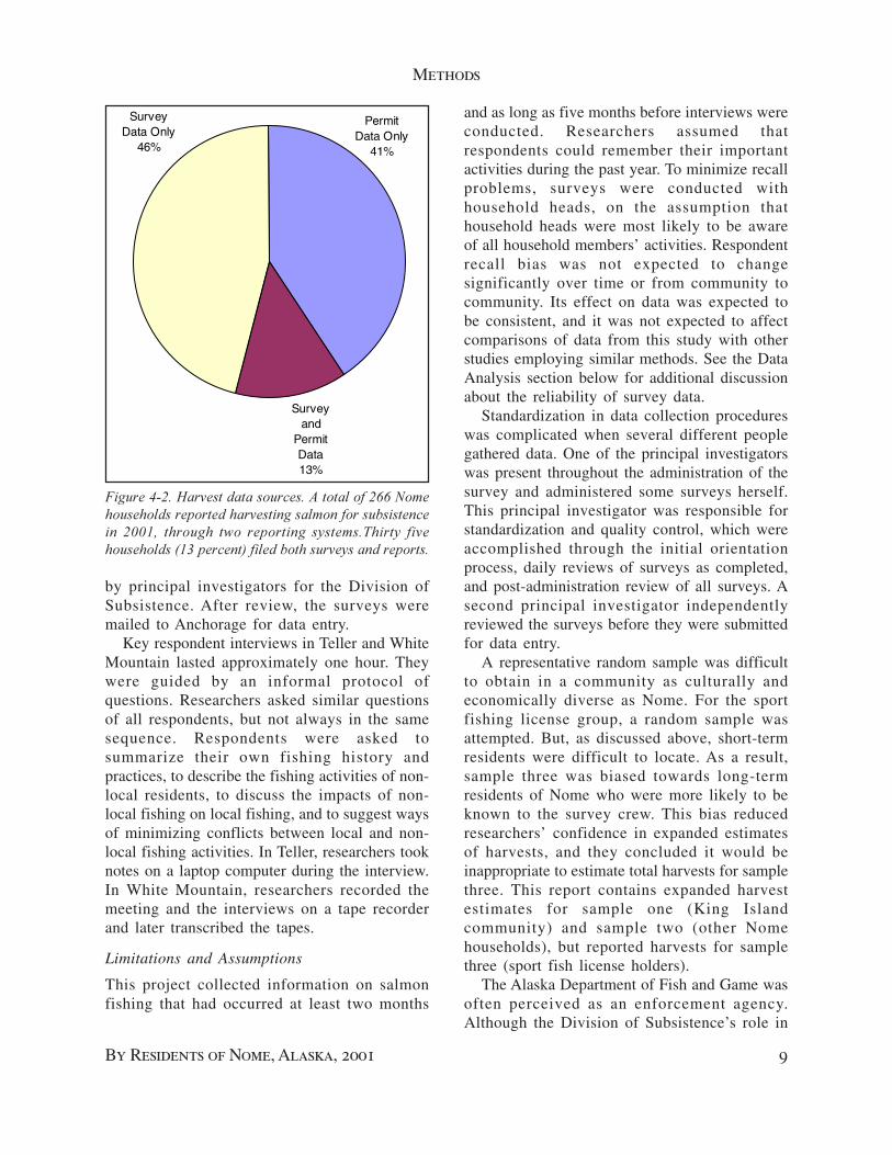
Survey and
Permit Data13%
Permit Data Only
41%
Survey Data Only
46%
by principal investigators for the Division ofSubsistence. After review, the surveys weremailed to Anchorage for data entry.
Key respondent interviews in Teller and WhiteMountain lasted approximately one hour. Theywere guided by an informal protocol ofquestions. Researchers asked similar questionsof all respondents, but not always in the samesequence. Respondents were asked tosummarize their own fishing history andpractices, to describe the fishing activities of non-local residents, to discuss the impacts of non-local fishing on local fishing, and to suggest waysof minimizing conflicts between local and non-local fishing activities. In Teller, researchers tooknotes on a laptop computer during the interview.In White Mountain, researchers recorded themeeting and the interviews on a tape recorderand later transcribed the tapes.
Limitations and Assumptions
This project collected information on salmonfishing that had occurred at least two months
and as long as five months before interviews wereconducted. Researchers assumed thatrespondents could remember their importantactivities during the past year. To minimize recallproblems, surveys were conducted withhousehold heads, on the assumption thathousehold heads were most likely to be awareof all household members’ activities. Respondentrecall bias was not expected to changesignificantly over time or from community tocommunity. Its effect on data was expected tobe consistent, and it was not expected to affectcomparisons of data from this study with otherstudies employing similar methods. See the DataAnalysis section below for additional discussionabout the reliability of survey data.
Standardization in data collection procedureswas complicated when several different peoplegathered data. One of the principal investigatorswas present throughout the administration of thesurvey and administered some surveys herself.This principal investigator was responsible forstandardization and quality control, which wereaccomplished through the initial orientationprocess, daily reviews of surveys as completed,and post-administration review of all surveys. Asecond principal investigator independentlyreviewed the surveys before they were submittedfor data entry.
A representative random sample was difficultto obtain in a community as culturally andeconomically diverse as Nome. For the sportfishing license group, a random sample wasattempted. But, as discussed above, short-termresidents were difficult to locate. As a result,sample three was biased towards long-termresidents of Nome who were more likely to beknown to the survey crew. This bias reducedresearchers’ confidence in expanded estimatesof harvests, and they concluded it would beinappropriate to estimate total harvests for samplethree. This report contains expanded harvestestimates for sample one (King Islandcommunity) and sample two (other Nomehouseholds), but reported harvests for samplethree (sport fish license holders).
The Alaska Department of Fish and Game wasoften perceived as an enforcement agency.Although the Division of Subsistence’s role in
��������������������������������������������� �!��� ���� �������������� ����������������������������������� �""#� � ���� � ���� ���������� ��������$ ����� ���� ���� �����%&��������'���������� ���������������������

Chapter 2
10 Subsistence Samon Fishing
ADF&G was to document subsistence uses,many residents perceived any ADF&G employeeas a “game warden.” Although this project wasadministered by Kawerak and almost all fieldcontacts were made by Kawerak employees,ADF&G participation in the project may havediscouraged some respondents fromparticipating.
Researchers attempted to minimizeenforcement bias limitations by thoroughlyinforming field researchers and respondents ofthe purpose of the surveys, of the intended useof the data, of the techniques used to protecthousehold identities in published reports, andof respondents’ right to refuse to participate inthe survey. Information about individuals’activities was kept confidential. No data fromthis study were provided to any enforcementdivisions of any of the participating agencies.Researchers returned survey results to thecommunity, and involved members of thecommunity in the review of this report.
Data Analysis
Survey data were entered in Microsoft Access, adatabase program, then read into SPSS, astatistical program for analyzing survey data.Most of the analyses were then conducted inSPSS, with tables and charts prepared usingMicrosoft Excel. Frequencies, means, crosstabulation, and multiple response procedureswere used.
In addition to the harvest reports provided byrespondents in this survey, Nome subsistencesalmon harvest data for the 2001 season alsowere available from ADF&G’s subsistencesalmon permits. Researchers created a data filethat included both survey and permit harvest data,and both types of data were used to calculatefinal reported and estimated harvests. In mostcases, only one source of data was available foreach household and those data were used in thefinal calculations. But 35 households in thesurvey sample (5 households in sample two, and30 households in sample three) also obtainedNome subsistence permits (Fig. 4-2). Of those35 households, 26 households returned theirpermits. Researchers compared the data from
surveys and permits for each of the 35households.
Ideally, permit and survey reports for eachhousehold would agree. But, as might beexpected, they did not. The 35 householdsreported 928 salmon on the surveys, comparedwith 699 salmon on permits, a difference of 229salmon. In comparing reports household byhousehold researchers noticed the followingpatterns.
More households reported harvests throughsurveys than through permits. Households thathad neglected to turn in permit reports werewilling to report their harvests in a face-to-faceinterview. Some households that reported notfishing on subsistence permits reportedsubsistence harvests on their surveys. In mostcases, these were rod and reel harvests takenunder sport fishing licenses, and were notrequired to be reported on the permit system.
When permit reports existed, permit reportsseemed more precise. For example, onehousehold reported 17 chum, 35 pink, 8 sockeye,and 29 coho on its permit, compared with 10chum, 25 pink, 30 sockeye, and 20 coho on itssurvey. The permit total was 89 salmon comparedwith the survey total of 85 salmon. This waslogical because permit households wereencouraged to record harvests on a dailycalendar. For the survey, surveyed householdswere asked to recall their harvests several monthslater.
Researchers concluded that survey reportsseemed more complete than permit reports, butpermit reports seemed more precise. Thereforeresearchers decided to substitute permit reportsfor survey reports when both reports existed.Otherwise, researchers used the survey reports.This affected 3 households in sample two and12 households in sample three, and slightlyincreased reported and estimated salmonharvests.
Merging the survey and permit data allowedresearchers to calculate total estimates of Nome’ssalmon harvests. This provided a more completeperspective for evaluating the significance ofNome’s harvests from areas outside the Nomepermit area.
11
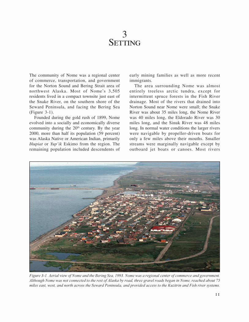
3Setting
The community of Nome was a regional centerof commerce, transportation, and governmentfor the Norton Sound and Bering Strait area ofnorthwest Alaska. Most of Nome’s 3,505residents lived in a compact townsite just east ofthe Snake River, on the southern shore of theSeward Peninsula, and facing the Bering Sea(Figure 3-1).
Founded during the gold rush of 1899, Nomeevolved into a socially and economically diversecommunity during the 20th century. By the year2000, more than half its population (59 percent)was Alaska Native or American Indian, primarilyIñupiat or Yup’ik Eskimo from the region. Theremaining population included descendents of
early mining families as well as more recentimmigrants.
The area surrounding Nome was almostentirely treeless arctic tundra, except forintermittent spruce forests in the Fish Riverdrainage. Most of the rivers that drained intoNorton Sound near Nome were small; the SnakeRiver was about 35 miles long, the Nome Riverwas 40 miles long, the Eldorado River was 30miles long, and the Sinuk River was 48 mileslong. In normal water conditions the larger riverswere navigable by propeller-driven boats foronly a few miles above their mouths. Smallerstreams were marginally navigable except byoutboard jet boats or canoes. Most rivers
�������������� ��������������� ���������������� ������������� �� ������� ��������������������� ����������������������������� ��������������������������������� �� � !��� ����������� ������ ��� �� ������������� ����� ����"#������� ���������� ��������� ������������� ���$������� �� ���%�������� �������������&�'������ ���������������!������

Chapter 3
12 Subsistence Samon Fishing
������� �(��$�%�� ����� ��������� )�*(***������+�%�%�� ������� ���������(*���������!���������(*�� ����������������������������������� ��� ���������' ��%�������
41
12,4
88
2,60
0
852 1,21
3
1,55
9
1,87
6
2,31
6
2,48
8
2,54
4 3,50
0
3,50
5
0
2,500
5,000
7,500
10,000
12,500
15,000
1890
1900
1910
1920
1930
1940
1950
1960
1970
1980
1990
2000
YearN
umbe
r of
Peo
ple
supported several runs of different species ofPacific salmon and, like salmon runs throughoutwestern Alaska, most of these runs were indecline during the 1990s.
Residents of Nome hunted and fishedextensively along the southern coast of theSeward Peninsula, in the Safety Soundwatershed, and in the Kuzitrin and Fish Riverwatersheds (Magdanz and Olanna 1986). Accessto the country was facilitated by three state-maintained gravel roads that began in Nome andled east to Council, north to the Kougarok miningdistrict, and west to Teller. Many smaller,unmaintained roads branched off the state roadsystem to reach mines and camps throughoutthe area. No other community in northwestAlaska had such an extensive road system, andit facilitated summer access to areas thatotherwise would have been difficult to reach fromNome.
This study explored how Nome residents haveadapted to restrictions in the local subsistencesalmon fisheries. To provide context for thefindings, this chapter describes the setting forthis study, the history of the area, the communityof Nome at the time of the study, and themanagement of Nome area salmon fisheries.
History
Eskimo occupancy of the area began at least4,000 years ago (Bockstoce 1979:88). Prior tothe Nome gold rush in 1899, the Nome townsitehad been seasonally inhabited by Iñupiat Eskimoand was known as Sitnasuak (Ray 1964:73).Twenty inhabitants were recorded in the 1880census (Petroff 1884:11). A nearby site at themouth of the Nome River, Uinokhtuguik, wasinhabited by 10 persons in 1880 (Petroff1884:11). The principal Iñupiaq settlements inthe area were Qipd’uq (or Asuucuryaq), 15 mileseast at Cape Nome with 60 inhabitants in 1880,and Ayuuq, 15 miles west on Sledge Island with50 inhabitants in 1880 (Koutsky 1981:26, 27).
Smaller settlements, like those at the Nomeand Snake rivers, occurred along the coast atproductive locations. All these communities,including those at Nome’s site, comprised eitherone society occupying the coast from CapeDouglas to Rocky Point (Burch 1980) or two
related societies bounded at Cape Nome (Ray1964, 1967). These societies were independentof Euro-Americans socially and economicallyuntil the gold rush began.
The community of Nome was founded onOctober 18, 1898, as a mining district on theSnake River (Collier, Hess, Smith, and Brooks1908:18). In 1899, nearly 3,000 miners alreadyin the North hurried to Nome. In 1900, asevidence of the rich gold deposits reachedoutside Alaska, more than 20,000 more peoplearrived. Residents voted to incorporate the Cityof Nome in April 1901, and Nome has beeninhabited continuously ever since (Cole1984:101). For the first few years of the twentiethcentury Nome was the largest city in Alaska (Cole1984:101), but the richest placer deposits wereworked out within a decade and its populationquickly declined. Nome’s population from 1890through 2000 is illustrated in Figure 3-2.
The Iñupiat societies in the Nome area athistoric contact were severely impacted by thegold rush and ceased to exist as societies by theearly twentieth century. In 1918, the Eskimo

Setting
By Residents of Nome, Alaska, 2001 13
population in the Nome area was estimated tobe 250, and of those, 200 died in an influenzaepidemic (Cole 1984:136). Remnant survivors -mostly children - were scattered and thecommunities at Cape Nome and Sinuk Riverwere abandoned. After 1918 Nome was the onlypermanent settlement on the central southernSeward Peninsula between Cape Nome and PortClarence.
From its early days, Nome attracted otherIñupiat from the surrounding region. Labor wasalways needed for long-shoring, mining, andservices. Some Iñupiat - especially from KingIsland and the Diomede Islands - made wagelabor part of their seasonal round of economicactivities. World War II temporarily boosted thelocal economy when Nome became a refuelingstop for the lend-lease program that providedUnited States airplanes to the Soviet Union.Civilian job opportunities attracted more Iñupiatfrom area communities to Nome, but the militaryboom was temporary, too. Gradually,government came to be a mainstay of the regionaleconomy, providing administrative, educational,medical, and social services to the SewardPeninsula and Norton Sound area. In 1983, stateand local governments employed 1,159 Nomeresidents, compared with only 303 in 1969 (Cityof Nome 1985:19).
Nome in 2001
By 2001, what had once been a booming miningtown had evolved into a multi-cultural serviceand retail center. It was a polyglot communitywith an Eskimo majority (59 percent). Theminorities included whites (39 percent), blacks,Asians, and Hispanics. Nome produced forexport small quantities of gold, reindeer, andseafood. It depended heavily on employment ingovernment and tourism, and on non-commercial fish and wildlife harvested for familyand personal consumption. Like most other ruralAlaska communities, Nome exhibited extremesof employment, income, and housing. Somepeople were employed year round, were highlypaid, and lived in expensive homes. Others wereemployed seasonally or not at all, were poorlypaid, and lived in one-room plywood cabins.
Whatever their economic station, mostfamilies in Nome supplemented their diet withwild foods. A survey of a random sample ofNome houses conducted by the Division ofSubsistence in 1982 found that 95 percent ofthe households used one or more wild foods(Wolfe and Ellanna 1983: 111). Approximately65 percent reported using at least six differentkinds of wild food (Wolfe and Ellanna 1983:105).The Alaska Geographic Differential Study found93 percent of Nome area households used wildfoods (Alaska Department of Administration1985:201). Nome area households reportedspending more than $1,400 annually onsubsistence equipment, supplies, andtransportation (Alaska Department ofAdministration 1985:202).
Nome has one of rural Alaska’s most extensiveroad systems: three state-maintained, gravelroads lead into the country: 75 miles to Teller,82 miles to Taylor in the Kougarok miningdistrict, and 70 miles to Council. Figure 3-3shows where the Teller road meets Port Clarence,just outside of the community of Teller. Theroads connect with no others and terminate withinthe region, but have a considerable impact onwildlife harvesting patterns.
A 1986 Division of Subsistence study foundthat Nome’s harvest areas were two to three timesas large as harvest areas for other smallercommunities in the region (Magdanz and Olanna1986). The study indicated that roads facilitatedharvesting, especially of moose and plants.Salmon fishing areas on four local rivers - theSinuk, Snake, Nome, and Solomon - can bereached by road from Nome. Five more - theCripple, Penny, Eldorado, Flambeau, andBonanza - are accessible by boat (Figure 3-4).Except for the Snake (which was small andtainted by city sewer discharge), the Nome Riverwas the closest river to Nome. The Kougarokroad parallels the Nome River almost its entire41-mile length, one bridge crosses less than amile above its mouth, and another crosses about13 miles inland. Most fishing by Nome residentsoccurred in Subdistrict 1 (Nome) of the NortonSound District, which included all waters

Chapter 3
14 Subsistence Samon Fishing
draining into Norton Sound from Penny Riverto Topkok Head.
The Nome River has been an especiallyattractive fishing location to newcomers, whohad not yet learned their way around the countryor who did not have the necessary equipment toreach some other rivers. During the first 17 years,permit data showed that the Nome River attractedthe most effort, but effort declined substantiallyafter 1986. The Eldorado and Flambeau riverswere the second most heavily fished river systemsfrom 1975-91. After the Nome River decline,the Eldorado and Flambeau rivers became themost heavily fished river system in the Nomesubdistrict.
During the 1980s and 1990s, the stategradually improved the Nome road system. Asaccess improved, several Nome families beganmaintaining summer homes in Council, on theNiukluk River, a tributary of the Fish River. Someof them also fished in the Council area. As localNome salmon fisheries declined, some Nomefamilies also began driving up the Kougarok
Road to fish in the Pilgrim River, a tributary ofthe Kuzitrin. Other families began driving up theTeller Road to fish in Grantley Harbor and thelower Kuzitrin River. Documenting the natureand extent of these expanding fishing efforts wasone of the primary goals of this project.
Salmon Fishery Management
At the time of this study, both the state and federalgovernments managed salmon fisheries in theNorton Sound area. The Federal SubsistenceBoard managed subsistence salmon fishing innavigable waters on federal public lands, whilethe state managed subsistence salmon fishing inall other areas. Kawerak Inc., the Alaska Nativenon-profit regional corporation based in Nome,was an active cooperator in both state and federalmanagement. Kawerak’s Natural ResourcesDepartment operated projects that providedinformation about salmon abundance andsubsistence harvests, consulted with agencymanagers on agency management decisions, andparticipated in the government regulatory
��������,��-����� ��������������-������.� ����� ��� ��� ������� ������������������������������-������ ��������������������� ��������� �/ ����� �� �������������� ������������-�������-�������� ��������������������-������� ��% � �����������0� ����!�1 � ��� � ���� ��������� %%��2�� ���!�����������-������������� ���������� ���������

Setting
By Residents of Nome, Alaska, 2001 15
processes through boards, councils, andcommittees.
The federal government’s involvement inmanagement began in territorial days, andfocused primarily on commercial fisheries.There were no records of active federalmanagement in Nome area subsistence fisheriesprior to statehood in 1959, except for a region-wide survey of subsistence harvests (Raleigh1957).
The State of Alaska began managingcommercial and subsistence salmon fisheries inthe Nome area in 1960, and established twofishery management districts in the area. TheNorton Sound District included all watersbetween the westernmost tip of Cape Douglasand Canal Point Light, and was divided into sixsubdistricts. Subdistrict 1 included waters in thevicinity of Nome; subdistrict 2 includedGolovnin Bay and its drainages; subdistrict 3included waters in the vicinity of Elim and MosesPoint; subdistrict 4 included waters in the vicinityof Koyuk; subdistrict 5 included waters in the
vicinity of Shaktoolik; and subdistrict 6 includedwaters in the vicinity of Unalakleet. The PortClarence District included all waters of Alaskabetween the westernmost tip of Cape Prince ofWales and the westernmost tip of Cape Douglas,and was not divided into subdistricts.
The State of Alaska managed salmon fishingunder three different sets of regulations:subsistence, commercial, and sport. Theapplication of these regulations depended uponthe disposition of the catch and the gear used.
1 “Subsistence” was defined as “thenoncommercial, customary and traditionaluses of wild renewable resources for directpersonal or family consumption..., for themaking and selling of handicraft articles...,and for the customary trade, barter, orsharing...” (AS 16.05.940) Any Alaskaresident could participate in a state-managed subsistence fishery (i.e.participation was not limited to indigenous
��������,��3���� ���.����������� �%���������� ���!+�������� �%��� �������������������3���� ���.������ ����(*������� ������������-���� �� �������� ������������� ��������������������������*�� ���� ��!�(***��� ������������������������������������ �/ ����������������������4������� ���-���������� ������� ����������� ���������

Chapter 3
16 Subsistence Samon Fishing
or local rural residents). No license wasrequired.
2 “Commercial fishing” was defined asfishing “with the intent of disposing of(fish) for profit, or by sale, barter, trade, orin commercial channels.” (AS 16.05.940)Commercial salmon fishing was limited topeople who owned a “limited entry permit.”Otherwise, any person could participate incommercial fishing; a commercial permitwas required.
3 “Sport fishing” was defined as fishing forpersonal use with a rod and reel. (AS16.05.940). Any person could participatein sport fishing; a sport fishing license wasrequired.
In most of northwest Alaska, subsistence salmonfishing was allowed seven days a week and therewere no harvest limits. The exceptions wereNorton Sound subdistricts 1 (Nome) and 6(Unalakleet) and the Port Clarence District,which were closed to salmon fishing for one ormore days during the week. In some areas in theNome and Unalakleet subdistricts, gillnets werelimited in length during part or all of the fishingseason. In the Nome subdistrict, a number ofupstream areas were closed entirely to salmonfishing to protect spawning salmon.
In 1999, as the result of several lawsuits,management of subsistence salmon fishing onnavigable federal waters adjacent to federalpublic lands reverted to the federal government.Since then, most salmon fisheries around the statehave been subject to “dual management,”involving both federal and state managers,federal and state boards, and often cooperativegroups of fishers as well.
The waters in the immediate vicinity of Nomewere managed by the state, but portions of theKuzitrin and Fish river watersheds were subjectto management by the federal government, aswas much of the Unalakleet River. Consequently,shifts in effort from the state managedsubsistence salmon fisheries in the Nomesubdistrict potentially could affect subsistencefisheries in adjacent areas that were subject tofederal management.
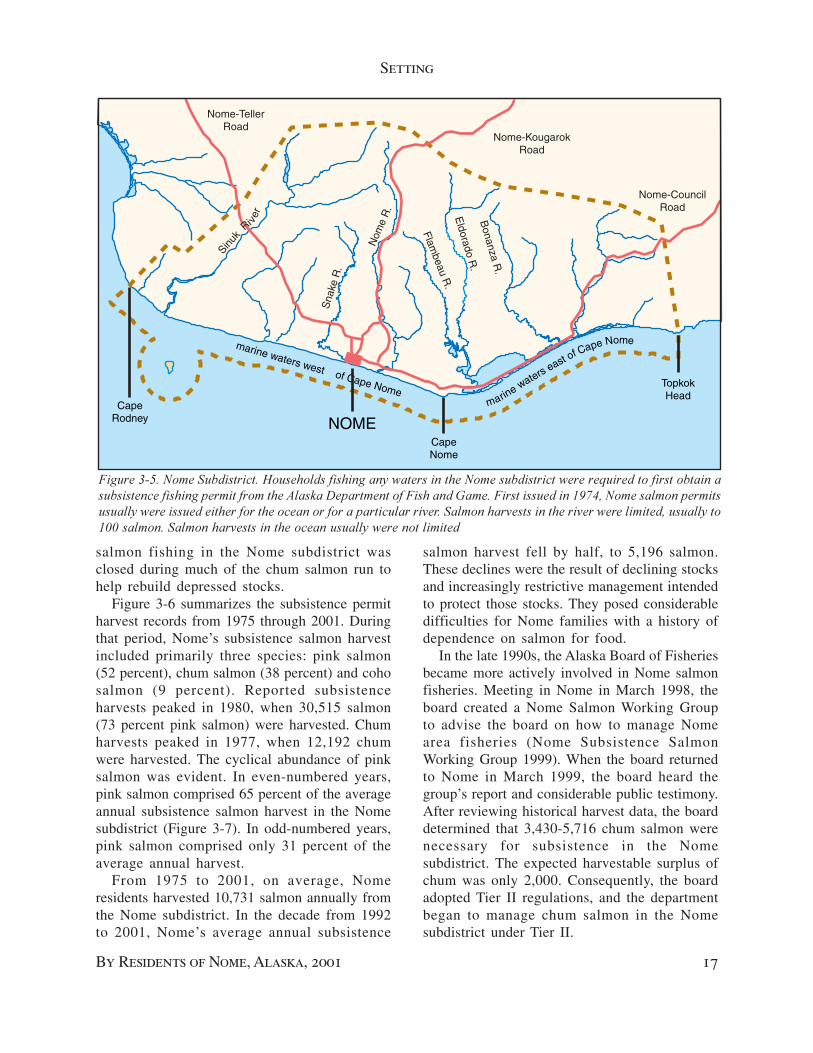
Salmon Fishing in the Nome Subdistrict
The Nome subdistrict was by far the most heavilyrestricted subsistence salmon fishery in theregion (Figure 3-4). Table 3-1 lists some of thestate regulations that have affected subsistencefishing in the Nome subdistrict. Permits wereinstituted in 1974, and have been the basis bothfor managing fishing and for reporting harvestssince then. These permits included a catchcalendar to be returned at the end of the season.Fishing households were asked to record theircatches by date and species, and to indicate thetype of gear used. Each household was entitledto one permit. The permit authorized a householdto catch a specified number of salmon from aparticular river. Permits could be transferred fromriver to river.
The abundance of salmon species in the Nomearea has varied over time. Pink salmonabundance has alternated on a two-year cycle,with strong even-year runs and weak odd-yearruns. Coho salmon abundance, negligible beforethe mid 1970s, increased through the 1980s, andwas decreasing in the late 1990s. Chum salmonabundance declined substantially in the late1970s, and failed to respond to rebuilding effortsduring the 1980s and 1990s, and only recentlybegan achieving escapement goals in somestreams. The largest run of sockeye in the areawas in Salmon Lake, but that run was depressedfrom the mid 1970s through the late 1990s, whenit finally responded to a lake fertilization programand beginning to rebuild in the early 2000s.Chinook salmon were present, but not abundantin the area.
Beginning about 1980, the Alaska Departmentof Fish and Game became particularly concernedabout chum salmon returns to the Nomesubdistrict. Commercial fishing was drasticallycurtailed in the mid-1980s. Runs did not recoveras expected, and in the early 1990s thedepartment increased restrictions on thesubsistence fishery, primarily by managingfishing time through emergency orders.
In regulation, subsistence fishing the Nomesubdistrict was open four days a week, andsalmon harvests were limited in all subdistrictstreams. Throughout the 1990s, subsistence
Setting
By Residents of Nome, Alaska, 2001 17
salmon fishing in the Nome subdistrict wasclosed during much of the chum salmon run tohelp rebuild depressed stocks.
Figure 3-6 summarizes the subsistence permitharvest records from 1975 through 2001. Duringthat period, Nome’s subsistence salmon harvestincluded primarily three species: pink salmon(52 percent), chum salmon (38 percent) and cohosalmon (9 percent). Reported subsistenceharvests peaked in 1980, when 30,515 salmon(73 percent pink salmon) were harvested. Chumharvests peaked in 1977, when 12,192 chumwere harvested. The cyclical abundance of pinksalmon was evident. In even-numbered years,pink salmon comprised 65 percent of the averageannual subsistence salmon harvest in the Nomesubdistrict (Figure 3-7). In odd-numbered years,pink salmon comprised only 31 percent of theaverage annual harvest.
From 1975 to 2001, on average, Nomeresidents harvested 10,731 salmon annually fromthe Nome subdistrict. In the decade from 1992to 2001, Nome’s average annual subsistence
salmon harvest fell by half, to 5,196 salmon.These declines were the result of declining stocksand increasingly restrictive management intendedto protect those stocks. They posed considerabledifficulties for Nome families with a history ofdependence on salmon for food.
In the late 1990s, the Alaska Board of Fisheriesbecame more actively involved in Nome salmonfisheries. Meeting in Nome in March 1998, theboard created a Nome Salmon Working Groupto advise the board on how to manage Nomearea fisheries (Nome Subsistence SalmonWorking Group 1999). When the board returnedto Nome in March 1999, the board heard thegroup’s report and considerable public testimony.After reviewing historical harvest data, the boarddetermined that 3,430-5,716 chum salmon werenecessary for subsistence in the Nomesubdistrict. The expected harvestable surplus ofchum was only 2,000. Consequently, the boardadopted Tier II regulations, and the departmentbegan to manage chum salmon in the Nomesubdistrict under Tier II.
��������#��������� ����������1������������������ �!�� ������������������� ����������������5���������������� � ��� �� �����������������%����������������� �� �6�% ��������������� ���0 ���������������������",�������� �����%��������� ��!������������������������������� ��������� �% ������ ���������� ������ ������������������������������������� ��!���**�� ������� ������ ����������������� ����� ��!�����������������
Nome-KougarokRoad
Nome-CouncilRoad
Nome-TellerRoad
marine waters west of Cape NomeCape
Rodney
CapeNome
TopkokHead
NOMEmarin
e waters east of Cape Nome
Sinuk
Ri ver
Nom
e R
.
Sna
ke R
.
Eldorado R
.
Flambeau R
.
Bonanza R
.

Chapter 3
18 Subsistence Samon Fishing
Date Regulation1961 Seines or nets with stretched mesh smaller than 4 l/2” prohibited in the Nome River above Osbom
and in the Snake River.
1962 Six subdistricts created in Norton Sound district for management purposes. Nome subdistrict open to commercial and subsistence fishing seven days a week.
1965 Subsistence catch calendars or questionaires distributed in the Nome area for the first time.
1968 Permits required to fish in the Nome, Sinuk, Snake and Solomon rivers. Limit: 500 salmon per permit.
1969 Subsistence fishing in Norton Sound put on same schedule of openings and closures as the commercial fishery. Nome subdistrict still open seven days a week.
1972 Salmon fishing prohibited in Salmon Lake from July 15 to August 31.
1973 Commercial fishing in Nome subdistrict restricted to four days a week. Subsistence fishing restricted because of 1969 regulation, above.
1974 Subsistence permits required to fish in the Norton Sound District from Cape Douglas to Rocky Point and in the Port Clarence District in the Pilgrim River drainage including Salmon Lake
1976 Permit limits in Nome River reduced from 500 to 100 salmon.
1977 Nome subdistrict periods reduced to two 24-hour openings per week, then closed July 9. Commercial salmon fishing is limited by CFED permit.
1980 Board of Fisheries sets commerical fishery guideline harvest of 5,000 to 15,000 chum. Subsistence salmon permit limits increased from 100 to 250 salmon on the Nome River.
1984 The Nome River from its mouth upstream for 200 yards is closed to fishing.
1984 Subsistence permit limits for chum and coho salmon reduced to 20 chum and 20 coho salmon for the Snake and Nome rivers. Remainder of 250-salmon limit can be filled with pink salmon.
1988 Seines or nets with stretched mesh smaller than 4 l/2” prohibited in the Nome River. In the Nome River, no person may operate more than 50 feet of gill net.
1992 No person may operate more than 50 feet of gill net in freshwater in the Nome Subdistrict.Seining can be directed on species other than chum or pink.
1994 Subsistence fishing in marine waters in Nome Subdistrict open Monday-Friday
1999 Determined 3,430-5,716 chum salmon were necessary for subsistence. Tier II fishery established for chum salmon.
2001 Optimum Escapement Goals (OEGs) established for Nome, Eldorado, and Snake Rivers.Source: Alaska Board of Fisheries regulation booklets and Department of Fish and Game pemit records.
TABLE 3-1. CHRONOLOGY OF SELECTED FISHING REGULATIONS AFFECTING THE NOME AREA, 1961-2001

Setting
By Residents of Nome, Alaska, 2001 19
9,22
4
7,39
9
15,4
98 17,6
18
10,7
57
30,5
15
15,9
24
25,8
83
17,1
62
23,9
43
8,89
4
17,6
43
10,9
45
9,25
0
4,81
6 7,04
7
5,27
1
10,6
68
4,76
1
8,56
4
5,66
9
6,18
4
3,25
6
6,84
7
652
3,84
7
1,51
1
0
5,000
10,000
15,000
20,000
25,000
30,000
35,000
75 76 77 78 79 80 81 82 83 84 85 86 87 88 89 90 91 92 93 94 95 96 97 98 99 00 01
Num
ber
of S
alm
on H
arve
sted
Sockeye Chinook Coho Chum Pink Linear (Salmon)
��������7���� ���������� ������ ���������%������ !�%��������������������� �����������"#(**��1 �������� ��� ��������������������)*� �� ��� ��������������8����%�� ����������� �� ���������-����99���������� �� ���������
��������"���%���������%������������� ���������� ��������������������� ����������"#(**��$����� ����� ��� ���� �������� ����!� ���!��������������� ��� �������������� �����!� ��� �������� ��� ��� ������������� ����!� ����-���%��%����������%����� �������������� ���������� ������ %%��2�� ���!���� �������������� �����!� ���:����;�4����%��%����������� ������������� �����!� ���:�����;�
Even-Year Harvest(Annual Average 13,493 Salmon)
Pink65%
Chum27%
Chinook0.4%
Coho8%
Sockeye0.2%
Odd-Year Harvest(Annual Average 8,167 Salmon)
Pink31%
Chum56%
Chinook1% Coho
12%
Sockeye0.3%

Chapter 3
20 Subsistence Samon Fishing
Under Tier II, not everyone who wanted tofish was able to do so. The subsistence lawdirected the Board to give a priority to those whohad the greatest customary and directdependence and the fewest alternative resources.To measure those factors, the Board - incooperation with the Nome Salmon WorkingGroup, the Alaska Department of Fish and Game,and the Nome public - developed two questions.
The first question asked applicants: “Howmany years have you fished or processedsubsistence-caught chum salmon from the NomeSubdistrict? Applicants were awarded one pointfor each year of fishing history, to a maximumof 75 points.” The second question askedapplicants: “How much of your chum salmoncame from the Nome Subdistrict during the pastfour years?” The more chum that came from theNome Subdistrict, the more points were awarded,up to a maximum of 10 points.
People who wanted to fish chum salmon inthe Nome Subdistrict had to fill out an applicationeach spring, and answer these two questions.Applicants were scored and ranked, and the top10 or 20 ranking households got permits.
In 1999, the first year of Tier II, 81 householdsapplied for the available 20 Tier II permits. Thenext year, 2000, a weaker chum salmon run waspredicted, so managers began the season withonly 10 Tier II permits available. The number ofapplicants for Tier II permits dropped from 81to only 30. Fifty-eight households who hadapplied in 1999 did not apply in 2000, including13 of the households who had successfullyapplied the year before. Seven households whichhad not applied in 1999 decided to apply in 2000.Of the ten permits, seven went to householdsthat had received permits in 1999, two went tohouseholds that had applied in 1999 but had beenunsuccessful, and one went to a new applicanthousehold.
Why were there so few applicants in 2000?First, some low-scoring 1999 applicants did notreapply in 2000. Second, salmon returns in 1999were worse than expected. Subsistence salmonharvests were the lowest on record, and Tier IIfishing families did not get as much fishingopportunity as had been expected. That no doubtdiscouraged many people. Of the 20 Tier II
permit holders in 1999, only 6 actually fished.Of the 87 Tier I permit holders in the Nomesubdistrict, only 19 fished. That was by far thelowest effort ever seen in the Nome subdistrictsince permitting began in 1974. Indeed, almostas many people fished outside the NomeSubdistrict as in it.
There were several reasons that Nomeresidents would be attracted to areas outside theNome subdistrict. First, access was relativelyeasy. Using any one of three state-maintainedgravel roads, Nome residents could pull a boaton a trailer from Nome to a boat launching sitein one of these adjacent areas in about two hours.
Second, rivers in the adjacent watersheds werelarger than those in the vicinity of Nome. Themajor streams in the Nome Subdistrict ranged inlength from about 33 miles (Eldorado River) toabout 48 miles (Sinuk River).
By comparison, the Fish River, the nextwatershed to the east, was about 75 miles long.Its major tributary, the Niukluk River, was about53 miles long, longer than the longest stream inthe Nome Subdistrict. The Kuzitrin River, thenext watershed to the west, was about 95 mileslong. Its Pilgrim River (about 50 miles long) andKougarok River (at least 48 miles long) tributarieswere also as long as the longest rivers in theNome Subdistrict.
Third, salmon stocks in the Fish and Kuzitrinsystems were more abundant than salmon stocksin the Nome subdistrict. Especially attractivewere the sockeye salmon from Salmon Lake atthe headwaters of the Pilgrim River. Decimatedby over fishing in the 1970s, Salmon Lakesockeye were responding to a fertilization projectin the mid 1990s, and were becoming asignificant part of Nome’s subsistence harvestagain. Except for a small stock in the Sinuk River,sockeye were not present in Nome Subdistrictstreams.
Fourth, and perhaps most important,competition was less in the adjacent areas.Consequently, there were no harvest limits orclosed waters in the adjacent areas. Nomeresidents, like residents of smaller communitiesin the adjacent areas, could harvest as manysalmon as they needed where ever they wishedin the adjacent areas.

Setting
By Residents of Nome, Alaska, 2001 21
�����������0���������� �� ��-�����������!����0������������� ��%�����% � �����0��������< �����: ��������;�����0��������� !�:����������;�-�����������!�� ��� �������� ���� ��!�� ���� ����%����������������!�� �������������� ����%���������� �$����=������ %%��� ������������ ��%����� �� ���� ����������������%�������� ��� ��������)(�
The shift in fishing effort by Nome residentsaway from the Nome subdistrict into adjacentwatersheds raised concerns among managersand in adjacent communities. What effects wouldNome’s fishing have on fishing opportunities forresidents of the adjacent areas? Subsistenceharvests and fishing periods had rarely beenlimited in these other areas through 2001. Woulda shift in Nome’s effort result in increasingrestrictions for outlying fisheries?
The White Mountain-Golovin Area
The White Mountain-Golovin area bounds theNome Subdistrict on the east and northeast, andincludes two permanent communities. WhiteMountain is on the east bank of the Fish Riverabout 10 miles (20 river miles) above the rivermouth. Golovin is on the east bank of GolovninBay, on a spit separating Golovnin Lagoon fromGolovnin Bay (Figure 3-8).
In the 19th century, the White Mountain-Golovin area was inhabited by two societies,Unalik Yup’ik speakers who resided in the
Golovnin Bay portion, and Qawiaraq Iñupiaqspeakers who resided in the Fish River portion(Koutsky 1981b:8). In the 20th century,descendents of these two societies settled inGolovin and White Mountain, respectively.Intermarriages between the two societies wascommon, so descendents of the two societies canbe found in both Golovin and White Mountain.At the time of this study, all residents spokeEnglish.
In the 19th century, the major communities inthe Golovnin Bay portion were believed to be��������, west of Golovnin Lagoon and Atnaq atCape Darby (Koutsky 1981b:13). In the 1880census, Petroff reported 100 people at ������������ ��� ����� ��� Atnaq. In the 2000 census,Golovin’s population was 144 people (U.S.Census Burreau 2001:143).
In the 19th century, the most prominent FishRiver community was �����, near the mouth ofthe Niukluk River, approximately 16 river milesabove the current site of White Mountain(Koutsky 1981b: 32-34). Ray estimates the Fish

Chapter 3
22 Subsistence Samon Fishing
3,630
12,246
13,762
5,699
7,424
1,998
7,941
4,163
0
2,000
4,000
6,000
8,000
10,000
12,000
14,000
16,000
18,000
20,000
1994 1995 1996 1997 1998 1999 2000 2001
Est
imat
ed N
umbe
r of
Sal
mon
Har
vest
ed
6,445
7,755
7,017
3,530
6,571
2,127
6,560
1,707
0
1,000
2,000
3,000
4,000
5,000
6,000
7,000
8,000
9,000
10,000
1994 1995 1996 1997 1998 1999 2000 2001
Est
imat
ed N
umbe
r of
Sal
mon
Har
vest
ed
Sockeye Chinook Coho Chum Pink Linear (Salmon)
�����������3���� ������ ���������� ������ ��������8�����>���� ��� ���0�����������,(**���������,��� ����� ������������ ������������������������������� ��� ��������� ��������������������!������!�%��/�����������!�� � ������������������ ���� ���������� ������ ���������� ����8�����>���� ��� ���0����������������% ���������!� ���
Golovin
White Mountain

Setting
By Residents of Nome, Alaska, 2001 23
River population in 1850 to have been about 50people (Ray 1984:295). White Mountain’spopulation in the 2000 census was 203 people(U.S. Census Bureau 2001:368).
Most Nome residents reach the Fish Riversystem by driving the Nome-Council road 70miles to Council, then taking a boat down theNiukluk River from Council to its confluencewith the Fish River, distance of about 12 miles.In most years, the Niukluk River is too shallowduring the salmon season to use a propeller-driven boat, so Nome residents use outboard jetmotors.
During the first two decades of the 20th
century, Council was an important miningcommunity with as many as 300 people. Itspopulation declined to 109 residents by 1920,and since then varied between zero and about50. During the 1980s and 1990s, Council wasreborn as a seasonal, recreational community forNome residents. Some Nome residentspurchased and rehabilitated the old miningcabins; others purchased lots and built newcabins. These are all “second homes,” however.
The 2000 census reported no permanentresidents in Council.
Figure 3-9 shows estimated subsistencesalmon harvests by residents of White Mountainand Golovin, based on information fromhousehold surveys conducted by the AlaskaDepartment of Fish and Game and Kawerak Inc.(Georgette et al 2002). Overall, salmon harvestswere declining in both communities; harvests atthe beginning of the survey period were almosttwice as large as harvests at the end of the surveyperiod, reflecting declines in pink salmonharvests. Note in particular how few pink salmonwere harvested in 1999 and 2001.
As in the Nome subdistrict, the cyclicalabundance of pink salmon influenced the patternof subsistence harvests in the White Mountain-Golovin area. Figure 3-10 shows the averagecomposition of subsistence salmon harvests ineven-numbered and odd-numbered years forWhite Mountain and Golovin. In the even years(1994, 1996, 1998, and 2000), pink salmoncomprised 79 percent of the total salmon harvest.In the odd years (1995, 1997, 1999, and 2001)
��������*��4��%������������ ������ ����������8�����>���� ��� ���0����������,(**��� ������ ����������������� �����!� ��� ���#*�%�������� ������� ����������� �����!� �������������������!����� ��� �������%����� �����4���� ��� ����� ������ ��� ������ ��������� ��������������������!���������%%�����������%����� ��������
Even-Year Harvest(Annual Average 14,920 Salmon)
Pink78%
Sockeye1%
Chinook1%
Chum11% Coho
9%
Odd-Year Harvest(Annual Average 10,063 Salmon)
Pink35%
Chum55%
Coho8%
Chinook1%
Sockeye1%

Chapter 3
24 Subsistence Samon Fishing
pink salmon comprised only 35 percent of thetotal. The abundant pink salmon seem to bufferthe harvest of chum salmon. In even years, chumharvests averaged 1,634 fish (11 percent of thetotal). In odd years, chum harvests averaged5,451 fish (35 percent of the total). Other salmonspecies’ harvests were not so cyclical.
The Port Clarence Area
The Port Clarence area bounds the NomeSubdistrict on the west and northwest and, likethe White Mountain-Golovin area, includes twopermanent communities. Teller is on a narrowspit that separates Grantley Harbor from PortClarence. Brevig Mission is on the north shoreof Port Clarence, above five miles northwest ofTeller. In this study, researchers focused on thecommunity of Teller, which is closer to Nomeand connected by road to Nome, and would beexpected to feel effects of Nome residents’fishing before the community of Brevig Mission.
In the 19th century, the Kuzitrin watershed inthe eastern Port Clarence area was occupied bythe ��� ����� society, whose centralcommunity was Qawiaraq on the Kuzitrin River(Koutsky 1981a:11, 29). Ray estimates theirpopulation to have been about 80 people in 1850(Ray 1984:295).
Also in the 19th century, Port Clarence wasoccupied by the ��������, whose communitieswere spread along the Bering Sea coast fromCape York to Cape Douglas, in Port Clarenceitself, Imuruk Basin, Tuksuk Channel, and as farinland as the American and Agiapuk rivers. Thisarea includes both the modern communities ofTeller and Brevig Mission.
In the 19th century, the ��������� were hostto a major trading fair each summer, held at PointSpencer, the tip of the long peninsula separatingPort Clarence from the Bering Sea (Ray 1975:98).The ����� from Little Diomede Island also cameto the Port Clarence area to trade and to fish,and presumably had alliances with families inthe� ��� ������ ��� �������� societies.Several ����� families settled in Teller duringthe 20th century.
The ��� ����� and the �������� hadmore opportunities than some other 19th century
societies to come into contact with Europeansand Euro-Americans. The Plover, an English shipsearching for Sir John Franklin, spent twowinters, 1850-51 and 1851-52, frozen in the iceat Grantley Harbor (Great Britain SessionalPapers 1852-53). The next winter, theRattlesnake, an English supply ship spent thewinter in Port Clarence, and sent an expeditionoverland to Wales (Great Britain Sessional Papers1853-54).
In 1866, the Western Union Telegraphexpedition established a base camp on the northside of the channel between Port Clarence andGrantley Harbor. The natural harbor of PortClarence attracted Yankee whalers, whoestablished a coal station near Point Spencer in1884 (Healy 1887:13). Reindeer were introducedto Alaska in 1892 near the site of Brevig Mission(which was known as “Teller Mission” until itwas renamed in the 1950s to avoid confusionwith nearby Teller).
After the discovery of gold in Nome in 1898,prospectors swarmed over the Seward Peninsula.More modest quantities of gold were discoveredin the Teller area, and by 1900 Teller’s populationhad swelled to 5,000 people. By 1910, Teller’spopulation had diminished to 125. Teller’spopulation declined further after the 1918influenza epidemic, reaching a low of only 80people in 1920. Teller grew in the 1940s and1950s, reaching 217 people in 1960. Since then,Teller ’s population ranged betweenapproximately 150 and 250 people. At the timeof this study, Teller was home to 269 people, themajority descended from the original��� ����� and ����� families.
For the first half of the 20th century, BrevigMission was known as “Teller Mission.” Thename was changed in the 1950s to end confusionwith nearby Teller and to honor one of thecommunity’s early missionaries. BrevigMission’s population in 2000 was 276 people. A� �� � ����� ���� ��� �� ���� �� � �� �������� �� ���� ���������� ���� �� ����� ��� ����������� ������ ��� �� �� �� ��������������� ������� � !����� ��� ������ ����� ������������� "��� #������� ����� ����$� ������������������ � �� ��� %��� ������� ��������

Setting
By Residents of Nome, Alaska, 2001 25
7,771
8,862
5,614
3,550
7,233
2,764
3,494 3,310
0
1,000
2,000
3,000
4,000
5,000
6,000
7,000
8,000
9,000
10,000
1994 1995 1996 1997 1998 1999 2000 2001
Est
imat
ed N
umbe
r of
Sal
mon
Har
vest
ed
3,064
6,533
5,340
3,366
6,615
3,1372,863
4,660
0
1,000
2,000
3,000
4,000
5,000
6,000
7,000
8,000
9,000
10,000
1994 1995 1996 1997 1998 1999 2000 2001
Est
imat
ed N
umbe
r of
Sal
mon
Har
vest
ed
Sockeye Chinook Coho Chum Pink Linear (Salmon)
����������3���� ������ ���������� ������ ��������-������ ����������>����������,(**��-����� �� ��� �������� �������������!��� �������������� ���������� �������� ������������� ����-������ �����������$���� ��������� �������� ���������������������������*�?�������������� ������������%�������������-�������� ������������>�������
Brevig Mission
Teller

Chapter 3
26 Subsistence Samon Fishing
descendents ultimately settled in Brevig Mission,or were lost in the epidemics of 1900 and 1917
Figure 3-11 shows estimated subsistencesalmon harvests by residents of Brevig Missionand Teller, based on information from householdsurveys conducted by the Alaska Department ofFish and Game and Kawerak Inc. (Georgette etal 2001). The consistent and substantialcontribution of sockeye salmon to thesubsistence harvest was evident in bothcommunities. Sockeye were not abundant in thenearby Norton Sound District. Teller’s totalsubsistence salmon harvest appeared to bedeclining over the survey period, while Brevig
��������(��4��%������������ ������ ����������-������ ����������>����������,(**��8�������� ����������������!���������������-������ ����������>�������� �� ������� ����� � ������ ������ �� ��������������������������������������!�� �����������%����������� ��%��%���������������� �������-���� �� ��������%������ ������� ����������� �� ��
Even-Year Harvest(Annual Average 10,569 Salmon)
Pink36%
Sockeye22%
Chinook2%
Chum26%
Coho14%
Odd-Year Harvest(Annual Average 9,237 Salmon)
Pink16%
Chum34%
Coho11%
Chinook1%
Sockeye38%
Mission’s remained approximately the same. Thedecline in Teller was attributable primarily todeclines in chum and pink salmon harvests.
Figure 3-12 shows the average speciescomposition of subsistence salmon harvests ineven- and odd-numbered years for Teller andBrevig Mission. Pink salmon harvests in the PortClarence area varied as they did in the Nomepermit area and White Mountain-Golovin area,comprising twice as much of the harvest in even-numbered years as in odd-number years. Butoverall harvests varied less between odd- andeven-numbered years, partly because of theconsistent harvests of sockeye.

27
1,837
4,078
5,528
6,138
1,000
2,000
3,000
4,000
5,000
6,000
7,000
Harvests Reportedby Permit Only
Harvests Reportedby Survey Only
Harvests Reportedby Permit & Survey
Expanded Estimatesof Total Harvest
Data Collection Method
Num
ber
of S
alm
on H
arve
sted
Sockeye Chinook Coho Pink Chum Unknown Salmon
4Findings: Nome Salmon Harvests in 2001
From 1994 to the present, two different methodshave been used to estimate salmon harvests inthe Norton Sound-Port Clarence Area. In smallercommunities, Alaska Department of Fish andGame and Kawerak staff conducted householdsurveys at the end of the salmon fishing season(Georgette et al 2002). In Nome, ADF&G issuedsubsistence salmon fishing permits. Together,these two harvest reporting systems documentedmost of the Norton Sound and Port Clarenceareas’ subsistence salmon harvests.
However, some subsistence harvests byresidents of Nome were not being documentedin either system. These included the King Island
fishery at Cape Wooley, other Nome families whofished outside the Nome permit area, and Nomefamilies who obtained their subsistence harvestswith rods and reels under a sport fishing licenserather than a subsistence permit.
This study attempted to documented the totalsubsistence salmon harvest by residents of Nomeby combining subsistence permit and harvestsurvey data. In this study, researchers estimatedthat Nome residents harvested 6,138 salmon in2001 (Figure 4-1). Nome residents reportedharvesting 1,837 salmon through the permitsystem, and 4,078 salmon through surveysadministered in this study.
������������ ������������������������������������������������������ �������������������������������������������������������������������������� ������������������������������������������������������������������������� ������������������ �� ��������������� ���� � ���������� ���� �� ���������������������������������������� ������� �� ������������������!�� ��������"������������������������ ���������������������������

28 Subsistence Salmon Fishing
Chapter 4
A few households who obtained subsistencepermits were later surveyed for this study. Thus,they reported harvests through both systems.After these households were identified to avoiddouble counting, researchers tabulated a totalreported harvest of 5,528 salmon. Expanding forunsurveyed households and unreturned permitsbrought the total estimated subsistence harvestof salmon by Nome residents in 2001 to 6,138salmon (Figure 4-1).
This chapter summarizes the findings,beginning with estimates of the total effort andharvests by Nome residents, by area. Then itdiscusses the harvests of the different samplesin the survey project.
Effort and Harvest by Area
In 2001, 104 Nome households returnedsubsistence salmon permits and 158 Nomehouseholds were contacted during the survey
project (including 21 households who previouslyhad obtained subsistence permits). Thus,subsistence salmon harvest information wasgathered from a total of 233 Nome households(20 percent of Nome’s 1,184 occupiedhouseholds) who provided 294 separate harvestreports (households who fished in more than onearea filed multiple reports). Table 4-1 includes asummary of these harvest reports by area, byspecies, by gear type, and by strata.
Of the 233 total households, 134 householdsreported catching at least one salmon in 2001.The largest concentration of effort, as would beexpected, was in the Nome permit area, where106 households reported catching salmon.Twenty-nine households caught salmon in theWhite Mountain-Golovin area, 40 caught salmonin the Port Clarence area, 6 caught salmon ineastern Norton Sound, and 2 caught salmon in
Nome Permit Area
Port Clarence
Area
White Mountain -
Golovin Area
Eastern Norton Sound Area
Other Alaska Areas All Areas
Number of Salmon Harvested, By SpeciesSockeye 477 427 0 0 114 1,018Chinook 28 14 57 30 0 129Coho 995 144 584 98 0 1,821Pink 398 212 129 0 0 739Chum 1,326 265 666 76 0 2,333Unknown Salmon 2 96 0 0 0 98All Salmon 3,226 1,158 1,436 204 114 6,138
Number of Salmon Harvested, By Gear TypeNets 2,617 1,084 871 111 86 4,769Rods and Reels 609 73 565 93 28 1,369All Gear 3,226 1,158 1,436 204 114 6,138
Number of Salmon Harvested, By StrataPermit Households (N=130 HHs) 2,591 0 156 0 0 2,746King Island Community (N=37 HHs) 0 403 0 0 0 403Other Nome Households (N=24 HHs) 111 735 789 0 0 1,635SF License Households (N=117 HHs) 525 20 492 204 114 1,355All Strata 3,226 1,158 1,436 204 114 6,138
TABLE 4-1. ESTIMATED SALMON HARVESTS BY AREA AND OTHER VARIABLES
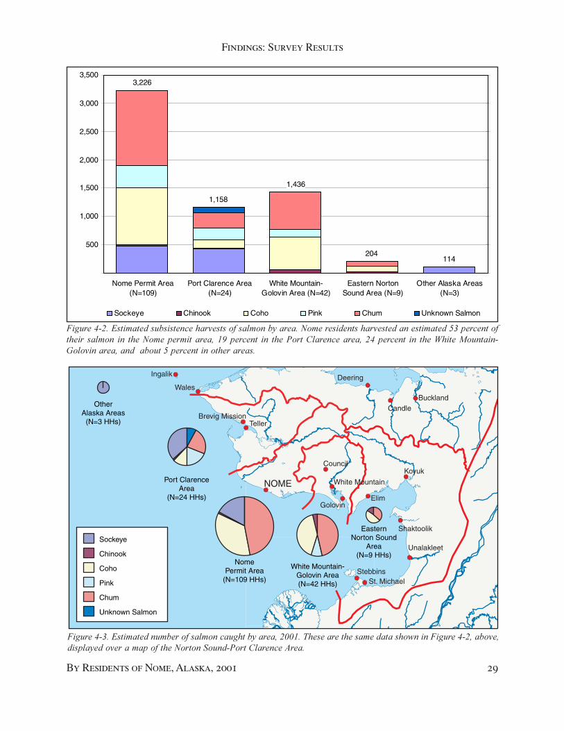
Findings: Survey Results
By Residents of Nome, Alaska, 2001 29
3,226
1,158
1,436
204114
500
1,000
1,500
2,000
2,500
3,000
3,500
Nome Permit Area(N=109)
Port Clarence Area(N=24)
White Mountain-Golovin Area (N=42)
Eastern NortonSound Area (N=9)
Other Alaska Areas(N=3)
Sockeye Chinook Coho Pink Chum Unknown Salmon
NOME
Brevig MissionTeller
Wales
Council
White Mountain
GolovinElim
Koyuk
Shaktoolik
Unalakleet
StebbinsSt. Michael
Ingalik Deering
BucklandCandle
Selawik
Sockeye
Chinook
Coho
Pink
Chum
Unknown Salmon
OtherAlaska Areas
(N=3 HHs)
EasternNorton Sound
Area(N=9 HHs)
White Mountain-Golovin Area(N=42 HHs)
Port ClarenceArea
(N=24 HHs)
NomePermit Area
(N=109 HHs)
�������� ��#������������������������������������������$%%��"����������������������������������������$����������� ��������������� ���������������&���������'��������(����
��������$��#���������������������������������������������������������������������������������������) � ��������������� ������� ��� ��������� ������������*� ������� ��� ���������'��������������$�� ������� ��� ����+�����,�������-������������������������)� ����������������������

30 Subsistence Salmon Fishing
Chapter 4
other areas of Alaska. The survey asked aboutharvests in the Kotzebue Sound area, the Yukonarea, and the St. Lawrence Island area. Nosurveyed households reported harvesting salmonin any of these three areas.
Thirty-nine Nome households who caughtsalmon in 2001 harvested all their salmon outsidethe Nome permit area. Thirteen householdsreported fishing in two areas, and two householdsreported fishing in three areas. For householdsfishing in more than one area, by far the mostcommon pattern was to fish in the Nome permitarea and one other area, although one householdreported fishing in the Port Clarence and theWhite Mountain-Golovin areas, but not in theNome permit area.
The distribution of harvests among thedifferent areas closely followed effort (Figure 4-2, Figure 4-3). In other words, average harvestsper household were similar in all three areas.
In 2001, the permit system documented theharvest of 1,837 salmon in the Nome permit area.
NOME
Brevig MissionTeller
Wales
Council
White Mountain
GolovinElim
Koyuk
Shaktoolik
Unalakleet
StebbinsSt. Michael
Ingalik Deering
BucklandCandle
Selawik
Rod and Reel Harvest
Net Harvest
OtherAlaska Areas
(N=3 HHs)
EasternNorton Sound
Area(N=9 HHs)White Mountain
Golovin Area(N=42 HHs)
Port ClarenceArea
(N=24 HHs)
NomePermit Area
(N=109 HHs)
�����������#������������������������������������������� �����������$%%���������������������!.� ������������������� ���������� ���������������������������������������������� ��� ���������'������������������������ ��������*� �������������������������������� ����������.� ������������������� ���������������/� ��������������+�����,�������-�������������'�������������������������/�� ������������������������������������ ��0����������� � �������
That represented only 57 percent of this study’sestimated total salmon harvest of 3,226 salmonby Nome residents in the Nome permit area. Ofthe estimated 1,389 salmon not reported in thepermit system, 609 (44 percent) were taken withrod and reel, the remainder were unreported netharvests.
This study estimated that Nome residentsharvested 1,158 salmon in the Port Clarence area,1,436 salmon in the White Mountain-Golovinarea, 204 salmon in the eastern Norton Soundarea, and 114 salmon in other Alaska areas(Figure 4-2). In percentage terms, 47 percent ofthe estimated harvest by Nome residents wastaken outside the Nome permit areas, none ofwhich were required to be reported through thepermit system.
In sum, this survey substantially increaseddocumentation of Nome’s salmon harvest. The1,837 salmon reported through the permit systemrepresented only 30 percent of the estimated total

Findings: Survey Results
By Residents of Nome, Alaska, 2001 31
��������)��#��������������������������������������� ������� �����������$%%��(�����.%� ���������������������������������������������������0����������������������������������������� �������������������������������0��������������������� � ���� �������� ����������(���1���� 2����������������3��������� ��������� ��� ���������'�������������� ��������� ��'� ��+�������4����������������������������������))� �����������������������������+�����,�������-������������
NOME
Brevig MissionTeller
Wales
Council
White Mountain
GolovinElim
Koyuk
Shaktoolik
Unalakleet
StebbinsSt. Michael
Ingalik Deering
BucklandCandle
Selawik
Permit Households
King Island Community
Other Nome Households
SF License Households
OtherAlaska Areas
EasternNorton Sound
White Mountain Golovin Area
Port ClarenceArea
NomePermit Area
harvest of 6,138 salmon by Nome residents inall areas.
Figure 4-3 also shows how the compositionof harvests varied by area. In the total Nomesalmon harvest, chum comprised 38 percent,followed by coho with 30 percent, and sockeyewith 17 percent. In the Nome permit and WhiteMountain-Golovin areas, chum contributed themost, 41 percent and 46 percent respectively. Ineastern Norton Sound, coho contributed thelargest portion of the harvest, 48 percent. In thePort Clarence area, sockeye harvests (37 percent)exceeded the other species. These differencesreflected the local abundance of the differentspecies. Port Clarence was the only area withsignificant numbers of sockeye.
In Norton Sound, pink salmon runs were muchstronger in even-numbered years than in odd-numbered years. In 2001, pink salmoncontributed only 10 percent to the total estimatedcatch. That would be expected to double in aneven-numbered year.
Figure 4-4 shows the number of salmoncaught in each area, by gear type. Nets accountedfor 81 percent of the total harvest in the Nomepermit area, 94 percent of the harvest in the PortClarence area, and 61 percent of the harvest inthe White Mountain-Golovin area. A substantialreliance on rods and reels was evident in boththe areas east of the Nome permit area. In part,this reflected the targeting of coho salmon, whichwere readily taken with rod and reel.
Figure 4-5 shows the proportion of the harvestin each area taken by the different strata in thesurvey, and by the permit households. In theNome permit area, as would be expected, 96percent of the harvest was either from permithouseholds (80 percent) or sport fish licensehouseholds (16 percent). Also as expected, KingIsland households’ harvests occurred in the PortClarence area, where they comprised 35 percentof the total. Other Nome households accountedfor most of the rest (63 percent). The WhiteMountain-Golovin area showed harvests by all
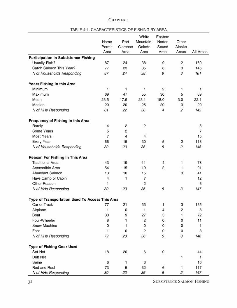
32 Subsistence Salmon Fishing
Chapter 4
Nome Permit Area
Port Clarence
Area
White Mountain -
Golovin Area
Eastern Norton Sound Area
Other Alaska Areas All Areas
Participation in Subsistence FishingUsually Fish? 87 24 38 9 2 160Catch Salmon This Year? 77 23 35 8 3 146N of Households Responding 87 24 38 9 3 161
Years Fishing in this AreaMinimum 1 1 1 2 1 1Maximum 69 47 55 30 5 69Mean 23.5 17.6 23.1 18.0 3.0 22.1Median 20 20 25 20 3 20N of HHs Responding 81 22 36 4 2 145
Frequency of Fishing in this AreaRarely 4 2 2 8Some Years 5 2 7Most Years 7 4 4 15Every Year 66 15 30 5 2 118N of Households Responding 82 23 36 5 2 148
Reason For Fishing In This AreaTraditional Area 43 19 11 4 1 78Accessible Area 54 15 19 2 1 91Abundant Salmon 13 10 15 3 41Have Camp or Cabin 4 1 7 12Other Reason 1 2 3N of HHs Responding 80 23 36 5 3 147
Type of Transportation Used To Access This AreaCar or Truck 77 21 33 1 3 135Airplane 1 0 1 4 2 8Boat 30 9 27 5 1 72Four-Wheeler 8 1 2 0 0 11Snow Machine 0 1 0 0 0 1Foot 1 0 2 0 0 3N of HHs Responding 79 23 36 5 3 146
Type of Fishing Gear UsedSet Net 18 20 6 0 44Drift Net 1 1Seine 6 1 3 10Rod and Reel 73 5 32 6 1 117N of HHs Responding 80 23 36 6 2 147
TABLE 4-1. CHARACTERISTICS OF FISHING BY AREA

Findings: Survey Results
By Residents of Nome, Alaska, 2001 33
samples except King Island. Other Nomehouseholds accounted for 55 percent, sport fishlicense households accounted for 34 percent, andpermit households accounted for 11 percent ofthe total harvest in the White Mountain-GolovinArea.
Household Fishing Histories
The survey included a number of questions thatasked about households’ fishing histories. Thequestions were asked separately about each areafished (Appendix 1). Table 4-1 summarizes theresponses to these questions, by area. Thesequestions were not asked of households whoonly obtained permits.
When asked how many years they had fishedin each area, households’ responses ranged from1 to 69 years, with an average tenure of 22 years.Tenure was greatest in the Nome permit area,23.5 years, but almost as great in the WhiteMountain-Golovin area 23.1 years, and not thatmuch less in the Port Clarence area, 17.6 years.When asked how frequently they had fished ineach area during the last decade, 80 percent ofthe households reported fishing in the area everyyear, and an additional 10 percent reportedfishing in most years (Table 4-2).
The responses to these two questions were atodds with perceptions that Nome households
were increasing their efforts outside the Nomepermit area. The surveyed households, at least,reported almost continuous fishing in both thePort Clarence area and the White Mountain-Golovin area over the last decade. The answerssuggested that Nome residents’ fishing hasbecome more visible, either because they werefishing more often, in more visible locations,with different gear (nets as opposed to rods andreels), or harvesting more salmon outside theNome permit area.
The most common reason given for fishingin each area was access, cited by 62 percent ofthe households, followed by “traditional area”by 53 percent of the households, and “abundantsalmon” by 28 percent of the respondents.Relatively few households reported a camp or acabin as the reason for fishing in a particulararea, except in the White Mountain-Golovinarea. Most of these probably were in Council,an old mining community accessible by roadfrom Nome.
The significance of the state road system wasevident in the responses to the question abouthow households accessed the different areas tofish for subsistence. While only 49 percent usedboats to access their fishing areas, 92 percentused cars or trucks.

34 Subsistence Salmon Fishing
Chapter 4

35
5Findings: Teller and White Mountain
In 2001, Nome residents harvested almost halftheir salmon outside the Nome permit area. Ofthe estimated 6,138 salmon harvested by sampledhouseholds, 1,158 salmon (19 percent) camefrom the Port Clarence area, and 1,426 salmon(23 percent) came from the White Mountain-Golovin area.
Residents of the smaller communities in theseareas have become concerned about the effectsof increased harvests of local salmon stocks, andabout competition for fishing sites. To explorethese concerns, researchers in this studyinterviewed key respondents in both Teller andWhite Mountain, and held a community meetingin White Mountain. Harvest data for Teller andWhite Mountain were collected in a separateproject, and are summarized in Chapter 3.
This chapter summarizes the results of thecommunity meeting and interviews. Thesummaries begin with descriptions of therespondents and the local fishery, thensummarizes their assessments of the impacts ofNome residents’ fishing on the Teller and WhiteMountain fisheries.
Teller
The Teller respondents included nine people infive households. These included heads of threehouseholds who had lived in Teller all their livesexcept short periods away for work or education,an elder couple who moved to Teller from aneighboring community in the 1950s and hadlived there ever since, and one couple in whichthe man had lived in Teller less than ten years.Two respondents were interviewed in the IRAoffice, the remaining seven were interviewed intheir homes.
All but one of the respondent households wasactively involved in salmon fishing in 2001. Thenon-fishing respondent did not fish in 2001
because of a health problem, but he did help hisparents fish, and he had been an active fisher inthe past.
One respondent reported fishing salmon fromhis family camp on the north side of GrantleyHarbor. All the remaining respondents reportedsetting salmon nets off the beach in front of Telleron the south side of Grantely Harbor. They usedset gill nets, with 4.5-inch to 5.25-inch mesh,ranging from 75 to 150 feet long.
“We put out short nets, or nets with a pocketin it,” said one respondent.
“A hundred fifty feet is a long net here,” saidanother.
Respondents in one household helpedresearchers map family net sites on the Tellerbeach. Families with houses on the beach usuallyset nets in front of their houses. There was notroom along the beach for everyone to set at once,so neighbors took turns setting their nets,sometimes coordinating their sets with telephonecalls. Several respondents described cooperativefishing arrangements with other households.Figure 5-1 summarizes a typical arrangement ofnets described by respondents, showing both netsset by Teller families and nets set by Nomefamilies off the beach in front of Teller.
“In this area,” one man said, “if one or theother of us has their net out drying, then one ofthe other of us will put their net in.” Anotherrespondent reported sharing a single 150-footnet with two other households.
The short nets and the cooperative approachto fishing allowed a maximum number of familiesto fish along the congested beach in front ofTeller. Still, two respondents reported conflictswith other Teller families over net sites.
One respondent reported a fellow resident who“had the guts to tell me that he was fishing outin front of the old house for so many years, and
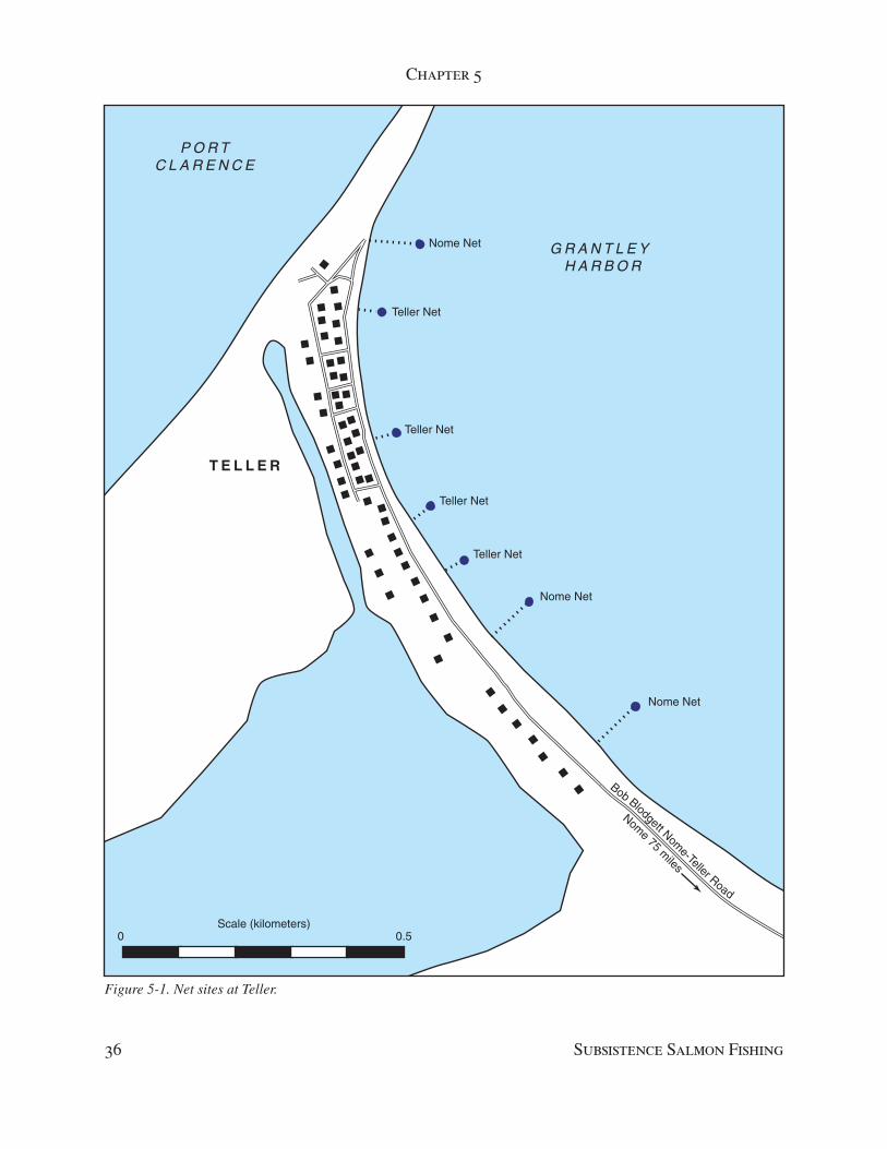
Chapter 5
36 Subsistence Salmon Fishing
Figure 5-1. Net sites at Teller.
Bob Blodgett Nome-Teller Road
Nome 75 m
iles
G R A N T L E Y H A R B O R
P O R TC L A R E N C E
T E L L E R
Nome Net
Nome Net
Nome Net
Teller Net
Teller Net
Teller Net
Teller Net
0 0.5Scale (kilometers)

Findings: Key Respondent Interviews
By Residents of Nome, Alaska, 2001 37
he never did. He tried to take over our fishingsite. We used it, but right there (they) came andsaid that was their fishing area. They wanted totake our scow and our anchors and our cuttingtables.” The respondent maintained use of thesite and the other resident eventually moved outof Teller.
Teller respondents differed in their assessmentof the 2002 salmon runs in the Port Clarencearea. “The run’s down,” one respondent said.“Usually our freezer is completely full by now,and the other one is half full, and we leave roomfor a moose. This year, we could put three moosein. This year, everything was down. They saythere’s lots of fish on Agiapuk River, but wehaven’t gone up there.”
But another resident reported, “We had a goodrun this year, 10 to 20 fish a net. A lot of itdepends on how many fish people want, too.”
Several respondents agreed that in a goodyear, one could expect to catch 100 to 125 fish aday at the height of the run. Regardless of runstrength, weather during the summer of 2002was ideal for drying salmon, cool and windy butnot wet.
Every Teller respondent reported that thenumber of Nome residents fishing in the Tellervicinity had increased in recent years.Researchers asked one respondent if Nomeresidents came to Teller when he was young.“No. There was no road,” he observed. “Peoplewent from community to community in skinboats. But they weren’t here for fish. They camehere for berries and stuff. They were from Walesmostly, Diomede, Shishmaref, even Kotzebue.The only Nome traffic we got was people goingup North, and the tug boat.”
The Teller road was completed in 19??.Fishing was good in the Nome in the 1970s; bothcommercial and subsistence salmon fisheries inthe Nome area were reporting record harvests.Asked when he first observed Nome residentsfishing in the Teller area, one respondent said,“That’s hard to say, because we have somepeople who relocated from here to Nome. Theyhave camps up Tuksruk channel and farther up.If they’re not staying on land that their parentsor grandparents used, it’s near to it. They’d beneighbors or something like that.”
Several Teller respondents said they firstobserved significant fishing effort by unrelatedNome residents in the early 1990s, whichcoincided with the beginning of extensivesubsistence fishing closures in the Nome area.
“Occasionally you’d see someone (fromNome),” said one respondent. “Everybody hasfamily here. But in the last 10 years, since Nomeclosed, we hadn’t seen anything like thatbefore.”
One respondent thought that Nome residents’effort in Teller depended on what was going onin Nome. “If they close the ocean in Nome,” hesaid, “then people start showing up here. Someof the time, if they’re not running down therevery good, they’ll come up here. But usually,it’s when that area is closed down there. You seethe same thing happening on the Fish River.”
Another attractive feature of the Teller fisheryfor Nome residents is the presence of sockeyesalmon (“reds”), which are uncommon in theNome Subdistrict. One respondent observed thatusually he began seeing Nome residents “afterthe Fourth of July. They hit the red run. They hitright after the Fourth of July, for about twoweeks… Everybody wants reds.”
The exact number of Nome residents whobegan fishing in Teller is unknown, but it wasnot a large number. Several respondents agreedthat at most, they would see four or five Nomenets set off the beach at Teller at any one time,along with a similar number of nets belongingto Teller families.
The Nome residents usually stay “only acouple days… Most of the time they catch theirfish, put them in totes, bring them to Nome.”Occasionally a Nome resident would set up adrying rack on the beach, or cut and salt fish.But the most commonly observed practice wasto return to Nome with fish in the round.
Nome residents apparently were good abouttending their nets. Most stayed in Teller until theywere done fishing. “There were some peoplewho leave their nets, and go to Nome,” onerespondent said. “They come set their net in themorning, then go back to Nome, and then comeback in the evening to check it.”
There was only one net-tending problemreported. “(A Nome man) left a real long net out

Chapter 5
38 Subsistence Salmon Fishing
there, and never came around for a whole week.Everybody bitched like hell.”
“If it’s really windy, or if they don’t comeback,” one Teller respondent said, “I’ll untie theirnet from shore and let it drift out, attached to theanchor. I do that to local people sometimes, too.If people set a net, go to Nome, and don’t comeback, I’ll untie their net, too.”
For the most part, the same group of Nomeresidents returned each year. Those with familyin Teller blended in, often fishing upriver infamily fish camps, out of sight and out of mind.But others set their nets right off the beach inTeller, and conflicts developed between theNome and Teller fishers. From Teller’sperspective, the biggest problem by far was thelength of Nome residents’ nets.
When researchers arrived for one interview,the respondent didn’t even wait for a question.He began with a statement. “The problem wehave is those big nets. A shackle. They fisheverything, and there’s no escapement.”
His comment was echoed by anotherrespondent. “The amount of gear being set…wasalarming, the length of the nets. Nobody aroundhere had that kind of gear.”
Teller residents described going out to tendtheir 100-foot or 150-foot net, and finding 300-foot nets set on either side. “Some people havebeen offended. ‘That guy is corking me off. Heset a 300-foot net in front of me, and I’m notcatching anything now.’ A lot of (Nome) peopleset right in front of the village (Teller). That’sthe easiest place to fish with a truck.”
“The amount of gear was the first thing thatraised anybody’s hackles,” one Teller man said.“It’s as if it set a standard. If you want to catchany fish, you have to set 300 feet. If we all go tothat size of gear, how much do we need? It’s’getting to be a competitive deal all the wayaround. It’s not looking good.”
Several Teller families, this respondentreported, have purchased longer gear forthemselves, to better compete with the Nomeresidents. One Nome resident was advertisinghis 300-foot net for sale in the Teller Native Storein August, 2002.
“Now some local people are fishing long nets.I sure don’t like to see that. They don’t realize
that getting a longer net to catch the fish theyused to catch isn’t helping matters. I think if wegot together, and when fish start declining, we’dshorten our nets, so that we can have someescapement… There’s nothing wrong with themcoming up here and fishing, as long as they lookat what people here are doing.”
Several respondents thought the Board ofFisheries should limit net lengths in the vicinityof Teller to no more than 150 feet.
A second issue in Teller involved customarytrade, that is, the exchange of subsistence-caughtfood for cash. Under state regulations, the saleof any subsistence caught fish is prohibitedunless the sale occurs in a recognized customarytrade fishery. The state has not established acustomary trade fishery in the Port Clarence area.But customary trade in fish is allowed underfederal regulations. So fish caught in federally-managed waters in the Port Clarence area couldbe sold legally; fish caught in state-managedwaters could not.
Several families in Teller and nearby BrevigMission reportedly were involved in customarytrade in dried salmon. Teller respondents alsobelieved that one Teller resident and several ofthe Nome residents fishing in the Teller area wereselling fresh, unprocessed salmon for cash.
“I get calls almost every week,” said onerespondent, “from individuals who want to knowwho’s selling dry fish up here. People fromAnchorage come to Nome, and want to get dryfish. They can’t get any in Nome, so they’ll callup here. I’ll give them phone numbers, mostlypeople in Brevig Mission. We used to sell themto Blodgett’s store. (Demand) has increased.Before was it through the store they werepurchasing. Now it’s (from) individuals.”
“On this side (Teller), there are only two orthree families at this time. But if you go to theBrevig Mission side, you have more, five or sixfamilies are selling dry fish. Sometimes it mightbe as many as ten families.”
Demand is certainly present. “Fish havebecome more of a commodity here,” anotherrespondent said. “There are days when I’mchecking the net and I’ve had people come upand ask to buy salmon from the net. It’s an

Findings: Key Respondent Interviews
By Residents of Nome, Alaska, 2001 39
awkward situation. You don’t really want to sellany, and you don’t want to give that many away.”
A third respondent described a Teller residentallegedly “coming back with totes full of fish,selling them on the beach. His biggest buyerswere people from Norton Sound Hospital.”
Respondents seemed more tolerant ofcustomary trade in dried fish, and less tolerantof customary trade in fresh fish. “People whoare coming up here to fish for sale, that’s notright,” said one respondent. “They say they’resubsistence fishing, but they’re not.”
White Mountain
White Mountain respondents included 17 people.Sixteen respondents provided comments duringa community meeting to discuss fishing issues.Three respondents (two of whom had attendedthe meeting) were interviewed the day after themeeting by Sandra Tahbone and AustinAhmasuk.
Most respondents were active in subsistencefishing in the White Mountain-Golovin area (one
Figure 5-2. Customary Trade in Salmon. A hand-printed flyer on a bulletin board in a Nome grocery store advertisesdried salmon for sale, and lists Teller and Nome phone numbers. Customary trade (meaning the exchange of subsistence-caught fish for cash) is legal under federal regulations, but prohibited by state regulations.
respondent did not fish herself). One of therespondents also was involved in a family sportfish guiding business based in White Mountain.
Respondents ranged in age from …They described a subsistence fishery that
concentrated on the harvest of pink and chumsalmon for drying (survey data show the averageharvest in White Mountain and Golovin to be90 percent pink and chum). The rest of thesalmon harvest is primarily coho and a smallnumber of chinook, which are eat fresh or frozen.
Beach seines were the most frequentlymentioned type of gear, but set gill nets and rodsand reels also are used. Several respondentsmentioned switching from propeller-drivenoutboard motors to outboard jets, which are betterable to travel in shallow water and thus open upnew areas to fishing.
Older respondents recalled much largerharvests when they were younger. “When wewere growing up,” she recalled, “we had a three-tier fish rack. We would fill it almost every

Chapter 5
40 Subsistence Salmon Fishing
weekend and put away in our cache. Now wejust fill up one tier.”
“I used to put away six to eight hundred fishaway for our family and for bargaining,” saidanother respondent. “Now it’s harder to get fish,so I probably put away enough to get by. Maybehalf of that.”
All three interviewed respondents said fishwere less abundant now than in the past, andduring the meeting several other people agreed.While not as severe as the declines in the Nomearea, the declines in the Fish River system haveresulted in closures for commercial, sport, andsubsistence fishing during the last decade. Thesubsistence closure in ___ is believed to havebeen the first ever subsistence salmon fishingclosure in the White Mountain-Golovin area.
Some respondents suggested the decline wasrelated to commercial fishing in other parts ofAlaska; one respondent complained thecommercial fishing in Golovnin Bay adverselyaffected salmon abundance in the Fish Riversystem. Several respondents also mentionedincreases in beaver and brown bear populations.
Half the respondents mentioned concernsabout beaver dams. “When I was little,” onerespondent recalled, “I never saw a beaver dam.The closest was a muskrat. I was a teenager thefirst time I saw a beaver, and actually ate beaver.Now we have beavers in every creek. They areblocking off some areas of the river… Peoplehave tried to kill off the beavers, but there isonly so much you can take.
“I’ve never seen so many beavers dams, inevery creek and slough. There is one across fromour camp. We’ve been trying to get rid of it. Webrought this up with Fish and Game. They saidthat when beavers build dams, they make a placefor fish to spawn right below. But the dams thatI see are too shallow and freeze below the dams.
“If you go up the Council river, there’s a placecalled Ophir, with a huge huge dam. Right belowit, there are hundreds of silvers trying to get pastit. A couple people from Council tried to tear itdown, and the beavers built it right back up.”
Brown bear populations also have increased,which some respondents thought was related tothe arrival of moose in the Fish River area about50 years ago. “When I was twenty years old, I
only saw one bear,” said one respondent. “Nowwe see a lot of them… One day we saw sevenbears, two of which were cubs. Everyday wesee tracks.” Biologists believe bear predation hasdepressed the moose population in the area; localpeople feel bears have depressed the salmonstocks as well.
Along with the decline in stocks, there alsowas a decline in fishing effort by local residents,several respondents asserted. One respondent,who juggles subsistence fishing with thedemands of a summer job described her personalfishing history:
I started fishing with my grandparents at aplace called Niialupaq. There is a cabinwith a couple tents there. I probably startedin the early ‘60s. There were a couplefamilies that fished there. When we werethere, we fished for our food source as wellas for dog food. We spent the entire summerthere. There were a couple fish racks foreach family that lived there.
Today, I put fish away for my family andmy grandpa. I also put some fish away totrade for muktuk and walrus. We try to getenough fish so we can have enough nativefoods. This year, I probably put away maybethree or four hundred pinks, more than lastyear. I used to smoke silvers but I haven’t fora couple years due to low silver runs. It’s notas good as before. Sometimes, I don’t havetime for that either.
The decline in abundance, harvests, and effortalso have resulted in a decline in sharing, somerespondents believed. People have fewer fish forthemselves, and thus fewer fish to share.
Against this background of decliningabundance and declining harvests, WhiteMountain respondents also began seeing anincrease in the number of Nome residents fishingin the White Mountain-Golovin area, which theydated to the late 1980s and early 1990s. Thegrowth of the seasonal community at Councilhas contributed to Nome’s effort in the Fish Riversystem.
Findings: Key Respondent Interviews
By Residents of Nome, Alaska, 2001 41
“Council is getting to be pretty crazy,” onerespondent said. “Cars everywhere, boatseverywhere.”
“When I was little,” said another respondent,“the only (non-local) boat I would see was oldman Holly. He was the only one who would comedown. Maybe it’s been ten to twelve years, andit seemed to increase every year after that. In thebeginning, it used to be locals, now with morehouses in Council, there have been more andmore Nome boats.”
Because the Niukluk River was too shallowmost of the season to navigate with a propeller-driven boat, most Nome residents used outboardjet boats. In 2002, the water was so low belowCouncil that it was hard to access the Fish River,even with jet boats. “This year we were blessedwith low water so we didn’t see too many boats,”said one person in White Mountain. Respondentsalso observed Nome boats increasing in size overtime, and a shift towards flat-bottom boats thatworked better with outboard jets.
Nome residents targeted different species andrelied more heavily on rod and reel gear in theWhite Mountain-Golovin area than in the PortClarence area. Earlier in the season some Nomeresidents come to the Fish River to harvest chumsand pinks. Others targeted the chinook (king)run. Later in the season, from end of July intoAugust, Nome residents came for coho (silver)salmon. “People that come earlier are more thanlikely doing their subsistence fishing,” said aWhite Mountain respondent. “More and morecome down for sports fishing. We saw a couplenew outfits from Nome that are bringing clientsto fish.”
“I think they are targeting silvers and kings,”said another respondent. “I don’t usually fishfor kings but I notice when the kings are runningI see a lot more people.”
Nome boats tended to make day trips downriver to fish, returning back upriver to Councilin the evening. Some boats made multiple tripsdown and up the Niukluk River, which somerespondents thought was a way to circumventsport fishing limits.
“They will catch their limit and come backdown,” the respondent said. “When there wasn’ta limit you would see two people in a boat;
nowadays the boats are packed. They bring theirkids to count for taking a limit, which is threemore fish you can take.”
The most common impact (mentioned by sixrespondents) of Nome residents’ fishing wascompetition for fishing sites between localresidents using beach seines and the Nomeresidents using rods and reels.
“You want to seine once,” said onerespondent. “Then you catch what you need forthe day. There are only so many spots, and usuallythere are boats there already, like three or fourboats. I don’t know if they are just sports fishingor subsistence fishing, I don’t want to go outand seine in front of them. I don’t know if I coulddo that legally, if they’re just sports fishing andI’m subsistence fishing. I’m seeing more andmore of that.”
“One of our ladies talked about going downto the holes to subsistence seine where the chumswould be,” said one respondent, “before theNome boats get there. Otherwise we wouldn’tbe able to seine. Otherwise we will have to findanother spot. We don’t want to be mean and fishin their spot.”
The competition between Nome and WhiteMountain residents was not limited to simplysubsistence fishing. One family in WhiteMountain operates a sport fishing guide businessfrom their camp. They also were affected bycompetition from Nome residents. “When wefirst started off our fishing business,” said oneof the owners, “we never had to fight for anyareas or sites. Nowadays, it’s gotten so we haveto start earlier and earlier. The Nome boats areshowing up as early as 5:00 am.
“There are maybe four good holes and maybeup to ten holes that we use. You have to get therebefore someone else does. Some of those boatswill be sitting in a hole and will cap you, they’llgo a hundred yards below, throw their anchorout. When they do that to our guides, we toldthem just to leave.”
The Fish River system was also a populardestination for Nome moose hunters, despiterecent restrictions in seasons and bag limits inthe White Mountain-Golovin area.
“We are seeing more hunters because peopleknow our river,” said one respondent. “This year

Chapter 5
42 Subsistence Salmon Fishing
because of low moose (populations) in our area,we could only take so many moose. We had somany different boats in our area hunting moose,and we were only given so many to catch. Itwas a scramble, combat hunting. There werepeople leaving early and coming home late totry to bag a moose.
“It used to be, a whole season, people wouldleave at dusk, go hunting, and come back beforeit gets dark, because that is when the moose comeout. Now it’s an all day thing. You have to getout before other people show up. When we didour hunting, we would bump into different boatsthat weren’t from our area.”
One resident suggested that ADF&G shouldmonitor boat traffic in and out of Council. Afrequent complaint was the location of the salmoncounting tower, which was on the Niukluk.Several respondents suggested it should bemoved onto the lower Fish River, so it couldcount all the salmon entering the Fish Riversystem.
Many respondents were concerned about thefuture. “We don’t have problems like Nome,”said one. “I don’t want to see it come down tothat. I could see it; I wouldn’t like it. I don’t seeit changing too drastically. Maybe because westill have fish – I don’t want to lose our fish.”
43
6Discussion
This study provided a more complete estimateof Nome residents’ subsistence salmon harvestthan has existed previously. In the Nome permitarea in 2001, the subsistence permit systemreported 1,837 salmon harvested, while this studyestimated 3,226 salmon, a difference of 1,389salmon. Outside the Nome permit area, this studyestimated that Nome residents harvested anadditional 2,912 salmon, for a total harvest of6,138 salmon. Thus the subsistence permitsystem accounted for at most 30 percent ofNome’s total subsistence salmon harvest in 2001.
This study estimated that Nome residents took1,436 salmon in the White Mountain-Golovinarea, compared with an annual average of only170 salmon reported through the permit system.This study also estimated that Nome residentstook 1,158 salmon in the Port Clarence area,compared with an annual average of only 150salmon reported through the permit system.
Most of this unreported harvest was legallytaken, but was not required to be reported. Eitherit occurred outside the area in which permits wererequired or it was harvested with rods and reelsby people holding sport fish licenses.
Harvest reports and key respondent interviewsindicated that Nome residents fishing in the PortClarence area used nets and targeted sockeyesalmon. Sockeye comprised 37 percent of Nomeresidents’ harvests in this area, while sockeyecomprised 29 percent of Port Clarence arearesidents’ harvests.
In contrast, the data suggested that Nomeresidents fishing in the White Mountain-GolovinArea used rods and reels for about a third oftheir harvest, and they targeted coho salmon.Coho comprised 41 percent of Nome residents’harvests in this area, but only about 9 percent ofWhite Mountain’s and Golovin’s harvests.
Although Nome residents reported they hadbeen fishing in the areas adjacent to Nome foran average of 22 years, residents of the adjacentareas perceived a substantial increase in effortand harvests since about 1990, which theyattributed to increasing regulation of Nomesubdistrict fisheries. These two findings were notnecessarily inconsistent, as the survey did notask Nome residents about past levels of effortand harvest. It was possible that Nome residentsmay have occasionally harvested small amountsof salmon in adjacent areas in the past, thenincreased their effort and harvest in recent yearsand become more visible.
Nome was ten times as large as most of itsneighbors, and located in an area of relativelysmall rivers and modest salmon runs. Bycomparison, most other communities innorthwest Alaska were relatively small (averagepopulation 350) and most were located on ornear rivers with substantial salmon runs (e.g. FishRiver, Koyuk River, Shaktoolik River, UnalakleetRiver).
Fishery managers responded to thesedifferences by adopting different subsistencesalmon regulations in different areas. In most ofNorton Sound, there were no closed waters, noclosed periods, and no harvest limits forsubsistence salmon. In the Nome subdistrict,there were areas of closed waters in all the majorstreams, closed periods every week, fishingpermits with harvest limits, and the state’s onlyTier II salmon fishery.
While some families were discouraged fromfishing by declining abundance and restrictiveregulations, as shown by declining salmonfishing effort and harvests in the Nomesubdistrict since the mid 1980s, other familiesappear to have adapted to the restrictions by

44 Subsistence Salmon Fishing
Chapter 6
increasing their effort and harvests in adjacentareas.
Among respondents in Teller and WhiteMountain, competition for fish sites was the mostcommon complaint. Some Teller residentsthought that limiting gill net lengths to 150 feetin the Port Clarence area would alleviate muchof the conflict there, basically forcing everyoneto use similar gear. In the White Mountain-Golovin area, Nome residents were more likelyto use rods and reels while local residents usedbeach seines, so a solution to the conflicts wasmore elusive. In both areas, though, being a goodneighbor clearly would go a long way toreducing conflict.
Residents of adjacent areas were very awareof the restrictions placed on salmon fishing inNome, and some worried that similar restrictionswould follow Nome residents into other areas.Because the state legally cannot provide asubsistence priority on the basis of proximity tothe resources, Nome residents had as muchopportunity to harvest salmon for subsistence inthe state-managed portions of the Fish or Kuzitrinrivers as they had in the Nome River. Or as oneWhite Mountain resident said, “The U.S. is a freecountry, so you can’t go around telling peoplenot to fish.”
One White Mountain resident commented, “Tome salmon means a lot. I do it every year, I’vedone it since I was young. I can’t imagine
thinking someday I might have to buy fish toeat. I depend on this resource. I supply mygrandpa with his fish. I can’t see us not doingthis, I want to have fish, I want my grandchildrento have fish to eat. It’s a big part of my life.”
The Federal Subsistence Board does havemore flexibility under law. Customary andtraditional use determinations could be used tolimit the areas in which Nome residents fished.However, Nome residents already have built arecord of using salmon from the Port Clarencearea and the White Mountain-Golovin area. TheFederal Subsistence Board also is in the midst ofa review of its “rural” definition. Although Nomeis named as a “rural” community in the AlaskaNational Interest Lands Conservation Act, thatdesignation could change at some point in thefuture.
The situation as a whole provided a good caseexample of the challenges of managing forsubsistence for a regional center. Although thisstudy focused on salmon, similar studies couldhave examined patterns of moose hunting ormusk oxen hunting around Nome. Because thisstudy collected and analyzed data for only oneyear, it was not clear how harvests by Nomeresidents may have varied over time in theadjacent areas. Even so, the study providedmanagers with a much more complete summaryof Nome’s harvest.
45
References
Alaska Department of Administration1985 Alaska Geographic Differential Study.
Alaska Department of Fish and Game1993 Community Profile Database. Division
of Subsistence. Juneau.
Alaska Department of Labor1986 Alaska Planning Information. Juneau.
1990 Alaska Population Overview: 1988 andProvisional 1989 Estimates. Juneau.
1993 Alaska Population Overview: 1991Estimates. Juneau.
Anderson, Douglas D.1984 Prehistory of North Alaska. IN Handbook
of North American Indians: Arctic. DavidDamas, vol. ed., William C. Sturtevant,gen. ed. Smithsonian Institution.Washington, D.C. pp. 80-93.
Bockstoce, John1979 The Archeology of Cape Nome, Alaska.
The University Museum. University ofPennsylvania. Philadelphia.
Burch, Ernest S., Jr.1980 Traditional Eskimo Societies in
Northwest Alaska. IN Alaska NativeCulture and History. Y. Kotani and W.B.Workman (eds). National Museum ofEthnology, Senri Ethnological Series 4.Osaka, Japan.
1984 Kotzebue Sound Eskimo. IN Handbookof North American Indians: Arctic. DavidDamas, vol. ed., William C. Sturtevant,gen. ed. Smithsonian Institution.Washington, D.C. pp. 303-319.
Cole, Terrence1984 Nome: City of the Golden Beaches.
Alaska Geographic 11( 1).
Collier, Arthur J. and Frank L. Hess, Phillip S.Smith, and Alfred H. Brooks.
1908 The Gold Placers of parts of SewardPeninsula, Alaska. Washington, D.C.:United States Geological Survey BulletinNo. 328.
Conger, Annie Olanna, and James Magdanz1990 The Harvest of Fish and Wildlife in Three
Alaska Communities: Brevig Mission,Golovin, and Shishmaref. Division ofSubsistence, Alaska Department of Fishand Game. Technical Paper 188. Juneau.
Georgette, Susan, David Caylor, and SandraTahbone
2002 Subsistence Salmon Harvest SummaryNorthwest Alaska, 2001. Division ofSubsistence, Alaska Department of Fishand Game. Juneau.
Georgette, Susan and Hannah B. Loon1990 Subsistence and Sport Fishing of
Sheefish on the Upper Kobuk River,Alaska. Division of Subsistence, AlaskaDepartment of Fish and Game. TechnicalPaper 175. Juneau.
1993 Subsistence Use of Fish and Wildlife inKotzebue, a Northwest Alaska RegionalCenter. Division of Subsistence, AlaskaDepartment of Fish and Game. TechnicalPaper 167. Juneau.

46 Subsistence Salmon Fishing
References
Howe, Allen L., Gary Fidler, Allen E. Bingham,and Michael J. Mills
1996 Harvest, Catch, and Participation inAlaska Sport Fisheries during 1995.Division of Sport Fish, AlaskaDepartment of Fish and Game. FisheryData Series No. 96-32.
Koutsky, Kathryn1981a Early Days on Norton Sound and Bering
Strait: An Overview of Historic Sites inthe BSNC Region. Volume III: The PortClarence and Kawerak Areas.Anthropology and Historic Preservation,Cooperative Park Studies Unit,University of Alaska, Fairbanks.
1981b Early Days on Norton Sound and BeringStrait: An Overview of Historic Sites inthe BSNC Region. Volume IV: The Nome,Fish River, and Golovin Areas.Anthropology and Historic Preservation,Cooperative Park Studies Unit,University of Alaska, Fairbanks.
Lean, Charles F., Frederick J. Bue, and Tracy L.Lingnau
1995 Annual Management Report 1993:Norton Sound, Port Clarence, Kotzebue.Division of Commercial FisheriesManagement and Development, AlaskaDepartment of Fish and Game. RegionalInformational Report No. 3A95-06.Anchorage.
Magdanz, James1992 Subsistence Salmon Fishing by Permit in
the Nome Subdistrict and Portions of thePort Clarence District, 1975-91. Divisionof Subsistence, Alaska Department ofFish and Game. Technical Paper 220.Juneau.
Magdanz James, and Annie Olanna1984 Controls on Fishing Behavior on the
Nome River. Division of Subsistence,Alaska Department of Fish and Game.Technical Paper 207. Juneau.
1986 Subsistence Land Use in Nome, aNorthwest Alaska Regional Center.Division of Subsistence, AlaskaDepartment of Fish and Game. TechnicalPaper ___. Juneau.
Magdanz, James and Charles Utermohle1994 The Subsistence Salmon Fishery in the
Norton Sound, Port Clarence, andKotzebue Districts, 1994. Division ofSubsistence, Alaska Department of Fishand Game. Technical Paper 237.
Nome Subsistence Salmon Working Group1999 Recommendations to the Alaska Board
of Fisheries for the management of theNome Area Subsistence Salmon Fishery.Alaska Board of Fisheries record copy1, “Workgroup” tab. March 28, 1999.Juneau.
Pete, Mary1996 Testimony before the Alaska Board of
Fisheries, April 14, 1996. Director,Division of Subsistence, AlaskaDepartment of Fish and Game. Juneau.
Petroff, Ivan1884 Report on the population, industries, and
resources of Alaska. IN Tenth census ofthe United States. Department of theInterior, Census Office. Washington D.C.
Raleigh, Robert F.1957 Western Alaska Salmon Investigations,
Operation Report 1957:Reconnaissance of Salmon FisheriesBetween Cape Newenham and PointHope, Alaska, 1957. Bureau ofCommercial Fisheries, United States Fishand Wildlife Service.
Ray, Dorothy Jean1964 Nineteenth Century Settlement and
Subsistence Patterns in Bering Strait.Arctic Anthropology 2(2):61-94.
1967 Land Tenure and Polity of the BeringStrait Eskimos. Journal of the West6(3):371-394.
References
By Residents of Nome, Alaska, 2001 47
1984 Bering Strait Eskimo. IN Handbook ofNorth American Indians: Arctic. DavidDamas, vol. ed., William C. Sturtevant,gen. ed. Smithsonian Institution.Washington, D.C. pp. 285-302.
Thomas, Daniel1980a Nome Salmon Subsistence Research
Report. Division of Subsistence, AlaskaDepartment of Fish and Game. TechnicalPaper 11. Juneau.
1980b Issue Paper on the Nome RiverSubsistence Salmon Fishery. Division ofSubsistence, Alaska Department of Fishand Game. Technical Paper 10. Juneau.
University of Alaska1994 Cost of Food at Home for a Week in
Alaska: December 1994. AlaskaCooperative Extension. Fairbanks.
U.S. Census Bureau2001 Profiles of General Demographic
Characteristics 2000, Alaska. U.S.Department of Commerce. Washington,D.C.
Wolfe, Robert, and Linda Ellanna, compilers1983 Resource Use and Socioeconomic
Systems: Case Studies of Fishing andHunting in Alaska Communities.Division of Subsistence, AlaskaDepartment of Fish and Game. TechnicalPaper __. Juneau.

48 Subsistence Salmon Fishing
References

49
Appendix 1Survey Instrument


G1 NOME 2001 COMMUNITY ID # 251
GENERAL SUBSISTENCE SALMON HOUSEHOLD HARVEST SURVEY SAMPLE ID # ____
QUESTIONS HH ID # ____
Survey Date: _________________________________ Household Size: __________________________________
Interviewer: __________________________________ P.O. Box: _______________________________________
Phone: _________________________________________
Information collected on this survey is used by Kawerak and ADF&G to better understand subsistence salmon fisheries inNorton Sound. We will NOT publish information about your household’s fishing activities. We will NOT use the informationfrom this survey for enforcement. You are NOT required to participate in this survey. We will publish a summary of salmonharvests by your community, and send it to all the households that participate.
QUESTIONS FOR ALL HOUSEHOLDS
Would you like to participate in our survey?c NO
Thank You!c YES
Go to question 1
1. Did your household catch salmon for subsistence use this year, includingwith a rod-and-reel? c NO c YES
2. Does your household usually subsistence fish for salmon?c NO
Go to question 11c YES
Ask next question
QUESTIONS FOR FISHING HOUSEHOLDSAsk households that answered “YES” to question.
3. During the past ten years, where has your household usually subsistence
fished for salmon? Mark all areas usually fished…
c NOME PERMIT AREA
c PORT CLARENCE AREA
c WHITE MOUNTAIN-GOLOVIN AREA
c EASTERN NORTON SOUND AREA
c YUKON AREA
c ST. LAWRENCE ISLAND AREA
c KOTZEBUE AREA
c OTHER ALASKA AREAS
A ________________________________
B ________________________________
C ________________________________
4. As salmon have declined in the Nome Area during the last ten years, has
your household’s use of salmon changed? If so, how?
Mark all that apply…
c SALMON USE HAS NOT CHANGED
c USE LESS SALMON
c USE MORE OTHER WILD FOODS OR FISH
c USE MORE STORE-BOUGHT FOOD
c HELP OTHERS HARVEST MORE
c T RADE OR BARTER FOR FISH
c DEPEND ON “DISASTER” FISH
c SHARE LESS SALMON WITH OTHERS
c_OTHER (EXPLAIN)___________________
_________________________________
_________________________________

G2 NOME 2001 COMMUNITY ID # 251
GENERAL SUBSISTENCE SALMON HOUSEHOLD HARVEST SURVEY SAMPLE ID # ____
QUESTIONS HH ID # ____
MORE QUESTIONS FOR FISHING HOUSEHOLDSContinued from Page G1...
5. How has your household gotten salmon during the last ten years?
Mark all that apply…
c FISHED T IER II PERMIT IN NOME AREA
c FISHED T IER I PERMIT IN NOME AREA
c HELPED OTHER FAMILY FISH
c FISHED WITH ROD & REEL IN NOME AREA
c FISHED SOMEWHERE ELSE
c NOME PEOPLE SHARED SALMON WITH US
c OTHER PEOPLE SHARED SALMON WITH US
c T RADED OR BARTER FOR SALMON
c BOUGHT SALMON
c DID NOT USE SALMON
c OTHER (EXPLAIN…)_________________
_________________________________
6. Did anyone in your household apply for a Tier II permit this year? c NO
Ask next question 4c YES
Go to question 8
7. If NO, why didn’t anyone apply for a TIER II chum permit this year?
Mark all that apply…
c DON’T USE CHUM SALMON
c PREFER TO FISH SOMEHWERE ELSE
c DON’T LIKE PERMITS
c APPLIED BEFORE , DIDN’T GET ONE
c DIDN’T T HINK WE WOULD GET ONE
c T OO MUCH T ROUBLE TO APPLY
c WANT OTHER PEOPLE T O HAVE A CHANCE
c OTHER (EXPLAIN…)_________________
_________________________________
8. What year did you or your family move to Nome (whom ever came first)?_______________ WHAT YEAR?
9. How many years have you or anyone in your household subsistencefished for salmon since living in Nome?If they have never fished, enter zero, and skip to question 11. _______________ YEARS FISHED
10. Where did your household subsistence fish for salmon this year?
Mark all areas fished this year.
If they did not fish this year, skip this question and go to question 11.
For each area fished this year, fill out a separate harvest survey page…
c NOME PERMIT AREA
c PORT CLARENCE AREA
c WHITE MOUNTAIN-GOLOVIN AREA
c EASTERN NORTON SOUND AREA
c YUKON AREA
c ST. LAWRENCE ISLAND AREA
c KOTZEBUE AREA
c OTHER ALASKA AREAS
A ________________________________
B ________________________________
C ________________________________

H1 NOME 2001 COMMUNITY ID # 251
HARVEST PAGE SUBSISTENCE SALMON HOUSEHOLD HARVEST SURVEY SAMPLE ID # ____
FOR AREA 1 HH ID # ____
1. Where is the first area your household fished for salmon this year?Questions on this page apply to this area only.
A c NOME PERMIT AREA
B c PORT CLARENCE AREA
C c WHT. MOUNTAIN-GOLOVIN AREA
D c EASTERN NORTON SOUND AREA
E c YUKON AREA
F c ST. LAWRENCE ISLAND AREA
G c KOTZEBUE AREA
H c OTHER ALASKA AREAS
_________________________
2. This year, where did you fish in this area?For example, “Cape Wooley” “Shaktoolik River” “Niukluk River” “near Teller.” If more than one, list all places.
__________________________________________________________________________________________
3. How long have you fished for salmon in this area? YEARS _______________
4. How often have you fished for salmon in this area?
c EVERY YEAR c MOST YEARS
7-9 years over10 yearsc SOME YEARS
4-6 years over 10 yearsc RARELY
1-3 years over 10 years
5. Why do you fish for salmon in this area?
Mark all that apply…
c T HIS IS OUR T RADITIONAL FISHING AREA
c T HIS AREA IS ACCESSIBLE
c SALMON ARE ABUNDTANT IN T HIS AREA
c OTHER (EXPLAIN…)______________
______________________________
6. Please estimate how many salmon your household caught in this area for subsistence use this year, including with a rod-and-reel (your share of the catch if fishing with others).Include salmon you gave away, ate fresh, lost to spoilage, or obtained from helping others process fish.
CHUM _______"DOGS”
CHINOOK _____"KINGS”
PINK ________"HUMPIES"
SOCKEYE _______"REDS"
COHO ________"SILVERS"
UNKNOWN SALMON ____
7. What type(s) of fishing gear did your household use in this area for catching subsistence salmon this year?
c SET GILL NET c DRIFT GILL NET c SEINE c ROD AND REEL
7a. If rod-and- reel was used in this area…How many salmon from this area did your household catch and keep with rod-and-reel this year?
CHUM _______"DOGS”
CHINOOK _____"KINGS”
PINK ________"HUMPIES"
SOCKEYE _______"REDS"
COHO ________"SILVERS"
UNKNOWN SALMON ____
8. How did you get back and forth from Nome to this area this year? (Mark all that apply)
c CAR OR T RUCK
c AIRPLANE
c BOAT
c FOUR-WHEELER
c OTHER (EXPLAIN…)______________
9. Did your household subsistence fish for salmon in any other areas this year? c NO c YES
Fill out anotherharvest page…
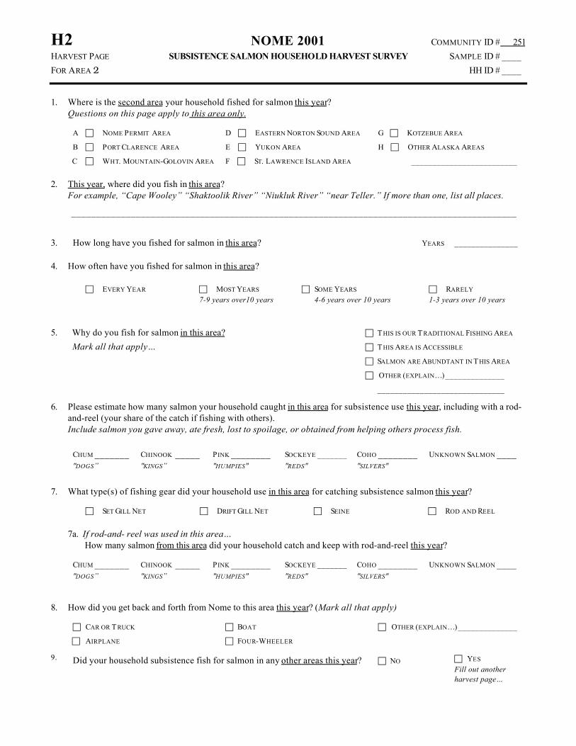
H2 NOME 2001 COMMUNITY ID # 251
HARVEST PAGE SUBSISTENCE SALMON HOUSEHOLD HARVEST SURVEY SAMPLE ID # ____
FOR AREA 2 HH ID # ____
1. Where is the second area your household fished for salmon this year?Questions on this page apply to this area only.
A c NOME PERMIT AREA
B c PORT CLARENCE AREA
C c WHT. MOUNTAIN-GOLOVIN AREA
D c EASTERN NORTON SOUND AREA
E c YUKON AREA
F c ST. LAWRENCE ISLAND AREA
G c KOTZEBUE AREA
H c OTHER ALASKA AREAS
_________________________
2. This year, where did you fish in this area?For example, “Cape Wooley” “Shaktoolik River” “Niukluk River” “near Teller.” If more than one, list all places.
__________________________________________________________________________________________
3. How long have you fished for salmon in this area? YEARS _______________
4. How often have you fished for salmon in this area?
c EVERY YEAR c MOST YEARS
7-9 years over10 yearsc SOME YEARS
4-6 years over 10 yearsc RARELY
1-3 years over 10 years
5. Why do you fish for salmon in this area?
Mark all that apply…
c T HIS IS OUR T RADITIONAL FISHING AREA
c T HIS AREA IS ACCESSIBLE
c SALMON ARE ABUNDTANT IN T HIS AREA
c OTHER (EXPLAIN…)______________
______________________________
6. Please estimate how many salmon your household caught in this area for subsistence use this year, including with a rod-and-reel (your share of the catch if fishing with others).Include salmon you gave away, ate fresh, lost to spoilage, or obtained from helping others process fish.
CHUM _______"DOGS”
CHINOOK _____"KINGS”
PINK ________"HUMPIES"
SOCKEYE _______"REDS"
COHO ________"SILVERS"
UNKNOWN SALMON ____
7. What type(s) of fishing gear did your household use in this area for catching subsistence salmon this year?
c SET GILL NET c DRIFT GILL NET c SEINE c ROD AND REEL
7a. If rod-and- reel was used in this area…How many salmon from this area did your household catch and keep with rod-and-reel this year?
CHUM _______"DOGS”
CHINOOK _____"KINGS”
PINK ________"HUMPIES"
SOCKEYE _______"REDS"
COHO ________"SILVERS"
UNKNOWN SALMON ____
8. How did you get back and forth from Nome to this area this year? (Mark all that apply)
c CAR OR T RUCK
c AIRPLANE
c BOAT
c FOUR-WHEELER
c OTHER (EXPLAIN…)______________
9. Did your household subsistence fish for salmon in any other areas this year? c NO c YES
Fill out anotherharvest page…

H3 NOME 2001 COMMUNITY ID # 251
HARVEST PAGE SUBSISTENCE SALMON HOUSEHOLD HARVEST SURVEY SAMPLE ID # ____
FOR AREA 3 HH ID # ____
1. Where is the third area your household fished for salmon this year?Questions on this page apply to this area only.
A c NOME PERMIT AREA
B c PORT CLARENCE AREA
C c WHT. MOUNTAIN-GOLOVIN AREA
D c EASTERN NORTON SOUND AREA
E c YUKON AREA
F c ST. LAWRENCE ISLAND AREA
G c KOTZEBUE AREA
H c OTHER ALASKA AREAS
_________________________
2. This year, where did you fish in this area?For example, “Cape Wooley” “Shaktoolik River” “Niukluk River” “near Teller.” If more than one, list all places.
__________________________________________________________________________________________
3. How long have you fished for salmon in this area? YEARS _______________
4. How often have you fished for salmon in this area?
c EVERY YEAR c MOST YEARS
7-9 years over10 yearsc SOME YEARS
4-6 years over 10 yearsc RARELY
1-3 years over 10 years
5. Why do you fish for salmon in this area?
Mark all that apply…
c T HIS IS OUR T RADITIONAL FISHING AREA
c T HIS AREA IS ACCESSIBLE
c SALMON ARE ABUNDTANT IN T HIS AREA
c OTHER (EXPLAIN…)______________
______________________________
6. Please estimate how many salmon your household caught in this area for subsistence use this year, including with a rod-and-reel (your share of the catch if fishing with others).Include salmon you gave away, ate fresh, lost to spoilage, or obtained from helping others process fish.
CHUM _______"DOGS”
CHINOOK _____"KINGS”
PINK ________"HUMPIES"
SOCKEYE _______"REDS"
COHO ________"SILVERS"
UNKNOWN SALMON ____
7. What type(s) of fishing gear did your household use in this area for catching subsistence salmon this year?
c SET GILL NET c DRIFT GILL NET c SEINE c ROD AND REEL
7a. If rod-and- reel was used in this area…How many salmon from this area did your household catch and keep with rod-and-reel this year?
CHUM _______"DOGS”
CHINOOK _____"KINGS”
PINK ________"HUMPIES"
SOCKEYE _______"REDS"
COHO ________"SILVERS"
UNKNOWN SALMON ____
8. How did you get back and forth from Nome to this area this year? (Mark all that apply)
c CAR OR T RUCK
c AIRPLANE
c BOAT
c FOUR-WHEELER
c OTHER (EXPLAIN…)______________
9. Did your household subsistence fish for salmon in any other areas this year? c NO c YES
Fill out anotherharvest page…

H4 NOME 2001 COMMUNITY ID # 251
HARVEST PAGE SUBSISTENCE SALMON HOUSEHOLD HARVEST SURVEY SAMPLE ID # ____
FOR AREA 4 HH ID # ____
1. Where is the fourth area your household fished for salmon this year?Questions on this page apply to this area only.
A c NOME PERMIT AREA
B c PORT CLARENCE AREA
C c WHT. MOUNTAIN-GOLOVIN AREA
D c EASTERN NORTON SOUND AREA
E c YUKON AREA
F c ST. LAWRENCE ISLAND AREA
G c KOTZEBUE AREA
H c OTHER ALASKA AREAS
_________________________
2. This year, where did you fish in this area?For example, “Cape Wooley” “Shaktoolik River” “Niukluk River” “near Teller.” If more than one, list all places.
__________________________________________________________________________________________
3. How long have you fished for salmon in this area? YEARS _______________
4. How often have you fished for salmon in this area?
c EVERY YEAR c MOST YEARS
7-9 years over10 yearsc SOME YEARS
4-6 years over 10 yearsc RARELY
1-3 years over 10 years
5. Why do you fish for salmon in this area?
Mark all that apply…
c T HIS IS OUR T RADITIONAL FISHING AREA
c T HIS AREA IS ACCESSIBLE
c SALMON ARE ABUNDTANT IN T HIS AREA
c OTHER (EXPLAIN…)______________
______________________________
6. Please estimate how many salmon your household caught in this area for subsistence use this year, including with a rod-and-reel (your share of the catch if fishing with others).Include salmon you gave away, ate fresh, lost to spoilage, or obtained from helping others process fish.
CHUM _______"DOGS”
CHINOOK _____"KINGS”
PINK ________"HUMPIES"
SOCKEYE _______"REDS"
COHO ________"SILVERS"
UNKNOWN SALMON ____
7. What type(s) of fishing gear did your household use in this area for catching subsistence salmon this year?
c SET GILL NET c DRIFT GILL NET c SEINE c ROD AND REEL
7a. If rod-and- reel was used in this area…How many salmon from this area did your household catch and keep with rod-and-reel this year?
CHUM _______"DOGS”
CHINOOK _____"KINGS”
PINK ________"HUMPIES"
SOCKEYE _______"REDS"
COHO ________"SILVERS"
UNKNOWN SALMON ____
8. How did you get back and forth from Nome to this area this year? (Mark all that apply)
c CAR OR T RUCK
c AIRPLANE
c BOAT
c FOUR-WHEELER
c OTHER (EXPLAIN…)______________
9. Did your household subsistence fish for salmon in any other areas this year? c NO c YES
Fill out anotherharvest page…

G3 NOME 2001 COMMUNITY ID # 251
GENERAL SUBSISTENCE SALMON HOUSEHOLD HARVEST SURVEY SAMPLE ID # ____
QUESTIONS HH ID # ____
QUESTIONS FOR NON-FISHING HOUSEHOLDSAsk households that answered “NO” to question 2 or “ZERO” to Question 9.
11. Did your household help another household fish, cut, or hang salmon, orprocess it in some other way? c NO c YES
12. Did you receive salmon in exchange for your help? c NO c YES
13. If YES, what areas did those fish come from? Mark all that apply
A c NOME PERMIT AREA
B c PORT CLARENCE AREA
C c WHT. MOUNTAIN-GOLOVIN AREA
D c EASTERN NORTON SOUND AREA
E c YUKON AREA
F c ST. LAWRENCE ISLAND AREA
G c KOTZEBUE AREA
H c OTHER ALASKA AREAS
_________________________
15. Check first area fish came from, and then estimate how many salmon you received for your household from that area.
First Area Check One A c B c C c D c E c F c G c H c
CHUM _______"DOGS”
CHINOOK _____"KINGS”
PINK ________"HUMPIES"
SOCKEYE
_______"REDS"
COHO ________"SILVERS"
UNKNOWN SALMON ____
16. Check second area fish came from, and then estimate how many salmon you received for your household from that area.
Second Area Check One A c B c C c D c E c F c G c H c
CHUM _______"DOGS”
CHINOOK _____"KINGS”
PINK ________"HUMPIES"
SOCKEYE
_______"REDS"
COHO ________"SILVERS"
UNKNOWN SALMON ____
17. Check third area fish came from, and then estimate how many salmon you received for your household from that area.
Third Area Check One A c B c C c D c E c F c G c H c
CHUM _______"DOGS”
CHINOOK _____"KINGS”
PINK ________"HUMPIES"
SOCKEYE
_______"REDS"
COHO ________"SILVERS"
UNKNOWN SALMON ____
18. Check fourth area fish came from, and then estimate how many salmon you received for your household from that area.
Fourth Area Check One A c B c C c D c E c F c G c H c
CHUM _______"DOGS”
CHINOOK _____"KINGS”
PINK ________"HUMPIES"
SOCKEYE
_______"REDS"
COHO ________"SILVERS"
UNKNOWN SALMON ____

G4 NOME 2001 COMMUNITY ID # 251
GENERAL SUBSISTENCE SALMON HOUSEHOLD HARVEST SURVEY SAMPLE ID # ____
QUESTIONS HH ID # ____
COMMERCIAL FISHING QUESTIONSAsk all households
19. Did anyone in your household commercial fish for salmon this year? c NO c YES
20. Where did you commercially fish for salmon?For example, “Subdistrict 2” “Unalakleet” “Bristol Bay.” If more than one place, list all places.
__________________________________________________________________________________________
21. Were all of the salmon you caught when commercial fishing sold, or weresome brought home to eat or processed for subsistence?
c ALL SOLD c SOME USED FOR
SUBISSTENCE
22. If some used for subsistence, how many commercially caught salmon didyour household use for subsistence?
CHUM _______"DOGS”
CHINOOK _____"KINGS”
PINK ________"HUMPIES"
SOCKEYE ______"REDS"
COHO ________"SILVERS"
UNKNOWN SALMON ____
23. Were these salmon included in the estimates you already gave me? c NO c YES
FINAL QUESTIONSAsk all households
24. Do you have any suggestions or concerns about subsistence fishing?
25. Would you be available for an interview to gather more information? c NO c YES
THANK YOU FOR YOUR TIME AND FOR HELPING WITH THIS PROJECT.A summary of this subsistence fishing survey will be sent to you next spring (April).