SUBMIT ALL ATTACHED MATERIALS ON PAPER … Conarroe...NOMINATION OF HISTORIC BUILDING, STRUCTURE,...
56
NOMINATION OF HISTORIC BUILDING, STRUCTURE, SITE, OR OBJECT PHILADELPHIA REGISTER OF HISTORIC PLACES PHILADELPHIA HISTORICAL COMMISSION SUBMIT ALL ATTACHED MATERIALS ON PAPER AND IN ELECTRONIC FORM ON CD (MS WORD FORMAT) 1. ADDRESS OF HISTORIC RESOURCE (must comply with an Office of Property Assessment address) Street address: 176 Conarroe Street BRT/OPA Acct. No. 775119000 Postal code: 19127-1327 Councilmanic District: 4 2. NAME OF HISTORIC RESOURCE Historic Name: Die Himmelfahrt der Heiligen Jungfrau Maria-Kirche, Myk. Pa. Common Name: St. Mary-of-the-Assumption (German) R. C. Church, Myk. Pa. 3. TYPE OF HISTORIC RESOURCE X Building Structure Site Object 4. PROPERTY INFORMATION Condition: X excellent good fair poor ruins Occupancy: occupied X vacant under construction unknown Current use: None. 5. BOUNDARY DESCRIPTION Please attach a plot plan and written description of the boundary. SEE ATTACHED SHEET. 6. DESCRIPTION SEE ATTACHED SHEET. Please attach a description of the historic resource and supplement with current photographs. 7. SIGNIFICANCE Please attach the Statement of Significance. [See Attached Sheet] Period of Significance (from year to year): from 1849 to 2012 Date(s) of construction and/or alteration: 1849 Architect, engineer, and/or designer: German Immigrant Stonemasons. Builder, contractor, and/or artisan: [unknown] Original owner: R. C. Archdiocese of Philadelphia, Pa. Other significant persons: None.
Transcript of SUBMIT ALL ATTACHED MATERIALS ON PAPER … Conarroe...NOMINATION OF HISTORIC BUILDING, STRUCTURE,...
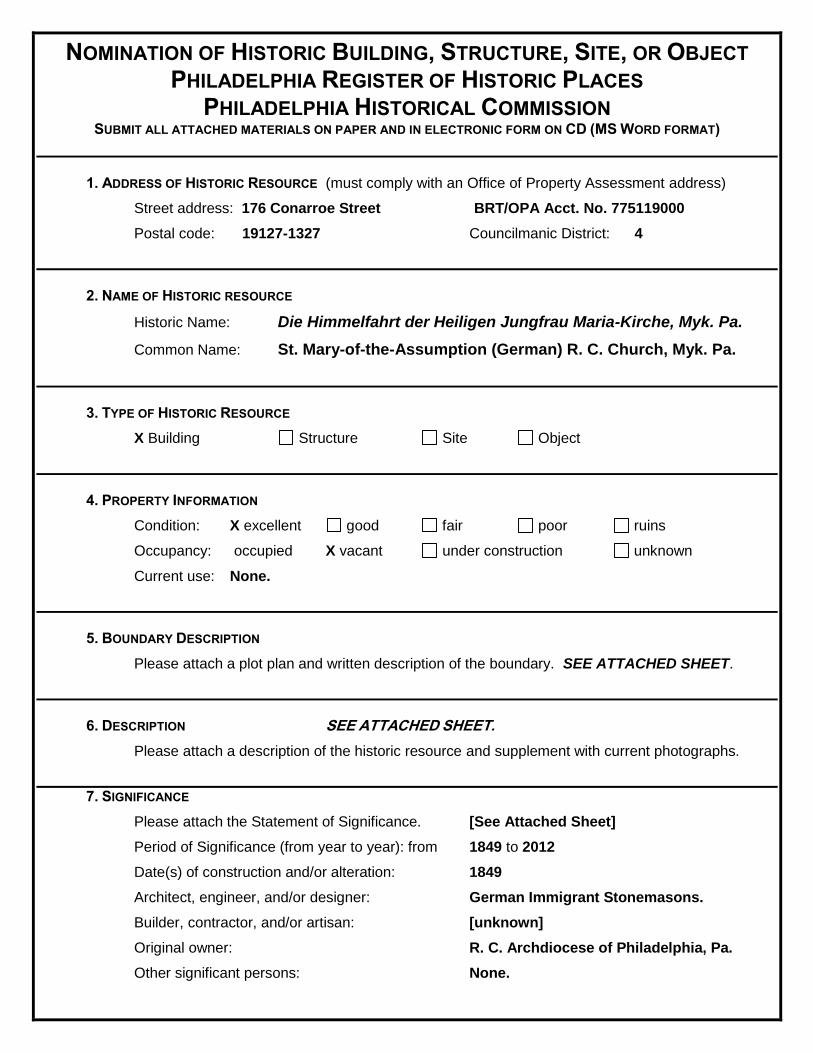
NOMINATION OF HISTORIC BUILDING, STRUCTURE, SITE, OR OBJECT PHILADELPHIA REGISTER OF HISTORIC PLACES
PHILADELPHIA HISTORICAL COMMISSION SUBMIT ALL ATTACHED MATERIALS ON PAPER AND IN ELECTRONIC FORM ON CD (MS WORD FORMAT)
1. ADDRESS OF HISTORIC RESOURCE (must comply with an Office of Property Assessment address)
Street address: 176 Conarroe Street BRT/OPA Acct. No. 775119000
Postal code: 19127-1327 Councilmanic District: 4
2. NAME OF HISTORIC RESOURCE
Historic Name: Die Himmelfahrt der Heiligen Jungfrau Maria-Kirche, Myk. Pa.
Common Name: St. Mary-of-the-Assumption (German) R. C. Church, Myk. Pa.
3. TYPE OF HISTORIC RESOURCE
X Building Structure Site Object
4. PROPERTY INFORMATION
Condition: X excellent good fair poor ruins
Occupancy: occupied X vacant under construction unknown
Current use: None.
5. BOUNDARY DESCRIPTION
Please attach a plot plan and written description of the boundary. SEE ATTACHED SHEET.
6. DESCRIPTION SEE ATTACHED SHEET.
Please attach a description of the historic resource and supplement with current photographs.
7. SIGNIFICANCE
Please attach the Statement of Significance. [See Attached Sheet]
Period of Significance (from year to year): from 1849 to 2012
Date(s) of construction and/or alteration: 1849
Architect, engineer, and/or designer: German Immigrant Stonemasons.
Builder, contractor, and/or artisan: [unknown]
Original owner: R. C. Archdiocese of Philadelphia, Pa.
Other significant persons: None.
CRITERIA FOR DESIGNATION:
The historic resource satisfies the following criteria for designation (check all that apply): X (a) Has significant character, interest or value as part of the development, heritage or cultural
characteristics of the City, Commonwealth or Nation or is associated with the life of a person significant in the past; or,
(b) Is associated with an event of importance to the history of the City, Commonwealth or Nation; or
X (c) Reflects the environment in an era characterized by a distinctive architectural style; or, X (d) Embodies distinguishing characteristics of an architectural style or engineering specimen; or, (e) Is the work of a designer, architect, landscape architect or designer, or engineer whose work
has significantly influenced the historical, architectural, economic, social, or cultural development of the City, Commonwealth or Nation; or,
(f) Contains elements of design, detail, materials or craftsmanship which represent a significant innovation; or,
(g) Is part of or related to a square, park or other distinctive area which should be preserved according to an historic, cultural or architectural motif; or,
(h) Owing to its unique location or singular physical characteristic, represents an established and familiar visual feature of the neighborhood, community or City; or,
(i) Has yielded, or may be likely to yield, information important in pre-history or history; or X (j) Exemplifies the cultural, political, economic, social or historical heritage of the community.
8. MAJOR BIBLIOGRAPHICAL REFERENCES
Please attach a bibliography. SEE ATTACHED SHEET.
9. NOMINATOR
Name with Title John Charles Manton Email [email protected]
Organization Research-Historian / 21st Ward. Date 6 April 2016.
Street Address Telephone (215) 482-6047
City, State, and Postal Code: Philadelphia, PA 19128-1108
Nominator are X is not the property owner.
PHC USE ONLY
Date of Receipt:_6 April 2016_____________________________________________________________
Correct-Complete Incorrect-Incomplete Date:_________________________________
Date of Notice Issuance:_________________________________________________________________
Property Owner at Time of Notice
Name:_________________________________________________________________________
Address:_______________________________________________________________________
______________________________________________________________________________
City:_______________________________________ State:____ Postal Code:_________
Date(s) Reviewed by the Committee on Historic Designation:____________________________________
Date(s) Reviewed by the Historical Commission:______________________________________________
Date of Final Action:____________________________________________________________________
Designated Rejected 4/11/13
Meredith.keller
Typewritten Text
X
Meredith.keller
Typewritten Text
Meredith.keller
Typewritten Text
Meredith.keller
Typewritten Text
Meredith.keller
Typewritten Text
5/13/2016
Meredith.keller
Typewritten Text
5/13/2016
Meredith.keller
Typewritten Text
Archdiocese of Philadelphia
Meredith.keller
Typewritten Text
119 Rector Street
Meredith.keller
Typewritten Text
Philadelphia
Meredith.keller
Typewritten Text
PA
Meredith.keller
Typewritten Text
19127

5. BOUNDARY DESCRIPTION:
Proposed boundary for the designation. Courtesy of the Philadelphia Water Department.
ALL THOSE CERTAIN four contiguous tracts or pieces of land with the buildings and improvements
thereon erected and a Burial Ground, SITUATE at MANAYUNK, within the TWENTY-FIRST WARD of
the City of Philadelphia, more particularly identified by the BRT/OPA Account Number: 775119000,
containing a combined total measurement of 13,426 square feet, as measured by the Philadelphia Water
Department —
KNOWN AND TAXED AS: 176 CONARROE STREET, CONSISTING OF AND BEING THE
FOLLOWING SEVERAL PARCELS:

2
Map 92-N-10 / Lot #141
176 CONARROE ST — Perimeter of 235 ft and an area of 1,948 ft2
Map 92-N-10 / Lot #142

3
174 CONARROE ST — Perimeter of 237 ft and an area of 1,910 ft2
Map 92-N-10 / Lot #143
172 CONARROE ST — Perimeter of 365 ft and an area of 8,182 ft
2
Map 92-N-10 / Lot #140

4
THE FOUR COMBINED CONARROE STREET PARCELS 1 | BRT/OPA: 775119000
Above Measurements: Courtesy of Parcel | Explorer. <http://citymaps.phila.gov/ParcelExplorer>.
Segment 1 = 136.3 ft., Segment 2 = 93.6 ft., Segment 3 = 133.8 ft., Segment 4 = 105.7 ft.
Total length = 469.4 ft., and Area of 13,425.5 ft2. Segments are accurate, as the footage
and area are nearly identical with those measured by the City of Philadelphia Water
Department on page ONE of this document.2
1 On the 2
nd Feb. 1846, Jacob Levering sold several tracts of land consisting of multiple lots within a plan,
situate in the Village of Manayunk in the Township of Roxborough, registered in Philadelphia Deed Book
AWM Vol.21, page 155 and Deed Book AWM Vol.24, page 37, to Richard Moffit. On the 4th
of December
1848, Richard Moffit sold many of the same lots (then called Oak street) to Joseph McMullen. See:
Philadelphia Deed Book GWC Vol.8 pages 1 - 10. Joseph McMullen then sold the Rt. Rev. Francis P.
Kenrick, the Roman Catholic Bishop of Philadelphia, four lots which are the subject of this nomination.
These lots have never been formerly or legally combined by any instrument of law, such as a deed of
conveyance since the day on which they were first purchased, also they may never have been never been
surveyed. See attached Deed Abstract on page 37.
2 [Note: The four parcels are measured individually by DOR Parcel | Explorer totaling 13,696 square feet –
contains an excess and difference of 270 square feet when compared to the Philadelphia Water
Department’s calulation of the four combined parcels, Taxed as One, equaling 13, 426 square feet. This
discrepancy is not any error by the nominator, but it may be an error of the City of Philadelphia or it’s
computer software, or there may be unaccounted and untaxed land within these parcels].
5
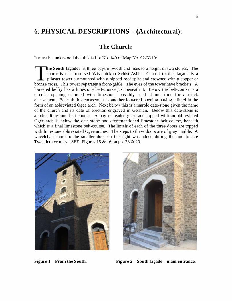
6. PHYSICAL DESCRIPTIONS – (Architectural):
The Church:
It must be understood that this is Lot No. 140 of Map No. 92-N-10:
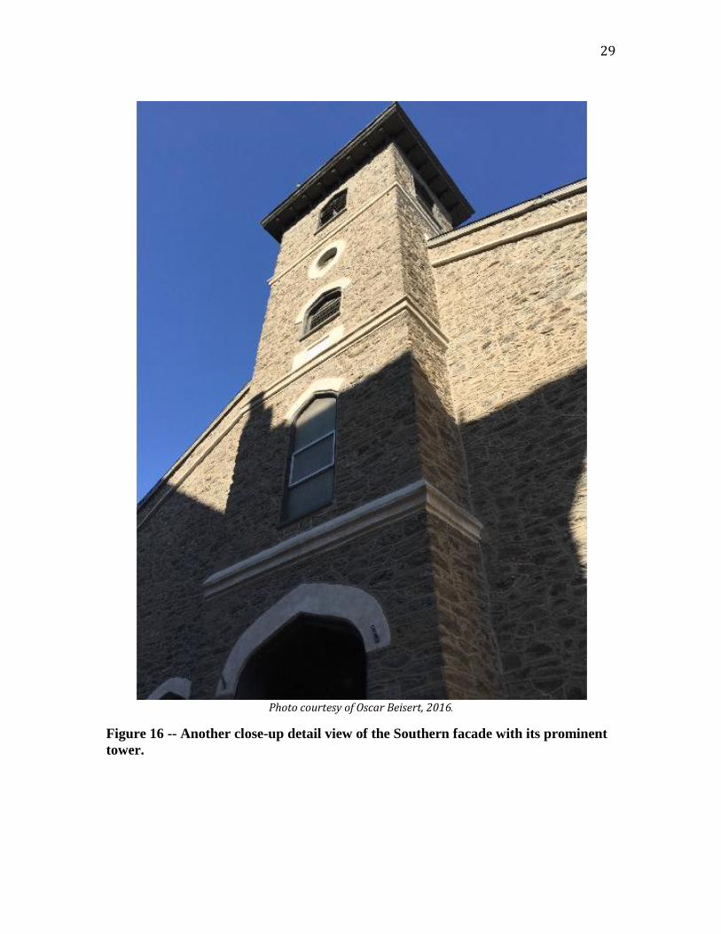
he South façade: is three bays in width and rises to a height of two stories. The
fabric is of uncoursed Wissahickon Schist-Ashlar. Central to this façade is a
pilaster-tower surmounted with a hipped-roof spire and crowned with a copper or
bronze cross. This tower separates a front-gable. The eves of the tower have brackets. A
louvered belfry has a limestone belt-course just beneath it. Below the belt-course is a
circular opening trimmed with limestone, possibly used at one time for a clock
encasement. Beneath this encasement is another louvered opening having a lintel in the
form of an abbreviated Ogee arch. Next below this is a marble date-stone given the name
of the church and its date of erection engraved in German. Below this date-stone is
another limestone belt-course. A bay of leaded-glass and topped with an abbreviated
Ogee arch is below the date-stone and aforementioned limestone belt-course, beneath
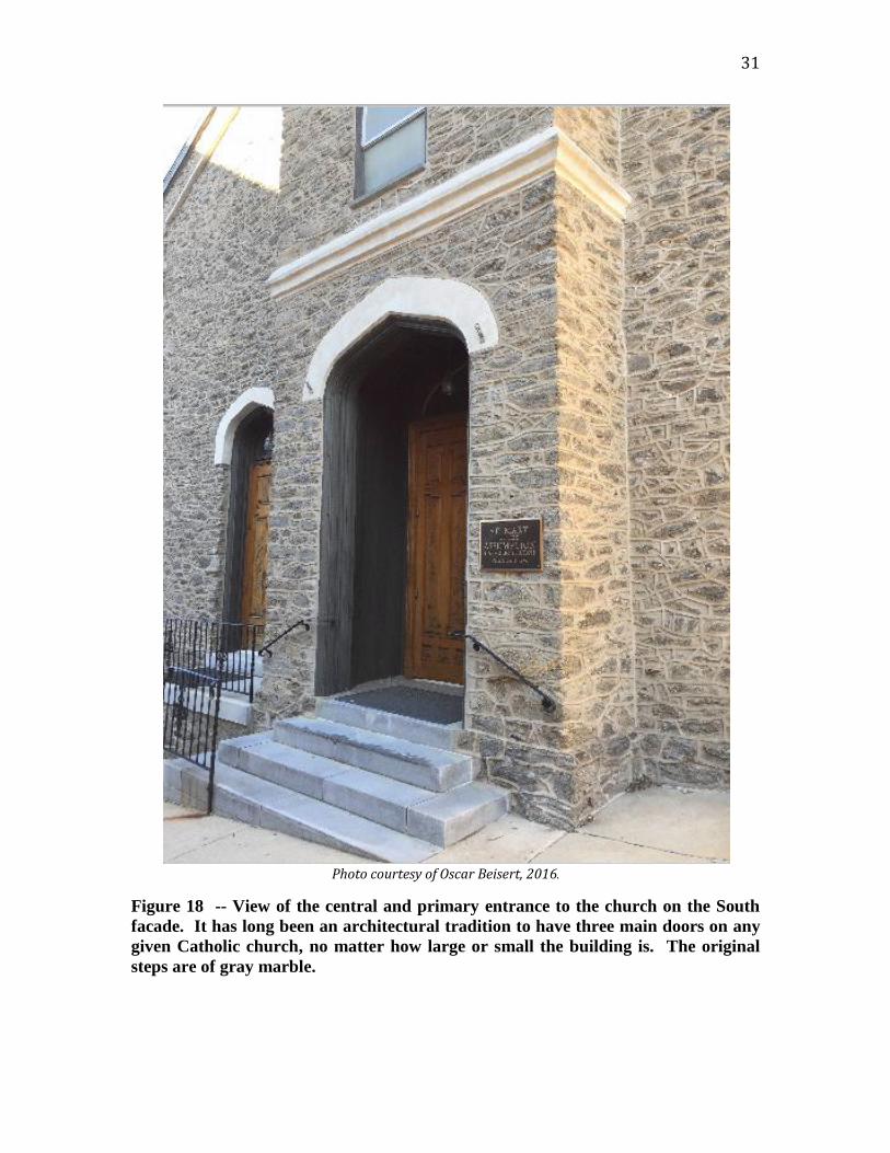
which is a final limestone belt-course. The lintels of each of the three doors are topped
with limestone abbreviated Ogee arches. The steps to these doors are of gray marble. A
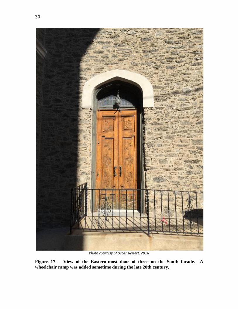
wheelchair ramp to the smaller door on the right was added during the mid to late
Twentieth century. [SEE: Figures 15 & 16 on pp. 28 & 29]
Figure 1 – From the South. Figure 2 – South façade – main entrance.
T

6
he West Façade: is six bays in width and rises to a height of two stories. Its fabric is of un-coursed Wissahickon Schist-Ashlar. The sills of each bay are of gray marble and their lintels are abbreviated Ogee arches, above which is a
limestone belt-course that runs the entire width of the Western façade. There are six cellar bays, two of which have been converted into entrances to the cellar. The North and South corners of the Western façade have straight Quoins. There are pilasters inserted between each bay only rising to the aforementioned limestone belt-course. The eve of the roof is trimmed in red brick of a patterned design.
Photo courtesy of Oscar Beisert, 2016.
Figure 3 -- The West façade viewed from the Southwest.
T

7
he North Façade: presents no bays and rises to a height of two stories. Its façade
is stucco presumably over rough fieldstone and painted with white paint. An A-
frame roof surmounts the whole. No bays where ever made because this façade of
the church lined a narrow alley with the Liebert-Obert Brewery (now an open parking
lot). An 1881 building permit reports an extension of this façade by 28 feet. [SEE: FN #5,
p. 12]
Photo courtesy of Oscar Beisert, c2016.
Figure 4 -- The unadorned and plain North facade.
T
8
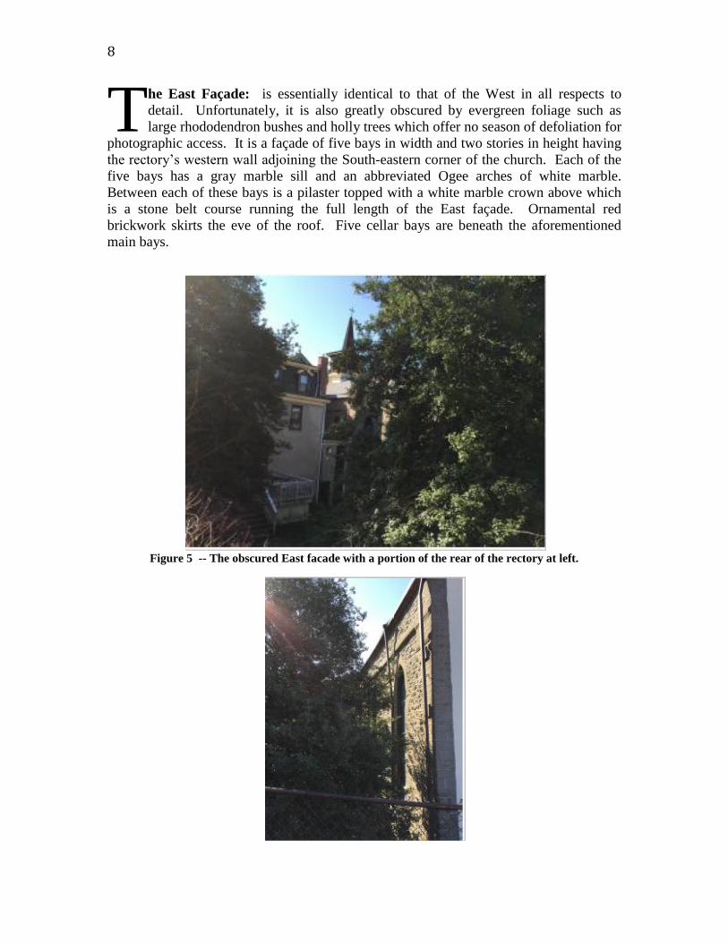
he East Façade: is essentially identical to that of the West in all respects to
detail. Unfortunately, it is also greatly obscured by evergreen foliage such as
large rhododendron bushes and holly trees which offer no season of defoliation for
photographic access. It is a façade of five bays in width and two stories in height having
the rectory’s western wall adjoining the South-eastern corner of the church. Each of the
five bays has a gray marble sill and an abbreviated Ogee arches of white marble.
Between each of these bays is a pilaster topped with a white marble crown above which
is a stone belt course running the full length of the East façade. Ornamental red
brickwork skirts the eve of the roof. Five cellar bays are beneath the aforementioned
main bays.
Figure 5 -- The obscured East facade with a portion of the rear of the rectory at left.
T

9
The Rectory.
Photo courtesy of Oscar Beisert, c2016.
Figure 6 -- South facade of the rectory.
It must be understood that this section concerns Lot Nos. 141, 142, & 143 of Map No.
92-N-10:
he South Façade: of the rectory is the only façade visible. [SEE figure 6 above.]
Both its eastern and western walls are actually party walls to both the church and a
private residence. The South façade is seven bays wide and rises to a height of
two and one-half stories. Its façade is of course red brick with and estimated construction
date of about 1871. All bays have been replaced with windows of the mid to late 20th
century. First and second story bays have lintels and sills of gray marble and are of one-
over-one. The main entrance has a leaded stained glass transom. The original double
doors have been replaced with a 20th
century steel door with matching sidelight. [SEE:
Figure 7] A second floor poly sided projecting bay of wood encased in painted tin.
There is a projecting eve with a corbelled bargeboard. Six gabled dormers protrude from
a Mansard rood with 20th
century a variegated fish-scale replacement shingles topped
with a crown moulding along the edge of the upper roof.
T

10
Figure 7 -- Two additional views of the rectory’s South facade.

11
7. STATEMENT OF SIGNIFICANCE:
he former St. Mary of the Assumption [German] Roman Catholic Church and its
rectory at 176 Conarroe Street is a significant historic resource that merits
designation by the Philadelphia Historical Commission and inclusion on the
Philadelphia Register of Historic Places. Located in Manayunk, set within a particularly
old world streetscape, the buildings that comprise the former Catholic church satisfy
Criteria for Designation a, c, d, and J as enumerated in Section 14-1004 of the
Philadelphia Code. The buildings and burial ground at 176 Conarroe Street:
(a) Have significant character, interest or value as part of the development,
heritage, or cultural characteristics of the city, commonwealth, or nation ….
(c) Reflect the environment in an era characterized by a distinctive architectural
style;
(d) Embody distinguishing characteristics of an architectural style or engineering
specimen; and,
(j) Exemplify the cultural, political, economic, social or historical heritage of the
community.
The Rectory of St. Mary of the Assumption satisfies Criteria for Designation a and j as
enumerated in Section 14-1004 of the Philadelphia Code, which are named above and do
not need to be repeated.
Historical Overview:
he German-speaking Catholics in Manayunk had increased to such numbers that
in 1849 the work of organising a German parish was begun. Previous to this time
the two score families of German-speaking Catholics, whilst they heard Mass at
St. John the Baptist, were counted as members of Holy Trinity parish at 6th & Spruce
Streets. In 1843 an arrangement was made by which one of the Redemptorists at St.
Peter’s went once a month to hear confessions and to preach in the German language.
The German Catholics of Manayunk petitioned Bishop Kenrick in 1849 to form a parish.
When Bishop Kenrick arranged for the formation of a parish for the German-speaking
Catholics, the necessary funds were secured, and ground on Oak (now Conarroe) Street
was purchased in the Spring of 1849. A cornerstone was laid in June 1849on the Feast of
the Holy Trinity. In the announcement of this event, the Catholic Herald reported, “as
the congregation is poor, they rely much on the generosity of their fellow Catholics for
the success of their undertaking.”3 The church was consecrated on 6 January 1850. On
3 Catholic Herald. Philadelphia : Catholic Church, 31 March 1849, p. 1.
T
T

12
the Feast of the Epiphany. The first pastor was the Rev. Fr. S. R. Etthoffer, who after one
year was succeeded by the Rev. Fr. A. Shippert, D. D. 4
In 1854, the Reverend Fr. Francis X. Marshall was appointed the third resident
pastor, although the church for almost a year had been attended by the Reverend Fr.
Grundtner, who remained pastor four years, and in 1860, the Rev. Dr. Nicola was
transferred from St. Alphonsus’s Church. Although pastor only two years, his reputation
as an orator and scholar remained amongst the parishioners in fond remembrance for
several years thereafter. After Fr. Nicola’s death in 1862, the Rev. Fr. Rudolph Kuenzer,
took over the parish. A school was built opposite the church in 1867. In 1871 Father
Kuenzer was appointed to Holy Trinity Church, and was succeeded by the Rev. Fr. F. J.
Martersteck, whose pastorate was marked not only by his pious zeal, but by the splendid
manner in which he administered the temporalities of the church, consisting of two new
sacristies, and a new sanctuary, with three marble altars, and entire new church furniture.5
The cost of these improvements being paid by one of the parishioners, Sebastian Anthony
Rudolph, the German born owner of the Ashland Paper Mills. Father Martersteck made
other improvements enlarging the pastoral residence and the parish convent, and in 1872
built an addition to the school, so as to double its capacity. He celebrated the Silver
Jubilee of his ordination in June 1893, and died 2 July 1901, when the Rev. Fr. Henry A.
Gantert, who had been stationed at St. Alphonsus’s, was appointed.6
A gradual decline in use of the German language for Stations of the Cross,
Confession, and homilies, was a direct result of the German enclave being assimilated
into an English-speaking world to which their ancestors had immigrated. With the
unprecedented change from Latin to the local vernacular language in the liturgy of the
Mass after Vatican II reforms of 1962, the language chosen was not German, but English.
German surnames from the original founders continued in parish records up until the
church’s closure in 2012. In that year the Archdiocese of Philadelphia decided to merge
this ethnic parish with the nearby parish of Saint John-the-Baptist. Proffering a shortage
of priests, declining church membership, and the financial impossibility of maintaining
five Catholic churches all within a block or two of each other, led to the church’s closure
in June of 2012, after an occupation spanning 163 years. All that remains of Manayunk’s
German enclave are local German surnames and the church building, the oldest found to
be surviving in Roxborough-Manayunk, now known as the Twenty-first Ward of
Philadelphia.
Criteria A and J
aint Mary-of-the-Assumption Roman Catholic Church has significant character,
interest and value as part of the heritage and cultural characteristics of the City of
Philadelphia, as related to the immigration and settlement of German Catholics
4 Kirlin, Joseph L. J.: Catholicity in Philadelphia : from the earliest missionaries down to
the present time. Philadelphia : John Jos. McVey, 1909. p. 347. 5 The building permit for the 1881 alterations report that an addition 28 by 49 feet (described as a “chancel”) made to the church. (American Architect and Building News, May 7, 1881). 6 Kirlin, pp. 456-457.
S

13
within the larger context of Philadelphia. Built by a specific community of German
Catholics, St, Mary of the Assumption was part of the early development of immigrant
parishes in a manufacturing neighbourhood in Philadelphia. Its early church building and
its larger complex of buildings represents the heritage and cultural characteristics of
German Catholics as the third oldest such congregation in the city.
The first national or “ethnic” parish in America was Holy Trinity Roman Catholic
Church, located near the juncture of 6th
& Spruce Streets. Serving the large German-
speaking Catholic population of Philadelphia, the building dates to the late 18th
Century.
The second German Catholic parish in Philadelphia was St. Peter the Apostle Church,
known today as the National Shrine of Saint John Neumann, located at 1019 N. 5th
Street
at Girard Avenue. This building dates to 1847.7 St. Mary of the Assumption dates to
1849 and is the third German Catholic parish in Philadelphia.
By the turn of the 20th
Century, the city had eleven German Catholic parishes.
These “pure-German Catholic parishes” embraced an estimated total of 23,395 men,
women, and children.8
In contrast, the Philadelphia German Conference of the Evangelical Lutheran
Ministerium of Pennsylvania had a communing membership that totalled 6,429. German
Catholics outnumbered German Lutherans, despite the fact that the Germans were
outnumbered within the Catholic Church. German Catholics made up 17% of the city’s
Catholic population. The city had seventy-three Catholic parishes in 1900 and most were
Irish. Essentially, national churches served their associated neighbourhood. The locality
of St. Mary of the Assumption serviced as an enclave for German Catholics.
German Catholics not only founded St. Peter the Apostle Church and St. Mary of
the Assumption in the mid-19th
Century, but eight other parishes would emerge by 1900.
German Catholics were also instrumental in founding St. Vincent’s Orphans’ Asylum in
1855 and St. Mary’s Hospital in the 1860s. German Catholic mutual aid societies were
under the larger Volkverein, organised in 1876 as a unit of a national federation of such
associations, the German Roman Catholic Central-Verein of North America.9
Criterion “J”
aint Mary-of-the-Assumption was the focal point or centre of a German-immigrant
enclave that existed for well over a century in Manayunk. The extant complex of
buildings, including the Church, itself, and the attached rectory and burial ground,
exemplify the cultural, economic, social and historical heritage of the German Catholic
community of Manayunk.
German Catholics were attracted to Manayunk by its many mills as the Industrial
Revolution progressed in the 19th
Century. Three aspects of this revolution involved the
Manayunk Canal, the Pennsylvania and Reading Railroad lines, and particularly the
mills, most of which produced textiles for local and national markets.
7 Connelly, James F., The History of the Archdiocese of Philadelphia. Philadelphia : The Archdiocese of Philadelphia, 1976. P. 131. 8 Kazel, Russell A.: Becoming Old Stock: The Paradox of German-American Identity, Princeton (NJ) : Princeton Univeristy Press, 2004, pp. 34-37. 9 Kazel, p. 206-210.
S
14
A by-product of the Industrial Revolution was housing for workers, and churches
and schools for the religious and educational purposes. Each group of European
immigrants to arrive in Manayunk organised their own ethnic churches and schools, i.e.
the Irish in 1830, the Germans in 1849, the Poles in 1898, and the Italians in 1906. By
the turn of the 20th
century, Manayunk was a town of ethnic communities that were all
unified by employment in the mills and the authority of the Roman Catholic Church in
Philadelphia. Each group had a very distinctive culture brought here from the Old World
and each kept their respective language, customs, religious practices and heritage alive
for several generations after their arrival.
The church building served as the house of worship for the German Catholics. Its
attached rectory provided the housing required for the German-speaking priests, who
served the parish. These two buildings and the adjoining burial ground are critical
components required for the religious life of German Catholics in Manayunk.
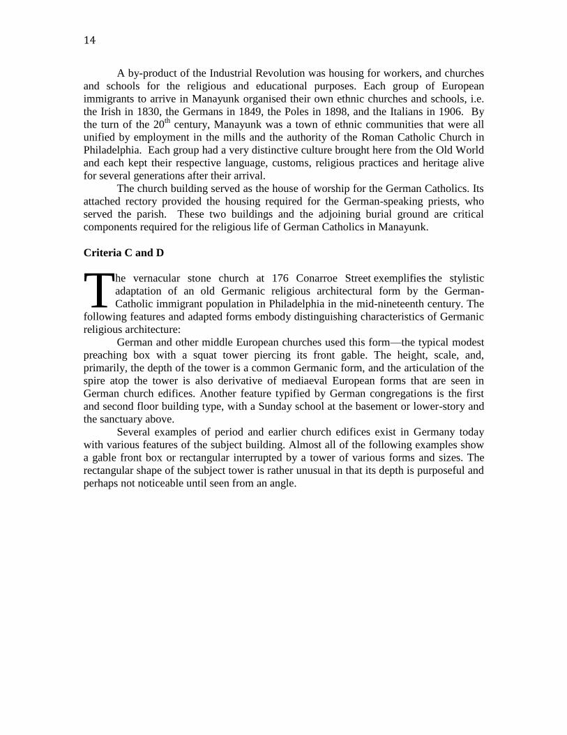
Criteria C and D
he vernacular stone church at 176 Conarroe Street exemplifies the stylistic
adaptation of an old Germanic religious architectural form by the German-
Catholic immigrant population in Philadelphia in the mid-nineteenth century. The
following features and adapted forms embody distinguishing characteristics of Germanic
religious architecture:
German and other middle European churches used this form—the typical modest
preaching box with a squat tower piercing its front gable. The height, scale, and,
primarily, the depth of the tower is a common Germanic form, and the articulation of the
spire atop the tower is also derivative of mediaeval European forms that are seen in
German church edifices. Another feature typified by German congregations is the first
and second floor building type, with a Sunday school at the basement or lower-story and
the sanctuary above.
Several examples of period and earlier church edifices exist in Germany today
with various features of the subject building. Almost all of the following examples show
a gable front box or rectangular interrupted by a tower of various forms and sizes. The
rectangular shape of the subject tower is rather unusual in that its depth is purposeful and
perhaps not noticeable until seen from an angle.
T

15
Church of St. George’s, Bad Gandersheim, Northeim, Lower Saxony, in Germany. Courtesy Wikipedia.
hilst it is possible that the subject tower is simply shallow in depth because its
relationship to the street, it is more likely a form that derived from the
Germanic roots of designer and/or the congregation at the time the church was
built. The hipped roof forming a steeple in a squat fashion is also seen in many German
churches, transcending much of its architectural timeline. One example of tower form
can be seen in the Church of St. Georg, pictured above. Whilst this tower is larger in
scale, it shares a remarkably similar form.
W

16
St. Georg’s Kirche, Kirchweyhe. Courtesy Wikipedia.
ther examples show additional similarities, including St. Georg’s Kirche, shown
above. In many ways, the scale of this tower and the execution of the roof and
spire bare a striking resemblance to the subject building. The brickwork of the
corbelling in various places is also similar to the subject building, despite the fact that the
tower itself is wooden rather than brick. The same is true of St. Christophperus Kirche,
Bodenfelde and Evangelical Kirche, Friedland-Deiderode von Suden, shown on page 17.
Both of these buildings have similar towers and roof types with minor variations from the
subject building. However, they are important examples to references, as they too served
smaller congregations.
O

17
Left: St. Christophperus Kirche, Bodenfelde. Right: Evangelical Kirche, Friedland-Deiderode von Suden. Courtesy
Wikipedia.
Left: the old frame church in Kedingbruch. Right: St. Georg’s Kirche, Warberg. Courtesy Wikipedia.
Note that the tower on the lower left is separate from the church building, but employs a
similar roof type and steeple configuration. The tower on right employs the same form as
the subject building with a larger tower projecting from the front.

18
Evangelical Lutheran Church in Lippoldshausen, Stadt Hann. Munden, Sundniedersachsen. The
ancient building shares qualities in form with the subject building and is also made of stone.
pon further inspection, the above-described Germanic form and its features
become explicative of the period and location of construction, reflecting the
environment in an era characterized by distinctive architectural styles, as well as
the use of local materials. Distinctively stylistic elements include the Neo-Classical,
Georgian and the Gothic Revivals, but with the dramatic, yet typical overwhelming
quality of Philadelphia materials. The windows at the south and north elevations are set
within rows of pilasters feature Tuscan capitols. Various influences of the Gothic Revival
are also present in the building. Its windows in the north and south elevations feature
lintels that are formed by brick almost in the form of gauged arches, the joints forming
the common center. At the east, primary elevation, the arches are pointed and the lintels
not being quite a true lancet arch. The tower, while Germanic in form and scale, features
Georgian Revival features such as its bull’s eye window and the coursing at various
stages. Its doorway and other windows are also Gothic Revival. The building is
constructed almost entirely of Wissahickon Schist, which is due to its location in
Manayunk.
In itself, then, the church encapsulates these various features that are distinct of an
era and locality. The form speaks to its German Catholic people, being culturally
U
19
distinctive of German Architecture in America, whilst its various stylistic overtones are
born of the period fashions.
The Churchyard.
On the West side of the church is a churchyard, the smallest burial ground still existing in
Manayunk. An iron fence encloses it and many of the gravestones within, have been laid
flat. It also contains an underground vault containing the remains of several priests that
served the parish in the course of its long history. A large white marble cross marks the
location of the aforementioned vault. Because this burial ground is a part of the same
parcel on which both church and rectory have been built, it is considered germane to this
nomination and bears the same historical significance to the whole.
8 BIBLIOGRAPHY:
Deeds:
GWC:3;362 (1849) Joseph McMullen TO Francis P. Kenrick.
RLL:44;340 (1849) Joseph McMullen TO Francis P. Kenrick.
GWC:54;258 (1850) Joseph McMullen TO Francis P. Kenrick.
District Court – Sheriff Book J-2.
Published Works:
American Architect and Building News (May 7, 1881).
Baccella, Bernard: A History of St. Mary-of-the-Assumption in Manayunk, 1849-2005.
[Philadelphia : St. Mary-of-the-Assumption Parish, 2005]
Bromley, George W.: Atlas of the City of Philadelphia, Volume 12, 21st Ward.
Philadelphia : G. W. & W. S. Bromley, 1892.
Catholic Herald (March 31, 1949) & (June 16, 1849)
Connelly, James F.: The History of the Archdiocese of Philadelphia. Philadelphia : The Archdiocese of Philadelphia, 1976.

20
BIBLIOGRAPHY – Continued:
Historical Sketches of the Catholic Churches and Institutions in Philadelphia : a Parish
Register and Book of reference. Philadelphia : Daniel H. Mahony, [c1895].
Hopkins, G. M.: Atlas of the City of Philadelphia, 21st & 28
th Wards. Philadelphia : G.
M. Hopkins, 1884.
Insurance Maps of Philadelphia, Pennsylvania. Vol. 20. Philadelphia : Sanborn Map
Company, 1923 & 1950.
Kazel, Russell A.: Becoming Old Stock: The Paradox of German-American Identity. Princeton (NJ) : Princeton University Press, c2004.
Kirlin, Joseph L. J.: Catholicity in Philadelphia : from the earliest missionaries down to
the present time. Philadelphia : John Jos. McVey, 1909.
Manton, John Charles: Bygones: a Guide to Historic Roxborough-Manayunk.
Philadelphia : J. C. Manton, Historical Research, 1990.
McElroy’s Philadelphia Directory, 1856.
Miles, Joseph Starne & Cooper, William H.: A Historical Sketch of Roxborough,
Manayunk, Wissahickon. [Philadelphia : George Fein & Co., 1940]
Philadelphia Water Department: Stormwater Map, 2016.
Public Ledger (June 1, 1849)
Smith, Elvino V.: Atlas of the City of Philadelphia, 21st Ward. Philadelphia : Elvino V.
Smith, 1911.

21
Photo Gallery:
Photo courtesy of Oscar Beisert, 2016.
Figure 8 -- The church viewed from the Southwest.

22
Photo courtesy of David Harris, 2016.
Figure 9 -- The cornerstone is set so high up on the tower’s façade that only a bird
can view it. [SEE figure 15]. This image, possibly taken from a third floor school
window directly across the street, is inscribed in German: “Deutsche romisch
katholileshe Kirche, gegründet im Jahre 1849 – German Roman Catholic Church
Established in the Year 1849.” The inscription is almost illegible due to acid rain
caused by nearby trains using fossil fuel during the 19th
century.

23
Photo courtesy of Oscar Beisert, 2016.
Figure 10 -- Looking East on Conarroe Street with the church on the left and school
at right. Conarroe is a typically narrow Manayunk street with an incline that is a
notable feature throughout this mill town.
24
Photo courtesy of Oscar Beisert, 2016.
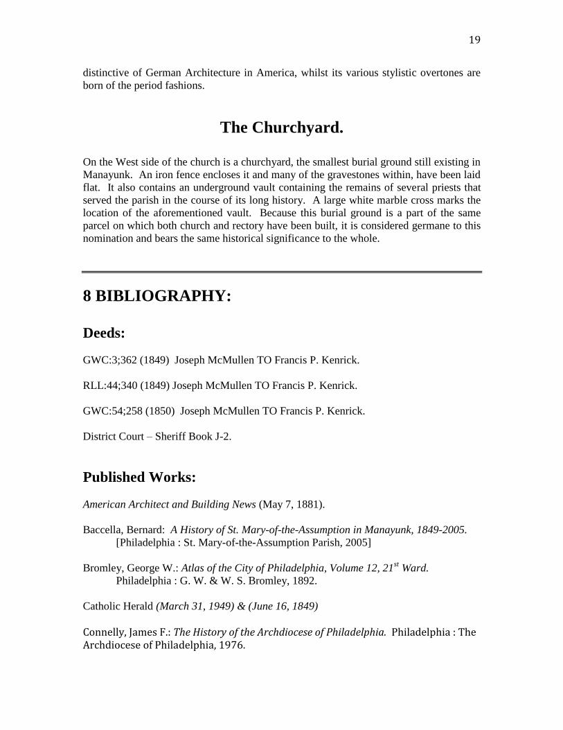
Figure 11 -- The Southern facade viewed from the Southeast. St. Mary's rectory is
seen here in part at the right. Its Western wall was erected flush with the Eastern
facade of the church.

25
Photo courtesy of Oscar Beisert, 2016.
Figure 12 -- The Western facade [viewed in part] from the Southwest. Along this side of the church
are several graves of former priests and prominent parishioners presently being disinterred in
preparation for an impending sale of the property.
26
Photo courtesy of Oscar Beisert, 2016.
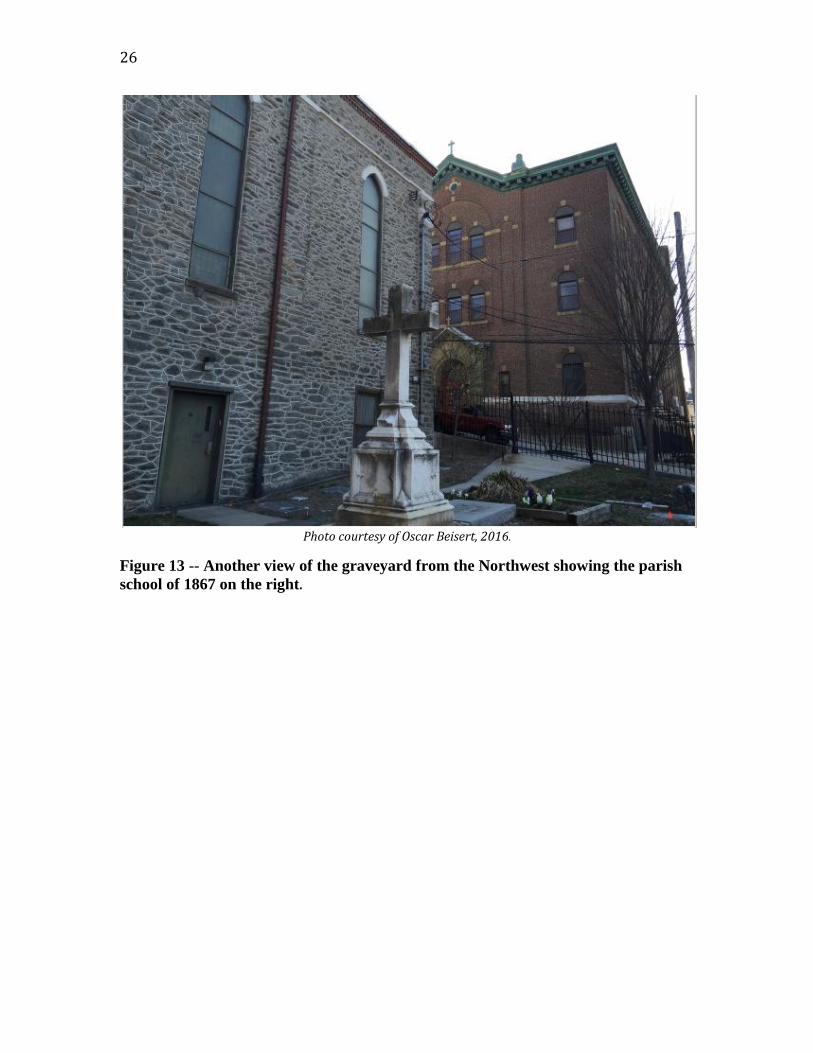
Figure 13 -- Another view of the graveyard from the Northwest showing the parish
school of 1867 on the right.
27
Photo courtesy of Oscar Beisert, 2016.
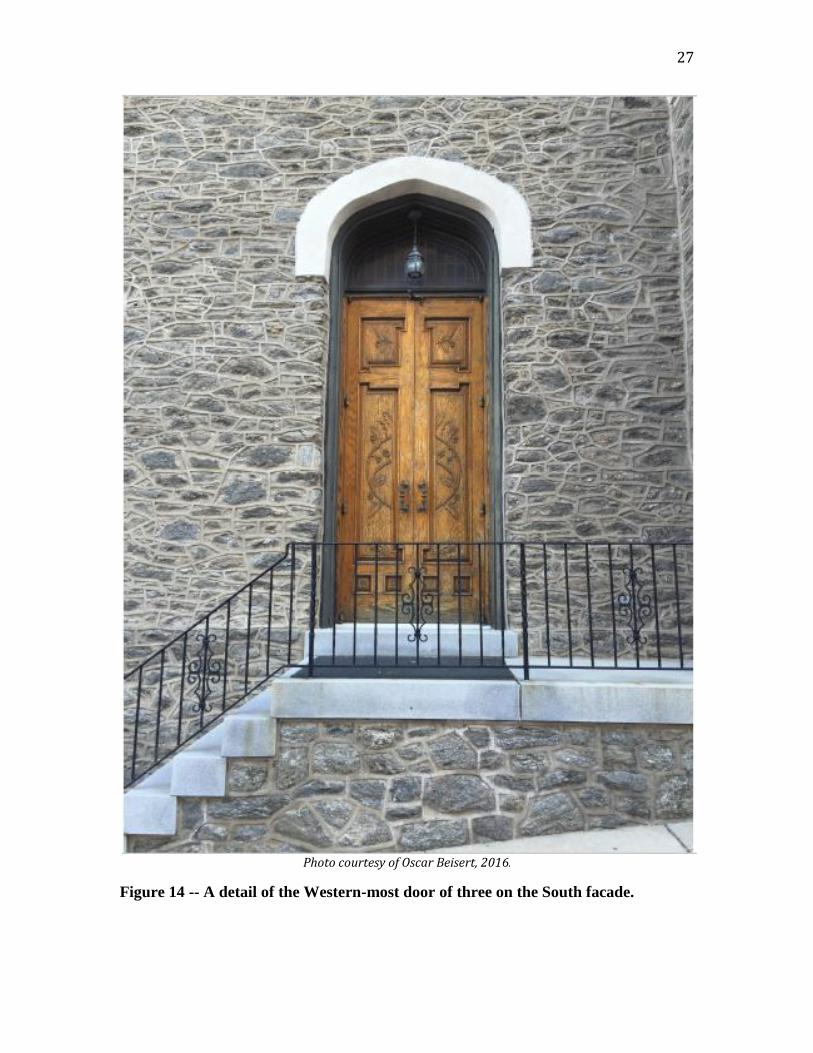
Figure 14 -- A detail of the Western-most door of three on the South facade.

28
Photo courtesy of Oscar Beisert, 2016.
Figure 15 -- Detailed close-up shot of the tower on the South facade. A marble stone
containing the name and erection date of the church in German, is seen here just
beneath the third opening down from the eve of the roof.
29
Photo courtesy of Oscar Beisert, 2016.
Figure 16 -- Another close-up detail view of the Southern facade with its prominent
tower.
30
Photo courtesy of Oscar Beisert, 2016.
Figure 17 -- View of the Eastern-most door of three on the South facade. A
wheelchair ramp was added sometime during the late 20th century.
31
Photo courtesy of Oscar Beisert, 2016.
Figure 18 -- View of the central and primary entrance to the church on the South
facade. It has long been an architectural tradition to have three main doors on any
given Catholic church, no matter how large or small the building is. The original
steps are of gray marble.

32
Photo courtesy of Oscar Beisert, 2016.
Figure 19 -- The Northern facade viewed from the Northeast. In an effort to cut
building costs, many Philadelphia buildings have stone or brick facades when
viewed from the street, with the less prominent façade being covered in stucco or
plaster and then painted over.

33
Photo courtesy of an anonymous parishioner, 2012.
Figure 20 -- This is a view of the interior of the church during a Mass. All of the
Stations of the Cross that line the walls of the nave are oil paintings on canvas of an
event in the final days of the life of Christ on earth. They are very unusual because
most series of Stations of the Cross are either of carved white marble or wood. Each
painting is worth at least $1,000 on the antique art market today. The various
frescoes are all original, being done during the extension of the sanctuary twenty-
eight feet in 1881.

34
THE RECTORY:
Photo courtesy of Oscar Beisert, 2016.
Figure 21 -- The Southern facade of the rectory is the only clear view of the house.
With its Eastern and Western facades being erected flush with the walls of either the
church or another adjoining house. These facades are featureless with no
description required.

35
Photo courtesy of Oscar Beisert, 2016.
Figure 22 -- This is a rear view of the rectory and part of the Eastern facade of the
church obscured by a large holly tree and other foliage. Viewed from the Northeast.

36
DEEDS:
1849 Deed AWM:86;528 – Philadelphia City Archives.
Figure 23 -- This is a section of the first page of the church's 1849 Deed, copied by a
city clerk into a large Deed Book from the original vellum document.

37
38

39
MAPS:
S. L. Smedley, 1862 – Section #22.
Figure 24 -- Samuel L. Smedley's map of 1863 fails to depict the church building,
although the church had existed there for fourteen years. Saint John's Church is
depicted further south on this same map. It is at best, an error of omission.

40
G. M. Hopkins, 1875 – Vol. 2, Plate “A.”
Figure 25 -- Hopkins’ 1875 map depicts the church and the 1867 schoolhouse, not
directly across the street, but were the convent now stands, leading to the belief that
the convent was the original schoolhouse and later converted into a convent.

41
G. M. Hopkins, 1884, Plate #16.
Figure 26 -- This map of 1884, some nineteen years later, reveals that the location of
the church and schoolhouse have not changed.

42
G. W. Bromley, 1892 – Plate #1
Figure 27 -- Bromley's map of 1892 shows the convent indicated, but the two
buildings directly across the street from the church are not yet owned by St. Mary's.
43
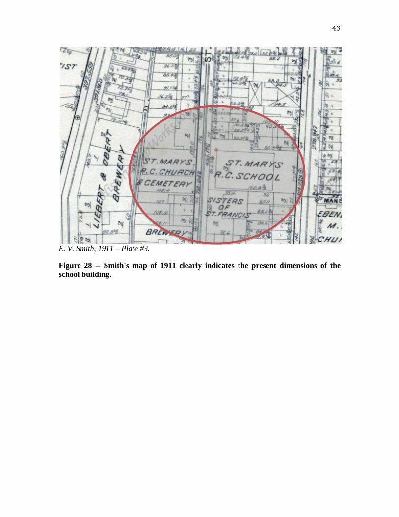
E. V. Smith, 1911 – Plate #3.
Figure 28 -- Smith's map of 1911 clearly indicates the present dimensions of the
school building.

44
Sanborn, 1923 – Sheet No. 508.
Figure 29 -- An interesting feature of this 1923 map is the small building behind the
convent marked “W. C.,” meaning “water closet” or toilet. It was either for the
exclusive use of the convent or more than likely, for the students of the school.

45
Sanborn, 1950 – Sheet No. 521
Figure 30 -- Sanborn's map of 1950 reveals nothing that is not already indicated in
his map of 1923.
46
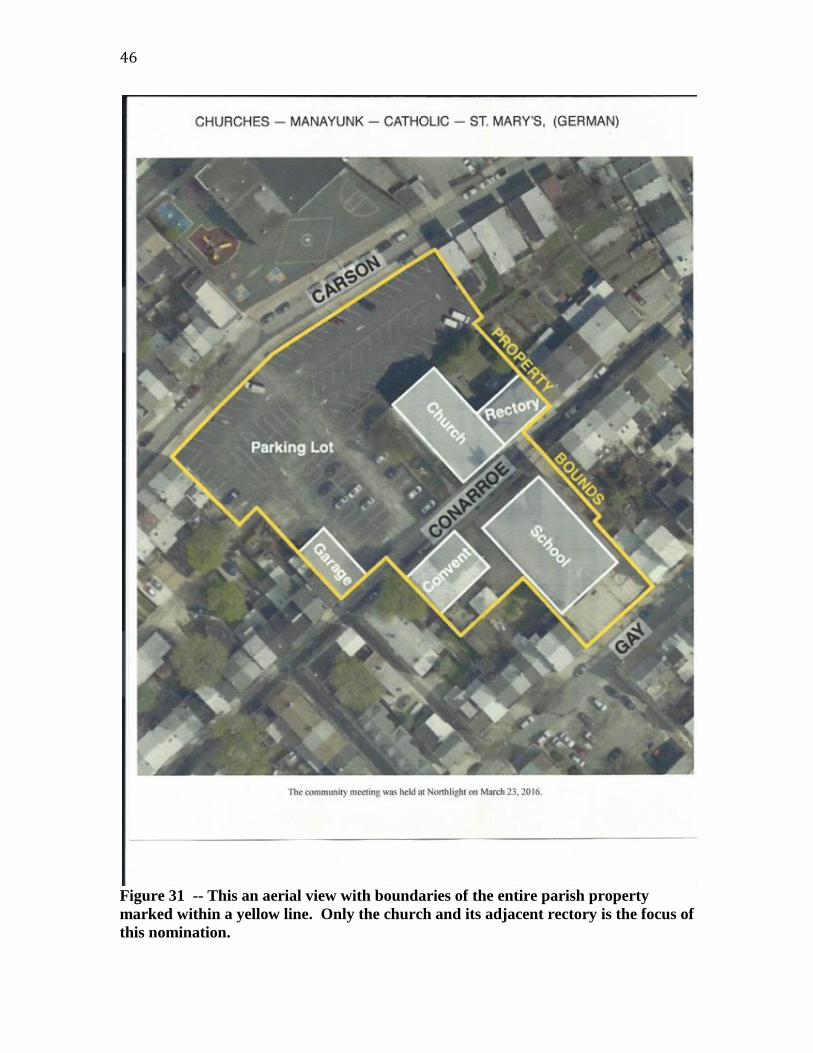
Figure 31 -- This an aerial view with boundaries of the entire parish property
marked within a yellow line. Only the church and its adjacent rectory is the focus of
this nomination.

47
MISSCELLANEOUS:
Figure 32 -- An application text taken from a Philadelphia Department of Licences
& Inspections document received from the authorities of the church to reuse the
former rectory as a boarding house for students of various local universities.

48
Figure 33 -- The Notice of Refusal from the Philadelphia Department of Licences &
Inspections dated February 22, 2012.

49
Document courtesy of the Philadelphia City Archives.
Figure 34 -- Father Nichola was St. Mary’s pastor at the beginning of the American
Civil War. He died in 1862 of Phthisis (Pulmonary Tuberculosis) and was
entombed in the priests’ vault on the West side of the church.

50
Document courtesy of the Philadelphia City Archives.
Figure 35 -- Official Certificate of Death for the Reverend Fr. Christian F. Rudolph
(1856-1889) who died of Phthisis (pulmonary tuberculosis) at age 33. His remains
were interred along the western wall of the church on 28th
February 1889, only to be
exhumed and translated 127 years later.

51
Document courtesy of the Philadelphia City Archives.
Figure 36 -- Official Certificate of Death for the Reverend Fr. Francis J. Martersteck
(1844-1901) who died of Pneumonia at age 57. His remains were interred the
priests’ vault along the western wall of the church on 5th
July 1901, only to be
exhumed and translated 115 years later.

52
From the Catholic Herald (June 16, 1849)
Figure 37 -- A newspaper report of an unfortunate accident that occurred during
the dedication ceremonies of the church in 1849.
Public Ledger (June 1, 1849), p. 1.

53
McElroy’s Philadelphia Directory For 1856, p. 884.
Figure 38 -- The church was not listed in any city directory until 1856. It had also
changed its name several times in the course of its 163-year history, being known as
"Immaculate Conception of the B. V. M," "Assumption of the B. V. M.,” “Saint
Mary of the Assumption,” to name a few. The church’s non-listing prior to 1856
had much to do with the Act of Consolidation (1854) before which the outer
townships and boroughs of the county were not usually listed in city directories.
This doesn’t mean that the church did not exist however.

54
Figure 39 -- A partial list of past rectors before 1927. “Pfarrer” is the German
equivalent of “Reverend.”