SUBJECT: SECTION 43A APPLICATION PLANNING … · Amend the Latrobe Plan in regard to the proposed...
89
SUBJECT: SECTION 43A APPLICATION PLANNING SCHEME AMENDMENT AND PAINTBALL FACILITY 37 SPEEDWAY DRIVE, LATROBE AUTHOR: MANAGER PLANNING SERVICES – SHARON HOLLAND DATE: 8 DECEMBER 2015 FILE REF: DA 184/2015 ATTACHMENTS: DRAFT AMENDMENT 04/15 AND SUPPORTING SUBMISSION 1. PURPOSE OF REPORT The purpose of this report is to: 1. Initiate an amendment to the Latrobe Interim Planning Scheme 2013 to: Rezone land contained in Certificate of Title 162285/1 located at 37 Speedway Drive, Latrobe from General Residential to Particular Zone 2 – Latrobe Speedway Site; Amend the Latrobe Plan in regard to the proposed zoning; and Amend the Latrobe Planning Scheme ordinance through insertion of a site specific set of standards, for use and development of Certificate of Title 162285/1, as Clause 33.0 into Part D of the Planning Scheme; and 2. Consider an application for a paintball facility at 37 Speedway Drive, Latrobe. 2. BACKGROUND INFORMATION Council has been approached by a couple wanting to open a paintball facility in the area. This is a sport and according to the Tasmanian Police website, it has only recently been legalised in Tasmania and is licensed under the control of the Tasmanian Police Force. It is now possible for anyone who wishes to open a paintball business to apply to register as a paintball operator. There has been good interest in the prospect of paintball, and several potential paintball business operators have shown interest around the State. Strong requirements exist for applicants to operate a licensed paintball range, including inspections and certifications of the venue. The applicant has investigated many sites on the north-west coast of Tasmania and has found the Latrobe Speedway to offer many advantages including a large outdoor area with existing toilet facilities, change rooms and car parking areas, convenient access to the Bass Highway and Devonport Airport and buffered from residential use by adjoining industrial use and areas of native vegetation. There are redundant areas to the east of the Speedway facilities on the title that the Speedway operators have given permission to be used for the paintball facility. 3. SITE LOCALITY AND CHARACTERISTICS The subject title (CT 162285/1) is located at 37 Speedway Drive, Latrobe and comprises 16.92ha. It is an irregular shaped lot and contains facilities associated with the Latrobe Speedway. These include the racing track, pits, control building, scoreboard, offices, kiosk facility, toilets and change rooms, various grandstands within a fenced area and car parking areas. It is surrounded by land owned by Crown Land Services that contains bush. This land is bounded to the north by Shaw Street, which services lots developed for residential use in a rural setting. The land owned by Crown Land Services is bounded to the west by the Annexure "O" Latrobe Council OPEN Agenda 14th December, 2015 Page 462
Transcript of SUBJECT: SECTION 43A APPLICATION PLANNING … · Amend the Latrobe Plan in regard to the proposed...
SUBJECT: SECTION 43A APPLICATION
PLANNING SCHEME AMENDMENT AND PAINTBALL FACILITY
37 SPEEDWAY DRIVE, LATROBE
AUTHOR: MANAGER PLANNING SERVICES – SHARON HOLLAND
DATE: 8 DECEMBER 2015
FILE REF: DA 184/2015
ATTACHMENTS: DRAFT AMENDMENT 04/15 AND SUPPORTING SUBMISSION
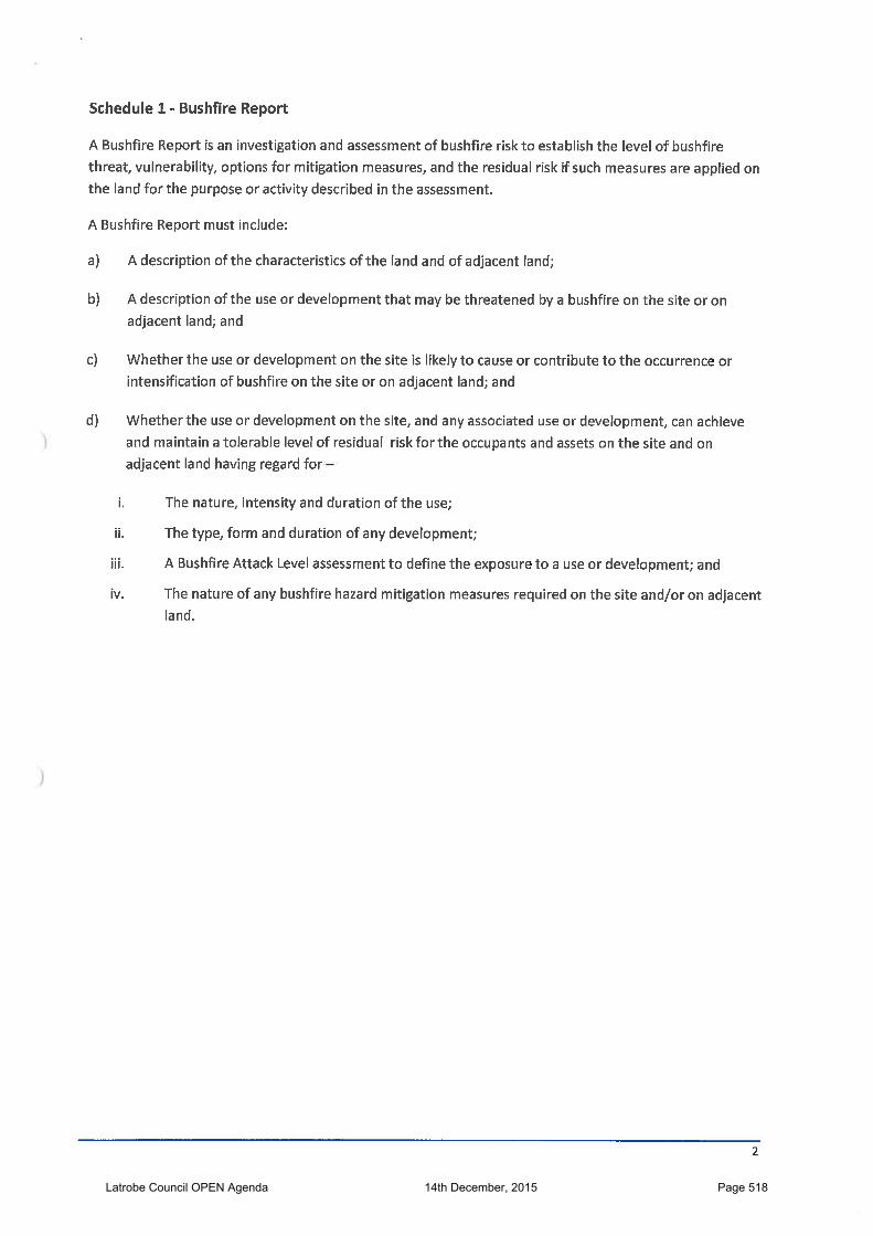
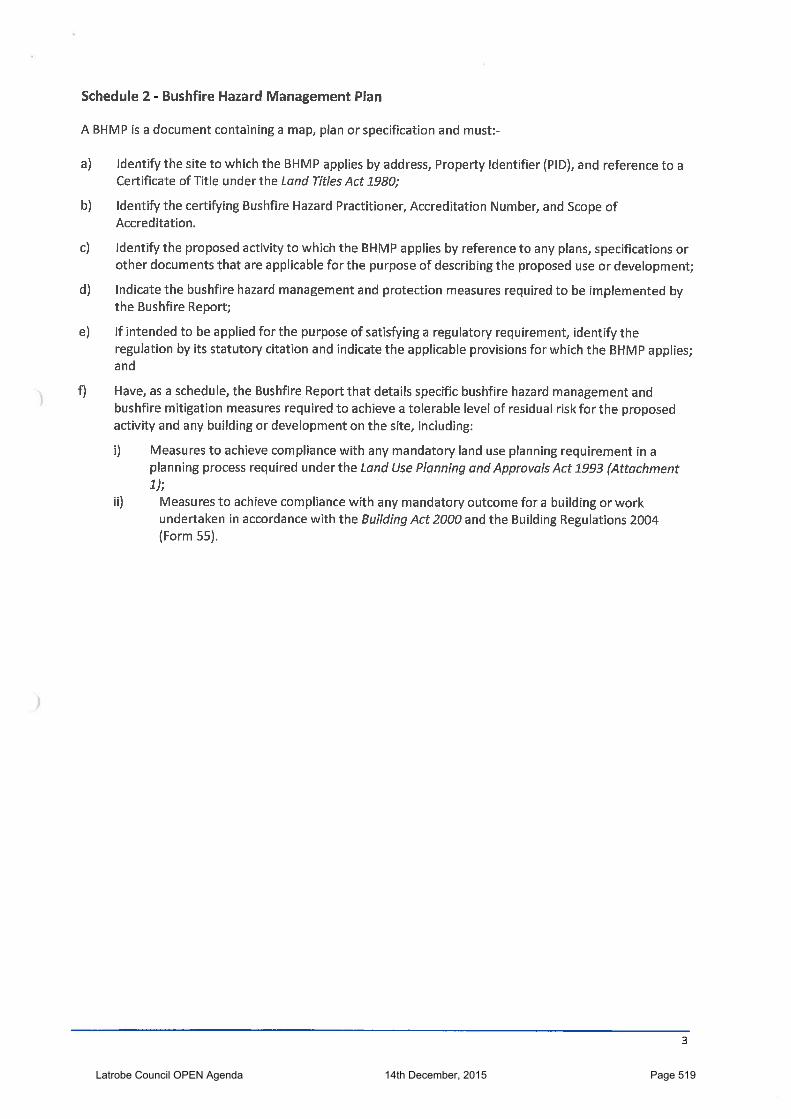
1. PURPOSE OF REPORTThe purpose of this report is to:
1. Initiate an amendment to the Latrobe Interim Planning Scheme 2013 to: Rezone land contained in Certificate of Title 162285/1 located at 37
Speedway Drive, Latrobe from General Residential to Particular Zone 2 –Latrobe Speedway Site;
Amend the Latrobe Plan in regard to the proposed zoning; and Amend the Latrobe Planning Scheme ordinance through insertion of a site
specific set of standards, for use and development of Certificate of Title162285/1, as Clause 33.0 into Part D of the Planning Scheme; and
2. Consider an application for a paintball facility at 37 Speedway Drive, Latrobe.
2. BACKGROUND INFORMATION
Council has been approached by a couple wanting to open a paintball facility in the area.This is a sport and according to the Tasmanian Police website, it has only recently beenlegalised in Tasmania and is licensed under the control of the Tasmanian Police Force. Itis now possible for anyone who wishes to open a paintball business to apply to register asa paintball operator.There has been good interest in the prospect of paintball, and several potential paintballbusiness operators have shown interest around the State.Strong requirements exist for applicants to operate a licensed paintball range, includinginspections and certifications of the venue.The applicant has investigated many sites on the north-west coast of Tasmania and hasfound the Latrobe Speedway to offer many advantages including a large outdoor area withexisting toilet facilities, change rooms and car parking areas, convenient access to theBass Highway and Devonport Airport and buffered from residential use by adjoiningindustrial use and areas of native vegetation. There are redundant areas to the east ofthe Speedway facilities on the title that the Speedway operators have given permission tobe used for the paintball facility.
3. SITE LOCALITY AND CHARACTERISTICS
The subject title (CT 162285/1) is located at 37 Speedway Drive, Latrobe and comprises16.92ha. It is an irregular shaped lot and contains facilities associated with the LatrobeSpeedway. These include the racing track, pits, control building, scoreboard, offices,kiosk facility, toilets and change rooms, various grandstands within a fenced area and carparking areas.It is surrounded by land owned by Crown Land Services that contains bush. This land isbounded to the north by Shaw Street, which services lots developed for residential use ina rural setting. The land owned by Crown Land Services is bounded to the west by the
Annexure "O"
Latrobe Council OPEN Agenda 14th December, 2015 Page 462
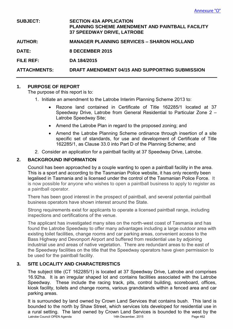
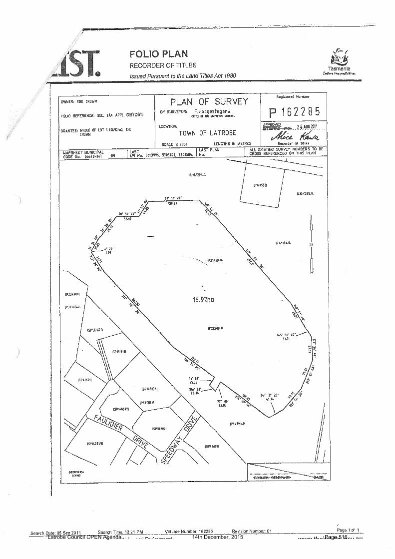
Henry Street unmade road reservation, to the east by the unmade York Street road reservation and to the south by the Latrobe Industrial Estate. Access is off Speedway Drive through the Latrobe Industrial Estate. A copy of the survey plan for the subject titles is shown in Figure 1.
Figure 1 Survey Plan for CT 162285/1
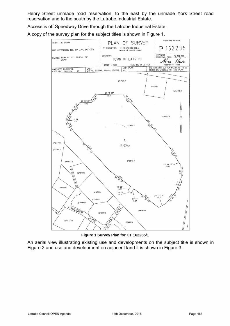
An aerial view illustrating existing use and developments on the subject title is shown in Figure 2 and use and development on adjacent land it is shown in Figure 3.
Latrobe Council OPEN Agenda 14th December, 2015 Page 463
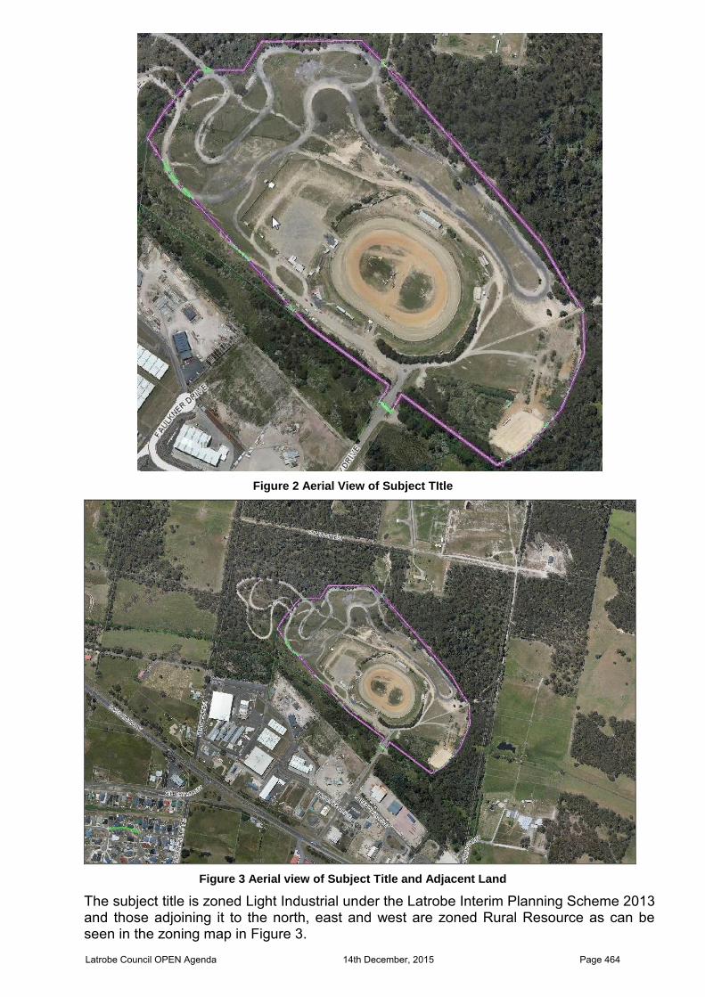
Figure 2 Aerial View of Subject TItle
Figure 3 Aerial view of Subject Title and Adjacent Land
The subject title is zoned Light Industrial under the Latrobe Interim Planning Scheme 2013 and those adjoining it to the north, east and west are zoned Rural Resource as can be seen in the zoning map in Figure 3.
Latrobe Council OPEN Agenda 14th December, 2015 Page 464
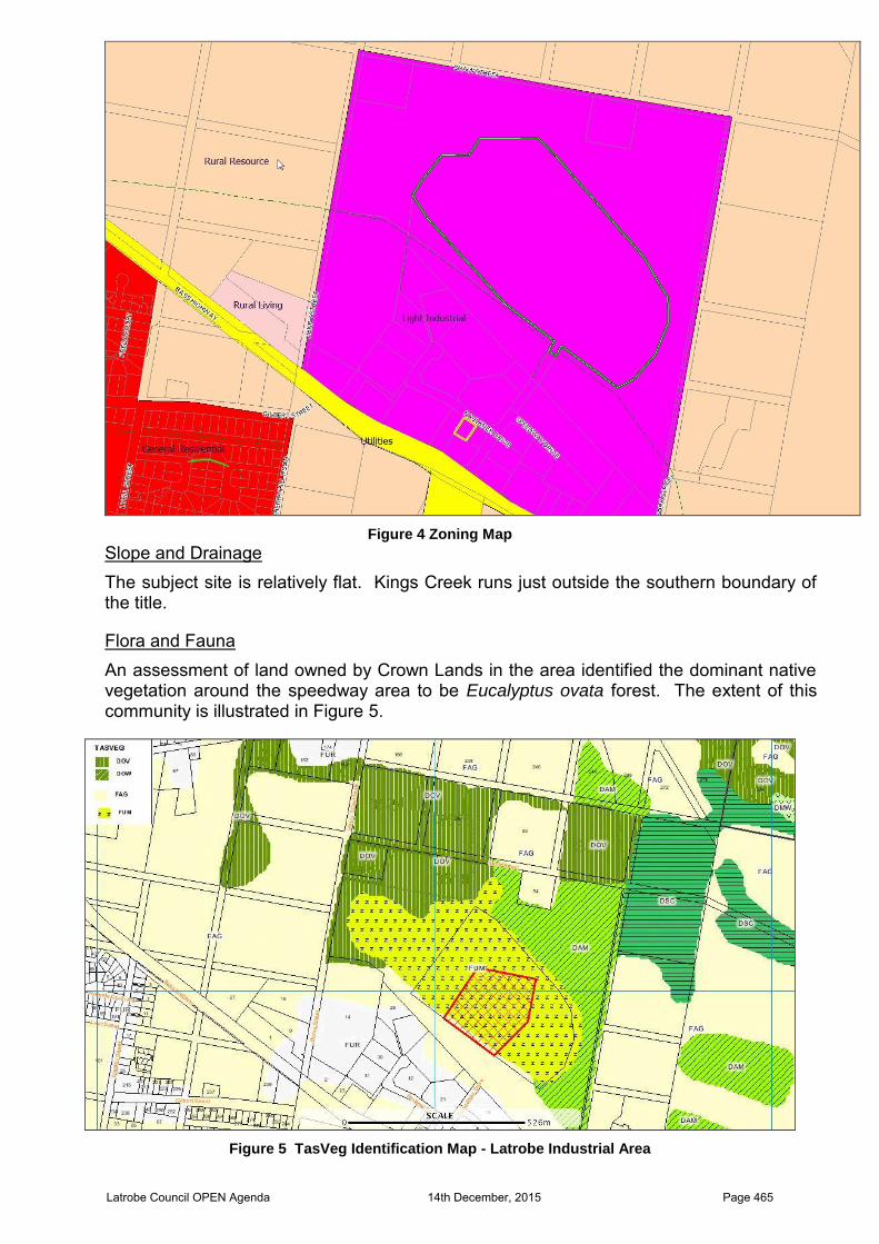
Figure 4 Zoning Map
Slope and Drainage The subject site is relatively flat. Kings Creek runs just outside the southern boundary of the title.
Flora and Fauna An assessment of land owned by Crown Lands in the area identified the dominant native vegetation around the speedway area to be Eucalyptus ovata forest. The extent of this community is illustrated in Figure 5.
Figure 5 TasVeg Identification Map - Latrobe Industrial Area
Latrobe Council OPEN Agenda 14th December, 2015 Page 465

The Eucalyptus ovata forest is identified by the dark olive green hatching and marked with the TasVeg classification code DOV. Eucalyptus ovata forest is classified as a threatened forest type statewide. It is protected from clearance or conversion under the Forest Practices Act 1985 and Forest Practices Regulations 2007.
The subject title is mainly cleared of vegetation. It is classified as agricultural, urban and exotic vegetation (FUM). A desktop review of the area reveals some sightings of the endangered fauna species, Engaeus granulatas - Central North Burrowing crayfish and Parameles gunnii – Eastern Barred Bandicoot. A map identifying these sightings is shown in Figure 6. All are outside the subject title.
Figure 6 Location of Sightings of Threatened Species
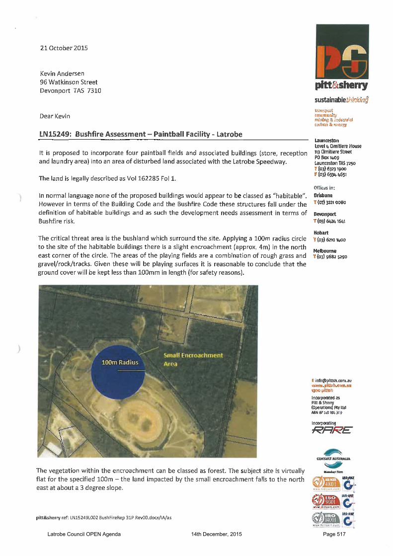
Bushfire Hazard A bushfire Hazard Risk Assessment by Ian Abernethy of Pitt & Sherry was lodged with the paintball application detail. This assessment found the site to be a combination of rough grass, gravel, rock and tracks. Bushfire risk is evident on adjacent land where the vegetation is classified as forest. Water supply is available within the Speedway complex. Public access is via a Council maintained road and tracks within the property that are constructed with either bitumen or compacted gravel. The site was considered exempt from assessment against the provisions of the Bushfire Area Code under the Latrobe Interim Planning Scheme 2013. Land Stability and Geology The subject site is basically flat and not within any identified landslip area. Provision of Services The subject title is an internal lot accessed from a fully constructed Council maintained road. It has existing connections to TasWater’s reticulated water and sewer mains, Council’s stormwater network, TasNetworks electricity infrastructure and Telstra’s telecommunications infrastructure. Heritage The site has been significantly modified. It has been used as a Speedway and for associated events for many years. Combined with its inland location, it is unlikely that any items of aboriginal cultural heritage are on the site.
Latrobe Council OPEN Agenda 14th December, 2015 Page 466
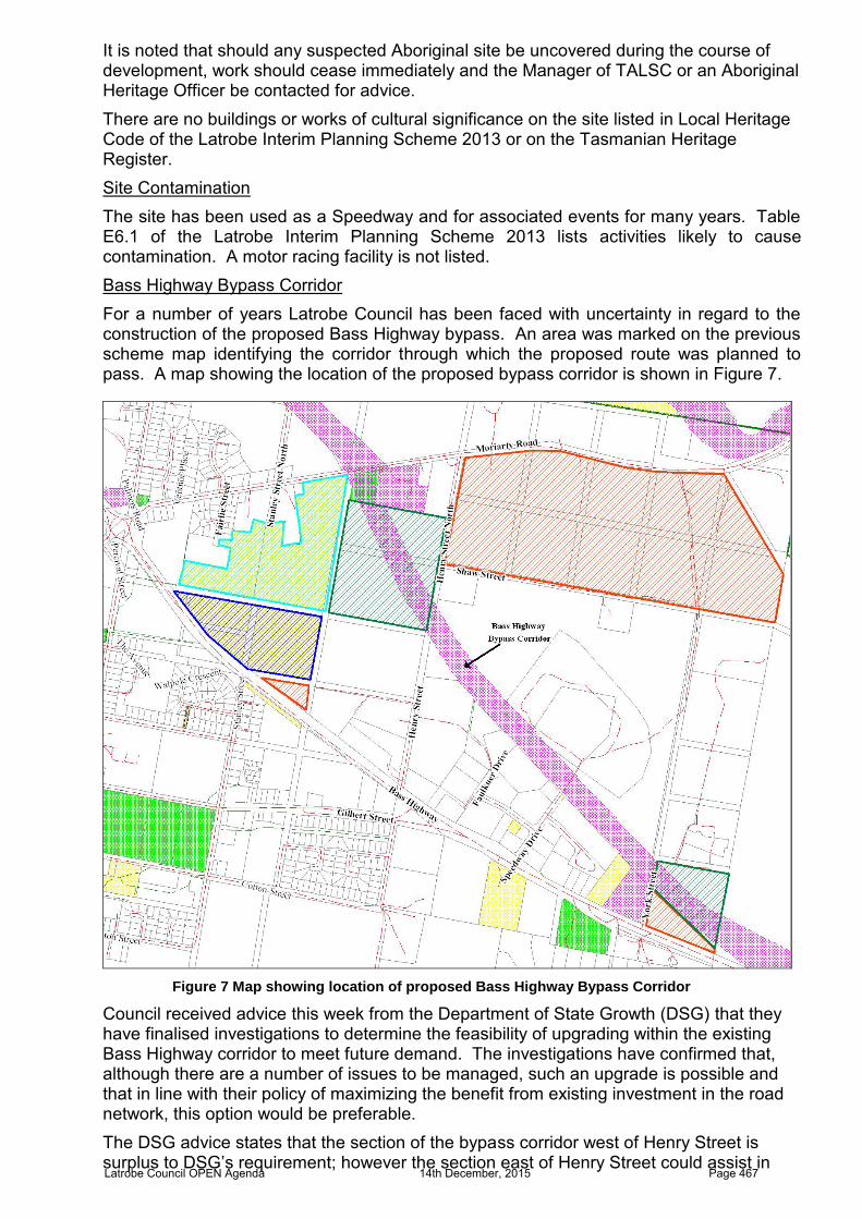
It is noted that should any suspected Aboriginal site be uncovered during the course of development, work should cease immediately and the Manager of TALSC or an Aboriginal Heritage Officer be contacted for advice. There are no buildings or works of cultural significance on the site listed in Local Heritage Code of the Latrobe Interim Planning Scheme 2013 or on the Tasmanian Heritage Register. Site Contamination The site has been used as a Speedway and for associated events for many years. Table E6.1 of the Latrobe Interim Planning Scheme 2013 lists activities likely to cause contamination. A motor racing facility is not listed. Bass Highway Bypass Corridor For a number of years Latrobe Council has been faced with uncertainty in regard to the construction of the proposed Bass Highway bypass. An area was marked on the previous scheme map identifying the corridor through which the proposed route was planned to pass. A map showing the location of the proposed bypass corridor is shown in Figure 7.
Figure 7 Map showing location of proposed Bass Highway Bypass Corridor
Council received advice this week from the Department of State Growth (DSG) that they have finalised investigations to determine the feasibility of upgrading within the existing Bass Highway corridor to meet future demand. The investigations have confirmed that, although there are a number of issues to be managed, such an upgrade is possible and that in line with their policy of maximizing the benefit from existing investment in the road network, this option would be preferable. The DSG advice states that the section of the bypass corridor west of Henry Street is surplus to DSG’s requirement; however the section east of Henry Street could assist in Latrobe Council OPEN Agenda 14th December, 2015 Page 467

improving the transport flow around the industrial estate. The advice flags the benefits of working with Council on options, both for the short and long term, to ensure the optimum outcome in terms of safety and efficient land use planning is achieved.
4. COMPLIANCE WITH STRATEGIC PLAN
Living on the Coast: The Cradle Coast Regional Land Use Strategy 2010 - 2030 is a statutory planning instrument under the Tasmanian Resource Management and Planning System. The purpose of the Strategy is to provide a consistent policy foundation for the regulatory intentions and requirements contained in local planning schemes prepared for each municipal area. The proposed amendment and paintball facility directly support many of the identified strategic outcomes in this document. Part A is the Cradle Coast Regional Land Use Planning Framework. Section 3.5 of the Framework discusses employment land and identifies it to be locations designated for clusters of industry, business, or other economic activity, including but not limited to manufacturing, processing, transport, storage, business and retail, institutions and tourism It goes further to say that a core challenge for supporting economic activity is to ensure the right land is available in the right location at the right time with the right level of infrastructure and services and that each industry type has distinct characteristics which determine land demand, location, relationship and infrastructure requirements. The Framework supports planning that provides for industry, business and commerce that is accessible, serviced with an adequate level of infrastructure, safe from natural hazards, buffered against sensitive land use, and does not compromise natural, cultural and community values. Part C is the Cradle Coast Land Use Strategy. Section 3 discusses support for economic activity. It states that tourism and visitor services and renewable energy generation are established and evidence emerging strengths; although considerable infrastructure development and secure access to reliable markets is required. Increasing capacity in digital communication will assist to diminish isolation and provide the Region with competitive equality and opportunity for new business ventures to enhance and extend existing advantage and established capacity. The Strategy finds it imperative that the region build on advantage to future diversify and expand economic activity in order to remain competitive and secure. Sections 3.35 d), f) and h) read as follows; d) promote tourism incidental to resource, industrial and settlement activity;
f.) integrate tourist experience and infrastructure into settlement centres to support and reinforce economic function;
h) ensure regulatory requirements and approval processes do not unduly direct or restrain the location, nature and flexibility of tourism operations and visitor accommodation
Section 4.5 of the Strategy outlines land use policies for facilitating access to business services. The Strategy recognizes that support can be given to economic activity by recognising a strong connectedness between the success of economic endeavour and security of access to land and resources. It acknowledges the compliance costs for business and the risk of constraint on competition that arise from unnecessary regulatory intervention.
5 RISK ISSUES
Latrobe Council OPEN Agenda 14th December, 2015 Page 468
The combined amendment and development application process requires a public exhibition period that has the potential to result in representations being made against the proposal. If the Tasmanian Planning Commission upholds these objections, then the amendment could be refused. The proposed amendment is the result of a comprehensive town planning exercise that included extensive public consultation and provides a strategic justification for development of the site for residential and commercial use.
6. FINANCIAL IMPLICATIONS Financial implications of the proposal include the $296 fee payable to the Tasmanian Planning Commission for the Planning Scheme amendment, and staff time. Advertising the Planning Scheme amendment, as per the requirements of LUPAA, will be an additional cost. Costs for lodgment of the amendment should it be approved and advertising costs are required by Council to be met by the proponent.
7. CONSULTATION The planning scheme amendment process requires a statutory public exhibition period of at least 28 days to be undertaken once Council certifies the amendment. This statutory exhibition period must be advertised twice in the local newspaper and will ensure that the public has ample opportunity to make comment.
8. STATUTORY REQUIREMENTS The amendment has been drafted in accordance with the requirements of the Land Use Planning and Approvals Act 1993 (LUPAA), which outlines the process that Council must undertake when initiating and certifying amendments. A range of matters have been considered in documenting the proposal to ensure that it meets the objectives of the Tasmanian Resource Management and Planning System and the planning process, which are outlined as schedules to LUPA. Consideration has also been given to Tasmanian Sustainable Development Policies (State Policies) as required by the State Policies and Projects Act 1993.
9. OFFICER’S COMMENTS
Current and Proposed Use and Development Standards
The subject site is currently zoned Light Industrial under the Latrobe Interim Planning Scheme 2013. The purpose of the Light Industrial Zone is to provide for manufacturing, processing, repair, storage and distribution of goods and materials where off-site impacts are minimal or can be managed to minimise conflict or impact on the amenity of any other uses. Council has had previous discussions in respect of an expression of interest to establish a paintball facility on the site. That activity would be categorised as Sport and Recreation under the Latrobe Interim Planning Scheme 2013. Sport and Recreation is prohibited in the Light Industrial zone. The subject title has been used as a Speedway and for associated events for many years. Council approved an application for improved public facilities on the site, a training room and function centre ancillary to the use earlier in 2015. The proposed amendment proposes introduction of a Particular Purpose zone into Clause 33 of the planning scheme to include a set of site specific use and development standards for the site to be known as the Latrobe Speedway Site. The proposed amendment will enable establishment of the proposed paintball facility and/or other similar recreational related activities that complement existing use in the area and make efficient use of redundant areas of the Speedway site. It will allow for the development of tourist related activities in an area close to the Bass Highway and Devonport Airport and the existing go-cart facility in Speedway Drive.
Latrobe Council OPEN Agenda 14th December, 2015 Page 469
The proposed amendment will also provide a permit pathway for extensions to the Latrobe Speedway, which is an existing non-conforming use on the site.
10. DEVELOPMENT APPLICATION
Proposal
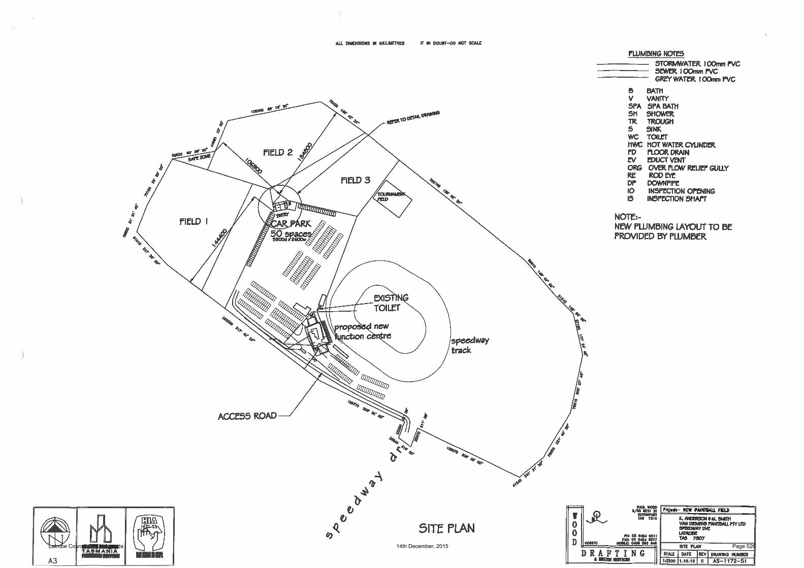
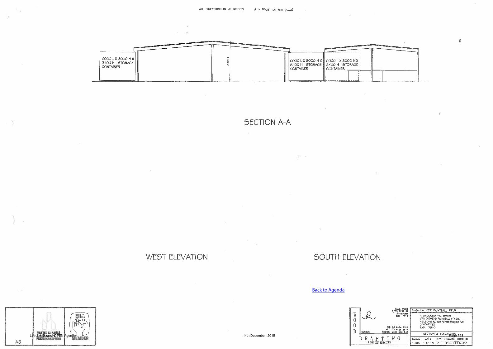
A paintball facility is proposed at 37 Speedway Drive, Latrobe. The paintball facility is located in a redundant area of the Speedway site to the east of the race track and supporting facilities. It comprises four playing fields utilizing the natural terrain and inert obstacles as “hiding” areas, a mustering area for players, which consists of an area covered with shadecloth between storage containers, the containers themselves to be used for the storage of equipment and cleaning materials and an office and administration area. The facility will make use of existing amenities on the site, such as the Speedway car park and toilets. A sign is proposed at the entrance to Speedway Drive. The facility will operate between 9.00am and 8.00pm seven (7) days a week, excepting days when the speedway is operating. On these days the facility will only open in the morning. Between 3 to 5 employees will be on the site at any one time. Four playing fields are a normal industry standard with only two being used at any time. Teams are made up of as equal numbers as can be mustered. A game lasts approximately 3 hours. The maximum number of people playing per day will be 100, playing on two of the four fields. The operator’s estimate of seasonal activity is 50% in the summer months, 40% in the shoulder months and 30% in winter. The bulk of the bookings will be groups that are likely to car pool or arrive by bus. Estimated vehicle movements are 25 – 30 per day. A safe setback distance from third party property is required to prevent stray paintballs leaving the site. An adequate distance is 8 – 10m. Paintballs are made of biodegradable, water soluble, non-toxic materials. The site will be monitored during business hours and after hours by security cameras. Signage is proposed below existing signage on an existing structure at the corner of Bass Highway and Speedway Drive. The proposed sign is 5metres X 1 metre. It advertises the proposed facility. A copy of the site plan submitted with the application is shown in Figure 8. It shows the location of existing development on the site and the operational areas and supporting services required by the proposed paintball facility. A copy of the floor and elevation plans for the registration and utility services building is shown in Figures 9 and 10. A copy of the proposed sign is shown in Figure 11 and a picture of the structure it proposed to be mounted on is shown in Figure 12.
Latrobe Council OPEN Agenda 14th December, 2015 Page 470
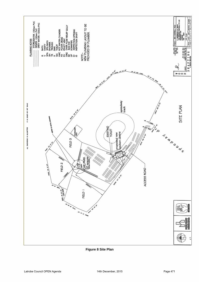
Figure 8 Site Plan
Latrobe Council OPEN Agenda 14th December, 2015 Page 471
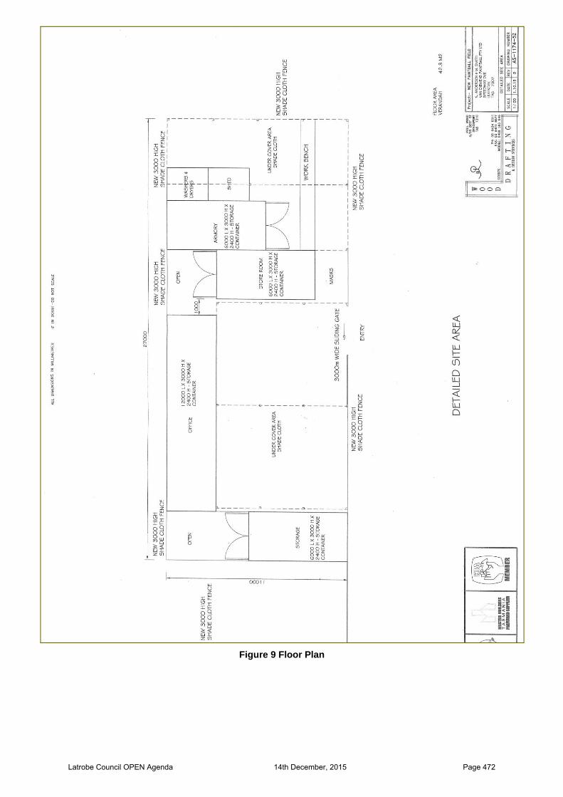
Figure 9 Floor Plan
Latrobe Council OPEN Agenda 14th December, 2015 Page 472

Figure 10 Elevation Plan
Latrobe Council OPEN Agenda 14th December, 2015 Page 473
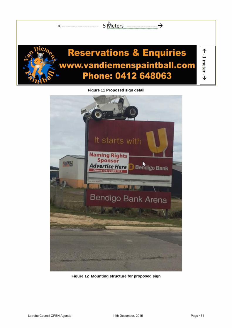
Figure 11 Proposed sign detail
Figure 12 Mounting structure for proposed sign
Latrobe Council OPEN Agenda 14th December, 2015 Page 474

INTERNAL REFERRALS
The application was referred to Council’s Engineering, Environmental Health and Building departments. Engineer’s report and recommended conditions. The existing 6m wide private road from Speedway Drive through Crown land is to be used as the primary means of access.
Condition: Stormwater discharge from the development and overland flows from the property are to be contained on site connected to existing private stormwater or directed to the stormwater drain within the site. Formed surfaces are not to direct water to adjoining properties. Environmental Health Officer’s report The site has existing connection to TasWater’s reticulated sewer system and does not require on-site management of waste water. Note: Ensure appropriate action is taken to mitigate/minimise any emissions from the site that may cause or is likely to cause environmental harm or environmental nuisance under the provisions of Environmental Management and Pollution Control Act 1994 and associated Regulations Insert Building Department’s report An application is required for a building permit for the registration and utility services building.
Development Application Assessment
The application for the proposed paintball facility is assessed against the proposed standards for development of the site included in the amendment and all other relevant standards under the Latrobe Interim Planning Scheme 2013. The assessment assumes approval by Tasmanian Planning Commission (TPC) of draft amendment DA 04/15. Clause 8.2 of the Planning Scheme requires use or uses of land for which use and development is proposed to be categorized in accordance with the definitions contained in Table 8.2. The proposal has been categorized as Sport and Recreation. Under Table 8.2: Use Classes, Sport and Recreation means:
use of land for organized or competitive recreation or sporting purposes including associated club rooms.
Under Clause 33.2: Use Table, Residential use has permitted status If for (a) a bowling alley, fitness centre, gymnasium; or (b) an indoor or outdoor recreation facility; and (c) not a spectator sport
The proposed paintball facility is an outdoor recreation facility and not a spectator sport.
Latrobe Council OPEN Agenda 14th December, 2015 Page 475
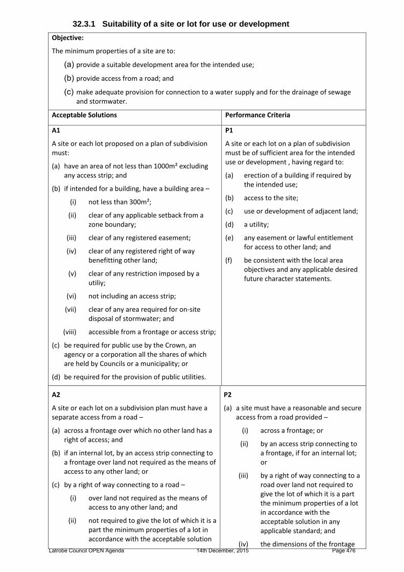
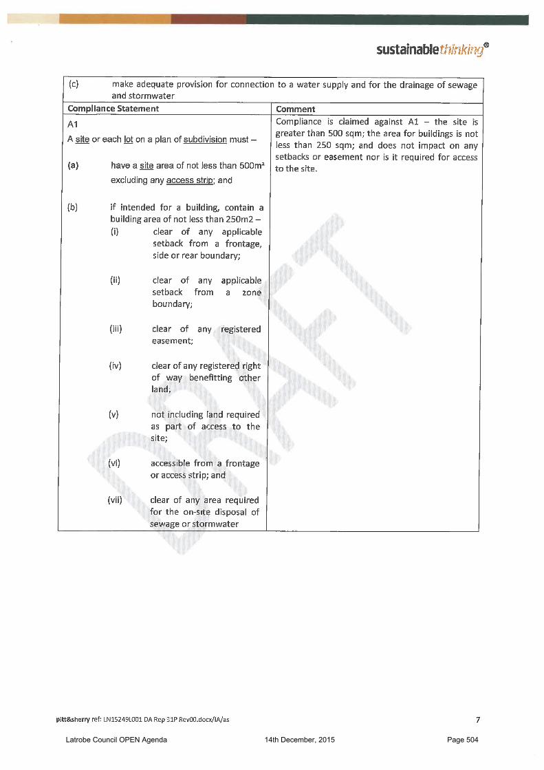
32.3.1 Suitability of a site or lot for use or development
Objective:
The minimum properties of a site are to:
(a) provide a suitable development area for the intended use;
(b) provide access from a road; and
(c) make adequate provision for connection to a water supply and for the drainage of sewage and stormwater.
Acceptable Solutions Performance Criteria
A1
A site or each lot proposed on a plan of subdivision must:
(a) have an area of not less than 1000m² excluding any access strip; and
(b) if intended for a building, have a building area –
(i) not less than 300m²;
(ii) clear of any applicable setback from a zone boundary;
(iii) clear of any registered easement;
(iv) clear of any registered right of way benefitting other land;
(v) clear of any restriction imposed by a utiliy;
(vi) not including an access strip;
(vii) clear of any area required for on-site disposal of stormwater; and
(viii) accessible from a frontage or access strip;
(c) be required for public use by the Crown, an agency or a corporation all the shares of which are held by Councils or a municipality; or
(d) be required for the provision of public utilities.
P1
A site or each lot on a plan of subdivision must be of sufficient area for the intended use or development , having regard to:
(a) erection of a building if required by the intended use;
(b) access to the site;
(c) use or development of adjacent land;
(d) a utility;
(e) any easement or lawful entitlement for access to other land; and
(f) be consistent with the local area objectives and any applicable desired future character statements.
A2
A site or each lot on a subdivision plan must have a separate access from a road –
(a) across a frontage over which no other land has a right of access; and
(b) if an internal lot, by an access strip connecting to a frontage over land not required as the means of access to any other land; or
(c) by a right of way connecting to a road –
(i) over land not required as the means of access to any other land; and
(ii) not required to give the lot of which it is a part the minimum properties of a lot in accordance with the acceptable solution
P2
(a) a site must have a reasonable and secure access from a road provided –
(i) across a frontage; or
(ii) by an access strip connecting to a frontage, if for an internal lot; or
(iii) by a right of way connecting to a road over land not required to give the lot of which it is a part the minimum properties of a lot in accordance with the acceptable solution in any applicable standard; and
(iv) the dimensions of the frontage Latrobe Council OPEN Agenda 14th December, 2015 Page 476
in any applicable standard; and
(d) with a width of frontage and any access strip or right of way of not less than 10.0m; and
(e) the relevant road authority in accordance with the Local Government (Highways) Act 1982 or the Roads and Jetties Act 1935 must have advised it is satisfied adequate arrangements can be made to provide vehicular access between the carriageway of a road and the frontage, access strip or right of way to the site or each lot on a proposed subdivision plan.
and any access strip or right of way must be adequate for the type and volume of traffic likely to be generated by –
a. the intended use; and
b. the existing or potential use of any other land which requires use of the access as the means of access for the land; and
(v) the relevant road authority in accordance with the Local Government (Highways) Act 1982 or the Roads and Jetties Act 1935 must have advised it is satisfied adequate arrangements can be made to provide vehicular access between the carriageway of a road and the frontage, access strip or right of way to the site or each lot on a subdivision plan; or
(b) It must be unnecessary for the development to require access to the site or to a lot on a subdivision plan.
A3
A site or each lot on a plan of subdivision must be capable of connecting to a water supply –
(a) from a connection to a water supply provided in accordance with the Water and Sewerage Industry Act 2008; or
(b) from a rechargeable drinking water system R6 with a storage capacity of not less than 10,000 litres if –
(i) there is not a reticulated water supply; and
(ii) development is for a use with an equivalent population of not more than 10 people per day.
P3
(a) There must be a water supply available for the site or for each lot on a plan of subdivision with an adequate level of reliability, quality and quantity to service the anticipated use of the site or the intended use of each lot on a plan of subdivision; or
(b) It must be unnecessary to require a water supply
A4
A site or each lot on a plan of subdivision must be capable of draining and disposing of sewage and trade waste –
(a) to a reticulated sewer system provided in accordance with the Water and Sewerage Industry Act 2009; or
(b) by onsite disposal if –
(i) sewage or trade waste cannot be drained to a reticulated sewer
P4
(a) A site or each lot on a plan of subdivision must drain and dispose of sewage and trade waste –
(i) in accordance with any prescribed emission limits for discharge of waste water;
(ii) in accordance with any limit advised by the Tasmanian Environmental Protection
Latrobe Council OPEN Agenda 14th December, 2015 Page 477
system; and
(ii) the development
a. is for a single dwelling; or
b. creates a total sewage and waste water flow of not more than 1,000l per day; and
(iii) the site has capacity for onsite disposal of domestic waste water in accordance with AS/NZS1547:2012 Onsite domestic wastewater management clear of any defined building area or access strip
Agency;
(iii) without likely adverse impact for the health or amenity of the land and adjacent land;
(iv) without compromise to water quality objectives for surface or ground water established under the State Policy on Water Quality Management 1997; and
(v) with appropriate safeguards to minimise contamination if the use or development has potential to –
a. indirectly cause the contamination of surface or ground water; or
b. involve an activity or process which requires the use, production, conveyance or storage of significant quantities of sewage or trade waste that may cause harm to surface or ground water if released through accident, malfunction, or spillage; or
(b) It must be unnecessary to require arrangements for the drainage and disposal of sewerage or trade waste.
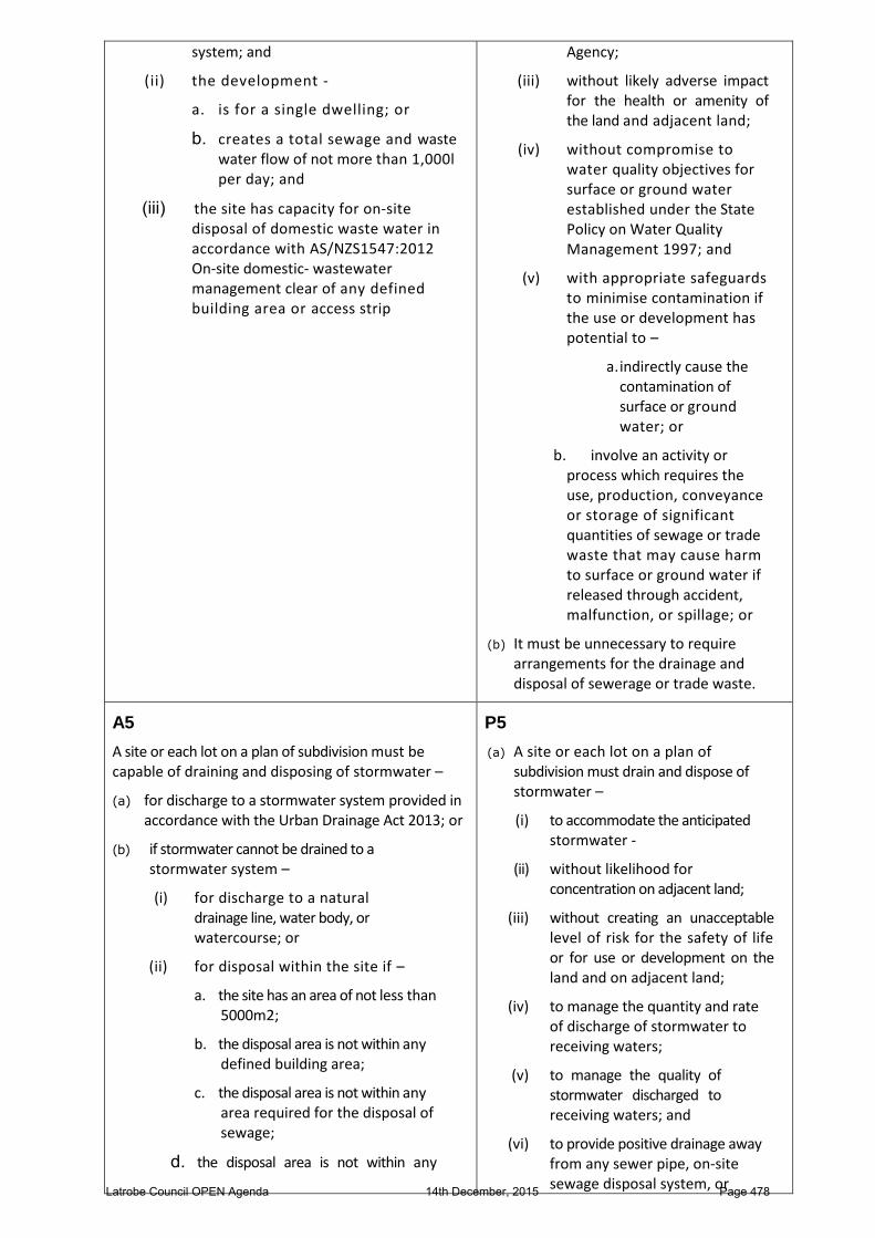
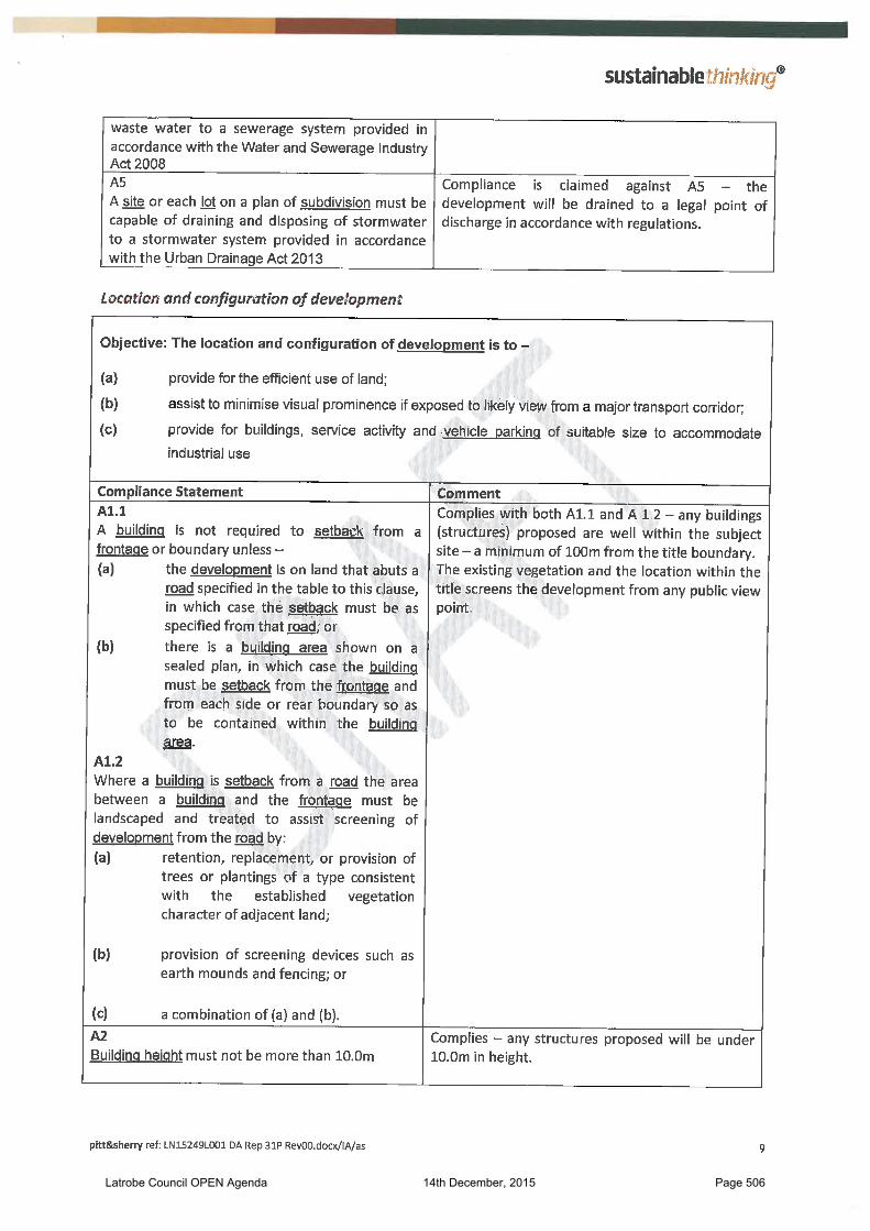
A5
A site or each lot on a plan of subdivision must be capable of draining and disposing of stormwater –
(a) for discharge to a stormwater system provided in accordance with the Urban Drainage Act 2013; or
(b) if stormwater cannot be drained to a stormwater system –
(i) for discharge to a natural drainage line, water body, or watercourse; or
(ii) for disposal within the site if –
a. the site has an area of not less than 5000m2;
b. the disposal area is not within any defined building area;
c. the disposal area is not within any area required for the disposal of sewage;
d. the disposal area is not within any
P5
(a) A site or each lot on a plan of subdivision must drain and dispose of stormwater –
(i) to accommodate the anticipated stormwater
(ii) without likelihood for concentration on adjacent land;
(iii) without creating an unacceptable level of risk for the safety of life or for use or development on the land and on adjacent land;
(iv) to manage the quantity and rate of discharge of stormwater to receiving waters;
(v) to manage the quality of stormwater discharged to receiving waters; and
(vi) to provide positive drainage away from any sewer pipe, onsite sewage disposal system, or Latrobe Council OPEN Agenda 14th December, 2015 Page 478
access strip; and
e. not more than 50% of the site is impervious surface
building area; or
(b) It must be unnecessary to require arrangements for the drainage and disposal of stormwater.
The subject title has an area of 16.92ha. It contains the Latrobe Speedway site, which has an area of approximately 6ha. The subject site, inclusive of the car park is approximately 6ha. It includes the proposed playing fields and the registration and services/utilities building.
The proposal complies with A1 for this Standard. Access to the site is via a private driveway off Speedway Drive. There is no new access proposed as access to the facility is shared with the Latrobe Speedway. Council’s engineer is satisfied that the access is adequate for the proposed use. The proposal complies with A2 for this Standard. The site has an existing connection to TasWater’s reticulated water supply. The proposal complies with A3 for this Standard. The site has an existing connection to TasWater’s reticulated sewer system. The proposal complies with A4 for this Standard. The subject site comprises 16.92ha. There is sufficient area for stormwater management on the site. A condition will be included on the permit as follows:
Stormwater discharge from the development and overland flows from the property are to be contained on site connected to existing private stormwater or directed to the stormwater drain within the site. Formed surfaces are not to direct water to adjoining properties.
In this manner the proposal will A5 for this Standard.
32.3.2 Location and configuration of development
Objective The location and configuration of development is to –
(a) provide for the efficient use of land;
(b) provide for buildings, service activity and vehicle parking of suitable size to accommodate use
(c) provide consistency in the apparent scale, bulk, massing and proportion of adjacent buildings; and
(d) minimise unreasonable impact on the amenity of the use on land beyond the boundaries of the zone.
Acceptable Solution Performance Criteria
A1
Building height must be not be more than 10.0m.
P1
Building height must –
(a) minimise apparent scale, bulk, massing and proportion relative to any adjacent building;
(b) respond to the effect of the slope and orientation of the site; and
(c) provide separation between buildings to attenuate impact.
Latrobe Council OPEN Agenda 14th December, 2015 Page 479

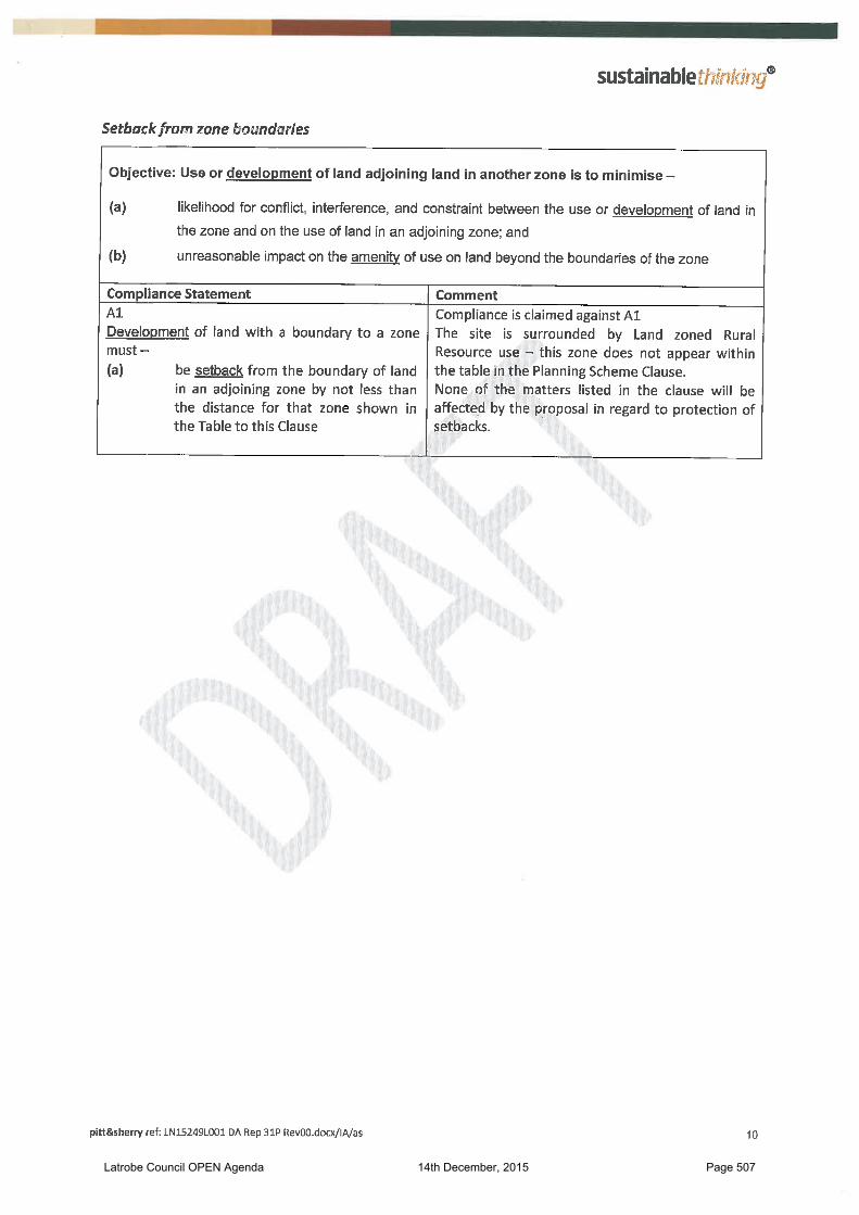
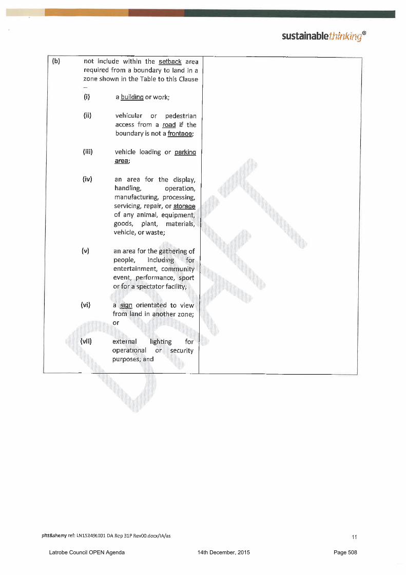
A2
Development of land with a boundary to a zone must –
(a) be setback from the boundary of land in an adjoining zone by not less than the distance for that zone shown in the Table to this Clause;
(b) not include within the setback area required from a boundary to land in a zone shown in the Table to this Clause –
(i) a building or work;
(ii) vehicular or pedestrian access from a road;
(iii) vehicle loading or parking area;
(iv) an area for the gathering of people, including for entertainment, community event, performance, sport or for a spectator facility;
(v) a sign orientated to view from land in another zone; or
(vi) external lighting for operational or security purposes; and
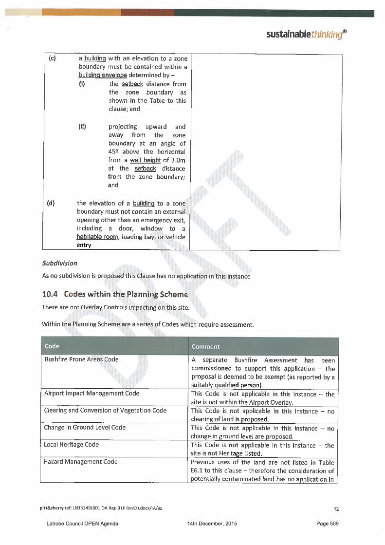
(c) a building with an elevation to a zone boundary must be contained within a building envelope determined by –
(i) the setback distance from the zone boundary as shown in the Table to this clause; and
(ii) projecting upward and away from the zone boundary at an angle of 45
0 above
the horizontal from a wall height of 3.0m at the setback distance from the zone boundary; and
(d) the elevation of a building to a zone boundary must not contain an external opening other than an emergency exit, including a door, window to a habitable room, loading bay, or vehicle entry.
P2
The location of development must –
(a) minimise likelihood for conflict, interference and constraint from use on land in an adjoining zone; and
(b) minimise likely impact on the amenity of use on land in an adjoining zone.
Table to Clause 32.3.2 A2
Adjoining Zone Setback(m)
Light Industrial 4.0
The registration and services/utilities building has a height of 3.451m. The proposal complies with A1 for this Standard. The registration and services/utilities building is setback 144.4m from the south-western boundary, 106.9m from the north-western boundary and 164.8m from the north-eastern boundary. The proposal complies with A2 for this Standard.
Latrobe Council OPEN Agenda 14th December, 2015 Page 480
Codes
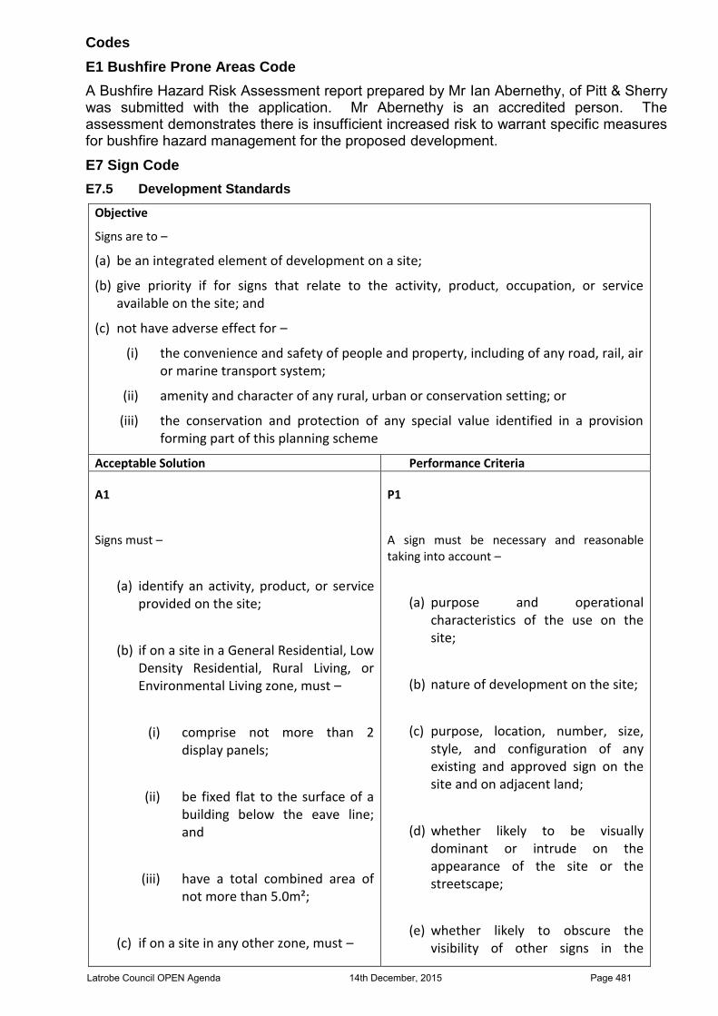
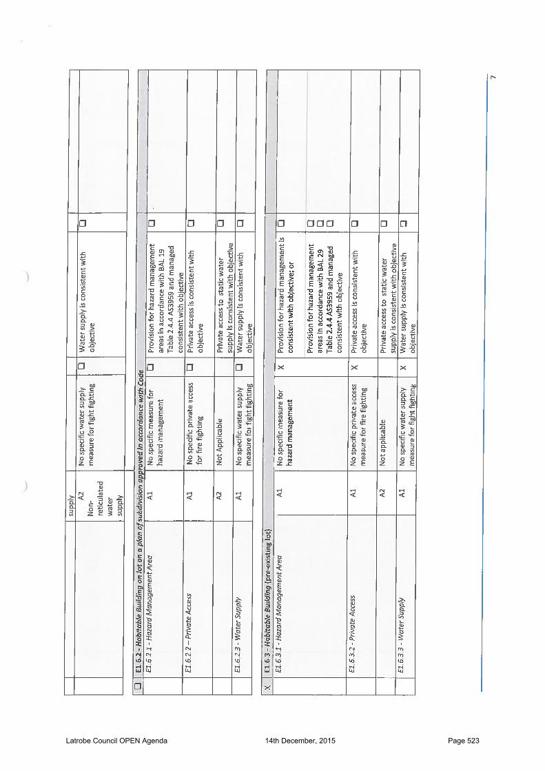
E1 Bushfire Prone Areas Code
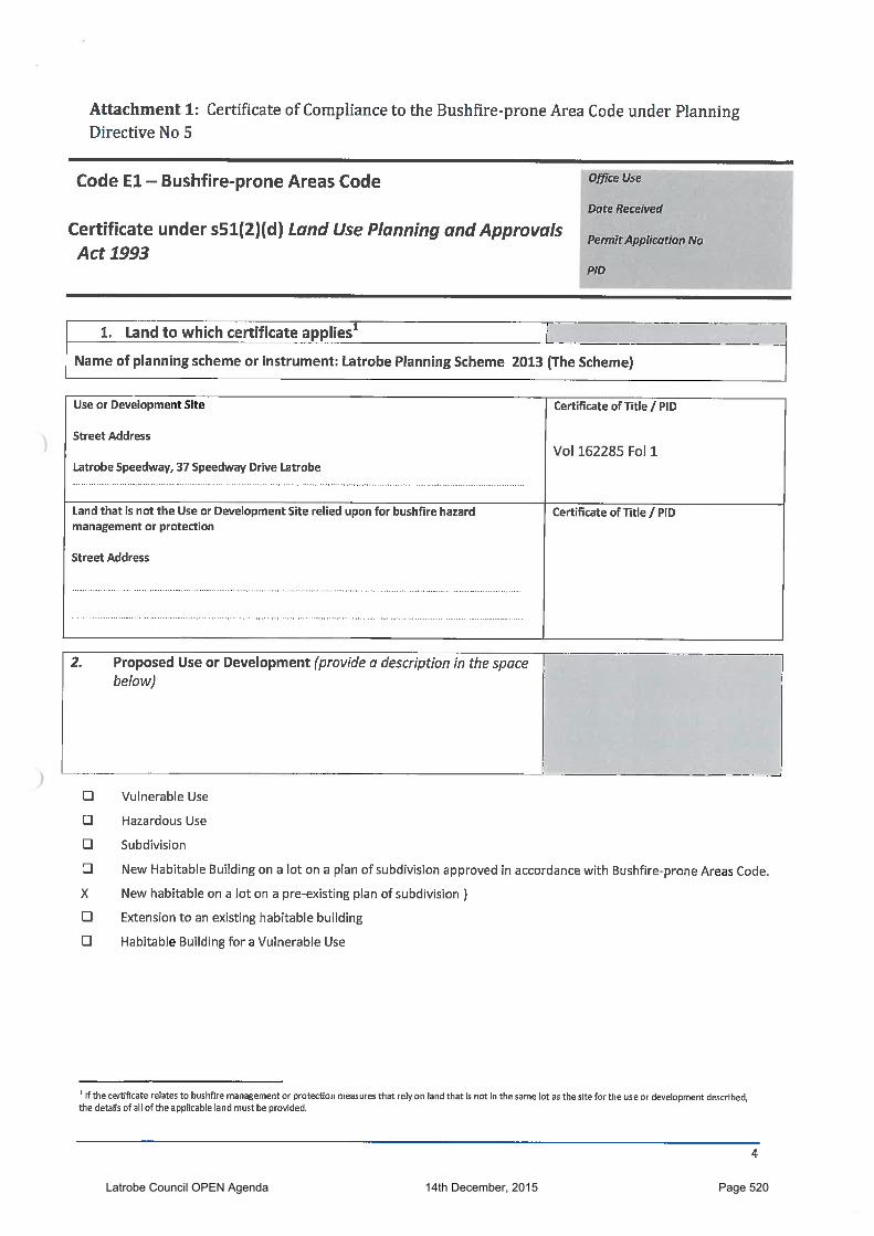
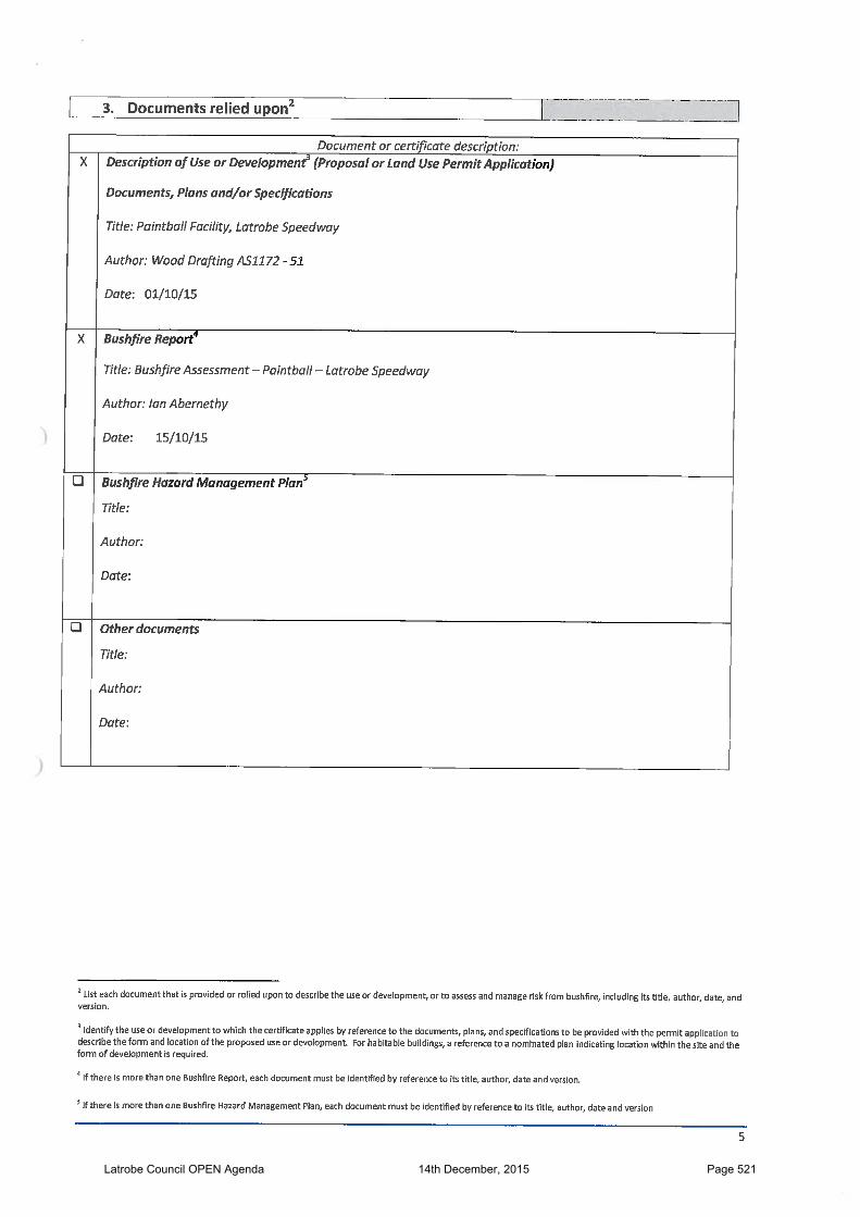
A Bushfire Hazard Risk Assessment report prepared by Mr Ian Abernethy, of Pitt & Sherry was submitted with the application. Mr Abernethy is an accredited person. The assessment demonstrates there is insufficient increased risk to warrant specific measures for bushfire hazard management for the proposed development.
E7 Sign Code
E7.5 Development Standards
Objective
Signs are to –
(a) be an integrated element of development on a site;
(b) give priority if for signs that relate to the activity, product, occupation, or service available on the site; and
(c) not have adverse effect for –
(i) the convenience and safety of people and property, including of any road, rail, air or marine transport system;
(ii) amenity and character of any rural, urban or conservation setting; or
(iii) the conservation and protection of any special value identified in a provision forming part of this planning scheme
Acceptable Solution Performance Criteria
A1
Signs must –
(a) identify an activity, product, or service provided on the site;
(b) if on a site in a General Residential, Low Density Residential, Rural Living, or Environmental Living zone, must –
(i) comprise not more than 2 display panels;
(ii) be fixed flat to the surface of a building below the eave line; and
(iii) have a total combined area of not more than 5.0m²;
(c) if on a site in any other zone, must –
P1
A sign must be necessary and reasonable taking into account –
(a) purpose and operational characteristics of the use on the site;
(b) nature of development on the site;
(c) purpose, location, number, size, style, and configuration of any existing and approved sign on the site and on adjacent land;
(d) whether likely to be visually dominant or intrude on the appearance of the site or the streetscape;
(e) whether likely to obscure the visibility of other signs in the
Latrobe Council OPEN Agenda 14th December, 2015 Page 481
(i) comprise not more than 5 display panels;
(ii) have a total combined area of not more than 50.0m²
(iii) be separated from any other freestanding or projecting sign by not less than 10.0m
(iv) be fully contained within the applicable building envelope and –
a. not extend above the parapet or the ridge of a roof; or
b. if a free-standing sign, have a height above natural ground level of not more than 5.0m;
(v) not involve a corporate livery, colour scheme, insignia or logo applied to more than 25% of the external wall surface of each elevation of a building;
(vi) not be located in an access strip, loading area, or car park;
(vii) not be animated, changeable, flashing, or rotating unless providing advisory or safety information;
(viii) not resemble any air or marine navigation device, or a railway or road traffic control or directional device or sign;
(ix) not visually obscure any sign or device required for the convenience and safety of air or marine navigation or for use of
locality;
(f) whether visible beyond the immediate locality;
(g) whether likely to impact on operational efficiency and safety of a railway, road, navigable water, or controlled air space in accordance with the advice of any relevant regulatory entity;
(h) whether likely to impact on the amenity of a habitable room or private open space in a residential development;
(i) any advice or requirement of the relevant road manager; and
(j) implication for the objectives of any local heritage provision applicable for the site
Latrobe Council OPEN Agenda 14th December, 2015 Page 482
a railway or a road; and
(x) not cause illumination that overspills the boundaries of the site; and
(d) not be on land for which a Local Heritage Code forming part of the planning scheme applies
Signage is proposed below existing signage on an existing structure at the corner of Bass Highway and Speedway Drive. The proposed sign is 5metres long and 1 metre high. It advertises the proposed facility. The proposed sign identifies and advertises an activity on an internal lot off the end of Speedway Drive. It is to be mounted on a structure than contains existing signage advertising the Latrobe Speedway. The dimensions of the sign are similar to those existing on the structure. The proposed sign has a display area of 5m². It is not likely to have any greater impact than existing signage in the area. The proposal satisfies P1 for this Standard.
Traffic Generating Use and Parking Code
E9.5.1 Provision for parking
Objective:
Provision is to be made for convenient, accessible, and usable vehicle parking to satisfy requirements for use or development without impact for use or development of other land or for the safety and operation of any road
Acceptable Solutions Performance Criteria
A1
Provision for parking must be -
(a) the minimum number of on-site vehicle parking spaces must be in accordance with the applicable standard for the use class as shown in the Table E9A;
(b) motor bike parking at a rate of 1 space for every 20 vehicle parking spaces;
(c) parking spaces for people with disabilities at the rate of 1 space for every 20 parking spaces or part thereof; and
(d) bicycle parking at the rate of 1 space for every 20 vehicle parking spaces or part thereof
P1
(a) It must be unnecessary or unreasonable to require arrangements for the provision of vehicle parking; or
(b) Adequate and appropriate provision must be made for vehicle parking to meet -
(i) anticipated requirement for the type, scale, and intensity of the use;
(ii) likely needs and requirements of site users; and
(iii) likely type, number, frequency, and duration of vehicle parking demand
Under Table E9A Sport and Recreation does not specify the number of spaces for an outdoor facility that is not a spectator facility excepting a bowling green. The maximum number of people paying per days will be 100, playing on two of the four fields. The operator’s estimate of seasonal activity is 50% in the summer months, 40% in the shoulder months and 30% in winter.
Latrobe Council OPEN Agenda 14th December, 2015 Page 483
The bulk of the bookings will be groups that are likely to car pool or arrive by bus. Estimated vehicle movements are 25 – 30 per day. The title has existing provision of 180 sealed car parking spaces and 120 gravel & grass car parking spaces. The provision of parking satisfies the requirements for the proposed use. The proposal complies with A1 for this Standard. E9.5.2 Provision for loading and unloading of vehicles
Objective:
Provision is made for conveniently located and accessible areas for the loading and unloading of goods and materials and for the pick-up and set-down of passengers from vehicles
Acceptable Solutions Performance Criteria
A1
There must be provision within a site for -
(a) on-site loading area in accordance with the requirement in Table E9A; and
(b) passenger vehicle pick-up and set-down facilities for business, commercial, educational and retail use at the rate of 1 space for every 50 parking spaces
P1
(a) It must be unnecessary or unreasonable to require arrangements for loading and unloading of vehicles; or
(b) Adequate and appropriate provision must be made for the loading and unloading of vehicles to meet–
(i) likely volume, type and frequency of vehicles associated with the delivery and collection of goods and passengers; and
(ii) likely frequency and duration of requirements for delivery and collection of goods or people
Under Table E9A Sport and Recreation requires provision of 1 small rigid truck space. The title has existing provision of 180 sealed car parking spaces and 120 gravel & grass car parking spaces. The provision of parking satisfies the requirements for the proposed use. The proposal complies with A1 for this Standard.
E9.6.1 Road access
Objective:
Arrangements for vehicular access to a road and for junctions with a road are to protect safety and operation of a road
Acceptable Solutions Performance Criteria
A1
There must be an access to the site from a carriageway of a road R36 –
(a) permitted in accordance with the Local Government (Highways) Act 1982;
(b) permitted in accordance with the Roads and Jetties Act 1935; or
(c) permitted by a license granted for access to a limited access road under the Roads and Jetties Act 1935
P1 There is no performance criteria
Latrobe Council OPEN Agenda 14th December, 2015 Page 484
Access to the site is from Speedway Drive which is a fully constructed Council maintained road.
The proposal complies with A1 for this Standard.
E9.6.2 Design of vehicle parking and loading areas
Objective:
Vehicle circulation, loading, and parking areas–
(a) protect the efficient operation and safety of the road from which access is provided;
(b) promote efficiency, convenience, safety, and security for vehicles and users; and
(c) provide an appropriate layout and adequate dimension to accommodate passenger or freight vehicle associated with use of the site
Acceptable Solutions Performance Criteria
A1.1
All development must provide for the collection, drainage and disposal of stormwater; and
A1.2
Other than for development for a single dwelling in the General Residential, Low Density Residential, Urban Mixed Use and Village zones, the layout of vehicle parking area, loading area, circulation aisle and manoeuvring area must –
(a) Be in accordance with AS/NZS 2890.1 (2004) – Parking Facilities - Off Street Car Parking;
(b) Be in accordance with AS/NZS 2890.2 (2002) – Parking Facilities – Off Street Commercial Vehicles;
(c) Be in accordance with AS/NZS 2890.3 (1993) – Parking Facilities – Bicycle Parking Facilities;
(d) Be in accordance with AS/NZS 2890.6 Parking Facilities – Off Street Parking for People with Disabilities;
(e) Each parking space must be separately accessed from the internal circulation aisle within the site
P1
The layout and construction of a vehicle parking area, loading area, circulation aisle, and manoeuvring area must be adequate and appropriate for –
(a) the nature and intensity of the use;
(b) effect of size, slope and other physical characteristics and conditions of the site;
(c) likely volume, type, and frequency of vehicles accessing the site;
(d) likely demand and turnover for parking;
(e) delivery and collection vehicles;
(f) familiarity of users with the vehicle loading and vehicle parking area;
(g) convenience and safety of access to the site from a road;
(h) safety and convenience of internal vehicle and pedestrian movement;
(i) safety and security of site users; and
(j) the collection, drainage, and disposal of stormwater
A2
Design and construction of an access strip and vehicle circulation, movement and standing areas for use or development on land within the Rural Living, Environmental Living, Open Space, Rural Resource, or Environmental Management zones must be in accordance with the principles and requirements for in the current edition of Unsealed Roads Manual – Guideline for Good Practice ARRB
P2
Design of internal access roads and vehicle circulation, movement and standing areas for permitted use on land within the Rural Living, Environmental Living, Open Space, Rural Resource, or Environmental Management zones must be adequate and appropriate for the likely type, volume, and frequency of traffic
Latrobe Council OPEN Agenda 14th December, 2015 Page 485
The title has existing provision of 180 sealed car parking spaces and 120 gravel & grass car parking spaces. The Performance Criteria gives Council discretion to consider an alternative hard surface provided the construction of the vehicle parking area, loading area, circulation aisle and manoeuvring area is adequate and appropriate for:
the nature and intensity of the use; effect of characteristics and conditions of the site; likely volume, type and frequency of vehicles accessing the site; and safety of site users accessing and within the site.
The building will not intensify the existing use on the title. The finish of the existing parking area is appropriate for the existing use on the site.
The proposal satisfies Performance Criteria P1 for this Standard.
11. CONCLUSION
The proposed development satisfied the requirements of the Latrobe Interim Planning Scheme 2013, assuming approval by Tasmanian Planning Commission (TPC) of draft amendment DA 04/15.
12. RECOMMENDATION
That the report by the Planning Officer dated 8 December 2015 concerning Draft Amendment 04/15 and DA 184/2015 be received and Council:
1. Approve the proposed amendment as presented; 2. Certify the proposed amendment; 3. Advertise the proposed amendment in The Advocate and place it on public
exhibition for a period of 28 days; and
4. Approve the proposed paintball facility with the following conditions: (a) Consent is for the proposed paintball facility substantially in accordance with
endorsed plans Drwg. Nos. AS-1172-51, AS-1174-52 and AS-1174-53. (b) Consent is for the proposed 5.0m x 1.0m sign substantially in accordance
with endorsed signage detail. (c) Stormwater discharge from the development and overland flows from the
property are to be contained on site connected to existing private stormwater or directed to the stormwater drain within the site. Formed surfaces are not to direct water to adjoining properties.
(d) Operating hours are to be between 9.00am and 8.00pm seven (7) days a week.
Latrobe Council OPEN Agenda 14th December, 2015 Page 486
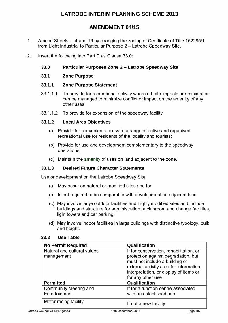
LATROBE INTERIM PLANNING SCHEME 2013
AMENDMENT 04/15
1. Amend Sheets 1, 4 and 16 by changing the zoning of Certificate of Title 162285/1
from Light Industrial to Particular Purpose 2 – Latrobe Speedway Site.
2. Insert the following into Part D as Clause 33.0:
33.0 Particular Purposes Zone 2 – Latrobe Speedway Site
33.1 Zone Purpose
33.1.1 Zone Purpose Statement
33.1.1.1 To provide for recreational activity where off-site impacts are minimal or can be managed to minimize conflict or impact on the amenity of any other uses.
33.1.1.2 To provide for expansion of the speedway facility
33.1.2 Local Area Objectives
(a) Provide for convenient access to a range of active and organised recreational use for residents of the locality and tourists;
(b) Provide for use and development complementary to the speedway operations;
(c) Maintain the amenity of uses on land adjacent to the zone.
33.1.3 Desired Future Character Statements
Use or development on the Latrobe Speedway Site:
(a) May occur on natural or modified sites and for
(b) Is not required to be comparable with development on adjacent land
(c) May involve large outdoor facilities and highly modified sites and include buildings and structure for administration, a clubroom and change facilities, light towers and car parking;
(d) May involve indoor facilities in large buildings with distinctive typology, bulk and height.
33.2 Use Table
No Permit Required Qualification
Natural and cultural values management
If for conservation, rehabilitation, or protection against degradation, but must not include a building or external activity area for information, interpretation, or display of items or for any other use
Permitted Qualification
Community Meeting and Entertainment
If for a function centre associated with an established use
Motor racing facility If not a new facility Latrobe Council OPEN Agenda 14th December, 2015 Page 487
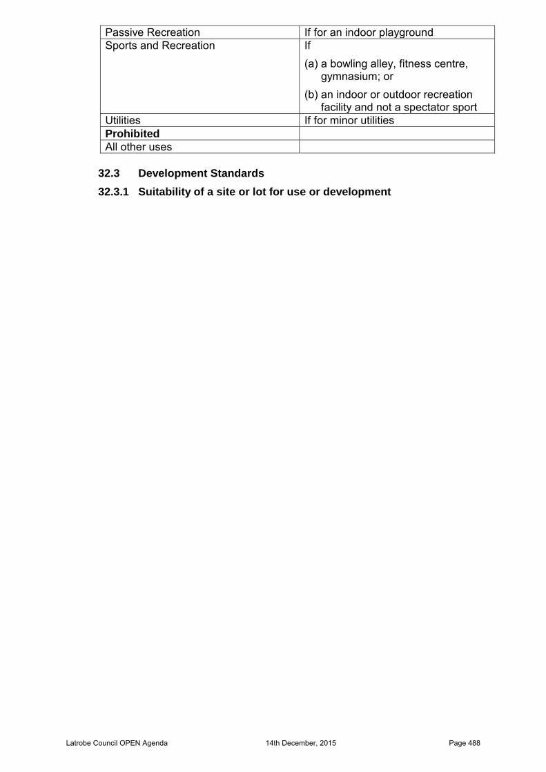
Passive Recreation If for an indoor playground Sports and Recreation If
(a) a bowling alley, fitness centre, gymnasium; or
(b) an indoor or outdoor recreation facility and not a spectator sport
Utilities If for minor utilities Prohibited
All other uses
32.3 Development Standards
32.3.1 Suitability of a site or lot for use or development
Latrobe Council OPEN Agenda 14th December, 2015 Page 488

Objective:
The minimum properties of a site are to:
(d) provide a suitable development area for the intended use;
(e) provide access from a road; and
(f) make adequate provision for connection to a water supply and for the drainage of sewage and stormwater.
Acceptable Solutions Performance Criteria
A1
A site or each lot proposed on a plan of subdivision must:
(e) have an area of not less than 1000m² excluding any access strip; and
(f) if intended for a building, have a building area –
(i) not less than 300m²;
(ii) clear of any applicable setback from a zone boundary;
(iii) clear of any registered easement;
(iv) clear of any registered right of way benefitting other land;
(v) clear of any restriction imposed by a utiliy;
(vi) not including an access strip;
(vii) clear of any area required for on-site disposal of stormwater; and
(viii) accessible from a frontage or access strip;
(g) be required for public use by the Crown, an agency or a corporation all the shares of which are held by Councils or a municipality; or
(h) be required for the provision of public utilities.
P1
A site or each lot on a plan of subdivision must be of sufficient area for the intended use or development , having regard to:
(g) erection of a building if required by the intended use;
(h) access to the site;
(i) use or development of adjacent land;
(j) a utility;
(k) any easement or lawful entitlement for access to other land; and
(l) be consistent with the local area objectives and any applicable desired future character statements.
A2
A site or each lot on a subdivision plan must have a separate access from a road –
(f) across a frontage over which no other land has a right of access; and
(g) if an internal lot, by an access strip connecting to a frontage over land not required as the means of access to any other land; or
(h) by a right of way connecting to a road –
(iii) over land not required as the means of access to any other
P2
(c) a site must have a reasonable and secure access from a road provided –
(v) across a frontage; or
(vi) by an access strip connecting to a frontage, if for an internal lot; or
(vii) by a right of way connecting to a road over land not required to give the lot of which it is a part the minimum properties of a lot in accordance with the acceptable solution in any
Latrobe Council OPEN Agenda 14th December, 2015 Page 489

land; and
(iv) not required to give the lot of which it is a part the minimum properties of a lot in accordance with the acceptable solution in any applicable standard; and
(i) with a width of frontage and any access strip or right of way of not less than 10.0m; and
(j) the relevant road authority in accordance with the Local Government (Highways) Act 1982 or the Roads and Jetties Act 1935 must have advised it is satisfied adequate arrangements can be made to provide vehicular access between the carriageway of a road and the frontage, access strip or right of way to the site or each lot on a proposed subdivision plan.
applicable standard; and
(viii) the dimensions of the frontage and any access strip or right of way must be adequate for the type and volume of traffic likely to be generated by –
a. the intended use; and
b. the existing or potential use of any other land which requires use of the access as the means of access for the land; and
(vi) the relevant road authority in accordance with the Local Government (Highways) Act 1982 or the Roads and Jetties Act 1935 must have advised it is satisfied adequate arrangements can be made to provide vehicular access between the carriageway of a road and the frontage, access strip or right of way to the site or each lot on a subdivision plan; or
(d) It must be unnecessary for the development to require access to the site or to a lot on a subdivision plan.
A3
A site or each lot on a plan of subdivision must be capable of connecting to a water supply –
(c) from a connection to a water supply provided in accordance with the Water and Sewerage Industry Act 2008; or
(d) from a rechargeable drinking water system R6 with a storage capacity of not less than 10,000 litres if –
(ii) there is not a reticulated water supply; and
(iii) development is for a use with an equivalent population of not more than 10 people per day.
P3
(c) There must be a water supply available for the site or for each lot on a plan of subdivision with an adequate level of reliability, quality and quantity to service the anticipated use of the site or the intended use of each lot on a plan of subdivision; or
(d) It must be unnecessary to require a water supply
A4
A site or each lot on a plan of subdivision must be capable of draining and disposing of sewage and trade waste –
(c) to a reticulated sewer system provided
P4
(c) A site or each lot on a plan of subdivision must drain and dispose of sewage and trade waste –
(vi) in accordance with any Latrobe Council OPEN Agenda 14th December, 2015 Page 490
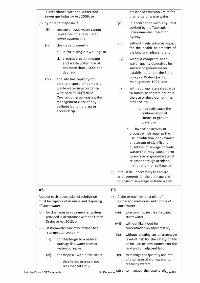
in accordance with the Water and Sewerage Industry Act 2009; or
(d) by onsite disposal if –
(iii) sewage or trade waste cannot be drained to a reticulated sewer system; and
(iv) the development
c. is for a single dwelling; or
d. creates a total sewage and waste water flow of not more than 1,000l per day; and
(iv) the site has capacity for onsite disposal of domestic waste water in accordance with AS/NZS1547:2012 Onsite domestic wastewater management clear of any defined building area or access strip
prescribed emission limits for discharge of waste water;
(vii) in accordance with any limit advised by the Tasmanian Environmental Protection Agency;
(viii) without likely adverse impact for the health or amenity of the land and adjacent land;
(ix) without compromise to water quality objectives for surface or ground water established under the State Policy on Water Quality Management 1997; and
(x) with appropriate safeguards to minimise contamination if the use or development has potential to –
c. indirectly cause the contamination of surface or ground water; or
d. involve an activity or process which requires the use, production, conveyance or storage of significant quantities of sewage or trade waste that may cause harm to surface or ground water if released through accident, malfunction, or spillage; or
(d) It must be unnecessary to require arrangements for the drainage and disposal of sewerage or trade waste.
A5
A site or each lot on a plan of subdivision must be capable of draining and disposing of stormwater –
(c) for discharge to a stormwater system provided in accordance with the Urban Drainage Act 2013; or
(d) if stormwater cannot be drained to a stormwater system –
(iii) for discharge to a natural drainage line, water body, or watercourse; or
(iv) for disposal within the site if –
f. the site has an area of not less than 5000m2;
P5
(c) A site or each lot on a plan of subdivision must drain and dispose of stormwater –
(vii) to accommodate the anticipated stormwater
(viii) without likelihood for concentration on adjacent land;
(ix) without creating an unacceptable level of risk for the safety of life or for use or development on the land and on adjacent land;
(x) to manage the quantity and rate of discharge of stormwater to receiving waters;
(xi) to manage the quality of Latrobe Council OPEN Agenda 14th December, 2015 Page 491
g. the disposal area is not within any defined building area;
h. the disposal area is not within any area required for the disposal of sewage;
i. the disposal area is not within any access strip; and
j. not more than 50% of the site is impervious surface
stormwater discharged to receiving waters; and
(xii) to provide positive drainage away from any sewer pipe, onsite sewage disposal system, or building area; or
(d) It must be unnecessary to require arrangements for the drainage and disposal of stormwater.
32.3.2 Location and configuration of development
Objective The location and configuration of development is to –
(e) provide for the efficient use of land;
(f) provide for buildings, service activity and vehicle parking of suitable size to accommodate use
(g) provide consistency in the apparent scale, bulk, massing and proportion of adjacent buildings; and
(h) minimise unreasonable impact on the amenity of the use on land beyond the
boundaries of the zone.
Acceptable Solution Performance Criteria
A1
Building height must be not be more than
10.0m.
P1
Building height must –
(d) minimise apparent scale, bulk, massing and proportion relative to any adjacent building;
(e) respond to the effect of the slope and orientation of the site; and
(f) provide separation between buildings to attenuate impact.
A2
Development of land with a boundary to a zone must –
(e) be setback from the boundary of land in an adjoining zone by not less than the distance for that zone shown in the Table to this Clause;
(f) not include within the setback area required from a boundary to land in a zone shown in the Table to this Clause –
(vii) a building or work;
(viii) vehicular or pedestrian access from a road;
(ix) vehicle loading or parking area;
(x) an area for the gathering of people, including for
P2
The location of development must –
(c) minimise likelihood for conflict, interference and constraint from use on land in an adjoining zone; and
(d) minimise likely impact on the amenity of use on land in an adjoining zone.
Latrobe Council OPEN Agenda 14th December, 2015 Page 492

entertainment, community event, performance, sport or for a spectator facility;
(xi) a sign orientated to view from land in another zone; or
(xii) external lighting for operational or security purposes; and
(g) a building with an elevation to a zone boundary must be contained within a building envelope determined by –
(iii) the setback distance from the zone boundary as shown in the Table to this clause; and
(iv) projecting upward and away from the zone boundary at an angle of 45
0 above the horizontal from a
wall height of 3.0m at the setback distance from the zone boundary; and
(h) the elevation of a building to a zone boundary must not contain an external opening other than an emergency exit, including a door, window to a habitable room, loading bay, or vehicle entry.
Table to Clause 32.3.2 A2
Adjoining Zone Setback(m)
Light Industrial 5.0
Latrobe Council OPEN Agenda 14th December, 2015 Page 493

Latrobe Council OPEN Agenda 14th December, 2015 Page 494
Latrobe Council OPEN Agenda 14th December, 2015 Page 495
Latrobe Council OPEN Agenda 14th December, 2015 Page 496
Latrobe Council OPEN Agenda 14th December, 2015 Page 497

Latrobe Council OPEN Agenda 14th December, 2015 Page 498
Latrobe Council OPEN Agenda 14th December, 2015 Page 499
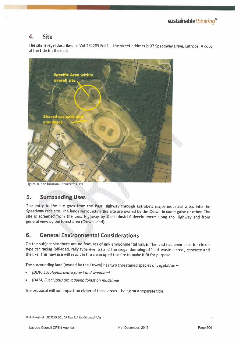
Latrobe Council OPEN Agenda 14th December, 2015 Page 500
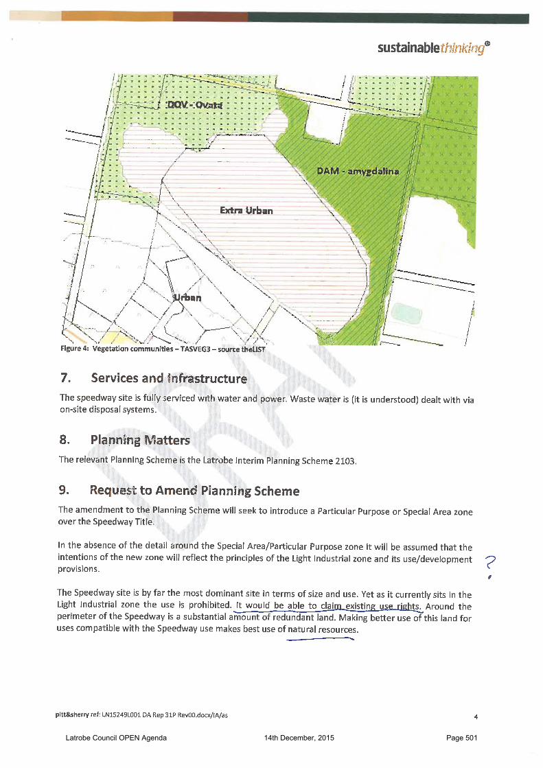
Latrobe Council OPEN Agenda 14th December, 2015 Page 501
Latrobe Council OPEN Agenda 14th December, 2015 Page 502
Latrobe Council OPEN Agenda 14th December, 2015 Page 503
Latrobe Council OPEN Agenda 14th December, 2015 Page 504
Latrobe Council OPEN Agenda 14th December, 2015 Page 505
Latrobe Council OPEN Agenda 14th December, 2015 Page 506
Latrobe Council OPEN Agenda 14th December, 2015 Page 507
Latrobe Council OPEN Agenda 14th December, 2015 Page 508
Latrobe Council OPEN Agenda 14th December, 2015 Page 509

Latrobe Council OPEN Agenda 14th December, 2015 Page 510
Latrobe Council OPEN Agenda 14th December, 2015 Page 511
Latrobe Council OPEN Agenda 14th December, 2015 Page 512
Latrobe Council OPEN Agenda 14th December, 2015 Page 513

Latrobe Council OPEN Agenda 14th December, 2015 Page 514
Latrobe Council OPEN Agenda 14th December, 2015 Page 515
Latrobe Council OPEN Agenda 14th December, 2015 Page 516
Latrobe Council OPEN Agenda 14th December, 2015 Page 517
Latrobe Council OPEN Agenda 14th December, 2015 Page 518
Latrobe Council OPEN Agenda 14th December, 2015 Page 519
Latrobe Council OPEN Agenda 14th December, 2015 Page 520
Latrobe Council OPEN Agenda 14th December, 2015 Page 521

Latrobe Council OPEN Agenda 14th December, 2015 Page 522
Latrobe Council OPEN Agenda 14th December, 2015 Page 523
Latrobe Council OPEN Agenda 14th December, 2015 Page 524

Latrobe Council OPEN Agenda 14th December, 2015 Page 525
Latrobe Council OPEN Agenda 14th December, 2015 Page 526

Latrobe Council OPEN Agenda 14th December, 2015 Page 527
Back to Agenda
Latrobe Council OPEN Agenda 14th December, 2015 Page 528
SUBJECT: CONSENT AGREEMENT – 2 UNIT DEVELOPMENT AT 3 ST GEORGES CRESCENT, SHEARWATER
AUTHOR: STATUTORY PLANNING OFFICER – LEE-ANNE RYAN
DATE: 7 DECEMBER 2015
FILE REF: DA 138/2015
ATTACHMENTS: ORIGINAL PROPOSAL PLANS, REVISED PROPOSAL PLANS,
CONSENT AGREEMENT
1. PURPOSE OF REPORTThe purpose of this report is for Council to consider a consent agreement betweenLatrobe Council, Mr & Mrs B Wylie and Prime Design for a proposed 2 unit grouped housedevelopment at 3 St Georges Crescent, Shearwater.
2. BACKGROUND INFORMATION
Council received an application lodged under Section 57 of The Land Use Planning andApprovals Act 1993 for a proposed 2 unit grouped house development at 3 St GeorgesCrescent, Shearwater on 3 September 2015.As per statutory requirements, the application was advertised on 12 September 2015 andtwo representations were received from Mr & Mrs B Wylie and L Lebski & L Bird, who arethe owners of the adjoining properties at 77 Shearwater Boulevard, Shearwater, and Unit1, 4 St Georges Crescent, Shearwater respectively. Council considered the proposal andthe representations at its meeting held on Monday 12 October 2015 and resolved torefuse the application for the reasons outlined in the Table below:
Grounds of Refusal Clause 10.4.2 : Setbacks and building envelope for all dwellings P3 (a)(i) Impact on residential amenity due to unreasonable loss of
sunlight to a habitable room (dining room) of adjoining dwelling
The applicant lodged an appeal in regard to Council’s decision with the Resource Management and Planning Appeal Tribunal (the Tribunal). Latrobe Council and one ofthe representors, Mr & Mrs Wylie are parties to the appeal.At the Directions Hearing held on 6 November 2015 the Tribunal asked the parties if therewere any likelihood of a mediated outcome. The applicant indicated they were willing toconsider an amendment to the proposal plans and the Council indicated it was willing toreview its decision provided the representors were involved in the mediation process. MsLebski looked at the revised proposal plans submitted and indicated she was nowsatisfied with the proposal, especially as any permit issued would carry a conditionrequiring the windows facing her property to be double glazed and have obscure glazingor screening. Mr & Mrs Wylie joined as a party to the appeal on 12 November 2015.The Tribunal held a Mediation Hearing on 20 November 2015 and the applicant providedthe amended proposal plans for consideration by all parties. Mr & Mrs Wylie were advisedto seek independent advice in regard to the matter by the Tribunal and indicated they maybe willing to consider an amended proposal. A further mediation hearing was proposed.The amended proposal plans were again considered at the Mediation Hearing held on 4December 2015. All parties were asked their opinion of the amended plans and approvalfor the revised development was given by the representors provided the north westerncorner of the proposed additional dwelling is located a minimum of 2.0m away from the
Annexure "P"
Latrobe Council OPEN Agenda 14th December, 2015 Page 529
western title boundary. The applicant agreed to provide an amendment to the proposal plans. Council’s representative was asked their view on the matter and they advised that provided the representor was agreeable Council may be willing to review their decision and sign a consent agreement in regard to the amended proposal. Where consent is reached, the Tribunal requires the preparation of a consent agreement to be signed by all parties and lodgment of this agreement with the Tribunal for their consideration. Where a permit is to be issued, a permit in draft form is to be provided with the consent agreement. Council’s representative stated that the matter would need to go before Council for a decision.
3. COMPLIANCE WITH STRATEGIC PLAN The recommendation provides support to the following objectives of the Latrobe Council ‘Our Place, Our Plan’, A Strategic Direction 2012 - 2017.
To administer and update the Planning Scheme to manage development and land use.
4. FINANCIAL IMPLICATIONS In cases such as this it is usual for all parties to be responsible for their own costs. With regard to the cost for Council it involves staff time to prepare the appropriate documentation.
5. CONSULTATION The Appeal process is a consultative process. The issues concerning the applicant and the representor have been resolved through mediation.
6. STATUTORY REQUIREMENTS The Tribunal has power under Section 17 of the Resource Management and Planning Appeal Tribunal Act 1993, to issue a final decision, where parties have conducted a Section 17 conference (mediation) and agreed to a settlement which the Tribunal is satisfied is appropriate and lawful.
7. OFFICER’S COMMENTS The original proposal triggered the following discretions under the Latrobe Interim Planning Scheme 2013:
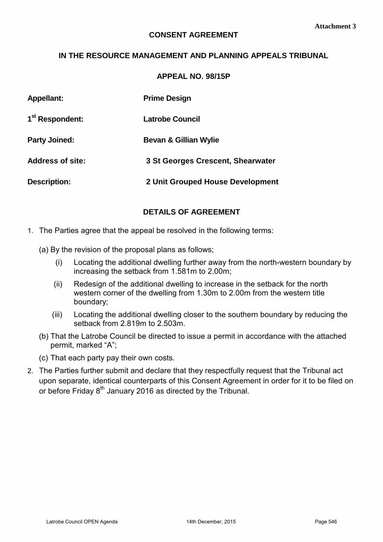
Suitability of Site;
Reduction in setback from side and rear title boundaries; and
Privacy The amendments to the proposal include:
i. Locating the additional dwelling further away from the north-western boundary by increasing the setback from 1.581m to 2.00m;
ii. Redesign of the additional dwelling to increase in the setback for the north western corner of the dwelling from 1.30m to 2.00m from the western title boundary;
iii. Locating the additional dwelling closer to the southern boundary by reducing the setback from 2.819m to 2.503m.
As stated, the revised plans have increased the setback of the additional dwelling from the north-western boundary from the original 1.581m to 2.00m and the north western corner of the dwelling from the western boundary from the original 1.30m to 2.00m. The revised proposal plans do not invoke any additional discretion. The proposal seeks a reduction in the side setback and rear setback for the additional dwelling. The matters that must be considered are:
reduction in sunlight to a habitable room of a dwelling on an adjoining lot; Latrobe Council OPEN Agenda 14th December, 2015 Page 530
overshadowing the private open space of a dwelling on an adjoining lot;
visual impact caused by apparent scale and bulk on an adjoining lot; and
separation is provided between dwellings on adjoining lots that is compatible with the surrounding area.
The additional dwelling is located to the rear of subject site. The north-western corner of the dwelling is setback 2.0m from the north-western title boundary and 2.0m from the western title boundary. Amended shading diagrams submitted during the mediation process are shown in Figures 1 and 2. The shadow diagrams demonstrate that the proposed dwelling has the potential to cast shade onto the dining room of the adjoining dwelling to the west at 9am on 21 June. The lower portion of the dining room window is shaded at 10am and no shadow is cast on the dining room from 11am. The adjoining title to the south contains a shed and landscaped area near the common title boundary. The 0.316m reduction in setback from the southern title boundary will have no greater impact on the private open space area of the adjoining lot to the south than the original proposal. The height of the wall presenting to the western and southern boundaries is only 2.40m. The proposed dwelling has a skillion roof, with a pitch of 5°, which rises from the western title boundary. The proposed dwelling is designed to fit with the sloping nature of the site. The design of the roof minimises the visual impact on adjoining titles. The representors, who are the adjoining owners to the west, have indicated they consent to the revised plans.
Latrobe Council OPEN Agenda 14th December, 2015 Page 531
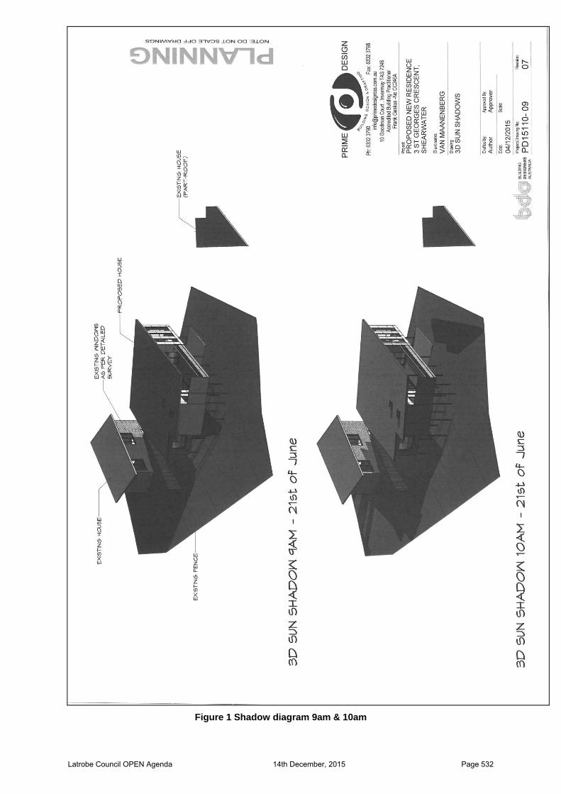
Figure 1 Shadow diagram 9am & 10am
Latrobe Council OPEN Agenda 14th December, 2015 Page 532
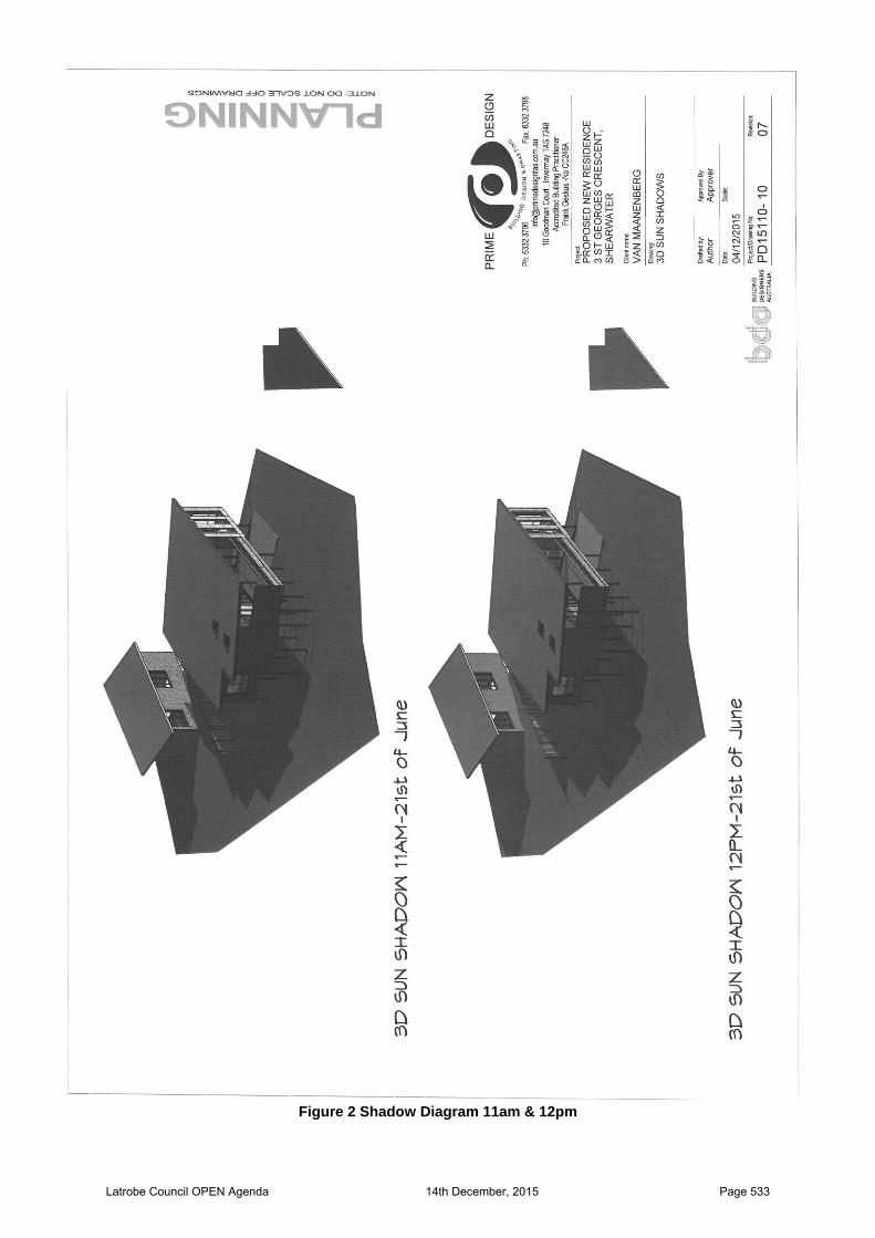
Figure 2 Shadow Diagram 11am & 12pm
Latrobe Council OPEN Agenda 14th December, 2015 Page 533
8. RECOMMENDATION That the report by Council’s Strategic Planning Officer, Lee-Anne Ryan, dated 7 December 2015 concerning a consent agreement in relation to Development Application DA 138/2015 be received and the Council resolve to: A. Endorse a consent agreement, which will include a draft permit for approval of a 2 unit
grouped house development at 3 St Georges Crescent, Shearwater subject to the following conditions: 1. Consent is for the proposed development at 3 St Georges Crescent, Shearwater
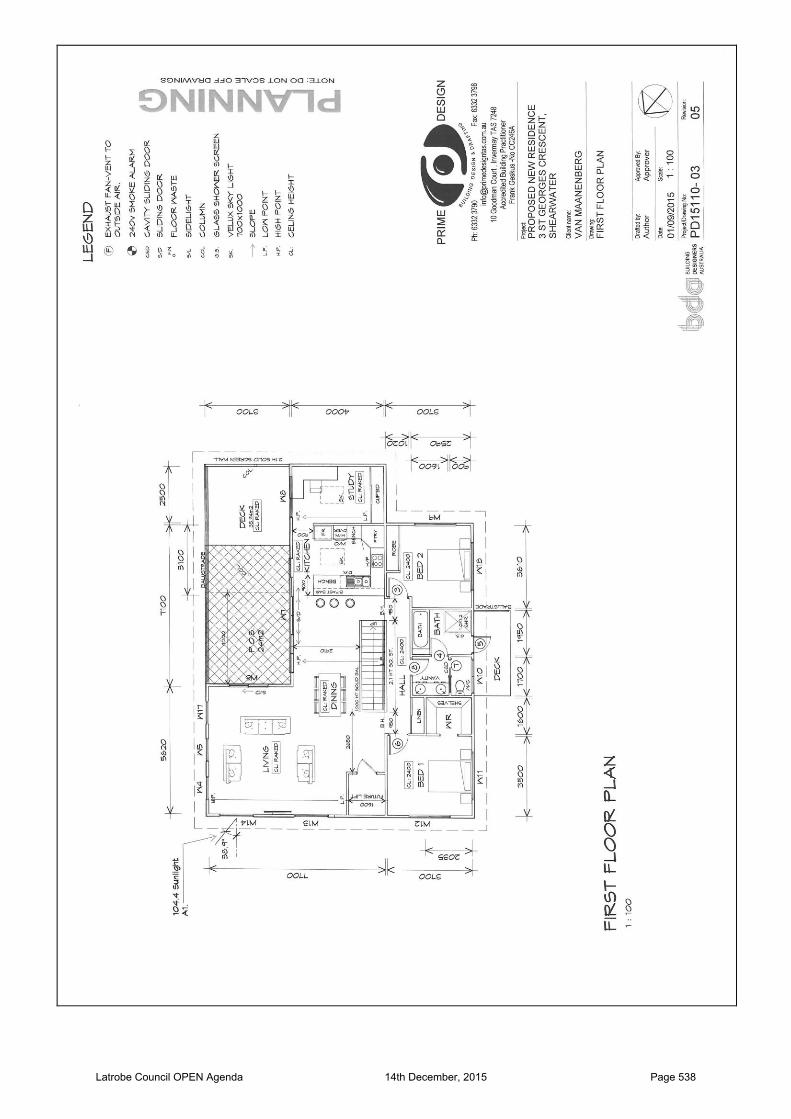
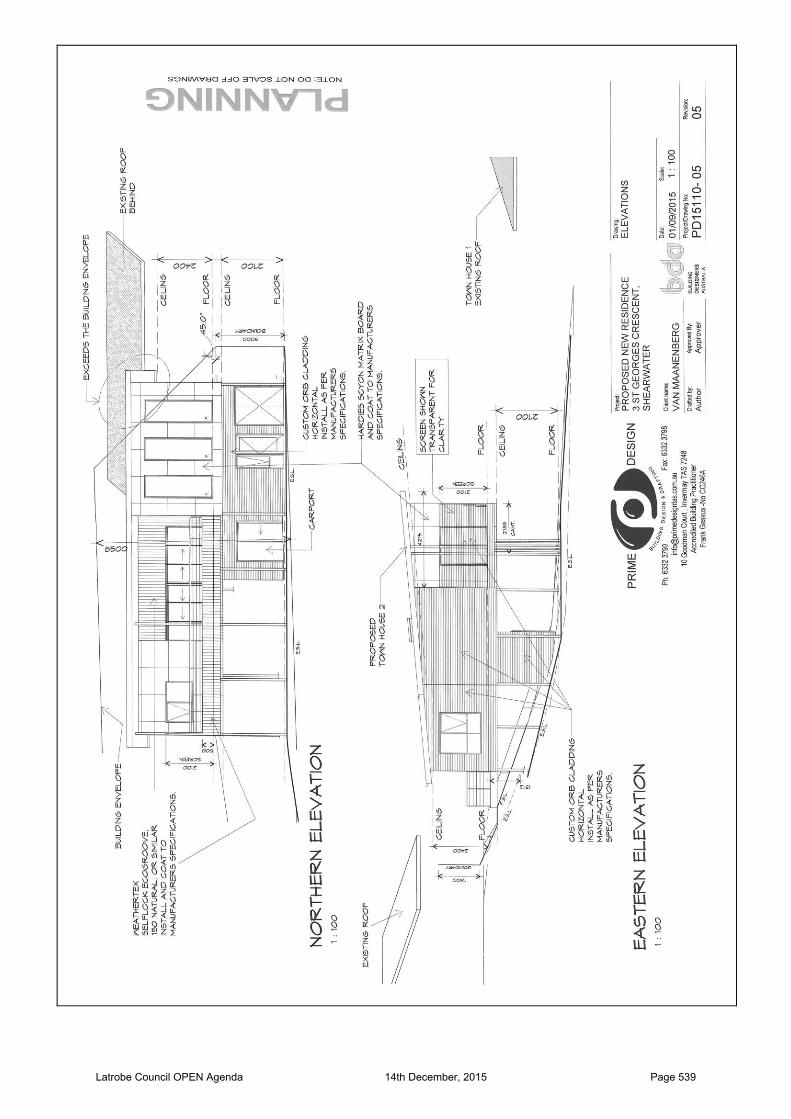
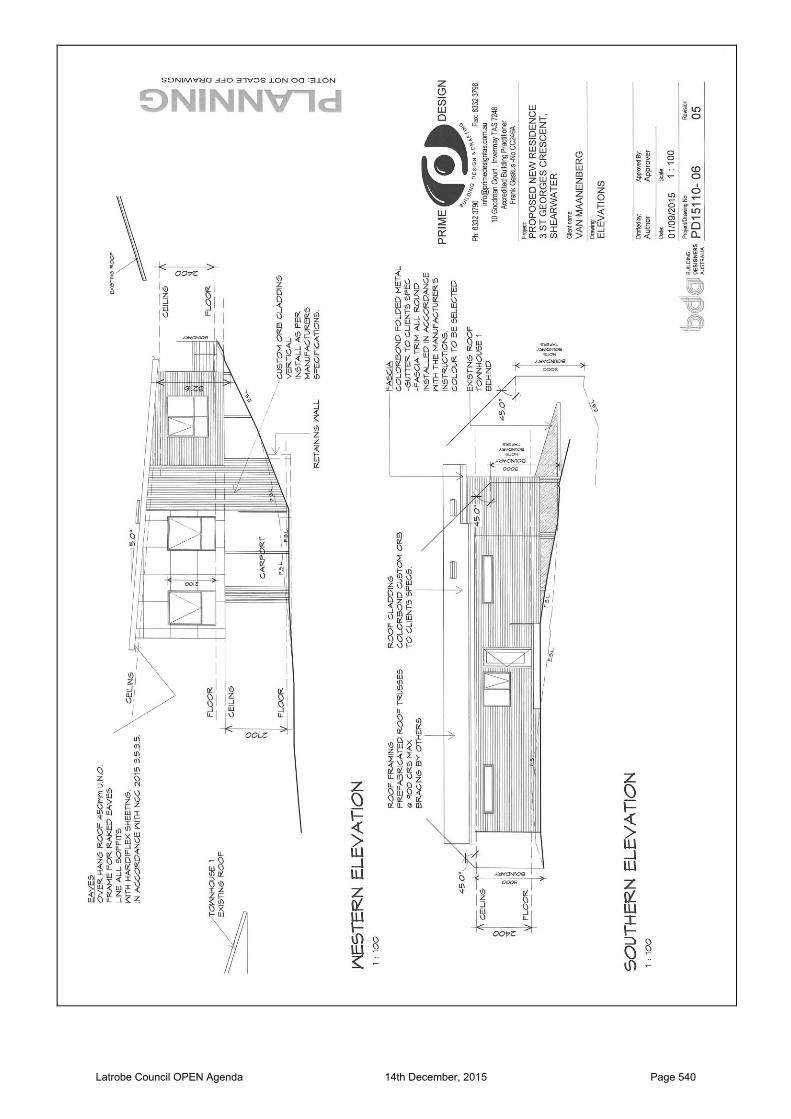
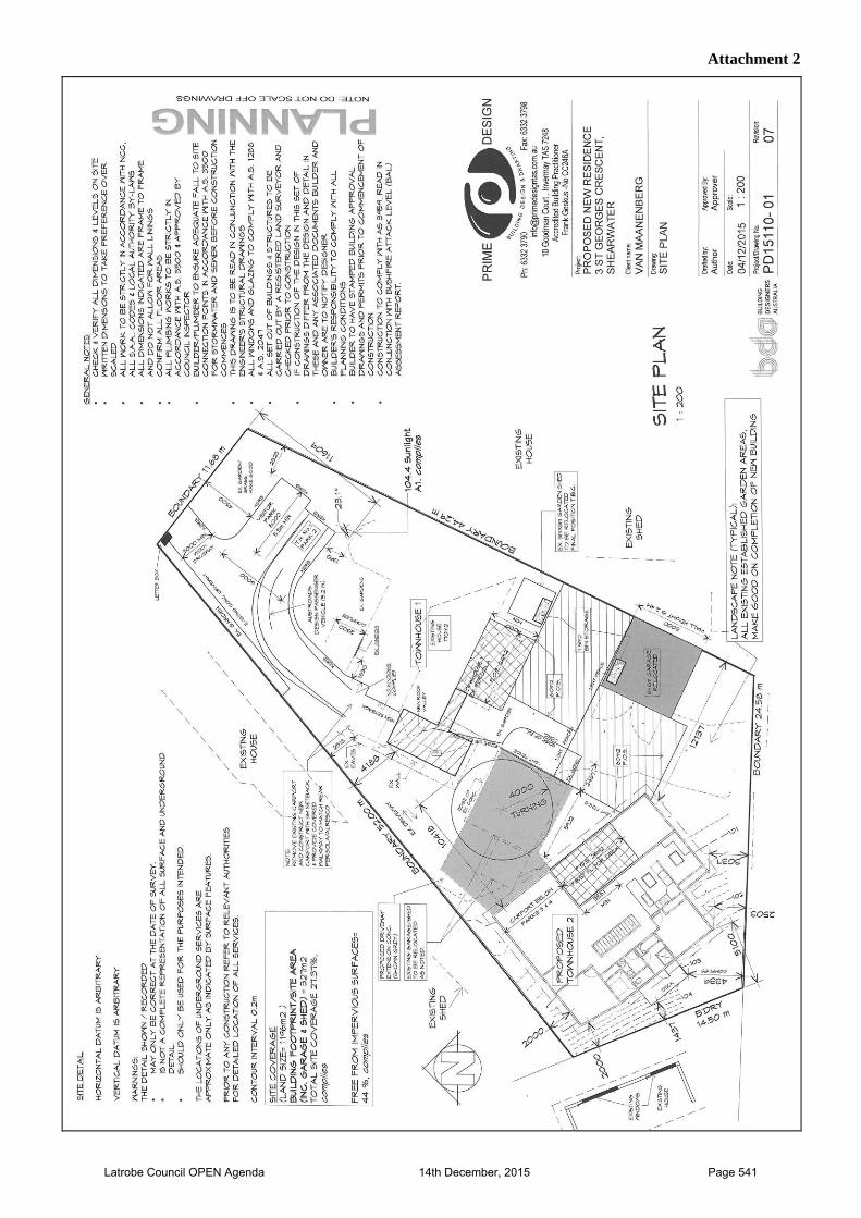
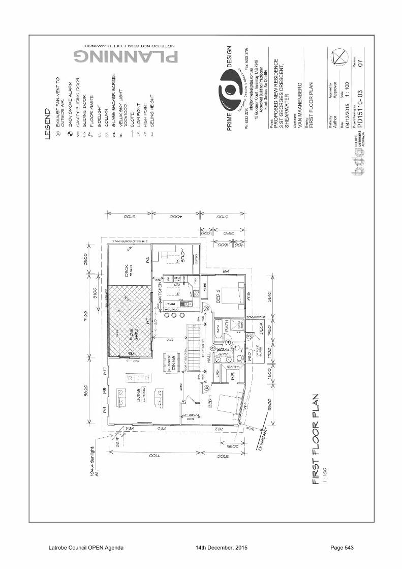
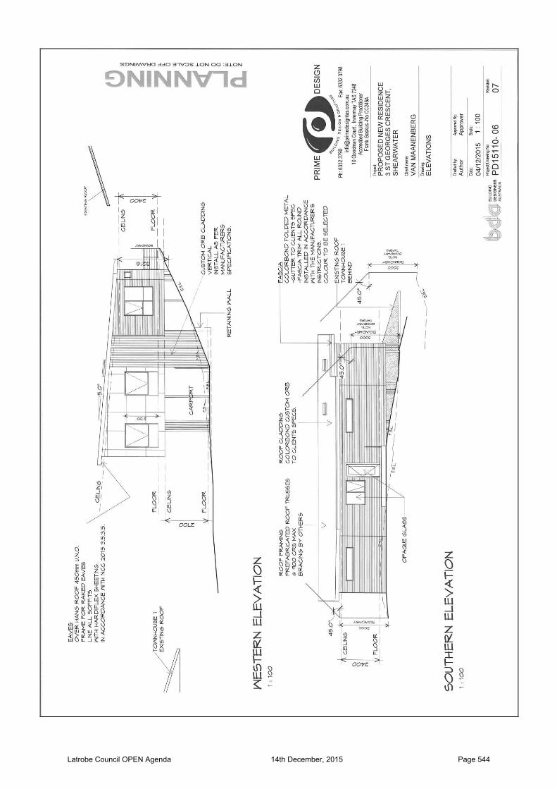
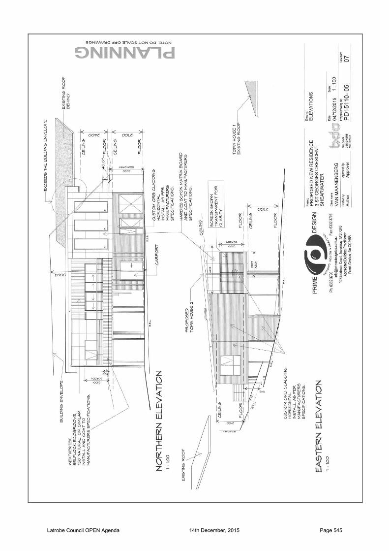
substantially in accordance with endorsed plans, Project No: PD15110-01 Rev. 07, PD15110-02 Rev. 07, PD15110-03 Rev. 07, PD15110-05 Rev. 07 and PD15110-06 Rev. 07.
2. Consent is for the statutory permitted building setback of 4.00m to be reduced to 1.437m for the proposed dwelling from the western title boundary.
3. Consent is for the statutory permitted building setback of 4.00m to be reduced to 2.503m for the proposed dwelling from the southern title boundary.
4. Consent is for the statutory permitted building setback of 5.00m to be reduced to 2.00m for the proposed dwelling from the north-western title boundary.
5. The north facing windows of bedroom 1 and the living room must be double glazed and have obscure glazing or screening.
6. TasWater The developer shall comply with the conditions, which TasWater has required the planning authority to include in the permit in accordance with Section 56P(1) of the Water and Sewerage Industry Act 2008. These conditions are specified in TasWater’s submission to Council, Reference TWDA 2015/01442-LC, a copy of which is attached and endorsed to be a document forming part of this permit.
7. Works Within Road Reservation The existing single 3.6 metre wide driveway located in the road reservation from the edge of existing roadway to the property boundary is to be used as the primary means of accessing for the property. New driveways or alterations/widening to the existing driveway will require Engineering approval. All other works, including any variation to driveway width within the road reservation require engineering approval. With the exception of reshaping and grassing, nature strips are subject to separate Council approval. In such an instance, a plan of all proposed works including all landscaping, drainage and the planting of suitable trees shall be lodged and approved prior to commencing such works. Such works may require the signing of a licence agreement with Council prior to commencement.
8. Stormwater Stormwater discharge from the development and overland flows from the property are to be connected to the existing private stormwater system within the property. Formed surfaces are not to direct water to adjoining properties. The private stormwater system is to be designed by a suitably qualified person in accordance with AS/NZS3500.3. Minor storm events are to be adequately drained from the property, which may require the design and installation of an on-site stormwater detention system in accordance with section 8.11 of AS/NZS3500.3. Major storm events are to have an appropriate overflow path and shall not cause flooding of any new building.
9. Should there be any cut or fill greater than 1.0m in depth or height an application must be lodged with Council for consideration.
Latrobe Council OPEN Agenda 14th December, 2015 Page 534

10. Council will endorse any stratum plan for the development when all the above conditions are completed to Council’s satisfaction, or alternatively, a bond lodged with Council to cover uncompleted works. All bonded works to be completed within 6 months of the stratum plan being endorsed; and
B. Forward the endorsed consent agreement to the Resource Management and Planning Appeals Tribunal for their consideration.
Latrobe Council OPEN Agenda 14th December, 2015 Page 535
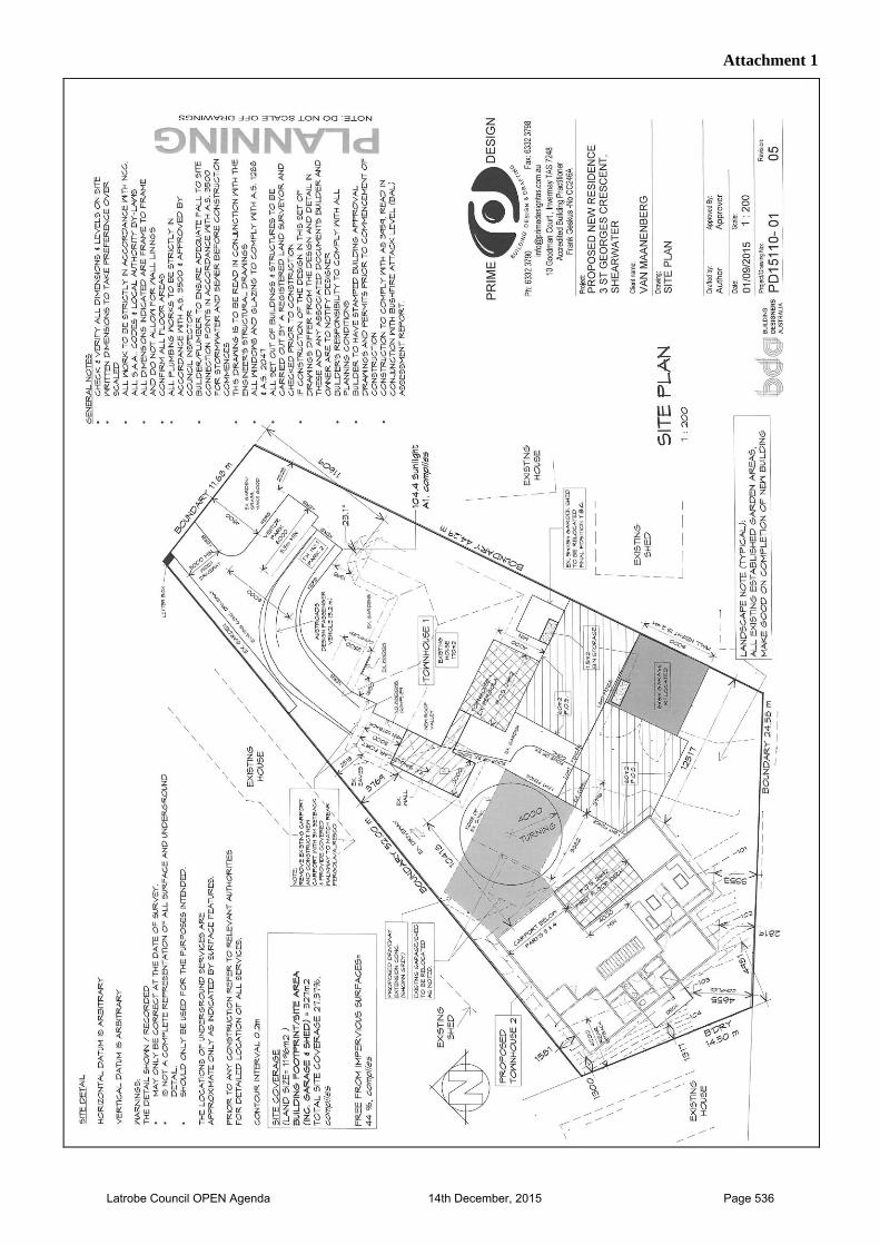
Attachment 1
Latrobe Council OPEN Agenda 14th December, 2015 Page 536
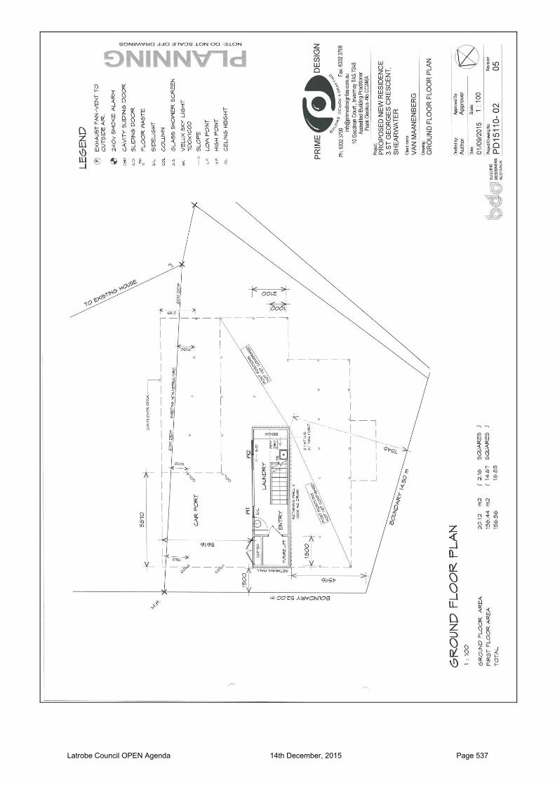
Latrobe Council OPEN Agenda 14th December, 2015 Page 537
Latrobe Council OPEN Agenda 14th December, 2015 Page 538
Latrobe Council OPEN Agenda 14th December, 2015 Page 539
Latrobe Council OPEN Agenda 14th December, 2015 Page 540
Attachment 2
Latrobe Council OPEN Agenda 14th December, 2015 Page 541
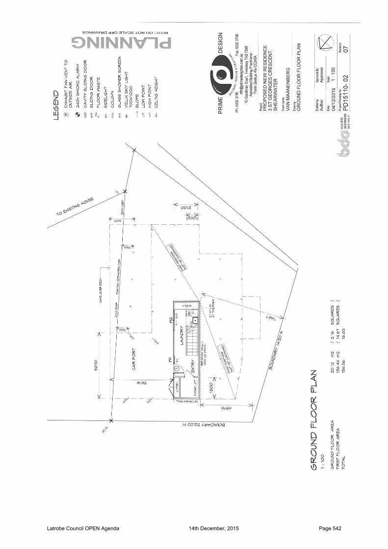
Latrobe Council OPEN Agenda 14th December, 2015 Page 542
Latrobe Council OPEN Agenda 14th December, 2015 Page 543
Latrobe Council OPEN Agenda 14th December, 2015 Page 544
Latrobe Council OPEN Agenda 14th December, 2015 Page 545
Attachment 3
CONSENT AGREEMENT
IN THE RESOURCE MANAGEMENT AND PLANNING APPEALS TRIBUNAL
APPEAL NO. 98/15P
Appellant: Prime Design
1st Respondent: Latrobe Council
Party Joined: Bevan & Gillian Wylie
Address of site: 3 St Georges Crescent, Shearwater
Description: 2 Unit Grouped House Development
DETAILS OF AGREEMENT 1. The Parties agree that the appeal be resolved in the following terms:
(a) By the revision of the proposal plans as follows; (i) Locating the additional dwelling further away from the north-western boundary by
increasing the setback from 1.581m to 2.00m; (ii) Redesign of the additional dwelling to increase in the setback for the north
western corner of the dwelling from 1.30m to 2.00m from the western title boundary;
(iii) Locating the additional dwelling closer to the southern boundary by reducing the setback from 2.819m to 2.503m.
(b) That the Latrobe Council be directed to issue a permit in accordance with the attached permit, marked “A”;
(c) That each party pay their own costs. 2. The Parties further submit and declare that they respectfully request that the Tribunal act
upon separate, identical counterparts of this Consent Agreement in order for it to be filed on or before Friday 8th January 2016 as directed by the Tribunal.
Latrobe Council OPEN Agenda 14th December, 2015 Page 546
Signed:
(Prime Design)
Signed:
(Bevan & Gillian Wylie)
Signed:
(Council)
Date signed:
To: Registrar
Resource Management & Planning Appeals Tribunal GPO Box 2036 HOBART 7001
Latrobe Council OPEN Agenda 14th December, 2015 Page 547

“A”
Planning Permit DA 138/2015
In accordance with Division 2 of the Land Use Planning and Approvals Act 1993, the Latrobe Council (Planning Authority) hereby grants a permit –
To: Prime Design PO Box 3076 LAUNCESTON TAS 7250
ADDRESS OF LAND:
3 ST GEORGES CRESCENT SHEARWATER
THIS PERMIT ALLOWS FOR:
an additional dwelling unit at 3 St Georges Crescent, Shearwater (PID 7375796), in accordance with application DA 138/2015, and subject to the following conditions:
1. Consent is for the proposed development at 3 St Georges Crescent, Shearwater substantially in accordance with endorsed plans, Project No: PD15110-01 Rev. 07, PD15110-02 Rev. 07, PD15110-03 Rev. 07, PD15110-05 Rev. 07 and PD15110-06 Rev. 07.
2. Consent is for the statutory permitted building setback of 4.00m to be reduced to 1.437m for the proposed dwelling from the western title boundary.
3. Consent is for the statutory permitted building setback of 4.00m to be reduced to 2.503m for the proposed dwelling from the southern title boundary.
4. Consent is for the statutory permitted building setback of 5.00m to be reduced to 2.00m for the proposed dwelling from the north-western title boundary.
5. The north facing windows of bedroom 1 and the living room must be double glazed and have obscure glazing or screening.
6. TasWater The developer shall comply with the conditions, which TasWater has required the planning authority to include in the permit in accordance with Section 56P(1) of the Water and Sewerage Industry Act 2008. These conditions are specified in TasWater’s submission to Council, Reference TWDA 2015/01442-LC, a copy of which is attached and endorsed to be a document forming part of this permit.
7. Works Within Road Reservation The existing single 3.6 metre wide driveway located in the road reservation from the edge of existing roadway to the property boundary is to be used as the primary means of accessing for the property. New driveways or alterations/widening to the existing driveway will require Engineering approval. All other works, including any variation to driveway width within the road reservation require engineering approval. With the exception of reshaping and grassing, nature strips are subject to separate Council approval. In such an instance, a plan of all proposed works including all landscaping, drainage and the planting of suitable trees shall be lodged and approved prior to commencing such works. Such works may require the signing of a licence agreement with Council prior to commencement.
Latrobe Interim Planning Scheme 2013
Latrobe Council OPEN Agenda 14th December, 2015 Page 548
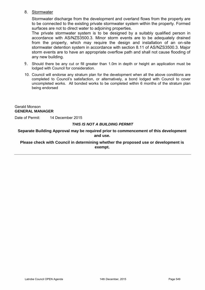
8. Stormwater Stormwater discharge from the development and overland flows from the property are to be connected to the existing private stormwater system within the property. Formed surfaces are not to direct water to adjoining properties. The private stormwater system is to be designed by a suitably qualified person in accordance with AS/NZS3500.3. Minor storm events are to be adequately drained from the property, which may require the design and installation of an on-site stormwater detention system in accordance with section 8.11 of AS/NZS3500.3. Major storm events are to have an appropriate overflow path and shall not cause flooding of any new building.
9. Should there be any cut or fill greater than 1.0m in depth or height an application must be lodged with Council for consideration.
10. Council will endorse any stratum plan for the development when all the above conditions are completed to Council’s satisfaction, or alternatively, a bond lodged with Council to cover uncompleted works. All bonded works to be completed within 6 months of the stratum plan being endorsed
Gerald Monson GENERAL MANAGER
Date of Permit: 14 December 2015
THIS IS NOT A BUILDING PERMIT
Separate Building Approval may be required prior to commencement of this development
and use.
Please check with Council in determining whether the proposed use or development is
exempt.
Latrobe Council OPEN Agenda 14th December, 2015 Page 549
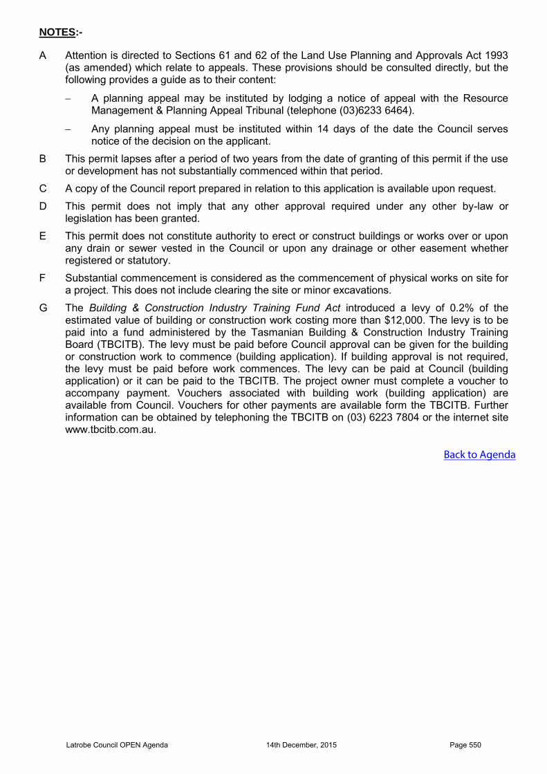
NOTES:-
A Attention is directed to Sections 61 and 62 of the Land Use Planning and Approvals Act 1993(as amended) which relate to appeals. These provisions should be consulted directly, but thefollowing provides a guide as to their content:
A planning appeal may be instituted by lodging a notice of appeal with the ResourceManagement & Planning Appeal Tribunal (telephone (03)6233 6464).
Any planning appeal must be instituted within 14 days of the date the Council servesnotice of the decision on the applicant.
B This permit lapses after a period of two years from the date of granting of this permit if the useor development has not substantially commenced within that period.
C A copy of the Council report prepared in relation to this application is available upon request.
D This permit does not imply that any other approval required under any other by-law orlegislation has been granted.
E This permit does not constitute authority to erect or construct buildings or works over or uponany drain or sewer vested in the Council or upon any drainage or other easement whetherregistered or statutory.
F Substantial commencement is considered as the commencement of physical works on site fora project. This does not include clearing the site or minor excavations.
G The Building & Construction Industry Training Fund Act introduced a levy of 0.2% of the estimated value of building or construction work costing more than $12,000. The levy is to bepaid into a fund administered by the Tasmanian Building & Construction Industry TrainingBoard (TBCITB). The levy must be paid before Council approval can be given for the buildingor construction work to commence (building application). If building approval is not required,the levy must be paid before work commences. The levy can be paid at Council (buildingapplication) or it can be paid to the TBCITB. The project owner must complete a voucher toaccompany payment. Vouchers associated with building work (building application) areavailable from Council. Vouchers for other payments are available form the TBCITB. Furtherinformation can be obtained by telephoning the TBCITB on (03) 6223 7804 or the internet sitewww.tbcitb.com.au.
Back to Agenda
Latrobe Council OPEN Agenda 14th December, 2015 Page 550