SUBDIVISION REVIEW SHEET
12
SUBDIVISION REVIEW SHEET CASE NO.: C8-2019-0112.1A COMMISSION DATE: October 19, 2021 SUBDIVISION NAME: Twilight Gardens ADDRESS: 8316 Twilight Terrace Dr. APPLICANT: Twilight Estates LLC AGENT: Jerome Perales (Perales Land Development LLC) ZONING: SF-1-CO-NP (single family residence) NEIGHBORHOOD PLAN: West Oak Hill AREA: 17.92 acre (780,595.2 sf) LOTS: 19 COUNTY: Travis DISTRICT: 8 WATERSHED: Williamson Creek JURISDICTION: Full Purpose VARIANCES: none DEPARTMENT COMMENTS: The request is for the approval of the Twilight Gardens subdivision composed of 19 lots on 17.92 acres. STAFF RECOMMENDATION: Staff recommends disapproval of the plat for the reasons listed in the comment report dated October 13, 2021, and attached as Exhibit C. The plat does not comply with the criteria for approval in LDC 25-4-84(B) and staff recommends disapproval for the reasons listed in the attached comment report. An application that has been disapproved with reasons may be updated to address those reasons until the application expires. If the applicant submits an update to address the reasons for disapproval, that update will be presented to the Land Use Commission within fifteen days of submittal. CASE MANAGER: Cesar Zavala PHONE: 512-974-3404 E-mail: [email protected] ATTACHMENTS Exhibit A: Vicinity map Exhibit B: Proposed plat Exhibit C: Comment report dated October 13, 2021
Transcript of SUBDIVISION REVIEW SHEET

SUBDIVISION REVIEW SHEET
CASE NO.: C8-2019-0112.1A COMMISSION DATE: October 19, 2021
SUBDIVISION NAME: Twilight Gardens
ADDRESS: 8316 Twilight Terrace Dr.
APPLICANT: Twilight Estates LLC
AGENT: Jerome Perales (Perales Land Development LLC)
ZONING: SF-1-CO-NP (single family residence) NEIGHBORHOOD PLAN: West Oak Hill
AREA: 17.92 acre (780,595.2 sf) LOTS: 19
COUNTY: Travis DISTRICT: 8
WATERSHED: Williamson Creek JURISDICTION: Full Purpose
VARIANCES: none
DEPARTMENT COMMENTS:
The request is for the approval of the Twilight Gardens subdivision composed of 19 lots on 17.92 acres.
STAFF RECOMMENDATION:
Staff recommends disapproval of the plat for the reasons listed in the comment report dated October 13, 2021, and attached as Exhibit C.
The plat does not comply with the criteria for approval in LDC 25-4-84(B) and staff recommends disapproval for the reasons listed in the attached comment report. An application that has been disapproved with reasons may be updated to address those reasons until the application expires. If the applicant submits an update to address the reasons for disapproval, that update will be presented to the Land Use Commission within fifteen days of submittal.
CASE MANAGER: Cesar Zavala PHONE: 512-974-3404 E-mail: [email protected]
ATTACHMENTS Exhibit A: Vicinity map Exhibit B: Proposed plat Exhibit C: Comment report dated October 13, 2021

Location Map
8316 Twilight Terrace Dr, Austin, TX 78737
nelly
Polygonal Line
zavalac
Text Box
EXHIBIT A

15
' S
ID
EW
AL
K
EA
SE
ME
NT
LOT 14
BLOCK C
SHADOWRIDGE CROSSING
SUBDIVISION SECTION 12
(DOC. NO. 200000133 O.P.R.)
LOT 15
BLOCK C
SHADOWRIDGE CROSSING
SUBDIVISION SECTION 12
(DOC. NO. 200000133 O.P.R.)
WATER QUALITY
CONSERVATION
EASEMENT
(DOC.NO. 200000133)
15
' P
UE
S
T
A
R
L
I
G
H
T
D
R
.
5
0
'
R
.
O
.
W
.
WATER QUALITY
CONSERVATION
EASEMENT
(DOC.NO. 200000133)
LOCATION MAPLOCATION MAP
NOT TO SCALE
PROJECT
LOCATION
Date: Jun 23, 2021, 6:15pm User ID: RVenegas
File: S:\Draw 2014\14-148 18 Acres Twilight Terrace Austin TX - TAS\14-148 Twilight Gardens Plat-Updated 2021-05-13.dwg
DRAWN BY: RV
PAGE 1 OF 3
STATE OF TEXAS
COUNTY OF BEXAR
I HEREBY CERTIFY THAT THE ABOVE PLAT CONFORMS TO THE MINIMUM
STANDARDS SET FORTH BY THE TEXAS BOARD OF PROFESSIONAL
LAND SURVEYING ACCORDING TO AN ACTUAL SURVEY MADE ON THE
GROUND.
.
TERESA A. SEIDEL
REGISTERED PROFESSIONAL LAND SURVEYOR NO. 5672
KFW SURVEYING, LLC
3421 PAESANOS PKWY, SUITE 101
SAN ANTONIO, TEXAS 78231
PHONE: 210-979-8444
FAX: 210-979-8441
STATE OF TEXAS
COUNTY OF TRAVIS
THAT SEVEN HOMES LLC. BEING OWNER OF A 10.002 ACRE TRACT OF LAND AND A 7.989
ACRE TRACT OF LAND CONVEYED BY DEED OF RECORD IN DOCUMENT 2015025092 OF
THE OFFICIAL PUBLIC RECORDS OF TRAVIS COUNTY, TEXAS.
SAID A 10.002 ACRE TRACT OF LAND, OUT OF THE JESSE WILLIAMS SURVEY NO. 62,
ABSTRACT 788 AND PREVIOUSLY BEING ALL OF A 10.00 ACRE TRACT OF LAND CONVEYED
TO J.R. & MARJORIE JO RUDOLPH OF RECORD IN VOLUME 2475 PAGE 509 OF THE OFFICIAL
PUBLIC RECORDS OF TRAVIS COUNTY, TEXAS, BEING CALLED TRACT 1 AND A 7.989 ACRE
TRACT OF LAND, PREVIOUSLY BEING ALL OF A 8.00 ACRE TRACT OF LAND CONVEYED TO
J.R. & MARJORIE JO RUDOLPH OF RECORD IN VOLUME 2714 PAGE 275 OF THE OFFICIAL
PUBLIC RECORDS OF TRAVIS COUNTY, TEXAS, BEING CALLED TRACT 2;
DO HEREBY SUBDIVIDE 17.991 ACRES IN ACCORDANCE WITH THE MAP OR PLAT
ATTACHED HERETO, TO BE KNOWS AS
TWILIGHT GARDENS
AND DO HEREBY DEDICATE TO THE PUBLIC THE USE OF ALL STREETS AND EASEMENT
SHOWN HEREON, SUBJECT TO ANY AND ALL EASEMENTS OR RESTRICTIONS
HERETOFORE GRANTED AND NOT RELEASED.
.
OWNER:
.
DULY AUTHORIZED AGENT
STATE OF TEXAS
COUNTY OF TRAVIS:
BEFORE ME, THE UNDERSIGNED AUTHORITY ON THIS DAY PERSONALLY APPEARED
, KNOWN TO ME TO BE THE PERSON WHOSE NAME IS SUBSCRIBED
TO THE FOREGOING INSTRUMENT, AND ACKNOWLEDGED TO ME THAT HE EXECUTED THE
SAME FOR THE PURPOSES AND CONSIDERATIONS THEREIN EXPRESSED AND IN THE
CAPACITY THEREIN STATED.
WITNESS MY HAND AND SEAL IN MY OFFICE
THIS DAY OF A.D. .
.
NOTARY PUBLIC, STATE OF TEXAS
= FOUND
1
2
" IRON ROD
= SET
1
2
" IRON ROD WITH BLUE CAP
STAMPED "KFW SURVEYING"
= RIGHT-OF-WAY
= CRITICAL WATER QUALITY ZONE
= WATER QUALITY TRANSITION ZONE
= EROSION HAZARD ZONE
LEGEND
OWNER/DEVELOPER:
ESSEN-PARMER LLC.
R. CRAIG SMITH
5153 BLUE BONNET BLVD.
BATON ROUGE, LA 70809
PHONE: (225)-769-2950
AREA BEING PLATTED
A 17.991 ACRE TRACT OF LAND OUT OF THE JESSE WILLIAMS SURVEY NO. 62, ABSTRACT
788 AND BEING COMPRISED OF A 10.002 ACRE TRACT OF LAND AND A 7.989 ACRE TRACT
OF LAND CONVEYED TO SEVEN HOMES LLC OF RECORD IN DOCUMENT 2015025092 OF
THE OFFICIAL PUBLIC RECORDS OF TRAVIS COUNTY, TEXAS.
THIS SUBDIVISION PLAT IS LOCATED WITHIN THE FULL PURPOSE CITY LIMITS OF THE CITY
OF AUSTIN ON THIS THE ___ DAY OF ___________________, 2017, A.D.
APPROVED, ACCEPTED AND AUTHORIZED FOR RECORD BY THE DIRECTOR,
DEVELOPMENT SERVICES DEPARTMENT, CITY OF AUSTIN, COUNTY OF TRAVIS, TEXAS,
THIS THE ___ DAY OF _________________, 2017, A.D.
.
J. RODNEY GONZALES, DIRECTOR
DEVELOPMENT SERVICES DEPARTMENT
STATE OF TEXAS:COUNTY OF TRAVIS:
I, DANA DE BEAUVOIR, CLERK OF TRAVIS COUNTY, TEXAS, DO HEREBY CERTIFY THAT THEFOREGOING INSTRUMENT OF WRITING AND ITS CERTIFICATE OF AUTHENTICATION WAS FILEDFOR RECORD IN MY OFFICE ON THE ___ DAY OF ____________, 2017, A.D. AT _____O'CLOCK_______. PLAT RECORDS OF SAID COUNTY AND STATE IN DOCUMENT NUMBER____________________, OFFICIAL PUBLIC RECORDS OF TRAVIS COUNTY, TEXAS.
WITNESS MY HAND AND SEAL OF OFFICE OF THE COUNTY CLERK, THIS _____DAY OF_____________, 2017, A.D..
DANA DE BEAUVOIR, COUNTY CLERKTRAVIS COUNTY, TEXAS
_______________________DEPUTY
CASE NO: ...
F.I.R.
S.I.R.
R.O.W.
PLAT PREPARATION DATE: SEPTEMBER 18, 2020
APPLICATION SUBMITTAL DATE: _____________
TWILIGHT GARDENS
PLAT OF A 17.991 ACRE TRACT OF LAND
COMPRISED OF A 10.002 ACRE TRACT OF LAND
AND A 7.989 ACRE TRACT OF LAND
3421 Paesanos Pkwy, Suite 101, San Antonio, TX 78231
Phone #: (210) 979-8444 • Fax #: (210) 979-8441
TBPLS Firm #: 10122300
F
.
M
.
1
8
2
8
HIG
HW
AY
290
T
W
I
L
I
G
H
TM
E
S
A
D
R
.
CWQZ
WQTZ
EHZ
NOT TO SCALE
PAGE INDEX
AREA BEING REPLATTED
THE 1.046 ACRE AREA BEING REPLATTED WAS
PREVIOUSLY PLATTED AS A 1.046 ACRE RIGHT-OF-WAY
FROM THE SHADOWRIDGE CROSSING SECTION 12 OF
RECORD IN DOCUMENT NO. 200000133 OF THE OFFICIAL
PUBLIC RECORDS OF TRAVIS COUNTY, TEXAS
PLAT NOTES APPLY TO ALL PAGES
OF THIS MULTIPLE PAGE PLAT
PAGE 3
PAGE 2
ENGINEERS CERTIFICATION:
THIS IS TO CERTIFY THAT: I, JERRY PERALES, P.E. AM AUTHORIZED
UNDER THE LAWS OF THE STATE OF TEXAS TO PRACTICE THE
PROFESSION OF ENGINEERING AND HEREBY CERTIFY THAT THIS PLAT
IS FEASABLE FROM AN ENGINEERING STANDPOINT AND COMPLIES
WITH THE ENGINEERING RELATED POTIONS OF TITLE 25 OF THE CITY
OF AUSTIN LAND DEVELOPMENT CODE, AND IS TRUE AND CORRECT TO
THE BEST OF MY KNOWLEDGE.
.
JEROME PERALES, P.E. 94676
PERALES LAND DEVELOPMENT, LLC
FIRM REGISTRATION F-20933
8705 SHOAL CREEK, BLVD. SUITE 213
(512) 297-5019
SURVEYOR NOTES:
1. BEARINGS ARE BASED ON THE STATE PLANE
COORDINATE SYSTEM ESTABLISHED FOR THE TEXAS
CENTRAL ZONE 4203, NORTH AMERICAN DATUM (NAD) OF
1983.
2. THE COORDINATES SHOWN HEREON ARE GRID WITH A
COMBINED SCALE FACTOR OF 1.000064792
3. THE ELEVATIONS FOR THIS SURVEY ARE BASED ON
NAVD88 (GEOID12A).
4. ACCORDING TO THE FEMA FLOOD INSURANCE RATE MAP
FOR TRAVIS COUNTY, TEXAS, MAP NO. 48453C0560J,
EFFECTIVE DATED JANUARY 22, 2020, NO DELINEATION
OF THE 100-YEAR FLOODPLAIN HAS BEEN DETERMINED.
ALL PROPOSED RESIDENTIAL LOTS APPEAR TO BE
OUTSIDE THE 100-YEAR FLOODPLAIN. LOT 12 (PARKLAND
DEDICATED TO THE CITY OF AUSTIN) IS POTENTIALLY
LOCATED IN THE 100-YEAR FLOODPLAIN, KINCHEON
BRANCH OF WILLIAMSON CREEK TRAVERSES THROUGH
THIS LOT.
5. SET IRON PINS ARE 1/2" DIAMETER REBAR WITH A BLUE
CAP STAMPED "KFW SURVEYING" UNLESS OTHERWISE
NOTED.
zavalac
Text Box
EXHIBIT B

85.22'
50.0'
5.119 ACRE TRACT
AILEEN M. HOOKS AND RAY N. DONLEY
(VOLUME 12604 PAGE 984 O.P.R.)
LOT 23
BLOCK "A"
DRAINAGE & WATER QUALITY EASEMENT
HEIGHTS AT LOMA VISTA
(DOC. NO. 200300255 O.P.R.)
SHADOWRIDGE CROSSING
SUBDIVISION SECTION 12
(DOC. NO. 200000133 O.P.R.)
LOT 3
GREENBELT, WATER QUALITY
DRAINAGE & PUBLIC UTILITY
EASEMENT
LOT 15
LOT 14
LOT 12
LOT 13
WATER QUALITY
CONSERVATION
EASEMENT
NO. 200000133)
LOT 24
25' DRAINAGE
EASEMENT
(VOLUME 96 PAGE
116-118 D.P.R.)
BLOCK B
SHADOWRIDGE
CROSSING
SUBDIVISION SECTION 9
(VOLUME 96 PAGES
116-118 D.P.R.)
WATER QUALITY & DETENTION EASEMENT
(DOC. NO. 201300113 O.P.R.)
30' INGRESS AND
EGRESS EASEMENT
(VOLUME 2714 PAGE 275 O.P.R.)
10
9
8
7
6
5
4
3
2
19
18
17
16
15
14
11
S2
7° 3
8' 0
4"W
4
21
.4
3'
N2
7° 3
8' 0
4"E
4
40
.1
7'
C
1
2
C1
3
L10
30' INGRESS AND EGRESS EASEMENT
(VOLUME 2475 PAGE 509 O.P.R.)
S28° 18' 36"W
1205.20'
N62° 50' 43"W 638.17'
N28° 18' 37"E
1251.33'
8
7
.
2
9
'
S58° 4
2' 2
2"E
638.9
0'
L1
C
1
C2
C
3
C
4
C
5
C
6
C
8
C
9
C
1
1
C
1
4
W
QT
Z
E
H
Z
C
W
Q
Z
W
Q
T
Z
EH
Z
C
W
Q
Z
C
W
Q
Z
C
W
Q
Z
EH
Z
E
H
Z
E
H
Z
E
H
Z
1.000 ACRE
LEON GRIFFIN
(DOC. NO. 2001016079
O.P.R.)
C
7
C
1
0
S61° 39' 22"E 268.04'
303.46'
304.30'
305.15'
305.99'
306.83'
S61° 39' 22"E 307.66'
S61° 41' 24"E 242.36'
259.08'
258.08'
257.09'
256.09'
S61° 41' 24"E 255.08'
L
2
301.9
7'
286.8
3'
29.23'
70.90'
71.09'
71.29'
71.49'
71.69'
75.61'
85.40'
86.98'
84.51'
84.23'
84.55'
84.89'
85
.2
2'
84
.9
0'
84
.5
6'
84
.2
4'
57
.7
0'
71
.7
0'
71
.4
9'
71
.2
9'
71
.0
9'
70
.9
0'
68
.8
4'
10
3
.2
3
'
4
8
.
9
5
'
1
2
0
.8
5'
1
0
0
.
3
6
'
1
4
9
.
0
5
'
50.31'
L7
N
2
9
°
3
6
'
4
9
"
W
4
2
8
.
5
9
'
50.1
0'
5
0
.
0
'
6
0
.
0
'
6
0
.0
'
1
16.67'
6
4
.0
8
'
13.05'
14.85'
S57° 0
2' 1
1"E
319.1
3'
S58° 5
4' 0
1"E
104.0
4'
S
4
1
°
2
4
'
3
6
"
E
1
7
7
.
0
2
'
S28° 18' 37"W
180.03'
15.02'
301.2
1'
259.4
4'
ST
AR
RY
S
KY
C
T.
50' R
.O
.W
.
13
L
3
S23° 14' 08"W
168.35'
L
4
S
4
°
4
9
'
5
4
"
E
1
6
7
.
5
9
'
S
T
A
R
L
IG
H
T
D
R
.
5
0
' R
.O
.W
.
LOT 1
DRAINAGE LOT AND
DRAINAGE EASEMENT
LOT 13
DRAINAGE LOT AND
DRAINAGE EASEMENT
LOT 13
DRAINAGE EASEMENT
AND DRAINAGE LOT
W
QT
Z
DR
AINAG
E EASEM
ENT
D
R
A
IN
A
G
E
E
A
S
E
M
E
N
T
12
(PARKLAND DEDICATED
TO THE CITY OF AUSTIN)
S28° 18' 37"W
258.05'
63.3
9'
S28° 18' 36"W
367.74'
156.22'
5
0
.32'
15
' P
UE
15
' P
UE
50
' P
UE
50
' P
UE
24
.8
2'
15
' S
ID
EW
AL
K
EA
SE
ME
NT
N
4
5
°
0
0
' 2
7
"
W
2
4
9
.0
8
'
L
8
193.43'
N28° 18' 37"E
216.23'
192.62'
1
0
0
Y
R
.
F
L
O
O
D
P
L
A
I
N
100 YR
. FLO
OD
PLA
IN
1
0
0
Y
R
.
F
L
O
O
D
P
L
A
I
N
100 YR. FULLY
DEVELOPED FLO
ODPLAIN
5' SIDEWALK
5' SIDEWALK
5' S
ID
EW
ALK
EA
SE
ME
NT
S
4
4
°
2
2
'
4
9
"
E
1
7
7
.
8
4
'
11' P
U
E
1
1
' P
U
E
L6
11' PUE
11' PUE
L5
S
7
7
°
5
0
' 2
1
"
E
2
0
9
.2
0
'
S59° 36' 04"E 244.88'
C
W
Q
Z
N62° 50' 43"W
134.62'
L
1
4
L
1
3
L12
L
1
1
CW
QZ
27.0'
LOCATION MAPLOCATION MAP
NOT TO SCALE
PROJECT
LOCATION
Date: Jun 23, 2021, 6:11pm User ID: RVenegas
File: S:\Draw 2014\14-148 18 Acres Twilight Terrace Austin TX - TAS\14-148 Twilight Gardens Plat-Updated 2021-05-13.dwg
DRAWN BY: RV
PAGE 2 OF 3
STATE OF TEXAS
COUNTY OF BEXAR
I HEREBY CERTIFY THAT THE ABOVE PLAT CONFORMS TO THE MINIMUM
STANDARDS SET FORTH BY THE TEXAS BOARD OF PROFESSIONAL
LAND SURVEYING ACCORDING TO AN ACTUAL SURVEY MADE ON THE
GROUND.
.
TERESA A. SEIDEL
REGISTERED PROFESSIONAL LAND SURVEYOR NO. 5672
KFW SURVEYING, LLC
3421 PAESANOS PKWY, SUITE 101
SAN ANTONIO, TEXAS 78231
PHONE: 210-979-8444
FAX: 210-979-8441
STATE OF TEXAS
COUNTY OF TRAVIS
THAT SEVEN HOMES LLC. BEING OWNER OF A 10.002 ACRE TRACT OF LAND AND A 7.989
ACRE TRACT OF LAND CONVEYED BY DEED OF RECORD IN DOCUMENT 2015025092 OF
THE OFFICIAL PUBLIC RECORDS OF TRAVIS COUNTY, TEXAS.
SAID A 10.002 ACRE TRACT OF LAND, OUT OF THE JESSE WILLIAMS SURVEY NO. 62,
ABSTRACT 788 AND PREVIOUSLY BEING ALL OF A 10.00 ACRE TRACT OF LAND CONVEYED
TO J.R. & MARJORIE JO RUDOLPH OF RECORD IN VOLUME 2475 PAGE 509 OF THE OFFICIAL
PUBLIC RECORDS OF TRAVIS COUNTY, TEXAS, BEING CALLED TRACT 1 AND A 7.989 ACRE
TRACT OF LAND, PREVIOUSLY BEING ALL OF A 8.00 ACRE TRACT OF LAND CONVEYED TO
J.R. & MARJORIE JO RUDOLPH OF RECORD IN VOLUME 2714 PAGE 275 OF THE OFFICIAL
PUBLIC RECORDS OF TRAVIS COUNTY, TEXAS, BEING CALLED TRACT 2;
DO HEREBY SUBDIVIDE 17.991 ACRES IN ACCORDANCE WITH THE MAP OR PLAT
ATTACHED HERETO, TO BE KNOWS AS
TWILIGHT GARDENS
AND DO HEREBY DEDICATE TO THE PUBLIC THE USE OF ALL STREETS AND EASEMENT
SHOWN HEREON, SUBJECT TO ANY AND ALL EASEMENTS OR RESTRICTIONS
HERETOFORE GRANTED AND NOT RELEASED.
.
OWNER:
.
DULY AUTHORIZED AGENT
STATE OF TEXAS
COUNTY OF TRAVIS:
BEFORE ME, THE UNDERSIGNED AUTHORITY ON THIS DAY PERSONALLY APPEARED
, KNOWN TO ME TO BE THE PERSON WHOSE NAME IS SUBSCRIBED
TO THE FOREGOING INSTRUMENT, AND ACKNOWLEDGED TO ME THAT HE EXECUTED THE
SAME FOR THE PURPOSES AND CONSIDERATIONS THEREIN EXPRESSED AND IN THE
CAPACITY THEREIN STATED.
WITNESS MY HAND AND SEAL IN MY OFFICE
THIS DAY OF A.D. .
.
NOTARY PUBLIC, STATE OF TEXAS
OWNER/DEVELOPER:
ESSEN-PARMER LLC.
R. CRAIG SMITH
5153 BLUE BONNET BLVD.
BATON ROUGE, LA 70809
PHONE: (225)-769-2950
AREA BEING PLATTED
A 17.991 ACRE TRACT OF LAND OUT OF THE JESSE WILLIAMS SURVEY NO. 62, ABSTRACT
788 AND BEING COMPRISED OF A 10.002 ACRE TRACT OF LAND AND A 7.989 ACRE TRACT
OF LAND CONVEYED TO SEVEN HOMES LLC OF RECORD IN DOCUMENT 2015025092 OF
THE OFFICIAL PUBLIC RECORDS OF TRAVIS COUNTY, TEXAS.
THIS SUBDIVISION PLAT IS LOCATED WITHIN THE FULL PURPOSE CITY LIMITS OF THE CITY
OF AUSTIN ON THIS THE ___ DAY OF ___________________, 2017, A.D.
APPROVED, ACCEPTED AND AUTHORIZED FOR RECORD BY THE DIRECTOR,
DEVELOPMENT SERVICES DEPARTMENT, CITY OF AUSTIN, COUNTY OF TRAVIS, TEXAS,
THIS THE ___ DAY OF _________________, 2017, A.D.
.
J. RODNEY GONZALES, DIRECTOR
DEVELOPMENT SERVICES DEPARTMENT
STATE OF TEXAS:COUNTY OF TRAVIS:
I, DANA DE BEAUVOIR, CLERK OF TRAVIS COUNTY, TEXAS, DO HEREBY CERTIFY THAT THEFOREGOING INSTRUMENT OF WRITING AND ITS CERTIFICATE OF AUTHENTICATION WAS FILEDFOR RECORD IN MY OFFICE ON THE ___ DAY OF ____________, 2017, A.D. AT _____O'CLOCK_______. PLAT RECORDS OF SAID COUNTY AND STATE IN DOCUMENT NUMBER____________________, OFFICIAL PUBLIC RECORDS OF TRAVIS COUNTY, TEXAS.
WITNESS MY HAND AND SEAL OF OFFICE OF THE COUNTY CLERK, THIS _____DAY OF_____________, 2017, A.D..
DANA DE BEAUVOIR, COUNTY CLERKTRAVIS COUNTY, TEXAS
_______________________DEPUTY
CASE NO: ...
PLAT PREPARATION DATE: AUGUST 18, 2020
APPLICATION SUBMITTAL DATE: __________
0'
SCALE : 1''=100'
100'
200'
300'
TWILIGHT GARDENS
PLAT OF A 17.991 ACRE TRACT OF LAND
COMPRISED OF A 10.002 ACRE TRACT OF LAND
AND A 7.989 ACRE TRACT OF LAND
3421 Paesanos Pkwy, Suite 101, San Antonio, TX 78231
Phone #: (210) 979-8444 • Fax #: (210) 979-8441
TBPLS Firm #: 10122300
F
.
M
.
1
8
2
8
HIG
HW
AY
290
T
W
I
L
I
G
H
TM
E
S
A
D
R
.
MA
TC
H LIN
E S
EE
S
HE
ET
2 O
F 2
= FOUND
1
2
" IRON ROD
= SET
1
2
" IRON ROD WITH BLUE CAP
STAMPED "KFW SURVEYING"
= RIGHT-OF-WAY
= CRITICAL WATER QUALITY ZONE
= WATER QUALITY TRANSITION ZONE
= EROSION HAZARD ZONE
LEGEND
F.I.R.
S.I.R.
R.O.W.
CWQZ
WQTZ
EHZ
ENGINEERS CERTIFICATION:
THIS IS TO CERTIFY THAT: I, JERRY PERALES, P.E. AM AUTHORIZED
UNDER THE LAWS OF THE STATE OF TEXAS TO PRACTICE THE
PROFESSION OF ENGINEERING AND HEREBY CERTIFY THAT THIS PLAT
IS FEASABLE FROM AN ENGINEERING STANDPOINT AND COMPLIES
WITH THE ENGINEERING RELATED POTIONS OF TITLE 25 OF THE CITY
OF AUSTIN LAND DEVELOPMENT CODE, AND IS TRUE AND CORRECT TO
THE BEST OF MY KNOWLEDGE.
.
JEROME PERALES, P.E. 94676
PERALES LAND DEVELOPMENT, LLC
FIRM REGISTRATION F-20933
8705 SHOAL CREEK, BLVD. SUITE 213
(512) 297-5019
SURVEYOR NOTES:
1. BEARINGS ARE BASED ON THE STATE PLANE
COORDINATE SYSTEM ESTABLISHED FOR THE TEXAS
CENTRAL ZONE 4203, NORTH AMERICAN DATUM (NAD) OF
1983.
2. THE COORDINATES SHOWN HEREON ARE GRID WITH A
COMBINED SCALE FACTOR OF 1.000064792
3. THE ELEVATIONS FOR THIS SURVEY ARE BASED ON
NAVD88 (GEOID12A).
4. ACCORDING TO THE FEMA FLOOD INSURANCE RATE MAP
FOR TRAVIS COUNTY, TEXAS, MAP NO. 48453C0560J,
EFFECTIVE DATED JANUARY 22, 2020, NO DELINEATION
OF THE 100-YEAR FLOODPLAIN HAS BEEN DETERMINED.
ALL PROPOSED RESIDENTIAL LOTS APPEAR TO BE
OUTSIDE THE 100-YEAR FLOODPLAIN. LOT 12 (PARKLAND
DEDICATED TO THE CITY OF AUSTIN) IS POTENTIALLY
LOCATED IN THE 100-YEAR FLOODPLAIN, KINCHEON
BRANCH OF WILLIAMSON CREEK TRAVERSES THROUGH
THIS LOT.
5. SET IRON PINS ARE 1/2" DIAMETER REBAR WITH A BLUE
CAP STAMPED "KFW SURVEYING" UNLESS OTHERWISE
NOTED.

LOT 14
BLOCK C
SHADOWRIDGE CROSSING
SUBDIVISION SECTION 12
(DOC. NO. 200000133 O.P.R.)
LOT 15
BLOCK C
SHADOWRIDGE CROSSING
SUBDIVISION SECTION 12
(DOC. NO. 200000133 O.P.R.)
LOT 3
LOT 2
WATER QUALITY
CONSERVATION
EASEMENT
(DOC.NO. 200000133)
LOT 16
BLOCK C
SHADOWRIDGE CROSSING
SECTION 12
RESUBDIVISION OF
LOTS 16, 17 & 19, BLOCK C
(DOC. NO. 200900039 O.P.R.)
DRAINAGE EASEMENT
WATER QUALITY & DETENTION EASEMENT
NOWOTNY ACRES
(DOC. NO. 201300113 O.P.R.)
N28° 18' 37"E
1251.33'
8
7
.
2
9
'
C
W
Q
Z
CW
QZ
1.000 ACRE
LEON GRIFFIN
(DOC. NO. 2001016079
O.P.R.)
100YR FLOODPLAIN
FEMA MAP NO.48453C0250E
EH
Z
EH
Z
CW
QZ
L7
N
2
9
°
3
6
'
4
9
"
W
4
2
8
.
5
9
'
N58° 5
7' 0
4"W
205.5
0'
L
9
S58° 5
7' 0
4"E
220.0
8'
S
2
9
°
3
6
'
4
9
"
E
4
7
0
.
6
1
'
C
1
5
S28° 18' 37"W
258.05'
L
8
S
T
A
R
L
I
G
H
T
D
R
.
5
0
'
R
.
O
.
W
.
N28° 18' 37"E
216.23'
1
0
0
Y
R
.
F
U
L
L
Y
D
E
V
E
L
O
P
E
D
F
L
O
O
D
P
L
A
I
N
WATER QUALITY
CONSERVATION
EASEMENT
(DOC.NO. 200000133)
LINE TABLE
LINE #
L1
L2
L3
L4
L5
L6
L7
L8
L9
L10
L11
L12
L13
L14
LENGTH
4.98'
104.95'
57.13'
54.25'
5.76'
17.33'
50.01'
54.88'
44.29'
8.17'
105.36'
245.15'
69.37'
105.20'
DIRECTION
S27°38'04"W
S46°45'32"E
S81°12'15"E
N83°43'31"W
S59°27'29"E
N47°55'47"W
N62°48'21"W
N37°19'56"W
N34°58'34"W
N27°38'04"E
S35°00'50"E
S65°28'47"E
S41°01'01"E
S80°09'35"E
CURVE TABLE
Curve #
C1
C2
C3
C4
C5
C6
C7
C8
C9
C10
C11
C12
C13
C14
C15
LENGTH
23.55'
113.03'
23.55'
23.55'
205.78'
27.01'
87.91'
199.37'
162.32'
146.48'
38.87'
23.55'
113.03'
23.55'
50.97'
RADIUS
25.00'
60.00'
25.00'
25.00'
60.00'
25.00'
155.00'
209.21'
164.46'
205.00'
25.00'
25.00'
60.00'
25.00'
74.92'
DELTA
53°58'05"
107°56'10"
53°58'05"
53°58'05"
196°30'20"
61°53'22"
32°29'53"
54°36'08"
56°33'00"
40°56'24"
89°05'15"
53°58'05"
107°56'10"
53°58'05"
38°58'45"
CHORD BRG
S00°39'01"W
S27°38'04"W
S54°37'07"W
S00°39'01"W
S71°55'10"W
N40°46'30"W
N87°58'11"W
N77°01'43"W
S75°32'26"E
S83°44'53"E
N72°10'41"E
N00°39'01"E
N27°38'04"E
N54°37'07"E
N80°18'15"E
CHORD DIST
22.69'
97.04'
22.69'
22.69'
118.76'
25.71'
86.74'
191.91'
155.81'
143.38'
35.07'
22.69'
97.04'
22.69'
49.99'
NOTES:
1. A TRAVIS COUNTY DEVELOPMENT PERMIT IS REQUIRED PRIOR TO CONSTRUCTION.
2. NO LOT WILL BE OCCUPIED UNTIL THE STRUCTURE IS CONNECTED TO THE CITY OF
AUSTIN WATER AND WASTEWATER SYSTEM.
3. ALL SIDEWALKS, DRAINAGE, WATER AND WASTEWATER USES TO BE CONSTRUCTED
AND INSTALLED TO THE CITY OF AUSTIN STANDARDS.
4. EROSION/SEDIMENTATION CONTROLS ARE REQUIRED FOR ALL CONSTRUCTION ON
EACH LOT, INCLUDING SINGLE FAMILY AND DUPLEX CONSTRUCTION, PURSUANT TO THE
LAND DEVELOPMENT CODE AND THE ENVIRONMENTAL CRITERIA MANUAL.
5. WATER QUALITY CONTROLS ARE REQUIRED FOR ALL DEVELOPMENT WITH
IMPERVIOUS COVER IN EXCESS OF 20% OF THE NET SITE AREA OF EACH LOT PURSUANT
TO LDC SECTION 25-8-211.
6. ALL WATER AND WASTEWATER SYSTEM IMPROVEMENTS MUST BE IN ACCORDANCE TO
CITY OF AUSTIN WATER AND WASTEWATER SYSTEM DESIGN CRITERIA AND
SPECIFICATIONS. ALL WATER AND WASTEWATER PLANS MUST BE PRESENTED TO THE
CITY OF AUSTIN FOR REVIEW AND APPROVAL. ALL WATER AND WASTEWATER
CONSTRUCTION MUST BE INSPECTED BY THE CITY OF AUSTIN.
7. THE ELECTRIC UTILITY HAS THE RIGHT TO PRUNE AND/OR REMOVE TREES,
SHRUBBERY AND OTHER OBSTRUCTIONS TO THE EXTENT NECESSARY TO KEEP THE
EASEMENTS CLEAR. THE UTILITY WILL PERFORM ALL TREE WORK IN COMPLIANCE WITH
CHAPTER 25-8, ARTICLE I OF THE CITY OF AUSTIN LAND DEVELOPMENT CODE.
8. THE OWNER/DEVELOPER OF THIS SUBDIVISION/LOT SHALL PROVIDE THE CITY OF
AUSTIN ELECTRIC UTILITY DEPARTMENT WITH ANY EASEMENT AND/OR ACCESS
REQUIRED, IN ADDITION TO THOSE INDICATED, FOR THE INSTALLATION AND ONGOING
MAINTENANCE OF OVERHEAD AND UNDERGROUND ELECTRIC FACILITIES. THESE
EASEMENTS AND/OR ACCESS ARE REQUIRED TO PROVIDE ELECTRIC SERVICE TO THE
BUILDING, AND WILL NOT BE LOCATED SO AS TO CAUSE THE SITE TO BE OUT OF
COMPLIANCE WITH CHAPTER 25-8 OF THE CITY OF AUSTIN LAND DEVELOPMENT CODE.
9. THE OWNER SHALL BE RESPONSIBLE FOR INSTALLATION OF TEMPORARY EROSION
CONTROL, REVEGETATION AND TREE PROTECTION FOR ELECTRIC UTILITY WORK
REQUIRED TO PROVIDE ELECTRIC SERVICE TO THIS PROJECT. THIS ELECTRIC UTILITY
WORK SHALL ALSO BE INCLUDED WITHIN THE LIMITS OF CONSTRUCTION FOR THIS
PROJECT.
10. PUBLIC SIDEWALKS, BUILT TO CITY OF AUSTIN STANDARDS, ARE REQUIRED ALONG
THE FOLLOWING STREETS AND AS SHOWN BY A DOTTED LINE ON THE FACE OF THE
PLAT: STARRY SKY COURT AND STARLIGHT DRIVE. THESE SIDEWALKS SHALL BE IN
PLACE PRIOR TO THE LOT BEING OCCUPIED. FAILURE TO CONSTRUCT THE REQUIRED
SIDEWALKS MAY RESULT IN THE WITHHOLDING OF CERTIFICATES OF OCCUPANCY,
BUILDING PERMITS, OR UTILITY CONNECTION BY THE GOVERNING BODY OR UTILITY
COMPANY. (LDC SECTION 25-6-351)
11. PARKLAND DEDICATION IS REQUIRED PER ORDINANCE 20070621-027, OR AS
AMENDED, PRIOR TO APPROVAL OF ANY SITE PLAN IN THIS SUBDIVISION.
12. THIS SUBDIVISION PLAT WAS APPROVED AND RECORDED BEFORE THE
CONSTRUCTION AND ACCEPTANCE OF STREETS AND OTHER SUBDIVISION
IMPROVEMENTS. PURSUANT TO THE TERMS OF A SUBDIVISION IMPROVEMENTS
AGREEMENT BETWEEN THE SUBDIVIDER AND THE CITY AUSTIN, DATED JANUARY 19, 1999.
THE SUBDIVIDER IS RESPONSIBLE FOR THE CONSTRUCTION OF ALL IMPROVEMENTS
NEEDED TO SERVE THE LOTS WITHIN THE SUBDIVISION. THIS RESPONSIBILITY MAY BE
ASSIGNED IN ACCORDANCE WITH THE TERMS OF THAT AGREEMENT. FOR THE
SUBDIVISION IMPROVEMENTS AGREEMENT PERTAINING TO THIS SUBDIVISION, SEE
SEPARATE INSTRUMENT RECORDED IN VOL. 13352, PG. 0714, IN THE DEED RECORDS OF
TRAVIS COUNTY, TEXAS.
13. PROPERTY OWNER SHALL PROVIDE FOR ACCESS TO DRAINAGE EASEMENTS AS MAY
BE NECESSARY AND SHALL NOT PROHIBIT ACCESS BY GOVERNMENTAL AUTHORITIES.
(LDC SECTION 25-7-152)
14. PRIOR TO CONSTRUCTION, EXCEPT DETACHED SINGLE FAMILY ON ANY LOT IN THIS
SUBDIVISION, A SITE DEVELOPMENT PERMIT MUST BE OBTAINED FROM THE CITY OF
AUSTIN. (LDC SECTION 25-5-1).
15. PRIOR TO CONSTRUCTION ON LOTS IN THIS SUBDIVISION, DRAINAGE PLANS WILL BE
SUBMITTED TO THE CITY OF AUSTIN FOR REVIEW. RAINFALL RUN-OFF SHALL BE HELD TO
THE AMOUNT EXISTING AT UNDEVELOPED STATUS BY PONDING OR OTHER APPROVED
METHODS. ALL PROPOSED CONSTRUCTION OR SITE ALTERATION ON LOTS 3-4, BLOCK A
REQUIRES APPROVAL OF A SEPARATE DEVELOPMENT PERMIT. (LDC SECTION 25-7-61)
16. NO BUILDINGS, FENCES, LANDSCAPING OR OTHER OBSTRUCTIONS ARE PERMITTED IN
DRAINAGE EASEMENTS EXCEPT AS APPROVED BY THE CITY OF AUSTIN OR TRAVIS
COUNTY. (LDC SECTION 25-7-3)
17. ALL DRAINAGE EASEMENTS ON PRIVATE PROPERTY SHALL BE MAINTAINED BY THE
PROPERTY OWNER OR HIS/HER ASSIGNS.
18. DEVELOPMENT WHICH EXCEEDS 20% IMPERVIOUS COVER, WHEN CALCULATED
AGAINST TOTAL PROPERTY, SHALL CONTROL THE INCREASED STORMWATER.
19. THE OWNER OF THIS SUBDIVISION, AND HIS OR HER SUCCESSORS AND ASSIGNS,
ASSUMES RESPONSIBILITY FOR PLANS FOR CONSTRUCTION OF SITE IMPROVEMENTS
WHICH COMPLY WITH APPLICABLE CODES AND REQUIREMENTS OF THE CITY OF AUSTIN.
THE OWNER UNDERSTANDS AND ACKNOWLEDGES THAT PLAT VACATION OR REPLATTING
MAY BE REQUIRED, AT THE OWNER'S SOLE EXPENSE, IF PLANS TO CONSTRUCT THE SITE
DO NOT COMPLY WITH SUCH CODES AND REQUIREMENTS.
20. ADJOINERS SHOWN HEREON ARE PER TRAVIS COUNTY APPRAISAL DISTRICT
RECORDS AND OFFICIAL PUBLIC RECORDS OF TRAVIS COUNTY, TEXAS.
21.
AREA BEING PLATTED
A 17.991 ACRE TRACT OF LAND OUT OF THE JESSE WILLIAMS SURVEY NO. 62, ABSTRACT
788 AND BEING COMPRISED OF A 10.002 ACRE TRACT OF LAND AND A 7.989 ACRE TRACT
OF LAND CONVEYED TO SEVEN HOMES LLC OF RECORD IN DOCUMENT 2015025092 OF
THE OFFICIAL PUBLIC RECORDS OF TRAVIS COUNTY, TEXAS.
0'
SCALE : 1''=100'
100'
200'
300'
TWILIGHT GARDENS
PLAT OF A 17.991 ACRE TRACT OF LAND
COMPRISED OF A 10.002 ACRE TRACT OF LAND
AND A 7.989 ACRE TRACT OF LAND
3421 Paesanos Pkwy, Suite 101, San Antonio, TX 78231
Phone #: (210) 979-8444 • Fax #: (210) 979-8441
TBPLS Firm #: 10122300
LOCATION MAPLOCATION MAP
NOT TO SCALE
PROJECT
LOCATION
F
.
M
.
1
8
2
8
HIG
HW
AY
290
T
W
I
L
I
G
H
TM
E
S
A
D
R
.
Date: Jun 23, 2021, 6:15pm User ID: RVenegas
File: S:\Draw 2014\14-148 18 Acres Twilight Terrace Austin TX - TAS\14-148 Twilight Gardens Plat-Updated 2021-05-13.dwg
DRAWN BY: RV
PAGE 3 OF 3
CASE NO: ...
MA
TC
H LIN
E S
EE
S
HE
ET
1 O
F 2
TWILIGHT TERRACE DR.
ZONING: SF-1-CO-NP
LAND USE SINGLE FAMILY RESIDENTIAL
TOTAL SITE AREA = 17.92 AC / 7,83,679 SF = 100%
NET SITE AREA = 9.48 AC / 4,12,796 SF = 52.7%
ALLOWABLE IMPERVIOUS COVER IN WQTZ = 0.00 AC / 0 SF = 0.0%
ALLOWABLE IMPERVIOUS COVER IN UPLAND ZONE = 2.37 AC / 1,03,199 SF = 25.0%
ALLOWABLE IMPERVIOUS COVER = 2.37 AC / 1,03,199 SF = 25.0%
IMPERVIOUS COVER OF RIGHT OF WAY = 0.22 AC / 9, 583 SF = 2.3%
IMPERVIOUS COVER OF SUBDIVISION IMPROVEMENTS = 0.06 AC / 2, 449 SF = 0.6%
TOTAL ASSUMED BUILDING COVERAGE = 1.95 AC / 85, 000 SF = 20.6%
TOTAL IMPERVIOUS COVER OF ROW AND SUBDIVISION IMPROVEMENTS = 0.28 AC / 12,032 SF = 2.9%
IMPERVIOUS COVER IN UPLAND ZONE = 2.00 AC / 87032 SF = 21.1%
TOTAL ASSUMED IMPERVIOUS COVER = 2.23 AC / 97,032 SF = 23.5%
LOT SIZE SUMMARY TABLE
LOTS > 3 ACRES = 1
LOTS > 1 ACRES AND ≤ 3 ACRES = 0
LOTS > 15,000 SF AND ≤ 1 ACRES = 15
LOTS > 10,000 SF AND ≤ 15,000 SF = 0
≤ 10,000 SF = 0
SUBTOTAL NUMBER OF LOTS = 16
DRAINAGE FACILITY LOT = 2
ROW = 1
PARKLAND DEDICATION = 1
TOTAL NUMBER OF LOTS = 20
LOT IMPERVIOUS COVER SUMMARY TABLE
LOTS > 3 ACRES = 10000
LOTS > 1 ACRES AND ≤ 3 ACRES = 0
LOTS > 15,000 SF AND ≤ 1 ACRES = 75000
LOTS > 10,000 SF AND ≤ 15,000 SF = 0
≤ 10,000 SF = 0
85000
*ACCORDING TO LDC 25-8-64
10000 SF ASSUMED IC
7000 SF ASSUMED IC
5000 SF ASSUMED IC
3500 SF ASSUMED IC
2500 SF ASSUMED IC
22. STREETS WILL BE CONSTRUCTED TO THE CITY OF AUSTIN STANDARDS. LDC
25-6-171(a).
23. THE CRITICAL ROOT ZONE OF ALL PROTECTED SIZE TREES TO REMAIN THAT ARE
AFFECTED BY THE PAVING IN THE ROW SHALL HAVE NO CUTS OR FILL GREATER
THAN 4”. ALL DIGGING WILL BE DONE BY HAND AND AIR SPADE.
STATE OF TEXAS
COUNTY OF BEXAR
I HEREBY CERTIFY THAT THE ABOVE PLAT CONFORMS TO THE MINIMUM
STANDARDS SET FORTH BY THE TEXAS BOARD OF PROFESSIONAL
LAND SURVEYING ACCORDING TO AN ACTUAL SURVEY MADE ON THE
GROUND.
.
TERESA A. SEIDEL
REGISTERED PROFESSIONAL LAND SURVEYOR NO. 5672
KFW SURVEYING, LLC
3421 PAESANOS PKWY, SUITE 101
SAN ANTONIO, TEXAS 78231
PHONE: 210-979-8444
FAX: 210-979-8441
ENGINEERS CERTIFICATION:
THIS IS TO CERTIFY THAT: I, JERRY PERALES, P.E. AM AUTHORIZED
UNDER THE LAWS OF THE STATE OF TEXAS TO PRACTICE THE
PROFESSION OF ENGINEERING AND HEREBY CERTIFY THAT THIS PLAT
IS FEASABLE FROM AN ENGINEERING STANDPOINT AND COMPLIES
WITH THE ENGINEERING RELATED POTIONS OF TITLE 25 OF THE CITY
OF AUSTIN LAND DEVELOPMENT CODE, AND IS TRUE AND CORRECT TO
THE BEST OF MY KNOWLEDGE.
.
JEROME PERALES, P.E. 94676
PERALES LAND DEVELOPMENT, LLC
FIRM REGISTRATION F-20933
8705 SHOAL CREEK, BLVD. SUITE 213
(512) 297-5019

CITY OF AUSTIN –DEVELOPMENT SERVICES DEPARTMENT SUBDIVISION APPLICATION – MASTER COMMENT REPORT
CASE NUMBER: C8-2019-0112.1A REVISION #: 00 UPDATE: U0 CASE MANAGER: Cesar Zavala PHONE #: 512-974-3404 PROJECT NAME: Twilight Gardens LOCATION: 8316 TWILIGHT TERRACE DR SUBMITTAL DATE: September 20, 2021 REPORT DUE DATE: October 14, 2021 FINAL REPORT DATE: October 13, 2021 STAFF REPORT: This report includes all staff comments received to date concerning your most recent subdivision application submittal. The comments may include requirements, recommendations, or information. The requirements in this report must be addressed by an updated submittal. The subdivision application will be approved when all requirements from each review discipline have been addressed. If you have any questions, concerns or if you require additional information about this report, please contact your case manager at the phone number listed above or by using the contact information listed for each reviewer in this report.
Any change to the plan/plat shall not cause noncompliance with any applicable code or criteria. In addition, any change to the plat may trigger new comments.
UPDATE DEADLINE INFORMATION (LDC 25-4-56; 25-4-82): All comments must be addressed by filing an updated submittal prior to the update deadline of . Otherwise, the application will expire. If this date falls on a weekend or City of Austin holiday, the next City of Austin workday will be the deadline.
Extension of Review Period, Extension of Update Deadline and Tolling of Application Period do not apply to applications for preliminary plan, plat or subdivision construction plans (LDC 25-1-88; 25-1-89; 25-1-90).
UPDATE SUBMITTAL INSTRUCTIONS (LDC 25-1-83):
1. Applicants must make an appointment with Intake Staff (974-1770) in order to submit an update.
2. Your update must include the following items:
a. This report
b. The revised plat/plan in pdf format
c. A letter that addresses each comment in the master comment report
3. Updates must be submitted on an approved submittal date, between the hours of 8:30 am and 4:00 pm. Refer to the submittal calendar for a list of approved submittal dates.
IMPORTANT NOTICE: the City of Austin Mayor and Travis County Judge COVID orders that suspended deadlines are set to end on December 31, 2021. Unless the Covid orders are extended, applications or determinations will begin expiring again on or after January 1, 2022. Please review the coversheet of the most recent staff report to find the expiration date. FYI: Preliminary Plan and Final Plat applications expire after 90 days and Subdivision Construction Plans expire after 1 year unless the application has been approved.
zavalac
Text Box
EXHIBIT C

REVIEWERS: Planner 1 : Cindy Edmond AW Utility Development Services : Bradley Barron 911 Addressing : Jorge Perdomo Drainage Engineering : David Marquez Environmental : Pamela Abee-Taulli Flood Plain : Joydeep Goswami PARD / Planning & Design : Justin Stewart Site Plan Plumbing : Juan Beltran Subdivision : Cesar Zavala Water Quality : David Marquez Wetlands Biologist : Ana Gonzalez
No Review Required. Out of Austin Energy service area, served by Pedernales Electric Cooperative, Inc.
No comments at this time.
DE1 Update the engineering report to reflect the current site and the calculations for the current site and also the correct water quality methods being used. DE2 Ensure the calculations are using Atlas 14 conditions as this will modify the sizing of your pond. For drainage, fully developed conditions are to be assumed in sizing of the pond and drainage infrastructure. (For water quality pond sizing, offsite flows can be assumed at 0% as you are not required to treat but pond sizing should be sized for it if draining to the ponds. Water quality can also use LDC 25-8-64 for impervious cover assumptions) Also account for sizing of a splitter box as it is required in the Barton Springs Zone. DE3 Submit fiscal estimate for pond cost as the cost will be the total cost of the ponds (per fiscal policy) plus the percent required by ECM 1.2.2.1E. DE4 It looks like the second portion of note 15 can be removed. DE5 Note 18 can be removed as note 15 addresses no adverse impact. DE6 For note 21, the lot size summary table impervious cover can be put into the water quality section of the engineering report and can be removed from the plat as these are assumptions and not specific restriction required on the plat.
PLAT NOTES [LDC 25-1, Article 4]
Electric Review - Andrea Katz - 512-322-6957
ATD Engineering Review - Sydnie Fiocca - 512-978-1670
Drainage Engineering Review - David Marquez - 512-974-3389
Environmental Review - Pamela Abee-Taulli - 512-974-1879

EV 1 Add the following note: "This site is subject to the City of Austin's Void and Water Flow Mitigation Rule." [LDC 25-8, Subchapter A, Article 7; ECM 1.12.0, Appendix P-1] EV 2 Remove the specific reference to Land Development Code sections shown in plat notes #13 regarding access to drainage easements, #15 regarding submittal of drainage plans to the City, and #16 regarding obstructions in the drainage easement. A subdivision final plat note should only reference the Land Development Code in general. [[LDC 25-1, Article 4] EV 3 Remove the CWQZ & WQTZ delineation from the plat. Add the following note: “Waterway setbacks as defined by the Land Development Code may be located on this property. Development is limited within waterway setbacks.” [LDC 25-8, Article 7] EV 4 For all projects in the Barton Springs Zone, add the following note: “The maximum portion of any commercial, multi-family, or single family/duplex lot that may be established as turf or landscaped area is 15 percent. However, no lot shall be restricted to less than 2000 square feet of turf or landscaped area. Undisturbed natural areas or areas restored to natural conditions shall not be considered landscaped areas or turf.” [LDC 25-8, Subchapter A, Article 13; ECM 1.6.9.2.E] ESC FISCAL SURETY [LDC 25-1, Article 5; ECM Appendix S-1] EV 5 Provide a conceptual erosion & sedimentation control plan along with the fiscal estimate for erosion/sedimentation controls and revegetation based on ECM Appendix S-1. A conceptual ESC plan is necessary to assess the accuracy of the ESC fiscal estimate. ESC fiscal surety must be posted with the City of Austin prior to Plat approval. Additional fiscal posting might be required at the time of subdivision construction plan ESC review.
Sites with a limit of construction greater than one acre must include a $3000 per acre LOC clean-up fee in the fiscal estimate. [LDC 25-8, Subchapter A, Article 5; ECM Appendix S-1]
Sites with a limit of construction greater than 25 acres are required to show phasing of disturbance tailored to the specific site conditions. A phased ESC plan and phased fiscal estimate are required. [LDC 25-8, Subchapter A, Article 7, Division 4; ECM 1.4.4]
The revegetation line-item quantity must equal the entire LOC area less any existing impervious cover proposed to remain and less proposed public streets and sidewalks. This is necessary in the event that construction ceases after vegetation has been removed from within the LOC. [LDC 25-8, Subchapter A, Article 5; ECM Appendix S-1]
DATE REVIEWED: 10/12/21 UPDATE #: U0 FORMAL UPDATE REQUIRED. Reviewer’s Notes: A portion of the subject tract is located within the critical water quality zone (CWQZ) and erosion hazard zone (EHZ), which indicates a contributory drainage area of 64 acres (or greater). This is the threshold to establish a regulatory floodplain per DCM 1.2.6. FP1. Please provide the following:
a. Confirmation statement that the best available data was used to delineate the COA floodplain (DCM 1.2.6)
b. Digital copy of the floodplain model and all associated backup data within a signed & sealed report (LDC 25-7-33 & 61; DCM 1.2.6)
i. NOTE: A digital version of the report and all associated backup data may be emailed to [email protected].
Flood Plain Review - Joydeep Goswami - 512-974-3521

Pursuant to compliance with Sections 307.1, 609.6, and 721.1 of the 2021 Uniform Plumbing Code, add a plat note that conveys the following: Each Lot within this subdivision shall have separate sewer taps, separate water meters, and their respective private water and sewer service lines shall be positioned or located in a manner that will not cross lot lines.
Update: 0 PR 1: Parkland dedication will be required per City Code §25-1-601, as amended, prior to approval of this final plat. Thank you for showing the parkland along the creek. Please extend a finger of parkland up to the ROW for a unimproved or mulch trail, so the public can access the public land. PR2: After this addition, please provide this review a table showing how much land is unencumbered, 100yr fld pln, 25 yr floodplain, within existing or proposed easements so this reviewer can calculate remaining fees under City Code §25-1-601. PR3: Please confirm total number of units.
SR 1. Update the title of the plat to show with a larger font and show the acreage information in a
smaller font below the title/name of the plat. 25-1-83 or 30-1-113 SR 2. Show all lot and block numbers. 25-1-83 or 30-1-113 SR 3. The plat must be printed on mylar that is no less than 18x24. 25-1-83 or 30-1-113 SR 4. Revise the lines as follows: 25-1-83 or 30-1-113
The boundary line must be solid and the heaviest weighted line. Verify the boundary line accurately encompasses only the area inside the preliminary plan.
All proposed lot lines must be solid and the second heaviest line.
Easement lines (existing and proposed) must be broken, and a lighter weight than lot lines. The easement area may be shaded or hatched.
Lot lines outside but adjacent to the project must be broken and the lightest weight.
SR 5. Remove the application submittal date information from the plat.
SR 6. Update the sheets to show the plat drawing on the first page with the plat notes and signatures on the second page, also update the sheet numbering on the matchlines. The exhibit showing the sheet pages and the platted Starlight Dr. portion should be the last page. 25-1-83 or 30-1-113
SR 7. One concrete monument is required to be placed at or near a major property corner if one is not
located and shown within 1300 feet on previously recorded property. 25-4-131 or 30-2-131 SR 8. Update the plat sheet set to only show one owner’s preamble, notary for the owner, City of Austin
and commission approval block, and Travis County annotation block. This information is not needed on each sheet.
Site Plan Plumbing - Juan Beltran - 512-972-2095 [email protected]
PARD / Planning & Design Review - Justin Stewart - 512-974-9475
Subdivision Review - Cesar Zavala - 512-974-3404

SR 9. Add the Case # in the bottom right hand corner of each sheet, C8-2019-0112.1A . 25-1-83 or 30-1-113
SR 10. In the approval blocks change all applicable dates to 20__. 25-1-83 or 30-1-113 SR 11. Verify the scale on the plat is correct. 25-1-83 or 30-1-113
SR 12. Revise the owner’s dedication block as follows and list the current owner of the property as listed
in the provided deed.: 25-1-83 or 30-1-113, TX LGC 212.004(c) That (owner) being the owner of that certain (acreage) tract of land out of the (survey/abstract) situated in _______ County, Texas, as conveyed by deed as recorded in Document No. ( XX ) of the official public records of _______ County, Texas, does hereby subdivide (XX) acres of land in accordance with the attached map or plat shown hereon, pursuant to Chapter 212 of the Texas Local Government Code, to be known as:
TITLE OF SUBDIVISION
And do hereby dedicate to the public, the use of the streets and easements shown hereon, subject to any easements and/or restrictions heretofore granted and not released.
SR 13. Add the Land Use Commission approval block. 25-1-83 or 30-1-113:
Accepted and authorized for record by the Land Use Commission of the City of Austin, Texas, on this, the ______day of ______20__.
___________________________ ________________________ Chair Secretary
SR 14. Update the City of Austin approval block on the plat to show the case manager and current director’s information: 25-1-83, 30-1-113 APPROVED, ACCEPTED AND AUTHORIZED FOR RECORD BY THE DIRECTOR, DEVELOPMENT SERVICES DEPARTMENT, CITY OF AUSTIN, COUNTY OF TRAVIS, THIS THE ____ DAY OF _____________, 20__, AD.
_________________________________________________ Cesar Zavala for: Denise Lucas, Director Development Services Department
SR 15. Show signatures of owner(s), notary public(s) with appropriate seals and dates. Print names under signatures with addresses. 25-1-83 or 30-1-113
SR 16. Indicate the distance from the subdivision to the nearest intersection. 25-1-83 or 30-1-113
SR 17. Provide a lot summary table near the legend. Indicate the acreage of the overall subdivision, the size of each lot (in square footage), and the number and total of each land use (open space, drainage, parkland, etc.) 25-1-83 or 30-1-113
SR 18. Revise the engineer’s certification 25-1-83 or 30-1-113
“I, (name of engineer), am authorized under the laws of the State of Texas to practice the profession of engineering and hereby certify that this plat is feasible from an engineering standpoint and complies with the engineering related portions of (Title 25/Title 30) of the City of Austin Land Development Code, and is true and correct to the best of my knowledge.”
SR 19. Revise the surveyor’s certification. 25-1-83 or 30-1-113

“I, (name of surveyor), am authorized under the laws of the State of Texas to practice the profession of surveying and hereby certify that this plat complies with the surveying related portions of (Title 25/Title 30) of the City of Austin Land Development Code, and is true and correct to the best of my knowledge, and was prepares from an actual on the ground survey of the property made under my direction and supervision.”
SR 20. Add the following plat note 25-1-83 or 30-1-113
"Lot XX, Block YY will be maintained by the owner or his/her assigns. No residential development shall be allowed on this lot. If conveyed to a public entity or neighborhood organization, recreation facilities and rest areas may be constructed".
SR 21. If fiscal is not required to be posted, add the following note and delete Note 12: 25-1-83, 30-1-113
“By approving this plat, the City of Austin assumes no obligation to construct any infrastructure in connection with this subdivision. Any subdivision infrastructure required for the development of the lots in this subdivision is the responsibility of the developer and/or the owners of the lots. Failure to construct any required infrastructure to City standards may be just cause for the City to deny applications for certain development permits including building permits, site plan approvals, and/or certificates of occupancy.”
SR 22. If fiscal is required, replace Note #12 with thes following note. The subdivision construction agreement (SCA) will be prepared by the fiscal officer. 25-1-83, 25-4-38, 25-4-84 or 30-1-113, 30-2-38, 30-2-84
"This subdivision plat was approved and recorded before the construction and acceptance of streets and other subdivision improvements. Pursuant to the terms of a Subdivision Construction Agreement between the subdivider and the City of Austin, Dated ____________, 20__, the subdivider is responsible for the construction of all streets and facilities needed to serve the lots within the subdivision. This responsibility may be assigned in accordance with the terms of that agreement. For the Construction Agreement pertaining to this subdivision, see the separate instrument recorded in Doc#. ____________________, in the Official Public Records of _________ County, Texas."
SR 23. Add a note listing any lot that will not have residential uses, such as open space lots or landscape
lots, list the organization that will maintain these lots. Include that no residential uses are allowed on these lots.
SR 24. Verify that the information on the plat matches the preliminary plan. 25-1-83
AW1. Per Utility Criteria Manual Section 2, §15-9, §25-4, §25-5, §25-9, and the Uniform Plumbing Code: The landowner intends to serve each lot with City of Austin water and wastewater utilities. Each lot must have a separate water and wastewater utility connection and no existing or proposed plumbing may cross lot lines. The landowner, at own expense, will be responsible for providing the water and wastewater utility improvements, offsite main extensions, system upgrades, utility relocations and or abandonments to serve each lot. AW2. Per Utility Criteria Manual Section 2, §25-4, and the Uniform Plumbing Code: Replace note 6 with the following note: THE WATER AND WASTEWATER UTILITY SYSTEM SERVING THIS SUBDIVISION MUST BE IN ACCORDANCE WITH THE CITY OF AUSTIN UTILITY DESIGN CRITERIA. THE WATER AND WASTEWATER UTILITY PLAN MUST BE REVIEWED AND APPROVED BY AUSTIN WATER. ALL WATER AND WASTEWATER CONSTRUCTION MUST BE INSPECTED BY THE CITY OF AUSTIN. THE LANDOWNER MUST PAY THE CITY INSPECTION FEE WITH THE UTILITY CONSTRUCTION
AW Utility Development Services - Bradley Barron - 512-972-0078
AW3. Per Uniform Plumbing Code: There is a private lift station and force main within the boundaries of the proposed plat that will cross lot lines. Provide approval from Site Plan Plumbing review for proposed plat. FYI. The landowner must pay the tap and impact fee once the landowner makes an application for a City of Austin water and wastewater utility tap permit.
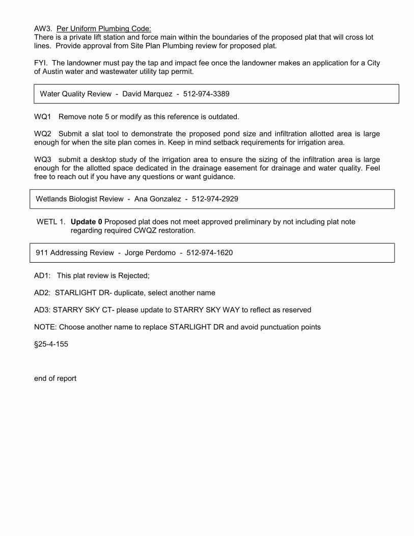
WQ1 Remove note 5 or modify as this reference is outdated. WQ2 Submit a slat tool to demonstrate the proposed pond size and infiltration allotted area is large enough for when the site plan comes in. Keep in mind setback requirements for irrigation area. WQ3 submit a desktop study of the irrigation area to ensure the sizing of the infiltration area is large enough for the allotted space dedicated in the drainage easement for drainage and water quality. Feel free to reach out if you have any questions or want guidance.
WETL 1. Update 0 Proposed plat does not meet approved preliminary by not including plat note
regarding required CWQZ restoration.
AD1: This plat review is Rejected; AD2: STARLIGHT DR- duplicate, select another name AD3: STARRY SKY CT- please update to STARRY SKY WAY to reflect as reserved NOTE: Choose another name to replace STARLIGHT DR and avoid punctuation points §25-4-155 end of report
Water Quality Review - David Marquez - 512-974-3389
Wetlands Biologist Review - Ana Gonzalez - 512-974-2929
911 Addressing Review - Jorge Perdomo - 512-974-1620