
SUBDIVISION REGULATIONS - Lawrence, Kansasi) Enforcement and Penalties ..... 96 (j) Violations ........
120
Lawrence/Douglas County | Subdivision Regulations| January 10, 2012 SUBDIVISION REGULATIONS for Lawrence and the Unincorporated Areas of Douglas County, KS Regulations Governing Land Divisions in the City of Lawrence and the Unincorporated Areas of Douglas County, Kansas Chapter 20, Article 8 of the Lawrence Development Code AND Chapter 11, Article 1 of the Douglas County Code December 19, 2006 Edition Amended: 09/11/07; 12/04/07; 03/25/08; 09/10/08; January 6, 2009; December 8, 2010; January 10, 2012
Transcript of SUBDIVISION REGULATIONS - Lawrence, Kansasi) Enforcement and Penalties ..... 96 (j) Violations ........

Lawrence/Douglas County | Subdivision Regulations| January 10, 2012
SUBDIVISION REGULATIONS for
Lawrence and
the Unincorporated Areas of Douglas County, KS
Regulations Governing Land Divisions in the City of Lawrence and
the Unincorporated Areas of Douglas County, Kansas
Chapter 20, Article 8 of the Lawrence Development Code
AND
Chapter 11, Article 1 of the Douglas County Code
December 19, 2006 Edition
Amended: 09/11/07; 12/04/07; 03/25/08; 09/10/08;
January 6, 2009; December 8, 2010; January 10, 2012

Article 8 Subdivision Design and Improvements Contents of Article
Lawrence/Douglas County | Subdivision Regulations| January 10, 2012
Approval and Amendment Dates:
Original December 19, 2006 Edition
Ordinance 8064/Resolution 06-41, published December 31, 2006 Approved by Lawrence City Commission on December 19, 2006
Approved by the Board of Douglas County Commissioners on December 20, 2006
Amended September 11, 2007: Joint Ordinance/Resolution No. 8193, published November 9, 2007
Approved by the Board of Douglas County Commissioners on September 10, 2007 Approved by the Lawrence City Commission on September 11, 2007
Amended December 4, 2007:
Joint Ordinance No. 8230/Resolution 08-03, published January 28, 2008 Approved by the Board of Douglas County Commissioners on November 14, 2007
Approved by the Lawrence City Commission on November 20, 2007 and December 4, 2007
Amended March 25, 2008:
Joint Ordinance No. 8255/Resolution 08-14, published April 25, 2008 Approved by the Board of Douglas County Commissioners on November 14, 2007
Approved by the Lawrence City Commission on March 25, 2008.
Amended September 10, 2008:
Joint Ordinance No. 8301/Resolution 08-41, published September 27, 2008 Approved by the Board of Douglas County Commissioners on September 3, 2008
Approved by the Lawrence City Commission on September 9, 2008.
Amended January 6, 2009: Joint Ordinance No. 8364/Resolution 09-06, published February 28, 2009
Approved by the Board of Douglas County Commissioners on February 11, 2009 Approved by the Lawrence City Commission on February 10, 2009.
Amended December 8, 2010
Joint Ordinance No. 8317/Resolution 10-30, published December 28, 2010 Approved by the Board of Douglas County Commissioners on December 8, 2010.
Approved by the Lawrence City Commission on December 7, 2010.
Amended January 10, 2012
Joint Ordinance No. 8690/Resolution 12-01, published January 16, 2012 Approved by the Board of Douglas County Commissioners on January 4, 2012.
Approved by the Lawrence City Commission on January 3, 2012.

Article 8 Subdivision Design and Improvements Contents of Article
Lawrence/Douglas County | Subdivision Regulations| January 10, 2012
Official Copy as Adopted by Ordinance No. 8690 and Resolution 12-01.
__________________________ January 16, 2012
/s/ Jonathan Douglass City Clerk date of publication
__________________________ January 16, 2012
/s/Jameson D. Shew, County Clerk date of publication

Article 8 Subdivision Design and Improvements Contents of Article
Lawrence/Douglas County | Subdivision Regulations| January 10, 2012
Article 8. Subdivision Design and Improvements
Contents of Article
Article 8. Subdivision Design and Improvements ............................ 1
20-801 General ................................................................................................. 5
(a) Purpose and Intent ........................................................................................................... 5
(b) Jurisdiction ....................................................................................................................... 6
(c) Applicability ...................................................................................................................... 6
(d) Exemptions ...................................................................................................................... 7
(e) Vested Rights ................................................................................................................... 9
(f) Combination of Unplatted Lands in Unincorporated Douglas County ........................... 11
20-802 General Review and Approval Procedures ......................................... 12
(a) Authority to File Applications ......................................................................................... 12
(b) Form of Application ........................................................................................................ 12
(c) Pre-application Meetings ............................................................................................... 12
(d) Notices . ........................................................................................................................ 12
(e) Application Processing Cycles ....................................................................................... 14
(f) Application Review and Recording Fees ....................................................................... 14
(g) Application Completeness, Accuracy and Sufficiency ................................................... 14
(h) Applications Containing Technical Deficiencies ............................................................ 15
(i) Applicability .................................................................................................................... 15
20-803 Property Divisions in Service Area 1, Lawrence Urban Growth Area . 16
(a) Prerequisite to Development ......................................................................................... 16
(b) Procedure Required ....................................................................................................... 16
20-804 Cluster Developments in the Urban Growth Areas ............................. 17
(a) Purpose .......................................................................................................................... 17
(b) Applicability .................................................................................................................... 17
(c) Immediate Development Acreage and Future Development Acreage .......................... 18
(d) Restrictive Covenant ...................................................................................................... 23
(e) Notice to Nearby Property Owners ................................................................................ 23
(f) Cluster Developments – After Annexation ..................................................................... 24
(g) Application ..................................................................................................................... 24
(h) Administrative Review and Consideration Procedures .................................................. 24
20-805 (RESERVED) ........................................................................................ 25
20-806 Property Divisions in the Rural Area (Outside the UGAs) .................. 26
(a) Purpose .......................................................................................................................... 26

Article 8 Subdivision Design and Improvements Contents of Article
Lawrence/Douglas County | Subdivision Regulations| January 10, 2012
(b) Definitions ...................................................................................................................... 26
(c) Applicability .................................................................................................................... 26
(d) Residential Development Parcel (RDP) ......................................................................... 27
20-807 Certificate of Survey, Administrative Review Procedures .................. 30
(a) Purpose .......................................................................................................................... 30
(b) Authority ......................................................................................................................... 30
(c) Applicability .................................................................................................................... 30
(d) Application ..................................................................................................................... 31
(e) Requirements and Material to be Included .................................................................... 32
(f) Criteria for Review ......................................................................................................... 34
(g) Review and Action by the Planning Director ................................................................. 34
(h) Amending an Approved Certificate of Survey ................................................................ 35
(i) Appeals Process for Sections 20-804 and 20-806 ........................................................ 36
(j) Certificate of Survey Expiration ..................................................................................... 36
20-808 Minor Subdivisions/Replats ............................................................... 37
(a) Purpose .......................................................................................................................... 37
(b) Authority ......................................................................................................................... 37
(c) Applicability .................................................................................................................... 37
(d) Criteria for Review ......................................................................................................... 39
(e) Application ..................................................................................................................... 41
(f) Contents ......................................................................................................................... 41
(g) Review and Action by the Planning Director ................................................................. 42
(h) Review and Action by the Governing Body ................................................................... 43
(i) Signatures on Minor Subdivision/Replat following Action by the Governing Body ........ 43
(j) Processing after Approval of Minor Subdivision/Replat ................................................. 43
(k) Minor Subdivision/Replat Expiration .............................................................................. 43
20-809 Major Subdivisions ............................................................................. 44
(a) Purpose .......................................................................................................................... 44
(b) Applicability .................................................................................................................... 44
(c) Applications and Procedures ......................................................................................... 44
(d) Criteria for Review ......................................................................................................... 45
(e) Preliminary Plat – Application ........................................................................................ 45
(f) Preliminary Plat Contents .............................................................................................. 46
(g) Review and Action by the Planning Commission .......................................................... 51
(h) Phasing for Final Plats ................................................................................................... 52
(i) Effects of Approval by the Planning Commission .......................................................... 52
(j) Preliminary Plat Expiration ............................................................................................. 52
(k) Final Plat – Application .................................................................................................. 53

Article 8 Subdivision Design and Improvements Contents of Article
Lawrence/Douglas County | Subdivision Regulations| January 10, 2012
(l) Final Plat Contents ......................................................................................................... 54
(m) Final Plat – Review and Action by Planning Director .................................................... 57
(n) Final Plat – Review and Action by Governing Body ...................................................... 59
(o) Signatures on Final Plat ................................................................................................. 59
(p) Processing after Approval of Final Plat .......................................................................... 60
(q) Final Plat Expiration ....................................................................................................... 60
20-810 Subdivision Design Standards ............................................................ 61
(a) General . ........................................................................................................................ 61
(b) Frontage ......................................................................................................................... 61
(c) Access .. ........................................................................................................................ 62
(d) Blocks.. .......................................................................................................................... 63
(e) Streets. .......................................................................................................................... 64
(f) Street and Road Names and Lot and Block Numbering ................................................ 70
(g) Lot and Block Numbering .............................................................................................. 71
(h) Easements ..................................................................................................................... 71
(i) Parks, Open Space Schools and Other Public Facilities ............................................... 72
(j) Land In Floodplain Overlay Districts .............................................................................. 72
(k) Protection of Environmentally Sensitive Lands ............................................................. 73
(l) Soils and Soil Testing – City of Lawrence ..................................................................... 75
(m) Soils and Soil Testing – Unincorporated Area of the County ........................................ 75
20-811 Public Improvements Standards ........................................................ 76
(a) General Public Improvement Construction Standards .................................................. 76
(b) Streets or Roads ............................................................................................................ 77
(c) Sidewalks and Pedestrian Ways ................................................................................... 77
(d) Wastewater Disposal Systems ...................................................................................... 79
(e) Water Supply ................................................................................................................. 81
(f) Telephone, Cable Television Electrical Lines ................................................................ 82
(g) Street Trees ................................................................................................................... 82
(h) Completion of Public Improvements .............................................................................. 88
(i) Escrow Deposit .............................................................................................................. 89
(j) Irrevocable Letter of Credit ............................................................................................ 89
(k) Lot Pinning ..................................................................................................................... 90
20-812 (Reserved) .......................................................................................... 91
20-813 Administration and Enforcement ....................................................... 92
(a) Planning Director Powers and Duties ............................................................................ 92
(b) Planning Commission Powers and Duties ..................................................................... 92
(c) Dedications or Vacations ............................................................................................... 92
(d) Building Permits in the Unincorporated Area of Douglas County .................................. 93

Article 8 Subdivision Design and Improvements Contents of Article
Lawrence/Douglas County | Subdivision Regulations| January 10, 2012
(e) Building Permits in the City of Lawrence ....................................................................... 94
(f) Appeals .......................................................................................................................... 94
(g) Variances ....................................................................................................................... 95
(h) Design Variances for Planned Development ................................................................. 95
(i) Enforcement and Penalties ............................................................................................ 96
(j) Violations ....................................................................................................................... 96
(k) Penalties; Remedies ...................................................................................................... 96
20-814 Building Setbacks, Enforcement, Exceptions ..................................... 98
(a) Building or Setback Lines On Major Streets or Highways ............................................. 98
(b) Exceptions ..................................................................................................................... 98
(c) Appeal – Setback ........................................................................................................... 98
(d) Enforcement ................................................................................................................... 99
(e) Interpretation .................................................................................................................. 99
20-815 Interpretations, Rules of Construction and Definitions ................... 100
(a) Interpretation and Rules of Construction ..................................................................... 100
(b) Definitions .................................................................................................................... 100

Article 8 Subdivision Design and Improvements Section 20-801 General
Lawrence/Douglas County | Subdivision Regulations| January 10, 2012 5 of 120
20-801 General
(a) Purpose and Intent
(1) The purpose of the Subdivision Regulations of this Article is to ensure that the division of land, which, in many instances, is an initial step in Urbanization, will serve the public interest and general welfare. Since the allocation and arrangement of Parcels of land for both private uses and public uses helps to influence the health, safety, economy, livability, and amenities of an area, these regulations are intended to:
(i) Provide for the harmonious and orderly development of land within the City and the Unincorporated Area of Douglas County by making provisions for adequate open space, continuity of the transportation network, recreation areas, drainage, utilities and related Easements, light and air, and other public needs;
(ii) Contribute to conditions conducive to health, safety, aesthetics, convenience, prosperity, and efficiency; and
(iii) Provide for the conservation and protection of human and natural resources.
(2) The Subdivision Regulations of this Article are designed, intended and should be administered to:
(i) Ensure that in the City and in the Unincorporated Area of Douglas County is in accordance with the Comprehensive Plan; any adopted watershed/sub-basin plans, sector or Neighborhood Plans covering the subject Subdivision; the applicable Zoning Regulations enacted to implement those plans; and the Lawrence/Douglas County MPO Transportation Plan;
(ii) Provide for the conservation of existing neighborhoods and facilitate the development of new neighborhoods;
(iii) Prevent the development of substandard Subdivisions and blighted areas that will be a detriment to the community;
(iv) Coordinate the development of each Parcel of land with the existing community and facilitate the proper of adjoining land;
(v) Provide adequate and accurate records of all land Divisions;
(vi) Ensure that the cost of Improvements, which benefit primarily the Tract of land being developed, be borne primarily by the Owners or Developers of the subject Tract, and that the cost of Improvements that provide benefits to the subject Tract and the community as a whole be shared by the Developer and the community;

Article 8 Subdivision Design and Improvements Section 20-801 General
Lawrence/Douglas County | Subdivision Regulations| January 10, 2012 6 of 120
(vii) Ensure that Subdivisions are designed and developed in a manner that is consistent with all applicable flood protection and storm water management regulations and other applicable land use and development regulations of Lawrence and Douglas County;
(viii) Provide for the efficient arrangement and orderly location of Street/Roads;
(ix) Encourage the reduction of vehicular congestion and support multi-modal transportation design standards in a manner that supports multi-modal transportation;
(x) Provide for the reservation or Dedication of lands for open space and other community facilities;
(xi) Require the provisions of off-site and On-Site Public Improvements that are necessary to serve land being developed;
(xii) Provide for any other services, facilities and Improvements deemed necessary to serve land being developed; and
(xiii) Establish Building Envelope lines.
(b) Jurisdiction
(1) The Subdivision Regulations of this Article shall apply to all lands within the City of Lawrence and the Unincorporated Area of Douglas County.
(2) In some cases, different standards are established for lands within the City, the Urban Growth Areas and the Rural Area. Unless otherwise expressly stated, however, all regulations and standards of this Article shall apply with equal force to land located in incorporated and Unincorporated Areas.
(c) Applicability
(1) Unless expressly addressed as an exemption in Section 20-801(d) below, no Lot, Tract or Parcel of land shall be divided into two or more parts for the purpose of sale, transfer or Development, whether immediate or future, except through the procedures and in accordance with the standards set forth in this Article.
(2) For property within the incorporated city limits of Lawrence, no building permit shall be issued unless the property is Platted as a Lot of Record.
(3) If Subdivision or Platting of a property is required within the City of Lawrence in order to receive a building permit prior to development, the Subdivider shall preliminarily Plat all of their contiguously owned lands that are not Platted.

Article 8 Subdivision Design and Improvements Section 20-801 General
Lawrence/Douglas County | Subdivision Regulations| January 10, 2012 7 of 120
(d) Exemptions
(1) The purpose of this sub-section is to list specifically those divisions and transfers of land that are entirely exempt from regulation under this Article. This sub-section shall be strictly construed, so that any transaction failing in any way to meet one, or more, of the requirements for exemption shall be subject to the full effect of this Article.
(2) The following divisions and transfers of land are exempt from the requirement that divisions occur only in accordance with the standards and procedures set forth in this Article and may be accomplished by deed or other instrument of transfer without any reference to this Article:
(i) A division created exclusively for Agricultural Purposes, when that division does not involve the creation of any new Public Streets, public Roads, or public Easements or residential development;
(ii) A division occurring through the sale or transfer of any Lot that has been legally Platted in accordance with Subdivision Regulations in effect at the time of the Platting;
(iii) A division used exclusively for cemetery purposes and Accessory uses associated therewith;
(iv) A division occurring through the transfer of land for use as a Right-of-Way for widening a Road or railroad or as an Easement for public purposes or public utilities, when no new Street/Road or Easement of Access is involved;
(v) A division of unplatted land in the Unincorporated Area of the County [commonly utilized with Section 20-801(f)] for the purpose of combination with an existing Parcel so long as the remaining portion of the unplatted land retains the minimum dimensional requirements for a Certificate of Survey;
(vi) A division of 5 acres or greater within the Unincorporated Area of the County that occurred on or before June 1, 2005 and that was not lawfully created through the Exemptions section of the Subdivision Regulations in effect at the time of the division, provided said division meets the minimum Frontage requirements in the County’s Access Management Standards or provided said division has a minimum Frontage of 250’ on a Local or Minor Collector classified Road;
(vii) A correction of a description in a prior conveyance provided that the correcting instrument (commonly called a Correction Survey used to make a Boundary Line Adjustment between two existing Parcels) contains a reference to the original instrument of conveyance by date, book and page and other description. Within a reasonable time after receiving a correction instrument, the Register of Deeds shall deliver a copy of the correction instrument to the Planning Director; or

Article 8 Subdivision Design and Improvements Section 20-801 General
Lawrence/Douglas County | Subdivision Regulations| January 10, 2012 8 of 120
(viii) Within the City of Lawrence, the division of land to allow for the sale of individual attached or detached residential Dwellings in a townhouse development; provided that, the following conditions are met:
a. The land has been developed with and is occupied by an attached or detached Dwelling;
b. The land being divided or transferred under this exemption is covered by a recorded declaration of covenants subjecting the land and Improvements thereon to procedures and conditions regulating the manner in which Improvements may be expanded, reconstructed and maintained;
c. Prior to recording of the first division for a townhouse development, a development plan, or similar document, shall be recorded at the Register of Deeds showing at a minimum:
1. The entire townhouse development, 2. A legal description of the boundaries of the entire
development, 3. Any Tracts for common Ownership, maintenance or use,
ponds or drainage areas, and 4. The intended Tracts, Parcels or general building locations
(along with building numbers or proposed addresses) for division into townhouse units.
d. If the declaration allows additional land to be submitted to the townhouse development, the location and description of the additional land shall also be shown.
(ix) Within the Unincorporated Area of the County, a division (commonly called a Homestead Exemption Survey) created to divide off a residential building that existed On-Site on December 31, 2006, provided that the following conditions are met:
a. The minimum size of the new Parcel upon which the residential building is located meets both the County’s Sanitary Code requirements for Access to a Potable Water supply and the Height, Area and Bulk Requirements in of the Douglas County Zoning Regulations;
b. The On-Site Sewage Management System is located entirely on the new Parcel upon which the residential building it serves is located and is in compliance with the County’s Sanitary Code requirements; and,
c. The new Parcel on which the residential building is located meets the minimum Frontage and entrance spacing requirements established in the County’s Access Management Standards.

Article 8 Subdivision Design and Improvements Section 20-801 General
Lawrence/Douglas County | Subdivision Regulations| January 10, 2012 9 of 120
Such legally created Parcel of land on which the residential building is located shall not be subject to further review under this Article, unless or until this Parcel is further divided. The remaining Parcel is not eligible for a building permit until Subdivided in accordance with this Article.
(e) Vested Rights
(1) A division of land created in conformance with this Article, or created in conformance with the Exemption section of the previously adopted Subdivision Regulations that were in effect prior to December 20, 2006, and said division of land was filed and recorded as a Plat of survey, deed, or affidavit of equitable interest identifying the division as a separate Tract of real estate at the Register of Deeds office:
(i) On or before June 1, 2005; or
(ii) After June 1, 2005, and as of December 31, 2006, provided a division of land made after June 1, 2005, met the 10 acre requirement and other requirements for a residential building permit pursuant to Douglas County Resolution No. 05-6-5 and resolutions extending such Resolution, shall remain lawfully existing, retaining established rights to the issuance of a building permit, subject to additional regulatory authority of the Governing Body.
Such legally created Parcel shall not be subject to further review under this Article; unless or until it is further divided.
(2) Lot of Record or Non-Conforming Lots/Parcels
(i) In the City of Lawrence, a Lot of Record or Parcel created before the Effective Date of this Article that has been maintained in individual Ownership, may be used for residential purposes for a detached Dwelling or for another use that is allowed in the UR (Urban Reserve) District without further review under this Article, until such Lot of Record or Parcel is further Subdivided.
(ii) In the City of Lawrence, Nonconforming Lots/Parcels that meet the requirements of Section 20-1504 of the Land Development Code may be used in accordance with Article 15 without further review under this Article, until such Lot/Parcel is further Subdivided.
(iii) In the City of Lawrence, properties which include partial Lot descriptions or multiple Lot descriptions which were created prior to December 19, 2006, are not subject to review under this Article if the property meets the standards of either the zoning district that it was governed by when the property was created or the current zoning district in which it is located unless the development pattern of the property is altered.

Article 8 Subdivision Design and Improvements Section 20-801 General
Lawrence/Douglas County | Subdivision Regulations| January 10, 2012 10 of 120
(iv) For property in the Unincorporated Areas of Douglas County, a Lot of Record or a Parcel lawfully created within the A (Agricultural) District, A-1 (Suburban-Home Residential) District, or R-1 (Single-Family Residential) District in the Unincorporated Area of Douglas County on or before December 31, 2006, that has been maintained in individual Ownership, may be used for residential purposes for a single-family home or for another use allowed within the District the property is located in, without further review under this Article, until such Lot of Record or Parcel is further Subdivided.
(3) For property in the Unincorporated Areas of Douglas County, a Parcel created to divide off an existing residential building and grounds from a larger Parcel pursuant to Section 20-801(d)(2)(ix) through the recording of a Homestead Exemption Survey, when the principal building on the Parcel is for single-family residential purposes, shall have no further review under this Article until such Parcel is further Subdivided only when:
(i) The residential building existed on site on or before December 31, 2006;
(ii) It is served by a Potable Water source located on the Parcel that includes the existing residential building improvement;
(iii) The Parcel conforms with the County’s Sanitary Code; and,
(iv) That Parcel is zoned either A (Agricultural), A-1 (Suburban Home Residential), VC (Valley Channel), or R-1 (Single-Family Residential).
(4) Upon the recording of a Final Plat, development rights in land covered by that Plat shall vest in accordance with K.S.A. 12-764. This vesting shall be effective only so long as the same general category of residential uses is continued; any significant change of use shall subject the property to additional review and the applicability of additional regulations, which may affect some rights that are vested as to the particular use and the particular pattern of development. The development rights for a single-family residential Subdivision shall expire in accordance with K.S.A. 12-764.

Article 8 Subdivision Design and Improvements Section 20-801 General
Lawrence/Douglas County | Subdivision Regulations| January 10, 2012 11 of 120
(f) Combination of Unplatted Lands in Unincorporated Douglas County
(1) A vested Parcel may be combined with another unplatted Parcel and retain the right to a building permit for one principal building for residential purposes on the newly created Land Combination provided:
(i) A survey of the Land Combination is filed at the Register of Deeds; and
(ii) All land covered by the survey is owned by the same person or persons; and
(iii) The Owner requests in writing that the County Clerk combines the constituent Parcels for tax parcel purposes.
(2) A Land Combination does not increase the number of building permits a Parcel of land has a vested right to receive.

Article 8 Subdivision Design and Improvements Section 20-802 General Review & Approval Procedures
Lawrence/Douglas County | Subdivision Regulations| January 10, 2012 12 of 120
20-802 General Review and Approval Procedures
(a) Authority to File Applications
Unless otherwise expressly stated, applications for review and approval under this Article may be initiated by all the Owners of the property that is the subject of the application; or the Owners’ authorized Agent.
(b) Form of Application
(1) Applications required under these Subdivision Regulations shall be submitted in a form and in the numbers of copies required by the Planning Director. All application materials must be submitted in both print and electronic format.
(2) The Planning Director shall develop checklists of application submittal requirements and make those checklists available to the public. The application also shall contain all materials required by:
(i) Section 20-807(d)&(e) for Certificate of Survey applications;
(ii) Section 20-808(e) for Minor Subdivision/Replat applications;
(iii) Section 20-809(f) for Preliminary Plat applications; or
(iv) Section 20-809(l) for Final Plat applications, whichever is applicable.
(c) Pre-application Meetings
All applicants submitting applications for approvals must attend a pre-application meeting with Planning Staff. Pre-application meetings shall be scheduled by the applicant to allow adequate time to review and respond to issues raised at the pre-application meeting. The meeting shall occur at least 7 working days before submitting an application.
(d) Notices
The notice provisions of this section apply to the Major Subdivision process except as otherwise expressly stated.
(1) Content
(i) Newspaper and Mailed Notice
All newspaper and Mailed notice shall:
a. Indicate the date, time and place of the public hearing or date of action that is the subject of the notice;
b. Describe the property involved in the application by Street or Road address or by general description;
c. Describe the nature, scope and purpose of the application or proposal; and

Article 8 Subdivision Design and Improvements Section 20-802 General Review & Approval Procedures
Lawrence/Douglas County | Subdivision Regulations| January 10, 2012 13 of 120
d. Indicate where additional information on the matter can be obtained.
(2) Newspaper Notice
When the provisions of these Subdivision Regulations require that “Newspaper Notice” be provided, the Planning Director is responsible for ensuring notice is published in the official newspaper of the City of Lawrence or Douglas County. The notices shall appear in the newspaper at least 20 days before the date of the public hearing.
(3) Mailed Notice
When the provisions of these Subdivision Regulations require that “Mailed Notice” be provided:
(i) Owner Notice; Radius
The official responsible for accepting the application shall mail notice to the record Owner of the subject property and all Owners of property located within 200 feet of the subject property if in the City of Lawrence and within 1,000 feet of the subject property if located in the Unincorporated Areas of Douglas County. If the subject property Abuts a City limits, the area of notification shall be extended to at least 200 feet inside the City or 1,000 feet into the Unincorporated Area.
(ii) Notice to Registered Neighborhood Associations
The official responsible for accepting the application shall mail or e-mail notice to any Registered Neighborhood Associations whose boundaries include or are contiguous to the subject property.
(iii) Ownership Information
The applicant is responsible for providing certified Ownership information. Current Ownership information shall be obtained from the Douglas County Clerk. Ownership information will be considered current if, at the time of submission, it is no more than 30 days old.
(iv) Timing of Notice
Required notices shall be deposited in the U.S. mail at least 20 days before the public hearing, meeting, or date of action that is the subject of the notice. When required notices have been properly addressed and deposited in the mail, failure of a party to receive such notice will not be grounds to invalidate any action taken.
(4) Administrative Processes
(i) Minor Subdivision/Replats and Final Plats
Subdivision or consolidation of property through the Minor Subdivision/Replat and Final Plat processes are administrative processes and do not require individual newspaper or mailed notice.

Article 8 Subdivision Design and Improvements Section 20-802 General Review & Approval Procedures
Lawrence/Douglas County | Subdivision Regulations| January 10, 2012 14 of 120
(ii) Certificates of Survey
Division of property through the Certificate of Survey process is an administrative process.
a. Mailed notice requirements for divisions within the Urban Growth Areas are provided in Section 20-804.
b. Mailed notice is not required for divisions located outside of the Urban Growth Areas.
c. The notice requirements for appeals to Certificates of Survey determinations are provided in Section 20-807(i).
(e) Application Processing Cycles
Officials responsible for accepting applications may, after consulting with review and decision-making bodies, publish processing cycles for applications. Processing cycles may establish:
(1) The official date upon which a completed application was submitted;
(2) Deadlines before consideration;
(3) Dates of regular meetings;
(4) The scheduling of staff reviews and staff reports on complete applications; and,
(5) Any required time frames for action by review and decision-making bodies.
(f) Application Review and Recording Fees
Applications shall be accompanied by the review has been established by the applicable Governing Body. Fees are not required for applications initiated by review or decision-making bodies. Application review fees are nonrefundable. Additional recording fees are required prior to recording approved documents at the Register of Deeds and will be collected at that time.
(g) Application Completeness, Accuracy and Sufficiency
(1) An application will be considered complete and ready for processing only if it is: submitted in the required number and form; includes all required information; and, is accompanied by the required fees.
(2) Within 5 working days of application filing, the Planning Director shall determine whether the application includes all information required by these Subdivision Regulations. If an application does not include all of the required

Article 8 Subdivision Design and Improvements Section 20-802 General Review & Approval Procedures
Lawrence/Douglas County | Subdivision Regulations| January 10, 2012 15 of 120
information, it will be deemed incomplete. If an application includes all of the required information, it will be deemed complete. Written notice of the incompleteness and the specific information lacking shall be provided to the applicant or the applicant’s Agent.
(3) No processing of incomplete applications shall occur and incomplete applications will be removed from the processing cycle. When the deficiencies are corrected, the application will be placed in the next processing cycle. If the deficiencies are not corrected by the applicant within 60 days, the application will be considered withdrawn. No refund of a review fee shall be made for applications that are withdrawn.
(4) Applications deemed complete will be considered to be in the processing cycle and will be reviewed by Planning Staff and other review and decision-making bodies in accordance with the procedures of these Subdivision Regulations.
(h) Applications Containing Technical Deficiencies
(1) The Planning Director may require that applications be revised before being placed on the agenda of the Planning Commission or Governing Body, if the Planning Director determines that:
(i) The application contains one or more significant inaccuracies or omissions that hinder timely or competent evaluation of compliance with this Article;
(ii) The application contains multiple minor inaccuracies or omissions that hinder timely or competent evaluation of compliance with this Article;
(iii) The application cannot be approved without a Variance or some other change or modification that the decision-making body for that application does not have the authority to grant or approve. This determination shall be made in written form to the applicant. If the determination is based on this sub-section (iii), it shall include an explanation of what Variance, change or modification would be required to allow approval of the application.
(2) Applications that contain the aforementioned types of inaccuracies or that substantially fail to comply with this Article shall be revised before they will be placed on an agenda of the Planning Commission or Governing Body.
(3) Action or inaction by the Planning Director under this section may be appealed to the appropriate Governing Body in accordance with Section 20-807(h) or Section 20-813(f), whichever is applicable.
(i) Applicability
Unless expressly exempted under Section 20-801(d), no Subdivision or Residential Development Parcel may be created and no Certificate of Survey may be recorded with the Register of Deeds until the division has been approved in accordance with the applicable Review and Approval Procedures of this Article.

Article 8 Subdivision Design and Improvements Section 20- 803 Property Divisions in Service Area 1, Lawrence Urban Growth Area
Lawrence/Douglas County | Subdivision Regulations| January 10, 2012 16 of 120
20-803 Property Divisions in Service Area 1, Lawrence Urban Growth Area
(a) Prerequisite to Development
No division of land in Service Area 1 of the Lawrence Urban Growth Area shall be approved until the land proposed for division has been annexed into the City.
(b) Procedure Required
Upon annexation of land originally located in Service Area 1 into the City of Lawrence, a proposed division of Platted or unplatted land shall be processed and considered in accordance with the Minor Subdivision/Replat or Major Subdivision provisions of this Article, whichever is applicable.

Article 8 Subdivision Design and Improvements Section 20-804 Cluster Developments in the Urban Growth Areas
Lawrence/Douglas County | Subdivision Regulations| January 10, 2012 17 of 120
20-804 Cluster Developments in the Urban Growth Areas
(a) Purpose
The purpose of this Section is to allow an administrative approval procedure for divisions of land to accommodate rural residential development on land Parcels that are located within the Urban Growth Areas of cities in Douglas County. The procedure contemplates that forethought and design considerations will be employed to identify the future Urban Density residential development of the land Parcel prior to any division occurring, and that based on these considerations, 3 acre or larger Residential Development Parcels may be created when they allow for future divisions through a ‘Build Out Plan’ of the Residential Development Parcels, at some future time, to create Urban Blocks and connective Street networks in accordance with the Design Standards in the Subdivision Regulations for the city associated with the Urban Growth Area. These regulations will result in Residential Development Parcels that retain their rural character for the immediate future, but will also allow for more efficient transition to Urban Density development as subsequent circumstances dictate. The clustering of development Parcels within the Urban Growth Areas on Parcels that contain at least 20 acres is intended to mitigate the strain on Infrastructure and public services and to anticipate future development patterns for the remainder of the property after annexation.
(b) Applicability
(1) The division of a Parcel of land that contains at least 20 acres in area, and that is located in Service Areas 2-4, of Lawrence’s Urban Growth Area or in another City’s Urban Growth Area, may be approved according to the Cluster Development provisions of this Section.
(i) For purposes of determining compliance with the 20 acre minimum Parcel area, an entire half of a quarter-quarter section (e.g. West ½ of the Southeast ¼ of the Southeast ¼) shall be deemed to be a 20 acre Parcel.
(ii) In calculating the size of a Parcel, the Parcel size shall be deemed to include ½ of the adjoining Road Right(s)-of-Way if this inclusion is necessary for the Parcel to conform to the applicable minimum Parcel size.

Article 8 Subdivision Design and Improvements Section 20-804 Cluster Developments in the Urban Growth Areas
Lawrence/Douglas County | Subdivision Regulations| January 10, 2012 18 of 120
(c) Immediate Development Acreage and Future Development Acreage
Lands divided pursuant to this Section shall be developed as a Cluster Development and shall be identified as either the Immediate Development Area or the Future Development Area in accordance with the following requirements.
(1) Immediate Development Area.
The Immediate Development Area of a Cluster Development shall not exceed 60% of the total acreage of the proposed development included in the Certificate of Survey. The Immediate Development Area may further be divided into Residential Development Parcels (RDPs) subject to the requirements of this Section. Residential Development Parcels shall be located only in the Immediate Development Area. Individual Residential Development Parcels shall only take Access from a Cross Access Easement and shall be laid out in a manner that minimizes adverse impacts to the Future Development Area. Development of the Immediate Development Area, to the greatest extent practicable, shall conform to the following requirements:
(i) Minimum Parcel Acreage and dimensional standards
Residential Development Parcels shall be laid-out and designed to comply with all applicable zoning district regulations listed in the County Zoning Regulations. The minimum Residential Development Parcel size shall be 3 acres.
(ii) Location of Residential Development Parcels
Within the Cluster Development, each Residential Development Parcel shall be designed and developed in accordance with the requirements in this sub-section:
a. Clustered to take Access from Cross Access Easements to minimize Access points to the adjacent public Right(s)-of-Way. 1. Cross Access Easements shall be established by a
separate legal instrument, acceptable to the legal counsel of the nearby city and the Easement shall be filed recorded at the Register of Deeds as a Restrictive Covenant of the Cluster Development that prohibits development of the Future Development Area until, upon annexation, the Cross Access Easement is dedicated to the annexing city as public Road Right-of-Way.
2. The Cross Access Easements shall be written so that, upon annexation by a city, the Cross Access Easement shall be in acceptable form and dimensions to be dedicated to the City as public Road Right(s)-of-Way, to allow for construction of Streets within the Cross Access Easements to meet the then current city Street standards.

Article 8 Subdivision Design and Improvements Section 20-804 Cluster Developments in the Urban Growth Areas
Lawrence/Douglas County | Subdivision Regulations| January 10, 2012 19 of 120
b. Planned and laid out to allow for future Subdivision of the Residential Development Parcel s into Platted Lots at an Urban Density commensurate with the zoning and Subdivision Regulations of the annexing city.
(iii) Utility – Water
All Residential Development Parcels shall obtain Publicly Treated Water delivered through a water meter.
(iv) Utility – Wastewater
All Residential Development Parcels shall have an On-Site Sewage Management System approved by the Director of Lawrence/Douglas County Health Department or a connection to a wastewater disposal system approved by the Kansas Department of Health and Environment.
(v) County Health Code Restriction in Floodplain
On-Site Sewage Management Systems shall be located outside the FEMA designated regulatory Floodplain.
(vi) Building Envelopes
The buildable area for each Residential Development Parcel within the Immediate Development Area shall be defined by Building Envelopes and structure placement is governed by the setbacks established in the Douglas County Zoning Regulations.
a. Residential Development Parcels shall be planned and arranged to allow for the future Subdivision of these Parcels into Urban Streets and Blocks that conform to the development regulations of the city associated with the Urban Growth Area.
b. The buildable area for each Residential Development Parcel shall be defined by Building Envelopes which accommodate the future Block layout and exclude lands which have been identified for protection as Environmentally Sensitive Lands.
c. The Building Envelopes for each RDP shall be shown on the Certificate of Survey.

Article 8 Subdivision Design and Improvements Section 20-804 Cluster Developments in the Urban Growth Areas
Lawrence/Douglas County | Subdivision Regulations| January 10, 2012 20 of 120
(vii) Access
a. When the Cluster Development is located within the Lawrence Urban Growth Area or in the Urban Growth Area of another city, the development shall have direct Access to a Road that meets or exceeds the County’s Rock Road Standard.
b. When established as part of a Cluster Development in Lawrence's UGA, the service drive constructed within the Cross Access Easement shall be constructed, at a minimum, to meet the County’s Rock Road Standard, and the minimum width of traveled-way plus shoulder shall be 20 feet.
1. As an alternative, when a Cross Access Easement provides Access to only one or two RDPs in the Immediate Development Area, a waiver from this construction standard may be permitted if approved by the County Engineer and when provisions for future improvement to Road standards are included in the Restrictive Covenants.
c. Only one Access point shall be allowed for the entire development unless a separate Access point is necessary to allow Access to prevent intrusion or damage to the Environmentally Sensitive Lands being conserved and protected.
(viii) Steep Slopes
The Building Envelopes of Residential Development Parcels shall not contain any slopes greater than 15%.
(ix) Minimum Road Right(s)-of-Way
a. If the Cluster Development is located adjacent to public Road Right-of-Way that does not meet the minimum width standards of Section 20-810(e)(5), approval of the application for division pursuant to this Section 20-804 shall be subject to a condition that the Subdivider dedicate, by separate instrument to the County, ½ the additional land necessary to bring the Road(s) adjoining the Cluster Development to the required Right-of-Way standard based on the Road’s classification established in the County’s Access Management Standards.
b. All necessary Dedications shall be by separate instrument, satisfactory to the County Counselor, and recorded with the Register of Deeds.
c. No final action may be taken on the Certificate of Survey until this additional Road Right-of-Way has been dedicated.

Article 8 Subdivision Design and Improvements Section 20-804 Cluster Developments in the Urban Growth Areas
Lawrence/Douglas County | Subdivision Regulations| January 10, 2012 21 of 120
(x) Minimum Frontage and Entrance Spacing Requirements
a. The Cluster Development must meet the minimum Frontage and Entrance Spacing Requirements established in the County’s Access Management Standards. The Frontage and Entrance Spacing Requirements are based on the classification of the Road upon which the Cross Access Easement is proposed to take Access.
b. Minimum RDP Frontage on the Cross Access Easement is not subject to the Frontage requirements in Section 12-318 of the Douglas County Zoning Regulations.
(xi) Drainage Easements
If any portion of the Residential Development Parcel lies in a FEMA designated regulatory Floodplain, or if drainage Channels or Swales exist on the Residential Development Parcel that carry runoff from adjacent property or Public Street/Roads, the FEMA designated regulatory Floodplain or drainage Channel or Swale shall be protected by grant of an Easement, or other similar device, evidenced by separate legal instrument, as may be required by the Planning Director and acceptable to the County Counselor.
(xii) Restrictive Covenants
Property in the Immediate Development Area shall be subject to a Restrictive Covenant as set forth in Section 20-804(d).
(2) Future Development Area
The Future Development Area shall meet the requirements set forth in this sub-section:
(i) Minimum Requirement.
A minimum of 40% of the total Cluster Development shall be designated as Future Development Area. To the extent practical, the Future Development Area should be one contiguous area of land for future planning purposes.
(3) Conservation of Natural Resources
No matter where located within the boundaries of the Certificate of Survey, land that is or contains Environmentally Sensitive Lands identified in Section 20-810(k), to the greatest extent reasonably practicable, shall be conserved and protected through the recording with the Register of Deeds of either a Temporary Set Aside Agreement or a permanent Conservation Easement.

Article 8 Subdivision Design and Improvements Section 20-804 Cluster Developments in the Urban Growth Areas
Lawrence/Douglas County | Subdivision Regulations| January 10, 2012 22 of 120
(i) Temporary Set Aside Agreement
a. A Temporary Set Aside Agreement shall prohibit development, while the lands are located within the Urban Growth Area that would significantly impair or interfere with the environmental, geographical or historical characteristics of the identified natural resources.
b. The Temporary Set Aside Agreement shall be provided to the City and County by separate legal instrument, satisfactory to the County Counselor and City Manager or other appropriate city official.
c. The City will have regulatory authority over the Temporary Set Aside Agreement only after the property has been annexed into the City.
d. Within 2 years of the date of annexation into the City, the Temporary Set Aside Agreement will expire unless further action is taken by either the City or the property Owner to secure its continuance.
(ii) Conservation Easement
a. A permanent Conservation Easement may be established by an Owner that desires a more permanent and perpetual method of protecting and conserving natural resources. The areas of land that a permanent Conservation Easement may cover include those lands identified in Section 20-810(k), or similar sensitive lands.
b. A permanent Conservation Easement shall be established to retain the environmental, geographical or historical characteristics of the land.
c. It shall be conveyed to a public or nonprofit organization that protects and preserves lands of ecological, scenic, historic, agricultural, or recreational significance.
d. A permanent Conservation Easement created for protecting natural resources may or may not be sufficient to meet the requirements for re-evaluation by the county for land appraisal and taxation purposes.
(4) Restriction on Subsequent Divisions
Any further division for development purpose is prohibited until annexation or until an amended Certificate of Survey is approved and filed recorded with the Register of Deeds.
(5) Restrictive Covenant
The Immediate and Future Development Areas shall be subject to a Restrictive Covenant as set forth in Section 20-804(d).

Article 8 Subdivision Design and Improvements Section 20-804 Cluster Developments in the Urban Growth Areas
Lawrence/Douglas County | Subdivision Regulations| January 10, 2012 23 of 120
(d) Restrictive Covenant
The Immediate Development Area and Future Development Area each shall be restricted by a separate instrument, satisfactory to the County Counselor, which shall:
(1) Incorporate by reference and have attached as an exhibit the Build Out Plan;
(2) Require future division of the Residential Development Parcel s to conform to the Build Out Plan or the Subdivision Regulations in place at that time;
(3) For the Immediate Development Area, limit each Residential Development Parcel to one principal Dwelling and accessory buildings until annexation into a city and municipal water and Sanitary Sewer service are extended to the property;
(4) For the Future Development Area, any further division for development purposes is prohibited until annexation or until an amended Certificate of Survey is approved and recorded with the Register of Deeds;
(5) Restrict the location of structures within the Immediate Development Area to Building Envelopes that have been created to allow for the future Subdivision of the Immediate Development Area into Blocks of an Urban Density that avoids interference with planned future Street/Roads, Easements and setbacks;
(6) Be binding upon the Owner and all of its successors and assigns, and shall constitute a covenant running with the land, expiring at the time the subject property is annexed by a city; and
(7) Be in a recordable form and be recorded with the Register of Deeds.
(e) Notice to Nearby Property Owners
(1) Written notice of the proposed division for rural residential purposes shall be mailed to the Owner of record of all property within ¼ mile of the subject property. The notice shall be sent by the applicant by regular mail, postage pre-paid. The mailing addresses for property Owners within the ¼ mile notification area shall be obtained from the Douglas County Clerk. The applicant shall submit a Certificate of Mailing, at the time of submission of the Certificate of Survey application. A Certificate of Survey application shall be considered incomplete without an executed Certificate of Mailing. The notice shall provide:
(i) A brief description of the location of the property proposed for division;
(ii) The projected date a Certificate of Survey application will be submitted to the Lawrence/Douglas County Planning Office;
(iii) A contact telephone number and address for the property Owner proposing the division for rural residential purposes; and,

Article 8 Subdivision Design and Improvements Section 20-804 Cluster Developments in the Urban Growth Areas
Lawrence/Douglas County | Subdivision Regulations| January 10, 2012 24 of 120
(iv) The letter shall include the following statement and information:
(2) The failure of a property Owner within the ¼ mile mailing distance to receive the written notice will not affect the validity of the application for a Certificate of Survey.
(f) Cluster Developments – After Annexation
(1) Upon Annexation, development shall occur in accordance with the Build Out Plan or an approved plan meeting the Subdivision Regulations in place at the time. If, however, the appropriate city’s plans or regulations for the area covered by the Build Out Plan recommend a different type of land use or scale of development, the property shall be Platted to conform to the city’s current plans and regulations.
(2) Upon Annexation, all future divisions of land in the Immediate Development Area or Future Development Area shall be made in accordance with Section 20-809, Major Subdivisions for the City of Lawrence, or in accordance with the applicable procedures set forth in the annexing city’s Subdivision Regulations.
(g) Application
Any person having legal or equitable interest in property that meets the criteria required by this Section may file, with the Planning Director, an application for a division of land in conformance with this Section. The completed application must:
(1) Satisfy the requirements of Section 20-802;
(2) Be submitted with an approved application form supplied by the Planning Department;
(3) Be submitted in both print and electronic format; and,
(4) Shall be accompanied by the application materials listed in 20-807(d).
(h) Administrative Review and Consideration Procedures
The Planning Director shall review all applications for Cluster Developments pursuant to this Section in accordance with the Certificate of Survey administrative review procedures set forth in Section 20-807.
Notice of Proposal to divide land located at [road address or general description such as; ½ mile north of the intersection of x road and y road, on the east side] for rural residential development purposes.
This letter is being sent to the Owner of property adjoining and within ¼ mile of the boundaries of the property proposed for division for rural residential Cluster Development. The purpose of this letter is to provide general information to the recipient and/or Owner of property of a proposed or potential change in land use.

Article 8 Subdivision Design and Improvements
Section 20-805 [RESERVED]
Lawrence/Douglas County | Subdivision Regulations| January 10, 2012 25 of 120
20-805 (RESERVED)

Article 8 Subdivision Design and Improvements
Section 20-806 Property Divisions in the Rural Area (Outside the UGAs)
Lawrence/Douglas County | Subdivision Regulations| January 10, 2012 26 of 120
20-806 Property Divisions in the Rural Area (Outside the UGAs)
(a) Purpose
Horizon 2020, the Comprehensive Land Use Plan, strongly encourages that residential development be located in the Lawrence Urban Growth Area or within the Urban Growth Areas of the other incorporated cities in the County. Horizon 2020 also recognizes the need for suitable residential development in the Rural Area of Douglas County.
(b) Definitions
When used in this Section 20-806, the following terms have the following meanings:
(1) Original Tract – shall be composed of a Parcel or a combination of all adjacent Parcels under a single Ownership [not separated by public Right(s)-of-Way] that share common boundary lines or two separate Ownerships that share a common boundary line, for the purpose of creating one Parent Parcel.
(2) Parent Parcel – an area of 20 acres or more surveyed solely for the purpose of creating one or more Residential Development Parcels.
(3) Residential Development Parcel – a Parcel created from the Parent Parcel through the administrative Certificate of Survey process to make the new land division eligible for a residential building permit.
(4) Rural Area – the area of Unincorporated Douglas County lying outside the Urban Growth Areas of Lawrence, Baldwin City, Eudora and Lecompton.
(c) Applicability
Residential Development Parcels may be created within the Rural Area according to the following requirements:
(1) The Owner of the land must identify a Tract of land, which shall be a minimum of 20 acres and take Access to a Full Maintenance Road, in accordance with this Section. The Tract containing the area for the proposed Residential Development Parcel(s) shall be known as the “Parent Parcel”. The land from which the Parent Parcel is identified shall be known as the “Original Tract”.
(i) For purposes of determining compliance with the 20 acre minimum Tract area, entire half of a quarter-quarter section (e.g. West ½ of the Southeast ¼ of the Southeast ¼) shall be deemed to be a 20 acre Tract.
(ii) In calculating the size of a Tract, the Tract size shall be deemed to include ½ of the adjoining Road Right(s)-of-Way or Easements if such inclusion is necessary for the Tract to conform to the applicable minimum Tract size.

Article 8 Subdivision Design and Improvements
Section 20-806 Property Divisions in the Rural Area (Outside the UGAs)
Lawrence/Douglas County | Subdivision Regulations| January 10, 2012 27 of 120
(d) Residential Development Parcel (RDP)
(1) Up to 3 Residential Development Parcels (RDP) may be created by dividing a Parent Parcel, depending on the classification of the Full Maintenance Roads bounding the property.
(i) Up to 2 RDPs may be created by dividing the Parent Parcel if the Parent Parcel is bounded on only 1 side by a Road or the Parent Parcel is bounded on 2 or more sides by Roads and any of the Roads are classified as other than Local Roads.
(ii) Up to 3 RDPs may be created if the Parent Parcel is bounded on 2 or more sides by Local Roads.
(2) Residential Development Parcels can be created through the Certificate of Survey process only when the Planning Director finds: the property is being divided for single-family residential purposes; the division does not involve or result in the creation of any minimum maintenance or Full Maintenance new Roads or Road Rights-of-Way or Easements; and, the division is made in accordance with the following requirements:
(i) Minimum Residential Development Parcel Area and dimensional standards
Residential Development Parcels shall be laid-out and designed to comply with all applicable zoning district regulations listed in the County Zoning Regulations. Each Residential Development Parcel shall have the minimum area required in Section 12-318 in the County Zoning Regulations. The minimum Parcel area shall also meet the County Sanitary Code minimum requirements for residential development that has an On-Site Sewage Management System;
(ii) Development Access
Each Residential Development Parcel shall have direct Access to a Full Maintenance Road;
(iii) County Health Code Requirements
a. The applicant has provided evidence that each Residential Development Parcel will satisfy all applicable health and sanitation requirements of the Lawrence/Douglas County Health Department;
b. On-Site Sewage Management Systems shall be located outside the FEMA designated regulatory Floodplain.
(iv) Grouping Divisions
When a Parent Parcel has previously been identified and filed of record from an Original Tract, any subsequent Parent Parcel identified from that Original Tract shall, where practicable, be located with one boundary line adjacent to the previously created Parent Parcel to encourage the grouping of Residential Development Parcels to facilitate the efficient provision of Infrastructure and other public services.

Article 8 Subdivision Design and Improvements
Section 20-806 Property Divisions in the Rural Area (Outside the UGAs)
Lawrence/Douglas County | Subdivision Regulations| January 10, 2012 28 of 120
(v) Minimum Frontage and Entrance Spacing Requirements.
Each Residential Development Parcel must meet the minimum Frontage and Entrance Spacing Requirements established in the County’s Access Management Standards. The Frontage and Entrance Spacing Requirements are based on the classification of the Road upon which the Residential Development Parcel is proposed to take Access.
(vi) Minimum Road Right(s)-of-Way
a. If the Original Tract/Parent Parcel Division is located adjacent to public Road Right(s)-of-Way that does not meet the minimum width standards of Section 20-810(e)(5), approval of the application for division of land pursuant to this Section 20-806 will be subject to the condition that the Owner dedicate, by separate instrument to the County, ½ the additional land necessary to bring the Road(s) adjoining Original Tract/Parent Parcel to the required Right-of-Way standard based on the Road’s classification established in the County’s Access Management Standards.
b. All necessary Dedications shall be by separate instrument, satisfactory to the County Counselor, and recorded at the Register of Deeds.
c. No final action may be taken on the Certificate of Survey until this additional Road Right-of-Way has been dedicated.
(vii) Building Envelope
a. When a Residential Development Parcel includes lands identified for Protection of Environmentally Sensitive Lands in Section 20-810(k), a Building Envelope is required to be shown on the Parcel and it shall not include the areas and sites identified for resource preservation.
b. A Building Envelope is not required on a Residential Development Parcel that does not include lands within the categories identified for resource preservation in Section 20-810(k); however, structure placement is governed by the setbacks established in the Douglas County Zoning Regulations.
Article 8 Subdivision Design and Improvements
Section 20-806 Property Divisions in the Rural Area (Outside the UGAs)
Lawrence/Douglas County | Subdivision Regulations| January 10, 2012 29 of 120
(viii) Conservation Easement
a. A permanent Conservation Easement may be established by an Owner that desires a more permanent and perpetual method of protecting and conserving natural resources. The areas of land that a permanent Conservation Easement may cover include those lands identified in Section 20-810(k), or similar sensitive lands.
b. A permanent Conservation Easement shall be established to retain the environmental, geographical or historical characteristics of the land.
c. It shall be conveyed to a public or nonprofit organization that protects and preserves lands of ecological, scenic, historic, agricultural, or recreational significance.
d. A permanent Conservation Easement created for protecting natural resources may or may not be sufficient to meet the requirements for re-evaluation by the county for land appraisal and taxation purposes.
(3) With respect to any division made according to this Section, the subsequent Residential Development Parcels shall be considered Parcels but shall not be considered Platted Lots created through a Major or Minor Subdivision/Replat process. Each Residential Development Parcel shall be eligible for the issuance of building permits for one single-family Dwelling and permitted accessory uses, buildings and structures. Use for any other purpose (other than agricultural use), construction of more than one single-family Dwelling, or further division of the Residential Development Parcel shall be prohibited. Development for any other use will require review through the Major Subdivision process.

Article 8 Subdivision Design and Improvements
Section 20- 807 Certificate of Survey, Administrative Review Procedures
Lawrence/Douglas County | Subdivision Regulations| January 10, 2012 30 of 120
20-807 Certificate of Survey, Administrative Review Procedures
(a) Purpose
The purpose of the Certificate of Survey review procedure is to provide an administrative process for creating an accurate record of the description and location of Residential Development Parcel divisions created in conformance with Sections 20-804 or 20-806, whichever is applicable, without requiring full compliance with the regulations of Section 20-809, Major Subdivisions.
(b) Authority
The Planning Director is authorized to review and approve applications for land divisions made in conformance with Sections 20-804 and 20-806, subject to the requirements of this Section. This review procedure allows for an administrative approval process with final action by the Planning Director.
(c) Applicability
An application for a division of land submitted with a complete Certificate of Survey shall be considered for approval in the following circumstances:
(1) The proposed division meets the criteria of one of the types of division authorized by Sections 20-804 or 20-806, for review in conformance with this Section.
(2) Residential Development Parcels are eligible for Certificate of Survey approval only one time within the Urban Growth Areas of the cities in Douglas County. However, an amended Certificate of Survey may be recorded for property in the Urban Growth Areas, or within the Rural Area when it:
(i) Includes the same land area as the original Certificate of Survey; and,
(ii) When it meets the applicable requirements in Sections 20-804 or 20-806.
(3) For the purpose of interpreting the applicability of the Certificate of Survey administrative review procedure, any proposed development or division of land, which the Planning Director determines is intended to evade the Major Subdivision procedures of Section 20-809 because it would result in a de facto Major Subdivision through the combination of previous contiguous Certificates of Survey, is not eligible to use the Certificate of Survey review procedure.

Article 8 Subdivision Design and Improvements
Section 20- 807 Certificate of Survey, Administrative Review Procedures
Lawrence/Douglas County | Subdivision Regulations| January 10, 2012 31 of 120
(d) Application
Applications for a Certificate of Survey review procedure shall be submitted to the Planning Director in conformance with the general requirements of Section 20-802; be submitted in both print and electronic format; and be accompanied by:
(1) The applicable review and recording fees;
(2) Proof of legal or equitable interest in the property;
(3) Proof that there are no unpaid taxes on the subject property in the form of a certificate that all taxes and special assessments due and payable have been paid; and
(4) One paper and one electronic copy of a Certificate of Survey that complies with the requirements of Section 20-807(e).
(5) In addition, for Cluster Developments in an Urban Growth Area:
(i) A certificate of mailing for letters mailed to property Owners within ¼ mile of the property proposed for the Cluster Development for rural residential development purposes;
(ii) A Build Out Plan illustrating the following with respect to both the Immediate Development Area and Future Development Area:
a. A realistic future Urban Block layout designed consistent with the Comprehensive Land Use Plan of the applicable city and the Subdivision Design Standards and Public Improvement Standards set forth in Sections 20-810 and 20-811 for the City of Lawrence or in the Subdivision Regulations set forth in the annexing city’s regulations;
b. The layout of future Streets/Roads; provided that, Local Streets/Roads shall be planned to provide Street/Road connections to adjoining Parcels, neighborhoods, or future development open spaces, at a spacing of 600’ to 800’ as a means of discouraging the reliance on County and State Roads or highways for local trips;
c. Block level Easement locations for utilities and storm water drainage;
d. Locations of Building Envelopes for each Residential Development Parcel that are respective of the future Urban Street and Block layout; and,
e. Supplemental written information that demonstrates how public utilities may be extended to the Subdivision to accommodate future Urban Density development.
Article 8 Subdivision Design and Improvements
Section 20- 807 Certificate of Survey, Administrative Review Procedures
Lawrence/Douglas County | Subdivision Regulations| January 10, 2012 32 of 120
(6) For applications within Urban Growth Areas, an executed annexation agreement allowing annexation by the city that’s Urban Growth Area the development is located within based on the adopted annexation policies of that city, when the city requires such an agreement.
(7) For properties including Environmentally Sensitive Lands identified in Section 20-810(k), a proposed Temporary Set Aside Agreement or permanent Conservation Easement and a copy of proposed Restrictive Covenants as identified in Section 20-804(c)(3).
(e) Requirements and Material to be Included
A Certificate of Survey shall comply with the following requirements:
(1) The Certificate of Survey shall be legibly drawn on Mylar with permanent ink or printed or reproduced by a process guaranteeing a permanent record and shall be a minimum size of 11 inches by 17 inches;
(2) The Certificate of Survey shall show or contain on its face the following information; provided, however, that the licensed Land Surveyor may, at his or her discretion, provide additional information regarding the survey:
(i) A title or title block including the quarter-section, section, township, range and principal meridian in which the surveyed land is located. A Certificate of Survey shall not bear the title “Plat,” “Subdivision” or any title other than “Certificate of Survey;”
(ii) A note stating “This Certificate of Survey was not prepared for the purpose of the Platting of land. No further divisions of the Parcels created by this survey shall occur until the property is Subdivided in accordance with all applicable Subdivision Regulations of Douglas County or the city into which it is annexed or until an Amended Certificate of Survey is approved and recorded with the Register of Deeds.”;
(iii) The name(s) of the person(s) who own the land and who commissioned the survey and the names of any adjoining Platted Subdivisions;
(iv) The date the survey was completed;
(v) A north arrow;
(vi) A written and graphic scale.
(vii) A narrative legal description of the property surveyed, including a Benchmark or other vertical reference point tied to the United States Geological Survey;
(viii) A location map showing the property surveyed in relation to property Ownership lines within the same section and the nearest existing public Right(s)-of-Way;

Article 8 Subdivision Design and Improvements
Section 20- 807 Certificate of Survey, Administrative Review Procedures
Lawrence/Douglas County | Subdivision Regulations| January 10, 2012 33 of 120
(ix) The dimensions and locations of all of the Parcels indicated on the survey, including dashed lines to depict the future Urban Street and Block layout in the Build Out Plan. This requirement is not applicable to a Certificate of Survey prepared in accordance with Section 20-806;
(x) A numbering system or other clear and simple method of identifying each Parcel within the Certificate of Survey;
(xi) The location and width of public Right(s)-of-Way, existing and proposed;
(xii) The location of any Easements, existing and proposed;
(xiii) The dimensions of all existing structures in relation to existing and proposed Parcel lines, and based on the future Urban Street and Block layout shown in the Build Out Plan, if applicable;
(xiv) Building Envelopes, when required, shall be shown for every Residential Development Parcel and shall not include lands identified as Environmentally Sensitive Lands as identified in Section 20-810(k);
(xv) Except for divisions made in conformance with Section 20-806, Building Envelopes shall be designed to allow for the placement of rural residences on Parcels that will facilitate future further Subdivision of the Residential Development Parcel into Urban Streets and Blocks;
(xvi) A note stating the specific Section [20-804 or 20-806] pursuant to which the division is being made;
(xvii) Restrictive Covenants, Temporary Set Aside Agreements, or Conservation Easements required by the proposed division shall be noted with book and page number in which the covenants, Temporary Set Aside Agreements, or Conservation Easement are recorded;
(xviii) The signature of the Owner, properly acknowledged;
(xix) The dated signature and seal of the Kansas licensed Land Surveyor responsible for the survey along with a note stating: “This survey complies with the Kansas Minimum Standards for Boundary Surveys”;
(xx) A line on the survey for the review date and signature of the County Surveyor beneath a note stating: “Reviewed in compliance with K.S.A. 58-2005”;
(xxi) A line for the approval date and signature of the Planning Director under a note stating: “Approved as a Certificate of Survey under the Subdivision Regulations of the City of Lawrence & the Unincorporated Area of Douglas County”; or the Subdivision Regulations of the appropriate City; and
(xxii) A line for identification of book and page of the Register of Deeds recording information.

Article 8 Subdivision Design and Improvements
Section 20- 807 Certificate of Survey, Administrative Review Procedures
Lawrence/Douglas County | Subdivision Regulations| January 10, 2012 34 of 120
(3) Before approval of a Certificate of Survey in the Lawrence Urban Growth Area that will not be served by City of Lawrence utilities, the property Owner shall provide written documentation to the Lawrence-Douglas County Health Officer and the Lawrence-Douglas County Planning Director that Publicly Treated Water, delivered through a water meter, is available to and will be provided for all Residential Development Parcels.
(f) Criteria for Review
An application for a division requiring an approved Certificate of Survey shall be approved if, and only if, it meets all of the following criteria:
(1) The proposed division meets the requirements for a division of land under Sections 20-804 or 20-806, as applicable;
(2) The Certificate of Survey meets all of the requirements of Section 20-807;
(3) The proposed Residential Development Parcels and all other aspects of the proposed Certificate of Survey conform with the current Comprehensive Plan of Lawrence and Douglas County or, where applicable, the Comprehensive Plan of another city in Douglas County;
(4) The Certificate of Survey conforms to the County’s Access Management Standards and does not preclude or interfere with the subsequent logical continuation of any Street/Roads shown thereon affecting the land included in the proposed Certificate of Survey. If additional Right-of-Way is needed to meet the minimum required for the classification of Road Accessed by the development in the Certificate of Survey, the Certificate of Survey review process shall be suspended for up to 90 days to allow for Dedication by separate instrument of the necessary Right-of-Way. If the criteria for review are not met by the end of the suspension period, this shall be sufficient cause for rejecting an application for a Certificate of Survey;
(5) The proposed Certificate of Survey is consistent with any conditions imposed on any previous division of any part of the same land; and
(6) The proposed Certificate of Survey complies with the Kansas Minimum Standards for Boundary Surveys.
(g) Review and Action by the Planning Director
(1) The General Review and Approval Procedures set forth in Section 20-802 shall apply to all applications under this Section.
(2) Upon receipt of a complete application, the Planning Director shall review the application for conformance with applicable regulations.
(3) The Planning Director shall conduct the review of the application within 30 days of receipt of the complete application. If the Planning Director finds that

Article 8 Subdivision Design and Improvements
Section 20- 807 Certificate of Survey, Administrative Review Procedures
Lawrence/Douglas County | Subdivision Regulations| January 10, 2012 35 of 120
the Certificate of Survey conforms to all of the standards set forth in this Article, the Director shall sign and indicate on an original copy of the Survey “Approved as a Certificate of Survey under the Subdivision Regulations of the City of Lawrence & the Unincorporated Area of Douglas County” with the date of approval.
(4) If the Planning Director finds that the Certificate of Survey fails in any way to conform to the standards set forth in this Article or that the proposed division is not eligible for administrative approval pursuant to this Section, the Planning Director shall refuse to approve the proposed Certificate of Survey and shall notify the applicant by letter, within the 30 day review period, of the reason(s) for that refusal. If the deficiency or other reason for denial can be cured through action of the applicant, the applicant may submit a revised application and Certificate of Survey within 45 days after receipt of the letter and shall not be required to pay an additional fee.
(5) If approved, the Certificate of Survey shall be recorded by the Planning Director with the Douglas County Register of Deeds. A copy shall be kept by the Planning Director, and a copy shall be furnished to the applicant and to the County Zoning & Codes office.
(h) Amending an Approved Certificate of Survey
An approved Certificate of Survey may be amended for a Parent Parcel created in accordance with Section 20-806 or, prior to annexation by a city, in accordance with Section 20-804 for Lawrence’s or another city’s Urban Growth Area. The amendment may occur when there is an application to revise an area designated as a Residential Development Parcel, Immediate Development Area, Future Development Area, or the layout of Residential Development Parcels and future Streets or Blocks on the Build Out Plan. The Future Development Area cannot be revised for those portions that include Environmentally Sensitive Lands identified in Section 20-810(k), permanent Conservation Easement(s), or Temporary Set Aside Agreement(s). A revision to approved Access to the development (location of Cross Access Easement or individual Driveway Access) from public Road Right-of-Way shall be permitted only upon written recommendation from the County Engineer that revising the point of Access to the public Road is desirable for public safety.
(1) An amendment to an approved Certificate of Survey shall:
(i) Include the entire land area of the original Certificate of Survey and be signed by all of the current Owners of land within the entire land area of the original Certificate of Survey;
(ii) Be submitted in the same form as an original Certificate of Survey and meet the requirements in Section 20-807(d) through (g);
(iii) Be eligible for the same appeals procedure identified in Section 20-807(i) as the original Certificate of Survey;
(iv) Comply with the Subdivision Regulations in effect at the time the amended Certificate of Survey application is submitted for review; and

Article 8 Subdivision Design and Improvements
Section 20- 807 Certificate of Survey, Administrative Review Procedures
Lawrence/Douglas County | Subdivision Regulations| January 10, 2012 36 of 120
(v) For each amended Certificate of Survey, the creation of new Residential Development Parcel s in addition to those created originally shall only be permitted if an additional Residential Development Parcel is permitted according to Sections 20-804 and 20-806 and/or by the County’s Access Management Standards.
(2) An amendment of a Certificate of Survey shall not alter future Street layouts that would conflict with a Build Out Plan approved for an adjacent property.
(i) Appeals Process for Sections 20-804 and 20-806
(1) Upon the approval or denial of an application for a division of land under Sections 20-804 or 20-806, a party aggrieved by the Planning Director’s decision may appeal that decision to the Board of County Commissioners. To have standing to make an appeal, the party must have been the applicant or an Owner of property within ¼ mile of the land that is the subject of the decision.
(2) The Planning Director shall provide written notice of the filing of an appeal setting forth the subject of the appeal, the time and place and when the appeal shall be heard. The notice shall explain that there will be an opportunity to present evidence to the Board of County Commissioners and it shall be mailed to the applicant and all Owners of property within ¼ mile of the land that is the subject of the appeal.
(3) The County Commission shall set a hearing date for the appeal that is at least 15 days after written notice is sent to the appellant. The appellant shall have the burden of establishing by clear and convincing evidence that the Planning Director’s decision was incorrect.
(j) Certificate of Survey Expiration
(1) If an approved Certificate of Survey has not been recorded at the Register of Deeds office, the approval of a Certificate of Survey shall be effective for no more than 24 months from the date of approval unless all conditions of approval have been completed or an extension has been granted by the Planning Director for good cause.
(2) Such request for extension must be submitted to the Planning Director prior to the expiration of the original 24 month approval period.

Article 8 Subdivision Design and Improvements
Section 20-808 Minor Subdivisions/Replats
Lawrence/Douglas County | Subdivision Regulations| January 10, 2012 37 of 120
20-808 Minor Subdivisions/Replats
(a) Purpose
The purpose of this administrative process is to provide an economical and efficient procedure for the adjustment of Platted Lot Lines in developed areas through a Resubdivision or Replat procedure, where an adjustment involves little or no expansion of the public Infrastructure. The Minor Subdivision/Replat process allows for a one-step Resubdivision approval process with final action by the Planning Director.
(b) Authority
The Planning Director is hereby authorized to review and approve Minor Subdivisions/Replats in accordance with the procedures of this Section.
(c) Applicability
(1) Within the City of Lawrence, a Platted Lot may be divided into 4 or fewer Platted Lots by using the Minor Subdivision/Replat procedures of this section; provided, that:
(i) No new Street or extension of an existing Street is created, or
(ii) A Vacation of Streets, Alleys, Setback Lines, Access Control or Easements is required or proposed.
(iii) As an alternative, if Right-of-Way or Easements are proposed to be dedicated or vacated, the Minor Subdivision/Replat shall be placed on the Governing Body’s agenda for approval of the subject Vacation or acceptance of additional Dedications after mailed notice to surrounding property Owners and prior to final administrative approval of the Minor Subdivision/Replat.
(2) Within the Unincorporated Area of the County, a Platted Lot may be divided into 2 Platted Lots by using the Minor Subdivision/Replat procedures of this section, provided that:
(i) Each resulting Lot has a minimum Lot area that conforms to the County Sanitation Requirements for minimum Lot area;
(ii) The Platted Lot takes Access from a Hard Surfaced Road or from a Road that meets or exceeds the County’s Rock Road Standard;
(iii) No new Road or extension of an existing improved Road is created, or
(iv) A Vacation of Roads, Setback Lines, Access Control or Easements is required or proposed; and,
(v) The Minor Subdivision/Replat is not prohibited by any other Section of this Article.

Article 8 Subdivision Design and Improvements
Section 20-808 Minor Subdivisions/Replats
Lawrence/Douglas County | Subdivision Regulations| January 10, 2012 38 of 120
(vi) As an alternative, if Right-of-Way or Easements are proposed to be dedicated or vacated, the Minor Subdivision/Replat shall first be placed on the Governing Body’s agenda for approval of the subject Vacation or acceptance of additional Dedications after mailed notice to surrounding property Owners and prior to final administrative approval of the Minor Subdivision/Replat.
(3) The merger or consolidation of full Lots or full Lots with portions of Platted Lots into a fewer number of Lots shall be processed as a Minor Subdivision/Replat;
(4) For the purpose of interpreting the Minor Subdivision/Replat eligibility criteria of this sub-section, any proposed Subdivision that the Planning Director determines is designed, intended, or by proximity to a previous Minor Subdivision or Replat would evade the Major Subdivision procedures of this section by resulting in a de facto Major Subdivision, shall not be eligible for the Minor Subdivision/Replat process;
(5) Lots are eligible only one time for approval of a division or consolidation through the Minor Subdivision/Replat process and any further divisions or consolidations of the originally Platted or newly created Lots shall be processed as Major Subdivisions; however,
(i) Lot Line adjustments or mergers that do not increase the total number of Lots may be accomplished through the Minor Subdivision/Replat process even if the property had previously been part of a Minor Subdivision or Replat.

Article 8 Subdivision Design and Improvements
Section 20-808 Minor Subdivisions/Replats
Lawrence/Douglas County | Subdivision Regulations| January 10, 2012 39 of 120
(d) Criteria for Review
A Lot or group of Lots submitted as a Minor Subdivision/Replat shall be approved if all of the following criteria are met:
(1) The proposed division(s) or consolidation(s) meets the criteria of one of the types of divisions or consolidations eligible for review through the Minor Subdivision/Replat process under Section 20-808(c);
(2) All Lots created through the Minor Subdivision/Replat process conform to the Lot size requirements of the underlying zoning district;
(3) Each Lot resulting from the division or consolidation will have direct Access to an existing Public Street/Road that meets current adopted Access and Public Improvement Standards or will meet such standards as a result of Improvements required as a condition of approval of the Minor Subdivision/ Replat;
(4) If the property is located adjacent to a Public Street/Road Right-of-Way that does not meet the minimum Right-of-Way standard of Section 20-810(e)(5), approval of the Minor Subdivision/Replat will be subject to the condition that the Subdivider dedicate to the City or County, as applicable, one-half the additional land necessary to bring the Road(s) adjoining the land to be divided to the required minimum Right-of-Way standards.
(i) All necessary off-site Dedications shall be recorded by separate instrument with the Register of Deeds and proof of these Dedications shall be provided to the Planning Director. No final action shall be taken on the Minor Subdivision/Replat until this additional Right-of-Way Dedication has been recorded.
(ii) All necessary On-Site Dedications may be recorded by separate instrument with the Register of Deeds office or may be provided on the Minor Subdivision/Replat; however, the Minor Subdivision/Replat shall be placed on the Governing Body’s agenda for acceptance of the additional Right-of-Way after mailed notice and prior to final approval of the Minor Subdivision/Replat.
(5) Any additional public Easements necessary to serve the property shall be Dedicated prior to final approval of the Minor Subdivision/Replat, either by:
(i) Separate instrument, or
(ii) The Minor Subdivision/Replat is placed on the Governing Body’s agenda for acceptance of the additional Easements after mailed notice and prior to final approval of the Minor Subdivision/Replat.

Article 8 Subdivision Design and Improvements
Section 20-808 Minor Subdivisions/Replats
Lawrence/Douglas County | Subdivision Regulations| January 10, 2012 40 of 120
(6) If any portion of the property within the Minor Subdivision/Replat lies in a FEMA designated regulatory Floodplain, or if drainage Channels or Swales exist on the property that carry runoff from adjacent property or Public Street/Roads, the FEMA designated regulatory Floodplain or drainage Channel or Swale shall be protected by grant of Easement, Dedication or other similar device as may be required by the Planning Director. No final action shall be taken on the Minor Subdivision/Replat until this Dedication has been recorded, either by:
(i) Separate instrument, or
(ii) The Minor Subdivision/Replat is placed on the Governing Body’s agenda for acceptance of the additional Right-of-Way or Easements after mailed notice and prior to final approval of the Minor Subdivision/Replat.
(7) The Owner shall provide written documentation for divisions or combination of Lots in the Unincorporated Area of the County to the Planning Director providing proof that the proposed Lots will have:
(i) Access to Publicly Treated Water delivered through a water meter; and,
(ii) Test holes for an On-Site Sewage Management System have been reviewed and approved by the Director of Lawrence/Douglas County Health Department.
(8) The proposed Lots and all other aspects of the proposed Minor Subdivision/Replat conforms with the current Comprehensive Plan of Lawrence and Douglas County;
(9) The Minor Subdivision/Replat conforms with the adopted Major Thoroughfares Map referenced in the Comprehensive Plan and does not preclude or interfere with the subsequent logical continuation of any Street/Roads shown thereon affecting the land included in the proposed Minor Subdivision/Replat or the original Platted Subdivision;
(10) The proposed Minor Subdivision/Replat is consistent with any conditions imposed on the original Platted Subdivision from which the Lots being divided or consolidated were originally Platted; and,
(11) The Minor Subdivision/Replat conforms to the Kansas Minimum Standards for Boundary Surveys.

Article 8 Subdivision Design and Improvements
Section 20-808 Minor Subdivisions/Replats
Lawrence/Douglas County | Subdivision Regulations| January 10, 2012 41 of 120
(e) Application
(1) Requests for Minor Subdivision/Replat approval shall be submitted to the Planning Director.
(2) Each application shall be submitted on a form provided by the Planning Director; be submitted in both print and electronic format; and shall be accompanied by:
(i) The applicable review and recording fees;
(ii) Copies of scaled drawings of a Minor Subdivision/Replat as required by the Planning Director, certified by a licensed Land Surveyor; and
(iii) A certificate that all taxes and special assessments due and payable have been paid.
a. Any unpaid special assessments shall be noted with the application submittal and a proposed redistribution plan for these unpaid special assessments, which meets the City Clerk and City Engineer requirements for Lots within the City of Lawrence or with the County Clerk and County Engineer requirements for Lots within the Unincorporated Area of Douglas County, also shall be submitted with the application.
(iv) If Dedication or Vacation of Easements or Rights-of-Way is proposed, a certified copy of a property Ownership list to provide mailed notice in accordance with 20-802(d)(3).
(f) Contents
(1) The Minor Subdivision/Replat shall contain the following information:
(i) A title that includes the original Lot numbers and Subdivision name and an indication that this is a Minor Subdivision/Replat of said Lots in the Subdivision;
(ii) Legal description of the property, including a Benchmark or other vertical reference point tied to the United States Geological Survey;
(iii) Location map identifying community features and the nearest existing public Right(s)-of Way within a one mile radius of the site;
(iv) Location and dimensions of existing and/or proposed Easements and utilities;
(v) Dimensions and locations of the new Lots to be created through the division or consolidation;
(vi) Location and width of Driveways, existing and proposed;
(vii) Dimensions of all existing structures in relation to existing and proposed Lot Lines;

Article 8 Subdivision Design and Improvements
Section 20-808 Minor Subdivisions/Replats
Lawrence/Douglas County | Subdivision Regulations| January 10, 2012 42 of 120
(viii) Signature of the Owner, properly attested;
(ix) A signature and date line for approval by the Planning Director, stating “Approved as a Minor Subdivision/Replat under the Subdivision Regulations of the City of Lawrence and the Unincorporated Area of Douglas County”;
(x) A signature and date line for the appropriate Governing Body Chair indicating acceptance or approval, if the Minor Subdivision/Replat proposes either the Dedication or Vacation of Easements or Right-of-Way;
(xi) A line on the survey for the review date and signature of the County Surveyor beneath a note stating: “Reviewed in compliance with K.S.A. 58-2005”;
(xii) A dated signature and seal of the licensed Land Surveyor responsible for the survey and a note stating: “This survey conforms to the Kansas Minimum Standards for Boundary Surveys.”; and,
(xiii) A note on the face of the Minor Subdivision/Replat which states: “Further division or consolidation of any Lots contained in this Minor Subdivision/Replat is prohibited, and shall be processed as a Major Subdivision, unless the action meets the exception noted in Section 20-808(c)(5)(i).”
(g) Review and Action by the Planning Director
(1) Upon receipt of a complete application, the Planning Director shall review the application for conformance with applicable regulations.
(2) The Planning Director shall conduct the review of the application within 30 days of receipt of the complete application. If the Planning Director finds that the Minor Subdivision/Replat conforms to all of the standards set forth in this Section, the Director shall sign and date an original Mylar copy of the Minor Subdivision/Replat.
(3) If the Minor Subdivision/Replat proposes either the Dedication or Vacation of Easements or Rights-of-Way, the Planning Director shall:
(i) Provide mailed notice to surrounding property Owners as established in Section 20-802(d); and
(ii) Place the Minor Subdivison/Replat on the Governing Body’s agenda for either acceptance of Dedications or approval of proposed Vacations.
(4) If the Planning Director finds that the Minor Subdivision/Replat fails in any way to conform to the standards set forth in this Section or that the proposed division or consolidation is not eligible for consideration as an Minor Subdivision/Replat, the Planning Director shall refuse to approve the proposed Minor Subdivision/Replat and shall notify the applicant by letter of the reason(s) for such refusal. If the deficiency or other reason for denial can be cured through action of the applicant, the applicant may submit a revised

Article 8 Subdivision Design and Improvements
Section 20-808 Minor Subdivisions/Replats
Lawrence/Douglas County | Subdivision Regulations| January 10, 2012 43 of 120
application and map within 45 days after receipt of such letter and shall not be required to pay an additional fee. If the reason for denial is that the proposed division or consolidation is not eligible for consideration as a Minor Subdivision/Replat because the Replat does not meet all of the criteria in Section 20-808(d), the Subdivider may submit an application for Major Subdivision approval at any time.
(5) The Planning Director shall forward a signed, original Mylar copy of the Minor Subdivision/Replat to the Register of Deeds for recording.
(6) Appeals of the Planning Director’s decision on a Minor Subdivision/Replat shall be subject to Section 20-813(f)(1).
(h) Review and Action by the Governing Body
If the Planning Director determines that the Minor Subdivision/Replat includes a proposal to dedicate or vacate Easements and/or Rights-of-Way, the Minor Subdivision/Replat shall be placed on the Governing Body’s agenda for acceptance or Vacation of Easements and/or Rights-of-Way following the appropriate review process, mailed notice and prior to the Planning Director’s final approval of the application.
(i) Signatures on Minor Subdivision/Replat following Action by the Governing Body
If the Minor Subdivision/Replat includes the Dedication or Vacation of Easements and/or Rights-of-Way and the Governing Body has accepted the Dedication or approved the Vacation, the Planning Director shall submit the Minor Subdivision/Replat to the Mayor or Chairperson of the Board of County Commissioners, as applicable, for signatures.
(j) Processing after Approval of Minor Subdivision/Replat
(1) Prior to the Minor Subdivision/Replat being recorded with the Register of Deeds, a digital version of the Minor Subdivision/Replat shall be submitted to the Planning Director in a format approved by the Planning Director as identified in the application packet.
(2) Errors found in closure or internal dimensions shall be corrected prior to filing recording the Minor Subdivision/Replat.
(k) Minor Subdivision/Replat Expiration
(1) Approval of a Minor Subdivision/Replat by the Planning Director and acceptance of Dedications by the appropriate Governing Body shall be effective for no more than 24 months from the date of acceptance unless all conditions of approval have been completed or an extension has been granted by the Planning Director for good cause.
(2) Such request for extension must be submitted to the Planning Director prior to the expiration of the original 24 month approval period.

Article 8 Subdivision Design and Improvements
Section 20-809 Major Subdivisions
Lawrence/Douglas County | Subdivision Regulations| January 10, 2012 44 of 120
20-809 Major Subdivisions
(a) Purpose
The Major Subdivision procedures of this Section are intended to provide a standardized review process for Preliminary and Final Plats. The Major Subdivision process requires a two-step review process with Preliminary Plat approval by the Planning Commission, and Final Plat approval by the Planning Director. In addition, Final Plats that include Dedication or Vacation of Easements and/or Rights-of-Way, require action by the appropriate Governing Body.
(b) Applicability
(1) The Major Subdivision procedures of this section apply to all land divisions or consolidations that are not eligible for review in conformance with the Certificate of Survey Administrative Review Procedures or the Minor Subdivision/Replat process.
(2) New Residential Subdivisions are not permitted in the Unincorporated Area of Douglas County, except on property zoned A-1 or R-1 prior to January 1, 2007.
(3) Non-Residential Subdivisions are permitted in the Unincorporated Area of Douglas County.
(c) Applications and Procedures
(1) The General Review and Approval Procedures set forth in Section 20-802 shall apply to all applications under this Section.
(2) Specific application and Preliminary Plat contents are provided in Section 20-809(e) & (f).
(3) Specific application and Final Plat contents are provided in Section 20-809(l) & (m).
Article 8 Subdivision Design and Improvements
Section 20-809 Major Subdivisions
Lawrence/Douglas County | Subdivision Regulations| January 10, 2012 45 of 120
(d) Criteria for Review
Approval or disapproval of Major Subdivisions shall be based on the following criteria:
(1) Each Lot resulting from the division will have direct Access to a Public Street/Road that has been accepted by the county or city or a Private Street that has been approved as part of a Planned Development;
(2) Each Lot resulting from the division will conform with the minimum Lot size and other dimensional requirements applicable to the property through the Zoning District regulations;
(3) The proposed Major Subdivision and all Lots within it conform fully with the standards set forth in Section 20-810;
(4) The proposed Lots and all other aspects of the proposed Major Subdivision conforms with the current Comprehensive Plan of Lawrence and Douglas County; and watershed/sub-basin plans, sector or Neighborhood Plans;
(5) The proposed Major Subdivision conforms with any adopted Major Thoroughfares Map and provides for the logical continuation of any Street/Roads shown thereon affecting the land included in the proposed Major Subdivision;
(6) The proposed Major Subdivision shall provide for a logical connection of Streets between adjacent Subdivisions taking into consideration constraints from steep Topography and other natural features that may limit Street connectivity but allow for pedestrian connectivity, shall conform with adopted watershed/sub-basin plans, sector or Neighborhood Plans for Street layout;
(7) The proposed Major Subdivision conforms to the adopted master plans for the water and wastewater systems and conforms to the overall drainage basin master plan; and
(8) The Major Subdivision Plat conforms to the Kansas Minimum Standards for Boundary Surveys.
(e) Preliminary Plat – Application
A Subdivider shall apply for Preliminary Plat approval by submitting an application to the Planning Director.
(1) Each application shall be accompanied by:
(i) The applicable filing fee;
(ii) A completed Major Subdivision-Preliminary Plat application form;
(iii) The required number of paper copies and an electronic copy of a complete submission of a Preliminary Plat;
(iv) A certified copy of a property Ownership list to provide Mailed Notice in accordance with 20-802(d)(3); and
(v) A drainage plan for Major Subdivisions if within the City limits, or for Major Non-Residential Subdivisions that are located within an Urban Growth Area.

Article 8 Subdivision Design and Improvements
Section 20-809 Major Subdivisions
Lawrence/Douglas County | Subdivision Regulations| January 10, 2012 46 of 120
(f) Preliminary Plat Contents
The Preliminary Plat shall be drawn to a scale where all features presented are readable.
(1) Materials to be Included
The Preliminary Plat shall:
(i) State the name of the proposed Subdivision;
(ii) List names and addresses of the Subdivider, the land planner or Subdivision designer (if any) and the licensed Land Surveyor;
(iii) Show date of preparation, north arrow and graphic scale;
(iv) Identify the Plat as a Preliminary Plat;
(v) Give a legal description of the proposed Subdivision complete with section, township, range, principal meridian, county, and acreage. Show the location of the nearest section and/or quarter-section corner on the Plat, with a description tying it to the point of beginning for the Subdivision.
(vi) A Replat shall not be required to be referenced to a section and/or quarter-section corner, provided the original Plat for the subject Replat is tied to at least one of these corner monuments;
(vii) Include location, description and elevation of all Benchmarks established or source used for vertical control. There must be at least one established vertical control point as the basis for the topographic survey included with the application;
(viii) Show names of adjoining Subdivisions or, in the case of unplatted land, the names of the Owner or Owners of adjoining property;
(ix) Show Topography (contour interval not greater than 2 feet) of the site. Topography shall be consistent with City of Lawrence and/or Douglas County aerial Topography. Where Land Disturbance, Grading or development has occurred on a site or within 100 feet of the subject site since the date the City of Lawrence and/or Douglas County, whichever is applicable, obtained aerial Topography, an actual field survey shall be required for the topographic data in the vicinity of the disturbed area;
(x) Show on the face of the Plat or on a separate sheet, a general location of the proposed Subdivision. The general location map shall be drawn to an appropriate scale and shall show the relationship of the proposed Subdivision to the following:
a. The nearest Intersection of Public Streets;
b. If not in the City, any state highway located within one-half mile of the property;
Article 8 Subdivision Design and Improvements
Section 20-809 Major Subdivisions
Lawrence/Douglas County | Subdivision Regulations| January 10, 2012 47 of 120
c. If in the City, any public school or park located within one-quarter mile of the property. If in the County, any public school located within one mile of the property;
d. If in the Urban Growth Area, the nearest City Limits, and the nearest boundary of the Urban Growth Area;
e. The zoning of the property and any other Zoning Districts located within one-quarter mile (if in the City or within the Urban Growth Area) or within one-half mile (if in the Rural Area).
(2) Existing Conditions
The Preliminary Plat shall also show the following existing conditions:
(i) Location of any area designated as Floodplain, location and direction of the flow of existing water courses; and the surface elevation of the regulatory flood.
(ii) Location of any area in the Floodplain Overlay District, location and direction of flow of all water courses; and base flood elevation at water course entrances to and exits from the proposed Subdivision;
(iii) Location of section lines, private or Public Streets, Alleys, Easements, and city boundaries within and immediately adjacent to the proposed Subdivision;
(iv) Location of natural features such as unique topographic features, lakes, Stream Corridors, and insofar as can reasonably be shown, natural features to be removed;
(v) Boundaries of Stands of Mature Trees, Jurisdictional Wetlands, historic sites and archaeological sites on the property proposed for Subdivision as identified on the GIS Baseline Environmentally Sensitive Lands Map maintained by the Planning Director;
(vi) Existing use of the property, including the location of all existing buildings, indicating those that will be removed and those that will remain on the property after the Final Plat is recorded;
(vii) Horizontal location and vertical elevation (if available) of existing Sanitary Sewers, storm water sewers, and Culverts within and adjacent to the proposed Subdivision, and the location of existing water mains, underground wiring, pipelines, and gas lines;
(viii) Zoning of all land within and adjacent to the Tract;
(ix) Location, description and elevation of all Benchmarks established or source used for vertical control;
(x) Types of soil, with the soil types generally indicated on the Preliminary Plat or a supplemental sheet; and,

Article 8 Subdivision Design and Improvements
Section 20-809 Major Subdivisions
Lawrence/Douglas County | Subdivision Regulations| January 10, 2012 48 of 120
(xi) For a Subdivision that will rely on the use of On-Site Sewage Management Systems, a summary of available information on the subsurface Water Table, including the depth of the Water Table at the highest, lowest and typical locations within the Subdivision.
(3) Proposed Improvements
The Preliminary Plat shall further show the following:
(i) Proposed Streets (including location, width, names, approximate grades), and their relation to Platted Streets or to proposed Streets as shown on any Watershed/Sub-basin Plan, sector or Neighborhood Plan of adjacent property;
(ii) Easements, showing width and general purpose;
(iii) Layout of all new municipal utilities proposed to serve the Subdivision;
(iv) Blocks and Lots, showing approximate dimensions and proposed Block and Lot numbers;
(v) Sites designated for other than single-family use by the adopted comprehensive or appropriately adopted Watershed/Sub-basin Plan, Sector or Neighborhood Plan. (Such plan shall be referenced on the face of the Plat);
(vi) Sites proposed for Dedication as drainageway, park, school, or other public purposes;
(vii) Sites proposed by the applicant for land uses not in conformance with adopted comprehensive or Neighborhood Plans accompanied by a note on the face of the Plat stating that approval of the Preliminary Plat does not certify approval of these proposed land uses.
(viii) If requested by Planning Staff, the Building Envelope for proposed Lots.
a. Lots that are not rectangular or that have a single dimension of less than 55 feet shall include the Building Envelope permitted under the current Zoning District regulations. A typical Building Envelope diagram may be provided where the majority of Lots are the same size.
b. A note referring to such Building Envelope shall be included on the face of the Preliminary Plat regarding the applicable Zoning District and the date of the Zoning provisions on which the preparer has relied in designating the Building Envelope.
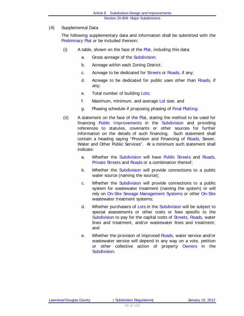
Article 8 Subdivision Design and Improvements
Section 20-809 Major Subdivisions
Lawrence/Douglas County | Subdivision Regulations| January 10, 2012 49 of 120
(4) Supplemental Data
The following supplementary data and information shall be submitted with the Preliminary Plat or be included thereon:
(i) A table, shown on the face of the Plat, including this data:
a. Gross acreage of the Subdivision;
b. Acreage within each Zoning District;
c. Acreage to be dedicated for Streets or Roads, if any;
d. Acreage to be dedicated for public uses other than Roads, if any;
e. Total number of building Lots;
f. Maximum, minimum, and average Lot size; and
g. Phasing schedule if proposing phasing of Final Platting.
(ii) A statement on the face of the Plat, stating the method to be used for financing Public Improvements in the Subdivision and providing references to statutes, covenants or other sources for further information on the details of such financing. Such statement shall contain a heading saying “Provision and Financing of Roads, Sewer, Water and Other Public Services”. At a minimum such statement shall indicate:
a. Whether the Subdivision will have Public Streets and Roads, Private Streets and Roads or a combination thereof;
b. Whether the Subdivision will provide connections to a public water source (naming the source);
c. Whether the Subdivision will provide connections to a public system for wastewater treatment (naming the system) or will rely on On-Site Sewage Management Systems or other On-Site wastewater treatment systems;
d. Whether purchasers of Lots in the Subdivision will be subject to special assessments or other costs or fees specific to the Subdivision to pay for the capital costs of Streets, Roads, water lines and treatment, and/or wastewater lines and treatment; and
e. Whether the provision of improved Roads, water service and/or wastewater service will depend in any way on a vote, petition or other collective action of property Owners in the Subdivision.

Article 8 Subdivision Design and Improvements
Section 20-809 Major Subdivisions
Lawrence/Douglas County | Subdivision Regulations| January 10, 2012 50 of 120
(iii) A separate narrative, explaining in detail the general nature and type of Public Improvements proposed for the Subdivision, and the manner by which the Subdivider intends to provide for their installation, as for example, by Public Improvement Petition, actual construction, escrow deposit, or performance bond. If other than by Public Improvement Petition, the approximate time for completion of such Improvements should be indicated.
(iv) Notation on the face of the Plat that all new telephone, cable television and electrical lines (except high voltage lines) must be located underground when in the City of Lawrence or in Lawrence Urban Growth Area.
(v) Notation on the face of the Plat that the Developer is responsible for the cost of any relocation of existing utilities, if necessary to serve the proposed Subdivision.
(5) Stormwater Drainage – City of Lawrence
(i) Supplemental Data
The Preliminary Plat shall contain data, information and supplemental maps of surrounding property in sufficient detail regarding storm water drainage issues, as determined by the Planning Director or the Planning Commission. The Planning Director or the Planning Commission may request additional data, information and supplemental maps from the applicant regarding storm water drainage, as appropriate.
(ii) Minimum Floor Elevations
On Lots adjacent to all drainage Easements and on drainageways that are designated by the Director of Public Works or his or her designee, the Preliminary Plat shall indicate:
a. The required minimum habitable floor elevations for structures on Lots; or,
b. The minimum elevation for a foundation opening(s) which shall be certified by a licensed Land Surveyor or Engineer.
c. A note that states: If a basement is built on a Lot where a minimum elevation has been established, the building design is encouraged to incorporate a sump pump.

Article 8 Subdivision Design and Improvements
Section 20-809 Major Subdivisions
Lawrence/Douglas County | Subdivision Regulations| January 10, 2012 51 of 120
(g) Review and Action by the Planning Commission
(1) The Planning Commission shall conduct the review of the application at the meeting at which it is scheduled by the Planning Director, unless the Subdivider requests deferral to a future meeting. The Planning Commission shall determine if the Preliminary Plat conforms to the requirements of the Subdivision Regulations and such determination shall be made within 60 days after the first meeting the Planning Director has placed the submitted Plat on a Planning Commission agenda for action.
(2) If the Planning Commission finds that the proposed Preliminary Plat conforms to all of the criteria set forth in Section 20-809(d) the Planning Commission shall approve the Preliminary Plat.
(3) If the Planning Commission finds that the proposed Preliminary Plat fails in any way to conform to the standards set forth in Section 20-809(d), the Planning Commission shall, by motion, deny approval to the proposed Preliminary Plat and shall state in the motion the reason(s) for that denial.
(4) The Planning Director shall give written notice to the Subdivider of the action of the Planning Commission. If the Preliminary Plat has been disapproved, or conditionally approved, the notice shall specifically state the ways in which the Preliminary Plat fails to conform to these Subdivision Regulations.
(5) If the deficiency or other reason for denial can be cured through action of the applicant, the applicant may submit a revised application and Preliminary Plat within 60 days after receipt of the written notice and shall not be required to pay a further fee. In case of a resubmission, the Planning Commission shall consider the resubmitted application at the next meeting occurring at least 21 days after receipt of the complete resubmission by the Subdivider.
(6) If the Planning Commission fails to act on the Preliminary Plat within 60 days of the date of their first meeting occurring after the receipt of a Preliminary Plat on their agenda, the Subdivider may, by letter, apply to the Planning Director for a “Certificate of Deemed Approval”. If the Planning Director finds that a complete application was received at least 60 days before the date of the letter and placed on a Planning Commission agenda, and that no action has been taken by the Planning Commission, the Planning Director shall issue a “Certificate of Deemed Approval” indicating that “this Preliminary Plat shall be deemed approved due to a failure of the Planning Commission to take timely action in accordance with K.S.A. 12-752(b).”

Article 8 Subdivision Design and Improvements
Section 20-809 Major Subdivisions
Lawrence/Douglas County | Subdivision Regulations| January 10, 2012 52 of 120
(h) Phasing for Final Plats
(1) A Preliminary Plat may, at the option of the applicant, contain a proposed schedule for submitting Final Plat applications in phases. The Planning Commission may approve the proposed phasing plan if it finds that:
(i) The area represented by each proposed phase is of sufficient size to permit the economical installation of Public Improvements;
(ii) All parts of the necessary public and private Improvements Plans to serve the Subdivision will be provided concurrently with the phase which will first be served by those Improvements or part thereof, or with an earlier phase; and
(iii) All perimeter Rights-of-Way shall be dedicated for the entire Preliminary Plat with the first Final Plat phase of the approved Preliminary Plat.
(i) Effects of Approval by the Planning Commission
(1) Approval of the Preliminary Plat by the Planning Commission shall constitute approval of “the Plat” for purposes of K.S.A. 12-752, subject only to the following:
(i) Submission of a Final Plat, in the form and containing all of the information required by Section 20-809(k). The Final Plat shall be in substantial compliance with the Planning Commission’s approval of the Preliminary Plat, including satisfying any conditions imposed on that approval; and
(ii) Completion of Street/Roads, Roads and Public Improvements required by the terms of the approval of the Preliminary Plat, or provision of satisfactory Guarantees of Completion of Improvements, in accordance with Section 20-811(h)(2).
(j) Preliminary Plat Expiration
(1) Approval of a Preliminary Plat by the Planning Commission shall expire:
(i) Twenty four months from the date approval was granted, unless a complete application for Final Plat is submitted by that approval date.

Article 8 Subdivision Design and Improvements
Section 20-809 Major Subdivisions
Lawrence/Douglas County | Subdivision Regulations| January 10, 2012 53 of 120
(2) Upon application by the Subdivider, the Planning Commission may, if the cause of failure of the Subdivider to submit a Final Plat is beyond the Subdivider’s control, grant an extension of the time beyond this period, for a 24 month period for good cause shown. Such request for extension must be submitted to the Planning Director prior to the expiration of the 24 month approval period.
(i) The Planning Director shall place such request, with any recommendation, on the next available Planning Commission agenda based on the adopted submittal schedule.
(ii) The Planning Director shall notify the applicant by mail of the date of the proposed consideration by the Planning Commission. Mailed notice of the extension request shall also be provided by the Planning Office in accordance with Section 20-802(d). On that date, the Planning Commission shall hear from the applicant and the Planning Director and may hear from other interested parties.
(3) If a Final Plat has not been submitted, approved, and recorded within this 24 month period, or within an extension period, a Preliminary Plat must be resubmitted to the Planning Commission, reviewed and considered by the Planning Commission in accordance with the procedures set forth herein.
(k) Final Plat – Application
The Subdivider may initiate review of the Final Plat at any time after approval of the Preliminary Plat by the Planning Commission, including satisfaction of all conditions of Preliminary Plat approval. The Final Plat shall be processed in accordance with the provisions of Section 20-809(m).
(1) Each application shall be accompanied by:
(i) The applicable filing fee;
(ii) A completed Major Subdivision-Final Plat application form;
(iii) The required number of paper copies and an electronic copy of a complete submission of a Final Plat; and
(iv) All of the materials required by Section 20-809(l), as well as any additional materials required by the application form provided by the Planning Director.
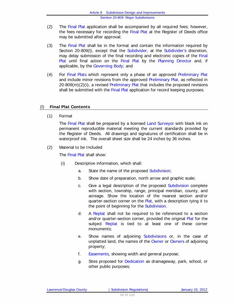
Article 8 Subdivision Design and Improvements
Section 20-809 Major Subdivisions
Lawrence/Douglas County | Subdivision Regulations| January 10, 2012 54 of 120
(2) The Final Plat application shall be accompanied by all required fees; however, the fees necessary for recording the Final Plat at the Register of Deeds office may be submitted after approval;
(3) The Final Plat shall be in the format and contain the information required by Section 20-809(l), except that the Subdivider, at the Subdivider’s discretion, may delay submission of the final recording and electronic copies of the Final Plat until final action on the Final Plat by the Planning Director and, if applicable, by the Governing Body; and
(4) For Final Plats which represent only a phase of an approved Preliminary Plat and include minor revisions from the approved Preliminary Plat, as reflected in 20-809(m)(2)(i), a revised Preliminary Plat that includes the proposed revisions shall be submitted with the Final Plat application for record keeping purposes.
(l) Final Plat Contents
(1) Format
The Final Plat shall be prepared by a licensed Land Surveyor with black ink on permanent reproducible material meeting the current standards provided by the Register of Deeds. All drawings and signatures of certification shall be in waterproof ink. The overall sheet size shall be 24 inches by 36 inches.
(2) Material to be Included
The Final Plat shall show:
(i) Descriptive information, which shall:
a. State the name of the proposed Subdivision;
b. Show date of preparation, north arrow and graphic scale;
c. Give a legal description of the proposed Subdivision complete with section, township, range, principal meridian, county, and acreage. Show the location of the nearest section and/or quarter-section corner on the Plat, with a description tying it to the point of beginning for the Subdivision.
d. A Replat shall not be required to be referenced to a section and/or quarter-section corner, provided the original Plat for the subject Replat is tied to at least one of these corner monuments;
e. Show names of adjoining Subdivisions or, in the case of unplatted land, the names of the Owner or Owners of adjoining property;
f. Easements, showing width and general purpose;
g. Sites proposed for Dedication as drainageway, park, school, or other public purposes;

Article 8 Subdivision Design and Improvements
Section 20-809 Major Subdivisions
Lawrence/Douglas County | Subdivision Regulations| January 10, 2012 55 of 120
(ii) In addition, the following information is required which is similarly required on the Preliminary Plat:
a. Location of any area within a Floodplain Overlay District zoning district;
b. Boundaries of significant Stands of Mature Trees, Jurisdictional Wetlands, historic sites and archaeological sites on the property proposed for Subdivision; protected environmentally sensitive lands as shown on the Preliminary Plat.
c. For properties within the City, the environmentally sensitive lands shall be located within a Tract or Easement and the Plat shall contain information regarding Ownership and maintenance of the Tract or Easement as well as the protection measures for the environmentally sensitive lands.
d. For properties within the unincorporated portions of the County, the Plat shall include a Building Envelope which excludes the environmentally sensitive lands and one of the following: a note that a Temporary Set Aside Agreement or permanent Conservation Easement which contains use restrictions and maintenance and protection measures has been recorded for the environmentally sensitive lands and the Book and Page Number for the recorded Temporary Set Aside Agreement or permanent Conservation Easement; or the protected environmentally sensitive lands shall be placed within Easements or Tracts and the Plat shall note the Ownership, maintenance responsibility and protection measures of the protected lands.
e. Proposed Streets (including location and proposed names), and their relation to Platted Streets or to proposed Streets as shown on any adopted general development plan of adjacent property; and,
f. Block and Lot numbers and dimensions of Blocks and Lots.
(iii) Accurate dimensions for all lines, angles, and curves used to describe boundaries, Streets, Easements and areas to be reserved for public use. Data for all curves shall include radius, arc length, chord length, and central angle;
(iv) For land located in a Floodplain, as defined and regulated under Chapter 20, Article 12 of the City Code and Section 12-328 of the Zoning Regulations for the Unincorporated Area of Douglas County, the following:
a. The total area of each Lot located in the designated Floodplain;
b. The Minimum Building Elevation and Minimum Elevation of Building Opening, as determined from Chapter 20, Article 12 of the City Code or Section 12-328 of the Zoning Regulations for the Unincorporated Area of Douglas County.

Article 8 Subdivision Design and Improvements
Section 20-809 Major Subdivisions
Lawrence/Douglas County | Subdivision Regulations| January 10, 2012 56 of 120
(v) On Lots adjacent to all drainage Easements and on drainageways that are designated by the Director of Public Works or his or her designee, the Final Plat shall indicate:
a. The required minimum habitable floor elevations for structures on Lots; or,
b. The minimum elevation for a foundation opening(s) which shall be certified by a licensed Land Surveyor or Engineer.
c. A note that states: If a basement is built on a Lot where a minimum elevation has been established, the building design is encouraged to incorporate a sump pump.
(vi) For any Lot including or adjacent to a Lot including environmentally sensitive lands as defined in Section 20-810(k) [County Code Section 11-110(k)] designation of a Building Envelope within which a building may be built after compliance with all applicable setback, Floodplain and sensitive land standards;
(vii) The dated signature and seal of the licensed Land Surveyor responsible for the survey and a note stating: “This survey conforms to the Kansas Minimum Standards for Boundary Surveys”;
(viii) Acknowledged certifications on the face of the Final Plat as listed below (may be combined where appropriate):
a. A certificate signed by all parties having any record, title or interest of record in the land Subdivided, showing their consent to the preparation and recording of the Plat;
b. A certificate, signed by the Owner or Owners, dedicating all Parcels of land which are intended for public use;
(ix) The endorsement of the Planning Commission as evidenced by the signature of its Chairperson;
(x) Acceptance of Dedication by the appropriate Governing Body, as indicated by the signature of the Chairperson of the Board of County Commissioners, the Mayor or another Person authorized to sign on behalf of either;
(xi) As a separate document, a certificate that all taxes and special assessments due and payable have been paid.
a. In the case of unpaid special assessments, a proposed redistribution of such unpaid special assessments which meets the county or city’s requirements and is acceptable to the County or City Clerk and County or City’s Public Works Director.
(xii) A note shall be placed on the Final Plat indicating that additional information concerning drainage and structural elevations are placed on the Preliminary Plat, if such requirement has been placed on the Preliminary Plat.

Article 8 Subdivision Design and Improvements
Section 20-809 Major Subdivisions
Lawrence/Douglas County | Subdivision Regulations| January 10, 2012 57 of 120
(xiii) A line shall be provided on the Plat for the review date and signature of the County Surveyor beneath a note stating: “Reviewed in compliance with K.S.A. 58-2005”.
(xiv) A reference line shall be provided on the Plat indicating the book and page where the Master Street Tree Plan is recorded at the Register of Deeds.
(xv) A note shall be placed on the Final Plat designating any Lots Abutting a Half-Street and that take sole Access from that Public Right-of-Way as non-buildable in accordance with Section 20-810(e)(9)(ii).
(xvi) Evidence shall be submitted with the Final Plat providing one or more of the means of ensuring completion of required Public Improvements identified in Section 20-811(h).
(m) Final Plat – Review and Action by Planning Director
(1) After approval or approval with conditions of a Preliminary Plat by the Planning Commission and prior to final approval of Public Improvement Plans, the Subdivider shall have prepared for recording a Final Plat, which is consistent with the action of the Planning Commission and with the formatting and content requirements of Section 20-809(l).
(2) If the Planning Director finds that the submitted Final Plat conforms with the content requirements of Section 20-809(l) and in substantial compliance with the Preliminary Plat approved by the Planning Commission, including satisfying any conditions incorporated in that approval, the Planning Director shall approve the Final Plat and attach to it a formal certification that the submitted Final Plat:
(i) Is in substantial compliance with the Preliminary Plat approved by the Planning Commission. The Final Plat shall be deemed to be in substantial compliance with the previously approved Preliminary Plat if one or more of the following criteria are met, as applicable:
a. No change.
b. Increase or reduction, less than or equal to ten percent, of the number of approved Lots, Parcels or Tracts shown within the approved phase of the Preliminary Plat.
c. Minor adjustments to Rights-of-Way lines, Easement lines and/or property lines to account for technical changes related to the proposed Public Improvement Plans.
d. Modifications to Easements and Rights-of-Way when the general form of the approved Preliminary Plat with regard to overall layout, public and/or private vehicular and pedestrian connection, area set aside for public space and/or open space, and required utility corridors is maintained.

Article 8 Subdivision Design and Improvements
Section 20-809 Major Subdivisions
Lawrence/Douglas County | Subdivision Regulations| January 10, 2012 58 of 120
(ii) Satisfies any conditions of approval imposed by the Planning Commission;
(iii) Includes the same proposed Dedications subject to minor technical adjustments as described in Section 20-809(m)(2)(i)(a) through (d), above;
(iv) Represents a Plat for which all required Public Improvements have been completed, or for which adequate Guarantee of Improvements has been provided as identified in Section 20-811(h); and
(v) Is otherwise consistent with the requirements of this Article for a Final Plat.
(3) If the Planning Director finds that the submitted Final Plat is deficient as to format or content or otherwise technically deficient, the Planning Director shall notify the Subdivider of the deficiency(ies) within 5 working days.
(4) If the Planning Director finds that the submitted Final Plat does not substantially comply with the approved Preliminary Plat, including any conditions incorporated in such approval, and with the proposed Dedications shown on the Preliminary Plat, subject to Section 20-809(m)(2)(i)(a) through (d), the Planning Director shall place the Final Plat on the agenda of the next Planning Commission meeting following the notice provisions of Section 20-802(d), for further consideration in accordance with the Preliminary Plat review and action provisions of Section 20-809(g).
(5) The Planning Commission approval of the Preliminary Plat combined with the Planning Director’s approval as to form and substantial compliance with the approved Preliminary Plat shall constitute Planning Commission approval of the Final Plat. No further action by the Planning Commission shall be necessary or required.

Article 8 Subdivision Design and Improvements
Section 20-809 Major Subdivisions
Lawrence/Douglas County | Subdivision Regulations| January 10, 2012 59 of 120
(n) Final Plat – Review and Action by Governing Body
(1) A Final Plat that has been approved by the Planning Director shall be submitted to the Governing Body, as applicable, for its consideration of acceptance of the Dedication of Street/Roads and other public Rights-of-Ways, service, and utility Easements and any land dedicated for public purposes.
(2) The Governing Body shall accept or refuse the Dedication of land for public purposes within 30 days after the first meeting of the Governing Body following the date of the Final Plat’s submission to the Clerk of the appropriate Governing Body. The Governing Body may defer action for an additional 30 days for the purpose of allowing for modifications to comply with the requirements established by the Governing Body. No additional review and recording fees shall be assessed during that period.
(3) If the Governing Body defers or refuses these Dedications, it shall advise the Planning Director of the reasons thereof.
(4) Failure of the Governing Body of the city or of the county to accept affirmatively a Dedication shown on the Final Plat shall be deemed to be a refusal of the proposed Dedication.
(5) The respective Governing Bodies maintain full legislative discretion to reject any proposed Dedication, regardless of the approval of the Final Plat. If the Governing Body rejects part or all of a proposed Dedication, the Subdivider may amend the Final Plat and resubmit it for consideration by the Planning Director without the rejected Dedication; if the Subdivider takes no action within 60 days of the rejection of any proposed Dedication, it shall constitute failure of a material condition of the approval of the Final Plat and the Final Plat shall be deemed to have been rejected.
(o) Signatures on Final Plat
If the Planning Director has approved and certified the Final Plat in accordance with Section 20-809(m), the Planning Director within 5 working days of receipt of the recordable copies of the Final Plat, shall submit the Final Plat to the Chair of the Planning Commission and to the Mayor or Chairperson of the Board of County Commissioners, as applicable, for signatures. Each of these persons shall, if he or she accepts the certification of the Planning Director, sign the Final Plat, including the “Acceptance of Dedications” certificate; if any of these persons refuse to sign the Final Plat, he or she shall refer the Final Plat to the Planning Commission for consideration at its next meeting in accordance with the requirements of Section 20-809(g), together with a memorandum explaining the reasons why such person refused to sign it.

Article 8 Subdivision Design and Improvements
Section 20-809 Major Subdivisions
Lawrence/Douglas County | Subdivision Regulations| January 10, 2012 60 of 120
(p) Processing after Approval of Final Plat
(1) After all signatures have been obtained and all other requirements of this Article have been completed, the Planning Director shall forward the recordable copy of the Final Plat to the Register of Deeds for recording. The recorded version of the Plat shall bear the endorsements provided in Section 20-809(l) including the endorsement by the Governing Body accepting the Dedications.
(2) Upon approval and acceptance of all Final Plats that create new Street/Roads or other Public Improvements, detailed Street/Road and/or utility plans shall be submitted to and approved by either the County Engineer or City Engineer, as applicable, prior to recording of the Final Plat, and these plans shall include the following:
(i) Plan, profile, ditch grades, and cross-sections of all Street/Roads, Alleys and other public ways; and,
(ii) Drainage areas and size and length of cross-Road drainage structures.
(3) Prior to the Final Plat being recorded with the Register of Deeds, a digital version of the Plat shall be submitted to the Planning Director in a format approved by the Planning Director. The digital file shall be registered to the State Plane Coordinate Grid System used by the city and county.
(4) Errors found in closure or internal dimensions shall be corrected prior to recording the Final Plat at the Register of Deeds.
(q) Final Plat Expiration
(1) Approval of a Final Plat by the Planning Director and acceptance of Dedications by the appropriate Governing Body shall be effective for no more than 24 months from the date of acceptance unless all conditions of approval have been completed, unless an extension has been granted by the Planning Director for good cause.
(2) Such request for extension must be submitted to the Planning Director prior to the expiration of the original 24 month approval period.

Article 8 Subdivision Design and Improvements
Section 20- -810 Subdivision Design Standards
Lawrence/Douglas County | Subdivision Regulations| January 10, 2012 61 of 120
20-810 Subdivision Design Standards
(a) General
(1) Applicability
All Subdivisions shall comply with the Design Standards of this Section and the Public Improvement Standards of Section 20-811.
(2) Design of Lots
(i) Lots shall be laid-out and designed to comply with all applicable zoning district regulations. The size, width, depth, shape, and orientation of each Lot in a Subdivision shall also take into consideration Topography (steepness of slope and gradient), physical features, type of use contemplated and effect on adjacent Lots.
(ii) Lots for commercial and industrial use shall be of size and arrangement to allow for off-Street/Road parking and loading facilities.
(iii) Double-Frontage and Reverse-Frontage Lots shall be avoided except where they are necessary to provide for the separation of residential development from Collector and Arterial Street/Roads or to overcome challenges of steep Topography and orientation.
(iv) A planting screen Easement of a minimum 20 feet, with or without a berm, shall be provided along the portion of the Lots Abutting such an Arterial Street/Road if required by the Planning Commission.
(v) Corner Lots shall be a minimum of 20% wider than the minimum Lot Width required in the applicable zoning district to allow for appropriate building setbacks and sufficient yard space.
(3) Plans for Resubdivision
(i) Whenever an area is divided into residential Lots with a Lot area of one acre or greater, and there is a possibility that such Lots may eventually be re-subdivided into smaller Lots, consideration shall be given to the Street, and Lot arrangement of the original Subdivision so that additional Streets can be opened later to permit a logical arrangement of smaller Lots.
(ii) Provision of Easements or Right-of-Way for the future opening and extension of such Streets and for gravity sewers and stormwater drainage shall be made a condition of Preliminary Plat approval.
(b) Frontage
All Lots shall have Frontage on a Public Street unless Lot Frontage is approved on a Private Street as part of a Planned Development.

Article 8 Subdivision Design and Improvements
Section 20- -810 Subdivision Design Standards
Lawrence/Douglas County | Subdivision Regulations| January 10, 2012 62 of 120
(c) Access
(1) City of Lawrence
For Lots located within the City, Access shall be provided directly from a Street or as follows:
(i) An Alley may provide the primary vehicular Access to one or more Lots in a Subdivision, provided that each such Lot shall have Street Frontage on a Public Street unless designed as part of a Planned Development.
(ii) Alley Access is particularly appropriate where the Street Frontage for the Lot is on a Collector or Arterial Street.
(iii) Residential shared Driveways are permitted when a recorded Access Easement is provided.
(iv) Joint-Use Driveways in Lawrence with a minimum paved width of 24 feet may be approved as part of the Subdivision approval process for non-residential developments (e.g., shopping centers, industrial/business parks), if there is a city approved Easement of record ensuring perpetual Access to the Joint-Use Driveway by all Lots with Frontage and providing for the perpetual Ownership, continuance and maintenance of the Joint-Use Driveway.
(v) Joint-Use Driveways shall not be considered as parking or loading space or as an aisle for Access to individual parking spaces in computing conformance with the parking requirements of the Development Code.
(vi) Joint use Access points may be approved within Lawrence when located wholly within the dedicated Public Street Right-of-Way.
(2) Unincorporated Area of the County
For Lots located within the Unincorporated Areas of the County, Access shall be directly from a Road or as follows:
(i) Joint-Use Driveways are not permitted in the Unincorporated Area of the County.
(ii) Shared Driveway Approaches serving residential uses may only be approved with the filing of an instrument for joint maintenance of the Driveway Approach area and only when individual Driveways are separately maintained beyond the Road Easement or Right-of-Way line.
(iii) Joint use Access points may be approved when located wholly within the dedicated or public Road Easement.

Article 8 Subdivision Design and Improvements
Section 20- -810 Subdivision Design Standards
Lawrence/Douglas County | Subdivision Regulations| January 10, 2012 63 of 120
(d) Blocks
(1) General
The lengths, widths, and shapes of Blocks shall be determined with due regard to:
(i) Limitations and opportunities of Topography and other physical features such as utilities, Floodplains, Jurisdictional Wetlands and natural storm drainage patterns;
(ii) Provision of building sites adequate for the uses contemplated;
(iii) Zoning requirements as to Lot sizes and dimensions; and
(iv) Need for convenient Access, circulation, and control of Street traffic for safety.
(2) Length
(i) City of Lawrence
Block length for Local Streets within the City of Lawrence shall not exceed 800 feet in length (centerline to centerline of Streets) unless the Subdivider demonstrates to the satisfaction of the Planning Commission that:
a. There are Pedestrian Ways at intervals of 700 feet or less, replacing the connection that would exist as a Sidewalk along the Street; and
b. The proposed Block must be greater than 800 feet in length because physical conditions preclude a Block length of less than 800 feet. Such conditions may include, but are not be limited to, Topography or the existence of natural resource areas such as Jurisdictional Wetlands, Floodplains, wildlife habitat areas, steep slopes or Woodlands.
(ii) Unincorporated Area of the County [Reserved]
(3) Width
A residential Block shall have sufficient width to allow for two tiers of Lots of appropriate depth unless it adjoins a limited-Access, Collector, or Arterial Street, railroad or other nonresidential use, in which case it may have a single tier of Lots that exceed the minimum Lot area required in the zoning district.
(4) Shape
Blocks may be irregular in shape, provided their design meets the requirements of Lot standards, traffic flow and control considerations and any adopted watershed/ sub-basin plans, Sector or Neighborhood Plan.

Article 8 Subdivision Design and Improvements
Section 20- -810 Subdivision Design Standards
Lawrence/Douglas County | Subdivision Regulations| January 10, 2012 64 of 120
(e) Streets
(1) General
(i) Local Streets within the City of Lawrence should be less than 1,320 feet in length.
a. Local Streets exceeding 800 feet in length shall include Traffic Calming Devices, shown in an adopted City of Lawrence Traffic Calming Policy document as maintained by the Public Works Director.
(ii) All Streets within Subdivisions shall be laid-out, arranged and designed in accordance with any adopted watershed/sub-basin plans, Sector or Neighborhood Plan or, in the absence of such a plan, with all applicable standards of this Article.
(iii) Arterial and Collector Streets shall be laid-out, arranged and designed in accordance with any adopted Major Thoroughfares Map or corridor plan.
(iv) Subdivisions shall provide a logical Street layout in relation to topographical conditions, public convenience, safety and the proposed use of the land to be served by such Streets.
(v) At time of Preliminary Plat approval, the full Right-of-Way for all boundary line and Full Maintenance Roads under the applicant’s Ownership control shall be annexed to the City.
(2) Connections
(i) Street connections shall provide Access to adjoining lands, existing and proposed Streets.
(ii) Every Subdivision shall provide for at least one Street connection to each adjacent Subdivision or future adjacent Subdivision.
a. Any existing or Platted Street that terminates at the boundary line of a proposed Subdivision shall be continued into the proposed Subdivision in such a manner as to provide Street connections to adjoining lands and Streets within the proposed Subdivision or,
b. Local Streets may terminate in a Cul-de-sac if an existing environmental feature dictates the design.
(iii) Streets shall provide connections to adjacent undeveloped land in accordance with the adopted Major Thoroughfares Map.
(iv) Proposed Subdivisions that have Access to the public Road system via a Single Outlet must comply with the currently adopted International Fire Code. IFC requirements may limit the total number of Lots or residential Dwelling units permitted; total amount of square feet constructed; or the type of construction allowed.

Article 8 Subdivision Design and Improvements
Section 20- -810 Subdivision Design Standards
Lawrence/Douglas County | Subdivision Regulations| January 10, 2012 65 of 120
(v) Residential Collector Streets shall provide connections to nonresidential uses within the neighborhood and shall not typically intersect with Arterial Streets.
a. Bicycle & pedestrian facilities are strongly recommended for Residential Collectors.
b. Various traffic-calming treatments may be used to reduce travel speeds.
c. Residential Collector Streets with adjacent residential land uses should, in most cases, be limited to two lanes.
d. Residential Collector Streets that connect neighborhoods to shopping areas shall be designed to have indirect connections to Arterial Streets.
(vi) Streets longer than one Lot that terminate at the property boundaries of undeveloped land shall provide an improved temporary Turn-around.
(3) Intersecting Streets
(i) Local Streets generally should not intersect Arterial Streets. The Planning Commission, with the City Engineer’s recommendation, may approve a new connection of a Local Street to an Arterial Street:
a. Where it finds that such connection is part of the best traffic solution for the new Subdivision; and
b. Where the Subdivider will add turn lanes or other Improvements recommended by the City Engineer to the Arterial Street to minimize the impact of the connection on the functioning of the Arterial Street.
(ii) Local Streets intersecting opposite sides of another Local or Collector Street when offset shall be offset 300 feet or more.
(iii) Streets shall intersect as nearly as possible at right angles.
(iv) Not more than two Streets shall intersect at any one point.
(4) Requirements When Access Barriers Exist
Wherever a proposed Subdivision contains or is adjacent to a Marginal Access Street or Road; an Arterial Street or a railroad Right-of-Way; the Planning Commission, as part of the Preliminary Plat approval, shall require the following for the protection for the integrity and subsequent safety, efficiency and economy of the Marginal Access, Arterial, or railroad Right-of-Way:
(i) Dedication of a Local Street or Road to provide ingress and egress to and from such Blocks or Lots;
(ii) A Street or Road approximately parallel to and on each side (where applicable) of such Marginal Access Street or Road, Arterial Street or railroad Right-of-Way at a distance suitable for the appropriate use of the land between such Streets or Roads;

Article 8 Subdivision Design and Improvements
Section 20- -810 Subdivision Design Standards
Lawrence/Douglas County | Subdivision Regulations| January 10, 2012 66 of 120
(iii) Reverse Frontage Lots with Access Control provisions along the rear property line; or
(iv) Adequate distance between such parallel Streets or Roads and the Arterial, Marginal Access Street or Road, or railroad so as to provide for proper approach grades and future grade separation.
(5) Cross-Sections
(i) City of Lawrence
All Platted Subdivisions lying within the City of Lawrence shall comply with the following cross-section standards:
Street Type
Right-of-Way
Min. Width (feet)
Principal Arterial 150
Minor Arterial (3 lane) 100
Collector 80
Residential Collector 60
Local 60
Limited Local 50
Cul-de-sac 60
Marginal Access (Frontage Road)
60
a. Pavement width constructed according to City standards. b. Additional r-o-w may be necessary at Intersections. c. Paved bulb with 50’ radius is required/60’ minimum r-o-w radii
required.

Article 8 Subdivision Design and Improvements
Section 20- -810 Subdivision Design Standards
Lawrence/Douglas County | Subdivision Regulations| January 10, 2012 67 of 120
(ii) Unincorporated Area of the County
All residential developments and nonresidential Subdivisions within the Unincorporated Area shall comply with the following minimum cross-section standards:
Street Type
Right-of-Way
Min. Width (feet)
Principal Arterial (w/ median)
150
Principal Arterial (w/o median)
120
Minor Arterial 100
Major Collector 80
Minor Collector 70
Local 70
a. Right-of-Way shall be sufficient to include top of ditch back
slopes; may be variable b. Road design shall meet design standards contained in KDOT’s
“Project development Manual for Non-National Highway System Local Government Road and Street Projects” and/or AASHTO Green Book standards.

Article 8 Subdivision Design and Improvements
Section 20- -810 Subdivision Design Standards
Lawrence/Douglas County | Subdivision Regulations| January 10, 2012 68 of 120
(6) Grades
The finished grade for all Streets and Roads shall be at or above the base flood elevation. The grades of Streets and Roads shall comply with the following standards:
Street Type Maximum
Grade (%)
Minimum
Grade (%)
Arterials (Principal and Minor):
City or Urban Growth Area 5 1.0
Rural Area 5 1.0
Collector (Major or Minor) 8 1.0
Marginal Access 10 1.0
Local 10 1.0
(i) The City or County Engineer, as applicable, shall be authorized to approve minor deviations for short distances from these grade standards when it is determined that compliance with these standards is impracticable.
(ii) Within the City of Lawrence, maximum grade of Streets serving industrial areas shall be 5% regardless of Street classification.
(7) Radii of Curvature
The minimum radius of curvature of the centerline of Arterial and Collector Street shall meet design standards contained in KDOT’s “Project development Manual for Non-National Highway System Local Government Road and Street Projects” and/or AASHTO Green Book standards.
(8) Cul-de-sacs
(i) Cul-de-sac lengths shall not exceed 10 times the required minimum Lot Width of the base zoning district or 1,000 feet (1,320 feet in Unincorporated Area), whichever is less.
a. A Cul-de-sac’s length shall be measured from the center point of the Cul-de-sac bulb or Turn-around to the centerline of the Right-of-Way of the nearest intersecting through Street.
(ii) Maximum Cul-de-sac length may be increased by up to 25% above the maximum allowed by Section 20-810(e)(8)(i) during the Preliminary Plat approval process if the Planning Commission determines that the proposal meets all of the following criteria:

Article 8 Subdivision Design and Improvements
Section 20- -810 Subdivision Design Standards
Lawrence/Douglas County | Subdivision Regulations| January 10, 2012 69 of 120
a. It is impracticable to connect the Street to another Street or to provide a looped Street or other means of Access that would avoid the Cul-de-sac or allow the Cul-de-sac to meet the length limit because: 1. The area is separated from other parts of the Subdivision
or a possible Street connection by Floodplains, Jurisdictional Wetlands, or steep slopes greater than 10% or other natural resource areas; and
2. Other properties adjoining the area have already been
Subdivided or developed in a manner that precludes connecting the Cul-de-sac to an existing or proposed Street.
b. Use of Cluster Housing provisions of this Development Code would not reasonably allow compliance with the Cul-de-sac length limit of Section 20-810(e)(8) and realization of at least 75% of the maximum Lot density allowed by the site’s base zoning; and
c. The degree of increase in allowable Cul-de-sac length is the minimum necessary to allow the above findings.
d. The Subdivider bears the burden of demonstrating that all criteria have been met.
(iii) In Subdivisions with Cul-de-sacs, Easements may be required to ensure that the water supply system is looped.
(iv) If a Cul-de-sac is longer than 600 feet, the Subdivision shall include Pedestrian Easements at the terminus of the Cul-de-sac to provide pedestrian connections to and from the Cul-de-sac, in accordance with 20-810(h)(4)(iii).
(9) Half-Streets
(i) Whenever Right-of-Way for one-half of a Street has been dedicated to bring that Street to then-current standards, regardless of whether that half of the Street has been improved, and a Subdivision of land adjoining the other half of the Street is proposed, the remainder of the Right-of-Way shall be dedicated and improved by the Subdivider.
(ii) No building permits shall be issued for Lots with Access only to a Half-Street until the entire remainder of the Street Right-of-Way between the two nearest intersecting Streets and passing in front of the subject Lot(s) is dedicated and improved.

Article 8 Subdivision Design and Improvements
Section 20- -810 Subdivision Design Standards
Lawrence/Douglas County | Subdivision Regulations| January 10, 2012 70 of 120
(10) Private Streets and Roads
(i) Unincorporated Area of the County
a. Private Roads are prohibited in the Unincorporated Area of Douglas County, except for those that were approved prior to December 15, 1998.
b. Before Douglas County will consider a request to assume maintenance of any existing Private Road, by Dedication or otherwise, the Road must be brought into compliance with all applicable Road and Right-of-Way standards.
(ii) City of Lawrence
a. New Private Streets in the City are permitted only in Planned Developments approved by the Planning Commission and City Commission.
b. Private Streets shall be built to City Street construction standards and maintained by the Landowner.
(11) Alleys
(i) Alleys shall be provided in commercial and industrial districts, except that the Planning Director may waive this requirement where other definite or assured provisions are made for service Access, off-Street loading and unloading and parking spaces consistent with and adequate for the uses proposed.
(ii) Alleys shall have a minimum unobstructed Right-of-Way width of 20 feet.
(iii) Alleys shall comply with the construction standards of the city and/or county, as determined by the City or County Engineer.
(iv) Intersecting Alleys shall be prohibited except when no feasible alternative exists. When Alley Intersections are unavoidable, a turning radius shall be provided to permit safe vehicular movement.
(v) Alleys that serve dock areas shall be designed with adequate Turn-around facilities.
(f) Street and Road Names and Lot and Block Numbering
(1) City of Lawrence
(i) Street names shall be proposed by the Subdivider, reviewed by the Public Works Director, and approved by the City Commission. The approval of Street names shall be within the legislative discretion of City Commission, subject to the following standards:
a. Compass directions shall not be used as part of Street names;
b. The identifiers “Court and “Circle” shall be used as follows:

Article 8 Subdivision Design and Improvements
Section 20- -810 Subdivision Design Standards
Lawrence/Douglas County | Subdivision Regulations| January 10, 2012 71 of 120
1. A Court identifies a Dead-End or Cul-de-sac; and 2. A Circle identifies a Street where both ends terminate at
the same Roadway.
c. Streets that run in an east – west direction shall be named as numbered Streets;
(ii) Existing Street names shall be used where the Street to be named is, or would be, a logical extension of an existing Street even though separated by undeveloped land, natural physical barriers or man-made obstructions; and
(iii) Where a proposed Street is shown on an adopted Major Thoroughfares Map and such map indicates a name for that Street, that name shall be used.
(2) Unincorporated Area of the County
Road names in the unincorporated County shall be named in accordance with the E911 Emergency Management System.
(g) Lot and Block Numbering
Lot numbers shall be assigned by starting in the northeast corner of each Block and proceeding in a counterclockwise direction. When a Street or Road separates a group of Lots, a new Block shall be identified, and the Lots within the new Block shall be numbered as herein specified.
(h) Easements
(1) Permanent Utility Easements
Permanent utility Easements shall be provided where necessary to accommodate utilities that will serve the Subdivision. Permanent utility Easements shall be provided where necessary to allow for utility service in and through the proposed Subdivision. Where such an Easement is necessary, it shall be centered on rear or side Lot Lines, as applicable, and shall be at least 30 feet and 15 feet wide respectively, except that Easements for Street lighting purposes only need not exceed 10 feet in width.
(2) Temporary Utility Easements
Temporary utility Easements shall be provided where necessary to accommodate the installation of utilities that will serve the Subdivision. Temporary utility Easements shall be centered on rear or side Lot Lines and shall be at least 30 feet and 25 feet wide respectively. The temporary utility Easement shall expire after the initial installation of the required utilities. After the expiration of a temporary utility Easement, the permanent utility Easement will govern.
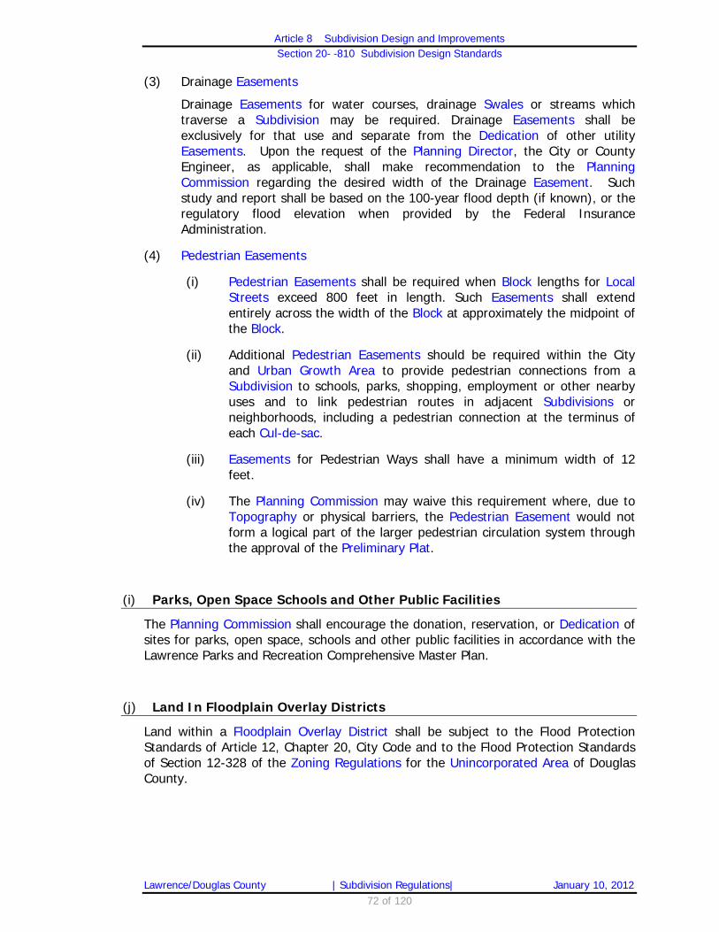
Article 8 Subdivision Design and Improvements
Section 20- -810 Subdivision Design Standards
Lawrence/Douglas County | Subdivision Regulations| January 10, 2012 72 of 120
(3) Drainage Easements
Drainage Easements for water courses, drainage Swales or streams which traverse a Subdivision may be required. Drainage Easements shall be exclusively for that use and separate from the Dedication of other utility Easements. Upon the request of the Planning Director, the City or County Engineer, as applicable, shall make recommendation to the Planning Commission regarding the desired width of the Drainage Easement. Such study and report shall be based on the 100-year flood depth (if known), or the regulatory flood elevation when provided by the Federal Insurance Administration.
(4) Pedestrian Easements
(i) Pedestrian Easements shall be required when Block lengths for Local Streets exceed 800 feet in length. Such Easements shall extend entirely across the width of the Block at approximately the midpoint of the Block.
(ii) Additional Pedestrian Easements should be required within the City and Urban Growth Area to provide pedestrian connections from a Subdivision to schools, parks, shopping, employment or other nearby uses and to link pedestrian routes in adjacent Subdivisions or neighborhoods, including a pedestrian connection at the terminus of each Cul-de-sac.
(iii) Easements for Pedestrian Ways shall have a minimum width of 12 feet.
(iv) The Planning Commission may waive this requirement where, due to Topography or physical barriers, the Pedestrian Easement would not form a logical part of the larger pedestrian circulation system through the approval of the Preliminary Plat.
(i) Parks, Open Space Schools and Other Public Facilities
The Planning Commission shall encourage the donation, reservation, or Dedication of sites for parks, open space, schools and other public facilities in accordance with the Lawrence Parks and Recreation Comprehensive Master Plan.
(j) Land In Floodplain Overlay Districts
Land within a Floodplain Overlay District shall be subject to the Flood Protection Standards of Article 12, Chapter 20, City Code and to the Flood Protection Standards of Section 12-328 of the Zoning Regulations for the Unincorporated Area of Douglas County.

Article 8 Subdivision Design and Improvements
Section 20- -810 Subdivision Design Standards
Lawrence/Douglas County | Subdivision Regulations| January 10, 2012 73 of 120
(k) Protection of Environmentally Sensitive Lands
(1) Definition of Environmentally Sensitive Lands
Certificates of Survey land divisions and Platted Subdivisions shall be designed to protect environmentally sensitive lands which contain natural resources and environmentally sensitive areas. Environmentally sensitive lands are listed below in a priority order for protection:
(i) Regulatory floodway, designated on the FEMA Flood Insurance Rate Map for Douglas County and identified on the GIS Baseline Environmentally Sensitive Lands Map;
(ii) Regulatory floodway fringe, designated on the FEMA Flood Insurance Rate Map for Douglas County based on the 100 year storm and identified on the GIS Baseline Environmentally Sensitive Lands Map;
(iii) Jurisdictional Wetlands, as determined by the Army Corps of Engineers;
(iv) Stream Corridors as defined in these regulations and identified on the GIS Baseline Environmentally Sensitive Lands Map;
(v) Stands of Mature Trees, as defined in these Regulations and identified on the GIS Baseline Environmentally Sensitive Lands Map; and
(vi) Archaeological or historic sites listed on local, state, or federal registers and identified on the GIS Baseline Environmentally Sensitive Lands Map.
(2) Determination of environmentally sensitive lands.
The presence of environmentally sensitive lands shall be determined from an examination of the site and the following resources:
(i) FEMA Flood Insurance Rate Map for Douglas County, most current adopted map;
(ii) US Fish and Wildlife Service National Wetland Inventory Maps;
(iii) GIS Baseline Environmentally Sensitive Lands Map;
(iv) Kansas State Historical Society Archeological and Historic Resources Inventory; and
(v) Other resources which may be appropriate.
(3) Protection Standards for Environmentally Sensitive Lands – City of Lawrence
(i) Section 20-1101(d)(2)(i) of the Land Development Code limits the required protection of environmentally sensitive lands to a maximum protection area of 20% of the total land area of residentially zoned property.

Article 8 Subdivision Design and Improvements
Section 20- -810 Subdivision Design Standards
Lawrence/Douglas County | Subdivision Regulations| January 10, 2012 74 of 120
(ii) Section 20-1101(d)(2(ii)(b) requires that when Platting, environmentally sensitive lands to be protected shall be placed within Tracts or Easements and information regarding Ownership and maintenance responsibility of the Tract or Easement, as well as protection measures, shall be included on the Preliminary and Final Plat.
(iii) Section 20-1101(e) contains information on density bonuses which may be possible when environmentally sensitive lands are protected in greater amounts than required.
(iv) Section 20-1101(d)(2)(ii)(a) requires that a Sensitive Areas Site Plan be submitted prior to, or concurrent with, all Subdivision applications for properties containing environmentally sensitive lands. The requirements of a Sensitive Areas Site Plan are found in Section 20-1101(f).
(4) Protection Standards for Environmentally Sensitive Lands – Unincorporated Area of the County
(i) Per Sections 20-804(c)(3) [County Code Sections 11-104(c)(3)], Certificates of Survey land divisions within the UGA shall protect environmentally sensitive lands through the filing of a Temporary Set Aside Agreement or a permanent Conservation Easement with the Register of Deeds.
(ii) Per Section 20-806(d)(2)(vii) [County Code Section 11-106(d)(2)(vii)] Certificates of Survey outside the UGA for properties which contain environmentally sensitive lands shall designate Building Envelopes which exclude the protected environmentally sensitive lands.
(iii) All Plats which include environmentally sensitive lands shall protect them through one of the following methods:
(iv) The filing of a Temporary Set Aside Agreement or permanent Conservation Easement with the Register of Deeds.
(v) Placement of the environmentally sensitive lands within Tracts or Easements. Information regarding Ownership and maintenance responsibility of the Tract or Easement, as well as protection measures shall be included on the Preliminary and Final Plat.
(vi) Protection of environmentally sensitive lands is encouraged to the maximum amount possible, but required protection is limited to 40% of the site included in the Certificate of Survey and 20% of the total site for Platted properties.

Article 8 Subdivision Design and Improvements
Section 20- -810 Subdivision Design Standards
Lawrence/Douglas County | Subdivision Regulations| January 10, 2012 75 of 120
(l) Soils and Soil Testing – City of Lawrence
Soils shall be identified based on the Soil Conservation Survey soils categories and characteristics. Soils test shall be obtained to verify sub-surface soil characteristics for rocky or unstable soil types, when requested by the City Engineer, for areas proposed to be dedicated for City of Lawrence public Rights-of-Way and public Easements.
(m) Soils and Soil Testing – Unincorporated Area of the County
Soils shall be identified based on the Soil Conservation Survey soils categories and characteristics. Soils test holes shall be conducted in accordance with the Douglas County Sanitary Code.

Article 8 Subdivision Design and Improvements
Section 20-811 Public Improvement Standards
Lawrence/Douglas County | Subdivision Regulations| January 10, 2012 76 of 120
20-811 Public Improvements Standards
(a) General Public Improvement Construction Standards
(1) Standards
All Public Improvements, including but not limited to water, sanitary sewer, Streets, curbs, gutters, storm sewers and storm drainage, roundabouts, pedestrian facilities, Traffic Calming Devices or traffic control devices shall comply with the construction standards established by the City Engineer or County Engineer, as applicable. Such standards are incorporated herein by reference.
(2) Administration and Fees
(i) Compliance with the items listed in Section 20-811(a)(1) and use of appropriate construction methods shall be determined by the County or City Engineer, as applicable.
(ii) A permit shall be issued by the County or City Engineer, as applicable for the construction of a future Public Improvement prior to commencement of any work activity associated with the improvement.
(iii) A fee in an amount determined by resolution of the Governing Body shall be charged for the permit.
(3) Pre-Pinning in the Unincorporated Area of the County
In the Unincorporated Area of Douglas County, at or before the time of construction of Public Improvements, sufficient grade and alignment stakes shall be set by a licensed Land Surveyor, engaged by the Subdivider to assure compliance with plan, profile and drainage of Streets and such other Public Improvements as are proposed and submitted with the Final Plat and approved by the County Engineer.
(i) Compliance with the items listed above and use of appropriate construction methods shall be determined by the County Engineer.
(ii) A permit shall be issued by the County Engineer for the construction of a future Public Improvement prior to commencement of any work activity associated with the improvement.
(iii) A fee in an amount set by Resolution of the County Commission shall be charged for the permit.
(iv) This sub-section shall apply only to Subdivisions in which the complete Lot pinning required by Section 20-811(k) has not been completed at the time that the first Public Improvements are installed.
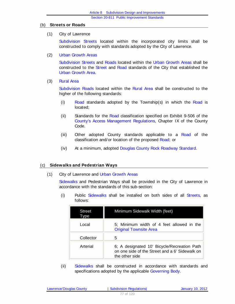
Article 8 Subdivision Design and Improvements
Section 20-811 Public Improvement Standards
Lawrence/Douglas County | Subdivision Regulations| January 10, 2012 77 of 120
(b) Streets or Roads
(1) City of Lawrence
Subdivision Streets located within the incorporated city limits shall be constructed to comply with standards adopted by the City of Lawrence.
(2) Urban Growth Areas
Subdivision Streets and Roads located within the Urban Growth Areas shall be constructed to the Street and Road standards of the City that established the Urban Growth Area.
(3) Rural Area
Subdivision Roads located within the Rural Area shall be constructed to the higher of the following standards:
(i) Road standards adopted by the Township(s) in which the Road is located;
(ii) Standards for the Road classification specified on Exhibit 9-506 of the County’s Access Management Regulations, Chapter IX of the County Code.
(iii) Other adopted County standards applicable to a Road of the classification and/or location of the proposed Road; or
(iv) At a minimum, adopted Douglas County Rock Roadway Standard.
(c) Sidewalks and Pedestrian Ways
(1) City of Lawrence and Urban Growth Areas
Sidewalks and Pedestrian Ways shall be provided in the City of Lawrence in accordance with the standards of this sub-section:
(i) Public Sidewalks shall be installed on both sides of all Streets, as follows:
Street Type
Minimum Sidewalk Width (feet)
Local 5; Minimum width of 4 feet allowed in the Original Townsite Area
Collector 5
Arterial 6; A designated 10’ Bicycle/Recreation Path on one side of the Street and a 6’ Sidewalk on the other side
(ii) Sidewalks shall be constructed in accordance with standards and specifications adopted by the applicable Governing Body.

Article 8 Subdivision Design and Improvements
Section 20-811 Public Improvement Standards
Lawrence/Douglas County | Subdivision Regulations| January 10, 2012 78 of 120
(iii) Variances
a. The applicant for a Subdivision may request a Variance for the requirement to construct part of or all of the Sidewalks in the Subdivision as part of the Preliminary Plat review in accordance with the Variance procedures outlined in Section 20-813(g).
b. If the Planning Commission takes no specific action on a proposed Variance for part or all of a Sidewalk requirement, the Variance shall be deemed to be denied. In reviewing Variance requests from the standard Sidewalk width, special consideration shall be given to walks adjacent to Collector or Arterial Streets located in historic districts and areas with severe site Topography which would make it impractical or difficult to build a Sidewalk in accordance with the above standards.
(iv) Sidewalks required to be constructed within the same Right-of-Way as the Street being paved shall be constructed concurrently with the paving of the adjacent Roadway or with the first phase of development of a multiple-lot Subdivision, adjacent to any improved Street.
(v) Pedestrian Ways
a. Where an approved Preliminary Plat shows a Pedestrian Way other than a Sidewalk, an improved Pedestrian Way not less than five feet wide in the Easement space dedicated for that purpose shall be provided by the Subdivider.
b. Pedestrian Way Easements shall be improved in accordance with adopted City construction standards for Sidewalks and shall conform to all accessibility requirements of the Americans with Disabilities Act.
c. Completion of such Improvements shall be guaranteed in accordance with Section 20-811(h)(2) or subject to site plan review or non-residential development standards.
d. The responsibility for paving the Pedestrian Way shall be the Developer’s, and these Pedestrian Ways shall be constructed concurrent with the paving of the most adjacent Roadway, unless otherwise provided by the Planning Director in acting on the Final Plat.
e. The responsibility for maintenance of the Pedestrian Way shall be that of adjacent property Owners or the Home Owners Association for the Subdivision.

Article 8 Subdivision Design and Improvements
Section 20-811 Public Improvement Standards
Lawrence/Douglas County | Subdivision Regulations| January 10, 2012 79 of 120
(vi) Public Improvement Petitions shall include the construction of Sidewalks or Pedestrian Ways, except where the Planning Commission has specifically waived the installation as provided in Section 20-811(c)(1)(iii) above. The total cost of all Sidewalks or Pedestrian Way Improvements shall be borne by the property benefited in the improvement district.
(2) Urban Growth Areas
An Agreement Not to Protest the Formation of a Future Benefit District for the construction of Sidewalks may be required as a condition of approval for Platted Subdivisions in the Urban Growth Areas in accordance with the standards of Section 20-811(c)(1) for the Lawrence UGA or the standards of the applicable city’s UGA.
(3) Rural Area
The Planning Commission may recommend and the Board of County Commissioners shall be authorized to require Sidewalks in other Major Subdivisions when deemed necessary to provide for safe pedestrian connections to nearby schools, parks, shopping, employment or other uses or activities.
(d) Wastewater Disposal Systems
(1) City of Lawrence and Urban Growth Areas
(i) The approval of any Subdivision requiring connection to the City of Lawrence wastewater system is contingent upon the availability and adequacy of the City to provide wastewater services to the area being Subdivided.
a. It is the applicant’s responsibility to ensure their proposed development takes into consideration the City’s long-range plans, studies, reports, and similar documents for wastewater services, including submission of a Downstream Sanitary Sewer Study in accordance with Administrative Policy No. 76.
b. Failure to conform to these provisions warrant denial of the Subdivision Plat.
(ii) On-Site Sewage Management Systems are prohibited on any land which is Platted under these regulations and is located in the City of Lawrence or in Service Area 1 of the Urban Growth Area of Lawrence.

Article 8 Subdivision Design and Improvements
Section 20-811 Public Improvement Standards
Lawrence/Douglas County | Subdivision Regulations| January 10, 2012 80 of 120
(2) Urban Growth Area and Rural Area
(i) On-Site Sewage Management Systems may be permitted in Subdivisions in Service Areas 2-4 of Lawrence’s Urban Growth Area, other City’s Urban Growth Areas, or in Subdivisions in the Rural Area, subject to the following minimum Lot area standards:
a. For Lots that use well water as the primary Potable Water source, the minimum Lot area for an On-Site Sewage Management System is 5 acres. Any land located within the Floodplain shall not be counted in calculating Lot area for the purpose of meeting minimum Lot area requirements for On-Site Sewage Management System use;
b. For all other Lots, the minimum Lot area requirement for an On-Site Sewage Management System is 3 acres. Any land located within the Floodplain shall not be counted in calculating Lot area for the purpose of meeting minimum Lot area requirements On-Site Sewage Management System;
c. No portion of an On-Site Sewage Management System shall be located within the FEMA designated Floodplain; and,
d. Calculation shall not include land dedicated for Rights-of-Way or exclusive Easements.
(ii) Community Sewage collection and treatment facilities (including lagoons) may be provided for Subdivided or newly created Lots in the Urban Growth Areas or for any other newly created Lots not suitable for an On-Site Sewage Management System.
a. Such systems shall be subject to approval by the Kansas Department of Health and Environment and shall be designed to allow for future connection to a public sewer system.
b. Maintenance of such facilities shall be provided by a Home or Property Owners Association, benefit district (if then permitted under Kansas law), or other appropriate entity. Evidence shall be submitted at the time of Subdivision approval showing the establishment of such an entity to be responsible for maintenance and management of the system.
(iii) In situations in which an On-Site Sewage Management System has been proposed, no Subdivision shall receive final approval until the Subdivider has presented evidence that the On-Site Sewage Management System, as a method of Sewage disposal for the Subdivision, has been approved by the Director of the Lawrence-Douglas County Health Department.
(3) On-Site Sewage Management Systems shall be constructed in accordance with the Douglas County Sanitary Code, Resolution 09-44, as amended.

Article 8 Subdivision Design and Improvements
Section 20-811 Public Improvement Standards
Lawrence/Douglas County | Subdivision Regulations| January 10, 2012 81 of 120
(e) Water Supply
(1) City of Lawrence and Urban Growth Areas
(i) The approval of any Subdivision requiring connection to the City of Lawrence municipal water system is contingent upon the availability and adequacy of the City to provide water services to the area being Subdivided.
a. It is the applicant’s responsibility to ensure their proposed development takes into consideration the City’s long-range plans, studies, reports, and similar documents for water services in accordance with Administrative Policy No. 52.
b. Failure to conform to these provisions warrant denial of the Subdivision Plat.
(ii) Before approval of a Final Plat within Lawrence’s Urban Growth Area that will not be served by the City of Lawrence utilities, the Subdivider shall provide written documentation to the Lawrence-Douglas County Health Department Director and the Lawrence-Douglas County Metropolitan Planning Director that Publicly Treated Water, delivered through a water meter is available to and will be provided for all Lots.
(iii) Before approval of a Final Plat for land located within the City of Lawrence or Lawrence’s Urban Growth Area, the Subdivider must sign an agreement to connect to a municipal water system when public water lines are within 1,000 feet of any planned development on the property and such connection is feasible.
(2) Urban Growth Area and Rural Area
(i) In the Unincorporated County, Subdividers are required to consult with the applicable Fire Department and Rural Water District to determine if the provision of fire hydrants as part of the Public Water Supply system is feasible.
(ii) Where determined by the Fire Department and Rural Water District to be feasible, fire hydrants must be provided.
(iii) Where existing water pressure is insufficient for fire hydrants as part of the Public Water Supply, or where there is no Publicly Treated Water supply, the Subdivider must install dry hydrants adjacent to a pond or other water storage device with sufficient capacity, and in an appropriate location, to support firefighting needs as determined by the applicable Fire Department.

Article 8 Subdivision Design and Improvements
Section 20-811 Public Improvement Standards
Lawrence/Douglas County | Subdivision Regulations| January 10, 2012 82 of 120
(f) Telephone, Cable Television Electrical Lines
(1) Telephone, cable television and electrical lines must be located underground when located in the City of Lawrence or Subdivisions in Lawrence’s Urban Growth Area. This provision shall not apply to high voltage electrical lines.
(2) The Developer is responsible for the cost of any relocation of existing utilities, if necessary to serve the proposed Subdivision.
(g) Street Trees
All Subdivisions within the City of Lawrence or Lawrence’s Urban Growth Area shall be required to provide a Master Street Tree Plan that meets the standards of this sub-section.
(1) Minimum Tree Requirements
Street trees shall consist of canopy shade and/or ornamental trees, as defined below and meeting the following minimum requirements:
(i) Size
Medium or large trees, as defined by Section 18-103(e) of the Code of the City of Lawrence, Kansas, and amendments thereto, which can reach a mature height of 45 feet or greater are required except that ornamental trees planted pursuant to Section 20-811(g)(2)(iv) are not subject to the 45 feet height requirement. The minimum trunk Caliper of Street trees, at the time of planting, measured six inches above the ground in accordance with the American Nurseryman Standards shall be as follows:
Street Tree Type
Minimum Trunk Caliper (inches)
Mature Height (feet)
Canopy Shade
2 (ball and burlap or equivalent) At least 45
Ornamental 2 (ball and burlap or equivalent) No more than 20
(ii) Number
One tree shall be provided for every 40 feet of Street Frontage. The Planning Director may approve a Master Street Tree Plan that varies from this requirement to allow for Driveways, utilities, and Intersection visibility requirements.
(iii) Minimum Species Diversity
The following minimum requirements shall apply to all Master Street Tree Plans. To prevent uniform insect or disease susceptibility, a mix of species shall be provided. The City Parks and Recreation Director shall, upon request, provide a list of trees that are acceptable to satisfy

Article 8 Subdivision Design and Improvements
Section 20-811 Public Improvement Standards
Lawrence/Douglas County | Subdivision Regulations| January 10, 2012 83 of 120
the requirements for Master Street Tree Plans. To promote diversity in the Urban forest, the number of trees required to be planted shall be in accordance with the following requirements:
Number of Trees per Plat
Minimum Number of Species
1–10 1
11–20 2
21–30 3
31–40 4
41+ 6
(2) Planting Location and Spacing
(i) Location in RS and RM12D Zoning Districts
a. Street trees shall be located in the front yard, building setback and/or adjacent to the Right-of-Way at a distance not greater than 10 feet from the boundary line of the Right-of-Way; where practical.
b. Street trees shall be planted after planned utilities have been installed.
c. Trees shall be planted no closer than 8 feet from existing underground utility lines, where practical and approved by the Planning Director.
d. On corner Lots, no tree shall be planted nearer than 50 feet from the intersecting curb lines of the two Streets.
e. No tree shall be planted between the curb and the Sidewalk if the clear space is less than 3 feet wide.
(ii) Location in all Other Zoning Districts
a. Street trees shall be located either within the Street Right-of-Way or within the required front yard building setback, PROVIDED,
b. No tree is located farther than 30 feet from the back of the curb, with the exception of Lots on the radius of a Cul-de-sac which shall be located not greater than 45 feet from the back of the curb, where practical.
c. Street trees shall be planted after planned utilities have been installed.

Article 8 Subdivision Design and Improvements
Section 20-811 Public Improvement Standards
Lawrence/Douglas County | Subdivision Regulations| January 10, 2012 84 of 120
d. Trees shall be planted no closer than 8 feet from existing utility lines, where practical and approved by the Planning Director.
e. On corner Lots, no tree shall be planted nearer than 50 feet from the intersecting curb lines of the two Streets.
f. No tree shall be planted between the curb and the Sidewalk if the clear space is less than 3 feet wide.
(iii) Spacing
a. Street trees shall be evenly spaced along the Street Frontage.
b. As alternative, Street trees may be clustered, if based on Planning Director evaluation, conditions exist which dictate building location and Driveway placement which interrupts the even spacing of Street trees. Such conditions include: 1. The Lot is on a corner; 2. The presence of existing trees, which qualify for credit
under Section 20-811(g)(5);and/or 3. Topographic conditions (i.e. steep gradient, rock
outcroppings).
(iv) Overhead Lines and Fixtures
If the planting site will prevent the growth of canopy shade trees due to overhead utility lines, ornamental trees shall be permitted as a substitution for the canopy shade trees in accordance with the Location and Spacing requirements of this Section and shall be subject to the following requirements:
a. The canopy of the ornamental tree(s) shall be no closer than 10 feet from the overhead lines and its mature height shall not exceed 20 feet; and
b. The ornamental tree(s) shall be planted at least 15 feet away from any Street light.
(v) Cul-de-sac Lots
Lots on Cul-de-sacs that have a Street Frontage of 45’ or less shall be required to provide only one Street tree per Lot.

Article 8 Subdivision Design and Improvements
Section 20-811 Public Improvement Standards
Lawrence/Douglas County | Subdivision Regulations| January 10, 2012 85 of 120
(3) Master Street Tree Plan
(i) A proposed written and graphic Master Street Tree Plan shall be submitted at the time a Final Plat is submitted to the Planning Department for review.
(ii) Prior to recording the Final Plat with the Register of Deeds, the applicant shall provide a Master Street Tree Plan that is signed and properly acknowledged by the property Owner(s). The Master Street Tree Plan shall be written to be binding on present and future property Owners. A reference line shall be provided on the Final Plat indicating the book and page where the Master Street Tree Plan is filed which shall be completed at the time the Final Plat is recorded at the Register of Deeds.
(iii) The Master Street Tree Plan shall be prepared in a format established by the Planning Director and shall include the following information:
a. A list of acceptable Street tree types;
b. The number of trees to be provided for each Lot;
c. The number, location and size of existing trees proposed to be saved and applied to the fulfillment of this requirement;
d. The provisions to be taken pursuant to Section 18-107 of the Code of the City of Lawrence, Kansas during construction for the protection of existing trees to be saved (if any);
e. If trees are proposed in Street medians, provisions for maintenance (including how water line extensions will be paid); and
f. The identification of power line locations.
(4) Provision of Right of Entry
(i) Each Final Plat for detached or attached single Dwelling residential structures to be built on individual Platted Lots in a City residential Subdivision in RS and RM12D zoning districts shall contain the following note on the face of the Final Plat: “The City is hereby granted a temporary right of entry to plant the required Street trees pursuant to Section 20-811(g) of the City Subdivision Regulations.”
(ii) For Final Plats filed before January 1, 2002, for detached or attached single Dwelling residential structures to be built on individual Platted Lots in a City residential Subdivision in RS and RM12D zoning districts, the property Owner of undeveloped Lots for which a city building permit has not been issued shall sign a consent form and submit it with the building permit application granting the City of Lawrence temporary right of entry to plant the required Street trees pursuant Section 20-811(g) of the City Subdivision Regulations.

Article 8 Subdivision Design and Improvements
Section 20-811 Public Improvement Standards
Lawrence/Douglas County | Subdivision Regulations| January 10, 2012 86 of 120
(5) Credits for Existing Trees
Existing trees may be applied toward the fulfillment of this Street tree requirement when:
(i) All of the following conditions exist:
a. The tree is healthy and of a species the Director of the Parks and Recreation Department or his/her designee determines to be desirable as a Street tree;
b. The existing tree is within the Street Right-of-Way or within 30 feet of the back of the curb or proposed curb line;
c. The tree(s) Caliper of a canopy shade tree is at least four inches measured six inches from the ground, or in the case of an ornamental tree, the tree Caliper is at least two inches, measured six inches from the ground, in accordance with the American Nurseryman Standards;
d. The applicant has submitted a tree protection plan that conforms with the requirements of Section 18-107 of the Code of the City of Lawrence, Kansas, and amendments thereto, and
e. The existing or proposed location of overhead utility lines along the Street Right(s)-of-Way will not prevent the full growth of the Street tree.
(6) Timing of Landscape Placement
(i) The timing of, and manner in which the Street trees shall be planted for detached or attached single Dwelling residential structures to be built on individual Platted Lots in city residential Subdivisions in RS and RM12D Zoning Districts shall be in accordance with City Administrative Policy No. 83.
(ii) For all other required Street trees not covered by (i) above, and/or developments requiring a site plan or development plan:
a. Trees shall be installed, after other Public Improvements, if water is available for their care and maintenance. The property Owner or his designee shall be required to guarantee planting of the tree at the time a building permit application is submitted.
b. Street trees shall be planted prior to final building inspection or the issuance of an occupancy permit. Consideration shall be given to seasons of the year and adverse weather conditions in requiring completion of tree planting PROVIDED, the guarantee for planting is extended to the date of completion of tree planting.
c. Guarantee shall be provided in the following form:

Article 8 Subdivision Design and Improvements
Section 20-811 Public Improvement Standards
Lawrence/Douglas County | Subdivision Regulations| January 10, 2012 87 of 120
1. A cash escrow deposit in a financial institution authorized to do business in Kansas in an amount set forth in the City of Lawrence Administrative Policy No. 83. This escrow deposit shall be invested and reinvested by such bank or savings and loan, the interest or discount from which shall be paid to the Subdivider upon final release of such escrow deposit as determined by Section 20-811(i). Money will be withdrawn to pay the Developer or a designated nursery after the installation of said trees and prior to the issuance of a final certificate of inspection; or
2. The appropriate Governing Body, at its discretion, may accept an irrevocable letter of credit from a financial institution or a corporate surety performance bond in lieu of a cash escrow deposit to insure the planting of the required Street trees.
(7) Continuing Maintenance
(i) Continuing maintenance of trees planted by the City shall be in accordance with the maintenance provisions set forth in City of Lawrence Administrative Policy No. 83.
(ii) For all other required Street trees not covered by Section 20-811(g) and/or developments requiring a site plan or development plan, the on-going maintenance of trees, once planted, shall be the responsibility of the property Owner adjacent to the public Right-of-Way or Private Street. If a Street tree dies or fails to be planted within one calendar year of issuance of an occupancy permit, the City shall notify the property Owner of the need to plant or replace the tree(s) as applicable. Should the property Owner fail to plant or replace the tree within 30 days of notification, the City shall reserve the right to cause the required trees to be installed and the cost of the tree(s), plus the cost of installation of the tree(s), shall be assessed to the property Owner.

Article 8 Subdivision Design and Improvements
Section 20-811 Public Improvement Standards
Lawrence/Douglas County | Subdivision Regulations| January 10, 2012 88 of 120
(h) Completion of Public Improvements
Before a Final Plat or Minor Subdivision/Replat may be recorded, the Subdivider shall:
(1) Provide written certification from the City or County Engineer, as applicable, that all required Public Improvements in that portion of a Subdivision authorized for development have been completed in accordance with applicable Design and Public Improvement Standards of this Article; or
(2) Provide for one or more of the following means of ensuring completion of required Public Improvements:
(i) A Public Improvement Petition for construction and installation of all or a portion of the required Public Improvements.
(ii) A cash escrow deposit in an amount estimated by the appropriate Engineer to be sufficient to assure the appropriate Governing Body of the construction and installation of the uncompleted portion of the required Public Improvements in accordance with applicable improvement standards;
(iii) An irrevocable letter of credit from a financial institution qualified to do business in Kansas, in a form satisfactory to the appropriate Governing Body, in an amount estimated by the appropriate Engineer to be sufficient to assure the appropriate Governing Body of the construction and installation of required Public Improvements in accordance with applicable improvement standards; or
(iv) Approval subject to conditions:
a. The Planning Director may approve the Final Plat subject to the condition that it not be recorded until the City Engineer or County Engineer, as applicable, has determined that all required Public Improvements have been completed in accordance with the standards of this Article and related design standards of the applicable local government.
b. If the required Improvements are not timely completed, the City Engineer or County Engineer with the Planning Director may submit the Final Plat to the appropriate Governing Body for further consideration; after giving the Subdivider an opportunity to be heard, the appropriate Governing Body may:
c. Authorize the Planning Director to rescind the approval of the Plat, require additional assurance for completion of the Public Improvements,
d. Authorize the recording of the Final Plat without further Improvements, or
e. Extend the timeline for completion of the Public Improvements.
(v) The appropriate Governing Body may, at its discretion, determine which of such methods for ensuring completion of required Public Improvements shall be required.

Article 8 Subdivision Design and Improvements
Section 20-811 Public Improvement Standards
Lawrence/Douglas County | Subdivision Regulations| January 10, 2012 89 of 120
(i) Escrow Deposit
(1) The amount of the cash escrow deposit determined in accordance with Section 20-811(h)(2)(ii) shall be deposited by the appropriate Governing Body in a special escrow account in the commercial bank in which the funds of such appropriate Governing Body are then deposited.
(2) This escrow deposit shall be invested and reinvested by such bank in short-term government securities, the interest or discount from which shall be paid to the Subdivider upon final release of such escrow deposit as hereinafter provided.
(3) Upon written certification from the City or County Engineer, as applicable, that the required Improvements have been 30% completed, the appropriate Governing Body shall release 30% of such escrow deposit to the Subdivider.
(4) Upon a like certification that the required Public Improvements have been 50% and thereafter, 75% completed, the appropriate Governing Body shall release 20% and 25% respectively, of the original escrow deposit to the Subdivider.
(5) Upon written certification from the appropriate Engineer that the required Public Improvements have been completed in accordance with applicable improvement standards, the balance of such escrow deposit, together with all earnings accrued thereon, shall be released to the Subdivider.
(j) Irrevocable Letter of Credit
(1) The amount of an irrevocable letter of credit determined in accordance with Section 20-811(h)(2)(iii) shall be submitted by the Subdivider to the City or County Engineer, City or County Public Works Director or other designated representative.
(2) By the 10th of each month, the City or County Engineer or other designated representative shall certify to an Agent of the financial institution, estimates of the amount of work completed by the contractor.
(3) The financial institution may submit a new letter of credit, which would reflect the balance of work remaining to be completed as determined by the City or County Engineer to replace the previous letter of credit.
(4) Ten percent of the total project cost shall be retained until the City Engineer or County Engineer, whichever is appropriate, has accepted all of the Public Improvements in that phase of the Subdivision.
Article 8 Subdivision Design and Improvements
Section 20-811 Public Improvement Standards
Lawrence/Douglas County | Subdivision Regulations| January 10, 2012 90 of 120
(k) Lot Pinning
(1) Pins for all corners of the Subdivision and for all Lot corners shall be set and the completion of the setting certified by the responsible Land Surveyor before a Final Plat or Replat is recorded.
(2) As an alternative to Section 20-811(k)(1), before the recording of a Final Plat or Minor Subdivision/Replat with the Register of Deeds, the Developer or Owner shall provide certification to the Planning Director that the Subdivision’s boundaries are pinned and there is a contract with a licensed Land Surveyor to pin the Lots after completion of Street and Public Improvements.
(3) A Major Subdivision can be pinned or staked in phases that are coincident with:
(i) The Street construction and development phase;
(ii) The placement of utilities within the designated utility Easements phase; and
(iii) The pouring of building foundations for slabs for building construction (issuance of a building permit phase).
(4) At the time the Public Improvement Plans are submitted to the Public Works Director for approval, the center lines of Right(s)-of-Way shall be identified by establishing the following control points:
(i) Points of Intersection (PI);
(ii) Points of Tangency (PT); and,
(iii) Points of Curvature (PC).
(5) Simultaneously with the construction of Public Improvements, staking or pinning of the Subdivision boundary corners and key points along the Easement(s) shall be completed to provide the following information:
(i) The Intersection of four or more Lots;
(ii) Points of curvature; and
(iii) Points of Intersection with other Easements.
(6) At the time of application for a building permit, the Developer or builder of the Lot shall present certification (letter stamped by a licensed Land Surveyor) to the Building Safety Manager to assure Lot corners are pinned and pins are found or set.

Article 8 Subdivision Design and Improvements
Section 20-812 [Reserved]
Lawrence/Douglas County | Subdivision Regulations| January 10, 2012 91 of 120
20-812 (Reserved)

Article 8 Subdivision Design and Improvements Section 20-813 Administration and Enforcement
Lawrence/Douglas County | Subdivision Regulations| January 10, 2012 92 of 120
20-813 Administration and Enforcement
(a) Planning Director Powers and Duties
The Planning Director shall have the following powers and duties under this Article:
(1) Maintain permanent and current records with respect to these regulations, including amendments thereto;
(2) Receive all pre-applications together with other necessary information;
(3) Distribute copies of applications and other necessary information to other appropriate governmental agencies and departments for their review and recommendations;
(4) Review applications of land division for compliance with these regulations;
(5) Present reports and recommendations to the Planning Commission and Governing Bodies;
(6) File approved Final Plats, Minor Subdivision/Replats, and Certificates of Surveys with the Register of Deeds;
(7) Make such other determinations and decisions as may be required by these regulations or by the Planning Commission.
(b) Planning Commission Powers and Duties
The Planning Commission shall have the following powers and duties under this Article:
(1) Review and approve, conditionally approve, or disapprove Preliminary Plats;
(2) Grant or deny Variances to the Design Standards of this Article as per Section 20-813(g);
(3) Make such other determinations and decisions as may from time to time be required by these regulations, or by applicable state law.
(c) Dedications or Vacations
The applicable Governing Bodies shall be responsible for accepting the Dedication or approving the Vacation of Rights-of-Way for Public Streets, Roads and public Easements.

Article 8 Subdivision Design and Improvements Section 20-813 Administration and Enforcement
Lawrence/Douglas County | Subdivision Regulations| January 10, 2012 93 of 120
(d) Building Permits in the Unincorporated Area of Douglas County
No building permit shall be issued for any building or structure in the Unincorporated Area of the County unless the Douglas County Zoning & Codes Director finds that:
(1) The proposed building or structure shall be located:
(i) On a Platted Lot shown on an approved and recorded Final Plat for a Subdivision or on a Residential Development Parcel shown on an approved and recorded Certificate of Survey;
(ii) On a Platted Lot or land division in existence on the Effective Date of these regulations that has a vested right under these requirements pursuant to Section 20-801(e);
(iii) On a Platted Lot or land division, created through a valid Exemption to these regulations or to the Subdivision Regulations that were in effect at the time when the Lot or land division was created as identified in Section 20-801(d); or
(iv) On a recorded Land Combination, created pursuant to Section 20-801(f).
(2) A building permit may be issued for improvement of an existing residential building in the Unincorporated Area of the County if the Douglas County Zoning & Codes Director finds that the existing residential building:
(i) Was built on the site prior to the Effective Date of these regulations; and,
(ii) Is located on a land Parcel of sufficient size to meet the County’s Sanitary Code requirements.
(3) All Public Improvements required as a condition of approval of the Final Plat on which the Lot is shown have been completed or the Subdivider has provided security for the completion of such Improvements, in accordance with Section 20-811(h)(2);
(4) A certification, signed by a licensed Land Surveyor, has been presented as proof of pinning for each of the Lots for which building permits are requested; and,
(5) There has been compliance with any conditions of Final Plat or Certificate of Survey approval.

Article 8 Subdivision Design and Improvements Section 20-813 Administration and Enforcement
Lawrence/Douglas County | Subdivision Regulations| January 10, 2012 94 of 120
(e) Building Permits in the City of Lawrence
No building permit shall be issued for any building or structure in the City of Lawrence unless the Planning Director finds that:
(1) All Public Improvements required as a condition of approval of the Final Plat on which the Lot is shown have been completed or the Subdivider has provided security for the completion of such Improvements, in accordance with Section 20-811(h)(2);
(2) A certification, signed by a licensed Land Surveyor, has been presented as proof of pinning for each of the Lots for which building permits are requested; and
(3) There has been compliance with:
(i) All applicable Design Standards and Public Improvement requirements of this Article;
(ii) All applicable Review and Approval Procedures of Section 20-802; and
(iii) Any conditions of Final Plat approval.; or
(4) The property is determined by the Planning Director to be a Lot of Record or a nonconforming Lot as defined in Section 20-1504 of the Land Development Code.
(f) Appeals
(1) From Decision of the Planning Director
Unless otherwise provided, a person aggrieved by a decision of the Planning Director under these Subdivision Regulations may appeal the decision to the Lawrence Board of Zoning Appeals in accordance with Section 20-1311 of the City Code or the Douglas County Board of Zoning Appeals in accordance with Section 12-323 of the County Code, as applicable. Such appeal shall be filed within 30 days of the date of the letter, memo, staff report or other written representation of the decision of the Planning Director which was reasonably available to the person aggrieved. An appeal not timely filed is barred.
(2) From Decision of the Douglas County Zoning and Codes Director
Unless otherwise provided, a person aggrieved by a decision of the Douglas County Zoning & Codes Director under these Subdivision Regulations may appeal the decision to the Douglas County Board of Zoning Appeals in accordance with Section 12-323 of the Douglas County Zoning Regulations. Such appeal shall be filed within 30 days of the date of the letter, memo, staff report or other written representation of the decision of the Zoning and Codes Director which was reasonably available to the person aggrieved. An appeal not timely filed is barred.

Article 8 Subdivision Design and Improvements Section 20-813 Administration and Enforcement
Lawrence/Douglas County | Subdivision Regulations| January 10, 2012 95 of 120
(3) From Decision of Planning Commission
A person aggrieved by a decision of the Planning Commission under these Subdivision Regulations may appeal the decision to the City Commission (in the case of a matter involving land in the City) or to the Board of County Commissioners (in the case of a matter involving land in an unincorporated part of the County). Such appeal shall be filed within 30 days of the date of the meeting of the Planning Commission at which the action appealed from was taken. An appeal not timely filed is barred.
(4) From Decision of Governing Body
A person aggrieved by a decision of the Board of County Commissioners or the Lawrence City Commission under these Subdivision Regulations may pursue any available cause of action in a court of competent jurisdiction, subject to the rules of civil procedure then in effect and subject to any limitations imposed by Kansas law.
(g) Variances
In cases where there is hardship in carrying out the literal provisions of the Design Standards of these regulations (such as Design Standards for Lot Width, Lot area, Block depth, etc.) or Public Improvement Standards of these regulations, the Planning Commission may grant a Variance from such provisions, except that in cases where there is hardship in carrying out the literal provisions found in Section 20-811(d) regarding wastewater disposal systems, the appropriate Governing Body may grant a Variance from such provisions.
(1) An application for a Variance shall be made to the Planning Director. The Planning Commission shall give the applicant and any other interested persons an opportunity to be heard with respect to the proposed application for a Variance from the provisions of the regulations.
(2) A Variance shall not be granted unless all of the following apply:
(i) Strict application of these regulations will create an unnecessary hardship upon the Subdivider;
(ii) The proposed Variance is in harmony with the intended purpose of these regulations; and,
(iii) The public health, safety and welfare will be protected.
(h) Design Variances for Planned Development
When a Plat is presented which includes land for which a Planned Development plan has been approved, the Planning Commission may vary the Design Standards in these regulations as necessary to conform to such approved Preliminary and Final Development Plans.

Article 8 Subdivision Design and Improvements Section 20-813 Administration and Enforcement
Lawrence/Douglas County | Subdivision Regulations| January 10, 2012 96 of 120
(i) Enforcement and Penalties
It shall be the duty of the Douglas County Zoning & Codes Director, the City Codes Enforcement Manager, and the Planning Director to enforce the Subdivision Regulations of this Article.
(j) Violations
The following shall constitute violations of these Subdivision Regulations:
(1) To submit for recording, any Subdivision Plat, land division or other Development Plan that has not been approved in accordance with the procedures of these Subdivision Regulations or that does not qualify for an exemption under these Subdivision Regulations;
(2) To engage in the construction of a building or development or division of land, requiring one or more approvals under these Subdivision Regulations without obtaining all such required approvals;
(3) To engage in the construction of a building or development or division of land, requiring one or more approvals under these Subdivision Regulations in any way inconsistent with any such approval or any conditions imposed thereon;
(4) To violate the terms of any approval granted under these Subdivision Regulations or any condition imposed on such approval; or
(5) To violate any lawful order issued by any person or entity under these Subdivision Regulations.
(k) Penalties; Remedies
The following penalties and remedies shall be available to the City and County in enforcing these Subdivision Regulations:
(1) The City or County may seek an injunction or other equitable relief in the District Court to stop any violation of these Subdivision Regulations or of a permit, certificate or other form of authorization granted hereunder.
(2) The City or County may seek a Court order from the District Court in the nature of mandamus, abatement or other action or proceeding to abate or remove a violation or to restore otherwise the premises in question to the condition in which they existed prior to the violation.
(3) The City or County may seek such criminal or civil penalties as are provided by Kansas law, City or County Code. For purposes of these penalties, each day’s violation shall constitute a separate offense.
(4) The City’s Building Safety Manager or the Douglas County Zoning & Codes Director may deny or withhold all permits, certificates or other forms of authorization on any land, or structure or Improvements thereon:
(i) Which has been divided or Subdivided other than in accordance with the requirements of these Subdivision Regulations; or

Article 8 Subdivision Design and Improvements Section 20-813 Administration and Enforcement
Lawrence/Douglas County | Subdivision Regulations| January 10, 2012 97 of 120
(ii) On which there is an uncorrected violation of these Subdivision Regulations.
(5) Any permit or other form of authorization required under these Subdivision Regulations may be revoked by the City’s Building Safety Manager, the Douglas County Zoning & Codes Director, the Planning Director, or by any City or County official with authority to issue such permit when the official determines:
(i) That there is departure from the plans, specifications, or conditions as required under terms of the Subdivision approval;
(ii) That the Subdivision approval was procured by false representation or was issued by mistake; or
(iii) That any of the provisions of these Subdivision Regulations are being violated.
(6) Written notice of revocation shall be served upon the Owner, the Owner’s Agent or contractor, or upon any person employed on the building or structure for which such permit was issued, or shall be posted in a prominent location, and thereafter construction shall stop.
(7) Whenever a building or part thereof is being constructed, reconstructed, altered or repaired in violation of these Subdivision Regulations, the City’s Building Safety Manager or the Douglas County Zoning & Codes Director may order the work to be immediately stopped.
(i) The stop-work order shall be in writing and directed to the person doing the work. The stop-work order shall state the specific work to be stopped, the specific reasons for the stoppage, and the conditions under which the work may be resumed.
(ii) Violation of a stop-work order constitutes a misdemeanor.
(8) Where a violation of these Subdivision Regulations involves a failure to comply with approved plans, or conditions to which the approval of such plans was made subject, the Planning Commission may, upon notice to the applicant and other known parties in interest (including any holders of building permits affected):
(i) Revoke the plan or other approval or
(ii) Condition its continuance on:
a. Strict compliance with these Subdivision Regulations,
b. The provision of financial security to ensure that construction is completed in compliance with approved plans, or
c. Such other conditions as the city may reasonably impose.
(iii) Any required financial security shall be in a form approved by the City or County, as applicable.
Article 8 Subdivision Design and Improvements Section 20-814 Building Setbacks, Enforcement, Exceptions
Lawrence/Douglas County | Subdivision Regulations| January 10, 2012 98 of 120
20-814 Building Setbacks, Enforcement, Exceptions
(a) Building or Setback Lines On Major Streets or Highways
(1) Purpose
As part of the Comprehensive Plan, the City and County have identified major entrances or gateways to the City and the Urban Growth Area around it. To enhance the appearance of those gateways, it is the intent of the City and the County to create a greenway effect along the major corridors through those gateways.
(2) Building and parking Setback Lines are hereby established on certain major Streets or highways as follows:
(i) West Sixth Street from K10 (South Lawrence Trafficway) to Wakarusa Drive and West Sixth Street from Monterey Way to Folks Road: a Setback Line of 50 feet.
(3) Building and parking setback limits on West Sixth Street from Wakarusa Drive to Folks Road shall be based on the approved zoning for each Tract of land.
(b) Exceptions
(1) In the event that a governmental taking or acquisition for Right-of-Way, Easement or other governmental use would reduce a setback that previously complied with this Section, that reduction in setback shall not be deemed to constitute a violation of this Section.
(2) Any non-conforming residential building or structure located within the 50 foot building and parking setback, which is damaged by fire, flood, explosion, wind, earthquake, war, riot, or other calamity or Act of God, may be restored or reconstructed provided; said restoration or reconstruction occurs on the original foundation. The building or structure may not be rebuilt to a greater density or intensity than existed before the damage.
(c) Appeal – Setback
Notwithstanding Section 20-813, any appeal of the building and parking Setback Line established for major Streets or highways shall be to the Board of Zoning Appeals of the applicable jurisdiction, provided that no appeal shall be required in the instance of the reduction in a setback resulting from a governmental taking or acquisition for Right-of-Way, Easement, or other governmental use, as provided in Section 20-814(b) (1). The Board of Zoning Appeals shall have the power to modify or vary the building and parking Setback Line in specific cases in order that unwarranted hardship, which constitutes a complete deprivation of use as distinguished from merely granting a privilege, may be avoided. In the absence of such a hardship, the intended purpose of the building and parking Setback Line shall be strictly observed.

Article 8 Subdivision Design and Improvements Section 20-814 Building Setbacks, Enforcement, Exceptions
Lawrence/Douglas County | Subdivision Regulations| January 10, 2012 99 of 120
(d) Enforcement
No building or occupancy permit shall be issued for any new building within the Plat approval jurisdiction of the City of Lawrence, or the Unincorporated Area of Douglas County, which fails to comply with the requirements of Section 20-814.
(e) Interpretation
The provisions of Section 20-814 shall not be interpreted to deprive the Owner of any existing property or of its use or maintenance for the purpose to which such property is then lawfully devoted.

Article 8 Subdivision Design and Improvements
Section 20-815 Interpretations, Rules of Construction and Definitions
Lawrence/Douglas County | Subdivision Regulations| January 10, 2012 100 of 120
20-815 Interpretations, Rules of Construction and Definitions
(a) Interpretation and Rules of Construction
(1) Where the conditions imposed by the provisions of these regulations are either more restrictive or less restrictive than comparable conditions imposed by any other provisions of any other applicable law, ordinance, resolution, rule, or regulation of any kind, the regulations which are more restrictive and impose higher standards or requirements shall govern.
(2) The provisions of these regulations are not intended to abrogate any Easement, covenant, or other private agreement; provided, that where the requirements of these regulations are more restrictive or impose higher standards or regulations than such Easement, covenant, or other private agreement, the requirements of these regulations shall govern.
(3) A division of land, which was not lawful at the time of the adoption of these regulations on December 31, 2006, shall not become or be made lawful solely by reason of adoption of these regulations.
(4) The provisions of these regulations are cumulative and are additional limitations upon all other laws and ordinances heretofore passed or which may be passed hereafter governing any subject matter in the provisions of these regulations.
(b) Definitions
(1) Words used in this Article have the standard dictionary definition unless they are defined in this section. Words defined in this section shall have the specific meaning assigned, unless the context expressly indicates another meaning.
(2) Words or terms that are specifically defined in the Subdivision Regulations, and specifically used in the context of these regulations, are distinguished by being in Title Case and in Blue Text in the original code document.
(3) The words “shall”, “will”, “shall not”, and “may not” are mandatory.
(4) The word “may” is permissive.
(5) The word “and” indicates that all connected items or provisions apply.
(6) The word “or” indicates that the connected items or provisions may apply singularly and in combination.
(7) Floodplain terms referenced in this Article are defined in Section 20-1205 of the Land Development Code of the City of Lawrence and Section 12-303 of the Zoning Regulations for Douglas County.

Article 8 Subdivision Design and Improvements
Section 20-815 Interpretations, Rules of Construction and Definitions
Lawrence/Douglas County | Subdivision Regulations| January 10, 2012 101 of 120
Term Definition
Abut To physically touch or border upon; or to share a common property line.
Access A way or means of approach to provide vehicular or pedestrian physical entrance to a property.
Access Control Access Control is the limitation of public Access rights to and from properties Abutting Streets or highways. Access Control is used on Arterial Streets and higher functional classes of Streets to preserve traffic service levels and safety.
Agent (of Owner or Applicant)
Any person who can show certified written proof that he or she is acting for the LandOwner or applicant.
Agricultural Purposes A purpose that is directly related to the agricultural activity on the land which shall include: (a) the cultivation and tillage of the soil; (b) dairying; (c) the production, cultivation, growing or harvesting of any agricultural or horticultural commodity; (d) the raising or training of livestock, bees, fur-bearing animals, or poultry; or (e) any practices performed by a farmer or on a farm, incident to or in connection with such farming operations.
The term "agriculture purpose" does not mean the processing for sale or handling for sale a commodity or product grown or produced by a person other than the farmer or the farmer's employees. In all cases, an agricultural purpose does not include a structure used as a residential Dwelling or an On-Site Sewage Management System.
Alley A public or private way not more than 20 feet wide primarily designed to serve as a secondary means of Access to Abutting property.
Benchmark Surveying mark made in some object which is permanently fixed in the ground, showing the height of that point in relation to National Geodetic Vertical Datum (NGVD) and City or County Datum.
Block A Parcel of land entirely surrounded by Public Streets, highways, railRoad rights-of-way, public walks, parks or green strips, or drainage Channels or a combination thereof.

Article 8 Subdivision Design and Improvements
Section 20-815 Interpretations, Rules of Construction and Definitions
Lawrence/Douglas County | Subdivision Regulations| January 10, 2012 102 of 120
Term Definition
Bore Hole or Soil Boring Soil test(s) conducted by drilling or auguring a hole through the native soil and logging the descriptions of the soil stratification, characteristics, moisture content, presence of Groundwater, and other relevant observations in accordance with the Unified Soil Classification System, USDA’s Soil Textural Triangle, or other professional soil description system as approved by the applicable local health department.
Boundary Line Adjustment
A change in the boundary between adjoining lands that does not create an additional building site and that, when completed, will result in Tracts/Parcels of land that meet minimum Road Frontage requirements OR Lots that comply with the Lot Design Standards of Section 20-810(a)(2) and with the Zoning District regulations that apply to the subject property.
Boundary Line Street (or Road)
A Street or Road that forms a part of the boundary line of a City.
Build Out Plan A future Subdivision layout that has been planned and designed to the Urban Street and Block level based on existing Topography and the Design Standards in the Subdivision Regulations of the city associated with the Urban Growth Area. The Build Out Plan identifies an internal Street network that has connectivity to existing and planned Collector and/or Arterial Streets, including Blocks for future Urban development, and the general location of utility and drainage Easements.
Buildable Lot A Lot for which a building permit can be obtained. Property that is designated as a “Tract” of land is not a Buildable Lot, unless the Tract is identified for specific uses, such as signs, area markers or public utilities, as part of the Subdivision process.
Building Envelope The buildable area of a Lot or a Residential Development Parcel defined by the minimum required setbacks of the applicable Zoning Regulations and excluding lands identified to be protected per Section 20-810(k) [County Code Section 11-110(k)].
Caliper The American Association of Nurserymen standard for trunk measurement of nursery stock, as measured at 6 inches above the ground for trees up to and including 4 inch Caliper size, and as measured at 12 inches above the ground for larger sizes.
Certificate of Survey A legal instrument approved pursuant to Section 20-807; this is a narrowly used term and this instrument is not considered a “Plat” or a ‘Subdivision” as defined herein.
Article 8 Subdivision Design and Improvements
Section 20-815 Interpretations, Rules of Construction and Definitions
Lawrence/Douglas County | Subdivision Regulations| January 10, 2012 103 of 120
Term Definition
Channel A watercourse with a definite bed and banks which confine and conduct the normal continuous or intermittent flow of water.
Cluster Development
A form of residential development permitted in the Urban Growth Areas that requires Residential Development Parcel s to take Access from a common Cross Access Easement and to set aside common areas and to plan for the conservation of natural resources.
Comprehensive Plan The Comprehensive Plan for the city or county, officially approved or adopted to provide long-range Development policies, and which may include, among other things, the plan for land use, land Subdivision, circulation, and community facilities.
County’s Access Management Standards
Access and minimum Frontage standards in the Douglas County Code, Chapter IX, Article 5.
County’s Rock Road Standard
Standards as delineated in Chapter IX, Section 203 of the Douglas County Code.
Cul-de-sac A Street that has one outlet and is permanently terminated by a vehicle Turn-around at the other end. This is a sub-category of Streets with a Single Outlet.
Culvert A drain, ditch or conduit not incorporated in a closed system, which carries drainage water under a Driveway, Roadway, railRoad, pedestrian walk or public way.
Curb Cut The opening along the curb line at which point vehicles may enter or leave a Roadway.
Datum, City A reference point from which heights or depths are calculated within the City of Lawrence. All reference marks using City Datum are required to also denote NGVD elevation.
Dedication Gift or donation of property by the Owner to a governmental unit. The transfer is conveyed by a Plat or a written separate instrument. The act of dedicating is completed with a formal acceptance by the Governing Body.
Design Standards, Subdivision
All requirements and regulations relating to design and layout of Subdivisions contained in Section 20-810.

Article 8 Subdivision Design and Improvements
Section 20-815 Interpretations, Rules of Construction and Definitions
Lawrence/Douglas County | Subdivision Regulations| January 10, 2012 104 of 120
Term Definition
Detention Pond A facility for the temporary storage of stormwater runoff. The stormwater may be released to downstream facilities at a designed rate of flow.
Developer The legal or beneficial Owner or Owners of a Lot or of land proposed to be Subdivided including the holder of an option or conTract to purchase, or other person having enforceable proprietary interests in the land.
Double Frontage Lot (or Through Lot)
A Lot with two opposite Lot Lines Abutting upon Streets or Roads which are substantially parallel.
Douglas County Zoning & Codes Director
The director of the Douglas County Zoning and Codes Department or such Person’s designee with primary responsibility for enforcement and administration of the Zoning and Building Code Regulations of Douglas County.
Drainage System Pipes, waterways, natural features and man-made Improvements designed to carry stormwater drainage.
Driveway A privately owned means of providing direct vehicle Access to Streets.
Driveway Apron or Driveway Approach
For property within the City of Lawrence:
The Driveway area located between the Sidewalk and the curb. When there is no Sidewalk, the apron or approach shall be defined as extending a minimum of six (6) feet from the back of the curb toward the Lot Line.
For property in the Unincorporated Areas:
The improved surface located between existing edge of Road surface and the existing Right-of-Way line and installed in accordance with Douglas County Public Works Department standards.
Driveway, Joint-Use A privately owned Driveway that provides Access to 2 or more Lots in a non-residential Development, such as in a shopping center (with outLots) or a business or industrial park.
Dwelling A building or portion thereof designed or used exclusively as the residence or sleeping place of one or more persons, but not including a tent, trailer or recreational vehicle.

Article 8 Subdivision Design and Improvements
Section 20-815 Interpretations, Rules of Construction and Definitions
Lawrence/Douglas County | Subdivision Regulations| January 10, 2012 105 of 120
Term Definition
Easement A grant by a property Owner to the public, a corporation, or persons for the use of land for specific purposes.
Easement, Access An Easement created for the purpose of providing vehicular or pedestrian Access to a property.
Easement, Conservation A non-possessory interest of a holder in real property imposing limitations or affirmative obligations, the purposes of which include retaining or protecting natural, scenic or open-space values of real property, assuring its availability for agricultural, forest, recreational or open-space use, protecting natural resources, maintaining or enhancing air or water quality or preserving the historical, architectural, archaeological or cultural aspects of real property. In case of any conflict between this definition and K.S.A. 58-3810, as it may be amended from time to time, the amended statute shall control and shall be used in the construction and interpretation of these regulations.
Easement, Cross Access An Easement between two or more adjacent Parcels creating rights to utilize a service drive providing vehicular Access among those Parcels so the driver need not enter the Public Street system, except at a limited Access point.
Effective Date December 31, 2006, the date Joint Ordinance No. 8064/ Resolution No. 06-41 adopting this Article 8, Chapter 20, Code of the City of Lawrence and Chapter 11, of the Douglas County Code took effect.
Floodplain The land area inundated by a flood of a given magnitude as determined by the Flood Insurance Study or based on an approved Hydrologic and Hydraulic Study.
Force Main A sanitary sewer line through which wastewater is pumped rather than carried by gravity flow.
Frontage Road A “Street, Marginal Access” located in front of the properties that it Abuts.
Frontage The boundary of a Lot or Residential Development Parcel that Abuts a Street or a Road Right-of-Way.
Full Maintenance Road A Road in the Unincorporated Area of the County that receives maintenance on a regular basis in accordance with its Road classification and traffic counts.

Article 8 Subdivision Design and Improvements
Section 20-815 Interpretations, Rules of Construction and Definitions
Lawrence/Douglas County | Subdivision Regulations| January 10, 2012 106 of 120
Term Definition
Governing Body The respective City Commission or City Council within the incorporated limits of the City of Lawrence, Baldwin City, Eudora, or Lecompton and the Board of County Commissioners within the Unincorporated Area of Douglas County.
Grading The act of excavation or filling or a combination of both or any leveling to a smooth horizontal or sloping surface on a property, but not including normal cultivation associated with an agricultural operation.
Groundwater Any subsurface water in the zone of saturation, including but not limited to spring water, perched Water Tables, seasonal Water Tables and aquifers.
Half-Street The Right-of-Way for a Street bordering one or more property lines of a Subdivision to which the Subdivider has allocated only a portion of the required Street Right-of-Way width.
Hard Surfaced Road A properly constructed and maintained Road surface with asphaltic concrete, Portland cement concrete or with chip sealed aggregate base.
Home Owners Association
A community association, other than a condominium association, which is organized in a Development in which individual Owners share common interests in open space or facilities. The Home Owners Association usually holds title to reserves, manages and maintains the common property, and enforces certain covenants and restrictions. Condominium associations differ from Home Owners Associations in that condominium associations do not have title to the common property.
Homestead Exemption Survey
A boundary survey creating a new Parcel from the division of a vested Parcel, for a residence that existed on the vested Parcel on 12/31/2006, which was made in accordance with Section 20-801(d)(2)(ix). The vested rights from the original Parcel remain with the existing residence, transferring to the new residential Parcel when the survey is recorded at the Register of Deeds.
Improvements All facilities constructed or erected by a Subdivider to permit and facilitate the use of Lots and Blocks for residential, institutional, business or manufacturing purpose. Improvements include all facilities listed in Section 20-811.

Article 8 Subdivision Design and Improvements
Section 20-815 Interpretations, Rules of Construction and Definitions
Lawrence/Douglas County | Subdivision Regulations| January 10, 2012 107 of 120
Term Definition
Infrastructure Facilities and services under the control of a governmental agency needed to sustain all land uses or activities in a community. Infrastructure includes water lines, sewer lines, and other utilities, Streets and Roads, communications, and public facilities, such as fire stations, parks, schools, and other similar type uses.
Intersection Where two or more Streets cross at-grade.
Jurisdictional Wetland Wetlands which are regulated by Section 404 of the Clean Water Act and are under the regulatory jurisdiction of the Army Corps of Engineers (Corps) and the Environmental Protection Agency (EPA).
Land Combination The combination of a vested division of land in the Unincorporated Area with additional acreage to increase the overall acreage of an individual residential Parcel.
Land DistUrbance Any activity involving the clearing, cutting, excavating, filling, or Grading of land or any other activity that alters land Topography or vegetative cover.
Land Surveyor One who is licensed by the State of Kansas as a Land Surveyor and is qualified to make accurate field measurements and to mark, describe, and define land boundaries.
Lot A designated area of land established by Plat or Subdivision to be used, transferred, developed or built upon as a unit.
Lot, Reverse Frontage A Through Lot that is not Accessible from one of the parallel or non-intersecting Streets upon which it fronts.
Lot Depth The distance between the midpoint of the front Lot Line and the mid-point of the rear Lot Line.
Lot Line, “or Residential Development Parcel Line”
The perimeter of a Lot or a Residential Development Parcel.
Lot Width, “or Residential Development Parcel Width”
The distance between the side Lot Lines of a Lot, or the side lines of a Residential Development Parcel measured at the required front Setback Line.

Article 8 Subdivision Design and Improvements
Section 20-815 Interpretations, Rules of Construction and Definitions
Lawrence/Douglas County | Subdivision Regulations| January 10, 2012 108 of 120
Term Definition
Lot of Record A legally created Lot recorded at the Register of Deeds as part of a Plat or Subdivision.
Major Thoroughfares Map(s)
A plan adopted by the Metropolitan Planning Organization, the Planning Commission and the Governing Body(ies) identifying and classifying the major Streets and Roads in the community.
Metes and Bounds A method of describing the boundaries of land by directions and distances from a known point of reference.
Minimum Elevation of Building Opening
The minimum elevation above sea level at which a building located in the Floodplain may have a door, window, or other opening.
Minor Subdivision See “Subdivision, Minor/Replat”
Neighborhood Plan See “Sector Plan”
Off-Site Improvements
Improvements located on property outside the perimeter of the Subdivision that are determined by the Planning Commission to be necessary because of the proposed Subdivision, e.g., construction of Streets, signalization of Intersections, drainage Channels, extension of public utilities, etc.
On-Site Sewage Management System
A conventional, alternative, experimental, or innovative Sewage disposal system which serves a single family residential building or a single non-residential building.
On-Site Located within the perimeter of the property that is subject to an application for Subdivision or a Certificate of Survey approval.
Open Space, Common Land within a Subdivision, which is designed and intended for the common use or enjoyment of the residents of the Development and may include such complementary structures and Improvements as are necessary and appropriate. Common Open Space may be Platted as a Tract which is owned and maintained by a Home Owners Association or a property Owners association.
Original Townsite Area The original Townsite of the City of Lawrence, as shown on the “Original Townsite Map” available for public inspection from the Planning Director.

Article 8 Subdivision Design and Improvements
Section 20-815 Interpretations, Rules of Construction and Definitions
Lawrence/Douglas County | Subdivision Regulations| January 10, 2012 109 of 120
Term Definition
Original Tract
A Parcel or a combination of all adjacent Parcels under a single Ownership [not separated by public Right(s)-of-Way] that share common boundary lines or two separate Ownerships that share a common boundary line, for the purpose of creating one Parent Parcel.
Outlet, Single A single connection between the Street or Road system in a particular Subdivision or other development and the Street system shown on the Major Thoroughfare Map; a Cul-de-sac is a sub-category of Streets with Single Outlets, but a loop Road or more complex system within a development may also have Access to the Street system through a Single Outlet.
Overlay District A special zoning district that has been “overlaid” on a base zoning classification to alter some or all the base district Zoning Regulations.
Owner An individual, association, partnership or corporation having legal or equitable title to land other than legal title held only for the purpose of security. For the purpose of notice, the Owner may be determined using the latest Douglas County Appraiser’s assessment roll.
Package Plant A prefabricated or pre-built wastewater treatment plant.
Parcel A Lot or contiguous Tracts owned and recorded as the property of the same persons or controlled by a single entity.
Parent Parcel An area of 20 acres or more surveyed solely for the purpose of creating one or more Residential Development Parcel s.
Pedestrian Easement A strip of land dedicated for public use which is dedicated across a Block for the purpose of providing pedestrian Access to adjacent areas.
Pedestrian Way A public walk dedicated entirely through a Block, from Street to Street, or providing Access to a school, park, recreation area, employment or shopping center.
Percolation Test A test designed to determine the ability of ground to absorb water and used in determining the suitability of a soil for drainage or for the use of a septic system.

Article 8 Subdivision Design and Improvements
Section 20-815 Interpretations, Rules of Construction and Definitions
Lawrence/Douglas County | Subdivision Regulations| January 10, 2012 110 of 120
Term Definition
Percolation Downward flow or infiltration of water through the pores or spaces of rock or soil.
Planning Area The area considered in the development of a Comprehensive Plan for cities in Douglas County.
Planning Commission The Lawrence/Douglas County Metropolitan Planning Commission.
Planning Director The Lawrence/Douglas County Metropolitan Planning Director.
Plat (or Subdivision Plat)
A complete and exact map representing a Tract of land, showing the boundaries and location of individual Lots, Easements, and Streets which has been approved by the Planning Commission and recorded in the office of the County Register of Deeds. The term includes a Replat.
(To Plat as an action) – To Subdivide a property in accordance with these regulations.
Plat, Preliminary
A map of proposed land Subdivision showing the character and proposed layout of the Parcel in sufficient detail to indicate its’ its suitability for the proposed Subdivision.
Plat, Final
A map of a land Subdivision prepared in a form suitable for filing of record with necessary affidavits, Dedications, restrictions, and acceptances, and with complete bearings and dimensions of all lines defining Lots and Blocks, Streets, Alleys, Easements, public areas and other dimensions of land.
Potable Water Water suitable for drinking or cooking purposes.
Public Improvement Petition
A legal instrument which serves as the basis for initiation of a Public Improvement project by the Governing Body. A Public Improvement Petition is frequently used during the Subdivision Platting process to guarantee the construction of certain Improvements that are required as conditions of Plat approval, such as Street paving, Sidewalks, water and sewer lines, and stormwater and drainage Improvements.
Public Improvements Any Infrastructure constructed for which a municipality may ultimately assume responsibility for maintenance and operation or which may affect an improvement for which a municipality is responsible.

Article 8 Subdivision Design and Improvements
Section 20-815 Interpretations, Rules of Construction and Definitions
Lawrence/Douglas County | Subdivision Regulations| January 10, 2012 111 of 120
Term Definition
Public Improvement Plans
The engineering plans and specifications necessary to construct all Infrastructure Improvements needed to serve a proposed Subdivision or development.
Public Utility Facilities Telephone, electric and cable television lines, poles, equipment and structures; water lines, holding towers or gas pipes, mains, valves or structures; sewer pipes, valves or structures; Pumping Stations; telephone exchanges and repeater stations; and all other facilities, equipment and Structures necessary for conducting a service by a government, public or private utility provider.
Public Water Supply A system outside of incorporated cities for delivery to the public of piped water for human consumption that has at least 10 service connections or regularly serves at least 25 individuals daily at least 60 days out of the year. This term includes any source, treatment, storage, or distribution facilities used in connection with the system.
Publicly Treated Water Water supplied for domestic purposes by a municipality or by a Rural Water District and approved by the Kansas State Department of Health.
Pumping Station A pumping facility that transports wastewater between two gravity flow sewer lines. A Pumping Station is used when topographic conditions do not allow a continuous gravity flow system.
Replat (or Resubdivision)
The further division of a Tract of land which has previously been lawfully Subdivided and for which a Plat of such prior Subdivision has been duly recorded. A Replat is processed as an administrative review in accordance with the Minor Subdivision/Replat procedures in Section 20-808.
Residential Development Parcel
A Parcel created from the Parent Parcel through the administrative Certificate of Survey process to make the new land division eligible for a residential building permit.
Restrictive Covenant A restriction on the use of land traditionally set forth in a deed. Restrictions are also placed of record by separate instruments including Home Owners Association agreements. The Restrictive Covenant usually runs with the land.
Right-of-Way An area dedicated to public use for pedestrian and vehicular movement, which may also accommodate public utilities.
Road or Roads Same as “Street” or “Streets”.

Article 8 Subdivision Design and Improvements
Section 20-815 Interpretations, Rules of Construction and Definitions
Lawrence/Douglas County | Subdivision Regulations| January 10, 2012 112 of 120
Term Definition
Road, Stub A short section of public Road or Road Easement dedicated to provide future Access to an adjacent unPlatted Tract of property.
Roadway The paved or improved area of a Street Right-of-Way, exclusive of Sidewalks, Driveways, or related uses.
Rural Area The area of Unincorporated Douglas County lying outside the Urban Growth Areas of Lawrence, Baldwin City, Eudora and Lecompton.
Sanitary Sewers Pipes that carry only domestic, industrial or commercial Sewage and into which storm, surface and ground waters are not intentionally admitted.
Sector Plans Plans that encompass one or more sections of land with the purpose being to use geographic and demographic information to develop a detailed land use vision of future development or redevelopment of a study area.
Setback Line The line that is the required minimum distance from the Street right- of-way line or any other Lot Line that establishes the area within which the principal Structure must be erected or placed.
Sewage Lagoon An artificial pond designed to exclude surface water and receive raw Sewage through a submerged sewer for biological decomposition.
Sewage The total of organic waste and waste water generated by residential, industrial and commercial establishments.
Sidewalk A paved, surfaced, or leveled area, paralleling and usually separated from the Street, used as a pedestrian walkway.
Stand of Mature Trees An area of ½ acre (21,780 sq ft) or more located on the ‘development land area’ or on other contiguous properties containing trees that are 25 feet or more in height, or are greater than 8” Caliper, in an amount adequate to form a continuous or nearly continuous canopy. (Canopy may be determined from resources such as, but not limited to, NAIP: National Agricultural Imaging Program; City/County GIS aerials; and field surveys.)
Stormwater Detention Any storm drainage technique that retards or detains runoff, such as a detention or retention basin.

Article 8 Subdivision Design and Improvements
Section 20-815 Interpretations, Rules of Construction and Definitions
Lawrence/Douglas County | Subdivision Regulations| January 10, 2012 113 of 120
Term Definition
Stream Corridor A strip of land 100 feet wide, of which the centerline shall be the centerline of a stream that is not an ephemeral stream: a stream where flow occurs for only a short time after extreme storms and does not have a well-defined Channel, similar to a drainage way.
Street or Streets (or Roads)
Any vehicular way(s) which: (1) is an existing state, county or municipal Roadway; or (2) is shown upon a Plat approved pursuant to law; or (3) is approved by other official action.
Street, Arterial Arterial Streets are the highest level of Street classification, generally providing for longer distance trips with relatively high traffic volumes and high speeds for the context. Principal Arterials permit traffic flow through the Urban area and between major destinations. Minor Arterials collect and distribute traffic from principal Arterials and expressways to Streets of lower classification, and, in some cases, allow traffic to directly Access destinations.
Street, Collector A Collector Street provides for land Access and traffic circulation within and between residential neighborhoods and commercial and industrial areas. They distribute traffic movements from these areas to the Arterial Streets. Collectors do not typically accommodate long through trips and are not continuous for long distances.
Street, Cul-de-sac A Street having only one outlet and being permanently terminated by a vehicle Turn-around at the other end.
Street, Dead-End A Street having only one outlet and which does not benefit from a Turn-around at its end.
Street, Expressway Any divided Street or highway with no Access from Abutting property and which has either separated or at-grade Access from other Public Streets and highways.
Street, Freeway Any divided Street or highway with complete Access Control and grade separated interchanges with all other Public Streets and highways.
Street, Limited Local A Local Street providing Access to not more than eight Abutting single-family residential Lots.

Article 8 Subdivision Design and Improvements
Section 20-815 Interpretations, Rules of Construction and Definitions
Lawrence/Douglas County | Subdivision Regulations| January 10, 2012 114 of 120
Term Definition
Street, Local Local Streets provide direct Access to adjacent land uses. Direct Access from a Local Street to an Arterial Street is typically discouraged.
Street, Marginal Access A Street that is generally parallel and adjacent to an Arterial Street or other limited-Access Street and that is designated to provide direct Access to adjacent property. Marginal Access Streets are commonly known as “Frontage Roads”.
Street, Private (City) Any Tract of land or Access Easement set aside to provide vehicular Access within a Planned Development that is not dedicated or intended to be dedicated to the City and is not maintained by the City. Owners of a Private Street may choose to gate Access to this type of Street from the general public.
Street, Private (County) Private Roads in the Unincorporated County are Roads not dedicated for public use that were approved by the County Commission prior to December 15, 1998.
Street, Public
A way for vehicular traffic, whether designated as a Local, Collector, Arterial, Freeway or other designation, which is improved to City standards, dedicated for general public use, and maintained by the City. The term shall also include Alleys.
Street, Residential Same as “Local Street”.
Street, Residential Collector
Residential collector is a special category of Collector Street characterized by lower speeds & the residential nature of land uses along the corridor. These Streets are designed to connect residential areas in neighborhoods to non-residential uses but do not connect to Arterial Streets.
Street, Stub A short section of Street Right-of-Way Platted to provide future Access to an adjacent unPlatted Tract of property.
Subdivide
The act or process of creating a Subdivision.
Subdivider The Owner, or any other person, firm or corporation, authorized by the Owner, undertaking proceedings under the provisions of these regulations for the purpose of subdividing and Platting land.
Subdivision Any land, vacant or improved, which is divided or proposed to be divided into two or more Lots, Parcels, or Tracts for the purpose,
Article 8 Subdivision Design and Improvements
Section 20-815 Interpretations, Rules of Construction and Definitions
Lawrence/Douglas County | Subdivision Regulations| January 10, 2012 115 of 120
Term Definition whether immediate or future, of sale or building development, including ReSubdivision, but not including property described through the “Certificate of Survey” Administrative Procedure as is separately defined.
Subdivision, Major A two-step review process including Planning Commission approval of a Preliminary Plat and administrative approval of a Final Plat to create a Subdivision in accordance with Section 20-809.
Subdivision, Minor A one-step administrative review process that provides for ReSubdivision of previously Platted property where little or no expansion of Public Infrastructure is involved. The Minor Subdivision/Replat is completed in accordance with Section 20-808.
Subdivision Regulations For the City of Lawrence, Article 8 in Chapter 20 of the City Code, as adopted and amended from time to time by Ordinance adopted by the City Commission. For Douglas County, Chapter XI in the County Code, as adopted and amended from time to time by Resolution adopted by the Board of County Commissioners.
Swale A shallow ditch lined with grass or other vegetation for the purpose of carrying stormwater from one location to another and filtering sediments and other pollutants from stormwater runoff.
Temporary Set Aside Agreement
An agreement relating to land located within the Urban Growth Area that contains the resources identified in Section 20-810(k) that, as reasonably practicable, requires the retention of the environmental, geographical, or historical characteristics of the land and prohibits any use or activity that will significantly impair, interfere with, or destroy these characteristics.
Topography The configuration of a surface area showing National Geodetic Vertical Datum (NGVD).
Tract When part of a Platted Subdivision, a Tract is a Parcel reserved for open space, storm drainage, Easement purposes or an otherwise specific and restricted use.
Traffic Calming Device Physical traffic control or intervention measures designed to reduce the negative effects of motor vehicle use, alter driver behavior and improve conditions for non-motorized Street users.
Turn-around An area at the closed end of a Street with a single common ingress and egress within which vehicles may reverse their direction.

Article 8 Subdivision Design and Improvements
Section 20-815 Interpretations, Rules of Construction and Definitions
Lawrence/Douglas County | Subdivision Regulations| January 10, 2012 116 of 120
Term Definition
Unnecessary Hardship The condition resulting from application of these regulations when viewing the property in its environment that is so unreasonable as to become an arbitrary and capricious interference with the basic right of private property Ownership, or convincing proof exists that it is impossible to use the property for a conforming use, or sufficient factors exist to constitute a hardship that would in effect deprive the Owner of their property without compensation. Mere financial loss or the loss of a potential financial advantage does not constitute Unnecessary Hardship.
Unincorporated Area That portion of Douglas County lying outside any incorporated municipality.
Urban An area generally characterized by residential, commercial and industrial development, as well as the availability of public services required for that development, specifically a municipal water and sewer system, an extensive network of Streets, public transit and other such services (such as municipal fire protection or senior services). Development not providing such services may be considered non-Urban or rural.
Urban Density A residential density that resembles the built and developed density of the city for which an Urban Growth Area was projected and adopted.
Urban Growth Area – Lawrence
The area that is defined in the City and County Comprehensive Land Use Plan as the Urban Growth Area (UGA) surrounding the City of Lawrence.
Urban Growth Area – [other cities in the County]
The area defined by a city’s master plan as land that will be annexed into the city within the land use planning period to accommodate the future growth and development of neighborhoods, businesses and industries by the extension of city Infrastructure and services.
Vacation
The termination of, or termination of an interest in, an Easement, Right-of-Way or public Dedication of land.
Variance Permission to depart from the Design Standards (20-810) or Public Improvement Standards (20-811) of the regulations when the application of a specific standard is so unreasonable that it would prevent the logical Subdivision of the property.
Water Table The upper surface of Groundwater, or that level below which the soil is seasonally saturated with water.

Article 8 Subdivision Design and Improvements
Section 20-815 Interpretations, Rules of Construction and Definitions
Lawrence/Douglas County | Subdivision Regulations| January 10, 2012 117 of 120
Term Definition
Woodlands Natural hardwood forests, whether or not actively forested.
Zoning Regulations The remainder of Chapter 20 of the City Code or Chapter 12 of the Douglas County Code.


![Interpolating Subdivision for Meshes with Arbitrary T opology [ Zorin et. al ] – SIGGRAPH’96](https://static.fdocuments.in/doc/165x107/56813886550346895da038ad/interpolating-subdivision-for-meshes-with-arbitrary-t-opology-zorin-et-al-56e8df22c948c.jpg)

