SUBDIVISION REGULATIONS FOR CREEK COUNTY, OKLAHOMA
115
i SUBDIVISION REGULATIONS FOR CREEK COUNTY, OKLAHOMA Adopted by Resolution No. 2021-116
Transcript of SUBDIVISION REGULATIONS FOR CREEK COUNTY, OKLAHOMA
i
SUBDIVISION REGULATIONS FOR
CREEK COUNTY, OKLAHOMA
Adopted by Resolution No. 2021-116
ii
SUBDIVISION REGULATIONS CREEK COUNTY, OKLAHOMA
Adopted by Resolution No. 2019-87
Effective Date: August 19, 2019
CREEK COUNTY BOARD OF COUNTY COMMISSIONERS:
Newt Stephens Jr., District 1
Vice Chair
Leon Warner, District 2
Chair
Jarrod Whitehouse, District 3
Creek County Planners:
Wendy Murray
Ashley Drake
iii
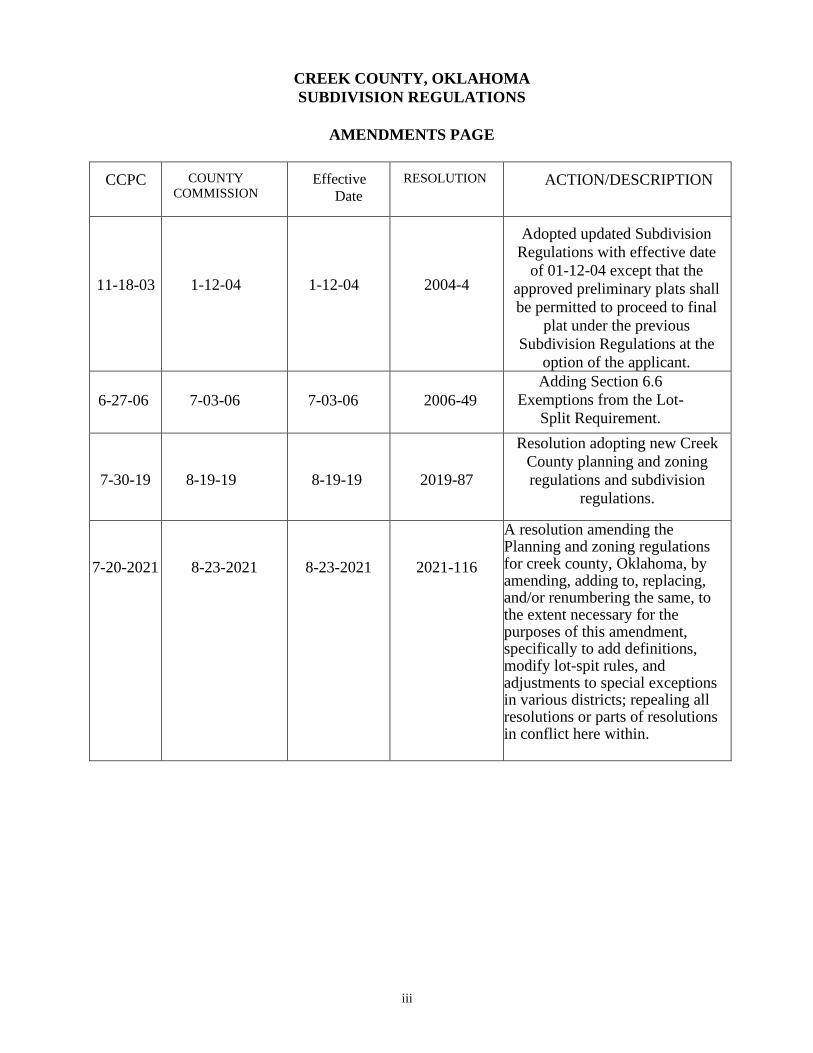
CREEK COUNTY, OKLAHOMA
SUBDIVISION REGULATIONS
AMENDMENTS PAGE
CCPC COUNTY
COMMISSION Effective
Date
RESOLUTION ACTION/DESCRIPTION
11-18-03
1-12-04
1-12-04
2004-4
Adopted updated Subdivision
Regulations with effective date
of 01-12-04 except that the
approved preliminary plats shall
be permitted to proceed to final
plat under the previous
Subdivision Regulations at the
option of the applicant.
6-27-06
7-03-06
7-03-06
2006-49
Adding Section 6.6
Exemptions from the Lot-
Split Requirement.
7-30-19
8-19-19
8-19-19
2019-87
Resolution adopting new Creek
County planning and zoning
regulations and subdivision
regulations.
7-20-2021
8-23-2021
8-23-2021
2021-116
A resolution amending the Planning and zoning regulations for creek county, Oklahoma, by amending, adding to, replacing, and/or renumbering the same, to the extent necessary for the purposes of this amendment, specifically to add definitions, modify lot-spit rules, and adjustments to special exceptions in various districts; repealing all resolutions or parts of resolutions in conflict here within.
iv
TABLE OF CONTENTS
SECTION 1 GENERAL PROVISIONS .........................................................................................1
1.1 TITLE .......................................................................................................................................1
1.2 AUTHORITY ...........................................................................................................................1
1.3 JURISDICTION .......................................................................................................................1
1.4 PURPOSES ..............................................................................................................................2
1.5 CONFLICT AND SEVERABILITY ........................................................................................2
1.6 SAVING PROVISION .............................................................................................................3
1.7 AMENDMENTS ......................................................................................................................3
1.8 CONDITIONS OF APPROVAL ..............................................................................................3
1.9 WAIVER OF PLATTING REQUIREMENT ...........................................................................3
1.10 MODIFICATIONS .................................................................................................................4
1.11 DEFINITION AND TENSE ...................................................................................................4
1.12 MINIMUM STANDARDS AND DESIGN CRITERIA .......................................................4
1.13 PREVIOUSLY PLATTED SUBDIVISIONS .......................................................................5
1.14 PREVIOUSLY SUBDIVISIONS WITHIN AN ANNEXATION FENCE LINE ..................5
1.15 PENALTY ..............................................................................................................................5
1.16 FILING FEES .........................................................................................................................6
1.17 TYPES OF SUBDIVISIONS MAJOR, MINOR AND LOT SPLIT .......................................7
SECTION 2 APPLICATION PROCESS ......................................................................................13
2.1 PRE-APPLICATION CONFERENCE ....................................................................................13
2.2 SKETCH PLAT ........................................................................................................................14
2.3 TECHNICAL ADVISORY COMMITTEE ............................................................................15
2.4 PRELIMINARY PLAT AND PRELIMINARY CONSTRUCTION ......................................15
2.5 FINAL CONSTRUCTION PLANS .........................................................................................18
2.6 FINAL PLAT ............................................................................................................................18
2.7 PLATTING REQUIRED FOR MANUFACTURED HOME PARKS .....................................20
SECTION 3 SPECIFICATION FOR DOCUMENTS ....................................................................22
3.1 PLATTING ACCURACY ........................................................................................................22
3.2 SKETCH PLAT ........................................................................................................................22
3.3 PRELIMINARY PLAT ...........................................................................................................23
3.4 PRELIMINARY CONSTRUCTION PLANS .........................................................................25
3.5 FINAL CONSTRUCTION PLANS .........................................................................................25
3.6 FINAL PLAT ............................................................................................................................26
v
3.7 MONUMENTATION ..............................................................................................................31
SECTION 4 PLANNING AND DESIGN REQUIREMENTS .......................................................33
4.1 GENERAL ................................................................................................................................33
4.2 STREET ...................................................................................................................................34
4.3 ALLEYS ...................................................................................................................................42
4.4 SIDEWALKS ...........................................................................................................................42
4.5 BLOCKS...................................................................................................................................43
4.6 LOTS ........................................................................................................................................43
4.7 EASEMENTS ...........................................................................................................................44
4.8 FLOODPLAIN AREAS ...........................................................................................................45
4.9 STORM WATER DRAINAGE AND DETENTION FACILITIES ........................................45
4.10 INJECTION, OIL AND GAS EXTENSION SITES- RESIDENTIAL SUBDIVISION ........46
4.11 SANITARY SEWAGE DISPOSAL AND WATER SUPPLY...............................................47
4.12 PUBLIC PARKS AND OPEN SPACES ...............................................................................49
4.13 RESERVE STRIPS ................................................................................................................49
4.14 PAVED DRIVEWAY APPROACHES ONTO SECTION LINE OR ARTERIAL ROADS .49
4.15 HILLSIDE DEVELOPMENT ................................................................................................50
SECTION 5 ....................................................................................................................................51
5.1 INSTALLATION AND INSPECTION OF IMPROVEMENTS .............................................51
5.2 BONDING OF SUBDIVISION IMPROVEMENTS ..............................................................51
5.3 COMPLETION AND ACCEPTANCE OF PUBLIC IMPROVEMENTS ..............................54
5.4 TIME LIMIT .............................................................................................................................54
5.5 VACATED PLATS .................................................................................................................54
SECTION 6 LOT-SPLIT PROCEDURES AND STANDARDS .................................................55
6.1 AUTHORITY ...........................................................................................................................55
6.2 INTENT AND PURPOSE ........................................................................................................55
6.3 PROCEDURE...........................................................................................................................55
6.4 CERTIFICATE OF APPROVAL .............................................................................................56
6.5 APPROVAL GUIDELINES .....................................................................................................57
6.6 EXEMPTION FROM THE LOT SPLIT REQUIREMENT .......................................................................59
SECTION 7 ....................................................................................................................................60
7.1 AUTHORITY ...........................................................................................................................60
7.2 INTENT AND PURPOSE ........................................................................................................60
7.3 PROCEDURE...........................................................................................................................60
7.4 CERTIFICATE OF APPROVAL .............................................................................................61
7.5 APPROVAL GUIDELINES .....................................................................................................61

vi
SECTION 8 DEFINITION .............................................................................................................62
Figure
ILLUSTRATIONS………………………………………………………………………………...69 - 79
1 DEVELOPMENT REVIEW AND PROCESSING
2 DEVELOPMENT DISTRICT CONCEPT
3 NEIGHBORHOOD CONCEPT
4 PROPOSED SUBDIVISION SITE
5 SKETCH PLAT
6 PRELIMINARY PLAT
7 FINAL PLAT
8 PLANNED UNIT DEVELOPMENT
9 BORDER STREETS
10 OPEN SPACE
APPENDICES……………………………………………………………………………………..81-107
A. OKLAHOMA STATE DEPARTMENT OF ENVIRONMENTAL QUALITY REQUIREMENTS FOR
SUBDIVISIONS ............................................................................................................................................
B. REQUIREMENTS FOR TRAFFIC CHANNELIZATION AND TURN BAYS ON ARTERIAL
STREETS .......................................................................................................................................................
C. MAJOR STREET AND HIGHWAY PLAN: TRAFFIC RIGHT-OF-WAY AND
PAVING SECTIONS ....................................................................................................................................
D. STANDARD LOCATION OF UNDERGROUND UTILITY LINES AND COLOR CODE ..................
E. SUGGESTED FORM OF PERFORMANCE BONDS AND CERTIFICATES ......................................
vii
RESOLUTION OF THE BOARD OF COUNTY COMMISSIONERS CREEK COUNTY, OKLAHOMA
2021– 116
A RESOLUTION AMENDING THE PLANNING AND ZONING REGULATIONS FOR CREEK COUNTY, OKLAHOMA, BY AMENDING, ADDING TO, REPLACING, AND/OR RENUMBERING THE SAME, TO THE EXTENT NECESSARY FOR THE PURPOSES OF THIS AMENDMENT, SPECIFICALLY TO ADD DEFINITIONS, MODIFY LOT-SPIT RULES, AND ADJUSTMENTS TO SPECIAL EXCEPTIONS IN VARIOUS DISTRICTS; REPEALING ALL RESOLUTIONS OR PARTS OF RESOLUTIONS IN CONFLICT HERE WITHIN. WHEREAS, pursuant to 19 O.S. § 865.51 et seq, Creek County, Oklahoma, has availed itself of land use regulation laws, established a planning commission by resolution of the board and by a vote of the majority of the people voting at an election called for such purpose in the county, reaffirmed the Creek County Board of Adjustment as created under prior resolution, and appropriated funds in the amounts necessary to carry out the purpose of land use regulation and planning pursuant to Oklahoma law; WHEREAS, the Board of County Commissioners of Creek County, Oklahoma has deemed it necessary and proper and for the benefit of the people of Creek County, Oklahoma, to encourage the most appropriate uses of land; to maintain and stabilize the value of property, to reduce fire hazards and improve public safety and safeguard the public health, to decrease undue traffic congestion and its accompanying hazards, and to create a comprehensive and stable pattern of land uses within the County by adopting the attached regulations; and WHEREAS, the attached, proposed amendments to the regulations established for the purposes above are necessary to further the promotion of the public health, safety, comfort, convenience, and general welfare; NOW THEREFORE BE IT RESOLVED THAT, THE BOARD OF COUNTY COMMISSIONERS OF CREEK COUNTY DOES:
At the recommendation of the Creek County Planning Commission and Creek County Board of
Adjustment, amend the planning and subdivision regulations for all the unincorporated territory within Creek County, Oklahoma, and those incorporated territories within the County that elect to utilize the County Land Use Regulations pursuant to 19 O.S. § 865.69;
Provide that an approved copy of this resolution and its approved attachments is ordered placed on
record in the office of the County Clerk of Creek County. Expressly repeal all resolutions or parts of resolutions in conflict herewith, if any, to the extent of the conflict. However, nothing in this resolution shall be construed to prevent the enforcement of other resolutions, laws, or regulations which prescribe more restrictive limitations. If any one or more of the sections, sentences, clauses or parts of this resolution or its attachments shall for any reason be held invalid, the invalidity of such section, sentence, clause or part shall not affect or prejudice in any way the applicability and validity of any other section, sentence, clause or part of this resolution or its attachments. For the purposes of maintaining the proper and orderly growth of Creek County and preserving the public peace, health, safety, and general welfare of this County, this resolution shall take effect and be in force immediately. DONE THIS __23rd__ DAY OF ___August_____, 2021____. BOARD OF COUNTY COMMISSIONERS CREEK COUNTY, OKLAHOMA

viii
_____________________________________ NEWT STEPHENS JR., CHAIRMAN _____________________________________ ATTEST: LEON WARNER, VICE-CHAIRMAN _________________________ _____________________________________ JENNIFER MORTAZAVI ROGER SMITH, MEMBER COUNTY CLERK
1
1.1 TITLE.
SECTION 1. GENERAL PROVISIONS
These Regulations shall hereafter be known, cited and referred to as the Subdivision
Regulations of Creek County, Oklahoma (hereafter referred to as “Subdivision Regulations “or
“Regulations“).
1.2 AUTHORITY.
1. The Creek County Planning Commission (hereafter referred to as "Planning
Commission") pursuant to the powers and jurisdiction vested through O.S. Title 19,
Section 866 and subsequent amendments thereto hereby exercises the power and
authority to review, approve and disapprove plats and plans for the subdivision of land.
2. Any sale or contract of sale or agreement to purchase any lot or division of land, as
defined in these Regulations, either by lot description or by metes and bounds, including
contracts for deed, shall constitute a subdivision of land, and no such transaction shall be
undertaken or instrument shall be recorded until or unless approved as required by the
CCPC, the Creek County Board of Commissioners by Oklahoma State Statutes, and as
follows:
a. Such written approval shall be required by the CCPC by its endorsement on the
instrument of transfer.
b. If the owner or agent of the owner of any land transfers, sells, agrees to sell, or
negotiates to sell any tract of land of less than 10.00 acres where the tract was not
shown of record in the office of the County Clerk as separately owned and not
located within a Major Subdivision approved according to law and filed in the
Office of the County Clerk prior to the effective date of these Regulations, shall
not be recorded, and the deed or other instrument shall be void and impart no
notice.
1.3 JURISDICTION.
These Subdivision Regulations shall apply to all subdivisions of land located within the
unincorporated areas of Creek County and in particular, the following:
1. The division of land into two (2) or more tracts, lots, sites, or parcels, any part of which,
when subdivided, shall contain less than ten (10) acres in area; or
2. The division of land, previously subdivided or platted, into tracts, lots, sites or parcels
of less than ten (10) acres in area; or
3. The dedication, vacation or reservation of any public or private easement through any
tract of land regardless of the area involved, including those for use by public and private
utility companies; or
4. The dedication or vacation of any street or alley through any tract of land regardless of
the area involved.
2
1.4 PURPOSES.
These Regulations are adopted for the following purposes:
1. To provide measures and standards to facilitate the sustainable physical development of
the unincorporated areas of Creek County in accordance with the adopted Comprehensive
Plan, adopted Major Street Plan, and the adopted Engineering Design Criteria, and
Standards and Specifications for Construction; and all related regulations and
requirements of Creek County.
2. To harmoniously relate the development of the various tracts of land to the existing
development and facilitate the future development of adjoining tracts;
3. To provide the most beneficial relationship between the uses of land, buildings and the
circulation of traffic throughout the County, having particular regard to the avoidance of
congestion in the streets and highways, and the pedestrian traffic movements appropriate
to the various uses of land and buildings, and to provide for the proper location and width
of streets and building lines;
4. To secure and provide for the proper arrangement of streets or other highways in relation
to the existing or planned streets or highways or to the Comprehensive Plan or plans of
the area; for adequate and convenient open spaces for traffic, utilities, access for
emergency response and public safety purposes, parking lots, parks, playgrounds, light
and air; and for the avoidance of congestion of population;
5. To establish a subdivision process that is expeditious, efficient and as cost effective as
possible, while providing for public health, safety, and general welfare;
6. To provide that those costs of improvements which primarily benefit the tract of land
being developed be borne by the owners or developers of the tract, and that those costs
of improvements which primarily benefit the County as a whole be borne by the County;
and
7. To establish adequate and accurate records of land subdivision.
1.5 CONFLICT AND SEVERABILITY.
1. Conflict with Public and Private Provisions.
a. Public Provisions. All regulations, codes, orders, resolutions or parts thereof in
conflict with these Subdivision Regulations are hereby repealed to the extent
necessary to give these Regulations full force and effect.
b. Private Provisions. These Regulations are not intended to abrogate any easement,
covenant or any other private agreement or restriction, provided that where the
provisions of these Regulations are more restrictive or impose higher standards or
regulations than such easement, covenant, or other private agreement or
restriction, the requirements of these Regulations shall govern.
3
2. Severability. If any part or provision of these Regulations or application thereof to any
person or circumstances is adjudged invalid by any court of competent jurisdiction, such
judgment shall be confined in its operation to the part, provision, or application directly
involved in the controversy in which such judgment shall have been rendered and shall
not affect or impair the validity of the remainder of these Regulations or the application
thereof to other persons or circumstances. The Creek County Board of County
Commissioners hereby declares that it would have enacted the remainder of these
Regulations even without any such part, provision, or application.
3. Severability. If any part or provision of these Regulations or application thereof to any
person or circumstances is adjudged invalid by any court of competent jurisdiction, such
judgment shall be confined in its operation to the part, provision, or application directly
involved in the controversy in which such judgment shall have been rendered and shall
not affect or impair the validity of the remainder of these Regulations or the application
thereof to other persons or circumstances. The Creek County Board of County
Commissioners hereby declares that it would have enacted the remainder of these
Regulations even without any such part, provision, or application.
1.6 SAVING PROVISION.
These Regulations shall not be construed as abating any action now pending under, or by virtue
of prior existing Subdivision Regulations, or as discontinuing, abating, modifying or altering
any penalty accruing or about to accrue, or as affecting the liability of any person, firm or
corporation, or as waiving any right of the County under any section or provision existing at
the time of adoption of these Regulations, or as vacating or annulling any rights obtained by
any person, firm or corporation by lawful action of the County, except as shall be expressly
provided for in these Regulations.
1.7 AMENDMENTS.
For the purpose of providing for the public health, safety and general welfare, the Planning
Commission, with final approval from the Creek County Board of County Commissioners, may
from time to time amend the provisions imposed by these Subdivision Regulations. The
Planning Commission, in the manner prescribed by law, shall hold public hearings on all
proposed amendments.
1.8 CONDITIONS OF APPROVAL.
Regulations of the subdivision of land and the attachment of reasonable conditions to land
subdivision are an exercise of valid police power delegated by the State of Oklahoma to Creek
County. The sub divider has the duty of compliance with reasonable conditions laid down by
the Planning Commission for design, dedication, improvement and restrictive use of the land
so as to conform the physical and economic development of the County to the safety and general
welfare of the future owners of realty in the subdivision and of the County at large.
1.9 WAIVER OF PLATTING REQUIREMENT.
The Creek County Board of County Commissioners, upon a recommendation of the Planning
Commission, may waive the platting requirement upon a determination that the purposes and
intent of these Regulations have been met by previous platting have or will be achieved by other
actions, or could not be achieved by a plat or replat.
4
1.10 MODIFICATIONS.
1. General. The Planning Commission, where unusual topographical or other exceptional
conditions require the same, and when the purpose of these Regulations may be served
to the same extent may modify these Regulations by an alternative proposal. The Planning
Commission shall not approve a modification where the granting of the modification will
be detrimental to the public safety, health, or welfare, or be injurious to other property or
improvements, or where the same will impair the spirit, purposes, and intent of the Zoning
Code of Creek County or the Comprehensive Plan. Any such modification is subject to
final approval by the Creek County Board of County Commissioners. Only the Board of
Adjustment may grant a variance of zoning regulations.
2. Conditions. In approving modifications, the Planning Commission may require such
conditions as will, in its judgment, secure substantially the objectives of the standards or
requirements of these Regulations.
3. Procedures. A request for any such modification shall be submitted in writing by the sub
divider at the time when the sketch plat, preliminary plat, or lot-split is filed for the
consideration of the Planning Commission. The request shall state fully the grounds for
the application and all of the facts relied upon by the sub divider.
4. Approval. Such modifications may be granted only by the affirmative vote of three-
fourths (3/4) of the total number of members of the Planning Commission subject to the
approval of the plat and acceptance of the dedications shown thereon by the Creek County
Board of County Commissioners.
5. Exception. The Creek County Planner may waive the requirement for a sketch plat
or may allow the developer to submit a preliminary and final plat simultaneously where
the nature of the development (e.g., one lot one block, etc.) indicates that such an
exception would not otherwise be contrary to the intent of these Regulations; however, all
such exceptions are subject to the final approval of the Planning Commission.
1.11 DEFINITION AND TENSE.
1. Definition. For the purpose of these Regulations, certain terms and words are to be used
and interpreted as defined in Section 8, Definitions of these Regulations.
2. Tense. Words used in the present tense shall include the future tense, words in the singular
number shall include the plural and words in the plural number shall include the singular,
except where the natural construction of the writing indicates otherwise. The word
"should" is directory and not mandatory. The word "shall" is mandatory and directory.
1.12 MINIMUM STANDARDS AND DESIGN CRITERIA.
1. In enacting various provisions of these Regulations, and in promulgating any rules or
regulations which may be made necessary in order to carry out the purpose of these
Regulations, the Creek County Board of County Commissioners is setting forth certain
minimum standards for construction which may not be violated in the construction of any
5
public improvements. By setting forth these minimum standards, neither the County as
an entity nor any of its staff is making any representations, warranties or assurances that
these minimum designs are sufficient.
2. Any person owning such land or developing land within the unincorporated areas of
Creek County must rely upon their own design professional to design facilities, whether
public or private, which are capable of providing the services required of such public or
private facilities, and which are adequate under all reasonably foreseeable circumstances
for the purposes intended.
3. When the County Staff examines proposals or construction plans for conformity with
these Regulations, such review is being performed to determine whether or not the
minimum standards will be met. The approval of such plans does not represent, warrant,
or assure any person that the designs are adequate for the purposes intended. Neither the
enactment of these Regulations nor review of improvements to be constructed or
proposed under these Regulations shall in any manner create liability for Creek County.
1.13 PREVIOUSLY PLATTED SUBDIVISIONS.
With regard to any subdivision which has received final plat approval and which has not yet
installed all of the required subdivision improvements, and unless otherwise directed by the
Creek County Board of Commissioners, that subdivision shall be required to install such
improvements in accordance with the following:
1. The Subdivision Regulations, Engineering Design Criteria, and Construction Standards
and Specifications in effect at the time of final plat approval; or
2. In compliance with the current Subdivision Regulations, Engineering Design Criteria, and
Construction Standards and Specifications.
1.14 PROPOSED SUBDIVISIONS WITHIN AN ANNEXATION FENCELINE
In those cases where a proposed subdivision is included within the annexation fence line of an
incorporated city or town and upon written agreement between the Creek County Board of
County Commissioners and the governing body of said city or town, the proposed subdivision
shall be reviewed and approved by the Creek County Planner and Creek County Engineer using
the subdivision regulations, engineering design criteria, and construction standards and
specifications of said city or town. Further, said subdivision shall be constructed and inspected
during construction by said city or town officials to ensure compliance with the applicable
regulations.
1.15 PENALTY
1. Any person, firm or corporation, who shall violate any of the provisions of these
Regulations, or shall fail to comply therewith, shall be deemed guilty of an offense and
shall be liable for a fine as provided herein. Each day of such violation shall constitute a
separate offense. In addition the remedies provided herein, the County may institute any
other action or proceeding to enforce these Regulations.
6
2. No construction shall commence or permit issued for any new structure or change,
improvement or alteration of any existing structure on any tract of land which does not
comply with all of the provisions of these Regulations.
3. Whoever, being the owner or agent of the owner of any land within the area, transfers, or
sells or agrees to sell, or negotiates to sell any land by reference to or exhibition thereof,
or by other use of a plat of a subdivision or a contract for deed or other instrument before
such plat or deed or instrument has been approved by Creek County and filed of record
in the office of the County Clerk, or whoever, being the owner or agent of the owner of
any parcel of ground, transfers, or sells or agrees to sell, or negotiates to sell any tract of
land of less than ten (10) acres where such tract was not shown of record in the office of
the County Clerk as separately owned at the effective date of the Regulations herein
provided and not located within a subdivision approved according to law and filed of
record in the office of the County Clerk, or if so located, not comprising at least one (1)
entire lot as recorded, without first obtaining the written approval of the Planning
Commission, including approval by the Creek County Board of County Commissioners,
as applicable, by its endorsement on the instrument of transfer, or contract of sale or other
agreement to transfer, shall be subject to the penalties provided below and such
transaction shall be unlawful and shall not be recorded by the County Clerk.
4. A violation of these Regulations shall be deemed a misdemeanor and shall be punishable
by fine. Any person, firm or corporation who violates or refuses to comply with any of
the provisions of these Regulations shall be fined not less than five ($5.00) nor more than
twenty dollars ($20.00) including costs for each offense. Upon conviction, each day a
violation continues to exist shall constitute a separate offense.
1.16 FILING FEES
1. In accordance with the Schedule of Fees adopted by the Creek County Board of County
Commissioners, there shall be paid a filing fee for each sketch plat, preliminary plat and
for each final plat. A filing fee shall also be paid for each sketch plat, preliminary plat and
final plat of a Planned Unit Development. There shall also be a filing fee for minor
subdivisions and lot- splits. All fees for subdivisions located within Creek County shall
be paid to the Creek County Planner at the time of filing of a particular application.
2. Where only a portion of an approved Preliminary Plat is submitted for final plat approval,
a final plat of the remaining area may be submitted at any time within two (2) years of the
preliminary approval without payment of an additional Preliminary Plat filing fee by the
subdivider, providing the final plat for the additional area conforms substantially with the
approved preliminary plat.
3. Further, there shall be an engineering review fee paid at the time of submission of the
application for a Preliminary Plat to Creek County, Oklahoma at which time all
Preliminary Construction Plans and Deed of Dedications and Restrictive Covenants shall
be submitted for review and approval. Any fee above the base engineering review fee
shall be determined by the Creek County Board of County Commissioners based on the
actual cost of engineering review necessary to determine if the proposed Preliminary and
Final Construction Plans meet minimum Creek County regulations. Any such additional
7
fee above the base fee shall be due and paid prior to approval of the Final Plat.
1.17 TYPES OF SUBDIVISIONS: MAJOR, MINOR AND LOT-SPLIT
The following types of subdivisions are regulated by these Regulations:
1. Major Subdivision
a. The division of land into five (5) or more tracts or lots, any
portion of which when divided comprise less than 10.00 acres.
b. Dedication of a road, highway or street through a tract of land regardless of area.
c. Re-subdivisions of land hereto divided or platted into lots or parcels.
d. Rezoning of a parcel or tract to a greater density or intensity.
e. Major subdivisions require a pre-application conference, sketch plat, preliminary
plat, final plat, and all related plans and information as required by these Regulations.
f. Certified Abstractor’s List of abutting property owners as defined herein with their
current addresses outward from each property line of the property to be subdivided.
2. Minor Subdivision
a. Any subdivision creating or causing to be created not more than four (4) lots, any
portion of which has an area of less than ten (10) acres that does not have frontage
on an existing street, requires extension of a new street or road, requires the extension
of public facilities, or requires the creation of any new public improvements. Minor
Subdivisions could adversely affect the remainder of the parcel or adjoining property
and therefore shall not be in conflict with any provision or portion of the
Comprehensive Plan, Major Street Plan, Zoning Code, or these Subdivision
Regulations.
b. A Minor Subdivision of land into tracts or lots is considered to be a less intensive
form of subdivision, which may or may not require rezoning. However, minor
subdivisions are subject to the further procedural and design requirements of these
Regulations.
c. General Requirements for a Minor Subdivision.
(1) The sub divider shall have prepared a drawing for discussion with the County
Planner prior to preparation of any required Survey Plan (Survey).
(2) Every Minor Subdivision of land, any portion of which is less than
10.00 acres and containing not more than four (4) tracts or lots within the
unincorporated areas of the County shall have prepared and submitted to the
CCPC for approval or disapproval a Certified Survey.
(3) Before approving any Survey of a proposed Minor Subdivision, the CCPC
must find that the land covered by the proposed Minor Subdivision is suitable
8
both for development and for the type of development proposed. Further, it
shall be determined that said land can be safely used for building purposes
without undue danger from flood or from any other threat or menace to the
public health, safety and general welfare.
(4) Prior to approval of a Minor Subdivision the CCPC shall determine that said
land can be served economically with the necessary public or private facilities.
(5) Review and comment from any affected municipality is also required by the
CCPC for said development approval in the interest of the public health, safety
and general welfare.
d. Application Requirements for Minor Subdivisions.
A complete application is required prior to submission of an application for a Minor
Subdivision, including the Certified Survey, and the following additional
information:
(1) An application form signed by the landowner of record or written
authorization from said owner.
(2) Application filing fee.
(3) Evidence of compliance with the County requirements for public facilities.
(4) Evidence of compliance with the County requirements for Flood Hazard
Prevention.
(5) Four (4) original (fax not acceptable) copies of the Survey incorporating items
agreed upon during preceding conferences with the County Planning Staff.
Such Survey must be filed with the application not less than 45 days before
the meeting of the CCPC if the Survey is to be acted upon at such meeting.
(6) In areas where septic tanks or other private on-site disposal systems are to be
used, a soil survey, percolation test or such other test is required to determine
the suitability of the soil for such systems, and shall be made by a Professional
Engineer or other agent as approved by the ODEQ in accordance with the
standards required by the ODEQ. Two (2) copies of the engineer’s report shall
be filed with the Creek County Health Department and one copy shall be
submitted with the proposed Survey of the Minor Subdivision.
e. Minor Subdivision Survey Plan (Survey) Requirements
(1) The maximum density for a Minor Subdivision of land shall not exceed the
Bulk and Area allowances of the Zoning Code.
(2) The sub divider or his engineer shall prepare a preliminary survey sketch for
discussion with the County Planner prior to preparation of a Survey.
9
(3) A legible, original stamped Survey (fax copies are not acceptable) shall be
drawn to a scale of not less than 100 feet to the inch on three (3) sheets having
a minimum dimension of 11” X 17” and one sheet having a dimension of 8.5”
X 11” and shall show:
(a) The location of the Minor Subdivision with reference to section lines,
and other existing features within the area to be subdivided and the
location of dedicated streets at the points where they abut and are
immediately adjacent.
(b) A Surveyor’s Certificate must be affixed to the face of the Survey.
(c) A copy of the deed.
(d) The existing and/or proposed location and width of driveways, setback
lines, easements, fences, existing buildings, wells, septic systems or
other on-site disposal systems, and lot dimensions. If street
improvements are required, excluding driveway approaches, the
application shall not be eligible for consideration under a Minor
Subdivision.
(e) Existing sanitary and storm sewers, water drains, oil and gas lines,
injection wells, culverts and other underground structures within the
tract or immediately adjacent to the tract.
(f) The title under which the proposed Minor Subdivision is to be recorded
and the name of the subdivider, engineer, landscape architect, or
surveyor who prepared the Survey Plan.
(g) North Point, scale and date.
(h) One (1) copy of signed statements regarding the proposed use of the land
and the proposed improvements and restrictions shall be included with
the Survey.
(i) Topographical layout of the land represented a ten (10) foot contour
intervals.
(j) One inch border at the top, bottom, and right and left sides.
(k) Sketches of legal description or other such information do not meet the
minimum requirements for a Survey.
f. The finished Survey Plan must include the following information:
(1) The boundary lines of the areas being subdivided with accurate distances and
bearings.
(2) The lines of all proposed driveways showing width of the driveway and

10
drainage flow.
(3) The accurate outline and legal description of any property offered for
dedication for public use.
(4) The lines of all adjoining lands and the right-of-way lines of adjacent streets.
(5) All lot lines with dimensions (not ditto marks) and bearings.
(6) Building lines and easements for rights-of-way provided for public use,
services or utilities, and the edge of the paving or improved surface of an
abutting roadway.
(7) The Finding Location and the Legal Description of the property.
(8) All drainage patterns, i.e. flow-line elevations, direction of flow, and top-of-
ditch bank lines.
(9) The dimensioned location of all existing buildings and fences.
(10) A title block that includes the name of the County and State, and location of
the Survey in regard to Section, Township and Range.
(11) Building lines shall be shown on all Survey Plans. On any lot abutting a section
line or arterial roadway, the building lines shall be established as designated
in the Zoning Code, Subdivision Regulations and the Major Street and
Highway Plan.
g. The following certificates are required on all Surveys:
(1) Owner’s Certificate and Dedication.
(2) Surveyor’s Certificate.
(3) Certificate of CCPC approval.
(4) Certificate that the soil is sufficiently porous to make septic tanks or other on-
site disposal systems practical for each lot offered for sale when septic tanks
or similar private systems are contemplated for use.
(5) Mortgage Lien Release of Public Dedication(s).
h. Minor Subdivision Design Requirements
(1) Whenever a parcel is divided into lots of 2.5 acres or more and there are
indications that such lots may eventually be re- subdivided, consideration must
be given to the street and lot arrangement in the Minor Subdivision so that
additional streets can be opened. Such future subdivisions should therefore be
considered a Major Subdivision and conform to the requirements for a Major
Subdivision and the Subdivision Regulations. A subdivision of more than four
(4) lots constitutes a Major Subdivision and must follow and conform to the
11
Subdivision Regulations.
(2) Any and all Minor Subdivisions must conform to the existing zoning at the
time of the subdivision. All easement and frontage requirements shall be those
required by the current zoning at the time of the submission of the Survey Plan.
Any change of zoning requires that the Minor Subdivision conform to the
platting requirements of the Subdivision Regulations and the Change in
Zoning Procedures of the Zoning Code.
(3) All lots created shall have direct frontage and direct access to a County
maintained road. Such access shall be only from roads built to County
Standards prior to approval of the Survey Plan. All driveways that access
County Section Line or Arterial Roads shall be paved and improved in
accordance with the County regulations. No lot contained within a Minor
Subdivision shall be landlocked with no direct access to a County Maintained
Road and all such lots shall have access from a County maintained road.
(4) Any Minor Subdivision shall conform to the general character of existing land
use of surrounding properties and acreage. A radical departure from existing
land use, densities or general aesthetic character, shall comply with the
requirements of the Subdivision Regulations for a Major Subdivision and the
Comprehensive Plan.
i. CCPC action on an application for approval of a Minor Subdivision shall include
the following:
(1) The CCPC shall approve the application. Application for Minor Subdivisions
shall also require review and comment by the Technical Advisory Committee
(TAC).
(2) In the event that the application is disapproved or is approved conditionally,
the reason(s) for such action shall be included in the minutes of the CCPC
meeting and stated in a memorandum sent to the applicant. Such memorandum
shall refer specifically to the provisions of the Minor Subdivision regulations
with which the application or Survey does not conform as submitted.
(3) In conditionally approving a Minor Subdivision, the CCPC may require the
subdivider to submit a revised Survey.
(4) The CCPC shall act upon the Survey within 45 days after it has been
submitted, as long as the appropriate deadlines have been met and the required
information has been requested, unless stipulation for additional time is
required. The grounds for refusal or approval of any Minor Subdivision,
including a citation of, or reference to the rule or regulation violated by the
application shall be stated in the minutes of the CCPC. The approval shall be
shown on the Survey with the date of such approval over the signature of the
CCPC Chairperson, Secretary or County Planner.
12
(5) One copy of the application and Survey Plan shall be retained in the permanent
file of the CCPC.
3. Lot -Split
a. A Lot-Split is any subdivision containing not more than two (2) lots, any portion of
which has an area of less than ten (10) acres that has frontage on a County maintained
road, not involving any new street or road, or the extension of public facilities, or the
creation of any public improvements, and not adversely affecting the remainder of
the parcel or adjoining property, and not in conflict with any provision or portion of
the Comprehensive Plan, Major Street Plan, Zoning Code, or these Subdivision
Regulations.
b. A Lot-Split containing not more than three (3) lots, any portion of which has an area
of less than ten (10) acres that has frontage on a County maintained road, not
involving any new street or road, or the extension of public facilities, or the creation
of any public improvements, and not adversely affecting the remainder of the parcel
or adjoining property, and not in conflict with any provision or portion of the
Comprehensive Plan, Major Street Plan, Zoning Code, or these Subdivision
Regulations.
c. A Lot-Split is not considered to be an appropriate method of subdividing or
developing a large area and tracts of 160 acres or less are permitted only one lot split.
However, a Lot Split is an effective measure for single lot subdivision for the purpose
of resale, or conveyance.
d. All Lot-Splits shall conform to Section 6 of these Regulations, and all other
applicable codes and regulations of Creek County.
e. A lot split of .50 (half) an acre or less does not require a lot split if correcting an
encroachment, unless it changes the zoning district. Will be at staff’s discretion.
f. Any tract of land 10 acres and under shall have no further lot splits for 1(one)
calendar year upon secondary split.
13
SECTION 2. APPLICATION PROCESS
2.1 PREAPPLICATION CONFERENCE.
The process for review and submission of a plat is shown in Illustration 1, Development Review
and Processing that is included following Section 8 of these Regulations. Application and
Checklists are shown in Appendix A.
1. Prior to submission of an application for any form of subdivision, the subdivider shall
participate in a preapplication conference.
2. The purpose of the preapplication conference shall be to gather information and data
necessary for the expeditious processing of the proposed subdivision from the perspective
of both the County and the subdivider. Subsequent to the preapplication conference and
for phased projects (except as otherwise provided for by these Regulations) a sketch plat
and preliminary plat is required for the whole project. Only the final plat is required for
each phase prior to development.
3. The following persons or their designated representative shall be present and participate
in the preapplication conference:
a. District County Commissioner;
b. County Department representative;
c. County Planner;
d. Subdivider or developer;
e. Subdivider’s engineer and/or surveyor;
f. Such other persons as indicated to be necessary in order to fully evaluate and provide
useful and necessary information and direction to the County and subdivider.
4. The following types of information shall be available and established at or subsequent to
the pre-application conference:
a. The Comprehensive Plan, if available for the subject tract;
b. Existing zoning or such other related information as would be necessary to support
the proposed development;
c. The availability of utilities and responsibility and policies for extension of such
utilities if and as necessary;
d. The Major Street Plan and street classifications within and from the proposed
development to abutting land;
e. Topography, slopes, drainage, and such other information as might be necessary to
evaluate proposed street patterns and layouts;
f. A property boundary survey showing the exact legal description and location of any
and all existing structures, septic fields, easements, oil or gas wells, etc. with
dimensions by the surveyor.

14
g. Preliminary investigations of soils, oil or gas pipelines or wells, or other such
surface (such as large water bodies) or subsurface conditions as might bear upon the
feasibility of the proposed development; and
h. Such other information as might be provided by the County or developer on an
initial basis to assess the feasibility of the proposed development prior to proceeding
to a sketch plat.
2.2 SKETCH PLAT.
1. Requirements. Before preparing the preliminary plat, or as a requirement for submitting
a Planned Unit Development (PUD), unless otherwise provided for by these Regulations,
the subdivider may be required to prepare a sketch plat (which in the case of a PUD serves
as the PUD Development Plan) after a preapplication conference. During the sketch plat
review process the subdivider will be advised of the following:
a. The procedure for approval of a subdivision plat and/or PUD;
b. Provisions of the Comprehensive Plan, Major Street Plan, and Zoning Code;
c. Requirements as to general layout of streets, reserve areas, improvements, drainage,
water, sewerage, floodplain, fire protection and similar matters;
d. Availability of existing services and utilities and requirements and policies for
extension; and
e. To discuss the proposed subdivision with those officials and departments which
must eventually approve those particular aspects of the subdivision plat coming
within their jurisdiction who were not present at the preapplication conference.
2. Procedure.
a. The TAC shall review the sketch plat, and make a recommendation to the Planning
Staff.
b. A minimum of five (5) full size copies and 35 sets of 11” x 17” copies of the plat
drawing (all folded to 8 ½ X 11”) of the sketch plat shall be submitted to the
Planning Staff a minimum of 15 working days prior to the meeting of the Technical
Advisory Committee (TAC).
c. The Planning Staff shall transmit the sketch plat for review to appropriate officials
or agencies and notify any city or town within three (3) miles of the proposed
subdivision.
d. The Planning Staff shall review the sketch plat and the recommendation of the
TAC.
e. In those cases where the TAC, Planning Staff and subdivider concur in the
requirements for approval of the sketch plat, Planning Commission review is not
required. If the subdivider and Planning Staff disagree on said requirements for
approval, the subdivider may appeal to the Planning Commission within ten (10)
days of the notice of disapproval from the Planning Staff.
f. After review and discussion of the sketch plat, Planning Staff report, and TAC
15
recommendation, the Planning Staff or the Planning Commission shall advise the
subdivider of any specific changes or additions in the layout and the character and
extent of required improvements and reservations, which will be necessary for
approval.
g. The Planning Staff or Planning Commission shall approve or disapprove, or
conditionally approve the sketch plat after receiving the recommendation of the
TAC.
2.3 TECHNICAL ADVISORY COMMITTEE.
1. General. There is hereby created a subdivision Technical Advisory Committee (TAC).
The TAC shall be responsible for coordinating review and comments, and making
recommendations to the Creek County Planning Staff and Planning Commission on all
subdivision plats and lot- splits as provided in these Regulations.
2. Committee Membership. The TAC shall be composed of representatives from
departments, agencies, companies and offices involved in the subdivision process
including, but not limited to Planning, Engineering, Water and Sewer, Law Enforcement,
Fire, Oklahoma Department of Environmental Quality (DEQ), School Boards, District
Attorney, Federal Housing Administration, Utility Companies, and the Natural Resource
Conservation Service. The Creek County Planner shall serve as the recording secretary
and facilitator of the TAC.
3. Meeting Dates. The TAC shall meet as needed. The meeting shall be posted as required
by Oklahoma State Statutes and an agenda available in the offices of the Planning
Department.
4. Recommendations to the Planning Commission. The TAC recommendations to the
Planning Commission shall be submitted in written form by the Planning Staff to the
Planning Commission and Creek County Board of County Commissioners.
2.4 PRELIMINARY PLAT AND PRELIMINARY CONSTRUCTION PLANS.
1. Application Procedure and Requirements. The subdivider shall submit a preliminary plat
for approval. A minimum number of copies of said plat shall be submitted as follows:
a. Applications for preliminary plat approval will not be accepted unless accompanied
by a certified list prepared by a licensed abstractor of all abutting property owners
of record in the office of the County Clerk, five (5) full-size sets of the plat drawing,
the preliminary construction plans and also the proposed deeds of dedication and
restrictive covenants.
b. Include 35 copies of the plat drawing and deeds of dedication and restrictive
covenants in an 11”x 17” format, and folded to 8 ½” X 11”.
c. Be accompanied by an application and filing fee, review fee and any established by
the Planning Commission;
16
d. Comply in all respects with the sketch plat as approved;
e. Be submitted to the Planning Staff at least 15 working days prior to the meeting of
the TAC at which it will be considered; and
f. Comply in all respects with the requirements of these Subdivision Regulations;
however, a preliminary plat not meeting all of these requirements may be
submitted, provided, that the subdivider presents with the plat application a letter
requesting specific waivers or modifications describing in detail the reasons
therefore.
2. Review.
a. The Planning Staff shall:
(1) Distribute copies of the preliminary plat to appropriate officials, agencies, or
departments, and notify any city or town within three
(3) miles of the proposed subdivision;
(2) Send written notice of the application to all abutting property owners at least
seven (7) days prior to the Planning Commission meeting;
(3) Field check the area being platted as needed;
(4) Review the preliminary plat for conformance with the adopted
Comprehensive Plan, Zoning Code, Planned Unit Development (PUD)
conditions, Board of Adjustment actions, and Subdivision Regulations, and
County or other appropriate master plans for water, sewerage, streets and
drainage; and
(5) Prepare written analyses and recommendations.
b. Preliminary Construction Plans. The subdivider shall submit five (5) full-size sets
of Preliminary Construction Plans folded to 8 ½” X 11” for proposed improvements
at the time of application for approval of the preliminary plat to the Planning Staff
for review by the following departments and/or agencies as applicable:
(1) All plans for drainage, storm sewers, streets, sidewalks and pedestrian ways,
and other public improvements must be reviewed and approved by the
County Engineering Department.
(2) The appropriate Water and Sewer Department shall approve preliminary
construction plans for sanitary sewer and water improvements in accordance
with the applicable local, state or federal regulations. A report of such
approval shall be submitted with the preliminary plat application and/or prior
and approval of the preliminary plat.
(3) If the subdivision is to be served by private water or sewage disposal systems,
the plans for such improvements shall be prepared in accordance with the
adopted standards of the Oklahoma Department of Environmental Quality
(DEQ) as referenced in Appendix B, as well as be reviewed and approved by
DEQ and the County as required prior to installation.
17
c. Technical Advisory Committee (TAC). The TAC shall review the preliminary plat
and make a recommendation to the Planning Commission, which shall include any
recommendations or modifications of the Subdivision Regulations requested by the
subdivider.
3. Hearing and Approval.
a. The Planning Commission shall hold a hearing on the preliminary plat.
b. After the Planning Commission has reviewed the preliminary plat and
accompanying reports and recommendations from the Planning Staff, the TAC, and
any other recommendations, testimony, and exhibits presented at the hearing, the
subdivider shall be advised of any changes and/or additions required by the
Planning Commission in order to comply with these Regulations.
c. The Planning Commission shall approve, conditionally approve, or disapprove the
preliminary plat at such meeting or within thirty (30) days after the date of the
regular meeting of the Commission at which the hearing on preliminary approval
is closed, including any continued dates for such hearing.
d. If the preliminary plat is approved with a modification of any of the requirements
of these Regulations, the reasons therefore shall be stated in written form and
included in the minutes of the Planning Commission meeting.
e. If the preliminary plat is approved with conditions, the Planning Commission may
require the subdivider to submit a preliminary plat revised to show the required
changes prior to submission of the final plat.
f. If the preliminary plat is disapproved, the reasons for disapproval shall be stated in
written form and included in the minutes of the Planning Commission.
g. One (1) copy of the proposed preliminary plat as acted upon by the Planning
Commission shall be retained in the office of the County Planner and one (1) copy
shall be returned to the subdivider. Each copy shall include the date of approval,
conditional approval, or disapproval and the reasons therefore.
h. The approval of a preliminary plat shall be effective for a period of two
(2) years from the date of approval by the Planning Commission unless otherwise
approved by the Planning Commission for an extended period of time, at the end
of which time approval of the final plat must have been obtained from the Planning
Commission. Any preliminary plat not receiving final plat approval within two (2)
years including any approved extensions by the Planning Commission shall be null
and void.
i. The preliminary plat shall conform to the adopted Subdivision Regulations at the
time of approval of the preliminary plat unless modifications have been granted
through the proper appeals process.
j. Subsequent to preliminary approval and prior to preparation of and approval of the
final plat, the subdivider shall prepare final construction plans to be reviewed and
approved by the County.
k. In accordance with Oklahoma State Statutes, any preliminary plat approval shall be
18
revocable for cause by the Creek County Board of County Commissioners, upon
review and recommendation by the Planning Commission, and such preliminary
approval shall not be entered on the face of the plat.
2.5 FINAL CONSTRUCTION PLANS.
A subdivider shall submit final construction plans for proposed improvements with the
application for final plat approval. Five (5) full-size sets of the Final construction plans folded
to 8/12” X 11” shall be submitted to the Planning Department for review by the following:
1. The Engineering Department shall review and approve the final construction plans for
streets, drainage and storm sewers, and sidewalks and pedestrian ways in accordance
with the adopted Engineering Standards.
2. The appropriate Water and Sewer Department and/or the appropriate water and sewer
authority shall review and approve sanitary sewer and water construction plans in
accordance with the applicable local, state or federal regulations.
3. If the subdivision is to be served by private water or sewage disposal systems the DEQ
will review the system for conformance with adopted standards prior to issuance of
Building Permits or the start of construction and only after the Planning Commission has
approved the minimum bulk, area and access requirements for the lots to be created.
4. Final Plat Drawings and As Built Plans for public utilities and streets shall be submitted
in an electronic file format as required by the County Engineer, the Creek County
Assessor, and the Creek County Planner.
2.6 FINAL PLAT.
1. Application Procedure and Requirements. Following the approval of the preliminary plat,
the subdivider shall submit to the Planning Department an application for approval of a
final subdivision plat which shall:
a. Be made as prescribed in these Regulations;
b. Comply in all respects with the approved preliminary plat;
c. Be accompanied by a minimum of five (5) full-size sets of the final plat drawing
and 35 copies of the plat drawing reduced to 11” x 17”, all folded to 8 ½” X 11”;
d. Be accompanied by the final plat filing fee as established by the Planning
Commission and five (5) full-size sets of the stamped final construction plans;
e. Be accompanied by an electronic file of the final plat in accordance with the
requirements of the Creek County Assessor’s office;
f. Include a reproducible copy of the plat drawing showing the street addresses of
each lot;
g. Release letters from the applicable utility companies;
h. Owner’s papers and a certificate of non-development from the Oklahoma
Corporation Commission;
19
i. As Built drawings have been received for the required improvements, or the
required surety has been submitted for acceptance by the Creek County Board of
Commissioners; and
j. A TAC meeting may be required on the final plat and construction plans.
2. Review.
a. The Planning Staff and County Engineer shall review the final plat for compliance
with the approved preliminary plat.
b. The Planning Staff shall make a recommendation for approval or denial of the final
plat based on compliance with the following:
(1) All conditions, restrictions and requirements of these Regulations and with
other applicable regulations or laws have been met;
(2) All conditions that have been attached to the approved preliminary plat have
been complied with;
3. Review and Determination.
a. The final plat shall be submitted to the Planning Commission for final approval.
b. The Planning Commission shall at such meeting or within 30 days thereafter:
(1) Review the final plat and the report and recommendation of the Planning Staff;
and
(2) Approve the plat if the conditions of preliminary plat approval have been met,
or disapprove the plat if the conditions of preliminary plat
approval have not been met, and state in detail in the record of its meeting any
reasons for disapproval; or
(3) Take such other action as appropriate based on the reviews of the final plat
drawings and submittal.
c. If the governing body of any city or town in the County protests against a
subdivision plat of any land lying within three (3) miles of the limits of the
incorporated area of such city or town, the plat shall be approved by not less than
three-fourths (3/4) members of the Planning Commission present and voting with
the reasons therefor stated in the minutes of the meeting.
d. Upon approval of the Final Plat by the Planning Commission and prior to filing of
said Plat, the final plat must additionally be approved by the Creek County Board
of County Commissioners.
4. Endorsement of Approval on Plat.
a. No final approval shall be endorsed on the final plat until all requirements of plat
approval have been met and the As Built plans have been received or other
requirements for submission and acceptance of sureties have been met as per
Section 5.
20
b. The parties responsible for endorsing approval on the plat shall be the County
Engineer, or any other party authorized in writing to sign for said County Engineer,
and the Chairperson or such other officer of the Planning Commission as
authorized by these Regulations and in writing to sign for said Chairperson.
c. When the subdivider has chosen to install improvements prior to the endorsement
of the final plat, approval shall not be endorsed on the plat until after all conditions
of County approval and Oklahoma State Law have been satisfied and all
improvements satisfactorily completed and accepted by the County.
d. Written evidence shall be submitted, including submission of As Built Plans as
described in these Regulations that the required improvements have been installed,
and necessary dedications made, in a manner satisfactory to the County as shown
by a sealed certificate signed by the Developer’s Engineer.
e. When the subdivider has chosen to guarantee construction of improvements by
written agreement, approval shall not be endorsed on the plat until after the
agreement has been executed and delivered to the Creek County Board of
Commissioners, the agreement executed by the County, and all conditions of the
approval pertaining to the final plat have been satisfied.
f. Inspection of public improvements during and upon completion of construction
shall be arranged by County for a third party engineer or other qualified inspector,
approved by the County, paid for by the developer and working at the direction of
the County.
5. Filing and Release of the Plat After the final plat has received the required endorsements
and has been filed, the Planning Staff shall distribute copies to appropriate County
officials, agencies or departments, and the remaining signed copies to the subdivider.
6. Recording of the Final Plat.
The final plat shall be filed in the office of the Creek County Clerk within one (1) year
after approval by the Planning Commission and Creek County Board of Commissioners.
2.7 PLATTING REQUIRED FOR MANUFACTURED HOME PARKS.
1. Intent and Purpose.
a. Platting of manufactured home parks is required for the purposes of identifying
spaces for rent, minimum space sizes and density, points of access and circulation
patterns, regulating building setbacks, establishing easements, and to otherwise
establish minimum development standards based on these Regulations, the Creek
County Zoning Code, and other applicable codes and regulations.
b. Platting serves to identify and define the location of internal streets and parking
areas, public and private utility easements, and to define reserve and common areas
as would be used for recreation and storm water management purposes.
c. No individual spaces in such parks are permitted to be sold or otherwise conveyed
21
on an individual basis.
2. Platting Process.
a. The procedures outlined in these Regulations, particularly such procedures
requiring a pre-application conference, sketch plat, preliminary plat and final plat,
planning and design requirements, and conceptual and final construction plans
shall apply equally to the development of a manufactured home park.
b. The common areas and streets in platted manufactured home parks shall remain
under private control and maintenance. Internal drives and streets are not subject
to the minimum right-of-way requirements of these Regulations. However, all such
streets shall be improved to a width and standard established by the County for
drainage and paving to allow the safe and efficient passage of private vehicles as
well as emergency and other public vehicles.
22
SECTION 3. SPECIFICATION FOR DOCUMENTS.
3.1 PLATTING ACCURACY.
Plats shall be prepared with the following accuracy:
1. Sketch plats shall be to a scale as specified in Section 3.2 and may be submitted in free-
hand form.
2. Preliminary plats shall be drawn to scale as specified in Section 3.3 with such accuracy
as to determine the location of lot, block, property and boundary lines, utility and other
facilities to the nearest one-hundredth foot.
3. Final plats shall be prepared as specified in Section 3.6 with third-order survey accuracy
for both vertical and horizontal survey datum and also include the following information:
a. Traverse data for the plat, including the coordinates of the boundary of the
subdivision with the error of closure;
b. The computation of all distances, angles, and courses that are shown on the final
plat unless measured in the field; and
c. All stakes, monuments or other evidence found on the ground in use to determine
the boundaries of the plat.
3.2 SKETCH PLAT.
1. The subdivider is required to participate in a pre-application conference to submit a
sketch plat, to receive comments and recommendations from the Planning Staff, the
Technical Advisory Committee (TAC), and if needed from the Planning Commission to
facilitate the processing of the preliminary plat as specified in Section 2.1.
2. The sketch plat may be a free-hand drawing. The preferred scale of a sketch plat is
1"=100' except where the tract size or amount of detail requires a larger scale, and may
be superimposed over a topographic map or aerial photograph.
3. The sketch plat shall show the following:
a. The proposed layout of streets, lots, and public areas;
b. Boundary lines of the proposed subdivision;
c. Location and width of streets adjacent to the property;
d. Existing utilities on or adjacent to the property showing type, location,
and size;
e. Existing watercourses, floodways, floodplains and storm drainage;
f. Ground elevations on the property on at least ten (10) foot contour intervals;
g. Existing buildings on the area to be platted;
h. The location of every pipeline, injection, oil or gas well (either existing, active or
inactive wells, plugged or unplugged abandoned wells) as shown by the records
of the Oklahoma Corporation Commission and by such other records as may be
on file with the Planning Department, or any planned future well sites if known;
and
23
i. For subdivisions with lots having an area of 2.5 acres or less on which a private
sewage system is proposed, the lot area (in square feet and decimals to tenths of
an acre) shall be shown on each lot.
3.3 PRELIMINARY PLAT.
1. The application for preliminary plat approval must include the names and addresses of
the owner and developer, evidenced by a recorded deed, and the name and address of the
Professional Land Surveyor preparing the plat. A preliminary plat must also be
accompanied by the required filing fee, include the required number of copies,
Preliminary Construction Plans, ODEQ documents, and include such other information
as required by the County for submission of the preliminary plat.
2. The preliminary plat shall be prepared by a Professional Land Surveyor licensed to
practice in the State of Oklahoma.
3. The preliminary plat shall be drawn to a scale of not more than 1” = 100’. However, if
the property exceeds 100 acres, the scale may be 1” = 150’ or 1” = 200’.
4. The preliminary plat shall show or be accompanied by the following:
a. Name of the subdivision prefaced by “Preliminary Plat”;
b. The name and address of the owner or owners of the land to be subdivided, the
name and address of the land surveyor and the names and addresses of the abutting
property owners;
c. Date of preparation of the plat, north arrow and scale (written and graphic
representation);
d. Key or location map showing major streets and the location of subdivisions within
the mile section, and a summary of the total acres platted, the number of lots and
blocks, the number of reserve areas and other pertinent information as would be
required to summarize the nature and character of the proposed development;
e. A legal description of the property, size of the property and numbers of lots and
blocks;
f. Location and dimensions of all boundary lines of the proposed subdivision to the
nearest one-hundredth foot;
g. Names of all adjacent subdivisions or owners of unplatted land and the names,
locations, and widths of all existing and proposed streets, easements, drainage
ways, and other public ways adjacent to the property;
h. Locations and widths of and the recording references for easements including book
and page of recording if applicable, of all oil, gas, and petroleum products pipelines
and any required setbacks on or adjacent to the property;
i. Location and width of easements for existing utilities on or adjacent to the property
including book and page of recording reference if applicable, and any required
setbacks;
24
j. Location of every pipeline, injection, oil or gas well, (either existing, active or
inactive wells, plugged or unplugged abandoned wells) as shown by the records of
the Oklahoma Corporation Commission and by such other records as may be on
file with the Planning Department, or any planned future well sites if known;
k. Location and description of all regulatory floodplains or other water courses,
existing and proposed drainage structures, water bodies and watercourses, to
include a schedule of driveway culvert dimensions shown on the face of the plat
the minimum diameter of which shall be 18”;
l. Areas subject to flooding based upon the regulatory floodplain;
m. Names, locations and widths of all proposed streets;
n. Location and dimensions of all proposed streets, drainage ways, detention
facilities, pedestrian ways, bike paths, parks, playgrounds, public ways, or other
public or private reservations;
o. All proposed lots and blocks consecutively numbered, their dimensions, and
building setback lines shall be shown on the plat for each residential single-family
lot and street addresses on each lot shall be designated with the following
Caveat/Disclaimer shown on the face of the plat:
Caveat/Disclaimer
Addresses shown on this plat are accurate at the time the plat was
filed. Addresses are subject to change and should never be relied on
in place of the legal description.
p. A topographic map of the subdivided area with contour lines having two (2) foot
contour intervals based on United States Coastal and Geodetic Survey datum;
q. Preliminary Construction Plans;
r. The deeds of dedication and restrictive covenants shall be shown on the preliminary
plat and shall include language which provides for and requires the formation of a
homeowners or other owners association which shall be responsible for the
maintenance of all common areas and any privately owned facilities, including but
not limited to drainage and detention areas, park areas, private streets, entry
features, and sidewalks;
s. Language shall be included on the face of the preliminary plat specifying
“Acknowledgements” by the owner, surveyor, and engineer that the plat has been
prepared in accordance with all of the regulations and requirements of these
Regulations;
t. For subdivisions with lots having an area of 2.5 acres or less on which a private
sewage system is proposed, the lot area (in square feet and decimals to tenths of an
acre) shall be shown on each lot; and
u. Any other information as may be required by the Planning Staff, Planning
Commission, and Board of County Commissioners as may be reasonably necessary
for the full and proper consideration of the proposed subdivision.
25
3.4. PRELIMINARY CONSTRUCTION PLANS.
Preliminary Construction Plans shall be prepared by a Professional Engineer licensed to
practice in the State of Oklahoma. Said plans shall be submitted with the preliminary plat and
be in accordance with the requirements and specifications of the department or agency having
jurisdiction over the improvements and shall show:
1. The location and width of each proposed right-of-way and street, sidewalk and pedestrian
way;
2. The location, size, dimensions and points of access as applicable for existing streets and
utilities within 200 feet of the project boundary as necessary to serve the subject property.
Utilities shall include, but are not limited to storm sewer, sanitary sewer, water, and
drainage facilities;
3. The location, size and associated easements for existing and proposed storm drainage,
sanitary sewer or water distribution system including points of connection to the existing
system;
4. The proposed plans and specifications of any public water or sewage system;
5. Topography of the subdivided area with contour lines having contour intervals
appropriate to provide a clear and accurate understanding of the natural topography based
on National Geodetic and Vertical datum, including off-site areas as required for a
comprehensive understanding of flow, grading and slope;
6. A grading and drainage plan indicating the location and size of existing and proposed
storm sewers, the location and width of proposed drainage ways, including points of
access to the existing system;
7. The proposed location of the detention facility and its inflow and outflow locations shall
be submitted showing access to the detention facility for maintenance;
8. The location of all proposed off-site utility extensions.
9. The location of all proposed off-site easements; and
10. Such other information as may be required by the County for review and analysis of the
proposed development and related plans.
3.5 FINAL CONSTRUCTION PLANS.
The final construction plans for improvements shall be prepared by a Professional Engineer
licensed to practice in the State of Oklahoma, shall be submitted in accordance with the
requirements and specifications of the department or agency having jurisdiction over the
improvements, and shall include the following:
1. Profiles showing existing and proposed elevations along the center lines of each proposed
street, with existing and proposed grades;

26
2. Cross-sections of each proposed street, bicycle path, pedestrian way and sidewalk
showing the type and width of the improvement;
3. Plans and profiles of all proposed utilities and improvements, which shall include streets,
storm sewer, water and drainage facilities.
4. Proposed plans and specifications for public or private water or sewage systems.
5. Results of soil profile or percolation tests if on-site sewage systems are to be used, or
otherwise be in accordance with DEQ requirements. The soil profile testing method is
preferred by DEQ and the County.
6. Plans and profiles of the proposed water distribution system showing pipe sizes,
materials, hydrant locations, and such other detail and information as required by the
County or appropriate water authority.
7. A drainage and grading plan showing all existing and proposed storm sewers, manholes,
catch basins, detention facilities, watercourses, culverts, and other drainage structures
within the tract, or adjacent thereto, with pipe sizes, grades, and inlets. All street culverts
and bridges shall be sized, at a minimum, convey a 50-year runoff event. The drainage
plan shall show the size of dedicated easements, or reservations for all detention facilities
and drainage ways and whether private or public maintenance is proposed and provide
design information defining the drainage area with a summary sheet showing how the
standards are met; Contact Floodplain Administrator at 317 E Lee, Suite 102, Sapulpa,
OK.
8. Grading plans showing natural and finished final grades, and finished floor elevations;
and
9. Copies of the completed application form required by DEQ.
3.6 FINAL PLAT.
1. The final plat shall be at the same scale as the preliminary plat, contain the information
required as conditions of preliminary plat approval, and be prepared by a Professional
Land Surveyor licensed to practice in the State of Oklahoma.
2. Upon approval of the final plat by the CCPC and Creek County Board of Commissioners,
final originals and copies of the approved final plat drawing shall be submitted as follows:
the final plat shall be on mylar with a marginal line around the entire sheet one (1) inch
from the edge of the sheet, with no plat lines, lettering, signatures, and seals outside the
margins; two (2) reproducible signed originals (one [1] for the County Clerk and one [1]
for the County Planner); and six (6) copies on blue or black line durable paper (one [1]
for the County Clerk and five [5] for the County Planner).
3. Information required on the final plat shall include:
a. Name of the subdivision prefaced by “Final Plat”;

27
b. The name and address of the owner or owners of the land to be divided, the name
and address of the subdivider and the name and address of the Professional Land
Surveyor;
c. Date of preparation of the plat, north arrow and scale (in both written and graphic
representation);
d. Key or location map showing major streets and the location of subdivisions within
the mile section, a summary of the total acres platted, the number of lots and
blocks, the number of reserve areas and other pertinent information as would be
required to summarize the nature and character of the proposed development;
e. The surveyed legal description of the property;
f. Names of all adjacent subdivisions and the names, locations, and widths of all
existing and proposed streets, easements, drainage ways, and other public ways
adjacent to or abutting the property;
g. Boundary of the subdivided area, block boundary, street, and other right-of-way
lines with distances, angles, and/or bearings. Where these lines follow a curve, the
central angle, the radius, points of curvature, length of curve, and length of
intermediate tangents shall be shown;
h. The accurate dimensions of all property to be offered for dedication for public use,
and all property reserved for the common use of the property owners within the
subdivision with the purpose indicated;
i. The dimensions of all lots and lot lines, and the bearings of those lot lines not
parallel or perpendicular to the street right-of-way line;
j. All easements shall be denoted by fine dashed lines, clearly identified, and if
already on record, the recorded reference (book and page) of such easements; the
width of the easement with sufficient ties to locate it definitely with respect to the
subdivision must also be shown;
k. Easements that serve the area being platted located outside of the boundaries of
the plat and recorded reference (book and page) shall be required for plat approval;
l. The deeds of dedication and restrictive covenants applicable to the subdivision
shall be shown;
m. The location of every pipeline, injection, oil or gas well (either existing active or
inactive, plugged or unplugged abandoned wells) as shown by the records of the
Oklahoma Corporation Commission and by such other records as may be on file
with the Planning Department and the location of any planned future well sites if
known;
n. Location and description of all regulatory floodplains or other water courses,
existing and proposed drainage structures, water bodies and watercourses, to
include a schedule of driveway culvert dimensions shown on the face of the plat
the minimum diameter of which shall be 18”;
28
o. All proposed lots and blocks consecutively numbered, their dimensions, building
setback lines, and street addresses with the following notation:
Caveat/Disclaimer
Addresses shown on this plat are accurate at the time the plat was
filed. Addresses are subject to change and should never be relied on
in place of the legal description.
p. Blocks shall be consecutively numbered, and all lots within each block shall
be consecutively numbered;
q. The basis of bearings;
r. Size, location, description and identification of all monuments set or to be set. The
size, location and identification of all monuments found, found and accepted,
retagged, recapped and replaced in making the survey shall be shown to assure the
perpetuation or re- establishment of any point or line of the survey;
s. Coordinates of all block corners, points of intersection, points of curve, points of
tangent, points of reverse curve, points of compound curve, center of cul-de-sac,
and centers of eyebrows;
t. A statement shall be placed on the face of the plat that the roads either have been
or will be built according to County requirements. In those cases where the roads
have been constructed in accordance with County requirements and accepted by
the County, the following statement shall be placed on the face of the final plat:
Roads shown on this plat have been [or will be as provided for by the
assurances required by the Subdivision Regulations] constructed to County
standards and will be maintained by Creek County, Oklahoma upon
acceptance of said roads by separate resolution of the Board of
Commissioners of Creek County, Oklahoma.
However, in those cases where said roads have not been constructed in accordance
with County standards, the following statement shall be placed on the face of the
final plat:
Roads shown on this plat have not been constructed in accordance with
County standards and will not be maintained by the County until or unless
all such roads are improved to County standards and accepted by
resolution.
In the case where said roads have not been built to County standards and are not
to be maintained by the County, the developer shall be required to install signs
attesting to the private maintenance.

29
u. Any other information as may be required by the Planning Staff, Planning
Commission, and Board of County Commissioners as reasonably necessary for
the full and proper consideration of the proposed subdivision;
v. For subdivisions with lots having an area of 2.5 acres or less on which a private
sewage system is proposed, the lot area, in square feet and decimals to tenths of
an acre shall be shown on each lot; and
w. The recording references and dedication of and for all streets and easements
located within or adjacent to the plat or utilized or impacted by the plat.
4. The following certifications (see Appendix H) shall be required on the face of the final
plat prior to final plat approval of said plat by the Planning Commission and Creek County
Board of Commissioners:
a. Certification by the Professional Land Surveyor who prepared the plat as to the
accuracy of the survey and of the plat, and that the monuments and benchmarks
are accurate as to location shown, which shall also state that he or she has fully
complied with the requirements of these Regulations and the subdivision laws of
the State of Oklahoma governing surveying, dividing and mapping of land, and
that the plat is a correct representation of all of the exterior boundaries of the land
surveyed and the subdivision of it, and that the plat represents a survey made by
such surveyor;
b. Certification by the Professional Engineer licensed to practice in the State of
Oklahoma that the design of the required improvements is in conformance with
the standards, requirements, and provisions of the applicable agency or
department and these Regulations;
c. Certification by the County Engineer, based upon “As Built” drawings submitted
by and certified by the Developer’s Engineer, that the subdivision plat conforms
to County standards and specifications of these and other applicable regulations
as may be required;
d. Certification by the DEQ that the subdivision conforms to the applicable
environmental regulations as may be required;
e. Certification by the County Water and Sewer Utility or other appropriate authority
that the subdivision conforms to all applicable regulations concerning public water
supply and sanitary sewer facilities;
f. Certification by the owner of the land that states that he or she has caused the land
described in the plat to be surveyed, divided, mapped, dedicated and access rights
reserved as represented on the plat. Dedication of streets, easements, and other
public areas, as applicable, shall also be made as a part of this certificate and the
certificate shall be executed as a real estate conveyance is executed; and
g. The owner shall further acknowledge on the face of the final plat that the several
improvements as set forth by notation on the final plat that all streets have been or
30
shall be graded, base material applied and surfaces paved in accordance with the
Engineering Standards of the County to include, where applicable, curbs and
gutters, street name signs in place, visual screens, utilities and street lights
installed, and all drainage and detention facilities constructed in accordance with
the approved plans on file with the Engineering Department, all at the owner’s
expense and in compliance with the requirements of the County.
5. The following supplemental information (see Appendix H) shall be submitted with the
final plat:
a. Current certification by a bonded abstractor, attorney or title insurance company
of the last grantees of record owning the entire interest in the property being
subdivided to include holders of mortgages and liens filed of record;
b. The consent of all owners of the subject property to the platting of the property;
c. Certificate of notice as to the platting of the property to the holders of mortgages
and liens thereon;
d. Current certification from the Corporation Commission of the State of Oklahoma
setting forth the status of oil and gas activity on said property;
e. When the subdivider has chosen to install improvements prior to the endorsement
of the Final Plat, approval shall not be endorsed on the plat until after all conditions
of the approval have been satisfied and all improvements satisfactorily completed.
There shall be written evidence that the required improvements have been
installed, and necessary dedications made, in a manner satisfactory to the County
Engineer;
f. When the subdivider has chosen to guarantee construction of improvements by
written agreement, approval shall not be endorsed on the plat until after the
required agreements guaranteeing the installation of the required improvements
have been executed and delivered to the Board of County Commissioners, and all
conditions of the approval pertaining to the plat have been satisfied; and
g. Other information as required by the Planning Staff, Planning Commission, and
Creek County Board of County Commissioners.
6. An electronic file (computer disk or CD) for the Planning Commission (CAD dxf or dwg
file and GIS shape file) and the Creek County Assessor of the final plat referenced to a
section corner shall be submitted with the final plat. A computer disk or CD shall contain
the following information:
a. Lot lines;
b. Lot dimensions, block numbers and lot numbers, and street addresses;
c. Boundary of the subdivided area, block boundary, street, and other right-of-way
lines with distances, angles, and/or bearings, and where these lines follow a curve,
the central angle, the radius, points of curvature, length of curve, and length of
intermediate tangents shall be shown;
d. The names of all adjacent subdivisions and the names, locations, and widths of all
31
existing and proposed streets, easements, drainage ways, and other public ways
adjacent to the property;
e. Title block listing the subdivision name prefaced by “Final Plat”, the surveyor’s
name, easement lines and dimensions;
f. Water bodies and stream meander lines and names, easement lines and dimensions;
and
g. Other information as required by Planning Staff, Planning Commission and Creek
County Board of County Commissioners.
7. All plat review fees and inspection fees shall be paid in full prior to final approval and
prior to affixing the signatures of the Planning Commission and Creek County Board of
Commissioners on the face of the final plat.
3.7 MONUMENTATION.
Monuments set must be in sufficient number and durability so as not to be readily disturbed, to
assure together with monuments already existing, the perpetuation or re-establishment of any
point or line of the survey. Monuments shall be constructed of material capable of being detected
with conventional instruments for finding ferrous or magnetic objects, and as follows:
1. Monuments must be placed at each point in the boundary of the subdivision. These
monuments shall be a minimum of fifteen (15) inches in length with a minimum diameter
of one-half (1/2) inch iron pipe or bar;
2. Monuments must be placed at each corner of each lot in the subdivision. These
monuments shall be a minimum of fifteen (15) inches in length with a minimum diameter
of three-eights (3/8) inch iron pipe or bar;
3. Monuments must be placed along the centerline of each street within the subdivision at
all street intersections, points of curve, points of tangent, points of compound curve,
points of reverse curve, center of cul-de-sacs and center of eyebrows. These monuments
shall be a minimum of fifteen
(15) inches in length with a minimum diameter of one-half (1/2) inch iron pipe or bar;
4. In such cases where the placement of a required monument at its proper location is
impractical, a witness corner or reference monument must be placed, preferably on a line
of survey, with the data given to show its location upon the ground in relation to the
subdivision boundary or lot corner;
5. Brass caps for vertical control must be set in concrete, stamped with the elevation
(N.G.V.D.) and the registration number of the Registered Professional Land Surveyor in
responsible charge preceded by the letters “RPLS”. Vertical control monuments must be
placed at an interval of one brass cap per 20 acres or part thereof and spaced
proportionately throughout the subdivision; and

32
6. Any monument set by a Registered Professional Land Surveyor to mark or reference a
point on a boundary, land line, lot corner or centerline must be permanently and visibly
marked or tagged with a durable marker or cap stamped with the registration number of
the Registered Professional Land Surveyor in responsible charge preceded by the letters
“RPLS”.
33
SECTION 4. PLANNING AND DESIGN REQUIREMENTS
4.1 GENERAL.
The design of each subdivision shall be in accordance with the applicable zoning requirements
and the policies and goals of the Comprehensive Plan, Engineering Design Criteria, and
Standard Specifications for Construction, and all related Creek County rules and regulations.
Each subdivision shall relate harmoniously to the overall County and the immediately adjacent
area, such that the development shall proceed in an orderly, safe, efficient and attractive
manner.
1. Development District Concept and the Neighborhood Concept. The Development
District and Neighborhood Concept, as expressed in the Comprehensive Plan, shall be
considered in the development of all subdivisions as shown in Figures 2 and 3.
2. Site Characteristics. Each subdivision plat shall be designed to retain the natural
topography and vegetation in the building and recreation areas wherever practical.
Environmentally sensitive areas, such as steep slopes, timbered areas, streams and
floodplains, may be designated by the subdivider as public or private open areas and
utilized as amenities to the development.
3. Parks and Open Spaces.
a. Each development in the R Residential Zoning Districts shall contribute to the
provision of open space and/or usable recreation area if and/or as required by the
Creek County Board of Commissioners, the Comprehensive Plan, and all other such
regulations of the County.
b. Park and open space areas shall be related to the appropriate usable natural features
of the site, such as slopes, rock outcroppings, streams, timbered areas and floodplain
areas and to the circulation and land use patterns.
4. Circulation - Streets and Sidewalks. The street system of a subdivision shall be
appropriately designed and related to the proposed land use as follows:
a. The density or intensity of development will determine the right-of-way width and
paving in keeping with the area being served;
b. Residential streets, excluding collector streets, shall be laid out so that their use by
through traffic is prohibitive;
c. Points of access to arterial streets should be limited in number, and minor street
intersections with arterial streets should be no closer than 600 feet from the
intersection of arterial streets;
d. Arterial streets should serve as the boundaries of neighborhoods;
e. Curb and gutter construction shall be required on all development of one acre or less
34
and on all lots having a frontage of 150 feet or less, except as otherwise permitted
by the Zoning Code; and.
f. For those lots where the street construction is to be curb and gutter, sidewalks shall
be required on both sides of all primary arterial, secondary arterial and residential
collector streets, for separate pedestrian circulation as hereinafter provided unless
approved for a modification by the Planning Commission and Creek County Board
of Commissioners and as otherwise required in Section 4.4.
5. Finished Floor Elevation for Public Sanitary Sewer.
a. The minimum finished floor elevation for construction in a subdivision shall be
submitted on a copy of the final plat with Preliminary and Final Construction Plans.
b. In all cases where the finished floor elevation is not constructed at one foot above
the elevation of the top of the rim of the upstream manhole, backflow preventer
valves shall be installed on private property as follows:
(1) Backflow preventer valves shall be installed on all buildings that connect to a
public sewer; and
(2) Backflow preventer valves shall be installed so that access is provided to the
working parts for service and repair. If installed under concrete or asphalt
paving such as sidewalks, driveways or parking areas, backflow preventer
valves shall be installed in a permanent box or access enclosure whose lid is
flush with the finished grade. If installed under soil or ground cover vegetation,
a backflow preventer valve is considered to be accessible.
4.2 STREETS.
1. General. The arrangement, character, extent, width, grade and general location of all
streets shall conform to the Comprehensive Plan, the Major Street Plan, the Engineering
Design Criteria, and the Standards and Specifications for Construction. Where streets are
not shown in the Comprehensive Plan or the Major Street Plan, the arrangement of streets
in a subdivision shall either:
a. Provide for the continuation or appropriate projection of existing streets in
surrounding areas; or
b. Conform to a plan for the neighborhood approved and adopted by the Planning
Commission and Creek County Board of Commissioners to meet a particular
situation where topographical or other conditions make continuance or
conformance to existing street patterns impracticable. The relationship to existing
and planned streets, topography, public convenience and safety, and the proposed
uses of the land to be served shall be considered in determining the arrangement,
character, extent, width, grade and location of all streets.
c. Design speed shall be a maximum of 25 miles per hour on all residential streets and
a maximum of 30 miles per hour on all collector streets, or as otherwise approved
by the Planning Commission and Creek County Board of Commissioners.
d. Half streets shall be prohibited, except where essential to the reasonable
35
development of the subdivision in conformity with all other requirements of these
Regulations and as determined by the Planning Commission. Whenever a half
street is adjacent to a tract to be subdivided, the other half of the street shall be
platted with the tract being subdivided.
e. Any subdivision that create lots with direct access to a County Section Line or
Arterial Road shall widen and otherwise improve said Road to a width and standard
as determined by the County Engineer based on these Regulations and as finally
determined and approved by the Creek County Board of Commissioners.
f. The developer of any subdivision shall layout, grade and otherwise improve streets
as designated on the construction drawings submitted with the plat. No construction
of buildings shall commence within the subdivision until the required public
improvements have been completed and accepted by the Creek County Board of
Commissioners, or as otherwise provided by these Regulations.
g. Roadway surfacing shall be in accordance with the Engineering Design Criteria,
and the Standards and Specifications for Construction of Creek County. All grading
and surfacing shall be done under the supervision of the Creek County Board of
Commissioners and shall be subject to their final approval and acceptance. The
improvement of the intersection of any street or driveway with a State or Federal
Highway shall be approved by ODOT. As Built drawings shall be required by the
County upon completion of the improvements and prior to acceptance for
maintenance by the County
h. All driveway approaches onto public or private roads or streets shall be improved
to the standards established by the Creek County Board of Commissioners.
2. Access.
a. Reserve strips controlling access to streets or other lands shall be prohibited except
where their control is placed with the County under conditions approved by the
Planning Commission and Board of County Commissioners.
b. The subdividing of land shall provide each lot with access to a public street,
highway or approved private street to assure convenience of the lot owner as well
as provide for the layout of utilities, garbage and waste removal, fire protection,
and for the general welfare, public health and safety.
c. Where a subdivision abuts or contains an existing or proposed arterial or collector
street, “Limits of No Access” (LNA) provisions controlling ingress and egress to
such streets may be required by the Planning Commission in accordance with
adopted standards to assure traffic safety and to relieve congestion along such
streets.
d. Where a subdivision abuts or contains an existing or proposed state or federal
highway, arterial or collector street, the Planning Commission may require a
reverse frontage with no vehicular access (LNA) permitted along a public or private
property line, or other such landscape or screening treatment as may be necessary
for adequate protection of residential properties and to afford separation of traffic
from the ingress and egress from individual residential lots.
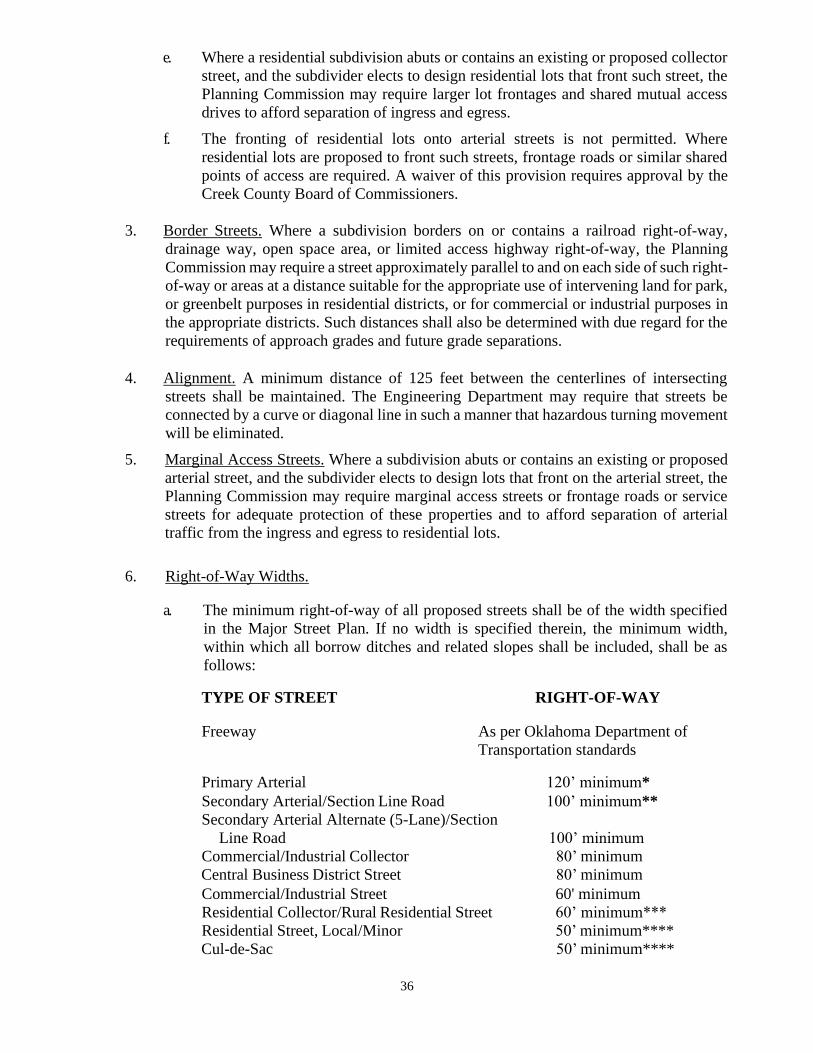
36
e. Where a residential subdivision abuts or contains an existing or proposed collector
street, and the subdivider elects to design residential lots that front such street, the
Planning Commission may require larger lot frontages and shared mutual access
drives to afford separation of ingress and egress.
f. The fronting of residential lots onto arterial streets is not permitted. Where
residential lots are proposed to front such streets, frontage roads or similar shared
points of access are required. A waiver of this provision requires approval by the
Creek County Board of Commissioners.
3. Border Streets. Where a subdivision borders on or contains a railroad right-of-way,
drainage way, open space area, or limited access highway right-of-way, the Planning
Commission may require a street approximately parallel to and on each side of such right-
of-way or areas at a distance suitable for the appropriate use of intervening land for park,
or greenbelt purposes in residential districts, or for commercial or industrial purposes in
the appropriate districts. Such distances shall also be determined with due regard for the
requirements of approach grades and future grade separations.
4. Alignment. A minimum distance of 125 feet between the centerlines of intersecting
streets shall be maintained. The Engineering Department may require that streets be
connected by a curve or diagonal line in such a manner that hazardous turning movement
will be eliminated.
5. Marginal Access Streets. Where a subdivision abuts or contains an existing or proposed
arterial street, and the subdivider elects to design lots that front on the arterial street, the
Planning Commission may require marginal access streets or frontage roads or service
streets for adequate protection of these properties and to afford separation of arterial
traffic from the ingress and egress to residential lots.
6. Right-of-Way Widths.
a. The minimum right-of-way of all proposed streets shall be of the width specified
in the Major Street Plan. If no width is specified therein, the minimum width,
within which all borrow ditches and related slopes shall be included, shall be as
follows:
TYPE OF STREET RIGHT-OF-WAY
Freeway As per Oklahoma Department of
Transportation standards
Primary Arterial 120’ minimum*
Secondary Arterial/Section Line Road 100’ minimum**
Secondary Arterial Alternate (5-Lane)/Section
Line Road 100’ minimum
Commercial/Industrial Collector 80’ minimum
Central Business District Street 80’ minimum
Commercial/Industrial Street 60' minimum
Residential Collector/Rural Residential Street 60’ minimum***
Residential Street, Local/Minor 50’ minimum****
Cul-de-Sac 50’ minimum****

37
* 130' minimum right-of-way required for a right turn lane for a primary
arterial street at the major intersection to extend a
distance of 388' paralleling said right side of street, measured from the
section line as shown in Appendix C.
**108' minimum right-of-way required for a right turn lane for a secondary
arterial street at the major intersection to extend a distance of 388'
paralleling said right side of street, measured from the section line as
shown in Appendix C.
***Permitted with borrow ditches for construction of lots with a frontage
of greater than 150’ or greater.
****Requires curb and gutter design and construction for lots with a frontage
of less than150’.
b. If greenbelts or drainage ways are influenced by natural topographical features and
are provided within the proposed plat, the width and location shall be determined
as may be deemed necessary by the Planning Commission to preserve such
features.
c. The pavement width and lane configuration shall be subject to the requirements of
the County Engineer and otherwise be in accordance with the Major Street Plan as
included in Appendix D.
d. The standards for street surfacing, curb and gutter, and storm sewer design or open
storm drainage shall be subject to the requirements of the Engineering Department
and the adopted Engineering Design Criteria and Standard Specifications for
Construction.
e. Regardless of street classification or right-of-way width, where a private drive
crosses a borrow ditch, the developer’s engineer shall determine the minimum
required diameter of the culvert which shall be shown and recorded on the face of
the final plat. All such culvert pipes shall be sized to, at a minimum, convey the 5-
year runoff event and be a minimum of 18 inches in diameter. All such culvert
pipes shall include a standard inlet/outlet structure for each private drive.
7. Cul-de-sac.
Except as otherwise provided herein, cul-de-sacs shall not exceed 500 feet in length,
measured from the intersecting street to the center of the turn-around, and if more than
150 feet in length shall have a turn-around radius at the property line of not less than 50
feet. To meet the needs of specific situations, this requirement may be changed by the
Planning Commission, upon recommendation by the TAC, when topography or other
limiting factors make such changes necessary for securing the best overall design;
however, in no case shall such cul-de-sac exceed 1500 feet. A modification (Section 1.10)
approved by the Planning Commission of the requirements of this subsection is not
required.
8. Intersections.
a. Property lines at street intersections and Sight Distance Triangles shall be designed
in accordance with the Zoning Code.
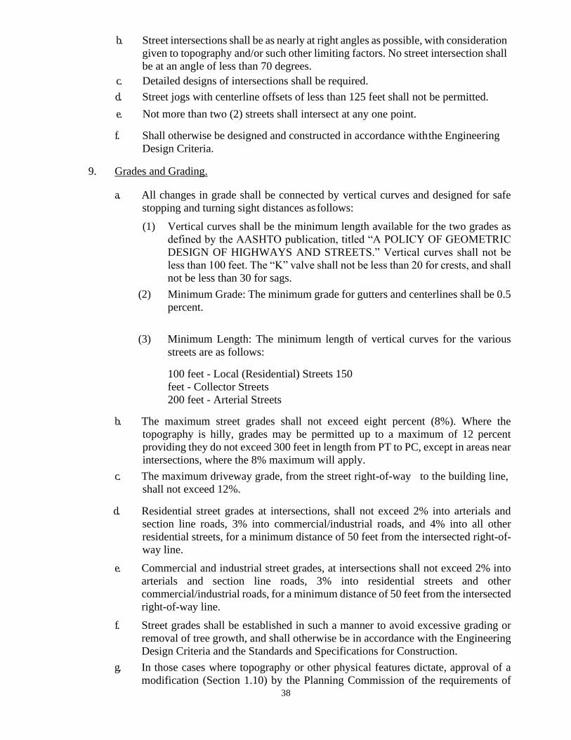
38
b. Street intersections shall be as nearly at right angles as possible, with consideration
given to topography and/or such other limiting factors. No street intersection shall
be at an angle of less than 70 degrees.
c. Detailed designs of intersections shall be required.
d. Street jogs with centerline offsets of less than 125 feet shall not be permitted.
e. Not more than two (2) streets shall intersect at any one point.
f. Shall otherwise be designed and constructed in accordance with the Engineering
Design Criteria.
9. Grades and Grading.
a. All changes in grade shall be connected by vertical curves and designed for safe
stopping and turning sight distances as follows:
(1) Vertical curves shall be the minimum length available for the two grades as
defined by the AASHTO publication, titled “A POLICY OF GEOMETRIC
DESIGN OF HIGHWAYS AND STREETS.” Vertical curves shall not be
less than 100 feet. The “K” valve shall not be less than 20 for crests, and shall
not be less than 30 for sags.
(2) Minimum Grade: The minimum grade for gutters and centerlines shall be 0.5
percent.
(3) Minimum Length: The minimum length of vertical curves for the various
streets are as follows:
100 feet - Local (Residential) Streets 150
feet - Collector Streets
200 feet - Arterial Streets
b. The maximum street grades shall not exceed eight percent (8%). Where the
topography is hilly, grades may be permitted up to a maximum of 12 percent
providing they do not exceed 300 feet in length from PT to PC, except in areas near
intersections, where the 8% maximum will apply.
c. The maximum driveway grade, from the street right-of-way to the building line,
shall not exceed 12%.
d. Residential street grades at intersections, shall not exceed 2% into arterials and
section line roads, 3% into commercial/industrial roads, and 4% into all other
residential streets, for a minimum distance of 50 feet from the intersected right-of-
way line.
e. Commercial and industrial street grades, at intersections shall not exceed 2% into
arterials and section line roads, 3% into residential streets and other
commercial/industrial roads, for a minimum distance of 50 feet from the intersected
right-of-way line.
f. Street grades shall be established in such a manner to avoid excessive grading or
removal of tree growth, and shall otherwise be in accordance with the Engineering
Design Criteria and the Standards and Specifications for Construction.
g. In those cases where topography or other physical features dictate, approval of a
modification (Section 1.10) by the Planning Commission of the requirements of
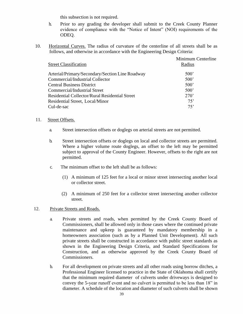
39
this subsection is not required.
h. Prior to any grading the developer shall submit to the Creek County Planner
evidence of compliance with the “Notice of Intent” (NOI) requirements of the
ODEQ.
10. Horizontal Curves. The radius of curvature of the centerline of all streets shall be as
follows, and otherwise in accordance with the Engineering Design Criteria:
Minimum Centerline
Street Classification Radius
Arterial/Primary/Secondary/Section Line Roadway 500’
Commercial/Industrial Collector 500’
Central Business District 500’
Commercial/Industrial Street 500’
Residential Collector/Rural Residential Street 270’
Residential Street, Local/Minor 75’
Cul-de-sac 75’
11. Street Offsets.
a. Street intersection offsets or doglegs on arterial streets are not permitted.
b. Street intersection offsets or doglegs on local and collector streets are permitted.
Where a higher volume route doglegs, an offset to the left may be permitted
subject to approval of the County Engineer. However, offsets to the right are not
permitted.
c. The minimum offset to the left shall be as follows:
(1) A minimum of 125 feet for a local or minor street intersecting another local
or collector street.
(2) A minimum of 250 feet for a collector street intersecting another collector
street.
12. Private Streets and Roads.
a. Private streets and roads, when permitted by the Creek County Board of
Commissioners, shall be allowed only in those cases where the continued private
maintenance and upkeep is guaranteed by mandatory membership in a
homeowners association (such as by a Planned Unit Development). All such
private streets shall be constructed in accordance with public street standards as
shown in the Engineering Design Criteria, and Standard Specifications for
Construction, and as otherwise approved by the Creek County Board of
Commissioners.
b. For all development on private streets and all other roads using borrow ditches, a
Professional Engineer licensed to practice in the State of Oklahoma shall certify
that the minimum required diameter of culverts under driveways is designed to
convey the 5-year runoff event and no culvert is permitted to be less than 18” in
diameter. A schedule of the location and diameter of such culverts shall be shown
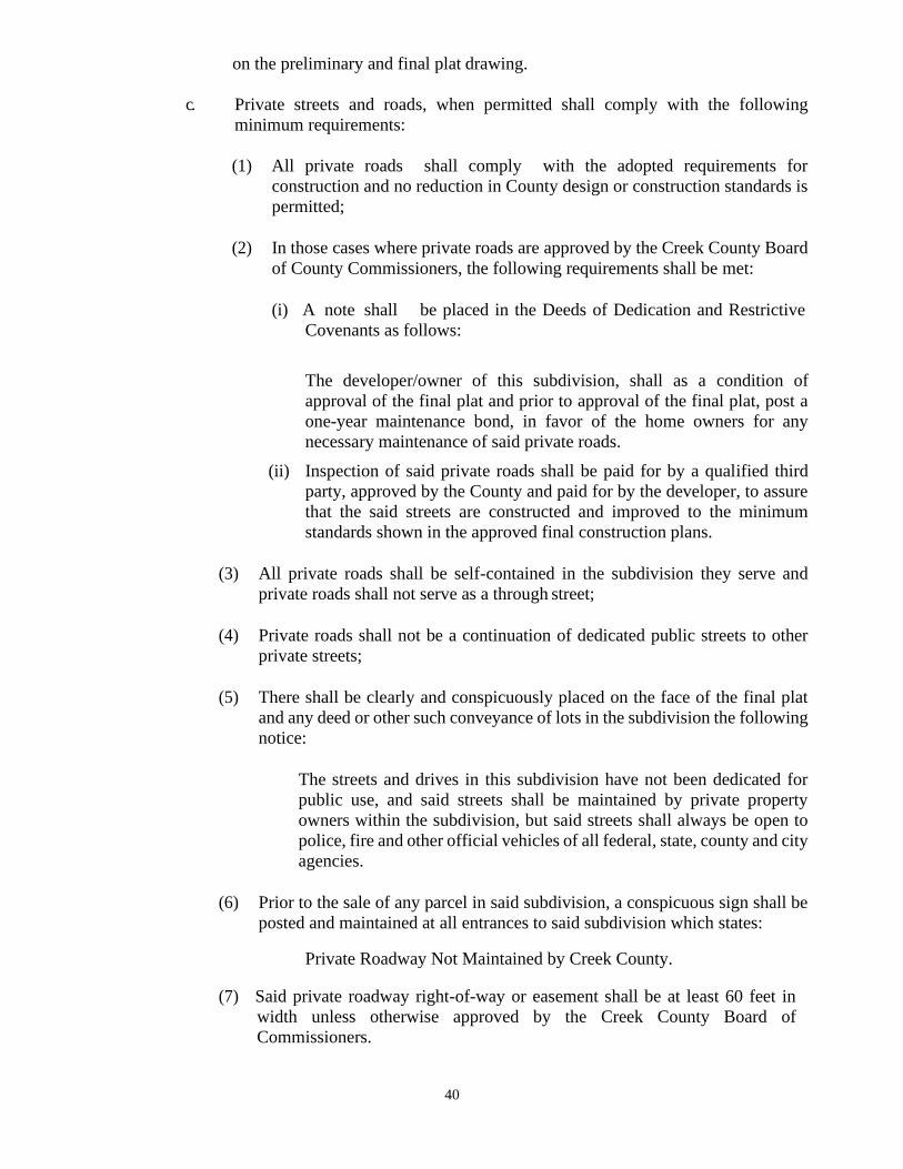
40
on the preliminary and final plat drawing.
c. Private streets and roads, when permitted shall comply with the following
minimum requirements:
(1) All private roads shall comply with the adopted requirements for
construction and no reduction in County design or construction standards is
permitted;
(2) In those cases where private roads are approved by the Creek County Board
of County Commissioners, the following requirements shall be met:
(i) A note shall be placed in the Deeds of Dedication and Restrictive
Covenants as follows:
The developer/owner of this subdivision, shall as a condition of
approval of the final plat and prior to approval of the final plat, post a
one-year maintenance bond, in favor of the home owners for any
necessary maintenance of said private roads.
(ii) Inspection of said private roads shall be paid for by a qualified third
party, approved by the County and paid for by the developer, to assure
that the said streets are constructed and improved to the minimum
standards shown in the approved final construction plans.
(3) All private roads shall be self-contained in the subdivision they serve and
private roads shall not serve as a through street;
(4) Private roads shall not be a continuation of dedicated public streets to other
private streets;
(5) There shall be clearly and conspicuously placed on the face of the final plat
and any deed or other such conveyance of lots in the subdivision the following
notice:
The streets and drives in this subdivision have not been dedicated for
public use, and said streets shall be maintained by private property
owners within the subdivision, but said streets shall always be open to
police, fire and other official vehicles of all federal, state, county and city
agencies.
(6) Prior to the sale of any parcel in said subdivision, a conspicuous sign shall be
posted and maintained at all entrances to said subdivision which states:
Private Roadway Not Maintained by Creek County.
(7) Said private roadway right-of-way or easement shall be at least 60 feet in
width unless otherwise approved by the Creek County Board of
Commissioners.
41
(8) All applicable building setback lines shall be calculated from a line one-half
the width of the required street right-of-way or road and be parallel to said
private right-of-way or easement.
(9) Said private roadway shall not be dedicated to Creek County but may be
reserved for future dedications and then only at such a time as when the street
construction is improved to County standards by the private property owner.
Until such future dedication and except as provided above all private streets
and roads shall be subject to the maintenance of an owners association
composed of the mandatory membership all property owners in the
subdivision.
(10) At the Creek County Board of Commissioner’s option, a petition of at least
60% of the owners in the subdivision to improve and dedicate the private
roadway to the County shall bind all said owners in the subdivision to improve
said street or roadway in compliance with the requirements of Creek County.
Such cost shall be proportionately assessed to the property owners.
(11) Plans for private street improvements shall be prepared by a Professional
Engineer licensed to practice in the State of Oklahoma. The subdivider shall
file with the County a surety (performance) bond in the amount of 125% of
the estimated construction costs, conditioned that the subdivider, as principal,
will faithfully install and complete improvements and utilities in the
subdivision within a period not to exceed two (2) years, according to
requirements of the County, approved plans, specifications, and subdivision
rules and regulations, and will pay all bills for contractors, improvements, and
utilities. An extension of this period may be granted only by the Creek County
Board of Commissioners.
(12) Said Professional Engineer licensed to practice in the State of Oklahoma shall
furnish the actual bid costs of said improvements and utilities to the County
Engineer, who upon review may approve the costs of paving, storm sewers
and other drainage facilities, if required, in order that the Planning
Commission may determine whether or not the amount of the bond submitted
is adequate to assure the construction of these facilities and in order to protect
the interests of the County and public welfare. All current policies, inspection
fees, or other normal requirements of the County Engineer shall also apply in
full force to assure the proper construction of said private roadways.
(13) In lieu of the above provision, and only upon completion of said
improvements, the developer may submit a document prepared by a
Professional Engineer licensed to practice in the State of Oklahoma, which
certifies that all private roads for said development are constructed in
accordance with the Engineering Design Criteria, and Standard Specifications
for Construction and as otherwise approved the Board of County
Commissioners.
(14) Prior to the approval of such private roadways by the County Engineer and
Creek County Board of Commissioners, all abutting property owners shall
enter into a legal agreement and form an owners association to guarantee
42
maintenance and apportion the maintenance cost among said owners. Such
agreement shall clearly state that the County is not responsible for
maintenance.
(15) In those cases where development is served by private streets, no further
subdivision of such land is permitted beyond that approved on the plat until or
unless said streets are improved to County standards and accepted for
maintenance by resolution of the Creek County Board of Commissioners; and
(16) Street stub easements to serve potential future subdivision and to improve the
overall circulation pattern of the area shall be provided in any location deemed
appropriate by the Planning Commission. Connections from such private
streets to planned or existing dedicated public streets shall be permitted only
subject to approval by the Planning Commission and Creek County Board of
Commissioners.
4.3 ALLEYS.
1. Unless provision is made for utility easements, emergency access and service access,
alleys shall be provided in commercial and industrial districts at the rear of all lots
regardless of frontage on a major street.
2. Alleys serving commercial and industrial areas shall not be less than 30 feet in width and
shall be paved the full width.
3. Alleys may be required in R Residential zoning districts by the Planning Commission
after review and recommendation by the TAC for efficient solid waste collection, more
effective police and fire protection or for more efficient provision of service access and
maintenance of utilities. Alleys serving such R Residential zoning districts shall not be
less than 20 feet in width and shall be paved for the full width.
4. Alley intersections and sharp changes in alignment shall be avoided, but where necessary,
corners shall have a radius sufficient to permit safe vehicular movements as determined
by the County Engineer.
5. Dead-end alleys shall be avoided where possible, but if unavoidable shall be provided
with adequate turnaround facilities at the dead-end as determined by the County Engineer.
4.4 SIDEWALKS.
1. Where curb and gutter streets are constructed, sidewalks shall be required on both sides
of all primary arterials, secondary arterials, secondary arterial alternates, and residential
collector streets. However, in subdivisions developed in A Agriculture Districts or in R
Residential Districts where lots are a minimum of 150 feet wide, sidewalks are not
required. Further, in the event there exists a unique situation in determining the
requirement for sidewalks along residential collectors streets, the Creek County Board of
County Commissioners, upon recommendation of the Planning Commission, may grant
a modification to such requirements. Sidewalk requirements or the granting of an
exception thereto shall consider the relationship of such sidewalks to existing and planned
streets, topography, public convenience and safety, and the proposed uses of the land and
proximity to existing and proposed future development.
43
2. In those cases where sidewalks are required along primary arterial streets, secondary
arterial streets or secondary arterial alternate streets, the County, at its sole option and
upon recommendation of the County Engineer, may allow the subdivider to escrow 100%
of the actual bid cost or 125% of the estimated construction cost as determined by the said
Engineer in a cash account with the County to allow such sidewalks to be constructed at
a later specified date. The County Engineer may allow the subdivider to provide a
performance bond in favor of the County in the amount of 150% of the estimated
construction cost approved by the County Engineer in lieu of a cash account.
3. The Planning Commission may require, in order to facilitate pedestrian access to schools,
parks, playgrounds, churches, shopping centers or nearby streets, perpetual unobstructed
easements of not more than ten (10) feet in width to provide adequate pedestrian
circulation. Such easements shall be indicated on the plat.
4. Sidewalks shall be located within the dedicated right-of-way and constructed in
accordance with the adopted Creek County Engineering Design Criteria and Standard
Specifications for Construction.
4.5 BLOCKS.
1. The length, width and shape of blocks shall be suited for the planned use of the land and
be determined in accordance with the following:
a. Zoning requirements applicable to lot sizes and dimensions;
b. Needs for convenient access, circulation, control and safety of street traffic; and
c. Limitations and opportunities of topography.
2. Blocks for residential use shall not be longer than 1500 feet, measured along the centerline
of the abutting streets. When a block exceeds 700 feet in length, the Planning Commission
may require a dedicated right-of-way not less than ten (10) feet in width with a paved
crosswalk not less than six
(6) feet in width in the right-of-way to provide pedestrian access at the approximate mid-
point of the block. A modification (Section 1.10) approved by the Planning Commission
of the requirements of this section is not required.
3. Blocks used for residential purposes should be of sufficient width to allow for two (2)
tiers of lots of appropriate depth, except where adjacent to major streets, limited access
highways, railroads, waterways, or when prevented by topographical conditions.
4. Blocks intended for business and industrial use should be of a width and depth suitable
for the intended use, with due allowance for off-street parking and loading facilities.
4.6 LOTS.
1. Configuration. The size, shape, and orientation of lots shall be appropriate for the location
of the subdivision and for the type of development and planned use. Each residential lot
shall be designed with a front lot line, a rear lot line and not more than three (3) side lot
lines. Front lot line, rear lot line and side lot line are defined in the Zoning Code. The
Planning Commission may modify this requirement when the purpose of these
44
Regulations may be served to the same extent by an alternative proposal as provided in
Section 1.10 Modifications.
2. Access. Every lot shall have frontage on or abut a street dedicated to and maintained by
the County (or approved private street) or other approved access. See Section 4.2.2.
3. Zoning Requirements. Lot dimensions, yard, building setback lines, and lot area shall
conform to the requirements of the Zoning Code.
4. Double Frontage and Reverse Frontage.
a. Double frontage and reverse frontage lots should be avoided except where necessary
to provide separation of residential development from through traffic or to overcome
specific disadvantages of terrain and orientation. Said lots shall have a minimum
depth of 125 feet and shall be screened from the abutting street on the rear.
b. For double frontage or reverse frontage lots, a planting screen easement of at least
ten (10) feet in width shall be provided along the portion of the lots abutting the street
on the rear and there shall be no right of access across a planting screen easement.
At the discretion of the Planning Commission, the developer may substitute for an
easement and planting screen a permanent opaque ornamental fence not less than six
(6) feet tall, in which case the ten (10) feet planting screen easement will not be
required .
5. Corner Lots. Corner lots should exceed the minimum lot requirements in order to provide
adequate building area on the lot due to the required building setbacks on both streets.
6. Lot Lines. Side lot lines should be at right angles to or radial to street lines or to the
tangent of curving streets. Lot lines not at right angles to or radial to street lines or to the
tangent of curving streets must show bearings of the lot lines.
7. Private Sewer and/or Water. Where a proposed subdivision is not served by public
sewer and/or water, lot dimensions and area shall conform to the requirements of the
DEQ. See Appendix B.
4.7 EASEMENTS.
1. Utility Easements.
a. Easements shall be a minimum of 22 feet, 11 feet on each side of all rear lot lines, or
a width as specified by the utility company, and when necessary on other lot lines, for
utilities, drainage, or access. Easements (drainage, access, utility, etc.) shall be
exclusive for the intended primary purpose.
b. When an easement of 22 feet in width is not provided, the minimum width of the
easement shall be 17.5 feet.
c. Easements shall be maintained free of buildings, fences, appurtenances, or other
structures which would prevent vehicular access for maintenance and service of
utilities.
d. A modification (Section 1.10) approved by the Planning Commission of the
45
requirements of this section is not required.
2. Drainage Easements. Drainage easements, as required by the adopted Engineering Design
Criteria, shall be provided on the subdivision plat.
3. Easements Subject to TAC Review. The location, width, and alignment of all easements
shall be subject to review by the TAC prior to approval by the Planning Commission and
Board of County Commissioners.
4. Color coding shall comply with Appendix E, “Standard Location of Underground Utility
Lines and Color Code.”
5. Standards for oil and gas drilling shall be in accordance with the Zoning Code and all
other applicable County, state or federal regulations.
6. Evidence of research and plugging of operative or inoperative oil or gas wells shall be
submitted as required in Sections 3.2, 3.3, and 3.6.
4.8 FLOODPLAIN AREAS.
In order to develop lands identified by the official floodplain maps of Creek County as being
subject to flooding hazards or periodic inundation, said lands shall not be subdivided into lots,
tracts or parcels for any use which would be incompatible with such flooding hazards and a
letter of map amendment and revision or evidence of compliance with the applicable regulations
of Creek County shall be required prior to approval of the final plat or prior to start of
construction. The following additional requirements shall be met:
1. Improvements are provided which meet the standards and requirements of Creek County
and the appropriate state and federal agencies that are designed and constructed so as to
render such land safe for residential or other uses; or
2. The intended use of the land is permitted by adopted regulations or resolutions of the
County because such use has a low flood damage potential and will not obstruct flood
flows, which shall be certified and attested to by a Professional Engineer licensed to
practice in the State of Oklahoma.
3. If development is permitted within the floodplain, such development shall comply with
all permitting requirements of Creek County and the adopted floodplain regulations.
4.9 STORM WATER DRAINAGE AND DETENTION FACILITIES.
1. The post-development runoff shall not exceed the pre-development runoff for all runoff
frequency rainfall events, at all locations where runoff exits the property, and
documented by the 5-year and 100-year frequency rainfall events.
2. The storm water drainage system shall be designed and constructed in accordance with
the standards and requirements adopted by Creek County, and shall be so designed to
receive and pass the runoff from a post development 100-year frequency rainfall. The
entire flow shall be confined within the said storm water drainage systems, easements or
reserve areas.
46
3. The ownership and maintenance requirements (privately owned, frequency of mowing,
dredging of ponds, etc.) for all detention facilities shall be specified in the Deeds of
Dedication and Restrictive Covenants.
4. A 20’ wide minimum improved access way shall be provided to all detention facilities as
required in the Engineering Design Criteria.
4.10. INJECTION, OIL AND GAS EXTRACTION SITES - RESIDENTIAL
SUBDIVISIONS.
1. Existing Operative, Inoperative, Plugged and Abandoned Wells:
a. Shall be shown on the face of the plat submittal as well as described in the
Restrictive Covenants;
b. All abandoned, inoperative or inactive wells shall be properly plugged;
c. Residences shall be setback a minimum of 200 feet or more from any existing
operative or inoperative oil or gas well unless said well is properly plugged, or
unless the Planning Commission has reduced the setback requirement. However,
no such setback shall be less than that required by H.B. 1569 or subsequent
amendments thereto;
d. Residences shall be setback a minimum of 50 feet from any plugged well;
e. Access to such well sites shall be separate from residential lots and so indicated on
the face of the plat for all unplugged wells for the purpose of maintenance and
rework;
f. Evidence of research and plugging of operative or inoperative wells (i.e., a
certificate or letter from the Oklahoma Corporation Commission) shall be
submitted as required in Sections 3.2 and 3.3; and
g. Inactive or abandoned foundations, anchors, or other solid bulk structures shall be
remediated in the following manner:
(1) Removal of certain portions from the development to an approved location,
or burial of remaining portions in a manner approved by the Creek County
Board of Commissioners.
(2) Reduction into sections of manageable size for burial and possible future
removal is required as follows:
(i) Location of placement shall be approved by the Creek County Board
of Commissioners and shown or specified on the face of the plat.
(ii) Buried material shall be in a location that does not encroach upon
easements or otherwise create complications for future use of
common property or for any lot.
(iii) Material bulk sections may be located in a flood prone area only
when included in a floodplain development permit.
47
2. Planned Oil or Gas Well Sites
a. Well sites with an area of less than ten (10) acres shall not be permitted within
residential subdivisions.
b. If the developer owns both the surface rights and all mineral rights, he may by plat
or reserve designate future well sites, if there are no existing oil, gas or mineral leases
of record.
c. If the developer does not own all the mineral rights, or there are recorded oil and gas
leases on the subject property, written notice must be sent to all parties who have an
oil, gas, or mineral interest or recorded oil or gas lease, as shown by the records of
the County Clerk. Said notice shall inform of the intent to subdivide said property by
reference to a legal description.
d. Interested parties shall have 60 days from receipt of said notice to respond with a
notice of a future intent to drill oil or gas. Said response shall be in writing to both
the developer and the Planning Commission of the intent to drill for oil or gas in the
future.
e. The developer and owners of leases or owners of mineral interests have an additional
120 days from the date of the notice to agree upon the reserved location of the well
sites.
f. If the parties cannot agree on the location of the well sites, the Planning Commission,
after public hearing, shall select the well sites based on the information supplied by
the mineral rights owner and the developer.
g. All well sites shall be shown on the face of the plat, as well as referenced in the
Restrictive Covenants, such as by lot and block or reserve area.
h. Standards for location of well sites:
(1) A minimum of two (2) acres or more in size for each well site;
(2) Access shall be provided to the site for purposes of maintenance and service;
and
(3) There shall be no more than one (1) well site within the boundaries of the plat
for each 20 acres of land covered by the plat.
4.11 SANITARY SEWAGE DISPOSAL AND WATER SUPPLY.
1. General Requirements:
a. All subdivisions shall utilize a public drinking water supply approved by the DEQ,
or such supply as would otherwise comply with the regulations of the DEQ.
b. All plans pertaining to the public collection and treatment of sewage must be
approved by the DEQ, the applicable sewer department, and Creek County.
c. All plans pertaining to distribution and treatment of public drinking water must be
approved by the DEQ, the applicable water depart- ment, and Creek County.
48
d. If the subdivision is located within 500 feet of an existing public water or public
sanitary sewer system, the developer shall connect with said system that so it is
available to every lot within the subdivided area.
2. Requirements for Sanitary Sewer Improvements:
a. The Subdivider shall at his or her expense, provide an internal sanitary sewer
collection system to every lot within the subdivision. Said system shall be designed
and constructed as approved by the DEQ and in accordance with requirements of
Creek County and the duly adopted standards and specifications of any applicable
sewer district.
b. Where an approved public sanitary sewer system is greater than 500 feet but less
than one (1) mile from the subdivision and in order to allow development during
the time required to extend the public sanitary sewer system into those areas
without such system, the Planning Commission and Creek County Board of County
Commissioners require the following:
(1) A central treatment plant may be utilized until an approved public system is
available within 500 feet or less, provided that said treatment system meets
all applicable water quality criteria and is designed and constructed as
approved by DEQ and in accordance with regulations of Creek County and
any applicable district.
(2) In those cases where a Master Wastewater Plan for the drainage basin in
which the subdivision is proposed has been prepared and adopted, and where
said plan specifies that the sewer interceptor is included on the officially
adopted Five Year Capital Improvement Program, a subdivision may
develop initially on individual on-site systems in accordance with standards
as set out herein, provided that in addition to installation of the on-site
systems, the developer shall be required to install a sewer collection system
within the subdivision that can be connected to the public system when it
becomes available, and each lot shall be provided with a building sewer line
connected to such system. Said system and building sewer line shall be
designed and constructed as approved by the DEQ and in accordance with
ordinances of the other applicable authorities. Language shall be included
on the face of the Final Plat, which specifies that future tie-on to the public
system is required and that the costs for such tie-on shall be the responsibility
of the individual lot owners.
c. Subdivisions that plan to utilize individual on-site sewage disposal systems must
comply with the requirements of the Oklahoma Administrative Code, Title 252,
Chapter 641.
d. Several types of subsurface or above ground, on-site sewage disposal systems may
be permitted. It is beyond the scope of these Subdivision Regulations to provide
detailed instructions, designs, or specifications for any sewage disposal systems.
The subdivider shall be responsible for obtaining the applicable regulations of the
agency having jurisdiction and complying with the procedural and substantive
requirements therein.
49
e. All lots in the proposed subdivision shall meet the minimum lot size requirements
of the Oklahoma Department of Environmental Quality for on-site sewage
disposal systems. Refer to APPENDIX B. These minimum lot size requirements
shall not be varied except by the agency having jurisdiction over the permitting of
the proposed sewage disposal systems.
f. The subdivider shall submit restrictive covenants with the preliminary subdivision
plat application relative to the installation and use of individual on-site sewage
disposal systems and/or connection to the public sanitary sewer system as
provided in APPENDIX B.
g. Developers of subdivisions wherein it is planned to initially use on- site sewage
disposal systems shall comply with the regulations of Creek County and the DEQ.
h. Alternative treatment systems may be constructed provided that a contract is
entered into with a public entity approved and licensed to operate and maintain
such an alternative treatment system, or that the continued maintenance and
operation of such system is otherwise secured such as by Deed of Dedication and
Restrictive Covenants as would be applicable in a PUD. Said systems and sewer
collection system shall be designed and constructed in accordance with the duly
adopted standards and specifications of the DEQ, Creek County and any other
applicable authorities.
4.12 PUBLIC PARKS AND OPEN SPACES.
Residential subdivisions should preserve and provide open spaces, suitably located and of
reasonable size for parks, playgrounds, play lots, playfields, or other recreational areas
sufficient to serve the subdivision. The maintenance and upkeep of such areas shall remain the
responsibility of the property owners in said subdivision and be secured by the mandatory
membership of such owners in a homeowners association as required by a PUD or in the
restrictive covenants.
4.13 RESERVE STRIPS.
1. A reserve strip is defined as a strip of land typically created by the owner to be privately
retained to prevent, restrict, or otherwise control access to public utilities or streets.
2. Reserve strips are prohibited by these Subdivision Regulations and are not otherwise
permitted to be created or held in such private control.
4.14 PAVED DRIVEWAY APPROACHES ONTO COUNTY MAINTAINED ROADS.
1. The fronting of residential lots with driveways onto County maintained roads less than
320 feet apart shall be avoided due to traffic safety concerns posed from such access to
traffic on said section line or arterial roads and the ingress and egress from such residential
drives.
2. In those cases where access is permitted from residential or other development, prior
approval shall be required from the County Engineer or County Planner and the following
requirements shall apply:
50
a. All such approaches shall be paved, and shall not exceed a maximum width of 25
feet, and shall be constructed in accordance with the requirements of the
Engineering Design Criteria, and the Standards and Specifications for Construction
of Creek County;
b. If and as necessary, a culvert pipe shall be provided that would pass the runoff from
a 5-year rainfall event. In no case shall said culvert pipe be permitted to be less than
18 inches in diameter. The hydrological engineering for such a determination shall
be performed at the cost of the private property owner and is subject to the approval
by the County Engineer; and
c. In those areas where a curb cut or driveway access is requested for a state or federal
highway, evidence of approval from the applicable state or federal agency must be
secured prior to requesting such approval from Creek County. Driveway approaches
on the right-of- way of a state or federal highway, shall comply with the most
restrictive of the requirements for construction as administered by Creek County, or
the state, or the responsible federal agency.
4.15 HILLSIDE DEVELOPMENT.
The development of Hillside areas or any areas with a slope greater than eight
(8) percent shall be designed to minimize grading and filling and in such a manner as to retain
the maximum feasible amount of natural ground cover. Areas with slopes in excess of 20
percent shall be utilized as open space or developed as a Planned Unit Development in
accordance with the applicable provisions of the Zoning Code and these Regulations.
51
SECTION 5. REQUIREMENTS FOR IMPROVEMENTS, INSPECTION AND BONDING.
5.1 INSTALLATION AND INSPECTION OF IMPROVEMENTS.
1. Following approval of the final construction plans, and prior to the final plat approval, the
subdivider shall complete in a manner satisfactory to the County Engineer, all required
improvements and said improvements shall be free and clear of all liens, claims and
encumbrances.
2. Third party inspection of all improvements is required as follows:
a. Inspection shall be performed by a Professional Engineer licensed to practice in
the State of Oklahoma or such others as licensed to inspect such improvements.
b. The selection of said inspector(s) shall be based on the approval of the Board of
Commissioners of Creek County.
c. The costs of all such inspections shall be paid for by the subdivider, and all such
costs shall be paid in full prior to the acceptance of said improvements by the
County and prior to affixing of signatures to the final plat by the Planning
Commission and Creek County Board of Commissioners.
d. The results of said inspections shall be periodically reported to the Creek County
Engineer and/or the respective Creek County District Commissioner.
5.2 BONDING OF SUBDIVISION IMPROVEMENTS.
1. In lieu of completion of required public improvements, except for sidewalks as specified
in Section 4.4, and prior to issuance of any building permit, or start of construction, the
Board of County Commissioners shall require that the subdivider record an improvement
guarantee with the County Clerk (approved and accepted by the Board of County
Commissioners and approved as to form by the District Attorney) to assure the actual
construction of improvements according to the plans and specifications approved by the
County Engineer. All improvements shall be completed as required by these Regulations
and Oklahoma Statutes within a period of time not to exceed two (2) years from the date
of approval of the final plat by the Planning Commission and Board of County
Commissioners. The Board of County Commissioners shall have the power to extend
that deadline one (1) additional year where the subdivider can present valid reason(s) for
such extension. (See also Appendix F and Section 5.4.)
2. All improvement guarantees shall be one of the alternative forms listed below and shall
be in the amount of 125% of the estimated cost to construct the improvements as
determined by the developer’s engineer with concurrence of the County Engineer, or
100% of the actual bid cost to construct such improvements with County participation
required in the bid process, and include all other guarantees and conditions satisfactory
to the County. No building construction shall be permitted nor utility service
52
furnished on any lot which does not comply with these requirements.
3. Alternative forms of Improvement Guarantees shall be as follows:
a. Surety Performance Bond. The subdivider shall obtain a surety bond from a surety
bonding company authorized to do business in the State of Oklahoma. The bond
shall be payable to the County, recorded with the County Clerk, and shall be in one
of the amounts as specified above as estimated by a Professional Engineer licensed
to practice in the State of Oklahoma and approved by the County Engineer for
completing all required improvements; or
b. Escrow Account. The subdivider shall deposit cash or other instrument readily
convertible into cash at face value, either with the County Treasurer or in escrow
with a bank. The use of any instrument other than cash, and, in the case of an escrow
account, the bank with which the funds are to be deposited shall be subject to the
approval of the Creek County Board of Commissioners. The amount of the deposit
shall be in one of the amounts as specified above as estimated by a Professional
Engineer licensed to practice in the State of Oklahoma and approved by the City
Engineer for completing all required improvements. The subdivider shall record
with the County Clerk an agreement (approved and accepted by the Board of County
Commissioners and approved as to form by the District Attorney) between the
financial bank and said subdivider guaranteeing the following:
(1) That the funds of said escrow account shall be held in trust until released by
the County and may not be used or pledged by the subdivider or bank as
security in any other matter during that period; and
(2) That in the case of a failure on the part of the subdivider to complete said
improvements, the bank shall immediately make the funds in said account
available to the County for use in the completion of those improvements; and
(3) Funds deposited with the County Treasurer shall bear no interest during the
term of the deposit; or
c. Letter of Credit. The subdivider shall provide from a bank or other reputable
financial institution (subject to the approval of the Creek County Board of
Commissioners) a letter of credit. This letter of credit (approved as to form by the
District Attorney) shall be recorded with the County Clerk, and shall certify the
following:
(1) That the creditor does guarantee funds in one of the amounts specified above
as estimated by a Professional Engineer licensed to practice in the State of
Oklahoma and approved by the County Engineer for completing all required
improvements;
(2) That in the case of failure on the part of the subdivider to complete the
specified improvements within the required time period, the creditor shall pay
to the County, immediately and without further action, the full amount of such
funds as are necessary to finance the completion of those improvements, up to
53
the limit of credit stated in the letter; and
(3) That this letter of credit may not be withdrawn, or reduced in amount until
released by the Creek County Board of Commissioners.
d. In the event that the subdivider is the principal on any delinquent corporate surety
bond, the obligations of which have not been fulfilled, said subdivider shall be
required to provide as surety, cash or a certificate of deposit for any improvement
not installed and/or constructed by the subdivider prior to the recording of any other
final plat.
e. It shall be the responsibility of the subdivider posting any form of improvement to
guarantee to inform the Creek County Board of Commissioners through the County
Planner when such obligations under said guarantee have been fulfilled and to
request release from the terms and conditions of the posted improvement guarantee.
The subdivider’s obligation shall not be considered fulfilled until the Creek County
Board of Commissioners has specifically released the subdivider from such
obligation.
f. Any construction surety, regardless of form, shall be accompanied by a certified
engineer’s estimate, prepared by a Professional Engineer licensed to practice in the
State of Oklahoma, certifying that the improvement guarantee amount is sufficient
to cover 125% of the current cost of constructing the guaranteed improvement,
except as specified in Section 5.2.2 above.
g. If any portion of the required improvements shall fail to be accepted for dedication
within the allocated time period, either for reasons of incompletion or for reason of
substandard construction, the Creek County Board of Commissioners shall take the
following action:
(1) Where improvements have been guaranteed under the provision of these
Regulations, the Creek County Board of Commissioners shall declare
whatever security has been pledged as a guarantee to be in forfeit.
(2) Where the Creek County Board of Commissioners is not already in possession
of said guarantee, it shall immediately take the actions necessary to obtain it.
Upon receipt of these securities, the County shall use them, or receipts from
their sale if that be necessary, to finance the completion of required
improvements or the rebuilding of such improvements to the proper
specifications.
(3) Where improvement guarantees given under the provisions of these
Regulations are about to expire and the improvements guaranteed under such
securities have been determined by the County Engineer to have been
constructed in a substandard manner or have otherwise failed, the County shall
require that the subdivider extend the period of the surety to allow such
deficiencies to be remedied as per the terms of the original surety. The amount
of the surety in such cases shall be based only on the deficiencies and be 125%
of the estimated cost to remedy such deficiencies as determined by the County
54
Engineer, or 100% of the actual bid cost to remedy such deficiencies.
(4) Unused portions of these securities shall be returned to the subdivider, bonding
company, or crediting institution, as is appropriate.
5.3 COMPLETION AND ACCEPTANCE OF PUBLIC IMPROVEMENTS.
1. At such time as the subdivider has completed the installation and construction of all
required public utilities and improvements, the subdivider may apply for acceptance of
all such improvements by the County.
2. The individual or legal entity responsible for causing a public improvement to be
constructed shall make written request through the County Engineer that such public
improvements be accepted by the County. Upon receipt of such notice, the developer’s
engineer, who must be a Registered Engineer licensed to practice in the State of
Oklahoma, shall certify that he or she has made a final inspection of the improvements,
and submit drawings attested with his/her seal certifying that said improvements have
been constructed in accordance with the approved final construction plans.
3. Upon receipt of the written recommendations and findings of the County Engineer, to
include receipt and approval of the required As Built Drawings, the Creek County Board
of Commissioners may accept such improvements upon the finding that said
improvements meet the requirements of these Regulations and all other conditions of
approval have been satisfied (submission of maintenance bonds, As Built Drawings, etc.).
4. Upon completion of improvements or satisfaction of the purposes and requirements of the
sureties, such sureties shall be released and notification of such release shall be given to
the subdivider.
5. In addition to the requirement for certification by the developer’s engineer, the results of
the third party inspection by the designated agent of the County shall be considered as
required by Section 5.1.
5.4 TIME LIMIT.
Prior to the granting of final plat approval, the subdivider and Creek County Board of
Commissioners shall agree upon a deadline for the completion of all required improvements.
The period within which required improvements must be completed shall be specified by the
Creek County Board of Commissioners in the action approving the final subdivision plat and
shall not exceed two (2) years from date of final approval, unless extended by the Planning
Commission and approved by the Creek County Board of Commissioners for good cause.
5.5 VACATED PLATS.
Vacation of the plat as provided by Oklahoma State Statutes shall remove the obligation to
construct such improvements.
55
SECTION 6. LOT-SPLIT PROCEDURES AND STANDARDS
6.1 AUTHORITY.
1. The Planning Commission, pursuant to the powers and jurisdiction vested through
Oklahoma Law and as required herein, does hereby exercise the power and authority to
review, approve and disapprove divisions of land hereinafter referred to as lot-splits.
2. Reference must also be made to Section 1.17 Types of Subdivisions for a description of the
types and requirements of these Regulations as they pertain to major subdivisions, minor
subdivisions, and lot splits.
6.2 INTENT AND PURPOSE.
1. The regulations contained in this Section are intended to establish reasonable standards of
design and procedures for lot-splits as defined in Section 8 of these Regulations in order to
accomplish the policy and purposes set forth in Sections 1.3, 1.4, and 1.17 as they are
applicable to lot-splits.
2. Planning Commission approval of lot-splits shall be based upon the following requirements:
a. All resulting lots shall comply with the provisions of the applicable “Flood Damage
Prevention Ordinance” or related regulations;
b. All resulting lots shall have written approval from the Oklahoma Department of
Environmental Quality (DEQ) for the sewage disposal system;
c. All resulting lots shall have access to public utilities by proper easement or other
approved right-of-way;
d. All resulting lots shall have frontage upon a County maintained and/ or dedicated road
or receive approval of a modification from such road requirement from the Planning
Commission and approval of a variance to the frontage requirement of the Zoning Code
from the Board of Adjustment. Approval of waivers from the Planning Commission
shall be based upon such lots being the product of previously filed deeds, property left
as a result of previously filed deeds, or be splits involving strips of land left between
filed deeds. Roads serving such lands shall have a minimum right-of-way of 60 feet. All
paving and drainage must be contained within the street right-of-way. Such roads built
after 1987 may not receive a waiver or variance to these requirements; and
e. All resulting lots shall meet the minimum bulk and area requirements of the zoning
district in which they are located.
6.3 PROCEDURE.
The following procedure shall be required for processing lot-splits:
1. Application Form and Drawing. A complete lot-split application shall be filed with the
Planning Commission Staff and the appropriate fee paid. The application is considered

56
complete and may be accepted for processing by the Planning Commission Staff when it
meets the following requirements and includes the following information:
a. The name(s), address(es), phone number(s) of the current owner or owners of record
of the land to be subdivided.
b. The written consent of all owners of the subject property to the splitting of the
property.
c. A complete legal description and Survey performed by a Professional Land Surveyor
of the existing undivided lot of record and a legal description of each of the proposed
lots shall accompany the application. Legal descriptions shall consist of Lot, Block,
Subdivision Name, County, and State or a metes and bounds description of the
perimeter of the property with all bearings expressed in degrees, minutes, and
seconds and dimensions accurate to two decimal places or a description based on
sectionalized land. Said legal description shall identify a point of beginning tied to a
known corner of a section or fraction of a section.
d. One copy of a Survey depicting all existing and proposed lot lines with dimensions
(and bearings if applicable), all existing buildings and improvements and their
distances from lot lines, adjacent streets and street widths, existing access limitations,
and a north arrow and scale.
e. The drawing should be limited to a maximum size of 11” x 17”.
f. A deed or other instrument of conveyance demonstrating the status of the pre-divided
and post-divided parcel relative to the definition of “Lot of Record”.
2. Planning Commission Staff Review. In its review of lot-splits, the Planning Commission
Staff shall:
a. Distribute copies of the application form and drawing to the appropriate officials,
agencies, departments or utilities; and
b. Field check the subject area if and/or as needed.
3. Lot-Splits Requiring Planning Commission Staff Review Only. Where review by the
Planning Commission Staff reveals that a lot-split meets all approved requirements and
definitions as set forth in these Regulations, and all proposed lots are adequately served by
utilities either by easement or in public streets, the Creek County Planner may grant “Prior
Approval” of the lot-split and the Planning Commission may ratify the approval at the next
Planning Commission meeting.
6.4 CERTIFICATE OF APPROVAL.
1. Planning Commission approval shall be shown by certification on the instrument of transfer
as required by Oklahoma State Statutes. The Planning Commission Chairperson or the
Creek County Planner, or such other Officer of the Planning Commission as designated by
such Chairperson shall sign the certification.
57
2. Upon having said written approval by the Planning Commission affixed to this instrument
of transfer, the subdivider may then file the instrument with the County Clerk, such approval
being an official document that will be contained in the abstract of the property being split
6.5 APPROVAL GUIDELINES.
Approval or disapproval of lot-splits shall be based upon the requirements of the applicable
paragraphs in Section 4 of these Regulations along with the following guidelines:
1. Lots.
a. Lot dimensions shall conform to the Zoning Code and shall meet the requirements
set forth in Section 4.6 of these Regulations.
b. In the case of lots not served by public sanitary sewers and/or public water, such lots
shall be of sufficient area to properly accommodate a suitable private sewage
disposal system and otherwise meet the requirements of the DEQ and Section 6.5.4
below.
c. Corner lots or double frontage lots should have such extra width and area beyond the
minimum requirements for other lots as may be necessary to permit appropriate
setbacks on both streets while insuring that adequate buildable space remains.
2. Easements and Utilities. Where a lot-split will result in a lot having inadequate access to
utility easements, dedication of easements shall be required in accordance with the
requirements of these Regulations and the applicable utility providers. Requirements for
easements and/or utility extensions shall be considered as a basis for requiring the
application to be submitted as a Minor Subdivision in accordance with these Regulations.
3. Access and Streets.
a. Where a tract to be split is controlled by non-access provisions, no lot shall be
approved where such provision will preclude access for said lot.
b. The splitting of land shall provide each lot with access to a County maintained road,
so that the convenience of the lot owner or user is assured, as well as the layout of
utilities, garbage and waste removal, fire protection and public health and safety is
thereby adequately provided for.
c. Where land to be split contains within its boundaries areas designated for street right-
of-way on the Major Street Plan, the split shall not be approved where street right-
of-way fails to conform to said Plan except upon a finding that:
(1) All utilities are in place and the additional right-of-way is not required for
utility placement;
(2) The public has, by virtue of statutory right-of-way or statutory easement or
suitable roadway dedication, right-of-way sufficient to allow the placement of
pavement of a width necessary to meet the standards of the Major Street Plan
for the particular street involved; and
(3) Development made possible by the split itself will not measurably increase
58
the burden of traffic on an adjacent street to such an extent that it would
adversely affect the health, safety, and welfare of the public; or
(4) In the judgment of the Planning Commission, and subject to final approval by
the Creek County Board of Commissioners, existing structures which cannot
be reasonably required to be removed lie in the existing or proposed right-of-
way and alignment proposed by the Major Street Plan, and said structures
preclude the construction of the planned street.
4. Sewage Disposal.
a. Where a tract to be split abuts a public sanitary sewer, no split shall be approved until
or unless the approval of the applicable water or sewer authority or other appropriate
agency is obtained, and the water or sewer is extended as required in these
Regulations.
b. Within the subject area of Creek County that is not served by sanitary sewer within
500 feet of the nearest property line, the regulations for subdivisions shall apply for
lots that plan to utilize on-site systems, and connection to the public sewer collection
system is not required. However, provisions for such connection shall be required as
provided in Section 4.11 of these Regulations.
c. Lot size requirements shall be the same as those for subdivisions provided that an
exception to lot size may be granted upon concurrence of the DEQ, if all lots created
have existing structures and the lot-split does not, in effect, change the density.
Proper documentation (evidence of an instrument as recorded in the office of the
Creek County Clerk) of the foregoing circumstances must be provided showing
transfer of ownership of the subject lot or parcel prior to January 1, 1974.
d. Prior to start of construction, a sewage disposal system approved by the DEQ shall
be required for each lot created as required for subdivisions. (See also Section 4.11
and Appendix B).
5. Public Water Supply
A public water supply serving each lot may be required as provided for in the regulations
of the DEQ and Creek County.
6. Paved Driveway Approaches and Driveway Culverts.
As conditions of approval of all lot-splits and as a requirement of access to the adjoining
paved County maintained road, the driveway approach from the edge of the improvement
of the road to the private property line shall be paved to the minimum standard established
by these Regulations and other applicable standards. A culvert pipe, a minimum diameter
of 18” or such larger diameter pipe as determined by the County as shall be required to pass
the runoff from a 100-year rainfall event, shall be installed by the private property owner.
59
6.6 EXEMPTIONS FROM THE LOT-SPLIT REQUIREMENT.
The following shall be exempt from the Lot-Split requirement of these Regulations:
1. Land divisions which cause the creation of two (2) tracts, either one of which will be
conveyed unto a public receiving body, including the Department of Transportation of the
State of Oklahoma, the Oklahoma Turnpike Authority, Creek County, or any municipally
incorporated city or town of the State of Oklahoma, and will be used as public right-of-way
for public roads, streets, highways, railroads, or for facilitating other such public
infrastructural needs, shall be exempt from the Lot Split requirement of these Regulations,
in accordance with the following provisions:
a. The tract of land which is conveyed unto the public receiving body shall not require
certification on the instrument of transfer.
b. Prior to its first conveyance, the tract of land which is retained by the private property
owner shall be submitted to the Planning Commission Chairperson or the Creek
County Planner, or such other Officer of the Planning Commission as designated by
such Chairperson, who shall sign certification that such tract is exempt from the Lot-
Split requirement. The officer shall review and confirm that such land complies with
applicable Zoning regulations, and for this purpose may require evidence and
application and an application review fee, as established by the adopted fee schedule.
Upon having said written approval by the Planning Commission affixed to this
instrument of transfer, the owner may then file the instrument with the County Clerk,
such certification being an official document that will be contained in the abstract of
the property.
2. Land divisions caused pursuant to the order of a court of competent jurisdiction, when such
order specifically approves the Lot-Split or exempts such land division from Lot-Split
approval.
3. New tracts of land caused by the combination of two (2) or more smaller tracts of land,
when such new parcels would contain less than ten (10) acres, provided that the new tract
of land does not exceed the total perimeter of the pre-combined smaller tracts.
60
SECTION 7. CHANGE OF ACCESS PROCEDURES AND STANDARDS
7.1 AUTHORITY.
The Planning Commission, pursuant to the powers and jurisdiction vested through Oklahoma Law,
does hereby exercise the power and authority to review, approve and disapprove changes to the
limits of access and limits of no access recorded on subdivision plats (including major
subdivisions, minor subdivisions, or lot-splits) hereinafter referred to as Change of Access.
7.2 INTENT AND PURPOSE.
The regulations contained in this Section are intended to establish reasonable standards of design
and procedures for lot-splits as defined in Section 8 of these Regulations in order to accomplish
the policy and purposes set forth in Sections 1.3 and 1.4, as they are applicable to lot-splits.
7.3 PROCEDURE.
The following procedure shall be followed in processing Changes of Access:
1. Applicant should review the proposed changes with the County Engineer, as applicable, prior
to preparing the forms. A detailed site plan showing present and proposed curb cuts,
buildings, drives, parking areas, etc. should be prepared for this discussion.
2. Application form and Drawing. Three (3) copies of a Change of Access application form and
supporting documents shall be filed with the Planning Commission Staff and the appropriate
fee paid in accordance with the following requirements:
a. Prepare a precise exhibit on 8 1/2” x 11” paper depicting the existing recorded access
limits and the proposed access change;
b. Obtain the plat name and number from the office of the County Clerk;
c. Complete the document titled, “CHANGE OF AND CONSENT TO AREAS OF
ACCESS AS SHOWN ON RECORDED PLAT” which is available from the office of
the Planning Commission Staff, sign and notarize the document taking care to use the
proper acknowledgment from (individual or Corporate);
d. Complete the application from, which is available from the Planning Commission Staff;
e. Obtain the County Engineer’s approval and signature of the final documents before
submitting to the Planning Commission Staff; and
f. Submit three (3) copies of the completed application and supporting documents with
original signatures and acknowledgments, along with the filing fee, to the offices of the
Planning Commission Staff.
3. Planning Commission Staff Review and Submittal to the Planning Commission. Upon receipt
of a completed application, the Planning Commission Staff shall:
61
a. Review the submittal for completeness;
b. Review the zoning and subdivision records on file at the Planning Commission offices
to determine conformance with the current requirements; and
c. Place the item on the next available Planning Commission agenda for approval and
signature.
4. Planning Commission Approval. Where review by the County Engineer and the Planning
Commission Staff reveals that a Change of Access meets all approved guidelines herein set
forth, the Planning Commission shall approve the Change of Access at the next available
Planning Commission meeting. Final approval is required by the Creek County Board of
Commissioners unless otherwise specified by said Board.
7.4 EVIDENCE OF APPROVAL.
1. Approval shall be shown by two (2) signatures on the document titled, “CHANGE OF AND
CONSENT TO AREAS OF ACCESS AS SHOWN ON RECORDED PLAT.” The required
signatures will be by the County Engineer, as applicable, and one of the following:
a. Chairperson, Vice-Chairperson or other officer of the Planning Commission; or
b. The Creek County Planner.
2. The Planning Commission Staff will return the original documents to the applicant with
evidence of approval to the applicant. The applicant may then file the instrument with the
County Clerk, the approval being an official document that will be contained in the abstract
of the property.
3. The applicant shall return a copy of the filed instrument to the Planning Commission Staff.
7.5 APPROVAL GUIDELINES.
1. Approval or disapproval of Changes of Access shall be based upon the current County
standards for driveway locations, width, spacing from other driveways, and all other
applicable standards in effect at the time of approval; and
2. Approval or disapproval shall be based on conformance of the proposal with all applicable
zoning requirements, including approved Planned Unit Developments, or any other special
zoning or Subdivision Regulations in effect at the time of approval.
62
SECTION 8. DEFINITIONS
Abutting: For the purposes of providing notice, abutting shall mean contiguous or separated therefrom
only by a non-arterial street.
Alley: A minor right-of-way dedicated for public use which gives a secondary means of vehicular
access to the back or side properties otherwise abutting a street, and which may be used for public
utility purposes, but is not intended for general traffic circulation.
All-Weather Material: A hard surface, dust-free material capable during ordinary use of withstanding
normal weather conditions without substantial deterioration. Gravel, rock, or screenings alone, without
use of a petroleum or cement binder, does not meet the definition of an all-weather, dust-free material.
Annexation Fenceline: An incorporated strip of land, typically a minimum of 20 feet in width or as
otherwise prescribed by Oklahoma State Statutes, delineating the future growth area of a city or town.
As Built Drawings: The drawings as issued for construction on which the developer’s engineer, upon
completion of the work and subject to approval and acceptance of the County Engineer, has shown
changes due to addenda or change orders and other information based on record documents furnished
by the contractor and/or inspector to said engineer and which were annotated by the contractor to show
changes made during construction. Further, upon completion of the improvements, and prior to
acceptance of said improvements by the Creek County Board of Commissioners, said developer’s
engineer shall affix thereto his or her seal attesting to the accuracy and completeness of such
improvements and drawings and provide the County with the required number of complete sets.
Block: A tract of land bounded by streets, or by a combination of streets and public parks, cemeteries,
a railroad right-of-way, shoreline of a waterway, or boundary line of a municipality.
Board of Commissioners: The Board of Commissioners of Creek County.
Collector Street: See, “Street Collector.”
Comprehensive Plan: The master plan for the physical development of Creek County as prepared and
adopted by the Creek County Planning Commission, and approved by the Creek County Board of
County Commissioners pursuant to 19 O.S.
866.1 - 866.36 and subsequent amendments thereto, and includes any part of such Plan.
Construction Plans: The maps or drawings prepared by a Professional Engineer licensed to practice
in the State of Oklahoma accompanying a preliminary and final subdivision plat and showing the
specific location and design of improvements to be installed as a condition of approval of a plat in the
subdivision in accordance with the requirements of the Creek County Engineer based on the Creek
County Subdivision Regulations, Engineering and Design Criteria, and Specifications and Standards
for Construction.
County: Creek County, Oklahoma.
County Road: Shall be a road maintained by Creek County.
63
County Clerk: The Clerk of Creek County, Oklahoma.
County Commissioner: A County Commissioner of Creek County, Oklahoma.
County Engineer: The Engineer of Creek County, Oklahoma, as designated by the Creek County
Board of County Commissioners.
County Planner: The Planner of Creek County, Oklahoma, as designated by the Creek County Board
of Commissioners.
Cul-De-Sac: See, “Street, Cul-De-Sac.”
Deeds of Dedication: The instrument(s) of public record by which specified interests in land are
described and conveyed to the public and by which the formalities prerequisite to the recording of a
subdivision plat or other similar instrument are set forth and which may, though not required to do so,
set forth private covenants or restrictions establishing requirements for buildings, construction, use, or
other such conditions of the subject land. It is required that the development standards of a Planned
Unit Development and other similar standards be shown and included in the Deeds of Dedication on
the face of the Preliminary and Final Plat.
DEQ: The Oklahoma Department of Environmental Quality.
Detention Facility: A facility for the collection or storage of stormwater for subsequent discharge at
a rate that is less than the rate of inflow.
Development: Any man-made change in improved or unimproved real estate, including but not
limited to buildings or other structures, mining, dredging, filling, grading, paving, excavation or drilling
operations.
Easement: A grant of one or more of the property rights by the property owner to the public, a
corporation, or other persons for the use of land for specific purposes.
Engineering Department: Shall mean the Engineering Department of Creek County.
Engineering Design Criteria: The criteria adopted by the Creek County Board of Commissioners that
establishes minimum criteria for engineering design and construction of infrastructure and other
improvements related to the development of subdivisions.
Floodplain or Flood-Prone Area: Any land area susceptible to being inundated by water from any
source, such as the area adjoining the channel of a river, creek, stream or watercourse, or lake or any
other body of standing water which may from time to time be covered by floodwater. The floodplain
areas shall be those as described and delineated on maps contained within the offices of the County
Planner. See, “Flood or Flooding.”
Flood or Flooding: A general and temporary condition of partial or complete inundation of normally
dry land areas from:
1. The overflow of inland or tidal waters; or
64
2. The unusual and rapid accumulation or runoff of surface waters from any source.
Frontage: That dimension of a lot abutting a street right-of-way to which access is available from said
lot.
Governing Body: Unless otherwise clearly specified, shall mean the Board of County Commissioners
of Creek County.
Grade: The slope of a road, street or other public way, specified in percent (%) of vertical to horizontal
measurements.
Half-Mile-Line: The north-south or east-west line, which bisects a one square mile section of land.
Health Department: The Oklahoma Department of Environmental Quality (DEQ).
Jurisdiction: See, “Territorial Jurisdiction.”
Lot, Lot of Record: A tract, plot or portion of a subdivision or other parcel which is part of a
subdivision, the plat of which has been recorded in the office of the County Clerk of the County in
which the lot is located or a parcel of land, the deed of which is recorded in the office of the County
Clerk of the County in which the parcel is located. A Lot, or Lot of Record is further classified as
follows:
1. An unplatted parcel of land which was filed of record by distinct instrument in the office of the
Creek County Clerk prior to October 21, 1986; or
2. Any whole lot as shown on a subdivision plat properly filed of record in the office of the Creek
County Clerk prior to October 21, 1986; or
3. Any whole lot shown on a subdivision plat properly filed in the office of the Creek County Clerk
prior to October 21, 1986, which plat has shown on its face the approval of the Planning
Commission.
Lot, Double Frontage: A lot which runs through a block from street to street and has frontage on two
(2) or more streets, as distinguished from a corner lot.
Lot, Key: A lot having a side lot line abutting the rear lot line of another lot.
Lot, Reverse Frontage: A corner lot of such size and shape that a building erected on it might logically
be designed to face on either adjoining street, thus causing it to rear on the side lot line of an abutting
lot.
Lot-Split: Any subdivision containing not more than two (2) lots, any portion of which has an area of
less than ten (10) acres that has frontage on an existing street, not involving any new street or road, or
the extension of public facilities, or the creation of any public improvements, and not adversely
affecting the remainder of the parcel or adjoining property, and not in conflict with any provision or
portion of the Comprehensive Plan, Major Street Plan, Zoning Code, or these Subdivision Regulations.
Major Street: See, “Street, Major.”
65
Major Street Plan: The street plan and part of the Comprehensive Plan, which relates to the location
and standards for design and right-of-way for streets and highways, and includes such standards for
local and minor streets.
Minor Street: See “Street, Minor.”
Minor Subdivision: Any subdivision containing not more than four (4) lots, any portion of which has
an area of less than ten (10) acres that does not have frontage on an existing street, requires a new street
or road, the extension of public facilities, the creation of any public improvements, and that could
adversely affect the remainder of the parcel or adjoining property. Minor Subdivisions shall not be in
conflict with any provision or portion of the Comprehensive Plan, Major Street Plan, Zoning Code, or
these Subdivision Regulations.
Open Space: Space on the ground, which is not built upon or otherwise improved to an impervious
state (such as for buildings, drives or walkways) and which is maintained for active or passive
recreational or buffer type uses.
Planned Unit Development (PUD): A discretionary type of development as further defined by the
Creek County Zoning Code for a tract of land under single ownership or control, based upon the
underlying zoning and a development plan approved by the Creek County Board of County
Commissioners after a hearing and review by the Planning Commission permitting flexibility of
principal land uses, lot sizes and accessory uses not otherwise available under conventional zoning and
the related development standards.
Planning Commission: The Creek County Planning Commission (CCPC) or said Planning
Commission having such jurisdiction as determined by the Creek County Board of Commissioners.
Planning Director: The Administrative Official, also referred to as the County Planner, so designated
by the Creek County Board of County Commissioners to administer the Subdivision Regulations and
Zoning Code and other development related regulations in the unincorporated areas of Creek County
under the jurisdiction of the Planning Commission.
Plat, Final: A map or chart of land subdivision prepared in accordance with these Subdivision
Regulations in a form suitable for filing in the office of the County Clerk, including necessary
affidavits, dedications, and acceptances, and containing a complete engineering description including
references to field markers sufficient to locate on the ground all streets, alleys, blocks, lots, and other
elements of the subdivision.
Plat, Preliminary: A map or chart of a proposed land subdivision prepared in accordance with these
Subdivision Regulations showing the concept, character, and general details of the proposed
development.
Plat, Sketch: A map or chart of a proposed land division prepared after a pre- application conference
in accordance with these Subdivision Regulations showing the general layout of streets and
reservations of land, street improvements, drainage, water and sewerage, floodplains, the availability
of existing utilities and other related information.
Professional Engineer: A professional engineer registered and licensed to practice in the State of
66
Oklahoma.
Professional Land Surveyor: A land surveyor registered and licensed to practice in the State of
Oklahoma.
Quarter-Mile Line: A north-south or east-west line that bisects the north, south, east or west half of
the section.
Record Drawings: See, “As Built Drawings.”
Required Improvement: An improvement required by the Planning Commission in accordance with
these Subdivision Regulations, the Engineering Design Criteria, and the Standard Specifications for
Construction as a condition for approval of the plat.
Reserve Area: An area or part of a plat identified on the face of the plat and set aside for open space,
park land, stormwater detention or similar purposes which are specified on the face of the plat. The
title, ownership and responsibility for maintenance of Reserve Areas shall remain with the subdivider
until or unless conveyed to a homeowners association or accepted by the governing body. Said owner
shall grant to the governing body a perpetual easement for utilities and other public purposes as
specified in the covenants or deeds of dedication. The governing body shall have no liability for any
damage to any private improvements occasioned by the maintenance or reconstruction of utilities or
infrastructure located in the Reserve Area.
Reserve Strip: A strip of land typically created by the owner to be privately retained to prevent,
restrict, or otherwise control access to public utilities or streets. Such strips are not permitted to be in
private control or ownership in accordance with these Subdivision Regulations.
Restrictive Covenants: An agreement of public record that restricts the use or occupancy of real
property and sets forth a formal binding agreement that runs with such land and binds future land
owners, his or her successors, or assigns to such agreements.
Right-of-way: A strip of land occupied or intended to be occupied by a street, crosswalk, railroad,
road, electrical and communication services, oil or gas pipeline, water main, sanitary or storm sewer
main, shade trees, or for other special use. The usage of the term “right-of-way” for purposes of other
than the platting of land shall mean that every right-of-way thereafter established and shown on the
final plat is to be separate and distinct from the lots or parcels adjoining such right-of-way and not
included within the dimensions or areas of such lots or parcels. Right-of-way intended for streets,
crosswalks, water mains, sanitary sewers, storm drains, shade trees, or otherwise involving
construction or maintenance by a public agency shall be dedicated to the public use by the maker of
the plat on which such right-of-way is established. All such dedications are subject to the final approval
and acceptance by the Creek County Board of County Commissioners.
Secretary: The Secretary of the Planning Commission being the designee of the Planning Commission.
The Planning Director may serve as such recording secretary for such purposes as minutes as
designated by the Planning Commission.
Setback: The distance, existing or planned, between a building and the nearest property line on a street
right-of-way.

67
Standard Specifications for Construction: The specifications acting in conjunction with the
Engineering Design Criteria adopted by the Creek County Board of County Commissioners for
regulating the nature, extent, dimensions, construction, and financing of improvements in subdivisions.
Where the County has elected to participate in an agreement with an incorporated place to allow said
place to exercise extraterritorial subdivision jurisdiction, such specifications shall include a map
showing the extent of such jurisdiction. These Specifications may also be referred to as the
“Construction Standards.”
Street: A public way or private right-of-way as provided for by Oklahoma State Statutes that affords
the primary means of access to abutting property or serves as a thoroughfare for vehicular traffic or
both, but excludes alleys. See also Section 4.2 of these Regulations for further information on Streets.
The following street classifications are established in Creek County and recognized by the
Comprehensive Plan, the Major Street Plan and these Subdivision Regulations:
Street, Arterial/Section Line Road: A street designated on the Major Street Plan that carries a
significant portion of interurban vehicle traffic at moderate speeds with some traffic stops. See also
“Street, Primary Arterial.” “Street, Secondary Arterial,” or “Street, Secondary Arterial Alternate.”
Street, Border: A street located adjacent to a railroad, drainage way, park, open space area or limited
access highway.
Street, Collector: A street designated on the Major Street Plan that is intended to move traffic from
minor streets to arterial streets, including the principal entrance and circulation street or streets of a
development.
Street, Commercial Business: A category of traffic way that provides circulation within commercial
business districts and areas.
Street, Commercial Collector/Industrial Collector: A category of traffic way that provides
circulation to and from commercial and industrial areas to connect to major streets or highways.
Street, Commercial/Industrial: A category of traffic way that provides circulation within commercial
and industrial areas.
Street, Cul-de-sac: A minor local street with only one outlet and having a terminus for the safe and
convenient reversal of traffic movement including all emergency and service vehicles, and a maximum
length from the entrance to the center of the turn-around.
Street, Frontage or Service: A minor street auxiliary to and located on the side of a major street for
service to abutting properties and adjacent areas and for control of access.
Street, Major: Highways, arterials (primary, secondary and section line roads), and collector streets
shown on the Major Street Plan.
Street, Marginal Access: A street that serves development that may front an existing or proposed
arterial street.
Street, Minor (Local): Any traffic way of limited length not classified on the Major Street Plan that
provides direct access to abutting tracts of land and access to more heavily traveled streets, and that is
designed in such a manner to discourage its use by through traffic.
68
Street, Primary Arterial: A thoroughfare designated on the Major Street Plan that carries a significant
portion of interurban vehicular traffic at a moderate rate of speed.
Street, Secondary Arterial or Street, Secondary Arterial Alternate or Section Line Roadway: A
thoroughfare designated on the Major Street Plan that carries a significant portion of interurban
vehicular traffic having some traffic stops.
Subdivider: Any person, firm, partnership, corporation, or other entity, acting as a unit, subdividing
or proposing to subdivide land as herein defined.
Subdividing: The dividing of land into two (2) or more lots, parcels, tracts, or areas, any one (1) of
which when divided has an area of less than ten (10) acres, or any dividing of land involving the
vacating or dedicating of right-of-way or the alignment of an existing or proposed street or highway or
public utility easement, or the resubdividing of land heretofore divided into lots, sites, or parcels,
whether such dividing or resubdividing is by means of a map or plat or metes-and-bounds descriptions.
Subdivision: A tract of land that has been subdivided or is proposed to be subdivided.
Subdivision Regulations: The Subdivision Regulations adopted by the Creek County Board of County
Commissioners.
Territorial Jurisdiction: The area within which the Planning Commission has jurisdiction over the
subdividing of land, as provided by 19 O.S. Section 866, as amended. Said area consists of those parts
of Creek County for which the Planning Commission has adopted and the Board of County
Commissioners of Creek County has approved a Comprehensive Plan (including a Major Street Plan),
and/or zoning districts and classifications.
Town: A term describing a specific incorporated place, found within Creek County as defined by
Oklahoma State Statutes.
Town Board of Trustees: The Board of Trustees of a specific Town found within Creek County.
Way: Any street, avenue, parkway, highway, boulevard, road, or alley reserved and/or dedicated for public
or private use chiefly by vehicular or pedestrian traffic.
Zoning Code: The Zoning Code and amendments thereafter adopted by the Creek County Board
of County Commissioners.
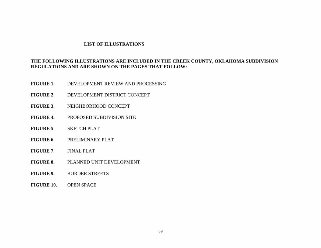
69
LIST OF ILLUSTRATIONS
THE FOLLOWING ILLUSTRATIONS ARE INCLUDED IN THE CREEK COUNTY, OKLAHOMA SUBDIVISION
REGULATIONS AND ARE SHOWN ON THE PAGES THAT FOLLOW:
FIGURE 1. DEVELOPMENT REVIEW AND PROCESSING
FIGURE 2. DEVELOPMENT DISTRICT CONCEPT
FIGURE 3. NEIGHBORHOOD CONCEPT
FIGURE 4. PROPOSED SUBDIVISION SITE
FIGURE 5. SKETCH PLAT
FIGURE 6. PRELIMINARY PLAT
FIGURE 7. FINAL PLAT
FIGURE 8. PLANNED UNIT DEVELOPMENT
FIGURE 9. BORDER STREETS
FIGURE 10. OPEN SPACE
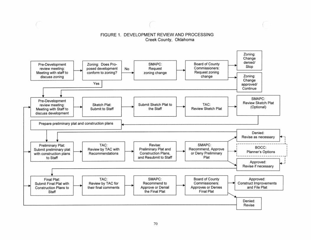
70
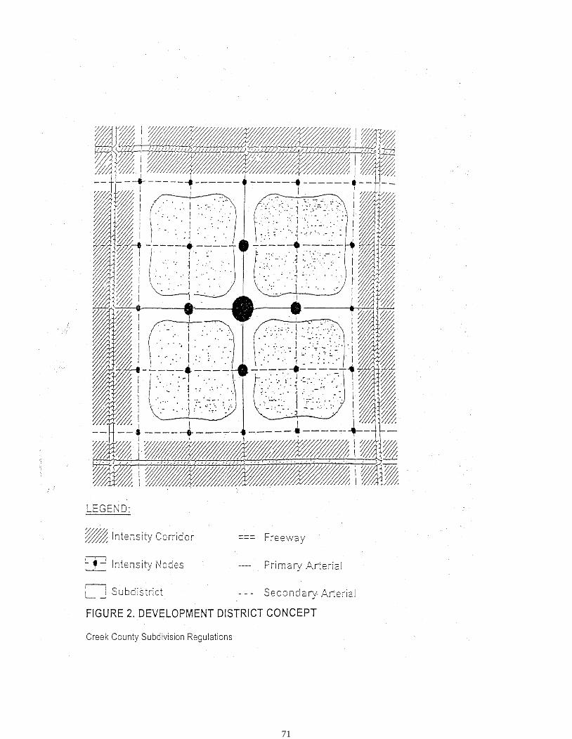
71
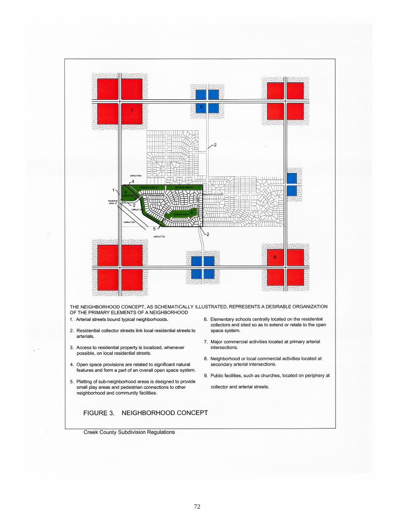
72
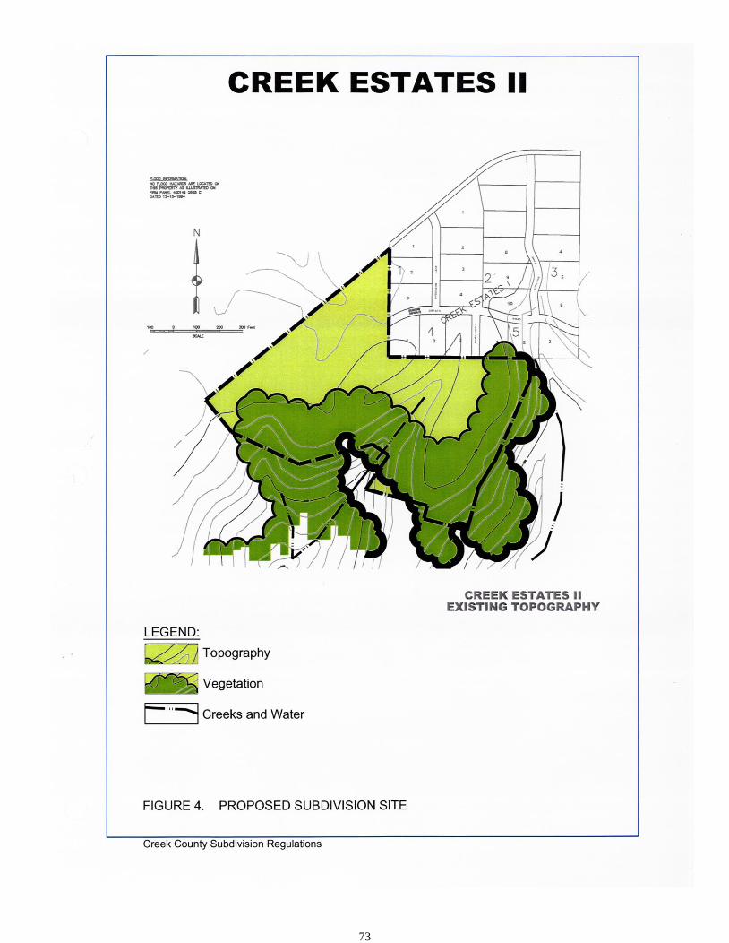
73

74
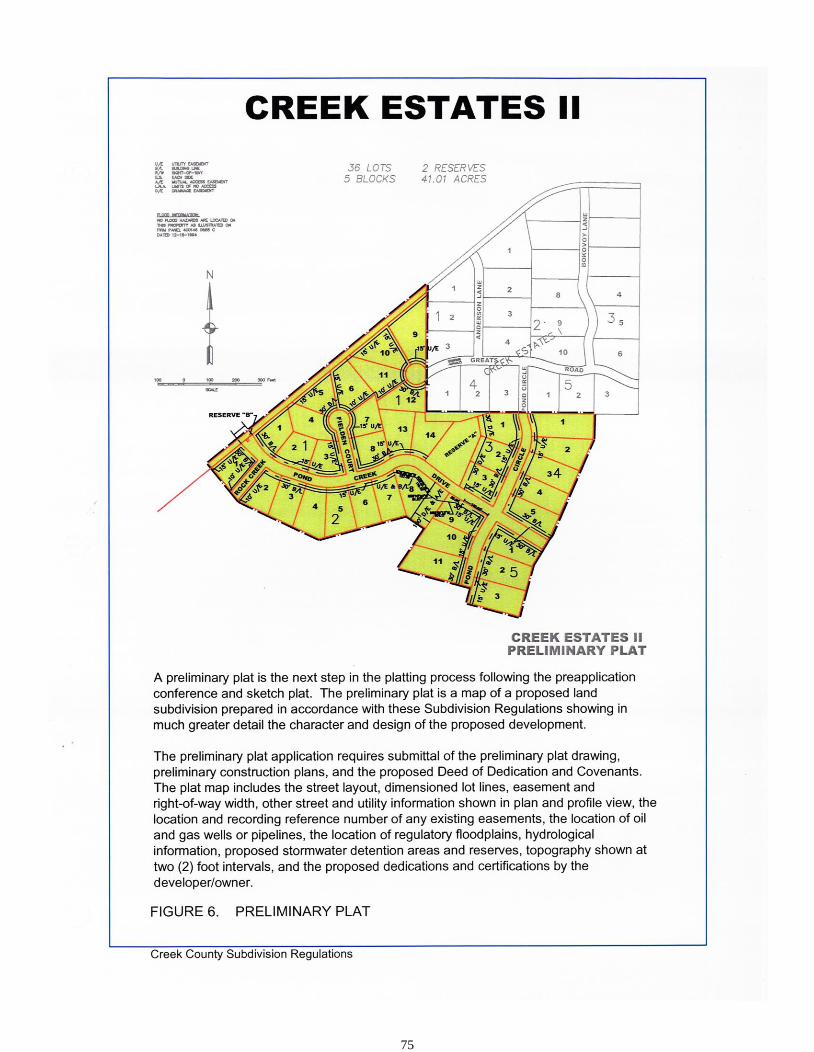
75
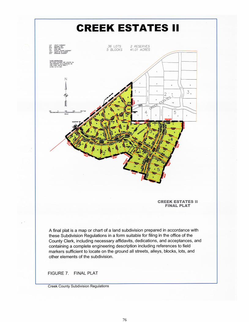
76

77
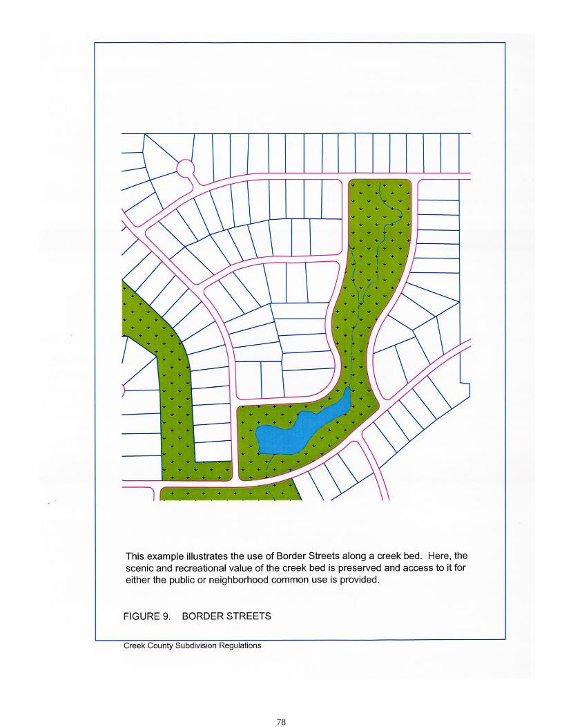
78

79
80
LIST OF APPENDICES
A. APPLICATIONS AND CHECKLISTS
B. CREEK COUNTY AND OKLAHOMA STATE DEPARTMENT OF ENVIRONMENTAL
QUALITY REQUIREMENTS FOR SANITARY SEWER IMPROVEMENTS
C. REQUIREMENTS FOR TRAFFIC CHANNELIZATION AND TURN BAYS ON ARTERIAL
STREETS AND SECTION LINE ROADS
D. MAJOR STREET PLAN: TRAFFIC RIGHT-OF-WAY AND PAVING SECTIONS
E. STANDARD LOCATION OF UNDERGROUND UTILITY LINES AND COLOR CODE
F. AGREEMENT GUARANTEEING INSTALLATION OF IMPROVEMENTS
G. DETENTION FACILITY MAINTENANCE AGREEMENT
H. SUGGESTED FORM OF CERTIFICATEAPPENDIX A APPLICATIONS AND CHECKLISTS
Appendix A: APPLICATIONS AND CHECKLISTS ARE BEING REVISED AT THE PUBLICATION
OF THE SUBDIVISION REGULATIONS. FOR THE LATEST COPIES AND INFORMATION
CONTACT THE CREEK COUNTY PLANNER

81
APPENDIX B
CREEK COUNTY AND
OKLAHOMA DEPARTMENT OF ENVIRONMENTAL QUALITY
REQUIREMENTS FOR SUBDIVISIONS
1. GENERAL:
Reference is made to Section 4.11 of these Regulations for the basic standards for subdivisions and
Section 6. The information contained in this Appendix is included for guidance and reference. The
Oklahoma State Department of Environmental Quality (DEQ) should be consulted for specific detailed
information not contained herein.
2. SUBDIVISIONS:
A. Provide the following information within the restrictive covenants of the subdivision plat as
follows:
For those subdivisions within Creek County that plan to utilize individual on-site sewage
disposal systems:
“Sewerage is intended to be disposed of by individual on-site sewage disposal
systems, and shall be subject to the regulations of the Oklahoma State
Department of Environmental Quality. Each lot owner shall be responsible for
obtaining the required permits and for the installation and maintenance of the
sewage disposal system serving the lot. If the system utilizes an underground
absorption field, the lot area containing the absorption field shall be maintained
free of paving, surfacing, swimming pools, lawn sprinkler systems, or any
building or other structure which would interfere with the functioning of the
absorption field. The system shall be maintained in proper operating condition at
all times by the lot owner. For aerobic on-site systems, a maintenance contract
shall be in effect as required by DEQ regulations consistent with the requirements
of the Oklahoma Department of Environmental Quality as described in the
Oklahoma Administrative Code Title 252, Chapter 641.”
B. Minimum Lot Size Requirements for On-Site Sewage Disposal Systems in Unincorporated Creek County:
Type of Disposal System Type of Water Supply Private
Public Well Water
Aerobic with Land Application ¾ Acre ½ Acre
Evapotranspiration/Absorption (ETA) 1 Acre 1 Acre Subsurface
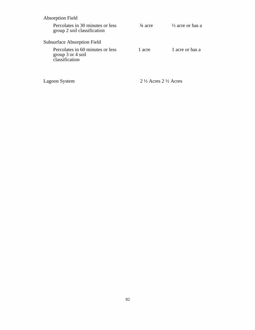
82
Absorption Field
Percolates in 30 minutes or less ¾ acre ½ acre or has a group 2 soil classification
Subsurface Absorption Field
Percolates in 60 minutes or less 1 acre 1 acre or has a group 3 or 4 soil classification
Lagoon System 2 ½ Acres 2 ½ Acres
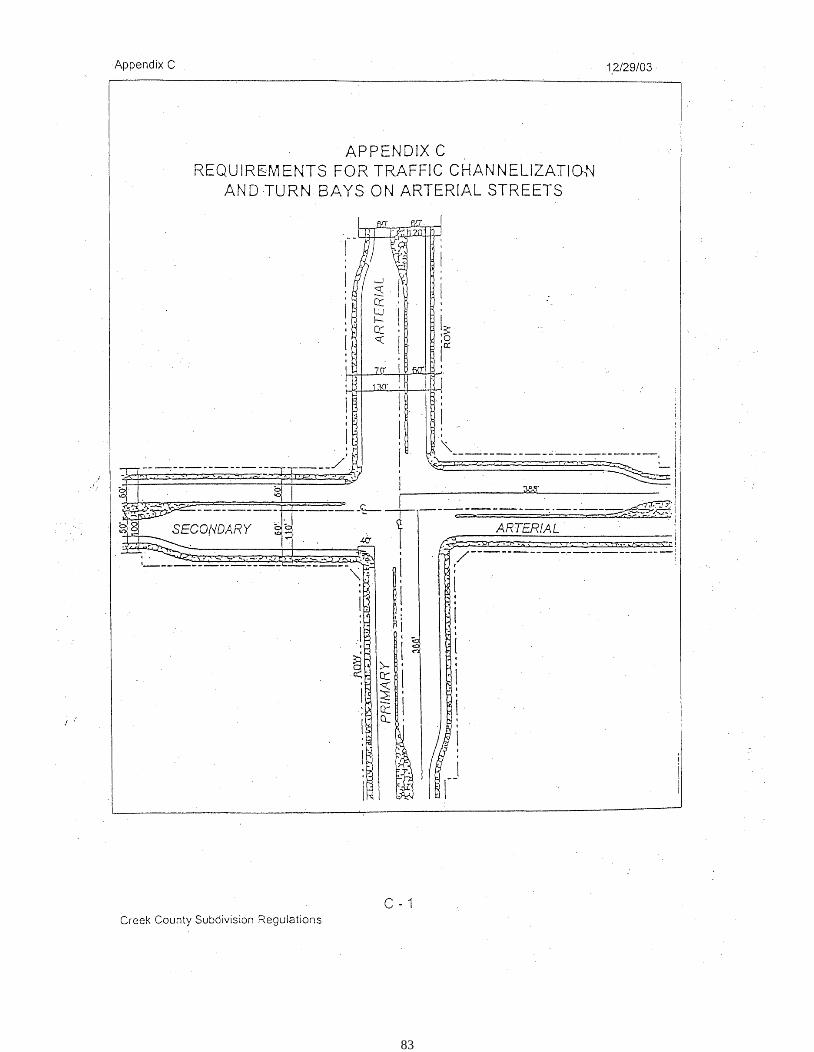
83
84
APPENDIX D
MAJOR STREET PLAN: TRAFFIC RIGHT-OF-WAY AND PAVING
SECTIONS
SEE THE PAGES THAT FOLLOW AND THE “CREEK COUNTY, OKLAHOMA ENGINEERING
DESIGN CRITERIA” AND THE “CREEK COUNTY, OKLAHOMA
STANDARD SPECIFICATIONS FOR CONSTRUCTION” FOR
ADDITIONAL INFORMATION
D-2 CREEK COUNTY TRAFFIC RIGHT-OF-WAY STANDARDS: D 01
D-3 CREEK COUNTY TRAFFIC RIGHT-OF-WAY STANDARDS: D 02
D-4 MINIMUM REQUIREMENTS FOR RURAL RESIDENTIAL STREETS: D 03
D-5 COLLECTOR/LOCAL PAVEMENT SECTIONS: D 04
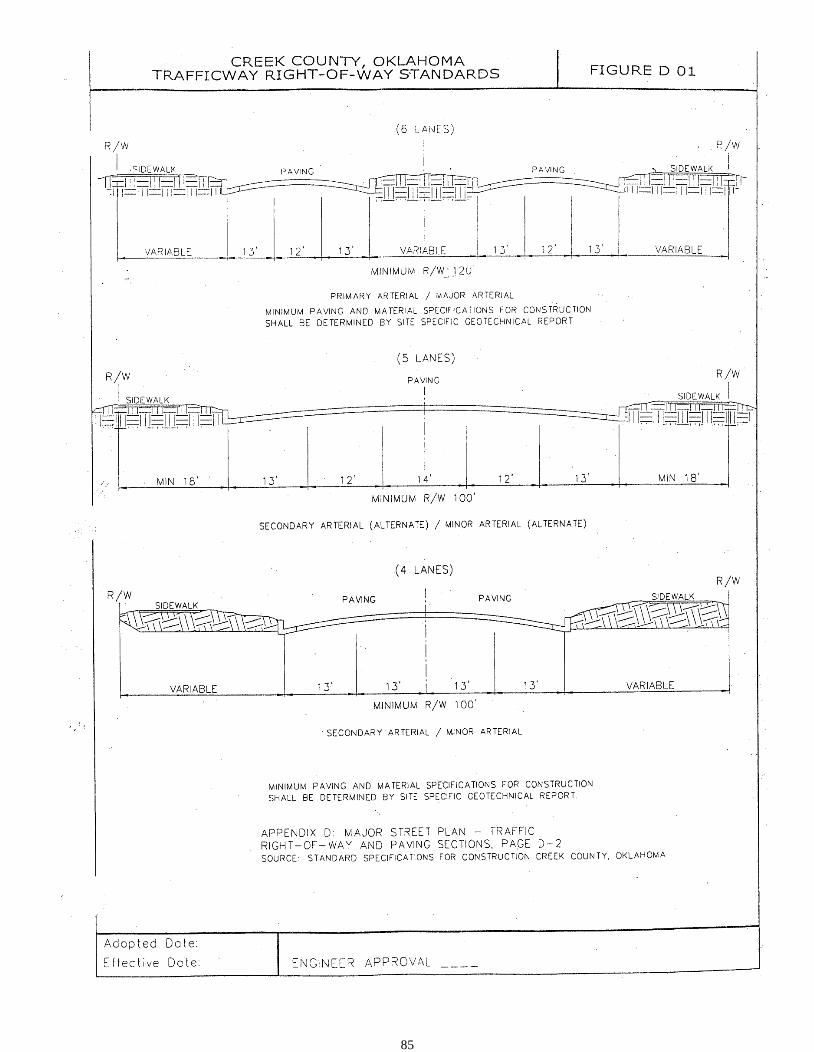
85
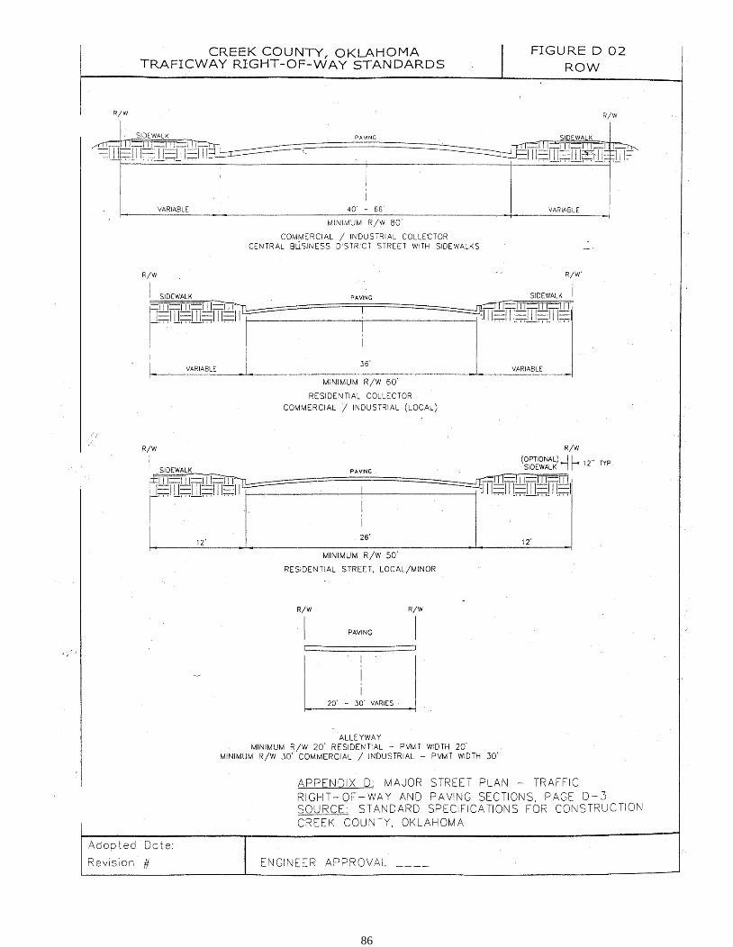
86
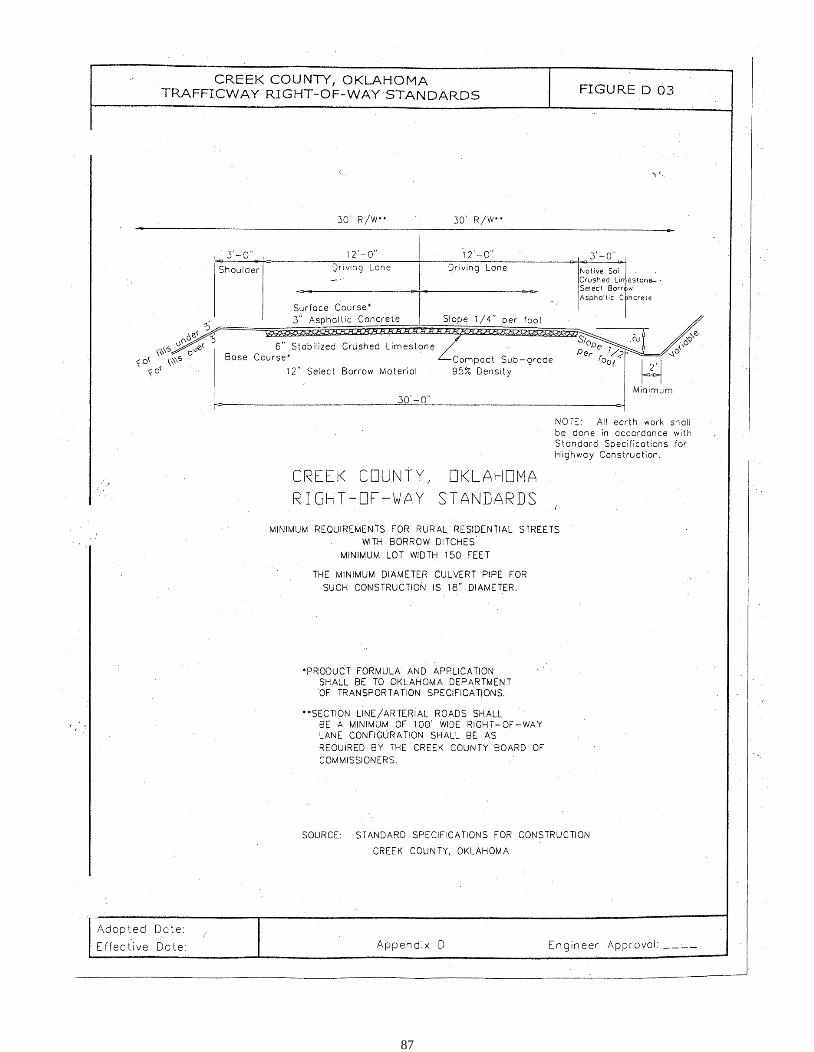
87
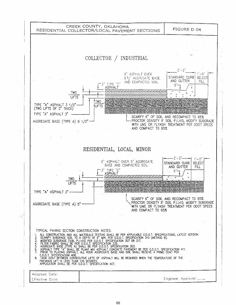
88
89
APPENDIX E
STANDARD LOCATION OF UNDERGROUND UTILITY
LINES AND COLOR CODE
E-2 UTILITY COLOR CODES
E-3 PERIMETER UTILITY LOCATIONS: 17.5’ EASEMENT, Figure E 01
E-4 PERIMETER UTILITY LOCATIONS: BACKYARD BACK TO BACK 11’
EASEMENTS
E-5 STREET UTILITY LOCATIONS: Figure E 03
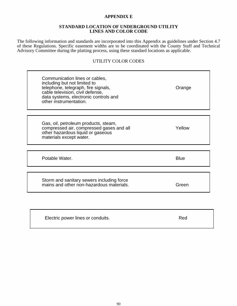
90
APPENDIX E
STANDARD LOCATION OF UNDERGROUND UTILITY
LINES AND COLOR CODE
The following information and standards are incorporated into this Appendix as guidelines under Section 4.7 of these Regulations. Specific easement widths are to be coordinated with the County Staff and Technical Advisory Committee during the platting process, using these standard locations as applicable.
UTILITY COLOR CODES
Green Storm and sanitary sewers including force mains and other non-hazardous materials.
Electric power lines or conduits. Red
Orange
Communication lines or cables, including but not limited to telephone, telegraph, fire signals, cable television, civil defense, data systems, electronic controls and other instrumentation.
Yellow Gas, oil, petroleum products, steam, compressed air, compressed gases and all other hazardous liquid or gaseous materials except water.
Potable Water. Blue

91
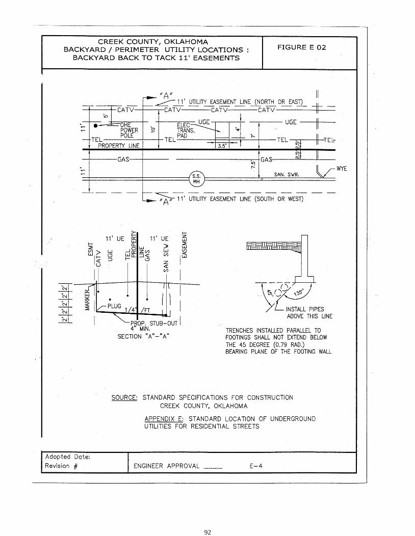
92
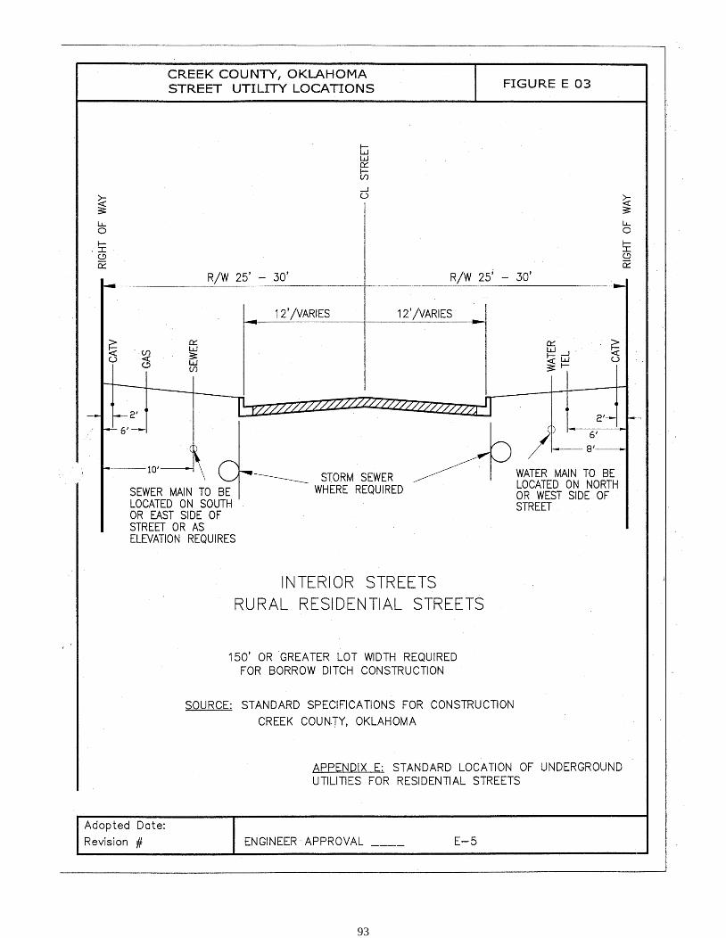
93

94
APPENDIX F
WHEREAS, application has been made to the Board of Commissioners of Creek County (County) regarding
the guarantee installation of public improvements, by the undersigned for approval of the
subdivision pursuant to 19 O.S., Section 866, and the duly adopted Subdivision Regulations; and
WHEREAS, the undersigned owns fee simple title in and to all of said real property comprising said
subdivision; and
WHEREAS, the developer has elected to file a Final Plat prior to installation of the required public
improvements as shown on the approved Final Construction Plans;
WHEREAS, the approval of said subdivision by the Creek County Planning Commission (Planning
Commission) is given upon the condition that certain improvements will be constructed and installed by the
undersigned in accordance with plans approved by the County for said improvements within two (2) years from
date of final approval of said plat by the Planning Commission.
NOW, THEREFORE, the undersigned in consideration of said approval by the Planning Commission
covenants and agrees to construct and install said improvements in accordance with said officially approved
plans, and further covenants and agrees that said facilities will be completed within two (2) years from date of
final approval of said subdivision plat by the Planning Commission. When improvements have been completed
and approved by the County, and prior to approval of the Final Plat, the developer’s engineer shall furnish the
County a complete set of mylar reproducible “As-Built” drawings and five (5) full cut sheet “As Built”
drawings, which shall include all changes and modifications required during the engineering, inspection and
construction phase/process.
This agreement shall be enforceable by the Board of Commissioners of Creek County, Oklahoma.
This covenant and agreement shall be binding upon the undersigned and his, its or their heirs, successors and
assigns. When said improvements have been completed, written acknowledgment of such fact by the County
Engineer shall be filed of record with the Creek County Clerk.
Dated this day of , .
ATTEST: by:
OWNER
95
________________________ Signature/Typed Name
(If corporation, state whether president or Vice-president)
Corporate Secretary (Corporate Seal)
Signature/Typed Name
This agreement has been voted upon and accepted by the Creek County Board of Commissioners on the day of , .
ACCEPTANCE/APPROVAL BY CREEK COUNTY BOARD OF COMMISSIONERS
_______________________________
Chairman
STATE OF )
COUNTY OF )
Before me, the undersigned, a Notary Public in and for said County and State, on this day of
, 20 , personally appeared to me known to be the identical person
who executed the foregoing instrument and acknowledged to me that
executed the same as free and voluntary act and
deed for the purposes therein set forth.
GIVEN under my hand and seal the day and year last above written.
My Commission Expires: _
Notary Public
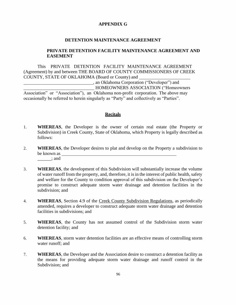
96
APPENDIX G
DETENTION MAINTENANCE AGREEMENT
PRIVATE DETENTION FACILITY MAINTENANCE AGREEMENT AND
EASEMENT
This PRIVATE DETENTION FACILITY MAINTENANCE AGREEMENT
(Agreement) by and between THE BOARD OF COUNTY COMMISSIONERS OF CREEK
COUNTY, STATE OF OKLAHOMA (Board or County) and
, an Oklahoma Corporation (“Developer”) and
HOMEOWNERS ASSOCIATION (“Homeowners
Association” or “Association”), an Oklahoma non-profit corporation. The above may
occasionally be referred to herein singularly as “Party” and collectively as “Parties”.
Recitals
1. WHEREAS, the Developer is the owner of certain real estate (the Property or
Subdivision) in Creek County, State of Oklahoma, which Property is legally described as
follows:
2. WHEREAS, the Developer desires to plat and develop on the Property a subdivision to
be known as ; and
3. WHEREAS, the development of this Subdivision will substantially increase the volume
of water runoff from the property, and, therefore, it is in the interest of public health, safety
and welfare for the County to condition approval of this subdivision on the Developer’s
promise to construct adequate storm water drainage and detention facilities in the
subdivision; and
4. WHEREAS, Section 4.9 of the Creek County Subdivision Regulations, as periodically
amended, requires a developer to construct adequate storm water drainage and detention
facilities in subdivisions; and
5. WHEREAS, the County has not assumed control of the Subdivision storm water
detention facility; and
6. WHEREAS, storm water detention facilities are an effective means of controlling storm
water runoff; and
7. WHEREAS, the Developer and the Association desire to construct a detention facility as
the means for providing adequate storm water drainage and runoff control in the
Subdivision; and
97
8. WHEREAS, the Association shall be charged in the Subdivision’s Covenants with the
duty of maintaining all common areas and common structures within the Subdivision,
including the detention facility; and
9. WHEREAS, the lack of proper cleaning, maintenance and repair could threaten the public
health, safety and welfare; and
10. rder to so protect the public health, safety and welfare, desires the means to recover its
cost incurred in the event the County must clean, maintain and/or repair a private detention
facility in this Subdivision in an effort to protect the public health, safety and welfare; and
11. WHEREAS, the County conditions its approval of this Subdivision on the Developer’s
and the Association’s agreement to so construct this detention facility, and conditions
approval on the Association’s agreement to reimburse the County in the event the burden
falls upon the County to so clean, maintain and/or repair the detention facility in this
Subdivision; and
12. WHEREAS, the County, in order to secure performance of the promises contained
herein, conditions approval of this Subdivision upon the Developer’s grant herein of a
perpetual easement over a portion of the Subdivision for the purpose of allowing the
County to periodically access, inspect, and, when so necessary, to clean, maintain and/or
repair the detention facility; and
13. WHEREAS, given that the Association could potentially avoid liability hereunder by
dissolving and reforming as a different entity, and given the difficulties inherent in
collecting an unsecured promise, the County, in order to secure performance of the
promises contained herein, condition approval of this Subdivision upon the Developer’s
creation, by and through this Agreement, of a covenant running with the land upon each
and every lot in the Subdivision.
Agreement
NOW, THEREFORE, in consideration of the mutual Promises contained herein, the
sufficiency of which are hereby acknowledged, the Parties agree as follows:
1. Incorporation of Recitals: The Parties incorporate the Recitals above into this
Agreement.
2. Covenants Running with the Land and Pro Rata Liability upon Individual Lot
Owners: The Developer and Homeowners’ Association agree that this entire Agreement and the
performance thereof shall become a covenant running with the land, which land is legally
described in Paragraph One (1) of the Recitals set forth above, and that this entire Agreement and
the performance thereof shall be binding upon themselves, their respective successors and
assigns, including individual lot owners within the Subdivision.
However, any liability imposed under this Agreement against an individual lot owner
98
shall not be joint and several with the Developer and the Association, but shall be pro rated on a
per-lot basis as determined by the following formula and illustration:
Each individual lot owner(s) shall be liable for no more than the total monetary amount
of liability multiplied by a fraction in which the numerator is the number of lots in the
Subdivision owned by a particular lot owner, and the denominator is the total number of
lots in the Subdivision. As to any lot(s) owned by more than one person or entity, the
liability among co-owners shall be joint and several for the pro rata obligation of that lot.
The application of this Paragraph is best illustrated by the following example. Assume the
following parameters: total liability is $10,000; total number of lots in the Subdivision is
100; Lot 1 is owned by persons A and B; person B also owns Lot 2. Liability is as follows:
the Developer, $10,000; the Association, $10,000; Lot 1 is $100, joint and several as to
A and B, Lot 2 is $100 owned solely by B. Thus person A’s total liability is
$100 and person B’s is $200. Applying the principle that the County cannot collect more
than it is owed, and assuming that the County cannot collect anything from the Developer
and the Association, if the County collected the
$200 from B, then it could not collect the $100 from A. Likewise, if the County collected
the $100 from A, then it could only collect $100 from B.
3. Construction: the Developer and the Homeowners’ Association agree that they
shall construct on (Tract or Lot: , Block , or Reserve
) as indicated on the final plat of the Subdivision and as described below a private
storm water detention facility (for multiple detention facilities, insert the following here:
consisting of ( ) detention ponds, one on each tract [or lot]) (“detention facility”). The Developer
and the Homeowners’ Association shall not commence construction of the detention facility until
the Planning Department and the Creek County Engineer have approved in writing the plans and
specifications for the detention facility. Failure to obtain such approval shall be material breach
of this Agreement, and shall entitle the County to pursue any remedies available to it at law or in
equity to enforce the same. Construction of the detention facility shall be completed prior to filing
of the final plat. Rough grading of the detention facility must be completed and inspected and
approved by the Creek County Engineer prior to commencing road construction.
In the event construction is not so completed, then the County may exercise its discretion
(as secured by performance bonds or other such surety) to complete the project, and shall have
the right to seek reimbursement from the Developer and the Homeowners’ Association and their
respective successors and assigns, for its actual costs and expenses incurred in the process of
completing construction.
The term actual costs and expenses shall be liberally construed in favor of the County,
and shall include, but shall not be limited to, labor costs tool and equipment costs, supply costs,
and engineering and design costs, regardless of whether the County uses its own personnel, tools,
equipment and supplies, etc. to correct the matter. In the event the County initiates any litigation
or engages the services of legal counsel in order to enforce the provisions arising herein, the
County shall be entitled to its damages and costs, including reasonable attorney fees, regardless
of whether the County contracts with outside legal counsel or utilizes in-house legal counsel for
the same. The scope of liability therefor of the Developer, the Association, and the individual lot
owners shall be as set forth in Paragraph 2 above.
99
4. Maintenance: The Developer and the Association agree for themselves, their
respective successors and assigns, including individual lot owners within the Subdivision, that
they will regularly and routinely inspect, clean and maintain the detention facility, and otherwise
keep the same in good repair, all at their own cost and expense. No trees or shrubs that will impair
the structural integrity of the detention facility shall be planted or allowed to grow on the detention
facility.
5. Creation of Easement: The Developer and the Association hereby grant the County a
non-exclusive perpetual easement upon the entire Tract(s) [or Lot(s)] described above. The
purpose of the easement is to allow the County to access, inspect, clean, repair and maintain the
detention facility; however, the creation of the easement does not expressly or implicitly impose
on the County a duty to so inspect, clean, repair or maintain the detention facility.
6. County’s Rights and Obligations: Any time the County determines, in the sole
exercise of its discretion, that the detention facility is not properly cleaned, maintained and/or
otherwise kept in good repair, the County shall give reasonable notice to the Developer, the
Association and their respective successors and assigns, including the individual lot owners
within the Subdivision, that the detention facility needs to be cleaned, maintain and/or otherwise
repaired. The notice shall provide a reasonable time to correct the problem(s). Should the
responsible parties fail to correct the specified problem(s), the County may enter upon the
Property to so correct the specified problem(s). Notice shall be effective to the above by the
County’s deposit of the same into the regular United States mail, postage pre-paid. However, this
Agreement does not expressly impose on the County a duty to so inspect, clean, repair or maintain
the detention facility.
7. Reimbursement of County’s Costs/Covenant Running with the Land: The Developer
and the Association agree and covenant, for themselves, their respective successors and assigns,
including individual lot owners within the Subdivision, that they will reimburse the County for
its costs and expenses incurred in the process of cleaning, maintaining, and/or repairing the
detention facility. However, the obligation and liability of the Developer hereunder shall only
continue until such time as the Developer transfers the entire management and operation of the
Association to the individual lot owners within the Subdivision. Notwithstanding the previous
sentence, the Association and the individual lot owners within the Subdivision shall always
remain obligated and liable hereunder, and as per the provisions of Paragraph 2 above.
8. Contingencies of Subdivision Approval: The Developer’s and the Association’s
execution and compliance with this Agreement are a condition of subdivision approval.
Additional conditions of this Agreement include, but are not limited to, the following:
a. Conveyance of Tract(s) from the Developer to the Association
(which will include a reservation of easement in favor of the County for purposes
of accessing, inspecting, cleaning, maintaining and repairing the detention
facility), and recording of the Deed for the same; and If not a conveyance of a
fee interest but merely creating and conveying an easement on the affected
lot(s), then substitute the following alternative Paragraph a:
100
a. Conveyance of easements on Lot(s) , Block from the Developer
to the Association and to the County for the purposes of accessing, inspecting,
cleaning, maintaining and repairing the detention facility, and recording of
appropriate conveyance documents for the same; and
b. The County’s receipt of a copy of the Articles of Incorporation for the Association,
as filed with the Oklahoma Secretary of State; a copy of the Bylaws of the
Association; a copy of the organizational minutes or other appropriate documents
of the Association, properly executed and attested, establishing that the
Association has adopted this Agreement as an obligation of the Association; and
c. A copy of the recorded (Book and Page) Covenants of the Subdivision establishing
that the Association is obligated to inspect, clean, maintain and repair the detention
facility; that the Association has adopted this Agreement as an obligation of the
Association; and that a funding mechanism is in place whereby individual lot
owners within the Subdivision pay a regular fee to the Association for, among
other matters, the inspection, cleaning, maintenance and repair of the detention
facility.
d. A copy of recorded (Book and Page) the Covenants of the Subdivision establishing
that this Agreement is incorporated into the Covenants, and that such Agreement
touches and concerns every lot in the Subdivision.
The County shall have the right, in the sole exercise of its discretion, to approve or
disapprove any documentation submitted to it under the conditions of Paragraph 8. The County’s
rejection of any documentation submitted hereunder shall mean that the appropriate condition of
this Agreement has not been fulfilled.
9. Distribution to Lot Purchasers: Upon the initial sale of any lot within the
Subdivision, prior to closing on such sale, the Developer shall give a copy of this Agreement to
the potential Buyer. Upon sale to said Buyer, the Buyer shall acknowledge receipt in writing of
this agreement.
10. Agreement Monitored by Planning Department: Any and all actions and decisions
to be made hereunder by the County shall be made by the Director of the Creek County Planning
Department. Accordingly, any and all documents, submissions, plan approval, inspections, etc.
shall be submitted to and shall be made of record by the Director of the Creek County Planning
Department.
11. Indemnification and Hold Harmless: To the extent authorized by law, the
Developer and the Association agree, for themselves, their respective successors and assigns,
including the individual lot owners in the Subdivision, that they will indemnify, defend and hold
harmless from any and all loss, costs, damage, injury, liability, claim, lien, demand, action and
causes of action whatsoever, whether at law or in equity, arising from or related to their
respective intentional or negligent acts, errors or omissions or that of its agents, officers, servants,
employees, invitees and licenses in the construction, operation, inspection, cleaning, solid or
101
hazardous wastes as defined by State and/or Federal environmental laws and maintenance and
repair of the detention facility, and such obligation arising under this Paragraph shall be joint and
several. Nothing in this Paragraph shall be deemed to waive or otherwise limit the defense
available to the County as provided by law. However, the obligation and liability of the Developer
hereunder shall only continue until such time as the Developer transfers the entire management
and operation of the Association to the Homeowners Association and/or individual lot owners
within the Subdivision.
12. Severability: In the event any Court of competent jurisdiction declares any part of
this Agreement to be unenforceable, such declarations shall not affect the enforceability of the
remaining parts of this Agreement.
13. Third Parties: This Agreement does not and shall not be deemed to confer upon or
grant to any third party any right to claim damages or to bring any lawsuit, action or other
proceeding against either the County, the Developer or the Association, their respective
successors and assigns, including any individual lot owners within the Subdivision, because of
any breach hereof or because of any terms, covenants, agreements or conditions contained herein.
14. Solid or Hazardous Wastes: Should any refuse from the detention facility be
suspected or identified as solid waste and/or hazardous waste, the Developer and the Association
shall take all necessary and proper steps to characterize the waste and properly dispose of it in
accordance with applicable State and/or Federal environmental laws and regulations. The County
shall not be responsible or liable for identifying, characterizing, cleaning up or disposing of such
solid and/or hazardous waste. Notwithstanding the previous sentence, should any refuse cleaned
up and disposed of by the County be determined to be solid and/or hazardous waste, the Developer
and the Association, but not the County, shall be responsible and liable as the owner, generator,
and/or transporter of said solid and/or hazardous waste.
15. Applicable Law and Venue: The laws, rules and regulations of the State of
Oklahoma and Creek County shall be applicable in the enforcement, interpretation and execution
of this Agreement, except that Federal law may be applicable regarding solid or hazardous wastes.
Venue shall be in the Creek County District Court.
IN WITNESS WHEREOF, the Parties affix their signatures below.
Executed this day of , , by:
[DEVELOPER’S NAME]:
By:
, President
(Insert Name)
The forgoing instrument was acknowledged before me this day of
102
, , by ,
President, .
Witness my hand and official seal.
My commission expires .
Notary Public
Executed this day of , , by:
HOMEOWNERS’ ASSOCIATION, an Oklahoma nonprofit
corporation.
By:
, President
(Insert Name)
The forgoing instrument was acknowledged before me this day of
, , by ,
President, .
Witness my hand and official seal.
My commission expires .
Notary Public

103
Executed this day of , .
BOARD OF COUNTY COMMISSIONERS OF CREEK COUNTY, STATE OF
OKLAHOMA
By:
, Chairperson
(Insert Name)
The forgoing instrument was acknowledged before me this day of
, , by the ,
Board of County Commissioners of Creek County, State of Oklahoma.
ATTESTED to by , County Clerk
(Insert Name)
Witness my hand and official seal.
My commission expires .
Notary Public
APPROVED as to Content and Form:
Assistant District Attorney
Date
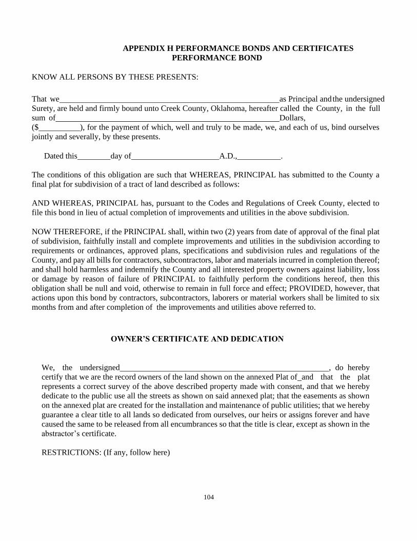
104
APPENDIX H PERFORMANCE BONDS AND CERTIFICATES
PERFORMANCE BOND
KNOW ALL PERSONS BY THESE PRESENTS:
That we as Principal and the undersigned
Surety, are held and firmly bound unto Creek County, Oklahoma, hereafter called the County, in the full
sum of Dollars,
($ ), for the payment of which, well and truly to be made, we, and each of us, bind ourselves
jointly and severally, by these presents.
Dated this day of A.D., .
The conditions of this obligation are such that WHEREAS, PRINCIPAL has submitted to the County a
final plat for subdivision of a tract of land described as follows:
AND WHEREAS, PRINCIPAL has, pursuant to the Codes and Regulations of Creek County, elected to
file this bond in lieu of actual completion of improvements and utilities in the above subdivision.
NOW THEREFORE, if the PRINCIPAL shall, within two (2) years from date of approval of the final plat
of subdivision, faithfully install and complete improvements and utilities in the subdivision according to
requirements or ordinances, approved plans, specifications and subdivision rules and regulations of the
County, and pay all bills for contractors, subcontractors, labor and materials incurred in completion thereof;
and shall hold harmless and indemnify the County and all interested property owners against liability, loss
or damage by reason of failure of PRINCIPAL to faithfully perform the conditions hereof, then this
obligation shall be null and void, otherwise to remain in full force and effect; PROVIDED, however, that
actions upon this bond by contractors, subcontractors, laborers or material workers shall be limited to six
months from and after completion of the improvements and utilities above referred to.
OWNER’S CERTIFICATE AND DEDICATION
We, the undersigned , do hereby
certify that we are the record owners of the land shown on the annexed Plat of and that the plat
represents a correct survey of the above described property made with consent, and that we hereby
dedicate to the public use all the streets as shown on said annexed plat; that the easements as shown
on the annexed plat are created for the installation and maintenance of public utilities; that we hereby
guarantee a clear title to all lands so dedicated from ourselves, our heirs or assigns forever and have
caused the same to be released from all encumbrances so that the title is clear, except as shown in the
abstractor’s certificate.
RESTRICTIONS: (If any, follow here)
105
Witness hand this day of , .
(ACKNOWLEDGEMENT)
CERTIFICATE OF SURVEY
I, , Professional Land Surveyor in the State of
Oklahoma, do hereby certify that I have carefully and accurately surveyed and platted the tract of
land described above, and that the accompanying plat designated herein as
, a development in Creek County, Oklahoma,
is a representation of the survey made on the ground using generally accepted practices and meets or
exceeds the Oklahoma minimum standards for the practice of land surveying as adopted by the
Oklahoma State Board of Registration for Professional Engineers and Land Surveyors, and the
requirements of Creek County, Oklahoma.
Executed this day of ,
Professional Land Surveyor, No.
(SEAL)
CERTIFICATE OF ENGINEER
I________________, a Professional Engineer in the State of Oklahoma, do hereby certify that all
construction and drainage plans for
, a development in Creek County, Oklahoma have been
prepared in accordance with and meet or exceed the standards and requirements of Creek County,
Oklahoma.
Executed this day of _____,________
Professional Engineer, License No.
(SEAL)
CERTIFICATE OF THE CREEK COUNTY TREASURER
I, , do hereby certify that I am the duly elected, qualified and acting
Treasurer of Creek County, State of Oklahoma. That the tax records of Creek County show all taxes
are paid for the year and prior years on the land shown on the annexed plat of in
Creek County, Oklahoma; and that the required statutory security has been deposited in the office of
the Creek County Treasurer, guaranteeing payment of the current year’s taxes; and further find and
certify that all deferred payments or unmatured installments upon special assessments have been paid
106
in full and that there is no special assessment procedure now pending against said land.
Creek County Treasurer
(SEAL)
CERTIFICATE OF APPROVAL
I HEREBY CERITFY THAT THIS CONVEYANCE WAS APPROVED
BY THE CCPC __________________________________________
PER APPLICATION ______________________________________
CC PLANNER DATE___________________________________
PARTMENT OF ENVIRONMENTAL QUALITY CERTIFICATION
The Creek County office of the Department of Environmental Quality has approved the attached plat of for
the use of public water systems and on-site sewer systems on the ___ Day o f _____________, ________.
Environmental Program Specialist Department of
Environmental Quality (SEAL)
ACCEPTANCE OF DEDICATIONS AND EXCEPTIONS TO DEDICATIONS BY THE CREEK
COUNTY BOARD OF COMMISSIONERS
BE IT RESOLVED by the Board of Commissioners of Creek County, Oklahoma, that the dedications but not
the maintenance of utility easements and road right-of-way, shown on the attached plat of are hereby
accepted. The maintenance of any drainage easements and reserve areas shall remain the responsibility of the
developer until or unless assumed by a mandatory homeowners association. The roads will be maintained by
Creek County, Oklahoma, only upon certification by a professional engineer licensed to practice in the State
of Oklahoma that the construction of said roads is in accordance with Creek County standards. Further, any
maintenance of said roads shall be conditioned upon formal acceptance of said roads by a separate resolution
of the Creek County Board of Commissioners.
Accepted this day of _______, .
Chairman, Creek County Board of Commissioners
ATTEST:
Creek County Clerk
107
APPLICABLE WHERE SEPTIC TANKS OR OTHER PRIVATE ON-SITE
WASTE-WATER SYSTEMS ARE TO BE USED:
I, being a Professional Engineer licensed to practice in the State of Oklahoma, certify that a soil survey and test have been completed by of testing laboratory, on and that the proposed private methods of on- site wastewater disposal systems shall be designed, constructed and installed in accordance with the regulations of the Oklahoma Department of Environmental Quality.
Name/Signature/Seal
Further, I being a duly employed and appointed representative of the Creek County Health Department have examined the results of the proposed private on-site wastewater disposal systems and have found them to be in accordance with the regulations and requirements of Creek County and the Oklahoma Department of Environmental Quality.
Name/Signature/Seal Date
RELEASE OF MORTGAGE
In consideration of the platting of the property shown on the annexed map of
, and other good and valuable considerations,
receipt of which is hereby acknowledged, do hereby release, relinquish and forever discharge a
certain mortgage made by and dated the day of
and dated the day of ,
, to which is recorded in the Book of
Mortgages at Page of the records of Creek County, State of Oklahoma, insofar as the same
covers all property dedicated for streets, alleys, parks, boulevards, easements or other public use, as shown on
said map.
Witness hand this day of , ____________.
Typed Name/Signature
CREEK COUNTY TREASURER’S CERTIFICATE
I, _ do hereby certify that I am the duly elected, qualified and
acting Creek County Treasurer, State of Oklahoma. That the tax records of said County show all taxes are
paid for the year and prior years on the land shown on the annexed plat of
in Creek County, Oklahoma; that the required statutory security
has been deposited in the office of the Creek County Treasurer, guaranteeing payment of the current year’s
taxes.
Creek County Treasurer Name/Signature Date