Style Guide · Web viewIn Word, to type an em dash, type two hyphens and the next letter, then...
20
_ EERI Earthquake Reconnaissance Report: MX.X [Location] Earthquake on [Month] [#], [Year] [Authors – First Name Last Name, First Name Last Name, etc.] [Month Year] A product of the EERI Learning From Earthquakes Program [Photo: Firstname Lastname] (note: drag and drop this text box with an invisible border into a corner of the cover
Transcript of Style Guide · Web viewIn Word, to type an em dash, type two hyphens and the next letter, then...

_EERI Earthquake Reconnaissance Report:MX.X [Location] Earthquake on
[Month] [#], [Year]
[Authors – First Name Last Name, First Name Last Name, etc.][Month Year]
A product of the EERI Learning From Earthquakes Program
[Photo: Firstname Lastname] (note: drag and drop this text box with an invisible border into a corner of the cover image)
Pierre Gerard, 05/04/17,
Template last updated: May 26, 2017_______Last Updated by: Pierre Gerard___________ Click above to log any changes to this template. Table of Contents (Ctrl + Click to Jump to Section):Cover Page Templates (End Notes)
Pierre Gerard, 05/26/17,
This cover image is an example from the Kaikoura, NZ earthquake report. Cover image should be representative of the earthquake damage and effects.

"[Double-click here to insert a cover image]"
EERI Earthquake Reconnaissance Team Report:
MX.X [Location] Earthquake on [Month] [#], [Year]
[Authors – First Name Last Name, First Name Last Name, etc.][Month Year]
A product of the EERI Learning From Earthquakes Program
EERI Earthquake Reconnaissance Team Report: MX.X [Location] Earthquake on [Date] Page 2
Pierre Gerard, 05/05/17,
This cover page is an example of an earthquake reconnaissance TEAM report.
Pierre Gerard, 05/03/17,
Cover image should be representative of the earthquake damage.

"[Double-click here to insert a cover image]"
[Organization]-[Organization]-EERI Earthquake Reconnaissance Report:
MX.X [Location] Earthquake on [Month] [#], [Year]
[Authors – First Name Last Name, First Name Last Name, etc.][Month Year]
A product of the EERI Learning From Earthquakes Program
EERI Earthquake Reconnaissance Team Report: MX.X [Location] Earthquake on [Date] Page 3
[Photo: Firstname Lastname] (note: drag and drop this text box with an invisible border into a corner of the cover image)
Pierre Gerard, 05/05/17,
This cover page is an example of an earthquake reconnaissance collaborative report, involving multiple organizations.
Pierre Gerard, 05/03/17,
Cover image should be representative of the earthquake damage.

1 STYLE GUIDE
EERI Grammatical Constructions and Style Choices
1.1 References: use End Notes (under the “References” tab above), and create bibliographic references for each End Note following the format in the References _ Section of this Report Template.
1. Please make sure all hyperlinked text is in this font color (Dark Red).
1.2 American vs. British English
2. While we have team members from Britain and New Zealand, EERI is based in the U.S. Let us go with American English. For example, use “neighbor”, not “neighbour.” Exceptions can be made for joint reports with non-U.S. partners.
1.3 Commas
1. Place a comma at the end of introductory clauses even if they are short. Example: “In most cases, red paint will work better.”
2. Place a comma after introductory words. Example: “Similarly, the houses were acceptable.
3. Place a comma after conjunctive adverbs (however, moreover, etc.). Example: I went to the store; however, I did not buy Sanything.
4. Commas before conjunctions (and, but, for, nor, or, yet, so). Example: I have two girls, and they are great.
5. Commas in a series: Use the comma before the “and” (example): I like raspberry, blackberry, and strawberry ice cream.
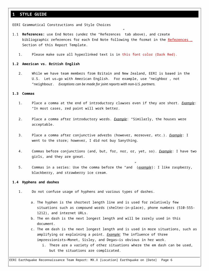
1.4 Hyphens and dashes
1. Do not confuse usage of hyphens and various types of dashes.
a. The hyphen is the shortest length line and is used for relatively few situations such as compound words (shelter-in-place), phone numbers (510-555-1212), and internet URLs.
b. The en dash is the next longest length and will be rarely used in this document. c. The em dash is the next longest length and is used in more situations, such as amplifying or explaining a
point. Example: The influence of three impressionists—Monet, Sisley, and Degas—is obvious in her work. i. There are a variety of other situations where the em dash can be used, but the situations are
complicated.ii. In Word, to type an em dash, type two hyphens and the next letter, then space. It will
automatically combine the two hyphens to the right length for the em dash.d. See the Chicago Manual of Style for details on the hyphen, en dash, and em dash.
2. There is no space before and after either the hyphen or the dashes.
1.5 Other
1. Numerals: Spell out numbers through nine, then go to 10. a. Numbers starting a sentence is spelled out regardless. Use numbers for typical construction terms.
2. Quotes and punctuation: Period goes inside quotation marks, as do commas. 3. Do not use shorthand for words, like “recon” instead of “reconnaissance.” No contractions, either.4. Define all acronyms the first time they are used in a section. Example: Earthquake Engineering Research
Institute (EERI).
EERI Earthquake Reconnaissance Team Report: MX.X [Location] Earthquake on [Date] Page 4

2 CHAPTER TEMPLATE (TO BE DELETED)
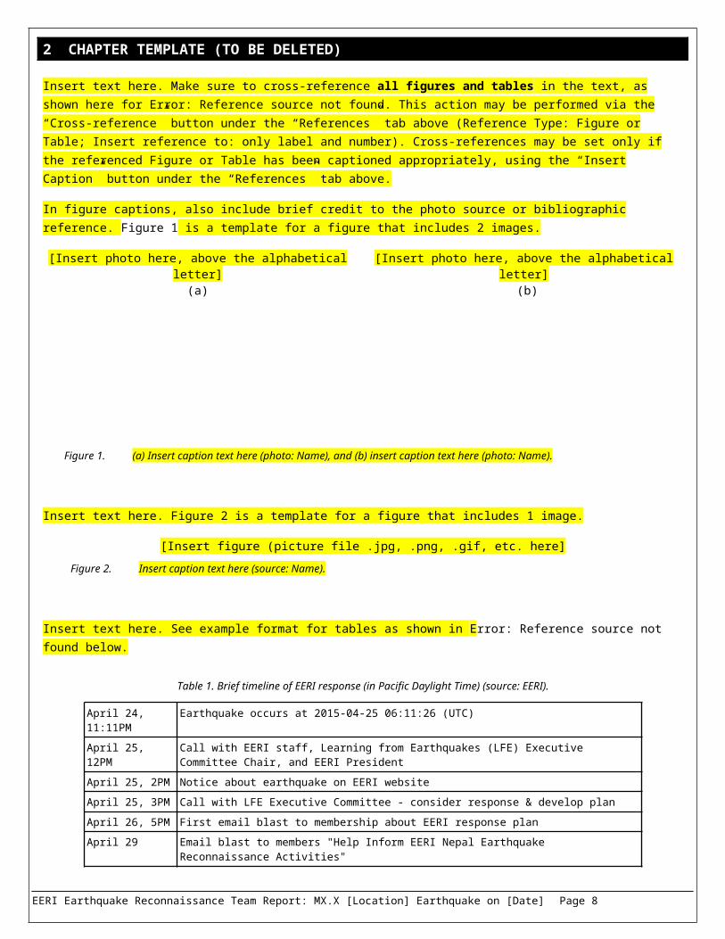
Insert text here. Make sure to cross-reference all figures and tables in the text, as shown here for Error: Reference source not found. This action may be performed via the “Cross-reference” button under the “References” tab above (Reference Type: Figure or Table; Insert reference to: only label and number). Cross-references may be set only if the referenced Figure or Table has been captioned appropriately, using the “Insert Caption” button under the “References” tab above.
In figure captions, also include brief credit to the photo source or bibliographic reference. Figure 1 is a template for a figure that includes 2 images.
[Insert photo here, above the alphabetical letter](a)
[Insert photo here, above the alphabetical letter] (b)
Figure 1. (a) Insert caption text here (photo: Name), and (b) insert caption text here (photo: Name).
Insert text here. Figure 2 is a template for a figure that includes 1 image.
[Insert figure (picture file .jpg, .png, .gif, etc. here]
Figure 2. Insert caption text here (source: Name).
Insert text here. See example format for tables as shown in Error: Reference source not found below.
Table 1. Brief timeline of EERI response (in Pacific Daylight Time) (source: EERI).
April 24, 11:11PM Earthquake occurs at 2015-04-25 06:11:26 (UTC)
April 25, 12PM Call with EERI staff, Learning from Earthquakes (LFE) Executive Committee Chair, and EERI President
April 25, 2PM Notice about earthquake on EERI website
April 25, 3PM Call with LFE Executive Committee - consider response & develop plan
April 26, 5PM First email blast to membership about EERI response plan
April 29 Email blast to members "Help Inform EERI Nepal Earthquake Reconnaissance Activities"
Below is a template for a table.
Table X. [Insert caption here] (source: Name/Organization).
[Right-click and insert/create columns/rows here, or use template above]
EERI Earthquake Reconnaissance Team Report: MX.X [Location] Earthquake on [Date] Page 5
Pierre Gerard, 04/28/17,
Caption options:(photo: [Firstname] [Lastname]).(source: [Organization/Author], [Year]).(adapted from [Organization/Author], [Year]).
Pierre Gerard, 04/28/17,
Caption options:(photo: [Firstname] [Lastname]).(source: [Organization/Author], [Year]).(adapted from [Organization/Author], [Year]).
3 EXAMPLE CHAPTER (TO BE DELETED)
3.1 Event Description
On November 14, 2016 at 12:02am local time (November 13, 2016 New Zealand at 11:02:56 UTC), the moment magnitude M7.8 Kaikoura earthquake occurred along the east coast of the upper South Island. The earthquake initiated in the Waiau Plains in North Canterbury, and involved multiple fault segments (Figure 3) as the rupture generally propagated northward over 150km to Cape Campbell in Marlborough (Building Seismic Safety Council (BSSC), 2009).1
The Marlborough Fault Zone (MFZ) is one of the most active crustal regions of New Zealand with many mapped active faults. Several significant rupture displacements occurred on previously unmapped fault segments, most notably the Papatea Fault near the Clarence River mouth. The most notable seismological aspect of the earthquake was the number of these fault segments which ruptured co-seismically in the same event. While previous surface mapping of these faults suggested they could be considered as separate fault segments for the purpose of earthquake rupture forecasting, clearly they are connected together at depth (or at least close to connected), and this event highlights the increased emphasis required to explicitly consider such complex multi-segment ruptures for future earthquake hazard and risk assessments as well as tsunami detection.
Surface rupture along the causative faults resulted in significant localized damage to transportation infrastructure near the coast and also fault rupture-induced landslides. The strong earthquake-induced ground motions in the near-source region also resulted in substantial landslides along State Highway 1. Ground motions with horizontal accelerations exceeding 1.0g were observed at four locations (two in the Waiau area, and also in Kekerengu and Ward). The ground motion
Figure 3. A map highlighting the mapped fault ruptures with measured displacement as well as other previously mapped faults in the region (source: Nicola Litchfield, et al. GNS Science/EQC).
EERI Earthquake Reconnaissance Team Report: MX.X [Location] Earthquake on [Date] Page 6
Pierre Gerard, 05/26/17,
Since this caption is towards the end of the page, please ensure that the caption text does not spill over onto the following page. You may need to add/remove preceding paragraph text, or re-size photos to avoid spillover.

recorded near the hypocentre in Waiau also exhibited 2.7g in the vertical direction, exhibiting the so-called 'slapdown effect' with asymmetric accelerations, very similar to that at Heathcote Valley in the 2010-2011 Canterbury earthquakes.
The ground motions from this earthquake were recorded at 224 GeoNet strong motion and broadband stations. Acceleration response spectra from four of these stations are shown in Figure 4. Significant efforts from several groups are currently making use of these observations to understand the overall ground motion intensity in the region. Figure 5 illustrates the inferred peak ground velocity (PGV) and Modified Mercalli intensities (MMI) based on broadband ground motion simulation (see: https://www.youtube.com/watch?v=P7t2u61daPg)2.
The general northward rupture propagation in this event resulted in forward directivity effects in the Wellington region, with the closest rupture plane approximately 50 km from the Wellington Central Business District (CBD). The characteristics of the ground motion in the Wellington region resulted in both geotechnical and structural related damage (described in subsequent sections). Figure 6 illustrates the observed ground motions in the urban Wellington region. The summary statistics for typical mid and low-rise structures are also identified as a percentage of the ULS design response spectrum. In addition, the empirically-predicted response spectrum in Wellington CBD for the Kaikoura earthquake is also shown, which highlights the higher ground motion amplitudes in the 1-2 second period range. Figure 6, for context, also illustrates the empirically-predicted demands for a hypothetical Wellington Fault earthquake, indicating the significantly higher spectral demands expected across all period ranges for such an event.
Amplified spectral accelerations between periods of 1- 2 seconds were most significant in the soil deposits in the Wellington Basin and the Hutt Valley. As the soil depths increased, this amplification also increased, resulting in spectral accelerations that exceeded the design spectra in the 1-2 second period range in the deepest deposits along the edge of the Wellington waterfront. The significant duration of these records was approximately 25 seconds. The maps in Figure 7 present the spectral acceleration at different locations in Wellington region as a percentage of the ULS design spectra for 0.3 seconds and 1.5 seconds, indicating demands at or above ULS design spectra for many of the waterfront sites for T=1.5 seconds. Short period demands throughout the region were well below the design spectrum.
Figure 4. Representative acceleration response spectra for the Kaikoura earthquake at strong motion station locations across the affected region: Kaikoura (KIKS), Blenheim (MGCS) and Wellington (PIPS and VUWS) (adapted from Brendon Bradley, Liam Wotherspoon, 2017).
EERI Earthquake Reconnaissance Team Report: MX.X [Location] Earthquake on [Date] Page 7
Pierre Gerard, 05/26/17,
In-text Hyperlinks:While an exception has been made here, typically hyperlinks will be inserted with relevant paragraph text as the placeholder, instead of the raw URL seen here. Additionally, please make sure all hyperlinked text is in this font color (Dark Red).
(a) (b)
Figure 5. Simulated values of (a) Modified Mercalli Intensity (MMI) and (b) peak ground velocity (PGV) (source: Brendon Bradley, Liam Wotherspoon)5.
Figure 6. Observed ground motion response spectra in the urban Wellington region and the 500yr return period design spectra, compared with the empirically-predicted response spectrum for the Kaikoura earthquake; and the empirically-predicted spectra for a hypothetical Wellington fault earthquake (source: Brendon Bradley, Liam Wotherspoon).
EERI Earthquake Reconnaissance Team Report: MX.X [Location] Earthquake on [Date] Page 8

(a) (b)
Figure 7. Map of Wellington and the Hutt Valley region showing the spectral acceleration as a percentage of the ultimate limit state design (500 year return period) for a) 0.3 second period; b) 1.5 second period (source: Kaiser GNS, Liam Wotherspoon).
4 RECONNAISSANCE TEAM OVERVIEW
The Earthquake Engineering research Institute (EERI) sent a multidisciplinary reconnaissance team to study impacts of the MX.X earthquake near [Location] on [Date]. The team conducted field reconnaissance from [Day of Week], [Date] – [Day of Week], [Date]. This report summarizes the reconnaissance team’s observations during their reconnaissance trip. It is part of a growing collection of information that the EERI staff, reconnaissance team, and community have stored on a detailed {virtual clearinghouse website}(insert hyperlink). It contains a captioned, geo-located {photo gallery}(insert hyperlink) and {data map}(insert hyperlink) shown in Figure 8.
[Insert screen capture of latest data map here]
Figure 8. The {online [Earthquake Name] Field Observations map}(insert hyperlink)3 contains over XXXX observational data points overlaid on the corresponding {USGS ShakeMap}(insert hyperlink)4 and several other data layers (source: EERI).
Team members included:
[Name], [Title], [Association] [Name], [Title], [Association] [Name], [Title], [Association]
The team’s technical objectives for this reconnaissance effort included:
1. [Describe objective 1]2. [Describe objective 2]3. Etc.
[Add this text if applicable]: In addition to the technical objectives listed above, the team was designed to provide training and mentorship opportunities for several EERI young members – while partnering with local colleagues to understand the unique regional perspective.
EERI Earthquake Reconnaissance Team Report: MX.X [Location] Earthquake on [Date] Page 9
Pierre Gerard, 03/05/17,
Click on the upper-left corner of this table in order to select the entire table [+], then copy and paste to add more figures.
Pierre Gerard, 05/01/17,
Note: please make sure all hyperlinked text is in this font color (Dark Red).
Pierre Gerard, 05/25/17,
This section is typically the first section of the reconnaissance report. Figure 1 is typically a screenshot of the data map, available in the clearinghouse for this earthquake. Figure 2 may include a reconnaissance team photo, if available.

5 SEISMICITY _
This section must contain information about the tectonic setting of the region, previous earthquake originated by the faults in the area struck by the earthquake, ground-motions records.
5.1 Event Description
Insert text here.
5.2 Seismicity
Insert text here.
6 GEOTECHNICAL EFFECTS
6.1 Geotechnical Setting
Insert text here.
6.2 Liquefaction
Insert text here.
6.3 Landslides
Insert text here.
6.4 Mud flows
Insert text here.
6.5 Lateral Spreading
Insert text here.
7 LIFELINES AND TRANSPORTATION
7.1 Utilities (e.g. wastewater, water, electricity, gas, etc.)
Insert text here.
7.2 Roads and Bridges
Insert text here.
8 BUILDINGS
8.1 Unreinforced Masonry Buildings
Insert text here.
8.2 Reinforced Concrete Buildings
Insert text here.
EERI Earthquake Reconnaissance Team Report: MX.X [Location] Earthquake on [Date] Page 10
Pierre Gerard, 05/26/17,
Note: Section “5” and onwards are examples of section and subsection topics for earthquake reconnaissance reports.

8.3 Steel Framed Buildings
Insert text here.
8.4 Wood Framed Buildings
Insert text here.
9 NONSTRUCTURAL COMPONENTS AND BUILDING CONTENTS
Insert text here.
10 CRITICAL FACILITIES
This section may contain special mentions about the performance of critical facilities, in case any of them experienced particular damages.
10.1 Schools
Insert text here.
10.2 Hospitals
Insert text here.
10.3 Fire/Police Stations
Insert text here.
10.4 Dams
Insert text here.
10.5 Hazardous Material Sites
Insert text here.
11 EMERGENCY RESPONSE
The section must list the emergency response activities undertaken by Government. For example: An international effort of more than 600 urban search and rescue personnel assisted with search and rescue immediately after the earthquake; the government’s logistical support for urban search was robust; building safety assessment procedure were used; after the earthquake agencies initiated regular “cluster” meetings across a variety of sectors involved in relief and recovery activities.; the government established a post-disaster needs assessment process to develop a reconstruction plan.
11.1 Evacuations
Insert text here.
11.2 Individual Building Owner Responses
Insert text here.
11.3 Building Safety Assessments
Insert text here.
EERI Earthquake Reconnaissance Team Report: MX.X [Location] Earthquake on [Date] Page 11

12 SOCIAL AND COMMUNITY IMPACTS
The section should assess further issues at the community and social level. For example: The earthquake affected all segments of society: the City Center has been cordoned off for 3 months; overall houses are maintained well and the earthquake shaking caused only limited structural damage to dwellings, but nonstructural damage was widespread; several telephone helplines were established to assist affected populations, included a line for those seeking information or financial support; recovery assistance centers and work and income service centers were opened in the region; official and unofficial social media presence was significant…
12.1 Risk communication channels and strategies
Insert text here.
12.2 Online channels for organizing
Insert text here.
12.3 Risk Messaging
Insert text here.
13 ECONOMIC IMPACTS
The paragraph should contain information regarding the performance of businesses and the general effects on the economy. For example: The businesses in the region affected were mainly SME. Some of them were forced to close but soon reopened within a week from the main shock, others were forced to relocate. The role of the insurance and the delays in the process of claims was fundamental.
13.1 Housing and Insurance
Insert text here.
13.2 Business Interruption
Insert text here.
13.3 Utility Disruptions
Insert text here.
13.4 Transportation Disruptions
Insert text here.
14 RECOVERY AND RESILIENCE
14.1 Description
Insert text here.
15 LESSONS AND CONCLUSIONS
Insert text here. Bulleted list ok.
EERI Earthquake Reconnaissance Team Report: MX.X [Location] Earthquake on [Date] Page 12

The paragraph should contain information about lessons and main findings of the reconnaissance effort. For example: considered the spread collapse of URM buildings due to liquefaction, data from this event will help to understand the poor performance of some retrofitted URM buildings and develop better design approaches and standards; the earthquake emphasizes the need for cities to create a centralized and accessible database of structural drawings for use in emergency building evaluation.
16 ACKNOWLEDGEMENTS
All Team members to enter text here.
17 COPYRIGHT
© 2017 Earthquake Engineering Research Institute, Oakland, California, 94612-1934
All rights reserved. No part of this publication may be reproduced in any form or by any means without the prior written permission of the publisher, Earthquake Engineering Research Institute, 499 14th Street, Suite 220, Oakland, CA 94612-1934, telephone: +1 (510) 451-0905, email: [email protected], website: www.eeri.org.
The Earthquake Engineering Research Institute (EERI) is a nonprofit corporation. The objective of EERI is to reduce earthquake risk by (1) advancing the science and practice of earthquake engineering, (2) improving understanding of the impact of earthquakes on the physical, social, economic, political, and cultural environment, and (3) advocating comprehensive and realistic measures for reducing the harmful effects of earthquakes.
Any opinions, findings, conclusions, or recommendations expressed herein are the authors’ and do not necessarily reflect the views of EERI, the authors’ organizations, or any funding agencies.
ISBN: 978-1-932884-67-8 (to be edited by EERI staff)
18 REFERENCES _
EERI Earthquake Reconnaissance Team Report: MX.X [Location] Earthquake on [Date] Page 13
Pierre Gerard, 05/26/17,
Note: these references are actually endnotes, referenced to sections of the text. Please make sure all references are endnotes referenced within the text.References: These endnotes loosely follow the APA bibliographic reference style. All references must be consistent with each other within the document. The most important rule is consistency.The citation to the reference section (Smith, 2010) after the document is only listed the first time in a chapter. For subsequent citations in the chapter, then it need not be added. Note the comma inside the citation. Headline case, not sentence case, is preferred for articles: “The Seismology of Nepal,” rather than “The seismology of Nepal.”

1
2
3
4