
STUDY PERFORMANCE REPORT - michigan.gov
76
137 TABLES
Transcript of STUDY PERFORMANCE REPORT - michigan.gov

137
TABLES

138
This page was intentionally left blank.

139
Table 1.–Inventory of major tributaries and lakes associated with the various Cheboygan River watershed segments. Tributaries are indented to show the stream they flow into.
Segment Stream–tributary
West Branch Maple River – Headwaters to Maple River Dam Brush Creek Cold Creek
East Branch Maple River – Headwaters to Maple River Dam Douglas Lake Beavertail Creek Lancaster Creek Van Creek
Maple River – Maple River Dam to Burt Lake
Sturgeon River – Headwaters to confluence with West Branch Sturgeon River Mossback Creek
Pickerel Creek Club Stream Stewart Creek Blackjack Creek
West Brach Sturgeon River Marl Creek
Sturgeon River – Confluence with West Branch Sturgeon River to Burt Lake Beebe Creek
Burt Lake Crooked River Crooked Lake Minnehaha Creek West Branch Minnehaha Creek Silver Creek Pickerel Lake Berry Creek Cedar Creek McPhee Creek Little Carp River
Pigeon River – Headwaters to Lansing Club Pond Dam South Branch Pigeon River
Pigeon River – Lansing Club Pond Dam to confluence with Little Pigeon River Cornwall Creek
Grindstone Creek Nelson Creek
Pigeon River – Confluence with Little Pigeon River to Mullett Lake Little Pigeon River Wilkes Creek
Mullett Lake Indian River Little Sturgeon River Crumley Creek Little Pigeon River Kimberly Creek Middle Branch Little Pigeon River North Branch Little Pigeon River Mullett Creek Ballard Creek

140
Table 1.–Continued.
Segment Stream–tributary
Black River – Headwaters to Clark Bridge Road Saunders Creek Tubbs Creek Hardwood Creek Stewart Creek Little McMasters Creek East Branch Black River
East Branch Black River Rattlesnake Creek
Black River – Clark Bridge Road to Kleber Dam McMasters Creek Canada Creek Tomahawk Creek Gregg Creek Bowen Creek Welch Creek
Canada Creek Packer Creek Van Hetton Creek Montague Creek Oxbow Creek
Black River – Kleber Pond Dam to Black Lake Milligan Creek Adair Creek Gokee Creek
Black Lake Stewart Creek Stony Creek Rainy River West Branch Rainy River Healy Creek Little Rainy River East Branch Rainy River Cold Creek Mud Creek
Lower Black River Long Lake Outlet Owens Creek Myers Creek
Cheboygan River Laperell Creek Terry Creek Lower Black River

141
Table 2.–Inventory of lakes 10 acres or larger in the Cheboygan River watershed. Lakes are organized by river valley segment.
Lake County Latitude Longitude Acreage
West Branch Maple River – Headwaters to Maple River Dam
Kathleen Lake Emmet 45.5300 -84.7752 45 Larks Lake Emmet 45.6047 -84.9298 592
East Branch Maple River – Headwaters to Maple River Dam
Arnott Lake Emmet 45.6261 -84.7751 23 Douglas Lake Cheboygan 45.5811 -84.6970 3,727 Galloway Lake Emmet 45.6526 -84.7779 20 Lancaster Lake Cheboygan 45.6219 -84.7079 51 Munro Lake Cheboygan 45.6147 -84.6829 515 Sherett Lake Emmet 45.6367 -84.7695 14 Vincent Lake Cheboygan 45.6030 -84.6945 30
Sturgeon River – Headwaters to confluence with West Branch Sturgeon River
Clifford Lake Otsego 45.0283 -84.6359 11 Lance Lake Cheboygan 45.2294 -84.5687 25 Murner Lake Otsego 45.0732 -84.7175 14 Olund Lake Otsego 45.0844 -84.7182 24 Pickerel Lake Otsego 45.1767 -84.5223 43 Wildwood Lake Cheboygan 45.2320 -84.5571 227 unnamed lake Cheboygan 45.2528 -84.5679 10 unnamed lake Otsego 45.1644 -84.6140 44
West Branch Sturgeon River
Barhite Lake Cheboygan 45.2644 -84.6598 11 Berry Lake Otsego 45.1236 -84.7323 19 Booth Lake Charlevoix 45.1991 -84.7354 17 Bows Lake Charlevoix 45.1503 -84.7790 48 Eighteen Lake Otsego 45.1633 -84.7262 21 Fleming Lake Otsego 45.1780 -84.6837 11 Heart Lake Charlevoix 45.1364 -84.8176 10 Hoffman Lake Charlevoix 45.1319 -84.7804 119 Kidney Lake Charlevoix 45.1314 -84.7957 11 Silver Lake Cheboygan 45.2694 -84.6329 68 Standard Lake Charlevoix 45.1991 -84.7354 15 Thumb Lake Charlevoix 45.1917 -84.7626 511 Weber Lake Cheboygan 45.2980 -84.7243 28 Woodin Lake Otsego 45.1325 -84.7284 29
Burt Lake
Burt Lake Cheboygan 45.4667 -84.6668 17,395 Crooked Lake Emmet 45.4108 -84.8259 2,352 Pickerel Lake Emmet 45.3967 -84.7684 1,082 Round Lake Emmet 45.4069 -84.8893 353

142
Table 2.–Continued.
Lake County Latitude Longitude Acreage
Pigeon River – Headwaters to Lansing Club Pond Dam
Big Lake Otsego 45.0083 -84.5848 124 Denny Lake Otsego 44.9939 -84.4823 19 Fifteen Lake Otsego 45.0789 -84.5384 15 Ginsell Lake Otsego 44.9919 -84.4973 11 Lansing Club Pond Otsego 45.1455 -84.4732 51 Lewis Lake Otsego 44.9836 -84.4976 74 Oley Lake Otsego 44.9989 -84.5740 23
Pigeon River – Lansing Club Pond Dam to confluence with Little Pigeon River
Cornwall Creek Flooding Cheboygan 45.2273 -84.4140 161 Grass Lake Otsego 45.1936 -84.4576 29
Pigeon River – Confluence with Little Pigeon River to Mullett Lake
Echo Lake Cheboygan 45.2501 -84.5197 27 Hackett Lake Cheboygan 45.2475 -84.4998 32 Mud Lake Otsego 45.1925 -84.4965 12 Unnamed lake Cheboygan 45.2641 -84.5018 17 Sixteen Lake Cheboygan 45.5936 -84.3254 10
Mullett Lake
Cochran Lake Cheboygan 45.4067 -84.5512 29 Devereaux Lake Cheboygan 45.4853 -84.4573 36 Marina Lake Cheboygan 45.4333 -84.6015 23 Mullett Lake Cheboygan 45.4361 -84.5168 16,704 Roberts Lake Cheboygan 45.4014 -84.5565 68 Silver Lake Cheboygan 45.4330 -84.4859 77
Black River – Headwaters to Clark Bridge Road
Blue Lake North Montmorency 45.1517 -84.3607 18 Blue Lake South Montmorency 45.1480 -84.3611 18 Hardwood Lake Otsego 45.1703 -84.4012 47 Nineteen Lake Otsego 45.0664 -84.4809 25 Town Corner Lake Montmorency 45.1142 -84.3657 15 Walled Lake Montmorency 45.1222 -84.3626 42
East Branch Black River
Foch Lakes Montmorency 45.1300 -84.3176 59
Black River – Clark Bridge Road to Kleber Pond Dam
Dog Lake Cheboygan 45.2839 -84.3987 192 Dollar Lake Montmorency 45.1928 -84.3176 10 Francis Lake Presque Isle 45.2405 -84.1834 40 Kleber Pond Cheboygan 45.3905 -84.3320 257 Little Tomahawk Lake Presque Isle 45.2319 -84.1807 23 Long Lake Presque Isle 45.2330 -84.2032 14

143
Table 2.–Continued.
Lake County Latitude Longitude Acreage
Shoepac Lake Presque Isle 45.2444 -84.1745 53 Silver Lake Cheboygan 45.2047 -84.3173 146 Tomahawk Creek Flooding Presque Isle 45.2168 -84.1790 574 Tomahawk Lake Presque Isle 45.2292 -84.1673 42 Tower Pond Cheboygan 45.3620 -84.2957 65 Twin Tomahawk Lakes Montmorency 45.1693 -84.1425 42 unnamed lake Montmorency 45.1827 -84.1267 15 unnamed lake Montmorency 45.1795 -84.1223 19
Canada Creek
Bear Lake Montmorency 45.0711 -84.1909 12 Bear Den Lake Presque Isle 45.2036 -84.2212 30 Clear Lake Montmorency 45.1219 -84.1793 138 Doty Lake Montmorency 45.1086 -84.2419 24 East Town Corner Lake Montmorency 45.1133 -84.2493 17 Geneva Lake Montmorency 45.1800 -84.2154 92 Jackson Lake Montmorency 45.0867 -84.1607 30 Little Joe Lake Montmorency 45.1936 -84.2237 12 Muskellunge Lake Montmorency 45.1058 -84.1923 126 Pug Lakes Montmorency 45.1033 -84.2065 21 unnamed lake Montmorency 45.0914 -84.1916 17 Valentine Lake Montmorency 45.0917 -84.1782 310 Virginia Lake Montmorency 45.1680 -84.2107 16 West Town Corner Lake Montmorency 45.1142 -84.2568 10 Wildfowl Lake Montmorency 45.1853 -84.2065 35
Black River – Kleber Pond Dam to Black Lake
Duby Lake Cheboygan 45.2755 -84.3470 68 Lost Lake Cheboygan 45.3100 -84.4082 16 McLavey Lake Cheboygan 45.2861 -84.3554 24 Osmun Lake Cheboygan 45.3247 -84.3890 48 Stony Creek Flooding Cheboygan 45.3913 -84.4121 41
Black Lake
Black Lake Cheboygan/Presque Isle 45.4667 -84.2668 10,114 Burgess Lake Presque Isle 45.2495 -84.0880 15 Gorman Lakes Presque Isle 45.2867 -84.0223 38 Hackett Lake Presque Isle 45.2860 -84.1730 15 Healy Lake Presque Isle 45.2286 -84.0387 25 Little Tomahawk Lake Montmorency 45.1844 -84.0615 104 Loon Lake Presque Isle 45.2583 -84.1690 55 McAvoy Lake Presque Isle 45.2483 -84.0951 11 Mud Lake Cheboygan 45.4914 -84.3307 39 Mud Lake Cheboygan 45.4483 -84.3051 12 Rainy Lake Presque Isle 45.2494 -84.0684 202 Upper Tomahawk Lake Montmorency 45.1800 -84.0815 39

144
Table 2.–Continued.
Lake County Latitude Longitude Acreage
Lower Black River
Long Lake Cheboygan 45.5347 -84.3987 379 Twin Lakes North Cheboygan 45.5375 -84.2873 181 Twin Lake South Cheboygan 45.5322 -84.2813 10
145
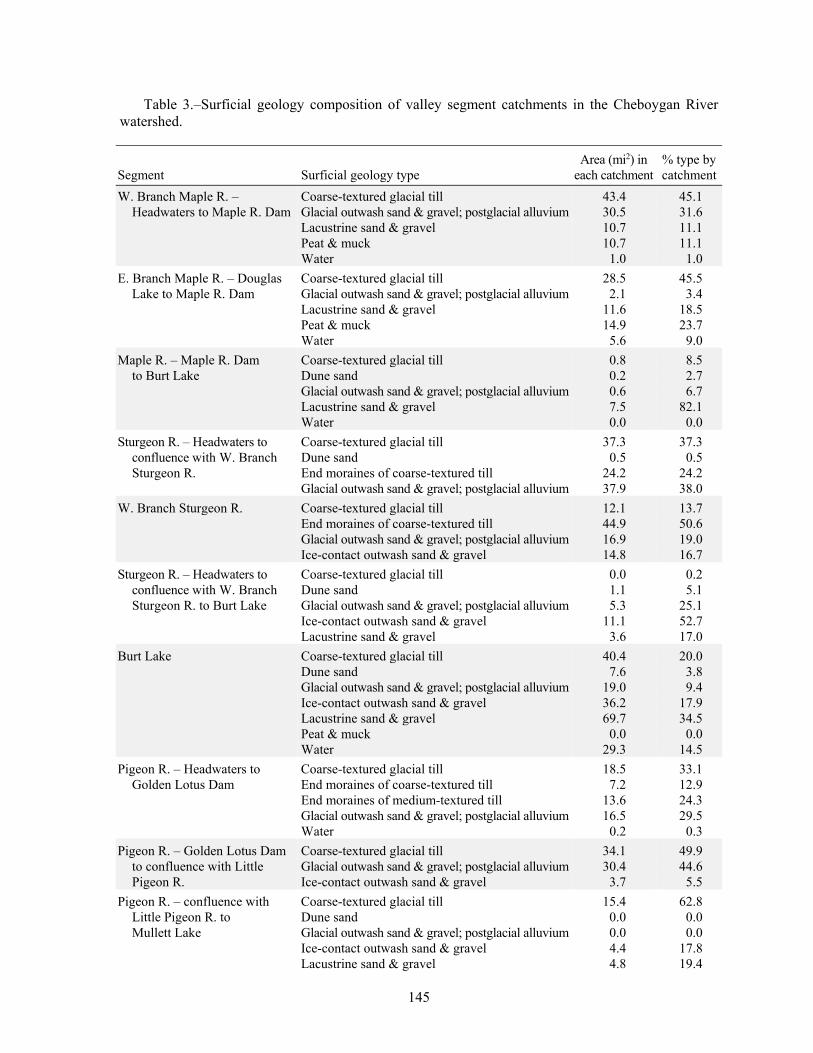
Table 3.–Surficial geology composition of valley segment catchments in the Cheboygan River watershed.
Segment Surficial geology type Area (mi2) in
each catchment % type by catchment
W. Branch Maple R. – Coarse-textured glacial till 43.4 45.1 Headwaters to Maple R. Dam Glacial outwash sand & gravel; postglacial alluvium 30.5 31.6
Lacustrine sand & gravel 10.7 11.1 Peat & muck 10.7 11.1 Water 1.0 1.0 E. Branch Maple R. – Douglas Coarse-textured glacial till 28.5 45.5
Lake to Maple R. Dam Glacial outwash sand & gravel; postglacial alluvium 2.1 3.4 Lacustrine sand & gravel 11.6 18.5 Peat & muck 14.9 23.7 Water 5.6 9.0 Maple R. – Maple R. Dam Coarse-textured glacial till 0.8 8.5
to Burt Lake Dune sand 0.2 2.7 Glacial outwash sand & gravel; postglacial alluvium 0.6 6.7 Lacustrine sand & gravel 7.5 82.1 Water 0.0 0.0 Sturgeon R. – Headwaters to Coarse-textured glacial till 37.3 37.3
confluence with W. Branch Dune sand 0.5 0.5 Sturgeon R. End moraines of coarse-textured till 24.2 24.2
Glacial outwash sand & gravel; postglacial alluvium 37.9 38.0 W. Branch Sturgeon R. Coarse-textured glacial till 12.1 13.7 End moraines of coarse-textured till 44.9 50.6 Glacial outwash sand & gravel; postglacial alluvium 16.9 19.0 Ice-contact outwash sand & gravel 14.8 16.7 Sturgeon R. – Headwaters to Coarse-textured glacial till 0.0 0.2
confluence with W. Branch Dune sand 1.1 5.1 Sturgeon R. to Burt Lake Glacial outwash sand & gravel; postglacial alluvium 5.3 25.1
Ice-contact outwash sand & gravel 11.1 52.7 Lacustrine sand & gravel 3.6 17.0 Burt Lake Coarse-textured glacial till 40.4 20.0 Dune sand 7.6 3.8 Glacial outwash sand & gravel; postglacial alluvium 19.0 9.4 Ice-contact outwash sand & gravel 36.2 17.9 Lacustrine sand & gravel 69.7 34.5 Peat & muck 0.0 0.0 Water 29.3 14.5 Pigeon R. – Headwaters to Coarse-textured glacial till 18.5 33.1
Golden Lotus Dam End moraines of coarse-textured till 7.2 12.9 End moraines of medium-textured till 13.6 24.3 Glacial outwash sand & gravel; postglacial alluvium 16.5 29.5 Water 0.2 0.3 Pigeon R. – Golden Lotus Dam Coarse-textured glacial till 34.1 49.9
to confluence with Little Glacial outwash sand & gravel; postglacial alluvium 30.4 44.6 Pigeon R. Ice-contact outwash sand & gravel 3.7 5.5
Pigeon R. – confluence with Coarse-textured glacial till 15.4 62.8 Little Pigeon R. to Dune sand 0.0 0.0 Mullett Lake Glacial outwash sand & gravel; postglacial alluvium 0.0 0.0
Ice-contact outwash sand & gravel 4.4 17.8 Lacustrine sand & gravel 4.8 19.4

146
Table 3.–Continued.
Segment Surficial geology type Area (mi2) in
each catchment % type by catchment
Mullett Lake Coarse-textured glacial till 27.4 18.9 Dune sand 10.1 6.9 Glacial outwash sand & gravel; postglacial alluvium 1.1 0.8 Ice-contact outwash sand & gravel 21.3 14.6 Lacustrine sand & gravel 62.5 42.9 Peat & muck 0.0 0.0 Water 23.1 15.9 Black R. – Headwaters to Coarse-textured glacial till 22.0 26.3
Clark Bridge Rd. End moraines of medium-textured till 13.7 16.4 Glacial outwash sand & gravel; postglacial alluvium 48.1 57.4 E. Branch Black R. Coarse-textured glacial till 14.7 29.0 End moraines of medium-textured till 12.3 24.4 Glacial outwash sand & gravel; postglacial alluvium 23.5 46.6 Black R. – Clark Bridge Rd. Coarse-textured glacial till 72.5 79.2
to Kleber Dam Dune sand 1.2 1.3 Glacial outwash sand & gravel; postglacial alluvium 17.9 19.5 Canada Creek Coarse-textured glacial till 25.1 37.5 Glacial outwash sand & gravel; postglacial alluvium 42.0 62.5 Black R. – Kleber Dam to Coarse-textured glacial till 35.5 53.3
Black Lake Dune sand 1.5 2.2 Glacial outwash sand & gravel; postglacial alluvium 19.1 28.6 Ice-contact outwash sand & gravel 5.7 8.6 Lacustrine sand & gravel 4.8 7.2 Water 0.0 0.1 Black Lake Coarse-textured glacial till 127.6 65.3 Dune sand 5.1 2.6 Glacial outwash sand & gravel; postglacial alluvium 3.1 1.6 Ice-contact outwash sand & gravel 10.4 5.3 Lacustrine sand & gravel 34.7 17.8 Water 14.3 7.3 Lower Black R. Coarse-textured glacial till 12.5 27.3 Dune sand 2.7 5.8 Lacustrine sand & gravel 30.6 66.8 Water 0.0 0.0 Cheboygan R. Coarse-textured glacial till 2.1 12.0 Dune sand 1.2 6.8 Lacustrine sand & gravel 14.4 81.1

147
Table 4.–Monthly mean, maximum, and minimum flows in cubic feet per second (ft3/s) from United States Geological Survey gages in the Cheboygan River watershed (United State Geological Survey 2007).
Station number (drainage area, mi2) and location (years of data) Oct Nov Dec Jan Feb Mar Apr May June July Aug Sept
04127997 (192) Sturgeon River at Wolverine 1942–2006
Mean 211 223 211 200 198 243 305 237 207 184 171 198 Maximum 326 301 306 295 275 354 431 353 272 255 301 290 Minimum 153 164 157 133 130 172 179 154 149 130 134 141
04128500 (598) Indian River at Indian River 1942–82
Mean 489 540 584 586 582 586 730 757 615 502 424 435 Maximum 686 777 793 755 749 803 1,088 1,181 863 796 678 600 Minimum 318 408 422 451 382 453 379 501 360 260 277 262
04128990 (57.7) Pigeon River near Vanderbilt 1950–2006
Mean 77.4 82.1 75.8 70.6 70.3 88.2 117 86.3 70.4 64.3 64.5 71.5Maximum 112 112 105 94.9 90.1 136 164 142 94.5 106 116 120 Minimum 56.6 63.1 60.1 50.8 50.1 62.8 69.8 54.4 50.7 46.7 42.6 50
04129500 (139) Pigeon River at Afton (1942–81)
Mean 123 137 126 117 114 174 260 172 131 108 95.5 114 Maximum 198 228 200 204 172 302 420 283 205 200 169 208 Minimum 81.9 85.3 90 77.5 80.2 96.5 144 93.2 80.4 59.2 64.5 76.4
04130000 (889) Cheboygan River near Cheboygan (1942–82)
Mean 680 805 840 858 847 922 1,097 1,054 846 677 600 640 Maximum 1,019 1,228 1,157 1,177 1,173 1,317 1,537 1,733 1,367 1,137 977 1,009 Minimum 260 425 458 517 610 603 533 561 451 363 404 384

148
Table 4.–Continued.
Station number (drainage area, mi2) and location (years of data) Oct Nov Dec Jan Feb Mar Apr May June July Aug Sept
04130500 (311) Black River near Tower (1942–2000)
Mean 244 269 248 221 220 338 535 343 248 202 184 217 Maximum 459 489 409 433 398 594 882 638 405 408 351 367 Minimum 138 130 163 150 138 188 220 177 140 112 86.1 116
04131000 (79) Rainy River near Onaway (1942–52)
Mean 10.2 18.2 11.5 11.4 9.2 52.2 126 41.7 17.5 8.7 1.9 3.3 Maximum 59.2 75.5 37.5 39.7 33.1 128 272 104 41.5 24.4 9 11.1 Minimum 0.5 1 2 2.7 2.3 9.3 38.2 23.2 2.7 0.8 0.2 0.2
04131500 (87.9) Rainy River near Ocqueoc (1952–79)
Mean 21.3 28.6 35.2 20.2 19.2 60.5 167 80.0 30.2 20.0 11.8 14.5 Maximum 92.2 72.6 92.8 80.5 54.7 179 334 178 77.6 118 76.4 57.0 Minimum 2.0 4.1 3.0 2.5 3.6 8.8 70.7 16.9 4.3 1.5 0.7 1.1
04132000 (558) Black River near Cheboygan (1942–74)
Mean 358 447 455 408 404 499 1,001 677 370 295 258 287 Maximum 898 916 791 636 671 904 1,708 1,564 722 718 734 749 Minimum 95.1 143 239 248 204 324 380 258 133 77.0 80.3 124

149
Table 5.–Mean annual discharge, drainage area in square miles, and exceedence flows at nine United States Geological Survey gage sites in the Cheboygan River watershed. All discharge data are presented as cubic feet per second. Sites are arranged in ascending order by gage number (United States Geological Survey 2007).
Period Drainage Mean annual Exceedence flows Ratio of 10% and Gage site (station number) of record area discharge 10% 50% 90% 90% exceedence flow
Sturgeon River at Wolverine (04127997) 1942–2006 192 216 289 200 158 1.8 Indian River at Indian River (04128500) 1942–82 598 569 760 555 387 2.0 Pigeon River near Vanderbilt (04128990) 1950–2006 57.7 78.2 109 70 54 2.0 Pigeon River at Afton (04129500) 1942–81 139 139 215 118 82 2.6 Cheboygan River near Cheboygan (04130000) 1942–82 889 822 1,170 802 477 2.5 Black River near Tower (04130500) 1942–2000 311 272 463 228 145 3.2 Rainy River near Onaway (04131000) 1942–52 79 26 64 7 1 64.0 Rainy River near Ocqueoc (04131500) 1952–79 87.9 42 100 20 3 33.3 Black River near Cheboygan (04132000) 1942–74 558 455 853 380 128 6.7

150
Table 6.–July and August water temperature (°F) of the Cheboygan River watershed (MDNR, Fisheries Division, unpublished data). Data within segments are sorted in an upstream to downstream direction.
Segment number Subwatershed Water body Location Date Maximum Minimum Mean
Maximum weekly mean
1 W. Br. Maple River W. Br. Maple River Ralmer or Robinson Rd. West Jul-05 84.2 64.0 74.2 79.7 Aug-05 81.2 60.8 69.8 75.0 Brush Creek Van Rd. Jul-05 77.0 54.8 68.0 71.8 Aug-05 75.1 57.0 65.9 68.4 W. Br. Maple River Ely Br. Rd. Jul-05 79.1 57.3 69.4 73.9 Aug-05 78.4 58.7 66.6 70.6 Cold Creek Ely Rd. Jul-05 80.2 60.2 70.2 74.8 Aug-05 78.0 58.3 67.5 71.1 W. Br. Maple River Robinson Rd. Jul-04 68.2 53.8 60.4 62.5 Aug-04 68.4 51.2 58.8 61.3
2 E. Br. Maple River E. Br. Maple River Douglas Lake Rd. Jul-05 84.3 61.7 73.3 78.6 Aug-05 83.6 59.4 68.4 72.2 C64 Jul-05 63.5 55.9 60.1 61.7 Aug-05 63.5 57.0 60.8 61.8
3 Maple River Maple River Below Lake Kathleen Dam Jul-05 72.3 61.2 65.7 68.4 Aug-05 69.9 58.7 63.5 66.4 Brutus Rd. Jul-05 69.9 56.1 62.3 64.8 Aug-05 68.7 55.3 60.2 62.6
4 Sturgeon River Sturgeon River Poquette Rd. Jul-05 62.0 49.4 55.9 57.0 Aug-05 65.2 49.1 55.6 57.9 Mossback Creek Nowak Rd. Jul-05 60.9 47.5 53.7 54.9 Aug-05 66.7 48.9 54.4 56.6 Sturgeon River Whitmarsh Rd. Jul-05 68.5 51.4 60.8 62.6 Aug-05 68.5 54.8 59.5 62.8 Sturgeon Valley Rd. Jul-05 65.5 53.0 60.4 62.2 Aug-05 66.1 53.0 59.1 62.4 Pickerel Creek Near mouth Jul-05 68.6 50.4 60.3 62.0 Aug-05 68.9 52.7 60.2 62.4

151
Table 6.–Continued.
Segment number Subwatershed Water body Location Date Maximum Minimum Mean
Maximum weekly mean
4 Sturgeon River– 53.5 54.3 continued Club Creek Sturgeon Valley Rd. Jul-05 57.8 47.7 55.0 57.5 Aug-05 63.2 49.7 Fontinalis Rd. Jul-05 74.6 57.4 67.0 69.7 Aug-05 74.9 56.9 64.8 68.9 Sturgeon River Trowbridge Rd. Jul-05 73.1 54.6 64.1 66.7 Aug-05 73.5 54.0 62.0 65.8 Blackjack Creek Shire Rd. Jul-05 54.4 48.2 50.8 51.7 Aug-05 62.5 51.0 52.7 53.1 Stewart Creek Near mouth Jul-05 77.1 51.4 64.7 67.2 Aug-05 77.5 51.7 62.3 66.6
5 W. Br. Sturgeon River W. Br. Sturgeon River McGregor Rd. Jul-05 77.1 56.0 67.6 71.1 Aug-05 76.5 55.5 65.1 69.4 Shingle Mill Br. Jul-05 66.7 51.7 59.8 61.9 Aug-05 66.7 51.7 58.6 61.9 Old 27 Br. Jul-06 68.9 53.3 60.9 62.8 Aug-06 69.1 50.9 58.4 63.1
6 Sturgeon River Sturgeon River Wolverine Rd. Jul-05 73.1 54.3 64.3 67.0 Aug-05 73.1 54.1 62.2 66.0 Rondo Rd. Jul-05 72.3 55.0 64.5 67.4 Aug-05 72.3 54.4 62.1 66.1 Cutover or Hutch Rd. Jul-05 70.0 56.0 64.4 67.3 Aug-05 70.6 55.2 62.3 66.1
7 Burt Lake Minnehaha Creek Newson Rd. Jul-06 75.3 63.1 68.9 70.7 Aug-06 75.0 61.6 68.3 71.8 W. Br. Minnehaha Creek South of Mitchell Rd. Jul-03 64.0 51.8 57.9 59.4 Aug-03 64.3 50.3 58.6 60.4 Minnehaha Creek Pickerel Lake Rd. Jul-05 62.8 48.4 55.4 57.0 Aug-05 61.9 48.7 55.0 56.6

152
Table 6.–Continued.
Segment number Subwatershed Water body Location Date Maximum Minimum Mean
Maximum weekly mean
7 Burt Lake– continued Berry Creek Reams Rd. Jul-05 62.3 48.6 55.6 57.1 Aug-05 62.1 50.3 55.9 56.9 Cedar Creek Pickerel Lake Rd. Jul-05 52.8 45.6 48.8 49.5 Aug-05 52.0 46.4 48.5 49.2
8 Pigeon River Pigeon River Whitehouse Trail Jul-05 66.0 50.2 58.0 59.5 Aug-05 66.0 51.2 57.3 59.8 S. Br. Pigeon River Sparr Rd. Jul-05 68.6 52.8 61.3 63.2 Aug-05 67.3 53.3 60.3 63.2 Pigeon River Old Vanderbilt Rd. Jul-06 71.5 54.2 63.5 66.1 Aug-06 75.1 52.0 60.7 65.6
9 Pigeon River Pigeon River Below Lansing Club Pond Jul-98 78.5 58.1 67.5 71.7 Aug-98 72.3 59.8 66.2 67.0 Sturgeon Valley Rd. Jul-06 80.0 52.7 66.5 68.6 Aug-06 78.3 44.7 62.3 68.5 Tin Br./Cornwall Rd. Jul-05 77.8 55.2 66.8 70.2 Aug-05 75.9 56.1 63.7 68.0 Cornwall Creek Cornwall Rd. Jul-05 71.9 52.4 62.4 65.5 Aug-05 71.9 57.2 64.9 67.3 Pigeon River Webb Rd. Jul-05 77.8 56.1 68.0 71.9 Aug-05 76.6 51.1 64.3 69.0 McIntosh Creek Montgomery Rd. Jul-05 79.6 61.7 71.1 74.7 Aug-05 77.1 58.9 67.9 72.0
10 Pigeon River Little Pigeon River Webb Rd. Jul-05 71.7 55.2 64.7 67.9 Aug-05 70.2 55.5 62.5 66.0 Wilkes Creek Montgomery Rd. Jul-05 79.1 51.8 65.9 70.8 Aug-05 74.5 57.9 64.6 68.1 Wilkes Creek Tributary Montgomery Rd. bend Jul-05 84.9 58.0 71.0 75.4 Aug-05 80.0 60.3 68.7 72.3

153
Table 6.–Continued.
Segment number Subwatershed Water body Location Date Maximum Minimum Mean
Maximum weekly mean
10 Pigeon River– continued Pigeon River M-68 Jul-05 79.2 59.0 70.1 74.6 Aug-05 77.0 57.9 66.0 70.4 Agnes Andrea Nature Preserve Jul-03 78.0 58.2 67.6 71.0 Aug-03 77.3 58.7 68.5 71.2
11 Mullett Lake Little Sturgeon River Afton Rd. Jul-05 79.6 58.0 68.8 72.8 Aug-05 78.0 57.4 65.9 70.2 Johnson Creek Dunham Rd. ford Jul-05 71.6 52.1 63.0 66.4 Aug-05 70.7 54.4 61.8 64.9 Little Sturgeon River M-68 Jul-05 72.0 53.0 61.7 64.8 Aug-05 68.1 53.9 60.6 63.6 Kimberly Creek M-68 Aug-05 80.1 57.6 66.5 70.7 Little Pigeon River Ormsbee Rd. Jul-05 82.5 56.6 69.0 73.8 Aug-05 82.1 57.1 65.8 70.7 N. Br. Little Pigeon River Silver Lake Rd. Jul-05 81.9 62.2 72.2 76.6 Aug-05 76.8 58.8 66.9 71.3 Little Pigeon River near mouth at Silery Rd Jul-05 78.5 60.7 70.0 74.7 Aug-05 76.6 59.5 66.7 71.1 Mullett Creek South Extension Rd. Jul-04 63.4 49.9 55.9 57.5 Aug-04 61.7 46.8 54.8 56.2 Mullett-Burt Rd. Jul-04 78.3 55.7 67.8 69.9 Aug-04 75.5 54.4 64.2 67.9 Ballard Creek M-33 Jul-04 71.4 54.7 62.3 64.3 Aug-04 67.0 50.8 59.3 61.8
12 Black River Black River Johnson’s Crossing Jul-04 68.7 50.7 59.3 61.2 Aug-04 66.3 48.8 57.5 59.7 Saunders Creek Gingell Rd. Jul-04 63.1 49.4 55.0 56.2 Aug-04 61.4 47.4 53.8 55.0 Black River Tyrolean Hills Jul-04 72.6 52.3 62.0 64.1 Aug-04 70.8 49.2 59.4 62.2
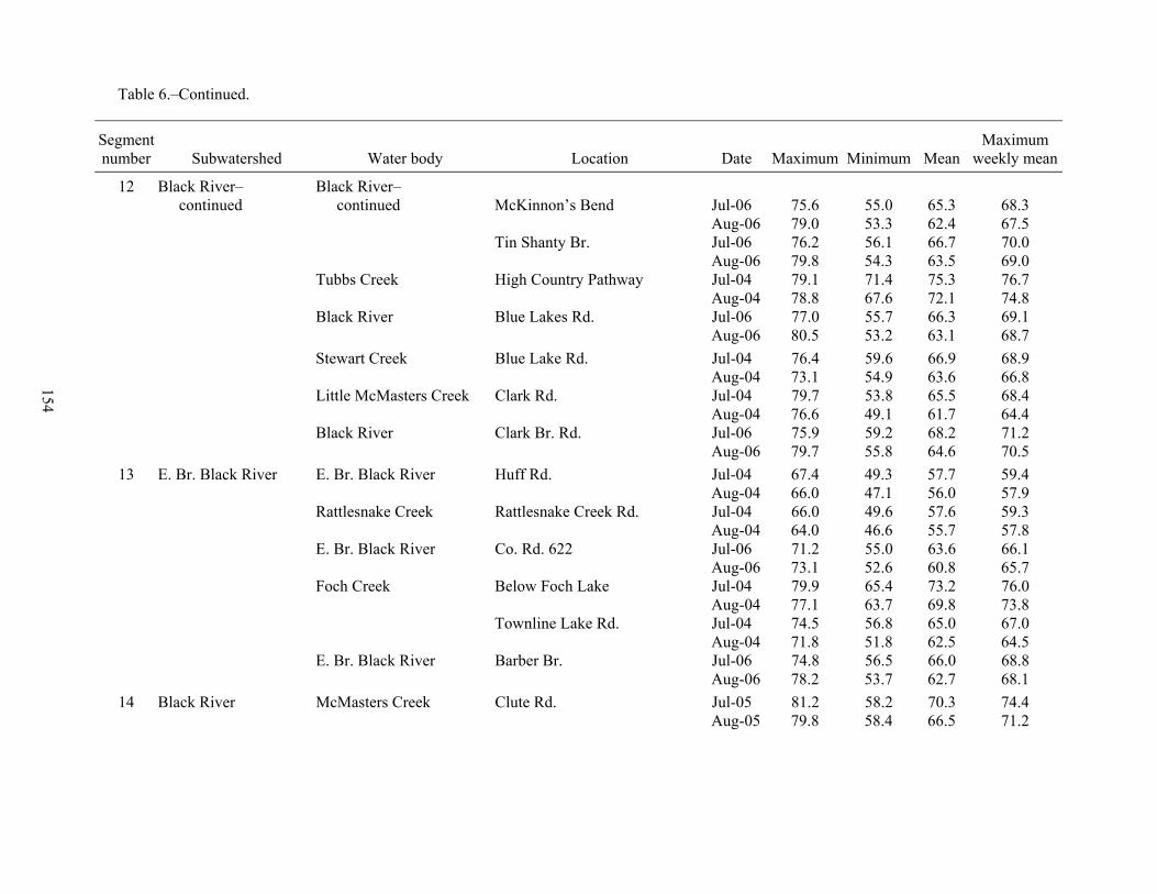
154
Table 6.–Continued.
Segment number Subwatershed Water body Location Date Maximum Minimum Mean
Maximum weekly mean
12 Black River– Black River– continued continued McKinnon’s Bend Jul-06 75.6 55.0 65.3 68.3 Aug-06 79.0 53.3 62.4 67.5 Tin Shanty Br. Jul-06 76.2 56.1 66.7 70.0 Aug-06 79.8 54.3 63.5 69.0 Tubbs Creek High Country Pathway Jul-04 79.1 71.4 75.3 76.7 Aug-04 78.8 67.6 72.1 74.8 Black River Blue Lakes Rd. Jul-06 77.0 55.7 66.3 69.1 Aug-06 80.5 53.2 63.1 68.7 Stewart Creek Blue Lake Rd. Jul-04 76.4 59.6 66.9 68.9 Aug-04 73.1 54.9 63.6 66.8 Little McMasters Creek Clark Rd. Jul-04 79.7 53.8 65.5 68.4 Aug-04 76.6 49.1 61.7 64.4 Black River Clark Br. Rd. Jul-06 75.9 59.2 68.2 71.2 Aug-06 79.7 55.8 64.6 70.5
13 E. Br. Black River E. Br. Black River Huff Rd. Jul-04 67.4 49.3 57.7 59.4 Aug-04 66.0 47.1 56.0 57.9 Rattlesnake Creek Rattlesnake Creek Rd. Jul-04 66.0 49.6 57.6 59.3 Aug-04 64.0 46.6 55.7 57.8 E. Br. Black River Co. Rd. 622 Jul-06 71.2 55.0 63.6 66.1 Aug-06 73.1 52.6 60.8 65.7 Foch Creek Below Foch Lake Jul-04 79.9 65.4 73.2 76.0 Aug-04 77.1 63.7 69.8 73.8 Townline Lake Rd. Jul-04 74.5 56.8 65.0 67.0 Aug-04 71.8 51.8 62.5 64.5 E. Br. Black River Barber Br. Jul-06 74.8 56.5 66.0 68.8 Aug-06 78.2 53.7 62.7 68.1
14 Black River McMasters Creek Clute Rd. Jul-05 81.2 58.2 70.3 74.4 Aug-05 79.8 58.4 66.5 71.2

155
Table 6.–Continued.
Segment number Subwatershed Water body Location Date Maximum Minimum Mean
Maximum weekly mean
14 Black River– continued Black River Shangrila Rd. Jul-04 73.0 57.6 65.3 67.4 Aug-04 72.4 53.9 62.2 65.8 Crockett Rapids Br. Jul-06 77.7 60.9 69.5 72.6 Aug-06 80.8 57.9 65.7 71.8 Tomahawk Creek Elk Hill Rd. Jul-04 76.6 57.3 66.8 69.5 Aug-04 73.8 50.9 62.1 65.3 Co. Rd. 634 Jul-04 83.4 61.6 72.4 75.4 Aug-04 82.4 55.4 68.2 72.4 M-33 Jul-04 75.2 58.8 67.4 70.6 Aug-04 73.1 54.4 63.4 67.3 Gregg Creek Black River Rd. Jul-04 69.6 52.2 61.4 63.3 Aug-04 68.2 48.0 59.0 61.9 Black River Black River Rd. Jul-04 75.0 58.6 66.9 69.2 Aug-04 74.1 55.8 63.8 67.8
15 Canada Creek Packer Creek Rouse Rd. Jul-04 77.9 52.6 64.9 67.4 Aug-04 76.4 48.7 61.6 64.7 Van Hetton Creek Roth Rd. Jul-04 82.2 52.3 66.5 69.3 Aug-04 79.6 49.3 63.5 67.2 Canada Creek Co. Rd. 622 Jul-04 81.8 62.2 70.5 73.2 Aug-04 80.2 57.6 67.5 70.8 South wire Jul-06 80.4 62.3 71.7 74.4 (Canada Creek Ranch) Aug-06 82.3 59.7 68.5 74.3 High banks Jul-06 76.5 59.7 67.8 70.1 (Canada Creek Ranch) Aug-06 78.3 55.5 64.7 70.2 Canada Creek Gravel bottom Jul-05 77.7 56.8 68.5 72.2 (Canada Creek Ranch) Aug-05 75.5 59.1 66.7 69.9 Above Montague Creek Jul-06 74.9 58.5 66.2 68.6 (Canada Creek Ranch) Aug-06 76.8 47.7 63.3 68.5 Below Montague Creek Jul-06 75.0 58.3 66.3 68.6 (Canada Creek Ranch) Aug-06 76.5 54.1 63.3 68.6

156
Table 6.–Continued.
Segment number Subwatershed Water body Location Date Maximum Minimum Mean
Maximum weekly mean
15 Canada Creek– Canada Creek– continued continued Wilson Br. Jul-05 74.7 54.7 64.8 67.8 (Canada Creek Ranch) Aug-05 72.6 57.5 63.6 66.2 Wadsworth Br. Jul-05 75.3 55.2 65.1 68.1 (Canada Creek Ranch) Aug-05 73.8 57.4 63.7 66.5 North wire Jul-06 76.8 57.4 66.9 69.5 (Canada Creek Ranch) Aug-06 80.6 54.6 63.7 69.0 Canada Creek Highway Jul-04 71.1 53.3 61.9 63.8 Aug-04 69.9 50.0 59.0 61.0 Oxbow Creek Oxbow Creek Rd. Jul-06 86.9 55.5 70.8 74.0 Aug-06 91.5 48.9 66.1 72.5 Near county line Jul-06 80.8 58.2 70.1 73.2 Aug-06 85.2 53.9 65.8 72.2 Canada Creek Highway Jul-04 73.8 56.1 64.7 67.1 Aug-04 72.6 51.4 61.7 64.7
16 Black River Black River Below Kleber Dam Jul-04 74.8 63.4 70.3 72.4 Aug-04 92.3 55.2 72.0 75.5 Milligan Creek Near headwaters Jul-04 77.5 55.8 66.6 68.8 Aug-04 75.7 54.2 63.0 67.3 Gokee Creek Osmun Rd. Jul-04 71.1 49.7 62.4 65.3 Milligan Creek Gokee Hill area Jul-03 78.7 57.1 66.9 70.0 Aug-03 77.4 54.6 67.8 70.6 Milligan Creek Upstream of M-68 Jul-06 85.6 47.6 67.2 70.9 Aug-06 81.4 46.7 62.4 67.5 Near M-68 Jul-06 81.1 59.5 70.6 73.6 Aug-06 79.8 53.5 66.3 72.0 Black River One mile below Kleber Dam Jul-05 83.7 67.5 74.0 76.1 Aug-05 79.0 62.6 69.8 74.5 Near mouth of Black Lake Jul-05 82.6 67.0 75.5 79.6 Aug-05 79.3 61.9 70.3 75.5

157
Table 6.–Continued.
Segment number Subwatershed Water body Location Date Maximum Minimum Mean
Maximum weekly mean
17 Black Lake Stewart Creek Steel Rd. Aug-04 76.9 47.1 60.7 63.9 Stony Creek Vermilya Highway Jul-04 73.2 47.8 62.8 65.8 Aug-04 73.2 41.9 59.7 62.6 North Allis Highway Jul-04 76.2 50.8 62.1 65.0 W. Br. Upper Rainy River Near mouth Jul-04 71.7 56.0 64.2 67.2 Aug-04 71.7 52.8 60.8 64.1 Healy Creek Near mouth Jul-04 78.4 52.5 64.9 68.9 Aug-04 71.1 46.7 58.3 61.1 Rainy River Below Rainy Lake Jul-04 77.8 60.9 68.7 71.4 Aug-04 81.0 46.9 61.9 66.3 Stony Creek End of Brady Rd. Jul-04 77.1 58.8 67.5 70.0 E. Br. Rainy River Schnep Rd. Jul-04 74.4 56.9 63.6 67.5 Aug-04 67.3 50.3 55.8 62.9 Rainy River South Porter Rd. Jul-04 79.5 59.3 68.1 69.1 Aug-04 77.7 54.0 64.8 69.8 Little Rainy River South Porter Rd. Jul-04 83.5 58.8 70.1 72.5 Aug-04 81.9 52.1 66.7 70.6 Rainy River North Allis Highway Jul-04 76.8 59.1 67.9 70.1 Aug-04 75.9 54.9 64.4 68.2
17 Black Lake Cold Creek Roost Rd. Jul-04 73.2 57.8 65.0 67.9 Aug-04 69.3 53.3 61.2 63.8
18 Lower Black River Long Lake Creek Gaynor Rd. Jul-04 73.1 54.4 64.0 66.5 Aug-04 71.9 44.1 60.6 63.5 Owens Creek Ross Rd. Jul-04 78.2 58.7 67.6 70.1 Aug-04 74.5 55.4 64.8 67.5 Black River Stony Creek End of Brady Rd. Aug-04 74.3 53.8 63.2 66.4
19 Cheboygan River Laperell Creek Inverness Trail Jul-04 60.8 52.4 55.9 56.9 Aug-04 60.3 49.9 54.9 56.2 Near Old 27 Jul-04 65.5 52.5 58.5 60.4 Aug-04 63.5 48.6 56.8 58.5 Cheboygan River Bayview Drive Jul-05 85.8 70.1 77.1 81.2 Aug-05 82.2 60.2 73.2 77.3

158
Table 7.–Gradient of the entire Cheboygan River watershed.
Gradient class Description Miles % of watershed
0–2.9 ft/mile low 147.4 17.5 3.0–4.9 ft/mile medium 39.1 4.6 5.0–9.9 ft/mile high 132.2 15.7 10.0–69.9 ft/mile very high 442.5 52.6 70–149.9 ft/mile chutes and pools 65.6 7.8 >150 ft/mile falls and rapids 14.7 1.8 Total: 841.6

159
Table 8.–Gradient of the Cheboygan River and its tributaries by river segment.
Reach Segment or major tributary Gradient class
(ft/mile) Miles % of reach
W. Br. Maple River Headwaters to Maple River Dam 0–2.9 9.5 59.5 5.0–9.9 6.5 40.5 Total: 16.0
E. Br. Maple River 0–2.9 1.6 26.3 10.0–69.9 4.6 73.7 Total: 6.2
Maple River Maple River Dam to Burt Lake 3.0–4.9 2.4 35.3 5.0–9.9 3.7 54.3 10.0–69.9 0.7 10.4 Total: 6.8
Sturgeon River Headwaters to confluence with 0–2.9 0.4 1.8 W. Br. Sturgeon River 3.0–4.9 1.3 5.4 5.0–9.9 10.3 42.0 10.0-69.9 11.2 45.7 >150 1.3 5.1 Total: 24.6
Confluence with W. Br. Sturgeon 0–2.9 0.7 4.7 River to Burt Lake 10.0-69.9 13.4 95.3 Total: 14.1
W. Br. Sturgeon River 0–2.9 0.8 4.4 10.0–69.9 17.0 95.6 Total: 17.8
Burt Lake Crooked River 0–2.9 5.2 100.0 Total: 5.2
Pigeon River Headwaters to Golden Lotus Dam 0–2.9 1.1 7.7 5.0–9.9 6.0 42.0 10.0–69.9 7.2 50.4 Total: 14.3
Golden Lotus Dam to confluence
with Little Pigeon River 5.0–9.9 7.0 45.1 10.0–69.9 8.5 54.9 Total: 15.4
Confluence with Little Pigeon
River to Mullett Lake 0–2.9 5.5 37.9 10.0–69.9 9.0 62.1 Total: 14.5
Mullett Lake Indian River 0–2.9 4.0 100.0
Total: 4.0

160
Table 8.–Continued.
Reach Segment or major tributary Gradient class
(ft/mile) Miles % of reach
Black River Headwaters to Clark Bridge Road 0–2.9 4.5 15.9 5.0–9.9 14.3 50.5 10.0–69.9 9.5 33.5 Total: 28.4
Clark Bridge Road to Kleber Dam 0–2.9 5.5 28.5 3.0–4.9 0.2 0.8 5.0–9.9 12.3 63.8 10.0–69.9 1.3 6.9 Total: 19.2
Kleber Dam to Black Lake 3.0–4.9 8.3 87.8 10.0–69.9 0.9 9.4 >150 0.3 2.8 Total: 9.5
Lower Black River 0–2.9 5.8 52.4 3.0–4.9 4.4 39.6 10.0–69.9 0.9 8.0 Total: 11.1
E. Br. Black River 5.0–9.9 13.5 68.4 10.0–69.9 6.2 31.6 Total: 19.7
Canada Creek 0–2.9 0.9 4.2 3.0–4.9 7.7 38.0 5.0–9.9 8.0 39.1 10.0–69.9 3.8 18.7 Total: 20.4
Black Lake Rainy River 0–2.9 1.8 7.6 3.0–4.9 2.4 10.2 5.0–9.9 7.1 29.9 10.0–69.9 12.4 52.3 Total: 23.8
Cheboygan River 0–2.9 4.2 60.3 5.0–9.9 2.7 39.7 Total: 6.9

161
Table 9.–Analysis of channel morphology data for select tributaries of the Cheboygan River. Stream width was calculated from measurements made by the United States Geological Survey and Michigan Department of Natural Resources, Fisheries Division. Status indicates whether site is outside of expected range; "W" is too wide and "N" is too narrow. Expected range (mean, upper 95%, and lower 95% widths) were calculated using equations developed by Leopold and Maddock (1953) and Leopold and Wolman (1957).
Actual Discharge Expected width (ft) Water body Location Date width (ft) (ft3/s) Lower 95%a Meanb Upper 95%c Status
W. Br. Maple River Robinson Rd. 08/07/2002 26.0 35.4 24.7 32.6 43.0 E. Br. Maple River C64 (Mills Rd.) 07/31/2002 23.9 21.3 19.5 25.3 33.0 Maple River below Maple River Dam 07/29/2002 40.0 115.2 43.1 58.7 80.0 N Sturgeon River Trowbridge Rd. 07/18/2005 30.0 75.0 35.2 47.4 63.9 N Wolverine 07/02/2007 54.0 145.0 48.1 65.9 90.3 W. Br. Sturgeon River Old 27 Highway 07/25/2005 30.0 51.7 29.6 39.4 52.5 W. Br. Minnehaha Creek Berger Rd. 07/25/2003 8.0 2.2 6.7 8.2 10.1 Pigeon River near Vanderbilt 08/03/2007 46.0 43.1 27.1 36.0 47.7 Elk Hill Campground 08/06/2002 38.0 105.1 41.3 56.1 76.2 N Afton 08/07/2007 57.0 67.1 33.4 44.9 60.2 Agnes Andreae Nature Preserve 07/24/2003 34.0 92.3 38.9 52.6 71.2 N Little Pigeon River Burls Rd. 07/25/2002 23.0 13.3 15.6 20.0 25.8 Black River Springs area (Black River Rd.) 08/17/2006 38.0 29.1 22.5 29.6 38.8 Sids Drive 08/16/2006 36.0 34.8 24.5 32.4 42.7 Blue Lakes Rd. 08/08/2005 38.0 62.1 32.2 43.2 57.8 near Tower 07/23/2001 51.0 174.0 52.4 72.2 99.4 N E. Br. Black River Old Railroad Grade (Huff Rd.) 08/23/2007 37.8 29.3 22.6 29.7 39.0 Canada Creek Geodetic Rd. 08/25/2005 21.0 22.2 19.8 25.8 33.6 Doty Trail 08/20/2004 25.0 29.4 22.7 29.8 39.1 Wilson Bridge 08/25/2005 31.5 31.0 23.2 30.6 40.2
a Lower 95% = 10^(0.662895+(0.471522*log10(Q))). b Mean = 10^(0.741436+(0.498473*log10(Q))). c Upper 95% = 10^(0.819976+(0.525423*log10(Q))).

162
Table 10.–Dams in the Cheboygan River watershed, sorted by county. Date is the date of construction; location is provided by township (T.), range (R.), and section (Sec.); “Owner” indicates ownership as private, state, or local government; blanks indicate data are missing; an asterisk (*) indicates the dam is classified a high or significant hazard (J. Pawloski, MDEQ LWMD).
County Dam name River reach Date T. R. Sec. Owner
Head (ft)
Pond area(acres)
Storage(acre-ft)
Cheboygan Alverno Dam* Black River 1904 37N 1W 35 private 16 1,025 1,260 Berry Creek Ranch Dam Berry Creek 1942 34N 3W 22 private 6 4 0 Cheboygan Dam* Cheboygan River 1922 38N 1W 31 private/state 21 18,150 82,947 Cornwall Creek Dam* Cornwall Creek 1966 33N 1W 27 state 27 161 2,570 Crooked Lake Walleye Pond Trib-Hassler Creek 1970 35N 3W 17 state 8 4 19 Dog Lake Dam McMasters Creek 1957 33N 1W 11 state 4 520 1,870 Echo Lake Dam Trib-Little Pigeon River 1971 33N 2W 14 state 4.5 25 150 Ginop Dam Hasler Creek 1987 34N 3W 7 private 0 1 0 Jury Dam Trib-Little Pigeon River 1958 33N 2W 12 private 0 20 0 Kleber Dam Upper Black River 1949 35N 1E 29 private 42 270 7,320 Little Sturgeon Club Dam Little Sturgeon River 35M 2W 30 private 1 1 Maxson Dam Morrow Creek 35N 2W 20 private 6 4 Roberts Lake Dam Twin Lakes Creek 1948 35N 2W 28 state 4.3 54 210 Stony Creek Dam Stony Creek 1952 35N 1W 27 state 5 190 1,330 Tower Dam Black River 1918 34N 1E 3 private 20 102 1,900 Towner Dam Trib-Little Pigeon River 33N 2W 2 private 7 Wildwood Lake Dam* Bradley Creek 1962 33N 2W 21 private 20 222 2,800 Twin Lakes Dam Twin Lakes Outlet 37N 1E 34 private 3 234
Emmet Crooked Lake Dam Crooked River 1967 35N 4W 10 state 1 2,300 Maple River Dam Maple river 1966 36N 4W 10 private 16 43 808 Ottawa Trout Pond #1 Dam Trib-Crooked River 1920 36N 4W 34 private 4 0 1 Ottawa Trout Pond #3 Dam Trib-Crooked River 1920 36N 4W 34 private 12 3 16 Spring Lake Dam Trib-Crooked Lake 34N 5W 27 local 5 Starks Mill Dam Silver Creek 1951 34N 4W 4 private 20 4 60

163
Table 10.–Continued.
County Dam name River reach Date T. R. Sec. Owner
Head (ft)
Pond area(acres)
Storage(acre-ft)
Montmorency Doty Dam Van Hetton Creek 31N 2E 6 3 24 Foch Lakes Dam Trib-East Branch Black 1948 32N 1E 28 state 9 60 440 Muskellunge Lake Level Control Canada Creek 1957 32N 2E 33 private 4 126 1,000 Rainy River Dam West Branch Upper 1960 32N 3E 4 state 7.5 270 1,755
Otsego Bailey Fund East Dam Trib-Pigeon River 31N 2W 31 private 0 2 Bailey Fund West Dam Trib-Pigeon River 31N 2W 31 private 0 3 Fontinalis Club Home Dam Club Stream 1960 32N 2W 17 private 9.1 5 50 Fontinalis Club Middle Dam Club Steam 1960 32N 2W 18 private 8.2 10 70 Fontinalis Club Upper Dam Club Stream 1870 32N 2W 19 private 5.2 15 75 Golden Lotus Dam Pigeon River 1955 32N 1W 19 private 13 45 565 Light Dam Trib-Sturgeon River 31N 2W 6 private 0 2 Platte Dam (Downstream) Duck Creek 30N 2W 2 private 0 2 Platte Dam (Upstream) Duck Creek 30N 2W 2 private 0 1 Quigley Dam Trib-Club Stream 1965 32N 3W 13 private 15 50 120 Rogell Dam Trib-Club Stream 1958 32N 3W 13 private 6 2 Saunders Dam Black River 1920 31N 1W 20 private 4 12 Schrader Dam Duck Creek 31N 2W 23 private 0 1 Turner Dam Sturgeon River 31N 3W 14 private 4 Woodin Lake Dam West Branch Sturgeon 1940 32N 3W 30 private 7 28 100
Presque Isle Feel Dam #2 Healy Creek 1974 33N 3E 22 private 8 6 26 Feel Dam #1 Healy Creek 1960 33N 3E 22 private 4 14 Moreau Dam Trib-Stony Creek 2000 34N 2E 16 private 5 Ramsey Dam Healy Creek 1963 35N 2E 8 private 0 2 16 Tomahawk Creek Flooding Tomahawk Creek 1965 33N 2E 27 state 12 575 8,060

164
Table 11.–Active National Pollution Discharge Elimination System (NPDES) permits in the Cheboygan River watershed, as of May 9, 2007 (Kenneth Hozak, MDEQ Water Bureau, personnel communication). An * indicates that data were not available.
County and permittee Permit type Receiving water
Cheboygan County Great Lakes Tissue Wastewater Unnamed Cheboygan Wastewater Treatment Plant Wastewater Cheboygan River Blarney Castle Oil General Cheboygan River Inverness Dairy Inc General * Wolverine Power Supply – Tower General * Rieth-Riley-Afton Site General Little Pigeon River BP Products NA Inc-Cheboygan General Cheboygan River Anchor In Marina Storm water Lake Huron via Cheboygan R Burt Lake Marina Storm water Sturgeon River Cheboygan Cement-Cheboygan Storm water Cheboygan River Howe Marine-Indian River Storm water Indian River Moran Iron Works-Bowen Road Storm water Bowen Creek Link Industries Storm water Ditches to Indian River WSM Ent-Indian River Marina Storm water Indian River Baumgarten Forest Products Storm water Welch Creek Circle M Ranch Storm water Sturgeon River Walstrom Marine-Cheboygan Storm water Cheboygan River R E Glancy-Crusher 3 Storm water BP Amoco – Cheboygan Storm water Cheboygan River
Emmet County MDNR-Oden Fish Hatchery Wastewater Unnamed tributary to Crooked Lake UM Biological Station Wastewater Maple River Harbor Springs Area Sewage Wastewater * Karriger Eng & Mfg Inc Construction * Up North Industries-Petoskey Storm water Round Lake Ryde Marine Inc-Alanson Storm water Crooked Lake
Otsego County MACTEC Eng and Con Inc Wastewater Unnamed Treetops Resort-Gaylord General Pigeon River Treetops Resort-Gaylord General Pigeon River
Presque Isle County Onaway Wastewater Treatment Plant Wastewater Bowen Creek Elk Run Landfill-Republic Storm water Little Rainy River

165
Table 12.–MDEQ Procedure 51 macroinvertebrate community information for the Cheboygan River watershed (from Walker 2008a, 2008b, 2008c, 2008d).
Number Taxa (number) Water body Location of taxa mayfly caddisfly stonefly EPT % Rating
Black River Ninnever Cabin 33 7 7 2 48.5 Excellent Black River Blue Lakes Road 37 6 9 1 43.2 Excellent E Br Black River Blue Lakes Road 36 7 8 1 44.4 Excellent Black River Crocket Rapids 31 5 7 3 48.4 Excellent McMasters Cr N of Clark Bridge Rd 30 2 5 0 23.3 Acceptable Black River Black River Road 42 7 8 2 40.5 Excellent Milligan Cr Brady Rd 31 4 9 2 48.4 Excellent Canada Cr Canada Creek Hwy 38 6 10 2 47.4 Excellent Oxbow Cr S off Canada Cr Hwy 27 4 8 1 48.1 Excellent Tomahawk Cr M-33 29 3 6 1 34.5 Excellent Bowen Cr Bowen Rd 27 2 7 0 33.3 Acceptable Rainy River Allis Hwy 34 6 5 3 41.2 Excellent Little Rainy River 1 Mile Hwy 25 3 5 0 32.0 Acceptable Owens Cr Ross Rd 22 2 3 0 22.7 Acceptable Laperell Cr Laperell Rd 29 5 6 1 41.4 Excellent Mullett Cr d/s Crump Rd 20 2 7 3 60.0 Excellent E Br Maple R Douglas Lake Rd 38 5 7 1 34.2 Acceptable Maple River Maple River Rd 37 7 10 3 54.1 Excellent Maple River Robinson Rd 37 5 10 3 48.6 Excellent McPhee Cr Valley Rd 25 2 8 1 44.0 Excellent Minnehaha Cr Pickerel Lake Rd 21 4 3 2 42.9 Acceptable Little Pigeon River Silery Road 29 3 7 1 37.9 Excellent Pigeon River M-68 38 4 7 2 34.2 Excellent

166
Table 12.–Continued.
Number Taxa (number) Water body Location of taxa mayfly caddisfly stonefly EPT % Rating
Pigeon River Webb Rd 35 5 9 1 42.9 Excellent Little Pigeon River Webb Rd 34 6 7 3 47.1 Excellent Pigeon River Elk Hill Campground 39 7 8 1 41.0 Excellent Pigeon River Sturgeon Valley Rd 40 6 6 2 35.0 Excellent Pigeon River Old Vanderbilt Rd 36 7 8 4 52.8 Excellent Pigeon River Whitehouse Trail 31 6 6 2 45.2 Excellent Sturgeon River Fisher Woods Rd 35 5 9 2 45.7 Excellent Sturgeon River Rondo Rd 31 4 9 2 48.4 Excellent Sturgeon River Cornwall Grade Canoe Launch 35 5 10 2 48.6 Excellent Sturgeon River Sturgeon Valley Rd 25 5 5 2 48.0 Excellent Sturgeon River Poquette Rd 28 6 7 3 57.1 Excellent Club Stream Fontinalis Club 30 6 8 1 50.0 Excellent Little Sturgeon River Crumley Creek Rd 29 6 6 4 55.2 Excellent W Br Sturgeon River Shire Rd 35 4 8 3 42.9 Excellent W Br Sturgeon River McGregor Rd. 32 8 9 1 56.3 Excellent

167
Table 13.–Cheboygan River watershed sites regulated under Part 201 as of April 2007, data provided by Michigan Department of Environmental Quality, Remediation and Redevelopment Division. Acronyms: BTEX = benzene, toluene, ethylbenzene, xylene; PCE = perchloroethylene; PNAs = polynuclear aromatic hydrocarbons; TCA = trichloroethane; TCE = trichloroethylene; TMB = trimethylbenzene; MTBE = methyl tertiary butyl ether. (There are no listed Charlevoix County, Presque Isle County, or Montmorency County Part 201 sites in the Cheboygan River watershed.)
County Common site name Pollutant
Cheboygan County: 1. Cheboygan DPW Benzene, Xylenes 2. Amoco Oil Company Benzene, PNAs 3. Cheboygan City Park Lead, Zinc 4. 992 South Main St. PCE, TCE 5. Inverness Twp. Dump Diethyl ether, Lead 6. Center Tool Arsenic, Lead, Cyanide, PNAs, BTEX 7. Lownsberry Salvage Benzene, Cadmium, Lead, Zinc 8. Cheboygan County Rd Commission Chloride 9. Rivertown Tannery Arsenic, Lead, Bis(2-Ethylhexyl)phthalate
10. Arsenic Disposal Area Arsenic, Lead 11. Northwood Oil BTEX, Arsenic, 1,2,4-TMB, 1,3,5 TMB, MTBE, PNAs 12. State St. Bulk BTEX, Lead 13. Wolverine Elementary School TCE 14. Club Road Property Benzene, PNAs 15. Former Rittenhouse Furniture Arsenic, Barium, Lead
Emmet County: 1. Martins Fruit Market Selenium 2. One Way Auto Parts 1,2,4-TMB, 1,3,5- TMB, Benzene, Ethylbenzene,
Napthalene, Toluene, Xylenes, n-Butylbenzene, n-Propylbenzene, sec-Butylbenzene
3. Pellston Dump Village Solid waste 4. Littlefield Twp. Dump Solid waste 5. McKinley Twp. Dump Solid waste 6. Windjammer Marine 1,2,4-TMB, 1,3,5-TMB, 2-Methylnaphthalene, Arsenic,
Benzene, Ethylbenzene, Naphthalene, Xylenes, n-Propylbenzene, Mercury, Indeno (1,2,3-cd) pyrene
7. Former Howes Leather Tannery TCE, PCE
Otsego County: 1. Shell Oil Company Chlorides 2. Sparr Rd Spill Benzene, Toluene 3. Wilkinson Rd 1,1,2 TCA 4. Res Wells East of Gaylord Brine 5. Higgins Industries TCE, PCE

168
Table 14.–Cheboygan River watershed sites regulated under Part 213 as of April 2007. Data provided by Michigan Department of Environmental Quality, Remediation and Redevelopment Division.
County Common site name Pollutant
Cheboygan County: 1. Corner Store Gasoline 2. Stan Stelden (Old Orchard Trailer Park) Gasoline 3. White’s Sales Service Gasoline 4. 9636 M-33 S (Crowley Store) BTEX, PNAs, Metals 5. Zyco Distributing Gasoline 6. Former Cook Corp. Gasoline 7. Former Texaco Indian River Gasoline 8. Cheboygan-Otsego-Presque Isle ISD Closed 9. Bundy’s Party Store (Tower Mini Mart) Gasoline 10. Cheboygan Ct Rd Garage Tower Diesel 11. Tri-River Party Store Gasoline 12. Forward Indian River (Robert Mitchell Property) Gasoline/Diesel 13. Jack Auto Repair BTEX & PNAs 14. Vincent’s Service Gasoline 15. Alpena Oil Co. (Indian River Trading Post) Gasoline 16. Paula’s Café Gasoline 17. Cheboygan Imperial #18 Gasoline 18. Schultz’s Interstate Gasoline 19. Hostettlers Office Supply Used oil/Gasoline 20. Cheboygan Convenience Store (Convenient Food Mart) BTEX/PNAs 21. Main St. (M-72 Hwy) Right Of Gasoline 22. Blarney Castle France Super Gasoline 23. Great Lakes Tissue Gasoline 24. Cheboygan Clark (Clark #1011) BTEX 25. Proctor & Gamble Paper BTEX & PNAs 26. Holiday Station Store #173 Gasoline 27. Cheboygan EZ Mart (Cheboygan Bay Mart) BTEX 28. Ormsbee Motors Gasoline 29. Rex Oil & Gas Company Gasoline
Emmet County: 1. County General Store Gasoline 2. Windjammer Marina Gasoline 3. Williams Marathon Gasoline 4. Emmet County Rd Commission Gasoline 5. UPS Petoskey Gasoline

169
Table 14.–Continued.
County Common site name Pollutant
Otsego County: 1. Sparr Mall Gasoline
Presque Isle: 1. Onaway Food Mart Gasoline 2. Village Corner Party Store Gasoline 3. Winter Hawks/General Store Gasoline 4. 211 Outpost Gasoline 5. Presque Isle Electric Coop Inc. Gasoline 6. Presque Isle Co Rd Commission Gasoline 7. Croad Salvage Gasoline 8. Onaway Tax Service Gasoline 9. Painter Petroleum Gasoline 10. Vance’s Service Center Gasoline

170
Table 15.–Designated trout streams in the Cheboygan River watershed. The entire stream, from its source to the downstream limit, including tributaries, is designated trout water, unless excepted.
Designated trout streams County
Cheboygan River (T38N, R1W, S29) up to dam in S31 Cheboygan EXCEPT: During the months of June, July, and August
Laperell Creek (T37N, R1W, S19) Cheboygan Tributaries of Crooked River:
Whites Creek (T36N, R4W, S35) Emmet Unnamed Creek (T35N, R4W, S3) Emmet Unnamed Creek (T36N, R4W, S35) Emmet McPhee Creek (T35N, R4W, S10) Emmet
Tributaries of Crooked Lake: Hatchery Outlet (T35N, R4W, S18) Emmet Unnamed Creek (T35N, R5W, S13) Emmet Unnamed Creek (T35N, R5W, S24) Emmet Minnehaha (T35N, R4W, S29) EXCEPT: Emmet
Silver Creek Pond (T34N, R4W, S4) Emmet
Tributaries of Pickerel Lake: Mud Creek (T35N, R4W, S27) Emmet Cedar River (Berry Creek, T35N, R4W, S25) Emmet, Cheboygan Unnamed Creek (T35N, R4W, S26) Emmet
Tributaries of Burt Lake: Little Carp River (T36N, R3W, S4) Cheboygan Maple River (T36N, R3W, S29, 31) and following tributaries: Cheboygan, Emmet
West Branch Maple River (T36N, R4W, S10) Emmet East Branch Maple River (T36N, R4W, S10) Emmet Cold Creek (T37N, R4W, S30) Emmet Brush Creek (T37N, R5W, S27) Emmet
Sturgeon River (T35N, R3W, S24) and following tributaries: Cheboygan, Otsego Beebee Creek (T34N, R2W, S31) Cheboygan, Otsego West Branch Sturgeon River (T33N, R2W, S7) Cheboygan, Otsego, Charlevoix Marl Creek (T33N, R3W, S15) Cheboygan Allen Creek (T33N, R3W, S14) Cheboygan Bairds Creek (T34N, R3W, S12) Cheboygan No Name Creek (T34N, R3W, S25) Cheboygan Mud Creek (T33N, R3W, S18) Cheboygan Bradley Creek (T33N, R2W, S20) Cheboygan Stewart Creek (T33N, R2W, S31) and all other tributaries Cheboygan Pickerel Creek (T32N, R2W, S10) Otsego Unnamed Creek (T32N, R2W, S21) Otsego Club Stream (T32N, R2W, S10) Otsego Mossback Creek (T31N, R3W, S12) Otsego
Indian River tributaries: Little Sturgeon River (T35N, R2W, S19) Cheboygan
Mullett Lake tributaries: No Name Creek (T37N, R2W, S25) Cheboygan No Name Creek (T37N, R2W, S26) Cheboygan

171
Table 15.–Continued.
Designated trout streams County
Mullett Lake tributaries–continued: Mullet Creek (T36N, R2W, S16) Cheboygan Little Pigeon River (T35N, R2W, S9) Cheboygan North Branch Little Pigeon River (T35N, R2W, S14) Cheboygan Middle Branch Little Pigeon River (T35N, R2W, S23) Cheboygan South Branch Little Pigeon River (T35N, R2W, S23) Cheboygan
Pigeon River (T35N, R2W, S9) and the following tributaries: Cheboygan, Otsego Wilkes Creek (T34N, R2W, S12) Cheboygan Nelson Creek (T34N, R1W, S32) Cheboygan Little Pigeon River (T34N, R1W, S31) Cheboygan McIntosh Creek (T33N, R1W, S5) Cheboygan McPhee Creek (T33N, R1W, S8) Cheboygan Grindstone Creek (T33N, R1W, S17) Cheboygan Cornwall Creek (Cornwall Impoundment Dam) Cheboygan Unnamed Creek (T34N, R2W, S24) Cheboygan Unnamed Creek (T33N, R1W, S28) Cheboygan Unnamed Creek (T32N, R2W, S25) Otsego And all unnamed above T31N, R2W, S13 Otsego
Black River Basin Black River from Red Bridge (T35N, R1E, S5) upstream Cheboygan
to Kleber Dam (T35N, R1E, S29) Black River from Tower Dam Pond upstream and following tributaries: Cheboygan, Presque Isle
Milligan Creek (T35N, R1E, S29) Cheboygan Sturgis Creek (T34N, R1E, S14) Cheboygan Two Unnamed Creeks (T34N, R2E, S19) Presque Isle Gregg Creek (T34N, R1E, S25) Cheboygan Unnamed Creek (T34N, R2E, S31) Presque Isle Canada Creek (T33N, R1E, S12) Cheboygan Unnamed Creek (T33N, R1E, S12) Cheboygan Unnamed Creek (T33N, R1E, S11) Cheboygan McMasters Creek (T33N, R1E, S21) Cheboygan East Branch Black River (T32N, R1E, S8) Montmorency Stewart Creek (T32N, R1E, S8) Montmorency Hardwood Creek (T32N, R1E, S30) Montmorency Tubbs Creek (T31N, R1W, S1) Otsego Unnamed Creek (T31N, R1W, S20) Otsego Unnamed Creek (T31N, R1W, S27) Otsego
Little Mud Creek (T36N, R1E, S28) Cheboygan Stony Creek (T35N, R1E, S12) Cheboygan, Presque Isle Rainy River (T35N, R2E, S22) Presque Isle Unnamed Creek (T35N, R2E, S26) Presque Isle Little Rainy River (T34N, R2E, S11) Presque Isle East Branch Rainy River (T34N, R3E, S18) Presque Isle Unnamed Creek (T33N, R3E, S21) Presque Isle

172
Table 16.–Fish species documented in the Cheboygan River watershed. Species origin: N = native; C = colonized; and I = introduced. Cheboygan River watershed status: P = recent observation; O = extirpated; U = historic record, or current status unknown. Threatened (T) and Special Concern (SC) species are noted.
Common name Scientific name Species origin
Cheboygan watershed status
Lampreys Petromyzontidae northern brook lamprey Ichthyomyzon fossor N P American brook lamprey Lampetra appendix N P sea lamprey Petromyzon marinus C P silver lamprey Ichthyomyzon unicuspis N P
Sturgeons Acipenseridae lake sturgeon (T) Acipenser fulvescens N P
Gars Lepisosteidae longnose gar Lepisosteus osseus N P
Bowfins Amiidae bowfin Amia calva N P
Herrings Clupeidae alewife Alosa pseudoharengus C P
Carps and minnows Cyprinidae spotfin shiner Cyprinella spiloptera N P common carp Cyprinus carpio C P brassy minnow Hybognathus hankinsoni N U common shiner Luxilus cornutus N P northern pearl dace Margariscus nachtriebi N P hornyhead chub Nocomis biguttatus N P river chub Nocomis micropogon N P golden shiner Notemigonus crysoleucas N P pugnose shiner (SC) Notropis anogenus N U emerald shiner Notropis atherinoides N P blackchin shiner Notropis heterodon N U blacknose shiner Notropis heterolepis N U spottail shiner Notropis hudsonius N P rosyface shiner Notropis rubellus N U sand shiner Notropis stramineus N P mimic shiner Notropis volucellus N P northern redbelly dace Phoxinus eos N P finescale dace Phoxinus neogaeus N U bluntnose minnow Pimephales notatus N P fathead minnow Pimephales promelas N P longnose dace Rhinichthys cataractae N P western blacknose dace Rhinichthys obtusus N P creek chub Semotilus atromaculatus N P
Suckers Catostomidae white sucker Catostomus commersonii N P silver redhorse Moxostoma anisurum N P greater redhorse Moxostoma valenciennesi N P

173
Table 16.–Continued.
Common name Scientific name Species origin
Cheboygan watershed status
Bullhead catfishes Ictaluridae black bullhead Ameiurus melas N P yellow bullhead Ameiurus natalis N P brown bullhead Ameiurus nebulosus N P channel catfish Ictalurus punctatus N P
Pikes Esocidae northern pike Esox lucius N P tiger muskellunge a E. lucius x E. masquinongy I O muskellunge Esox masquinongy N P
Mudminnows Umbridae central mudminnow Umbra limi N P
Smelts Osmeridae rainbow smelt Osmerus mordax I U
Trouts Salmonidae lake herring Coregonus artedi N U lake whitefish Coregonus clupeaformis N P pink salmon Oncorhynchus gorbuscha C P coho salmon Oncorhynchus kisutch I P rainbow trout Oncorhynchus mykiss I P Chinook salmon Oncorhynchus tshawytscha I P brown trout Salmo trutta I P brook trout Salvelinus fontinalis N P splake Salvelinus fontinalis x S. namaycush I P lake trout Salvelinus namaycush N P Arctic grayling (extirpated) Thymallus arcticus N O
Trout-Perch Percopsidae trout-perch Percopsis omiscomaycus N U
Cods Lotidae burbot Lota lota N P
Killifishes Cyprinodontidae western banded killifish Fundulus diaphanus N U
Sticklebacks Gasterosteidae brook stickleback Culaea inconstans N P ninespine stickleback Pungitius pungitius N P
Sculpins Cottidae mottled sculpin Cottus bairdii N P slimy sculpin Cottus cognatus N P

174
Table 16.–Continued.
Common name Scientific name Species origin
Cheboygan watershed status
Sunfishes Centrarchidae rock bass Ambloplites rupestris N P green sunfish Lepomis cyanellus N P pumpkinseed Lepomis gibbosus N P bluegill Lepomis macrochirus N P northern longear sunfish Lepomis peltastes N U smallmouth bass Micropterus dolomieu N P largemouth bass Micropterus salmoides N P black crappie Pomoxis nigromaculatus N P
Perches Percidae rainbow darter Etheostoma caeruleum N P Iowa darter Etheostoma exile N P least darter Etheostoma microperca N U johnny darter Etheostoma nigrum N P yellow perch Perca flavescens N P northern logperch Percina caprodes N P channel darter Percina copelandi N U blackside darter Percina maculata N P walleye Sander vitreus N P
Gobies Gobiidae round goby Neogobius melanostomus C P
Drum Sciaenidae freshwater drum Aplodinotus grunniens C P
a last stocked in Cornwall Impoundment in 1991
175
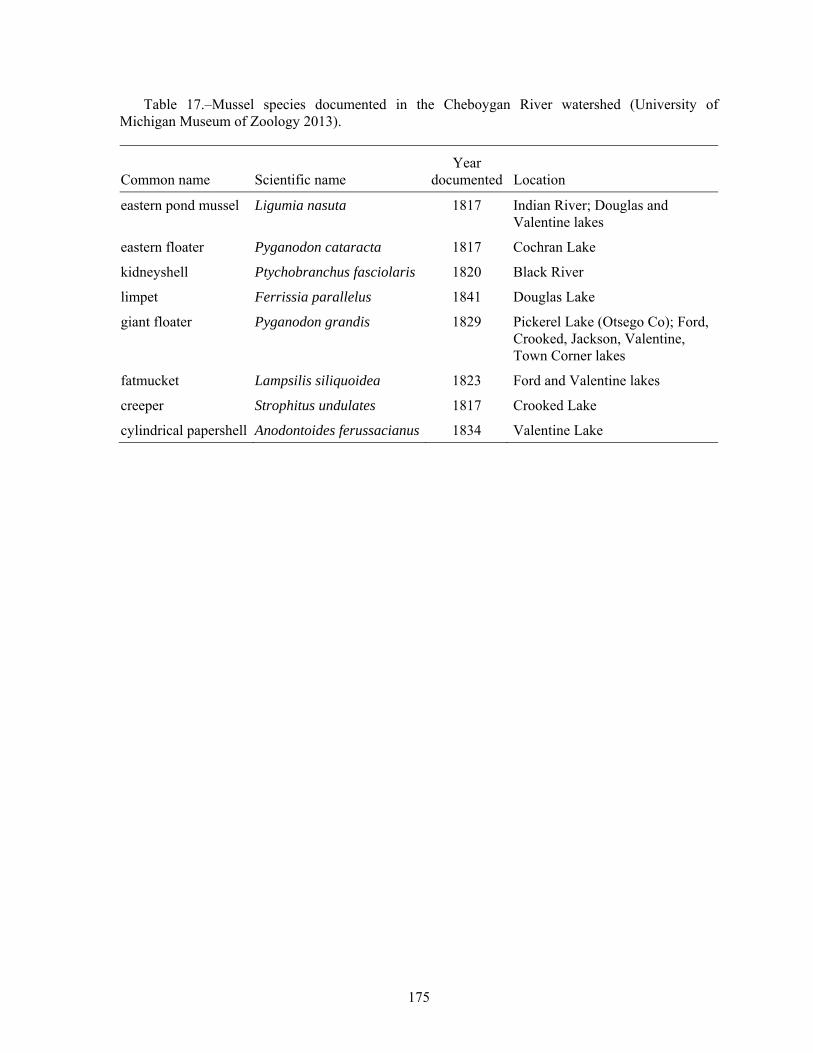
Table 17.–Mussel species documented in the Cheboygan River watershed (University of Michigan Museum of Zoology 2013).
Common name Scientific name Year
documented Location
eastern pond mussel Ligumia nasuta 1817 Indian River; Douglas and Valentine lakes
eastern floater Pyganodon cataracta 1817 Cochran Lake
kidneyshell Ptychobranchus fasciolaris 1820 Black River
limpet Ferrissia parallelus 1841 Douglas Lake
giant floater Pyganodon grandis 1829 Pickerel Lake (Otsego Co); Ford, Crooked, Jackson, Valentine, Town Corner lakes
fatmucket Lampsilis siliquoidea 1823 Ford and Valentine lakes
creeper Strophitus undulates 1817 Crooked Lake
cylindrical papershell Anodontoides ferussacianus 1834 Valentine Lake

176
Table 18a.–Aquatic invertebrates in the Black River subwatershed of the Cheboygan River watershed (modified from Walker 2008). X = present, dash (–) indicates not collected.
Taxa Bla
ck R
.–Tu
bbs C
k co
nflu
ence
Bla
ck R
.–B
lue
Lake
s Rd
E B
Bla
ck R
.–B
lue
Lake
s Rd
Bla
ck R
.–C
rock
ett
Rap
ids B
r
McM
aste
rs C
k–ne
ar
Cla
rk B
ridge
Rd
Bla
ck R
.–B
lack
R. R
d
Mill
igan
Ck–
Bra
dy R
d
Can
ada
Ck–
Can
ada
Ck
Hig
hway
Oxb
ow C
k–m
id
stat
ion
Tom
ahaw
k C
k–M
33
Hig
hway
Bow
en C
k–Bo
wen
Rd
Rai
nry
R.–
Alli
s H
ighw
ay
Littl
e R
ainy
R.–
One
M
ile H
ighw
ay
Ow
ens C
k–R
oss R
d
PORIFERA (sponges) – – – – X – – – X – – – X – PLATYHELMINTHES (flatworms)
Turbellaria – – – – – – – – – – – – – – BRYOZOA (moss animals) – – – – – X – – – – – – – – ANNELIDA (segmented worms)
Hirudinea (leeches) X – – – X – X – – – X – X X Oligochaeta (worms) X X X X X X X X – X X X – X
ARTHROPODA Arachnoidea
Hydracarina X – X X X X X X – – – X X – Crustacea
Amphipoda (scuds) – – X – X X – X X X – X X X Decapoda (crayfish) X X X X X X X X X X X X X X Isopoda (sowbugs) X X – X X X – – – – X – X X
Insecta Ephemeroptera (mayflies)
Baetiscidae X X X – – X – X – – – X – – Baetidae X X X X X X X X X X X X X X Caenidae X – X – – X – X – – – X X X Ephemerellidae X X X X – X – X X – – – – – Ephemeridae X X X X – X – X – – – – – – Heptageniidae X X X X X X X X X X X X X Isonychiidae X X X X – X X – – – – X – –

177
Table 18a.–Continued.
Taxa Bla
ck R
.–Tu
bbs C
k co
nflu
ence
Bla
ck R
.–B
lue
Lake
s R
d
E B
Bla
ck R
.–B
lue
Lake
s Rd
Bla
ck R
.–C
rock
ett
Rap
ids B
r
McM
aste
rs C
k–ne
ar
Cla
rk B
ridge
Rd
Bla
ck R
.–B
lack
R. R
d
Mill
igan
Ck–
Bra
dy R
d
Can
ada
Ck–
Can
ada
Ck
Hig
hway
Oxb
ow C
k–m
id
stat
ion
Tom
ahaw
k C
k–M
33
Hig
hway
Bow
en C
k–Bo
wen
Rd
Rai
nry
R.–
Alli
s H
ighw
ay
Littl
e R
ainy
R.–
One
M
ile H
ighw
ay
Ow
ens C
k–R
oss R
d
Leptophlebiidae – – – – – – X – X X – X – – Tricorythidae – – – – – – – – – – – – – –
Odonata Anisoptera (dragonflies)
Aeshnidae X X X X X X X X X X X X X X Cordulegastridae – X – – – X – X X X X – – – Gomphidae X X X X X X X X X X – X X –
Zygoptera (damselflies) Calopterygidae – X X X X X X X X X X X X X Coenagrionidae – – – – – – – – – – – – X – Lestidae – – – – – – – – – – – – – –
Plecoptera (stoneflies) Nemouridae – – – – – – – – – X – X – – Perlidae X – – X – X X X X – – X – – Perlodida X X – X – X X X – – – X – – Pteronarcyidae – – X X – – – – – – – – – –
Hemiptera (true bugs) Belostomatidae – – – – – – – – – – – – – – Corixidae X X X X X X – – – – – – – – Gerridae X – – X X X – X X X X X – X Mesoveliidae – – – – – – – – – – – – – – Nepidae – – – – – – – – – – – – – – Veliidae – X X X – X X – X X – X – X
Megaloptera Corydalidae (dobson flies) X X X X – X X X – X X X – X Sialidae (alder flies) – X – – – – – – – – X – – –

178
Table 18a.–Continued.
Taxa Bla
ck R
.–Tu
bbs C
k co
nflu
ence
Bla
ck R
.–B
lue
Lake
s Rd
E B
Bla
ck R
.–B
lue
Lake
s Rd
Bla
ck R
.–C
rock
ett
Rap
ids B
r
McM
aste
rs C
k–ne
ar
Cla
rk B
ridge
Rd
Bla
ck R
.–B
lack
R. R
d
Mill
igan
Ck–
Bra
dy R
d
Can
ada
Ck–
Can
ada
Ck
Hig
hway
Oxb
ow C
k–m
id
stat
ion
Tom
ahaw
k C
k–M
33
Hig
hway
Bow
en C
k–Bo
wen
Rd
Rai
nry
R.–
Alli
s H
ighw
ay
Littl
e R
ainy
R.–
One
M
ile H
ighw
ay
Ow
ens C
k–R
oss R
d
Trichoptera (caddisflies) Brachycentridae X X X X – X – X X – – – – – Glossosomatidae – X X – – – X – – – – X – – Helicopsychidae X X X X X X X X X X X X X – Hydropsychidae X X X X X X X X X X X X X X Hydroptilidae – – – – – – X – – – – – – – Lepidostomatidae – – X – – – – X X – X – – – Leptoceridae – X – X – X X X – – – – – – Limnephilidae X X X X X X X X X X X X X X Molannidae X – – – X – – X – X X – X – Philopotamidae – X – X – X X X X X – – – – Phryganeidae – – – – – – – – – – – – – – Polycentropodidae X X X X X X X X X – X – – X Psychomyiidae – – – – – – – – – – – – – – Uenoidae X X X – – X X X X X X X X –
Coleoptera (beetles) Dryopidae – – – – – – – – – – X X – – Dytiscidae (total) – – – – – X – – – X – – – X Elmidae – X X X X X X X X X X X X X Gyrinidae (larvae) – – – – – – – – – – – – – – Gyrinidae (adults) – X – – X – – – – – – – – – Haliplidae (larvae) – – – – – – – – – – – – – – Haliplidae (adults) – – – – – – – X – – – – – – Hydrophilidae (total) X – X – – X – X – – – X – – Psephenidae (larvae) – – – – – – – – – – – – – – Psephenidae (adults) – – – – – X – – – – – X – –

179
Table 18a.–Continued.
Taxa Bla
ck R
.–Tu
bbs C
k co
nflu
ence
Bla
ck R
.–B
lue
Lake
s Rd
E B
Bla
ck R
.–B
lue
Lake
s Rd
Bla
ck R
.–C
rock
ett
Rap
ids B
r
McM
aste
rs C
k–ne
ar
Cla
rk B
ridge
Rd
Bla
ck R
.–B
lack
R. R
d
Mill
igan
Ck–
Bra
dy R
d
Can
ada
Ck–
Can
ada
Ck
Hig
hway
Oxb
ow C
k–m
id
stat
ion
Tom
ahaw
k C
k–M
33
Hig
hway
Bow
en C
k–Bo
wen
Rd
Rai
nry
R.–
Alli
s H
ighw
ay
Littl
e R
ainy
R.–
One
M
ile H
ighw
ay
Ow
ens C
k–R
oss R
d
Diptera (flies) Athericidae X X – – – – – – – – – X – – Ceratopogonidae – – – X X X X – – X – X X X Chironomidea X X X X X X X X X X X X X X Culicidae – – – – – – – – – – – – – – Simuliidae X X X X – X X X X X X – X X Stratiomyidae – – – – X – – – – X – – – – Tabanidae X – – – X X – – – X – X X – Tipulidae X X X – – – X X – X X X – –
MOLLUSCA Gastropoda (snails)
Ancylidae (limpets) – – X – – – – – – – – – – – Lymnaeidae – X X – – – – – – – – – – – Physidae X X X – X X – X X X X – X – Planorbidae – – X – X – – – – – X – – – Plauronceridae – – – – – X – – – – – – – – Viviparidae – – – – X – – X – – – – – X
Pelecypoda (bivalves) Pisidiidae – X X – – X – X – – – – – X Sphaeriidae (clams) – X – X X – X X X – X X X – Unionidae (mussels) – – – – X – X – – – – – – –
Total Number of Taxa 33 37 36 31 30 42 31 38 27 29 27 34 25 22 Macroinvertebrate Community Ratinga EXC EXC EXC EXC ACC EXC EXC EXC EXC EXC ACC EXC ACC ACC
a ACC = acceptable; EXC = excellent

180
Table 18b.–Aquatic invertebrates in the Maple and Pigeon river subwatersheds of the Cheboygan River watershed (modified from Walker 2008). X = present, dash (–) indicates not collected.
Taxa Lape
rell
Ck–
La
pere
ll R
d
Mul
lett
Ck–
near
C
rum
p R
d
E B
Map
le R
.–D
ougl
as L
k R
d
Map
le R
.–M
aple
R. R
d
Map
le R
.–Ro
bins
on R
d
McP
hee
Ck–
Val
ley
Rd
Min
neha
ha C
k–Pi
cker
el L
k R
d
Littl
e Pi
geon
R.–
Si
lery
Rd
Pige
on R
.–M
68
Hig
hway
Pige
on R
.–W
ebb
Rd
Littl
e Pig
eon
R.–
Web
b Rd
Pige
on R
.–El
k H
ill
Cam
pgro
und
Pige
on R
.–St
urge
on
Val
ley
Rd
Pige
on R
.–O
ld
Van
derb
ilt R
d
Pige
on R
.–W
hite
hous
e Tr
ail
PORIFERA (sponges) – – X – X – – X – X – X X – – NEMATOMORPHA (roundworms) – – – – – X – – – – – – – – – PLATYHELMINTHES (flatworms)
Turbellaria – – – – – – – – – – – – X – – BRYOZOA (moss animals) – – – – – – – – X – – – – – – ANNELIDA (segmented worms)
Hirudinea (leeches) – – X X X – – X X – – X X – – Oligochaeta (worms) X X X X X X X – X X X X X X X
ARTHROPODA Arachnoidea
Hydracarina X – – X X – X X – X – X X X X Crustacea
Amphipoda (scuds) X – X X X – X X – – X X – – X Decapoda (crayfish) X – X – – – – X X X X X X – – Isopoda (sowbugs) – – X X X – X – – – – – X – –
Insecta Ephemeroptera (mayflies)
Baetiscidae – – X X X – – – – – X – X X – Baetidae X X X X X X X X X X X X X X X Caenidae – – X – – – – – – X X – – X X Ephemerellidae X – X X X – X – X X X X X X X Ephemeridae X – – X X – X – – – – X – X X Heptageniidae X X X X X X X X X X X X X X X

181
Table 18b.–Continued.
Taxa Lape
rell
Ck–
La
pere
ll R
d
Mul
lett
Ck–
near
C
rum
p R
d
E B
Map
le R
.–D
ougl
as L
k R
d
Map
le R
.–M
aple
R. R
d
Map
le R
.–Ro
bins
on R
d
McP
hee
Ck–
Val
ley
Rd
Min
neha
ha C
k–Pi
cker
el L
k R
d
Littl
e Pi
geon
R.–
Si
lery
Rd
Pige
on R
.–M
68
Hig
hway
Pige
on R
.–W
ebb
Rd
Littl
e Pig
eon
R.–
Web
b Rd
Pige
on R
.–El
k H
ill
Cam
pgro
und
Pige
on R
.–St
urge
on
Val
ley
Rd
Pige
on R
.–O
ld
Van
derb
ilt R
d
Pige
on R
.–W
hite
hous
e Tr
ail
Isonychiidae – – – X – – – X X X – X X – – Leptophlebiidae X – – X – – – – – – – X – – X Tricorythidae – – – – – – – – – – X X X X –
Odonata Anisoptera (dragonflies)
Aeshnidae X – X X X X – X X X X X X X – Cordulegastridae X – X – – X – X – – X – – – – Gomphidae – – – – X – – X X X X – X X X
Zygoptera (damselflies) Calopterygidae – – X X – – – X X X X X X – – Coenagrionidae – – X – – – – – X – – – – – – Lestidae – – – – – – – – – – – – – – –
Plecoptera (stoneflies) Leuctridae – X – – – – – – – – X – – X – Numouridae X X – – – X X – – – – – – X X Perlidae – – X X X – – X X X X X X X – Perlodida – X – X X – X – – – – – – – – Pteronarcyidae – – – X X – – – X – X – X X X
Hemiptera (true bugs) Belostomatidae – – – – – – – – X – – – – – – Corixidae – – X – X – – – X X – X X X X Gerridae X X X X X X X X – X X X X X X Mesoveliidae – – – – – – – – – X X X – X X Nepidae – – – – – – – – – – – – – – – Veliidae – – – – – – – – X – – – – – –

182
Table 18b.–Continued.
Taxa Lape
rell
Ck–
La
pere
ll R
d
Mul
lett
Ck–
near
C
rum
p R
d
E B
Map
le R
.–D
ougl
as L
k R
d
Map
le R
.–M
aple
R. R
d
Map
le R
.–Ro
bins
on R
d
McP
hee
Ck–
Val
ley
Rd
Min
neha
ha C
k–Pi
cker
el L
k R
d
Littl
e Pi
geon
R.–
Si
lery
Rd
Pige
on R
.–M
68
Hig
hway
Pige
on R
.–W
ebb
Rd
Littl
e Pig
eon
R.–
Web
b Rd
Pige
on R
.–El
k H
ill
Cam
pgro
und
Pige
on R
.–St
urge
on
Val
ley
Rd
Pige
on R
.–O
ld
Van
derb
ilt R
d
Pige
on R
.–W
hite
hous
e Tr
ail
Megaloptera Corydalidae (dobson flies) X – X X X – – – X X X X X X – Sialidae (alder flies) X X – – – X X – – X – X X X –
Neuroptera (spongilla flies) Sisyridae – – – – – – – – – – – – X – –
Trichoptera (caddisflies) Brachycentridae X – – X X – – X X X X X X X X Glossosomatidae X X X X X X – – X X – X – X – Helicopsychidae – – X – – – – – – X – X X X – Hydropsychidae X X X X X X X X X X X X X X X Hydroptilidae – – – – – – – – – – – – – – – Lepidostomatidae X X – X X X – – – – X – – – X Leptoceridae – – X X X X – X X X X X X X X Limnephilidae X X X X X X – X X X X X X X X Molannidae – – X X X – – – – – – – – – – Philopotamidae X X – X X X X X X – – – – X X Phryganeidae – – – – – – – – – X X – – – – Polycentropodidae – – – X X – – X – X X X – – – Psychomyiidae – – – – – – – – – – – – – – – Rhyacophilidae – X – – – X X – – – – – – – – Uenoidae – X X X X X – X X X – X X X –
Coleoptera (beetles) Dryopidae – – – – – – – X X – – – – X – Dytiscidae (total) – X X X X X – – X – – – X – –

183
Table 18b.–Continued.
Taxa Lape
rell
Ck–
La
pere
ll R
d
Mul
lett
Ck–
near
C
rum
p R
d
E B
Map
le R
.–D
ougl
as L
k R
d
Map
le R
.–M
aple
R. R
d
Map
le R
.–Ro
bins
on R
d
McP
hee
Ck–
Val
ley
Rd
Min
neha
ha C
k–Pi
cker
el L
k R
d
Littl
e Pi
geon
R.–
Si
lery
Rd
Pige
on R
.–M
68
Hig
hway
Pige
on R
.–W
ebb
Rd
Littl
e Pig
eon
R.–
Web
b Rd
Pige
on R
.–El
k H
ill
Cam
pgro
und
Pige
on R
.–St
urge
on
Val
ley
Rd
Pige
on R
.–O
ld
Van
derb
ilt R
d
Pige
on R
.–W
hite
hous
e Tr
ail
Elmidae X X X X X X – X X X X X X X X Gyrinidae (larvae) – – – – – – – – – – – – – – – Gyrinidae (adults) X – – – – – – – – – – – – – X Haliplidae (larvae) – – – – – – – – – – – – – – – Haliplidae (adults) – – X – – – – – – – X – – – – Hydrophilidae (total) X – – – – – – – X X – X X – X Psephenidae (larvae) – – – – – – – – – – – – – – –
Diptera (flies) Athericidae – – – – – X – – X X X X – – X Ceratopogonidae – – – X X – X X – – X – X – – Chironomidea X X X X X X X X X X X X X X X Culicidae – – – – – – – – – – – – – – – Dixidae – – – – – – – – X – – – – X X Simuliidae X X X X X X X X X X X X X X X Stratiomyidae – – – – – – – – – – – – – – – Tabanidae – – – – – – – – – – – X X X – Tipulidae X X X – X X X X – – – – – – X
MOLLUSCA Gastropoda (snails)
Ancylidae (limpets) – – X X – – – – – – – – – – – Lymnaeidae – – X – – – – – – – – – – – – Physidae X – X X X X – X X – X X X X X Planorbidae – – – – – – – – – – – – – – – Plauronceridae – – – – – – – – X X – X X – –

184
Table 18b.–Continued.
Taxa Lape
rell
Ck–
La
pere
ll R
d
Mul
lett
Ck–
near
C
rum
p R
d
E B
Map
le R
.–D
ougl
as L
k R
d
Map
le R
.–M
aple
R. R
d
Map
le R
.–Ro
bins
on R
d
McP
hee
Ck–
Val
ley
Rd
Min
neha
ha C
k–Pi
cker
el L
k R
d
Littl
e Pi
geon
R.–
Si
lery
Rd
Pige
on R
.–M
68
Hig
hway
Pige
on R
.–W
ebb
Rd
Littl
e Pig
eon
R.–
Web
b Rd
Pige
on R
.–El
k H
ill
Cam
pgro
und
Pige
on R
.–St
urge
on
Val
ley
Rd
Pige
on R
.–O
ld
Van
derb
ilt R
d
Pige
on R
.–W
hite
hous
e Tr
ail
Pomaiopsidae – – – – – – – – X – – – – – – Viviparidae – – X – – – – – – – – – – – –
Pelecypoda (bivalves) Pisidiidae X – X – – – X X X X – X X – X Sphaeriidae (clams) – – X X X X X – X X X X X X – Unionidae (mussels) – – – – – – – – – – – – – – –
Total Number of Taxa 29 20 38 37 37 25 21 29 38 35 34 39 40 36 31 Macroinvertebrate Community Ratinga EXC EXC ACC EXC EXC EXC ACC EXC EXC EXC EXC EXC EXC EXC EXC
a ACC = acceptable; EXC = excellent

185
Table 18c.–Aquatic invertebrates in the Sturgeon River subwatershed of the Cheboygan River watershed (modified from Walker 2008). X = present, dash (–) indicates not collected.
Taxa Stur
geon
R.–
Fish
er
Woo
ds R
d
Stur
geon
R.–
Rond
o Rd
Stur
geon
R.–
Cor
nwal
l G
rade
Can
oe A
cces
s
Stur
geon
R.–
Stur
geon
V
alle
y R
d
Stur
geon
R.–
Po
quet
te R
d
Clu
b St
ream
–Fo
ntin
alis
Rd
Littl
e St
urge
on R
.–C
rum
ley
Ck
Rd
W B
r Stu
rgeo
n R
.–Sh
ire R
d
W B
r Stu
rgeo
n R
.–M
acG
rego
r Rd
PORIFERA (sponges) – – – – – – – – – PLATYHELMINTHES (flatworms)
Turbellaria – – – – – – – – BRYOZOA (moss animals) – – – – – – – – – ANNELIDA (segmented worms)
Hirudinea (leeches) – – – – – – – – – Oligochaeta (worms) X X X – X – X X –
ARTHROPODA Arachnoidea
Hydracarina X X X X X X – X X Crustacea
Amphipoda (scuds) X X X X – X X X X Decapoda (crayfish) X X X – – X – – X Isopoda (sowbugs) X X X – X X – X –
Insecta Ephemeroptera (mayflies)
Baetiscidae – – – X X – – X – Baetidae X X X X X X X X X Caenidae – – X – – – X – X Ephemerellidae X X X X X X X X X Ephemeridae – – X X X X X X X Heptageniidae X X X X X X X – X Isonychiidae X X – – – X – – X Leptophlebiidae – – – – X – X – X Tricorythidae X – – – – X – – X
Odonata Anisoptera (dragonflies)
Aeshnidae X X X – – X X X X Cordulegastridae X X – – – – X X X Gomphidae – – – – – – – – X
Zygoptera (damselflies) Calopterygidae X – X X – X X X X Coenagrionidae – – – – – – – – – Lestidae – – – – – – – – –
Plecoptera (stoneflies) Leuctridae – – – – – – X X – Nemouridae – – – X X – X X – Perlidae X X X – – X X – –

186
Table 18c.–Continued.
Taxa Stur
geon
R.–
Fish
er
Woo
ds R
d
Stur
geon
R.–
Rond
o Rd
Stur
geon
R.–
Cor
nwal
l G
rade
Can
oe A
cces
s
Stur
geon
R.–
Stur
geon
V
alle
y R
d
Stur
geon
R.–
Po
quet
te R
d
Clu
b St
ream
–Fo
ntin
alis
Rd
Littl
e St
urge
on R
.–C
rum
ley
Ck
Rd
W B
r Stu
rgeo
n R
.–Sh
ire R
d
W B
r Stu
rgeo
n R
.–M
acG
rego
r Rd
Perlodida X X X X X – – – X Pteronarcyidae – – – – X – X X –
Hemiptera (true bugs) Belostomatidae – – – – – – – – – Corixidae – – X – – – – X – Gerridae X X X X X X X X X Mesoveliidae – – – – – – – – – Nepidae – – – – – – – – – Pleidae X – – – – – – – – Veliidae – – – – X X – – –
Megaloptera Corydalidae (dobson flies) X X X X – X X X X Sialidae (alder flies) X – X – – – – – –
Trichoptera (caddisflies) Brachycentridae X X X X X X X X X Glossosomatidae X X X – – X – X X Helicopsychidae X X X – – – – – X Hydropsychidae X X X X X X X X X Hydroptilidae – – – – – – – – – Lepidostomatidae X X X X X X – X X Leptoceridae X – X – – X – – X Limnephilidae X X X X X X X X X Molannidae – – – – – – – – – Philopotamidae – X X – X X X X X Phryganeidae – – – – X – – X – Polycentropodidae X X X X X – X – X Psychomyiidae – – – – – – – – – Uenoidae X X X – – X X X –
Coleoptera (beetles) Dryopidae – X – X – – – – – Dytiscidae (total) – – – – – – – – – Elmidae X X X – – X – X X Gyrinidae (larvae) – – – X – – – – – Gyrinidae (adults) – – – – – – – – – Haliplidae (larvae) – – – – – – – – – Haliplidae (adults) X – – – – – – – – Hydrophilidae (total) – – X X X X X X X Psephenidae (larvae) – – – – – – – – –
Diptera (flies) Athericidae X X – X X X – X X

187
Table 18c.–Continued.
Taxa Stur
geon
R.–
Fish
er
Woo
ds R
d
Stur
geon
R.–
Rond
o Rd
Stur
geon
R.–
Cor
nwal
l G
rade
Can
oe A
cces
s
Stur
geon
R.–
Stur
geon
V
alle
y R
d
Stur
geon
R.–
Po
quet
te R
d
Clu
b St
ream
–Fo
ntin
alis
Rd
Littl
e St
urge
on R
.–C
rum
ley
Ck
Rd
W B
r Stu
rgeo
n R
.–Sh
ire R
d
W B
r Stu
rgeo
n R
.–M
acG
rego
r Rd
Ceratopogonidae – – – X X – X X – Chironomidea X X X X X X X X X Culicidae – – – – – – – – – Simuliidae X X X X X X X X – Stratiomyidae – – – – – – – – – Tabanidae – – X – X – X X – Tipulidae – – – – – X – – –
MOLLUSCA Gastropoda (snails)
Ancylidae (limpets) – – – – – – – – – Lymnaeidae – – – – – – – – – Physidae X X X X – – – X X Planorbidae – – – – – – X – – Plauronceridae – – – – – – – – – Viviparidae – – – – – – – – –
Pelecypoda (bivalves) Pisidiidae – X X – X – – X – Sphaeriidae (clams) X – – X – – – X – Unionidae (mussels) – – – – – – – – –
Total Number of Taxa 35 31 35 26 28 30 29 35 32 Macroinvertebrate Community Ratinga EXC EXC EXC EXC EXC EXC EXC EXC ACC
a ACC = acceptable; EXC = excellent

188
Table 19.–Amphibian and reptile species found in counties of the Cheboygan River watershed (Holman et al. 1993, Harding and Holman 1992, and Harding and Holman 1990). Threatened (T) and Special Concern (SC) species are noted. O = Otsego, M = Montmorency, V = Charlevoix, C = Cheboygan, and P = Presque Isle.
Common name Scientific name O M V C P
Frogs and Toads eastern American toad Bufo americanus americanus X X X X Xeastern gray tree frog Hyla versicolor X X X X Xnorthern spring peeper Pseudacris crucifer crucifer X X X X Xwestern chorus frog Pseudacris triseriata triseriata X X X X Xbull frog Rana catesbeiana X X X X Xgreen frog Rana clamitans melanota X X X X Xpickerel frog Rana palustris X X X X Xnorthern leopard frog Rana pipiens X X X X Xwood frog Rana sylvatica X X X X X
Salamanders blue-spotted salamander Ambystoma laterale X X X X Xspotted salamander Ambystoma maculatum X X X X Xeastern tiger salamander Ambystoma tigrinum tigrinum X X four-toed salamander Hemidactylium scutatum X X X X Xmudpuppy Necturus maculosus maculosus X X X X Xeastern newt-central subspecies Notophthalmus viridescens louisianensis X X X X Xred-backed salamander Plethodon cinereus X X X X X
Snakes and lizards northern ringneck snake Diadophis punctatus edwardsi X X X X Xfive-lined skink Eumeces fasciatus X X X X Xeastern hognose snake Heterodon platirhinos X X X X Xblue racer Coluber constrictor X eastern milk snake Lampropeltis tringulum triangulum X X X X Xnorthern water snake Nerodia sipedon sipedon X X X X Xeastern smooth green snake Opheodrys vernalis vernalis X X X X Xeastern massasauga rattlesnake (SC) Sistrurus catenatus catenatus X X X X Xbrown snake Storeria dekayi X X X X Xnorthern red-bellied snake Storeria occipitomaculate occipitomaculate X X X X Xnorthern ribbon snake Thamnophis sauritus septentrionalis X X X X Xeastern garter snake Thamnophis sirtalis sirtalis X X X X X
Turtles snapping turtle Chelydra serpentine X X X X Xpainted turtle Chrysemys picta X X X X Xwood turtle (SC) Clemmys insculpta X X X X XBlanding’s turtle (SC) Emydoidea blandingii X X X X Xcommon musk turtle Sternotherus odoratus X X X X X

189
Table 20.–Breeding bird species associated with wetland habitats—Otsego, Montmorency, Emmet, Cheboygan, and Presque Isle counties, MI (Doepker et al. 2001). SC = special concern, T = threatened, E = endangered.
Common name Scientific name
Gaviidae (loons)
Common loon (T) Gavia immer
Colymbidae (grebes)
Pied-billed grebe Podilymbus podiceps
Phalacrocoracidae (cormorants)
Double-crested cormorant Phalacrocorax auritus
Ardeidae (herons) Great blue heron Ardea herodias Green-backed heron Butorides striatus American bittern Botaurus lentiginosus Least bittern (SC) Ixobrychus exilis Black-crowned night heron (SC) Nycticorax nycticorax Greater egret Casmerodius albus
Anatidae (swans, geese and ducks) Canada goose Branta canadensis Mallard Anas platyrhynchos American black duck Anas rubripes Blue winged teal Anas discors Green winged teal Anas crecca Gadwall Anas streperas Wood duck Aix sponsa Ring-necked duck Aythya collaris Common goldeneye Bucephala clangula Hooded merganser Lophodytes cucullatus Common merganser Mergus merganser Red-breasted merganser Mergus serrator
Charadriidae (plovers) Piping plover (E) Charadrius melodus
Laridae (gulls and terns) Herring gull Larus argentatus Ring-billed gull Larus dealawarensis Black tern (SC) Chlidonias niger Caspian tern (T) Sterna caspia Common tern (T) Sterna hirundo
Accipitridae (hawks and eagles) Cooper’s hawk Accipiter cooperii Red-tailed hawk Buteo jamaicensis Red-shouldered hawk (T) Buteo lineatus Bald eagle (T) Haliaeetus Ieucicephalus Northern harrier (SC) Circus cyaneus
Pandionidae (ospreys) Osprey (T) Pandion haliaetus

190
Table 20.–Continued.
Common name Scientific name
Falconidae (falcons) Merlin (T) Falco columbarius
Tetraonidae (grouse) Ruffed grouse Bonasa umbellus
Gruidae (cranes) Sandhill crane Grus canadensis
Rallidae (rails) Virginia rail Rallus limicola Sora Porzana carolina American coot Fulica americana Common moorhen (SC) Gallinula chloropus
Charadriidae (plovers) Killdeer Charadrius vociferus
Scolopacidae (sandpipers) American woodcock Scolopax minor Common snipe Gallinago gallinago Spotted sandpiper Actitis macularia Upland sandpiper Bartramia longicauda
Cuculidae (cuckoos) Yellow-billed cuckoo Coccyzus americanus Black-billed cuckoo Coccyzus erythropthalmus
Tytonidae (barn owls) Great horned owl Bubo virginianus Barred owl Strix varia Long-eared owl (E) Asio otus Northern saw-shet owl Aegolius acadicus Eastern screech-owl Otus asio Common nighthawk Chordeiles minor
Trochilidae (hummingbirds)
Ruby-throated hummingbird Archilochus colubris
Alcedinidae (kingfishers) Belted kingfisher Ceryle alcyon
Picidae (woodpeckers) Red-bellied woodpecker Melanerpes carolinus Downy woodpecker Picoides pubescens Hairy woodpecker Picoides villosus Black-backed woodpecker Picoides arcticus Pileated woodpecker Dryocopus pileatus
Tyrannidae (flycatchers) Olive-sided flycatcher Contopus cooperi Alder flycatcher Empidonax alnorum Willow flycatcher Empidonax traillii Great crested flycatcher Myiarchus crinitus Eastern kingbird Tyrannus tyrannus

191
Table 20.–Continued.
Common name Scientific name
Alaudidae (larks) Tree swallow Tachycineta bicolor Bank swallow Riparia riparia Barn swallow Hirundo rustica Cliff swallow Petrochelidon pyrrhonota Purple martin Progne subis Northern rough-winged swallow Stelgidopteryx serripennis
Paridae (titmice) Black-capped chickadee Poecile atricapillus Tufted titmouse Baeolophus bicolor
Sittidae (nuthatches) Red-breasted nuthatch Sitta canadensis
Certhiidae (creepers) Brown creeper Certhia americana
Troglodytidae (wrens) House wren Troglodytes aedon Winter wren Troglodytes troglodytes Carolina wren Thryothorus ludovicianus Sedge wren Cistothorus platensis Marsh wren (SC) Cistothorus palustris
Mimidae (mockingbirds/thrashers) Gray catbird Dumetella carolinensis
Turdidae (thrushes) American robin Turdus migratorius Wood thrush Hylocichla mustelina Swainson’s thrush Catharus ustulatus Veery Catharus fuscescens
Sylviidae (gnatcatchers/kinglets) Blue-gray gnatcatcher Polioptila caerulea Golden-crowned kinglet Regulus satrapa Ruby-crowned kinglet Regulus calendulas
Bombycillidae (waxwings) Cedar waxwing Bombycilla cedrorum
Vireonidae (vireos) Yellow-throated vireo Vireo flavifrons Philadelphia vireo Vireo philadelphicus Red-eyed vireo Vireo olivaceus
Parulidae (warblers) Northern parula Parula americana Nashville warbler Vermivora ruficapilla Yellow warbler Dendroica petechia Yellow-rumped warbler Dendroica coronata Cape May warbler Dendroica tigrina Black-and-white warbler Mniotilta varia American redstart Setophaga ruticilla

192
Table 20.–Continued.
Common name Scientific name
Northern waterthrush Seiurus noveboracensis Mourning warbler Oporornis philadelphia Connecticut warbler Oporornis agilis Common yellowthroat Geothlypis trichas
Fringillidae (Finches, sparrows, buntings) Northern cardinal Cardinalis cardinalis Red crossbill Loxia curvirostra Rose-breasted grosbeak Pheucticus ludovicianus Savannah sparrow Passerculus sandwichensis Henslow’s sparrow (SC) Ammodramus henslowii Song sparrow Melospiza melodia Lincoln’s sparrow Melospiza lincolnii Swamp sparrow Melospiza georgiana White-throated sparrow Zonotrichia albicollis
Icteridae (blackbirds and orioles) Red-winged blackbird Agelaius phoeniceus Brewer’s blackbird Euphagus cyanocephalus Common grackle Quiscalus quiscula
Northern oriole Icterus galbula
Ploceidae (finches) Purple finch Carpodacus purpureus Pine siskin Carduelis pinus

193
Table 21.–Mammals in the Cheboygan River watershed (Baker 1983). Threatened (T) and special concern (SC) species are noted.
Common name Scientific name
Marsupiala (pouched mammals)
opossum Didelphis virginiana
Insectivora (shrews,moles, and allies) eastern mole Scalopus aquaticus starnose mole Condylura cristata masked shrew Sorex cinereus pygmy shrew Sorex hoyi water shrew Sorex palustris shorttail shrew Blarina brevicauda
Chiroptera (bats and flying mammals) little brown myotis Myotis lucifugus silver-haired bat Lasionycteris noctivagans big brown bat Eptesicus fuscus red bat Lasiurus borealis hoary bat Lasiurus cinereus
Lagamorpha (rabbits, hares and picas) snowshoe hare Lepus americanus eastern cottontail Sylvilagus floridanus
Rodentia (rodents) eastern chipmunk Tamias striatus woodchuck Marmota monax thirteen-lined ground squirrel Spermophilus tridecemlineatus eastern gray squirrel Sciurus carolinensis eastern fox squirrel Sciurus niger red squirrel Tamiasciurus hudsonicus northern flying squirrel Glaucomys sabrinus American beaver Castor canadensis white-footed mouse Peromyscus leucopus deer mouse Peromyscus maniculatus meadow vole Microtus pennsylvanicus southern red-backed vole Clethrionomys gapperi woodland vole (SC) Microtus pinetorum muskrat Ondatra zibethicus southern bog lemming Synaptomys cooperi Norway rat Rattus norvegicus house mouse Mus musculus meadow jumping mouse Zapus hudsonius woodland jumping mouse Napaeozapus insignis porcupine Erethizon dorsatum
Carnivora (flesh eaters) coyote Canis latrans red fox Vulpes vulpes gray fox Urocyon cinereoargenteus black bear Ursus americanus raccoon Procyon lotor

194
Table 21.–Continued.
Common name Scientific name
American marten (T) Martes americana ermine Mustela erminea long-tailed weasel Mustela frenata least weasel Mustela nivalis mink Mustela vison American badger Taxidea taxus striped skunk Mephitis mephitis river otter Lutra canadensis bobcat Lynx rufus
Artiodactyla (even-toed ungulates) eastern elk Cervus elaphus whitetail deer Odocoileus virginianus

195
Table 22.–Natural features in the Cheboygan River watershed. Status codes: E = endangered; T = threatened; SC = Special Concern. Blanks occur when none of the status categories apply. Michigan Department of Natural Resources, Natural Features Inventory, unpublished data.
Common name Scientific name State status
Vertebrate lake sturgeon Acipenser fulvescens T Northern goshawk Accipiter gentiles SC Grasshopper sparrow Ammodramus savannarum SC Red-shouldered hawk Buteo lineatus T Black tern Chlidonias niger SC lake herring Coregonus artedi T Blanding’s turtle Emydoidea blandingii SC Common loon Gavia immer T wood turtle Glyptemys insculpta SC Bald eagle Haliaeetus leucocephalus T woodland vole Microtus pinetorum SC pugnose shiner Notropis anogenus SC Osprey Pandion haliaetus T channel darter Percina copelandi E King rail Rallus elegans E eastern massasauga Sistrurus catenatus catenatus SC
Invertebrate secretive locust Appalachia arcana SC spike-lip crater Appalachina sayanus SC dusted skipper Atrytonopsis hianna T slough grass Beckmannia syzigachne T Hungerford’s crawling water beetle Brychius hungerfordi E watercress snail Fontigens nickliniana SC splendid clubtail Gomphus lineatifrons SC Henry’s elfin Incisalia henrici SC three-striped oncocnemis Oncocnemis piffardi SC three-horned moth Pachypolia atricornis SC eastern flat-whorl Planogyra asteriscus SC aquatic snail Planorbella smithi SC red-legged spittlebug Prosapia ignipectus SC grizzled skipper Pyrgus Wyandot SC Douglas stenelmis riffle beetle Stenelmis douglasensis SC Lake Huron locust Trimerotropis huroniana T
Vascular Plant pale agoseris Agoseris glauca T round-leaved orchis Amerorchis rotundifolia E lake cress Armoracia lacustris T goblin moonwort Botrychium mormo T Pumpelly’s brome grass Bromus pumpellianus T large water-starwort Callitriche heterophylla T fairy-slipper Calypso bulbosa T

196
Table 22.–Continued.
Common name Scientific name State status
Hill’s thistle Cirsium hillii SC Pitcher’s thistle Cirsium pitcheri T ram’s head lady’s slipper Cypripedium arietinum SC false violet Dalibarda repens T English sundew Drosera anglica SC early hairstreak Erora laeta SC rough fescue Festuca scabrella T limestone oak fern Gytmnocarpium robertianum T whiskered sunflower Helianthus hirsutus SC bayonet rush Juncus militaris T Michigan monkey flower Mimulus michiganensis E bog bluegrass Poa paludigena T Hill’s pondweed Potamogeton hillii T sloe plum Prunus alleghaniensis SC blunt-lobed woodsia Woodsia obtuse T
Plant community dry-mesic northern forest intermittent wetland northern fen pine barrens
Other features Great blue heron rookery lichen Menegazzia terebrata

197
Table 23.–Fish stocking, by county, in the Cheboygan River watershed, 1979–2007. Data from Michigan Department of Natural Resources, Fisheries Division records. Includes known private fish stockings and rearing marsh plants.
County Number stocked Location Species Years in period
Charlevoix Hoffman Lake walleye 93–94 2,800 Thumb (Louise) Lake lake trout 79–80 20,000
rainbow trout 89, 07 44,068 splake 81–06 512,870 Cheboygan
Black Lake lake sturgeon 82–84, 88 11,512 walleye 89–93 50,650 Black River lake sturgeon 01–03, 05–07 16,668 Burt Lake atlantic salmon 86 38 lake sturgeon 83–84, 90 13,543 rainbow trout 87 194,963 walleye 89–93 88,976 Cheboygan River brown trout 88 10,000 chinook salmon 03–07 410,766 lake trout 01 115,425 rainbow trout 80–07 488,600 Cornwall Impoundment tiger musky 79–91 (alt yrs) 4,850 Douglas Lake northern pike 79–80, 82–86, 88–89,
93–97, 99–04 425,682 Hemlock Lake brook trout 07 295 brown trout 82 148 rainbow trout 92 600 Indian River muskellunge 89–93, 96–97 69,320 Little Sturgeon River brook trout 79–81, 83, 85, 88–99,
03–07 26,135 brown trout 92–99, 03–07 6,363 rainbow trout 79–83, 85, 89–99, 03–07 41,953 Long Lake walleye 79–86, 89–93, 97, 98,
00–01, 03, 05 869,655 Mullett Lake brown trout 89, 91 60,000 lake sturgeon 83–84, 90, 03, 05–07 18,007 lake trout 79–87, 96–98 663,900 rainbow trout 87, 89, 92, 07 76,258 splake 87–88, 90–95 424,075 walleye 99–03 413,870 Roberts Lake hybrid sunfish 86 14,000 Silver Lake rainbow trout 79–07 158,709 Sturgeon River lake sturgeon 03, 05–07 4,338 rainbow trout 79–93 213,757 Twin Lakes 2, 3, 4, 5 splake 82–88, 90–93 69,490 Weber Lake brook trout 79–81, 83–87 18,140
brown trout 88–07 50,990

198
Table 23.–Continued.
County Number stocked Location Species Years in period
Emmet Crooked Lake brown trout 88 127,410 walleye 79–81, 84–86, 88–91, 94,
96, 98–00, 03–06 603,025 East Branch Maple River brook trout 83–84 890 Four Lakes brook trout 94-95 2,250 rainbow trout 95 250 Maple River brook trout 79, 86, 07 937 brown trout 81-83 21,000 Pickerel Lake walleye 81-85, 89, 94, 96, 98, 00,
04, 06 188,425 Round Lake walleye 91, 95-96, 98 75,800 Silver Creek Pond brook trout 81-85 2,250
rainbow trout 79-85, 88, 90-94 17,300 Montmorency
Clear Lake rainbow trout 79-86, 89 59,300 splake 88, 90-97, 99-07 139,540 Foch Lakes largemouth bass 79 920 Lake Geneva bluegill 05, 07 750 hybrid sunfish 05 325 Town Corner Lake brown trout 83 102 Wildfowl Lake bluegill 05, 07 750 hybrid sunfish 05 325
Otsego Big Lake walleye 88, 91-05 (alt yrs) 98,000 Club Creek brook trout 91, 98-99, 03-07 3,900 rainbow trout 90-07 14,545 Ford Lake brown trout 82, 92 1,275 rainbow trout 07 590 Lost Lake brook trout 82, 85 770 North Twin Lake brown trout 82, 92 600 Pickerel Lake rainbow trout 79-07 82,022 Pigeon River brook trout 84 23,300 Section Four Lake brook trout 82, 85, 07 660 brown trout 92 300 South Twin lake brown trout 82, 92 518 Storey Lake rainbow trout 03, 04 290 West Lost Lake brook trout 82, 85 750
rainbow trout 92, 07 570 Presque Isle
Bear Den Lake brook trout 05-07 4,590 rainbow trout 04-07 8,514 Little Tomahawk Lake brook trout 88 3,500

199
Table 23.–Continued.
County Number stocked Location Species Years in period
Presque Isle–continued Rainy Lake bluegill 79 700 fathead minnow 79 17,250
rainbow trout 80 1,200 walleye 99 1,400 yellow perch 79 700
Shoepac Lake brook trout 81, 84-88 13,694 brown trout 88-93 20,774 rainbow trout 79, 81-86 14,150

200
Table 24.–Trout stream fishing regulations by type (Anonymous 2010). LP = Lower Peninsula; UP = Upper Peninsula.
Minimum size limit (in) Daily Brook Brown Rainbow trout Lake Coho, Chinook, Atlantic
Type Open season Possession season Tackle possession limit trout trout (steelhead) Splake trout & pink salmon salmon
1 Last Sat in April – Sept 30
Last Sat in April–Sept 30
All 5/3 a 8 LP 8 LP 10 8 24 10 15
7 UP 7 UP
2 Last Sat in April – Sept 30
Last Sat in April–Sept 30
All 5/3 a 10 12 12 10 24 10 15
3 All year All year All 5/3 a 15 15 15 15 24 10 15
4 All year brown trout, All 5/3 a 8 10 10 10 24 10 15 brook trout, & Atlantic salmon: Last Sat in April–
Sept 30
Other trout species all year
a Five fish, with no more than three fish 15 inches or larger, and no more than one Atlantic salmon. NOTE: It is unlawful to fish for any species or possess fishing devices along a stream closed to fishing.

201
Table 25.–Trout lake regulations by type.
Minimum size limit (in) Daily Brook Brown trout, rainbow Lake Coho, Chinook, Atlantic
Type Open season Possession season Tackle possession limit trout trout, & splake trout & pink salmon salmon
A Last Sat. in April – Sept. 30
Last Sat. in April – Sept. 30
All except minnows 5/3a 10 12 15 10 15
B All year All year All 5/3a 10 12 15 10 15
C All year All year All 5/3a 8 8 8 10 15
D Last Sat. in April – Sept. 30
Last Sat. in April – Sept. 30
Artificial lures onlyb 1 15 15 15 10 15
E All year All year All 3c 15 15 15 10 15
F All year Lake trout All 5/3/2d 10 10 10 10 10 May 1 – Labor Day Other trout species
all year
a Five fish, with no more than three fish 15 inches or larger, and no more than one Atlantic salmon. b On Type D lakes only artificial lures may be used. It is unlawful to use or possess live bait, dead or preserved bait, organic or processed food,
or scented material on any of the waters or on shore. c No more than one Atlantic salmon. d Daily harvest limits: five in any combination, no more than three fish of any one species, except Lake trout and Splake. For Lake trout and
Splake – two fish. NOTE: It is unlawful to fish for any species or possess fishing devices along a stream closed to fishing.

202
This page was intentionally left blank.

203
REFERENCES
Aiello, C. 2006. Michigan Water Chemistry Monitoring, Great Lakes Tributaries, 2004 Report. MDEQ Report Number MI/DEQ/WB-06/045.
Albert, D.S., S.R. Denton, and B.V. Barnes. 1986. Regional landscape ecosystems of Michigan. School of Natural Resources, University of Michigan, Ann Arbor.
Alexander, G.R., J.L. Fenske, and D.W. Smith. 1995. A fisheries management guide to stream protection and restoration. Michigan Department of Natural Resources Fisheries Special Report 15, Ann Arbor.
Alexander, G.R., and E.A. Hansen. 1983. Effects of sand bedload sediment on a brook trout population. Michigan Department of Natural Resources Fisheries Research Report 1906, Ann Arbor.
Alexander, G.R., and E.A. Hansen. 1986. Sand bed load in a brook trout stream. North American Journal of Fisheries Management 6:9-23.
Alexander, G.R., and J.R. Ryckman. 1986. Effect of an abnormal discharge of sediment from the Lansing Club Impoundment on the trout population in the Pigeon River, Otsego and Cheboygan Counties, Michigan. Michigan Department of Natural Resources Technical Report 86-8, Ann Arbor.
Anonymous. 1884. Letter to editor. Am. Angler 6 (10):154.
Anonymous. 1885. Letter to editor. Am. Angler 7 (3):43.
Anonymous. 1897. Letter to editor. Recreation 7 (1):58.
Anonymous. 1973. A Concept of Management for the Pigeon River Country. Michigan Department of Natural Resources, Forestry Division, Lansing, Michigan.
Anonymous. 1988. Michigan’s Blue Ribbon Trout Streams. Michigan Department of Natural Resources, Fisheries Division, Lansing.
Anonymous. 1996. Mercury pollution prevention in Michigan. Michigan Department of Environmental Quality, Office of the Great Lakes, Lansing.
Anonymous, 1997. A guide to public rights on Michigan waters. Michigan Department of Natural Resources, Law Enforcement Division, Report Number 9, Lansing.
Anonymous. 2000. Michigan stream classification: 1967 system. Chapter 20 in Schneider, James C. (ed.) 2000. Manual of fisheries survey methods II: with periodic updates. Michigan Department of Natural Resources, Fisheries Special Report 25, Ann Arbor.
Anonymous 2010. 2010 Michigan Fishing Guide. Michigan Department of Natural Resources, Lansing, Michigna.

204
Bailey, R.M., W.C. Latta, and G.R. Smith. 2004. An atlas of Michigan fishes with keys and illustrations for their identification. Museum of Zoology, University of Michigan, Miscellaneous Publication No. 192. Data were acquired through a digital transfer of ArcGIS coverage Version 8.2 from original source.
Bailey, R.M., and G.R. Smith. 1981. Origin and geography of the fish fauna of the Laurentian Great Lakes basin. Canadian Journal of Fish and Aquatic Science 38: 1539-1561.
Bain, M.B, J.T. Finn, and H.E. Booke. 1988. Streamflow regulation and fish community structure. Ecology: 69(2):382-392.
Baker, J.P. 1980. The distribution, ecology, and management of the lake sturgeon (Acipenser fulvescens Rafinesque) in Michigan. Michigan Department of Natural Resources, Fisheries Research Report 1883, Ann Arbor, Michigan, USA.
Baker, M.E., M.J. Wiley, and P.W. Seelbach. 2003a. GIS-based models of potential groundwater loading in glaciated landscapes: considerations and development in Lower Michigan. Michigan Department of Natural Resources Fisheries Division Research Report Number 2064, Ann Arbor.
Baker, M.E., M.J. Wiley, P.W. Seelbach, and M.L. Carlson. 2003b. A GIS model of subsurface water potential for aquatic resource inventory, assessment, and environmental management. Environmental Management 32: 706-719.
Baker, R.H. 1983. Michigan mammals. Michigan State University, East Lansing.
Becker, G.C. 1983. Fishes of Wisconsin. University of Wisconsin Press. Madison.
Bedient, P.B., and W.C. Huber. 1992. Hydrology and floodplain analysis. Addison-Wesley Publishing Company, Reading, Massachusetts.
Booth, D.B. 1991. Urbanization and the natural drainage system - impacts, solutions, and prognoses. The Northwest Environmental Journal 7:93-118.
Borgeson, D.P. 1974. Michigan sport fishing regulations. Pages 67–74 in Michigan Fisheries Centennial Report 1873-1973. Michigan Department of Natural Resources, Fisheries Management Report 6, Ann Arbor.
Bovee, K.D., T. Newcomb, and T.G. Coon. 1994. Relations between habitat variability and population dynamics of bass in the Huron River, Michigan. U.S. Department of the Interior, National Biological Survey, Washington D.C., Biological Report 21, Washington.
Brenden, T.O., R.D. Clark, Jr., A.R. Cooper, P.W. Seelbach, L. Wang, S.S. Aichele, E.G. Bissell, and J.S. Stewart. 2006. A GIS framework for collecting, managing, and analyzing multi-scale landscape variables across large regions for river conservation and management. Pages 49-74 in R.M. Hughes, L. Wang, and P. W. Seelbach, editors. Influences of landscapes on stream habitats and biological assemblages. American Fisheries Society, Symposium 48, Bethesda, Maryland.
Brooks, K.N., P.F. Ffolliott, H.M. Gregersen, J.L. Thames. 1991. Hydrology and the management of watershed. Ames, Iowa, Iowa State University Press.
Burroughs, B.A. 2007. Effects of dam removal on fluvial geomorphology and fish. Doctoral dissertation. Michigan State University, East Lansing.

205
Cattanéo, F., N. Lamouroux, P. Breil, and H. Capra. 2002. The influence of hydrological and biotic processes on brown trout (Salmo trutta) population dynamics. Canadian Journal of Fisheries and Aquatic Sciences 59:12-22.
Cleland, C.E. 1982. The inland shore fishery of the northern Great Lakes: its development and importance in prehistory. American Antiquity 47:761-784.
Coon, T.C. 1987. Responses of benthic riffle fishes to variation in stream discharge and temperature. Pages 77-85 in W. J. Mathews and D. C. Heins, editors. Community and evolutionary ecology of North American stream fishes. University of Oklahoma Press, Norman.
Coscarelli, M., and E. Bankard. 1999. Aquatic nuisance species handbook for government officials. Michigan Department of Environmental Quality, Office of the Great Lakes, Lansing.
Curless, W.W. 1973. A post-impoundment investigation of the fishes in Lake Kathleen, Emmet County, Michigan. University of Michigan Biological Station, Pellston.
Cushman, R.M. 1985. Review of ecological effects of rapidly varying flows downstream from hydroelectric facilities. North American Journal of Fisheries Management 5:330-339.
Cwalinski, T.A. 2004. Douglas Lake, Cheboygan County. Status of the Fishery Resource Report, 2004-09. Michigan Department of Natural Resources, Ann Arbor.
Cwalinski, T.A., N.A. Godby, Jr., and A.J. Nuhfer. 2006. Thunder Bay River Assessment. Michigan Department of Natural Resources Fisheries Special Report 37, Ann Arbor.
Cwalinski, T.A., and P.A. Hanchin. 2011. The fish community and fishery of Black Lake, Cheboygan and Presque Isle counties, Michigan in 2005-06 with emphasis on walleyes, northern pike, and smallmouth bass. Michigan Department of Natural Resources, Fisheries Special Report 56, Lansing.
Dewberry, T.C. 1992. Protecting the biodiversity of riverine and riparian ecosystems: the national river public land policy development project. Transactions of the 57th North American Wildlife and Natural Resources Conference. Pp. 424-432.
Diana, J.S. 1995. Biology and ecology of fishes. Biological Sciences Press, Carmel, Indiana.
Doepker, R.V., L.E. Thomasma, and S.A. Thomasma. 2001. MIWildHab – Michigan Wildlife Habitats [computer program]. Michigan Department of Natural Resources, Wildlife Division, Lansing, MI and Two by Two Wildlife Consulting, Grand Rapids.
Dorr, J.S. Jr., and D.F. Eschman. 1970. Geology of Michigan. The University of Michigan Press, Ann Arbor.
Eaton, J.G., J.H. McCormick, B.E. Goodno, D.G. O’Brien, H.G. Stegany, M. Hondzo, and R.M. Scheller. 1995. A field information-based system for estimating fish temperature tolerances. Fisheries 15(4): 10-18.
Edly, K., and J. Wuycheck. 2006. Water quality and pollution control in Michigan: 2006 sections 303(d), 305(b), and 314 integrated report. Michigan Department of Environmental Quality Report Number MI/DEQ/WB-06/019, Lansing.

206
Edwards, E.A., G. Gebhart, and O.E. Maughan. 1983. Habitat suitability index models: smallmouth bass. United States Department of the Interior, Fish and Wildlife Service, Biological Report 82 (10.6), Washington.
Edwards, E.A., D.A. Kriger, M. Bacteller, and O.E. Maughan. 1982. Habitat suitability index models: black crappie. United States Department of the Interior, Fish and Wildlife Service Biological Report 82 (10.6), Washington.
Farrand, W.R. 1988. The glacial lakes around Michigan. Michigan department of Natural Resources, Geological Survey Division, Bulletin 4, Lansing.
Franz, D.C. 1985. The Pigeon River Country. Pigeon River Country Association, Gaylord, Michigan.
Fuller, Douglas R. 2006. Water resources of the Cheboygan River watershed. Unpublished class handout produced by SEE-North, Petoskey, Michigan. 46 pp.
Gislason, J.C. 1985. Aquatic insect abundance in a regulated stream under fluctuating and stable diel flow patterns. North American Journal of Fisheries Management 5:39-46.
Godby, N.A., Jr. 2000. Growth, diet, and prey availability for juvenile steelhead in the Muskegon River and Bigelow Creek, Michigan. Master’s thesis. University of Michigan, Ann Arbor.
Gooding, M.P. 1995. A watershed classification scheme for lower Michigan. Master’s thesis. University of Michigan, Ann Arbor.
Guth, F.E., and E.C. Guth. 1975. A bit about Mullett Lake Village, near the “Tip-of-the-Mitt” in Michigan. Indian River, Michigan.
Hanchin, P.A., R.D. Clark, Jr., R.N. Lockwood, and T.A. Cwalinski. 2005a. The fish community and fishery of Burt Lake, Cheboygan County, Michigan in 2001-02 with emphasis on walleyes and northern pike. Michigan Department of Natural Resources, Fisheries Special Report 36, Ann Arbor.
Hanchin, P.A., R.D. Clark, Jr., R.N. Lockwood, and N.A. Godby, Jr. 2005b. The fish community of Crooked and Pickerel Lakes, Emmet County, Michigan with emphasis on walleyes and northern pike. Michigan Department of Natural Resources, Fisheries Special Report 34, Ann Arbor.
Harding, J.H., and J.A. Holman. 1990. Michigan turtles and lizards. Michigan State University Cooperative Extension Service Bulletin E-2234, East Lansing.
Harding, J.H., and J.A. Holman. 1992. Michigan frogs, toads, and salamanders. Michigan State University Cooperative Extension Service Bulletin E-2234, East Lansing.
Hay-Chmielewski, E.M., P.W. Seelbach, G.E. Whelan, and D.B. Jester, Jr. 1995. Huron River Assessment. Michigan Department of Natural Resources, Fisheries Special Report 16, Ann Arbor.
Hay-Chmielewski, E.M., and G.E. Whelan. 1997. Lake sturgeon rehabilitation strategy. Michigan Department of Natural Resources, Fisheries Special Report 18, Ann Arbor.
Hendrickson, G.E., and C.J. Doonan. 1971. Reconnaissance of the Black River, a cold-water river in the northcentral part of Michigan’s southern peninsula. Hydrologic Investigations, Atlas HA-354, Department of the Interior, United States Geological Survey, Washington D.C.

207
Holman, J.A., J.H. Harding, M.M. Hensley, and G.R. Dudderar. 1993. Michigan snakes. Michigan State University Cooperative Extension Service Bulletin E-2000. East Lansing.
Hough, E. 1899. Movements of western anglers. Forest and Stream 52 (22):432.
Huron Pines Resource Conservation and Development Council. 2002. Black Lake watershed stewardship initiative non-point-source pollution management plan. Huron Pines RC&D, Grayling.
Hynes, H.B.N. 1970. The ecology of running waters. Liverpool University Press, Liverpool England.
Jensen, A.J., and B.O. Johnsen. 1999. The functional relationship between peak spring floods and survival and growth of juvenile Atlantic salmon (Salmo salar) and brown trout (Salmo trutta). Functional Ecology 13:778-785.
Kelley v. Golden Lotus. 1987. Otsego County Circuit Court.
Knighton, D. 1984. Fluvial forms and process. Edward Arnold Ltd, London.
Leopold, L.B., and T. Maddock. 1953. The hydraulic geometry of stream channels and some physiographic implications. United States Geological Survey Professional Paper 252, Washington.
Leopold, L.B., and M.G. Wolman. 1957. River channel patterns: Braided, meandering and straight. United States Geological Survey Professional Paper 282b pp. 33-85, Washington.
Leopold, L.B., M.G. Wolman, and J.P. Miller. 1964. Fluvial processes in geomorphology. W. H. Freeman and Company, San Francisco, California.
Lessard, J.L. 2001. Temperature effects of dams on coldwater fish and macroinvertebrate communities in Michigan. Michigan Department of Natural Resources, Fisheries Research Report 2058, Ann Arbor.
Lobón-Cerviá, J. 2004. Discharge-dependent covariation patterns in the population dynamics of brown trout (Salmo trutta) within a Cantabrian river drainage. Canadian Journal of Fisheries and Aquatic Sciences 61:1929-1939.
MacCrimmon, H.R., and B.L. Gots. 1972. Rainbow trout in the Great Lakes. Ontario Ministry of Natural Resources, Toronto.
Madison, G., and R.N. Lockwood. 2004. Manistique River assessment. Michigan Department of Natural Resources, Fisheries Special Report 31, Ann Arbor.
McPherron, A. 1967. The Juntunen site and the late Woodland prehistory of the Upper Great Lakes area. Anthropological Paper No. 30, Museum of Anthropology, University of Michigan, Ann Arbor.
Mershon, W.B. 1916. The grayling in Michigan. Forest and Stream 86 (2):799.
Michigan Geographic Data Library. 2007. Spatial data coverage. Michigan Department of Information Technology, Lansing. Available: http://www.mcgi.state.mi.us/mgdl/. (September 2007).

208
MDCH (Michigan Department of Community Health). 2007. 2007 Michigan family fish consumption guide. Available: http://www.michigan.gov/documents/FishAdvisory03_67354_7.pdf. (July 2, 2007).
MDEQ (Michigan Department of Environmental Quality). 2005. Soil erosion and sedimentation control training manual. MDEQ, Lansing.
MDEQ (Michigan Department of Environmental Quality). 2008. Michigan Department of Environmental Quality mercury strategy staff report: MDEQ’s current status and recommended future activities toward the goal of eliminating anthropogenic mercury use and releases in Michigan. Available: http://www.michigan.gov/documents/deq/MDEQ_MSWG_FinalReportJan2008.pdf_222256_7.pdf
MDEQ (Michigan Department of Environmental Quality). 2011. Press release: Regulations increase environmental protection and public transparency. Lansing, Michigan. Available: http://www.michigan.gov/deq/0,4561,7-135-3308_3323-256844--,00.html (August 2011).
MDEQ (Michigan Department of Environmental Quality), Water Division. 1997. Procedure 51. Qualitative biological and habitat survey protocols, wadable streams and rivers. Lansing.
MDNR (Michigan Department of Natural Resources). 1974. Michigan Fisheries Centennial Report, 1873-1973. MDNR, Fisheries Management Report 6, Ann Arbor.
Michigan Information Center. 1996. Preliminary population projections to the year 2020 for Michigan by counties. Michigan Office of the State Budget, Lansing. Available: http://www.michigan.gov/documents/8510_26104_7.pdf. (September 2007).
MNFI (Michigan Natural Features Inventory). 2011. Rare Species Explorer website, Michigan State University Extension, Michigan State University. Available: http://web4.msue.msu.edu/mnfi/explorer/index.cfm. (August 2011).
MIRIS (Michigan Resource Information System). 1978. Template – Land use/cover circa 1800. Michigan Department of Natural Resources, Lansing.
Michigan Society of Planning Officials. 1995. Patterns on the land: our choices-our future. Final Report of the Michigan Society of Planning Officials Trend Future Project, Rochester.
Michigan State College. 1942. Michigan Log Marks bulletin 4, East Lansing.
Neff, B.P., A.R. Piggott, and R.A. Sheets. 2005. Estimation of shallow ground-water recharge in the Great Lakes Basin: U.S. Geological Survey Scientific Investigations Report 2005-5284, 20 p.
NEMCOG (Northeast Michigan Council of Governments). 1987. Burt Lake watershed project non-point-source pollution watershed management plan. 37pp. Gaylord, Michigan.
NEMCOG (Northeast Michigan Council of Governments). 2003. Cheboygan River/Lower Black River watershed initiative. NEMCOG, Gaylord.
NOAA (National Oceanic and Atmospheric Administration). 2001. Coastal Change Analysis Program (C-CAP) land cover analysis. NOAA Coastal Services Center, Charleston.
NRCS (Natural Resources Conservation Service). 1994. State Soil Geographic (STATSGO) data base for Michigan. United States Department of Agriculture, NRCS, Fort Worth.

209
Norman. 1887. The rise and fall of the grayling. Am. Angler 11 (6):87.
Nuhfer, A.J., D.J. Borgeson, and K. Newman. 2009a. Assessments and Economic Valuation of a fish kill in the Pigeon River caused by a sediment release from the Golden Lotus Inc. impoundment and alteration of natural flow by the Golden Lotus Inc. Dam in June 2008. Michigan Department of Natural Resources, Fisheries Division report.
Nuhfer, A.J., D.J. Borgeson, and K. Newman. 2009b. Unnatural flow variability of the Pigeon River caused by the Golden Lotus Inc. Dam. Michigan Department of Natural Resources, Fisheries Division report.
Nuhfer, A.J., D.J. Borgeson, and K. Newman. 2009c. Summer water warming of the Pigeon River caused by the Golden Lotus Inc. Dam and impoundment. Michigan Department of Natural Resources, Fisheries Division report.
Nuhfer, A. J., R. D. Clark, Jr., and G. R. Alexander. 1994. Recruitment of brown trout in the South Branch of the Au Sable River, Michigan, in relation to stream flow and winter severity. Michigan Department of Natural Resources, Fisheries Research Report 2006, Ann Arbor.
Olson, E.N., and G. Turner. 1989. Old rivertown, Cheboygan centennial: 1889-1989. Cheboygan Daily Tribune.
O’Neil, W. 1977. This land and man: an historical look at the use of land and natural resources in the inland water route region of northern lower Michigan. University of Michigan Biological Station, Pellston, Michigan.
Petts, G.E. 1984. Impounded Rivers. Chichester, John Wiley and Sons, Chichester, England.
Pflieger, W.L. 1975. The fishes of Missouri. Missouri Department of Conservation. Jefferson City.
Poff, N.L., and J.D. Allan. 1995. Functional organization of stream fish assemblages in relation to hydrological variability. Ecology 76(2):606-627.
Rosgen, D. 1996. Applied river morphology, 2nd edition. Wildland Hydrology, Pagosa Springs, Colorado.
Schneider, J.C., editor. 2000. Manual of fisheries survey methods II: with periodic updates. Michigan Department of Natural Resources, Fisheries Special Report 25, Ann Arbor.
Scott, W.B., and E.J. Crossman. 1998. Freshwater fishes of Canada. Galt House Publications Ltd., Oakville, Ontario.
Seelbach, P.W. 1986. Population biology of steelhead in the Little Manistee River, Michigan. Doctoral dissertation. University of Michigan, Ann Arbor.
Seelbach, P.W., M.J. Wiley, J.C. Kotanchik, and M.E. Baker. 1997. A landscape-based ecological classification system for river valley segments in Lower Michigan. Michigan Department of Natural Resources, Fisheries Research Report 2036, Ann Arbor.
Spina, A.P. 2001. Incubation discharge and aspects of brown trout population dynamics. Transactions of the American Fisheries Society 130:322-327.

210
Strange, E.M., P.B. Moyle, and T.C. Foin. 1992. Interactions between stochastic and deterministic processes in stream fish community assembly. Environmental Biology of Fishes 36:1-15.
Strudley, G. 2002. Cheboygan: change in a small town 1844-2001. Bachelor of Arts research. University of Reading, Reading, United Kingdom.
Taft, W. 2003. Biological survey of the Thunder Bay River watershed: Montmorency, Presque Isle, and Alpena counties, Michigan, June, August, and September 2000. Michigan Department of Environmental Quality, Water Division-03/037, Lansing.
Tanner, H.H. 1987. Atlas of Great Lakes Indian History. University of Oklahoma Press, Norman.
Tip of the Mitt Watershed Council. 2001. Burt Lake watershed project non-point-source pollution watershed management plan. Tip of the Mitt Watershed Council, Petoskey.
Tip of the Mitt Watershed Council. 2002. Mullett Lake watershed protection plan. 58pp. Petoskey, Michigan.
Tip of the Mitt Watershed Council. 2006. Larks Lake Watershed Planning Project. 43pp. Petoskey, Michigan.
Trautman, M.B. 1981. The fishes of Ohio. Ohio State University Press, Columbus.
U.S. Army Corps of Engineers, Detroit District (USACE). 1979. Navigable status of Cheboygan River/Inland Waterway basin, Michigan. Navigability Report: 29-34.
USFWS (U.S. Fish and Wildlife Service). 2006. Hungerford’s crawling water beetle (Brychius hungerfordi) recovery plan. U.S. Fish and Wildlife Service, Fort Snelling, MN, vii + 82 pp.
USGS (United States Geological Survey). 2000. NHD technical references: concepts and contents. USGS, Reston, Virginia. Available: http://nhd.usgs.gov/techref.html. (September 2007).
USGS (United States Geological Survey). 2007. Surface-water data for Michigan. USGS. Available: http://waterdata.usugs.gov/mi/nwis/sw. (September 2007).
University of Michigan Museum of Zoology website, Museum of Zoology, University of Michigan.http://www.lsa.umich.edu/ummz/. (February 2013).
Vincent, R.E. 1962. Biogeographical and ecological factors contributing to the decline of the Arctic grayling, Thymallus arcticus Pallus, in Michigan and Montana. Doctoral dissertation. University of Michigan, Ann Arbor.
Walker, B.R. 2008a. A biological survey of the Black River and selected tributaries. Cheboygan, Presque Isle, Montmorency, and Otsego Counties. July 2005. Michigan Department of Environmental Quality, Water Bureau. Report No. MI/DEQ/WB-08/004.
Walker, B.R. 2008b. A biological survey of the Maple River and selected Western Cheboygan River watershed tributaries. Emmet and Cheboygan counties. June 2005. Michigan Department of Environmental Quality, Water Bureau. Report No. MI/DEQ/WB-08/003.
Walker, B.R. 2008c. A biological survey of the Pigeon River and selected tributaries in Cheboygan and Otsego counties, July 15-20, 2005. Michigan Department of Environmental Quality, Water Bureau. Report No. MI/DEQ/WB-08/001.

211
Walker, B.R. 2008d. A biological survey of the Sturgeon River and selected tributaries in Cheboygan and Otsego counties. July 12-15, 2005. Michigan Department of Environmental Quality, Water Bureau. Report No. MI/DEQ/WB-08/002.
Wang, L., J. Lyons, P. Kanehl, and R. Gatti. 1997. Influences of watershed land use on habitat quality and biotic integrity in Wisconsin streams. Fisheries 22(6):6-12.
Warner, B., and P. Gilardy. 1996. A step back in time, vol. 1. Otsego Historical Society, Gaylord.
Wehrly, K.E., M.J. Wiley, and P.W. Seelbach. 2003. Classifying regional variation in thermal regime based on stream fish community patterns. Transactions of the American Fisheries Society 132:18-38.
Wiley, M.J., S.L. Kohler, and P.W. Seelbach. 1997. Reconciling landscape and local views of aquatic communities: lessons from Michigan trout streams. Freshwater Biology 37:133-148.
Wiley, M.J., and P.W. Seelbach. 1997. An introduction to rivers. Michigan Rivers Inventory Project, Michigan Department of Natural Resources, Fisheries Special Report 20, Ann Arbor.
Wills, T.C., T.G. Zorn, and A.J. Nuhfer. 2006. Stream Status and Trends Program sampling protocols. Chapter 26 in J.C. Schneider, editor. Manual of fisheries survey methods II: with periodic updates. 2000. Michigan Department of Natural Resources, Fisheries Special Report 25, Ann Arbor.
Woldt, A.P. 1998. Production of juvenile steelhead in two northern Lake Michigan tributaries. Master’s thesis. University of Michigan, Ann Arbor.
Zorn, T.G. and A.J. Nuhfer. 2007a. Influences on brown trout and brook trout population dynamics in a Michigan river. Transactions of the American Fisheries Society 136(3):691-705.
Zorn, T.G. and A.J. Nuhfer. 2007b. Regional synchrony of brown trout and brook trout population dynamics among Michigan rivers. Transactions of the American Fisheries Society 136(3):706-717.
Zorn, T.G., P.W. Seelbach, E.S. Rutherford, T.C. Wills, S.-T. Cheng, and M.J. Wiley. 2008. A regional-scale habitat suitability model to assess the effects of flow reduction on fish assemblages in Michigan streams. Michigan Department of Natural Resources, Fisheries Research Report 2089, Ann Arbor.
Zorn, T.G., P.W. Seelbach, and M.J. Wiley. 1997. Patterns in the distributions of stream fishes in Michigan's Lower Peninsula. Michigan Department of Natural Resources, Fisheries Research Report 2035, Ann Arbor.
Zorn, T.G., P.W. Seelbach, and M.J. Wiley. 2002. Distributions of stream fishes and their relationship to stream size and hydrology in Michigan’s Lower Peninsula. Transactions of the American Fisheries Society 131:70-85.
Zorn, T.G., and S.P. Sendek. 2001. Au Sable River Assessment. Michigan Department of Natural Resources, Fisheries Special Report 26, Ann Arbor.
Kevin E. Wehrly, Editor Alan D. Sutton, Graphics Ellen S. Grove, Desktop Publishing Approved by David F. Clapp

212
This page was intentionally left blank.


