STUDY OF FOREST FIRES IN SIKKIM HIMALAYAS, INDIA...
12
233 STUDY OF FOREST FIRES IN SIKKIM HIMALAYAS, INDIA USING REMOTE SENSING AND GIS TECHNIQUES R. K. Sharma, Narpati Sharma, D. G. Shrestha, Keshar Kr. Luitel, M. L. Arrawatia and Safal Pradhan ABSTRACT T he adverse impact of uncontrolled forest fire on the ecology and environment is well known. Erratic rainfall, extensive dry spells during winters, early summers and decrease in annual rainfall in recent past due to climate change has increased incidence of forest fires in Sikkim. With warming of the climate, forest fire is ascending upwards and impacting the temperate oak and sub-alpine conifer forests which are not habituated to this new threat. High calorific value, aggressive middle storey vegetation and slow growing nature of these old growth forests makes them especially vulnerable to this new threat fuelled by a warming climate. Besides the loss of precious flora and fauna, forest fire affects the regeneration of plants, soil moisture regime and nutrient balance and renders trees prone to insect and fungal attack. In the present study, an attempt has been made to prepare the database on forest fires in Sikkim using IRS LISS III imagery at 1:50,000 scale. During the study, date and time of forest fires in Sikkim were collected and near real-time monitoring using satellite imageries for forest fire was carried out. For the study, three seasons satellite imageries - 10 th January 2009, 23 rd March 2009 and 10 th May 2009 of IRS P6 LISS III were selected. During the visual interpretation of the 10 th January 2009 imagery four number of forest fires have been identified, while in the 23 rd March 2009 imagery, 201 forest fires have been identified and using10 th May 2009 imagery, 82 additional fire incidences have been identified with the total burnt area of 0.2214 sq. km, 22.975 sq. km, and 9.995 sq. km respectively. The forest fire damage between January to May 2009 was identified using the time series satellite imageries in the different types of forests as well. Alpine forest, Conifer forest, forest thickets in temperate forest show no forest fire incidences as observed in the satellite imagery during the period. In contrast, sub tropical forest and sal forest shows the highest percentage of fire burnt area as detected using the satellite imagery. KEYWORDS: Biodiversity, Forst fire, Climate change, Forest type, IRS P6 LISS III, Remote sensing Photo 1: Impacts of forest fire in Sal forest near Sumbuk, South Sikkim
Transcript of STUDY OF FOREST FIRES IN SIKKIM HIMALAYAS, INDIA...
233
STUDY OF FOREST FIRES IN SIKKIM HIMALAYAS, INDIA USING REMOTE SENSING AND GIS TECHNIQUES
R. K. Sharma, Narpati Sharma, D. G. Shrestha, Keshar Kr. Luitel, M. L. Arrawatia and Safal Pradhan
ABSTRACT
The adverse impact of uncontrolled forest fire on the ecology and environment is well known. Erratic rainfall, extensive dry spells during winters, early summers and decrease in annual rainfall in recent past due to climate change has increased incidence of forest fires in Sikkim. With warming of the climate,
forest fire is ascending upwards and impacting the temperate oak and sub-alpine conifer forests which are not habituated to this new threat. High calorific value, aggressive middle storey vegetation and slow growing nature of these old growth forests makes them especially vulnerable to this new threat fuelled by a warming climate. Besides the loss of precious flora and fauna, forest fire affects the regeneration of plants, soil moisture regime and nutrient balance and renders trees prone to insect and fungal attack. In the present study, an attempt has been made to prepare the database on forest fires in Sikkim using IRS LISS III imagery at 1:50,000 scale. During the study, date and time of forest fires in Sikkim were collected and near real-time monitoring using satellite imageries for forest fire was carried out. For the study, three seasons satellite imageries - 10th January 2009, 23rd March 2009 and 10th May 2009 of IRS P6 LISS III were selected. During the visual interpretation of the 10th January 2009 imagery four number of forest fires have been identified, while in the 23rd March 2009 imagery, 201 forest fires have been identified and using10th May 2009 imagery, 82 additional fire incidences have been identified with the total burnt area of 0.2214 sq. km, 22.975 sq. km, and 9.995 sq. km respectively. The forest fire damage between January to May 2009 was identified using the time series satellite imageries in the different types of forests as well. Alpine forest, Conifer forest, forest thickets in temperate forest show no forest fire incidences as observed in the satellite imagery during the period. In contrast, sub tropical forest and sal forest shows the highest percentage of fire burnt area as detected using the satellite imagery.
KEYWORDS: Biodiversity, Forst fire, Climate change, Forest type, IRS P6 LISS III, Remote sensing
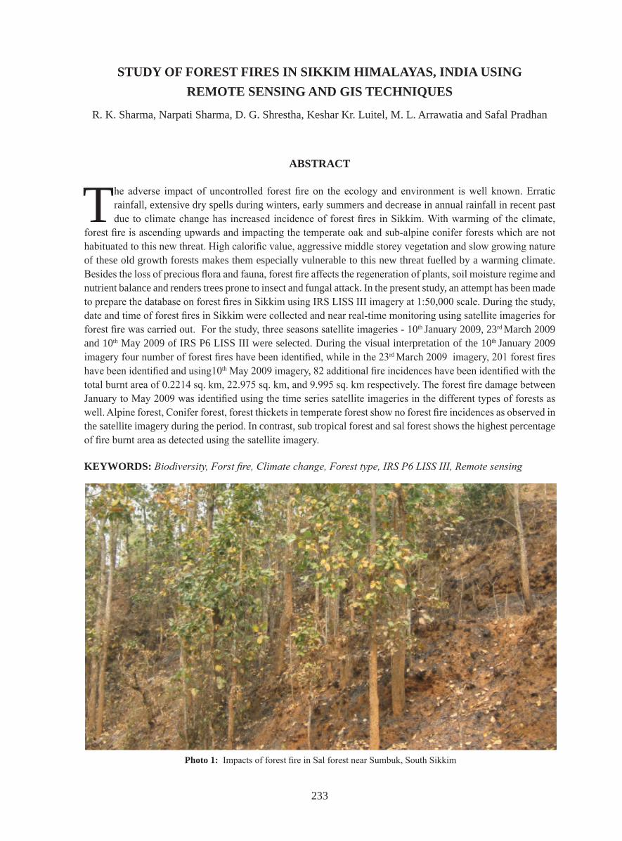
Photo 1: Impacts of forest fire in Sal forest near Sumbuk, South Sikkim
234
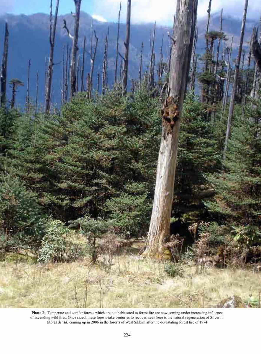
Photo 2: Temperate and conifer forests which are not habituated to forest fire are now coming under increasing influence of ascending wild fires. Once razed, these forests take centuries to recover, seen here is the natural regeneration of Silver fir
(Abies densa) coming up in 2006 in the forests of West Sikkim after the devastating forest fire of 1974
235
Forest fires are a very common problem that have significant impacts on terrestrial, aquatic, and atmospheric systems throughout the globe. Every year the world faces extreme wild fires, which affect million of hectares of forest leading to adverse effects on biodiversity, ecosystem functioning and
landscape stability. Forest fires are mostly classified as crown fires, surface fires and ground fires on the basis of intensity (Narendran 2001).
According to United Nations study, the total forest area of the world in 1900 was nearly 7000 M ha and by 1975, it was reduced to 2890 M ha (Haywood 1995). Severe forest fires have occurred in many countries in Asia, Africa, Europe, North America, South America and Australia. Many of the forest fires that occurred during the years 1997 and 1998 have been linked to a drier climate and have been attributed to events such as ENSO (E1 Nino Southern Oscillation) (Narendran 2001).
In the context of India, according to the recent State of Forest Report, the forest cover in India is 67.5 M ha, constituting 20.5 % of its geographical area, represented by 41.68 M ha of dense forest and 25.87 M ha of open forest (FSI 2003). Forest fire is a major cause of degradation of India’s forests. In tropical deciduous forests, fire is a recurrent phenomenon due to higher levels of water stress during summer.While statistical data on fire loss is weak, it is estimated that the proportion of forest areas prone to forest fires annually ranges from 33% in some states to over 90% in others (Roy 2004). According to Forest Protection Division of the Ministry of Environment and Forests (GOI), 3.73 million ha of forests are affected by fire annually in India (Bahuguna 1999). The first ever forest fire in India occurred about 200 million years ago coinciding with the time of evolution of early mammals on earth (Narendran 2001).
Forest fires and climate change are related since both may be due natural as well as anthropogenic activities. Climate change refers to a “statistically significant variation in either the mean state of the climate or in its variability persisting for an extended period (typically decades or longer). Climate change may be due to natural internal processes or external forces or due to persistent anthropogenic negative inputs to the composition of the atmosphere or in land use” (IPCC TAR 2001b). It is one of the triggering factors for the forest fires together with the anthropogenic activities. Climatic abnormalities are going to make forest ecosystem more susceptible and increase the risk of burning. Increased dry spells could also place dry and moist deciduous forests at increased risk from forest fires. There is growing scientific evidence that climate change will increase the number and size of wildfires, both globally and in North America (Mukhopadhyay 2009).
Wild fires are frequent along the Himalayan foothills and also in the deciduous forests elsewhere. In recent years extended droughts (prolonged dry weather), together with rapidly expanding exploitation of tropical forest and the demand for conversion of forest to other land uses, has resulted in significant increase in wild fire size, frequency and related environmental impacts (Roy 2004). Some studies suggest universal increase in fire frequency with climate warming (Overpeck et al. 1990). Forest fires are expected to increase in some areas with climate change and decrease in others. Although some forest areas (such as the Amazon, Mediterranean and temperate US) are predicted to be much drier, and therefore more vulnerable to fire, other areas, such as tropical Africa, may be wetter and less vulnerable to fire (Scholze et al. 2006). Climate variability is expected to increase across the globe (IPCC WGII 2007) and this will lead to increase in temperature along with prolonged droughts and less rainfall making the forests more vulnerable to forest fires.
Unlike in other parts of the country where summer is the main fire season, the long dry winter from December to March is the fire season in Sikkim. Forest fires are most frequent during winters, when long dry spells
236
cause high day temperate which is further exacerbated by strong winds and easy availability of dry fuel wood. Forest fire in Sikkim is commonly experienced below the altitude of 2500m with higher intensity in dry zones especially in the Sal forest ecosystem and to a lesser extent in the temperate oak and sub-alpine conifer forests. Off late, incidence of forest fires in temperate forests which are not accustomed to forest fire is increasing. There is an increased incidence of forest fire which is now ascending into the temperate zone.
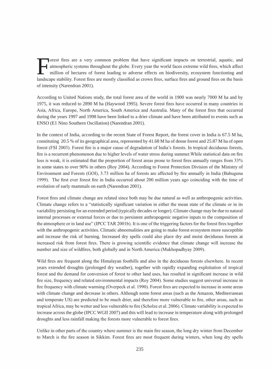
Fires are frequent in the subtropical Sal forests in Sikkim and occur in the winter months. Earlier, winter precipitation used to prevent these fires, however, with the change in the climatic pattern, winters are becoming increasingly warm and dry. Hence forest fires are raging for longer periods and also ascending to higher altitudes. The extent of the damage depends upon the frequency and intensity of fires, the type of forests, availability of fuel and local climatic factors. Forest Fire in Sal forests takes the form of ground fires, and though they have a higher frequency, they mostly affect the regeneration and the ground flora which normally recovers during the ensuing monsoons. However, in oak forests, the fire takes the form of a canopy fire and the whole oak tree catches fire and burns for several days, as its calorific value is high. Subsequently, the middle storey vegetation (dwarf bamboo thickets, Viburnum sp., Edgeworthia sp.) aggressively colonizes the burnt area and prevents the climax species from regenerating. e.g. The oak and coniferous forest affected by the major forest fire which occurred during the 1970s in West Sikkim are yet to recover fully.
Photo 3: Conifer forest of Uttarey, West Sikkim after fire incidence Photo courtesy- T.B. Subba
237
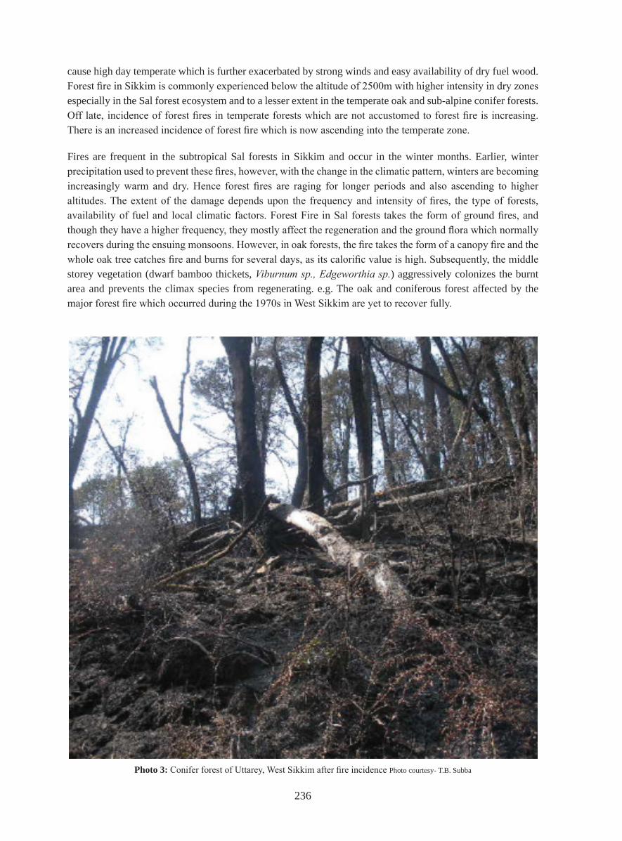
Photo. 4: Forest personnel extinguishing the forest fire in Uttarey, West Sikkim Photo courtesy- T.B. Subba
Climate is an important driver of fire in the Western US (Littell et al. 2009) and changes in climate have led to earlier and warmer springs and summers resulting in increased wildfire activity (Westerling et al. 2006). Most of the incidences of forest fires are linked to the climatic parameters like temperature, rainfall and humidity, which on becoming abnormal may lead to the burning of forests.
Regarding Sikkim, detailed study on patterns of forest fires due to climate change are lacking. Due to significant decreasing trend in the mean maximum temperature during monsoon, significant increasing trend in the mean minimum temperature throughout the year as a whole, a significant decreasing trend in the diurnal range of temperature has been experienced in recent years, resulting in the annual increasing trend in annual range of temperature leading to the prevalence of a warmer climate in Sikkim. Also, cold wave conditions have now become few and far between, which may be attributed to the rise in average minimum temperature (Gupta et al. 2006). So this abnormality in the climate of Sikkim together with prolonged winter droughts possibly makes the forest areas vulnerable to forest fires.
Now days, the application of remote sensing and GIS in the mapping and classification of natural resources is quite common. Classification and analysis of burnt areas using remote sensing requires some knowledge of the land cover disturbance effect on reflection of electromagnetic energy (White et al. 1996). In this paper, we demonstrate the application of remote sensing for identifying burnt areas in Sikkim and GIS tools for mapping and analysis. The use of GIS technology for forest fire simulation allows the integration of all the data on a single platform simplyfing the modelling and analysis of potential forest fires (Srivastava et al. 2001).
MATERIALS AND METHODS
Study Area:
The forest types are mostly Lower hill forests (Below 900m), Middle hill forests (900-1800m), Upper hill forests (1800-2450m), Rhododendron and Oak forest/ Conifer forest (2450-3350m) and Alpine pastures (above 3350m).
238
The low altitude areas of Sikkim like Singtam, Rangpo and Jorethang experience temperature variation between 40C to 350C. Places like Gangtok with moderate altitude of 1800 meters, experience temperatures between 10C and 250C whereas in altitudes above 4000 meters, the temperature never rises above 150C and remains much below the freezing point during winters and for a great part of spring and autumn (Verma 2009). Because of the proximity of Sikkim to the Bay of Bengal and the fact that the mountains of the state come directly in the path of the monsoon clouds, most parts of Sikkim experience torrential rains during summer. The average annual rainfall of Gangtok is 325cm whereas Muguthang in North Sikkim has an average annual rainfall of 60cm (Verma 2009). The driest belt in Sikkim lies in South district where most of the fire incidences take place.
Methodology:
The Forests, Environment and Wildlife Management Department, Government of Sikkim has collected the GPS location of forest fires immediately after the forest fire. These location points were shortlisted according to the date, and cloud free satellite imagery of IRS P6 of 10th January 2009, 23rd March 2009 and 10th May 2009 were ordered from NRSC, Hyderabad. The satellite data were imported in ERDAS Imagine 9.1 software from CD ROM and geo-rectified with image to image registration in second order polynomial using UTM (Universal Transverse Mercator) WGS 84 Projection in Zone 45. The total RMS error was maintained to less than one.
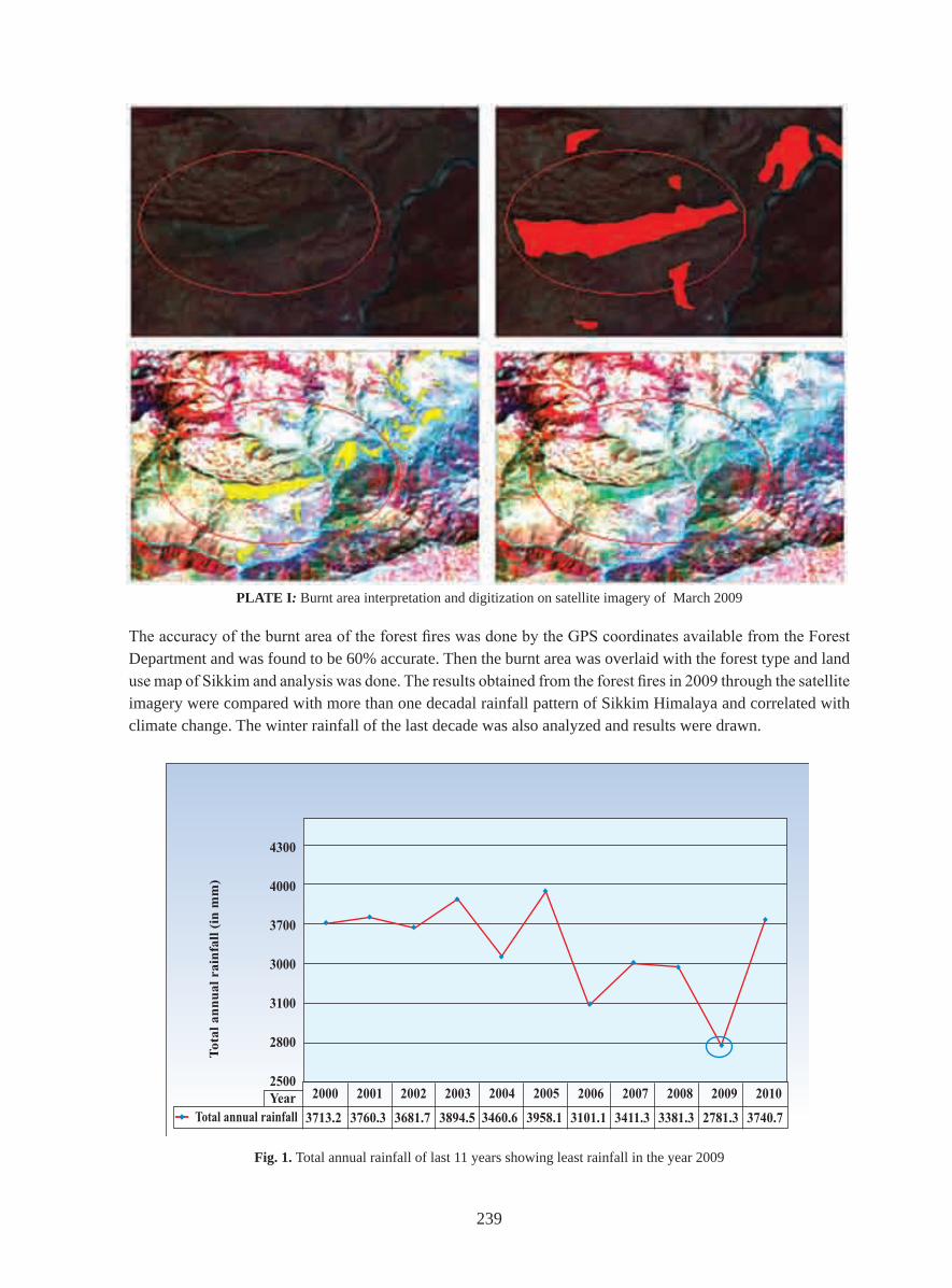
The identification of forest fire was done using visual interpretation/Digitization in ERDAS Imagine 9.1. Taking image band as 3 2 1, 4 3 1 and SWIR band and it was found that burnt area was clearly visible in SWIR band. The tone of the burnt area was recognized as dark brown and shows a smooth texture.
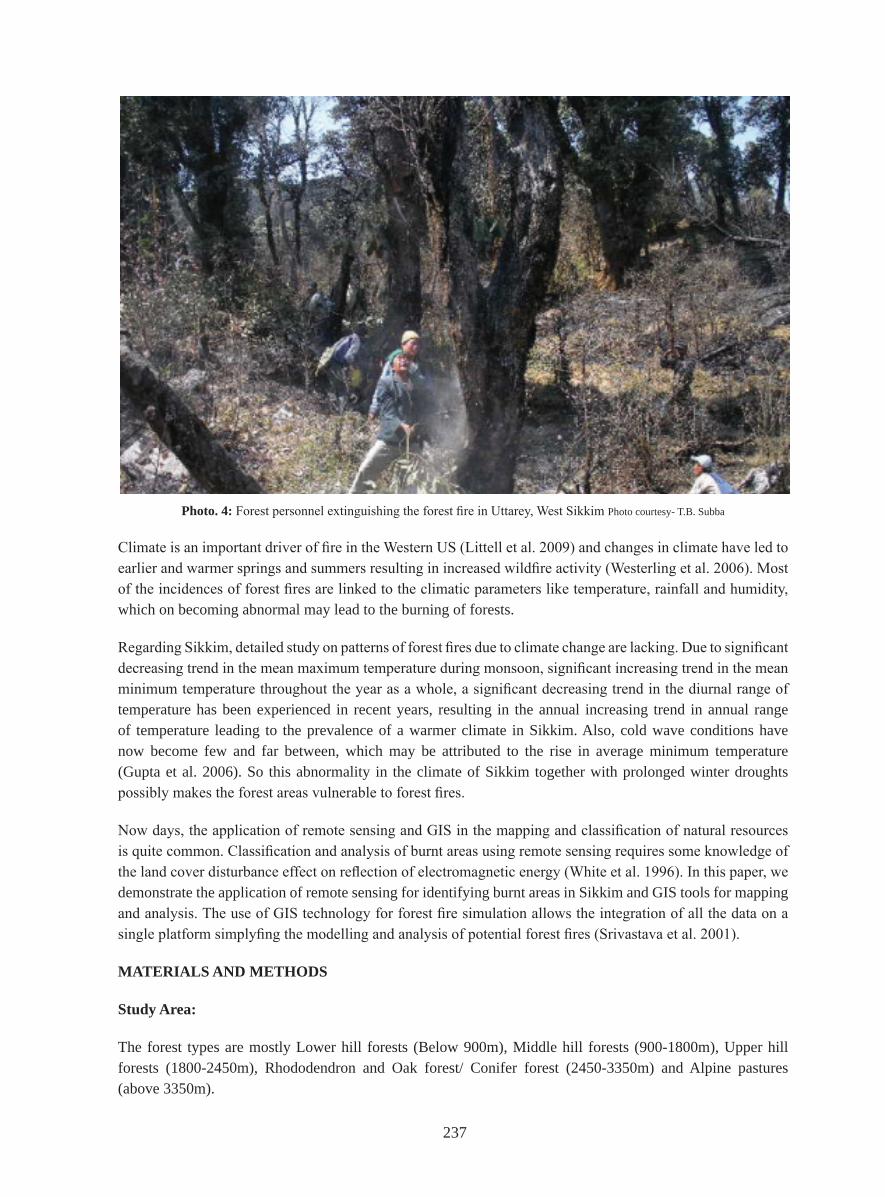
Photo 5: Burnt areas after massive forest fires in Uttarey Photo courtesy- T.B. Subba
239
The accuracy of the burnt area of the forest fires was done by the GPS coordinates available from the Forest Department and was found to be 60% accurate. Then the burnt area was overlaid with the forest type and land use map of Sikkim and analysis was done. The results obtained from the forest fires in 2009 through the satellite imagery were compared with more than one decadal rainfall pattern of Sikkim Himalaya and correlated with climate change. The winter rainfall of the last decade was also analyzed and results were drawn.
PLATE I: Burnt area interpretation and digitization on satellite imagery of March 2009
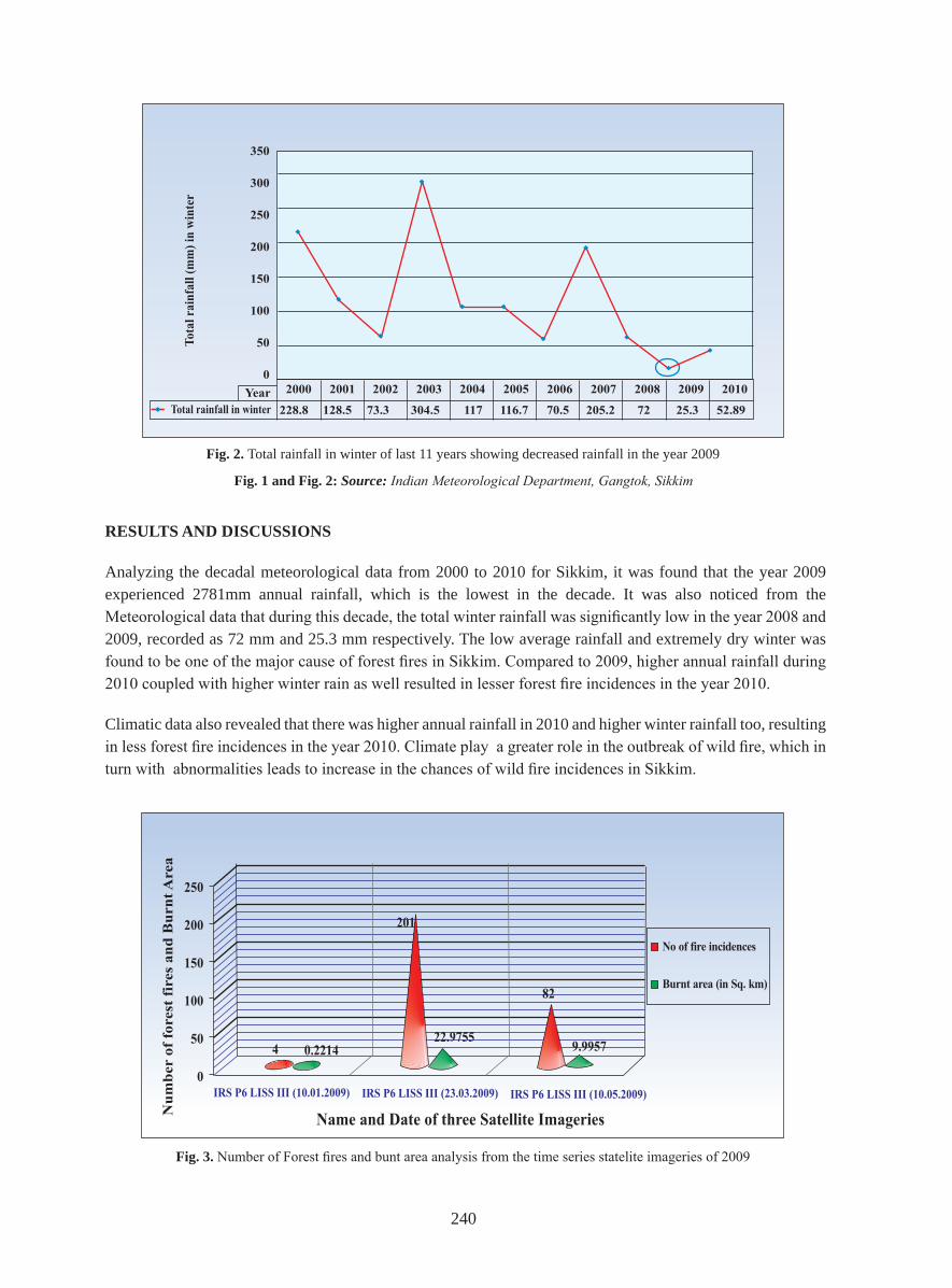
Fig. 1. Total annual rainfall of last 11 years showing least rainfall in the year 2009
240
RESULTS AND DISCUSSIONS
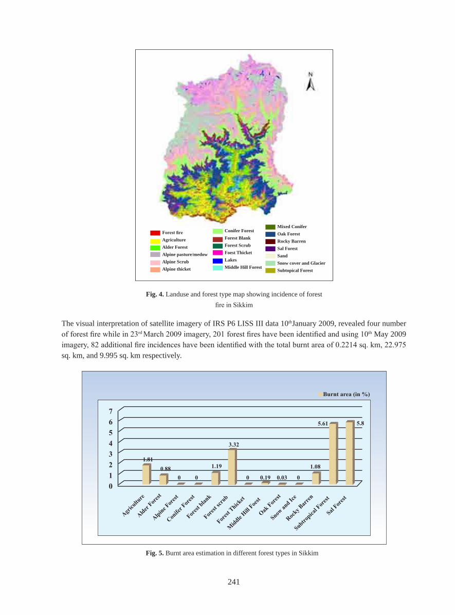
Analyzing the decadal meteorological data from 2000 to 2010 for Sikkim, it was found that the year 2009 experienced 2781mm annual rainfall, which is the lowest in the decade. It was also noticed from the Meteorological data that during this decade, the total winter rainfall was significantly low in the year 2008 and 2009, recorded as 72 mm and 25.3 mm respectively. The low average rainfall and extremely dry winter was found to be one of the major cause of forest fires in Sikkim. Compared to 2009, higher annual rainfall during 2010 coupled with higher winter rain as well resulted in lesser forest fire incidences in the year 2010.
Climatic data also revealed that there was higher annual rainfall in 2010 and higher winter rainfall too, resulting in less forest fire incidences in the year 2010. Climate play a greater role in the outbreak of wild fire, which in turn with abnormalities leads to increase in the chances of wild fire incidences in Sikkim.
Fig. 1 and Fig. 2: Source: Indian Meteorological Department, Gangtok, Sikkim
Fig. 2. Total rainfall in winter of last 11 years showing decreased rainfall in the year 2009
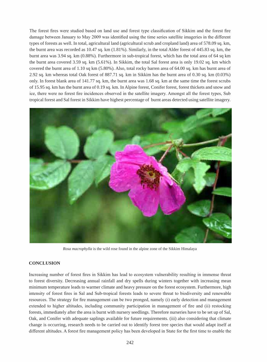
Fig. 3. Number of Forest fires and bunt area analysis from the time series statelite imageries of 2009
241
ForestfireAgricultureAlder ForestAlpine pasture/medowAlpine ScrubAlpine thicket
Conifer ForestForest BlankForest ScrubFoest ThicketLakesMiddle Hill Forest
Mixed ConiferOak ForestRocky BarrenSal ForestSandSnow cover and GlacierSubtopical Forest
Fig. 4. Landuse and forest type map showing incidence of forest fire in Sikkim
Fig. 5. Burnt area estimation in different forest types in Sikkim
The visual interpretation of satellite imagery of IRS P6 LISS III data 10thJanuary 2009, revealed four number of forest fire while in 23rd March 2009 imagery, 201 forest fires have been identified and using 10th May 2009 imagery, 82 additional fire incidences have been identified with the total burnt area of 0.2214 sq. km, 22.975 sq. km, and 9.995 sq. km respectively.
242
The forest fires were studied based on land use and forest type classification of Sikkim and the forest fire damage between January to May 2009 was identified using the time series satellite imageries in the different types of forests as well. In total, agricultural land (agricultural scrub and cropland land) area of 578.09 sq. km, the burnt area was recorded as 10.47 sq. km (1.81%). Similarly, in the total Alder forest of 445.83 sq. km, the burnt area was 3.94 sq. km (0.88%). Furthermore in sub-tropical forest, which has the total area of 64 sq km the burnt area covered 3.59 sq. km (5.61%). In Sikkim, the total Sal forest area is only 19.02 sq. km which covered the burnt area of 1.10 sq km (5.80%). Also, total rocky barren area of 64.00 sq. km has burnt area of 2.92 sq. km whereas total Oak forest of 887.71 sq. km in Sikkim has the burnt area of 0.30 sq. km (0.03%) only. In forest blank area of 141.77 sq. km, the burnt area was 1.68 sq. km at the same time the forest scrubs of 15.95 sq. km has the burnt area of 0.19 sq. km. In Alpine forest, Conifer forest, forest thickets and snow and ice, there were no forest fire incidences observed in the satellite imagery. Amongst all the forest types, Sub tropical forest and Sal forest in Sikkim have highest percentage of burnt areas detected using satellite imagery.
Rosa macrophylla is the wild rose found in the alpine zone of the Sikkim Himalaya
CONCLUSION
Increasing number of forest fires in Sikkim has lead to ecosystem vulnerability resulting in immense threat to forest diversity. Decreasing annual rainfall and dry spells during winters together with increasing mean minimum temperature leads to warmer climate and heavy pressure on the forest ecosystem. Furthermore, high intensity of forest fires in Sal and Sub-tropical forests leads to severe threat to biodiversity and renewable resources. The strategy for fire management can be two pronged, namely (i) early detection and management extended to higher altitudes, including community participation in management of fire and (ii) restocking forests, immediately after the area is burnt with nursery seedlings. Therefore nurseries have to be set up of Sal, Oak, and Conifer with adequate saplings available for future requirements. (iii) also considering that climate change is occurring, research needs to be carried out to identify forest tree species that would adapt itself at different altitudes. A forest fire management policy has been developed in State for the first time to enable the
243
government to focus on fire prevention aspects and to coordinate efforts with various agencies. The policy integrates modern fire fighting approaches with community based fire fighting strategies and is devised to preserve the unique biodiversity of the forests of the State especially those of the lower altitudes. The policy provides for zoning of the forests on the basis of their vulnerability, so that different treatments can be meted out to the different zones.
Hence, there is a great need to explore options for early detection of forest fires and Remote Sensing may play vital role in the creation of a model which may act as an alarm for quick counter action.
ACKNOWLEDGEMENTS
The authors greatly acknowledge Dr. M.S.R. Murthy, Mr. G Rajshekar and Mr. T.R. Kiran Chand, National Remote Sensing Centre, Forestry Division, Hyderabad for valuable suggestions, helpful advice and constant guidance. Also, special thanks to Shri. Pradeep Kumar (IFS), and others officials of Department of Forests, Government of Sikkim, for providing necessary data and support. At the same time, the authors express their special thanks to Dr. Sandeep Tambe, RMDD and the officials of State Remote Sensing Applications Centre, Sikkim for valuable suggestions.
REFERENCES:
Bahuguna, V.K. 1999. Forest fire prevention and control strategies in India, International Forest fires News, 20, 5-9.
Forest Survey of India (FSI), 2003. State of Forest Report, 2001, Ministry of Environment and Forests, Dehradun.
Gupta, R.C., and Das, M. 2006. Letters to the Editor, Recent trends in temperature (cold wave conditions) and rainfall over Gangtok city. Mausam, 57(3): 511 – 512.
Haywood, V., 1995. Global Biodiversity Assessment, Cambridge University Press, Cambridge.
IPCC TAR, 2001b. Climate Change 2001: The Scientific Basis. IPCC. IPCC Third Assessment Report.
IPCC WGII 2007. Climate Change 2007: Chapter 4: Impacts, adaptation and vulnerability. Contribution of Working Group II to the Fourth Assessment Report of the Intergovernmental Panel on Climate Change, Cambridge University Press, Cambridge, UK and New York, USA.
Littell, J.S., Mckenzie, D., Peterson, D.L., Westerling, A.L. 2009. Climate and wildfire area burned in western U.S. ecoprovinces, 1916–2003. Ecological Applications 19: 1003-1021.
Mukhopadhyay, Durgadas., 2009. Impact of climate change on forest ecosystem and forest fire in India. Climate Change: Global Risks, Challenges and Decisions IOP Publishing. IOP Conf. Series: Earth and Environmental Science 6 (2009) 382027 doi:10.1088/1755-1307/6/8/382027.
Narendram, K. 2001. Forest fires: Origin and Ecological Paradoxes. General article. Resonance, November 2001.
Overpeck JT, Rind D, Golberg R. 1990. Climate-induced changes in forest disturbances and vegetation. Nature; 343:51-53.
Roy, P.S. 2004. Forest Fire and Degradation Assessment using Satellite Remote Sensing and Geographic Information System. Satellite Remote Sensing and GIS Applications in Agricultural Meteorology, pp. 362-363.
Scholze, M., Knorr, W., Arnell, N.W. & Prentice, C. 2006. A climate-change risk analysis for world ecosystems. Proceedings of the National Academy of Sciences 103: 13116–13120.
244
Srivastava, M.L., Gupta, Saurabh., Owais Syed Taha. 2001. A New Horizon towards Forest Fire Mapping using GIS. Department of Forests, Environments and Wildlife, Government of Sikkim and Sikkim State Unit, National Informatics Centre, Ministry of Information Technology. pp 4.
Verma, Rajesh 2009. Sikkim- A Guide and Handbook, 17th Edition.
Westerling, A.L., Hidalgo, H.G., Cayan, D.R. & Swetnam, T.W. 2006. Warming and earlier spring increase Western US. Forest wildfire activity. Science 313: 940-943.
White, Joseph D., Ryan, Kevin C., Key, Carl C., Running, Steven W. Remote Sensing of Forest Fire Severity and Vegetation Recovery. International Journal of Wildland Fire 6(3): 125.136, 1996 ©IAWF. Printed in USA.
AUTHORS
R. K. SharmaSikkim State Council of Science and TechnologyDevelopment Area, Gangtok – 737101, Sikkim, INDIAEmail:[email protected](Corresponding author)
Narpati SharmaSikkim State Council of Science and TechnologyDevelopment Area, Gangtok – 737101, Sikkim, INDIAEmail: [email protected]
D. G. ShresthaDepartment of Science and Technology and Climate ChangeDevelopment Area, Gangtok – 737101, Sikkim, INDIAEmail: [email protected]
Keshar Kumar LuitelDepartment of Mines, Minerals and GeologyAbove Power Secretariat, Gangtok- 737101, Sikkim, INDIAEmail: [email protected]
M. L. Arrawatia, IFS (Retired)Sikkim Public Service CommissionGangtok- 737101, Sikkim, INDIAEmail: [email protected]
Safal PradhanSikkim State Council of Science and TechnologyDevelopment Area, Gangtok – 737101, Sikkim, INDIAEmail: [email protected]