
studio6225maraetaimutt
24
MULTI USE TRANSPORT TOWN A GROWTH STRATEGY FOR MARAETAI THOMAS KEAL 1204909
-
Upload
thomas-keal -
Category
Documents
-
view
214 -
download
2
description
studio 6225 2012 assignment 2 matraetai medium density development thomas keal
Transcript of studio6225maraetaimutt

MULTI USE TRANSPORT TOWNA GROWTH STRATEGY FOR MARAETAI
THOMAS KEAL 1204909

3
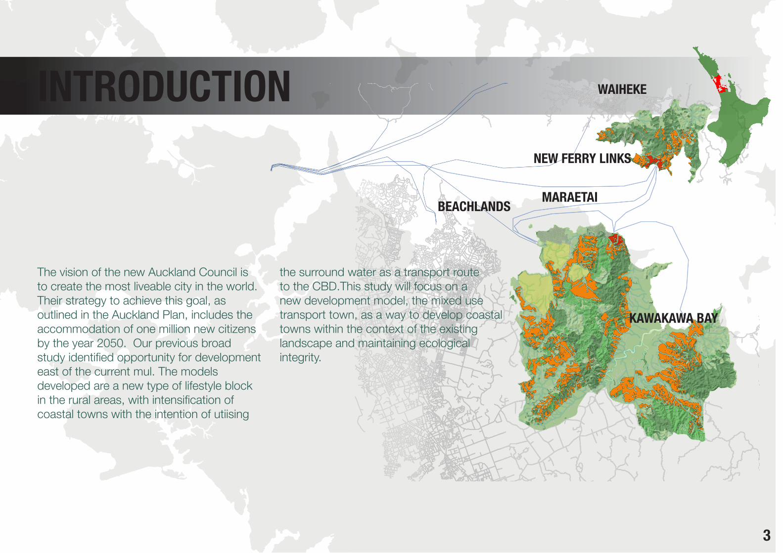
The vision of the new Auckland Council is to create the most liveable city in the world. Their strategy to achieve this goal, as outlined in the Auckland Plan, includes the accommodation of one million new citizens by the year 2050. Our previous broad study identified opportunity for development east of the current mul. The models developed are a new type of lifestyle block in the rural areas, with intensification of coastal towns with the intention of utiising
the surround water as a transport route to the CBD.This study will focus on a new development model, the mixed use transport town, as a way to develop coastal towns within the context of the existing landscape and maintaining ecological integrity.
INTRODUCTION
BEACHLANDS MARAETAI
KAWAKAWA BAY
WAIHEKE
NEW FERRY LINKS


5
Auckland’s current urban growth pattern and the global economic situation highlights the need to examine city planning processes and land use practices. Periodically extending the mul to allow for more development squeezes the landscape out to the edges, and the urban form becomes detached from the identity of the land. I propose to develop the city in an informed way, which respects the qualities of the landscape, but integrates them into the city design, rather than pushing against them.
RATIONALE

6
AREA OF STUDYLOCATION

7
CONTEXT
ROADINGFERRY ROUTESRAIL
Maraetai is disconnected from the motorway and rail, however it has the potential to be developed intensively if the waters around the coast are embraced as routes for commuting between the CBD and the coastal settlements.

8
Existing vegetation in Maraetai is a priority in design decisions as it is integral to the areas character.
VEGETATION
EXOTICNATIVE
9
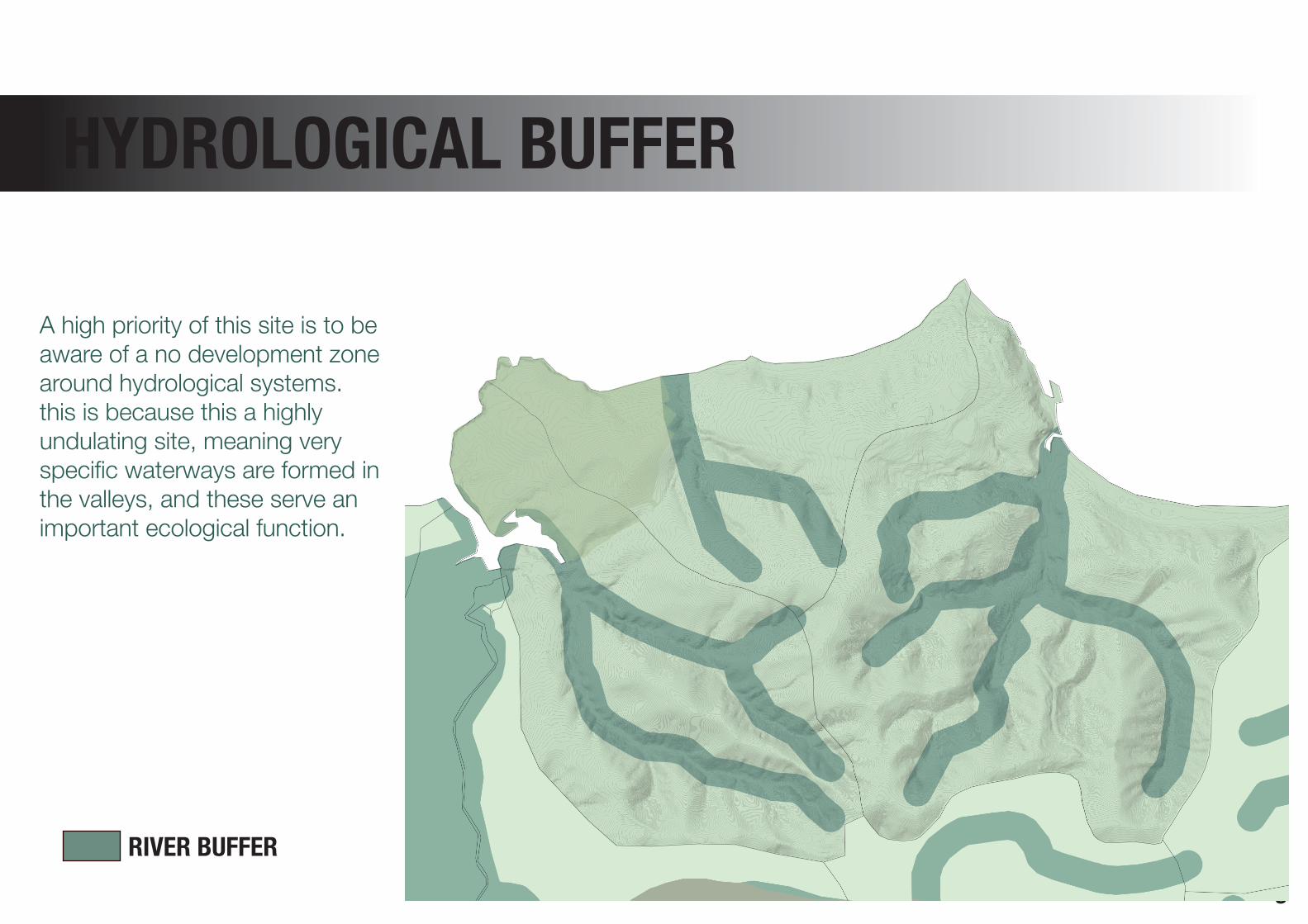
HYDROLOGICAL BUFFER
A high priority of this site is to be aware of a no development zone around hydrological systems. this is because this a highly undulating site, meaning very specific waterways are formed in the valleys, and these serve an important ecological function.
RIVER BUFFER
10
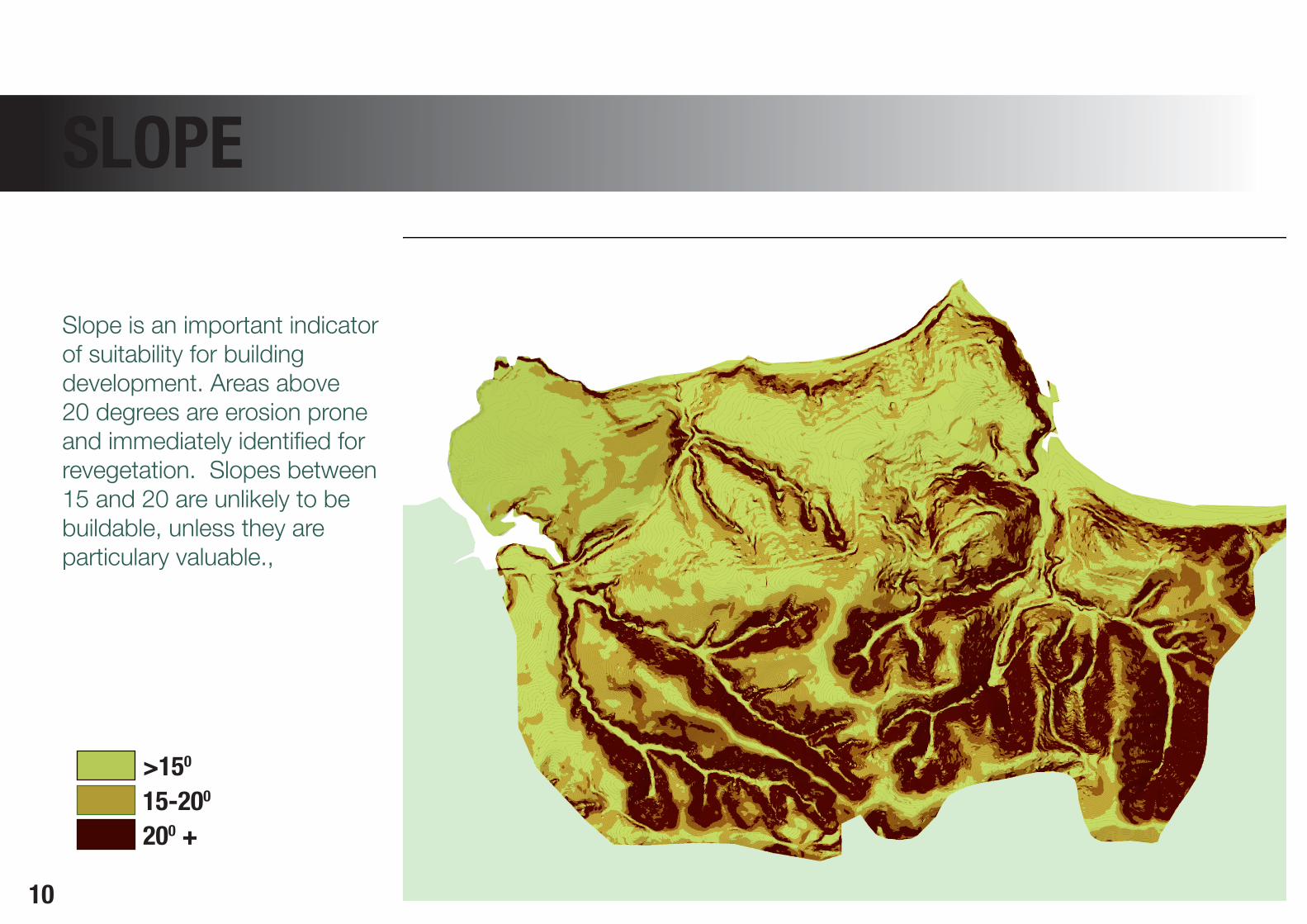
Slope is an important indicator of suitability for building development. Areas above 20 degrees are erosion prone and immediately identified for revegetation. Slopes between 15 and 20 are unlikely to be buildable, unless they are particulary valuable.,
SLOPE
>150
15-200
200 +
11
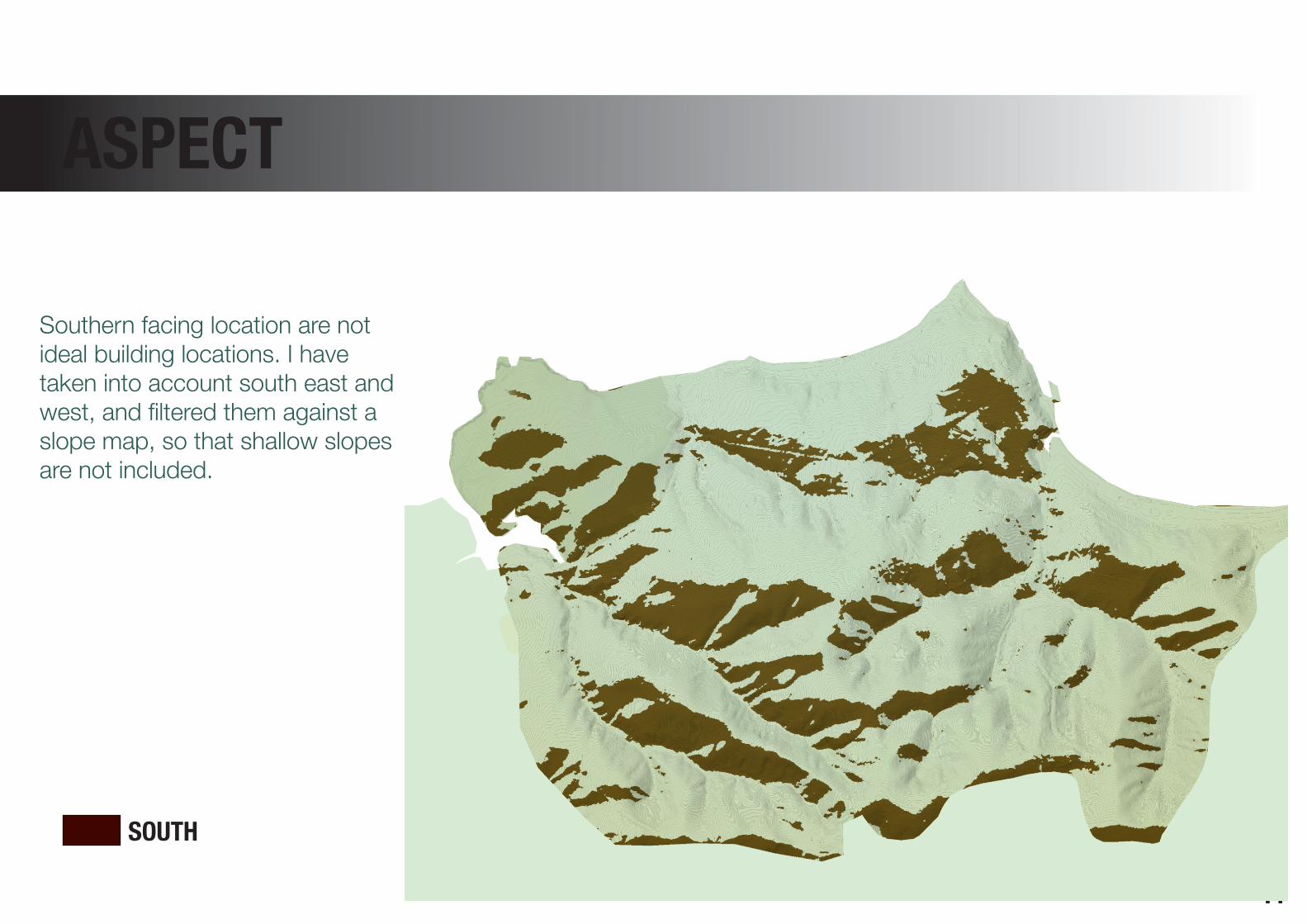
ASPECT
Southern facing location are not ideal building locations. I have taken into account south east and west, and filtered them against a slope map, so that shallow slopes are not included.
SOUTH
12
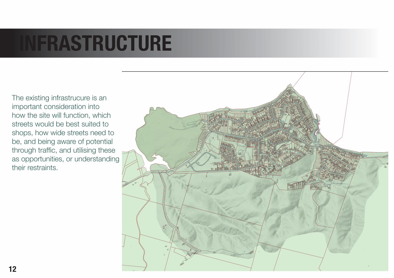
INFRASTRUCTURE
The existing infrastrucure is an important consideration into how the site will function, which streets would be best suited to shops, how wide streets need to be, and being aware of potential through traffic, and utilising these as opportunities, or understanding their restraints.
13
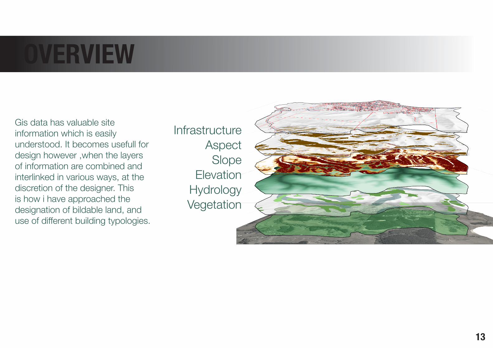
OVERVIEW
InfrastructureAspectSlope
ElevationHydrologyVegetation
Gis data has valuable site information which is easily understood. It becomes usefull for design however ,when the layers of information are combined and interlinked in various ways, at the discretion of the designer. This is how i have approached the designation of bildable land, and use of different building typologies.
14
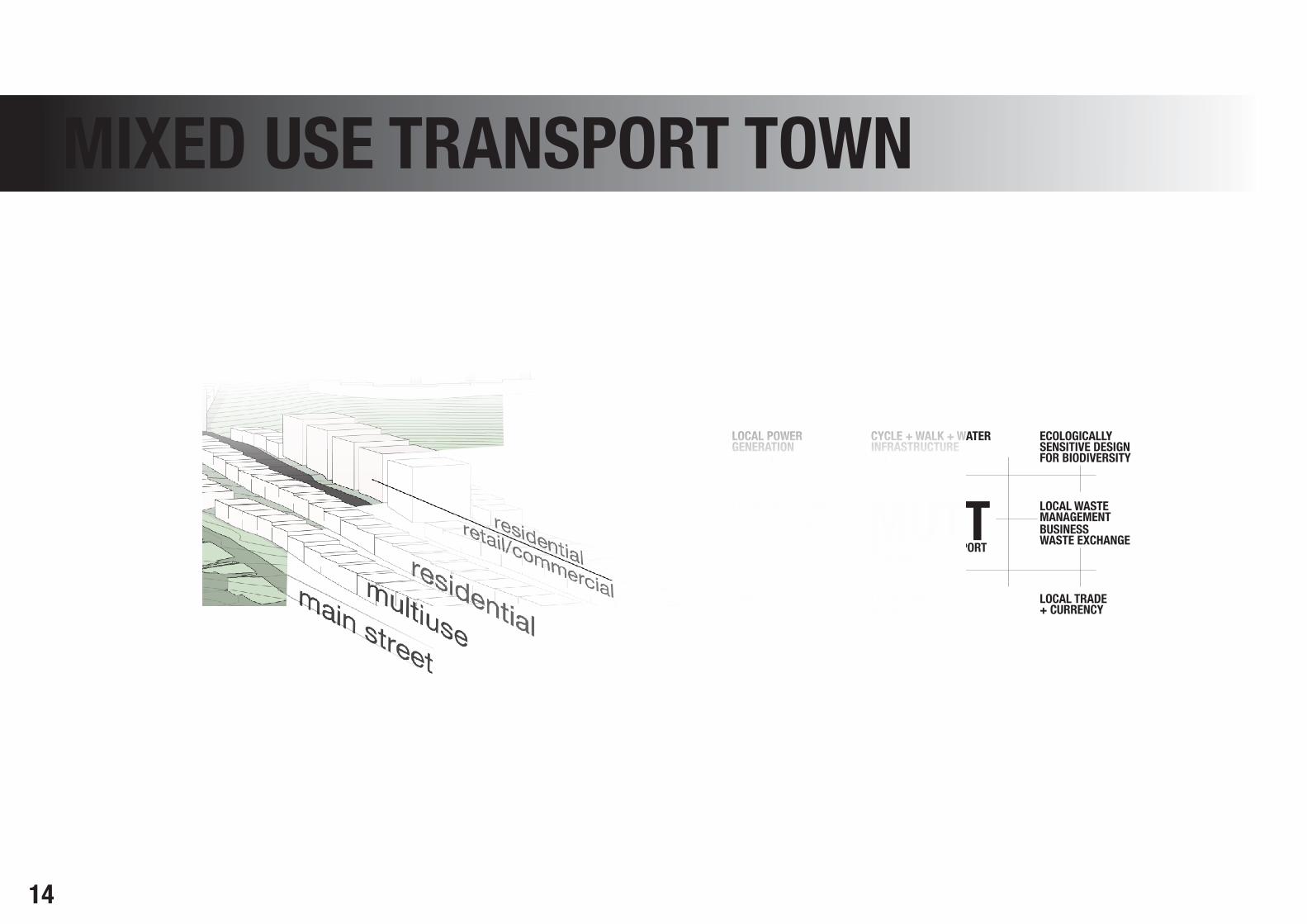
MIXED USE TRANSPORT TOWN
MIXED USE TRANSPORT MUTTTOWNCENTRES
ECOLOGICALLYSENSITIVE DESIGNFOR BIODIVERSITY
CYCLE + WALK + WATERINFRASTRUCTURE
BUSINESSWASTE EXCHANGE
LOCAL WASTEMANAGEMENT
LOCAL TRADE+ CURRENCY
EDIBLEPARKS
LOCAL POWERGENERATION
LOCAL FOODNETWORKS
LOCAL PRODUCTIONFORLOCAL CONSUMPTION

15
FOCUSED STUDY AREA
This area has been identified for potential development, as it is a single cadastral boundary, encompassing most of the buildable space in maraetai.
16
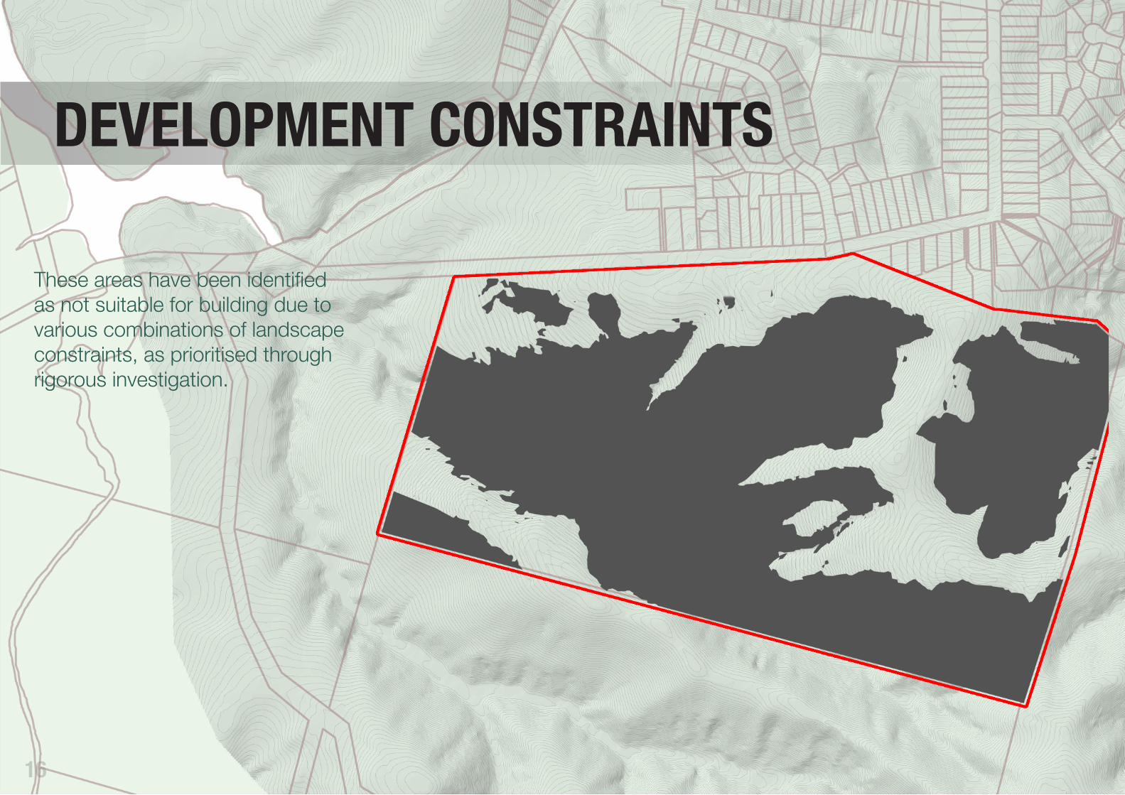
DEVELOPMENT CONSTRAINTS
These areas have been identified as not suitable for building due to various combinations of landscape constraints, as prioritised through rigorous investigation.

17
DEVELOPMENT
Consideration was given as to the most efficient method of developing a site, which is dictated by a undulation landform, with ridglines offering the most attractive opportunities. Plots of 250m2, with 150m2 terraced buildings were chosen as they offer the flexibilty of mixed use. Four story apartments are placed in areas close to the centre, which offer views. The gondola would operate as part of a town centre, with retail, commercial, and transport offerings.
TERRACEDAPARTMENTS

18
DEVELOPMENT FIGURES
Terraced housing
321 unitsplot size 250m2
unit footprint 150m2
unit size 300m2
=8.02 hectares
3.5 people per dwelling =1123.5 people
=140 people per hectare
at 80/20 residential/commercial
=112 people per hectare
Apartments
13 buildings (each with 16 units)plot size 600m2
unit footprint 400m2
unit size 100m2
=.78 hectares
3 people per dwelling =624 people
=800 people per hectare
at 80/20 residential/commercial
=640 people per hectare
19
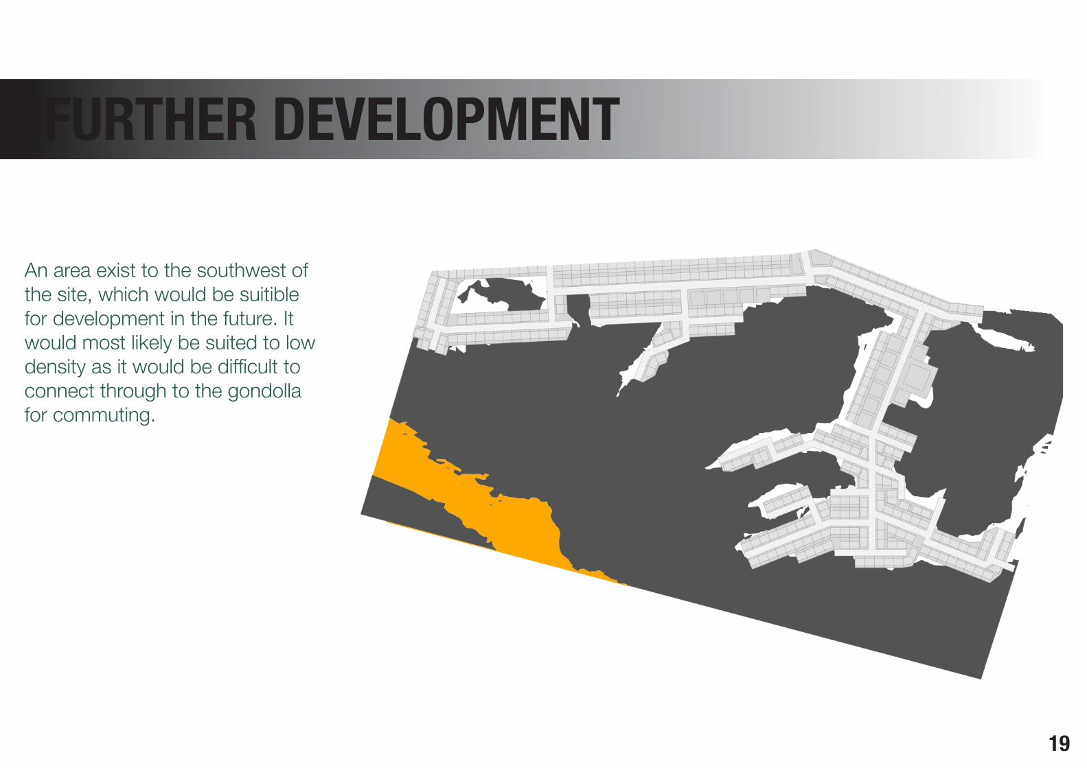
FURTHER DEVELOPMENT
An area exist to the southwest of the site, which would be suitible for development in the future. It would most likely be suited to low density as it would be difficult to connect through to the gondolla for commuting.
20
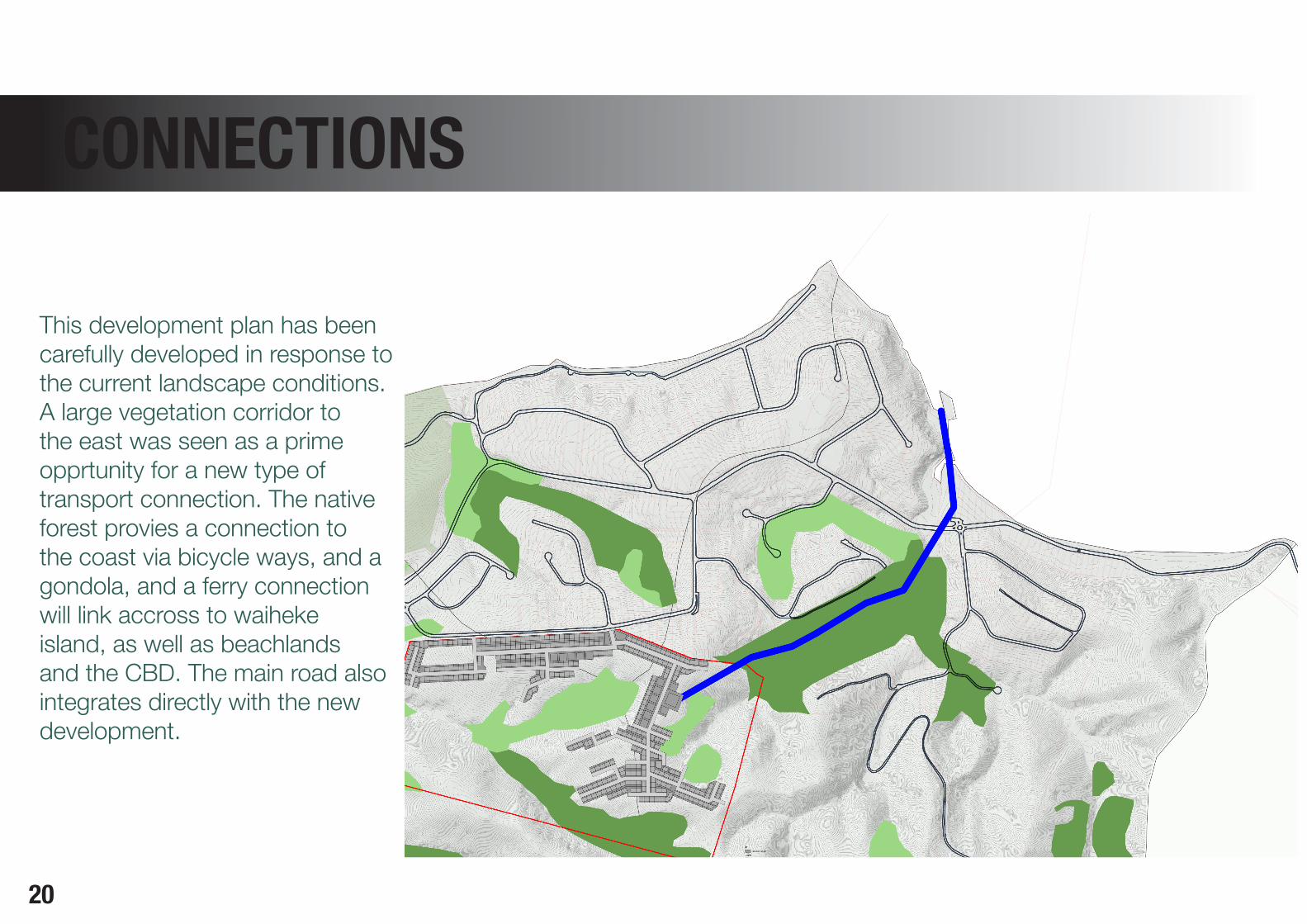
CONNECTIONS
This development plan has been carefully developed in response to the current landscape conditions. A large vegetation corridor to the east was seen as a prime opprtunity for a new type of transport connection. The native forest provies a connection to the coast via bicycle ways, and a gondola, and a ferry connection will link accross to waiheke island, as well as beachlands and the CBD. The main road also integrates directly with the new development.
21
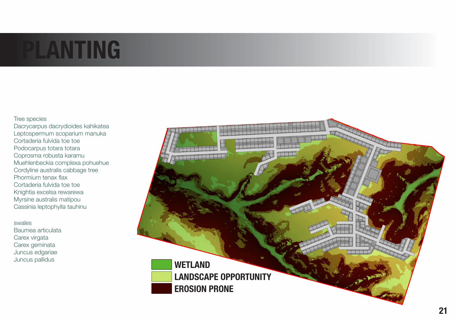
CONNECTIONS PLANTING
Tree speciesDacrycarpus dacrydioides kahikateaLeptospermum scoparium manukaCortaderia fulvida toe toePodocarpus totara totaraCoprosma robusta karamuMuehlenbeckia complexa pohuehueCordyline australis cabbage treePhormium tenax flaxCortaderia fulvida toe toeKnightia excelsa rewarewaMyrsine australis matipouCassinia leptophylla tauhinu
swalesBaumea articulataCarex virgataCarex geminataJuncus edgariaeJuncus pallidus WETLAND
LANDSCAPE OPPORTUNITYEROSION PRONE

22
REVEGETATION PROGRAMME
The gis analysis has identified sites which require revegetation, primarily around hydrological systems, and erosion prone zones. The development impact on the landscape will be mediated through an improvement in ecological connectivity, and integration of landscape features within infrastructural networks.
Slopes of 20 degrees or above will be planted with trees to control surface erosion and slipping. Riparian margins wil be planted
to protect the naturally forming habitats. These will be looked at on a closer scale to plan for specific outcomes, at which time more fine tuned planting treatments will be specified, with consideration to storm water systems, ground conditions, and cycle and walk ways.
More refined decisions as to land modification, and planting will require working closely with ecologists, storm water engineers, and structural architects.

23
REVEGETATION PROGRAMMErange. Apartment were only built where they view was particulary valuable, and they were within close proximetry to the infrastructural links. The gondola provides a link between the community and a small ferry terminal, which is an extention of the current boat dock. The gondola poles are places on the ridges, and give a view out to waiheke as it passes over the hills. Bike tracks will be drawn along the edge of the forest, and the gondola will have provisions for returning these to the top.
This is a clear example of how natural landscape features can enhance urban planning and design.
CONCLUSIONMaraetai is posed as a coastal town with huge potential for intensification along the ridglines and north facing slopes. The new developments should be mixed use, to provide work and recreation within the community. The landscape in this area is hilly, providing unique views from ridges, and ecologically rich valleys. Terraced housing was used as a building typology as it is flexible as a mixeduse model, and makes efficient use of the land availible. They would be efficient to built and have a low ecological footprint, as they could be designed to collect water and solar energy. The faces of the buildings coud be very individual, even if the insides were of limited

24
3 News. Retrieved from: http://www.3news.co.nz/Critics-call-Auckland-30-year-plan-unachievable/tabid/370/articleID/248584/Default.aspx
Arpa, J., Mozas, J., & Per, A. F. (2007). Dbook. Density, data, diagrams, dwellings. Vitoria-Gasteiz, Spain: a&t ediciones.
Auckland Reigonal Council. (2007). Auckland Sustainability Framework. Retrieved from http://www.aucklandoneplan.org.nz/auckland-sustainability-framework/.
Auckland Regional Council. (2010). A brief history of Auckland’s urban form.
Auckland Council. (2011). Auckland Draft Plan. Chapter 7. Retrieved from http://www.aucklandcouncil.govt.nz/en/aboutcouncil/planspoliciespublications/theaucklandplan/draftaucklandplan/pages/home.aspx
Boffa Miskell Ltd. (2005). Beachlands Growth Management Strategy Draft 2 November. Prepared for Manukau City Council
Boffa Miskell Ltd. (2006). Takanini plan change: vegetation, landscape and visual assessment.
Boffa Miskell Ltd. (2006). Takanini plan change: vegetation, landscape and visual assessment.
Bogunovich, D. & Bradbury, M. (2011). Auckland 2040: a resilient urban region on the water. Proceedings from the 11th Asian Urbanism Conference. Hyderabad, India.
E-architect (n.d.) Seewurfel Zurich: Lake Cubes’ : Mixed-Use Regeneration Development. Retrieved from: http://www.e-architect.co.uk/switzerland/seewurfel.htm
Grant, G. (2011). The importance of biodiversity. Urban Design, Issue 117, p22.
Ignatieva, M., Meurk, C., Simcock, R., Stewart, G., van Roon, M. (2008). How to put nature into our neighbourhoods. Lincoln, New Zealand: Manaaki Whenua Press
McDonald, R., & Marcotullio, P. (2011). Global effects of urbanisation on ecosystem services. In J. Neimela (Ed). Urban ecology: patterns, processes, and applications. New York, NY: Oxford University Press
Soul Environments Ltd. (2010). Clevedon village and surrounding area landscape assessment.
Village Home Owners Association. (2009). Village Homes, Davis, California Retrieved from: http://www.villagehomesdavis.org/
REFERENCES


