Structural Evolution of The Northern Bonaparte Basin ...searg.rhul.ac.uk/pubs/amir_etal_2010 IPA NW...
17
Back to Menu IPA10-G-210 PROCEEDINGS, INDONESIAN PETROLEUM ASSOCIATION Thirty-Fourth Annual Convention & Exhibition, May 2010 STRUCTURAL EVOLUTION OF THE NORTHERN BONAPARTE BASIN, NORTHWEST SHELF AUSTRALIA Vicki Amir *, ** Robert Hall * Christopher F. Elders * ABSTRACT The Bonaparte Basin is the northernmost basin on Australia’s NW Shelf. The study area lies immediately south of the arc-continent collision in the Timor region. Structural configuration analysis based on time-migrated 3D seismic lines shows three main stages of evolution: (i) Middle Triassic (?) extension produced NNE-SSW trending faults; (ii) Late Jurassic-Early Cretaceous rifting (breakup event) produced E-W to ENE-WSW trending faults; and (iii) Neogene Australia-Banda Arc continental collision in Timor produced NE-SW trending faults. The two Mesozoic events had different extension directions and displacement during Late Jurassic rifting was about half that of the Early Mesozoic extensional phase. Early Mesozoic structures influenced development of the prominent low relief NE-SW trending accommodation zone in the eastern Mesozoic rift graben and also maybe controlled the separation into graben compartments. Australia-Banda Arc continental collision in the Neogene led to the reactivation of the older Mesozoic rift faults, particularly faults that had the largest and longest displacement. As a consequence, conjugate faults developed above narrow horst blocks with hard linkage of older and younger faults in the Cretaceous-Paleocene sequence. Flexure due to Timor loading and also oblique motion along the margin have been proposed as mechanisms responsible for the development of the NE-SW structures with net normal displacement and the reactivation that occurred in the Neogene. Right-stepping en-echelon fault arrays and splay fault development suggest oblique motion during Neogene collision. Neogene reactivation resulted in drowning of car- bonate platform/build-ups near the surface although circular seismic artefacts could * Royal Holloway University of London ** ConocoPhillips Indonesia Ltd. indicate hydrocarbon migration/leakage associated with micro-fracture development within fault damage zones. Keywords: tectonics, structure, evolution, Australia INTRODUCTION The study area is located on the Australian NW Shelf (Figure 1) close to the western edge of the Sahul Platform. To the north, the area is bounded by the Timor Trough with a NE-SW trend. At the present day the Australian plate is being subducted beneath the SE Asian margin and the northwestern part of Australia is currently in collision with the Banda Arc in the area around Timor Island (Hamilton, 1979). More than 45 wells have been drilled in this area, especially in the JPDA (Joint Petroleum Development Area; Figure 1), with oil and gas discoveries in the Sunrise and Troubadour fields in the northeast of the study area. A 3D seismic survey and a series of 2D seismic lines cross the study area which lies within the Sahul Platform and the Laminaria High in the northeast (Figure 1). These data were provided by Geoscience Australia. The water depths range from 50 metres to more than 1000 metres based on seismic observations. One detailed exploration well data set, from the Kuda Tasi–2 well near the Laminaria High (Figure 1), was downloaded from the Geoscience Australia website. A number of studies have been undertaken in the Vulcan sub- basin (Woods, 1998, 2004; Chen et al., 2002; Edwards et al., 2004) which lies to the southwest of the study area, and in the JPDA (Gorter et al., 2004) to the northeast of the area. These studies have utilised predominantly 2D seismic data and have been concerned with petroleum exploration. The area discussed in this study is relatively understudied in comparison. The main focus here is the structural configuration and an understanding of structural evolution of the northern Bonaparte Basin.
Transcript of Structural Evolution of The Northern Bonaparte Basin ...searg.rhul.ac.uk/pubs/amir_etal_2010 IPA NW...
Back to Menu IPA10-G-210
PROCEEDINGS, INDONESIAN PETROLEUM ASSOCIATION Thirty-Fourth Annual Convention & Exhibition, May 2010
STRUCTURAL EVOLUTION OF THE NORTHERN BONAPARTE BASIN,
NORTHWEST SHELF AUSTRALIA
Vicki Amir *, ** Robert Hall *
Christopher F. Elders * ABSTRACT The Bonaparte Basin is the northernmost basin on Australia’s NW Shelf. The study area lies immediately south of the arc-continent collision in the Timor region. Structural configuration analysis based on time-migrated 3D seismic lines shows three main stages of evolution: (i) Middle Triassic (?) extension produced NNE-SSW trending faults; (ii) Late Jurassic-Early Cretaceous rifting (breakup event) produced E-W to ENE-WSW trending faults; and (iii) Neogene Australia-Banda Arc continental collision in Timor produced NE-SW trending faults. The two Mesozoic events had different extension directions and displacement during Late Jurassic rifting was about half that of the Early Mesozoic extensional phase. Early Mesozoic structures influenced development of the prominent low relief NE-SW trending accommodation zone in the eastern Mesozoic rift graben and also maybe controlled the separation into graben compartments. Australia-Banda Arc continental collision in the Neogene led to the reactivation of the older Mesozoic rift faults, particularly faults that had the largest and longest displacement. As a consequence, conjugate faults developed above narrow horst blocks with hard linkage of older and younger faults in the Cretaceous-Paleocene sequence. Flexure due to Timor loading and also oblique motion along the margin have been proposed as mechanisms responsible for the development of the NE-SW structures with net normal displacement and the reactivation that occurred in the Neogene. Right-stepping en-echelon fault arrays and splay fault development suggest oblique motion during Neogene collision. Neogene reactivation resulted in drowning of car- bonate platform/build-ups near the surface although circular seismic artefacts could * Royal Holloway University of London ** ConocoPhillips Indonesia Ltd.
indicate hydrocarbon migration/leakage associated with micro-fracture development within fault damage zones.
Keywords: tectonics, structure, evolution, Australia INTRODUCTION
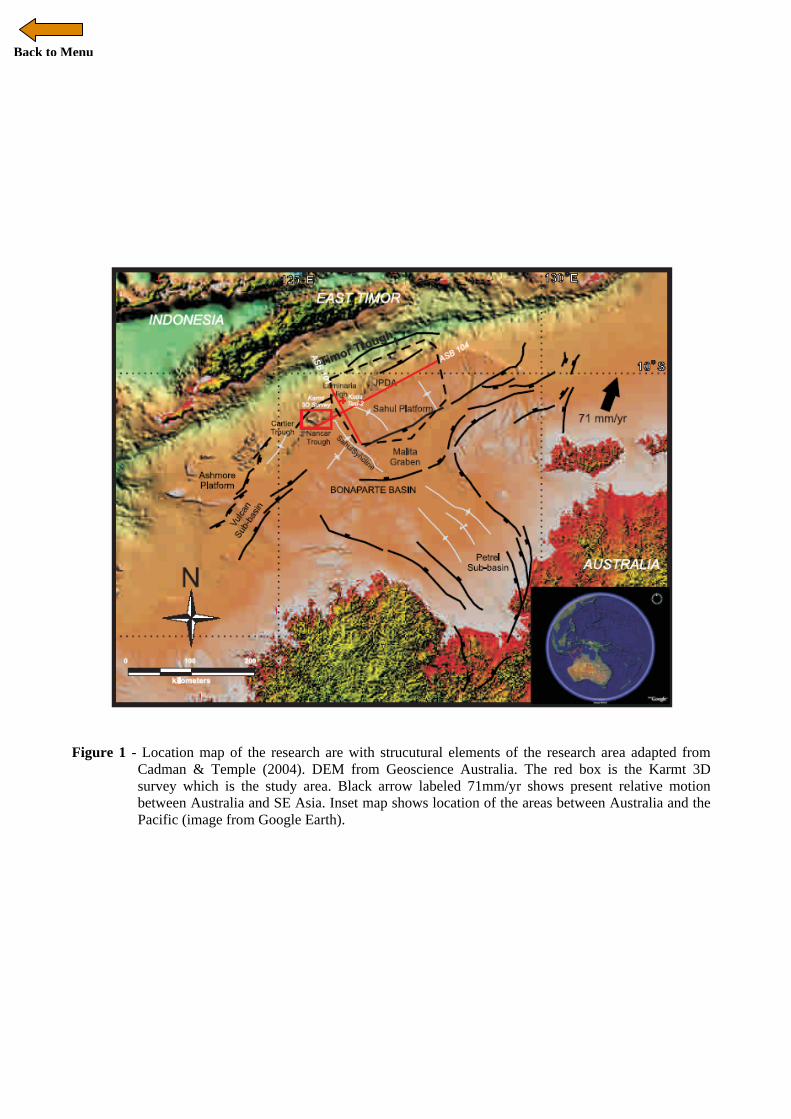
The study area is located on the Australian NW Shelf (Figure 1) close to the western edge of the Sahul Platform. To the north, the area is bounded by the Timor Trough with a NE-SW trend. At the present day the Australian plate is being subducted beneath the SE Asian margin and the northwestern part of Australia is currently in collision with the Banda Arc in the area around Timor Island (Hamilton, 1979). More than 45 wells have been drilled in this area, especially in the JPDA (Joint Petroleum Development Area; Figure 1), with oil and gas discoveries in the Sunrise and Troubadour fields in the northeast of the study area.
A 3D seismic survey and a series of 2D seismic lines cross the study area which lies within the Sahul Platform and the Laminaria High in the northeast (Figure 1). These data were provided by Geoscience Australia. The water depths range from 50 metres to more than 1000 metres based on seismic observations. One detailed exploration well data set, from the Kuda Tasi–2 well near the Laminaria High (Figure 1), was downloaded from the Geoscience Australia website. A number of studies have been undertaken in the Vulcan sub-basin (Woods, 1998, 2004; Chen et al., 2002; Edwards et al., 2004) which lies to the southwest of the study area, and in the JPDA (Gorter et al., 2004) to the northeast of the area. These studies have utilised predominantly 2D seismic data and have been concerned with petroleum exploration.
The area discussed in this study is relatively understudied in comparison. The main focus here is the structural configuration and an understanding of structural evolution of the northern Bonaparte Basin.
Back to Menu
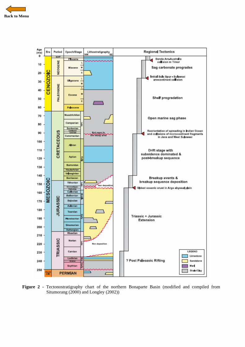
TECTONIC SETTING The regional geology of the basins, including the Bonaparte and Browse Basins, has been described by numerous authors including Laws & Kraus (1974), Gunn (1988), Mory (1988), Patillo & Nicholls (1990), and Longley (2002). The geological evolution of the area started with rifting in the Paleozoic which controlled the distribution and thicknesses of the Mesozoic and Cenozoic sequences. This rifting phase was followed by subsidence and accompanied by sedimentation. The Mid-Triassic tectonic event produced a fault trend in NNE-SSW direction. According to Chen et al. (2002) this event was followed by another rifting phase, in the same orientation, in the Mid-Late Jurassic, and was associated with Callovian uplift and erosion. This erosion and uplift, also suggested by Harrowfield & Keep (2005), are resulted in the amplification of basement structural highs as well as leading to sedimentary thinning. Longley (2002) and Etheridge & O’Brien (1994) mentioned that during the Jurassic-Cretaceous, the relict intra-continental Permo-Carboniferous rift was exploited, modified and incorporated into the passive margin that later would become the Australian NW shelf. Chen et al. (2002) suggested another period of rifting that occurred in the Late Jurassic (~153 Ma) which provided the accommodation space for the Late Jurassic-Cretaceous break-up sequence to fill the basin. Extension was accompanied by uplift in the Late Jurassic and this is interpreted to be due to flexure driven by sea-floor spreading (Harrowfield & Keep, 2005). This flexure led to erosion and truncation that produced the Valanginian unconformity. Following the formation of this unconformity the post-breakup sag phase sequences were deposited in the shelf area of the passive margin. In the Late Cenozoic, the Australian Plate collided with the Banda volcanic arc which caused down-warping of the Australian continental margin and led to flexure of the Australian Plate. Loading of Timor Island on the northwest Australia margin may have contributed further to this flexure (Londono & Lorenzo, 2004). As collision continued through the Pliocene, the trench south of the arc became inactive, and later the southward-dipping Flores and Wetar thrusts became the new active margin between Southeast Asia and the Australian Plate (Hall, 2002; Audley-Charles, 2004). It is suggested that slab break-off may have contributed to these younger fault movements (Hall, 2002). Keep et al. (2002) described the
deformation in the Neogene and divided it into three main pulses, which occurred in the Early Miocene, the Late Miocene and the late Early Pliocene. All pulses of deformation are considered by Keep et al (2002) to be associated with the Neogene-Banda Arc collision that according to them began at ~25 Ma in the Late Oligocene. In contrast, Hall (2002) identifies ~25 Ma as the beginning of collision of the Sula Spur with Sulawesi, and dates the Banda Arc-Australia collision at about 4 Ma (Hall, 2002; Audley-Charles, 2004) (Figure 2). This Neogene tectonism associated with foreland development has been very important in producing reactivation and inversion of extensional faults in the vicinity of the Bonaparte Basin (Chen et al., 2002). In terms of structural development, the northern Bonaparte basin is mainly a result of extensional fault systems developed during rifting in the Paleozoic and Mesozoic. There was further displacement on faults that resulted from the Late Jurassic rifting that led to the breakup event (Figure 2). The collision between Australia Plate and the Banda arc, which occurred in the Late Cenozoic, has modified the fault architecture throughout the basin. Inheritance of extensional architecture and interaction with contractional setting of Neogene deformation has been discussed by several authors including Woods (1988) who concentrated on the tensional effects and Keep et al (2000) who concentrated on the strike-slip effects. Flexural deformation related to the oblique sense of movement is mentioned by Harrowfield et al. (2003). The load of Timor Island as a result of Early Pliocene arc-continental collision (Audley-Charles, 2004) caused lithospheric flexure and was resulted the development of a foredeep in the Timor trough and flexural bulge in the adjacent outer shelf (Chen et al., 2002) which most likely led to erosion. The Cenozoic faults are directly above, but apparently not quite parallel to the deeper Mesozoic fault system, reflecting the Cretaceous and Upper Jurassic shales and claystones that acted as ductile horizons during Neogene deformation. A model for the Neogene flexural deformation from Harrowfield & Keep (2005) suggests the uplifted area tends to have elastic behaviour induced by the down-warp of the Australian plate under Timor loading, accompanied by imbricated thrust structures. This Neogene deformation is associated with small remote N-S compressional stresses during the collision and represented by the normal (pure shear) contraction of Bonaparte basin and also strike-slip partitioned (simple shear)
Back to Menu
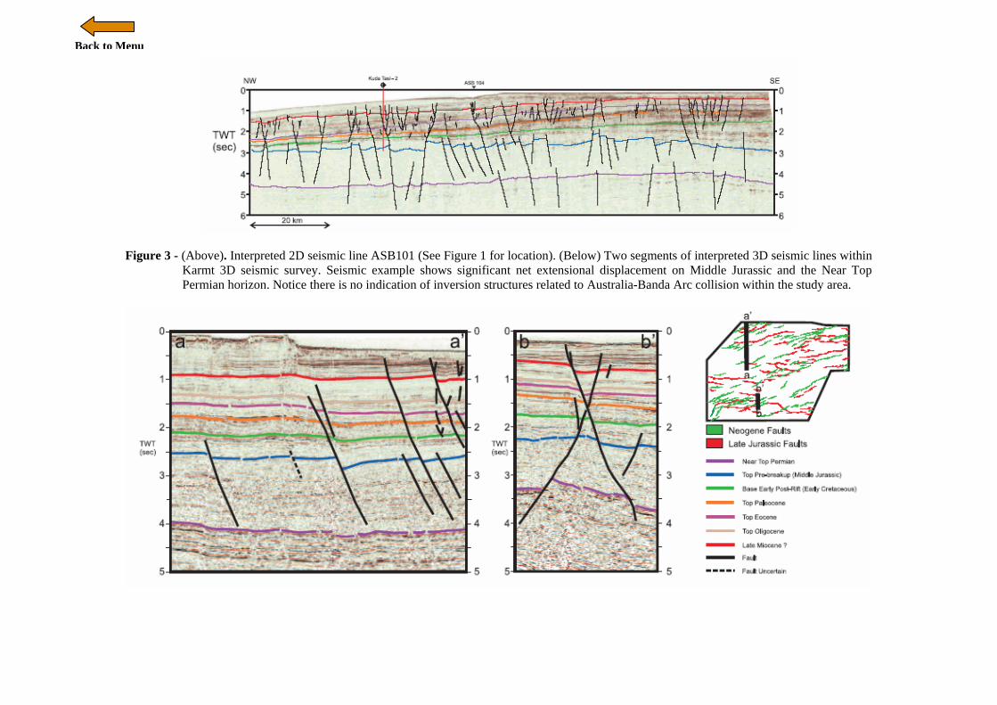
deformation (Harrowfield et al., 2003) outboard of the Ashmore platform. This oblique collision also varied in a complex way between hard-linked coaxial deformation with the same trend of faults in the local stress direction, and with soft-linked associated significant oblique deformation reflecting variations in basement structural relief and overburden thickness. The Neogene faults seldom reach the seafloor, but the maximum offset is mostly at the Miocene level which reflected the major phase of extensional movement. METHODOLOGY Seven horizons were picked as megasequences boundaries identified from the seismic data (Figure 3) and based on information from previous studies in the Bonaparte basin (Chen et al., 2002; Keep et al., 2002). Seismic interpretation utilized the Unix Landmark software, using Seisworks for interpretation and Geoprobe software for more detailed 3D visualization. The seismic horizons were also tied with Kuda Tasi-2 well data which has stratigraphic markers only and lack detailed information on the well logs. Because the Kuda Tasi-2 well data is located outside the 3D survey area, the correlation was extended across the ASB-101 and the ASB-104 2D line into the Karmt 3D survey. Time structure maps for several important horizons for major events were generated using Seisworks and Geoprobe software for 3D visualisation on the horizon to surface transformation. STRUCTURAL STYLES The long history with different tectonic regimes in this region has produced different structural styles through time. Several structural styles in the study area are observed on the seismic lines and also on the structural maps. These include features such as tilted fault blocks, conjugate fault structures, and en echelon fault structures. Tilted fault blocks were developed in the northwestern part of the study area (Figure 3a). Observations from the seismic lines suggest this style was developed early in the Late Jurassic during the breakup event. The later collision in the Neogene was reactivated the rift faults and formed complex vertical linkages with younger faults. The geometry of the faults suggests rotation was operating together with extension at the same time. The faults mostly die out at the near base of Triassic suggesting ductile deformation at this level to accommodate rotation of faults.
Conjugate fault structures are well developed at the south-western graben with an example shown in Figure 3b. The main fault has a steep angle of dip with the development of an antithetic fault dipping in the opposite direction. Small faults are also developed in between these two faults. Pliocene growth strata were deposited during the progressive development of this fault. The geometry of this conjugate fault set suggests this style was developed progressively above the horst blocks that had formed earlier during Mesozoic rifting. The conjugate fault structure tends to develop in narrow horst blocks rather than wide horsts to accommodate vertical linkage of older and younger fault in an easier way (Figure 4).
En echelon fault structures are well developed in the southern part of the study area (Figure 4c). The faults predominantly trend NE-SW and have a right stepping pattern. On the seismic line the faults are linked with the older rift faults with a steep angle of dip (60-70°) and planar fault surfaces which predominantly dipping to the south. Many small faults with the opposite dip also developed along the fault plane. These en echelon faults were developed in the Neogene and may be due to the collision. Clear seismic images and fault geometry of this structural style are shown in Figure 5.
VERTICAL FAULT LINKAGE
Australia-Banda Arc collision in the Neogene led to reactivation of several older fault structures in a selective manner. New faults developed above the largest and longest Mesozoic rift faults. Some are clearly linked to the older faults, but others are not. The geometry and the mechanism of linkage have been discussed for many years and are important to analyze in terms of breaching of structural traps related to hydrocarbon migration.
Late Miocene to Pleistocene extensional faulting is observed throughout the Bonaparte basin. This phase of faulting started around Early Pliocene at about 5-4 Ma and is associated with the development of Pliocene growth strata. The amount of offset on the faults often varies, probably because of the conjugate nature of the faults. Many of the faults are located above the Mesozoic rift faults indicating the development and location of the Neogene extensional faults was controlled by the earlier Mesozoic structures. The fault plane geometry (Figure 5) in several localities shows hard linkage between the Neogene faults and the Mesozoic rift faults. However, observations from seismic shows several post-rift faults are also formed independently in different locations and were not follow the Mesozoic rift faults.
Back to Menu
The conjugate fault geometry observed in the post-rift sequence also supports this interpretation. In places two faults developed at the same time with an opposite dip direction that have a large displacement in the upper and lower levels (Figure 5). This geometry suggests that the reactivation caused strain in the mid interval (Cretaceous-Paleocene level) where two large faults with opposite dipping direction are joined together. During the deformation, micro-fractures formed within this interval and accommodate the linkage of both large faults. A good example of this kind of feature is shown in Figure 5c, on a fault located in the south-western graben of the study area. The bounding faults of the horst block were reactivated and joined up with the younger fault. The development of splay faults within the graben is also observed in the seismic line (Figure 5c). Splay faults with opposite dips were also developed at the same time as the large fault formed during deformation and deposition of the Pliocene growth strata. En echelon fault structures are also observed in map view (Figure 5b). Different strike orientation of the Neogene post-rift faults and Jurassic rift faults does not indicate that no linkage occurred between them. In the south-eastern area of the study area, a very good example of hard linkage of en echelon fault structures with a Jurassic rift fault is observed (Figure 5b). In the 3D visualization of the fault plane geometry (Figure 5), these en echelon faults curves around and joined up with the older rift faults. Several splay faults from the linkage fault are also joined with the Late Jurassic syn-rift structures. STRUCTURAL CONFIGURATION AND DEFORMATION MECHANISMS Consistency between the regional structural and stratigraphic evolution and local geology is important. Stress re-orientation during the geological evolution will affect the structural configuration. Three major tectonic events with different fault trend directions have been identified in the study area, which are associated with the Mid Triassic extensional phase, Late Jurassic-Early Cretaceous rifting and breakup event, and the Neogene collision between Australia and the Banda Arc. Middle Triassic (?) Extensional Phase Based on observations from the seismic lines, this extensional phase produced normal faults that cut
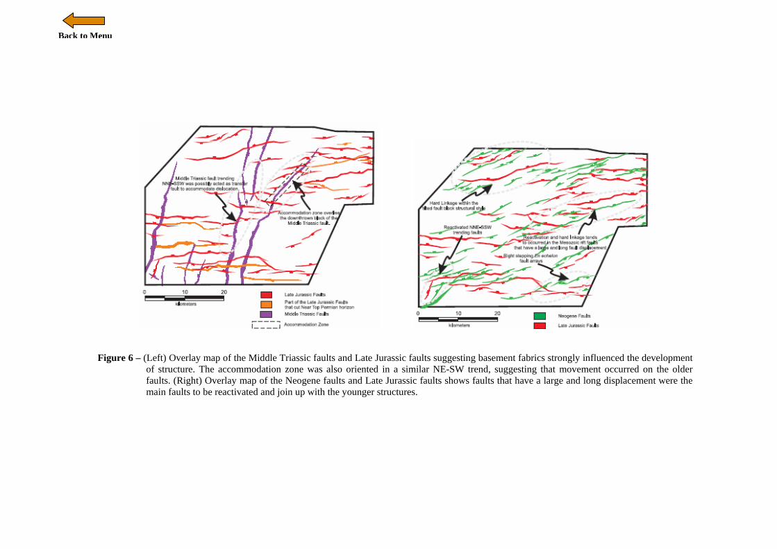
the Early Triassic to Permian sequence with displacements of more than 200 ms (TWT). The faults predominantly trend NNE-SSW. The timing of the fault movements is estimated to be younger than Early Triassic and older than Middle Jurassic. Thick Triassic to Middle Jurassic sediments are interpreted from the isochron map of Permian to top Middle Jurassic horizons, and suggests that this extensional phase created a large depocentre in the northeast of the study area. Similar older fabrics are also mentioned by Decker et al. (2009) as Permian NW-trending zones of weakness in the Canning Basin, Kimberley Block, Petrel Sub-basin, and Money Shoal. In extended regions, basement fabrics commonly influence the development of faults in the region, so it is possible that the trend of the Middle Triassic faults reflects Paleozoic structural fabrics which controlled the fault geometry. Segmented faults with relay ramp transfer zones were developed at this time. The inferred extension direction, of 300-320°, is perpendicular to the dominant NNE-SSW fault trend. A view of the structural configuration of the Middle Triassic extensional phase is shown in Figure 6. Late Jurassic-Early Cretaceous Rifting The extensional phase in the Early Mesozoic ultimately initiated the breakup event in the Late Jurassic. Displacement in the Jurassic was approximately half that of the earlier extensional phase. It created accommodation space that was filled by Late Jurassic syn-rift breakup sediments. Seismic observations clearly show the onlap terminations of this syn-rift sequence onto the Middle Jurassic surface represented by the Top Plover Formation (Figures 3 and 5). Breakup was associated with the formation of Jurassic oceanic crust in the Argo Abyssal Plain documented by the Ocean Drilling Program (ODP) Leg 123 site 765. The Late Jurassic normal faults predominantly trend E-W to ENE-WSW with steep to moderate angles of dip. The faults are believed to curve around to a NE-SW direction in the Vulcan sub-basin (Gartrell et al., 2006). Tilted fault blocks developed in the northwest of the study area with faults dominantly dipping to the NW suggest ductile deformation at the Triassic level during rifting. A low relief accommodation zone formed in the eastern graben, striking NE-SW along an en echelon array of segmented rift faults (Figure 6). This accommodation zone was formed due to

Back to Menu
interlocking propagation of en echelon array of segmented rift faults with different polarities. Another rift segment also developed in the southwest of the study area with no development of an en echelon array or accommodation zone. Based on the structural configuration overlay map of the Middle Triassic and Late Jurassic faults (Figure 6), it appears that older fabrics strongly influenced the development of this structure. The accommodation zone in the eastern graben overlies the depression that was created by the previous extensional phase. This accommodation zone was also oriented in a similar NE-SW trend, suggesting that movement occurred on the older faults. The interpreted 310-340o extension direction is perpendicular to the strike of the faults. The extension direction is consistent with the orientation of the fracture zones formed in the Jurassic oceanic crust. The interpretation also supports different extension directions for the Early Mesozoic and Late Jurassic events. Neogene Collision The Australia-Banda Arc collision in the Neogene reactivated older Mesozoic faults. Hence, there is a complex vertical linkage of faults in the Cretaceous-Paleocene interval. In general, the faults trend NE-SW and have a net normal displacement. The faults cut the Paleocene to approximately Upper Pliocene strata with significant development of growth strata in the Pliocene. This suggests that the faulting started during the Early Pliocene. The time structure map of the Late Miocene horizon can be considered as representative of the structural configuration in the Neogene (Figure 6). In some places the faults die out in a significant distance below the sea floor, suggesting Late Pliocene cessation of fault activity. Selective reactivation of the faults also occurred in this region. The structural configuration overlay map of Late Jurassic faults with Neogene faults (Figure 6) shows faults that have a large and long displacement are the main reactivated faults and these joined up with the younger structures. The dip direction of the Mesozoic rift faults does not influence the younger structures. This is clearly shown by the en echelon fault arrays located in the southern part of the study area (Fig 6) that dipping to the southeast, linked to Mesozoic rift faults with similar dip direction, whereas in the northern part of the study area the opposite is the case. Conjugate fault structures, right-stepping en echelon fault arrays, and splay faults developed at
this stage. Conjugate fault structures are well developed in the area where a narrow horst block was formed by the Late Jurassic rifting. Right-stepping en echelon fault arrays developed most likely in response to oblique convergence between Australia and SE Asia. The oblique motion also favoured the reactivation of the Early Mesozoic faults. The faults that cut the Permian and Triassic sequence also cut the syn-rift and post-rift sequence, suggesting that the older fault plane was favoured for being re-used by the latest applied stress direction in the Neogene. However, not all older faults were reactivated, which may be due to the thick overburden of the post-rift packages that prevented the fault to propagate easily.
No rifting occurred in the Neogene and the development of the extensional fault systems at this stage are not caused by stretching. In the Late Miocene the continental-oceanic transition reached the subduction system and collision of the Australia and Banda Arc began at approximately ~4 Ma in the Pliocene (Audley-Charles, 2004; Hall, 2002) and ultimately led to Timor over-thrusting the continental Australian plate, forming the Timor Trough foredeep and later back-thrusting north of the Banda Volcanic Arc. This suggests that there are two possible mechanisms that contributed to structural development in the early Pliocene, which are:
• Flexure induced by the Timor thrusting and loading, and/or
• Oblique convergence along the margin.
Supak et al. (2006) proposed a model of fault and fracture development during flexure based on analogue models using solidified plaster layers and analyzed the pattern resulting from a given load. In the flexure case, the faults tend to nucleate and concentrate along the axis of maximum tensile stress within a bending brittle plate. With greater bending, additional fault breaks occurs on either side of the initial break. This is different from the stretching case where the faults and fractures occur randomly and nucleate over a broad region. Based on this model, it is suggested here that initial fault development in the study area was induced by flexure after the Australian continent reached the subduction system and collided with the Banda Arc. The collision led to the fore-deep Timor Trough development with southward thrusting of the Australian margin. The Australian continental margin was evidently bent due to loading by thrusting on Timor. This probably induced uplift of part of the Australian margin and caused some

Back to Menu
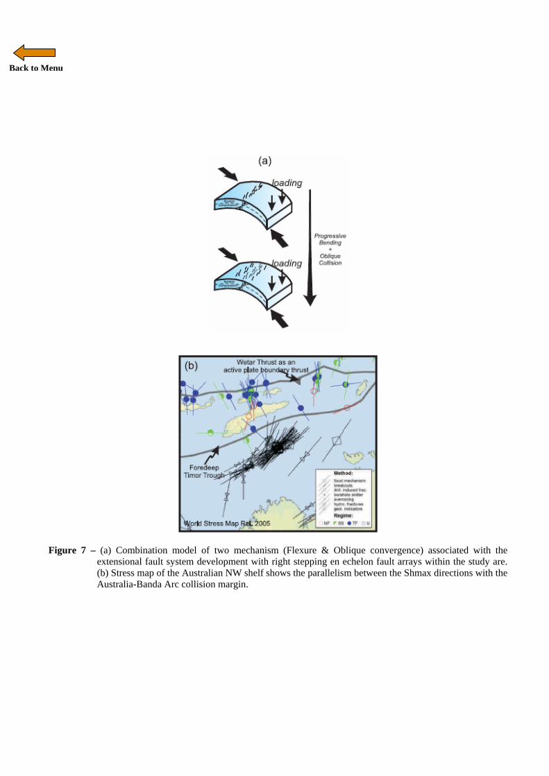
erosion of the upper crust. This may have provided sediment to the Pliocene growth sequence that filled the accommodation space during progressive development of extensional faults related to flexure. The model also suggests that as the bending movement continues, the extensional component will vary with depth. The upper layer will show extension that induces fault/fractures, whereas the lower part would undergo compression that could induce uplift. Londono & Lorenzo (2004) also used a flexural model in which continental crust of the Australian plate was flexed due to Timor loading during the Neogene collision. The uplift due to compression in the study area would be concentrated at a lower interval such as the Mesozoic. Uplift was concentrated on several horst blocks within the area and also explains why the faults were reactivated. This may also answer the question of why there are no inversion features (e.g. harpoon structures) developed during this down-warp. However, the flexural mechanism alone is not sufficient to explain the oblique displacement on right-stepping en echelon fault arrays, the splay fault development, and the reactivation of NNE-SSW trending Early Mesozoic faults observed in the study area. All of these features suggest that an oblique component was present in the region during the Late Cenozoic. This is also supported by the stress map (2005) based on well breakout and hydrofracture data (Figure 7b). The maximum horizontal stress (SHmax) in this area strikes 030-060o. The stress map shows the parallelism between the SHmax directions and the Australia-Banda Arc collision margin (Dyksterhuis et al., 2005). This suggests that the collision did not create a significant net push at the margin. The interpretations of the Late Miocene structural configuration during collision, the relative plate movements at ~5 Ma and present day, and the stress map of the region suggest flexure and oblique convergence were both influences. Loading due to Timor thrusting created near-surface extensional fault systems and uplift of Mesozoic horst blocks due to compression in the middle-deeper part of the crust caused linkage to deeper faults. Oblique convergence created right-stepping en echelon fault arrays trending NE-SW (Figure 7a). CARBONATE PLATFORM DEVELOPMENT The carbonate platforms or build-ups trend NE-SW relatively and follow the current shelf edge. Most
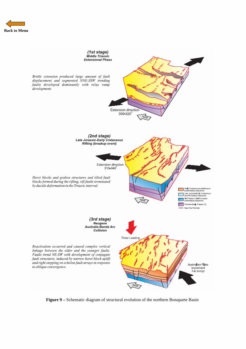
platforms or build-ups developed on top of high topography in the study area suggesting uplift associated with horst or footwalls during the Neogene collision (Figure 8). Environment controlled by tectonic setting appears to have been an important influence on carbonate platform development as suggested by Bosence (2005). An alternative explanation was proposed by O’Brien et al (2002) who suggested the development of these carbonate platforms to be induced by breaching of structural traps and oil migration during reactivation as evidenced by dry wells, although oil was discovered in the Sunrise and Troubadour fields in the north-east of the study area. An overlay of a map of carbonate areas with a semblance coherency time slice map (704 ms) (Figure 8) shows a correlation of seismic artefacts with carbonate areas suggesting some connection with trap breaching. However, in some places there is no relationship and the artefacts appear to be present only where fault linkages developed. The seismic lines also show that micro-fractures associated with fault damage zones which formed during the Neogene collision were responsible for hydrocarbon leakage and these were not developed solely in carbonate. Overall, there appears to be no direct relationship between carbonate platforms and build-ups with hydrocarbon migration. CONCLUSIONS Based on this study a structural evolution of the study area can be outlined (Figure 9). Three main tectonic events were observed in the study area: • Middle Triassic extension (NNE-SSW trending
faults) • Late Jurassic-Early Cretaceous rifting (breakup
event) (E-W to ENE-WSW trending faults) • Neogene Australia-Banda Arc collision (NE-
SW trending faults) The major phase of extension in the region took place in about the Middle Triassic. Brittle extension produced fault displacements of more than 500 m with steep fault dips of around 70-80°. Segmented NNE-SSW trending faults with significant relay ramp development probably reflect the influence of basement fabrics. Fault dips and strike directions are consistent with an extension direction of 300-320°.

Back to Menu
Renewed extension began in the Late Jurassic. Displacement amounts were half that of the previous extensional phase. Horst blocks and graben were developed in this rifting event and tilted fault blocks formed during the rifting possibly aided by ductile deformation in the Triassic sequence. In the east, a relay ramp transfer zone developed and formed a NE-SW oriented accommodation zone by the interlocking of propagating relay structures. The dominant ENE-WSW fault trend suggests the extension direction was probably 310-340°, similar to the orientation of fracture zones within the Jurassic oceanic crust. The rifting ceased in the Early Cretaceous (Valanginian) and was followed by regional subsidence over the region. The post-rift sequences were deposited and were dominated by fine clastic and carbonate sediments until the Miocene. Australia-Banda Arc collision occurred during the Pliocene. As a consequence of this collision, older Mesozoic faults with fault directions that favoured the applied stress direction were reactivated with complex linkages between deep and shallow faults. The collision was marked by Pliocene growth sequence deposition during extensional fault development. The faults trend predominantly NE-SW with development of conjugate fault structures, induced by uplift of narrow horst blocks and right stepping en echelon fault arrays in response to oblique convergence. Flexure induced by the Timor loading and oblique convergence due to relative plate movements combined with each other and modified the structural configuration of the study area. During flexure there was relative uplift of Mesozoic horst blocks. Oblique motion with a left-lateral sense of movement also modified the structural configuration with the development of right stepping en echelon fault arrays. Reactivation in the Neogene led to hydrocarbon migration via faults and micro-fractures and may have contributed to development of carbonate platforms and build-ups although overall there appears to be no direct relationship. ACKNOWLEDGEMENTS We thank Geoscience Australia for providing the dataset. Vicki Amir’s MSc programme at Royal Holloway was made possible by the SE Asia Research Group with funds from the consortium of oil companies who have supported our projects in SE Asia for many years. We thank Edyta Frankowicz and Ben Clements for information,
discussion and help and the 2007-2008 MSc Petroleum Geosciences students for support. REFERENCES Audley-Charles, M.G. 2004. Ocean trench blocked and obliterated by Banda forearc collision with Australian proximal continental slope. Tectonophysics, 389, 65-79. Bosence, D. 2005. A genetic classification of carbonate platforms based on their basinal and tectonic settings in the Cenozoic. Sedimentary Geology, 175, 49-72. Cadman, S.J. & Temple, P.R., 2004, Bonaparte Basin, NT, WA, AC and JPDA, Australian Petroleum Accumulations Report 5, 2nd Edition, Geoscience Australia, Canberra. Chen, G., Hill, K.C., Hoffman, N. & O’Brien, G.W. 2002. Geodynamic evolution of the Vulcan Sub-basin, Timor Sea, northwest Australia: a pre-compression New Guinea analogue? Australian Journal of Earth Sciences, 49, 719-736. Decker, J., Bergman, S.C., Teas, P.A., Baillie, P. & Orange, D.L. 2009. Constraints on the tectonic evolution of the Bird’s Head, West Papua, Indonesia. Proceedings Indonesian Petroleum Association, 33rd Annual Convention. Dyksterhuis, S., Albert, R.A. & Muller. R.D. 2005. Finite-element modelling of contemporary and palaeo-intraplate stress using ABAQUSTM. Computers & Geosciences, 31, 297-307. Edwards, D.S., Kennard, J.M., Preston, J.C., Boreham, C.J., van Aarssen, B.G.K., Summons, R.E. & Zumberge, J.E. 2004. Geochemical characteristics of hydrocarbons from the Vulcan Sub-basin, western Bonaparte Basin, Australia. In: Ellis, G. K., Baillie, P. W. & Munson, T. J. (Eds.), Timor Sea Symposium. Northern Territory Geological Survey, Darwin, Australia, 169-201. Etheridge, M.A. & O’Brien, G.W. 1994. Structural and tectonic of the Western Australian margin basin system. Petroleum Exploration Society of Australia Journal, 22, 45-63. Gartrell, A., Bailey, W.R. & Brincat, M. 2006. A new model for assessing trap integrity and oil preservation risks associated with postrift fault reactivation in the Timor Sea. American Association of Petroleum Geologists Bulletin, 90, 1921-1944.

Back to Menu
Gorter, J.D., Glikson, A.Y. & Deighton, I. 2004. Diatremes in the Northern Bonaparte Basin? Implication for petroleum exploration. In: Ellis, G. K., Baillie, P. W. & Munson, T. J. (Eds.), Timor Sea Symposium. Northern Territory Geological Survey, Darwin, Australia, 257-274. Gunn, P.J., 1988 Bonaparte Basin: Evolution and Structural Framework, in Purcell P.G. and Purcell, R.(Eds), The North West Shelf, Australia, Proceedings of the Petroleum Exploration Society of Australia Symposium, Perth, 1988, 275-286. Hall, R. 2002. Cenozoic geological and plate tectonic modification of SE Asia and the SW Pacific: Computer-based reconstructions, model and animations. Journal of Asian Earth Sciences, 20, 353-434. Hamilton, W. 1979. Tectonics of the Indonesian region. U.S. Geological Survey Professional Paper, 1078, 345 pp. Harrowfield, M., Cunneen, J., Keep, M., and Crowe, W., 2003. Early-stage orogenesis in the Timor Sea region, NW Australia. Journal of the Geological Society; December 2003; v. 160; no. 6; p. 991-1001. Harrowfield, M. & Keep, M. 2005. Tectonic modification of the Australian North-West Shelf: episodic rejuvenation of long-lived basin divisions. Basin Research, 17, 225. Keep, M., Clough, M & Langhi, L. 2002. Neogene tectonic and structural evolution of the Timor Sea region, NW Australia. In: Keep, M. & Moss, S.J. (Eds.) The Sedimentary Basins of Western Australia III, Proceedings West Australian Basins Symposium, Petroleum Exploration Society of Australia, 341-353. Laws, R. A., and G. P. Kraus, 1974, The regional geology of the Bonaparte Gulf-Timor Sea area: APEA Jour., v. 14, pt. 1, p. 77-84. Londono, J. & Lorenzo, J.M. 2004. Geodynamics of continental plate collision during late tertiary foreland basin evolution in the Timor Sea: constraints from foreland sequences, elastic flexure and normal faulting. Tectonophysics, 392, 37-54. Longley, I. 2002. The North West Shelf of Australia - a Woodside perspective. In: Keep, M. & Moss, S.J. (Eds.) The Sedimentary Basins of
Western Australia III, Proceedings West Australian Basins Symposium, Petroleum Exploration Society of Australia, 28-86. Mory, A. J., 1988, Regional geology of the offshore Bonaparte Basin, in Purcell, P. G., and Purcell, R. R., eds., The North West Shelf Australia: Proceedings of Petroleum Exploration Society Australia Symposium, Perth, 1988, W. A. PESA, p. 287-309. O’Brien, G.W., Glenn, K., Lawrence, G., Williams, A.K., Webster, M., Burns, S. & Cowley, R. 2002. Influence of hydrocarbon migration and seepage on benthic communities in the Timor Sea, Australia. Australian Petroleum Production and Exploration Association Journal, 225-240. Pattillo, J. & Nicholls, P.J. 1990. A tectonostratigraphic framework for the Vulcan Graben, Timor Sea region. Petroleum Exploration Society of Australia Journal, 30, 220-252. Proceedings of the Ocean Drilling Program, Leg 123. 1990. In: Gradstein, F.M., Ludden, J.N. and Shipboard Scientific Party, Proceedings of the Ocean Drilling Program, Leg 123, Initial Reports, 63-267. doi:10.2973/odp.proc.ir.123.104.1990. Situmorang, B., 2000. Timor Sea, Chapter 12. In: An Outline of the geology of Indonesia (Ed. By Darman, H. & Sidi, F.H.), pp161-164. Indonesian Association of Geologists IAGI, 2000. Supak, S., Bohnenstiehl, D.R., & Buck, W.R. 2006. Flexing is not stretching: An analogue study of flexure-induced fault populations. Earth and Planetary Sciences Letters, 246, 125-137. Woods, E.P. 1998. Extensional structures of the Jabiru Terrace, Vulcan sub-basin. In: Purcell P.G. & Purcell, R.R. (Eds.) The North West Shelf, Australia. Proceedings NW Shelf Symposium, Petroleum Exploration Society of Australia, 311-330. Woods, E.P. 2004. Twenty years of Vulcan Sub-basin exploration since Jabiru – what lessons have been learnt? In: Ellis, G. K., Baillie, P. W. & Munson, T. J. (Eds.), Timor Sea Symposium. Northern Territory Geological Survey, Darwin, Australia, 83-97.
Back to Menu
Figure 1 - Location map of the research are with strucutural elements of the research area adapted from
Cadman & Temple (2004). DEM from Geoscience Australia. The red box is the Karmt 3D survey which is the study area. Black arrow labeled 71mm/yr shows present relative motion between Australia and SE Asia. Inset map shows location of the areas between Australia and the Pacific (image from Google Earth).
Back to Menu
Figure 2 - Tectonostratigraphy chart of the northern Bonaparte Basin (modified and compiled from
Situmorang (2000) and Longley (2002))
Back to Menu
Figure 3 - (Above). Interpreted 2D seismic line ASB101 (See Figure 1 for location). (Below) Two segments of interpreted 3D seismic lines within Karmt 3D seismic survey. Seismic example shows significant net extensional displacement on Middle Jurassic and the Near Top Permian horizon. Notice there is no indication of inversion structures related to Australia-Banda Arc collision within the study area.
Back to Menu
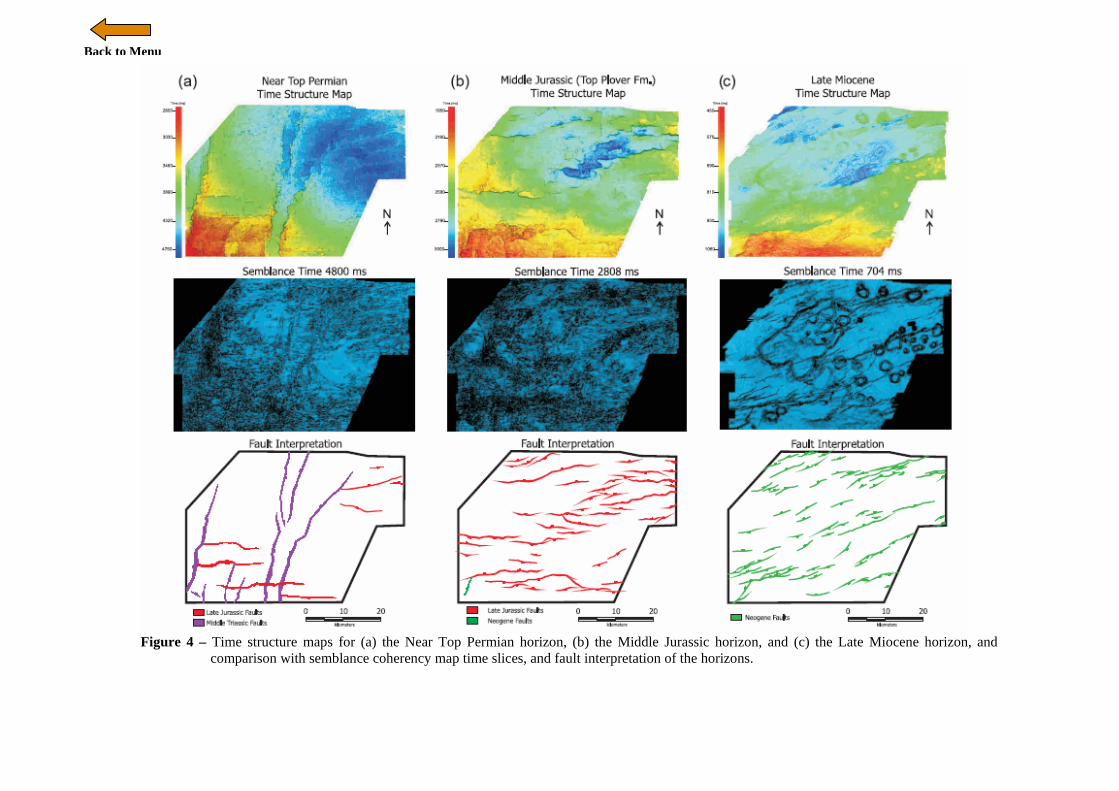
Figure 4 – Time structure maps for (a) the Near Top Permian horizon, (b) the Middle Jurassic horizon, and (c) the Late Miocene horizon, and
comparison with semblance coherency map time slices, and fault interpretation of the horizons.

Back to Menu
Figure 5 – The fault geometry in several localities shows hard linkage between the Neogene faults and the Mesozoic rift faults. However, the seismic
observations show several post-rift faults also formed independently in different locations and did not follow the older Mesozoic rift faults. This observation shows that extensional faults developed in the study area independently in the Cenozoic interval and were not directly caused by the propagation of the older faults to create on large fault.
Back to Menu
Figure 6 – (Left) Overlay map of the Middle Triassic faults and Late Jurassic faults suggesting basement fabrics strongly influenced the development of structure. The accommodation zone was also oriented in a similar NE-SW trend, suggesting that movement occurred on the older faults. (Right) Overlay map of the Neogene faults and Late Jurassic faults shows faults that have a large and long displacement were the main faults to be reactivated and join up with the younger structures.
Back to Menu
Figure 7 – (a) Combination model of two mechanism (Flexure & Oblique convergence) associated with the extensional fault system development with right stepping en echelon fault arrays within the study are. (b) Stress map of the Australian NW shelf shows the parallelism between the Shmax directions with the Australia-Banda Arc collision margin.

Back to Menu
Figure 8 - Overlay of carbonate platform/build-ups surface map with semblance coherency (704 ms) with seismic example for detailed feature as well
as 3D visualization of the platform.
Back to Menu
Figure 9 – Schematic diagram of structural evolution of the northern Bonaparte Basin