Street Addressing and the Management of Cities -...
284
Street Addressing and the Management of Cities CATHERINE FARVACQUE-VITKOVIC, LUCIEN GODIN, HUGUES LEROUX, FLORENCE VERDET, AND ROBERTO CHAVEZ DIRECTIONS IN DEVELOPMENT DIRECTIONS IN DEVELOPMENT 32923
Transcript of Street Addressing and the Management of Cities -...

Street Addressing and the Managementof CitiesCATHERINE FARVACQUE-VITKOVIC, LUCIEN GODIN,
HUGUES LEROUX, FLORENCE VERDET, AND ROBERTO CHAVEZ
D I R E C T I O N S I N D E V E L O P M E N TD I R E C T I O N S I N D E V E L O P M E N T
32923


Street Addressing andthe Management of Cities
D I R E C T I O N S I N D E V E L O P M E N T
Catherine Farvacque-Vitkovic, Lucien Godin, HuguesLeroux, Florence Verdet, and Roberto Chavez
WORLD BANK
Washington, D.C.

© 2005 The International Bank for Reconstruction and Development / The World Bank1818 H Street, NWWashington, DC 20433Telephone 202-473-1000Internet www.worldbank.orgE-mail [email protected]
All rights reserved.
1 2 3 4 08 07 06 05
The findings, interpretations, and conclusions expressed herein are those of the author(s) and donot necessarily reflect the views of the Board of Executive Directors of the World Bank or the gov-ernments they represent.
The World Bank does not guarantee the accuracy of the data included in this work. Theboundaries, colors, denominations, and other information shown on any map in this work do notimply any judgment on the part of the World Bank concerning the legal status of any territory orthe endorsement or acceptance of such boundaries.
Rights and PermissionsThe material in this work is copyrighted. Copying and/or transmitting portions or all of this workwithout permission may be a violation of applicable law. The World Bank encourages dissemina-tion of its work and will normally grant permission promptly.
For permission to photocopy or reprint any part of this work, please send a request with com-plete information to the Copyright Clearance Center, Inc., 222 Rosewood Drive, Danvers, MA01923, USA, telephone 978-750-8400, fax 978-750-4470, www.copyright.com.
All other queries on rights and licenses, including subsidiary rights, should be addressed tothe Office of the Publisher, World Bank, 1818 H Street NW, Washington, DC 20433, USA, fax 202-522-2422, e-mail [email protected].
Photo credits:Cover: ©Austrian Archives/CORBISPage 10: V. Mihailovic. Pages 19, 127: D. Diallo, Cellule Guinée. Pages 40, 121, 128, 133, 173, 182,198: T. Lahlou, Cellule nationale du Mozambique. Others: Groupe Huit.
Drawings:Page 198 : B. Gnoumou, Cellule Burkina Faso. Others: Groupe Huit.
On the cover, an astrolabe, one of the first tools of referencing, and an addressing map.
ISBN 0-8213-5814-4 e-ISBN 0-8213-5816-2
Library of Congress Cataloging-in-Publication Data has been applied for.
2004043534

ContentsForewordAcknowledgmentsAbout the AuthorsAbbreviations and Acronyms
1. What Is Street Addressing and Why Is It Necessary? What is street addressing? Why is street addressing necessary?
2. Street Addressing Applications Street addressing and civic identity Street addressing and urban information Street addressing and support to municipal services Street addressing and tax systems Street addressing and the land tenure issue Street addressing and slum upgrading Street addressing and concessionary services Street addressing and economic development
3. Street Addressing Practices Overview of main experiences Burkina Faso CamerGuinea Mali Mauritania Mozambique Niger
Other projects: Benin, Rwanda, Djibouti, Togo, and Côte d’Ivoire
4.Basic assumptions Activity 1. Designing the street addressing program Activity 2. Conducting a feasibility study Activity 3. Setting up the street addressing unit Activity 4. Estimating costs and time frames for an
addressing program Activity 5. Defining the scope of the program
ii i
viix
xixiii
123
192022242732373943
474854
oon 616570748085
Sénégal 90
97
Street Addressing Manual 103104106114121
130137

Activity 6. Choosing a codification system Activity 7. Mapping Activity 8. Surveying and numbering doorways Activity 9. Recording addresses Activity 10. Installing street signs Activity 11. Producing the address map and street index Activity 12. Conducting a media campaign Activity 13. Maintaining and adapting the system
1. Terms of reference for tax registers 2. Toponymy Commission—Burkina Faso 3. Cameroon: Naming of streets and public squares in cities 4. Tracking and monitoring addressing operations 5. Purchase of supplies and materials for street addressing 6. Preparing the address map: aerial photography 7. Preparing address and signage maps 8. Printing the address map and street index 9. Installing addressing materials
Index
BoxesChapter 11.1. Inscribing the names of streets in Paris 1.2. Changes to street names in Quebec 1.3. Disgruntled residents and the Toponymy Commission
1.4. Belgrade: History is written on the walls 1.5. China: Compass-based street addressing 1.6. Japan: Helpless citizens 1.7. Numbering of houses in Crest (France) in 1766 1.8. A “citizen project” Chapter 22.1. Monitoring of epidemics (Maputo, Mozambique) 2.2. Household waste, Conakry, Guinea 2.3. Inventory and valuation of built assets (Senegal and Guinea) 2.4. Development of tax registers (Senegal) 2.5. Tax department involvement in street
addressing surveys (Niger)
iv CONTENTS
140163168177182192195199
Annexes 203204209212214216222228232234
Glossary 239
Bibliography 249
257
56
(Canada) 7789
1010
23262729
30

2.6. Street addressing and concessionary services (Mozambique) 2.7. Economic database (Maputo) Chapter 44.1. Historical curiosities 4.2. Memorandum of agreement between
the municipality and the utility concessionaire 4.3. Urbadr
TablesChapter 22.1. Cadastre and street addressing: a comparison Chapter 33.1. Features of addressing operations based on a sampling
of 21 cities 3.2. Execution and financing of addressing by country and city 3.3. Addressing applications by country 3.4. Street addressing materials per city 3.5. Implementation of the project by city 3.6. Division and weighting of tasks 3.7. RFU costs in US$ Chapter 44.1. Street addressing tasks by phase 4.2. Distribution and phasing of tasks 4.3. Computer equipment for the unit 4.4. Basic cost calculation data 4.5. Calculating cost of street addressing (example) 4.6. Cost calculation assumptions 4.7. Summary of costs according to the city’s population 4.8. Variation in cost according to materials used 4.9. Implementation time frame according to the size of the city
4.10. Decametric numbering system 4.11. Unit cost of materials, not including installation (in US$) 4.12. Comparison of sign densities by cost 4.13. Sample list of street signs
FiguresChapter 11.1. History is written on the walls of Belgrade
The inscriptions change in the streets in ParisChapter 22.1. Cadastre and street addressing2.2. Addressing informal settlementsChapter 33.1. Ouagadougou: Divided into sectors
vCONTENTS
4145
148
171esse 180
36
49505392949597
112122128131132133134135136150185185187
1
340
60
. . .1
4
3.2. Conakry: Divided by “communes”3.3. Bamako: Divided by “addressing zones.”
Cities addressed in Mali3.4. Cities addressed in Mauritania3.5. Mozambique cities involved in addressing initiatives3.6. Niamey: Divided into “districts”3.7. Cities addressed in Senegal3.8. San Pedro: Divided into “addressing zones”Chapter 44.1. Flowchart for tasks4.2. Planning of tasks4.3. Addresses assigned to urban fixtures4.4. Organizational chart for the street addressing unit4.5. Street addressing unit during implementation 4.6. Street addressing materials 4.7. Training of a street addressing unit4.8. Defining phases of a street addressing project4.9. Addressing subdivision by address zones and by neighborhoods
4.10. Progression of the numbering system4.11. Sequential alternating numbering systems4.12. Metric alternating numbering system4.13. Decametric alternating numbering system4.14. Codification of cul-de-sacs and intersections4.15. Codification of intersections4.16. Addressing in informal settlements4.17. Combined addressing system4.18. Puebla Los Angeles in 15314.19. Mannheim4.20. Paris: Choderlos de Laclos’ proposal4.21. Street addressing system in Washington, D.C.4.22. Sectors in Chandigarh4.23. Stages of implementation for a street address map4.24. Example of an address map (Conakry)4.25. Example of survey form 4.26. Field surveyor and survey taker4.27. Team progress chart4.28. Model memo to be presented during the survey4.29. Progress chart for street addressing tasks4.30. Recording data4.31. Stenciling materials4.32. Sponsored street signs4.33. Signage map4.34. Street signs and signposts4.35. Sample map and index4.36. Conducting a media campaign through film, posters, logos
vi CONTENTS
69
7379848996
100
108110121126127128133141144147149150151153154155156157159160161162165166170173174175176181183186188191194198
Foreword
The most spectacular change in sub-Saharan Africa over the last fewdecades has been the dramatic demographic shift from rural areas tocities. Over 80% rural at independence, the region will soon be nearly 50%urbanized.
As cities in the developing world have confronted this demographicexplosion, urban management has become all the more challenging amidthe current trend toward decentralization. With little experience in urbanmanagement, local governments have often been unable to develop theresources they need to deal with urban growth.
Against this backdrop, systems for identifying streets, buildings, andplots have simply been unable to keep up with the pace of urbanization.As a result, 50% or more of the city streets in these countries have nonames or addresses, and the problem is particularly acute in the poorestneighborhoods.
This creates a worrisome predicament for urban services. With nosystem of street coordinates and no baseline information, how do youfind your way around a constantly growing city? How do you dispatchambulances, firemen, and law enforcement personnel quickly? How doyou send mail and messages to private homes? How do you locate urbanfacilities and infrastructure ? How do you pinpoint breakdowns in water,electricity, and telephone systems? How do you improve on-site collec-tion of water and electricity bills? How do you set up an efficient local taxsystem?
Makeshift solutions to these problems exist, but the delivery of urbanservices according to these methods is generally problematic or ineffec-tive. Over the past two decades, several projects aimed at improvingurban information systems in developing countries were launched. Mostof these projects had a limited impact because the proposed approachinvolved techniques that exceeded available local resources. The lack ofavailable local resources stimulated the search for a simpler, moreprogressive approach to urban information systems. Street addressingrequires few resources and a short implementation time frame, and it isintended to provide municipal authorities with an efficient system ofbaseline information on the city, allowing them to apply high-perfor-mance management tools. The broad range of experiences resulting fromthese projects demonstrates that municipal involvement is one key factorin guaranteeing the system’s sustainability. Municipalities shouldgradually broaden the scope of the intervention beyond the unit
vii

implementing the street addressing initiative to encompass the establish-ment of a municipal unit that will collect and analyze data and providecity authorities with the information they need to make decisions.
The challenge is to move gradually forward by teaching local leaders astep-by-step approach to managing information about their citiesthrough: mapping the city, codifying streets, conducting census surveys,setting up a simple computerized system, and developing appliedmanagement tools. Street addressing goes beyond mere urban manage-ment. Assigning individuals an identifiable location in the city providesboth a physical and a symbolic connecting point for all citizens within thecommunity. Street addressing is thus an essential avenue of recognitionfor the civic rights of all citizens.
Since the mid-1980s, the World Bank (International DevelopmentAssociation) and France (Ministry of Foreign Affairs) have providedfinancing for street addressing initiatives in several sub-Saharan Africancountries. More than 15 countries have applied this concept and itsspecific tools to their capital cities. In light of the positive results achieved,they have pursued the same strategy in secondary cities. Moreover,beginning in 1999, meetings to promote an international exchange ofideas have been organized, fostering a deeper understanding of how tomake street addressing initiatives more effective.
At the joint initiative of France’s Ministry of Foreign Affairs and theWorld Bank, an international Street Addressing Workshop held in Paris inApril 1999 hosted almost all of the African countries involved in this issue.In May 2001, the World Bank Infrastructure Forum, which each yearbrings together government and private sector professionals with WorldBank project officers and decisionmakers, helped to broaden awareness ofthis idea through the dissemination of the first draft of a simple technicalmanual on street addressing. In April 2002, during the World Bank’sUrban Forum, African officials responsible for street addressing initia-tives gave an update on the current situation in cities in their respectivecountries.
A 1997 World Bank publication, The Future of African Cities: Challengesand Priorities for Urban Development, mapped out the key issues raised byAfrica’s increasing urbanization and identified addressing as one of thekey tools for urban management. This manual, Street Addressing and theManagement of Cities, is the logical successor to the “toolbox” introducedin 1997. It reviews the role of street addressing within the array of urbanmanagement tools, outlines current and future applications, highlightspractices in several countries, and offers a methodological guide forimplementing street addressing initiatives. It will be produced in fourlanguages (French, English, Spanish, and Portuguese). Plans are alsounder way to make it available over the Internet.
viii FOREWORD

This publication is the result of a fruitful partnership between theWorld Bank and France’s Ministry of Foreign Affairs. We hope it willmake a substantial contribution toward improving urban managementand encouraging a broader recognition of the civic rights of all citizens.
Michel Wormser Claude BlanchemaisonSector Director Executive DirectorFinance, Private Sector, Infrastructure International CooperationAfrica Region and Development DepartmentWorld Bank French Ministry of Foreign Affairs
ixFOREWORD

Acknowledgments
This book was based on the experience gained from numerous streetaddressing projects in sub-Saharan Africa financed by the World Bankand France’s Ministry of Foreign Affairs since 1980. The players involvedin implementing these projects have benefited from exchanging ideas atvarious meetings, including the Street Addressing Workshop in Paris(April 1999) and the World Bank’s Urban Forum (November 2002). Thepublication also benefited from the wise advice of many practitioners ofstreet addressing, particularly in Benin, Burkina Faso, Cameroon, Chad,Congo, Côte d’Ivoire, Djibouti, Guinea, Mali, Mozambique, Niger,Rwanda, Senegal, and Togo.
The authors wish first to thank the “practitioners”: D. Belemsagha, D.Domboué, B. Gnoumou, E. Kiendrebeogo, F. Ouedraogo, P. Ouedraogo C.Paré, G. Sankara, P.F. Titinga, Y. Traoré (Burkina Faso); M.A. Kiniffo, B.Oloundé, R. Perrier (Benin); E.R. Ateba, A. Essaka-Moussoumbo, G.Mandeng, M. Manyinga, D. Tchouamou, J.Yango (Cameroon); A. Ahmat,M. Abbazen, A. Atadet, Y. Dago, P. Martin, M. Traoré (Chad); D. Bantsimba(Congo); C. Nado, P. Rakotomalala (Côte d’Ivoire); A.C. Barkad, T. deComarmond, A.A. Hemed, M.A. Houssein, I. Moumine (Djibouti); D.Diallo, J.L. Doumbouya, S. Kouyaté, M. Sylla, G. Tchidimbo (Guinea); G.Doublier, O. Konaté, M. Keita, B. Koné, J. Massein, I. N’diaye, M. Ouane,A. Traore (Mali); M. Athié, M. Ould Babetta, M. Ben Cheikroun, M. Brahim,E. Charvet, A.M. Ould El Kory, A. Ould Horma, C.A. Ould Houebib, A.Lebigot, M. Macina (Mauritania); M. Chiconela, T. Chissequere, J. Cuna., T.Lahlou, T. Vales, B. Nhachengo (Mozambique); A. Souley, C. Hontoundji,A.I. Barkiré (Niger); J.P. Galland (Rwanda); I. Barry, C. Diop, I. Ly, P.M.N’diaye (Senegal); C. Badabon, P. Karma, T. Kwassi, B. Wa’aloum (Togo).
The authors also wish to acknowledge representatives of the donorsthat supported the street addressing projects: I. Andersen, S. Debomy,C.Diou, R. Ludwick, R. Maurer, E. Ouayoro, F. Péchon, C. Reliquet, N.Ridolfi, B. Veuthey, D. Vaudaine, P. Watson (World Bank); J.L. Armand, J.Couillandeau, X. Crépin, N. Frelot, A. Harnist, B. Hoarau, G. Pourret(French Cooperation Agency); M. Bouillot, M.H. Chambrun, V. Daön(Decentralized Cooperation); C. Barrier C., A. Chetaille A., F. Filippi, R. dela Rochefoucauld, J.L.Venard (AFD); J.M. Renno (AIMF).
Thanks go also to G. Antier, P. Billot, C. Pinchon, B. Haurie, V. Chomen-towski, J.P. Lestang, C. Bouchaud, F. Damette, I. El Amrani, G. Josse, B.Michelon, M. Popesco, A. Sinet, J. White (Groupe Huit), A. Caroll, D. M.Schraft, A. Tirane, and F. Ortiz.
x

About the Authors
Lucien GodinAn urban planner, architect DPLG (Paris), and co-founder of Groupe Huit(1967), Lucien Godin has worked on urban development projects, manyfinanced by the World Bank, in a variety of countries, especially in theMaghreb, Africa, and Asia. He has also contributed to various publica-tions (Préparation des Projets Urbains d’Aménagement, Préparer un ProjetMunicipal, and The Future of African Cities).
Hugues LerouxAn engineer with degrees from the Paris Ecole Polytechnique and theCentre des Hautes Etudes de la Construction, Hugues Leroux co-foundedGroupe Huit (1967) and is a specialist in urban planning for developingcountries. He has headed numerous feasibility studies and has worked in27 countries, including Tunisia, Morocco, Mali, Burundi, and China. Hehas also contributed to a number of World Bank and United Nationspublications and taught courses in several universities and schools ofengineering.
Florence VerdetFlorence Verdet holds a DESS in Urban Planning and Urban Managementand has been a member of Groupe Huit since 2000. A specialist incomputer mapping, geographic information systems, and databaseprocessing, she supervises several addressing projects in Niger andMozambique and provides local units with technical support and trainingfor all operational tasks.
Roberto ChavezAn architect and urban planner (Arch., University of Morelos, Mexico ‘74;M.Arch.A.S., MIT, USA ‘76), Roberto Chavez has over 25 years of experi-ence in urban upgrading, low-income housing, municipal development,and cultural heritage projects and studies in Africa, Latin America, andNorth Africa. Upon returning from four years as the Bank’s ResidentRepresentative in Mozambique in 1997, he helped launch the Bank’sKnowledge Management program, focusing on communities of practiceand on indigenous knowledge. With the exception of his tenure asNicaragua’s National Director of Urban Development from 1983 to 1985,he has worked in the World Bank since 1977. He is co-author of SimpleComputer Imaging and Mapping.
xi

Catherine Farvacque-VitkovicAn urban planner and urban development specialist with degrees fromthe Université des Sciences Sociales in Grenoble, France, and the School ofGovernment and Business Administration, The George WashingtonUniversity, USA, Catherine Farvacque-Vitkovic has 20 years of WorldBank experience in Africa, the Middle East, and the Maghreb. She hasworked extensively on the preparation and implementation of urbandevelopment and municipal management projects and is the author orco-author of several books (Crest 1650-1789: La Ville et son evolution;Politiques Foncières des Villes en Développement [Reforming Urban LandPolicies and Administration in Developing Countries]; and The Future ofAfrican Cities, Challenges and Opportunities for Urban Development).
xii ABOUT THE AUTHORS

Abbreviations and Acronyms
ADM Agence de Développement Municipal (Municipal Development Agency, Senegal)
ADM Agua de Moçambique (Mozambican Water Authority)AFD Agence Française de Développement (French
Development Agency)AGETIP Agence d’Exécution de Travaux d’Intérêt Public pour
l’Emploi(Public Works and Employment Executing Agency, Senegal)
AGETUR Agence d’Exécution de Travaux Urbains (Benin; Togo)
AIMF Association Internationale des Maires Francophones(International Association of Francophone Mayors)
APUR Atelier Parisien d’Urbanisme (Urban Planning Agency of Paris)
BDE Banque de Données Economiques (Economic database)BDU Banque de Données Urbaines (Urban data bank)BTP Bâtiment Travaux Publics (Public Works)Carpol Cartographie Polyvalente (Multi-purpose cartography
unit, Mali) CCC Compte de Crédit Communal (Municipal Credit Fund,
Senegal)CCIA Chambre de Commerce, d’Industrie et d’Artisanat
(Chamber of Commerce, Industry and Handicrafts)CFPB Contribution Foncière sur les Propriétés Bâties
(property tax)CNA Cellule Nationale d’Adressage
(National Street Addressing Unit, Mozambique)CNSS Caisse Nationale de Sécurité Sociale
(National Social Security Office)CSDU Cellule Spéciale de Développement Urbain
(Special Urban Development Unit) CTAC Cellule Technique d’Appui aux Communes
(Technical Committee to Support the Municipalities of Bamako District, Mali)
CUN Communauté Urbaine de Niamey/de Nouakchott(Metropolitan government of Niamey/Nouakchott)
xii i

DAT Addressing and Toponymy DirectorateDCL Direction des Collectivités Locales (Department of Local
Governments)DGF Dotation Globale de Fonctionnement
(Global operating grant, Côte d’Ivoire)DGI Direction Générale des Impôts (National Tax Authority)DIU Projet de Décentralisation des Infrastructures Urbaines
(Urban Infrastructure Decentralization Project, Mauritania)
EDM Energie du Mali (Mali’s Electric Company)EU European UnionFAC Fonds d’Aide et de Coopération
(Aid and Cooperation Fund, France)FECL Fonds d’Equipement des Collectivités Locales
(Municipal Services Fund, Senegal)FEICOM Fonds d’Equipement et d’Investissement des Communes
(Municipal Services and Investment Fund, Cameroon)FIG Fédération Internationale des Géomètres
(International Federation of Surveyors)FPCL Fonds de Prêts aux Collectivités Locales
(Municipal Loan Fund, Côte d’Ivoire)FSD Fonds Spécial de Développement (Special Development
Fund)GDP Gross domestic productGIE Groupement d’Intérêt Economique (Local Business
Initiatives Group)GIS Geographic Information SystemIDA International Development Association (World Bank)IGN Institut Géographique National (National Geography
Institute)INSEE Institut National de la Statistique et des Etudes
Economiques(National Institute of Statistics and Economic Studies)
IPIE Inventaire pour la Programmation des Infrastructures et Equipements(Infrastructure and Services Programming Inventory)
MAE Ministère des Affaires Etrangères (Ministry of Foreign Affairs, France)
MOD Maître d’Ouvrage Délégué (Delegated Contract Manager)
MSF Médecins Sans Frontières (Doctors Without Borders)NGO Nongovernmental organization
xiv ABBREVIATIONS AND ACRONYMS

OED Département d’Évaluation des Opérations (Operations Evaluation Department)
OM Ordures ménagères (Household waste)ONEA Office National d’Eau et d’Assainissement
(National Office of Water and Sanitation, Burkina Faso)PAC Programme d’Appui aux Communes Sénégalaises
(Urban Development and Decentralization Program, Senegal)
PACUM Projet d’Appui aux Communes Urbaines du Mali (Municipal Support Project, Mali)
PACVU Projet d’Amélioration des Conditions de Vie Urbaine (Urban Environmental Project, Burkina Faso)
PDCC Projet de Développement des Communes Côtières (Coastal Towns Development Project, Côte d’Ivoire)
PDM Programme de Développement Municipal (Municipal Development Project)
PDUD Projet de Développement Urbain et de Décentralisation(Urban Development and Decentralization Project, Mali)
PIGU Programme d’infrastructures et de Gestion Urbaine (Infrastructure and Urban Management Project, Rwanda)
PIP Programme d’Interventions Prioritaires (Priority Investments Program)
PLIC Programme Léger d’Initiative Communale (Municipal Initiatives Program, Guinea)
PROP Programme de Réhabilitation et d’Ouverture Prioritaires(Priority Rehabilitation and Road Opening Program, Guinea)
PUH Permis Urbain d’Habiter (Occupancy Permit)PUR Plan Urbain de Référence (Urban Reference Plan)RAF Réforme Agraire et Foncière
(Agrarian and Land Reform, Burkina Faso) RFU Registre Foncier Urbain (Urban Land Register, Benin)SCAC Service de Coopération et d’Action Culturelle
(French Cooperation and Cultural Outreach Service)SMEs Small and medium-scale enterprisesSONABEL Société Nationale Burkinabè d’Electricité
(National Electric Power Company, Burkina Faso)SPTD Service Public de Transfert des Déchets
(Public Solid Waste Transfer Department, Guinea)SSA Sub-Saharan AfricaTOR Terms of Reference
xvABBREVIATIONS AND ACRONYMS

TF Titre Foncier (Land Ownership Title)TOM Taxe pour l’enlèvement des ordures ménagères
(Household waste tax)UDP Urban Development ProjectUP Unité de Projet (Project Unit)UPSU Unité Pilote des Services Urbains (Pilot Unit for Urban
Services)VAT Value added taxVRD Voirie et Réseaux Divers (Roads and Utilities)WHO World Health Organization
One U.S. dollar equals about 590 CFA francs (2004).
xvi ABBREVIATIONS AND ACRONYMS

1What Is Street Addressing and
Why Is It Necessary?
1

In recent decades, many cities in the developing world have experiencedextremely rapid growth. This growth has created many underserviced
neighborhoods. The street identification systems initially used in oldneighborhoods in the city centers have rarely been extended to new ones.Inadequate identification systems have created a worrisome predicamentfor urban services. With no system of street coordinates, how do you findyour way around a constantly growing city? How do you dispatchambulances, firemen, or law enforcement personnel quickly? How do yousend mail and messages to private homes? How can municipal services beprovided? How do you pinpoint breakdowns in water, electricity, andtelephone systems? How do you set up an efficient tax collection system?
As the pace of urbanization accelerated, many governments in theearly 1990s were also embracing decentralization. The abrupt emergenceof local governments made capacity building of municipal governmentteams a priority. Municipal governments were unequipped to meet thechallenges of such a broad array of problems: substantial new invest-ments and maintenance work were required while few resources wereavailable to do so, owing to almost nonexistent tax revenues.
The first street addressing initiatives in sub-Saharan Africa wereimplemented against this backdrop in the early 1990s. At the time, theyappeared to be an alternative to costly and ineffective cadastral projects.Street addressing makes it possible to begin at the beginning: to lay outthe city using a simple approach that can be put in place by local govern-ments as they strengthen their urban management expertise in the follow-ing four priority areas: (a) collecting information on their cities andfacilitating the updating of simplified urban planning documents, (b)planning investments, (c) maintaining facilities and infrastructure, and(d) mobilizing local resources more effectively.
What is street addressing?
Street addressing is an exercise that makes it possible to identify thelocation of a plot or dwelling on the ground, that is, to “assign an address”using a system of maps and signs that give the numbers or names ofstreets and buildings. This concept may be extended to urban networksand services: in addition to buildings, other types of urban fixtures, suchas public standpipes, streetlamps, and taxi stands also get addresses.
Designating a home address is a big problem—indeed, it is one of themost difficult to resolve in urban life, although it may not seem so. Theproblem is significant because individuals are as defined by their place ofresidence as they are by their height or the color of their hair or eyes.Today, one’s home address is an integral part of personal identificationdata: it is found on voter identification and social security cards. This
2 STREET ADDRESSING AND THE MANAGEMENT OF CITIES

problem is so difficult to resolve that it has taken a lot of time to find asolution, and yet, the solution is continually being modified.”1
Houses need a distinctive marker that is easily recognizable, but thesystem chosen most of the time, which defines the address using the streetnumber of the house on the street, and the city, was adopted only aftermuch trial and error. In fact, the “street-house” idea was not immediatelyobvious. It was sometimes supplanted by the idea of a block of houses, asin 18th century Mannheim, Germany, which was considered theprototype of American cities in the 19th century (chapter 4).
More than just a simple street identifying operation, street addressingprovides an opportunity to (a) create a map of the city that can be usedby different municipal units, (b) conduct a systematic survey thatcollects a significant amount of information about the city and itspopulation, and (c) set up a database on the built environment, a richsource of urban information that is too often unavailable. Informationgathered is associated with an address, thus making it easily locatable.This database (which can take the form of a GIS [geographical informa-tion system] at a later stage) is the major innovation of street addressinginitiatives, particularly in countries with rapidly growing urban areaswhere local authorities have lost control of the urbanization process.The real advantage lies in the potential of the urban informationdatabase, which, in conjunction with a street addressing plan and astreet index, can be used for various applications and benefit the popula-tion as a whole, local governments, and the private sector.
Why is street addressing necessary?
Street addressing has several objectives:(a) For the public, it makes the city more “user-friendly” by
- Improving the system of street coordinates to enable people to getaround the city more easily,
- Facilitating the delivery of emergency health, fire, and police ser-vices, and
- Locating urban facilities.(b) For local governments: it increases municipal revenues and improves
urban management through the use of:- Tools for planning and managing municipal services by technical
departments: the identification of public assets (street system, facil-ities, their length, number, and condition) allows a monitoring systemto be put in place to assist with urban planning and programmingof investments;
- Tools to improve local tax collection: using information gathered bystreet addressing initiatives, it is possible to locate and compile a
3WHAT IS STREET ADDRESSING AND WHY IS IT NECESSARY?

register of taxable individuals or businesses and thereby more accu-rately determine the tax base.
(c) For the private sector: it enables utility concessionaires to manage theirnetworks more effectively. In fact, street addressing helps water, elec-tricity, and telecommunications concessionaires to maintain their net-works and collect fees.
Historical perspective and street addressing across countries
Using the “street-house” idea to determine an address involves adoptinga system to identify streets and houses. A brief historical overview andexamples from different countries will make clear that this task is not aseasy as it might appear at first glance.
IDENTIFYING STREETS
The story begins with references to local placenames and shop signs (“theinn at Côte Chaude”). The most conspicuous or popular sign lent its nameto the street. In France, until the 17th century, cities had very few streets,2
and the issue of what to call them arose only with efforts to restructureurban areas (Louis XIV). At this time, new streets were created to replacethe walls of the city or to extend old streets. The next task was to make thechosen street name visible: although it appeared to be a simple undertak-ing, more than two centuries were required to draw up and establishprocedures to do so (box 1.1).
Circumstances over the course of history often lead to changes in astreet’s name. The way these changes occur and how citizens can becomeinvolved in effecting the changes, which often come about through a longprocess, both need to be articulated. The merging of cities in the oldmetropolitan area of Quebec provides a good example of the mechanisms,participants, and selection criteria (box 1.2). Although precautions may betaken, citizens often react in unexpected ways, as in the case of residentsof Gatineau (Canada), who were troubled by the Toponymy Commis-sion’s decisions, which did not provide the history lesson expected in thenew street naming process (box 1.3). Another example of name changes isthat of Belgrade (Serbia/Montenegro), where the signs reflect thechanging street names rewritten by the vicissitudes of history (box 1.4).
During the feverish urbanization of recent decades, the main issue hasbeen not so much changing the names of streets as assigning them namesat all; in rapidly growing cities, the majority of streets go nameless for along period of time because attributing a name is usually controversial.All manner of experiences underscore the impossibility of broadly assign-ing street names right from the outset. Street naming causes too muchcontroversy to implement quickly. Resorting to legal measures is often
4 STREET ADDRESSING AND THE MANAGEMENT OF CITIES

insufficient, as demonstrated by the case of Cameroon, where a presiden-tial decree on street naming has remained unheeded for years (annex 3).
The only recourse therefore is to adopt a more neutral street number-ing system.3 It can be implemented quickly and serves as a springboard tothe subsequent decision on a street name. Although this numberingsystem adapts well to a regular street layout (cities in the United States,old colonial cities in Latin America or West Africa), it is obviously moredifficult to implement when the layout is less uniform.
A few references to Asia will conclude this section: the transcendentrole of the compass in Chinese philosophy and its influence on China’sstreet addressing system (box 1.5) and the helplessness of the tourist (andthe average citizen) in search of an address in Japan (box 1.6).
5WHAT IS STREET ADDRESSING AND WHY IS IT NECESSARY?
Box 1.1. Inscribing the names of streets in Paris
Before 1728, no street names were indicated in Paris,4 except in very rarecases, such as “Rue Saint-Dominique, formerly des Vaches” (1643). Thesystematic inscription of street names goes back to 1728, when the policestipulated that street names5 be posted in large black letters on tin metalsheets, but owing to its fragility, this system was replaced by a system ofstone tablets in 1729. The owner of the house at the end of a street thenbecame responsible for inscribing the street name; thereafter, an 1806decree stipulated that the municipality would be responsible for new oil-based inscriptions. After several decades, they became illegible and had tobe redone in 1847. The new signs were made of porcelain fired at hightemperatures, and a 1938 decree provided the technical specifications:width of between 70 and 100 centimeters and height between 35 and 50centimeters; white letters and numbers; sky blue background; bronzegreen frame measuring 3.5 cm wide, with a shadow effect created by whiteand black thin lines.
The right to assign a name to a street was granted to the municipalcouncil, which had to seek the opinion of the local district council andsubmit the proposed name to the commission charged with evaluatingproposed street names. Paris’ street naming system is considered historic“because the old street names preserve the memory of the people thatchose them and the names given to the new streets will help to perpetuatethe memory of great men and their grand gestures of which the nationmay be proud.” The system also conforms to the following rules:
(Box continues on the following page.)

6 STREET ADDRESSING AND THE MANAGEMENT OF CITIES
Box 1.1. (continued)
• Simple names: “For a name to be chosen, not only must it be worthy, itmust also meet a variety of practical requirements: easy to spell,pronounce, describe and memorize.
• The biggest streets shall have grandiose names that are publiclyrecognized.
• Streets that run alongside churches shall preferably be designated bythe names of saints, prelates or famous preachers.
• Areas around the railways and neighborhoods where industrial sitesare located shall bear the names of famous engineers, inventors andmen of industry; the names of doctors shall be found on streets close tohospitals; astronomers and scholars shall be near the Observatory orthe schools.”6
Box 1.2. Changes to street names in Quebec
In 2004, “Quebec” will designate the territory covered by 13 cities mergedinto the old metropolitan area of Quebec. All 4,825 street names in theterritory will be standardized in order to eliminate identical names andthereby ensure public safety while facilitating the delivery of mail andlisting in the telephone directory.
A working group has been charged with inventorying streets withidentical names and drawing up selection criteria for designating streetsthat require a name change. Streets that require a name change will besubmitted to the Toponymy Committee of the City of Quebec, which willsuggest new names. The public may also suggest names, thereby addingto the bank of names available for naming city streets. All citizens affectedby the change in a street name will be consulted about their preference fora new street name.
Selection Criteria • conform to the norms of the Toponymy Commission • age or historic value• number of residential addresses• number of private businesses, organizations or institutions • impact on the naming system in place (example: flower names given to
many streets)• importance of the transportation route• logic of the name in relation to its surroundings• whether or not the street has already had its name changed in the last
decade.

7WHAT IS STREET ADDRESSING AND WHY IS IT NECESSARY?
Box 1.2. (continued)
Based on the bank of names and suggestions provided by all citizens,historical societies and local district leaders, names will be chosen andsubmitted to members of the Toponymy Commission who will reviewthem and choose a name for each street at issue. Each proposed new streetname will be submitted to all citizens affected by the change. They maygive their opinions on the proposed names or make other suggestions. TheToponymy Commission will make its final recommendations to themunicipal council, which will rule on the new names.
Box 1.3. Disgruntled residents and the Toponymy Commission (Canada)
“Overall, the Transition Committee did a good job. We are nonethelessflabbergasted to find the English names of trees on the list of recommen-dations for the Aylmer sector: Chestnut, Hickory, Aspen. This is acceptablefor the names of people who played some historical role in this area then,but English tree names, that’s beyond the pale. The public documentdistributed by the City of Gatineau says that ‘for those who don’t havetime to read, street names are a history lesson that is much easier to learnbecause it’s always right under their noses.’ A history lesson indeed! Ifthese street names are to be chosen, people will always have right undertheir noses proof that the Transition Committee and the City of Gatineaupreferred to anglicize the identity of the residents on these streets. Wecompletely disapprove of this choice! This is some bizarre history lesson!”
Box 1.4. Belgrade: History is written on the walls
In Belgrade, changes to street names are frequent, but a sign often recalls thehistory behind the change. Belgrade’s main avenue, which links the PlaceSlavija to the Place Terazije, has changed names several times, and eachchange has reflected momentous changes in the country’s history. First calledKing Milan Avenue, it was then renamed Marshall Tito Avenue, followed byAvenue of the Serbian Monarchs, only to be returned recently to its originalname, King Milan Avenue, after the first Serbian king following the Ottomanoccupation. In a similar fashion, the Boulevard of the Revolution was recentlyrenamed Boulevard of King Alexander (Kralj Alexander), one of the country’slast kings, assassinated in Marseille at the outbreak of the Second World War.

8 STREET ADDRESSING AND THE MANAGEMENT OF CITIES
Box 1.5. China: Compass-based street addressing
Street names and the street numbering system in China are two features ofthe country that capture the immediate attention of every tourist thattravels there. They may also be a source of great confusion if one does notunderstand either the logic or the basis of the system itself. Indeed, a streetname may change as many as sixteen times within a large city, and thenumbering will begin again with each new name. This superficialcomplexity, however, has a profoundly logical basis.
In fact, among the characteristics7 of classical Chinese philosophy thatpersist to the present day is the transcendent role played by the fourcardinal points of the compass and its central point. This organizationalprinciple is reflected at the national level, in the name China itself (countryof the center), which makes reference to this principle, and in the name ofthe capitals, Beijing (capital of the North) and Nanjing (capital of theSouth). Names of the provinces are also strongly influenced by thesereferences to geographical direction.
Within cities themselves, long streets are divided into east and west (ornorth and south, depending on the street’s orientation), and the streetnumbers start over on each part of the street. This is the reason that thefamous “Nanjing Street” in Shanghai is divided into “Nanjing dong lu“ orthe western part of Nankin Street. Other particularly long streets aredivided up into three parts : dong lu, zhong lu, xi lu (east, central, andwest part). This division into parts can occur in more or less arbitraryfashion, but it often references ancient outer walls that circled the city.
When these street names, which already include directional informa-tion, appear on a street sign (or sign giving directions at the exit from themetro, for example), the cardinal direction is also indicated by additionalinformation given at the bottom of each side of the sign: south or north,east or west. At every moment, then, citizens are oriented within the cityitself and also with respect to the cardinal points, as if a compass had beenplaced everywhere: not surprising in the country that invented it!
IDENTIFYING BUILDINGS
The need to identify buildings arose with the growth of cities in Europeand China in the 18th century. Addresses consisted of a street indicationwhere the house was located as well as additional information on theapproximate location. Here is a Paris address from 1778 : “from Sahuguetd’Espagnac, rue Meslé, the fourth door on the right entering from the ruedu Temple.”
The building numbering system adopted in France in the 15th centurywas not systematically adopted until the 18th century for several reasons:“The population wasn’t big enough for the need to be felt. The fear of tax

authorities, adherence to old habits, the fairly legitimate desire not tobecome a mere number—all of these factors contributed to things beingleft as they were.”10 The numbering of buildings addressed several differ-ent concerns:
• In the 15th century, the numbering system for houses near Notre-Damein Paris reflected the city’s concerns with the management of its assetsand properties.
• Beginning in the 16th century, the main concern was controlling illegalhousing construction in the inner suburbs,11 where “carriage houses,”whose construction was forbidden, were given numbers.
• Beginning in 1768, security became an important concern and wasreflected in efforts to number houses “in all the cities, towns and vil-lages where troops are housed” (box 1.7).
• In 1779, street addressing was part of the “citizen project” set up by aprivate citizen named Marin Kreenfelt, who proposed assigning exactand convenient addresses in order to promote good relationships betweencitizens (box 1.8).
• With the Revolution, broadly implemented street addressing initiativesreflected a fiscal concern: surveying property owners subject to a newtax, the property tax. However, street numbering by section, which wasput into place with little planning or method, produced results of dubi-ous utility.
• In 1805, the Empire lay the groundwork for the modern system, the prin-ciples of which are still in force today. The system is recognized because
9WHAT IS STREET ADDRESSING AND WHY IS IT NECESSARY?
Box 1.6. Japan: Helpless citizens
Aside from a few main thoroughfares, streets in Japan do not have names.In fact, the city districts (ku) are divided into neighborhoods (chome) thatgroup together several dozen houses and thus form a block. Houses arenumbered according to the block to which they belong and not as afunction of the street.8 The house numbering system is based on theirconstruction date. Thus, two houses located next to each other can benumbered out of sequence.9 As a result, it is very difficult to find a specificplace based on an address. The simplest approach is to go to the nearestpolice station, as the Japanese themselves do.
In contrast to Tokyo, however, Kyoto is easier to get around, since thecity is regularly laid out, at least in terms of the main streets. Nine mainthoroughfares cut across the city from east to west, beginning with Ichijo(1st street) to Kyujo (9th street), which are traversed by several avenues.

of its “usefulness for all administrative purposes, in particular for facil-itating tax payments,” but also as “a measure of order and security.”12
Municipal authorities and especially private individuals have mademany innovations and proposals with respect to the system.13
Street addressing guidelines
HOW SHOULD STREETS BE IDENTIFIED? The manner in which a city orneighborhood develops often dictates the framework for street identifica-tion.
• Naming streets. This is the most vivid way of identifying streets, and themost commonly used because of its suitability for any street layout.Name selection, however, can pose many problems that unduly lengthenthe implementation process. This solution works well when a city evolves
10 STREET ADDRESSING AND THE MANAGEMENT OF CITIES
Box 1.7. Numbering of houses in Crest (France) in 1766
The first mention of house numbering is found as early as 1766. Two yearslater, in 1768, a government order made the process official. Numberinghouses met a real need, and the great majority of cities in the Dauphinéregion hastened to conform to the order. The numbering system put inplace by two artisans in Crest, Jean Fréau, a glazier, and Pascal Giri, wasinitiated on December 23, 1766, and completed on January 3 of the follow-ing year. The system consisted of a single series of numbers beginning atthe town hall.
Box 1.8. A “citizen project”
Marin Kreenfeldt, chief deputy to the Elector of Cologne and author of theParis Almanac, added an identification number to the addresses alreadylisted in his publication by street. He requested the assigning of numbers toall doorways and, through his own efforts and at his own cost, providedthe first examples, when he obtained authorization from the chief of policeto number houses in the Opera district. This operation was sometimesperceived as preparing the way for some new tax law and was thereforeperformed in part at night. Numbering began on the left with the number 1and continued to the end of the street, continuing on the right side of thestreet so that the first and last numbers were opposite each other.

slowly enough to allow municipal authorities to devote some time tonaming decisions.
• Numbering streets in cities with a “checkerboard” or grid layout. This is amore “neutral” system that is easier for people to understand because thestreets are arranged in numerical or alphabetical order. Chapter 4 offersexamples of this solution as applied in Puebla, Mannheim, andWashington. Additional examples can be found in neighborhoods ofAfrican cities including Dakar, Djibouti, and Abidjan.
• Numbering streets in cities with an irregular layout. This system is often usedin anticipation of gradual street naming. One way to simplify the processof establishing street coordinates is to group the streets into neighbor-hoods or zones, which can then be assigned a sequential number with aprefix that designates the neighborhood or zone. Most of the street address-ing initiatives referred to in this publication have adopted such a system.
• Unidentified streets. Developing cities are not the only setting where streetaddressing initiatives aim to remedy the problem of unidentified streets.High-density housing projects and other residential developments alsocontribute to the information gap when they ignore surrounding streetlayouts, add private streets, and identify buildings by numbers or let-ters rather than by street coordinates.
HOW SHOULD BUILDINGS BE IDENTIFIED? The practice of continuous number-ing (1, 2, 3, 4, 5 and so on) along a street or in a neighborhood should be
11WHAT IS STREET ADDRESSING AND WHY IS IT NECESSARY?
Figure 1.1. History is written on the walls of Belgrade . . .the inscriptions change in the streets in Paris

abandoned. This solution was adopted in Paris during the Revolutionand resulted in great confusion. Regardless of the type of solutionadopted, a system of alternate numbering—even numbers on one side ofthe street, odd numbers on the other—should be used.14
• Sequential numbering. Odd (1, 3, 5 and so on) and even (2, 4, 6, and soforth) numbers are assigned sequentially to buildings on opposite sidesof the street. Structures that are built between existing buildings afternumbers have been assigned will use the suffix bis or ter (5, 5 bis, 5 ter).
• Metric numbering. Structures are assigned even or odd numbers corre-sponding to the distance between the building entrance and the begin-ning of the street.
• Decametric numbering. Even and odd numbers are assigned sequentiallyas in the first two solutions, but according to ten-meter-long sections ofstreet. This compromise between the first two solutions offers the dualadvantage of simplicity and estimated-distance numbering (chapter 4).
DEVELOPING CITIES AND SUB-SAHARAN CITIES. Prior to independence,colonial authorities generally assigned names to streets in the city centerbut were content to number the streets in the so-called “indigenous”neighborhoods that featured a systematic layout, such as Abidjan-Treichville and Dakar-Médina. In the wake of independence, cities experi-enced rapid, largely unplanned growth. In the succeeding years, there hasbeen little attempt to retain the once-prevalent system of street identifica-tion and doorway numbering, which has led to the present situation.
Cities must contend with a twofold problem: How can the street address-ing system be updated in the city center, where the layout is often regular?How should irregular settlements and peri-urban areas be treated?
In the old city centers, the colonial authorities generally introduced asequential numbering system.15 Such a system was well-suited to a slow,controlled urban growth process. The urban population explosion of thepostindependence era resulted in a profusion of unnamed streets andunnumbered buildings. Some streets did receive new names afterindependence, but increasing densification in city centers led to inconsis-tent numbering of buildings. As city officials contemplate a street address-ing initiative, they need to decide whether or not to update the systemused in the old city center. If the answer is yes, should they retain thesequential system or replace it with a metric (or decametric) numberingsystem for the entire city? If the old city center has retained its originaluniform numbering system, it might be simpler to update it and adopt ametric system for peri-urban areas.
Recently urbanized areas have either been configured into subdivisionswith a regular street layout, or they have developed as so-called squatter
12 STREET ADDRESSING AND THE MANAGEMENT OF CITIES

settlements or informal settlements with little or no organized layout. Ineither case, the streets usually go unidentified and buildings lack aconsecutive numbering system.16 The desire to avoid the major complica-tions involved in hasty street naming (owing to the need for consensus-building) has led city authorities to introduce a numbering system thatallows for both rapid identification and time to name streets gradually.
Recent street addressing projects undertaken in sub-Saharan Africa haveadopted a system that identifies each street in a neighborhood or zone by asequential number with a prefix that designates the neighborhood. Themunicipality of Matam in Conakry (Guinea) has been assigned the prefix“MA,” so the twelfth street in that neighborhood is called “MA.12 Street.”In Burkina Faso, the city of Ouagadougou is divided into sectors, and streetnames consist of the sector number followed by the street number. The cityof N’djaména in Chad uses a prefix pertaining to the district number. InSenegal, Niger, and Togo, the prefix refers to the name of the neighborhood.
Dwellings have generally been assigned a metric numbering systemfor two reasons: it takes account of distances, and it is well suited to agradual urbanization process because numbers can be assigned at anytime as new buildings appear.
The choice of a system for squatter settlements depends entirely on theattitude of the authorities. They may decide not to implement a streetaddressing system because of the illegal status of the settlements, orconversely, they may choose to begin incorporating the settlement into theoverall urban plan. For a poorly defined network of streets, the best optionis to identify the major routes and then institute an addressing system. Thistype of operation can be undertaken as part of an upgrading initiative.
Early street addressing systems in sub-Saharan Africa
The earliest urban projects financed by the World Bank did not tackle theproblem of street addressing. Some initial experience was gained,however, during the first Urban Project for Mali (1980), when street signswere posted to supplement the existing signs in the neighborhoods ofdowntown Bamako. In the 1980s and 1990s, the government and donorswere more preoccupied with introducing cadastres for tax purposes,which were expected to significantly bolster municipal finances. Thedifficulty of identifying the tax base figures prominently among the manyimpediments that led to at least a temporary rejection of such cadastres.Although a cadastral system does establish a reference point for a specificplot, it does not create a visible manifestation on the public roadway, soeven a tax collector will be unable to find that plot on the street as hewould with an address. Tax collection notices could be sent to post officeboxes, but many ploys can be used to return the notice to the sender.
13WHAT IS STREET ADDRESSING AND WHY IS IT NECESSARY?

Under these circumstances, the tax collection goal at the core of cadastralprojects could well be jeopardized unless priority is given to establishinga system that identifies streets and buildings. Beset with the sameproblem, water and electric utility concessionaires are often forced tocreate their own systems, sometimes using painted numbers on buildingfacades or organizing a system of “rounds” for presenting bills.
Street addressing as an urban information and management tool is akey element of the municipal capacity-building strategy adopted by mostgovernments and donors. The idea is to build a knowledge base and usesimple applications to benefit local governments. The failure of cadastralprojects and the institution of tax reforms (residence tax, single land tax)have helped spur the development of street addressing initiatives.
All of these methods were developed in Burkina Faso in 1985 inconnection with the second urban project (UDP 2) financed by the WorldBank, but the first implementation occurred in Chad under a projectheaded by the French Cooperation Agency. Acting on the momentum andgeneral support provided by these two donors, fifteen countries adoptedand tailored street addressing techniques to their own diverse circum-stances, as summarized below.
• Chad (1991) was the first country to carry out a street addressing initia-tive (N’djaména), with assistance from the French Cooperation Agencyand the city of Paris.
• Burkina Faso (1991) established an initial baseline for street addressingin Ouagadougou and Bobo-Dioulasso with World Bank financing. Themost noteworthy application was the linking of the street addressingsystem to a new “residence tax.”
• Cameroon (1993) designed its street addressing project with World Bankassistance and received implementation support from the French CooperationAgency. Operations on the ground were supervised in part by NGOs.
• Guinea (1993) received World Bank support to launch a street address-ing initiative in Conakry, which was tirelessly implemented by a highlymotivated municipal street addressing unit. The most significant appli-cations created under this initiative were the organization of a solidwaste collection system and support for secondary street maintenance.
• Mali (1993) conducted a street addressing initiative in six cities includ-ing Bamako, with assistance from the World Bank and the FrenchCooperation Agency. Local artisans crafted street signs that continue toserve as a benchmark despite a few shortcomings.
• Togo (1996) concurrently launched a street addressing initiative and aresidence tax in Lomé.
• Mozambique (1996) was the only non-Francophone country to conductthis type of operation, for which the French Cooperation Agency pro-
14 STREET ADDRESSING AND THE MANAGEMENT OF CITIES

vided support and technical assistance over several years. Six citiesincluding Maputo have implemented street addressing systems anddeveloped a variety of applications.
• Mauritania (1997) implemented street addressing in twelve cities includ-ing Nouakchott, with assistance from the World Bank, the FrenchCooperation Agency, and the French Development Agency (AFD). Theinitiative was combined with a fiscal application.
• Djibouti (1998) and Congo (1999) conducted street addressing studiesbut did not implement them.
• Senegal (1999) carried out a street addressing initiative in twelve cities.This operation, conducted under the Urban Development andDecentralization Program financed by the World Bank and the AFD, isone of the strengthening measures that city authorities decided to usein their “municipal contract.”
• Niger (2001) instituted a remarkably effective street addressing systemin Niamey with support from the International Association ofFrancophone Mayors (AIMF). The French Cooperation Agency is cur-rently providing support for an addressing initiative in Maradi (2003).
• Benin initially adopted a block addressing system (neighborhood, block,plot), which was later replaced by a “street-house” system under the1990 Urban Land Register project initiated in 1990 Cotonou and Parakouwith financing from the French Cooperation Agency. A similar projectwas also undertaken in Rwanda; a new program, PIGU (Infrastructureand Urban Management Project), is planned to assign addresses to infor-mal settlements in Kigali (2005).
• Côte d’Ivoire limited its street addressing project to the installation ofstreet signs in Abidjan, Abengourou, and San Pedro. Financing for SanPedro came from the national government and the European Unionunder the Coastal Towns Development Project (PDCC).
Several countries can be cited for exemplary results, including BurkinaFaso for its early achievements and fiscal applications, Cameroon for itsimplementation methods, Guinea for the creation and rapid implementa-tion of a street addressing system in squatter settlements, andMozambique for its diverse, high-quality applications.
The role of street addressing in municipal development
Street addressing plays a key supporting role in municipal development,for which we can cite five main features or trends:
• An increasing focus on providing priority services: as a result of demo-graphic pressure and limited resources, cities now tend to target prior-
15WHAT IS STREET ADDRESSING AND WHY IS IT NECESSARY?

ity needs in terms of basic services and infrastructure and pay specialattention to squatter settlements.
• A significant municipal dimension: local governments and municipalmanagers have become the partners of choice. This trend supports thedecentralization process, which has been initiated fairly effectively byevery country in the region, and rallies the donor community alreadydeeply committed to democratization.
• A two-pronged approach: finance and urban planning must be addressedconcurrently. This is the underlying objective of the financial and urbanaudits implemented in some countries (Senegal, Guinea, Mauritania,Niger, Madagascar, Rwanda, and Cameroon, for example), in which pri-orities are ranked and scaled according to each municipality’s financialresources.
• Financing shared with a mandatory local counterpart. Even though localcounterpart funding is relatively limited, it has become an indisputablerule of the game and a sign of the beneficiaries’ adherence to the principleof cofinancing.
• An institutional and financial arrangement intended to place responsi-bility on the various partners: a contractual approach. Senegal providesthe strongest example of this mechanism through its municipal con-tracts, which outline both the content of the Priority Investment Programsand the obligations of the municipalities under their MunicipalAdjustment Programs.
Notes
1. P. Lavedan (preface from Les numérotages des maisons de Paris du XV e siècle ànos jours [House Numbering in Paris from the 15th Century to the Present Day] byJ. Pronteau.
2. Paris had about 300 streets in 1300, 650 in 1700, 1100 in 1800, 4300 in 1900,and 5200 in 1960.
3. Numbering and number assignment: see glossary.4. The first street names in Paris most often arose from customary usage reflect-
ing a crossing point, a notable figure, proximity to a building (rue du Temple) orcenter where an occupation or craft was practiced (rue de la Verrerie [glasswork]),a special characteristic (rue de l’Abreuvoir [watering hole]) or, in particular, ashop sign (rue de la Huchette [bin]).There were no signs displaying street names.And since there were no street maps, it was often necessary to walk a considerabledistance before finding the street at issue.
5. Official names were given to some streets beginning in the 17th century inhomage to the royal family or notable figures (Colbert). Later, street namesappeared honoring merchants, aldermen, or municipal employees, and in 1782,famous people who had died (Molière). During the Revolution, street names
16 STREET ADDRESSING AND THE MANAGEMENT OF CITIES

commemorated the grand ideas and great men of the time. Many streets wererenamed: rue de la Raison [reason] (formerly rue Notre-Dame), place de la Liberté[freedom] (de l’Oratoire [oratory]). The Empire celebrated its victories. Since then,streets have almost always borne names of people. See J. Hillairet; op.cit.
6. Marc Voelckel (2002). L’inscription des noms de rues à Paris [Inscription ofStreet Names in Paris]. Ruavista
7. Marcel Granet (1929). La civilisation chinoise [Chinese Civilization]. Albinmichel.
8. Example of an address: “Teramachi 3-2-97,” or “temple district,” thirdsection, building 2-97.
9. This peculiarity may be the result of a deeper underlying principle, that oftraditional board games like “go” or “shôgi,” which are played by placing piecesnot on the squares themselves but rather on the intersections of the squares on theboard.
10. J. Pronteau. 1966. Les numérotages des maisons de Paris du XV° siécle à nosjours [House Numbering in Paris from the 15th Century to the Present Day].
11. After 1548, the monarchy was concerned about limiting the growth of Parisand its inner suburbs. In 1724, no “carriage houses” could be built in the innersuburbs, and in 1726, to facilitate surveying of these houses, a number was carvedon one side of the door frame. Beginning in 1778, a proposal was made to extendthe system to houses in the city.
12. This operation generated so much interest that the prefect of the Seineregion and the chief of police vied for its implementation.
13. Leblond, inventor of the meter, conceived a metric numbering system thatwould also indicate the length of the street (1800). Huvé proposed a decametricnumbering system (1801). Garros was the first to have the idea of an alternatingnumbering system, with even numbers on one side of the street and uneven onthe other (1799). Mathieu and Belu suggested “combining the street lightingsystem with the house numbering system“ (1802); Choderlos de Laclos came upwith an unusual street addressing project for the city of Paris in which thedirection the numbers would go was determined by the street’s orientation to theSeine. Indeed, the craziest project was related to the revolutionary idea of number-ing streets by sections.
14. Merruau Report, 1862.15. This alternative numbering proposal was introduced by an individual
named Garros in 1799, but it was initially rejected by the police chief as “of littleuse, and in itself quite perverse and very awkward to use . . . .”
16. Note that a decametric numbering system was introduced in a neighbor-hood of Bobo-Dioulasso during the colonization period.
17. Numbers are often painted on walls by utility concessionaires or censusworkers, but such inconsistent markers are useful only for those who haveinscribed them.
17WHAT IS STREET ADDRESSING AND WHY IS IT NECESSARY?


2Street Addressing Applications
19

Street addressing has many potential applications. The first and mostgeneral application involves the connection between street addressing
and civic identity. Other more practical applications explore links betweenstreet addressing and urban information systems, support for municipalservices, tax systems, the land tenure issue, upgrading of informal neighbor-hoods, support for concessionary services, and economic development.
Street addressing and civic identity
The notion of a city embraces the complementary concepts of the urbanand the civic, which stem from the traditional Roman distinction betweenurbs and civitas. Urban describes a “physical space for habitation, creation,exchange,” which is continually developing and changing. It presentscomplex managerial and administrative problems that become all themore formidable in the more impoverished countries, where resourcesare scarce and even the most basic tools are often lacking. The idea of civicrefers to the community life in which citizens participate. This metaphor-ical space requires a system in which resources and responsibilities aredistributed fairly, and where the local level is recognized as important forhandling problems that directly concern the local population. The locallevel also needs to have individuals capable of assuming such authorityin a thorough, competent manner. The local government, however, isoften no more than an administrative unit with severely limited resources,thus leaving no opportunity for civic institutions to take root. Thedevelopment of the municipal level, therefore, must be viewed as adecisively strategic step that is essential for the effective management ofurban problems.
Early urban projects came almost entirely under the urbs umbrella inview of their technical and economic focus. The results achieved by suchprojects were not insignificant, but they suffered from certain limitations,which can be overcome not by refining methods and procedures, butrather by embracing the notion of civitas—in other words, introducing theidea of civic involvement to address problem areas and design interven-tion methods.
In the cities of the developing countries, and particularly in sub-Saharan Africa, the urbanization process often takes place informally,resulting in unnamed streets and unnumbered houses. Some will say thatthings are fine as they are and that people can find one another. This istrue if one assumes that “find” is understood in terms of traditionalrelationships in the context of extended families, neighbors living in closeproximity, family lineage, and long-standing business relationships. Thelack of urban street coordinates goes hand in hand with a certain type andlevel of social relationship. In a traditional milieu, both family and
20 STREET ADDRESSING AND THE MANAGEMENT OF CITIES

business relationships share the commonality of being “non-urban” in thesense that they perpetuate the social systems that existed before the birthof the city. Although a city without a system of street coordinatescomprises a physical urban space on some level, it cannot transform intoa civic community without such a system in place. A citizen is not ananonymous entity lost in the urban jungle and known only by his relativesand co-workers; he has an established identity. He can reach and bereached by associations and government agencies, and he can interfacewith fellow citizens outside the traditional networks, all by dint ofresidence in the same city. An individual without an address has no civicidentity; a citizen, however, can communicate with fellow citizens.Having an address is essential for this exchange to occur.
Street addressing is therefore the foundation on which civic identitycan develop, and a prerequisite for the development of civic institutions.Although addressing will surely not in and of itself produce institutions,which are in essence a sociopolitical phenomenon, it is a technical require-ment for transforming a city from an informal urban space to a civiccommunity.
Street addressing is a necessity, but it can also serve as a reference toolfor streamlining the technical and financial aspects of city management.City managers are directly affected by these street addressing applica-tions. In areas with limited resources, the implementation of urbanmanagement tools based on street addressing systems enables gradualprogress and ensures technical expertise at the local level.
A gradual pace is a prerequisite for the success of any operation of thisnature. Too often in the past, sophisticated projects that use state-of-the-art methods and the latest software have been introduced, but they areoperational only with outside assistance. Street addressing needs to beless a technological feat than a tool that local players can use to progres-sively improve the way municipal business is conducted.
Street addressing generally involves three dimensions:
• relations between citizens, which are at the core of any system and canexist only with a street addressing system;
• relations between citizens and government authorities, which impliesthat each individual and economic activity can be located for both fiscaland political purposes;
• control of urban space, for which street addressing is the first in a seriesof applications intended to ensure the gradual development of man-agement tools.
The distinctive feature of street addressing is that it creates a commonground on which the concepts of urban space and civic community/identity
21STREET ADDRESSING APPLICATIONS

can come together. It is a prerequisite for undertaking a new approachthat will create a lasting connection between urbs and civitas. A city is, firstand foremost, a means for coexistence, exchange, communication, andintegration. Street addressing is just one of the many requirements thatwill help a city achieve social integration. Although it is one tool amongmany rather than a panacea, it merits special attention because of itscrucial role.
Street addressing and urban information
Through its surveys and spatial identification of locations, street address-ing offers an exceptional opportunity to gather baseline information on acity. The database and maps created through such an initiative make itpossible to evolve into a simplified geographic information system thatcan be coordinated with other urban management tools. The process ofmaintaining this reference tool provides an opportunity for progressiveupdates as new information becomes available.
Address management
In order to make optimal use of the database created through addressingsurveys, it is advisable to obtain or write a special address managementsoftware that incorporates the standard functions of a database (search,criteria-based retrieval, cross-search) and the functions designed tohandle the spatial dimension of the data (search, retrieval, and cross-reference by territory, and so forth). This software will facilitate thefollowing activities:
(a) Access the database by subject: - according to type of occupancy, retrieve data individually or by
group for dwelling or type of dwelling, economic use or type of eco-nomic use, facilities, urban fixtures (public standpipes, streetlamps,and the like); data should be retrievable by street or neighborhood,or for the entire city;
- according to address, retrieve data associated with the address orwith a street, a neighborhood, or a zone to be identified;
- drawing on cross-referenced data, show features such as pharma-cies or physicians in a specific neighborhood, and so forth;
(b) Store in memory all changes in occupancy for purposes of creating his-tory files that will make it possible to observe trends;
(c) Easily change or retrieve a new address at any time; (d) Add open parameters (data associated with the address) at any time
and in unlimited quantity;
22 STREET ADDRESSING AND THE MANAGEMENT OF CITIES

(e) Define “territories” (groups of addresses) upon request and as needed; (f) Take into account the distinction between even and odd numbers on
doorways for opposite sides of the street; (g) Easily import and export data from/to other applications (street system,
facilities, tax system) or another database;(h) Print data retrieved and/or all data.
EVOLUTION TOWARD A GEOGRAPHIC INFORMATION SYSTEM. Address manage-ment software was effectively used in all of the addressing operationsdiscussed in this manual. The software program was sometimes coordi-
23STREET ADDRESSING APPLICATIONS
Box 2.1. Monitoring of epidemics (Maputo, Mozambique)
The primary objective of this monitoring effort was to locate individualswho were sick. Computerized mapping makes it possible to identify areaswhere a disease concentrates and develops, but owing to privacyconcerns, the health centers do not always release very specific informa-tion. Pinpointing the location of affected individuals, however, can revealat-risk neighborhoods and thereby facilitate the work of physicians andfocus municipal efforts (drinking water supply, sanitation and drainage,waste collection, welfare measures, and so forth).
Maputo provides a revealing example of such an effort. From mid-August of 1997 to late April 1998, the city suffered a major cholera outbreakof 15,000 declared cases in 53 neighborhoods. The Ministry of Health,WHO, and Doctors Without Borders (MSF) asked Maputo’s municipalstreet addressing unit for its maps and database. With the assistance of thatentity, the Ministry conducted epidemiological research beginning inNovember 1997. The work, carried out in real time over several weeks,helped to determine the factors responsible for transmitting the diseaseand shed light on the principal causes that trigger and spread the disease(sources of contamination, inadequate drainage, poor access to healthcenters, and other factors). The most affected neighborhoods were thenmade aware of hygiene issues. A set of maps was prepared in order to:
• help MSF anticipate the number of equipped beds to be set up in eachneighborhood;
• monitor the evolution of the epidemic; • report the status to the various donors; • identify neighborhoods that are most vulnerable for priority interven-
tion;• organize the distribution of bleach and waste collection campaigns; • analyze water quality in wells and public standpipes in specific
neighborhoods.

nated with related applications (inventory of streets and/or facilities, forexample)1 or it evolved into a Geographic Information System (GIS)(Yaoundé, Douala, Nouakchott). It is usually preferable not to plan tomove over to a GIS until later, after the teams responsible for number-coded mapping and the computerized database have become completelyfamiliarized with their tools. When operational, a GIS is quite compellingas a powerful yet complex tool that combines mapping with a relationaldatabase, each of these elements requiring several years of experience tomaster.
Street addressing and support to municipal services
As illustrated in the preceding section, street addressing moves beyond asimple identification task to play a key role in the development of munici-pal management tools. It can be instrumental in consolidating municipalexpertise according to priority subject areas, such as street system manage-ment, maintenance of facilities and infrastructure, household waste collec-tion, urban property identification, investment planning, and so on.
Street system management
Street identification is a clear necessity for any intervention program, butin the absence of specific identifying information, only a rough approxi-mation can be achieved. Locating and recording street information is notan easy task, yet a street system constitutes a primary asset for municipalgovernments, requiring significant capital investment and annual mainte-nance expenditures. Consequently, street identification deserves priorityattention and rigorous monitoring by municipal authorities and technicalexperts.
The first stage in the proper management of such an asset begins withan identification process. Each street is given a name or number and adefined location with beginning and end points, and this initial informa-tion is then represented on a map. Without this preliminary step, it wouldbe impossible to organize maintenance work, street rehabilitation, andwaste collection. The second stage calls for recording the features of eachstreet, beginning with those most heavily used (classification, traffic,dimensions and condition of pavement, sidewalks, and shoulders; nearbypublic works and facilities; degree of deterioration; and so on). The dataare usually gathered in part during an initial street addressing operationand subsequently completed during specific periodic surveys intended toidentify “trouble spots” and emergency repair work.
The municipal unit in charge of the street addressing initiativeprovides support to the technical departments, and the municipality
24 STREET ADDRESSING AND THE MANAGEMENT OF CITIES

gains awareness of an area often ignored despite significant allocation ofresources. More specifically, the streets are divided into sections or blocksbetween two crossroads, which are then identified with a number thatlinks them to the street number.2 Various software programs3 analyze thedata and give expenditure forecasts for street maintenance and rehabilita-tion according to the amount and type of work to be done (for example,Douala and Yaoundé). Street addressing data have been used in Conakryto implement annual maintenance programs for secondary streets andbring neighborhoods out of isolation.
This street addressing application thus transcends mere addressmanagement. The tasks of the municipal unit in charge of such initiativescan encompass not only recognition of streets but also gathering data onstreet features and determining work to be done.
Household waste collection
Another application of street addressing is waste collection, for whichConakry, Guinea, provides an especially eloquent example. The localauthorities, with the support of the World Bank–financed Third UrbanProject beginning in 1999, decided to tackle an extremely troublesomesituation in which garbage littered the streets and sidewalks (Box 2.2).
This type of application could be incorporated into the broader notionof municipal services and encompass other operations such as streetcleaning or public transportation.
Inventory of municipal built assets
Few municipalities have an awareness of the extent of their assets, or atthe very least the property over which they have domain, if not posses-sion. Their infrastructure, buildings, and land tend to be poorly identi-fied. An initial inventory can be conducted during the first streetaddressing survey. The survey identifies the general layout of nationaland municipal streets, records street distances as buildings are given ametric numbering system, and notes the use category of each plot(residential, business, utilities, empty lot, or other use). If the addressingsurvey is then supplemented through the identification of urban fixtures(public standpipes, bus shelters, telephone booths, and the like) or specificsurveys of street systems or utilities, simple utilization of the addressdirectory will provide the basis for an inventory of assets. Other informa-tion can be added to the inventory, such as the ownership status of thefacility or land, property appraisals, and estimated cost of upkeep.
The value of these assets can be estimated on the basis of unit cost ofinvestment (floor area, for example), and the annual cost of upkeep can be
25STREET ADDRESSING APPLICATIONS

calculated as a percentage of the investment amount. Additional informa-tion on the degree of deterioration of public works will provide the basisfor a more accurate assessment of residual values of assets and more exactestimation of upkeep costs. These simple calculations can be done by thestreet addressing unit and/or the municipality’s technical departments.This type of calculation has been done by local consultants in the contextof urban audits (box 2.3).
An aid to investment planning
Local governments need to have information about their city for purposesof investment planning. Decision-making about financing prioritiesrequires knowledge of existing conditions based on a needs assessment. Anaddress directory can provide information on the population, infrastruc-ture, and facilities in each neighborhood, thus making it a useful tool for theimplementation of the Infrastructure and Services Programming Inventory(IPIE). This tool is a decisionmaking aid intended to guide urban interven-tions and identify priorities. By drawing on indicators and scores, the toolcan be easily applied to show the extent of access to public services and to
26 STREET ADDRESSING AND THE MANAGEMENT OF CITIES
Box 2.2. Household waste, Conakry, Guinea
Household waste management in Conakry in the late 1990s was initiallythe sole responsibility of municipal authorities. Unsanitary conditions inthat city led to efforts to clarify and assign the tasks of solid waste collec-tion, transfer, and treatment. The responsibility for waste collection wasturned over to SMEs (small and medium-scale enterprises), which couldthen bill the users directly. This system called for a precise delineation ofeach entity’s coverage area and the establishment of waste transfer points.The task of transferring waste to the existing landfill was handled by thecity’s Public Solid Waste Transfer Department (SPTD).
The Second Urban Project (UDP 2), financed by the World Bank, hadjust completed its first street addressing project and had published a streetmap, which at the time was one of the few such documents that were up-to-date. The neighborhood boundaries shown on the map served as aguide for the delineation and distribution of collection zones among thevarious SMEs. The installation of street signs simplified this process andmade it easier to delineate collection zone boundaries and routes and to setup transfer points. The street addressing system thus played a highlypositive role in launching an operation that indisputably owed its successto the concentrated efforts of several authorities, operators, and donorsfocused on a radical transformation of the city’s image.

establish a classification system so that neighborhoods can be rankedaccording to priority of intervention and type of service4 (box 2.3).
Street addressing and tax systems
Street addressing projects usually state among their objectives a “contri-bution to improved mobilization of fiscal resources.” The discussionbelow focuses on ways in which such projects can help improve theperformance of the existing tax system and reform the property taxsystem.
Improving the performance of the existing tax system
One of the primary benefits of using the address directory is the ability toobtain a list of economic activities that is usually more complete than theone used by the tax department and reveals the size of the population notlisted on the tax rolls. The key challenge is the reconciliation of addressdata with tax department data.
The World Bank–financed Urban Development and DecentralizationProgram offers a revealing lesson learned in Senegal (Thiès and Kaolack)with tax registers (box 2.4). The process, managed by the Tax Department,involves reconciling the address directory with the taxpayer rolls in order
27STREET ADDRESSING APPLICATIONS
Box 2.3. Inventory and valuation of built assets (Senegal and Guinea)
Under the Senegal Urban Development and Decentralization Program(PAC) co-financed by the World Bank and the AFD, urban audits weredeveloped for each local government. The goal was to conduct a needs-based evaluation of the city and use the results to decide on a priorityaction program to be financed by the PAC. The audits consist of a briefevaluation of all municipal properties for which the municipality hasresponsibility for upkeep, such as streets and drainage, administrative andrecreational facilities, markets, and the like. A simple property census andassessment of condition can provide an important guideline for schedul-ing future rehabilitation and maintenance work, and it also complementsthe Infrastructure and Services Programming Inventory (IPIE) drawn upduring the audits. This type of research was carried out in Senegal, as wellas in Guinea during UDP 3, and in Mauritania, Niger, Cameroon, Rwanda,and other countries. In each case, the audits were prepared by localconsultants, who performed with overall success.

to create a tax register that includes both taxpayer rolls and addressinformation5 (box 2.5).
Using such a reconciliation approach, tax departments can evaluate theresults of tax enrollment and tax collection efforts. At the same time, thedocuments and street identification make it easier to locate potentialtaxpayers. This is usually accomplished through the use of cadastral mapsand subdivision plans that are often imprecise, and it requires the involve-ment of specialized staff. The main problem derives from the lack ofspatial identification. Streets may not be identified, and plot referencesmay not correspond to the address or appear on building façades. The useof street addressing information with tax registers therefore constitutes animportant step toward determining the tax base and increasing taxrevenues (see annex 1, Terms of Reference).
Problems encountered and lessons learned
These types of solutions for improving the performance of tax systems aredifficult to implement, however, owing to:
• logistical problems: tax departments do not have enough resources, leav-ing them ill-prepared to work with a broader population segment;
• lack of agreement on methods and procedures: central governments—often backed by the IMF—prefer to focus primarily on potentially majortaxpayers and exhibit little interest in local taxation compared to nationaltaxation.
• legal and institutional issues: difficulty of fostering the cooperationbetween central tax departments and local governments needed to imple-ment a tax register.
Street addressing is nevertheless an undeniably useful tool for taxdepartments, although it is advisable to conduct a prior assessment of thepotential for technical coordination with their procedural framework.Municipalities need to establish a stronger connection with the tax depart-ments in order to anticipate the applications that will be needed, evenwell into the future. This type of planning will make it possible:
• to strengthen the dialogue with a central government that usually haslittle contact with the municipality, thereby creating a climate of trustbetween the two partners (most street addressing initiatives have set upa technical steering committee, which usually serves as an administra-tive connection between the tax and treasury departments); and
• to identify the necessary components for inclusion in the street address-ing surveys so that the tax rolls can more easily be reconciled with the
28 STREET ADDRESSING AND THE MANAGEMENT OF CITIES
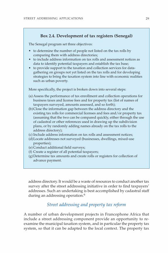
address directory. It would be a waste of resources to conduct another taxsurvey after the street addressing initiative in order to find taxpayers’addresses. Such an undertaking is best accomplished by cadastral staffduring an addressing operation.6
Street addressing and property tax reform
A number of urban development projects in Francophone Africa thatinclude a street addressing component provide an opportunity to re-examine the municipal taxation system, and in particular the property taxsystem, so that it can be adapted to the local context. The property tax
29STREET ADDRESSING APPLICATIONS
Box 2.4. Development of tax registers (Senegal)
The Senegal program set three objectives:
• to determine the number of people not listed on the tax rolls bycomparing them with address directories;
• to include address information on tax rolls and assessment notices asdata to identify potential taxpayers and establish the tax base;
• to provide support to the taxation and collection services for data-gathering on groups not yet listed on the tax rolls and for developingstrategies to bring the taxation system into line with economic realitiessuch as urban poverty.
More specifically, the project is broken down into several steps:
(a) Assess the performance of tax enrollment and collection operations forbusiness taxes and license fees and for property tax (list of names oftaxpayers surveyed, amounts assessed, and so forth);
(b)Close the information gap between the address directory and theexisting tax rolls for commercial licenses and fees and/or property tax(assuming that the two can be compared quickly, either through the useof cadastral or other references used in drawing up the subdivisionplans, or by randomly adding names already on the tax rolls to theaddress directory);
(c) Include address information on tax rolls and assessment notices; (d)Locate addresses not surveyed (businesses, dwellings, mixed-use
properties); (e) Conduct additional field surveys; (f) Create a register of all potential taxpayers; (g)Determine tax amounts and create rolls or registers for collection of
advance payment.

generally produces little revenue for several reasons: there is no realpolitical will to enforce it, central tax departments have little incentive tocollect a tax that devolves to the municipal level, tax laws dating back tothe colonial era are inadequate, and tax exemptions have been an overrid-ing policy. Under these projects, some cities have been able to move awayfrom an ownership-based property tax system that relies on a complexprocess involving rental values (taxes on “improved land,” that is, landwith buildings, and on unimproved land, which are poorly gauged to the
30 STREET ADDRESSING AND THE MANAGEMENT OF CITIES
Box 2.5. Tax department involvement in street addressing surveys (Niger)
The city of Niamey, which spearheaded a street addressing initiative usingAIMF (International Association of Francophone Mayors) financing,established several mixed teams consisting of municipal agents, arepresentative of the water company (SEEN), a representative of theelectric company (NIGELEC), and a cadastral agent.
The cadastral agent travels around with maps of the area to be assignedaddresses. Each street and door number is penciled in on the cadastral mapon paper. The team leader fills in each door number on the survey formsaccording to the cadastral reference for the plot. In this way, the twodirectories are reconciled with one another in real time.
When the area being assigned addresses has not yet been surveyed andentered in the cadastre, the subdivision plan also held by the cadastral andmunicipal agents is often used. This type of dual codification system forstreet-addressing and cadastral purposes makes it possible to reconcile theaddress directory with the other directories kept by the government andutility concessionaires.
“Business activities” data from street addressing operationsshared with tax and treasury departments (Burkina Faso)
The tax departments have implemented street addressing software andhave developed a data import-export module to simplify municipaltechnical department updates. The information is sent to the variousdepartments, which tailor the parameters of their software to serve theirown needs (additional information associated with each address, forexample).
The tax departments have indicated an interest in identifying businessactivities along public roadways, with an eye to using the same dooraddressing system to locate these types of facilities.

socioeconomic circumstances of the taxpayers and the administrativecapacity of the tax departments).
• Two factors create a gap between the objectives of a traditional propertytaxation system and the socioeconomic circumstances of the taxpayers.First, it is difficult to use ownership as the basis for direct property tax-ation when titles are issued only sparingly and most people have noland title. This type of taxation system is poorly understood, and it isoften difficult to distinguish between owner, renter, and occupant. Andsecondly, owing to the taxpayers’ usual inability to pay and the objectivelylow value of the properties, tax levies have been limited to amounts thatare often too low to make traditional property valuation and tax collec-tion operation financially viable.
• The management of a direct property taxation system is hampered bythe complex procedure for assessing rental or commercial values whenthere is no formal real estate market, and sometimes by the lack of admin-istrative resources such as information systems and site visits.
Such a system creates dysfunctions including unreliable tax assess-ments, frequent tax avoidance, a weak effective tax base, and perpetua-tion of procedural complexities from the assessment to the collectionstage.
In order to overcome these problems, municipalities have sought tosimplify procedures and move away from reliance on a tax based onproperty valuation. Basing the property taxation system on occupancyrather than on ownership delinks the tax from the tenure status of theproperty, on the notion that every resident—whether he owns or rents hishome—consumes urban services and therefore should help defray therelated municipal costs. Rather than struggle under a cumbersome andcomplex taxation system based on antiquated, largely unenforceable taxlaws, municipalities are moving toward simplification of the tax laws andadopting a property taxation approach more closely aligned with existingcapacities and resources.
Although this trend toward a new taxation system has not beenwidespread in Francophone Africa, examples can be cited in BurkinaFaso, Togo, and Mali, where property taxation reform has been coupledwith street addressing projects conducted under the auspices of WorldBank–financed urban development projects. The cities of Ouagadougou,Bobo-Dioulasso, and Lomé carried out street addressing initiatives inconjunction with the implementation of a local tax on all types ofresidences, using a simplified basis more in accordance with householdcapacity to pay. This type of residence tax was inspired in part by theurban tax in Morocco and the old Tunisian rent tax.
31STREET ADDRESSING APPLICATIONS

On the whole, the assessment of taxes on a simplified basis and the useof an address directory have reduced some of the procedural complica-tion. The issue of payment and collection is still largely unresolved, forthese same simplified assessment procedures and street addressing initia-tives have significantly swelled the tax rolls and necessitated more collec-tion efforts.
Street addressing and the land tenure issue
The cadastral projects financed by the World Bank in Africa during the1980s were not as successful as anticipated. These projects, which calledfor a long-term effort, were abandoned as a result of factors including thecomplexity and scope of the problem to be solved, the extensive resourcesto be mobilized, the need for day-to-day monitoring, and inadequate localexpertise. In other respects, such an approach might be regarded asquestionable, in view of the fact that one of the main obstacles to effectiveproperty tax management (which the cadastre itself helped to create) wasthe absence of addresses. The customary use of post office boxes forreceiving mail has led to a system that is unreliable if, for example, theaddressee is to sign an acknowledgement of receipt of an official letter,particularly in the case of a tax assessment notice. Under these circum-stances, then, it was understandable that considerable importance wouldbe placed on street addressing projects, which would “begin at thebeginning,” produce rapid and noticeable results, be managed by cityauthorities, and easily draw on local expertise, all for a cost nowhere nearthat of a cadastral project.
The great enthusiasm demonstrated for such projects sometimescreates the impression that there has been “competition” betweencadastres and street addressing, when the more appropriate term wouldbe “complementarity” between the two tools. To clear up any possibleconfusion, we will briefly summarize below the unique characteristics ofeach tool and then suggest ways in which they can be used.
CADASTRE AND STREET ADDRESSING
Owing to the many types of cadastres and the wide range of experienceswith street addressing operations, only a few simple comparisons areoutlined in table 2.1. Both of these tools offer illustrative documentationin the form of cadastral maps or addressing maps, and written documen-tation in the form of registers or directories.
Street addressing is a method for identifying streets and buildings thatmakes it possible to locate structures through the use of identifyingmarkers such as street signs and entrance numbers, the planimetricrepresentation of blocks of houses, and an address directory.
32 STREET ADDRESSING AND THE MANAGEMENT OF CITIES

A cadastre is a comprehensive and perpetual inventory that describesand assesses the value of landholdings. It consists of a set of documents inwhich are recorded the breakdown of landholdings and the name of theowner of each plot. This definition gives rise to two possible applicationsor interpretations: (a) a fiscal cadastre, which seeks to describe the propertytax base and serve as the basis for property valuation; or (b) a legal cadastre,intended to define the ownership rights attached to each plot. Therecorded data accurately define the property boundaries and also serve toensure ownership and property tax levies.7
The cadastre and land ownership in Francophone Africa
In most Francophone African countries,8 the primary function of the cadastreis to recognize and define land boundaries for the purpose of removing landsfrom the public domain and allocating them to private owners. “The peoplehave no rights over the land except as granted by the state.” Rather thanproperty rights being produced “from the bottom up” under a prescriptionsystem (whereby de facto occupancy becomes legal ownership after a certainprescription period that also requires proof of a date of purchase from aformer owner who has already acquired ownership through prescription),property rights are produced “from the top down.” In other words, the statedeclares itself the original owner of the land and exercises its sovereign powerto grant titles of ownership, thereby removing lands from its domain.” Thestate assigns title only after a long process that is cumbersome, costly,nontransparent, and inefficient. As a result, only about a hundred clear titlesare issued each year, during which time thousands of buildings, erectedwithout construction permits, fall outside the legal property ownershipsystem and enjoy absolutely no legal protection.
Under these circumstances, a cadastre has only limited impact, andtherefore city authorities would be well advised to seek ways to improvethe situation by applying street addressing techniques. Four solutions arediscussed here: reform the existing cadastre; supplement it with streetaddressing data; review the property taxation system; and undertake newstreet addressing initiatives in slum neighborhoods.9
Options for improvement
REFORM THE CADASTRE
In order to come to grips with the situation described above, the reform of theland tenure system would seem to be a prerequisite for achieving cadastralreform. Under one possible approach,10 property rights would no longer beallocated as a reward for perseverance over a long obstacle course, but ratherthrough a swift transformation from de facto ownership to legal status. Land
33STREET ADDRESSING APPLICATIONS

tenure would then bestow on the owner not only a right but also a responsi-bility to pay an annual property tax,11 and this would enable city authoritiesto keep an up-to-date list of property owners. Such a change would justify aradical simplification of the procedure for recognizing property rights, which
34 STREET ADDRESSING AND THE MANAGEMENT OF CITIES
Block B
Map 24
1 2 3 4 5 6
Example of a cadastral reference: 24 B 01The first lot is identified as
24 (map) B (block) 01 (sequential order)
A cadastre for tax purposes focuses on private space (yellow) and detailedlot descriptions to determine property value.
Address47 rue Antoine de Pluvinel
Street addressing focuses on public space (yellow) and visible identificationof addresses from the street.
Rue A. de Pluvinel 47
Street addressing
Cadastre
Figure 2.1. Cadastre and street addressing

35
Table 2.1. Cadastre and street addressing: a comparison Cadastre Street addressing
Definition “A general inventory of improved and A method for public identification of streets (and related urban fix-unimproved land in a municipal territory, with tures) and properties that makes it possible to locate buildings in a an individual listing of their physical composition, city through the use of identifying markers, the planimetric repre-using a planimetric plot representation, their sentation of blocks of houses, and an address directory.
economic use (yield), and their ownership, to provide the government with a sufficientlyprecise estimate to equitably apportion taxes on the landholding.”
System of coordinatesStreets/public A cadastre focuses on identifying properties Street addressing specifies an address according to street name, and space (private space) rather than streets (public space). therefore all streets and other public spaces are identified.Plots All plots are identified by a number (“cadastral Street addressing identifies doorways rather than plots.
reference”) and their specific location is shown on a cadastral map (surface area).
Urban fixtures A cadastre does not identify the location of Street addressing identifies the location of urban fixtures and urban fixtures (public standpipes, for example). assigns them an address. This task is not carried out systematically
during the initial intervention phase.
Representation in map formType of map A cadastre includes a set of maps on a scale Street addressing establishes a city map on a scale of 1:10,000 that
of 1:500 to 1:2000 that represent improved land, shows street names and/or numbers; numbers of doorways of some plot boundaries, and cadastral references (which buildings; address subdivisions; utilities. cannot be used for location purposes since This document is widely distributed to government offices and the they do not indicate external markers, unless general public.the maps are geometric).This document is not publicly distributed.
Representation on the groundA cadastre does not deal with street signs or Street addressing identifies street names or numbers and buildings building numbers and may or may not use through the use of signs and doorway numbers.the address if it is available.
Directory/ registerA record of occupants, lot description and the An address directory contains a limited amount of information, associated land rights, drawn up in conjunction including street identification, building number, economic use with the map. (residential or business activity), and perhaps cadastral reference
and water and electric meter numbers.
(Table continues on the following page.)

36
Table 2.1. Cadastre and street addressing: a comparison (continued)Cadastre Street addressing
Registration of ownershipA cadastre does not systematically guarantee Street addressing does not specify anything about ownership rights. ownership rights (for example, a fiscal cadastre). It can help confirm occupancy rights in slum neighborhoods.
Information provided about lots and buildingsEconomic use A cadastre does not indicate economic use, Street addressing provides information on economic use when
though it provides information that could help applicable to a particular property.determine the property value.
Physical A cadastre provides exact descriptions, such as An address directory often indicates how the plot or building looks composition surface area, apartment number, and property from the street.
value.Ownership A cadastre indicates the name(s) of the owner(s) An address directory does not confirm the occupants’ or owners’
and/or rightful claimants. names. It does not necessarily list names of occupants.
ImplementationA cadastre takes years to implement. It is A street addressing operation usually takes about a year. Updates updated regularly, primarily for changes of are usually done at the initiative of an ad hoc municipal agency.ownership. (France’s cadastre has been redonethree times.)
Tax applicationA cadastre does not necessarily result in a tax Street addressing has no direct tax application, but the addressapplication, but in most cases it is useful for directory is generally useful for tax levying purposes because it that purpose. enables tax assessment notices to be sent.
Cost The cost of implementing a nationwide cadastre A street addressing operation in a large city costs approximatelyis difficult to estimate, but some World Bank $200,000.projects indicate a cost of about $100 million.
Staff A large and highly qualified staff is needed to Implementation and upkeep requires only one or two qualified implement and maintain a cadastre on a professionals.long-term basis.

henceforth would be accomplished in a single stage, eliminating the require-ment of improvements to the land (site improvement or mise en valeur). Landwould be allocated immediately with full ownership rights conveyed andwould be recorded in the land register;12 the owner would immediatelyacquire the obligation to pay the tax and the right to sell the property withoutencumbrance. A street addressing operation undertaken in conjunction withthe reform would simplify the issuance of the tax assessment notice.13
This type of reform will surely not be implemented without some difficulty.If carried out as part of a project that is externally financed, the donor willlikely prefer a fundamental change in the notion of property rights over simpletechnical solutions. Moreover, the relevant government agencies, aware of theactual or potential benefit to be gained from a lengthy property transactionprocess, may resist any change in the status quo.
SUPPLEMENT THE CADASTRE WITH STREET ADDRESSING DATA
In the event that such a reform proves to be overly ambitious, a lesssweeping program can be adopted by using street addressing data tosupplement the data recorded by the cadastral unit. If field workers experi-enced with maps have no problem identifying individual properties, thesame will hold true for tax or treasury agents responsible for tax auditingand collection, as mentioned above in regard to the tax registers. This typeof intervention would take a two-pronged approach: (a) incorporate theaddresses into the cadastral data; and (b) establish a correspondencebetween addresses and cadastral references for plots that are so identified.
REVIEW THE PROPERTY TAXATION SYSTEM
As discussed in the preceding section, cadastral documentation that isinadequate or nearly nonexistent and often out of date does not precludethe implementation of innovative property taxation systems, for whichstreet addressing initiatives can play a fundamental role, as in the case ofthe residence tax14 in Burkina Faso. The innovation lies partly in requiringcitizens to participate in the costs of the city (rather than taxing propertythat is often unregistered), and partly in seeking simple solutions.15
Innovative solutions, of course, cannot solve every problem.
Street addressing and slum upgrading
In the context described above, cadastral registration generally covers lessthan 10% of the population while urban areas continue to grow in anessentially informal way. Efforts to regularize land tenure (by issuingtitles to land), which were at the heart of a large number of upgradingprograms for underserviced neighborhoods, have been largely fruitless inthe face of such an extensive problem.
37STREET ADDRESSING APPLICATIONS

Street addressing initiatives in “slums” or informal settlements are anoption although they are difficult to implement in practice for the follow-ing reasons:
• the neighborhoods are often known to be illegal, and the authorities fearthat street addressing is a pretext for their de facto regularization;
• the street layout is often indistinct or even nonexistent; • street addressing in formal neighborhoods is always viewed as a prior-
ity; under these circumstances, informal settlements are often overlooked.
This hesitation to deal with the slums, as understandable as it may be,must be overcome because it contributes to prolonged exclusion of slumpopulations from society. Of course it is true that street addressing alone willnot significantly change their living conditions, but it may help these settle-ments to better integrate into the city by strengthening their place in the largercommunity. Street addressing can thus lead to a kind of collective regular-ization of the slum which, even if limited in scope, often bears fruit muchsooner than difficult and slow-moving land tenure regularization projects.
The specific goal is to gather evidence that the slum populationpermanently resides in the neighborhood while setting out a way for themto move from their precarious and unrecognized status to occupancyrights. The results of this research should not be confined to the addressdirectory; they should be reported in government records to bolster theirlegitimacy. The idea is not to include them in the cadastre, which wouldsurely be an almost insurmountable obstacle, but rather to create a possibleparallel register accessible to eligible persons and located in a decentral-ized department.
Two possible scenarios emerge as to whether the initiative is acomponent of an upgrading program or is integrated into a city-widestreet addressing project. Whatever the circumstances, street addressingis an alternative to the formal regularization of property rights, which haslargely failed to achieve results in Africa.
COMPONENT OF AN UPGRADING PROGRAM. Under this scenario, the slum istargeted for improvement or upgrading projects, and street addressingshould support and round out the intervention, thereby helping theneighborhood to take its place in the larger community. If street addressingproves difficult to implement, it may be limited initially to the simple instal-lation of street signs on upgraded streets; the initiative will be completed ata later time.
INTEGRATION INTO A CITY-WIDE STREET ADDRESSING PROGRAM. Under thisscenario, no upgrading work is scheduled for the neighborhood, but a
38 STREET ADDRESSING AND THE MANAGEMENT OF CITIES

street addressing project is prepared for the city. The initiative consists ofincluding the neighborhood among those targeted by the street address-ing project, even if it means adjusting the actions to be taken:
• If the neighborhood streets are regularly laid out or if the right-of-wayfor the main routes permits automobile traffic, signs are installed on atleast the main access streets;
• If neighborhood streets are not regularly laid out and main routes arepoorly defined, the following steps are taken: (a) in conjunction withresidents, define the main routes by dividing the neighborhood into 5-to 10-hectare zones with adequate right-of-way to accommodate servicedelivery networks and vehicles (carts, ambulances); (b) install signs onthe main routes.
WHERE IS INNOVATION NEEDED? No matter which scenario is used, residentsmust take ownership of the street addressing initiative, which is achievedby their participation in naming the streets. As limited as these interven-tions may seem, their impact should not be underestimated. They help torelieve the isolation of neighborhoods that are usually neglected andgradually integrate them into the city.
Some innovation will no doubt be required in the implementation ofthe usual street addressing techniques for residents to feel secure in theirland tenure status while evidence that they are permanent residents of theneighborhood is gathered:
• GPS use should make it possible to identify the main routes and dwellingsin an unorganized urban milieu;
• Contents of the address directory should be adapted; paradoxically, moreinformation must be collected than would be required for an organizedneighborhood: household names, information establishing the presenceof a household (electricity bill, receipt for tax payment) or numbersplaced on residences by census workers or utility concessionaires, andthe like.
• Information gathering may also lead to innovation. For example, ifemphasizing the vulnerability of certain especially disadvantaged groupsappears to be important, it may be more useful to document their situ-ation as a group rather than in terms of individual households consid-ered separately.
Street addressing and concessionary services
It is increasingly common to use street addressing for concessionary andneighborhood services (box 2.6).
39STREET ADDRESSING APPLICATIONS

40 STREET ADDRESSING AND THE MANAGEMENT OF CITIES
Figure 2.2. Street addressing in informal settlements

Concessionary services
When utility concessionaires in urban areas (water and electricity) takepart in street addressing, the results are often very positive:
• Concessionaire representatives frequently monitor the conducting ofsurveys and numbering of buildings: at this time, they establish a tablein which the address and meter number are matched up (Chad,Mozambique).
• Concessionaires require that future subscribers give an address (BurkinaFaso, where the publication of the street addressing map was an impor-tant step forward in the process).
• A truly cooperative relationship is established between the municipalunit set up to manage the addressing process and water companies,whose directories have used the address as a key account identifier(Mozambique).
41STREET ADDRESSING APPLICATIONS
Box 2.6. Street addressing and concessionary services(Mozambique)
The Mozambican Water Authority (ADM) monitored the work being doneto implement a street addressing initiative in Maputo and four other cities.As a result, it was able to update the ADM address directory andinventory its own networks (a very positive result for Maputo). ADMbenefited in several ways from this collaboration:
• It now has a unique account identifier for its subscribers—theiraddress.
• It can now update its own address directory and manage it moreeffectively.
• It now has tools to facilitate its own interventions on the network(repairs, extensions), allowing it to regularize poorly identified connec-tions.
• It completed its cartographic database using graphic street addressinformation (location of public standpipes, for example), which facili-tates future implementation of a GIS.
Finally, an information exchange agreement between the municipalityand ADM was prepared to define the areas where street addressing and theconcessionaire’s business management system may overlap.

• Concessionaires have sometimes “addressed” their equipment (poles,transformers, public standpipes) to facilitate locating and maintainingthem.
However, concessionaires may also have concerns:
• They have already set up their own reference system and mapped net-works and subscribers (sometimes on GIS); they have worked out asystem of “rounds” for paying visits to subscribers, and they consider theintroduction of street addressing to be superfluous.
• They want street addressing initiatives but are sometimes disappointedwhen the project is completed and is not extended to new neighbor-hoods. On their own initiative, they sometimes extend street address-ing efforts but do so based on an approach that differs from the existingsystem (Bamako).
Any street addressing initiative should be launched only after priorconsultation with concessionaires so that they are aware of issues andchallenges that may be of concern to them.
Improving neighborhood services and the case of the post office
Emergency services such as fire, police, and ambulances are usually cited asdirect applications of street addressing, since an address map, its index, anddirectory reduce the emergency response time. But there are also directapplications for several other types of neighborhood services such as taxis,deliveries, and mail service, for example. It is quite surprising, however, thatmail delivery was not identified as one of the areas where street addressingcould have the greatest impact, even though very little experience had beengathered in this area; when the first initiative was implemented, somepeople even referred to it as the “postal address initiative.”
This hesitation is not without some basis. Emphasizing the linkbetween street addressing and mail delivery suggested that once streetaddresses had been assigned, the postal service could distribute the mailto each address within no time. In fact, many countries operate with apostal box or general delivery system, which at first seems less efficientbut more economical than a “door-to-door” system. The cost is in factshared by the postal service, which gathers the mail at the post office, andthe end-user, who comes to collect his or her mail.
This is the reason street addressing for mail routing has usually beenadopted only with the agreement of postal officials. That being said, forthe last several years, private express mail delivery services have sprungup, and the new demand for this service has led to a rethinking of this
42 STREET ADDRESSING AND THE MANAGEMENT OF CITIES

hesitation,16 especially given that some countries, like Mozambique andSenegal, are trying to leverage their street addressing experience toimprove mail delivery. An agreement was signed between the city andthe Correios de Moçambique to set forth the terms and conditions of cooper-ation between the postal service and the municipal unit responsible forimplementing the street addressing initiative. Moreover, private sectorinitiatives are beginning to appear: in Burkina Faso, the GIEs (LocalBusiness Initiatives Groups), often established by unemployed younggraduates of teaching programs, have offered their services to the postoffice and water and electricity concessionaires to ensure that bills andreminders of unpaid accounts were delivered.
Street addressing and economic development
Street address information concerns not only municipal managers butalso the many actors that make up the social and economic fabric of a city.The information is found in maps and databases and makes them easierto use and understand, especially for public and private economicoperators who have a particular interest in answering the followingquestions. What kinds of activities go on in the city? Where do they takeplace? How are households distributed? In other words, how is the cityorganized in spatial, economic, and social terms?
The address directory provides a very important piece of information:a list of existing formal and informal economic activities. The list is a goodbarometer of the city’s economic potential and the nature and location ofactivities taking place there. In addition, by preserving the history of alocation’s changing uses, address management software provides areliable indicator of the economic dynamics at work and can serve todocument trends.
Private companies are usually interested in street address databasesbecause they can use them to tailor their individual and joint businessstrategies. A database makes it easier to understand the competition andto prospect for business by dividing activities into sectors and economiccategories and the potential clientele into households and companies.Mapping helps each type of business to identify its own location in thecity as well as that of the competition; this leads to a better understandingof clients and potential markets and thus helps define a more effectiveand targeted business development strategy.
The municipality launches street addressing initiatives and thus playsa key role in making available the information they generate. Variousexperiences show that it can put this information to good use and therebykeep address systems up-to-date and in place. Indeed, different entitieswould like to adapt address mapping to their own uses (tourism, conces-
43STREET ADDRESSING APPLICATIONS

sionaires, Chamber of Commerce), and the municipality may negotiatesome of its rights to the information. For example, in Mozambique, eachaddress map is copyrighted in the name of the municipality, and its useallows the municipal street addressing unit to earn some revenue. Alongthe same lines, reconciling economic data with data from the addressdirectory makes it possible to set up an economic database (BDE). Maputois an example of a BDE used by the city government (box 2.7), but this canalso come about through the initiative of the private sector, professionalgroups, the Chamber of Commerce and Industry, or the trade council.
Possible action items
WEB SITE. The creation of a street addressing web site is one way to allowfor public (local community site) or private (CCIA [Chamber ofCommerce, Industry and Handicrafts], Yellow Pages, etc.) use of theinformation. This may be achieved with a simplified but precise and user-friendly map. One advantage of a web site is the hypertext function, whichmakes it possible to run the site with a great deal of flexibility (somethinglike a GIS), especially in the area of marketing the information.
STREET ADDRESS TRAINING. It has been noted in cities where street address-ing initiatives have been conducted that certain occupations—such as taxiand ambulance drivers, fire fighters, and police—have difficulty usingaddress systems. Motivating dispatchers to get training may complementefforts to make the data available to them. This training could be providedby the municipal unit in charge of the street addressing initiative; profes-sional associations; women’s, youth, or neighborhood groups; NGOs, etc.
SPONSORSHIP AND ADVERTISING. Street addressing initiatives may besponsored in different ways. One approach is to use signs or posts wherethe name or brand of the sponsor who provided financing for the initia-tive is inscribed. Another might make use of published documents, chartsand maps, catalogues, or even Internet sites. Other avenues such as televi-sion are also available.
In sum, street addressing initiatives can stimulate a more dynamicrelationship between local government and the private sector. Theinformation contained in street address directories often contrasts withthat of traditional economic indicators because it reflects all activities,including those of the informal sector, thereby providing a comprehen-sive overview of economic activities in a city and including a frequentlyneglected segment of economic life.
44 STREET ADDRESSING AND THE MANAGEMENT OF CITIES

45STREET ADDRESSING APPLICATIONS
Box 2.7. Economic database (Maputo)
To increase revenue and improve city management, the city of Maputotook steps to learn more about its economic fabric and fiscal potential. Aneconomic database (BDE) was thus put in place, with two objectives:
• to facilitate management of licenses by the Department of EconomicActivity (state deconcentrated services, integrated into city services);
• to ultimately increase revenue from local and national taxes onbusiness activities (IRTB [tax on income category B for farmers], CI[industrial tax on small craftsmen without employees], value-added tax[VAT], local taxes) by setting up a directory of companies.
The BDE was expected to produce three secondary effects:
(a) to facilitate decisionmaking on the municipal level, by increasingawareness of the web of existing activities and the pace of theirevolution;
(b) to allow BDE data to be reconciled with the directories of other entities(Tax Department), with a view toward eventually improving taxsystem performance;
(c) to upgrade the information given to economic operators in the city bymaking available to them updated data on economic activity.
DICT (Department of Industry, Commerce and Tourism) informationexisted in the form of a manually updated directory. This information wasreconciled with the street address directory, creating the opportunity todevelop a computerized database consisting of 9,000 companies andbusiness activities. The street addressing initiative compiled 7,295addresses for business purposes, and the DICT generated 8,912 licenses,which represents a gap of 20% owing to: (a) licenses granted for businesseswithout a business location, (b) the fact that several businesses had thesame address, with no real distinction between them on the ground, and (c)cessation of business activities by several entities that did not so indicate.
The data retrieval is initiated by the unit in charge of the street address-ing initiative, but the processing is being done at DICT, which has greaterexpertise with the formulas and procedures (the two departments signed aprotocol to exchange information). DICT regularly transfers the list of newregistered businesses to the DNS (Department of Statistics) and to two“tax districts” (Ministry of Finance) responsible for issuing tax rolls andcollection, but whose main activities are focused on the 500 “largest”taxpayers.

46 STREET ADDRESSING AND THE MANAGEMENT OF CITIES
This chapter has provided an overview of the various applications ofstreet addressing. The next chapter provides examples of these applica-tions as implemented in a number of countries.
Notes
1. Cityvia, Infrastructure and Services Programming Inventory 2. Example: Sections C.12-1, C.12-2 of street C.12.3. Programs such as Cadix, Cityvia, Urbavia, and Viziroad.4. The Future of African Cities, Chapter 5.5. The taxation services use the notion of a “pre-roll that requires validation.”6. In Burkina Faso, the heads of the street addressing units in Ouagadougou
and Bobo-Dioulasso established a connection between cadastral references anddata in the address directory.
7. Countries that have a fiscal cadastre include Belgium, Spain, France, andItaly. Countries with a legal cadastre include South Africa, Germany, Hungary,Switzerland, and Turkey. The United Kingdom and Ireland have no cadastre.
8. J. Comby. “Quel cadastre, pour quoi faire? L’exemple du Gabon.” [Usingwhich cadastre to do what? Gabon case study.]
9. This solution is discussed in section 6.10. According to J. Comby.11. The formula for determining the annual tax would discourage beneficiaries
from holding onto land of which they do not have use. At the present time, manyproperties, even if registered, quickly change hands informally. Levying a tax onallocated land each year creates an automatic update of the list of landowners.Anyone who is no longer a landowner will refuse to pay, and, conversely, paymentof the tax quickly creates a legal presumption of ownership. (J.Comby)
12. Rather than occurring on a plot by plot basis at the request of the interestedparty, this procedure would be carried out sector by sector at the government’sinitiative.
13. Alternatively, the tax might also be payable at the revenue office.14. Identical to the tax instituted in Togo.15. In Burkina Faso, two criteria are used to determine the tax: neighborhood
services and residential services (such as water and electricity consumption). InCôte d’Ivoire, the tax on improved land is also based on two simple criteria:neighborhood services and declared number of habitable rooms.
16. A similar hesitation is associated with tax departments: street addressingcertainly improves tax collection, but this is probably not a very good advertisingslogan.

3Street Addressing Practices
47

This chapter describes the street addressing projects carried out duringthe 1990s in various cities in sub-Saharan Africa. The first part of the
chapter presents an overview and comparison of the various efforts. Thesubsequent sections describe the individual projects in each country.
Overview of main experiences
The addressing activities undertaken between 1989 and 2004 includeprojects in 52 cities in 15 countries (Benin, Burkina Faso, Cameroon, Chad,Congo, Côte d’Ivoire, Djibouti, Guinea, Mali, Mauritania, Mozambique,Niger, Rwanda, Senegal, and Togo). A summary of the various operationscompares several features taken from a sampling of 21 cities1 that success-fully completed virtually all of their street addressing tasks (table 3.1).
The sample represents 11.2 million people. The population in the citiesrepresented ranges from 80,000 to 1,300,000 inhabitants. The overallbudget for these operations totals US$6,800,000, for an average ofUS$325,000 per project. In all, 84,000 street signs were installed and1,200,000 buildings were assigned an address, thus serving about 75% ofall households.2 The average cost is US$0.6 per capita3 and US$5.7 peraddressed doorway. Before street addressing projects were undertaken,only 8% of streets had names; in other words, 92% were unidentified.However, budgetary constraints necessitated the sparing use of streetsigns, resulting in an average of 1.2 signs per intersection. Thus, in someneighborhoods, only one in every two intersections received a street sign.
Various donors contributed to financing the addressing effort, includingthe World Bank, and the French Cooperation Agency represented by theMinstry of Foreign Affairs (MAE) and other departments (DecentralizedCooperation, AFD, and AIMF). These two donors have clearly workedclosely together. In some instances, they divided their financing amongcities for the same addressing project: PDUD (Urban Development andDecentralization Project) in Mali and PAC (Urban Development andDecentralization Program) in Senegal. In other cases, they helped to expandefforts launched by the other donors (Burkina Faso, Cameroon, and Niger).4
Actual project implementation differs by country (table 3.2):
• A country’s addressing project may have involved one or several cities:(Mauritania, Senegal (11), Mali, Mozambique (6), Côte d’Ivoire, Benin(3), Burkina Faso, Cameroon, Niger (2), and Guinea (1);
• The operation was initiated either within the scope of a Project Unit(Burkina Faso, Cameroon, Mali, and Senegal) or within the TechnicalDepartment of the municipalities (Guinea, Mozambique, Niger, Chad,and Togo);
48 STREET ADDRESSING AND THE MANAGEMENT OF CITIES

• The efforts either received ongoing technical assistance (Cameroon, Mali,Mauritania, Mozambique, and Chad), or occasional support from tech-nical missions (Burkina Faso, Guinea, Niger, and Senegal).
Addressing applications also vary by country (table 3.3). However,projects involving taxation were the most prevalent (residence tax inBurkina Faso and Togo, tax registers in Senegal, and municipal taxation inMauritania). Other applications involve urban management (streetsystem and household waste collection in Guinea, Cameroon, andBurkina Faso, an urban observatory in Cameroon).
49STREET ADDRESSING PRACTICES
Table 3.1. Features of addressing operations based on a sampling of 21 cities
Average Total
Number of cities in the sample 21Number of inhabitants (year 1 of addressing) 540,000 11,200,000Surface area of cities (in ha) 4,200 88,000Number of streets 2,000 42,000Number of intersections 3,400 72,000Number of street signs 4,000 84,000Number of doorways addressed 57,000 1,200,000Percentage of streets named 8%Cost of equipping addressing unit US$35,000 Cost of operations US$325,000 US$6,800,000 Annual municipal budget US$2,600,000 US$54,000,000 Number of streets/ha 0.5Number of intersections/ha 0.8Number of signs/intersection 1.2Cost per doorway addressed US$5.7Cost per capita US$0.6Average municipal budget/capita US$4.8

50
Table 3.2. Execution and financing of addressing by country and cityTasks Financing
Country and Addressing Population 1 2 3 4 5 6 7 8 9 10 11 12 13city addressed year 1 (year 1) CS SI SN AM AL SS LF WB MAE AFD DC EU AI
Burkina FasoOuagadougou 1992 600,000Bobo-Dioulasso 1993 300,000BeninCotonou 1993Parakou 1993Porto-Novo 1993CameroonYaoundé 1992 800,000Douala 1992 1,100,000CongoBrazzavilleCôte d’IvoireAbidjan 2000Abengouro 2003San Pedro 2000DjiboutiDjibouti 1997GuineaConakry 1993 1,100,000MaliBamako 1993 920,000Gao 1996 84,000Kayes 1996 53,000

51
Mopti Sévaré 1996 100,000Ségou 1996 110,000Sikasso 1996 103,000MauritaniaNouakchott 1997 700,000Aleg 1999 6,600Atar 2000 24,000Boutilimit 2001 17,000Moudjeria 2002 3,500Nouhadibou 1997 90,000Rachid 2002 1,800Rosso 2000 44,000Tekane 2002 2,000Tiguent 2001 3,500Tidjika 2002 10,000MozambiqueMaputo 1995 1,300,000Pemba 2000 90,000Quelimane 2000 195,000Nampula 2000 280,000Beira 2000 410,000Matola 2000 380,000NigerNiamey 2001 800,000Maradi 2003RwandaKigali 1993 270,000
(Table continues on the following page.)

52
Table 3.2. Execution and financing of addressing by country and city (continued)Tasks Financing
Country and Addressing Population 1 2 3 4 5 6 7 8 9 10 11 12 13city addressed year 1 (year 1) CS SI SN AM AL SS LF WB MAE AFD DC EU AI
SenegalDakar 2003 820,000Guiédiawaye 2003 450,000Pikine 2003 470,000Rufisque 2003 140,000Diourbel 2000 100,000Kaolack 2000 200,000Louga 2000 70,000St. Louis 2000 140,000Tambacounda 2000 60,000Thiès 2000 230,000Ziguinchor 2000 170,000ChadN’Djaména 1989 600,000TogoLomé 1996 850,000
task completed in progress principal financing
KeyCompletion of tasks Financing1. CS Codification study 7. LF Local financing2. SI Sign installation 8. WB World Bank3. SN Surveys, numbering of buildings 9. MAE French Ministry of Foreign Affairs4. AM Creation of address map 10. AFD French Development Agency5. AL Address list (spreadsheet) 11. DC Decentralized Cooperation6. SS Addresses in specialized software 12. EU European Union
13. AI Intl. Assoc. of Francophone Mayors
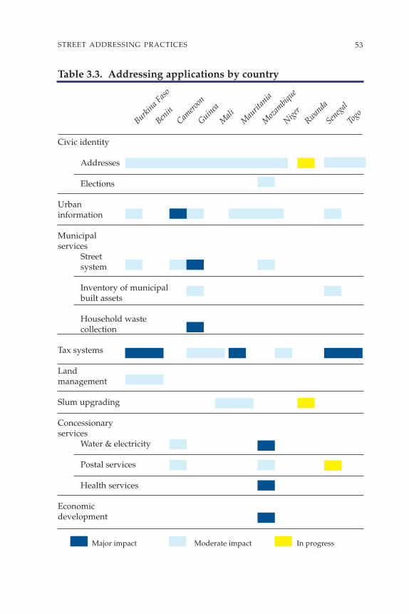
53STREET ADDRESSING PRACTICES
Table 3.3. Addressing applications by country
Civic identity
Addresses
Elections
Urbaninformation
Municipalservices
Street system
Inventory of municipalbuilt assets
Household wastecollection
Tax systems
Landmanagement
Slum upgrading
Concessionaryservices
Water & electricity
Postal services
Health services
Economicdevelopment
Major impact Moderate impact In progress
Burkina F
aso
Benin
Camero
on
Guinea
Mali
Mau
ritan
ia
Moz
ambiq
ue
Niger
Rwanda
Seneg
al
Togo

Background and objectives
The addressing system described in this document was originallydeveloped in Burkina in 1987 as part of the UDP 2 (Second UrbanDevelopment Project). This project had two components: the mobilizationof municipal resources and the strengthening of urban infrastructure.Mobilizing resources proved somewhat problematic since real estateproperty rights had been abolished in the Revolution, thereby eliminatingproperty titles and their accompanying property taxes. To overcome thesechallenges, authorities instituted two simple, complementary tools: theresidence tax and street addressing. Together, they helped to achieve thefollowing objectives:
54 STREET ADDRESSING AND THE MANAGEMENT OF CITIES
OuagadougouNumber of inhabitants 600,000Surface area of urbanized zone 10,750 haNumber of streets 4,910Number of intersections 12,400Streets named 70 streets in 1997
250 streets in 2002Number of doorways addressed 100,000Total cost of operation US$491,000 Cost/addressed doorway US$3.6Addressing unit established 1992Number assignment, surveys, sign installation 1994–1997Creation of address directory 1996–1997
Bobo-DioulassoNumber of inhabitants (1993) 300,000Surface area of urbanized zone (formal) 4,050 haNumber of streets 1,700Number of intersections 3,650Streets named 95 (7%)Number of doorways addressed 40,000Total cost of operation US$186,125 Estimated cost/addressed doorway US$4.7Addressing unit established 1993Number assignment, surveys, sign installation 1994–1997Creation of address directory 1996–1997
Burkina Faso

• To increase municipal resources through better collection of local taxesand fees;
• To improve management of urban services.
Financing and implementation
The addressing project received the following outside funding:
• As part of UDP 2, the World Bank financed an addressing system inOuagadougou and Bobo-Dioulasso starting in 1992. The Bank providedadditional financing in 2000 as part of the subsequent project (PACVU[Urban Environmental Project]) in order to complete street sign instal-lation after the municipality had decided to name the main streets thathad previously been numbered;
• In 2002, the French Cooperation Agency, which had financed a rewriteof the Urbadresse software as part of another project, financed the trans-fer of addressing data to this new software, and financed training on thesoftware as well.
• Initially, the addressing unit (UDP 2) handled the project, and at the endof the effort, the municipalities’ technical departments assumed respon-sibility for the work.
Technical features
• Division. Originally divided into neighborhoods, the city was subse-quently divided into “sectors” at the time of the Revolution (PresidentSankara): 30 sectors in Ouagadougou and 23 in Bobo-Dioulasso.Addressing adhered to the sector division that had gained acceptanceby both citizens and governments.
• Street codification. Streets are identified by a number composed of twoelements. The first is the sector number followed by a sequential number(for example: street 5.14 is the 14th street in sector 5).
• Numbering doorways. Numbering is metric and alternating (even andodd on opposite sides of the street).
• Street sign installation. A local firm selected following an internationalbidding process supplied street signs. Small local companies handledsign installation.
• Surveys and number assignment. The UDP 2 addressing unit carried out ini-tial efforts.
• Survey data. Include: the address, occupant’s name, plot use category,and cadastral references.
• Address directory. A specialized software program (developed in Macintosh4D) originally managed the data; in 2002 they were transferred to theUrbadresse software written for PC.
55STREET ADDRESSING PRACTICES
• Address map. For both cities, 3,000 copies of an address map and a streetindex were created and distributed.
Results
In neighborhoods where an addressing initiative was considered viable inboth cities, the UDP 2 project numbered doorways, took surveys, andinstalled street signs. The project included the printing of 3,000 copies ofa guide map with street index (2,000 copies for Ouagadougou and 1,000copies for Bobo-Dioulasso). In each city, an address directory was createdin a special software program.
At the end of UDP 2, the addressing units of both cities became part ofthe municipal technical departments (STM) that use addressing for atleast three purposes:
• Collecting household waste in collective trash bins: bins and collectionpoints are assigned addresses,
• Street cleaning (78 km in Ouagadougou and 24 streets in Bobo-Dioulassoare identified using the address system),
• “Door-to-door” collection of household waste (2,000 households inOuagadougou); addressing is used to collect garbage and waste collec-tion fees.
Over the past several years, addressing has continued with the follow-ing efforts:
• Matching addresses with cadastral references of the plots. The State LandManagement Department assisted in this effort. However, maps oraddress directories have not yet been updated;
• Creation of a Toponymy Commission. This is a major initiative of themunicipality of Ouagadougou. The commission produced a list of poten-tial names to gradually replace the numbers assigned to streets.Remarkably well organized and documented (Annex 2), this list hasenabled the municipality to name or rename 2,000 streets in Ouagadougou.For example, “Street 12.69” has become “Street K. Moryamba” and the“avenue de la Révolution” has been renamed “avenue de la Nation”;
• Purchase and installation of 2,000 new street signs in Ouagadougou;• The addressing unit of Ouagadougou has prepared and organized train-
ing sessions and awareness programs for national departments (tax andtreasury departments), municipal departments, and other users (suchas taxi drivers);
• Transfer of data, for both cities, to a new software program better suitedto the country’s IT environment;
56 STREET ADDRESSING AND THE MANAGEMENT OF CITIES

• Training for technical and tax departments on how to use the new soft-ware. This training was designed to help various departments collabo-rate to facilitate future data sharing.
Burkina Faso proved quite innovative in three areas of its addressinginitiatives. First, it set up a formal system of rules for addressing. At thesame time, it implemented a new tax based on the address system. Finally,it created a compendium of place names that an ad hoc commission nowuses to name streets. However, because of its impact, we will concentrateon the residence tax.
Specific application: residence tax
BACKGROUND. When the UDP 2 project began (1987), the country had aproperty tax paid by those persons with a furnished home. The tax was basedon the home’s rental value. The tax was calculated by applying a rate of 2% tothe rental value after deducting a minimum rent. Two additional taxes supple-mented this main tax: a tax on the rental value of residential accommodations(1% of the rental value) and additional centimes (15% of the main tax).
One of UDP 2’s goals was to increase resources because severalobstacles interfered with the application of this property tax such as:
• No control over the tax base because potential taxpayers were not filingstatements. When the business tax calculation was made, only a fewmerchants were actually taxed.
• Lack of consistency in calculating rental value.• Few tax assessment notices issued, compared to potential tax revenue.• High cost of managing the tax compared to actual yield.
In addition to these challenges, the government had abolished all landrights, which negated any application of the tax and, at the very least, theentire system needed to be reevaluated. Thus, the government institutedthe residence tax, which subsequently underwent various adjustments asthe effects of the revolutionary period gradually diminished.
CREATION OF AND ADJUSTMENTS TO THE RESIDENCE TAX
With land rights abolished, the residence tax no longer applied to landowners, but to “residents” who would be expected to help pay the city’sexpenses. The 1992 reform was designed to: (a) condense the tax assess-ment procedure by eliminating additional taxes, (b) simplify the methodfor determining the tax base by instituting a fixed scale, thereby promot-ing internal consistency, (c) increase the number of tax assessment noticesissued, and (d) choose simple criteria for taxation.
57STREET ADDRESSING PRACTICES

Two criteria determined the residence tax amount: level of services inthe neighborhood and quality of the home measured by water andelectricity consumption. A survey of the same sample of homes simulatedtwo different tax systems. The first was based on the criteria of the formerproperty tax system, and the second was based on water and electricityconsumption. There was such a strong correlation between the resultsthat the country opted for the second system because it was much easierto implement, since it was based simply on obtaining readings from utilityconcessionaires on amounts of water and electricity consumed. Thesedata determine the home’s level of services without necessitating actualinspection of the premises. Neighborhood facilities and level of serviceswere easy to assess. A scale system determined the level of taxes. Thus, ahome without water or electricity, located in a neighborhood with fewfacilities, was taxed at about two dollars per year, but a home with highconsumption rates (because of a pool or air conditioners) and located in aresidential neighborhood with good facilities was taxed at a rate fiftytimes higher.
When the reform was adopted, the addition of two more criteriacomplicated the procedure: type of building (permanent, semi-permanent, or cob) and number of rooms. But the results obtained wereinconclusive. The 1995 reform returned the system to the two criteriainitially used, and their application was revised and enhanced throughbetter management (automation), requirement to file, better investigationof taxpayers, and the application of financial or legal penalties for anyonenot filing or not paying taxes. In 1999, a new reform again adjusted the taxso that it was more compatible with the standard of living of low-incomepopulations.
The following measures further improved the system:
• An inventory made to create an address directory,• The design of data entry and data processing software to process infor-
mation from tax forms filed by taxpayers,• The use of various directories to supplement the information found on
tax forms filed by taxpayers (directories from SONABEL [National ElectricPower Company], ONEA [National Office of Water and Sanitation], andCNSS [National Social Security Office]).
PROBLEMS ENCOUNTERED
• Using the directory from the electric company (SONABEL) led to anumber of double taxation issues.
• Incorporating a processing department for a new tax within the NationalTax Authority (DGI) proved more difficult than expected.
58 STREET ADDRESSING AND THE MANAGEMENT OF CITIES

• The still-limited use of the address directory by utility concessionaires(water and electricity) has not helped taxpayers become accustomed tousing the address system.
ISSUING NOTICES AND COLLECTING TAXES
Since monitoring began (in 1996), tax assessment notices have been issuederratically, stabilizing at around 350 million CFAF in Ouagadougou and200 million CFAF in Bobo-Dioulasso. Yield was initially better in Bobo,with 36,000 potential taxpayers, compared with 40,000 in Ouagadougou,a city at least twice as large. However, Ouagadougou has improved itsissuing of tax notices over the past few years (65,000 in 2000).
Collections remain below expectations. This is partially due to theprocedure itself and due to local governments’ lack of involvement.Results indicate that a system of tax withholding at the source for employ-ees, monitoring during any formalities with financial or local administra-tions, and, finally, increased media coverage to increase citizens’awareness of how local resources are used (to improve local facilities andservices) would improve the tax collection rate.
HOW THE RESIDENCE TAX CHAIN WORKS
Initially established to simplify procedures (system of wealth-related taxcalculated by the taxpayer; entire urban population taxed), the residence tax isstill weighed down by its cumbersome procedures. This is primarily becausethe operations are split between the tax department (issuing notices) and thetreasury department (collections). Since the early 1990s, the operations of mostother taxes are managed (issuing notices and collections) entirely by either oneof these departments. The DGI has suggested the possibility of splitting thetwo residence tax units in Ouagadougou and Bobo-Dioulasso between thecentral tax departments of the financial administrations in both cities, but ithas not offered any specific timetable or method for transfer at this time.
HOW THE TAX COMPARES TO OTHER RESOURCES
The residence tax remains a minor revenue for municipalities: less than2% for Ouagadougou in 2001 and about 5% for Bobo-Dioulasso. However,it represents the only direct tax on households at the local level. A compar-ison with other household taxation systems throughout the region doesnot seem to indicate that any fundamental changes are needed to thesystem that was created in 1992. Several other countries have set up aproperty tax system based on the French system (Senegal, for example).An analysis of this tax system shows that the majority of the tax (over85%) is collected on premises used for professional purposes, i.e., fromcompanies. Thus, the tax on improved property is perceived as anadditional taxation on economic activity.
59STREET ADDRESSING PRACTICES

Overall, the success of the residence tax will depend on how to reach avery large potential taxpaying population (70,000 in Ouagadougou and40,000 in Bobo) and manage tax directories that have traditionally beenmanaged by both the tax department and the treasury department. Thus,efforts must focus on effective tax collection techniques and managementof the computerized taxpayer directory.
60 STREET ADDRESSING AND THE MANAGEMENT OF CITIES
22
189
8
17
7
16
2 1 29
30
28
2713
26
24
25
10
11 12
34
5
15
23
19
20
21 Fada
Bobo-Dioulasso
PoPo
OuahigouyaK
ongoussi
Progression of the numbering system
Figure 3.1. Ouagadougou: Divided into sectors

61STREET ADDRESSING PRACTICES
Background and objectives
The crisis that hit the Cameroonian economy in the late 1980s resulted ina drastic reduction in resources available to the government to financefacilities, infrastructure, and urban services. The second Urban Develop-ment Project (UDP 2), in preparation at the time, sought to identify newmeans for financing urban management. Various diagnostic studiesrevealed that the main problems stemmed from an inability to identifypotential taxpayers and users of city services. Thus, establishing anaddress system in the cities of Yaoundé and Douala seemed to be one wayto solve these problems quickly and easily. The main objectives were:
• To locate potential taxpayers to increase revenues, • To identify users of public services as part of efforts to privatize con-
cessionaires of commercial city services.
YaoundéNumber of inhabitants (1992) 780,000Surface area of urbanized zone 5,040 haNumber of streets 1,670Number of intersections 2,400Streets named 110 (6%)Number of doorways addressed 130,000Cost of signs and installation US$135,000Total cost of operation US$280,000Cost/addressed doorway US$2Addressing unit established 1992
DoualaNumber of inhabitants (1992) 1,100,000Surface area of urbanized zone 8,750 haNumber of streets 3,100Number of intersections 4,870Streets named 130 Number of doorways addressed 180,000Cost of signs and installation US$185,714Total cost of operation US$442,860Cost/doorway addressed US$2.4Addressing unit established 1992
Cameroon

Governmental authorities in Cameroon had been interested in anaddressing project for some time: in 1971 a presidential circular gaveinstructions regarding street names (annex 2). Some addressing measureshad already been carried out in places like the city center of Douala, BiyemAssi, and Cité Verte in Yaoundé. However, these initiatives remainedlimited to just a few neighborhoods until 1992, when two addressingprojects were launched in Yaoundé and Douala as part of UDP 2.
Financing and implementation
The addressing project received the following financing:
• As part of UDP 2, the World Bank financed the first addressing efforts inYaoundé and Douala starting in 1992;
• Through the FSD (Special Development Fund), bilateral French assis-tance helped expand addressing in Douala in 1994–95 to include zoneswhere addressing operations had originally been postponed.
Initially, the steering unit of UDP 2 (CSDU [Special Urban Develop-ment Unit]) carried out the project before handing over responsibility totechnical departments of both metropolitan governments.
Technical features
• Division: The urban zone was divided into 6 major zones.• Street codification: Streets are identified by a number composed of two
figures. The first represents the sector number followed by a sequentialnumber (for example: street 4.15 is the 15th street in zone 4).
• Numbering doorways. Numbering is metric and alternating (even andodd on opposite sides of the street).
• Street sign installation. A local firm selected following a bidding processmanufactured and installed street signs.
• Surveys and number assignment. Teams composed of municipal employ-ees and survey takers employed by a local NGO performed surveys andnumber assignments. The information gathered includes the address,occupant’s name, plot use category, type of activity, and, when applic-able, cadastral references.
• Address directory. In Douala, the addressing unit entered addresses toensure confidentiality and use of data by municipal departments. TheDouala Addressing Software (LAD) was developed locally (Windev).
• Monitoring. A supervisory committee was created. It included the Directorof the metropolitan government, the director of technical departments,and representatives of utility concessionaires.
62 STREET ADDRESSING AND THE MANAGEMENT OF CITIES

63STREET ADDRESSING PRACTICES
• Address map. In Yaoundé, an address map and street index were createdand printed. There was no official printing of the map for Douala; but itwas used to create a base map for the GIS prepared by municipal depart-ments.
Results
Efforts undertaken in Yaoundé and Douala are comparable, and theirsustainability over the past decade is remarkable. In particular, theseefforts have resulted in a much more influential addressing unit, whichhas become an urban observatory within the Technical DepartmentsDivision. Also of note is Douala’s determination to gradually complete itsaddressing project in spite of the difficulties of its situation:
• The city employed a “cumulative” process that began in the easiest areasto address and progressed to more difficult areas, and typically involvedan update every two years.
• A systematic search for financing allowed Douala to take over from theWorld Bank, most notably by combining funds from the metropolitangovernment with funds from bilateral aid.
Specific applications5
CREATING AN URBAN OBSERVATORY. In response to a lack of informationabout the city, the metropolitan government developed an integratedinformation system with support from French bilateral aid and the IGN(National Geographic Institute). Douala created an urban observatorywithin the departments of its metropolitan government. The observa-tory is designed to gather, process, and distribute information. Thecomputer graphics shop within the observatory takes part in allmetropolitan government (CUN) projects and studies, and handlesmapping. This represents a vast amount of work to map land use (MOS),neighborhood projects, bus lines, water distribution networks, majorroad projects financed by various donors, and household waste collec-tion circuits. These data have been helpful in providing a great deal ofinformation (through thematic maps and other data) about the citythrough:
• Development of addressing software (LAD),• Use of a GIS for automated mapping (street system, hydrography, build-
ings, green spaces, etc.),• Development of a street system management software program to assess
the level of road deterioration and cost for road rehabilitation (Camvoirie).

The city organizes annual campaigns to collect urban data from avariety of networks including streets, public lighting, and urban fixtures.An urban documentation and information center was created andmaintains the information gathered in the field through the addressingproject. This center is part of the Secretariat of the metropolitan govern-ment and is open and accessible to the public, whereas only technicaldepartments and other partners (network utility concessionaires andother institutional partners such as land developers and governmentaldepartments) have access to the observatory.
STREET SYSTEM MANAGEMENT. The local government wishes to monitor roadconditions and, based on a visual observation, estimate needs for regularand periodic maintenance. During the 1990s, the metropolitan govern-ment acquired a specific spreadsheet-based application that uses address-ing codifications for streets (Urbavia, Camvoirie). Bilateral cooperationassisted in redeveloping this application on a more advanced system. It isespecially designed to provide useful information for the “street mainte-nance account,” set up by the metropolitan government in 2001. However,the particularly difficult period in the 1990s limited financing so drasti-cally that all of the main streets have quickly become almost impassable.So the first priority at this time was no longer maintenance but a majorrehabilitation required for all streets, which became a World Bank projectin 2002.
UTILITY CONCESSIONAIRES AND POSTAL SERVICES. The address directory wassent to water and electric companies and to the postal services. The postoffice uses the addressing system to distribute invoices. As for water andelectricity, they are participating in an initiative through which theirconsumer identification index will match the address system, thusbecoming their primary tool for customer identification and resourcemobilization.
64 STREET ADDRESSING AND THE MANAGEMENT OF CITIES

65STREET ADDRESSING PRACTICES
Background and objectives
In Guinea, the end of the 1980s marked the end of a difficult planningperiod and signaled the institution of major reforms. Among these, thedecentralization policy resulted in the creation of five municipalities inConakry. However, these municipalities had few resources at theirdisposal and possessed little information about their territory. They alsolacked experience. Potential tax revenue was poorly evaluated, and theresources to implement any taxation systems were sorely lacking, so thatfewer than 40% of tax assessment notices issued resulted in collection oftax. To help these new municipalities deal with the difficulty and buildtheir capacities, an addressing component was included in the secondurban development project (UDP 2). The situation was particularlydifficult, but due to the addressing unit’s tenacity and rigorous approach,Conakry managed to reach its goals of:
• Establishing an updated city map, • Defining a system to make it easier to locate places in a city where hous-
ing had developed in a totally disorganized fashion over previousdecades,
• Helping to better identify the potential tax base.
ConakryNumber of inhabitants (1993) 1,100,000Surface area of urbanized zone 4,500 haNumber of streets 3,100Number of intersections 6,000Streets named 35Number of doorways addressed 87,000Total cost of operation US$500,000Estimated cost/addressed doorway US$5Addressing unit established 1993Numbering and surveys 1994-1995Sign installation 1996Creation of address directory 1997Address map printed 1997Update 2003
Guinea

Financing and implementation
As part of the UDP 2 project, the World Bank financed most of theoperation. In 2003, the new project (UDP 3) financed the purchase of newstreet signs for peri-urban areas and an update of the address map. Anaddressing unit handled these efforts. That unit was part of the city’stechnical departments, but it also had a certain amount of autonomy thatallowed it to successfully complete the operation within expecteddeadlines in a transparent manner that was verified by an auditor.
Technical features
• Division. The division corresponds to the city’s five municipalities:Kaloum, Dixinn, Matam, Ratoma, and Matoto.
• Street codification. Each street number is preceded by a code represent-ing the neighborhood initials (for example: KA.23 is the 23rd street ofthe Kaloum municipality).
• Numbering doorways and surveys. Numbering is metric and alternating(even and odd on opposite sides of the street). The addressing unit han-dled surveys and numbering. The survey gathered the following data:address, occupant’s name, plot use category, water and electricity meternumbers.
• Street signs. A local company selected following a bidding process man-ufactured the signs. The addressing unit and municipal technical depart-ments installed the signs.
• Address directory. Addresses entered by the addressing unit into a specialsoftware program (LAC) written for Mac were transferred to a new ver-sion of the software developed for PC (Urbadresse) in 2002.
• Address map. The addressing unit designed the address map on the com-puter and printed the map along with the street index. Both were madeavailable for purchase at a local bookseller.
Results
Prior to the addressing project, information about the city was practicallynonexistent, and even the technical departments occasionally haddifficulties identifying a street. One of the most significant results of theaddressing effort was the production of an overall city map. Over theyears, the city had developed informally in a geographically constrainingsite. Only the Kaloum municipality, planned during colonization,possessed any kind of updated mapping.
Aerial photography, the compilation of various documents, andrigorous surveys all enabled the addressing unit to establish a computer-
66 STREET ADDRESSING AND THE MANAGEMENT OF CITIES

67STREET ADDRESSING PRACTICES
ized address map after some “on the job” training. This documentincluded a huge amount of information about the city, gathered duringaddressing surveys. In particular, it provided information about streets.Its distribution and use by various technical departments made it possibleto develop other applications.
The first expansion of the addressing project involved the Nigermarket, where numbering of squares and boutiques helped increaserevenues. The second expansion, carried out during UDP 3, includedaddressing in growth areas. However, the most specific applications aretargeting household waste collection6 and neighborhood accessibility.
Specific applications
INCREASING NEIGHBORHOOD ACCESSIBILITY. Due to the area’s physicalconstraints, some neighborhoods are quite isolated. This “finger juttingout into the sea” spreads out over 36 km and is cut crosswise by variousthalwegs that limit access to some of the poorer neighborhoods. Thesituation is even more worrisome since the booming urbanization thathad developed over the past three decades was chaotic and has not helpedimprove services to these areas at all.
To manage this situation and improve conditions for the populationsliving there, one component of UDP 3 involves opening up these neighbor-hoods. The project involves work on secondary roads ranging frommaintenance to opening up roads. The goal is to ensure that underservedneighborhoods can gain access to community facilities (schools, dispen-saries, police stations) in order to better channel the city’s expansion.
To achieve these goals, two programs have been defined:
• The Municipal Initiatives Program (PLIC) for smaller, non-mechanizedprojects performed by small and medium-scale enterprises to improveuse of secondary roads. This includes work on drainage canals, boxdrains, and pavement (potholes).
• The Priority Rehabilitation and Road Opening Program (PROP) involveslarger projects designed to better organize access to very remote neigh-borhoods.
As part of these programs, the following addressing efforts haveproven helpful:
• Scouting out and mapping the network of streets for which no such doc-umentation existed previously;
• Installation of street signage to improve access to these neighborhoodsand facilitate street navigation;

• Identification of features (length, rights-of-way, drainage, etc.) and con-dition of roads.
These efforts have made it possible to work on neighborhoods that hadpreviously been considered inaccessible because their streets had not beenidentified and had not even been located by the technical departments. Inaddition, the PLIC and PROP programs used the information gathered inthe addressing survey about street features and main problems of deteri-oration to define needs and perform project forecasting.
WASTE MANAGEMENT. Until 1995, Conakry was beset with distressing sanita-tion problems. Garbage could accumulate in the city over several weeks,completely blocking certain intersections. The situation, which was furtheraggravated by heavy rainfall, was the perfect breeding ground for cholera,which remained a latent disease even during the dry season. The Pilot Unitfor Urban Services (UPSU), in charge of waste management, had onlyoperated effectively for a few years while its rolling stock was operatingproperly. To make up for the lack of waste collection, the city used trucksand volunteers and sometimes resorted to “emergency” efforts.
The will of the national and municipal governments to radically alterthe situation translated into a mobilization of resources under UDP 3 andthe implementation of an innovative waste collection and transfer system.Small and medium-scale enterprises would now be in charge of collectingwaste and taking it to various transfer points. Households would pay thecost directly. The SPTD (Public Solid Waste Transfer Department), whichreplaced the UPSU, would now transport waste from transfer points tothe landfill.
The addressing system was particularly useful in preparing for wastecollection. It helped to select the location of transfer sites, define zones thatwould be assigned to various small and medium-scale enterprises, andmap collection routes. Addressing made it possible to estimate the numberof homes in each zone. The competition for waste collection concessionswas fierce, and having this information was essential for equitableawarding of concessions and ultimately for monitoring the service. Theaddress map created, signage installed, and data gathered during thesurvey all facilitated cooperative discussion to determine zonalboundaries and helped ensure the program’s smooth implementation.
Subsequently, the addressing unit helped to keep the system runningsmoothly by evaluating the service’s rate of penetration in waste collec-tion zones. The small and medium-scale enterprises that have beenawarded concessions are evaluated according to these rates, and they areoccasionally required to improve their performance to retain their serviceconcession. It is therefore important to have an accurate count of the
68 STREET ADDRESSING AND THE MANAGEMENT OF CITIES

69STREET ADDRESSING PRACTICES
number of doorways in each zone and to be able to update this informa-tion regularly. The results so far have been positive:
– the rate of waste collection has increased from 20% to 80%, – the penetration rate is 64%, – 76% of bills are paid, – an estimated 3,000 jobs have been created,– the cost of collection, transfer, and dumping in the landfill for a
ton of waste is moderate: US$15.
There has been a synergy created between the public and privatesectors, and cholera has not been endemic here since 1997.
Municipal boundary
Waste collection zone boundary0 1 5km
Kaloum
Dixinn
Matam
Ratoma Ouest
DI
RA
MA
KA.
Ratoma Est
Matoto Ouest
MO
MEMatoto Est
RE
Figure 3.2. Conakry: Divided by “communes”

Background and objectives
Since the 1980s Mali has instituted various reforms intended to strengthenits decentralized services. In 1982, the first urban project (PUM), financedby the World Bank, mobilized resources from the District of Bamako forthe District’s State Land Inspectorate, responsible for reorganizing allland documents, and for the Departmental Tax Inspectorate, responsiblefor creating and implementing a street system and waste collection tax(TVEOM). Mali launched its first addressing project as part of theseefforts. Although limited to installing street signs in neighborhoods in thecity center, especially to facilitate the identification of businesses, it alsogave EDM (Mali’s Electricity Company) the opportunity to use addressesto reference some of its transformer equipment based on the streetnumbering system.
70 STREET ADDRESSING AND THE MANAGEMENT OF CITIES
Bamako Sikasso KayesNumber of inhabitants 1,016,000 120,000 55,000Year 1998 1999 2000Surface area of urbanized zone 10,000 haNumber of streets 2,600 585 397Number of intersections 2,400Streets named 150 (6%) 7 (1.2 %) 10 (2.5 %)Number of doorways addressed 60,000 9,843 8,371Cost of signs and installation US$19,000 US$23,000Total cost of operation US$262,000 US$69,000 US$55,000Estimated cost/doorway addressed US$4.40 US$7.00 US$6.60
Addressing unit established 1993 1999 2000
Ségou Mopti Sévaré GaoNumber of inhabitants (2001) 145,000 118,000 110,000Number of streets 711 507 452Streets named 9 (1.3%) 11 (2.2 %) 9 (2 %)Number of doorways addressed 13,840 10,634 8,376Cost of signs and installation US$26,000 US$28,000 US$31,000Total cost of operation US$75,000 US$72,000 US$75,000Estimated cost/doorway addressed US$5.50 US$6.80 US$9.00
Addressing unit established 2001 2001 2001
Mali

71STREET ADDRESSING PRACTICES
The second urban project, financed by the World Bank (1986–1992),helped to set up a financial division in the District of Bamako and to createa multipurpose cartography unit (Carpol) for the future creation of acadastre.
In 1992, the FAC7 financed an addressing initiative as part of theBamako District Support project (1992–1997). That project created anaddressing unit within the district’s technical unit using Carpol resourcesfor the project. The operation involved 2,600 streets, 60,000 entrances, and600 street signs.
Then, in 1999, the third urban project (PDUD), financed by the WorldBank, led to the institution of an “urban fee,” and addressing wasexpected to help identify the tax base. Five regional capitals implementedstreet addressing initiatives including Sikasso, Kayes, Ségou, Mopti, andGao. In 2000, a new project, Municipal Support Project, Mali (PACUM),financed addressing in Kayes.
Financing and implementation
Various forms of financing have followed one another to support address-ing efforts in Mali: the three urban projects financed by the World Bank,and in particular the Bamako District Assistance project,8 financed by theFrench Cooperation Agency. The addressing unit, founded in 1993 as partof the district’s technical support unit, which later became the TechnicalCommittee to Support the Municipalities of Bamako District (CTAC),9
has primarily been responsible for addressing. This committee, in chargeof addressing in Bamako, led addressing efforts in regional capitalsduring the Third Urban Project.
Technical features
• Divisions: In Bamako, the urban area is divided into nine address zones:three in municipalities I, II, and III and 6 in municipalities IV, V, and VI.
• Street Codification: The street is identified by a number composed of aradical (address zone number) followed by a sequential number (forexample: street 3.157 is the 157th street in zone 3). Numbering of streetsrunning east-west is even, and numbers increase chronologically alongopposite sides of the Niger River. Numbering of streets running north-south is odd, and numbering begins at the administrative borders ofmunicipalities II, VI and III, V.
• Numbering doorways. Numbering is metric and alternating (even andodd on opposite sides of the street).
• Street sign installation. Signage presented an opportunity to develop inno-vative solutions using artisanal stenciling. The project was handled

within the CTAC with FAC project technical assistance. Various localbusiness initiative groups performed the work.
• Surveys and number assignment. Teams made up of district employeesand survey takers from local business initiative groups completed sur-veys and number assignments. The address directory was created inDbase IV. Carpol handled the digital cartography.
Results
Some of the most significant results include:
• The remarkable synergy of various donors’ contributions; • The use of low-cost, artisanal stenciling techniques for signs;• Creation of the region’s first digital address map; • The Bamako addressing unit’s work in addressing regional capitals:
Sikasso served as a test site, followed by Kayes, then Ségou, Mopti-Sévaré, and Gao;
• The reflex of new inhabitants to automatically request a doorway numberfor each new building. The city districts now require these numbers todeliver official government documents, and some service providersrequire the numbers (to open a bank account, for example).
Nevertheless, the period following the addressing operation has beenmarked by some shortcomings: (a) a fairly ineffective, non-relationaldatabase was used to record addresses and was underutilized; (b)Carpol’s digital mapping resulted in a black and white Bamako guidemap of mediocre quality; (c) coordination between the finance depart-ments and the EDM utility concessionaire was initially well supportedwith communication and training efforts, but those efforts practicallyceased in the years following completion of addressing in Bamako. Thus,the project failed to achieve its objective of establishing a codification ofactivities common to both taxes and addressing at the time that thebusiness tax was simplified; (d) efforts to continue addressing and to keepinformation up-to-date ceased at the end of the French CooperationAgency project; new plots were no longer included, and ultimately EDMtook over the task of numbering blocks of houses using its own system.
Specific applications
The main feature that was unique to the Malian experience was thedevelopment of novel techniques for creating signs, which will be used bythe municipality of Nouadhibou (Mauritania). This solution involvesstenciling street names using an effective, low-cost, artisanal technique.
72 STREET ADDRESSING AND THE MANAGEMENT OF CITIES

73STREET ADDRESSING PRACTICES
Stencils are cut with a cutter using used offset plates. The street name ispainted on using a high-quality paint10 that is weather and UV-rayresistant. The technique’s success, implemented by local business initia-tive groups formed by young, unemployed graduates, was even moreremarkable since the solution proved to be quite economical and ideal formunicipalities with modest budgets.
7
43
2
1
56
89
BamakoDivided by “addressing zones”
Cities addressed in Mali
Sikasso
Segou
Gao
Bamako
Kayes Mopti Sevare
Figure 3.3. Bamako: Divided by “addressing zones.” Cities addressed in Mali

74 STREET ADDRESSING AND THE MANAGEMENT OF CITIES
Area Streets Doorways Total Cost/City Inhab. (ha) named addressed cost doorwayNouakchott 714,000 7,938 120,000 1,284,700 10.7Nouadhibou 89,743 838 681 17,140 25,500 1.5Rosso 73,250 462 426 8,504 14,900 1.8Atar 23,790 317 276 4,575 9,700 2.1Boutilmit 16,768 254 264 3,845 4,400 1.1Tidjikja 9,791 195 165 1,958 5,100 2.6Aleg 6,598 115 115 1,760 4,400 2.5Moudjeria 3,400 46 380 2,100 5.5Tiguent 3,250 52 480 2,600 5.4Rachid 1,800 14 267 1,300 4.9Tekane 1,600 25 214 1,100 5.1Subtotal 1 943,990 10,256 1,927 159,123 1,355,800 8.5
Kaedi 61,974 9,996 37,331 3.7Kiffa 47,678 7,690 28,720 3.7Zouerat 44,718 7,213 26,937 3.7Atar (updated) 23,790 3,837 14,330 3.7Aleg (updated) 14,809 2,389 8,921 3.7Selibaby 14,465 2,333 8,713 3.7Néma 12,001 1,936 7,229 3.7Ayoun 10,911 1,760 6,572 3.7Akjoujt 7,648 1,234 4,607 3.7Subtotal 2 237,994 38,386 143,361 3.7
Total 1,181,984 10,256 1,927 197,511 1,499,160 1.5Average, excluding Nouakchott 2.8
• Costs only including cities that implemented an address system as part of PADDEC
(Support of the Communal Development Process), PADDEM (Project to Support
Deconcentration and Decentralization in Mauritania), or AFD (French Development
Agency) projects. The projects receiving IDA (International Development Association)
funding (UDP) include 10 regional capitals; they are currently in progress.
• Cost per doorway does not include the tax survey.
Mauritania

75STREET ADDRESSING PRACTICES
Background and objectives
Mauritania has recently undergone a decentralization (laws of 1986 and1987) mainly intended to “promote the exercise of democracy and localdevelopment initiatives by implementing participatory methods thatpromote sound management of the affairs of populations” (GovernmentMunicipal Policy Statement). For about ten years, efforts involvingmunicipalities have mainly consisted of introducing tools and manage-ment methods that would help these decentralized bodies operate accord-ing to consistent guidelines in a country where the Walis are thepredominant group represented in territorial government. Another goalhas been the support of capacity building in the municipalities ofNouakchott and Nouadhibou that have each experienced extremely rapidurban growth.
Since 1998, addressing has been an important tool in sound municipalmanagement. With support from the MAE and AFD,11 and the WorldBank, addressing is now being expanded to all 12 regional capitals andeven beyond. The broad geographic scope of the operation is mainly dueto its tax applications. Addressing is expected to help consolidateprocedures for issuing tax notices and collecting taxes handled by munici-palities and therefore to help with the organization of decentralized anddeconcentrated departments in charge of these tasks. This objective hasbeen the driving force behind making this entire operation more immedi-ately operational. In addition, some local consulting firms have beenmobilized to support the municipalities in this task.
Financing and implementation
Financing for street addressing has come from:
• Municipalities themselves: this was the case for the first addressing proj-ect in Mauritania. The municipality of Nouadhibou handled the entireproject in 1998;12
• The MAE, as part of the PADDEC and then the PADDEM (starting in1999) projects for Nouakchott (pilot project in the municipality of TevraghZeina), Aleg, Atar, Rosso, Tidjikja and more recently for several ruralmunicipalities in Tagent. These projects fall under the leadership of theMinistry of the Interior, Post, and Telecommunications (MIPT);
• The AFD, as part of a financing agreement signed in 2001 with the met-ropolitan government of Nouakchott; the project involves extendingaddressing to the entire city;

• The World Bank with the Urban Development Project (2002) for the 10regional capitals that have still not implemented an address system orneed additional addressing work or updates. The previous DIU (UrbanInfrastructure Decentralization Project) had financed a mission in 1996to take aerial photographs of Nouakchott and all regional capitals. Thosephotographs proved invaluable for the addressing project.
The diversity of financing sources makes it difficult to accuratelyevaluate the cost of the work performed. However, the total amountinvested since 1998 in the 17 cities where a street addressing initiativehas been implemented or is under way is estimated at US$1.5 million,which is a rate of US$7.6 per doorway addressed. The street addressingeffort in Nouakchott accounts for 85% of the total expenditure and 60%of the total target population. This illustrates the significant differencesbetween the methods used for the capital compared with those used inother cities.
These ratios do not take into account costs for ongoing technicalassistance from the MAE and AFD. However, these figures attempt toinclude costs for tax surveys, which were often used instead of address-ing surveys in Mauritania. These surveys are the main source of costoverruns generated during these projects. These overruns are even morenoteworthy since the visible results of addressing efforts were weak, withfew good quality signs found on streets.
With regard to implementation, Mauritania (a) used local consultingfirms to handle these operations, (b) automatically included a tax surveycomponent as part of every operation, and, finally, (c) focused its effortssolely at the municipal level, so that the DGI (National Tax Authority) anddeconcentrated Public Works departments acted only as observers.
The project in Nouakchott opted to develop two software tools: a GISto manage addresses and a program to issue tax assessment notices. Upuntil very recently, the private service provider in charge of providingproject support was the sole user of these tools because the metropolitangovernment’s addressing unit was considered unprepared to use them.Changes are currently under way, and the addressing unit, currently partof the Resources Directorate, should become part of the Secretary Generalas its own directorate, considering the fact that it manages so manyfunctions that ultimately affect all directorates. Information provided byeach municipal addressing unit will be used to update the addressdirectory annually after national departments have verified the informa-tion. However, splitting the CUN into nine municipalities and splittingtaxation between municipal (occupancy tax and municipal tax) and inter-municipal taxes (business tax and land tax on improved property) mayultimately alter this arrangement.
76 STREET ADDRESSING AND THE MANAGEMENT OF CITIES

77STREET ADDRESSING PRACTICES
Technical features
• Division. In Nouakchott, the divisions correspond to the nine munici-palities of the metropolitan government (CUN),
• Street codification. The street is identified by a number composed of acomposite radical (municipality number and district number) and asequential number (for example: Street 42.156 is the 156th street in District2 of Municipality 4). Numbering increases chronologically along twomajor axes: one north-south axis separates the following municipalities:Teyaret, Ksar, El Mina de dar Naim, Arafat, and Riad. The other east-west axis separates the Tevragh Zeina, Ksar, Toujoumine de Sebkha, andArafat municipalities.
• Numbering doorways. Numbering is metric and alternating (even andodd on opposite sides of the street). However, in small towns, the systemsimply consists of numbering doorways chronologically without refer-ences to streets.
• Street sign installation. Initially, military engineers used a stenciling processto install signs in the Tevragh Zeina pilot zone. Signs were installed in afew neighborhoods in 2003. They are bilingual, in French and Arabic.
• Surveys. A tax survey was performed when the addressing system wasimplemented.
• Directory. Data are kept on a special software program (Arcom) that canbe used to issue local tax assessment notices (CFPB, TH, TC,13 businesstax). The program also tracks collections.
• Address map. The map is in a GIS (Anouana, which means address inHassania) but since it has not been printed, it has not been widely dis-tributed.
Results
Thanks to the efforts of the Department of Local Governments (DCL),which oversees the initiatives, to extend addressing to all regionalcapitals, addressing has quickly become commonplace in municipalitiesand among people in general. This is even more remarkable since theeffort, from the outset, was focused on taxation, which would notnecessarily have broad appeal. In Nouakchott, the effort includedawareness campaigns carried out particularly within schools.
However, municipal leaders have had difficulty taking over responsi-bility for the effort and its outcome because of (a) the absence of anydepartment responsible for addressing outside of Nouakchott andNouadhibou, and (b) the complexity of the tools developed (GIS, taxmanagement software) for the Nouakchott project, which makes themdifficult to replicate in other municipalities. These two factors are a direct

result of the methods used, and, in particular, they are a result of the factthat private entities handled the entire project.
Consistent methods were not employed when the effort expanded to17 cities. Each private service provider was free to develop its owntechniques. The lack of simple address management software led to asignificant gap between the computer technology developed for theproject in Nouakchott and the technology used in other cities. In fact, thelevel of sophistication of the tools developed could make it more difficultto reach sound management objectives established at the outset of theproject. Frequent changes in legislation and regulations means that thesetools often require complex and costly adjustments.
Finally, the significant increase in tax assessment notices issued, nowthat the tax base and taxpayers can automatically be identified, have notyet resulted in a comparably significant increase in collections. Forexample, the land tax on improved property is still only collected at a rateof 15% of notices issued in Nouakchott (Nouakchott in 2003: 80 millionUM14 collected for 609 million UM in tax assessment notices issued).Similarly in Rosso, the country’s third largest city, the occupancy tax onlybrought in 100,000 UM in collections in 2003 out of an estimated 6 millionUM in potential collections.
However, the completion of addressing efforts and tax surveys hasenergized the municipal departments in charge of tax collections, andtheir commitment is particularly evident in the collection of municipal taxfrom local merchants.
Finally, addressing in Mauritania still has a low profile. Municipalitieshave not published maps; the sophisticated mapping tools used havemade it difficult to produce simple maps that could have been distributedand posted as useful information in town halls and other governmentoffices. The installation of street signs has been limited.
Specific applications
LOCAL TAXATION. The main objective of addressing has been to gatherinformation about each piece of land and its location. Municipal taxationhad been almost nonexistent in terms of actual yield until the introduc-tion of addressing and was considered to be the priority application ofaddressing, so that each municipality and the CUN could establishequitable taxation. Computerized tax collection is expected to makeprocedures more secure and reduce the risks of dilution. Thus, special-ized software programs were developed to support the project inNouakchott. They were primarily intended to ensure more efficientcollection of taxes and fees and included Anouana software, a plotlocation tool, and Arcom, a tax assessment notice issuing and collections
78 STREET ADDRESSING AND THE MANAGEMENT OF CITIES

79STREET ADDRESSING PRACTICES
tracking program. Eventually, the CUN plans to interface both of thesesoftware tools.
For the other municipalities, objectives are similar, but they are usingdifferent tools. It is unlikely that these cities will use the two softwaretools developed in Nouakchott (except possibly Nouadhibou). The DCLplans to distribute “local taxation” software that is easier to use and hasno mapping link. For the time being, these cities manage their addressand tax directories either manually or with a spreadsheet program.
BASIC SERVICES. For the most part, the public services and major privateoperators who have been asked to use and invited to try the addressingsystem were very interested (MauriPoste, Mauritel, Mattel, Somelec,Snde, and others). However, they have taken a “wait and see” approach,and some would like to have exclusive rights to the tool.
Zouerat
Rachid
Moudjéria
Néma
Boutilimit
Aleg
Kaédi
Atar
Tidjikja
Kiffa
Selibali
AyoûnRosso
Akjoujt
Nouakchott
Nouadhibou
Figure 3.4. Cities addressed in Mauritania

Background and objectives
The addressing project is part of the Mozambican government’s plan todecentralize the administration of its 33 largest cities. Immediately follow-ing independence, the heavily centralized government had almostcomplete authority over the way cities were run. Municipalities were allthe more ineffective due to the impact of the civil war, a deterioratingeconomy, and the fact that large numbers of rural residents had migratedto cities, swelling unplanned urban neighborhoods that lacked adequatefacilities.15 In such a situation where few public resources were available,the Mozambican authorities wanted to create tools, procedures, andreferences that would help rebuild the capacities of urban institutions inorder to better control the development and administration of their cities.Addressing appeared to be the obvious first step in the entire process.Addressing for the city of Maputo was initiated in 1992 but not actuallyimplemented until 1995. The success of this effort led to an expansion ofthe project to four regional capitals—Beira, Nampula, Pemba, Queli-mane—and Matola, the city next to Maputo.
80 STREET ADDRESSING AND THE MANAGEMENT OF CITIES
Maputo Beira Nampula Pemba Quelimane MatolaNumber of
inhabitants2002 1,300,000 453,000 278,000 80,000 155,000 375,000
Urbanizedsurfacearea (ha) 8,300 3,700 2,250 960 1,160 4,600
Number of streets 2,464 970 840 586 573 1,400
Number of intersections 5,900 1,530 1,037 915 777 3,000
Streets named 454 236 62 29 49 303 Number of doorwaysaddressed 90,816 39,253 25,922 13,356 22,599 40,000
Cost: signs & install. (US$) 124,465 135,833 65,112 44,748 44,986 180,000
Total cost (US$) 553,250 - - - - -Dates 1995–99 2001–02 2001–02 2001–02 2001–02 2003–05
Mozambique

Technical features
• Division: In Maputo, the city was divided into five addressing zones and17 sectors.
• Street codification: Streets are identified by a number composed of a rad-ical (zone number) and a sequential number (for example: street 2.156 isthe 156th street in zone 2). Numbering runs east to west beginning atthe Bay of Maputo and south to north beginning at the Maputo estuary.
• Numbering doorways. Numbering is metric and alternating (even andodd on opposite sides of the street).
• Street sign installation. Local companies produced and installed the signs.• Surveys. The addressing unit performed surveys.• Directory. The directory was first created in an addressing software devel-
oped for Mac; it was later transferred to a new version of the software pro-gram (Urbadresse), this time developed for PC.
Technical Features are similar for other cities.
Financing and implementation
The PROL project (Local Government Reform Project), financed by theWorld Bank, initiated addressing in the Mozambican capital in 1992. Theproject was actually implemented at the start of 1995 as part of the“Project to support urban institutions and the social development ofMaputo neighborhoods,” cofinanced by the MAE and the city itself. Theimplementation, led by a municipal addressing unit, received ongoingtechnical assistance. Subsequently, a national addressing unit oversawan expansion of the effort to the cities of Beira, Nampula, Pemba, andQuelimane, using the same methods and procedures. This effort waspart of a “municipal development project of provincial capitals.” Finally,in 2003, a new effort was launched in Matola under different conditionsthat included financing from decentralized cooperation of the Depart-ment of Seine-St. Denis (France), which occasionally assists an address-ing unit.
Results
In 10 years, addressing has affected more than half of Mozambique’surban population, or 2.7 million inhabitants, and about 220,000 buildingshave been assigned an address. Nearly 70 municipal employees havebeen trained in addressing techniques. For the six cities involved in theeffort, an address directory, street index, and address maps have all beencreated, and streets now have street signs.
81STREET ADDRESSING PRACTICES

From an institutional standpoint, the addressing unit of Maputo is nowan official part of the city administration, and a national addressing unitwas created to coordinate operations throughout the country. Theaddressing units have established a number of contacts with governmen-tal departments, utility concessionaires, private companies, and NGOs;they have implemented numerous addressing applications. All in all,Mozambique’s experience is a model for addressing efforts. This successis due to the significant involvement of the Mozambican authorities, aswell as the MAE’s sustained support. Various factors should ensure thesustainability of this initiative:
• Mayors have realized how important addressing is for urban manage-ment;
• The addressing units know how to use addressing techniques, includingthe use of automated tools. They now have field technicians that canshare their knowledge with other agents;
• The creation of a new statute for addressing units allows them to selltheir services to government agencies, utility concessionaires, compa-nies, and individuals, which should cover part of their operating costs.
Specific applications
The previous chapter lists a number of applications that have beenimplemented: tracking epidemics, developing an economic database(BDE), and facilitating coordination with the postal service (Correios deMoçambique) and concessionary services (Agua de Moçambique). Inaddition, the addressing unit of Maputo worked with the NationalDirectorate for Construction and Urban Development to organize 2,400city streets into a hierarchical system, and it collaborated with theSecretariado Técnico de Administraçao Eleitoral to organize the firstmunicipal elections in 1998. Finally, it is important to highlight theinstitutional benefits gained by incorporating the addressing unit intothe capital’s municipal administration and creating a national address-ing unit.
INCORPORATING THE ADDRESSING UNIT INTO THE MUNICIPAL ADMINISTRATION.The addressing unit of Maputo became the Addressing and ToponymyDirectorate (DAT) in 2000. This directorate reports directly to the Mayor’soffice. That status and the fact that the DAT can sell its products andservices have helped to sustain its operations (regular field and mapupdates) and to develop new initiatives (creating thematic maps uponrequest of various departments, distributing excerpts of the addressdirectory, etc.). In addition, since the DAT is in charge of toponymy, it
82 STREET ADDRESSING AND THE MANAGEMENT OF CITIES

prepares lists for street names that will be submitted for approval to theMunicipal Assembly.
Finally, the DAT is responsible for issuing residency certificates for anynew buildings and any change of use. This document must also bepresented with all requests for connections to the water and electricitynetworks. This tool allows the DAT to remain informed about anychanges in buildings and to maintain an updated address directory.
CREATION OF A NATIONAL ADDRESSING UNIT. A national addressing unit wasformed in 2000 within the Ministry of State Administration under theNational Directorate for Municipal Development. It is responsible foraddressing all of the cities in the country and, consequently, for securingthe necessary financial backing for the project. Its specific responsibilitiesinclude:
• Training of addressing units and other governmental departments onaddressing techniques and applications;
• Tracking and monitoring operations in order to ensure that the address-ing units are operating smoothly and consistently in their various ini-tiatives;
• Providing support to addressing units: addressing software transfers,product sales, and use of copyrights;
• Handling communications: public relations with cities, utility conces-sionaires, and companies; administration, in collaboration with theInvestment Promotion Centre, of a web site entitled “Street addressingin Mozambique.”
83STREET ADDRESSING PRACTICES

84 STREET ADDRESSING AND THE MANAGEMENT OF CITIES
Figure 3.5. Mozambique cities involved in addressing initiatives
Beira
MaputoMatola
Qelimane
Pemba
Nampula

Background and objectivesNiamey was one of the last remaining capitals in the region without astreet addressing system. As this city of 800,000 inhabitants attempted todecentralize, proper street addressing became an urgent need. Anaddressing component had first been conceived as part of the PRIU(Urban Infrastructure Rehabilitation Project), which financed a feasibilitystudy in 2001. However, time constraints made the project unfeasible.Another donor, the AIMF, already working on other projects in Niger,showed an interest in including addressing in its cooperation with themetropolitan government of Niamey (CUN). The objectives included thecreation of an urban data bank, urban management tools, and theimprovement of the CUN’s resources.
Technical features
• Division. The city was divided into 44 neighborhood groups.• Street codification. The street is identified by a two-letter radical (neigh-
borhood code) followed by a number corresponding to the street number.Thus, “Street GM 12” is the 12th street in the “Grand Marché” neigh-borhood. Streets running parallel to the Niger River have even num-bers. Numbering begins either along the banks of the river or at the streetcoming out from the bridge.
• Doorway numbering. Numbering is metric and alternating (even and oddon opposite sides of the street).
• Street sign installation. A company selected following an internationalbidding process produced the signs, and local companies supervised bythe addressing unit installed the signs.
• Number assignment and surveys. The addressing unit performed bothtasks. The survey includes the address, occupant’s name, plot use cate-
85STREET ADDRESSING PRACTICES
Number of inhabitants 850,000Cost of signs US$190,000Cost of installation US$40,000Total cost of operation US$405,000Estimated cost/doorway addressed US$6.5
Addressing unit established 2002
Niger

gory, the cadastral reference, whether or not electricity and water areavailable, and information on streets.
• Address directory. This was created in the Urbadresse address manage-ment software program.
• Implementation. The metropolitan government’s addressing unit imple-mented the project. It is responsible for maintaining data. An accountingfirm periodically audits the addressing unit (solution found to be suc-cessful for street addressing in Conakry).
Financing and implementation
In 2001, the PRIU (World Bank) financed a feasibility study for streetaddressing in Niamey, but there was not enough time to implement theplan. The CUN (which financed the framework for an addressing unit)and the AIMF16 took over the project and successfully completed theinitiative, which is now considered as part of the preparations for theInternational Francophonie Games (Niamey, 2005). The AFD will helpcontribute to the effort’s continuation and implementation of applica-tions. In addition, in 2003, the MAE launched a street addressing projectin Maradi to which a tax application will be added for this city and for thecapital.
Results
What is remarkable about this project is the fact that all of the variousparts of the project were completed successfully, in a short period of time,under unusual conditions that could be considered “risky.” In fact, thiseffort, which was the country’s first such attempt:
• was not part of a project and thus did not have the advantage of thatframework (as in Burkina Faso, Guinea, Mauritania, or Mozambique),
• was carried out at the municipal level, where governmental departmentshad only modest resources,
• didn’t have the benefit of ongoing technical assistance, but instead hadoccasional assistance over several weeks,
• was financed by a donor with no experience in street addressing.
After 15 months, with the various tasks having been carried outconcurrently, progress was as follows: surveys and number assignmentsof doorways are complete for the entire city; the address directory iscomplete (about 50,000 addresses); signage maps and a list of signs havebeen sent to the supplier chosen following a bidding process; the 10,000street signs have been produced and installed; the address map and street
86 STREET ADDRESSING AND THE MANAGEMENT OF CITIES

index are ready for printing. Such positive results are due to severalconverging factors: empowerment of a very active steering committee(which quickly made certain decisions following the feasibility study),management outside the administrative rules of the addressing unitbudget but rigorous monitoring by a private, local accounting firm, and,above all, the remarkable involvement, within the CUN, of a small andhighly motivated local team that was consistently available.
Specific applications
Several important aspects of this operation have made it a success.
INVOLVEMENT OF THE STEERING COMMITTEE, which was composed ofrepresentatives from the CUN, the Cadastre, Urban Planning, the PRIU,utility concessionaires, and two neighborhood leaders per municipality.Together, this team managed to combine flexibility and quick responsetimes in meetings and decisionmaking. The general guidelines adoptedwere submitted for approval to the Municipal Council, but the steeringcommittee, which was easier to mobilize and more involved in theoperation itself, actually made the technical decisions.
USE OF A PRIVATE, LOCAL ACCOUNTING FIRM. It is often difficult to begin astreet addressing project. The addressing unit does not yet have a place inthe municipal government. It is usually necessary to employ short-termcontract staff (survey takers, laborers). Teams are on the move in the fieldon a daily basis. And the numerous needs in terms of small consumablesare often hard to predict. In addition, the typically tight deadlines of sucha project are not well suited to slow government bureaucracies. Finally,the budget involved is not insignificant and requires expert management.
Niamey’s street addressing experience, based on the Conakry model,has been instructive. Using a certified accounting firm to closely track theaddressing unit’s expenditures has proved valuable. This tool protectsresources and enables teams to overcome the difficulties mentionedabove. It also protects the addressing unit officer from getting sidetracked,allowing him to focus on technical matters. It helps maintain a certainwork pace by paying contract personnel weekly and by quickly payingtransportation and consumables expenses. Finally, it protects the address-ing unit from having to deal with a variety of requests that are oftendifficult to avoid.
PARTICIPATION OF UTILITY CONCESSIONAIRES AND OTHER DEPARTMENTS. Fromthe outset of the project, the steering committee coordinated severaldepartments to implement the street addressing operation. The commit-
87STREET ADDRESSING PRACTICES

tee managed to maintain the initial momentum, which sometimes tendsto fade as the project wears on. Thus, the project’s various participantssigned memoranda of understanding to facilitate information sharing.Also, the search for a common denominator among directories of variousdepartments and addressing showed cadastral references to be the bestway to ensure maximum reconciliation among the various directories.
EXEMPLARY COMMUNICATION. With the help of a Nigerian TV crew, theaddressing unit produced a public awareness video about street address-ing. A group of actors created an entertaining presentation of a familyfrom Niamey wondering about all the talk they are hearing about the newstreet addressing project. A neighborhood meeting is held to answerquestions. The entire sketch is lively and presents all the relevant informa-tion in five minutes. The video is available in both French and the locallanguage. Since few teams, aside from those in Guinea and Mozambique,took such measures to produce this type of information, it is worth notingthe effort here.
IN CONCLUSION, FUTURE PROSPECTS. The addressing unit staff have beenasked to provide technical assistance for Maradi’s future street address-ing project. The project’s success has encouraged other donors tostrengthen the unit’s capacities and to support the implementation ofaddressing for various applications like street system management,inventory of the metropolitan government’s public assets, and creation ofan urban information system that specifically uses the data gathered.
88 STREET ADDRESSING AND THE MANAGEMENT OF CITIES

89STREET ADDRESSING PRACTICES
Figure 3.6. Niamey: Divided into “districts”
Progression of thenumbering system
BANI FANDOU
MADINA
FILINGUEEXTENSION
LAZARET
FOULANI KOUARA
ROUTETILLABERY
ORTN KOUARA ME COURONNENORD
DAR ES SALAM
YANTALAHAUTYANTALA
ANCIEN
PLATEAU
ISSABERY
KOUARA KANO
GOUDEL AMBASSADES
FILINGUE
CITES
TALADJE
NOUVEAUMARCHE
CAMPS
GAMKALLE
ZONE INDUSTRIELLE
GRAND MARCHE
NIAMEYBAS
KALLEY
BOUKOKIPARC DESSPORTSLYCEE
BANGA BANA
KARADJE
LAMORDENOGARE
AGRIMET
KIRKISSOYE

Background and objectives
In Senegal, the first street addressing project after independence datesback to 1993, but addressing was not implemented in any significant wayuntil 1998 with the Urban Development and Decentralization Program(PAC). Street addressing is only one part of this large program andinitially affects only the country’s 11 largest cities, while PAC affects 67urban municipalities, for a total of US$81.4 million. Municipalitiesdetermine PAC investments based on “urban, organizational, andfinancial audits,” which list needs and municipal resources for meetingthose needs. Following a participatory process involving communitymembers and various stakeholders, the municipalities agree to the termsof a “municipal contract” signed with the central government to carry out
90 STREET ADDRESSING AND THE MANAGEMENT OF CITIES
PIP*(US$ millions) Addressing $ Population
1 Dakar 15.0 623,630 940,0462 Pikine 7.3 283,108 790,4813 Guediawaye 4.5 150,586 474,8114 Kaolack 4.2 92,864 251,1435 Thies 4.1 117,409 282,6756 Rufisque 2.8 110,052 170,3867 Ziguinchor 2.2 86,415 225,9168 Diourbel 2.1 56,725 116,1879 St. Louis 2.1 37,631 157,81910 Louga 1.6 36,240 89,78811 Tambacounda 0.9 72,167Subtotal 46.9 3,571,419All municipalities 81.4 4,704,566Investments portion 65.1Studies & MOD** 8.6Assistance portion 7.7FinancingIDA 70.4AFD 9.5Government 1.6
* Priority Investments Program** Delegated Contract Manager
Senegal

three priority programs for investment, maintenance, and institutionalstrengthening.
The street addressing component falls under this institutional strength-ening program. The project had a dual objective: (a) to address the maincities in the country, and ultimately facilitate local tax collection; and (b)to test, in two other cities, an interface of tax rolls and the addressdirectory to identify the potential taxpayers having thus far escaped taxpayment (“addressing and tax registers” in Thiès and Kaolack—seechapter 2).
Technical features
• Division. Cities are divided into neighborhoods generally defined bygovernment decree.
• Street codification. The street identification is composed of a two-letterradical (neighborhood code) followed by a number corresponding tothe street number. Thus “Street ES.12” is the 12th street in the “Escale”neighborhood. Numbering runs chronologically along two axes deter-mined by the city’s configuration. For example, in Ziguinchor, num-bering begins at the river for north-south running streets. And foreast-west running streets, numbering begins on opposite sides of thestreet that starts at the bridge.
• Doorway numbering. Numbering is metric and alternating (even and oddon opposite sides of the street).
• Street sign installation. A single company selected following an inter-national bidding process produced the signs, and local companies, super-vised by the ADM (Municipal Development Agency) and local addressingunits, installed the signs.
• Number assignment and surveys. Local addressing units performed thesetasks.
• Address directory. Data were originally on a spreadsheet before beingtransferred to the Urbadresse addressing software.
Financing and implementation
Addressing in Senegal received the following financing:
• In 1993, the “Support Project for Decentralization and UrbanDevelopment in Senegal” (PADDUS), with the help of the FrenchCooperation Agency, financed a street addressing training program andpilot addressing effort in M’Bour. The Department of Local Governmentsand the Department of Urbanism and Architecture completed this proj-ect together.
91STREET ADDRESSING PRACTICES

• The World Bank with AFD provided most of the financial backing forthe PAC (1998–2004). The Municipal Development Agency leads theproject and specifically oversees the street addressing component imple-mented by local addressing units.
Results
Street addressing initiatives were carried out in 11 cities simultaneously,and the implementation had to overcome three major hurdles:
• The number and size of cities targeted in the street addressing initia-tives;
• Although PAC and ADM were responsible for carrying out the project,their general timetable did not dictate when the project would start.Rather, the project’s timing was dictated by the mayor’s office, whichwas authorized to sign and execute the municipal contract;
• The PAC’s timeframe (five years).
Given these constraints, the fifteen cities initially eligible for address-ing carried out the project in various ways. Eight performed all address-ing tasks (Thiès, Louga, Diourbel, Kaolack, Ziguinchor, St-Louis,Guediawaye, and Tambacounda); three accomplished only partial streetaddressing, with the remainder of the project to be finalized as part of thenew PAC project (Dakar, Rufisque, and Pikine); and four did not meetdeadlines (M’Bour, Richard-Toll, Kolda, and M’Backé). The entireprogram includes mapping, street sign installation, surveys and numberassignment of doorways, and the creation of an address directory. Thepartial program is limited to the first two tasks.
92 STREET ADDRESSING AND THE MANAGEMENT OF CITIES
Table 3.4. Street addressing materials per cityStreet signs Doorway signs Posts
1 Dakar 21,747 3,4702 Pikine 10,387 8773 Guediawaye 5,573 403 3464 Kaolack 2,133 5,936 1125 Thies 2,749 8,282 696 Rufisque 2,082 937 Ziguinchor 1,432 6,009 2158 Diourbel 1,849 2,150 649 St. Louis 1,303 145 106
10 Louga 934 1,957 2511 Tambacounda 743 136 213

Specific applications
Aside from the “tax register” mentioned previously, the most notableaspect of the street addressing project in Senegal concerns its implemen-tation. The ADM (under close supervision of the World Bank and with theperiodic assistance of an international consultant) had to closely coordi-nate all street addressing activities so that they would be consistent withthe other efforts being undertaken at the municipal level. The organiza-tion of the project maps out as follows:
• The ADM’s Technical Department and its BDU (urban data bank) unithandled general project oversight. The department determines proce-dures to be followed, handles training of the municipal addressing unitsinvolved, initiates the process of drawing up address maps, preparesand launches the overall request for bids for the supply of signage mate-rials, and, finally, supervises the actual work of street addressing inmunicipalities.
• Each municipality creates a Local Addressing Unit (CLA) to track oper-ations with support from the ADM.
Except for the sign installation phase, addressing of the first cities inthe project (Thiès, Louga, Diourbel, Kaolack, and Ziguinchor) wasessentially carried out in-house. The ADM’s active participation in assist-ing the CLAs made it possible for municipalities to iron out all the initialproblems. The other cities hired consultants to perform two categories ofwork: (a) to establish codification, prepare address and signage maps,and create an inventory for signs to send to the manufacturer; (b) tosupport the CLA in performing surveys and number assignments andcreate the address directory. In all cases, the installation of street signs wascontracted out.
To track activities, the ADM created a detailed and weighted list of thevarious tasks and established a calculation table showing the progress ofthe work in each city for the entire project (annex 4).
93STREET ADDRESSING PRACTICES

94
Table 3.5. Implementation of the project by cityKao- Ziguin- Ru- Tamba- St. Guédia-
Thiès Louga Diourbel lack chor Dakar fisque Pikine counda Louis waye
Project launched A A A A A A A A A A AAddressing unit created A A A A A A A A C C CCodification A A A A A C C C A/C A/C A/CPilot operation A A A A A C C C C C CProvisional base map of city A A A A A C C C C C CSurveys: streets, doorways A A A A A x x x C C CStenciling doorway numbers A A A A A x x x C C CDirectory on spreadsheet A A A A A x x x C C CBase map w/key city features A A A A A A A A C C CSignage map A A A A A C C C A A ARFB for sign suppliers A A A A A A A A A A AReceipt of signs at A A A A A A A A A A A ARFB for sign installation A A A A A A A A A A ASign installation E E E E E E E E E E EPrinting map & index E E E E E E E E E E EDirectory on software x x x x x x x x x x x
Number of zones to address -> 21 14 14 16 12 48 3 16 8 13 12
A: ADM; C: Consultant; E: Company; x: deferred until next PAC; RFB: Request for bids.

95STREET ADDRESSING PRACTICES
Table 3.6. Division and weighting of tasksCity City City City
Step No. Weight Tasks A B C D
A 1 1% Project launch 2 2% Awareness, codification3 1% Addressing unit identification4 1% Proposals, project-related decrees
B 5 4% Provisional base map of city6 1% Documents for project7 2% Pilot operation8 10% Surveys: streets, doorways9 10% Stenciling doorway numbers
C 10 2% Base map w/key city features11 2% Signage map12 2% Directories on spreadsheet13 1% Street index14 1% Acceptance of work15 3% RFB for sign supply
D 16 4% Order from supplier17 3% Acceptance by ADM18 5% Delivery of signs to municipalities 19 2% RFB sign installation
E 20 27% Sign installation21 1% Acceptance of work or
certificate of completion
F 22 5% Automated map finalized23 2% Index & map printed24 8% Directory on addressing software
100%

96 STREET ADDRESSING AND THE MANAGEMENT OF CITIES
Figure 3.7. Cities addressed in Senegal
Diourbel
N’Backé
Tambacounda
ThièsDakar
Rufisque
M’Bour
Pikine
Ziguinchor
Kolda
Guediawaye
Louga
St. Louis
Richard Toll
phase 1phase 2
Kaolack

Other projects: Benin, Rwanda, Djibouti, Togo, and Côte d’Ivoire
Urban land register in Benin
Benin acquired an Urban Land Register (RFU), a sort of simplifiedcadastre, that the FAC began financing in the 1990s for Porto Novo,Cotonou, and Parakou. Creation of the RFU was a partnership amongvarious players: local administration, Central Tax and State Land Depart-ment, and Serhau, a service provider. The register is aimed at creatinglocal tax bases through surveys of land, buildings, and their owners oroccupants. It was only created for the “formalized” portion of the urbanfabric of main cities. A detailed survey has helped to create a database;thus, each plot has six files associated with it (plot, owner/taxpayer,building, housing unit/taxpayer, business establishment, owner/taxpayer). However, since tax departments are not kept informed aboutchanges in ownership (specifically, sales agreements), they have found itdifficult to maintain and update information.
The RFU has a dual addressing system: a geocodified address(neighborhood/zone, block of houses and plots) and a postal address(streets and plot entrances). The map known as the address map wascreated in order to physically locate plots, but there is no plan to actuallyinstall street signs or doorway numbers citywide.
Rwanda: addressing and urban land register
The project in Rwanda, which began in the early 1990s, is the result ofthe combination of a French Cooperation Agency project and a limitedWorld Bank project to build up urban institutions. Rwanda’s addressingproject attempted to combine the RFU project and other addressingefforts by creating an Urban Land Use Registry (RIOFU). It had threeobjectives: (a) to determine the property tax for local municipalities; (b)to issue land affidavits; (c) to create maps to be used for urban planningand development.
97STREET ADDRESSING PRACTICES
Table 3.7. RFU costs in US$Investment Cost/capita Cost/ha Cost/plot
Cotonou 1,050,000 1.9 150 15Porto-Novo 560,000 2.9 132 14Parakou 168,000 1.8 42 11

The urban district of Kigali, the capital, and the city of Butare wereequipped with such registers in 1992–1993. The register in Kigali coveredan area of 2,300 ha, and the register in Butare covered 500 ha. Plans wereto extend the operation to other cities, but dramatic events in 1994 nearlywiped out such efforts. However, the new PIGU program financed by theWorld Bank (2005) calls for a resumption of the initiative and a streetaddressing pilot operation in the informal settlements of Kigali. A GIS isalso being prepared for the capital city.
Djibouti: addressing in Balbala incomplete
The “historic districts” or magala in Djibouti (population of 450,000 in2002) developed near the port and the European district. Numbered 1–7bis, the districts were established in an organized fashion and wereassigned addresses before independence, despite the impermanence ofmany of their buildings. In 1983, the city expanded considerably to theBalbala basalt site when that area was no longer cut off from the city’shistoric district. This occurred when the city developed the Wadi Amboulicrossing and removed the barbed wire fence that had blocked thatentrance in the city. The Balbala site gradually became part of the city, andmany projects were undertaken to provide the area with facilities.
In 1997, the MAE financed a street addressing study for this newneighborhood (2,000 ha) following the significant infrastructure efforts(grande trame) that helped provide services to the most underservedneighborhoods in the metropolitan area. But the addressing project stalledthere, obviously waiting for a more opportune moment.
Togo: Street addressing and residence tax
In 1996, the Urban Development Project financed by the World Bankimplemented an addressing system and residence tax concurrently.This residence tax, payable by anyone with their main residence inTogo, is based on the type of housing and its water, electric, andtelephone facilities.
“This program to help local municipalities build financial resourcesincluded a vast city street addressing and taxpayer identificationprogram. Thus, from a level of less than 300 taxpayers previously subjectto a property-based taxation system (property tax and tax on householdwaste removal), street addressing has made it possible to identify over80,000 potential taxpayers for the residence tax. This reform is expected tohelp local municipalities improve their financial resources, to provideservices, and to make the needed urban investments to improve the livingenvironment of residents.”17
98 STREET ADDRESSING AND THE MANAGEMENT OF CITIES

An addressing unit that was part of the town hall’s administrationpiloted the first project in Lomé. In particular, the project focused on asimple street identification system based on districts: “District AdobouKomé—Street 6” for example. The address map of Lomé was laterincorporated into a GIS. In 2001, the Urban Integration and Local Cooper-ation Project financed by the MAE extended the addressing unit’s work.
Addressing in Côte d’Ivoire
Côte d’Ivoire undertook its first street addressing projects in Abidjanusing its own resources, and in San Pedro with financing from theEuropean Union (Coastal Towns Development Project). The project wassplit into three steps: (a) numbering streets and sign installation; (b)numbering buildings, (c) distributing a public guide map, producing anawareness campaign, and training the teams involved.
The first step was carried out in both cities. Thus, the 10 Abidjanmunicipalities were divided into 55 street address zones defined bynatural boundaries and each containing several neighborhoods. A letterwas assigned to each zone, with streets running east-west, parallel to theocean, being assigned even numbers and perpendicular streets beingassigned odd numbers. Thus, boulevard Latrille in the municipality ofCocody becomes “Bd A5 Latrille.” Streets in the seven municipalities havesigns. The addressing unit created as part of the BNETD (National Officefor Technical Studies for Development) eventually plans to equip a totalof 6,000 streets and 12,820 intersections and dead-end streets with about25,000 signs and 13,000 signposts.
The buildings have not yet been numbered, but plans are for thenumbering to be metric and alternating. A street database has beencreated, and address maps exist in computerized format but have not yetbeen printed in large quantities.
In the neighborhoods where addressing already existed such as Zone4, Plateau, Vieux Cocody, and Treichville, the old names were kept, but allof the streets have been numbered.
Finally, to make it easier for people to find their way around using thenew address system, plans are to post neighborhood maps in bus shelters,at the entrances and exits of neighborhoods, and in public places. As forfuture plans to name streets, the municipal councils will oversee thegradual implementation of that project.
99STREET ADDRESSING PRACTICES

100 STREET ADDRESSING AND THE MANAGEMENT OF CITIES
Figure 3.8. San Pedro: Divided into “addressing zones”
Bardo
Zimbabwe
Seweke
Sonouko
Poro
Port
Zone Industrielle
Corniche
DE
C
A
B
G
F
JK
NL
I
H

Notes
1. Maputo (population 1,300,000), Conakry, Douala, Bamako, Lomé, Niamey,Yaoundé, Nouakchott, N’djaména (population 600,000), Ouagadougou, Beira,Matola, Bobo-Dioulasso, Nampula, Thiès, Kaolack, Ziguinchor, Quelimane,Diourbel, Louga, Pemba (population 80,000). The numbers represent populationfigures for the year when addressing began in each city.
2. In most cities, authorities were reluctant to address so-called irregular orsquatter settlements.
3. The lowest cost is in Nouadhibou (US$0.25), and the highest is inNouakchott (US$10.7).
4. One country used its own funds to finance these activities (Côte d’Ivoire),but as of 2004 the effort remains limited in scope.
5. The same applications were developed in Yaoundé and Douala.6. This application was previously mentioned in Chapter 2 in the section
entitled “Support for municipal services.”7. Fonds d’Aide et de Coopération (Aid and Cooperation Fund) (France).8. This project is designed to increase resources for district management and
maintenance of city services, particularly roads. Addressing in Bamako consti-tutes a major component of the project.
9. Committee created in 1999 as a public corporation.10. Acrylic and vinyl copolymer base.11. French Development Agency.12. The first project was carried out in Nouadhibou, based on the Bamako
model, using only municipal financing (US$22,000), which equals US$0.25 perdoorway addressed, far below later costs for similar projects in Nouakchott.
13. CFPB: land tax on improved property, TH: occupancy tax, TC: municipaltax.
14. UM: oughiya, Mauritanian currency.15. In Maputo, annual population growth reached 8%.16. International Association of Francophone Mayors.17. Badabon, C. 2001. La lutte contre la pauvreté urbaine au Togo (Fight against
Urban Poverty in Togo).
101STREET ADDRESSING PRACTICES


4Street Addressing Manual
103

Basic assumptions
This chapter presents a set of activities that delineate the practical aspectsof implementing a street addressing program. The manual is based onthree assumptions:
1. Designating street names at the outset (i.e., giving names to streets that arenameless) is nearly impossible. Street naming is usually the prerogative ofmunicipal authorities, and the process is slow, involving a choice ofnames of individuals, heroic or historical figures, artists or benefactors,and often lengthy negotiations that are best faced rather than avoided.Usually, the most important streets are given the most prestigious names,creating a hierarchy of streets to match that of the names themselves, anespecially delicate task when the names of politicians are used. As the caseof Cameroon demonstrates, official decrees for street naming do notalways produce results (annex 3). The recommended solution is to adopta number identification system initially, which does not involve choicesbased on emotion and allows streets to be identified immediately. Thissystem, which has been adopted notably in the United States, is welladapted to cities with a “checkerboard” or grid layout where streetsfollow one another sequentially (street 1, street 2, street 3, etc.), but it isunsuitable when the street layout is irregular. In this case, streets in thesame district may be designated by an identifying element: a local place-name, the name of the district, or a sequential letter or number. This isconsidered a temporary solution, until the streets are gradually named,which is often more meaningful for residents. However, it is clear that astreet that has already been numbered is subsequently easier to namebecause it has already been identified, located, and defined by its originand end point.
2. Street addressing programs are a municipal undertaking. Some programshave been implemented as part of projects begun under ministerialsupervision before subsequently coming under the control of local gov-ernments. But this approach should be considered an exception to therule: implementing a street addressing program is an opportunity tomobilize the community, specifically through the creation of a streetaddressing unit, which should gradually evolve into an urban data bankunit, an urban observatory or the city’s urban planning unit.
3. An address is defined by its relation to a street rather than to a block of houses.The principle involved is to make the address visible in the public space,that is, from the street: this comes down to identifying streets (streetsigns) and buildings on them (numbers on the building façade). Othersystems give priority to identifying the block (private space) on a map,with no special attention given to a particular location. Several cadas-
104 STREET ADDRESSING AND THE MANAGEMENT OF CITIES
tral maps work this way, with no street names or numbers, but theirusers are surveyors and other professionals in the field, who are usedto reading maps with an ease that surpasses the abilities of the averagecitizen.
Presentation of the manual
The manual is organized into 13 illustrated activities that break down thedifferent phases of a street addressing program.
• Overview of the processActivity 1: Designing the street addressing programActivity 2: Conducting a feasibility study
• Responses to questions asked during the feasibility study Activity 3: Setting up the street addressing unitActivity 4: Estimating costs and time framesActivity 5: Defining the scope of the programActivity 6: Choosing a codification system
• Street addressing key tasks:Activity 7: MappingActivity 8: Surveying and numbering doorwaysActivity 9: Recording addressesActivity 10: Installing street signs Activity 11: Producing the address map and street index Activity 12: Conducting a media campaignActivity 13: Maintaining and adapting the system
105STREET ADDRESSING MANUAL
Activity 1. Designing the street addressing program
The program has three phases: preparation, implementation, and mainte-nance. The progression of each phase is described briefly below andillustrated by figures 4.1 and 4.2 (planning and sequencing of tasks).During these phases, the following tasks are undertaken: codification,surveying and number assignment to doorways, mapping, installation ofstreet signs, setting up an address directory, and media campaigns.
Preparation phase
OBJECTIVE AND TASKS. This phase should help to define approaches toimplementing the street addressing program and setting up the unitcharged with coordination, known as the “street addressing unit.” Tasksduring this phase will focus on:
• conducting a feasibility study to determine the codification system (cf.glossary) for identifying streets and numbering doorways as well asapproaches to implementing the program,
• setting up the street addressing unit responsible for coordinating imple-mentation.
EXPECTED RESULTS. Municipal authorities will approve the feasibilitystudy’s recommendations and render the street addressing unitoperational.
ACTORS. The municipality, consultant, street addressing unit.
DURATION AND COST. This phase lasts about 21 weeks, 12 of which are usedfor the feasibility study. Costs incurred will cover the feasibility study(two person-months) and hiring of three people to head the unit, inaddition to operating and materials acquisition expenses.
SCHEDULING. The preparation phase will be executed in two stages:feasibility study and setting up the street addressing unit (the followingnumbers refer to sequences in figures 4.1 and 4.2).
• Stage One: (1) select a consultant to run the feasibility study; (2) conductthe study, (3) have municipal authorities approve recommendations.
• Stage Two: (4) set up the unit, (5) collect initial documents (base maps),(6) conduct the first media campaign, (7) train street addressing unit agentsin implementing and monitoring the street addressing program (the con-sultant who prepares the feasibility study may also provide this training).
106 STREET ADDRESSING AND THE MANAGEMENT OF CITIES

Implementation phase
OBJECTIVE AND TASKS. This is the phase in which the program becomesfully operational by definition. Tasks will essentially focus on:
• preparing the address map and the street index (mapping),• positioning street signs at the main intersections (installation of signage),• numbering of doorways, according to the codification system adopted
and the survey associated with it,• setting up an address directory,• conducting a media campaign for the street addressing program.
EXPECTED RESULTS. Results will hinge on undertaking the tasks above andproducing the following documents: address map, street index, addressdirectory, media campaign components, signage map, list of street signs.
ACTORS. The municipality, street addressing unit, trainer, survey takersand laborers, media campaign specialist, street sign manufacturer andinstaller, printer.
DURATION AND COST. The duration of this phase will depend on the size ofthe city: the estimate is 12 to 18 months. Costs incurred will cover streetaddressing unit operations (including compensation for survey takersand short-term hires), supply of street signs and materials needed fornumbering doorways, and media campaign expenses.
SCHEDULING. Mapping, survey preparation, numbering of doorways, andlaunching of a request for bids for producing street signs may beundertaken almost simultaneously.
• Mapping. Based on initial preparations during the feasibility study andinformation gathered during the preparation phase, the street address-ing unit creates a base map (8), which depicts the streets and toponymyof the districts. The unit then creates an inventory of streets and inter-sections, which is essential for verifying the layout of the base map (9).The process of codifying streets then begins with indicating their iden-tifiers on the map, their endpoints, and the type of subdivision adoptedby the street addressing program. The map and the street index are thenfinalized before printing (11). After the request for bids is issued (12)and the printer is chosen (13), the printing process begins.
• Doorway numbering and surveys. Questionnaires and survey materialsare prepared (15) at the beginning of the implementation phase, as soonas the base map is ready. Survey takers must then be recruited and trained
107STREET ADDRESSING MANUAL

108 STREET ADDRESSING AND THE MANAGEMENT OF CITIES
Figure 4.1. Flowchart for tasks
15Prepare
questionnaires,materials
16Recruit andtrain survey
takers
1
Select aconsultant
2Feasibility
study (inc. codification)
3Approve
recommendations
4Set up the
street addressingunit
5Collect
documentation
10Codify streets on the map
9Inventory
streets andintersections
8Base map
7Train unitagents
23Request for bidsto manufacture
signs
25Signage map
and list of signs
6Media
campaign 1
Codification
SurveysDoorway numberingAddressdirectory
Mapping
Installation ofstreet signs
Mediacampaign
Preparation

109STREET ADDRESSING MANUAL
17Pilot
operation
19Surveys,number
doorways
20Record data
18Media
campaign 2
13Selectprinter
12Request forbids to print
11Prepare map
and streetindex
26Manufacture
signs
27Receivethe signs
29Select
company
28Request for
bids to installsigns
30Installsigns
33Update
map
14Print mapand street
index
31Update
surveys andnumbering
22Media
campaign 3
Implementation Maintenance
32Update streetsystem and
signage
24Select
supplier
21Process andpublish data

110 STREET ADDRESSING AND THE MANAGEMENT OF CITIES
Figure 4.2. Planning of tasks
FEASIBILITY STUDY 12 1. Select a consultant 2 2. Feasibility study (including codification) 8 3. Approve recommendations 2STREET ADDRESSING UNIT 9 4. Set up the street addressing unit 4 5. Collect documentation 3 6. Train unit agents 2MAPPING 46 8. Base map 3 9. Inventory streets and intersections 4 10. Codify streets on the map 5 11. Prepare map and street index 3 12. Request for bids to print map and index 8 13. Select printer 2 14. Print map and street index 4SURVEYS AND NUMBERING 39 15. Prepare questionnaires and materials 6 16. Recruit and train survey takers 4 17. Pilot operation 1 19. Surveys, number doorways 25ADDRESS DIRECTORY 33 20. Record data 28 21. Process and publish data 5INSTALL STREET SIGNS 39 23. Request for bids to manufacture signs 8 24. Select supplier 2 25. Signage map and list of signs 5 26. Manufacture signs 15 27. Receive the signs 2 28. Request for bids to install signs 6 29. Select company to install signs 2 30. Install signs 6MEDIA CAMPAIGN 48 6. Media campaign 1 1 18. Media campaign 2 1 22. Media campaign 3 2MAINTENANCE 14 31. Update surveys and numbering 12 32. Update street system and signage 6 33. Update map 6
weeks

111STREET ADDRESSING MANUAL
Year 1 Year 2
J F M A M J J A S O N D J F M A M J J A S O

112 STREET ADDRESSING AND THE MANAGEMENT OF CITIES
(16), and then a pilot operation is launched (17), which leads to a secondmedia campaign (18). The longest phase of the operation then begins(19): numbering doorways and conducting surveys of building occu-pants.
• Address directory. Data are entered daily (20) as surveys are completed.When the program has been completed, all of the data are processed anddistributed to the administrative bodies and departments involved (21).
• Installation of street signs. This is a lengthy step because it includes themanufacture and installation of the street signs. First, a request for bidsfor manufacturing the signs is issued (23) at the outset of the imple-mentation phase and after an inventory of streets and intersections hasbeen conducted, but an exact list of streets does not need to be availablein order to issue the request for bids. However, the list and signage map(25) should be ready upon selection of the supplier (24) so that produc-tion can get under way (26). Once the signs have been produced andbefore they are delivered (27), a request for bids is issued for placing thesigns (28), which will begin after the company has been selected (29).
• Media campaign. Awareness raising campaigns will target the popula-tion on at least three occasions: at the end of the preparation phase whenthe street addressing unit has been set up (6), during the pilot operation(17), and when the map and street index have been distributed (22).
Maintenance phase
OBJECTIVE AND TASKS. This phase usually requires fewer resources thanthose needed for implementation. Tasks will essentially focus on thefollowing issues:
• Updating and completing the numbering process: doorway numbershave disappeared, new doorways have been created, and addresses needto be assigned to new districts (31);
• Updating and distributing the address directory;
Table 4.1. Street addressing tasks by phaseTask Preparation Implementation Maintenance
Codification xMapping x x xNumbering of doorways—surveys x xInstallation of street signs x xAddress directory x xMedia campaign x x x

113STREET ADDRESSING MANUAL
• Updating and completing street sign installation: street signs have dis-appeared or have been damaged, new streets must be given signs (32);
• Updating the address map (33).
EXPECTED RESULTS. Results will consist of updated versions of existingdocuments and possibly the extension of street addressing programs toneighborhoods that do not yet have addresses. Once the main streetaddressing needs have been met, the street addressing unit shouldexpand its role, using the knowledge gained from the street addressingprogram, and broaden its mandate to become a documentation center, forexample, or urban database.
ACTORS. Municipality, street addressing unit.
DURATION AND COST. Maintenance should be conducted annually. Costsincurred will cover the operations of the street addressing unit andpossible supply of new street signs and materials for numberingdoorways.

Activity 2. Conducting a feasibility study
The local conditions and financial resources available are unique to eachcity; the design and implementation of a street addressing program musttake this specificity into account. Different approaches to numbering, signinstallation, and mapping are possible. Before undertaking a streetaddressing program, municipal authorities must have data available fordecisionmaking: a feasibility study helps to determine the conditionsunder which the program is feasible.
The feasibility study should offer more than general guidelines; it mustoffer specific and practical recommendations that make implementationof the program possible once municipal authorities have approved thestudy’s conclusions. These recommendations should focus on the follow-ing points:
• Codifying streets and doorways; • Scope of the program;• Practical methods for mapping, numbering, surveying, sign installation,
and creating an address directory;• Organizing and staging the program;• Cost, financing, deadlines.
Preferably, a consultant who specializes in street addressing shouldconduct the feasibility study. The study can be implemented in about fiveweeks, since this street addressing manual can answer questions that ariseduring the process.
Terms of reference for the feasibility study
BackgroundIn the last two decades, the municipality of Doloba (population of350,000) has grown rapidly (7% per year). Outside of the inner cityneighborhoods, streets are nameless and building doorways have nonumbers. The lack of an address system creates many obstacles to thedelivery of public services related to health care, law enforcement, andmunicipal technical services. Residents do the best they can toovercome these difficulties using the name of the neighborhood or localplacename as landmarks, but the situation has become so serious thatthe municipality has decided to launch a street addressing program.These terms of reference are designed to be used for a feasibility studythat describes the precise conditions under which this program shouldbe carried out.
114 STREET ADDRESSING AND THE MANAGEMENT OF CITIES

ObjectiveBased on the results of the study, municipal authorities should be able tomake clear decisions. A schedule for approval of the recommendationsformulated will be prepared for use upon completion of the study. Afterthe recommendations are approved, the program may be implemented assoon as possible.
Tasks to be implementedThe program has three phases: preparation, implementation, and mainte-nance. The feasibility study and the creation of a street addressing unitresponsible for coordinating the program are part of the preparation phase.
Tasks to be implemented focus on the following issues: (a) codificationof streets and doorways; (b) scope of the program; (c) practical methodsfor mapping, numbering, surveys, sign installation, and creating anaddress directory; (d) organization and staging of the program; (e) costand financing.
CODIFICATION
• Codification of streets. Most streets are nameless. Experience shows that itis almost impossible to assign names quickly and systematically becausethe naming process requires lengthy negotiations between the munici-pality and residents. The solution is to adopt a street numbering systemthat will gradually assign names in a subsequent phase. Given that streetsare not laid out regularly, as in a grid fashion, for example, numberscannot be assigned to streets in a sequential manner, that is, with street42 following street 41. To facilitate street identification, a prefix or suffixis usually added to the street number to refer to the municipality, dis-trict, or neighborhood. For example, if the reference is a district, the 42ndstreet of the 3rd district will be identified as street 3.42; if the referenceis sector C, the 42nd street would be identified as street C.42.
The consultant will study the main options for identifying streets andpinpoint their advantages and disadvantages before he/she formulateshis/her recommendations. Toward this end, he/she will provide a mapof the city at a 1:10,000 scale, indicating the proposed subdivision that willserve as a reference for the street (municipality, district, neighborhood,local placename, address zone).
• Numbering of doorways. The consultant will study the main options(sequential, decametric, metric numbering), their advantages and dis-advantages, and recommend a solution for numbering doorways.
For neighborhoods where doorways are already numbered, the con-sultant will make other recommendations.
115STREET ADDRESSING MANUAL

SCOPE OF THE PROGRAM
Priority neighborhoods. Many neighborhoods need addresses, and somemay receive higher priority than others. Some neighborhoods on theoutksirts of the city are still under construction, and it may be appropriateto delay implementation of a street addressing program in these areas.The consultant will propose a list of priority neighborhoods and substan-tiate his/her recommendations.
Street addressing coverage. Street addressing programs assign a numberto buildings (houses, places of business, facilities). Addressing may beextended to urban fixtures such as public standpipes, fire hydrants, orwaste transfer points. The consultant will indicate if he/she plans toinclude such fixtures in the first street addressing program or if he/sheplans to postpone their inclusion to a subsequent program.
Location of pilot operation. The consultant will indicate on the map anarea consisting of several streets where the pilot operation may beconducted. He/she will briefly specify the reasons for his/her choice.
PRACTICAL CONSIDERATIONS
• Mapping. The consultant will prepare a map of the city at a 1:10,000 scale(if possible, in electronic format, which will include the following infor-mation):– streets and squares that already have names,– administrative boundaries (municipalities, districts),– proposed boundaries for street codification,– priority zones and zones to be targeted in a subsequent phase, – geographical direction in which numbering will proceed, – toponymy of important neighborhoods and local placenames,– identification (numbering) of streets with end points indicated in
addition to direction of numbering on doorways for two city neigh-borhoods.
• Numbering of doorways. The consultant will prepare: – a survey form to be filled out upon number assignment, – a draft of the standard informational memo to be sent to residents, – a model for inscribing and finalizing doorway numbers.
• Address directory. The consultant will prepare a draft survey form andwill describe how the data should be handled, the purposes for whichit will be used on a regular basis and transmitted to the administrativebodies concerned.
• Sign installation. The consultant will provide the following information:– estimate of the number of existing intersections in the areas where
street addressing is needed,– estimate of the number of signs to be posted,
116 STREET ADDRESSING AND THE MANAGEMENT OF CITIES

– street sign proposal: size, wording, material, type of mounting, namingof suppliers,
– proposal for manufacture and installation.
ORGANIZING THE STREET ADDRESSING UNIT AND STAGING THE PROGRAM
• Supervisory Committee. The municipality has created a SupervisoryCommittee for the street addressing program, to which the consultant willsubmit the results of the study. The Committee includes representatives ofthe municipal council and decentralized departments of the Ministries ofthe Interior and Urban Affairs. It will meet periodically with the streetaddressing unit during the implementation phase to review progress onthe program. The consultant will propose a schedule of meetings for theSupervisory Committee during implementation of the program. He/shemay suggest additional meetings, for example, with neighborhood leaders.
• Street addressing unit. The unit will be responsible for coordinating activ-ities. For this purpose, it will recruit survey takers and hire short-termworkers to assist with the program. It will be responsible specifically formapping, numbering of doorways, the survey database, and placementof signs. The unit will have three full-time employees.
The consultant will identify and propose candidates who may assistthe unit, whether or not they are drawn from municipal departments.He/she will make recommendations on:– unit operations,– implementation planning,– the frequency of meetings with the Supervisory Committee.
The consultant will draw up a brief set of procedures specificallydescribing:
– the relationship between the Supervisory Committee and the streetaddressing unit during the implementation phase,
– the unit’s prerogatives and the role of different actors participatingin the program.
COST AND FUNDING
The consultant will assess projected costs of the program for the prepara-tion (setting up the street addressing unit), implementation and one-yearmaintenance phases, breaking out investment and operating expenses.
The street addressing unit will enjoy some financial autonomy, inparticular during the implementation phase (during which short-termworkers should be paid in timely fashion and minor expenses covered).The consultant will make recommendations on cost control measures.
When projected costs are reviewed, the consultant will break out, asneeded, the various sources of projected funding for the program.
117STREET ADDRESSING MANUAL

DURATION. DOCUMENTS TO BE SUBMITTED
The study will take five weeks. At the end of the third week, the consul-tant will submit an interim report in triplicate to the Supervisory Commit-tee in which a detailed cost estimate will be provided. The SupervisoryCommittee will have eight days to respond to the report. The consultantwill have one week to prepare his/her final report, of which he/she willsubmit five identical copies. Time allowance is five person-weeks.
DOCUMENTS TO BE PROVIDED BY THE MUNICIPALITY
The municipality will assist the consultant with contacting its own depart-ments, neighborhood leaders, and heads of other administrative bodiesthat have data needed for the study. It will provide the consultant withdocuments in its possession that may be needed for the study (specifi-cally, plans and maps of the city).
VALIDATION OF RESULTS
When the interim report is submitted, the consultant will provide his/herresults to the Supervisory Committee. To facilitate decisionmaking, theconsultant will use the schedule for approval below to summarize theissues covered.
Schedule for approval The schedule summarizes recommendations made by the consultant tothe Supervisory Committee. Each of the 23 points is submitted forapproval. The list below presents, in italics, sample responses or refers thereader to tables or figures.
• Codification1. What does the street addressing program propose for the street cod-
ification system and for approaches to subdividing the city? Subdividing the city: • into neighborhoods, • into groups of neighbor-hoods,• into districts, • into address zones, • other.Codification of streets: • numbering system using a figure or letter: street3.12, street C.12, • numbering system with initials of the neighborhood:street Med.12 or street 12.MED (in the “Medina” neighborhood).
2. Which numbering system is to be applied to doorways? Numbering is • sequential, • metric, • decametric.
3. In which direction will the numbering proceed? Determine two perpendicular axes in the city center (major street, river)from which the numbering will begin: • For streets running north to south,numbering will begin at the axis, and for streets running east to west, it willbegin at . . . .
118 STREET ADDRESSING AND THE MANAGEMENT OF CITIES

4. What will happen to the existing numbered doorways in some neigh-borhoods?The existing numbering system is • maintained and will be changed at alater date, • is changed, but the old numbers may be retained in the interim.
• Scope of the program5. Which are the priority zones, and where can street addressing be post-
poned?• Formal districts will be targeted as a priority (list). • Historic informaldistricts will be targeted under the same conditions as formal districts. • Only existing major streets (list) in the historic informal districts will betargeted. • New informal districts will be targeted at a later date (list). • Reasons for this proposal are as follows . . . )
6. Where will addresses be assigned: only to buildings or to urban fix-tures as well?The program will focus on • only buildings, • on buildings and urban fix-tures.
7. Where will the pilot operation take place?The pilot operation will take place in the . . . . neighborhood. The five streetschosen are: . . . .
• Practical considerations8. What will the street addressing map look like?
The proposed map at a scale of 1:10,000 is attached.9. What is the estimated number of doorways to which a number will
be assigned?The estimated number of doorways per neighborhood is as follows (see table).
10. How will the doorways be numbered?The numbering will be done by stenciling with paint on the wall • on a whiterectangle, • in a circle, • on wooden signs nailed over the doorway, etc.
11. Who will do the numbering and conduct the survey?This will be done by • the street addressing unit, with the assistance of surveytakers and laborers that the unit has recruited and trained; or . . . .
12.What kind of data will be collected by the survey?The data to be collected are provided in the following table (to be prepared):e.g.: complete address, type of use (housing, place of business, municipalfacility, urban fixtures), type of building (single- or multi-unit), access toutilities (water, electricity, telephone), width and length of street system—condition of streets and facilities.
13. What are the expected results? Better information on • the tax base, • municipal infrastructure and facili-ties.
14. What is the estimated number of street signs to be installed (signdensity)?
119STREET ADDRESSING MANUAL

The number of signs per neighborhood is provided in the following table. Ithas been calculated on the following basis: four signs per intersection in thecity center (list of neighborhoods), two signs at all intersections in the followingneighborhoods, two signs for every other intersection in the following neigh-borhoods, etc.
15. What type of street sign has been proposed?The proposed street sign has the following characteristics: material, size,color, mounting.
16. How will the sign manufacturer be selected?After an • international, • national request for bids has been issued.
17. Who will be responsible for installing the signs? How will the selec-tion be made?The signs will be placed by • a company selected after a local request for bidsis issued, • technical departments of the municipality.
• Organization and staging18. Who will manage the pilot operation? What are his or her main
responsibilities?A coordinator will manage the street addressing unit, • he/she will be themain liaison with the Supervisory Committee, • he/she will report to theDirector of Technical Departments, who will also be a liaison to theSupervisory Committee.
19. How will the municipality and street addressing unit interface?The following schedule lists the various meetings and field visits (table).
20. How many full-time and short-term workers will the street address-ing unit have?The unit will have . . . . full-time employees, including the coordinatorand . . . . short-term teams mobilized to conduct surveys and number thedoorways.
21. What is the time frame for implementation and the main stagesplanned?The projected schedule is as follows . . . .
• Cost and financing22. What are the projected costs?
Costs of implementation are broken down in the attached table: ….23. What are the different sources of projected funding?
• Municipality : . . . .% ; Project in support of local governments: … % ;utility concessionaires : . . . .% ; Sponsors : . . . .%
120 STREET ADDRESSING AND THE MANAGEMENT OF CITIES

121STREET ADDRESSING MANUAL
Figure 4.3. Addresses assigned to urban fixtures
Activity 3. Setting up the street addressing unit
This section focuses on the second stage of preparation for the program:setting up the street addressing unit.
Responsibilities
This stage involves two areas of responsibility: decisionmaking andimplementation.
DECISIONMAKING. Municipal authorities are responsible for decision-making. They are the main contract managers, and in this role undertakeand finance the program (sometimes with donor support); they makecritical decisions identified during the feasibility study related to thebudget, codification, scope of the program, media campaigns, selection ofsuppliers, and other matters. Owing to the broad impact of a streetaddressing program, other administrative entities and key utility conces-sionaires (water, electricity) should also be involved. Setting up a Supervi-sory Committee is usually a good approach to broadening participation.
IMPLEMENTATION. Various approaches may be workable here, but the ideaof setting up an implementation structure as a municipal service is notusually the most appropriate solution for a variety of reasons:

• Municipalities do not usually provide for this type of position, and cre-ating it sometimes leads to considerable delays that interfere with thelaunching of the program.
• Technical departments, where this position might be created, are oftenvery busy with day-to-day affairs and are unaccustomed to handlingmultiple activities (such as mapping, surveys, setting up a database).
• Finally, the implementation phase clearly differs from the mainte-nance phase: it is shorter (lasts about one year) and calls for a greaternumber of more diversified activities and narrowly focused, more spe-cialized skills.
For these reasons in part, experts who are not associated with the munici-pality have assisted in the implementation phase of several street addressingprograms, before these are taken over during the maintenance phase by oneof the municipal departments already in existence or created for this purpose.
In other words, although this implementation structure known as thestreet addressing unit is placed under municipal authority, its role may
122 STREET ADDRESSING AND THE MANAGEMENT OF CITIES
Table 4.2. Distribution and phasing of tasksTask Phase Responsible
• Train full-time staff Preparation Consultant• Procure supplies needed for Preparation
the program to succeed Implementation Coordinator• Organize and supervise public
awareness raising campaign Implementation Coordinator• Prepare codification and mapping Preparation
Implementation Chief Cart.• Prepare consultations with actors
(supplier, sign installation company, others, Implementation Coordinator
• Recruit short-term workers needed for implementation Preparation Coordinator
• Train short-term workers Preparation Chief Cart.Directory Mgr.
• Supervise street sign installation Implementation Chief Cart.• Supervise surveys and doorway
numbering Implementation Chief Cart.• Ensure creation of the computerized
address directory Implementation Directory Mgr.• Report to the Supervisory Committee Preparation
on progress of the program ImplementationMaintenance Coordinator

evolve from that of service provider during implementation to apermanent department during the maintenance phase. The unit mayeventually serve as a sort of municipal documentation center responsi-ble primarily for collecting information related to planning anddevelopment.
Tasks of the street addressing unit
The unit intervenes in accordance with decisions made upon completionof the feasibility study and recorded in its procedures. Its main tasksduring the implementation phase are as follows:
TASKS DURING PREPARATION
• Setting up the unit: Preparing the location, setting up office and computerequipment.
• Collection of documentation. The focus here is on maps, city plans, andexpansions under way, and aerial photographs. The purpose of this col-lection is to create a base map with an outline of streets and major facil-ities. The map is at a 1:10,000 scale and should serve as the basis for astreet inventory (activity 7).
• Training of unit agents. This is for core unit members (see below).
Composition of the street addressing unit
The unit comprises a set of full-time core members and teams that aredeployed on a short-term basis. The unit is managed by a coordinator.
Full-time core members are involved during the preparation phase, whenthe feasibility study is completed and during the implementation andmaintenance phases. They include as a minimum: (a) the coordinator,who is responsible for moving the work forward and ensuring that theunit is operating properly, (b) someone in charge of mapping andplacement of street signs, and (c) someone in charge of taking surveys andcreating the address directory.
Short-term teams are involved in the implementation phase duringsurvey taking and doorway numbering. To minimize supervisionproblems, it is usually advisable to form no more than four or five teams.Each team comprises (a) a team leader, (b) a field surveyor, (c) one or twosurvey takers, and (d) two to four painters and laborers.
This is one example of team composition. The qualifications andnumber of full-time team members may also vary depending on the scaleof the program.
123STREET ADDRESSING MANUAL

• Preparation: the unit consists only of full-time core members. • Implementation: the unit may have more than 30 people (three full-time
members and four teams of six to eight people). • Maintenance: staff may be reduced to the full-time team or even limited
to one person; under these circumstances, the program is not expectedto be extended nor is the unit’s role expected to evolve beyond its ini-tial mandate.
COORDINATOR. As the main liaison with the Supervisory Committee, thecoordinator plays an important role in organizing and managing theprogram. He has the following duties:
• Prepare decisions of the Supervisory Committee and associated meetings,• Provide a progress report on task implementation and obstacles encoun-
tered,• Prepare the media campaign, submit decisionmaking guidelines,• Prepare request for bid files and organize bid opening and sorting pro-
dures,• Supervise training of unit agents, • Organize team interventions in the field,• Oversee the work of actors,• Prepare payment arrangements for agents,• Oversee project execution.
Required skills and profile. Professional with a degree in management, thecoordinator will have the following qualifications: management experience,team leadership skills, mapping capabilities, computer knowledge commen-surate with the job. Topographers (or surveyors), engineers, and architectswould be the best suited for the preparation and implementation phases.
CHIEF CARTOGRAPHER. Assists the coordinator and is in charge of mappingand installing street signs. He is responsible for:
• Gathering mapping documentation to create the base map;• Street by street, checking that the base map conforms to the reality on
the ground, making any corrections necessary;• At each intersection, identifying existing street signs and future sign
placement;• Based on these observations, drawing up a list of existing street signs
and those to be ordered, preparing the signage map and the street index;• Taking delivery of orders (signs and posts);• Supervising installation of street signs;• Reporting to the coordinator.
124 STREET ADDRESSING AND THE MANAGEMENT OF CITIES

Required skills and profile. Experience in mapping and computers (designsoftware), project oversight, solid knowledge of the city. Map-makers,surveyors, and topographers would be the best suited for this position.
SURVEY AND DATABASE MANAGER. The coordinator’s other assistant. He isresponsible for:
• Preparing the surveys, • Assisting the coordinator in the organization of surveying and num-
bering teams,• Data input,• Ensuring that data are processed and disseminated according to the
coordinator’s instructions,• Ensuring that surveying and numbering teams are trained,• Reporting to the coordinator.
Required skills and profile. Experience in preparing, monitoring, and use ofsurveys, solid computer knowledge (databases), good organizational skills.A computer scientist or sociologist would be the best suited for this position.
SHORT-TERM TEAM
Team leader. Responsible for:• Managing the surveying and numbering teams in the field,• Preparing materials needed for numbering doorways,• Establishing and maintaining contact with residents during the survey,• Providing a daily progress update to the survey manager and deliver-
ing completed survey forms to him.
Required skills and profile. Team management, good interpersonal andorganizational skills, ability to read maps and charts. Topographers andproject leaders are well suited for this position.
Survey taker (one or two per team). Responsible for:• Completing survey questionnaires provided to residents,• Providing reports to the team leader.
Required skills and profile. Team management, good interpersonal andorganizational skills, ability to read maps.
Field Surveyor. Responsible for:• Regardless of the numbering system adopted, providing the painter
with number to be placed on the building;
125STREET ADDRESSING MANUAL

• Regardless of the system adopted, indicating on the map as the programprogresses the first and last number of each street segment (this infor-mation will be transmitted to the chief cartographer);
• Providing reports to the team leader.
Required skills and profile. Degree recipient, map reading ability.
Painters and laborers. Responsible for inscribing with chalk and thenpainting the doorway numbers according to the field surveyor’s instruc-tions. They must be literate.
TRAINING
Once the feasibility study has been completed, the full-time core memberswill be trained in street addressing techniques before the implementationphase begins. The consultant who prepared the feasibility study may alsoprovide this training. Additional computer training in using software forthe design and creation of the address directory is sometimes necessary.
Short-term teams receive training at the beginning of the implementa-tion phase. Training focused on survey techniques, distance measure-
126 STREET ADDRESSING AND THE MANAGEMENT OF CITIES
Figure 4.4. Organizational chart for the street addressing unit
Consultant
Coordinator
Team leader
Survey takersField surveyor
LaborersSurvey takersField surveyor
LaborersSurvey takersField surveyor
Laborers
Team leader Team leader
Chiefcartographer
Survey anddatabasemanager
SupervisoryCommittee
Technical departments
Short-term workers
Full-time staff

ment, doorway numbering, map reading, and organizing of data collecteddaily. It is completed on the ground during the pilot operation.
Unit operations
Experience shows that to create the best possible conditions forimplementing a street addressing program, the unit needs someautonomy at the outset. One key issue, for example, is payment of theshort-term team, which should be done weekly in the interest ofefficiency; this task raises the question of oversight, among other issues.Street addressing programs have worked best when administrativeprocedures are kept to a minimum and outside service providers areinvolved and responsible for managing the budget under a contract withmunicipal authorities.
Arranging offices and equipment for the unit
The unit must have its own offices and technical and computer equipment(suggested list provided; see table 4.3).
OFFICES. During the preparation and maintenance phases, the office has asmall staff and requires little office space. The requirements changeduring the implementation phase, when a meeting room is absolutelyessential for training, preparations, progress reports on daily activities,display of completed maps and those still in progress.
127STREET ADDRESSING MANUAL
Figure 4.5. Street addressing unit during implementation

128 STREET ADDRESSING AND THE MANAGEMENT OF CITIES
Table 4.3. Computer equipment for the unitType of equipment No. Allocation
Computer 2 Mapping and address directory
21” screen 2 Mapping and address directory
Computer (desktop or laptop) 1 CoordinatorBlack and white laser printer 1 Addressing unitColor printer 1 MappingPlotter (format A1 or A0) 1 MappingCD-ROM recorder 1 Addressing unitDC-AC inverter 3 Addressing unitScanner 1 Addressing unitMemory module 4 Mapping
Type of software No. Allocation
Word processing, spreadsheet, Coordinator, mapping, presentation 3 address directory
Design (like Illustrator) 1 MappingDesign (like AutoCAD) or GIS 1 MappingPhoto processing 1 MappingAddressing, database 1 Address directory
Figure 4.6. Street addressing materials

EQUIPMENT
Transportation: a vehicle such as a pickup truck to transport staff andequipment for survey taking, doorway numbering, and installation ofstreet signs. If a pickup is not available, motorbikes and carts may be used.
Furniture for the office and meeting room (including something to storemaps and plans).
Media campaign: overhead projector, video projector.Addressing (by team): an odometer, one or two sets of stencils, paint
brushes, paint rollers, consumables.
129STREET ADDRESSING MANUAL

Activity 4. Estimating costs and time frames for anaddressing program
Objective and expected results
The objective is to estimate the cost of a street addressing program and todesign an intervention program in which costs stay within the projectedbudget.
Implementation
The consultant makes a first estimate of the costs during the feasibilitystudy, and the results are compared to the projected budget for theprogram before being presented to the Supervisory Committee. Aframework for calculation (tables 4.4 and 4.5) makes it possible to vary thedifferent parameters until costs are brought into line with the budget. Theframework details staff, operating and equipment costs for the unit,materials supply and installation costs, costs associated with the mediacampaign, and printing of the address map and index.
Before any simulation is run, a preliminary inventory and mappingexercise will determine the scope of the program: number of streets,number of intersections (anchored or not by buildings), number of streetsthat already have addresses, kilometers of streets to be assigned anaddress (to estimate the number of doorways to be numbered).
Task 1. Prepare the database
The framework is set up using a table containing basic data (table 4.4),which differentiates street addressing data (lines 1 to 18) from cost data(lines 19 to 35). A footnote provides further detail on each item. Sincecalculations are made automatically, the boxed cells need only becompleted in table 4.4 to obtain the results in table 4.5. The calculations takeinto account the different assumptions formulated based on the populationto determine the number of teams, the duration of the program, and thestandard costs for the media campaign and printing (table 4.6). This calcula-tion framework provides an initial cost estimate, relates the estimate to theavailable budget, and thereby determines the program’s level of service.
Table 4.7 shows that the cost of the program ranges from US$109,000for a city of 50,000 inhabitants to US$519,000 for a city of 500,000 inhabi-tants. The larger the city, the lower the cost per inhabitant: US$1.76 for acity of 50,000 inhabitants and US$0.90 for a city of 500,000 (this ratio doesnot take into account the cost of equipment for the unit, which is consid-ered part of the initial investment).
130 STREET ADDRESSING AND THE MANAGEMENT OF CITIES

131STREET ADDRESSING MANUAL
Table 4.4. Basic cost calculation data1 Inhabitants 200,000 17 % of intersections 10%2 Inhabitants/hshld. 6.8 with posts3 % of neighborhoods 10% 18 Signposts (no.) 270
without addresses 19 Consultant (hrs./mo.) $4,0004 Surveys to be 26,471 Addressing unit
conducted (no.) 20 Coordinator (hrs./mo.) $6005 Surface area in ha to 3,000 21 Chief cartographers $450
receive an address (hrs./mo.)6 Survey/team/ 10 22 Survey mgr. (hrs./mo.) $450
hour (no.) 23 Support staff (hrs./mo.) $1507 Survey/team/ 2,000 Short-term
month (no.) 24 Team leader (hrs./mo.) $3508 Team/month 13 Team/mo. 25 Field surveyor (hrs./mo.) $300
needed (no.) 26 Survey taker (hrs./mo.) $2509 Teams (no.) 3 27 Unskill. painter (hrs./mo.) $100
10 Duration of surveys 4.4 mo. 28 Cost of street sign $1511 Duration of program 16 mo. 29 Cost of doorway sign $412 Intersections for zones 2,700 30 Cost of street signposts $25
receiving add. (no.) 31 Cost of street sign $613 Signs per 2 installation
intersection (no.) 32 Cost of doorway sign $314 % intersections 80% installation
with signs 33 Cost of signpost install. $1515 Street signs (no.) 4,320 34 Media campaign (%) 3%16 Doorway signs (no.) 200 35 Printing $12,000
1 & 2 Population and inhabitants per household (using available data).3 Percentage of population in districts subsequently receiving addresses (to be
determined).4 Number of surveys = number of doorways (automatic calculation based on ‘1, 2, 3’).5 Surface area of districts to receive an address (automatic calculation based on ‘1,3’
and densities of table 4.5).6 No. of surveys conducted by team and by hour (to be determined).7 No. of surveys conducted by team and by month (automatic calculation based on
‘6’ at a rate of 8 hours per day and 25 days per month).8 No. of team-months needed (automatic calculation).9 No. of teams (automatic calculation based on ‘4’ and ‘7’).10 Duration of survey (automatic calculation based on ‘8’ and ‘9’).11 Duration of program (automatic calculation using table 4.5). 12 No. of intersections to be equipped (automatic calculation based on ‘5’ and
assuming 0.9 intersections/hectare).13 No. of signs per intersection (to be determined).14 Percentage of intersections that would actually be equipped (to be determined).15 No. of street signs (automatic calculation based on ‘12, 13, 14’). 16 No. of doorway signs (to be determined; the doorway numbers are usually
painted as a cost-saving measure, but a few signs may be provided for public buildings that will serve as a prototype).
17 Percentage of intersections with signposts (to be determined after a quick survey; if an intersection has no façade where street signs can be installed, they should be installed on a signpost; this would only be in exceptional cases owing to cost constraints).
18 No. of signposts (automatic calculation based on ‘12’ and ‘17’).19–27 Monthly remuneration of staff on the addressing unit or temporarily employed
during the surveys (to be determined based on information to be gathered).28–33 Cost of supplying and installing street and doorway signs (to be determined based
on information to be gathered).34 Media campaign (automatic calculation based on hypotheses in table 4.5).35 Printing (automatic calculation based on hypotheses in table 4.5).

132 STREET ADDRESSING AND THE MANAGEMENT OF CITIES
Table 4.5. Calculating cost of street addressing (example)Team
$/month No. No. Months $ %
Summary 222,5371. Staff expenses 54,268 24%Consultant 4,000 1 2.5 10,000Addressing unitCoordinator 600 1 16.0 9,600Chief cartographer 450 1 16.0 7,200Survey and database manager 450 1 16.0 7,200Support staff 150 1 16.0 2,400Short-term hiresTeam leader 350 1 3 4.4 4,632Field surveyor 300 1 3 4.4 3,971Survey taker 250 2 3 4.4 6,618Unskilled painter 100 2 3 4.4 2,6472. Unit operating expenses 24,221 11%Rent, water, electricity, telephone 700 16.0 11,200Consumables 300 16.0 4,800Vehicle maintenance/fuel 500 16.0 8,000Consumables for surveys,
numbering 50 4.4 2213. Unit equipment 33,000 15%Computers 3 9,000Printers 2 1,000Plotter 1 3,000Engraver, DC-AC inverter,
scanner 1 3,000Software kits 1 4,000Photocopier 1 3,000Vehicle 1 10,0004. Supply and installation Unit Cost of addressing materials ($) Quantity 92,221 41%Supply of street signs 15 4,320 64,800Supply of doorway signs 4 200 800Supply of signposts for
street signs 25 270 6,750Installation of street signs 6 4,320 16, 848Installation of doorway signs 3 200 390Installation of posts for street
signs 15 270 2,6335. Media campaign 4% 6,352 3%6. Printing of address maps and index 12,000 5%

133STREET ADDRESSING MANUAL
Table 4.6. Cost calculation assumptionsDensity
No. of surveys No. of teams No. of months (inhab/ha)
Less than 10,000 inhabitants 1 12 150from 10 to 25,000 inhabitants 2 16 120from 25 to 50,000 inhabitants 3 16 120from 75 to100,000 inhabitants 4 18 80from 100 to 150,000 inhabitants 5 24 80from 150 to 200,000 inhabitants 5 24 80from 200 to 300,000 inhabitants 6 24 60more than 300,000 inhabitants 6 24 40
Population Media campaign Printing
Less than 100,000 inhabitants 5% $ 8,000from 100 to 500,000 inhabitants 4% $ 12,000more than 500,000 inhabitants 3% $ 18,000
Figure 4.7. Training of a street addressing unit

134
Table 4.7. Summary of costs according to the city’s populationCost in US$1000
SurveyNo. of No. of duration Unit Unit Media and US$ per
Inhabitants surveys teams (week) Staff operation equipment Supplies printing Total HH
50,000 6,618 1 3 34 18 33 13 11 109 1.7631% 17% 30% 12% 10% 100%
100,000 13,235 2 3 41 24 33 35 21 154 1.2126% 16% 21% 23% 14% 100%
200,000 26,471 3 4 42 24 33 92 18 210 0.8920% 12% 16% 44% 9% 100%
300,000 39,706 3 7 63 24 33 206 24 350 1.0618% 7% 9% 59% 7% 100%
400,000 52,941 4 7 75 27 33 274 27 437 1.0117% 6% 8% 63% 6% 100%
500,000 66,176 4 8 84 27 33 343 32 519 0.9716% 5% 6% 66% 6% 100%
700,000 92,647 4 12 102 28 33 479 36 678 0.9215% 4% 5% 71% 5% 100%
1,000,000 132,353 5 13 139 37 33 684 44 936 0.9015% 4% 4% 73% 5% 100%
1,500,000 198,529 6 17 184 37 33 1,025 55 1,334 0.8714% 3% 2% 77% 4% 100%

Task 2. Run necessary simulations
Several simulations are usually needed to reconcile estimated costs withthe projected budget for the program: for example, Table 4.8 shows thatthe amount of materials varies (according to hypotheses A, B, C) with thepercentage of the population that has not received an address, intersec-tions with signs, and intersections with posts. Simulations show a gap of40% in cost between scenarios A and C.
Other factors may lead to variations in the total cost: staff andequipment used, quality of materials, scope of the media campaign, ordistribution of documents printed.
Task 3. Estimate time frames
To estimate the overall time frame, a distinction must be drawn betweenthe preparation and implementation phases. The preparation phase lastsabout three months, from recruiting the consultant responsible for thefeasibility study to setting up the street addressing unit. The time framefor this phase cannot easily be condensed. Conversely, time needed forthe implementation phase depends on the size of the city, the number ofshort-term teams mobilized, and the time needed to analyze the data, formapping, production, etc. (full-time unit staff).
The previous framework shown in table 4.5 gives a quick estimate oftime needed for the implementation phase, which breaks out the coordi-nator’s intervention time (full-time team) and time needed from teamleaders (short-term team). Time involved depends on the size of the city(table 4.9) and the amount of materials needed for implementation.
135STREET ADDRESSING MANUAL
Table 4.8. Variation in cost according to materials usedCity of 100,000 inhabitants A (adequate) B (moderate) C ( low)
% of population w/o address 10% 20% 40%% of intersections with signs 100% 80% 50%% of intersections with posts 40% 20% 10%Cost $173,000 $153,000 $123,000

136 STREET ADDRESSING AND THE MANAGEMENT OF CITIES
Table 4.9. Implementation time frame according to the size ofthe city
Time required Total time involved City population for surveys (months) (months)
50,000 3.3 12.0100,000 3.3 16.0200,000 4.4 16.0300,000 6.6 16.0400,000 6.6 18.0500,000 8.3 18.0700,000 11.6 18.01,000,000 13.2 24.01,500,000 16.5 24.0

137STREET ADDRESSING MANUAL
Activity 5. Defining the scope of the program
Objective and expected results
The objective is to define the scope of the street addressing program bycomparing the resources available with coverage of planned activities.Three issues must be resolved:
• Priority neighborhoods to receive addresses. How can these priorities be set? • Coverage of the street addressing program. The program assigns a number
to the doorways of buildings (homes, places of business, facilities). Shouldit be extended to other significant urban fixtures: public standpipes, firehydrants, waste transfer points, etc.?
• Definition and location of pilot operation. What does the pilot operationentail? Where will it be implemented?
Implementation
The scope of the program is evaluated and approved by the SupervisoryCommittee during the feasibility study (preparation phase) and thenapplied and shaped during the implementation phase. Tasks includedetermining: (a) zones to receive an address; (b) coverage of the address-ing program; (c) the broad outlines of the pilot operation. Selection criteriahelp to further refine the tasks. They include:
• Available resources: will they be sufficient to cover all neighborhoods?• Time frames: is the time frame for implementation of the program com-
patible with the municipality’s agenda? • Technical choices: the idea of street addressing in so-called irregular neigh-
borhoods or developing neighborhoods often provokes widely differ-ing responses from government officials: – they are motivated to implement an addressing program in the neigh-
borhood during upgrading projects;– they are motivated to implement an addressing program to strengthen
land tenure for the population;– they are hesitant to implement an addressing program owing to the
complex urban fabric;– they refuse to implement an addressing program because they do not
want to legalize an irregular settlement.

Task 1. Define the zones to be addressed
ESTABLISH A NEIGHBORHOOD TYPOLOGY. The typology will define homoge-neous zones or neighborhoods (type of housing, population density, streetlayout) based on which the street addressing program will go forward orbe postponed:
• Densely populated formal neighborhoods (old and new): these are oftenlocated in the city center and are very busy and well served; initiatingstreet addressing in these neighborhoods has a significant impact on thepopulation.
• Formal neighborhoods that are becoming more densely populated: ifthe neighborhood is reasonably formal, street addressing can be quicklyinitiated; if not, it is usually preferable to wait until the neighborhoodhas been occupied and the urban development process has run its courseor is stabilizing.
• Squatter settlements and/or irregular neighborhoods: the government’sattitude on this will provide the basic approach. Technical obstacles usu-ally arise because there is no network of streets, and the solution is toidentify the main routes and assign addresses to them.
• Specific zones (industrial, military).
LIST THE NEIGHBORHOODS TO BE INCLUDED IN THE PROGRAM. The typology ofthe neighborhoods will determine which of them should receive priorityin the program and which should be assigned addresses at a later time.This list, which must be approved by the municipality, is tested on thebasis of the three previously mentioned criteria: cost, time frames, andtechnical choices (activity 4: cost assessment).
Task 2. Determine the coverage of the program
Various technical departments would like to assign addresses to urbanfixtures that are the municipality’s responsibility, to facilitate mainte-nance: public standpipes, fire hydrants, and waste transfer points, forexample. The issue is whether fixtures should be addressed at the sametime as buildings or if this task should be carried out separately. Onceagain, cost considerations, time frames, and technical choices willdetermine this decision.
There is a certain efficiency to assigning addresses to buildings andurban fixtures at the same time, but this may also increase costs and delaycompletion. It is necessary to train a team especially for this task sincesurvey taking and managing the whole operation become more compli-cated.
138 STREET ADDRESSING AND THE MANAGEMENT OF CITIES

It is often preferable to assign addresses to buildings first and deal withurban fixtures subsequently or during the maintenance phase, when theoperation can be conducted with a smaller staff. During the maintenancephase, a GIS may also be put in place to monitor the maintenance of urbanfixtures.
Task 3. Define and determine the setting for the pilot operation
The pilot operation is an important stage in the implementation phase; ittakes place between the training of short-term teams for the streetaddressing unit and conducting surveys in the field. The goals of the pilotoperation are (a) to test the results of training and (b) to conduct a mediacampaign that reaches local authorities and the general public. Theseobjectives are equally important, so it would be unwise to emphasize theformer over the latter.
It is important to define the parameters of the operation during thefeasibility study:
• Determine the budget for the pilot operation;• Set the time frame (one or two days, for example);• Specify the streets involved (three or four, for example);• List actions to be undertaken for the addressing operation (organizing
teams, surveys, numbering of doorways, and so on) and for the mediacampaign (radio, television).
139STREET ADDRESSING MANUAL

Activity 6. Choosing a codification system
Objective and expected results
The objective is to adopt a codification system for identifying streets andnumbering doorways. The expected result is improved navigationaround the city through the aid of easily visible signage that identifiesstreets and building entrances.
Assigning names as street identifiers can be a lengthy and sensitiveprocess, and the preferable solution initially is to use a numbering systemthat will enable people to find familiar places or subdivisions. Such anundertaking is seldom easy, however, since streets do not usually followa regular pattern. It is a much simpler task to number buildings, inasmuchas the available choices are limited to three alternatives (see task 4, below).
Implementation
During the course of the feasibility study, the consultant chooses a codifi-cation system, which is then subject to approval by the SupervisoryCommittee. The system is put into practice during the implementationphase while the address map is in preparation. The creation of a codifica-tion system involves the following tasks: (a) divide the city into addresszones, (b) decide on a system for identifying streets, (c) decide on a systemfor numbering streets, (d) decide on a system for numbering buildings,and (e) make adjustments for special cases. At the end of this section, wewill present five examples of codification systems used in cities that havea regular street layout.
Task 1. Divide the city into address zones
The objective of this task is to link a numbering system to familiar placessuch as neighborhoods, districts, and local placenames. The city can bedivided into groups of streets in the same zone, which are then given ashared identifier in the form of a prefix or suffix for easy location. Avariety of natural or administrative subdivisions—such as municipalities,city districts, sectors, neighborhoods, or local placenames—can delineateboundaries.
MUNICIPALITIES OR CITY DISTRICTS. This type of subdivision is suitable forlarge metropolitan areas. Under this system, a street is identified accord-ing to the number or initials of the municipality or city district (munici-palities in Conakry, city districts in N’djamena, or sectors inOuagadougou).
140 STREET ADDRESSING AND THE MANAGEMENT OF CITIES

141STREET ADDRESSING MANUAL
Figure 4.8. Defining phases of a street addressing project
Pilot operation zone
Nylon
Militarybase
Nohour
Elamo
IdabougouMadina
Omrane
Ismali
Kibougou Bougou
Vazah
Zahra
Trainstation
Koni
Growth area
Quinzan Zohour
Street addressing phase 1
Street addressing phase 2
Street addressing postponed

Advantages. (a) The system uses an administrative subdivisiongenerally familiar to most residents; and (b) the use of this type of subdivi-sion makes it easier for these entities to reconcile their own statistical datawith the addressing information.
Disadvantages. (a) Municipalities or city districts are sometimes toospread out for easy location of street coordinates; and (b) these entitiessometimes have more than 1,000 streets, making the identifier long anddifficult to read, for example, Street 6.1567.
NEIGHBORHOODS. This system identifies streets according to theirsurrounding neighborhood (as in Lomé, Niamey, and cities in Senegal).
Advantages. (a) Residents can usually identify and find neighborhoodseasily because they are a familiar reference point; and (b) since neighbor-hoods often comprise fewer than 100 streets, they are easy to identify andlocate.
Disadvantages. (a) Neighborhood boundaries are sometimes ill-definedor poorly understood, and the mapping process requires consultationwith local representatives who may not easily reach a consensus; and (b)neighborhoods may simply be local placenames encompassing a handfulof streets that would need regrouping, again necessitating consultationand agreement between local representatives.
AD HOC ADDRESS ZONES. If the aforementioned systems will not suffice, abreakdown into ad hoc address zones may be the appropriate solution (asin Yaoundé and Maputo, for example).
Advantages. (a) A variety of characteristics can be combined, such ashomogeneous residential areas, administrative boundaries, and naturaldividing points; and (b) if administrative boundaries change, the number-ing system is not subject to challenge.
Disadvantages. (a) The breakdown occurs along unfamiliar boundaries;and b) as a result, residents are less likely to comprehend the street identi-fication system.
GRID SYSTEM. Under this system, the city is divided into uniform sectionsin a grid pattern, and each numbered section becomes part of the streetidentifier.1 Thus, the streets in section 125 would be numbered 125.1,125.2, 125.3, and so on.
Advantages. (a) The sectioning process is not hindered by geographicfeatures or administrative subdivisions; (b) sections can be georeferencedeasily; and (c) the street numbering system is appropriately simple whenthere are few streets involved (e.g., fewer than 10).
Disadvantages. (a) The grid pattern does not usually follow the generallayout of city streets, and the same street may span several sections, thus
142 STREET ADDRESSING AND THE MANAGEMENT OF CITIES

complicating the numbering system; and (b) a grid system is a much lessmeaningful locator than a neighborhood reference.
WHICH SYSTEM IS BEST? These subdivisions, though important, are nothingmore than a tool for identifying streets that will ultimately be assignednames. The best type of subdivision is often the one that will be the mostmeaningful to residents, and therefore a grid system is not stronglyrecommended. The choice of subdivision should yield a simple, easilyreadable numbering system. One way to ensure that this condition isbeing met is to create zones comprising fewer than 900 streets. In zones ofthat size, the sequential numbers will have a maximum of three digits,and there will be a comfortable margin for the inclusion of any new streetswithin the zone (figure 4.9).
Task 2. Decide on a system for identifying streets
Once the city has been divided into municipalities, city districts, sectors,neighborhoods, or other type of address zone, they can be referenced inthe street identifier, as prefixed or suffixed numbers or letters.
• The choice of a street identification system should be guided by severalprinciples. The system should: – Be simple and easily understandable;– Allow for rapid codification of all streets, including those in slum
neighborhoods, pending a name assignment; – Take into account the city’s features and the ways in which its resi-
dents customarily establish points of reference (existing subdivisions,local placenames, and so on);
– Be amenable to gradual implementation as financial and humanresources become available.
• Several street identification options are available, as in the followingexamples:– Municipalities identified by number. In municipality 3, the streets
would be numbered 3.1 to 3.999, for example, Street 3.21.– City districts identified by letter. In district C, streets would be num-
bered C.1 to C.999, for example, Street C.21. Or alternatively, a suffixcan be used, as in Street 21.C.
– Neighborhoods identified by their initials. In the Medina neighbor-hood, the streets are numbered ME.1 to ME.999, for example, StreetME.21or Street 21 ME.
• How to ensure maximum readability?– Choose Street 3 rather than Street 003 to avoid similarity to a com-
puter-generated number.
143STREET ADDRESSING MANUAL

144 STREET ADDRESSING AND THE MANAGEMENT OF CITIES
Figure 4.9. Addressing subdivision by address zones and byneighborhoods
Streets ZO.1 to ZO.999
Streets QU.1 to QU.999
Streets ZA.1to ZA.999
Streets NO.1 to NO.499
Streets EX.1 to EX.999
Streets GA.1 to GA.999
Streets KO.1to KO.999
StreetsOM.001 to OM.499
Streets MA.1to MA.999
Streets VA.1 to VA.999
Streets EL.1 to EL.999
Streets ZI.1 to ZI.999Streets MI.1to MI.999
Streets IS.1 to IS.999
Streets BO.1 to BO.999
Streets KI.1 to KI.999
Streets ID.1 to ID.999
Streets NY.1 to NY.999
Streets RA.1 to RA.999
StreetsA.1 to A.999
StreetsH.1 to H.999
StreetsI.1 to I.999
StreetsF.1 to F.999
StreetsE.1 to E.999
StreetsG.1 to G.999
StreetsB.1 to B.999
StreetsC.1 to C.999
StreetsD.1 to D.999
Zone boundary
Number of zones
Zone boundary
Neighborhood codification

– Limit the number of signs: sequential numbers should not exceedthree digits.
– Avoid compound prefixes, such as Street 42037 where 4 refers to themunicipality, 2 to the district, and 037 to the sequential street number.Such an identification system may be intellectually satisfying, but lesseasily readable.
– Test the proposed identification system on model street signs (activ-ity 10). This precaution is essential if the signs are to be bilingual(Maghreb, for example).
• How to identify streets along address zone perimeters? A street that dividessectors C and E certainly cannot be assigned prefix C for the right sideand prefix E for the left. Arbitrary choices of this kind can be governedby alphabetical or numerical order, so that the street dividing sectors Cand E will be assigned prefix C (hence, Street C.120); and, similarly, thestreet dividing zones 3 and 5 will carry the prefix 3 (Street 3.98).
• How to treat named streets? Named streets will retain their name, but theaddressing unit assigns them a number as well to facilitate indexing.
FROM NUMBERS TO NAMES
• Which streets should receive naming priority?– Streets that border an address zone, beginning with those that carry
the heaviest traffic,– Streets regarded as major in terms of right-of-way or traffic flow, such
as “backbone” streets that span several sectors or neighborhoods,– Public squares and main intersections.
• How to begin the naming process? The city of Ouagadougou provides anotable example, in which city officials created a Toponymy Commissionthat gathered a list of names documented and classified into categoriessuch as famous figures, historical references, or geographic features(annex 2). The recommended method consists of the following steps: (a)identify those streets to receive naming priority; (b) choose a list of names;(c) when applicable, present the list to residents of the affected streetsfor their consideration; and (d) obtain approval from the municipalauthorities.
Task 3. Decide on a system for numbering streets
The following steps will facilitate implementation of the street numberingsystem and make it easier for people to understand the underlying logic:(a) determine the geographical direction in which numbering willproceed; and (b) differentiate even/uneven numbering according to theorientation of the street.
145STREET ADDRESSING MANUAL

Two perpendicular axes must first be defined to set the point fromwhich numbering will begin. The method of definition will vary depend-ing on a city’s particular configuration. Examples include:
• City traversed by a river (such as Bamako or Niamey): in each addresszone, numbers start from the banks of the river and from each side ofthe main avenue through the city center that runs perpendicular to theriver (such as a bridge over the Niger River).
• City on the seacoast (Dakar and Conakry, for example): in each addresszone, the numbers increase in conventional fashion from south to northand from west to east.
• City growing outward in all directions from the center (as in Oua-gadougou and Yaoundé): the axes are defined on the basis of character-istic features such as principal arterial streets in the city center, a railway,a thalweg, or other marker. The axes should be consistent with the sub-division boundaries and should not cross address zones. In each suchzone, the numbers increase perpendicularly to the axes.
Based on the defined axes, a decision is then made concerning whichstreets will carry even numbers (north-south streets, for example) andwhich will receive uneven numbers (east-west) (figure 4.10). For verylarge sectors, the numbering system is best applied in successive blocks.
Task 4. Decide on a system for numbering buildings
The first step in this task is to define the streets on the address map interms of their beginning and end, and then determine the geographicaldirection in which numbering will proceed, in accordance with the chosenstreet numbering system.
The numbering progression starts from the designated point zero ofeach street. By convention, buildings on the left side of the street areassigned uneven numbers, and those to the right receive even numbers,all of which increase in the direction of progression. Any of severalnumbering system options may be considered, including sequential,decametric, and metric systems.
SEQUENTIAL OR “CLASSIC” NUMBERING. The existing doorways are numberedsequentially, alternating between uneven numbers on the left side of thestreet (1, 3, 5, 7, and so on) and even numbers on the right side (2, 4, 6, 8,and so forth) (figure 4.11).
146 STREET ADDRESSING AND THE MANAGEMENT OF CITIES

Advantages. The system is (a) simple, well-known, and widely used; and(b) suitable if the numbering system goes into effect after all buildings havebeen completed and/or when all plans for future building have been set.
Disadvantages. (a) New structures built between existing numberedbuildings must be assigned numbers with “bis,” “ter,” and the like; (b)when several plots are merged, the numbers of the first and last plot in theseries are usually retained; (c) since building frontage usually varies inlength, successive even and uneven numbers are not necessarily directlyacross the street; and (d) in developing neighborhoods without a masterplan, it is nearly impossible to use sequential numbering becausebuildings spring up in no particular order, sometimes dozens of metersapart over periods of months or years.
147STREET ADDRESSING MANUAL
Figure 4.10. Progression of the numbering system
St. 1
St. 3
St. 5
St.7
St.
1S
t. 3
St.
5 S
t. 7
St.
1S
t. 3
St.
5 S
t. 7
St. 1
St. 3
St. 5
St. 7
St. 8St. 6St. 4 St. 2St. 8
St. 6St. 4 St. 2
St. 8St. 6St. 4
St. 2
St. 2St. 4St. 6 St. 8
streetsH.1 to H.999
streetsI.1 to I.999
streetsF.1 to F.999
streetsE.1 to E.999
streetsG.1 to G.999
streetsB.1 to B.999
streetsC.1 to C.999
streetsD.1 to D.999

METRIC NUMBERING. Under this system, conceived in 1800 by Leblond,inventor of the meter, address numbers signify the distance in metersbetween the street’s “point zero” and the building entrance (figure 4.12).
Advantages. (a) This numbering system is especially suited to areas ofrapid urbanization and allows for numbering isolated buildings; (b)successive even and uneven numbers follow a logical progression,making it easy to find addresses; (c) construction of a new building doesnot require the use of “bis” or “ter” with the address; and (d) the inherentrecognition of distances simplifies the provision of municipal services,particularly for utility network installation and maintenance.
Disadvantages. (a) Numbers containing three or four digits (in referenceto distance in meters) are harder to remember than two-digit numbers;and (b) numbers are not sequential, which sometimes confuses thoseunfamiliar with the numbering system.
DECAMETRIC NUMBERING. During the reign of Napoleon, the architect Huvéproposed this system, which calls for “placing numbers at equaldistances, for example every ten meters, thereby signaling the length ofthe street.” Streets are divided into 10-meter segments, which arenumbered successively 1, 3, 5, 7, etc., to the left and 2, 4, 6, 8, etc., to theright. Distance markers are placed every 100 meters to facilitate number-ing (figure 4.13).
Advantages. (a) This simple system combines the ease of readingsequential numbers and the possibility of measuring distances throughmetric numbering; (b) in developing neighborhoods, it facilitatesreference to the decametric system in order to assign addresses to isolated
148 STREET ADDRESSING AND THE MANAGEMENT OF CITIES
Box 4.1. Historical curiosities
Should the numbering scheme begin with “1” for each street? Or would itbe preferable to adopt continuous numbering within each neighborhood?The latter solution was used in Paris during the Revolution and existstoday in certain neighborhoods in Japan. The houses are numbered byblock rather than by street, creating a system especially perplexing topassersby and tourists.
Numbering generally begins from a point as close as possible to the citycenter in order to follow the street as it extends outward to the periphery,though this is not always the case. In Venice, for example, the first numberis assigned to a landmark building in each neighborhood; hence, theDoges’ Palace in the San Marco neighborhood bears the number “1.” Suchpeculiarities are not to be recommended.

buildings; for example, a building located in the 10th segment from thebeginning of the street will be assigned number 19 or 20, depending on itsposition on the left or right side of the street; (c) successive even anduneven numbers will be more or less directly across the street; and (d) theinherent recognition of distances simplifies the provision of municipalservices, particularly for utility network installation and maintenance.
Disadvantages. (a) Since the system is seldom used, there is little practi-cal know-how on which to draw; (b) two buildings located in the samesegment will require letters to differentiate the addresses, for example,12A, 12B; (c) in developing neighborhoods, a master plan will not beneeded, but as a minimum the system will require segmentation of streetsand installation of distance markers to facilitate the numbering of futurebuildings.
Task 5: Make adjustments for special cases
WHAT TO DO WITH THE OLD IDENTIFICATION SYSTEM? If the street addressingprogram has adopted a metric or decametric numbering system, whatshould be done in a city center that already has named streets and asequential numbering system?
149STREET ADDRESSING MANUAL
Figure 4.11. Sequential alternating numbering systems
2
6
4
10
12
8
3
1
5
7
9
2
6
4
10
12
8
3
3bis
8bis
6bis
8ter
5bis
7bis
1
5
7
9
Evennumbers
Evennumbers
Dire
ctio
n of
num
berin
g
Unevennumbers
Unevennumbers
Str
eet A
.14
Str
eet A
.14
Dire
ctio
n of
num
berin
g
Before densification After densification

Streets. All streets in the city center should be numbered according tothe system being implemented citywide, but street signs need not bechanged. Street numbers will be included in the street directory, and anyreplacement signs will include the number inscribed unobtrusivelybeneath the street name.
150 STREET ADDRESSING AND THE MANAGEMENT OF CITIES
Figure 4.12. Metric alternating numbering system
8
18
22
52
58
34
17
11
33
45
61
8
28
22
52
58
34
17
11
33
45
61
23
4039
Unevennumbers
Unevennumbers
Evennumbers
Evennumbers
Dire
ctio
n of
num
berin
g
Dire
ctio
n of
num
berin
g
55
1. Before densification 2. After densification
Table 4.10. Decametric numbering systemSegment Distance (m) No. left side No. right side
1 0–10 1 22 10–20 3 43 20–30 5 64 30–40 7 85 40–50 9 106 50–60 11 127 60–70 13 148 70–80 15 169 80–90 17 1810 90–100 19 2011 100–110 21 22

151STREET ADDRESSING MANUAL
Figure 4.13. Decametric alternating numbering system
2. Before densification1. Subdivision 3. After densification
2
6
4
12
12 bis
8
3
1
7
9
11
5
10
Unevennumbers
Unevennumbers
Evennumbers
Evennumbers
Dire
ctio
n of
num
berin
g
Dire
ctio
n of
num
berin
g
11 bis
7 bis
2
6
4
8
3
1
7
9
11
12
12 bis
Str
eet A
.14
Str
eet A
.14
1 2
3 4
5 6
7 8
9 10
11 12
1 2
3 4
5 6
7 8
9 1010
11 12
1 2
3 4
5 6
7 8
9 10
1111 12
10 m
0 m
20 m
30 m
40 m
50 m
60 m
Doorways• If the majority of buildings in the city center are numbered sequentially,
avoid drastic changes and allow the city center to retain its current num-bering system;
• If only a few doorways in the city center are numbered sequentially,retain the existing number—at least initially—and place the new numbernext to it so as to prevent confusion among citizens attached to their oldnumber.
HOW TO CODIFY CUL-DE-SACS? The simplest solution is to identify cul-de-sacs as such and assign numbers as for regular streets. As an example,Cul-de-sac 3.12 would be located between Street 3.11 and Street 3.13(figure 4.14).
Using a more complex solution, a cul-de-sac can be linked to the streetonto which it opens. For example, Street 3.12 would lead to Cul-de-sacs3.12(1) and 3.12(3) or Cul-de-sacs 12(2) and 12(4), depending on theirlocation on the even- or uneven-numbered side of the street.

City officials may wish to specify the location more precisely. Forinstance, a cul-de-sac located 325 meters from the beginning of Street 4.61would be given the number 4.61.325. Owing to the complexity of thissystem, however, it is often rejected in favor of a simpler solution.
HOW TO CODIFY PUBLIC SQUARES? Squares are codified in the same manneras streets. To avoid confusion, and in keeping with the cul-de-sacexample, different numbers are assigned to squares and streets, hence,Street C.26, Square C.28, Street C.30 (figure 4.14) .
The doorways on a public square are numbered according to thefollowing procedure: (a) specify a point zero at the place where a princi-pal street converges with the square; and (b) assign numbers starting frompoint zero and moving clockwise around the square.
HOW TO CODIFY INTERSECTIONS? A city’s technical departments may need toidentify intersections, particularly during the course of street systemstudies that differentiate street segments. The solution is to codify theintersection in reference to one of its component streets; for example, theintersections on Street 3.10 would be coded Intersection 3.10 A, Intersec-tion 3.10 B, and so forth.
Since an intersection involves two or more streets, it will be coded morethan once, but only the code of the more important street will be retained.For example, at the intersection of Streets 3.10 and 3.15, the intersectionwill be coded Intersection 3.10 C if Street 3.10 is more prominent (figure4.15).
HOW TO CODIFY INFORMAL SETTLEMENTS? These areas, also called squattersettlements or slums, tend to have streets unsuited to motor vehicles andare often regarded as illegal. City authorities may be hesitant to introducea street addressing system in such areas for fear of lending legitimacy toinformal occupancy.
In an effort to improve the living conditions of slum residents,however, cities sometimes perform emergency work, most notably toimprove access conducive to the introduction of water lines, streetlighting, and other utilities. A street addressing program should support,or even precede, this type of work to help identify and assign addressesalong the major routes in the area. The numbering scheme need not be asrigorously applied as in the aforementioned solutions, but buildingnumbers can reference the closest route.
One possible method of codifying informal settlements uses the follow-ing steps: (a) specify or confirm the principal routes through the area; (b)assign street numbers as indicated above, for example, Street 4.12 inreference to District 4 or Street ZA12 in the Zahra neighborhood; (c) at
152 STREET ADDRESSING AND THE MANAGEMENT OF CITIES

153STREET ADDRESSING MANUAL
Figure 4.14. Codification of cul-de-sacs and intersections
6.B
Street
21.
BS
treet
51.BStreet
Street B.13
4.B
Street
Cul-de-sac B.8
01.
BS
treet“zéro”
1m
1
StreetC.30
StreetC.26
Str
eet
53.C
Str
eet
33.C
M51
93.E
Street
73.E
Street
34.E
Street
14E
Street
Street E.42 Street E.46Square E.44
SquareC.28

intersections, establish appropriate division of space for the bisectingroutes; and (d) assign a number that links each dwelling to the street.
As an example, along Street 4.43, dwellings would be numbered 43/1,43/3 or 43/2, 43/4 depending on their location on the even- or uneven-numbered side, as previously determined (figure 4.16).
A COMBINED SYSTEM. For documentation purposes, we will briefly discussanother codification system used in the suburbs of U.S. cities, where thestreet layout is often “landscaped” rather than systematized as in a citycenter. Streets have names, but the house numbers often include a radicalthat refers to a neighborhood-type subdivision. Using 7809 MoorlandStreet as an example, 78 is the radical and 09 is the sequential number thatdesignates the fifth building from point zero on the right-hand side of thestreet. (figure 4.17)
Examples of cities with a regular street layout
If streets follow a regular “checkerboard” pattern with systematicallyarranged blocks of buildings, the street numbering process is simple. A
154 STREET ADDRESSING AND THE MANAGEMENT OF CITIES
Figure 4.15. Codification of intersections
Street 33..1100
Str
eet
3.1
5
3.10 C3.10 B
3.15 B
3.15 A
3.15 D
3.10 D 3.10 E

155STREET ADDRESSING MANUAL
Figure 4.16. Addressing in informal settlements
Street 4.37
Street 4.41
Street 4.45
Street 4.47Street 4.49
Street 4.43
Street
4.4
0
Str
eet 4
.42
Street 4.44
Street 4.12 Street 4.19
Stre et 4.3
Street 4.37
Street 4.41
Street 4.45
Street 4.47Street 4.49
Street 4.43
Street
4.4
0
Str
eet 4
.42
Street 4.44
Street 4.12 Street 4.19
Stre et 4.3

variety of solutions are available, however, as illustrated by the examplesof Puebla de los Angeles, Mexico; Mannheim, Germany; Paris, France;Washington, D.C., USA; and Chandigarh, India.
PUEBLA DE LOS ANGELES
With a present-day population of three million, this UNESCO-designatedWorld Heritage City and capital of the Mexican state of Puebla wasfounded in 1531 by the Franciscans, who dreamed of building a city thatwould serve as a model of harmony among all peoples and races and asan example for other cities in New Spain. The city is patterned in straightlines and divided into quadrants along two axes that change names at thecentral square, the Zocalo. Legend has it that angels drew the cross wherethe two axes meet. The east-west axis is formed by Avenida Camacho tothe east of the Zocalo and Avenida Reforma to the west. The north-southaxis is composed of Avenida 5 de Mayo on the north side of the Zocaloand Avenida 16 de Septiembre on the south side. The other east-westarteries are avenidas (avenues) and north-south arteries are calles (streets)(figure 4.18).
• In the northwest quadrant, the streets parallel to Reforma are even-num-bered and designated “west,” and streets parallel to 5 de Mayo haveuneven numbers and a “north” designation.
156 STREET ADDRESSING AND THE MANAGEMENT OF CITIES
Figure 4.17. Combined addressing system
7801
7803
7805
7807
7809
7811
7813 7812
7810
7808
7806
7804
7802

157STREET ADDRESSING MANUAL
• In the northeast quadrant, the streets parallel to Camacho are even-num-bered and designated “east,” while streets parallel to 5 de Mayo are evenand “north.”
• In the southwest quadrant, the streets parallel to Reforma are unevenand “west,” and those parallel to 16 de Septiembre are uneven and“south.”
• In the southeast quadrant, the streets parallel to Camacho are unevenand “east,” while those parallel to 16 de Septiembre are even and “south.”
The streets parallel to the north-south axis are numbered evenly to theeast of the axis and unevenly on the west side. Street numbers increase oneach side of the axis. The second street is called 2 North or 2 Southdepending on its position relative to the east-west axis. The same logicprevails for the east-west streets, that is, even numbers are designated“north” and uneven numbers “south.” Thus, the second street is called 2East on the east side and 2 West on the west.
Figure 4.18. Puebla Los Angeles in 1531
Reforma Camacho
5 de
May
o16
de
Sep
tiem
bre
6 O
4 O
2 O
3 O
5 O
7 O
9 O
2 P
4 P
6 P
3 P
Zocalo
5 P
7 P
9 P
2 N
3 N
5 N
7 N
4N
6 N
2 S
3 S
5 S
7 S
4 S
6 S
500 300 100 0 200 400
205
206
200
100
300
500
700
900
400
600
N : Norte; North S : Sur; South P : Poniente; West O : Oriente; East

Buildings are numbered according to the following system:
• To the west of 5 de Mayo–16 de Septiembre: between the axis and Street3, numbers begin with 100 (even and uneven numbers on opposite sidesof the street); between Streets 3 and 5, numbers begin with 300; betweenStreets 5 and 7, numbers begin with 500, and so on.
• To the east of 5 de Mayo–16 de Septiembre, the same idea applies:between Streets 2 and 4, numbers begin with 200, between Streets 4 and6, numbers begin with 400, between Streets 6 and 8, numbers begin with600, and so forth.
• To the north and south of Reforma–Camacho, the same logic applies.
MANNHEIM
The checkerboard plan of this citadel city, founded in 1606 by Frederick IVand reconstructed by Vauban in 1689, is generally regarded as theprototype for 19th-century cities in the United States and Europe. It wasthe only city in which streets were identified by letters and numbers. Theblocks have retained their original numbering system, hence the blockbounded by Streets F and 2 is called F2 (figure 4.19).
PARIS
Paris has been the focus of several street addressing projects since the eveof the Revolution, which bears witness to a prevailing desire “that ajudicious, steady, and rational process will truly facilitate relations amongcitizens.” One of the most curious such plans for this irregularly patternedcity was proposed in 1787 by Choderlos de Laclos, who envisioned asystem “whose apparent logic is a poor disguise for its extreme complex-ity”.2 His system divides the city on each side of the Seine into twentysections or neighborhoods (400 x 1000 toises,3 assigns them a letter andthen numbers the streets by assigning “uneven numbers to streetsrunning more or less parallel to the river and even numbers to streets thatare substantially perpendicular.” Houses are then numbered “followingthe flow of the river for streets parallel to it” and starting from the river onperpendicular streets. Addresses are given as a combination of numbersand letters, for example, District D, Street 8, house 25 (figure 4.20).
WASHINGTON, D.C.Washington has three street series (figure 4.21):
• North-south streets are numbered 1, 2, 3. For example, 16th Street islocated on the White House axis.
• East-west streets are designated alphabetically4 as A, B, C, and so on.Progressing beyond the letters, the streets have two-syllable names
158 STREET ADDRESSING AND THE MANAGEMENT OF CITIES

(Adams, Belmont, Chapin), then three syllables (Allison, Buchanan,Crittenden), and finally names of trees and flowers (Butternut, Cedar,Dahlia). Residents sometimes refer to the four alphabets of this system.
• Diagonal streets have names of states: Connecticut, Pennsylvania,Massachusetts, Wisconsin.
The progression moves outward on each side of the Capitol, which isintersected by North Capitol Street, East Capitol Street, South CapitolStreet, and the Mall. Two streets having the same identification are differ-entiated by points of the compass, for example, C Street NW, C Street NE,C Street SW, C Street SE.
Each street segment is numbered in increments of 100 starting from theCapitol, hence 100 between A and B Streets, 200 between B and C, 700between G and H. The same logic applies for the perpendicular streets:
159STREET ADDRESSING MANUAL
Figure 4.19. Mannheim
1 2 3 4 55 4 3 2 1
D
E
F
G
H
J
C
B
A
O
P
Q
R
S
T
N
M
L

100 between 1st and 2nd Streets, 200 between 2nd and 3rd Streets; 1800between 18th and 19th Streets. Doorway numbering follows the samelogic; hence, the first digits refer to the segment number, and the remain-ing digits designate the sequential number, with uneven numbers on theright side and even numbers on the left in increasing progression. Thus,1818 H Street is located on the 18th block from the Capitol on H Street.The building entrance is theoretically the 9th doorway from 18th Street onthe even side.
CHANDIGARH
The foregoing examples apply only to the centers of the respective cities.The street extensions do not follow the checkerboard pattern, and therigid numbering systems have broken down. Chandigarh offers anexample of a different arrangement. Built by Le Corbusier, the citydeveloped in a systematized manner and today occupies four times thesurface area planned at the time of its creation in 1950. The 25 original800x1200-meter sectors have increased to 100, but the plan has retained its
160 STREET ADDRESSING AND THE MANAGEMENT OF CITIES
Figure 4.20. Paris: Choderlos de Laclos’ proposal
K I H G F E D C B A
k i h g f e d c b b
u t s r q p o n m l
U T S R Q P O N M L

initial precision, making it possible to locate each sector instantly throughthe numbering system at the core of the city’s address system. The princi-pal arterial streets that form the grid system have names such as HimalayaMarg, Jan Marg, and Udyog Path. Within each sector the numberingsystem is less predictable, using blocks and doorways as references(figure 4.22).
161STREET ADDRESSING MANUAL
Figure 4.21. Street addressing system in Washington, D.C.
LK
M
E
D
F
G
C
D
E
HI
C
LK
M
ED
D
FG
C
C
HI
5 642 3116 15 14 13 12 10 9 8 7 6 5 4 3 11718
5 6422 3115 14 12 7 6 4 3 117
A
A
No
rth
Cap
ito
l
The Mall
Constitution Av.
Massachusetts Av.
Pennsylvania Av.
Independence Av.
East Capitol
So
uth
Cap
ito
l

162 STREET ADDRESSING AND THE MANAGEMENT OF CITIES
Figure 4.22. Sectors in Chandigarh

Activity 7. Mapping
Objective and expected results
The objective is to create an address map with a scale along the lines of1:10,000 that shows streets and neighborhoods, their toponymy, adminis-trative boundaries, and principal buildings. The addition to thisdocument of street sign information will result in the signage map.
Implementation
The street addressing unit’s chief cartographer will manage this activity,which consists of the following tasks:
• Preparation phase: (a) gather the documentation; and (b) confirm the levelof staff expertise in cartography;
• Implementation phase: (c) make the base map; (d) inventory all streets; (e)prepare the address map; and (f) prepare the signage map (see activity 10).
Task 1. Gather the documentation
The first task consists of gathering the existing cartographic documents fromsources including the city’s technical departments, the mapping and cadastralunits, the minister of urban development, and the water and electricity conces-sionaires. The documents may differ considerably in scale, format, supportmedia, creation dates, and topographic references. They are classified by orderof importance, with priority given to those that are the most topographicallyaccurate and thus able to provide a basis for the base map. The documentationis supplemented, if possible, by fairly recent aerial photographs of the city ora high-resolution satellite image5 (annex 6, aerial photography).
The following information should be gathered during the same period:(a) list and boundaries of neighborhoods, city districts, and municipali-ties; (b) list of local placenames, (c) list of streets currently and previouslynamed; (d) location of principal paved streets; (e) location of streets onwhich buildings are already numbered; (f) location of notable buildings,such as a ministry, city hall, prefecture, university, market, hospital, majorplace of worship, train station, airport, or the like.
Task 2. Confirm the level of staff expertise in cartography
The maps are best prepared on an electronic medium, in which case thechief cartographer should confirm the level of staff expertise when applic-able. The choice of software will depend on two factors: (a) ease of use so
163STREET ADDRESSING MANUAL

that the chief cartographer can delegate certain tasks; and (b) compatibil-ity with production using a four-color printing process in view of the broaddissemination of the address map. The training is estimated at one week.
Task 3. Prepare the base map
The base map will provide the basis for the address and signage maps. Theselected cartographic documents are converted to the same scale throughphotocopying, or by electronic means after scanning. The base map isprepared on carbon paper or electronic medium, assisted if applicable bya surveyor, a cartographer, and an architect. The base map includes:
• Street layout,• Boundaries of municipalities, neighborhoods, city districts,• Indication of notable buildings,• Toponymy of neighborhoods and local placenames,• Toponymy of previously named streets.
Task 4. Draw up the street inventory
It is essential to verify the contents of the base map and conduct a system-atic on-site inventory of streets and intersections. This painstaking taskcan be carried out using a vehicle, preferably with the participation of thecoordinator and the chief cartographer and survey manager to increasetheir familiarity with the city. The information to be gathered is reportedon a printout of the base map, which includes:
• The exact street layout,• Verification of previously named streets,• The location of existing street signs,• The location of streets with previously numbered buildings,• Identification of street condition (paved or unpaved),• Verification of the toponymy (neighborhoods, streets, local placenames)
and boundaries of municipalities, neighborhoods, and city districts.
Task 5. Prepare the address map
The base map is revised according to the gathered information. A printedmap is submitted to the Supervisory Committee and/or neighborhoodrepresentatives for validation of any unclear boundaries of municipali-ties, city districts, and neighborhoods.
The base map is then ready to become the address map, which willinclude:
164 STREET ADDRESSING AND THE MANAGEMENT OF CITIES

• The boundaries and toponymy of the subdivisions (municipality, sector,city district, neighborhood, and the like);
• The name or number of each street;• Arrows indicating the beginning and end of each street;• Doorway numbers at the end of each block (if applicable);• Major facilities (such as a ministry, city hall, school, hospital, market,
stadium, train station, railroad, or airport), places of note, and applica-ble toponymy;
• Main waterways and green spaces;• An alphanumeric grid (1 km x 1 km, for example) to make it easier to
locate points of reference;• Map legend, north indicator, and graphic scale.
The next phase involves preparation of the signage map and publica-tion of the address map.
165STREET ADDRESSING MANUAL
Figure 4.23. Stages of implementation for a street address map

166 STREET ADDRESSING AND THE MANAGEMENT OF CITIES
Figure 4.24. Example of an address map (Conakry)
Rue KA.001 Corniche Nord
Rue KA.004 C
orniche Sud
Rue KA.002 C
orniche Sud
Rue KA.004
Rue KA.086
Rue KA.043
Rue KA.094
Rue KA.094Rue MA.002
Rue
DI.0
24
Rue KA.024 Av. de la R
épublique
Rue KA.086
Rue
KA
.053
Rue KA.080 Route du Niger
Rue
MA
.001
Rue DI
Rue KA.003
Rue KA.005
Rue KA.007Bvd du Commerce
Rue KA.009
Rue KA.011
Rue KA.015
Rue KA.019
Rue KA.031
Bvd. Diallo Telly
Rue KA.033
Rue KA.021
Rue KA.023
Rue KA.025
Rue KA.027
Rue
KA
.056
Rue KA.008
Rue KA.006
Rue KA.012
Rue KA.016
Rue KA.010
Rue KA.014
Rue KA.020
Rue KA.022
017
Rue KA.026
Rue KA.028
KA.013
Rue KA.038
Rue KA.040
Rue KA.042
Rue KA.030 R
ue K
A.0
35
Rue KA.034
Place
KA.054
Rue KA.039
Rue KA.041
Rue KA.045
Rue KA.047
Rue KA.046
KA.044
Rue KA.048
KA.052 KA.070
KA.072
Rue KA.062
KA.060
Rue KA.066
Rue KA.064
Rue KA.068
KA.078
Rue KA.076
Rue KA.074
Rue KA.082
KA
.049
Rue
KA
.051
Rue KA.084
Rue
MA
.003R
ueD
I.003
Rue DI.004
Rue
DI.001
Ru
Rue
Rue KA.050
Rue KA.037
KA.009/475
Imp.
KA.031/138
Imp.
Rue KA.058
Allée
KA.080/1504
Imp.DI.024/555
Imp.
DI.0
24/5
76
Rue KA.090Rue KA.092
Rue KA.088
KA
.029
Rue KA.032 Av. W
illiamTubm
an
KA.036
Rue KA.018
Palais
des Nations
Palais
Présidentiel
Direction PAC
BC
RG
Marché Niger
Citernes SGP
Archeveché
Camp Almamy Samory Touré
Palais du Peuple
HopitalIgnace Deen
SOGEL
SEEG
MU
H
Banque Mondiale
C.N.S.S.
Port de Pêche Téminétaye
Stade de la Mission
CentreEmetteur
MairieKaloum
CentraleElectrique
Grand Hôtel de l'Unité
O.R.T.G.
G.H.I
Petit bateau
Gare de Conakry
Cité
des Nations
Siège
Gouvernorat
GarageSPTD
DUHTPT Cellule Adressage
Jardin du2 Octobre
Cimet deCamér
Monument du22 Novembre
CinémaLiberté
D
BSSP
SOGUICO
EcoleNationaledes Artset Métiers
Amb.Japon
USICA
MAEF
Amb.
France
Min. Transp. Télec.
& Tourisme
MPCMATD
Etat Major
Gendarmerie
Nationale
MR
AFP
Cathédrale
Ste Marie
Tribunal
CFD
Office des
Postes
SOTELGUI
UGAR
MEF
D. N
.
Douanes
MAE
MRNEMTPE
Ecole
Primaire
Almamya
Place des
Martyrs
S.Gl
PRG
Musée
National
EcolePrim
aire
Sandervalia
ACGP
Min. Pêche
etElévage
BPMG
BIG
UIBG
BIC
IGU
I
SGBG
BIAG
Min. Education
Nationale
0
175
297
386
470
1006
1006
873
873
742
636
553
0
386
297
175
470470470
553
636
742
288
204
114
540
368
454
509
561
690
834
982
426
505
590
644
697
827
900
973
190
62
0
0
126
249
340
62
126
190
288
558
697
830
76
159
0
249296
340
426
505
590
644
697
827
900
973
973
900
827
757
697
644
590
505
426
340
293
249
190
126
62
0
0
126
190
249
340
426
505
590
690
827
900
973
0
111167
103111
227
317
402
483
568
621
672 738
948
1097
1257
1359 1410
1486
0
43
132
219 299
384
479
0
114
218
361
1200
0
77
0
123
0
150
0
37
162
145513
0
145
270
399
574
740
906
1091
1275
1393
935
844
693
504
322
159
0
0
159
322
504
0
0
0
145
145
145
109
0
0 109
0
234
234
270
116
116
270
116
116
247
247
399
247
247
399
364
364
226
157
0
0
538
538
574
159
0
422
422
574
422
422
159
0
389
319
557
481
704
159
704
740
324
588
588
740
588
588
324
490
752
156
752
906
752
752
490
906
869
322
869
1054
504
1054
177
1091
869
939
939
1091
939
342
939
674
740
666
219
0
0
150
150
0
150
0
8691014
1086
1291198
0
1477
179
1790
0
1656
354
352 1756
733
635
523
554
833
733
634
535
552
451
350
251
302
150
72
0
0
103188
230
461
479
886
989
1228
1328 13841473
1608
19012111
383
2364
2136
1271
1051
169
1706
859
1124
1124
1275
1124
1124
1275
1201
685
1275
850
9090
0
1035
1317
1317
1465
1317
1317
170
1451100
1330
1424
1415
1454
1530
1040
335
180
281
180
0
082
0
1143
1224
1317
14020
79
157
0
79
165
0
79
165
0
79
1908
1699
0189
460
739871
667
466
0
122
193
085
152
0
85
270
228
173
351
312
257
335
383
431
403
558
624
715
828
896
1064
0
104
170
106
0
481
0
59
122171
59
122
221
0
0
245
109
0
118
0
156
186
115
548 0
0
741
0
164
262
3237
1831
208
418
012
8
463
43
0
318
390
4
0
258
201
0
0
11351
013
3
483
700
0
0
286
106
0
177
017
629
238
5
0
239
0
264
0
275
Almamya
Boulbinet
Sandervalia
ManquépasKouléwondy
Téminétaye
Coronthie
Sans-FilTumbo
Lan
Baie des Anges
Port Autonome de Conakry (PAC)

167STREET ADDRESSING MANUAL
MA.002Rue MA.002
Rue MA.500
Rue MA.250 Corniche Sud
Rue MA.500
Rue DI.024
Rue DI.256
Corniche N
ord
Rue DI.256Corniche Nord
Rue
DI.2
65
Rue DI.546 Corniche N
ord
Rue DI.546Corniche Nord
Corniche Nord
Rue MA.250 Corniche Sud
Rue MA.010 Au. Fidel Castro
Rue MA.006 Route du Niger Rue MA.286 Route du Niger
Rue MA.318 Au. Fidel Castro
Rue
MA
.501
Rue MA.540 Au. Fidel CastroRue MA.530 Route du Niger
Rue
Rue DI.002 Route de Donka
Rue DI.254 Route de Donka
Rue D
I.501
Rue DI.536 Bvd. Belle vue
Rue MA.008
Rue
MA
.003
Rue
MA
.015
Rue
MA
.007
Rue
MA
.013
Rue
MA
.021
Rue
MA
251
MA
.019
MA.017
MA.004
MA
.009
MA.011
.005
MA.023
MA
.255
Rue MA.258
Rue D
I.251
Rue
MA
.257R
ueM
A.259 MA.256
Rue MA.292
MA.294
Rue MA.290
Rue MA.296
295
Rue M
A.297
RueM
A.299
MA
.301
MA
.303 Rue MA.306
Rue MA.261
RueM
A.263
Rue MA.265MA.254
Rue MA.260
Rue MA.252
Rue MA.274
Rue MA.262
Rue MA.270
Rue MA.272
Rue
MA
.269
Rue
MA
.271
Rue
MA
.273
Rue MA.276
RueM
A.278
Rue MA.278
MA.282
MA.291
Rue MA.277
RueM
A.279 Rue MA.281
MA
.287
RueM
A.283
MA.280
Rue MA.268
Rue MA.266
MA.264 MA.285
MA
.289
Rue MA.279
Rue
MA
.501 MA.510
Rue MA.508
Rue MA.506Rue
MA
.505
MA.502
Rue
MA
.509
MA.
507
MA.514
Rue MA.512
Rue
MA
.511
Rue M
A.513
Rue MA.504
Rue
MA
.517
Rue MA.516
MA.518
MA
.253
Rue MA.506
Rue MA.520
Rue
MA
.519
Rue
MA
.521
Rue MA.523
Rue
MA
.527R
ue M
A.5
25
Rue
MA
.529
Rue
MA.
275
Rue MA.312
Rue MA.298
MA.304MA.302
MA.300
Rue
MA
.307
Rue MA.308
MA.314
MA
.305
MA.310
MA.309
MA
.503
Rue MA.532
MA
.515
Rue
MA
.531
Rue MA.534 MA.536
MA
.541
MA
.547
Rue MA.538
RueM
A.533
Rue
MA
.535
Rue MA.528
Rue MA.526
MA
.539
Rue
MA.
537
Rue MA.524
Rue MA.522
Rue
MA
.545
Rue
MA
.751
Rue MA.762
Rue MA.754
Rue MA.758
MA.7
53R
ueM
A.7
61
Rue MA.763
MA.7
6
755
Rue
MA
.757
Rue
DI.003
04
Rue
DI.001
Rue
DI.005
Rue D
I.007
Rue
DI.009
Rue DI.010
Rue
DI.011
DI.022
Rue
DI.013
Rue DI.006
Rue DI.016
Rue D
I.015
Rue
DI .01 7
Rue DI.014
RueDI.0
19
DI.008
021
Rue DI.020
Rue
DI.023
Rue
DI.025
DI.253
Rue DI.258
DI.2
57
DI.255
DI.252
Rue
DI.259
Rue
DI.261
Rue
DI.263
Rue DI.263
Rue DI.260
Rue DI.262
Rue DI.264
Rue DI.266
Rue DI.268
Rue
DI.2
67
Rue
DI.5
03
Rue DI.544
RueDI.5
42
Rue DI.540
RueDI.5
07
DI.505
Rue
DI.5
09
Rue DI.516
Rue
DI.5
11
Rue DI.530
DI.5
13
Rue DI.538 Rue DI.538 DI.521
DI.519
Rue DI.534
Rue DI.532
Rue
DI.523
Rue DI.520
DI.5
28
Rue D
I.515 Rue DI.518
Rue DI.514
Rue
DI.517
Rue DI.500
Rue DI.502
Rue
DI.525
Rue D
I.510
Rue DI.508
RueDI.5
27
Rue
DI.5
02
Rue DI.761
RueDI.5
02RueDI.529
Rue
DI.531 Rue
DI.533
DI.522
DI.5
26 RueDI.535
RueDI.537
Rue
DI.751
Rue D
I.751
DI.512
Rue DI.506
RueDI.5
39
Rue DI.504
RueDI.751 R
ueD
I.755
Rue
DI.763
Ru
DI.753
Rue DI.802
DI.757Ru
DI.767
DI.80
RueDI.7
59
Rue DI.822
DI.775
Rue
MA
.293
RueM
A.267
MA.759
DI.78
DI.018
Rue DI.012
524
DI.5
02/ 3
28
DI.5
02/ 3
28Imp.
Imp.
Imp.
DI.267/395DI.267/306
DI.267/467 Imp.
Imp.
Imp.DI.024/555
Imp.
DI.0
24/5
76
Imp.
DI.256/428
DI.258/52
Imp.
Imp.DI.263/189
Imp.D
I.254/4321
Imp. D
I.256/1196
DI.265/306Imp.
Imp. DI.265/42
0
MA.75
Rue MA.288
Cimetière deCaméroun
Jardin Botanique
GrandeMosquée
GardeRépublicaine
Université de Conakry
Abattoir
Cases deBelle-vue
MarchéMadina
Stade du 28 Septembre
CollègeSte Marie
Lycée Matam
Centre de SantéMaciré
Ecole PrimairePublique Dixinn Gare I
MarchéKenien
Marché
GareRoutière
Hopital Donka
HôtelCamayenne
Stade de Coleah
Lycée Coleah
ImprimerieP. Lumunba
EgliseSt Michel
Lycée de Donka
Blocs des Professeurs
CNPG
CitéDouane
Marché Coleah
Pharmacie Centrale
BSSP
SOGUICO
DATU
EcoleNationaledes Artset Métiers
Ecole de Mafanco
Mosquée de Mafanco
Commissariat et justicede Paix deMafanco
SUPER BOBO
Cour Suprême
CentreIslamique
SOGELtvx neufs
CinémaLe Coleah
Elf Guinée
Mosquée
Kébé
Amb.Nigéria
Cité desIngenieurs
Amb. Chine
Res. Nations Unies
Mairie de D
ixinn
Mosquée
Mosquéede Dixinn
Gare de Dixinn
CarrefourCaméléah
CarrefourCélibataire
EcoleJ. B. Tito
SONEG
CADAC
Ecole Primairede Touguiwondi
SOBRAGUI
208
418
012
8
463
318
390
520
456
586 619
877921
1091 1166
1178
0
258
201 0
233 20
5
0
0
180
0 43
127
550
364
0
129
353
0
113
173 234
51
0
345
404
40
324
235
0139
158
0
0
215
132
0
73
100
135
224
302
0 96256
155
010
8
138
213
313
99
0 91 235
0
50
159
232
960
187
058
0
38 104
136
0
136
198
269
355
78
483
700
834938
1113 1197 12781323
0
91
250
0
378
469
708
0
0
68
94
0
0
240542 613
776
1289 1433 1751
1778
423
0
497
550676 698
852
947
1163
1021
1194
14191635
0
141203 343
058
166
37
302
0
505
0
42
278
629
2650
0
185
226
150
0
0
640
185
467 317
087
38
364
0
72
150
224
243
305
495
698
039
144
578
0
6312
7
180
195
259
335
254
0 296
325
0 49
98
558
627 665
741
1162
1220
1573
1699
1796
1913
1971
0
166
88
0
80
101
291
0
39
134
220
0
124
300
0
103
0
118
344
522
285
Imp.D
I.510/ 285
218
0
08
326
507
0 157
0341
324
108
221
0
146
298
493
0
157
217
299
366
435
520
638
808
930
718
0
265
0
0
119
109
809
456
314
242
0
070
159
0
76
152
0
95
324
371
469
622
740
865
Imp.DI.523/ 371
0
70
019
4
0
207
348
466
0
120
0
152
271
DI.527/ 152
46
80
0
0
205
198
730269
432
0
0
0
558
698
768
850
0
172
358
529
470
0
118
222
546
685
Imp.DI.535/ 237
386
930
783
694
906
909
1208
1518
Allée
DI.261/521
177
278
442
460 553
1066
938848
768615
017
629
238
5
0 85
239
359 417
508
774
1046
207
017
9
264
534
806
1074
099
1128
826
550
275
0
89
080
179
0
9818
8200
316
417
Imp.MA.015/ 369
191
960
0
120
0
238
162
Imp.MA.023/ 167
0
0
147
264
Imp.250/ 266
280
545
570
8351048
1225
1330
1435
1635
18051828
3213
023
4
145
351
449
0
41
93
173
164
294
417
555
496
0 103
218
401491
200
0 98
186
930
0102
153
263
046
103
195
260
183
449
0
245
385
0
405443
527
0
245
206
0
106
0
217
0
234
336
303233
0
05610
6
221
178
0
0
215
393 495 567
693
0
91
245
323
364
444
0
262
326
416
504563
700
785
810
025
6
105
0
229
0
33
107
180
248
327
466
517
0
194
0
175
250
0
183
634
795
0
160
357
426
505
621
723
0 80
95
034
7814
3 165288
395
451
0
180
135
0
193
279
408
0
254
320
522674
804770
9441116
1217
1349
1553
1762
0
133
152
4890
0
128
0
0
77
170
0
131
0
260
527
0
101
188
206 0 247
0
55
0
81
200
0 42
152
0
51
7789
343 384 684
638
690
772
0
12
125
247
286 400
463472
131
0
0
117
0
110
0
89
0
109
39
0
86
0
182
67
193
0
284
0
129
135
0
80
0
123
203
320
301
23
364
645
739788
0
102
0
252
522
830929
10381136 1462
1950
00 84 340 430 509
661 761 863
1032
1122
1227
1288
1517 1615
109
143
182
258
363
298
390
517
517
730
813
0
197
054
0
104
210
0
147
0
34146
295
454
355
591
759
038
190
0 260
0
6813
4
210
264
0
140
0
171
258
359
412
502
608
0
159
261
345
460
049
173
206
298
354
431
580
0 100
0 97
0
13
146
0 153
013
5
201
252
0
103
124
256 26
234
90
8413
4
218
322
0
229 408
498
560
627
0
179
0 88 189
311
0 87
213
054
182
299
0
131
153
360
0
109
451
0
126
226295
358
0
216
307
368
471
0
142
433
602
670848 872
9761055
1121
1445
085
244
0 96
449
0
56
231
220
159
0
246
428504
648
Imp.M
A.534/430
0
178
0
151
194
300
0
0226
011
3
0
208
499
10741353
1585
1664
55
113
172
275
0
65
104
0
249
281
351
507
671
0
103
055
0
340
249
76
205
0
116
197
257
431
0
357
6200
634
0
175
0
32
2650
2120
206
283
388
414
577
684
987
1144
1032
0
129
199 21
6
347
416
448
538
67875
9
783
943
1066
1191
222
0
0
311
0
291
101
0
0
28
206
398
504
017
4
223
342
427
0
231
415
0164
221
302
336
0
99
87
217
147 268
00
201
328
431
0
0
203
315
332
0
160
537
0
0128
172
285
0
86
0
0 255
281
455
0120
0
Cameroun
LansébounyiDomino Coléah Cité
ColéahCentre
Camayenne
Landréah
Dixinn Port
Dixinn MosquéeDixinn Centre I
DixinnCentre II
Dixinn
Belle vue Ecole
Belle v March
Coléah Imprimerie
Madina Cité
Mafonco Centre
Mafonco
MadinaCentre
MadinaMarché
Madina
Mosquée
MadinaEcole
BoussouraTouguiwondy
Kènien
Matam Lid
Rails
Cité Ministérielle
Port deLandréah
Débarcadère de Dixinn
Chantier Naval
Port de Pêche de Dixinn
Boussoura Port
Banancoum
ba

Activity 8. Surveying and numbering doorways
Objective and expected results
The objective is to number the doorways of buildings and, in the process,conduct a survey whose results will be recorded in the address directory.This is undoubtedly the most time-consuming and meticulous part of thestreet addressing program.
Implementation
A number of tasks must be carried out prior to the surveys and doorwaynumbering: (a) approval of the codification system by the SupervisoryCommittee upon completion of the feasibility study; (b) definition andproduction of the base map; (c) preparation of questionnaires and ofsurveying and numbering materials; (d) recruitment and training ofsurveying and numbering teams; and (e) a pilot operation. Tasks (b) to (d)are performed at the start of the implementation phase.
Task 1. Codification
This task consists of establishing a street identification system and assign-ing numbers to doorways. See activity 6 for further discussion.
Task 2. Mapping
This task comprises the preparation of a base map, which will enableteams to find physical coordinates on the ground as they conduct surveysand install street signs. See activity 7 for further discussion.
Task 3. Preparation of questionnaires and other materials
PREPARATION OF QUESTIONNAIRES. Once the general framework for thesurvey is established during the feasibility study, the questionnaire canbe finalized. At this stage it may seem desirable to conduct a compre-hensive survey, but such an approach would involve considerable timeexpenditure. Since the surveys and doorway numbering are to beconducted concurrently, the recommended approach is to conduct aquick, cursory survey, for subsequent completion during the mainte-nance phase.
In view of these circumstances, the questionnaire should be short, withwording tailored to the working method employed in the survey. For
168 STREET ADDRESSING AND THE MANAGEMENT OF CITIES

example, the presence of a water company representative during thesurvey will make it easier to find out the meter number. The followingessential data should be obtained during this initial survey (figure 4.25):
• Address. Name of district, number assigned to each doorway, old numberif applicable, street number, street name if applicable.
• Land use category. For example: residential, institutional facility, business(specify).
• Type of building. Examples include: single-story, multi-story, detachedhouse; multi-unit; permanent or temporary structure.
Other information may be added:
• Water and electricity meter numbers. Meters may not be accessible with-out a utility company representative present.
• Cadastral references. Generally added to the questionnaire after thesurvey.
• Name of occupant. This information is sometimes difficult to determinefor a number of reasons (e.g., refusal to respond; or no point of contact,or several).
• Environment. Examples include: paved road, sidewalk, drainage canal,street lighting. For this type of information, however, it seems moreappropriate to organize a specific survey that would inventory andassign addresses to urban fixtures such as public standpipes and firehydrants, waste transfer points, bus shelters, and the like, preferablyduring the maintenance phase.
Once the forms have been prepared, the information can be codifiedfor easier computerized data entry. Forms pertaining to economicactivity and type of occupancy are prepared in collaboration with the taxdepartment, if possible. The survey form has space reserved for codifica-tion, but the survey taker will make handwritten entries for the type ofactivity.
PREPARATION OF MATERIALS. Each team should have the following materials:
• Survey forms, locator maps; • Informational memos signed by the mayor, for distribution during the
survey process;• Odometer (when a metric or decametric numbering system is used) for
measuring distances to determine doorway numbers;• Chalk, paint, paintbrushes, and stencils for numbering.
169STREET ADDRESSING MANUAL

Task 4. Recruitment and training of teams
Each team may consist of up to eight persons, including a team leader,field surveyor, survey takers, painters, and laborers. The tasks, thougheasy to perform, are quite varied, hence the diverse profiles of the teammembers required. During the recruitment process, special attentionshould be focused on the potential cohesiveness of the team, whosemembers will be required to work together throughout the operation. Theparticipation of agents from the utility concessionaires or the tax depart-ment during the survey process usually expedites data-gathering andenables agents to quickly complete their own directories with newaddress entries. A written agreement may be used to govern the partici-pation of the utility concessionaires (box 4.2).
The training focuses on the team members’ mastery of the tasksinvolved, as well as the organization of the team during and after thesurvey periods: (a) coordination of progress in the field; and (b) organiza-tion of collected data at the end of each session and review of materials forthe next day’s session.
170 STREET ADDRESSING AND THE MANAGEMENT OF CITIES
Figure 4.25. Example of survey form
Date .... Name
cobblestone
Detached houseTelephone boothVehicle rental agencyGeneral commercialApartment buildingDetached houseGeneral commercialMedical officeGeneral commercialTemporary structureDetached house
Type of occupancyDoorway no.No. Code Water Electr. Other
NeighborhoodStreet number ...........Street name .......................
Length of street ........ ....Width of right-of-way ............. Type of street ......... ......
1
2
3
4
5
6
7
8
9
10
11

Task 5. Pilot operation
The pilot operation has two objectives: to test team training and topromote the operation through the media, although the second objectiveshould not eclipse the importance of the first.
• The operation is conducted in a busy, fairly structured neighborhood markedby permanent buildings and a well-established street system. The locus ofthe operation is generally the city center, although streets whose lively activ-ity might interfere with the surveying and numbering tasks should beavoided. The initial strategy is to fine-tune the training approach while grad-ually preparing the team before it is required to tackle problem cases.
171STREET ADDRESSING MANUAL
Box 4.2. Memorandum of agreement between the municipality and the utility concessionaire
By agreement between the City of . . . . , as the first party, represented by. . . . , and the Water Company, as the second party, hereinafter referredto as the “concessionaire” and represented by . . . . , the parties haveagreed as follows:
Article 1 – The City has begun a street addressing program in which theconcessionaire has decided to take part by committing three of its agents toparticipate in field surveys, in collaboration with the street addressing unit.
Article 2 – Agents of the concessionaire shall help match eachsubscriber’s address information—gathered during the street addressingprogram—to the water meter number. The street addressing unit shallrecord the gathered data in an address directory and send the data to theconcessionaire along with the address map. The unit shall also provide theconcessionaire with interim reports of survey results.
Article 3 – The participation of the concessionaire’s agents will have abearing on the duration of the street addressing survey, which is estimatedto last three months. The coordinator of the street addressing unit shallnotify the concessionaire at least three weeks prior to the start of the fieldsurvey and shall provide periodic progress updates.
Article 4 – This agreement shall expire on (date), the anticipated comple-tion date of the street addressing program. The agreement may beamended subject to mutual consent of the parties.
Article 5 – This agreement shall be announced and distributed asneeded.
Done at . . . . on . . . .For the City, For the concessionaire,

• There is no need to choose an extensive area. The pilot area generallyencompasses only a few (i.e., four to five) streets, which should be suf-ficient for testing all of the teams.
TESTING. The testing concentrates on: (a) the team’s performance underrealistic circumstances; (b) giving survey respondents the mayor’s memowith a specific explanation of their new address; (c) conducting thesurvey; and (d) placing the number on the building.
MEDIA CAMPAIGN. The pilot operation provides an additional opportunityto make the authorities and the general population aware of the addresssystem. The campaign should emphasize the doorway numbering andsign installation operations. During this period, model street signs canalso be designed and possibly installed. In many cases, the signs are madeby local craftsmen for temporary use prior to full-scale production. Theobjective at this stage is to have a prototype of the permanent signs(dimensions, color, type of inscription).
Task 6. Assign numbers to buildings
This task is performed concurrently with the survey but will be discussedhere for ease of presentation. The numbering operation occurs in twophases:
• The municipality is responsible for the initial numbering phase of a streetaddressing program. The number is painted, using a stencil if possible,on the wall or door of the building. The occupant is obliged to keep thenumber visible; if this is not provided by law, a municipal regulation mayso stipulate.
• The occupant subsequently obtains and affixes a more permanent door-way sign.
The acquisition and mounting of doorway signs should not beincluded in the street addressing budget, in view of the cost andoperational constraints. The procurement of doorway signs involvesadministrative complications, especially if a metric numbering system isused (since the numbers are nonconsecutive), and affixing them oftenleads to a series of occupant-generated delays.
A few exceptions might be made in the case of public buildings, whichthe street addressing team could outfit with doorway signs. These couldserve as examples to encourage other residents to replace their paintednumber with such a doorway sign.
172 STREET ADDRESSING AND THE MANAGEMENT OF CITIES

PRACTICAL PROCEDURES. The numbers are usually affixed in two stepsduring a street addressing operation:
• The writing is first done in chalk by the marker, using the number indi-cated by the field surveyor, which corresponds to the distance to thedoorway from point zero in the case of a metric numbering system.
• The painter, proceeding more slowly, then stencils the number; in somecases, a rectangle is painted as a background for the number, preferablyon the wall of the building.
Where should the number be placed? A certain degree of homogeneity isdesirable for the stenciled numbers: position, height, uniform backgroundcolor, size of the numbers. As an example, the number might bepositioned above and in line with the entrance, or 1.8 meters above theground and 20 cm to the right of the entrance, in a place that will not beobscured by an open door or shutter.
Standardization offers the advantage of readability. For this reason,address numbers on Parisian buildings are white on a blue background—
173STREET ADDRESSING MANUAL
Figure 4.26. Field surveyor and survey taker

a color combination that is particularly easy to see, even at night underdim lighting conditions. A municipal regulation dated September 27,1982, requires that doorway signs placed over or near the door frame berectangular in shape and have a standard height of 17 cm, their widthvarying depending on the number of digits in the address. All numbersare white on an unframed blue background.
Task 7. Conduct the survey
The survey has several goals:
• To present the occupant with his new address and provide a brief expla-nation of the newly adopted numbering system;
• To write the number on the wall of the building after discussion withthe occupant;
174 STREET ADDRESSING AND THE MANAGEMENT OF CITIES
Figure 4.27. Team progress chart
Team leader Field surveyor
Survey taker
Survey taker
Marker
MarkerPainter
Painter
When a metric numbering system is used,the field surveyor tells the markers the correct distance,and the markers write that number in chalk on the building facade.The painters then stencil the number onto the building.

175STREET ADDRESSING MANUAL
Figure 4.28. Model memo to be presented during the survey
OP
ER
ATI
ON
D'A
DRESSAGE DE LA VILLED
ED
OLO
BA
OPERATION D'ADRESSAGE DE LA
VILLE DE DOLOBA
Direction des services urbains
STREET ADDRESSING PROJECT
CITY OF DOLOBAREPUBLIC OF CAMATO
The municipality has decided to begin a modernization project in orderto provide easier access to municipal services. As part of this effort, wewill be implementing a street addressing project.
What is street addressing?Street addressing involves assigning a number to each street in the city,until a future time when street names will be assigned. The number will bedisplayed at the street corner, mounted either on a panel on the wall of abuilding, or on a signpost. Each house will also be assigned a number.
What is the purpose of street addressing?
Street addressing will make it easier for you to find your way around thecity. It will also make it easier for the city to provide services such asambulances, fire trucks, and taxis. Mail, messengers and emergencyassistance will be able to reach you faster and more directly.
From now on, you will have an address similar to the example below:
M. Sory Diallo15, rue B.25
DolobaCamato
• To present a personalized memo containing the address—and if possi-ble the name—of the occupant (see model; figure 4.28); the head of thehousehold need not be present for the survey, as the memo should pro-vide all necessary information about the survey;
• To gather the essential data described above under task 3, includingaddress, type of occupancy, type of building, and other information.
PROGRESS CHECK. The tasks of numbering, surveying, and affixing ofdoorway signs are sometimes spaced out over long time intervals,therefore necessitating a monthly progress check for each task. A chartsuch as the model shown in figure 4.29 should be used.

176 STREET ADDRESSING AND THE MANAGEMENT OF CITIES
Figure 4.29. Progress chart for street addressing tasks
1. Verification of streets
2. Signage map
3. Production of street signs
4. Delivery of street signs
5. Public awareness raising campaign (1)
6. Public awareness raising campaign (2)
7. Installation of street signs
8. Verification of signs
9. Doorway numbering
10. Surveys
11. Address directory
12. Street index
13. Final address map
1 2Sector 3 4 5
Date:
Completed
In progress
In preparation

Activity 9. Recording addresses
Objectives and expected results
This activity has two objectives: (a) to set up an address directory basedon the survey findings, and (b) to make it available—using procedures tobe determined—to government agencies and utility concessionaires, whowill add supplementary information according to their own needs.
The expected results are:
• a computer printout, generally in spreadsheet form, intended to facili-tate the dissemination of information;
• a data analysis document that provides information such as number ofnamed or numbered streets, number of doorways per neighborhood,list of business activities by neighborhood, and the like.
Implementation
The implementation phase begins with the preparation of a data analysiscode for the survey (activity 8) and the development or procurement ofsystem software. The data are recorded during the survey process. Thisphase consists of four tasks: survey organization and checking; coding;data entry; and analysis and follow-up.
Task 1. Organization and checking
Each day, the documents are organized by the survey staff according tostreet and neighborhood, checked by the team leader, and filled in orannotated the same day or the next so that the information is not forgot-ten. The survey manager oversees this task.
Task 2. Coding
Some questionnaire responses that are written out during the surveyprocess—for example, type of business activity or use category—mustthen be coded.
Task 3. Data entry
USE OF SPECIAL SOFTWARE. A software program specially designed foraddress directories is recommended for two reasons:
177STREET ADDRESSING MANUAL

• Size of the address directory. The number of lines in the address directorywill ultimately equal the number of households. Hence, for a city with apopulation of one million, the address directory will comprise 100,000to 400,000 lines. For each line (one line per doorway assigned an address),there will be 10–20 items of data, such as address, use category, type ofbuilding, meter number, and so on. Consequently, the database can quicklyexceed a million data items. Under these circumstances, traditional spread-sheets are greatly outmoded in their data handling capacity.
• Use. The address directory will be used by professionals at many levels:technical experts, tax department personnel, data entry staff, and others.The situation calls for a specific application that provides fast, easyaccess for data search and retrieval. To meet these needs, an existingapplication may be adapted or a new one created (though the possi-bility of software bugs would have to be taken into account under thelatter scenario).
FUNCTIONS. The street addressing software will need to include functionsthat enable the following operations:
• Data entry: check for consistency of data entry and for keyboarding errors,change an address, keep a history file (old names);
• Tailoring the parameters: make modifications, particularly for occupancycodes and street or sector names;
• Search: search for any address according to any data item linked to it(such as name, street number, address, use category, and so on);
• Statistics: retrieve data and statistics using multiple criteria; • Geographic or “territorial” subdivision: be able to process data for a spe-
cific geographic area to serve the needs of technical or tax departmentsor utility concessionaires; a “territory” is user-defined and may be storedin memory; it may include one or more neighborhoods, one or morestreets or sections of street, or even- or uneven-numbered sides of thestreet;
• Data export: export data in standard formats (such as txt, xls, dbf);• Protection: limit access to some or all data through password protection.
DEFINITIONS
• Address. Each address corresponds to a unique code that makes it pos-sible to locate a single element of the city on a particular street.
• Type of occupancy. An address may refer to a dwelling, a business estab-lishment (company, shop, service facility, for example), an institutionalfacility (such as a school, hospital, or government agency), or an urbanfixture. Data entry is identical for all types of address.
178 STREET ADDRESSING AND THE MANAGEMENT OF CITIES

179STREET ADDRESSING MANUAL
• Multiple address. A single building may have space devoted to severaldifferent use categories.
• Neighborhoods and streets. Names of address zones are entered priorto addresses, so as to build into the database the codes that will enablethe software to function, i.e., the neighborhood code and the streetcode.
Task 4. Analysis and follow-up
Various types of requests are made for data analysis, such as:
• List of streets by neighborhood (named or numbered streets),• List of streets by neighborhood according to feature (right-of-way,
type, paved),• List of addresses by neighborhood according to occupancy type (res-
idence, business, facility, urban fixture),• List of addresses by neighborhood and by street,• List of businesses by neighborhood and by street.
Similar lists are provided by “territory,” if applicable.Back-up. The address directory is backed up daily during the data
entry phase.Follow-up. The survey progress is tracked each day by marking on an
address map those streets that have been “processed.”Training. The staff responsible for keying-in and updating the
address directory is familiarized with street addressing techniques andis given the appropriate software training.

180 STREET ADDRESSING AND THE MANAGEMENT OF CITIES
Box 4.3. Urbadresse
The Urbadresse software program was developed in the course of severalstreet addressing programs6 (free of charge). It enables fast, reliable entryand updating of addresses and generates statistical data. It can process150,000 addresses and about 5,000 streets in less than 10 seconds for themost complex data requests. The level of access can be differentiatedaccording to user, from the database manager to the data entry worker.
Data entry focuses on the following elements:
• Sectors, zones, or neighborhoods corresponding to the type of subdivisionused for street numbering. “Territories” may also be user-defined, forexample, a neighborhood or group of neighborhoods to which streetsmay be added.
• Streets: Neighborhood or zone number; street number; street name (ifany); type of roadway (avenue, boulevard, street, lane, cul-de-sac, forexample); category (primary, secondary, tertiary, and so forth);beginning with street no. . . . / ending with . . . ; length of street; firstand last doorway no.; right-of-way and width of roadway; coordinateson the map grid.
• Doorways: Number of doorway; old number (if any); street number andname (if any), occupancy type and code (dwelling, facility, business,urban fixture, other); occupancy group (for example, business activity:agriculture, industry, commercial); occupancy subgroup (such ascommercial wholesale, commercial retail, and so on).
• Optional parameters: For example, meter numbers, cadastral references,or other information.
The software program can generate statistics for all or part of the city, orfor address zones, neighborhoods, or specific territories. For example, it canprocess requests such as:
• Based on type of occupancy, select dwellings or types of dwellings,businesses or types of businesses, facilities, or urban fixtures, forexample. Selection can be by street, group of streets, neighborhood,“territory,” or the entire city.
• Based on address, select the data associated with an address, or with astreet or group of streets, by neighborhood or “territory”; thus, for anygiven street, it is possible to determine the number of occupied units,business activities, or facilities, for example.
• Store in memory all changes of occupancy in order to establish historyfiles, thereby making it possible to observe population dynamics.
• Easily input or modify a new address at any time.• Add free parameters (data associated with an address) at any time and
in unlimited number.

181STREET ADDRESSING MANUAL
Figure 4.30. Recording data
Box 4.3. Urbadresse (continued)
• Print excerpts and/or all data.• Distinguish between even and uneven doorway numbers for opposite
sides of the street.• Import or export data in standard format.

Activity 10. Installing street signs
Objective and expected results
The objective is to install signage on street corners to designate each streetby name and/or number. The expected result is either the installation ofstreet signs on building façades or posts or the use of more rudimentarysolutions. This decision is generally budget-driven.
Implementation
Owing to the diversity of tasks included under this activity, they shouldeach be undertaken in expedited fashion without necessarily waiting untilthe surveys have been completed. The following tasks are to beperformed: define the signage system, prepare the maps and list of streetsigns, procure the sign materials, and install the signs.
Task 1. Define the signage system
Work on this task begins during the feasibility study, in the form of costestimates and budget preparation—decisions that will undoubtedlyinfluence the choice of signage. The task extends into the street inventoryprocess at the beginning of the implementation phase. At this stage, theteam identifies corners where the building façades do not allow for wall-mounted signs and will therefore necessitate the installation of signposts.And finally, the team estimates the specific needs to be met during theoperation: (a) number of sign plates; (b) number of stenciled signs; and (c)number of signposts. The type of signage to be used will be determinedby weighing cost against durability.
COMPARISON OF SOLUTIONS
1. Wall-stenciled signs. This is the cheapest but least permanent solution, inwhich street names and numbers are stenciled onto the façades or enclo-sures of buildings at street corners. The factors of note in this regard arethe making of the stencil and the choice of paint.• Stencil. The experience of craftsmen has convincingly shown that pre-
cise crafting of the stencils is a decisive factor in their successful imple-mentation. When economy is chosen over quality, the inscriptionquickly fades or fails otherwise. A first stencil is used for roller-paint-ing the sign’s background color. The repetitive nature of this opera-tion calls for a solid frame that can be manipulated with corner ironsand handles (see figure 4.31).
182 STREET ADDRESSING AND THE MANAGEMENT OF CITIES

183STREET ADDRESSING MANUAL
Figure 4.31. Stenciling materials

Other stencils are used to repeat the word “street” or the districtname. Used aluminum offset plates7 work well for cutting out letterswith a cutter; a wood frame reinforces the stencil, making it possibleto achieve high-quality lettering. Experience indicates a production costof approximately US$10 per stencil.
• Coating. If the wall surface is unsatisfactory, a smooth coating a fewcentimeters thick can be applied. This extra thickness creates a raiseddesign and reduces the likelihood that it will be painted over duringa building renovation, for instance after a change of ownership.
• Paint. Paint is weather-sensitive and may fade after a number of years.It is therefore advisable not to try to economize on this item by exces-sively diluting mixtures or using lower-quality paint. Acrylic andvinyl copolymer-based paints generally hold up well against solarand ultraviolet radiation.
2. Panels or plates. This solution is costlier but more permanent than sten-ciled signs. The inscriptions are written on a panel or plate, which is sub-sequently mounted on a building façade or a post. A panel is dis-tinguished from a plate by its bent or turned-down edges, which makeit sturdier but increase the cost.• The material may be wood, plastic, aluminum or other metal; more
durable materials are usually more costly. Sign installations on ply-wood, painted metal, or certain types of plastic are often less expen-sive, but they offer little resistance to rain, sun, and other bad weatherconditions. A reflective film coating over a metal base seems attractive,but this solution is often expensive and at times unreliable. Variousmanufacturers suggest using aluminum with baked-on lacquer, butenameled metal is a durable and widely used solution.
• The shape, surface, color, and style of the lettering also affect the cost.• The dimensions may vary, as no international or even national stan-
dards exist. A 25 x 40 or 30 x 50 cm format is fairly common, thoughsmaller dimensions may suffice if a numbering system is used.
3. Post-mounted signs. This solution—required occasionally when signs cannotbe placed on a wall—is more expensive to implement. The cost includes notonly the plates, but also the mounting hardware and the post, and postmounting is also more expensive than a wall installation. The post dimensionsmust meet safety standards, with a height of at least 2.7 meters to allow forsafe clearance beneath the signs. The concrete pedestal must be outfittedwith a device to prevent the post from swiveling, and the post must be atleast 60 mm in diameter to discourage theft and vandalism. In some cases,cement has been poured into the tube to prevent sawing or theft.
A variety of approaches can be used to help reduce costs, such as vary-ing the sign density, gradual implementation, and sponsoring.
184 STREET ADDRESSING AND THE MANAGEMENT OF CITIES

VARYING SIGN DENSITY. Maximum sign density provides for a street sign onthe even- and uneven-numbered sides at each street corner. Under thisscenario, a two-street intersection would have eight signs—a costlysolution that can be modified for each neighborhood. Such a solution maybe suitable in the town center, but the sign density could be reduced inless-frequented neighborhoods—for example, two signs per intersection.To achieve further cost savings, street signs could be installed at everyother intersection. Such a solution would not make it too difficult to findstreet coordinates if streets are numbered consecutively.
GRADUAL IMPLEMENTATION. As an initial approach, street signs could beerected on major streets only, with a simpler solution such as stenciledsigns used on secondary roads. These latter would be outfitted later,starting with named streets.
A SPONSORING SYSTEM. Sign installation may be sponsored, with thesponsor’s name or logo printed unobtrusively in a small font (0.5 cm) onthe plate so as not to interfere with the main wording. This system can beused to place high-quality signs in historic districts8 or to encourage moresponsors after an initial group of neighborhoods has received sponsorship.
Task 2. Prepare the map and list of street signs
The signage map is generally prepared on a 1:5,000 enlargement of theaddress map. It contains the same information, as well as: (a) the position,
185STREET ADDRESSING MANUAL
Table 4.12. Comparison of sign densities by costSignage Intersections No. of plates or panels solution with signs per intersection Signposts
Maximum All 8 As neededIntermediate All 2 In moderationEconomical 1 out of 2 2 Strict minimumMinimum As many as possible Stenciling on walls None
Table 4.11. Unit cost of materials, not including installation (in US$)
Plate PanelOn wall On post On wall On post
Lacquered aluminum 23 54 31 62Metal and enamel 29 60 33 64Alu + reflective film 51 82 70 91

name, type (plate, stencil), and mounting type (i.e., wall- or post-mounted); and (b) doorway numbers at the end of each block (figure 4.33).
This map is especially useful for determining the number of signs to beinstalled for each neighborhood and street. It can also be used for:
• drawing up the list of street signs for procuring plates, panels, posts,and stencils;
• a reference document for the company that installs the panels, plates,and posts.
The list of street signs catalogues all signs to be made for installation onwalls and posts.
Task 3. Procuring sign materials
This task involves procuring the street addressing materials, usually byway of requests for bids. This process should be started without delay, inview of the time required for bidding, manufacture, and delivery of thematerials. The bidding process can proceed without the list of street signs,subject to the following conditions: (a) the feasibility study hasestablished the type of signage and estimated the number of plates and
186 STREET ADDRESSING AND THE MANAGEMENT OF CITIES
Figure 4.32. Sponsored street signs

187
Table 4.13. Sample list of street signsCommune Group of Name of Title of street No. of streetno. districts district Type of street (name or number) (if named) # on post # on wall
4 Talladjé (TJ) Talladjé Boulevard du 15 Avril TJ.2 2 74 Talladjé (TJ) Talladjé Rue TJ4 1 24 Talladjé (TJ) Talladjé Rue TJ.10 2 24 Zone Industrielle (ZI) Zone Industrielle Avenue de l’Afrique ZI. 2 2 24 Zone Industrielle (ZI) Zone Industrielle Avenue des Offices ZI. 4 2 74 Zone Industrielle (ZI) Zone Industrielle Rue ZI6 23 Poudrière (PO) Kalley Est Rue PO.4 33 Poudrière (PO) Poudrière Avenue du Damagaram PO 6 43 Poudrière (PO) Sabon Gari Avenue du Damagaram PO 6 31 Plateau (PL) Plateau Corniche Corniche Yantala PL 2 1 21 Plateau (PL) Plateau Avenue des Ministères PL 6 21 Plateau (PL) Plateau Avenue du Général de Gaulle PL 30 4 103 Nouveau Marché (NM) Baie d’Along Boulevard de l’Indépendance NM 42 1 33 Nouveau Marché (NM) Cimetière musulman Boulevard de l’Indépendance NM 42 2 13 Nouveau Marché (NM) Sabon Gari Rue NM 44 22 Liberté (LI) Koiratégui 1 Rue de Kabekoira LI 2 3 4

188 STREET ADDRESSING AND THE MANAGEMENT OF CITIES
Figure 4.33. Signage map
on wall
on signpost
sign
Street B.9
Street B.7
Street B.5
Street B.3
Street B.1
Street B.11
Str
eet
B.4
Str
eet
B.6
Str
eet
B.8
Str
eet
B.1
0
Str
eet
B.1
2
Str
eet
B.2
B.3
B.3B.3B.3
B.9 B.9
B.9B.9
B.7
B.7
B.5
B.5
B.3 B.3
B.11 B.11
B.1 B.1 B.1
B.4 B
.4
B.6
B.6
B.6
B.8 B
.8
B.1
0B
.10
B.1
2B
.12B.6
B.6B.2
B.1
2
B.2
B.2
B.2
B.2
Street B.1Street B.2Street B.3Street B.4Street B.5Street B.6
Street B.7Street B.8Street B.9Street B.10Street B.11Street B.12
332212
11
1
111
21311
wall signpost wall signpost

189STREET ADDRESSING MANUAL
panels needed, and (b) at the time of the contract award, the list of streetsigns must be ready, at least for a partial order if the supplier agrees to astaggered delivery schedule.
Stencils. It is appropriate to consult local craftsmen about making thestencils. Bidders will be required to submit a prototype during theselection process, however, to ensure that the materials meet the users’expectations.
Signs. If durability of materials is essential and the order will besizeable, it is generally advisable to arrange an international request forbids, which would open the way to dealing with specialized companiesthat can often work more reliably at lower cost.
Each bidder will be required to include with the bid a prototype forsigns and posts, which will be used as a reference for judging the qualityof the materials. The materials delivered must be of at least the samequality as that of the prototypes. The request for bids may suggest thatdifferent options be presented for the quantities to be supplied, contin-gent upon a more definitive indication of the quantity on which bids willbe judged (annex 4).
Task 4. Install the signs
RECEIVE, STORE AND DELIVER THE MATERIALS. A specific site is to be providedfor receiving, storing, and delivering the sign materials. Upon deliveryfrom the supplier, a certificate of completion must be signed by the streetaddressing unit and the supplier.
If possible, this site should be located near the areas where streetaddresses are being assigned. There should be sufficient space for system-atic storage of the materials (arranged by street) so as to facilitatesubsequent installation work. Security services should be provided toprevent theft.
Certificates of completion will be issued for daily deliveries of materi-als to the installation teams. The materials will be inventoried at leastonce per week. The street addressing unit will have the responsibility foreach of these tasks.
ORGANIZE SIGN INSTALLATION. The sign installation work includesmounting of signs and posts and stenciling of inscriptions on buildings.Contracts are generally awarded to local companies through a biddingprocess. If possible, requests for bids are issued separately for supplyingthe materials and for the installation work. The street addressing unit willsupervise the work, which will be performed according to an installationschedule drawn up with the contractor before the work begins. To thateffect, a map excerpt will be prepared and given to each team on a daily

basis, along with a list of work to be performed and materials to beobtained from the storage facility.
INSTALL THE SIGNS. The street signs are placed on walls or enclosures at aheight of three meters and a distance of 20 cm from the building corner,though these measurements should be regarded as indicative rather thanlimitative. The installation of signposts should conform to the country’susual signposting practices and must not disrupt traffic.
On a daily basis, the street addressing unit assesses the workcompleted and charts the progress on a map, and each week it conducts afield inspection. The sign installation is deemed to be completed uponacceptance of the work. The street addressing unit will verify that thework has been performed in accordance with the signage map andinventory sheets.
190 STREET ADDRESSING AND THE MANAGEMENT OF CITIES

191STREET ADDRESSING MANUAL
Figure 4.34. Street signs and signposts

Activity 11. Producing the address map and street index
Objective and expected results
The objective is to print and disseminate the address map and its index ofstreets to government offices and beyond to the general public. Thisactivity dovetails with the media campaign to promote the street address-ing program.
Implementation
At the beginning of the implementation phase, the street addressing unitprepared or arranged for the preparation of the address map that was tobe used for the surveys and sign installation. The remaining tasks are: (a)check and complete the map; (b) prepare the street index; (c) beginprinting; and (d) disseminate and, if possible, sell the documents.
Broad dissemination involves using printing processes unlike thosegenerally used by government printing offices. Consequently, it isadvisable to begin the map production process while keeping in mind theprinting requirements, which calls for judicious selection of map designsoftware.
Task 1. Check and complete the address map
The address map is supplemented and revised several times during thecourse of the surveys and sign installation. A number of final adjustmentswill therefore be needed before the document is sent to the printer.
PLAN AHEAD FOR THE PRINTING PROCESS BEFORE PRODUCING THE MAP
• If the map is designed on paper, it will be useful to transfer it onto acomputer using editing software;9
• If the map is already computerized, there is no certainty that the printerwill be able to use it easily. A map designed on editing software can usu-ally be edited in color with little difficulty. Otherwise, the data will needto be transferable to an editing program. It is advisable to settle theseissues prior to beginning work on map production.
• If the map is designed on GIS software, the graphics will need to beeasily exportable to an editing program. Although it is often tempting touse GIS software for street addressing because it combines data pro-cessing and map production, this type of software is quite complex; itwould not be advisable to begin map production with an inexperiencedstaff. The wise solution is to begin the initial street addressing operation
192 STREET ADDRESSING AND THE MANAGEMENT OF CITIES

with simple, inexpensive tools (editing software, for instance), and thenplan to graduate to a more sophisticated computerized system after thestreet addressing unit staff has been trained.
PREPARE THE DOCUMENT FOR PRINTING. It is customary procedure toconvert the computer document into films that will be used for four-color printing. The chief cartographer will need to find out theconstraints of this process at the beginning of the implementation phasein order to gauge its effects on the map preparation, and particularly onthe organization of the different layers comprising the address map(activity 7).
Task 2. Prepare the street index
The index can be used to locate streets on the map according to analphanumeric grid. It is presented in the form of a list printed either onthe front or on the reverse side of the address map, or in a booklet contain-ing the list of streets and map excerpts. The booklet is usually producedin a small format that can be easily slipped into a handbag or an automo-bile glove compartment.
Task 3. Print the map and index
The job of printing the map and index is contracted out through a biddingprocess. The production of the films from the electronic document callsfor pre-press production techniques that may be beyond the expertise ofsome printers. All bidders will therefore be required to include with theirbid a negative made from a map excerpt so that a qualified printer can bechosen (annex 8).
In order to obtain competitive rates, the map should be approximately70 x 100 cm, a format widely used in the printing industry. At least 2,000copies should be printed. In addition to specifications for the map andindex, the request for bids can include the provision of about 15 large-format copies printed on high-quality paper using a plotter, for distribu-tion to the municipality and government departments.
Task 4. Disseminate the documents
The map and index should be widely disseminated, preferably throughsale. Advertising space can be sold to keep costs down and facilitateupdates. It would be desirable, however, to broaden the dissemination byoffering (or selling) a computerized version, particularly for governmentdepartments and utility concessionaires.
193STREET ADDRESSING MANUAL

194 STREET ADDRESSING AND THE MANAGEMENT OF CITIES
Figure 4.35. Sample map and index
Avenue Hugo (D.20)
Stade
Marché
Lycée
Hotel
Ecole
Ecole
Police
Poste
Rue B.18
Rue A.18
Rue A.20
Rue B.14 Rue B.16
Rue B.10
Bd. des Nations (B2)
Rue de la Banque (D.4)
Rue Charlot (D.6)
Rue du Stade (D.8)
Av. de la Paix (A.6)
Rue
D.2
1
Rue
D.2
5
Rue
D.2
9
Rue
D.3
1
Rue
D.3
3
Rue
D.3
5
Rue
D.3
9
Rue D
.37
Rue
D.2
7
Rue
D.2
3
Rue D.22
Rue
D.1
7
D.19
B.19
Rue
D.1
3
Rue
D.9
Rue
G.1
Rue
G.3
Rue
G.5Rue
G.7
Rue
G.9
Rue
D.7
Rue
D.5
Ave
nue
du c
hem
in v
ert (
rue
1.15
)
Rue D.24)
Rue D.12
Rue C.6
C.4
C.8
C.12
C.16
C.2
Rue C.10
Rue C.14
Rue C.18
Rue D.14
Rue D.16
Rue D.18
Rue E.06
Rue E.08
Rue E.10
Rue E.12
Rue E.16
Rue E.18
Rue E.20
Rue E.22
Rue E.24
Rue E.26
Rue E.30
Rue E.28
Rue E.32
H.8
H.10
Rue E.14
Rue E.04
Rue
E.1
Rue
E.3
Rue
E.5
Rue
E.7
Rue
E.9
Rue
E.1
1
Rue
E.1
3
Rue
E.1
5
Rue
E.1
7
Rue
E.1
9
Ecole
Ecole
Ecole
6.16
G.4
G.6
G. 8
G.10
G.12
G.14
Rue G.16
Rue G.18
Avenue Nelson Mandela ( E2)
Av dela Nation (D.26)
Rue D.26
Rue D.28
Rue D.30
Rue D.32
Rue D.34
Rue D.36
Rue D.38
Ecole
Ecole
Ecole
Hopital
rue9.09
Gare
Rue
du
Bus
(D
.1)
Rue
D.3
Rue
B.7
Rue
B.5
Rue
B.1
1
Rue
B.1
3
Rue
B.1
5
Rue
B.2
5
Rue
B.1
7
Rue
B.2
3
Rue
B.2
7
Rue
B.2
9
Rue
B.3
1
B.3
3
B.3
5
B.3
7
B.3
9
B.4
1
B.4
3
B.4
5
B.4
7
B.4
9Rue B.51
C.2
5
C.2
1
Av.
du M
arch
é (
D.1
1)
Ave
nue
de la
Rep
ubliq
ue (
D.1
5)

195STREET ADDRESSING MANUAL
Activity 12. Conducting a media campaign
Objective and expected results
The objective is to keep the public informed of progress and to explain thereason, substance, and schedule of the street addressing program. A mediacampaign is therefore an essential tool for achieving this objective. Thesurveys, doorway numbering, and sign installation will have a direct effecton city residents, and these innovations will undoubtedly generate manyquestions and comments. The absence of relevant information could leadto misunderstanding or unfounded resistance to such a program.
Implementation
RESPONSIBILITY. The municipal authorities will oversee the mediacampaign. The street addressing unit may assist in this endeavor, but itwill not be equipped or trained to assume direct responsibility. A special-ized agency, if possible a local firm, should be hired to carry out thecampaign.
COST ESTIMATE. The consultant in charge of the feasibility study will submitan initial estimate to the Supervisory Committee, based on a percentageof the operating cost (3–5%).
TARGETS. The media campaign should be targeted to municipal authori-ties, government departments, economic operators, neighborhoodleaders, and civil society.
THE MEDIA. The experience gained during a variety of successful streetaddressing programs provides some helpful guidelines:
Meetings, seminars. This type of intervention lies within the means ofeven the smallest municipality. Arrangements should be made formeetings with:
• the municipality, to provide a forum for decisionmaking and approvalof proposals;
• tax departments and utility concessionaires, to identify mutual advan-tages and to look for ways they can work together;
• the municipality’s technical departments or the security, health, or postaldepartments, usually to explore the practical applications of streetaddressing;
• neighborhood leaders and the general public, typically of an informa-tional nature; and

• school children or taxi drivers (Mauritania, for example), for educationalpurposes.
Official “stamp of approval.” The launching of the street addressingprogram, the posting of the first street sign, a visit during the pilotoperation, and the dissemination of the address map are examples ofopportunities to “put an official stamp” on the program.
News articles. This type of intervention usually poses no problem, butthe street addressing unit should often provide assistance so that alltechnical explanations are accurately stated.
Radio and/or television interviews. These interviews play a key role in anymedia campaign, and the street addressing unit should be well prepared.
Memo from the mayor. This memo, presented during the survey, explainsthe occupant’s new address, and in particular the meaning of the numberpainted on the building (activity 8).
Leaflets. The dissemination of printed information about the munici-pality’s address system can be a very effective way to keep costs low.
T-shirts. In several instances, the street addressing units have outfittedtheir installation teams with “street addressing” t-shirts, which advertisethe program and attract and motivate participants.
Maps and index. The dissemination of the address maps and index inboth paper and electronic form helps to popularize and sustain theprogram over time.
Films. Some countries have prepared short television films on streetaddressing, which can be translated into multiple languages (Guinea,Mozambique, and Niger, for example).
SCHEDULE. The intensity of the media campaign should coincide with thephases of the program: (a) for the preparation phase: startup of theprogram; (b) for the implementation phase: pilot operation, completion,and evaluation; and (c) for the maintenance phase: expansion of theprogram into new neighborhoods, or assigning addresses to urban fixtures.
THEMES. The following principal themes should be developed during themedia campaign:
• The benefits of having an address: provides easier access for health andsafety services as well as utility concessionaires. The advantages for thepostal service seem obvious, but many countries use a post office boxor general delivery system, which is less effective but more economicalthan door-to-door mail delivery. Postal officials must be involved in anydiscussion of the merits of street addressing for mail delivery. A similardegree of caution should prevail in regard to taxation, for although an
196 STREET ADDRESSING AND THE MANAGEMENT OF CITIES

197STREET ADDRESSING MANUAL
address system can help improve tax collection, this would probablynot be an attractive advertising slogan.
• How the system will work. The codification system will need to be justi-fied and explained. Why number the streets and wait to name themlater? How does street numbering work? How does building number-ing work?
• Action plan. The street addressing program will take several months tocomplete, so the municipality would be well advised to present an actionplan showing the duration of operations, neighborhoods involved, actors,costs, and other information. The plan should also provide for longer-range goals, such as expansion of the operation to new neighborhoods,assignment of addresses to urban fixtures, detailed inventory of munic-ipal assets, and other applications to be managed by the street address-ing unit.

198 STREET ADDRESSING AND THE MANAGEMENT OF CITIES
Figure 4.36. Conducting a media campaign through film,posters, logos

Activity 13. Maintaining and adapting the system
Objective and expected results
Implementing a street addressing program in a city is necessarily anongoing operation, especially if the urban area is continually developing.Without maintenance, the system will quickly become obsolete. Theobjective of this activity is to maintain the system once it has beenestablished. The expected result is the identification of ways in which thestreet addressing unit in particular can help achieve that objective throughits intervention plan after the initial addressing operation.
Implementation
The importance of maintaining the system is generally well understood,but the means of achieving this objective are often left unspecified. Thestreet addressing unit is the entity best suited to assume responsibility forsystem maintenance, yet its suitability for that endeavor requires somejustification since it is not a part of the municipal organizational structure.Therefore, an action plan and budget will need to be prepared andapproved by the municipal authorities.
Task 1. Prepare action plans
The maintenance phase begins after the implementation phase, but it maycover a wide range of activities with three possible approaches that mayoverlap: maintain, extend, or broaden the mandate of the address system.
MAINTAIN THE EXISTING ADDRESS SYSTEM. The action plan focuses onneighborhoods already assigned addresses in order to:
• Repair or replace damaged or vandalized signs and posts; • Replace street number signs with name signs when the names have been
selected by the Toponymy Commission; • Redo faded doorway numbers, number newly constructed doorways;• Update the address directory after several changes have occurred, e.g.,
closure of previously existing doorways or addition of new ones, reas-signment of plot or building numbers.
In order to ensure that new addresses or changes of occupant aredeclared, some countries have instituted an “address certificate,” whichutility concessionaires require residents to have when making servicerequests.
199STREET ADDRESSING MANUAL

EXTEND THE ADDRESS SYSTEM. This approach focuses on completing thework begun:
• Efforts are focused on neighborhoods already assigned addresses, but opera-tions are extended to urban fixtures, at least those under municipalauthority or relating to neighborhood services, such as public stand-pipes, fire hydrants, public streetlamps, household waste transfer points,telephone booths or centers, public toilets, and the like.
• Efforts are focused on neighborhoods not assigned addresses during the ini-tial operation, either because they had few or no residents, or becausethey were deemed too difficult to outfit by reason of their informal natureor uncertain legal status. Slum neighborhoods will require special atten-tion. A street address system could help give underserved populationsa greater sense of security. There will undoubtedly be a need for inno-vation using the methods described earlier (chapter 2, section 6).
BROADEN STREET ADDRESSING APPLICATIONS. Once all neighborhoods havebeen assigned addresses, the action plan focuses on broadening streetaddressing applications, primarily by expanding data collection to mattersother than street addressing. At this point, the addressing unit will need toexpand its role and take an adaptive approach. The objective is to gatheradditional information about the city, which municipal authorities oftenneed for decisionmaking purposes. Many local governments have onlysketchy information about the population of certain neighborhoods or thecondition of the infrastructure and facilities under their responsibility.Against this backdrop, a number of street addressing units have graduallyevolved into documentation centers, urban databases, urban observato-ries, or urban planning units (Maputo, Yaoundé, Douala). Designationsaside, such developments create a tailor-made opportunity for using theknowledge gained during addressing operations to broaden the unit’smandate and answer the need for more information on municipalities.
The action plan could then cover a variety of topics and an inventory ofmunicipal assets can receive priority, particularly as this type of activity isregarded as a continuation of street addressing work.
• Street inventory: The data-gathering is done by section and in much moredetail than was the case in the street addressing survey, encompassingphysical features, road condition, and so forth. This type of research maycall for the use of specialized software.10
• Inventory of drainage works: The drainage canals along roads were iden-tified in the preceding inventory, but sometimes the responsibility formain outflow points falls to the municipality by default, and thereforeit is advisable to list them.
200 STREET ADDRESSING AND THE MANAGEMENT OF CITIES

• Inventory of public works associated with household waste management, suchas collection points, pickup routes, placement of trash bins, transfer cen-ters, and landfills.
• Inventory of neighborhood facilities, beginning with educational and healthfacilities (e.g., elementary schools, health posts) whose construction andupkeep fall under the responsibility of the municipality. In these cases,the inventory accounts not only for the physical description but also theoperation of the facility, such as the number of students, classrooms, andteachers, and other such information.
Each inventory generates descriptive reports that help officials assessneeds and the cost of maintenance, repairs, or public works construction,and the data can be used to guide municipal investment programs. Interms of implementation, a qualitative step is still needed to organize thedata into an urban information system.
The addressing unit’s action plan may encompass additional efforts,such as assistance to a street toponymy commission in order to graduallyreplace the existing street numbers, neighborhood population estimatesand needs assessment surveys, or a compendium of ongoing studies.
Task 2. Evaluate interventions
A simple list or description of possible action plans is insufficient. Thestreet addressing unit will need to quantify needs in terms of staff, materi-als, cost, and time before submitting its proposals to the municipal author-ities:
• If the existing address system is to be maintained, the full-time team thatcarried out the implementation phase will suffice. Its size could bereduced to one or two persons assigned to the municipality’s technicaldepartments, for example;
• If the address system is to be extended, the street addressing unit willfollow the formula used during the implementation phase to carry outthis task, i.e., full-time and short-term teams;
• If the address system is to be broadened, the situation will be different,since the nature of the interventions changes radically. This scenario willrequire a closer analysis to determine the team composition, whether ornot it should be assigned to an existing municipal department, and theoperating costs.
The foregoing proposals have been implemented to varying degrees inabout 50 cities in some 15 countries over the course of the 1990s. Muchwork remains to be done, however, so that street addressing can make a
201STREET ADDRESSING MANUAL

more substantial contribution toward improving urban management andencouraging a broader recognition of the civic rights of all citizens. Theseefforts are only a beginning.
Notes
1. The use of this system in Asmara has resulted in limited success, however,because only a few streets in the city center did not have names, and the sectionswere not systematically numbered.
2. J. Pronteau. Op.cit.3. A toise is an old measurement equaling 6.5 feet or just under 2 meters.4. J, X and Z are not included; I is spelled “Eye.”5. Images from Spot 5, QuickBird, or Ikonos, for example.6. Financed by the French Cooperation Agency and developed using Access,
this software runs on a standard PC with a 250–500 MHz Pentium II or III proces-sor, and can be installed from a CD-ROM.
7. Mali. Bamako, Kayes, Sikasso—Municipal Support Project (PACUM) andUrban Development and Decentralization Project (PDUD).
8. Historic city center of Puebla, Mexico: VW automobiles. 9. A software program such as Illustrator.
10. Such as Urbavia, Viziroad, or similar programs.
202 STREET ADDRESSING AND THE MANAGEMENT OF CITIES

Annexes
203

Annex 1. Terms of reference for tax registers
1. Background and objectives
Background. (Based on the Senegalese experience) The need to reform local taxation systems prompted the NationalAssembly to strongly recommend efforts to eliminate financial burdensand thereby enable local governments to carry out their missions. Variousstudies identified problems and bottlenecks in the current system andoffered recommendations. These studies especially emphasized the needto improve the taxation process, from taxpayer identification to allocationof tax revenues to the appropriate municipal accounts.
The municipal contracts signed with municipalities include support tocities with more than 50,000 inhabitants to improve their issuance of taxnotices and their collections for the CFPB (land tax on improvedproperty), TOM (household waste tax), and the business tax. Successfulcompletion of street addressing projects in these cities should make iteasier to identify the tax base and improve tax collection without requir-ing any changes to current legislation or regulations. The first effort toimprove direct local tax systems will be carried out in the municipalitiesof . . . . and . . . . before the effort is expanded to other cities.
The Ministry of Finance and Economy and, particularly, the NationalTax Authority participated in discussions about objectives and workingmethods for this initial project. The National Tax Authority is participat-ing in the initiative through the two regional tax inspectorates. The projectwill involve the combined efforts of the municipality (financial depart-ment and addressing unit), the regional tax inspectorate (regional inspec-tor and controllers assigned to these specific tax areas), the RPM (office ofmunicipal tax revenues), and a consultant.
This document represents the consultant’s terms of reference.
ObjectivesThe objectives are as follows:
(1) Do a valuation of the current status of tax rolls and collections;(2) Evaluate the resources and procedures currently used by the tax and trea-
sury departments and the municipality for assessment and collection ofthe CFPB and TOM taxes and the business tax and commercial licenses;
(3) Establish a statistical reconciliation between the number of potentialtaxpayers identified by addressing efforts and the number of taxpay-ers on tax rolls or identified by the advance payments list (PPA);
(4) Perform the necessary surveys so that addresses can be included besidetaxpayer names on existing tax rolls.
204 STREET ADDRESSING AND THE MANAGEMENT OF CITIES

When this activity has been completed, the work will be evaluated anda decision will be made to expand the mission to:
• revise existing property assessments if the valuation conducted duringthe test phase justifies such action,
• automate the method for assessing these particular taxes.
2. Tasks and phases
The consultant shall provide the following services to meet the aforemen-tioned objectives.
Phase 1: valuationThe consultant will conduct a comprehensive analysis of tax rolls andcollections for the CFPB and TOM taxes as well as the business tax andcommercial licenses. This analysis will study tax assessments and collec-tions over the past three fiscal years and will include:
(1) A fully supported statistical analysis of current tax assessments and col-lections for each of the taxes and fees concerned. Data will include:number of taxpayers, a breakdown by tax bracket, breakdown by busi-ness activity (for the business licenses and fees), volume and numberof tax-exempt properties and businesses, with a breakout of both per-manent exemptions and temporary tax relief.
The analysis will also study advance payment lists made during thissame period (tax rolls created after annual tax collection campaigns). Thestatistical analysis will conclude by highlighting the greatest contribu-tors to the city’s potential tax revenue. This will include a list of the city’slargest taxpayers and business activities. For each of these taxpayers, atable will specify the amount of various direct taxes paid by these tax-payers in order to compare the ratio of local taxation to national taxes.
The IT Department will provide the consultant with computerized taxrolls to perform this analysis. The consultant will study collections madebased on the collections reports provided by the RPM, and will do thesame for data regarding advance payments.
(2) An estimate of the tax burden represented by these taxes and fees on themain categories of taxpayers. This analysis will involve a sample ofabout 10 representative taxpayer profiles for the CFPB tax and businesslicenses and fees. The analysis will include interviews with taxpayers todetermine their opinion on the tax burden placed upon them by local tax-ation in their city.
(3) An evaluation of the resources and procedures of local tax and treasurydepartments for collecting local taxes covered in the study. Such resources
205ANNEXES

and procedures include number of employees, logistical resources, pro-cedures used (including the local tax circular and evaluation form,annual census, etc.).
The consultant will review the resources provided by the municipalauthorities and the corresponding budget. He will evaluate how thevalidation of tax rolls at the national level affects the timetable for issu-ing tax assessment notices, handling, and ultimately collecting all thetaxes. The consultant will give his/her opinion on the reliability of thetax rolls in light of actual collections and taxes considered unrecoverableby the RPM.
(4) A summary report on the various elements in the analysis and recommen-dations on how to improve the chain of tax collections for the city beingstudied.
The analysis is expected to take two months (finalization of the firsttwo steps of the valuation phase).
Phase 2: Including addresses in tax rollsThe tasks in this phase include:
(1) Adding addresses to tax rolls for the four taxes and fees concernedThis task involves placing an address beside the name of each taxpayerentry on the tax rolls. The addressing unit, the RPM, and the tax depart-ment will collaborate on this project. The consultant will be responsiblefor project direction and oversight. An address will be entered into thecomputerized directory created during the analysis phase. The consul-tant will provide detailed instructions on how to match addresses to names:
• pre-identification of listed taxpayers by comparing the cadastral mapand address map: work methods and organization;
• gathering additional data through field surveys;• sharing of tax rolls among the addressing unit, RPM, and tax depart-
ment;• data entry procedure: the address will be entered into the taxpayer
database provided in Phase 1; the cadastral reference will also beentered in order to make it easier to match information in the direc-tories of various departments;
• timetable for covering various zones: the consultant will draw up aschedule and scope of work for the project (zones) based on the termset for the project.
The consultant will monitor the project weekly and will draft a monthlyactivity report that is at least two pages long. All of this work will beput into a consolidated, computerized directory that includes:
• sequential number (DGI) [National Tax Authority];
206 STREET ADDRESSING AND THE MANAGEMENT OF CITIES

• sequential number (RPM) ;• taxpayer identification;• address of property taxed (city address system); if the taxpayer’s
address is not the same as the address of the property being taxed(non-occupant owner), both addresses will be listed whenever possible;
• cadastral references of the plot (DGI);• business activity or sector (business licenses and fees, CFPB and TOM
taxes for business premises);• the amount of each local tax owed by the taxpayer.
(2) Establishing a statistical comparison between the number of taxpayers on taxrolls or on advance payment lists and the number of addresses contained inthe address directory in order to draw conclusions.The consultant will use a simple, automated procedure to compare infor-mation in the address directory to determine:
• the number of residential occupancy units and the number of tax-payers on the tax rolls for CFPB and TOM taxes,
• the number of business occupancy units and the number of taxpay-ers on tax rolls for business licenses and fees.
This comparison will take into account any information about thepremises contained in the address directory that would enable the con-sultant to estimate the number of tax-exempt residential properties (rentalvalue less than 1.5 million CFAF, premises less than 10 years old).
3. Implementation, phases, and reports
ImplementationThe study’s contract manager is ……. The consultant will primarilyremain in contact with the IT Department and the addressing unitmanager, who will both monitor the project on a regular basis. Thecontract manager is responsible for maintaining contact with theappropriate departments and for providing access to information. He willprovide the consultant with directories obtained from the IT Departmentas well as a copy of the address directory created under his direction alongwith the corresponding map.
The addressing unit, RPM, and regional inspectorate in charge ofissuing local tax assessment notices shall provide the computer stationsneeded to perform these services. The municipality has appointed arepresentative to enter data on the spreadsheet and to perform other dataprocessing tasks outlined in phase 2.
The consultant will present his/her diagnostic report and his/her finalreport to the municipality, the contract manager, and representatives ofthe deconcentrated departments involved in the project (taxes andtreasury).
207ANNEXES

PhasesObjectives 3 and 4 will be carried out concurrently over a three-monthperiod following submission of the diagnostic report. For the second task,the consultant will be responsible for monitoring the staff that the munici-pality, the RPM, and the regional tax department shall assign to this work.
ReportsThe consultant shall submit:
• A launch note, one week following receipt of the instructions to the con-tractor. This note will outline the timetable and expected working meth-ods for performing the services (three copies);
• A diagnostic report, two months following receipt of the instructions tocontractor (three copies);
• A monthly activity report throughout the duration of the study (threecopies);
• A final report, three months following submission of the diagnosticreport; this report will include remarks and comments from the contractmanager regarding the diagnostic report as well as comments on activ-ity reports (five copies).
Reports shall be brief, clear, and geared toward quick implementation.They will include all specified annexes.
Consultant profileThe team shall be comprised of:
• a project manager specializing in local finances who has a strong knowl-edge of the country’s local taxation system,
• a socio-economist with a strong background in computers and surveyorganization. He/she will assist the project manager for the phase 1analysis work and structuring of the project in phase 2.
Term of servicesThe project will be carried out over six months, including time forresponse from the contract manager. The consultant is expected toprovide services equivalent to four person-months per city spread outover a five-month period.
Annexes:
• Excerpt of the address directory• Sample address survey form• Excerpt of tax rolls.
208 STREET ADDRESSING AND THE MANAGEMENT OF CITIES

Annex 2. Toponymy Commission—Burkina Faso
“For human beings living in community, the street is home on a grandscale—not because they find rest there, but because their lives are first andforemost a fabric of communal activities. While it is true that these activi-ties are tempered by rest, the street is still the tie that binds. In Africa, thestreet is one of the factors that determine who people are and where theylive: it runs from home to home. Paths, spaces, and boulevards shape lifefrom afar and leave their mark on movements of thought and activity. As aresult, the identity of streets, squares, and monuments defines and reflectsthe essence of the nation in its sovereignty, its history, and its culture.”
— Maître Pacéré Frédéric TitingaPresident of the Toponymy Commission
of the City of Ouagadougou (1997).
Outline, criteria, and categories for names
History(a) Great rulers, tribal leaders, ministers, renowned personalities inBurkinabe tradition and custom; (b) mythical, legendary, and epic figures;(c) men who fought against colonialism; (d) men who fought for indepen-dence and the formation of a new nation; (e) men who fought against theslave trade; (f) men who fought against forced labor; (g) men who foughtagainst recruiting soldiers into foreign armies; (h) past military heroes; (i)important dates in history.
Culture, philosophy, and the arts(a) Famous defenders of traditional values and culture; (b) traditional valuesand cultural names; (c) great narrators and storytellers; (d) advocates oftraditional dwellings, clothing, and cooking; (e) famous writers and mediafigures; (f) renowned musicians, singers, dancers, artists, painters, andathletes; (g) renowned filmmakers; (h) renowned actors and playwrights; (i)traditional dress; (j) instruments of music, dance, and rhythm, and instru-ments that preserve tradition; (k) traditional beverages and culinary arts.
Science(a) Innovators and inventors in various technologies; (b) famoustraditional healers, shamans, and medicine men; (c) renownedresearchers and inventors and their field of science.
Nation, politics, and government(a) Great political thinkers; (b) great political leaders; (c) great developersof national buildings; (d) civil servants who died serving the national
209ANNEXES

cause; (e) historic government buildings; (f) special modern governmentbuildings.
Economics, society, and religion(a) Well-known religious figures and missionaries; (b) famous unionleaders; (c) renowned managers; (d) famous entrepreneurs and economicleaders; (e) defenders of social causes (abandoned children, orphans,people with disabilities, the disenfranchised, the destitute, etc.); (f) organi-zational, moral, and religious principles and values of traditional andprofessional institutions; (g) traditional professions and seasonalproducts; (h) social rites and initiations.
International life(a) Countries and cities friendly to Burkina Faso; (b) OAU membercountries; (c) great African and international organizations; (d) famousforeigners who have influenced world history or Burkinabe history.
Places, traditional sites, environment(a) Flora and fauna of Burkina Faso; (b) rivers, oxbow lakes, streams, andhigh hills of Burkina Faso; (c) places, historical and cultural sites inOuagadougou and Burkina Faso including: administrative districts nearOuagadougou symbolizing resistance to colonialism, traditional ancestraldistricts, traditional decentralized districts, special traditional districts,locations of the last homes and burial sites of the Mogho-Naba, or rulers,administrative districts symbolizing the protection of distantOuagadougou and resistance to colonialism, historic districts ofOuagadougou, sacred places and places of traditional rites inOuagadougou, sacred rivers and water sources in Ouagadougou, localnames in Ouagadougou, traditional homes of the Mogho-Naba inOuagadougou, famous sacred places and sites in Burkina Faso.
Examples of listings in the Commission’s compendiumMoro Naba Karfo (1834–1842)Brother of Naba Sawadogo, son of Naba Roulougou and of Konneyassa.Naba Karfo was a “liberal” ruler. His tomb is in Ouagadougou.
Bibliography: Yamba Tiendrebeogo, “Histoire et coutumes royales desMossi de Ouagadougou” [“History and royal customs of the Mossi ofOuagadougou”], p. 47-49. 12 Izard. t. 1. P. 172. A a. Dim-Dolobsom, p. 288.
Karamokoba.Karamoko Sanogo de Lanfiera (the almamy karamokoba). Chief marka
de lanfièra, man of letters and great holy man, a national resistancefighter, arrested on November 24, 1896; sentenced to death in a hasty and
210 STREET ADDRESSING AND THE MANAGEMENT OF CITIES

groundless trial that was the work of the madman Voulet. According toLieutenant Voulet, he was shot for instigating the Samo revolt.
Bibliography: A. S. Balima: “Légendes et Histoire des peuples duBurkina Faso,” [“Legends and History of the People of Burkina Faso,”]1996, p. 161 181. Me Pacere: Documents et archives sur l’almamykaramokoba [Documents and archives on the almamy karamokoba].
211ANNEXES

Annex 3. Cameroon: Naming of streets and public squares in cities
The President of the Republic signed the following circular, but no specificactions followed.
(Excerpts from the circular of July 19, 1971)“ . . . the choice of names must comply with two essential criteria:
1. Services rendered Family and tribal ties or friendships must not form the basis for choosinga name for a street or public square. The name must, as much as possible,reflect the entire municipality’s tribute to or honor of a Cameroonian orforeigner who has rendered valuable services, either to the nation as awhole, or to the particular municipality.
The municipality may also choose to honor a global, international, orany other organization of obvious importance either to Cameroon or tothe municipality.
I must note that with regard to the use of peoples’ names, generallyaccepted practice gives priority to those who are deceased. The trend ofselecting names of living political leaders is not recommended. Neverthe-less, given our short national history, services rendered by an individualto a community or to the nation may be recognized during his lifetime.But these are exceptions that must always be fully justified in order toavoid a negative reaction that could call the government’s impartialityinto question.
2. Historic remindersIt is no less important that the names of streets and public squares in citiesremind future generations of certain milestones in our national history.Important historic dates in world history should also be consideredappropriate choices.
ProcedureGovernment representatives of municipal jurisdictions and mayors shalldraft proposals for naming public squares and streets in their city,working closely with individuals who are chosen on the basis of theirexpertise and who may or may not be municipal council members.
The prime ministers of both federal states shall submit proposals fornames to be approved by the head of state. The proposals shall include allsupporting documentation demonstrating why the name is an appropri-ate choice. All proposals for names that are approved by the President of
212 STREET ADDRESSING AND THE MANAGEMENT OF CITIES

the Republic shall be returned to the municipal government representa-tives and the mayors for adoption by the municipal council . . . . ”
—El Hadj A. Ahidjo President of the Federal Republic (Cameroon)
Yaoundé, July 19, 1971
213ANNEXES

Annex 4. Tracking and monitoring addressing operations
How can the progress of addressing work be measured, especially whenseveral cities are involved at the same time?
A spreadsheet is a useful measuring tool (see table A.1). The table isgradually completed as follows:
The addressing activities are broken down into six main steps (Athrough F) that encompass a total of 24 individual tasks. Each task isweighted based on how long it takes to complete that particular task.Thus, the operation launch represents only 1% of the entire operation,while sign installation represents 27%.
Three cities, X, Y, and Z, with populations of 100,000, 200,000, and300,000, respectively, are represented in the table. The numbers of zonestargeted in each city are 8, 12, and 20, respectively. There are two columns,data and results, for each city.
In the data column, the percentage of work completed is entered fortasks 1–7, 13–19, and 22–24. For tasks 8–12 and 20, the number of zoneswhere this work has been completed is indicated. Thus, for city X all ofthe tasks (1–7, 13–19, and 22–24) were 100% complete. The same is true forthe other tasks (8–12 and 20) carried out in the eight zones of the city. Onthe contrary, in city Z, only the first seven tasks were carried out. Tasks 8and 9 are relevant for 10 out of the 20 zones, and task 10 is relevant for 15of the zones.
A simple calculation combining the data and the percentagerepresented by each task (3rd column) makes it possible to determine theamount of work completed. For example, the work for task 13 was 50%complete in city Y and totals 0.5, or 5% of the entire operation.
In all, the work completed for cities X, Y, and Z is 100%, 38%, and 24%,respectively.
By weighting each result according to the population, we see that theoverall addressing operation was only 41% complete.
214 STREET ADDRESSING AND THE MANAGEMENT OF CITIES

215
Table A.1. Tracking implementation progressCity X Y Z
Population 100 000 200 000 300 000Number of zones 8 12 20
Step Task % Tasks Data Results Data Results Data Results
A 1 1% Operation launch 100% 1.0 100% 1.0 100% 1.02 2% Awareness, codification 100% 2.0 100% 2.0 100% 2.03 1% Addressing unit created 100% 1.0 100% 1.0 100% 1.04 1% Approval by municipality 100% 1.0 100% 1.0 100% 1.0
B 5 4% Provisional base map 100% 4.0 100% 4.0 100% 4.06 1% Preparing documents for operation 100% 1.0 100% 1.0 100% 1.07 2% Pilot operation 100% 2.0 100% 2.0 100% 2.08 10% Surveys: streets, doorways 8 10.0 6 5.0 10 5.09 10% Stenciling doorway numbers 8 10.0 6 5.0 10 5.0
C 10 2% Base map w/key city features 8 2.0 6 1.0 15 1.511 2% Signage map 8 2.0 6 1.0 -12 2% Survey forms on spreadsheet 8 2.0 3 0.5 -13 1% Street index 100% 1.0 50% 0.5 -14 1% Acceptance of work 100% 1.0 - -15 3% RFB for sign supply 100% 3.0 100% 3.0 -
D 16 4% Order from supplier 100% 4.0 100% 4.0 -17 3% Acceptance by addressing unit 100% 3.0 50% 1.5 -18 5% Delivery of signs to municipality 100% 5.0 50% 2.5 -19 2% RFB sign installation 100% 2.0 100% 2.0 -
E 20 27% Sign installation 8 27.0 - -21 1% Acceptance of work 100% 1.0 - -
F 22 5% Computerized map finalized 100% 5.0 - -23 2% Index and map printed 100% 2.0 - -24 8% Directory on addressing software 100% 8.0 - -
Total 100%Results 100% 38% 24% 41%

Annex 5. Purchase of supplies and materials for streetaddressing
Technical specifications for bid documents
Scope of workThis contract covers the supply of addressing materials needed for streetsigns in the city of …………, including the tools required to install the signs.
Deadlines, terms and conditions for delivery, and documentationThe deadline for delivery is no longer than five (5) months from the dateof notice of award to the supplier. The materials covered under thisrequest for bids will be delivered to and officially received at the follow-ing address:
Addressing unit …….Municipality of ……
Therefore, the supplier’s price must include all expenses related tomaking these materials available to the above address. The supplier shallbe solely responsible for all shipping and storage at the port of arrival sothat the municipality of …….. will not experience any difficulties withshipping or storage.
During shipping, the supplier shall notify the municipality and theinsurance company, by cable or telex, of all shipping details including:contract number, description of supplies, the ship, number and date of thebill of lading, port of loading, shipping date, port of discharge, etc. Thesupplier shall forward the following documents to the municipality of…….., and shall send a copy to the insurance company:
(i) copies of supplier invoices describing the items supplied, quantities,unit price, and total invoice amount;
(ii) original and three copies of the clean on board negotiable bill of lading,marked “expenses paid,” and three copies of the nonnegotiable billof lading;
(iii) three copies of packing lists identifying the contents of each package;(iv) insurance certificate;(v) manufacturer’s or supplier’s warranty certificate;(vi) certificate of inspection issued by the appointed inspection depart-
ment and factory inspection report from the supplier; and(vii) certificate of origin.
The municipality of …….. shall receive the above documents at leastone week prior to the arrival of the supplies in port, and if such documen-
216 STREET ADDRESSING AND THE MANAGEMENT OF CITIES

tation is not received, the supplier shall be liable for all resulting expensesincurred.
Types of materialsThe materials include street signs, mountings, and the tools andequipment needed to install the signs. The municipality of …….. shallsend to the winning supplier a complete list of street names and streetnumbers and the number of signs and signposts to be manufactured. Thesupplier shall not be responsible for installation.
Materials covered in this contract include:
(a) street name signs to be installed on mountings (bidirectional signposts),(b) street name signs to be installed on building façades or enclosures,(c) temporary street number signs to be installed on mountings (bidirec-
tional signposts),(d) street number signs to be installed on building façades or enclosures,(e) sign mountings: bidirectional signposts,(f) mounting hardware,(g) tools and equipment for attaching signs (kits).
WarrantyAll materials and equipment supplied under this contract are warrantedagainst any manufacturing defects and against any risk to users undernormal conditions of use of the aforementioned supplies. In particular,the materials shall be guaranteed to be rust- and weather-resistant.
The supplier’s obligation under this warranty does not include anyguarantee against defects caused after the client has accepted deliveryand particularly any defects caused by poor maintenance, deteriorationcaused by poor installation or acts of vandalism, modifications made tothe materials without the builder’s written consent, or inappropriaterepairs made by the municipality of ………… .
The warranty period shall be in effect for two (2) years starting fromthe date of delivery.
Certificate of completionUpon delivery, the materials covered under this contract shall beinspected at the following address : …………… .
A provisional completion of work certificate will be issued followingthe inspection.
At the end of the warranty period, the supplier will perform an inspec-tion in order to issue a final certificate of completion. Inspections will bemade of the quantity, dimensions, type of materials, quality, performanceof tools, and compliance with specifications.
217ANNEXES

Description of materials
Street signsSigns will be made of enameled steel, will be at least 12/10° thick, andwill have been treated with a vitrification process in an oven heated toover 800°. They will not have turned-down edges. They will be predrilledwith holes to attach the signs to the mounting. They will measure approx-imately 250 x 400 mm, which may vary depending on the complexity ofthe inscription. The letters, in a sans serif typeface, will be white. The signwill have a white border. The sign will be blue; however, for the basic bid,the supplier will indicate the cost of an option for signs with a bluebackground and another option where, depending on the district, thestreet signs would be different colors.
The signs will be installed either on enclosures, building façades, or onmountings (bidirectional signposts). The number street signs will havesimple inscriptions. The signs with names will have more complexinscriptions. All of the signs will include a reference to the municipalityand the district (see figure).
Mountings: bi-directional signpostsThese mountings are placed at intersections where it is not possible toattach signs to building façades or enclosures. The bidirectional mountingis designed to hold two (2) street signs (either two name street signs, twonumber street signs, or one of each).
The poles themselves will have a section with a surface measuringapproximately 60 mm x 60 mm. The poles will be three meters long,including about 50 cm for the foundation. The poles will be made ofgalvanized steel. The top of the pole will be protected (by a metal orplastic end cap), and the bottom will have a device to prevent the polefrom swiveling in its concrete pedestal.
Mounting hardwareThe supplier will deliver the necessary hardware for mounting the signsto signposts, building façades, or walls. Under normal conditions of use,the system used to mount signs must not damage the sign or its mountingwhen the sign is installed or removed. The materials for mounting signson signposts shall be compatible with the materials used to manufacturethe signpost.
The supplier shall also provide the hardware needed to mount thesigns on the mountings (bidirectional signposts). The quantity ofhardware delivered shall exceed the original amount calculated by 10percent.
218 STREET ADDRESSING AND THE MANAGEMENT OF CITIES

Mounting toolsThe supplier shall provide six sets of tools (kits) needed to mount signs onbidirectional signposts and on building façades and enclosures. Thesetools include, but are not limited to, drills with bits, anchors, and specialscrews for attaching signs to walls, and possibly small generators.
Number of signposts and signsThe supplier shall bid on the three options for quantities indicated asoptions A, B, and C, in the bid notice and on the price schedule (table A.2);however, the bid will primarily be evaluated based on the quantities inthe basic bid (option B).
Option(s)The supplier may choose to present one or more options for mountingsand signs, as long as the supplier submits the basic bid requested andprovides all descriptions, technical information, and costs of this (these)option(s), for the quantities as indicated in the three options A, B, and C.The supplier may present options for the inscription design proposed inactivity 10. He shall attach information clearly outlining the variations incost compared to the basic bid.
Prototype provided with bidThe supplier shall present, along with his bid, prototypes of signs and thebidirectional signpost for the basic bid. This shall be an 80 cm model,which will include (a) the top of the signpost with two signs, and (b) thebottom of the signpost with an anti-swiveling device.
The quality of materials delivered by the winning supplier shall not beinferior to the quality of the materials presented in the prototype.
Read and approved on…. The supplier(signature and stamp)
219ANNEXES

220 STREET ADDRESSING AND THE MANAGEMENT OF CITIES
Table A.2. Price scheduleOption A Number Unit
Description of supplies of items price Total
1. Signs with street name, to be installed on signposts 700
2. Signs w/street name, installed on building façades or enclosures 2,600
3. Signs with street number, to be installed on signposts 700
4. Signs w/street number, installed on building façades or enclosures 3,000
5. Mountings (bidirectional signposts) 7006. Mounting hardware QSF1
7. Mounting materials and tools (kits) 6Total costs of option A (before taxes)
Basic bid - Option B Number UnitDescription of supplies of items price Total
1. Signs with street name, to be installed on signposts 1,000
2. Signs w/street name, installed on building façades or enclosures 3,000
3. Signs with street number, to be installed on signposts 1,000
4. Signs w/street number, installed on building façades or enclosures 4,000
5. Mountings (bidirectional signposts) 1,0006. Mounting hardware QSF7. Mounting materials and tools (kits) 6
(a) Total cost for basic bid if all signs have blue background (before taxes)
(b) Total cost (before taxes) for basic bid if signs have different colors in different municipalities (five colors)
Option C Number UnitDescription of supplies of items price Total
1. Signs with street name, to be installed on signposts 1,200
2. Signs w/street name, installed on building façades or enclosures 3,600
3. Signs with street number, to be installed on signposts 1,200
4. Signs w/street number, installed on building façades or enclosures 6,000
5. Mountings (bidirectional signposts) 1,2006. Mounting hardware QSF7. Mounting materials and tools (kits) 6
Total cost of option C (before taxes)
1. QSF: quantity sufficient for

221ANNEXES
Table A.3. Summary of pricesBasic bid
Option A Option B Option C
Price of supplies FOB at port of loading
Unit price CIF port of destination (indicate port) or CIP destination
Maritime shipping costCost of shipping from port of entry
to final destinationInsurance costs (ex works to delivery on site)
and other delivery costs

Annex 6. Preparing the address map: aerial photography
Below are a number of technical specifications for the preparation ofvarious documents that are needed to create an address map. Thesedocuments include: aerial photos, orthophoto maps, photographicenlargements, and urban sketch maps. In the interest of simplicity, wehave assumed that aerial photographs would be used to produce:
• orthophoto maps for cities on the “A” list and• photographic enlargements and urban sketch maps for cities on the “B”
list.
Technical specifications
Under project ________, a series of aerial photographs and orthophotomaps will be produced for ________ (list of “A” cities), and photo enlarge-ments and urban sketch maps will be produced for ________ (list of “B”cities). The administrative entity responsible for the work is ________.The work to be conducted includes:
1. Aerial photographyThe work will be performed with an aircraft especially adapted for takingvertical-axis aerial photographs for use in producing standard aerialsurveys. If possible, the shot will include GPS coordinates of the center ofthe photo. The equipment recommended below is for information onlyand should be considered a minimum standard of quality for equipmentto be used.
1. Territories to be covered. See annex: coordinate table.2. Photographic scale, emulsion. Format 24 x 24 cm, on panchromatic emul-
sion at an average scale of 1:15,000. 3. Camera. The photos will be taken with a standard-field photogram-
metric camera, of type Wild RC 10, Zeiss RMK TOP15 or similar equip-ment, or a more recent model equipped with GPS.
4. Flight plans, overlap. The client will submit overflight authorizationrequests to the appropriate authorities once the consultancy servicescontract comes into effect.
Flight plans will be prepared by the winning bidder and submitted tothe client for approval at least 10 days before flights begin. If, at the endof that time, no objection has been made, the flight plans may be con-sidered approved.
222 STREET ADDRESSING AND THE MANAGEMENT OF CITIES

Without exception, aerial photographing passes will be oriented inan east-west direction. If the flight plan consists of only one pass, theoperator will take a photograph centered over the city.
Longitudinal photograph overlaps will be 60% ± 5%. Lateral overlapbetween adjacent passes will be 20% ± 5%.
5. Indication of the optical axis of the camera. The angular deviation of theoptical axis must not exceed three degrees from the vertical.
6. Drift. The drift correction error must not exceed four degrees from theflight axis.
7. Exposure, image movement. The exposure time and aircraft speed mustbe such that image movement does not exceed five micrometers.
8. Development, presentation of photographs. The density of the originalnegatives must fall between 0.5 and 1.2. They must be numbered con-secutively by city, and must include reference information, namely: year,country, number, and average scale. Photos must be cut and delivered inseparate plastic envelopes in carefully numbered and labeled boxes.
9. Contact printing. The photographic medium used for contact printsmust be of a stable plastic paper of minimum thickness 0.1 mm and ofa grade that allows for the best possible contrast. All information on themargins of the negatives must be clearly visible. Prints must be deliv-ered in carefully numbered and labeled boxes.
10. Index map. An index map will be provided on cardboard (1:50,000 ifavailable, or if not available 1:100,000). In addition to the center positionfor each photo, the index map must include photo mission references,photo scale, date and time the photos were taken, camera number, type,and focal length.
Deliverables and deadlineSix weeks following the signature of the contract with the client, thewinning bidder shall provide:
• original negatives, • three sets of contact prints on paper,• three sets of index maps of aerial shots.
2. Orthophoto mapsThe winning bidder, using photographs taken of “A” cities, shall produceorthophoto maps at a scale of 1:5,000 covering an area ________ km2 in size(annex). On the basis of the supplier’s proposal and after examining theaerial photographs, the client will decide on the exact delineation of thezones for which orthophoto maps will be produced.
223ANNEXES

1. Original prints of the aerial photographs will be scanned at 28 microns ona high performance photogrammetric film scanner. The requestedorthophoto maps are required for final output pixel resolution of 30 cm onthe ground. It will be georeferenced in the UTM coordinate system.
2. All geometric and radiometric rectifications, along with assembling andcutting the scanned photographs into “tiles,” shall be performed usingaccepted photogrammetric practices that incorporate the notions of geo-detic control (stereopreparation, aerial triangulation) and the DigitalTerrain Model. The software program(s) used for orthorectification willbe documented in the tenderer’s bid.
3 In addition to aerial photos, data available or acquired during the pro-ject will be used including:– Data files and locations of stereopreparation and aerial triangulation
points;– Ground control points; – On-board GPS flight path tracking data simultaneously referenced
on the ground, observed during new aerial photography;– Digital Terrain Model (DTM).
Deliverables and deadlineThe winning bidder shall supply:
1. Digital files: on CD-ROM (TIFF format), one copy. To be delivered 12weeks after receipt of the photographs by the client; – Images: orthophoto map in TIFF format as well as in a compressed
MrSID, ECW or JPEG 2000 format.– Accompanying georeferencing: DXF format, map showing position of
photo pairs and their control points, liaison and control coordinatesproduced from aerial triangulation. These digital files must be com-patible for use with software such as MapInfo.
2. Paper documents: to be delivered 16 weeks following receipt of the orig-inal photographs by the client. Produced by an imagesetter onto plasti-cized photo paper at a scale of 1:5,000, jointed plates of 3 x 3 km2, threecopies including a frame, a title, marginal grid ticks for ground coordi-nates, plate number, and an index map.
3. Photographic enlargementsFor the “B” cities, photographic enlargements at 1:5,000 will be madefrom the aerial photographs.
• Selection of photos. After examining the photos, the client will choosethose with the best coverage of the urban area, that is, one photo in twoin principle depending on overlap. A single photo may be enough for
224 STREET ADDRESSING AND THE MANAGEMENT OF CITIES

the geographically smaller centers. The client will be responsible forselection based on proposals from the winning bidder. The client willhave a maximum of one week after receipt of the photographs. If theclient fails to respond within this period, the winning bidder will referto his/her own proposals.
• Enlargements. The photo or photos selected will be blown up, using aphotographic enlarger equipped with an orthoscopic lens. The averagescale required is 1:5,000.
Deliverables and deadlineSix weeks after the client receives the photographs, the winning bidderwill provide:
• two sets of enlargements to 1:5,000 per city on plasticized paper of formatA0 or A1;
• a set of enlargements to 1:5,000 per city on reproducible medium toobtain the highest quality prints possible (using an ammonia solution).
• the digital raster for the selected scanned photos (on high resolutionscanner) to be delivered for each city on CD-ROM in DXF format andTAB format for MapInfo.
4. Urban sketch mapsFor the “B” cities, urban sketch maps1 at a scale of 1:5,000 will be preparedfrom aerial photographs.
Methodology. The photos will be used to prepare digital “urban sketch maps.”These sketch maps will be to a scale of roughly 1:5,000. They will be produced,for cases (a) and (b) below, on a digital plotting device as “flat models” thatallow the plotting details to be viewed stereoscopically. This may be done inthree ways, depending on the number of stereopairs to be processed:
• Six pairs or more: the pairs will be keyed to aerial triangulation pointscalculated using control points identified and measured on maps or onthe ground (at least 4 GPS points) and/or from the flight path record-ing (if this is available);
• Three to five pairs: the pairs may be mounted without specific controlpoints;
• Two pairs: if the city is contained within the single central photo, thesketch may be made by vectoring the scanned photo directly on thescreen.
The surface area covered will be the same as the urban zone selectedfrom the enlarged photos.
225ANNEXES

Features to be shown. The following objects should be identified:
• major hydrographic features; • major slopes and escarpments; • the contours of built-up areas, without showing buildings (except in the
case of major facilities);• communication routes, including those around the urban periphery;• major facilities, with the principal contours of their buildings (airports,
stadiums, large municipal buildings, train and bus stations, major mar-ketplaces, and large industrial buildings);
• schematic contours of large forested areas.
These features will be organized into separate information layers, witha legend to be provided by the supplier.
Deliverables and deadlineIn 18 weeks following receipt of the photos by the client, the winningbidder will supply, for each city:
• Two prints per city on paper of format A0 or A1, to a scale of 1:5,000; • One print per city on reproducible material in format A1, to a scale of
1:5000;• One CD per city of the urban sketch map in DXF format and in TAB
format for MapInfo. The urban sketch map of each city will be furnishedin a single computer file rather than split into several smaller files.
5. Samples The supplier’s bid must include samples. The electronic files must becompatible with MapInfo and will be examined when the bids areopened. Samples to be supplied include:
1. Negative of a panchromatic shot of the city to a scale of 1:15,000, and acontact print,
2. Enlargement on paper and on reproducible medium to a scale of 1:5,000,of one part of the previous negative (approximately A3 format),
3. High resolution scan of the corresponding photo, on CD in DXF formatand TAB format for MapInfo,
4. Urban sketch map corresponding to the previous enlargement deliv-ered on paper and on CD in DXF format and in TAB format for MapInfo.
226 STREET ADDRESSING AND THE MANAGEMENT OF CITIES

Annex: Coordinates of city perimetersCities are located within rectangles defined by upper-left-hand (X1, Y1)and lower-right-hand (X2,Y2) axes.
227ANNEXES
X1 Y1 X2 Y2
City A1City A2City B1City B2City B3
Note1. The name “urban sketch map” refers to the fact that any representation of
individual buildings is limited to very large structures.

Annex 7. Preparing address and signage maps
Terms of reference
BackgroundThe government of …… has received credit from …. in the amount of…… to finance the …….. project. Part of this program includes streetaddressing initiatives that are designed to facilitate: (a) the provision ofcity services (ambulance, fire, taxi, and police); (b) the location ofresidences, government buildings, utility concessionaires, businesses,manufacturing facilities, and other services; (c) payment collections,particularly by utility concessionaires.
Street addressing includes several tasks:
• Codification: working with local authorities to adopt boundaries foraddress zones and a system for naming and numbering streets and door-ways;
• Mapping and street index: establishing an address map, a signage map, astreet index directory, and list of necessary supplies;
• Street sign installation: installing street identification signs at intersec-tions;
• Surveys and numbering doorways: placing numbers on doorways ofpremises, buildings, or utilities;
• Data recording: collecting survey data in an ad hoc software program.
These terms of reference cover the implementation of the first streetaddressing tasks in the city of . . . . The municipality is the contractmanager for the work, and it has established an addressing unit that is incharge of monitoring the work and conducting a media campaign on theoperation. However, since the addressing unit’s resources are consideredinsufficient, the municipality has decided to engage a consultant to helpimplement the project’s main tasks. Therefore, the consultant will workclosely with the addressing unit throughout the project.
Consultant responsibilitiesThe consultant’s responsibilities will be carried out in two phases duringwhich the consultant will collaborate with the addressing unit as follows:
• The first phase includes performance of tasks A and B: codification, map-ping, and creation of a street index.
• The second phase, which includes the performance of tasks C and D, isconditional and may be covered under another consultancy contract.
228 STREET ADDRESSING AND THE MANAGEMENT OF CITIES

Phase 1. Task A: CodificationThe consultant will collaborate with the addressing unit to:
• Establish address zone boundaries; • Define a system for street identification and doorway numbering.
Phase 1. Task B: Mapping, street index, list of suppliesThe consultant will review:
• The zones to be assigned addresses in order to verify, correct, and com-plete the street layout found on the map provided by the municipality;
• All intersections in order to determine those intersections where signs canbe affixed to building façades and those intersections where bidirec-tional signposts need to be installed.
The consultant will prepare an address map to a scale of 1:10,000 incomputerized file format. This map will include the following:
• Address zone boundaries;• Streets including their numbering and/or their name as well as an indi-
cation of where the streets begin and end; • Identification of main facilities (such as main government buildings,
high schools, elementary schools, hospitals, health centers, importantreligious buildings, markets, large groups of buildings, train and busstations, military camps, stadiums, racetracks, large factories and ware-houses);
• Corresponding toponymy.
The consultant will prepare a signage map to a scale of 1:5,000 thatshows the location of street signs to be placed on building façades,enclosures, or signposts.
The consultant will prepare a street index on a spreadsheet based on theattached model.
The consultant will prepare the supply list for ordering supplies (streetsigns and signposts). This list will be prepared based on three elements:
• The municipality’s budget earmarked for this order;• The unit price of supplies, document to be provided by municipality;• Signage density: the density should be greater in the city center than on
the outskirts. All streets must have at least one street sign. The use ofsignposts must be limited to major intersections that do not have wallsor enclosures that can accommodate signs.
229ANNEXES

Phase 2. Task C: Surveys and numbering of doorwaysThe consultant will create survey and numbering teams charged with:
• Marking doorways by stenciling numbers on building façades; • Distributing to occupants the information sheet prepared by the munic-
ipality about the addressing operation, • Gathering survey data based on the attached model.
Phase 2. Task D: Creating a databaseThe consultant will transfer data to a spreadsheet and will organize thedata based on the attached model.
Consultant’s teamFor phase 1, the team will include: a project coordinator and a senior techni-cian who will both have experience with mapping software.
Project coordinator. Profile: urban planner, surveyor (baccalaureatediploma + 4 years). The project coordinator is responsible for:
• Overall coordination of work,• Update and creation of maps,• Generation of various reports requested.
Senior technician. Profile: urban planner, surveyor, land developer, civilengineer. The technician assists the project coordinator in his various dutiesand is responsible for supervising, updating, and creating address andsignage maps.
For informational purposes, the project coordinator could organize eachsurvey and numbering team for phase 2 (conditional) as follows: a teamleader, two survey takers, a field surveyor, two painters, and two laborers.
Documents submitted by consultantThe consultant shall submit to the municipality:
Phase 1
(a) A codification report, 15 days after start of study;(b) Address map and street index (draft version), 45 days after start of
study;(c) A signage map and list of supplies (draft version), 80 days after start of
study;(d) End-of-work report and final version of all documents submitted, 10
days after receipt of comments from municipality.
230 STREET ADDRESSING AND THE MANAGEMENT OF CITIES

When each report is submitted, the consultant will present the resultsof his work to municipality representatives. The municipality will providecomments to the consultant no later than eight days following receipt ofdocuments (a) and (b).
Phase 2
(a) An implementation schedule including the composition of survey teamsand their itinerary: before start of surveys;
(b) Survey forms grouped by neighborhood and by street: at end of pro-ject;
(c) Survey forms presented in a list on a spreadsheet: at end of project;(d) An end-of-project report.
Term of workThe term of services is estimated at ….. months (exact time period willdepend on the number of surveys to be performed).
Documents and materials provided to consultantThe municipality will provide the consultant with the followingdocuments:
• City map on paper and on electronic medium,• Division into neighborhoods,• List of neighborhoods to be assigned addresses, • Models of the address map, signage map, and street index,• An estimated budget for supply of street signs and signposts; unit prices
of supplies.
231ANNEXES

Annex 8. Printing the address map and street index
Technical specifications
The following clauses define the technical specifications for printing theaddress map and street index for the city of .…..
Documents to be producedThe following documents shall be produced: (a) address map and streetindex for distribution, (b) address map for posting.
City address mapsPrint format 68 x 98 cm. Four-color, one-sided printing. Medium: mappaper 115 gr/m2. Finishing: fanfolded in 17 x 24.5 cm format. Number ofcopies: 2,000.
Street indexPrint format 17 x 24.5 cm closed. Cover: coated paper 300 gr/m2
laminated. Inside: dull-coated paper 115 gr/m2. Four-color, two-sidedprinting. Binding: stitched folios, square back. Number of pages: 50.Number of copies: 2,000.
Address map for postingPrint format 140 x 180 cm. Four-color printing with UV ink on laminatedphotographic paper. Number of copies: 10.
Documents provided by municipalityThe municipality shall provide:
• To the bidder: the entire request for bid file with CD-ROM including amap to be used to produce a sample. This map will be submitted withthe proposal in order to determine the bidder’s ability to produce this typeof document.
• To the winning bidder: electronic files containing address maps andstreet indexes.
Supplier tasks (winning bidder)
• Verify quality of files provided by municipality;• Provide a Cromalin proof of address map;• Provide a model of street index;• Submit proof and model for “OK for printing” to be signed by munici-
pality;
232 STREET ADDRESSING AND THE MANAGEMENT OF CITIES

• Deliver products to following address:…………….
Time frame
• Period between date files are supplied along with notification of startof work and date of submission of proof and model for OK for printing:1.5 months.
• Period between date of OK for printing from supplier and date of deliv-ery of products to municipality: 2.5 months.
Supplier qualificationsThe supplier’s experience will be evaluated based on the followingproducts and references:
• Five samples of maps produced by the supplier;• One proof in format A3 of the map on CD-ROM attached to the request
for bid file;• Minimum required equipment: minimum 600 DPI plotter; imagesetter
of format 70 x 100 cm; color proofing machine (Cromalin or similar);four-color printer, format 70 x 100 cm; folding machine; book sewingmachine; laminating machine; square-stuck back binding machine;
• Computer equipment: ability to exchange FTP data; image and map pro-cessing equipment; illustration software;
• Human resources: at least two experienced computer graphics design-ers (attach CVs).
233ANNEXES

Annex 9. Installing addressing materials
Technical specifications
BackgroundThe government of …….. has received credit from ….. in the amount of ...to finance the ……... project. Part of this program includes street address-ing operations. The following specifications cover installation of address-ing materials in the city of ……….
Purpose of contractThis contract covers the installation of addressing materials in the city of……. The work to be conducted includes:
• The installation of street signs on building façades or enclosures; • The installation of signposts at the corner of certain streets; • The installation of doorway signs on the façades of identified buildings.
Types of materials to be installed Street and doorway signs shall be made of enameled steel sheet metalabout 12/10 thick. Street signs to be affixed to walls or signposts shall be450 mm long by 250 mm wide. Doorway signs will measure 150 mm by100 mm.
The signposts are square and measure three meters long. They have a60 mm square section. The bottom of each pole has a device to prevent thepole from swiveling in its concrete pedestal.
The addressing materials that will be supplied to the contractor alsoinclude the materials needed to affix the signs to their mountings.
Delivery of addressing materialsAddressing materials are stored at the following address:
........................
The municipality, represented by the addressing unit, will deliver theaddressing materials to the contractor responsible for installing thematerials. A statement drawn up between the addressing unit and thecontractor will list the materials. After this list has been drawn up, thecontractor can in no way dispute the quantities in the statement.
The contractor handling the installation will be responsible forensuring the safe storage of the addressing materials in adequate storagefacilities furnished or rented by the contractor specifically for thesematerials such that the facilities guarantee protection against any deterio-ration. The contractor shall protect the materials from theft, specifically
234 STREET ADDRESSING AND THE MANAGEMENT OF CITIES

by providing 24-hour security. The contractor will be fully liable for allmaterials delivered to it.
Documents provided to bidders are as follows:
• City address map (1:10,000): including, among other details, the namesand numbering to be used for streets;
• Signage map (1:5,000): showing the location of various signs to beinstalled on building façades or on signposts;
• List of number signs for doorways and streets;• These special technical specifications.
Installation workBefore work begins, the contractor shall provide the municipality with animplementation schedule by zone. This schedule will include details aboutthe composition of the installation team, its itinerary, and equipment to beused. The contractor may take this opportunity to make suggestions forimprovements to the work of installing addressing materials.
The municipality shall furnish mounting hardware (assembly jigs,screws, nuts, and bolts delivered by the supplier with the rest of theaddressing materials [signs and signposts]) to the contractor. To completethe installation work, the contractor shall have available tools (drills,screwdrivers, wrench sets, and small masonry materials) as well as thelogistics required to operate the tools (batteries, small generators, anddouble-sided ladders) and to transport the installation teams throughoutthe area (vehicles).
Installation of signs on walls will be performed as follows:
• Signs will be placed on the walls of buildings or of permanent façadespreferably 2.5 m above the ground and at least 30 cm from the corner ofthe wall in accordance with the indications on the signage map.
• The doorway signs will preferably be placed above doors and on per-manent mountings. If this is not possible, they will be placed to the rightor left of the doorway, 2 m above the ground, and on the side oppositefrom the hinge side, so that the signs are not obscured in any way.
Bidirectional signposts will be installed and street signs affixed asfollows:
• The signposts will be placed in the ground according to indications onthe signage map. They shall not impede pedestrian or car traffic.
• The signposts shall have a base made of shuttered concrete with a den-sity of 350 kg/m3, with a 40 cm x 40 cm cross section. The base shall beabout 60 cm high, including 10 cm above the natural ground and at least
235ANNEXES

50 cm buried. The bottoms of the holes for the bases shall be cleared ofall debris, organic materials, and any other substances that could inter-fere with the quality of the work. In addition, the contractor shall berequired to show the source of the materials by means of invoices or anyother documents signed by suppliers.
Addressing materials installation teamsThe contractor shall be required to take all necessary measures to providea sufficient number of installation teams to complete all work within thecontractually required deadline. The contractor is also responsible forassigning at least one senior technician (civil engineer, urban planner, ortopographer) to remain on the job site at all times.
Time frameThe time frame for completion of work is set at …… from the date ofsignature of this contract.
GuaranteeThe contractor shall be solely liable for all risks associated with installa-tion and storage of the materials until acceptance of work. The guaranteeperiod shall be two (2) years starting from the acceptance date.
QuantitiesThe quantities of addressing materials to be installed are as follows:
• Street signs. .............• Signposts. .............• Doorway signs. .............
Cost of servicesThe contractor is assumed to have full knowledge of the project’s limita-tions and all local conditions that may affect the performance of the work,including but not limited to:
• Travel conditions and access to worksites;• Difficulties of any kind related to storage, supply, and installation.
The prices proposed must include all charges required for the perfor-mance of all work, including: labor costs, travel costs, insurance costs,costs of supplying materials, equipment, and tools, costs incurred due todamages caused to a third party, costs related to poor handling ofmountings, street sign maintenance costs during the guarantee period,costs related to limitations and unexpected and unforeseen occurrences.
236 STREET ADDRESSING AND THE MANAGEMENT OF CITIES

Generally speaking, all constraints and limitations that the contractorexperiences in the course of successfully performing the work are coveredunder this contract, whether or not they are specifically listed herein. Thecontractor is assumed to have full knowledge of all such circumstances,having personally completed a field assessment before presenting his bid.
Inspection and monitoringThe municipality or its authorized agent reserves the right to performfield inspections during the work. The contractor shall take all necessarymeasures to ensure that these inspections are carried out under the mostfavorable conditions. If inspections reveal mistakes made in the work, thecontractor will be responsible for correcting these mistakes to the satisfac-tion of the municipality or its agent.
Provisional and final certificate of completionThe date for provisional acceptance of work is set for …… [date].Provisional and final acceptance will be made in the presence of thecontractor and the manager of the addressing unit representing themunicipality. A statement of provisional acceptance will be drawn up atthe end of the work for each lot. Final acceptance shall take place twoyears following provisional acceptance and will be announced under thesame conditions as for provisional acceptance. Contract-related inspec-tions will specifically cover: quantity of addressing materials installed,quality of installation, and compliance of installation.
Read and accepted, The contractor
237ANNEXES


Glossary
(Addr.): Terminology used specifically for street addressing; (Fr.): Terminologyused in France
Address directory List of all buildings and urban fixtures surveyedduring street addressing surveys includinginformation such as: type of building, number ofhouseholds per building, level of services,condition of facilities, cadastral references, waterand electric meter numbers. (Addr.)
Address map A map that specifically indicates street namesand numbers, the beginning and end of eachstreet, and the main facilities. This map isaccompanied by a street index.
Arc Ordered series of vertices (x, y coordinates) inArc/Info. Points at the beginning and end of anarc are called “nodes.” Arcs make up linefeatures, “lines,” and contours of area features,“polygons.”
Arterial system System of interconnecting lines that representpublic roadways (street system).
Assessment Method of calculating taxes by applying a partic-ular rate to the taxable base.
Assets All of the property held by an individual or legalentity.
Attribute Characteristic of a map feature. Street attributesmay include its name, length, width, etc.
Base map Map used for positioning elements (locationsand boundaries) on a new map.
BDU Urban data bank. Related files that are organizedfor efficient retrieval of urban data.
Block plan A graphic document showing developed land orland to be developed, at a scale of 1:100 to 1:1,000;it includes the perimeter dimensions, the accessroad(s), and the location of any existingbuildings.
239

Boundary survey Marking out the boundaries between two adjoin-ing private properties.
Cadastral conservation The general process of keeping documentationupdated to reflect any changes in the status ofproperty and ownership.
Cadastral excerpt Document to be produced in support of anyregistered deed of instrument filed with theMortgage Registry for publication in the realproperty directory. Issued from the mastercadastre, it includes the owner’s name, cadastralreferences of the plots for which there is a changeof ownership, and the plot contents.
Cadastral map A graphic representation drawn to scale showingall of the municipal territory with completedetails about its division into smaller properties.
Cadastral modification Method of cadastral map renewal: either bysimply “updating” the Napoleonic map or by a“renewal” consisting of an entirely new plotsurvey based on cadastral triangulation.
Cadastral reference Number assigned to each plot in a municipalterritory in order to positively identify the plot.For any given municipality, cadastral referencesof a plot are comprised of the letter(s) indicatingthe section in which the plot is located followedby the plot number (Ex.: A 212, AB 32, etc.).
Cadastral reform Method of renewing the cadastre introduced inFrance in 1955 that gave rise to an entirely newplot survey accompanied by mandatory delimita-tion between public and private property headedby a property delimitation commission. (Fr.)
Cadastral renewal Undertaken in France (1930) to replace theNapoleonic cadastre with new, updatedcadastral documentation designed to be keptcontinually up-to-date. (Fr.)
Cadastral revenue Revenue assigned to each plot, tax subdivision, orlocal subdivision, to compute the amount of taxpotentially generated from local direct taxation(property taxes on undeveloped and developedproperties and, partially, occupancy tax).
Cadastral revision Launched in France (1974) for cadastral renewalin order to improve the quality of the cadastralmap when it became impossible to correctlyidentify and physically locate buildings. The
240 STREET ADDRESSING AND THE MANAGEMENT OF CITIES

revision was performed using the cadastralreform procedure. (Fr.)
Cadastre A comprehensive and ongoing inventory thatdescribes and evaluates landholdings (plots ofland or built structures). “Civil status oflandholding.”Another definition: “general inventory of builtstructures and undeveloped land in a municipalterritory, with an individual listing of theirphysical composition, using a planimetric plotrepresentation, their economic use (return), andtheir ownership, to provide the government witha sufficiently precise estimate to equitably dividetaxes on the landholding.” This inventory is mostoften found in the form of graphic documenta-tion (cadastral maps) and literal documentation(registers and files).
Civic addressing Matching a telephone number with an address inan “Emergency Response System,” so that fire,ambulance, and police services can quicklyrespond to a request. (Canada).
Codification The process of identifying streets by a name ornumber and assigning a number to doorways.(Addr.)
Compulsory acquisition Procedure in which a public body requires thatan individual transfer all or part of privatelyowned property for public use in exchange forfinancial consideration.
Coordinates Numbers associated with points on a map. Designation Specific term, common name, and not a
toponym, printed on a map that designates ageographic object by its properties: Examples:cemetery, water tower, etc.
Digitizing Process that involves encoding the geometricdescription of geographic objects (points, lines,polygons, etc.) in digital form (x, y coordinates).
DTM Digital Terrain Model. A digital 3-D representa-tion of a geographic area. It may include spotelevations, contour lines, facets, or, in rastermode, cells.
Easement Encumbrance imposed upon property for the useor benefit of another property belonging toanother owner. Public easement: right of enjoyment
241GLOSSARY

is vested in the public rather than the individualswho are owners of the property subject to anencumbrance. Private easement: established by law,created on a property known as the servientproperty, for the use and enjoyment of anotherproperty, the dominant property. For example:joint ownership, views, right of way, etc.
FANTOIR Fichier Annuaire Topographique Initialisé Réduit(Fr.) Computerized directory of streets andplacenames in France.
Field surveyor In street addressing, the person who measuresdistances to assign numbers. (Addr.)
Frontage The boundary between private property and arecognized, classified public street. Theboundary is determined unilaterally by theadministrative authority that establishesboundaries between public streets and privateproperty.
Frontage map A map that determines, after a public survey, theboundary between the public roadway andprivate property. (Addr.)
Geocodification Assigning identifiers to geographic objects.(Addr.)
Geocoding Positioning on a map using x, y coordinates.(Addr.) Geocoding by postal address: process thatassigns geographic coordinates (x, y) to postaladdresses to represent them as points on a map.Geocoding by postal address requires a streetmap. (Addr.)
Geodetic network All points physically linked to the Earth’s crust.The position of these points is defined byestimated coordinates and their variations.
Geographic coordinates Measurement of a position on the Earth’s surfaceexpressed in degrees of latitude and longitude.
Geomatics All of the techniques used to gather, store,process, and disseminate geographic informa-tion. (Addr.)
Georeferenced data Form of computerized cartography that matchesdata to geographical positions and locatesaddresses on a map using point features.
Georeferencing Process that establishes a (mathematical)relationship between paper coordinates(example: centimeters or millimeters) on a planar
242 STREET ADDRESSING AND THE MANAGEMENT OF CITIES
map and actual (geographic) coordinates. Thecoordinates of a certain number of points(registration points or ticks) must be known inboth systems for georeferencing.
Georoute Database (National Geographic Institute Fr.) thatdescribes the street network of populationclusters of more than 10,000 inhabitants.
GIS Geographic Information System. An organizedsystem that combines hardware, software, andthe geographic data needed to enter, store,update, process, analyze, and display all sorts ofgeoreferenced information.
GPS “Global Positioning System”: A global satellitepositioning system that locates and calculates,using Lambert coordinates, datum points on amap with the help of satellites that orbit theearth. Initially designed by the United States formilitary purposes, it is now being used for civilapplications as well, particularly for geodetics.
Index map Schematic diagram of the municipal territory,generally at scale of 1:10,000 or 1:20,000, onwhich various plot sheets and the maintopographic details are represented.
Land delimitation Recognizing and defining the propertyboundaries of real estate, officially recorded in a“boundary survey.”
Land register All of the written and graphical documentationthat provides a precise and complete definitionof real property and rights in rem associated withthe property.
Land use plan Document that regulates the use of land accord-ing to master plans or that is established accord-ing to national urban planning regulations.
Literal information Information contained in the cadastre’s literaldocumentation (such as owners’ names, contentsof plots, type of crop, cadastral revenue, descrip-tion of premises, etc.).
Local placename Group of plots in the municipal territory, whichlocal citizens call by a particular name. (Addr.)
MAJIC “Cadastral Information Updating System.” Acomputer system that automatically processesand edits literal data contained in magnetic realestate files. (Fr.)
243GLOSSARY

Master cadastre A summary register that lists each owner’sproperty and its assessment.
Media campaign General publicity campaign regarding a streetaddressing project that presents the changes andbenefits of the operation.
Number assignment Assigning a number, a classification, tosomething. (Addr.)
Numbering system System for assigning a sequential number orclassification to something; classification order.Metric numbering system (street addressing):assigning a number based on the building’sdistance from the beginning of the street. (Addr.)
Odometer Device used to measure distances, generallycomprising a wheel and a counter. Used in streetaddressing for metric numbering of buildings.(Addr.)
Odonym The proper name of a traffic route feature: way,route, street, etc.
Oronym Name applied to a feature of topographicelevation such as a mountain, hill, or ravine.
Pilot operation With regard to street addressing: trial run beforethe project begins, to test the project’s organiza-tion, the know-how of surveyors, and themethod for installing signs. Space is limited to afew streets used to test the signs and codificationsystem chosen. (Addr.)
Plat Representation of plots that takes into accountproperty boundaries, rights, and easements ofthe properties after a survey and delineationperformed on the land by a certified surveyor inthe presence of all parties.
Plat report A list containing the property description andowner names for a group of plots. Preparedwhen a project requires a public intereststatement (acquisition, frontage map, etc.).
Plot number A number assigned to a plot within a section,and, when listed with the name of the section,constitutes the cadastral reference for that plot.
Plot sheet Sub-part of the Section.Point zero Point marking the beginning of a street. Number-
ing of buildings begins at this point.Property Piece of land. Land on which a building is built.
244 STREET ADDRESSING AND THE MANAGEMENT OF CITIES

Property appraisal Value of a property according to variousmethods such as market value, rental value,assessed value, contribution value, buildingvalue for a built-up structure, productive valuefor a rural property.
Publication of rights All of the rules, techniques, and methods ofimplementation that ensure the collection,preservation, and issuance of legal informationabout property for general legal purposes.
Real property Having to do with real estate.Real property directory General documentation, which includes, in the
form of verbatim excerpts, formalities subject tothe “publication of rights” system: deed registra-tions and court decisions regarding real propertyrights.
Real property report A certified surveyor, at the request of one of theparties or of a court, is responsible for perform-ing a technical evaluation of both built structuresand undeveloped land, and to disclose theresults in a report. These reports may begenerated for estimates, valuations, division ofproperty, or compulsory purchases.
REPLIC Inventory of Infracommunal Location: address-block table (Fr.)
RFU Urban Land Register (Benin): real estate informa-tion system with multiple uses, based on plotcartography, an address system, and an urbandatabase.
RGE Large-scale referential system: a coherent collec-tion of large-scale objective information describ-ing the territory (with at least metric accuracy).(Fr.)
RIVOLI “Computerized Directory of Streets andPlacenames.” A computerized directory ofstreets (in France) that codifies, by municipality,streets, local placenames, and groups ofbuildings. It is composed of files that include thecode number and name of the street, placename,or group of buildings; a list in ascending order ofstreet codes. (Addr.) (Fr.)
Section Portion of the municipal territory including acomplete accounting of local placenames the
245GLOSSARY

perimeter of which, when possible, is made up ofnatural or sufficiently permanent boundaries.
Sign installation Installing street sign panels and plates atintersections. (Addr.)
Signage map A map that shows where street sign panels andplates should be placed (on posts or on buildingfaçades). (Addr.)
Stencil A thin sheet of cardboard, plastic, or metal thatmakes it easy to paint cut-out shapes. (Addr.)
Stenciling In street addressing, this method is used to paintstreet numbers or names with a stencil. (Addr.)
Street Addressing Within the context of this document: A system usedto locate a building or plot, using the street nameand a doorway number. Involves sign installa-tion, numbering building doorways, mapping,and recording these data. (Addr.)(Internet). Domain name system: A database andserver system that ensures that domain and sitenames used by Internet users correspond todigital addresses used by computers.(Information systems - spreadsheets). “Relative”addressing: the cell address changes when aformula is copied. “Absolute” addressing: theaddress remains the same when a calculationrefers to a specific cell.
Street index A table that lists streets in alphabetical order orby neighborhood so that they can be located on amap using an alphanumeric grid. (Addr.)
Street sign panel A sign that designates a street and is placed atintersections during a street addressing project.It is distinguished from a street sign plate by itsturned-down edges that make it look like a smallbox. (Addr.)
Street sign plate A sign that designates a street and is placed atintersections during a street addressing project.It is distinguished from a street sign panel, whichhas a more elaborate design (turned-downedges). (Addr.)
Subdivision Division of real property in order to putbuildings on the property. Subdivision morethan doubles (or more than quadruples, in thecase of partition of an estate) the number of plotscreated from said property.
246 STREET ADDRESSING AND THE MANAGEMENT OF CITIES

Tax base All of the rules and transactions that helpdetermine the items (profits, sales volume)subject to taxation.
Tax roll List of taxpayers indicating amount of taxes theyowe.
Taxpayer Person who pays taxes.Topographic map A graphic representation of natural and man-
made features indicating their relative positionand altitude.
Topographic plat Representation, using cadastral data, of the plotboundaries; generally accompanies a topo-graphic plan.
Topometer See “odometer. (Addr.)Toponymy Science that studies the formation and evolution
of place names or toponyms. All of the names ofplaces in a country or region, on a map or a list.
Voluntary boundary Customary process of a boundary survey, but ifsurvey one of the parties refuses or does not agree with
the survey, the other party may resort to a “court-mandated” boundary survey. The boundarybetween private and public property is notestablished by a boundary survey. Rather, thegovernment establishes a delimitation known asfrontage.
247GLOSSARY


Bibliography
ADC The Map People, Metro Washington, DC. Street system of theDistrict of Columbia (p. 32).
Alexandre-Debray, J. 1963. Questions…à M. le Préfet de la Seine sur lesmoyens d’améliorer les systèmes traditionnels de signalisation de la voirie…(abaisser les plaques de numéros, indiquer le sens montant et descendant desséries, développer les signalisations lumineuses.(p. 261). Bull. municipal deParis.
Almanach parisien. 1827. Liste générale des habitants de Paris, classés par rueset par numéros des maisons. Ed. Marais-du-Temple, 14.
Association canadienne des sciences géodésiques. 1985. La rénovation cadastraleet la gestion foncière au Québec. PUF, Collection Que sais-je ?, No 3174.
Balima, A. S. 1996. Légendes et Histoire des peuples du Burkina Faso.Bellan, L. 1922. Proposition relative au numérotage des maisons dans le Ville de
Paris. Impr. Municipale.Bertrand M. 1998. “Ville en traverse, mobilité populaire, repérage urbain
(Bamako, Mali)” in Parole, n°5-6, p.81-110. Billot, P. and Pinchon, C. 2001. Adressage et géocodification à Paris. APUR
Note.Biver, M.L. 1963. Le Paris de Napoléon : aperçu du système de numérotation de
Frochot (1800 1804) et du système finalement adopté en 1805. (p. 53). Plon.Boissin. 1961. La signalisation lumineuse des noms des rues et des numéros
d’immeubles à Paris. Techniques et sciences municipals.Bourson, F. 1878. Le numérotage des maisons de Paris au Moyen Age. Bull. de
la Sté de l’histoire de Paris.Bouvier J.C., and Guillon, J.M. (dir.) (2001) La toponymie urbaine : significa-
tions et enjeux, actes du colloque tenu à Aix-en-Provence. December, 1998.Brandenberger, A.J. 1976. “Status of world mapping” World Cartography,
Volume XIV, Part One. ST/ESA/SER.L/14. New York: UnitedNations, pp. 3-71.
Brandenberger, A.J. and Ghosh, S.K. 1983. “World topographic mapping,1980; Analysis of the status of world topographic mapping; Worldcadastral surveying and mapping, 1980; Annexes.” World Cartogra-
249

phy, Volume XVII, Part one. ST/ESA/SER.L/17. New York: UnitedNations, pp. 1-33 and 45-65.
———. 1990. “Status of world topographic and cadastral mapping.”World Cartography, Volume XX, Chapter I. ST/TCD/14. New York:United Nations, pp. 1-116.
Brongniart, A. Traité des arts céramiques (renseignements sur la réalisation desplaques de numéros de 1847).
Calvet, L.J. 1994. Les voix de la ville. Introduction à la sociolinguistique urbaine.Paris, Payot.
Canut C., and Dumestre G. 1993. “Le relevé des noms de lieux-dits, problèmeset méthodes,” Revue Internationale d’Onomastique, Volume VI.
Champion, E. 1910. Un projet de Choderlos de Laclos sur la numérotation desrues de Paris.
Cherioux, A. 1930. Proposition relative aux plaques indicatrices des noms derues et aux numéros des immeubles. (Paris impr. municipale).
Choderlos de Laclos, P.A.F. 1787. Projet de numérotage des rues et des maisonsde Paris. Journal de Paris June 17.
Chomentowki, V. 1987. “Financer les équipements communaux.” Editions duMoniteur. Paris.
———. 1994. “L’analyse financière des collectivités locales françaises.” Etudestechniques-Juris-Classeurs. Paris.
Comby, J. 1995. Russia, urban development and emerging propertymarkets. Cadastre versus ownership. ADEF.
———. Quel cadastre pour quoi faire ? l’exemple du Gabon. Etude.Dale, P. 1976. Cadastral Surveys within the Commonwealth. HMSO,
London.Dale, P., and McLaughlin, J. 1988. Land Information Management.
Oxford : Oxford University Press.Defrance, Mareuse, E and Gosselin-Lenotre. 1899. Communication au sujet
du numérotage des maisons.Départ, Suisse Justice et Police/mensurations cadastrales. 1987. L’avenir de
notre sol. Une contribution à l’amélioration de l’information sur le sol et del’utilisation du sol.
Derycke, P. H. 1983. “Les enjeux de la fiscalité foncière.” ADEF. Paris:Economica.
Dia, M. 1996. “Africa’s Management in the 1990s and Beyond: Reconcil-ing Indigenous and Transplanted Institutions.” Washington, DC:World Bank.
Durussel, R. 1980. Constitution du cadastre numérique à l’aide des mensura-tions existantes. Lausanne: Imprivite SA.
E.M. 1875. Le Numérotage. en rouge et en noir des maisons de Paris, d’après ledécret du 4 février 1805. Gazette des architectes et du bâtiment.
250 STREET ADDRESSING AND THE MANAGEMENT OF CITIES

Fanet, V. 1907. Le Numérotage des maisons à Paris avant et pendant la revolu-tion. Le Mois littéraire, no. 107 (p. 524), November.
Farvacque, C. 1983. Crest en Dauphiné 1650-1789. La ville et son évolution.Imp. Le Crestois.
Farvacque-Vitkovic, C., and McAuslan, P. 1993. Politiques foncières des villesen développement. Etudes foncières. Paris: ADEF.
Farvacque-Vitkovic, C., and Godin L. 1997. The future of African cities.Challenges and priorities of urban development. Washington, DC:World Bank.
Feder, G. 1987. Land Registration and Titling from an Economist’sPerspective: A Case Study in Rural Thailand.
FIG. 1995. The FIG Statement on the Cadastre. (Public.11 1995 of theInternational Federation of Surveyors on the place and role of thesurveyor around the world).
———. 1998. Kaufmann Commission, J, Steudler, D. (The cadastre in 2014).———. 1999. The Bathurst Declaration on Land Administration for
substantial Development. FIG, UN, et al . 1996. The Bogor Declaration. Land Information Center of
New South Wales, Australia.Fleuriau de Bellemare. 1821. Projet adressé au Roi … pour l’entreprise du
balayage et du nettoyage des rues de Paris… Indication des rues et desnuméros des maisons : pour remédier à la mauvaise visibilité des numérospendant la nuit, la Société propose d’inscrire, devant chaque réverbère, lenom de la rue et le numéro de la maison. (p. 16. chap. XI). Impr. d’Everat.
Franklin, A. 1873. Estat, noms et nombre de toutes les rues de Paris en 1636 etnombre de toutes les rues de Paris en 1636, L. Willein.
Ganay, S. (de). 1948. “Toponymie et anthroponymie de l’Afrique Noire,” inOnomastica , n°2.
Garros. 1795. Lettre écrite aux administrateurs du Bureau central du canton deParis (sur la manière de numéroter les maisons). Journal de Paris 16 thermi-dor [T.N.: month of the French Republican calendar] year VII.
Godin, L. 1987. “Preparation of land development projects in urbanareas.” World Bank technical paper. No. 66 F.
Godin, L., Sinet, A., and Bouchaud, C., Groupe Huit. 1995. “Préparer unprojet municipal.” Economic Development Institute. Washington, DC:World Bank.
Hautecœur, L. Histoire de l’architecture classique en France..., Numérotageroyal–Numérotages sectionnaire et impérial. (Volumes IV and V).
Hegg, L. 1949. Le cadastre vaudois. Editions ERL–E. Ruckstuhl SA,Lausanne.
Henard, R. La rue St. Honoré. Numérotage de 1726, numérotage royal officieuxde la rue à la veille de la révolution. (XXIV. p. 417).
251BIBLIOGRAPHY

Henrion, Ch. Encore un tableau de Paris : Numéros des rues (sur l’incohérencedu système sectionnaire).
Henssen, J., 1990. Cadastre, Indispensable for Development. Enschede:International Institute for Aerospace Survey and Earth Sciences (ITC).
Henssen, J. and Williamson, I. P. 1990. Registro Territorial, Catastro y Su Interac-cion una Perspectiva Mundial. Topografia y Cartografia, Vol VII, No. 40.
Hirschowitz, M. 1936. Proposition tendant à doter les immeubles parisiensd’un dispositif pour indiquer la rue et le numéro de chaque maison, Paris,Impr. municipale.
Huard, Cdt A. Numérotage des rues de Paris, in the Fureteur médical.Hurtaux, P.T.N., and Magny, P. 1779. Dictionnaire historique de la ville de
Paris. Note sur les plaques d’inscription des noms des rues, posées en 1728.(p. 259. Volume IV). Moutard.
Husson, A. 1851. Traité de la législation des travaux publics et de la voirie enFrance, renouvellement du numérotage de 1847-1853. (p. 883).
Huvé, J.J. 1798. Numérotage des rues de Paris, Journal des bâtiments civils, desmonuments et des arts, 9 nivôse year X, ( p. 37) : placer les chiffres indicat-ifs à distance égale, comme de dix en dix mètres... [ce qui] donnerait en mêmetemps la longueur des rues” ; à rapprocher du “système métrique” du citoyenLeblond. Official Gazette of the French Republic.
———. Décret de 9 juin 1938 portant “réglementation des droits et obligationsde l’administration municipale et des propriétaires riverains des rues deParis en ce qui concerne l’indication des noms de rues et le numérotage desmaisons.”
———. 1827-1828. Almanach parisien ou liste générale des habitants de Paris,classés par rues et par numéros de maisons, contenant plus de 55 000 adresses.
———. 1768. Ordonnance du Roi pour régler le service dans les places et dansles quartiers... numérotation des maisons “dans toutes les villes… bourgs etvillages sujets au logement des troupes” (art. 3 Title V).
———. 1938 Décret portant “réglementation des droits et obligations del’administration municipale et des propriétaires riverains des rues de Parisen ce qui concerne l’indication des noms de rues et le numérotage desmaisons.”
Kessides, C. 1993. The Contributions of Infrastructure to EconomicDevelopment: A Review of Experience and Policy Implications.World Bank Discussion Paper 213. Washington, DC: World Bank.
Kreenfelt de Storcks, M. 1899. Numérotage des rues de Paris, 7 avril 1791(mémoire contre le numérotage des sections) in L. Lazard, Inventairesommaire.
Kriegel, O., and Herzfeld, G. 1993. Katasterlkunde in Einseldarstellungen.Loseblattsammlung, Herbert Wichmann Verlag, Karistuhe, ISBN 3-87907-236-1.
252 STREET ADDRESSING AND THE MANAGEMENT OF CITIES

Lanzac de Laborie, L. 1905. Paris sous Napoléon (T.II : le numérotage de Paris:anarchie du système révolutionnaire. p. 108).
Larsson, G. 1991. Land Registration and Cadastral Systems. New York:Longman Scientific and Technical.
Lavedan, P. 1952. Histoire de l’urbanisme. Epoque contemporaine : projet denumérotage “métrique” de l’architecte Huvé (an X) ; institution du systèmeactuel (Decree of 1805.) H. Laurens.
Lazare, F & L. 1855. Dictionnaire administratif et historique des rues etmonuments. Numérotage impérial et opération de régularisation prescritepar Rambuteau (p. 126). Paris. Revue municipale.
Leblond, A.S. 1797. 25 brumaire year IX. Numérotage des rues de Paris. Projetde “numérotage métrique,” consistant à placer, de dix en dix mètres, desplaques indicatives de ces longueurs, qui identifieraient en même temps lesemplacements des maisons. Journal des bâtiments et des arts, n°142.
Lelarge, A. 1920. Le numérotage des maisons de Paris sous Louis XVI etpendant la Révolution. Bull. de la Sté de l’histoire de Paris.
———. 1933. Le numérotage des maisons de Paris sous Louis XVI. privilège du2 juin 1779 accordé à Kreenfelt de Storks.
Léry, E. 1918. Les Anciens numérotages de Paris et de Versailles. Bull. Ville deParis. January 59, p. 162.
Levallois, J.J et al. 1988. Mesurer la terre. 300 ans de géodésie française ; de latoise du Châtelet au satellite. Ecole nationale des Ponts et chaussées. Associ-ation Française de Topographie.
Ljung, P., and Farvacque-Vitkovic , C. 1988. “Addressing the UrbanChallenge: A Review of World Bank FY87 Water Supply and UrbanDevelopment Operations.” Infrastructure and Urban DevelopmentDepartment Report INU 13. Washington, DC: World Bank.
Massard, A. 1959. Question écrite …. pour obtenir l’abaissement systématiquedes plaques de numéros.
Merruau, Ch. 1862. Rapport sur la nomenclature des rues et le numérotage desmaisons de Paris. De Mourgues.
Michaux, L. 1901. Communication relative au numérotage des rues. Comm.municipale du Vieux Paris; 1901 p. 183.
Milenkovic, B.C. 1998. Belgrade, People and Streets (Beograd, Ljudi iUlice). Beostar Beograd.
Morris, A.E.J. 1979. History of Urban Form. George Godwin Limited.Nichols, S. 1993. Land Registration: Managing Information for Land
Administration. Technical Report 168. University of New Brunswick,Canada.
Ordonnance du Roi. 1768. Ord. pour régler le service dans les places et dans lesquartiers (numérotation dans toutes les villes, bourgs et villages sujets aulogement des troupes). Archives Nationales Fr. AD+978.
253BIBLIOGRAPHY

Organization of Surveying and Mapping in the Federal Republic ofGermany. Schriftenreihe 1993 des Deutschen Vereins für Vermessungswe-sen, ISSN 0940-4260.
Poisson, G. 1964. Napoléon et Paris. Aperçu du système de numérotage élaborésous l’Empire (p. 96). Berger-Levrault.
Pronteau, J. 1965. Construction et aménagement des nouveaux quartiers deParis.
———. 1965. Note sur les maisons parisiennes habitées ou possédées.———. 1966. Les numérotages des maisons de Paris du XVesiècle à nos jours.
Ville de Paris.Rambuteau. 1847. Rapport de pour le renouvellement du numérotage des
maisons de Paris (Arch. Nat. F2 II Seine 22, Voirie Urbaine).Renard, V. 2002. L’improbable convergence des systèmes fonciers. Etudes
foncières – n°100.Riviere d’Arc, H. 2001. Nommer les nouveaux territoires urbains, Paris.
Unesco - Maison des sciences de l’homme.Schenk, E. 1990. Das Liegenschaftskataster in der Bundesrepublik Deutschland
- Stand und weitere Entwicklung. FIG-Kongreß 1990 Helsinki, ISBN 951-96097-0-9.
Sellier, L. 1917. Vœu en vue d’obtenir de l’Administration des mesures propresà placer à une hauteur maximum de deux mètres les indications du nom desrues et des numéros des immeubles… Paris, Impr. Municipale.
Simpson, S., and Rowton. 1976. Land Law and Registration. London:Surveyors Publications.
Taxil, L. 1904. Ancien numérotage des maisons, Commission municipale duVieux Paris, 1904.
Thiam, N. 1998. “Repérages sociolinguistiques dans les désignations de la villede Dakar (Sénégal)” Parole, no. 5-6.
Tribillon, J.F. 1994. “Nouveau manuel d’aménagement.” ADEF. Etudesfoncières. Paris.
United Nations. 1973. Report of the Ad Hoc Group of Experts onCadastral Surveying and Mapping. New York.
United Nations. 1985. Conventional and Digital Cadastral Mapping.Report of the Meeting of the Ad Hoc Group of experts on CadastralSurveying and Land Information Systems. Economic and SocialCouncil E/CONF.77/L.1.
Various. 1980. Le Cadastre Sarde de 1730 en Savoie. Musée Savoisien,Chambéry.
Vauthier, G. 1925. Le numérotage des rues de Paris. Bull. de la Sté de l’histoirede Paris et de l’Ile de France.
Vénard, J.L. 1986. “25 ans d’intervention française dans le secteur urbain enAfrique noire francophone” DAEI. Paris: Economica.
254 STREET ADDRESSING AND THE MANAGEMENT OF CITIES

Vimont, M. 1931. Essai sur les différents numérotages des maisons de la rue St.Denis Paris. Impr. des Orpbelins-apprentis d’Auteuil.
Vincent, P. 2002. Le Japon sac au dos (on addressing in Japan).Williamson, I. 1986. Cadastral and Land Information Systems in Develop-
ing Countries. The Australian Surveyor, Vol. 33.World Bank. 1972. “Urbanization.” Sector Policy Paper. Washington, DC:
World Bank.———. 1974. “Sites and Services Projects.” Sector Policy Paper. Washing-
ton, DC: World Bank.———. 1975. “Housing.” Sector Policy Paper. Washington, DC: World
Bank.———. 1979. World Development Report. “Urbanization: practices and
policies.” Oxford University Press.———. 1983. “Learning and Doing.” Washington, DC: World Bank.———. 1988. “Seminar on local development banks in the countries of
Maghreb.” Economic Development Institute (Infrastructure Division)and EM2IN and EMTIN Divisions of the Regional Bureau of theOrient and North Africa. Seminar notes.
———. 1990. World Development Report. “Poverty.” Washington, DC:World Bank; New York: Oxford University Press.
———. 1991 “Urban Policy and Economic Development: An Agenda forthe 1990s.” World Bank Policy Paper. Washington, DC: World Bank.
———. 1992. World Development Report. “Development and the environ-ment.” Washington, DC: World Bank; New York: Oxford UniversityPress.
———. 1994a. “Housing. Enabling Markets to Work.” General PolicyDocument of the World Bank. Washington, DC: World Bank.
———. 1994b “Municipal Development.” Sector Review. Urban Develop-ment Division. Washington, DC: World Bank.
———. 1994c. “Twenty Years of Lending in Urban Development, 1972-92:An OED Review.” Operation Evaluation Department, Washington,DC: World Bank.
———. 1995a. “A Continent in Transition: Sub-Saharan Africa in the Mid1990s.” Africa region.
———. 1995b. World Development Report, 1995. “Infrastructure andDevelopment.” Washington, DC: World Bank; New York: OxfordUniversity Press.
———. 1995c. “Round table on the financing of municipal investments inthe countries of Maghreb.” Economic Development Institute andDivision MN1P1 of the Regional Bureau of the Orient and NorthAfrica. Seminar notes.
255BIBLIOGRAPHY


Index
accounting firm, private, local, 87adapting the system, 199–202address
defined, 104–105, 178directory, 39, 43, 55, 58, 62, 64,
66, 77, 81, 86, 91, 112, 116,178, 239
zones, 73, 99, 100, 144zones, ad hoc, 142
addressesmanagement, 22recording (activity 9), 177–181tax rolls, 206–207training, 179
addressing applications, 49, 53–54equipment, 129phases, 141project results, 56–57, 63–64,
66–67, 72, 77–78, 81–82,86–87, 92
system, 54–55addressing materials, installation
cost, 236–237technical specifications, 234–238
addressing operations, 49, 50steps, 214tracking and monitoring,
214–215addressing unit, 83
future prospects, 88
address map (activity 11), 56, 63,66, 77, 99, 192–194, 229
dissemination, 193printing, 193printing, technical specifica-
tions, 232–233sample, 194technical specifications, 222–227terms of reference, 228–231
address systemextending, 200existing, 199evaluation, 201–202
advertising, 44aerial photography, 222–223Ahidjo, El Hadj A., 213arc, 239arterial system, 239assessment, 239assets, 239attribute, 239
background, 114base map, 239basic services, 79BDU, 239Belgrade, 4, 7, 11Benin, 15, 50, 97bids, technical specifications,
216–221block plan, 239
257

boundary survey, 240buildings, 58
identifying, 8–9numbering, 11–12, 17n.17, 99,
146–147see also doorway numbering
built assetscadastre, 36inventory and valuation, 25–26,
27Burkina Faso, 13, 14, 15, 30,
46nn.6,15, 50, 54–60, 209–211business activities, 30
cadastral conservation, 240cadastral excerpt, 240cadastral map, 240cadastral modification, 240cadastral reference, 240cadastral reform, 240cadastral renewal, 240cadastral revenue, 240cadastral revision, 240–241cadastral system, 2, 13–14cadastre, 32–33
defined, 33, 35, 241improvement, 33–34, 37land ownership and, 33property tax system, 37street addressing and, 34, 35–36supplementation, 37
Cameroon, 5, 14, 50, 61–64,212–213
Canada, 4, 6–7capacity building, 101n.8carriage houses, 9, 17n.11
certificate of completion, 217, 237Chad, 13, 14, 41, 52Chandigarh, 160–161, 162checkerboard, 11chief cartographer, 124–125China, 5, 8citizen project, 9, 10
city, 22perimeters, coordinates, 227
civic, 20addressing, 241identity, 20–22
codification, 115, 118–119, 168, 229,241
combined system, 155, 156defined, 228system (activity 6), 140–162systems, 149–155
communes, 69communications, 83, 88compulsory acquisition, 241concessionaires and services, 39,
41–42memorandum of agreement,
171utilities, 64, 87–88
Congo, 15, 50consultant
documents and materialsprovided to, 231
documents submitted by,230–231
responsibilities, 228–231term of work, 231
contract, purpose, 234coordinates designation, 241coordinator, 124cost, 97, 101n.3, 117, 120
estimating (activity 4), 130–136calculation, 131–133population, 134simulations, 135variation, 135
Côte d’Ivoire, 15, 46n.15, 50,99–100
cul-de-sacs, 151–152, 153
data entry, 177–178data recording, 181, 228database, 22–25, 43, 82
258 STREET ADDRESSING AND THE MANAGEMENT OF CITIES

creating, 230economic, 45manager, 125preparation cost, 130
decametric alternating system, 151decametric numbering system, 12,
17nn.13, 16, 148–149, 150decisionmaking, 121de Laclos, Choderlos, 158developing cities, 12–13digitizing, 241districts, 9, 89, 140, 142division, 55, 62, 66, 71, 77, 81, 85,
91Djibouti, 15, 50, 98documentation gathering, 163doorway numbering (activity 8),
55, 62, 66, 71, 77, 81, 85, 91,92, 107, 112, 115, 116, 146–147,172–176, 228, 230
procedure, 173–174progress chart, 174, 176special cases, 151see also buildings, numbering
drainage works, inventory, 200DTM, 241dual addressing system, 97
easement, 241–242economic development, 43–44epidemic, monitoring, 23
FANTOIR, 242feasibility study (activity 2),
114–120cost, 120documents, 118duration, 118financing, 120organization and staging, 120practical considerations, 116,
119program scope, 116, 119–120
schedule for approval, 118terms of reference, 114–116validation of results, 118
field surveyor, 125–126, 242financing, 16, 48, 55, 61, 66, 71,
75–76, 81, 86, 91, 99,101nn.4,12
fiscal cadastre, 33, 46n.7France, 4, 5–6, 17n.11
house numbering, 8–9, 10Paris, 5–6, 11, 12, 16n.4, 17n.13,
158, 160Francophone Africa, cadastre and
land ownership, 33Fréau, Jean, 10frontage, 242
map, 242funding, 117, 120furniture, 129
geocodification, 242geocoding, 242geodetic network, 242geographic coordinates, 242geographic information system
(GIS), evolution, 23–24geomatics, 242georeferenced data, 242georeferencing, 242–243georoute, 243Giri, Pascal, 10GIS, 243GPS, 243grid system, 11, 142–143Guinea, 13, 14, 15, 26, 27, 50,
65–69
history, 4–10historic reminders, street names,
212home address, designating, 2–3house numbering, 13
France, 8–9, 10
259INDEX

see also buildings, numbering;doorway numbering
household waste collection, 25,26, 56, 68–69public works inventory, 201
implementation, 55, 62, 66, 71, 76,81, 86, 92, 93, 94, 99
tasks, 95index map, 243indigenous neighborhoods, 12informal settlements, 12–13, 40,
152, 154, 155information gathering, 39innovation, 39inspection, materials installation,
237installation, 235–236
teams, 236intersections, 152, 153, 154inventories, 200–201investment planning, 26–28irregular layout, 11irregular settlements, 101n.2
Japan, 5, 9, 17n.9
Kreenfelt, Marin, 9, 10
laborers, 126land
delimitation, 243ownership and cadastre, 33register, 243tenure, 32–33use plan, 243
legal cadastre, 33literal information, 243local accounting firm, 87local placename, 243maintaining and adapting the
system, 199–202MAJIC, 243
Mali, 13–14, 50–51, 70–73Mannheim, 158, 159manual, 104–202
activities, 105activity 1 (program design),
106–113activity 2 (feasibility study),
114–120activity 3 (street addressing
unit), 121–129activity 4 (cost and time
frames), 130–136 activity 5 (program scope),
137–139activity 6 (codification system),
140–162activity 7 (mapping), 163–167activity 8 (surveying and
numbering doorways),168–176
activity 9 (recording addresses),177–181
activity 10 (installing streetsigns), 182–191
activity 11 (address map andstreet index), 192–194
activity 12 (media campaign),195–198
activity 13 (maintaining andadapting the system),199–202
assumptions, 104–105presentation of, 105
mapping (activity 7), 107, 116,163–167, 168, 228, 229
address map, 164–167base map, 164cadastre, 35cartography, staff expertise,
163–164documentation gathering, 163street inventory, 164
Maputo, 45
260 STREET ADDRESSING AND THE MANAGEMENT OF CITIES

master cadastre, 244materials, delivery, 234–235Mauritania, 15, 51, 74–79media campaign (activity 12), 112,
172, 195–198, 195–196, 244cost estimate, 195equipment, 129model memo, 175schedule, 196 themes, 196–197
memorandum of agreement, 171metric alternating numbering
system, 150metric numbering, 12, 17n.13, 148monitoring, 62, 93, 214–215
materials installation, 237Montenegro, 4Mozambique, 14–15, 23, 41, 45, 51,
80–84multiple address, defined, 179municipal administration, 82–83municipal built assets, inventory,
25, 27municipal role, 104municipal services, 24municipality, 140, 142
memorandum of agreement,171
role, 43–44
neighborhood, 9, 13, 17n.9, 142,144
accessibility, 67–68defined, 179facilities inventory, 201priority, 116services, 39, 42–43
Niger, 15, 30, 51, 85–89number assignment, 55, 62, 72,
85–86, 91, 244numbering system, 244
examples, 156–162progression, 147, 148–149
special cases, 149–155
occupancy type, defined, 178odometer, 244odonym, 244old city centers, 12oronym, 244orthophoto maps, 223–224
painters, 126Paris, 5–6, 11, 12, 16n.4, 17n.13,
158, 160see also France
photographic enlargements,224–225
pilot operation, 116, 139, 171–172,244
plat, 244report, 244
plotnumber, 244sheet, 244
point zero, 244population, 48, 101nn.1,15postal services, 42–43, 64prices
schedule, 220summary, 221
private accounting firm, 87private companies, 43program coverage, 138–139program scope (activity 5), 116,
119, 137–139project
coordinator, 230implementation, 48–52
property, 244appraisal, 245
property tax, 29–32cadastre and, 37formula, 46nn.11–14reform, 29–32
prototype, 219
261INDEX

public squares, 152naming, 212–213
public works, inventory, 201publication of rights, 245Puebla de los Angeles (1531),
156–158
Quebec, 4, 6–7questionnaires, 168–170
coding, 177sample, 170
real property, 245 directory, 245report, 245
recently urbanized areas, 12–13reconciliation, 28REPLIC, 245residence tax, 31, 57–60, 98–99
chain, 59collection, 59comparison with other
resources, 59–60criteria for, 58notices, 59problems, 58–59sectors, 60
residents, role, 39RFU, 245RGE, 245RIVOLI, 245Rwanda, 15, 51, 97–98, 204
samples, 226section, 245–246senior technician, 230sequential alternating numbering
systems, 149sequential numbering, 12Serbia, 4, 7services, 58services rendered, street names
and, 212
short-term team, 125sign installation, 246signage map, 246
terms of reference, 228–231signage system, 182
cost, 185implementation, 185panels or plates, 184post-mounted, 184sign density, 185sponsoring system, 185, 186stenciled, 182–184, 189
signposts, 191quantity, 219
slum upgrading, 37–40software, 76, 81, 177–178, 180–181 sponsorship, 44squatters. See informal settlementssteering committee, 87stencil, 246stenciling, 182–184, 189, 246street
China, 8cleaning, 56codification, 55, 62, 66, 71, 77,
81, 85, 91defined, 179identification system, 4–5,
24–25, 142, 145inventory, 200lighting, 17n.13naming, 4–5, 10–11, 16–17nn.4,
5, 104, 145, 212–213numbering, 5, 11, 99, 145–146sign panel or plate, 246special cases, 150unidentified, 11
street addressing, 32, 2461989–2004, 48–52broadened applications, 200coverage, 116defined, 2–3dimensions, 21
262 STREET ADDRESSING AND THE MANAGEMENT OF CITIES

guidelines, 10–13municipal development and,
15–16need for, 3–4objectives, 3–4opportunities, 3
street addressing program, design-ing (activity 1), 106
duration and cost, 113flowchart, 108–109implementation, 107–112maintenance, 112–113preparation, 106results, 113tasks, planning, 110–111, 112
street addressing unitcomposition, 123–127equipment, 127, 128–129implementation, 121–123offices, 127 organization, 117organization chart, 126responsibilities, 121setting up, 121–129 tasks, 122, 123unit operations, 127
street-house concept, 3, 4street index (activity 11), 192–194,
228, 229, 246dissemination, 193printing, 193printing, technical specifica-
tions, 232–233sample, 194
street signs, 55, 56, 62, 66, 71–72,72–73, 77, 81, 85, 91, 92, 99,112, 116–117, 191
cost, 185defining signage system,
182–185installing (activity 10), 182–190,
228map, 185–188
materials, 218mounting, 218–219process, 189–191procuring materials, 186, 189quantity, 219
street system management, 24, 64subdivision, 144, 246sub-Saharan cities, 12–13
early systems, 13–15Supervisory Committee, 117supplier
qualifications, 233tasks, 232
supplies and materialspurchase, 216–221list, 229
survey (activity 8), 55, 62, 72, 77,81, 85, 91, 107, 168–170, 173,228, 230
data, 55, 62manager, 125conducting, 174–176
tasks, 115tax
assessments, statistical analysis,205
base, 247burden, 205cadastre, 36collection, 13–14residence, 57–60roll, 206–207, 247see also property tax
tax and treasury departments,resources and procedures,205–206
tax register, 91addresses in tax rolls, 206–207consultant profile, 208development, 29implementation, 207phases, 208
263INDEX

reports, 208tasks and phases, 205–206term of services, 208terms of reference, 204–208
tax systemsexisting, 27–28, 30problems and lessons, 28–29see also property tax
taxation, 76, 78–79services and, 46n.5
taxpayer, 247team
leader, 125members, 230recruitment, 170
technical features, 55–56, 62, 66,71–72, 77, 81, 85, 91
territories, 23testing, 172time frame, 118134, 135, 136Titinga, Maître Pacéré Frédéric,
209Togo, 14, 52, 98–99toise, 158, 202n.3topographic map, 247topographic plat, 247topometer, 247toponymy, 247Toponymy Commission, 4, 6–7, 56,
200, 209–211
examples (1834–1842), 210–211tracking implementation process,
215training, 44, 56, 57, 83, 126, 133,
170, 179transportation, 129
Urbadresse, 180–181urban, 20
information, 22–25land register, 97–98observatory, 63–64sketch maps, 225–226, 227n.1
urbanization, sub-Saharan, 20–21
utility concessionaires, 64, 87–88memorandum of agreement,
171
valuation, 205voluntary boundary survey, 247
warranty, 217Washington, DC, 158–160, 161waste management. See
household waste collectionwater service, 41Web site, 44
zones, 138, 140–142
264 STREET ADDRESSING AND THE MANAGEMENT OF CITIES


As cities in developing countries have confronted demographic explosion, urbanmanagement has become all the more challenging amid the current trend towarddecentralization. With little experience in urban management, local governmentshave often been unable to develop the resources they need to deal with urbangrowth. Against this backdrop, systems for identifying streets, buildings, and plotshave simply been unable to keep up with the pace of urbanization. As a result, 50percent or more of the city streets in these countries have no names or addresses.The problem is particularly acute in the poorest neighborhoods.
This creates a worrisome predicament for urban services. With no system ofcoordinates and no baseline information, how do you find your way around aconstantly growing city? How do you dispatch ambulances, firefighters, and lawenforcement personnel quickly? How do you send mail and messages to homes?How do you locate urban facilities and infrastructure and maintain them? Howdo you pinpoint breakdowns in water, electricity, and telephone systems? How doyou improve on-site collection of water and electricity bills? How do you set up anefficient system for local taxes?
The World Bank has actively contributed to the “thinking” on urban issuesthrough specific urban strategies and the implementation of urban developmentprojects. A 1997 World Bank publication, The Future of African Cities, mappedout the key issues raised by Africa’s increasing urbanization and identified streetaddressing as one of the key tools for urban management. This manual is thelogical successor to the “toolbox” introduced in 1997. Produced jointly by theWorld Bank and the French Ministry of Foreign Affairs, it reviews the role ofstreet addressing within the array of urban management tools and explores thelinks between addressing and civic identity, urban information systems, supportfor municipal services, tax systems, land management and tenure issues, slumupgrading, support for concessionary services, and economic development. It alsooutlines current and future applications, highlights practices in many Africancountries, and offers a methodological guide for implementing street addressinginitiatives that can be used in any country.
ISBN 0-8213-5815-4