
STREAMFLOW ANALYSIS OF THE APALACHICOLA, PEARL… · streamflow analysis of the apalachicola,...
70
STREAMFLOW ANALYSIS OF THE APALACHICOLA, PEARL, TRINITY, AND NUECES RIVER BASINS, SOUTHEASTERN UNITED STATES By Karen E. Greene and Raymond M. Slade, Jr. U.S. GEOLOGICAL SURVEY Water-Resources Investigations 95-4043 Prepared in cooperation with the U.S. ENVIRONMENTAL PROTECTION AGENCY GULF OF MEXICO PROGRAM Austin, Texas 1995
Transcript of STREAMFLOW ANALYSIS OF THE APALACHICOLA, PEARL… · streamflow analysis of the apalachicola,...
STREAMFLOW ANALYSIS OF THE APALACHICOLA, PEARL, TRINITY, AND NUECES RIVER BASINS, SOUTHEASTERN UNITED STATES
By Karen E. Greene and Raymond M. Slade, Jr.
U.S. GEOLOGICAL SURVEY
Water-Resources Investigations 95-4043
Prepared in cooperation with theU.S. ENVIRONMENTAL PROTECTION AGENCY
GULF OF MEXICO PROGRAM
Austin, Texas 1995

U.S. DEPARTMENT OF THE INTERIOR
BRUCE BABBITT, Secretary
U.S. GEOLOGICAL SURVEY
Gordon P. Eaton, Director
Any use of trade, product, or firm names is for descriptive purposes only and does not imply endorsement by the U.S. Government.
For additional information write to: Copies of this report can be purchased from:
U.S. Geological Survey Earth Science Information Center
District Chief Open-File Reports Section U.S. Geological Survey Box 25286, Mail Stop 517 8011 Cameron Rd. Denver Federal Center Austin, TX 78754-3898 Denver, CO 80225-0046

CONTENTS
Abstract ................................................................................................................................................................................ 1
Introduction .............................................................................................................................^ 1
Purpose and Scope .................................................................................................................................................... 2
Acknowledgments .................................................................................................................................................... 2
Approach .............................................................................................................................................................................. 2
Selection of Basins ................................................................................................................................................... 2
Selection of Streamflow Stations and Precipitation Stations .................................................................................... 2
Determination of Temporal Trends ........................................................................................................................... 4
Analysis of Surface-Water Withdrawals ................................................................................................................... 4
Analysis of Selected Reservoirs by Streamflow Characteristics .............................................................................. 4
Streamflow Analyses ............................................................................................................................................................ 5
Apalachicola River Basin ......................................................................................................................................... 5
Streamflow Stations and Associated Precipitation Stations .......................................................................... 5
Temporal Trends in Streamflow and Precipitation ........................................................................................ 5
Surface-Water Withdrawals .......................................................................................................................... 5
Effects of Reservoirs on Streamflow ............................................................................................................. 5
Pearl River Basin ...................................................................................................................................................... 17
Streamflow Stations and Associated Precipitation Stations .......................................................................... 17
Temporal Trends in Streamflow and Precipitation ........................................................................................ 17
Surface-Water Withdrawals .......................................................................................................................... 19
Effect of Reservoir on Streamflow ................................................................................................................ 19
Trinity River Basin ................................................................................................................................................... 21
Streamflow Stations and Associated Precipitation Stations .......................................................................... 21
Temporal Trends in Streamflow and Precipitation ........................................................................................ 22
Surface-Water Withdrawals .......................................................................................................................... 33
Effects of Reservoirs on Streamflow ............................................................................................................. 35
Nueces River Basin .................................................................................................................................................. 43
Streamflow Stations and Associated Precipitation Stations .......................................................................... 43
Temporal Trends in Streamflow and Precipitation ........................................................................................ 44
Surface-Water Withdrawals .......................................................................................................................... 45
Effects of Reservoirs on Streamflow.............................................................................................................. 45
Summary and Conclusions ................................................................................................................................................... 49
Selected References ............................................................................................................................................................. 55
FIGURES
1. Map showing location of the Apalachicola, Pearl, Trinity, and Nueces River Basins ......................................... 3
2. Map showing location of selected Streamflow stations, precipitation stations, and major reservoirs
in the Apalachicola River Basin ........................................................................................................................... 6
CONTENTS iii

3-12. Graphs showing short-term trends in annual mean streamflow, annual minimum and maximum daily mean streamflow, and associated annual index precipitation for streamflow station:
3. 02333500 on the Chestatee River near Dahlonega, Georgia, in the Apalachicola River Basin ................ 74. 02335000 on the Chattahoochee River near Norcross, Georgia, in the Apalachicola River
Basin .......................................................................................^^^ 85. 02337000 on Sweetwater Creek near Austell, Georgia, in the Apalachicola River Basin ........................ 96. 02339500 on the Chattahoochee River at West Point, Georgia, in the Apalachicola River
Basin ....................................................................................................................^^^^^^ 107. 02344500 on the Flint River near Griffin, Georgia, in the Apalachicola River Basin .............................. 118. 02349500 on the Flint River at Montezuma, Georgia, in the Apalachicola River Basin .......................... 129. 02352500 on the Flint River at Albany, Georgia, in the Apalachicola River Basin .................................. 13
10. 02353500 on Ichawaynochaway Creek at Milford, Georgia, in the Apalachicola River Basin ................ 1411. 02358700 on the Apalachicola River near Blountstown, Florida, in the Apalachicola River
Basin .......................................................................................................................................................... 1512. 02359000 on the Chipola River near Altha, Florida, in the Apalachicola River Basin ............................ 16
13-15. Graphs showing:13. Reported annual surface-water withdrawals from the Apalachicola River Basin, by
category of use ........................................................................................................................................... 1714. Predicted peak streamflow at streamflow station 02335000 on the Chattahoochee River
downstream from Lake Sidney Lanier in the Apalachicola River Basin, before and after construction of the dam in 1956 ................................................................................................................ 18
15. Predicted peak streamflow at streamflow station 02358700 on the Apalachicola River downstream from Lake Seminole in the Apalachicola River Basin, before and after construction of the dam in 1954 ................................................................................................................ 19
16. Map showing location of selected streamflow stations, precipitation stations, and the majorreservoir in the Pearl River Basin ......................................................................................................................... 23
17-23. Graphs showing short-term trends in annual mean streamflow, annual minimum and maximum daily mean streamflow, and associated annual index precipitation for streamflow station:
17. 02482000 on the Pearl River at Edinburg, Mississippi, in the Pearl River Basin ..................................... 2518. 02483000 on Tuscolameta Creek at Walnut Grove, Mississippi, in the Pearl River Basin ....................... 2619. 02484000 on the Yockanookany River near Kosciusko, Mississippi, in the Pearl River Basin ............... 2720. 02486000 on the Pearl River at Jackson, Mississippi, in the Pearl River Basin ........................................ 2821. 02488500 on the Pearl River near Monticello, Mississippi, in the Pearl River Basin .............................. 2922. 02489500 on the Pearl River near Bogalusa, Louisiana, in the Pearl River Basin .................................... 3023. 02492000 on the Bogue Chitto near Bush, Louisiana, in the Pearl River Basin ....................................... 31
24. Map showing location of selected streamflow stations, precipitation stations, and major reservoirsin the Trinity River Basin ..................................................................................................................................... 32
25-28. Graphs showing short-term trends in annual mean streamflow, annual maximum daily mean streamflow, and associated annual index precipitation for streamflow station:
25. 08044000 on Big Sandy Creek near Bridgeport, Texas, in the Trinity River Basin .................................. 3326. 08047500 on the Clear Fork Trinity River at Fort Worth, Texas, in the Trinity River Basin .................... 3427. 08048000 on the West Fork Trinity River at Fort Worth, Texas, in the Trinity River Basin .................... 3528. 08055500 on the Elm Fork Trinity River near Carrollton, Texas, in the Trinity River Basin ................... 36
29-30. Graphs showing short-term trends in annual mean streamflow, annual minimum and maximum daily mean streamflow, and associated annual index precipitation for streamflow station:
29. 08057000 on the Trinity River at Dallas, Texas, in the Trinity River Basin ............................................. 3730. 08062500 on the Trinity River near Rosser, Texas, in the Trinity River Basin ......................................... 38
31. Graphs showing short-term trends in annual mean streamflow and annual maximum daily mean streamflow, and associated annual index precipitation for streamflow station 08063500 on Richland Creek near Richland, Texas, in the Trinity River Basin ....................................................................................... 39
32-33. Graphs showing short-term trends in annual mean streamflow, annual minimum and maximum daily mean streamflow, and associated annual index precipitation for streamflow station:
32. 08065000 on the Trinity River near Oakwood, Texas, in the Trinity River Basin .................................... 4033. 08066500 on the Trinity River at Romayor, Texas, in the Trinity River Basin ......................................... 41
iv

34. Graph showing reported annual surface-water withdrawals from the Trinity River Basin, bycategory of use ...................................................................................................................................................... 45
35-37. Graphs showing short-term trends in annual index precipitation and in annual mean streamflow, and total reported annual surface-water withdrawals from the subbasin upstream from streamflow station:
35. 08057000 on the Trinity River at Dallas, Texas ........................................................................................ 4636. 08062500 on the Trinity River near Rosser, Texas .................................................................................... 4737. 08066500 on the Trinity River at Romayor, Texas .................................................................................... 48
38. Graph showing predicted peak streamflow at streamflow station 08047500 on the Clear Fork Trinity River downstream from Benbrook Lake in the Trinity River Basin, before and after construction of the dam in 1952 ........................................................................................................................... 49
39. Graph showing predicted peak streamflow on the East Fork Trinity River downstream from LavonLake in the Trinity River Basin, before and after construction of the dam in 1954 ............................................. 50
40. Map showing location of selected streamflow stations, precipitation stations, and major reservoirs inthe Nueces River Basin ......................................................................................................................................... 51
41.-43. Graphs showing:41. Short-term trends in annual mean streamflow, annual minimum and maximum daily mean
streamflow, and associated annual index precipitation for streamflow station 08190000 on the Nueces River at Laguna, Texas, in the Nueces River Basin ........................................................... 52
42. Short-term trends in annual mean streamflow, annual maximum daily mean streamflow, and associated annual index precipitation for streamflow station 08194000 on the Nueces River at Cotulla, Texas, in the Nueces River Basin ...................................................................... 53
43. Short-term trends in annual mean streamflow, annual minimum and maximum daily mean streamflow, and associated annual index precipitation for streamflow station 08195000 on the Frio River at Concan, Texas, in the Nueces River Basin ................................................................ 54
44-47. Graphs showing short-term trends in annual mean streamflow, annual maximum daily mean streamflow, and associated annual index precipitation for streamflow station:
44. 08198000 on the Sabinal River near Sabinal, Texas, in the Nueces River Basin ...................................... 5545. 08205500 on the Frio River near Derby, Texas, in the Nueces River Basin ............................................. 5646. 08208000 on the Atascosa River at Whitsett, Texas, in the Nueces River Basin ...................................... 5747. 08210000 on the Nueces River near Three Rivers, Texas, in the Nueces River Basin ............................. 58
48. Graphs showing short-term trends in annual mean streamflow, annual minimum and maximum daily mean streamflow, and associated annual index precipitation for streamflow station 08211000 on the Nueces River near Mathis, Texas, in the Nueces River Basin ................................................................... 59
49. Graph showing reported annual surface-water withdrawals from the Nueces River Basin, bycategory of use ...................................................................................................................................................... 60
TABLES
1. Selected streamflow stations, associated precipitation stations, and periods of record in theApalachicola River Basin ..................................................................................................................................... 20
2. Long-term trends in streamflow and associated precipitation for streamflow stations in theApalachicola River Basin ..................................................................................................................................... 22
3. Selected streamflow stations, associated precipitation stations, and periods of record in thePearl River Basin .................................................................................................................................................. 24
4. Selected streamflow stations, associated precipitation stations, and periods of record in the TrinityRiver Basin ........................................................................................................................................................... 42
5. Long-term trends in streamflow and associated precipitation for streamflow stations in the TrinityRiver Basin ........................................................................................................................................................... 44
6. Selected streamflow stations, associated precipitation stations, and periods of record in the NuecesRiver Basin ........................................................................................................................................................... 60
7. Long-term trends in streamflow and associated precipitation for streamflow stations in the NuecesRiver Basin ........................................................................................................................................................... 62
8. Water-budget analysis for losses in annual mean streamflow resulting from filling and evaporationat Choke Canyon Reservoir .................................................................................................................................. 63
CONTENTS v

CONVERSION FACTORS
Multiply_______________By_____________To obtain
acre-foot (acre-ft) 1,233 cubic metercubic foot per second (ft3/s) 0.02832 cubic meter per second
inch (in.) 25.4 millimeterinch per year (in/yr) 25.4 millimeter per year
mile (mi) 1.609 kilometermile squared (mi2) 2.59 square kilometer
million gallons per day (Mgal/d) 0.04381 cubic meter per second
Water year is defined as the 12-month period from October 1 through September 30. The water year is designated by the calendar year in which it ends. Thus the 1988 water year ends on September 30, 1988.
vi
Streamflow Analysis of the Apalachicola, Pearl, Trinity, and Nueces River Basins, Southeastern United States
By Karen E. Greene and Raymond M. Slade, Jr.
Abstract
Annual mean streamflow and annual mini mum and maximum daily mean streamflows were compared with associated annual index precipita tion for sites on the main channels and tributaries of four major rivers that discharge directly into the Gulf of Mexico. Long- and short-term precipita tion trends were identified for selected streamflow stations with at least 40 years of record.
Long-term temporal trends in annual mean streamflow and annual maximum daily mean streamflow to the Gulf were not identified from the Apalachicola River Basin for the period of record studied. Annual mean and maximum streamflow to the Gulf increased with time from the Pearl River Basin and decreased from the Trinity River Basin. Annual mean streamflow showed varied trends and annual maximum streamflow decreased from the Nueces River Basin. Annual minimum streamflow to the Gulf increased in all of the basins studied. The annual index precipitation associated with the most downstream station also increased during the periods of record studied in all four of the basins. Short-term trends in stream- flow generally corresponded to trends in associ ated annual index precipitation for each station. For some streamflow stations in the Trinity River Basin, short-term trends in annual minimum streamflow increased while annual maximum streamflow decreased.
Total reported surface-water withdrawals have increased more than fourfold in the Trinity River Basin since 1940. Surface-water withdraw als from the Trinity River Basin in 1988 represent about one-fourth of the annual mean streamflow
near the mouth. Total withdrawals increased more than eightfold in the Nueces River Basin since 1940. Surface-water withdrawals from the Nueces River Basin in 1988 represent about one-third of the annual mean streamflow near the mouth.
Effects of selected reservoirs on streamflow in the four basins also were studied. Predicted peak streamflow into the Gulf from the Apalachi cola River was about 23 percent less for the 50- year peak streamflow after reservoir construction. Although one large reservoir was built on the Pearl River and many reservoirs have been built on the Trinity River and its tributaries, peak streamflow into the Gulf of Mexico from these rivers has not been affected during the past 50 years. Estimates from a water-budget analysis showed that the annual mean streamflow to the Gulf from the Nueces River was reduced by about 24 percent from 1985 through 1990 as a result of filling and evaporation at Choke Canyon Reservoir.
INTRODUCTION
The U.S. Environmental Protection Agency ini tiated the Gulf of Mexico Program (GMP) to develop and implement a comprehensive strategy for managing and protecting the resources of the Gulf of Mexico. The objective of the Program is to achieve a balance between the preservation and enhancement of living marine resources and the needs and demands of human activities. One of the Program's subcommittees, the Freshwater Inflow Committee, is responsible for assessing inflow to the Gulf from streams. The quantity and temporal distribution of freshwater inflow affect the delivery of nutrients to bays and estuaries and influence other ecological factors important to the spe cies that live in the Gulf of Mexico. This report was prepared by the U.S. Geological Survey (USGS) in
Abstract

cooperation with the Freshwater Inflow Committee of the GMP.
A previous report was prepared by the USGS for the Committee (U.S. Environmental Protection Agency, 1992). The report presented, for each of 44 major streams discharging directly to the Gulf, tempo ral trends in streamflow to the Gulf.
Purpose and Scope
The purpose of this report is to present temporal trends in streamflow and associated precipitation at selected sites in four major river basins that discharge directly to the Gulf of Mexico. Selected sites with at least 40 years of data were included in the study, which generally includes data through 1988. Trends in sur face-water withdrawals in each basin also are reported where sufficient data were available, and effects of res ervoirs on streamflow are presented for selected sites.
Acknowledgments
The authors thank Howard Liljestrand, a Civil Engineering teacher at the University of Texas at Aus tin, for reviewing this report and B.A. Moulton of the Texas Natural Resource Conservation Commission and the other members of the Freshwater Inflow Committee for their support in the preparation of this report.
APPROACH
Trends were determined for annual mean stream- flow discharge and annual minimum and maximum daily mean streamflow discharges for 7 to 10 long-term streamflow stations in each of the 4 basins. Annual mean streamflow is the mean gaged streamflow at each site for each year. Annual minimum daily mean stream- flow is the mean gaged streamflow for the day with the smallest mean streamflow during the year. Annual maximum daily mean streamflow is the mean gaged streamflow for the day with the largest mean stream- flow during the year. Precipitation trends are based on mean values of annual precipitation for representative long-term precipitation stations in the basin upstream from each streamflow station.
The available records for streamflow, precipita tion, and surface-water withdrawals vary among sites. For all of the selected stations, trends for the available period of continuous record were presented for stream- flow. For sites where the length of the associated pre cipitation record exceeded the length of streamflow
record, only the common period of record was used for comparison of the trends.
Trends were identified by straight-line regres sions and "best-fit" curves of the data. Annual mean and annual maximum streamflow data tend not to be normally distributed; therefore, a robust fitting proce dure was used. Curvilinear graphs of streamflow and precipitation data thus were produced without giving undue weight to outlying values.
Possible causes for changes in streamflow are inferred from trend comparisons; trends in streamflow are compared to trends in precipitation, to surface- water withdrawals (where available), and to reservoir development within each basin. The effects of reser voirs on streamflow were based on comparisons of peak streamflow for various recurrence intervals (such as 50 years) and, for two reservoirs, on comparisons of the statistical relations between precipitation and streamflow for the periods before and after the con struction of each reservoir.
Selection of Basins
The four basins chosen for the study are the Apalachicola River Basin in Georgia, Alabama, and Florida; the Pearl River Basin in Mississippi and Loui siana; and the Trinity River and Nueces River Basins in Texas (fig. 1). These basins were chosen because of their geographic distribution and diversity in hydrol ogy, climate, land use, and extent of development. A variety of factors affect streamflow in these four basins. Major factors are identified and described, and major reasons for trends in streamflow are explained.
Selection of Streamflow Stations and Precipitation Stations
Streamflow stations in each basin were selected from the long-term stations (those with more than 40 consecutive years of daily streamflow data) operated by the USGS. The most downstream long-term station on the main channel in each basin was included for analysis. Other stations on the main channel and a few on tributaries also were selected to represent areas of different geography, climate, and land use. All avail able data were retrieved from the USGS for each sta tion (U.S. Geological Survey, 1981). Methods and accuracy of streamflow data collection are described by Rantz and others (1982).
For each streamflow station selected for analysis, two to seven spatially distributed long-term
Streamflow Analysis of the Apalachicola, Pearl, Trinity, and Nueces River Basins, Southeastern United States

"w
<S0>
£CO
80>
co
IT
1a. jo"
8lc o J5a. <0>
O)il
APPROACH

precipitation stations operated by the National Ocean- ographic and Atmospheric Administration (NOAA) were selected to represent the annual index precipita tion in the basin upstream from each station. Precipita tion stations were selected because of their geographic spacing and period of record coincident to the stream- flow stations. Precipitation data for each station were collected by NOAA (U.S. Department of Commerce, 1889-1989). The mean of the total annual precipitation for the stations in or near the basin upstream from a streamflow station was used to estimate the annual index precipitation for that basin. Only those years with at least 11 complete months (fewer than 3 missing days) of record at a precipitation station were included. The number of stations selected for each basin was not sufficient to define the spatial variability of precipita tion over the basin.
Determination of Temporal Trends
Long-term trends and short-term trends in streamflow and associated precipitation were identified for the period of record used for each streamflow sta tion included in the study. Trends in precipitation were compared with trends in streamflow for each of the sta tions. Long-term trends were identified by a "best-fit" straight-line regression of the data. A positive slope of the line indicates a trend of long-term increasing val ues, and a negative slope indicates a trend of long-term decreasing values. To indicate a long-term trend, an increase or decrease greater than 5 percent was selected for streamflow, and an increase or decrease greater than 3 percent was selected for precipitation. These percent values probably exceed the potential gaging error in the data.
The LOcally WEighted Regression and Smooth ing Scatterplots (LOWESS) technique, described by Cleveland (1979), was used to identify short-term trends in the data. For each data value, LOWESS pro duces a best-fit curvilinear trend using a weighting fac tor to consider a specific range of the data. A factor of 10 percent was used for the precipitation data, meaning that each point on the trend line was based on the 10 percent of the data surrounding that point. A factor of 25 percent was used for the streamflow data. These fac tors were used to produce LOWESS curves with simi lar amplitudes for presentation and comparison of trends. The smaller factor was used for precipitation data because precipitation values varied less than streamflow values. Short-term trends were not deter
mined for sites for which at least about one-quarter of the annual minimum daily mean streamflow values were zero.
Analysis of Surface-Water Withdrawals
Surface-water withdrawal data were obtained from State agencies and from reports of the USGS. The data represent the reported surface-water withdrawals from basins upstream from individual streamflow sta tions. Data concerning return flows to the rivers were not readily available and therefore not included in the study. About one-half of the volumes withdrawn for municipal use might be returned to streams. Industrial and irrigation withdrawals are considered as consump tive uses by the Texas Natural Resource Conservation Commission.
Analysis of Selected Reservoirs by Streamflow Characteristics
One to three major reservoirs in each river basin were selected to characterize the effects of reservoir operations on streamflow. A surface-water impound ment with greater than 5,000 acre-ft of storage was considered to be a major reservoir. All reservoirs selected for analysis had at least 20 years of continuous record before and 20 years of continuous record after construction of the reservoir, at a station directly down stream from the reservoir. These records provide suffi cient data for analyses of predicted peak streamflow at each station. Peak streamflow frequency analysis using U.S. Water Resources Council (1981) guidelines was performed for each station for the periods of record before and after reservoir construction. Predicted peak streamflows for the two periods of record then were compared for each station.
For reservoirs with sufficient data, the relations of streamflow to precipitation during the periods of record before and after reservoir construction were compared. For each year, the mean streamflow was converted to the depth of runoff, in inches, over the drainage area associated with the station. A linear regression was produced for each period using annual index precipitation as the independent variable and the common logarithm of runoff as the dependent variable. A water-budget analysis was performed for one reser voir to estimate the volume of streamflow that was reduced in the river downstream from the reservoir because of filling and evaporation.
Streamflow Analysis of the Apalachicola, Pearl, Trinity, and Nueces River Basins, Southeastern United States
STREAMFLOW ANALYSES
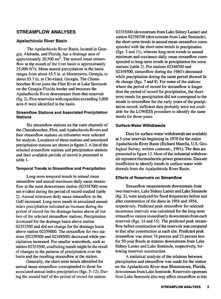
Apalachicola River Basin
The Apalachicola River Basin, located in Geor gia, Alabama, and Florida, has a drainage area of approximately 20,500 mi2 . The annual mean stream- flow at the mouth of the river basin is approximately 25,000 ft3/s. Mean annual precipitation in the basin ranges from about 45.5 in. at Montezuma, Georgia, to about 65.7 in. at Cleveland, Georgia. The Chatta- hoochee River joins the Flint River at Lake Seminole on the Georgia-Florida border and becomes the Apalachicola River downstream from that reservoir (fig. 2). Five reservoirs with capacities exceeding 5,000 acre-ft were identified in the basin.
Streamflow Stations and Associated Precipitation Stations
Six streamflow stations on the main channels of the Chattahoochee, Flint, and Apalachicola Rivers and four streamflow stations on tributaries were selected for analysis. Locations of these stations and associated precipitation stations are shown in figure 2. A list of the selected streamflow stations and precipitation stations and their available periods of record is presented in table 1.
Temporal Trends in Streamflow and Precipitation
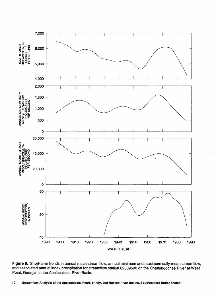
Long-term temporal trends in annual mean streamflow and annual maximum daily mean stream- flow at the most downstream station (02358700) were not evident during the period of record studied (table 2). Annual minimum daily mean streamflow to the Gulf increased. Long-term trends in associated annual index precipitation indicated an increase during the period of record for the drainage basins above all but two of the selected streamflow stations. Precipitation decreased for the drainage basin above station 02353500 and did not change for the drainage basin above station 02359000. The streamflow for two sta tions (02339500 and 02349500) decreased while pre cipitation increased. For smaller watersheds, such as station 02353500, conflicting trends might be the result of changes in the patterns of precipitation over the basin and the resulting streamflow at the station.
Generally, the short-term trends identified for annual mean streamflow corresponded to those for associated annual index precipitation (figs. 3-12). Dur ing the second half of the period of record for station
02335000 (downstream from Lake Sidney Lanier) and station 02358700 (downstream from Lake Seminole), the short-term trends in annual mean streamflow corre sponded with the short-term trends in precipitation (figs. 3 and 11), whereas long-term trends in annual minimum and maximum daily mean streamflow corre sponded to long-term trends in precipitation for some stations (table 2). For stations 02344500 and 02349500, streamflow during the 1980's decreased while precipitation during the same period showed lit tle change (figs. 7 and 8). For some of the stations where the period of record for streamflow is longer than the period of record for precipitation, the short- term trends for precipitation did not correspond to the trends in streamflow for the early years of the precipi tation record; sufficient data probably were not avail able for the LOWESS procedure to identify the same trends for those years.
Surface-Water Withdrawals
Data for surface-water withdrawals are available at 5-year intervals beginning in 1970 for the entire Apalachicola River Basin (Richard Marella, U.S. Geo logical Survey, written commun., 1991). The data are presented in figure 13. Most of the industrial withdraw als represent thermoelectric power generation. Data are insufficient to identify trends in surface-water with drawals from the Apalachicola River Basin.
Effects of Reservoirs on Streamflow
Streamflow measurements downstream from two reservoirs, Lake Sidney Lanier and Lake Seminole (fig. 2), were analyzed for flood frequencies before and after construction of the dams in 1956 and 1954, respectively. Predicted peak streamflow for selected recurrence intervals was calculated for the long-term streamflow station immediately downstream from each reservoir (figs. 14 and 15). The predicted peak stream- flow before construction of the reservoir was compared to that after construction at each site. Predicted peak streamflow was about 74 percent and 23 percent less for 50-year floods at stations downstream from Lake Sidney Lanier and Lake Seminole, respectively, fol lowing reservoir construction.
A statistical analysis of the relations between precipitation and streamflow was made for the station on the Apalachicola River near Blountstown, Florida, downstream from Lake Seminole. Reservoirs upstream from Lake Seminole also may affect streamflow at this
STREAMFLOW ANALYSES

Bmbrv
Swf etwatfr Creek
WALTER F. GEORGE RESERVOIR
-Toccoa
EXPLANATION
.... DRAINAGE BASIN BOUNDARY
- SUBBASIN BOUNDARY
02352500
Milford
Blakely
STREAMFLOW STATION AND NUMBER
CITY
CITY WITH PRECIPITATION STATION
GULF Of
10 20 30 40 MILES
0 10 20 30 40 KILOMETERS
Figure 2. Location of selected streamflow stations, precipitation stations, and major reservoirs in the Apalachicola River Basin.
6 Streamflow Analysis of the Apalachicola, Pearl, Trinity, and Nueces River Basins, Southeastern United States

CO
xz
500
400
300
200
150
100
50
0
8,000
6,000
2,000
80
70
60
501940 1950 1960 1970 1980 1990
WATER YEAR
Figure 3. Short-term trends in annual mean streamflow, annual minimum and maximum daily mean streamflow, and associated annual index precipitation for streamflow station 02333500 on the Chestatee River near Dahlonega, Georgia, in the Apalachicola River Basin.
STREAMFLOW ANALYSES

_. ZUJID
xz
3,000
2,500
2,000
1,500
800
600
400
20,000
10 '000
70
60
50
40
1900 1910 1920 1930 1940 1950
WATER YEAR
1960 1970 1980 1990
Figure 4. Short-term trends in annual mean streamflow, annual minimum and maximum daily mean streamflow, and associated annual index precipitation for streamflow station 02335000 on the Chattahoochee River near Norcross, Georgia, in the Apalachicola River Basin.
8 Streamflow Analysis of the Apalachicola, Pearl, Trinity, and Nueces River Basins, Southeastern United States

CO
500
400
4,000 -
2,000
60
50
401930 1940 1950 1960
WATER YEAR
1970 1980 1990
Figure 5. Short-term trends in annual mean streamflow, annual minimum and maximum daily mean streamflow, and associated annual index precipitation for streamflow station 02337000 on Sweetwater Creek near Austell, Georgia, in the Apalachicola River Basin.
STREAMFLOW ANALYSES 9
7,000
5,000
4,000
2,000
1,500
1,000
500
0
60,000
40,000
3IS- 0" 20,000
0
60
50
401890 1900 1910 1920 1930 1940 1950 1960 1970 1980 1990
WATER YEAR
Figure 6. Short-term trends in annual mean streamflow, annual minimum and maximum daily mean streamflow, and associated annual index precipitation for streamflow station 02339500 on the Chattahoochee River at West Point, Georgia, in the Apalachicola River Basin.
10 Streamflow Analysis of the Apalachicola, Pearl, Trinity, and Nueces River Basins, Southeastern United States
CO
tocc
500
400
300
200
60
40
20
0
6,000
4,000
2,000
55
xz
50
45
1930 1940 1950 1960
WATER YEAR
1970 1980 1990
Figure 7. Short-term trends in annual mean streamflow, annual minimum and maximum daily mean streamflow, and associated annual index precipitation for streamflow station 02344500 on the Flint River near Griffin, Georgia, in the Apalachicola River Basin.
STREAMFLOW ANALYSES 11

5,000
Ijttui 4,000
3,000
2,000
1,200
p&§ 1 '0001^§1 800
600
400
40,000
30,000
20,000
10,000
55
50
45
40
xz
if
1930 1940 1950 1960
WATER YEAR
1970 1980 1990
Figure 8. Short-term trends in annual mean streamflow, annual minimum and maximum daily mean streamflow, and associated annual index precipitation for streamflow station 02349500 on the Flint River at Montezuma, Georgia, in the Apalachicola River Basin.
12 Streamflow Analysis of the Apalachicola, Pearl, Trinity, and Nueces River Basins, Southeastern United States

7,000
ii 6'°°°5,000
4,000
1,500
*%llSi 1-°°°
500
a
so.ooo
20,000
55
50
45 4o
401930 1940 1950 1960
WATER YEAR
1970 1980 1990
Figure 9. Short-term trends in annual mean streamflow, annual minimum and maximum daily mean streamflow, and associated annual index precipitation for streamflow station 02352500 on the Flint River at Albany, Georgia, in the Apalachicola River Basin.
STREAMFLOW ANALYSES 13

xz
1,000
800 -
600
400
300
200
100
8,000
6,000
4,000
2,000
70
60
50
401940 1950 1960 1970
WATER YEAR
1980 1990
Figure 10. Short-term trends in annual mean streamflow, annual minimum and maximum daily mean streamflow, and associated annual index precipitation for streamflow station 02353500 on Ichawaynochaway Creek at Milford, Georgia, in the Apalachicola River Basin.
14 Streamflow Analysis of the Apalachicola, Pearl, Trinity, and Nueces River Basins, Southeastern United States

30,000
1 25,000
*
20,000
15,000
12,000
10,000
8,000
6,000
120,000
i So 100,000
i~ 80,000 -
60,000
60
.jto 50 <!a.z ou
401920 1930 1940 1950 1960
WATER YEAR
1970 1980 1990
Figure 11. Short-term trends in annual mean streamflow, annual minimum and maximum daily mean streamflow, and associated annual index precipitation for streamflow station 02358700 on the Apalachicola River near Blountstown, Florida, in the Apalachicola River Basin.
STREAMFLOW ANALYSES 15

2,000
CO
xz
1,000
700
600
500
400
8,000
6,000
4,000
2,000
65
60
55
501940 1950 1960 1970
WATER YEAR
1980 1990
Figure 12. Short-term trends in annual mean streamflow, annual minimum and maximum daily mean streamflow, and associated annual index precipitation for streamflow station 02359000 on the Chipola River near Altha, Florida, in the Apalachicola River Basin.
16 Streamflow Analysis of the Apalachicola, Pearl, Trinity, and Nueces River Basins, Southeastern United States
£.,UUU
Q 2,000 CCUJ Q.wQ
§ 1 '500
Zo3^-. 1,000
1CCQ
1 500
n
i i i i i
0 TOTAL
0 INDUSTRIAL O
A MUNICIPAL 0
D IRRIGATION
0O
Ooo o
-
-
-
A AA A
A D D Dm Q i i i
4,000
3,500
Q
3,000 § OUJc/)
2,500 2
UJ
B2,000 o
CDD O
1,500 ?
1,000 <Q
500 ^
1965 1970 1975 1980WATER YEAR
1985 1990 1995
Figure 13. Reported annual surface-water withdrawals from the Apalachicola River Basin, by category of use.
station. Before construction of the reservoir, the annual mean streamflow was about 17 percent of the associ ated annual index precipitation; streamflow was about 16 percent of precipitation after construction of the res ervoir. Therefore, streamflow as a percentage of precip itation was about 1 percent less after construction of the reservoir, which represents a decrease in streamflow of about 6 percent. This decrease, however, probably exceeds the potential error in the data, thus it is possible that no change in streamflow occurred.
Pearl River Basin
The Pearl River Basin, located in Mississippi and Louisiana, has a drainage area of approximately 8,730 mi2 . The annual mean streamflow is approximately 9,500 ft3/s at the most downstream station (02489500) (fig. 16). Mean annual precipitation in the basin ranges from about 55.8 in. in the upstream part of the basin to
about 62.3 in. in the downstream part of the basin. One major reservoir is in the basin.
Streamflow Stations and Associated Precipitation Stations
Four streamflow stations on the main channel of the Pearl River and three streamflow stations on tribu taries were chosen for analysis. Locations of selected long-term streamflow stations and precipitation sta tions in the Pearl River Basin are shown in figure 16. The selected streamflow stations and associated precip itation stations and their available periods of record are listed in table 3.
Temporal Trends in Streamflow and Precipitation
The long-term trends indicate increases in streamflow and precipitation at all but one of the
STREAMFLOW ANALYSES 17

70,000
OCD
§
CC
ffiQ
OQ LJJ CC D_
60,000
O O LJJ V)CC LJJ Q_
LJJ 50,000
40,000
30,000 -
20,000
10,000
O BEFORE DAM CONSTRUCTION
O AFTER DAM CONSTRUCTION
20 40 60 80
RECURRENCE INTERVAL, IN YEARS
100 120
Figure 14. Predicted peak streamflow at streamflow station 02335000 on the Chattahoochee River downstream from Lake Sidney Lanier in the Apalachicola River Basin, before and after construction of the dam in 1956.
selected sites in the Pearl River Basin: annual mean streamflow, annual minimum and maximum daily mean streamflow, and associated annual index precipi tation all increased during the period of record. The exception was streamflow station 02492000, where less than a 5-percent increase occurred in annual mini mum streamflow. Increases occurred at this station for annual mean and annual maximum streamflow and for associated annual index precipitation.
The short-term trends identified for the stream- flow generally corresponded to the trends in associated annual index precipitation for each station (figs. IT- 23). The trends for streamflow station 02486000 (downstream from the Ross R. Barnett Reservoir) indi cated an increase in annual minimum streamflow dur ing the 1980's and a decrease in annual mean and
annual maximum streamflow and in associated annual index precipitation during the same period (fig. 20). For station 02488500 (farther downstream), annual minimum streamflow increased during the late 1970's and 1980's, while annual mean and annual maximum streamflow and annual index precipitation decreased for the station during the same period (fig. 21). For sta tion 02489500 (the most downstream station studied on the main channel), annual mean streamflow decreased during the 1980's, while annual minimum streamflow increased, and annual index precipitation and annual maximum streamflow decreased and then increased during the same period (fig. 22). Causes for these trends were not investigated; however, the increases in annual minimum streamflow could result from
18 Streamflow Analysis of the Apalachicola, Pearl, Trinity, and Nueces River Basins, Southeastern United States

(-) oau ,\J\J\J
O 0 LJJ
2 300,000LU Q_
LJJ
£ 250,000OCD
z 200,000
3 2 150,000
LJJ
1* 100,000LJJ Q_Q
[5 50,000Q LJJ DC Q.
0 0
I I I 1 I
O BEFORE DAM CONSTRUCTION
<> AFTER DAM CONSTRUCTION^_^^^^
r^^^
^^^
^
&^ _.---' <>/ _.--'--*-""""""/."""""
©/'
t'i-3)
i i i i i
20 40 60 80 100 15
RECURRENCE INTERVAL, IN YEARS
Figure 15. Predicted peak streamflow at streamflow station 02358700 on the Apalachicola River downstream from Lake Seminole in the Apalachicola River Basin, before and after construction of the dam in 1954.
reservoir operation and from return flows from Jack son, Mississippi.
Surf ace-Water Withdrawals
Data for surface-water withdrawals were avail able for only two major users: Jackson, Mississippi, and the Georgia-Pacific Co. (Nancy Barber, U.S. Geo logical Survey, written commun., 1991). The City of Jackson reported annual mean withdrawals from the Pearl River ranging from 38.2 to 50.4 ft3/s from 1975 through 1985. The withdrawal for the city is used for municipal water supply, supplemented with ground- water withdrawals, and is returned to the Pearl River as treated effluent. From 1979 through 1986, the Georgia- Pacific Co. reported annual mean withdrawals from the Pearl River north of Monticello, Mississippi (fig. 16), ranging from 30.0 to 43.2 ft3/s. Because of the limited
period of record and lack of information about other possible surface-water withdrawals, these data were insufficient for determining trends in surface-water withdrawals in the Pearl River Basin.
Effect of Reservoir on Streamflow
The Ross R. Baraett Reservoir is the only major reservoir in the Pearl River Basin (fig. 16). This reser voir was built primarily for water supply and probably has not affected peak streamflow in the Pearl River. Peak streamflow frequency analyses of streamflow downstream from the reservoir before and after con struction of the reservoir in 1965 indicate that the predicted peak streamflow did not change following completion of the reservoir. The annual index precipi tation following reservoir construction was about 7 in. more than before construction of the reservoir;
STREAMFLOW ANALYSES 19

Table 1. Selected streamflow stations, associated precipitation stations, and periods of record in the Apalachicola River Basin
[Where the period of record for the associated precipitation stations exceeded the available period of record for the stream- flow station, the longest common period of record was used for analysis of trends for the streamflow station and its associ ated precipitation stations]
Streamflow station number and name Precipitation station number and location
Available periods of record (water years)
02333500 Chestatee Rivernear Dahlonega, Ga.
2006 Cleveland, Ga.
2475 Dahlonega, Ga.
1929-32, 1940-88
1948-88 1930-88
02335000 Chattahoochee River near Norcross, Ga.
2475 Dahlonega, Ga.
3621 Gainesville, Ga.
6407 Norcross, Ga.
8740 Toccoa, Ga.
1903-46, 1957-88
1930-88 1930-88 1948-88 1930-88
02337000 Sweetwater Creek near Austell, Ga.
2791 Douglasville, Ga.
3147 Embry, Ga.
1904-06, 1937-88
1948-88
1948-88
02339500 Chattahoochee River at West Point, Ga.
451 Atlanta, Ga.
2475 Dahlonega, Ga.
3147 Embry, Ga.
3621 Gainesville, Ga.
1896-88
1930-88 1930-88 1948-88
1930-88
9291 West Point, Ga. 1930-88
02344500 Flint River near Griffin, Ga.
451 Atlanta, Ga.
3271 Experiment, Ga.
1937-88 1930-88 1926-88
02349500 Flint River at Montezuma, Ga.
451 Atlanta, Ga.
3271 Experiment, Ga.
5979 Montezuma, Ga.
6335 Newnan, Ga.
1905-13,1930-881930-881926-881948-881948-88
8535 Talbotton, Ga. 1930-88
20 Streamflow Analysis of the Apalachicola, Pearl, Trinity, and Nueces River Basins, Southeastern United States

Table 1. Selected streamflow stations, associated precipitation stations, and periods of record in the Apalachicola River Basin Continued
Streamflow station number and name Precipitation station number and location
Available periods of record (water years)
02352500 Flint River at Albany, Ga.
140 Albany, Ga.
451 Atlanta, Ga.
3271 Experiment, Ga.
8535 Talbotton, Ga.
1902-21, 1930-881892-881930-881926-881930-88
02353500 Ichawaynochaway Creek at Milford, Ga.
979 Blakely, Ga.
2450 Cuthbert, Ga.
2570 Dawson, Ga.
1905-08,1940-88
1889-1911,1914-88
1948-881944-88
02358700 Apalachicola Rivernear Blountstown, Fla.
140 Albany, Ga.
451 Atlanta, Ga.
979 Blakely, Ga.
3261 Gainesville, Ga.
1921-88
1892-88 1930-881889-1911, 1914-88 1930-88
3271 Experiment, Ga.
7424 Quincy,Fla.
7429 Quincy, Fla.
9291 West Point, Ga.
1926-881896-98,1901-04,1916-671968-881930-88
02359000 Chipola River near Altha, Fla.
804 Blountstown, Fla.
979 Blakely, Ga.
6218 Ozark,Ala.
7429 Quincy, Fla.
1913-14,1922-27,1929-31,1943-88
1931-82
1889-1911, 1914-88
1930-86
1968-88
therefore, peak streamflow frequencies and statistical relations between precipitation and streamflow for the two periods cannot be compared meaningfully.
Trinity River Basin
The Trinity River, located entirely in the State of Texas, has a drainage area of approximately 18,000
*^.
mi . The annual mean streamflow is approximately 7,400 ft3/s at station 08066500, about 94 mi upstream from the mouth of the Trinity River (fig. 24). Mean
annual precipitation in the basin ranges from about 28.8 in. in the upstream part of the basin to about 52.2 in. in the downstream part of the basin. The Trinity River has 31 identified reservoirs in the basin with a capacity greater than 5,000 acre-ft of storage.
Streamflow Stations and Associated Precipitation Stations
Four streamflow stations on the main channel of the Trinity River and five stations on major tributaries
STREAMFLOW ANALYSES 21

Table 2. Long-term trends in streamflow and associated precipitation for streamflow stations in the Apalachicola River Basin
[no change, less than 5-percent increase or decrease for 50 years of streamflow record, or less than 3-percent increase or decrease for 50 years of precipitation record]
Long-term trend
Streamflow station number and name Annual mean streamflow
Annualminimum
daily meanstreamflow
Annualmaximum
daily meanstreamflow
Associated annual index precipitation
02333500
02335000
02337000
Chestatee River near Dahlonega, Ga.
Chattahoochee River near Norcross, Ga.
Sweet water Creek near Austell, Ga.
02339500 Chattahoochee River at West Point, Ga.
02344500 Flint River near Griffin, Ga.
02349500 Flint River atMontezuma, Ga.
02352500 Flint River at Albany, Ga.
02353500 Ichawaynochaway Creek at Milford, Ga.
02358700 Apalachicola Rivernear Blountstown, Fla.
02359000 Chipola River near Altha, Fla.
increased
no change
increased
decreased
no change
decreased
no change
decreased
no change
no change
no change
no change
no change
decreased
no change
decreased
increased
decreased
increased
decreased
increased
decreased
increased
decreased
decreased
decreased
increased
increased
no change
no change
increased
increased 1
increased 1
increased
increased
increased
increased
decreased1
increased 1
no change
1 Comparison of streamflow trends with the precipitation trend for this site may be affected by the shorter length of record for the precipitation stations associated with this streamflow station.
were selected for analysis. Locations of the long-term streamflow stations and precipitation stations selected for analysis in the Trinity River Basin are shown in fig ure 24. The selected streamflow stations, associated precipitation stations, and their available periods of record are presented in table 4.
Temporal Trends in Streamflow and Precipitation
Long-term trends indicated an increase in annual minimum daily mean streamflow and a decrease in annual maximum daily mean streamflow for all of the
selected streamflow stations in the Trinity River Basin (table 5). Associated annual index precipitation either increased with time or remained unchanged throughout the basin. Annual mean streamflow decreased at six of the nine streamflow stations. Annual mean streamflow increased for station 08047500, downstream from Ben- brook Lake, and for station 08057000. Annual mean streamflow did not change for station 08055500, down stream from Grapevine Lake and Lewisville Reservoir.
Short-term trends in annual mean streamflow generally corresponded to the trends identified for associated annual index precipitation (figs. 25-33).
22 Streamflow Analysis of the Apalachicola, Pearl, Trinity, and Nueces River Basins, Southeastern United States
\Ackerman '
Kosciusko 02484000
Canton
Brookhaveri, {^ I »
City '/ \ 02488500 V \ / \ V S 5 Monticetto \^
i 1 /^ M-e, \
EXPLANATION
- _ DRAINAGE BASIN BOUNDARY
- SUBBASIN BOUNDARY
N
A STREAMFLOW STATION AND NUMBER
CITY
*N
02489500
Bush B CITY
Columbia » CITY WITH PRECIPITATION STATION
3VSA
10 20 SO 40 MILES
0 10 20 30 40 KILOMETERS
/ \ n \Poplarville\v, (*°*^£' A" V " V '/024895001 /
S> I02492000 \B >
BushN v
Covington
0*>tf
&&
Figure 16. Location of selected streamflow stations, precipitation stations, and the major reservoir in the Pearl River Basin.
STREAMFLOW ANALYSES 23

Table 3. Selected streamflow stations, associated precipitation stations, and periods of record in the Pearl River Basin
[Where the period of record for the associated precipitation stations exceeded the available period of record for the streamflow station, the longest common period of record was used for analysis of trends for the streamflow station and its associated precipitation stations]
Streamflow station number and name
02482000 Pearl River at Edinburg, Miss.
02483000 Tuscolameta Creekat Walnut Grove, Miss.
02484000 Yockanookany River near Kosciusko, Miss.
02486000 Pearl River at Jackson, Miss.
02488500 Pearl River near Monticello, Miss.
02489500 Pearl River near Bogalusa, La.
02492000 Bogue Chitto near Bush, La.
Precipitation station number and location
52476894
31079326
394776
1389310746674776
5247
1094138931074467
5247
1094
186521513107
5247
7128
1094
18652151
Louisville, Miss.Philadelphia, Miss.
Forest, Miss.Walnut Grove, Miss.
Ackerman, Miss.Kosciusko, Miss.
Canton, Miss.Forest, Miss.Jackson, Miss.Kosciusko, Miss.
Louisville, Miss.
Brookhaven City, Miss.
Canton, Miss.Forest, Miss.Jackson, Miss.
Louisville, Miss.
Brookhaven City, Miss.
Columbia, Miss.Covington, La.Forest, Miss.
Louisville, Miss.Poplarville, Miss.
Brookhaven City, Miss.Columbia, Miss.Covington, La.
Available periods of record
1929-881930-881949-88
1940-88
1930-881948-88
1939-88
1948-881948-87, 1989-88
1902-881948-881930-881930-711948-87, 1989-88
1930-88
1939-881930-881948-881930-881931-71
1930-88
1939-881930-88
1930-881930-88
1930-88
1930-881930-88
1938-881930-88
1930-881930-88
24 Streamflow Analysis of the Apalachicola, Pearl, Trinity, and Nueces River Basins, Southeastern United States

2,000
1,500
1,000
500
20
10
0
20,000
15,000
5,000
70
60
50
401920 1930 1940 1950 1960
WATER YEAR
1970 1980 1990
Figure 17. Short-term trends in annual mean streamflow, annual minimum and maximum daily mean streamflow, and associated annual index precipitation for streamflow station 02482000 on the Pearl River at Edinburg, Mississippi, in the Pearl River Basin.
STREAMFLOW ANALYSES 25

1,000
500
CO
0
15
10
15,000
10,000 -
5,000
70
60
50
40
1940 1950 1960 1970
WATER YEAR
1980 1990
Figure 18. Short-term trends in annual mean streamflow, annual minimum and maximum daily mean streamflow, and associated annual index precipitation for streamflow station 02483000 on Tuscolameta Creek at Walnut Grove, Mississippi, in the Pearl River Basin.
26 Streamflow Analysis of the Apalachicola, Pearl, Trinity, and Nueces River Basins, Southeastern United States

600
400
200
15
10
0
15,000
10,000
5,000 -
xz
80
60
40
201930 1940 1950 1960
WATER YEAR
1970 1980 1990
Figure 19. Short-term trends in annual mean streamflow, annual minimum and maximum daily mean streamflow, and associated annual index precipitation for streamflow station 02484000 on the Yockanookany River near Kosciusko, Mississippi, in the Pearl River Basin.
STREAMFLOW ANALYSES 27

6,000
4,000
2,000
200
oig5£ 3l8ffi
150
100
40,000
tilo 30,000
2!S- 0" 20,000
10,000
70
60
50
xz
401900 1910 1920 1930 1940 1950 1960 1970 1980 1990
WATER YEAR
Figure 20. Short-term trends in annual mean streamflow, annual minimum and maximum daily mean streamflow, and associated annual index precipitation for streamflow station 02486000 on the Pearl River at Jackson, Mississippi, in the Pearl River Basin.
28 Streamflow Analysis of the Apalachicola, Pearl, Trinity, and Nueces River Basins, Southeastern United States

w
10,000
8,000
6,000
4,000
2,000
800
600
400
1930 1940 1950 1960
WATER YEAR
1970 1980 1990
Figure 21. Short-term trends in annual mean streamflow, annual minimum and maximum daily mean streamflow, and associated annual index precipitation for streamflow station 02488500 on the Pearl River near Monticello, Mississippi, in the Pearl River Basin.
STREAMFLOW ANALYSES 29

15,000
o £w 10,000
5,000
2,000
1,000
60,000
50,000
40,000
30,000
20,000
70
xz
60
501930 1940 1950 1960
WATER YEAR
1970 1980 1990
Figure 22. Short-term trends in annual mean streamflow, annual minimum and maximum daily mean streamflow, and associated annual index precipitation for streamflow station 02489500 on the Pearl River near Bogalusa, Louisiana, in the Pearl River Basin.
30 Streamflow Analysis of the Apalachicola, Pearl, Trinity, and Nueces River Basins, Southeastern United States
CO
2,500
2,000
1,500
1,000
800
ih35u600
400
30,000
25,000
20,000
15,000
10,000
70
xz
60
501930 1940 1950 1960
WATER YEAR
1970 1980 1990
Figure 23. Short-term trends in annual mean streamflow, annual minimum and maximum daily mean streamflow, and associated annual index precipitation for streamflow station 02492000 on the Bogue Chitto near Bush, Louisiana, in the Pearl River Basin.
STREAMFLOW ANALYSES 31

Cresson
Corsicana*\ N^^v twwcana x ~f \
HastKxo.l \^-~"\* Vx V .
'\r \-4» 'vA^-5^X£%{L% / \
\\ v x
/32''
EXPLANATION
_ _ _ DRAINAGE BASIN BOUNDARY
- SUBBASIN BOUNDARY
08066500 A STREAMFLOW STATION AND NUMBER
Rossier B CITY
Hillsboro 9 CITY WITH PRECIPITATION STATION
0 10 20 30 AC MILES
0 10 20 30 40 KILOMETERS
Figure 24. Location of selected streamflow stations, precipitation stations, and major reservoirs in the Trinity River Basin.
32 Streamflow Analysis of the Apalachicola, Pearl, Trinity, and Nueces River Basins, Southeastern United States
100
50
CO
0
4,000
-iDo o
2,000
40
xz~
30
201930 1940 1950 1960
WATER YEAR
1970 1980 1990
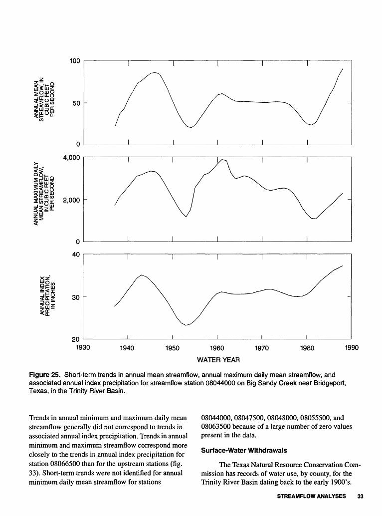
Figure 25. Short-term trends in annual mean streamfiow, annual maximum daily mean streamfiow, and associated annual index precipitation for streamfiow station 08044000 on Big Sandy Creek near Bridgeport, Texas, in the Trinity River Basin.
Trends in annual minimum and maximum daily mean streamflow generally did not correspond to trends in associated annual index precipitation. Trends in annual minimum and maximum streamflow correspond more closely to the trends in annual index precipitation for station 08066500 than for the upstream stations (fig. 33). Short-term trends were not identified for annual minimum daily mean streamflow for stations
08044000, 08047500, 08048000,08055500, and 08063500 because of a large number of zero values present in the data.
Surface-Water Withdrawals
The Texas Natural Resource Conservation Com mission has records of water use, by county, for the Trinity River Basin dating back to the early 1900's.
STREAMFLOW ANALYSES 33

IllCO
CO
3
200
150
100
50
0
6,000
4,000
2,000
40
35
30
25
201920 1930 1940 1950 1960 1970 1980 1990
WATER YEAR
Figure 26. Short-term trends in annual mean streamflow, annual maximum daily mean streamflow, and associated annual index precipitation for streamflow station 08047500 on the Clear Fork Trinity River at Fort Worth, Texas, in the Trinity River Basin.
Total reported annual surface-water withdrawals for the entire Trinity River Basin since 1940 are shown, by category of use, in figure 34. Withdrawals in the basin have increased more than fourfold since 1940. Most of this increase resulted from withdrawals for municipal water supplies; withdrawals for industrial uses also have increased. However, only about 20 percent of the reported withdrawals in 1990 were consumed and were
not returned to the streams (Texas Water Development Board, written commun., 1990).
Data for surface-water withdrawals for the sub- basins upstream from three streamflow stations (08057000,08062500, and 08066500) were compared with trends in annual mean streamflow and associated annual index precipitation at each station (figs. 35-37). Withdrawals have increased in the basin upstream from
34 Streamflow Analysis of the Apalachicola, Pearl, Trinity, and Nueces River Basins, Southeastern United States

-j 0 uj
CO
600
400
200
0
10,000
5,000 20.
xz~
40
35
30
25
201920 1930 1940 1950 1960 1970 1980 1990
WATER YEAR
Figure 27. Short-term trends in annual mean streamfiow, annual maximum daily mean streamfiow, and associated annual index precipitation for streamfiow station 08048000 on the West Fork Trinity River at Fort Worth, Texas, in the Trinity River Basin.
each of these three stations. Total surface-water with drawals from the Trinity River Basin in 1988 repre sented about one-fourth of the annual mean streamflow at station 08066500, the most downstream station on the Trinity River.
Effects of Reservoirs on Streamfiow
The streamflow at all of the stations selected for analysis probably is affected by upstream regulation.
Based on identified trends, annual minimum daily mean streamflow has increased and annual maximum daily mean streamflow has decreased at all of the selected stations (table 5). Numerous reservoirs in the basin have caused these trends. Increases in annual minimum streamflow resulted from releases from res ervoirs to supplement low flow and, downstream from Dallas and Fort Worth, discharges of treated waste- water into the streams. Decreases in annual maximum
STREAMFLOW ANALYSES 35

CO
ZQ-
1,500
1,000
500
0
30,000
20,000
10,000
xz
40
35
30
251900 1910 1920 1930 1940 1950 1960 1970 1980 1990
WATER YEAR
Figure 28. Short-term trends in annual mean streamflow, annual maximum daily mean streamflow, and associated annual index precipitation for streamflow station 08055500 on the Elm Fork Trinity River near Carrollton, Texas, in the Trinity River Basin.
streamflow resulted from attenuation of flood peaks by the reservoirs.
The streamflow at the long-term station immedi ately downstream from each of three reservoirs, Ben- brook Lake, Lavon Lake 1 , and Livingston Reservoir (fig. 24), was analyzed for peak streamflow frequency before and after construction of the reservoirs. Stream- flow at each of these reservoirs may be affected by
other upstream reservoirs. Predicted peak streamflow downstream from Benbrook Lake on the Clear Fork Trinity River, for the flood peak with an expected
'Peak streamflow before construction of Lavon Lake was calculated based on the period of record from 1924-53 for station 08061500. Peak streamflow after construction of Lavon Lake was calculated based on the period of record from 1954-89 for station 08061000.
36 Streamflow Analysis of the Apalachicola, Pearl, Trinity, and Nueces River Basins, Southeastern United States
CO
2,000
lil 1 '5°°1,000
500
300
200
100
0
40,000
30,000
20,000
10,000
0
40
xz
30
201900 1910 1920 1930 1940 1950 1960 1970 1980 1990
WATER YEAR
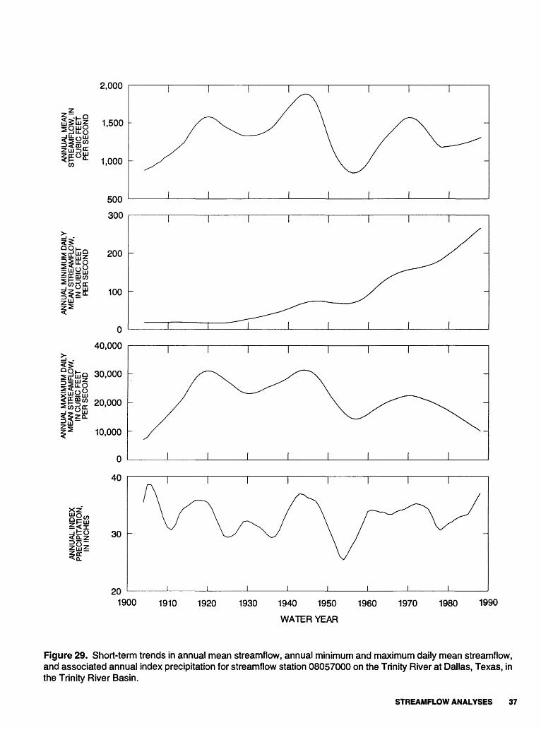
Figure 29. Short-term trends in annual mean streamflow, annual minimum and maximum daily mean streamflow, and associated annual index precipitation for streamflow station 08057000 on the Trinity River at Dallas, Texas, in the Trinity River Basin.
STREAMFLOW ANALYSES 37

Z><CD
6,000
4,000
2,000
0
1,000
500
i^
o60,000
40,000
20,000
xz
50
40
30
201940 1950 1960 1970
WATER YEAR
1980 1990
Figure 30. Short-term trends in annual mean streamflow, annual minimum and maximum daily mean streamflow, and associated annual index precipitation for streamflow station 08062500 on the Trinity River near Rosser, Texas, in the Trinity River Basin.
38 Streamflow Analysis of the Apalachicola, Pearl, Trinity, and Nueces River Basins, Southeastern United States

Ssfci
CO
5j r~ui z
xzogis
600
400
200
0
30,000
20,000
10,000
0
50
40
30
201940 1950 1960 1970
WATER YEAR
1980 1990
Figure 31 . Short-term trends in annual mean streamflow and annual maximum daily mean streamflow, and associated annual index precipitation for streamflow station 08063500 on Richland Creek near Richland, Texas, in the Trinity River Basin.
recurrence interval of 50 years, was about 44,600 ft3/s before and about 22,900 ft3/s after the reservoir was constructed in 1952 (fig. 38), a decrease of about 49 percent. Predicted peak streamflow downstream from Lavon Lake on the East Fork Trinity River was about 84,800 ft3/s before and 21,300 ft3/s after the reservoir was constructed in 1954 (fig. 39), a decrease of about 75 percent. The streamflow station downstream from
Livingston Reservoir on the main channel of the Trin ity River, constructed in 1969, was affected by upstream regulation for at least 15 years before the con struction of the reservoir (after 1969). Peak streamflow frequency analyses were performed for the period before upstream regulation and for the period after con struction of the reservoir. The predicted 50-year peak streamflow was about 112,000 ft3/s for both periods.
STREAMFLOW ANALYSES 39
8,000
6,000
4,000
2,000
1,000
500
0
60,000
iltilo 40,000
1|§UJ
15- 20,000
0
45
xz 40
35
30
251920 1930 1940 1950 1960
WATER YEAR
1970 1980 1990
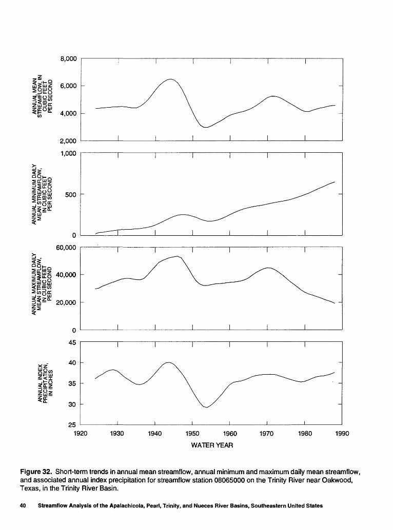
Figure 32. Short-term trends in annual mean streamflow, annual minimum and maximum daily mean streamflow, and associated annual index precipitation for streamflow station 08065000 on the Trinity River near Oakwood, Texas, in the Trinity River Basin.
40 Streamflow Analysis of the Apalachicola, Pearl, Trinity, and Nueces River Basins, Southeastern United States

10,000
i .QOn-_ _J jjjOS; St LLlZ21"-O
6,000
4,000
800
600
400
200
50,000
40,000
QCC
- 30,000
20,000
45
xz40
35
301920 1930 1940 1950 1960
WATER YEAR
1970 1980 1990
Figure 33. Short-term trends in annual mean streamflow, annual minimum and maximum daily mean streamflow, and associated annual index precipitation for streamflow station 08066500 on the Trinity River at Romayor, Texas, in the Trinity River Basin.
STREAMFLOW ANALYSES 41
Table 4. Selected streamflow stations, associated precipitation stations, and periods of record in the Trinity River Basin
[Where the period of record for the associated precipitation stations exceeded the available period of record for the stream- flow station, the longest common period of record was used for analysis of trends for the streamflow station and its associ ated precipitation stations]
Streamflow station number and name Precipitation station number and location
Available periods of record
08044000 Big Sandy Creek near Bridgeport, Tex.
08047500 Clear Fork Trinity River at Fort Worth, Tex.
984 Bowie, Tex.
1063 Bridgeport, Tex.
691 Benbrook Dam, Tex.
2906 Cresson, Tex.
9532 Weatherford, Tex.
1937-88
1897-98, 1900-27, 1955-88
1915-46,1948-88
1924-88
1949-88
1948-88
1902-88
08048000 West Fork Trinity River at Fort Worth, Tex.
271 Antelope, Tex.
1063 Bridgeport, Tex.
4517 Jacksboro, Tex.
9532 Weatherford, Tex.
1921-88
1910-20, 1948-88
1915-46,1948-88
1941-88
1902-88
08055500 Elm Fork Trinity River near Carrollton, Tex.
2404 Denton, Tex.
3415 Gainesville, Tex.
3420 Gainesville, Tex.
1907-88
1913-88
1897-98,1900-26, 1928-87
1987-88
08057000 Trinity River at Dallas, Tex.
08062500 Trinity River near Rosser, Tex.
1063 Bridgeport, Tex.
2244 Dallas, Tex.
3415 Gainesville, Tex.
3420 Gainesville, Tex.
1063 Bridgeport, Tex.
5766 McKinney, Tex.
9522 Waxahatchie, Tex.
1903-88
1915-46, 1948-88
1897-98, 1900-15, 1948-88
1897-98, 1900-26, 1928-87
1987-88
1924-25, 1939-88
1915-46,1948-88
1903-05,1912-88
1897-98, 1900-88
42 Streamflow Analysis of the Apalachicola, Pearl, Trinity, and Nueces River Basins, Southeastern United States

Table 4. Selected streamflow stations, associated precipitation stations, and periods of record in the Trinity River Basin Continued
Streamflow station number and name Precipitation station number Available periods and location of record
08063500 Richland Creek near Richland, Tex.
08065000 Trinity River near Oakwood, Tex.
08066500 Trinity River at Romayor, Tex.
2019 Corsicana, Tex.
4182 Hillsboro, Tex.
5869 Mexia, Tex.
3415 Gainesville, Tex.
3420 Gainesville, Tex.
4705 Kaufman, Tex.
5869 Mexia, Tex.
9532 Weatherford, Tex.
1063
2019
2114
5196
Bridgeport, Tex.
Corsicana, Tex.
Crockett, Tex.
Liberty, Tex.
5766 McKinney, Tex.
1939-88
1897,1901-88
1903-88
1904-57,1960-88
1924-88
1897-98,1900-26, 1928-87
1987-88
1901-88
1904-57,1960-88
1902-88
1924-88
1915^6,1948-88
1897,1901-88
1904-17,1924-88
1904-88
1903-05,1912-88
Livingston Reservoir probably has had only minimal effects on peak streamflow to the Gulf of Mexico from the Trinity River.
A statistical analysis of the relations between precipitation and streamflow was done for the station on the Trinity River near Romayor, Texas (08066500), downstream from Livingston Reservoir. Before con struction of the reservoir, the annual mean streamflow was calculated to be about 4.9 percent of the associated annual index precipitation for the station. After con struction of the reservoir, the annual mean streamflow was about 4.7 percent of the associated annual index precipitation. Therefore, streamflow, as a percent of precipitation, was about 0.2 percent less following con struction of the reservoir, which represents about a 4- percent decrease in streamflow. The decrease, however, exceeds the potential error in the data, thus any change in streamflow is not observable.
Nueces River Basin
The Nueces River Basin (fig. 40) has a drainage area of approximately 17,000 mi2 and annual mean streamflow of about 800 ft3/s at the most downstream station (08211000). Mean annual precipitation in the basin ranges from about 20.9 in. in the upstream part of the basin to about 27.5 in. in the downstream part. Three reservoirs in the basin have a capacity greater than 5,000 acre-ft of storage.
Streamflow Stations and Associated Precipitation Stations
Four streamflow stations along the main stem of the Nueces River and four streamflow stations on trib utaries were selected for analysis. For each station, two to seven precipitation stations were selected as indices to represent the precipitation associated with the
STREAMFLOW ANALYSES 43

Table 5. Long-term trends in streamflow and associated precipitation for streamflow stations in the Trinity River Basin
[no change, less than 5-percent increase or decrease for 50 years of streamflow record, or less than 3-percent increase or decrease for 50 years of precipitation record]
Streamflow station number and name Annual mean streamflow
Long-term trends
Annualminimum
daily meanstreamflow
Annualmaximumdaily meanstreamflow
Associated annual index precipitation
08044000 Big Sandy Creeknear Bridgeport, Tex.
08047500 Clear Fork Trinity River at Fort Worth, Tex.
08048000 West Fork Trinity River at Fort Worth, Tex.
decreased
increased
decreased
increased
increased
increased
decreased
decreased
decreased
increased
no change
increased
08055500 Elm Fork Trinity River near Carrollton, Tex.
08057000 Trinity Riverat Dallas, Tex.
08062500 Trinity Rivernear Rosser, Tex.
no change
increased
decreased
increased
increased
increased
decreased
decreased
decreased
increased
no change
increased
08063500
08065000
08066500
Richland Creek near Richland, Tex.
Trinity River near Oakwood, Tex.
Trinity River at Romayor, Tex.
decreased
decreased
decreased
increased
increased
increased
decreased
decreased
decreased
no change
no change
increased
streamflow. Locations of long-term streamflow stations and precipitation stations and the major reservoirs in the Nueces River Basin are shown in figure 40. The selected streamflow stations and precipitation stations and their available periods of record for the Nueces River Basin are presented in table 6.
Temporal Trends in Streamflow and Precipitation
Long-term trends in annual minimum daily mean streamflow indicated an increase for all of the selected stations during the period of record studied (table 7). Annual maximum daily mean streamflow decreased for all of the stations except for station 08198000, where the trend in annual maximum streamflow increased. Trends in annual mean streamflow and asso
ciated annual index precipitation varied for the selected stations (table 7).
The short-term trends in streamflow generally corresponded to the short-term trends identified for associated annual index precipitation (figs. 41-48). For station 08205500, the trends indicated increased pre cipitation during the late 1910's and 1920's, while the annual mean and maximum streamflow decreased (fig. 45). For stations 08190000 and 08211000 (the most downstream station studied), the annual minimum daily mean streamflow showed a general increase dur ing the 1970's and 1980's, while annual mean and max imum streamflow and annual index precipitation decreased (figs. 41 and 48). Short-term trends were not identified for annual minimum daily mean streamflow for stations 08194000, 08198000, 08205500,
44 Streamflow Analysis of the Apalachicola, Pearl, Trinity, and Nueces River Basins, Southeastern United States

2,000
QzO
UJ 1,50003 DC UJ Q.
UJ UJ LL
O
1,000O
- TOTAL----- MUNICIPAL
- INDUSTRIAL
--- IRRIGATION.......... MINING
1945 1950 1955 1960 1965 1970 1975 1980 1985 1990WATER YEAR
Figure 34. Reported annual surface-water withdrawals from the Trinity River Basin, by category of use.
08208000, and 08210000 because of large numbers of zero values in the data.
represent about one-third of the annual mean stream- flow at station 08211000.
Surface-Water Withdrawals
Records of surface-water withdrawals, by county, in the Nueces River Basin were obtained from the Texas Natural Resource Conservation Commis sion. Reported annual surface-water withdrawals since 1940 from the Nueces River Basin are shown, by cate gory of use, in figure 49. Withdrawals by Corpus Christi, downstream from station 08211000, are not considered in this report; however some of the reported withdrawals are downstream from this station. Since 1940, total surface-water withdrawals from the Nueces River Basin have increased more than eightfold. About one-half of withdrawal represents municipal use. Sur face-water withdrawals from the Nueces River Basin
Effects of Reservoirs on Streamflow
Three major reservoirs are in the Nueces River Basin (fig. 40). Upper Nueces Lake has a much smaller storage capacity than the other two lakes and was not included in this analysis. Lake Corpus Christi was built in 1934 and enlarged in 1958. Choke Canyon Reser voir, on the Frio River, began filling in October 1982. The available periods of record for the stations down stream from these reservoirs were insufficient for anal yses of streamflow before and after construction of the reservoirs. The net evaporation rates from the reser voirs were estimated from pan-evaporation data at the reservoirs using monthly pan-net coefficients (Kane, 1967). The annual mean net evaporation from Choke
STREAMFLOW ANALYSES 45

40
xz
30
BE
ffi
LU
20
2,000
Q
8 i 8 §CC LU W CO
CC
ii
1,500
O tum LLR o° m
~. o 1,0009 " E! ^
LU ?
E 500 STREAMFLOW
WITHDRAWALS
1900 1910 1920 1930 1940 1950 1960
WATER YEAR
1970 1980 1990
Figure 35. Short-term trends in annual index precipitation and in annual mean streamflow, and total reported annual surface-water withdrawals from the subbasin upstream from streamflow station 08057000 on the Trinity River at Dallas, Texas.
Canyon Reservoir is estimated to be about 84,000 acre- storage is 90 percent of that at the spillway. Evapora-ft based on 40 in/yr of net evaporation when storage is 90 percent of the capacity at the top of the spillway gates. Annual mean net evaporation from Lake Corpus Christi is estimated to be about 62,000 acre-ft when
tion losses from the two reservoirs are substantial com pared to streamflow from the Nueces River to the Gulf of Mexico, and the long-term mean streamflow to the Gulf is reduced by evaporation from both reservoirs.
46 Streamflow Analysis of the Apalachicola, Pearl, Trinity, and Nueces River Basins, Southeastern United States

xz
_jbo <CLZ
LU <rPE §r~ r\CO
LU
50
40
30
20
5,000
8CC LU 4,000LU CO
LU r_O LU
§ £ 3,000^ E5Z D~ O
^ ZQ ~
2,000 -
1,000
STREAMFLOW
WITHDRAWALS
1940 1950 1960 1970 WATER YEAR
1980 1990
Figure 36. Short-term trends in annual index precipitation and in annual mean streamflow, and total reported annual surface-water withdrawals from the subbasin upstream from streamflow station 08062500 on the Trinity River near Rosser, Texas.
A water-budget analysis was prepared for 1965- 90 to estimate the volume of streamflow that was reduced in the Nueces River downstream from Choke Canyon Reservoir resulting from filling and evapora
tion at the reservoir (table 8). Net evaporation losses were calculated for each year by multiplying the net evaporation depth times the mean surface area of the reservoir. Station 08210000 on the Nueces River is
STREAMFLOW ANALYSES 47
50
xz
_jbo <a.z 40
30
10,000
§ia: ft 8,000 LLI tn
§ O 6,000 ° 55Z D~ O
I s.
< ^ LLJ §E cci
1 iu4,000
2,000
STREAMFLOW
WITHDRAWALS
1920 1930 1940 1950 1960WATER YEAR
1970 1980 1990
Figure 37. Short-term trends in annual index precipitation and in annual mean streamflow, and total reported annual surface-water withdrawals from the subbasin upstream from streamflow station 08066500 on the Trinity River at Romayor, Texas.
downstream from Choke Canyon Reservoir and from upstream stations are 08194500,08205500,08206700, four upstream stations that comprise most of the flow at and 08208000 (fig. 40). Before the reservoir was con- downstream station 08210000. Annual mean stream- structed, the ratio of the downstream streamflow to the flow values were used in this analysis. The four total gaged upstream streamflow was determined to be
48 Streamflow Analysis of the Apalachicola, Pearl, Trinity, and Nueces River Basins, Southeastern United States

50,000
O O LU c/5
u 40,000
LU
It O
g 30,000
20,0001LU
C/5
°- 10,000 Q
OQ LU CC Q.
O BEFORE DAM CONSTRUCTION
O AFTER DAM CONSTRUCTION
10 20 30 40
RECURRENCE INTERVAL, IN YEARS
50 60
Figure 38. Predicted peak streamflow at streamflow station 08047500 on the Clear Fork Trinity River downstream from Benbrook Lake in the Trinity River Basin, before and after construction of the dam in 1952.
1.07, as explained in table 8. After the reservoir began receiving inflow, this ratio was multiplied by the total gaged upstream streamflow to estimate the expected downstream streamflow if losses had not occurred because of filling and evaporation at the reservoir. The streamflow reduction at the downstream station caused by filling and evaporation was assumed to be the expected streamflow minus the actual streamflow at the downstream station. The total volume reduction, 796,000 acre-ft (183 ft3/s), was similar to the volume, 806,000 acre-ft (185 ft3/s), determined for the sum of the total change in storage and the total estimated net evaporation losses for the reservoir (table 8). The streamflow reduction from 1985 through 1990 repre sented 24 percent of the long-term annual mean streamflow to the Gulf of Mexico as measured at the station on the Nueces River near Mathis, Texas.
SUMMARY AND CONCLUSIONS
For the Apalachicola River, long-term temporal trends in annual mean and annual maximum daily mean streamflow at the most downstream station were not evident during the study period. However, long- term trends indicate an increase in annual minimum daily mean streamflow and associated annual index precipitation. Annual mean streamflow was about 6 percent less for the period following construction of the most downstream reservoir in the Apalachicola River Basin. The 50-year peak streamflow at stations down stream from the reservoirs has been reduced by about 23 percent in the upper part of the basin and about 74 percent in the lower part of the basin. The reductions in predicted peak streamflow and the increases in annual
SUMMARY AND CONCLUSIONS 49
100,000
o oLU COrr
LUUJ
80,000
O
g 60,000
40,000 -UJ
CO
111°- 20,000 - o
oQ UJrrQu
O BEFORE DAM CONSTRUCTION
O AFTER DAM CONSTRUCTION
s*
O'
10 20 30 40
RECURRENCE INTERVAL, IN YEARS
50 60
Note: Peak streamflow before construction of the dam in 1954 was calculated based on the period of record from 1924 to 1953 at streamflow station 08061500. Peak stream- flow after construction of the dam was calculated based on the period of record from 1954 to 1989 at streamflow station 08061000 (fig. 24).
Figure 39. Predicted peak streamflow on the East Fork Trinity River downstream from Lavon Lake in the Trinity River Basin, before and after construction of the dam in 1954.
minimum daily mean streamflow probably result partly from effects of reservoir operations.
For the Pearl River, annual mean streamflow and annual minimum and maximum daily mean streamflow to the Gulf of Mexico and associated annual index pre cipitation in the basin increased during the period stud ied. The increases in streamflow are caused partly by increased precipitation on the basin. Predicted peak discharges near the mouth of the Pearl River, however, did not change as a result of the reservoir in the basin.
For the Trinity River, long-term trends for most stations indicated a decrease in annual mean stream-
flow to the Gulf of Mexico from the basin for the period studied, while associated annual index precipitation increased or remained unchanged. Annual minimum daily mean streamflow to the Gulf increased and annual maximum streamflow decreased, because of reservoir operations in the basin. Surface-water with drawals have increased more than fourfold in the Trin ity River Basin and as of 1988 represent about one- fourth of the annual mean streamflow at the most downstream station studied. Predicted peak streamflow in the upper reaches of the Trinity River were as much as 75 percent less following reservoir construction;
50 Streamflow Analysis of the Apalachicola, Pearl, Trinity, and Nueces River Basins, Southeastern United States

i > 8I 5 t""* /^ ^
UsI CD CO < LU zillX g §ai Q s>
s
I0 O
(I)
TJ (0
oI'a.
1"8
§o>
SUMMARY AND CONCLUSIONS 51

CO
kIliill
250
200
150
100
50
60
40
20
0
10,000
5,000
xz
0
30
25
20
151920 1930 1940 1950 1960
WATER YEAR
1970 1980 1990
Figure 41. Short-term trends in annual mean streamflow, annual minimum and maximum daily mean streamflow, and associated annual index precipitation for streamflow station 08190000 on the Nueces River at Laguna, Texas, in the Nueces River Basin.
52 Streamflow Analysis of the Apalachicola, Pearl, Trinity, and Nueces River Basins, Southeastern United States

300
^tj! 200
100
0
8,000
CO
XZ
6,000
4,000
30
25
20
151920 1930 1940 1950 1960
WATER YEAR
1970 1980 1990
Figure 42. Short-term trends in annual mean streamflow, annual maximum daily mean streamflow, and associated annual index precipitation for streamflow station 08194000 on the Nueces River at Cotulla, Texas, in the Nueces River Basin.
however, predicted peak streamflow to the Gulf did not change following reservoir construction. Predicted annual mean streamflow as a percentage of precipita tion in the basin was about 4 percent less following construction of Livingston Reservoir.
For the Nueces River, long-term trends indicate decreases in annual maximum daily mean streamflow
to the Gulf of Mexico from the basin, while annual minimum daily mean streamflow increased for all but one station studied. Trends in annual mean streamflow and associated annual index precipitation varied for the selected stations. Surface-water withdrawals from the basin increased more than eightfold from 1940 through 1990, and as of 1988 represent about one-third of the
SUMMARY AND CONCLUSIONS 53
CO
xz
200
150
100
50
0
60
40
20
0
6,000
4,000
2,000
35
30
25
201920 1930 1940 1950 1960
WATER YEAR
1970 1980 1990
Figure 43. Short-term trends in annual mean streamflow, annual minimum and maximum daily mean streamflow, and associated annual index precipitation for streamflow station 08195000 on the Frio River at Concan, Texas, in the Nueces River Basin.
54 Streamflow Analysis of the Apalachicola, Pearl, Trinity, and Nueces River Basins, Southeastern United States

100
50
0
3,000
2,000
1,000
35
30
25 -
201940 1950 1960 1970
WATER YEAR
1980 1990
Figure 44. Short-term trends in annual mean streamflow, annual maximum daily mean streamflow, and associated annual index precipitation for streamflow station 08198000 on the Sabinal River near Sabinal, Texas, in the Nueces River Basin.
mean annual streamflow from the Nueces River to the Gulf of Mexico. Filling and evaporation from Choke Canyon Reservoir from 1985 through 1990 represented about 24 percent of the long-term annual mean stream- flow to the Gulf from the Nueces River. Decreases in annual maximum daily mean streamflow are caused partly by reservoir operations in the Nueces River Basin.
SELECTED REFERENCES
Cleveland, W.S., 1979, Robust locally weighted regression and smoothing scatterplots: Journal of the American Statistical Association, v. 74, no. 368, p. 829-836.
Kane, J.W., 1967, Monthly reservoir evaporation rates for Texas 1940-65: Texas Water Development Board Report 64, 111 p. '
SELECTED REFERENCES 55

CO
xzf
200
100
0
8,000
6,000
4,000
2,000
30
25
20
T
1910 1920 1930 1940 1950
WATER YEAR
1960 1970 1980 1990
Figure 45. Short-term trends in annual mean streamflow, annual maximum daily mean streamflow, and associated annual index precipitation for streamflow station 08205500 on the Frio River near Derby, Texas, in the Nueces River Basin.
SELECTED REFERENCES Continued
Rantz, S.E., and others, 1982, Measurement and computa tion of streamflow: U.S. Geological Survey Water- Supply Paper 2175, 631 p.
Seaber, P.R., Kapinos, P.P., and Knapp, G.L., 1987, Hydro- logic unit maps: U.S. Geological Survey Water-Supply Paper 2294, 63 p.
Slade, R.M., Jr., 1992, Status of the Gulf of Mexico pre liminary report on inflows from streams: U.S. Environ mental Protection Agency Report EPA 800-R-005, 64 p.
U.S. Department of Commerce, 1889-1989, Climatological data, Alabama, Florida, Georgia, Louisiana, Missis sippi, Texas, annual summaries: National Oceanic and Atmospheric Administration, National Climatic Data Center.
56 Streamflow Analysis of the Apalachicola, Pearl, Trinity, and Nueces River Basins, Southeastern United States

150
100
50CO
1930 1940 1950 1960
WATER YEAR
1970 1980 1990
Figure 46. Short-term trends in annual mean streamflow, annual maximum daily mean streamflow, and associated annual index precipitation for streamflow station 08208000 on the Atascosa River at Whitsett, Texas, in the Nueces River Basin.
SELECTED REFERENCES Continued
U.S. Geological Survey, 1981, National water data storage and retrieval system: U.S. Geological Survey Open-
File Report 79-1336-1, v. 4 [variously paged]. U.S. Water Resources Council, 1981, Guidelines for deter
mining flood flow frequency: Hydrology Committee Bulletin 17B [variously paged].
SELECTED REFERENCES 57

1,500
500 -
0
20,000
10,000
0
30
25
201910 1920 1930 1940 1950 1960 1970 1980 1990
WATER YEAR
Figure 47. Short-term trends in annual mean streamflow, annual maximum daily mean streamflow, and associated annual index precipitation for streamflow station 08210000 on the Nueces River near Three Rivers, Texas, in the Nueces River Basin.
58 Streamflow Analysis of the Apalachicola, Pearl, Trinity, and Nueces River Basins, Southeastern United States

2,000
.
xz
1,000
0
100
50
0
30,000
20,000
~ 10,000
30
25
20
151940 1950 1960 1970 1980 1990
WATER YEARFigure 48. Short-term trends in annual mean streamflow, annual minimum and maximum daily mean streamflow, and associated annual index precipitation for streamflow station 08211000 on the Nueces River near Mathis, Texas, in the Nueces River Basin.
Figure 48 59

250
TOTAL
- MUNICIPAL
INDUSTRIAL
- IRRIGATION
1940 1945 1950 1955 1960 1965 1970 1975 1980WATER YEAR
1985 1990
Figure 49. Reported annual surface-water withdrawals from the Nueces River Basin, by category of use.
Table 6. Selected streamflow stations, associated precipitation stations, and periods of record in the Nueces River Basin
[Where the period of record for the associated precipitation stations exceeded the available period of record for the stream- flow station, the longest common period of record was used for analysis of trends for the streamflow station and its associated precipitation stations]
Streamflow station number and name
08 1 90000 Nueces River at Laguna, Tex.
Precipitation station number and location
7706
9265
9268
Rocksprings, Tex.
Uvalde, Tex.
Uvalde, Tex.
Available periods of record
1924-88
1932-35, 1938, 1941-86
1905-85
1985-88
60 Streamflow Analysis of the Apalachicola, Pearl, Trinity, and Nueces River Basins, Southeastern United States

Table 6. Selected streamflow stations, associated precipitation stations, and periods of record in the Nueces River Basin Continued
Streamflow station number and name
08 1 94000 Nueces River at Cotulla, Tex.
08 1 95000 Frio River at Concan, Tex.
08 1 98000 Sabinal River near Sabinal, Tex.
08205500 Frio River near Derby, Tex.
08208000 Atascosa River at Whitsett, Tex.
082 1 0000 Nueces River near Three Rivers, Tex.
Precipitation station number and location
1007
1486
2048
9265
9268
47804782
7873
4780
4782
7873
2458
4254
4256
7873
9265
9268
4254
4256
9716
9717
1007
1486
2458
3508
Brackettville, Tex.
Carrizo Springs, Tex.
Cotulla, Tex.
Uvalde, Tex.
Uvalde, Tex.
Kerrville, Tex.Kerrville, Tex.
Sabinal, Tex.
Kerrville, Tex.
Kerrville, Tex.
Sabinal, Tex.
Dilley, Tex.
Hondo, Tex.
Hondo, Tex.
Sabinal, Tex.
Uvalde, Tex.
Uvalde, Tex.
Hondo, Tex.
Hondo, Tex.
Whitsett, Tex.
Whitsett, Tex.
Brackettville, Tex.
Carrizo Springs, Tex.
Dilley, Tex.
George West, Tex.
Available periods of record
1927-88
1900-31, 1935-88
1912-17, 1928-72 1975-88
1901-07,1911-16 1922-88
1905-85
1985-88
1924-29, 1931-88
1897, 1901-741974-88
1903-46, 1948-88
1943-88
1897, 1901-74
1974-88
1903-46, 1948-88
1915-88
1910-87
1900-75
1975-88
1903-46, 1948-88
1905-85
1985-88
1932-88
1900-75
1975-88
1914-61, 1964
1964-88
1915-88
1900-31, 1935-88
1912-17, 1928-72 1975-88
1910-87
1916-88
Table 6 61

Table 6. Selected streamflow stations, associated precipitation stations, and periods of record in the Nueces River Basin Continued
Streamflow station number and name Precipitation station number and location
4254425692659268
97169717
0821 1000 Nueces River near Mathis, Tex.10071486
24584254
4256350892659268
97169717
Hondo, Tex.Hondo, Tex.Uvalde, Tex.Uvalde, Tex.
Whitsett, Tex.Whitsett, Tex.
Brackettville, Tex.Carrizo Springs, Tex.
Dilley, Tex.Hondo, Tex.
Hondo, Tex.George West, Tex.Uvalde, Tex.Uvalde, Tex.
Whitsett, Tex.Whitsett, Tex.
Available periods of record
1900-751975-881905-851985-88
1914-61, 19641964-88
1939-881900-31, 1935-881912-17, 1928-72
1975-881910-871900-75
1975-881916-881905-851985-88
1914-61, 19641964-88
Table 7. Long-term trends in streamflow and associated precipitation for streamflow stations in the Nueces River Basin
[no change, less than 5-percent increase or decrease for 50 years of streamflow record, or less than 3-percent increase or decrease for 50 years of precipitation record]
Streamflow station number and name
08190000
08194000
08195000
Nueces Riverat Laguna, Tex.
Nueces River at Cotulla, Tex.
Frio River at Concan, Tex.
Long-term trend
Annual Annual Associated Annual mean minimum maximum . . . streamflow daily mean daily mean . .. ..
streamflow streamflow Precipitation
increased increased decreased increased
decreased increased decreased no change
increased increased decreased no change
62 Streamflow Analysis of the Apalachicola, Pearl, Trinity, and Nueces River Basins, Southeastern United States

Table 7. Long-term trends in streamflow and associated precipitation for streamflow stations in the Nueces River Basin
[no change, less than 5-percent increase or decrease for 50 years of streamflow record, or less than 3-percent increase or decrease for 50 years of precipitation record]
Long-term trend
Streamflow station number Annual and name Annual mean minimum
streamflow daily mean streamflow
08198000
08205500
08208000
08210000
08211000
Sabinal River increased increasednear Sabinal, Tex.
Frio River increased increasednear Derby, Tex.
Atascosa River decreased increasedat Whitsett, Tex.
Nueces River near decreased increased Three Rivers, Tex.
Nueces River decreased increasednear Mathis, Tex.
5= SSincreased increased
decreased increased
decreased decreased
decreased no change
decreased increased
Table 8. Water-budget analysis for losses in annual mean streamflow resulting from filling and evaporation at Choke Canyon Reservoir
[ft3/s, cubic feet per second; acre-ft, acre-feet; --, data not available or not used]
Water year
1965196619671968
1969197019711972
1973197419751976
Totalupstream
mean streamflow
661495
1,456865
112766
2,2861,566
8071,251
719695
Expectedmean
streamflow at station 08210000
__~~-
« ~
Actual meanstreamflow at station 08210000
749564
2,0401,132
140843
2,1101,680
6891,213
668681
Streamflowreduction at station 08210000
(ft'/s)
_~ ~
~ -
~
Volumereduction at station 08210000 (acre-ft)
_~~-
~~~
~
_. . Estimated
reservoir »? reservoir (acre-ft) 3 (acre-ft)
__.__...
._
..
..~
._ ~
Table 8 63

Table 8. Water-budget analysis for losses in annual mean streamflow resulting from filling and evaporation at Choke Canyon Reservoir Continued
Water year
1977
1978
1979
1980
1981
1982
1983
1984
1985
1986
1987
1988
1989
1990
Total upstream
mean streamflow
(ft3/s)
1,424349
573673
1,26950617037
708
5591,908
194
49684
Expected mean
streamflow at station 08210000
(ftS/s) 1
__-
~
18240
758
5982,042
208
52732
Actual mean streamflow at station 08210000
(ftVs)
1,586441
511877
1,237487202
82
566448
1,244120
268646
TOTALS4
Streamflow reduction at station 08210000
(ft3/*)
~~~
~~ ~
192150798
88
-216
86
Volume reduction at station 08210000 (acre-ft)
__
-
~~
139,000
109,000578,00064,000
-156,00062,000
796,000
Change in storage at reservoir (acre-ft)2
~ ~
~~
+4,000
+99,000+111,000+479,000
-33,000
-262,000+24,000
+422,000
Estimated evaporation
from the reservoir (acre-ft)3
~
~
2,000
15,00037,00050,00098,000
119,00063,000
384,000
1 The total 1965-82 streamflow at the four streamflow stations upstream from station 08210000 was 93 percent of the total streamflow at station 08210000. The long-term streamflow at station 08210000, prior to the construction of Choke Canyon Reservoir, was assumed to be 1.07 times greater than the total streamflow at the upstream four stations.
2 Difference between storage in reservoir from beginning to end of year (data from USGS).3 Evaporation as calculated based on pan-evaporation data from the reservoir (U.S. Department of Congress, 1889-1989) and pan-
evaporation coefficients (Kane 1967).4 The total estimated volume reduction at station 08210000 from October 1984 through September 1990 is 796,000 acre-ft. The total
change in storage at the reservoir, 422,000 acre-ft, represents the volume impounded at the end of the 1990 water year. The sum of the total change in storage and total estimated net evaporation represents 806,000 acre-ft, which approximates the total estimated streamflow reduction of 796,000 acre-ft.
64 Streamflow Analysis of the Apalachicola, Pearl, Trinity, and Nueces River Basins, Southeastern United States


