Stratigraphic Harmonization in West Africa, a multi ... · Interpret and correlate stratigraphy...
30
Tim Gibbons Stratigraphic Harmonization in West Africa, a multi-country exploration project Manager of Business Development 5 th March 2015
Transcript of Stratigraphic Harmonization in West Africa, a multi ... · Interpret and correlate stratigraphy...

Tim Gibbons
Stratigraphic Harmonization in West
Africa, a multi-country exploration
project
Manager of Business Development5th March 2015

©2015 TGS-NOPEC Geophysical Company ASA. All rights reserved.
I saw a crane outside

©2015 TGS-NOPEC Geophysical Company ASA. All rights reserved.
What if we call the same thing by a different name?
Formation Fred Formation George

©2015 TGS-NOPEC Geophysical Company ASA. All rights reserved.
And that’s just in English
Portuguese
English
French
Spanish

©2015 TGS-NOPEC Geophysical Company ASA. All rights reserved.
The Problem
Data exchanges are of great importance for petroleum research as they allow for a
correlation of the geological characteristics of the basins.
Unfortunately, in Africa, data exchanges are hardly useful to the countries because
each country has prepared its stratigraphy by using its own nomenclature. This
situation does not allow for an easy recognition of formations even of same
geological age.

©2015 TGS-NOPEC Geophysical Company ASA. All rights reserved.
The Problem

©2015 TGS-NOPEC Geophysical Company ASA. All rights reserved.
The Solution
The African Petroleum Producers' Association (APPA) included in its 8th
Programme of Actions (2012-2017), the elaboration by 2015, of a study on the
harmonization of the stratigraphic nomenclature of sedimentary basins in four
geographical zones namely North Africa, West Africa, Gulf of Guinea and the
Intracratonic Zone.
Tender issued in November 2013:
• TGS responded to all three zones that were issued and won all three.
• Three other companies requested to tender.

©2015 TGS-NOPEC Geophysical Company ASA. All rights reserved.
Structure: Continental Intergovernmental
organisation
Created: 1987 in Lagos, Nigeria,
Purpose: Serve as a platform for African
petroleum producing countries to cooperate,
collaborate, share knowledge and
competences in matters relating to oil & gas
exploration and production.
Current Membership: 18 Countries - Algeria,
Angola, Benin, Cameroon, Chad, Democratic
Republic of Congo, Congo, Côte d'Ivoire,
Egypt, Gabon, Ghana, Equatorial Guinea,
South Africa, Libya, Mauritania, Niger, Nigeria
and Sudan.
Head Quarters: APPA Secretariat located in
Brazzaville, Republic of the Congo
African Petroleum Producers Association [APPA]

©2015 TGS-NOPEC Geophysical Company ASA. All rights reserved.
Well Positioned in the Seismic Value Chain
2D Seismic
3D Seismic
Wide Azimuth (WAZ) Seismic
M-WAZ Seismic
Full Azimuth Nodal Seismic
Electromagnetics (CSEM)
Aeromagnetics
Gravity
Multibeam
Seismic processing
Complex depth imaging
Proprietary technology
Ongoing R&D investment
Contract business model
Geophysical Data
Digital well data
Directional Surveys
Production data
Seabed / Seep studies
Regional geologic
interpretation
Facies Map Browser
Interpretive services
Geological Data Imaging Services
S E R V I C E SM U L T I - C L I E N T
9

©2015 TGS-NOPEC Geophysical Company ASA. All rights reserved.
TGS Interpretation Products Around the World
FMB Studies DSDP Projects Interpretation Studies

©2015 TGS-NOPEC Geophysical Company ASA. All rights reserved.
TGS Interpretation Experience and Expertise
Biostratigraphy,
Sedimentology,
Petrology,
Field Geology,
Geophysical interpretation,
2D & 3D seismic interpretation,
Regional seismic interpretation,
Depth conversion,
AVO analysis,
Play fairway analysis,
Lithology interpretation,
Seismic facies analysis,
Synthetics generation,
Exploration geology,
Petrophysics,
Integration of potential field data,
Seismic processing,
Prospectivity studies,
Sequence stratigraphy,
Salt interpretation,
Basin modelling,
Prospect risking and evaluation,
Prospect and field economics,
Micropalaeontology,
License round applications
TGS experience includes:
TGS has over 60 clients throughout the world who have licensed our products in
the last four years.
©2015 TGS-NOPEC Geophysical Company ASA. All rights reserved.
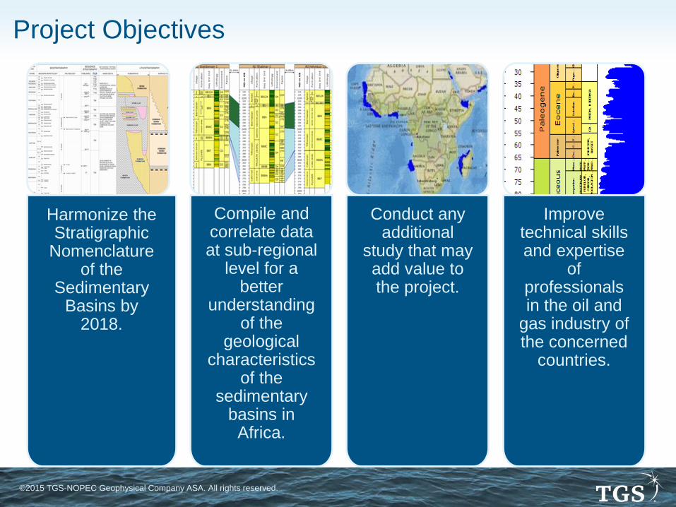
Harmonize the Stratigraphic
Nomenclature of the
Sedimentary Basins by
2018.
Compile and correlate data at sub-regional
level for a better
understanding of the
geological characteristics
of the sedimentary
basins in Africa.
Conduct any additional
study that may add value to the project.
Improve technical skills and expertise
of professionals in the oil and
gas industry of the concerned
countries.
Project Objectives

©2015 TGS-NOPEC Geophysical Company ASA. All rights reserved.
The
Intracratonic
Zone
The Gulf of
Guinea Zone
The West Africa
Zone
Basins and Zones Niger
Chad
Gabon
Congo
DR Congo
Angola
Nigeria
Cameroon
Nigeria
Eq Guinea
Cameroon
Gabon
Congo
DR Congo
Angola
W Nigeria
Togo
Benin
Ghana
Cote d’Ivoire
©2015 TGS-NOPEC Geophysical Company ASA. All rights reserved.
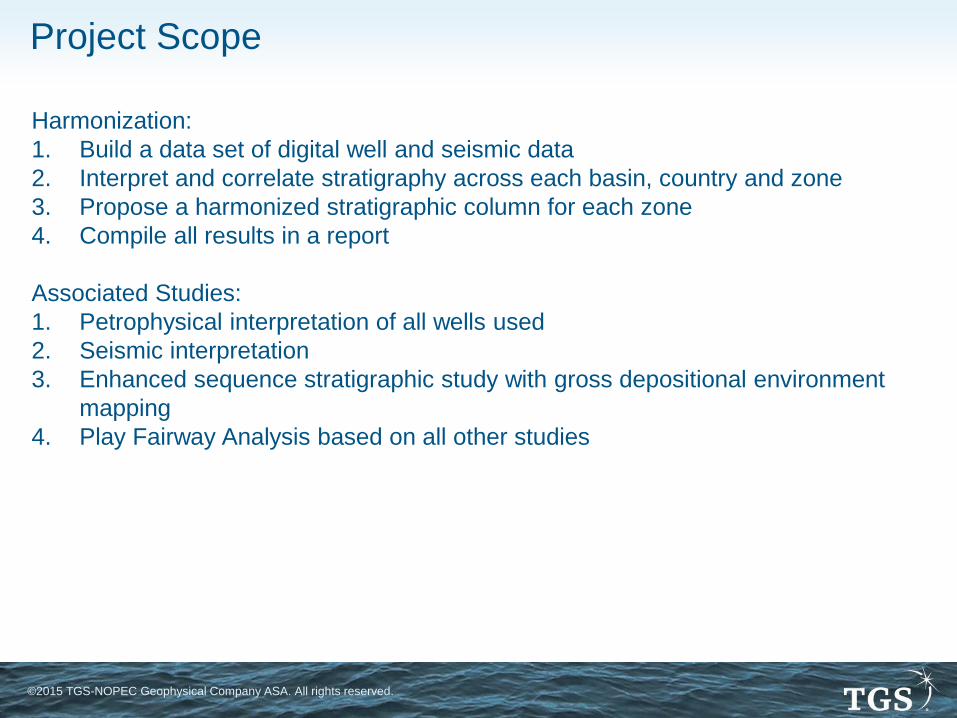
Project Scope
Harmonization:
1. Build a data set of digital well and seismic data
2. Interpret and correlate stratigraphy across each basin, country and zone
3. Propose a harmonized stratigraphic column for each zone
4. Compile all results in a report
Associated Studies:
1. Petrophysical interpretation of all wells used
2. Seismic interpretation
3. Enhanced sequence stratigraphic study with gross depositional environment
mapping
4. Play Fairway Analysis based on all other studies

©2015 TGS-NOPEC Geophysical Company ASA. All rights reserved.
15 stage process to complete the work:
1. Literature Search
2. Data audit
3. Scanning and digitizing
4. High quality well log creation
5. Preliminary paper interpretation
6. Core descriptions
7. Lithology interpretation
8. Biostratigraphy analysis
9. Interpretation of tops
10. Synthetic seismograms
11. Interpretation of seismic data
12. Build basic litho-, chrono- and sequence
stratigraphic scheme per country
13. Correlation between basins per country
14. Correlation between countries
15. Build final scheme and reporting
for each Country
Harmonization Project Processes
for each Zone

©2015 TGS-NOPEC Geophysical Company ASA. All rights reserved.
Project Deliverables
All data used in the project will be supplied as a deliverable – subject to
agreements with each of the countries involved.
All of the interpreted data will be delivered including:
• High quality logs
• Interpreted tops (Chrono, Litho and Sequence)
• Correlations
• Cross sections
• Synthetic Seismograms
• Seismic correlations
• Stratigraphic columns for each (sub) basin
All deliverables will be referenced to the final harmonized stratigraphic columns.
All well data deliverables and stratigraphic columns will be delivered through TGS’
Facies Map Browser.
The final version of the report will also be issued to all clients.

©2015 TGS-NOPEC Geophysical Company ASA. All rights reserved.
Facies Map Browser (FMB)
The FMB is a visualization interface for reviewing depositional systems models
derived from a comprehensive, interpreted well database, tied to reference seismic..
The FMB provides all of the well data, well interpretation and GDE maps over the
entire basin in a unique visualization environment.
The FMB is a known and trusted application, developed by TGS, to deliver the
results of sequence stratigraphic studies and play fairway analyses.

©2015 TGS-NOPEC Geophysical Company ASA. All rights reserved.
Petrophysical Analysis
Petrophysical Analysis of all wells included in the harmonization study, assuming
that sufficient data exists to permit this analysis.
Deliverables:
• Environmentally corrected log data
• Individual CPI’s
• Shale / clay volume
• Variable grain density
• Porosity Ø (total and effective)
• Permeability k where cored
• Connate water resistivity Rw
• Water Saturation Sw
• LAS files
• Documentation of Methodology adopted. Reference will be made to individual
wells where appropriate, for example, where there have been data problems, or
where an alternative interpretation methodology has been required.
©2015 TGS-NOPEC Geophysical Company ASA. All rights reserved.
Seismic Interpretation
Scope
1. The project will review all seismic data available but only a selection will be
interpreted, covering the available area / country
2. 10 time horizons will be interpreted as standard
3. Fault picking
4. Depth conversion – depending on velocity data
5. Gravity and Magnetic modelling, subject to available data, for interpreting
basement and definition of main structural elements
Deliverables
1. Seismic Database of all available data in SEGY
2. Nav available as GIS project
3. Seismic Interpretation along each line used (horizons). ASCII format
4. Maps in time and depth (GIS)
5. Fault polygons/patterns (GIS)
6. Documentation/ report (Word/pdf) Incl well tie panels

©2015 TGS-NOPEC Geophysical Company ASA. All rights reserved.
• Logs
• Tops
• Environment and facies
• Burial history
• Paleobathymetry
• TD tables/synths
• GDE maps --- all 3rd order sequences subject
to sufficient areal and well control
Enhanced Sequence Stratigraphic Study
Scope
1. Uses additional wells from the harmonization study
2. Interpretation of depositional environments and facies in each well
3. Gross Depositional Environment mapping
Deliverables
All data is delivered in the Facies Map Browser, including, where available:
• Biostrat
• Core/casing intervals
• Shows
• Lithologies
• Geochem if available
• Documentation/ reporting (Word/pdf)

©2015 TGS-NOPEC Geophysical Company ASA. All rights reserved.
Play Fairway Analysis
Scope
1. Leads catalogue
2. Thermal modelling
3. Seismic Facies analysis utilizing modified Macurda nomenclature (seismic facies
type with amplitude and continuity qualifiers)
4. All horizons that could be source, seal or reservoir
5. Common risk segment mapping
6. Revision to FMB GDE maps if required
Deliverables
All maps are delivered via an updated FMB
1. Seismic Facies Maps
2. Reservoir Distribution Risk Maps
3. Top Seal Distribution Risk Maps
4. Reservoir Temperature Risk Maps
5. Common Risk Segment Maps
©2015 TGS-NOPEC Geophysical Company ASA. All rights reserved.
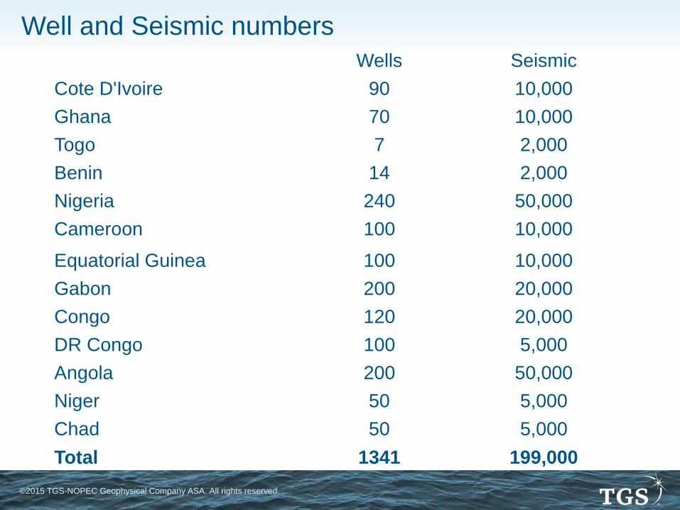
Well and Seismic numbers
Wells Seismic
Cote D'Ivoire 90 10,000
Ghana 70 10,000
Togo 7 2,000
Benin 14 2,000
Nigeria 240 50,000
Cameroon 100 10,000
Equatorial Guinea 100 10,000
Gabon 200 20,000
Congo 120 20,000
DR Congo 100 5,000
Angola 200 50,000
Niger 50 5,000
Chad 50 5,000
Total 1341 199,000

©2015 TGS-NOPEC Geophysical Company ASA. All rights reserved.
Project Time Frame
Project is anticipated to be formally approved by the APPA Council of Ministers in
April 2015.
TGS anticipates that work will start by July 2015, subject to sufficient pre-funding.
The Harmonization stage will be complete for all zones within three years.
The remaining projects will be delivered over a further three years.
©2015 TGS-NOPEC Geophysical Company ASA. All rights reserved.
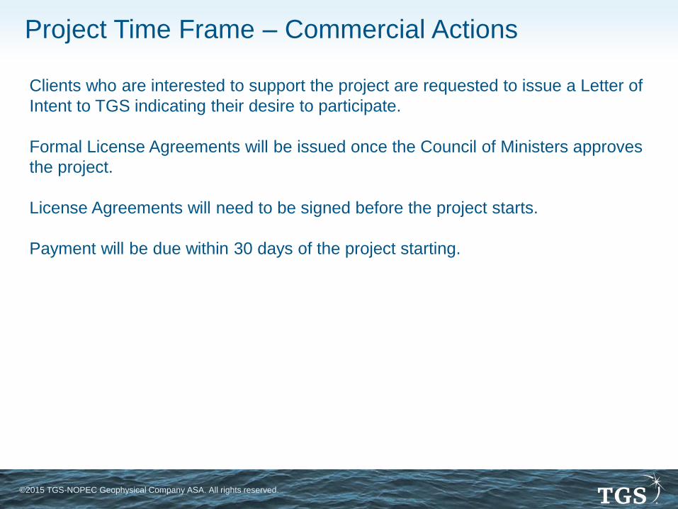
Project Time Frame – Commercial Actions
Clients who are interested to support the project are requested to issue a Letter of
Intent to TGS indicating their desire to participate.
Formal License Agreements will be issued once the Council of Ministers approves
the project.
License Agreements will need to be signed before the project starts.
Payment will be due within 30 days of the project starting.
©2015 TGS-NOPEC Geophysical Company ASA. All rights reserved.
TGS will adopt a multi-client approach to funding this project
Work on all deliverables will commence once pre-funding target is reached for a
zone
Project sponsors will enjoy a lower preferential early participant price
Licensing will require an initial payment followed by annual subscriptions until
project work is completed
Initial payment increases year on year and includes all missed subscription
payments
Minimum commitment is three years
Individual country products will only be available once the whole project is
complete
Project Commercial Proposal

©2015 TGS-NOPEC Geophysical Company ASA. All rights reserved.
Client Benefits
The project will save exploration companies time and money through the following
features:
1. Rapid access to a regional dataset and interpretation for future decision making
2. It provides a homogeneous framework for play modelling and exploration work
3. It consolidates understanding of regional geology and therefore fast tracks
understanding of basin development and shortens exploration cycle time
4. Provides a standardized nomenclature to improve the effectiveness of cross-
border data exchanges and new ventures analysis
5. Allows in-house technical resources to concentrate on high value prospect
definition work
6. Means to technically evaluate new opportunities throughout the region
7. It integrates of all data in a single environment to improve productivity
8. Provides a consistent framework for tracking and coordinating exploration efforts
thereby reducing exploration risk

©2015 TGS-NOPEC Geophysical Company ASA. All rights reserved.
Early Participation Benefits
Initial sponsors benefit from their involvement by:
1. Helping to guide the final selection of data used in the project
2. Annual participation in reviews of project progress
3. Involvement of staff members in the technical work
4. Access to the product sooner than their competitors
5. Lower cost of the finished product

©2015 TGS-NOPEC Geophysical Company ASA. All rights reserved.
Involvement in technical work
TGS would like to invite one person from each sponsor to spend a month
working in our London office during the harmonization project.
TGS will:
• Provide the necessary logistical help for visitors
• Provide the necessary office space and facilities
• Provide the necessary training and support
Client will:
• Pay all salary and expenses involved
Client benefits:
• Further involvement and direction to the project
• Understanding of TGS methodologies
• Early view of the results

©2015 TGS-NOPEC Geophysical Company ASA. All rights reserved.
Invitation
TGS proposes to hold a workshop in our London offices in Q2 2015 to present
more technical and project details of the project to interested parties.
We would be delighted if you could join us.
To register your interest or to ask any questions, please contact
Thank you
©2015 TGS-NOPEC Geophysical Company ASA. All rights reserved.
Tim Gibbons
+44 7766 024602