STRATEGIC REGIONAL RESEARCH - CBC
71
January, 2013 STRATEGIC REGIONAL RESEARCH A Region in Transition Photo by Guilhem Vellut
Transcript of STRATEGIC REGIONAL RESEARCH - CBC

January, 2013
STRATEGIC REGIONAL RESEARCH A Region in Transition
Photo by Guilhem Vellut

Authors and Researchers: Iain Dobson, Real Estate Search Corporation,
Glenn Miller, FCIP, RPP, Vice President, Canadian Urban Institute
Katherine Morton, MCIP, RPP, Senior Planner, Canadian Urban Institute
Yousaf Shah, Planning Assistant and Researcher, Canadian Urban Institute
Charissa Jattan, Planning Assistant and Researcher, Education and Research
Kailey Lamont, Planning Assistant and Researcher, Education and Research
Acknowledgements: This project was realized with the support of many stakeholders from across the Greater Toronto Area.
More specifically, the project team would like to acknowledge the contributions, advice and support we
received from the following individuals:
Andrew Browning, Cushman & Wakefield
Adam Brueckner, Oxford Properties Group
Andrea Calla, Tridel Group
Jeff Croxall, Sun Life Financial
Fred Eisenberger, Canadian Urban Institute
John Genest, Malone Given Parsons
Philip Gillin, Sun Life Financial
Dina Graser, Metrolinx
Tony Hernandez, Ryerson University
Yi Luo, Metrolinx
Randy Maclean, City of Toronto
Thomas McCormack, Strategic Projections Inc
Eric Miller, University of Toronto
Ross Moore, CBRE
David Morley, Scotia Bank
Bob Onyschuk, Onyschuk Strategic Advisors
Jeff Orlans, Brookfield
Lisa Salsberg, Metrolinx
Jake Schabas, Metrolinx
Elaine Shin, Ontario Growth Secretariat
Craig Smith, Ashlar Urban Real-Estate
Michael Sutherland, Metrolinx
Becky Upfold, Metrolinx
Keith Reading, Morguard
Susan Reisler, Media Profile
Michael Roschlau, Canadian Urban Transit
Association
Andrew Theoharis, Ontario Growth Secretariat
Ian Thompson, CBRE
Susie Wang, Oxford Property Group
Michael Williams, City of Toronto
Raymond Wong, CBRE

STRATEGIC REGIONAL RESEARCH – A Region in Transition
Page 3
15/01/2013
Executive Summary A Region in Transition
This study tackles the problem of connecting the way people live and work to a new way of planning the
Region. In the next 30 years, the GTA is expected to create one million additional jobs, most of which will
be housed in buildings that have not yet been built. The quality of life for those one million workers will
be dramatically impacted by where those buildings are built and the transit and road improvement
decisions we make now. Getting it right is the focus of the the solutions presented in this ground breaking
work.
The unparalleled pace of growth in the Greater Toronto Area (GTA) has vaulted the Region to a place of
prominence in North America. The GTA is a region in transition from a post-WW2 industrial hub to a
21st century regional economy. The Region has become the third largest industrial complex in North
America and the fifth largest office market in a remarkably short time. The GTA’s population is growing
by one million people every ten years. As of September 2012, there were more than 150 condominium
towers under construction, which is more projects than in the five largest cities in the U.S. combined.
But in global terms, Toronto is a relative newcomer to the world stage. London, Paris, New York and
Chicago already had populations exceeding one million at the turn of the last century while the Toronto
region only reached that size around 1940 but now exceeds six million. New York and Chicago already
had mature industrial economies in the 19th century when Toronto was little more than a trading post.
New York and Chicago famously led the way in the innovation of purpose-built, high rise office towers -
a phenomenon that did not arrive in Toronto until the late 1960s when the financial services sector
experienced extraordinary growth. The Region’s vibrant multi-cultural, ethnically diverse community is a
significant part of that growth.
The Region’s reputation as an investment-friendly place that can attract and retain talented entrepreneurs
and knowledge workers supports the idea that the Region will continue to grow at a strong pace for the
foreseeable future. Equally important, however, is providing the right kind of places for people to work.
Much attention in recent years has deservedly been paid to public policy related to regional growth
strategies, and in particular to policies related to residential growth; this paper argues that for the sake of
the Region’s long-term competitiveness there is also an urgent need to fill gaps in public policy affecting
the growth and location of office jobs.
This study is the first in a series of reports focused on strategic regional research,1 prepared with the
backing of public and private sector entities as well as individual experts in related areas of policy.
1 Strategic Regional Research or SRR has been established to conduct high quality, independent research on the
competitiveness of the Greater Toronto Area. A diverse range of public and private sector organizations contribute
to SRR, to ensure this collaboration can help shed some light on the important challenges the Region faces in
planning for growth.

STRATEGIC REGIONAL RESEARCH – A Region in Transition
Page 4
15/01/2013
The report addresses three critical issues:
Provincial policy promotes a comprehensive vision for intensification and connectivity, but there
is a disconnect between regional and municipal policies affecting the location and distribution of
employment.
Approximately 100M sq ft of office space – accounting for about half a million jobs – is not
connected to the Region’s network of higher order transit, and current plans do not propose how
to address this problem.
Another half million jobs in office employment are expected over the next 30 years, but there is
no coherent strategy for where and how the 100M sq ft of office space needed to house these jobs
will be located.
At present, there are two starkly different choices for the Region’s workforce with dramatically
different expectations for the quality of working life: One is for jobs located in mixed use, pedestrian
friendly, well connected areas like downtown Toronto and in locations adjacent to the subway; the other
is for jobs located in isolated, low amenity office clusters beyond the reach of higher order public transit.
At present, the success of suburban areas is predicated on lower costs, abundant land and short approval
times. The urban areas, in the downtown and areas adjacent to the subway, offer high quality transit
service, access to a variety of amenities, and an attractive pedestrian environment but suffer from a
shortage of sites targeted for office jobs and a complex approvals process that makes it difficult for
buildings to be planned and constructed in a timely manner.
In the interests of building a Region able to offer a full range of options to investors and employers, ways
must be found to bring the best attributes of both areas to the other. Timing is critical. As a new
generation of workers moves into the labour force, meeting expectations for continued growth in the
Region will depend heavily on sustaining the lifestyle and quality of place available in the urban core but
also improving the investment potential and quality of working life in office sub-markets throughout the
GTA. This will require the creation of attractive office space in a timely and competitive manner, as well
as providing employees with the option of working and living near to where daily amenities,
entertainment and culture are all available in close proximity to each other.
The demands of the New Economy are challenging cities to be increasingly flexible in how they
handle new investment in creating places to work: The New Economy is being driven by what
Professor John Polanyi calls the “accelerating society,” where decisions are occurring in ever shortening
cycles, businesses are formed overnight and grow exponentially. The demand for appealing new work
spaces is creating problems for cities and those responsible for city building. This is because businesses
want “a choice of locations that are cost effective, accessible and appropriate for the particular type of
business,”2 creating the kind of attractive mixed use environments with intensification and transit options
2 Canadian Urban Institute, 2011, ‘The New Geography of Office Location and the Consequences of Business as
Usual,’ Toronto

STRATEGIC REGIONAL RESEARCH – A Region in Transition
Page 5
15/01/2013
takes time. This is a dilemma felt keenly in the suburban areas but one that also applies in some urban
areas. The process of modern city building is not as simple as when earlier policy makers carved out
single-purpose employment or residential districts. Creating desirable mixed use environments is taking
longer to develop yet the new economy is moving at a faster and faster pace. The core of Toronto is a
highly successful example of a diverse, connected, mixed use environment, yet most growth in the Region
is not occurring there. A key challenge facing the Region is to enable areas with different attributes to
develop as desirable locations into the future.
The current policy affecting the creation and location of jobs is built on an industrial framework
that is hampering the Region’s ability to respond to employer needs: The physical structure of the
GTA was established when the focus of the economy was still on manufacturing. The transition from a
manufacturing base to a service-based economy took place very rapidly at a time of extraordinary growth.
Although downtown Toronto and areas adjacent to the subway evolved to accommodate a philosophy that
promoted mixed use development, policies originally established to protect industry were extended to
today’s ubiquitous employment lands in the surrounding suburban areas. As a result, although the GTA
can claim to have approximately 100M sq ft of office space that benefits from a mixed use environment,
virtually all office development in suburban areas over the past 30 years has been in uni-functional office
parks outside Toronto, designed and built to accommodate manufacturing. Taken together with an earlier
generation of building in similar areas within the City, this accounts for approximately 100M sq ft of
office space that is lacking in amenities and access to higher order transit. Growing congestion in office
locations in these areas – where access is dependent on highways already close to capacity - and minimal
new investment in employment areas without higher order transit in Toronto are conditions that need
solutions. Continued growth in areas with such severe congestion can no longer be guaranteed.
Planning policy, taxation policies, land use development practices and transit implementation are
driving location decisions that are not consistent with agglomeration economics: Governments at all
levels struggle to finance re-investment in infrastructure and cannot afford to invest in strategies which do
not achieve the desired outcomes. Policies implemented in isolation of the needs of employers such as
designating growth areas where employers won’t go, building transit into undeveloped areas and taxing
behaviour rather than rewarding investment are high risk. The challenge is to develop policies that
integrate places of employment into an intensified urban landscape; promote investment in Higher Order
Transit capable of connecting people to jobs over greater distances, while at the same time minimizing
their need to travel; and incent growth in areas where employers and their employees want to be.
Economic development, land use planning and transit implementation can no longer be developed in
isolation. The experience from other jurisdictions suggests that such policies can be created and
implemented collaboratively in ways that both support public policy goals and which meet the needs of
the private sector.
The evidence in our Region indicates that the GTA is in transition and our public policies need to reflect
these changes to permit the Region to meet its full potential. To that end, this paper offers concrete
examples of effective policy implementation as well as analysis of three areas in the GTA where land use
policy, economic development and infrastructure improvements would benefit from better integration.
Cities that can adapt and respond to this new dynamic will be the winners.

STRATEGIC REGIONAL RESEARCH – A Region in Transition
Page 6
15/01/2013
Table of Contents
EXECUTIVE SUMMARY 3
A Region in Transition 3
INTRODUCTION 7
Toronto’s New Status on the World Stage 7
THE GTA IS MOVING FROM FACTORIES TO OFFICES 12
Era I: Post War Era 1946-1965 - Building on the Industrial Base 12
Era II: The Financial Services Define a New Era - 1965-1992 15
Era III: Dealing with Over Supply - 1993-1998 18
Era IV: The New Age of the Tenant – 1999… 19
Location of Current Job Growth 24
GROWTH IN THE GTA IS CREATING TWO DISTINCT WORKING ENVIRONMENTS 32
Downtown Toronto: A Mixed-Use Transit Friendly Urban Success Story 32
Business Parks: Extraordinary Growth but Lack of Urban Amenities and Higher Order Transit 35
Agglomeration Economics 38
Accommodating Growth in the Age of Acceleration 39
THE GTA URGENTLY NEEDS AN INTEGRATED PLAN TO SHAPE THE FUTURE 40
The GTA is Expecting Sustained Growth 40
Business as Usual: Without Action, Keeping Pace with Growth is a Challenge 42
Understanding Who Creates Buildings and Why 44
Understanding Development Conditions across the Region 46
Financing Transit – Reducing Public Risk 48
COORDINATING POLICY, INFRASTRUCTURE AND INVESTMENT ON THE GROUND 52
Three Case Studies from the GTA 52
Airport Corporate Centre 53
Liberty Village 57
Downsview Park & Vicinity 60
CONNECTING HOME AND WORK: APPROACHES FROM OTHER MAJOR CITIES 64
The London Crossrail, U.K 64
Tysons Corner, Virginia, U.S.A 67
BIBLIOGRAPHY 69

STRATEGIC REGIONAL RESEARCH – A Region in Transition
Page 7
15/01/2013
Introduction Toronto’s New Status on the World Stage The exceptional growth of the Greater Toronto Area has taken place in a landscape originally planned in
the postwar era to accommodate manufacturing. In the past four decades, although the Region has
sustained that industrial growth it has at the same time been transformed by the rapid expansion of the
service sector, IT, bio medical research and, more recently, emergence of the cultural industries. From a
“standing start” at the beginning of the last century, the Toronto region has grown to become the third
largest industrial complex in North America (behind Los Angeles and Chicago), and the fifth largest
office market on the continent (behind New York, Chicago, Washington, Dallas-Fort Worth). The GTA is
also building an unprecedented number of high rise residential developments, with 150 projects under
construction3 – more than the five largest cities in the U.S. combined. In North America, only Manhattan
has more tall buildings than Toronto.4
But in global terms, Toronto is a relative newcomer to the world stage. London and Paris, together with
New York and Chicago, already had populations exceeding one million at the turn of the last century
while the Toronto region only reached that size in the 1940s. New York and Chicago had mature
industrial economies in the mid-19th century and famously led the way in the innovation of purpose-built,
high rise office towers, as those cities spurred the need to build higher to maximize the utility of available
building sites.5
The Region’s population has grown exponentially since the mid-1950s, and the strong pre-war industrial
base was expanded rapidly during the early years of the auto-pact and later by free trade. By any measure,
the Region has reached its present state of maturity in an extraordinarily short time frame.
The Toronto region is now in many respects as important to Canada as London is to the UK in terms of its
contribution to GDP and importance as an economic force. It has an industrial base that is comparable to
Chicago and Toronto’s financial core is now one of the world’s most important financial markets.
Toronto is also emerging as an innovative and important cultural centre, which is fueling economic
growth as well as contributing to the Region’s quality of life.
Jobs – mostly office jobs – are being created in the Region at a higher rate than anywhere else in North
America. The reasons for this phenomenal growth are complex and beyond the scope of this research,
however, the graph below illustrates these high levels of growth.
3 EMPORIS, 2012, ‘Toronto, North America's new high-rise metropolis,’, Oct. 24 2012 accessed at:
http://www.emporis.com/press/press-releases/toronto-north-americas-new-high-rise-metropolis 4 City of Toronto, 2011, ‘Tall Buildings, Inviting Change in Downtown Toronto’ accessed at:
http://www.toronto.ca/planning/tallbuildingstudy.htm#projectsummary 5 Bascomb, N., 2003, ‘Higher: a Historic Race to the Sky and the Making of a City,’ Doubleday

STRATEGIC REGIONAL RESEARCH – A Region in Transition
Page 8
15/01/2013
Growth in Office Space in the GTA 1900 - onward
Since the 1950s, the number of people working in office buildings in the GTA has grown exponentially. In
1965, the Region’s office space inventory was 22 million square feet: today it is over 200 million square
feet, representing approximately 1 million jobs.6
1950 1965 1975 1986 2012
10 M sq ft 22M sq ft 50M sq ft 105M sq ft 204M sq ft
Public policy, until recently, stimulated urban sprawl. Ontario’s policy-led planning system has at times
led and shaped growth but not always in line with market forces. Over a period of many decades and
economic cycles, the direction of public policy and the impetus of market forces have rarely been in
complete synch. Bold steps taken by the provincial government in recent years to limit sprawl,7 channel
growth to mixed use centres,8 and invest in rapid transit to the tune of $10 billion over the next five years
9
– without support from the federal government or partnerships with the private sector - are undoubtedly
beginning to have an impact, as evidenced by the emphasis on multi-residential housing starts in the
GTA. But at this critical time in the Region’s development, it is fair to ask whether public policy is
keeping pace with today’s fast changing economy, particularly with respect to employment.
At present, there is little guidance for practitioners between the high level Provincial Policy Statement
requirement for Ontario’s municipalities to identify and protect employment areas10
and obligations set
out in the Growth Plan for municipalities to achieve certain targets for jobs and population. The evidence
6 Estimated that 200M sq. ft accounts for 1 million jobs, based on an average of 200sq. ft per employee.
7 Government of Ontario, 2005, ‘Greenbelt Plan,’ accessed at: http://www.mah.gov.on.ca/Page189.aspx#greenbelt
8 Government of Ontario, 2006, ‘Places to Grow - The Growth Plan for the Greater Golden Horseshoe,’ accessed at:
https://www.placestogrow.ca/index.php?option=com_content&task=view&id=9&Itemid=14 9 Metrolinx, 2008, ‘The Big Move – Transforming Transportation in the Greater Toronto and Hamilton Area,’
accessed at: http://www.metrolinx.com/thebigmove/Docs/big_move/TheBigMove_020109.pdf. 10
Government of Ontario, 2005, ‘Provincial Policy Statement,’ accessed at:
http://www.mah.gov.on.ca/Page1485.aspx

STRATEGIC REGIONAL RESEARCH – A Region in Transition
Page 9
15/01/2013
compiled for this paper suggests that there is a need for spatially focused, economic development policy
that addresses the needs of employment in office buildings and more specifically where these buildings
are located and ought to be located in the future to maximize public investment.
New economy jobs are largely located in office buildings, re-purposed industrial buildings and a variety
of other types of live-work structures adopted by the creative industries. Today 55% of everyone
employed in the City of Toronto works in an office building. The problem is that the GTA’s distribution
of employment lands has remained almost unchanged since the post-war era despite the global shift from
manufacturing service based economies. A combination of tax issues and a broad range of public policies
affecting the cost of doing business in the Region helped spur decentralization of office space to suburban
locations. As the Region expanded, two non-complementary office environments have been created –
office buildings (mostly in the Toronto core) that offer amenities, good public transit and an attractive
quality of working life, and amenity-poor office environments located beyond the reach of public transit,
that consign a many employees to long commutes by car.
Within the context of the province’s “policy led system,” there are two critical provincial policies that
affect employment in the GTA. The first is a strongly worded provincial policy that requires municipal
authorities to first designate, and then take steps to preserve employment lands. The second is the
provincial Growth Plan that directs “major office” to a number of Urban Growth Centres identified in the
plan. The municipality is then responsible for implementing these policies on the ground.
The Provincial Policy Statement (PPS) sets out policies that reflect the “provincial interest” with respect
to land use planning and development, and requires that municipalities (referred to in the PPS as
“planning authorities”) provide for “an appropriate mix and range of employment (including industrial,
commercial and institutional uses).”
The protection of land to support employment functions is important. However, at this macro level it can
have the unintended consequence that it reinforces the concept of uni-functional office parks as
municipalities set aside large swaths of land for employment purposes. At the same time, the PPS does
not work to protect Ontario’s most valuable employment area, the Toronto financial core, which is not
classified as employment land and therefore not subject to protection.
The Growth Plan is the other relevant provincial planning document that applies to employment issues in
the Greater Toronto Area. The Growth Plan sets out a vision for ensuring the economic competitiveness
of the Region, to be carried out through a variety of mechanisms.
A key strategy of the Growth Plan is a commitment to create and/or intensify a number of Urban Growth
Centres, for which density targets have been set that specify the desired minimum density of residents and
jobs per hectare. The Urban Growth Centres form the basis of the province’s infrastructure strategy,
which, in the context of the Greater Toronto Area and Hamilton, position the UGCs as “mobility hubs” to
be linked through strategic investment in higher order transit. The Growth Plan directs that major office
uses should be located in Urban Growth Centres and other locations with “existing and planned higher
order transit service.”
STRATEGIC REGIONAL RESEARCH – A Region in Transition
Page 10
15/01/2013
However, the reality is that relatively few major office developments are drawn to Urban Growth Centres.
Within the City of Toronto, the Urban Growth Centres in Scarborough, Etobicoke and North York have
not seen significant growth in office jobs in 25 years. In the 905, current trends indicate that of 65 million
square feet of office space built in the past 30 years, less than five million square feet is located in
designated centres. Mississauga City Centre has not added new office buildings in 20 years. Because the
vast majority of office jobs continue to be attracted to locations other than designated centres, this tends to
undermine the goal of creating high intensity, mixed use centres of housing and employment.
Having identified where employment should be located, municipalities are also required through the PPS
to protect and preserve employment areas “for current and future uses,” taking into account “the needs of
existing and future businesses.” This provision in the PPS – together with a requirement that
comprehensive studies be undertaken before conversion is permitted - was added in 2005 to support
municipalities seeking to preserve employment lands in the face of economic pressures from competing
land uses (such as residential or retail uses). This policy thus allows municipalities to maintain a balanced
tax base while acknowledging the critical role of employment – access to jobs – as a key element of
economic competitiveness. This preservation of employment lands philosophy is also strongly enshrined
in the Growth Plan for the Greater Golden Horseshoe, which came into force in 2006.
Municipal powers essentially determine the locations of job growth. However, they are limited in their
ability to provide an appropriate environment for job creation. A key reason for this could be that
presently there are no interim mechanisms to help practitioners navigate the gap between high level
policy addressing and reserving sufficient land for jobs and the explicit directions in the Growth Plan that
link jobs to place.
Moreover, municipalities can only fund the most basic infrastructure. Highways (such as the 400 series
highways) are built and maintained by the province (Highway 407 and the Gardiner Expressway are the
exception) and funding from the province is required for construction of higher order transit such as
subways, LRT or high speed regional trains such as those operated by GO Transit.
Overall, while these provincial and municipal policies support many important principles by conserving
employment land, promoting connectivity and growth in established areas, the evidence suggests that
office jobs in the 905 are being created almost exclusively in uni-functional office parks. Creating great
places and a strong, vibrant office market requires not only a shift in public policy but a collaborative
effort to establish the right economic conditions.
Following a long tradition of separating land uses as a means of protecting the functional and economic
viability of industrial sites, land use policies require that “employment lands” continue to be laid out with
extensive set-backs, landscaping and vehicular circulation patterns suitable for prestige industrial
properties, even though the focus of many areas designated as employment lands is to accommodate
freestanding office buildings. This tradition began in locations like Consumers Road in the former North
York but was subsequently perpetuated in industrial and business/office parks in the 905.
In reality, not only do office uses not need to be physically separated from other uses in order to function
effectively, they actually suffer from the kind of protection offered by a uni-functional industrial/office

STRATEGIC REGIONAL RESEARCH – A Region in Transition
Page 11
15/01/2013
park. Despite the fact that an office building in Meadowvale or Airport Corporate Centre might share
many of the same attributes (such as employee density) as an office building in a mixed use zone in
downtown Toronto, as a result of protective land use policy, employees in locations such as Airport
Corporate Centre are denied easy access to amenities such as restaurants and shopping. This is because
distances between buildings (as a result of needing to accommodate large areas of surface parking) create
a hostile environment for walking. The combination of low gross employee densities and a functional
layout designed for car access in turn frustrates the ability of local authorities to serve employment lands
effectively with public transit.
Well-meaning but dated policies have channelled large amounts of GTA office growth and tens of
thousands of jobs into former industrial parks in the 905 with few amenities, limited transit connectivity
and increasing levels of congestion. This also applies to former industrial parks inside the boundaries of
Toronto. In the past 30 years, more than 60 million sq ft of office space has been created in uni-functional
office clusters, often developed side by side with industrial properties that generate car and truck traffic of
their own – another contributing factor to the issue of congestion on the Region’s principal arterial roads
and highways.
The Region’s industrial parks and highway infrastructure were conceived long before the current pattern
of office development began to evolve. The likelihood is that the factors which made these industrial
areas so attractive in the first place – inexpensive, easily developable land with room for expansion; good
highway access and visibility; proximity to an experienced labour force – start to lose their luster in face
of crippling congestion, ever longer commutes and shrinking availability of suitable sites.
Snap shots from the Region’s progressive and complimentary suite of provincial planning policies.
Images courtesy of Places to Grow - Growth Plan for the Greater Golden Horseshoe, The Big Move and from the The Green Belt Plan
STRATEGIC REGIONAL RESEARCH – A Region in Transition
Page 12
15/01/2013
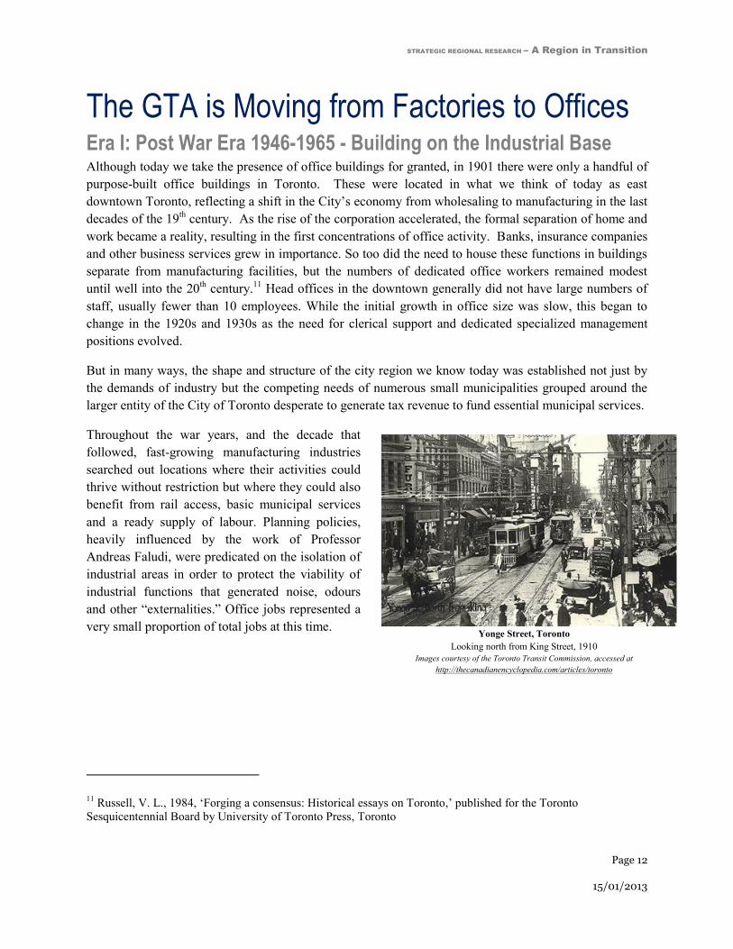
Yonge Street, Toronto
Looking north from King Street, 1910
Images courtesy of the Toronto Transit Commission, accessed at
http://thecanadianencyclopedia.com/articles/toronto
The GTA is Moving from Factories to Offices Era I: Post War Era 1946-1965 - Building on the Industrial Base Although today we take the presence of office buildings for granted, in 1901 there were only a handful of
purpose-built office buildings in Toronto. These were located in what we think of today as east
downtown Toronto, reflecting a shift in the City’s economy from wholesaling to manufacturing in the last
decades of the 19th century. As the rise of the corporation accelerated, the formal separation of home and
work became a reality, resulting in the first concentrations of office activity. Banks, insurance companies
and other business services grew in importance. So too did the need to house these functions in buildings
separate from manufacturing facilities, but the numbers of dedicated office workers remained modest
until well into the 20th century.
11 Head offices in the downtown generally did not have large numbers of
staff, usually fewer than 10 employees. While the initial growth in office size was slow, this began to
change in the 1920s and 1930s as the need for clerical support and dedicated specialized management
positions evolved.
But in many ways, the shape and structure of the city region we know today was established not just by
the demands of industry but the competing needs of numerous small municipalities grouped around the
larger entity of the City of Toronto desperate to generate tax revenue to fund essential municipal services.
Throughout the war years, and the decade that
followed, fast-growing manufacturing industries
searched out locations where their activities could
thrive without restriction but where they could also
benefit from rail access, basic municipal services
and a ready supply of labour. Planning policies,
heavily influenced by the work of Professor
Andreas Faludi, were predicated on the isolation of
industrial areas in order to protect the viability of
industrial functions that generated noise, odours
and other “externalities.” Office jobs represented a
very small proportion of total jobs at this time.
11 Russell, V. L., 1984, ‘Forging a consensus: Historical essays on Toronto,’ published for the Toronto
Sesquicentennial Board by University of Toronto Press, Toronto

STRATEGIC REGIONAL RESEARCH – A Region in Transition
Page 13
15/01/2013
Industrial districts were typically laid out to provide rail access to heavy industry and companies reliant
on the movement of materials and finished goods. These were surrounded by “light industry” located on
the periphery of the districts. These uses offered visibility and direct access from arterial roads but also
provided a buffer between industry and residential neighbourhoods.
The assumption that employment areas should remain isolated from residential was predicated on the
philosophy of mutual protection but also in the practical matter of protecting the viability of the industrial
tax base. The separation of uses thus became enshrined as “good planning practice,” an approach that
prevailed for many years.
While the backdrop for the rapid growth in office work that was to come had essentially been established
by the late 1940s, this era of municipal proliferation and expansion also created the conditions that led to
a radical departure from business as usual in municipal governance. On the recommendation of a Royal
Commission convened to address a crisis in the financing of infrastructure capable of keeping up with
burgeoning industrial demand, the province established the Corporation of the Metropolitan Toronto in
1953. Its then unique model of harnessing the municipal assets of a specific geographic area as the basis
for investment loans to pay for the expansion of hard services like water, sewage and roads was a first in
North America.
The first significant economic shifts affecting office work in Toronto took place in the post-war era of the
1950s through the mid-1960s as Ontario benefited from the growth of mining, telecommunications,
aerospace and automotive industries.12
The head offices of major corporations, as well as office functions
related to branch plant manufacturing began to grow and move toward “King & Bay.” This was also a
period of major public sector investments in infrastructure. When the over-crowding of Yonge Street
with streetcars (peak hour ridership exceeded 17,000 in 1947) bound for “King & Bay” became
intolerable, the TTC responded by planning the first leg of the City’s subway system. The TTC used
surpluses built up during the car-deprived war years to invest in the first subway from Union Station to
Eglinton, which opened in 1954.
Other investments soon followed. The first section of the Don Valley Parkway (from Eglinton to
Lawrence) opened in 1963. The University subway line (from Union to St George) was built to service
the growing number of insurance companies and other major institutions lining University Avenue, and
the Bloor-Danforth subway from Keele to Woodbine opened in 1964 to funnel workers into the
downtown.13
The growing importance of commuting by automobile was also acknowledged, with
construction of Highway 401 – in those early days, seen as a by-pass rather than the central corridor role
it plays today. The early 1960s also saw the beginnings of a high-capacity highway “box” of 400-series
highways in Toronto’s west end that were to provide unparalleled access and visibility to employment
lands around the airport and other industrially zoned lands in Mississauga (Highways 403 and 410).
12 Pecaut, D., 1996, ‘The Fourth Era,’ background report for the GTA Task Force
13 Levy, E., 2012, ‘Rapid Transit in Toronto: a Century of Proposals, Process, Politics, and Paralysis.’ Neptis
Foundation, forthcoming publication

STRATEGIC REGIONAL RESEARCH – A Region in Transition
Page 14
15/01/2013
A plan published by the Metropolitan Planning Board in 1965 serves as a bridge between a past focused
on manufacturing – the many industrial areas depicted on the map illustrate the close relationship between
industrial locations and rail/highway access – and a future where commercial development would need to
expand beyond a single central core to keep pace with a different dependency – on office jobs. The
strategic direction of today’s planning efforts is in fact built on a framework that dates from industrial
development in the 1950s.
Land Use Plan for Metro Toronto - Metropolitan Planning Board in 1965
In 1965, the Metropolitan Planning Board developed a highly influential land use plan for the Toronto region.
This plan was developed to support a growing industrial base, comprised of many manufacturing plants that required large tracts of land to operate, as well as access to heavy rail. These industrial land uses were also
segregated from surrounding residential developments to minimize amenity impacts. Today, land uses in the GTA continue to be influenced by this land use planning framework, despite the changing economy and the
needs of today’s commercial development being markedly different from earlier industrial growth.

STRATEGIC REGIONAL RESEARCH – A Region in Transition
Page 15
15/01/2013
Era II: The Financial Services Define a New Era - 1965-1992 The 1960s was an exciting time in Toronto, which, like the rest of Canada, was caught up in the
anticipation of the nation’s centenary. Although there were many centenary projects to mark the occasion,
few were more symbolic in staking a claim to modernity than the striking Toronto-Dominion Centre
designed by renowned architect, Mies van der Rohe. The first of five buildings (a sixth was added to the
campus later), the Toronto-Dominion Tower, opened to great fanfare in 1967. The project was the
brainchild of Allen Lambert, who was keen to capitalize on the merger of the Bank of Toronto and the
Dominion Bank that he had helped engineer in 1955. Long recognized as the fastest growing Canadian
bank, the opening of the TD Centre helped confirm TD’s place within the ranks of the “big five.”
So began the rapid maturation of Toronto’s skyline: CIBC added Commerce Court in 1972. This was
followed by the second TD tower (Commercial Union, now CP) in 1974, and the first tower of First
Canadian Place in 1975. Two years later the Royal Bank Plaza opened its doors (1977). These smart new
towers represented more than competition for “positioning” for constructing the tallest building among
the banks, however. Taking advantage of Canada’s unique banking rules that permitted developers to
leverage their assets by taking on equity loans from their bankers, this era also saw the emergence of a
new brand of risk-taking developers like the Reichmann brothers (Olympia and York) and the principals
of the firm that was to become Cadillac-Fairview. Companies like these flourished not only in Toronto
but in other major cities, notably London and New York.
By the time the Parti Quebecois was elected in 1976, the skyline of Toronto was already well established,
with the office space inventory in Toronto’s financial core having doubled in a single decade.
Although the City of Toronto enjoyed a period of rapid growth dominated by international investment, as
well as numerous headquarters and regional offices to provide “traded business services” like
communications, insurance, real estate and financial services,14
negative public reaction to the pace of
growth in the City saw the passage of a 45 foot height restriction in Toronto’s downtown. Although this
“holding” initiative was subsequently overturned by the OMB, the City used the breathing space afforded
by the by-law to adopt a bold new Central Area Plan, which introduced the concept of mixed use and
affordable housing to the downtown.
Spatially, although the growth of the banking sector throughout the mid-1970s ensured that downtown
Toronto attracted the “trophy buildings” that created Toronto’s distinctive skyline, entrepreneurial real
estate developers were also beginning to make their mark. Visionary developers like Walter Zwig saw
potential in developing major “spec” office buildings at locations adjacent to the Yonge Street subway,
which had been extended from Eglinton to Finch in 1974. Others took advantage of innovations in
telecommunications by providing affordable real estate locations that could meet the burgeoning needs of
U.S. companies like IBM, Olivetti and NCR. This led to the development of campus-like building clusters
that could serve “back office functions” at sites along Eglinton Avenue, and in locations with highway
14 Pecaut, D., 1996, ‘The Fourth Era,’ background report for the GTA Task Force

STRATEGIC REGIONAL RESEARCH – A Region in Transition
Page 16
15/01/2013
visibility and access along the Don Valley Parkway. The rapid expansion of the office sector in this
period took place largely within the boundaries of Metropolitan Toronto.
Rapid expansion of the office sector during this period provided policy makers with a conundrum. On the
one hand, the thinking of public policy and developers appeared to be in synch because of the popularity
of transit-oriented sites adjacent to the Yonge and University subway lines; on the other hand, the push
from developers to build offices in highway-oriented industrial parks challenged the historic commitment
to protect industrial lands. The short-term fix was to re-name these locations as “office parks,” but
permissions were given grudgingly and only on the understanding that that the areas would remain
dedicated to exclusively to employment uses. With Metropolitan Toronto quickly filling up, the demand
for less costly development sites (access to suburban sites with fewer restrictions, lower land values, the
ability to avoid expensive parking structures and the like) was soon to spread in the municipalities
surrounding Metro.
Parallel to the work of the Metropolitan Toronto Planning Board, the province was working at a supra-
regional scale throughout the 1960s to develop policies intended to shape growth for an area roughly
equivalent to what is today referred to as the Greater Golden Horseshoe. In 1968, the province unveiled a
document entitled, “Choices for a Growing Region,” which brought together regional land use planning
and transportation strategies. But as described in Richard White’s definitive summary of planning in this
period,15
this led to another project released in 1970, entitled “Design for Development: The Toronto-
Centred Region (TCR).” White notes that the TCR was actually a plan for the decentralization of growth,
which blurred the distinction between “planning” and prescriptive government programs to influence the
location of growth. Although neither the TCR nor the plans that followed were implemented, the process
of preparing these top-down plans likely influenced the province’s thinking that led to the creation of
additional two-tier governments on the borders of Metro.
Impressed with the success of Metropolitan Toronto as a governance model, the province established the
Region of York in 1971, followed by three more two-tier regional governments in Halton, Peel and
Durham. Although each of the regional governments proceeded to develop official plans to guide the
development of infrastructure (among other things), this approach came too late to influence growth
patterns and never managed to generate a cohesive vision for the GTA as a whole. The decision to create
new regional governments on the boundaries of Metro Toronto also effectively signed the death knell for
Metro, which now could no longer evolve to respond to changing needs. (Metro had once undertaken
planning for the urbanized area comprising Metro and surrounding areas, and the number of constituent
municipalities was reduced following a governance review in the 1960s.)
The late 1970s through the 1980s resulted in unprecedented levels of growth in the office market
throughout the region as developers stretched their own and municipal resources to meet the diverse
needs of a fast-growing region with an insatiable appetite for different kinds of office space.
15 White, R., 2007, ‘The Growth Plan for the Greater Golden Horseshoe in Historical Perspective,’ Neptis
Foundation, Toronto

STRATEGIC REGIONAL RESEARCH – A Region in Transition
Page 17
15/01/2013
Although the TTC continued to add subway capacity (the University line was extended from St George to
Wilson, the Scarborough RT was constructed, and an additional station opened on the Yonge subway to
serve office workers in buildings adjacent to the North York Centre), capital investments in rapid transit
were confined to within the City of Toronto. The only nod to the needs of suburban residents beyond the
boundaries of Toronto was expansion of GO service (which had been launched on a pilot basis in 1967),
but this too was focused on rush-hour service to downtown Toronto, utilizing track owned by CP and CN.
With the extension of the Don Valley Parkway northwards in 1977, the province simultaneously provided
additional capacity for commuters as well as opening up access to industrially zoned “employment lands”
north of Metro Toronto. Around this time, the municipalities of Scarborough, North York and Etobicoke,
in a bid to increase property tax revenues, raised the mill rate for the industrial property class. The
unanticipated impact of this decision after 1980 was to make industrial sites in Metro more expensive
than their newly accessible competitors in Mississauga, Richmond Hill, Markham and other
municipalities north of Metro. Developers in these municipalities were quick to take advantage of this
price differential. They began to add office buildings in these industrial areas, focusing initially on sites
with greatest visibility, but, with the support of local planning departments, continued the established
practice of providing amenities only on an ancillary basis. This was in part to avoid the risk of “price
contagion” but also consistent with the accepted philosophy of protecting industry from disruptive land
uses.
As the 1980s decade drew to a close, the pace of speculative office development in municipalities outside
of Toronto was still on the rise. This led to talk of development freezes in some suburban municipalities
as the authorities struggled to provide basic infrastructure. Concerned about the growing dependence on
commuting by car, the province and 30 municipalities in the GTA began to work collaboratively on
planning policies aimed at channeling growth into more compact forms of development at densities that
could be serviced by public transit.
But the pace of development proved to be unsustainable. At the high point of development activity there
were no fewer than 30 office buildings being built on a speculative basis. The era of rapid growth and
expansion of the Ontario economy – and the manifestation of that growth through the development and
occupation of unprecedented amounts of commercial office space - was about to come to an abrupt end.
In Era II, significant
expansion of the suburban
office inventory occurred.
These offices spaces were
generally only accessible
by a personal vehicle.

STRATEGIC REGIONAL RESEARCH – A Region in Transition
Page 18
15/01/2013
Era III: Dealing with Over Supply - 1993-1998 The rapid pace of the decline in the province’s economic fortunes also created challenges for
governments. From a national perspective, economic malaise in Greater Toronto affected Canada’s
performance as well because the GTA accounted for about one fifth of the nation’s GDP.
Meric Gertler, writing in 1991, pointed out that although manufacturing no longer generated as much
direct employment in Greater Toronto, manufacturing still made a significant contribution to the regional
economy. He was among the first to point out that “the geography of economic activity is of central
importance.”16
This line of enquiry is represented today by research into the beneficial effects of
agglomeration theory.
At the same time as the newly appointed Sewell Commission was re-evaluating the Planning Act, the
province continued its discussions with municipalities about forming a region-wide response to what
some observers were beginning to term as “employment sprawl.” The result in 1992 was an announced
shared “vision for nodes and corridor” development in the GTA.
Not unlike the current Growth Plan exercise, responsibility for implementing the vision rested with the
regional and local municipal governments. The concept called for the designation of a large number of
compact, mixed use centres linked by transit corridors as a means of slowing the spread of the region and
creating conditions more conducive to serving large amounts of new development with public transit.17
Unlike the Growth Plan process, however, the nodes and corridors agreement did little to engage the
public so few noticed when the plans failed to materialize.
The unforeseen problem with successful implementation was twofold: first, expectations for the need to
accommodate job growth (and therefore the scale of office development available to be channelled into
the centres) had been created at a time of unusually rapid growth. The scale of development when it
eventually returned was much less than anticipated, and the number of centres (or nodes) designated in
the region’s official plans greatly exceeded demand. The second problem was that, in part due to the
severity of the 1992 recession, provincial funding for public transit infrastructure improvements did not
materialize, which further reduced the likelihood of success. A third factor was that the market needed
time to absorb the significant amount of excess space that had been constructed on a speculative basis
prior to the recession, mostly in locations outside of Metro with little or no public transit.
When economic growth eventually returned to the Region, the world of planning, development and
government decision-making affecting regional issues had dramatically changed. The severity of the
recession led to many bankruptcies among developers; others were taken over by their creditors.
Surviving development companies relied almost exclusively on pension fund investments, and as a result,
the “build and they will come” philosophy was replaced with a risk-averse approach that requires
significant lease agreements to be in place before funds are advanced for construction. The effect of this
16 Gertler, M., 1991, ‘Toronto: the State of the Regional Economy,’ University of Toronto, Toronto
17 Canadian Urban Institute, 1997, ‘GTA Urban Structure: An Analysis of Progress Towards the Vision,’ Toronto

STRATEGIC REGIONAL RESEARCH – A Region in Transition
Page 19
15/01/2013
dramatic shift in focus was that developers would now have to respond to the demands of major tenants in
terms of where, when and how office buildings could be built. New development in this period was
almost exclusively committed to the “905” – the telephone code introduced in 1993 that overnight
became synonymous with the geography beyond Toronto’s borders.
Concerns about the state of the regional economy were never far from the headlines in the 1990s.
Continued concerns about how to manage the massive size and growing complexity of the GTA led to the
formation of the GTA Task Force, which carried out one of the most thorough, far-reaching evaluations
of the region ever undertaken. Forced to report ahead of schedule in 1996 following the election of a new
provincial government, recommendations for creation of a super-regional government did not proceed.
The report nevertheless highlighted a continuing, deepening concern that the region was not receiving the
necessary level of infrastructure investment, particularly in public transit.
Recognition of the role of public policy affecting planning and development saw the introduction in 1995
of the first Provincial Policy Statement, which among other issues, addressed the importance of
identifying and protecting employment lands. Even following a change in government the same year, the
policy persisted and remains as one of the building blocks for local and regional economic development.
Era IV: The New Age of the Tenant – 1999… Nineteen ninety eight was significant locally for a number of reasons: following on the heels of “Local
Service Re-alignment” (also known as downloading), a provincial initiative that increased the fiscal
burden facing municipal governments in 1997, the province chose 1998 to move forward with an
aggressive program of municipal amalgamations – the highest profile being the formation of the “mega
city” – Toronto – through the amalgamation of seven municipal corporations into a single entity. To
compound the fiscal challenges facing municipalities, this was also the year that market value assessment
was introduced, which further exacerbated the tax differentials between Toronto and neighbouring
jurisdictions.
The debate about how to address the transportation needs of a fast-growing region continued with the
formation of the Greater Toronto Services Board (GTSB), created in 1998 for the purpose of coordinating
regional-scale infrastructure decisions. Like its Vancouver cousin Translink, the GTSB faced the
challenge of adjusting planning and investment strategies from the traditional focus of serving a single
core to accommodating the travel demands of an urban region with multiple origins and destinations.
Although the Board’s mandate covered Greater Toronto and neighbouring Hamilton, 11 of its 15
members were politicians representing the newly formed City of Toronto, and the Board’s first chair,
Alan Tonks, had been the chair of Metro before amalgamation. While the GTSB was unable to reach
consensus on a comprehensive investment plan, the Board oversaw a program of steady expansion in GO
Transit service and successfully demonstrated the benefit – and need for - planning at a regional scale.
The GTSB was disbanded in 2001.

STRATEGIC REGIONAL RESEARCH – A Region in Transition
Page 20
15/01/2013
Meanwhile, as the development sector regained momentum, new office buildings began to be developed
to meet the needs of major tenants, which were located for the most part in the 905. The average size of
these buildings tended to be much smaller than those in the financial core for two reasons: first, signing a
lease agreement for a tenant requiring say, 75,000 sq ft meant that a building of 150,000 sq ft could
proceed; second, the scale of the building was dictated by the needs of the lead tenant.
Interest in addressing the competitive needs of the region continued. TD Economics led a new round of
debate about the importance of paying attention to infrastructure investment as a means of maintaining
the competitiveness of urban regions. In 2002, the bank published an indictment of current practices said
to be undercutting the region’s ability to compete in a global marketplace. “Despite robust population
and employment growth, real income per capita has fallen further behind that of the United States, with
the shortfall now measuring nearly 30 per cent….The infrastructure to support the GTA’s growth is not
being put in place…on the transportation front, this increases gridlock on GTA roads and highways,
threatens the effectiveness of public transit…there has been a definite shift in output, employment,
incomes and head offices from the City of Toronto to surrounding municipalities.”18
The range and extent of reports critical of the situation in the GTA continued to proliferate. In 2005, the
CUI was retained by the Toronto Office Coalition (an organization representing the interests of major
landlords and tenants in Toronto) to investigate why office development in Toronto had come to a
standstill. A key concern of the TOC was the tax differential between Toronto and the surrounding
“905.”19
The report documented three specific issues: commercial properties inside Toronto pay more educational
tax than similar properties in the 905; they also pay as much as three times the rate of commercial tax than
in the surrounding GTA municipalities; capping and clawbacks create inequities among similar properties
within the commercial tax class in Toronto, with the result that even when office buildings have been
reassessed at lower values, they are still required to pay the higher tax bill. The report concluded that tax
inequities between 416 and 905 make it harder for Toronto properties to retain or compete for new
tenants; this was resulting in tenancies – and jobs – relocating outside of Toronto; the vast majority of
office buildings in the 905 are auto-dependent, creating more road congestion and ultimately reducing the
competitiveness of the Region. This is because commercial development is an important economic
stimulus that helps define a city’s relevance. The report concluded that the combination of high taxes and
worsening congestion was a major deterrent for companies seeking to renew their office leases in
Toronto.
The Province has moved aggressively in the intervening decade, to address concerns about
competitiveness as it pertains to infrastructure and land use policy with a number of important legislative
initiatives. The Province worked collaboratively with many stakeholders to create the Growth Plan for the
Greater Golden Horseshoe, published in 2006. This was also the year that the Province created The
Greater Toronto Transportation Authority (later renamed as Metrolinx). The Big Move regional
18 TD Economics, 2002, ‘Special Report: The GTA: Canada’s Primary Economic Locomotive in Need of Repairs,’
19 Canadian Urban Institute, 2005, ‘Business Competitiveness in the GTA: Why Toronto is Losing Ground,’

STRATEGIC REGIONAL RESEARCH – A Region in Transition
Page 21
15/01/2013
transportation plan was published in 2008. Like its distant cousin, the vision for nodes and corridors, the
Growth Plan aims to concentrate development at densities that can be served by public transit. As pointed
out in a CUI report last year, however, current plans do not provide solutions for serving the principal
concentrations of office employment in the 905 or even significant amounts of office employment in
Toronto that has never been served by rapid transit.20
Many improvements to the GTA’s transit network are underway and/or in the planning stages. In 2010,
Metrolinx took over responsibility for building the Air Rail Link, which will provide an express rail
service between Union Station and Toronto Pearson International Airport.21
Service is scheduled to begin
in time for the PanAm/Parapan Games in 2015. GO Transit’s planned program upgrades also aim at
improving regional connectivity and include the introduction of two-way all day GO service on key
routes. GO and the City of Toronto are working collaboratively on major upgrades to Union Station.
Related BRT projects include the 18 km Mississauga Transitway and the 34 km VIVA Next Rapidways,
which are both under construction. Work is also underway to complete the Preliminary Design and
Transit Project Assessment Process for a proposed LRT on Hurontario. The 24 stop line would run from
the Brampton GO station, connect through Mississauga City Centre, and head south via Cooksville GO to
Port Credit GO station. Metrolinx is developing four LRT projects in Toronto, the most ambitious of
which is the 25 km Eglinton-Scarborough Crosstown line because much of it is underground.22
The three
other LRT projects include the Finch West LRT from the York-Spadina Subway to Humber College; the
Sheppard East LRT from Don Mills station east to Morningside Avenue; and the Scarborough RT
replacement and extension to Sheppard Avenue.
While these investments will introduce significant improvements and benefits to transit riders in the GTA,
there remains the open question of how best to provide higher order transit service to clusters of office
buildings currently beyond the reach of rapid transit.
Even though a number of major office buildings have been built in Toronto’s financial core in recent
years, the momentum for office development remains in the 905, which, for the most part, lies beyond the
reach of higher order transit. This was confirmed by a second CUI report for the TOC, carried out in
conjunction with Real Estate Search Corporation. This report concluded that a combination of tax
inequities, differences in planning policies and approval processes, and decades of under-investment in
public transit had in effect created a “new geography” of office location comprised of four distinct areas.
The financial core, which accounts for 24% of the market today (versus 63% in 1982), is heavily
dependent on financial services and the companies that support this sector. This over-dependence means
that Toronto is vulnerable to downturns in such an important sector. The “Toronto transit-oriented” sub-
20 Canadian Urban Institute with Real Estate Search Corporation, 2011, ‘The New Geography of Office Location
and the Consequences of Business as Usual in the GTA,’ prepared for the Toronto Office Coalition, accessed at:
http://www.canurb.com/sites/default/files/reports/2010/TOC_CUI_Report_April2011.pdf 21
Metrolinx website, 2012, ‘Air Rail Link,’ accessed on November 1, 2012 at:
http://www.metrolinx.com/en/projectsandprograms/airraillink/air_rail_link.aspx 22
Metrolinx website, 2012, ‘Toronto Light Rail and Transit Projects,’ accessed on November 1, 2012 at:
http://www.metrolinx.com/en/projectsandprograms/transitexpansionprojects/crosstownproject.aspx

STRATEGIC REGIONAL RESEARCH – A Region in Transition
Page 22
15/01/2013
market, which primarily comprises development adjacent to the subway, accounts for 24% of the market.
A concern with this area is that many parts of this sub-market have not seen growth in 20 years. An even
bigger problem is the third sub-market – “Toronto non-transit,” which although it accounts for some 21%
of overall market, has seen very little growth since the late 1980s. The fourth sub-market, the suburban
municipalities comprising the 905, accounts for 33% of the total – and growing. Offices in the 905 have
no access to higher order transit, the modal split23
for transit usage is rarely higher than 6%, and because
the office buildings are intermingled with pre-existing industrial buildings in many locations, the
contribution to regional congestion is significant.
Over the last couple of decades, the Kings has seen substantial revitalization and transformation.
Heritage buildings from Toronto’s industrial past have been repurposed and adapted for office space and
many new condominiums and lofts have been developed.
Image on left is courtesy of No Mean City, accessed at:http://www.nomeancity.net/janes-walk-revisiting-the-two-kings/ and Right: Nadine Robbins Realestate Estate,
accessed at: http://www.nadinerobbins.com/230-King-Court-Distillery-District-Condos-For-Sale.html
23 Modal split or modal share are common transportation terms, which describe the number of trips and/or the
percentage of travelers using a particular type of transportation.

STRATEGIC REGIONAL RESEARCH – A Region in Transition
Page 23
15/01/2013

STRATEGIC REGIONAL RESEARCH – A Region in Transition
Page 24
15/01/2013
Location of Current Job Growth An analysis of employment growth by location type over the past three decades suggests an opportunity
to re-evaluate employment policies affecting office development. As the maps and graphs below show,
there is a growing dichotomy between where office jobs occur in Toronto versus the 905 as well as in the
policies that direct employment growth.
Historically the Toronto region’s commerical growth was concenrated in the urban core24
Today the GTA is a powerful and expansive economic region25
24 Images top left and top right, courtesy of blogTO website, accessed at:
http://www.blogto.com/city/2011/02/toronto_in_photos_from_the_1850s_to_the_1990s/ 25
Image bottom left courtesy of blogTO website, accessed at:
http://www.blogto.com/city/2010/08/the_transformation_of_torontos_skyline_from_1880_to_today/.
Image bottom right, courtesy of Partners in Project Green, accessed from Construction Canada website at:
http://www.constructioncanada.net/newsletters/39-September-16-2009/229-toronto-pearson-high-flyer-in-airport-
sustainability

STRATEGIC REGIONAL RESEARCH – A Region in Transition
Page 25
15/01/2013
Era I: Post War Era 1946-1965 - Building the Industrial Base
In what we have dubbed the “Post-War era, 1946-1965 – building on the industrial base,” virtually all
office jobs were located in the City of Toronto, clustered largely in the Financial District, which at the
time did not permit residential development. The focus of policy reform (led by Matthew Lawson,
Commissioner of Planning for the newly established Toronto Planning Board) was on supporting
institutional growth (e.g. New City Hall), major retail policy (e.g. construction of the Simpson’s Tower
and later in the 1970s, the Eaton Centre), as well as innovations such as the PATH system, which not only
encouraged extensive retailing but provided sufficient pedestrian circulation capacity to facilitate
concentration of numerous large scale office projects (referenced in the previous chapter).
During Era I, Toronto’s office market was emerging and office spaces were largely concentrated in the
financial district. This office space was almost highly accessible by the subway.
Time Period Gross Floor Area Constructed
1899 - 1965 18,432,521

STRATEGIC REGIONAL RESEARCH – A Region in Transition
Page 26
15/01/2013
Era II: The Financial Services Define a New Era - 1965-1992
The second era (1965-1992) saw a dramatic shift in the types of location for office jobs and the policies
necessary to accommodate rapid expansion of the office sector. Until the end of the 1960s, most office
buildings were constructed in the Financial District and adjacent to the Yonge and University subways. In
keeping with expanding a “downtown” character, these buildings were zoned for mixed use to allow retail
and other amenities such as restaurants. As suggested in the previous chapter, the 1970s saw this trend
continue, particularly in North York in locations along the Yonge subway. With the encouragement of
Metro; North York, Etobicoke and Scarborough all modified their plans in an attempt to create mixed use
(including residential) in designated sub-centres. At the same time, these same municipalities battled
with Metro over policy changes to allow offices in industrial zones, which led to the first use of the term
“Employment Lands” in the City of Scarborough.
Given the high level of office development activity taking place in era II, it has been depicted on two
maps. The first illustrates office development from 1966 to 1980, where growth was still primarily
concentrated in the downtown core but with the first appearances of significant suburban office
development following the expansion of highway and subway infrastructure. The second map examines
growth between 1981 and 1992, when several suburban employment areas established themselves as
major regional office clusters.

STRATEGIC REGIONAL RESEARCH – A Region in Transition
Page 27
15/01/2013
Only after 1980 did the trend to placing offices in industrial districts expand beyond the City of Toronto’s
borders to places like Mississauga, Richmond Hill and Markham. The expansion of office uses located in
industrial districts (also referred to as office parks or business parks) added some 300,000 office jobs – an
unprecedented change in the way that employers accommodated their space needs – in the period up until
1991. The only significant office job growth in designated centres outside of the Financial District in
Toronto was in North York, and in the 905, in Mississauga City Centre. The second map, showing growth
from 1981 to 1992, illustrates the continued expansion of office development further into suburban
employment areas. Within the City of Toronto, however, high levels of office development also occurred
with the expansion of the subway to Scarborough.
Era II was the most significant period of office growth in the Region’s history. During this era, a
phenomenal 1.2M square foot of office space was built in the GTA, representing some half a million jobs.
This period was also remarkable as for the first time office growth was spreading into suburban
municipalities outside of the City of Toronto.
Time Period Gross Floor Area Constructed
1966 - 1992 121,569,199

STRATEGIC REGIONAL RESEARCH – A Region in Transition
Page 28
15/01/2013
Era III: Dealing with Over Supply - 1993-1998
The third era – 1993-1998 - (as described in the previous chapter) was a period of consolidation and some
notable changes in policies affecting office development. One example was in suburban municipalities
like Mississauga and Markham to expand the “downtown” character of their designated centres by
introducing residential uses. Downtown Mississauga has not attracted new office development since that
time. Within the City of Toronto, “radical” changes in official plan policy in the “Kings” either side of the
Financial District, often referred to as “de-regulation” have led to rapid growth of both office and
residential uses.
This era was characterized by an oversupply of office space and very few new buildings were developed.
Activity in this era was largely focused on repurposing existing buildings in the ‘brick and beam’ district.
Time Period Gross Floor Area Constructed
1993 - 1998 9,059,262

STRATEGIC REGIONAL RESEARCH – A Region in Transition
Page 29
15/01/2013
Era IV: The New Age of the Tenant – 1999…
The fourth – current – era of office development has seen office jobs in the 905 located exclusively in
industrial/office/business parks. The trend continues today. Within the City of Toronto, since 1999 there
has been minimal interest in developing offices in locations adjacent to higher order transit (i.e. the
subway system) outside of the Financial District. Virtually the only office job growth in Toronto until
2009 was in the Kings, which now accommodates some 18 million square feet of office development.
The Kings has also seen rapid condominium growth over the past two decades. According to
interviewees, office development in the Kings is able to compete with residential because the cost of
conversion is so much less than new construction but importantly, office space in the “Brick and Beam” is
accessible within a very short time frame – something that cannot be said for new construction. The scale
of conversions is also quite modest on a deal by deal basis, so conversions also carry less risk than new
construction.
This era has seen development largely concentrate in the 905, buildings have continued to be repurposed
and adapted in the brick and beam district, also known as ‘ the Kings.’
Time Period Gross Floor Area Constructed
1999 - 2007 24,322,850
STRATEGIC REGIONAL RESEARCH – A Region in Transition
Page 30
15/01/2013
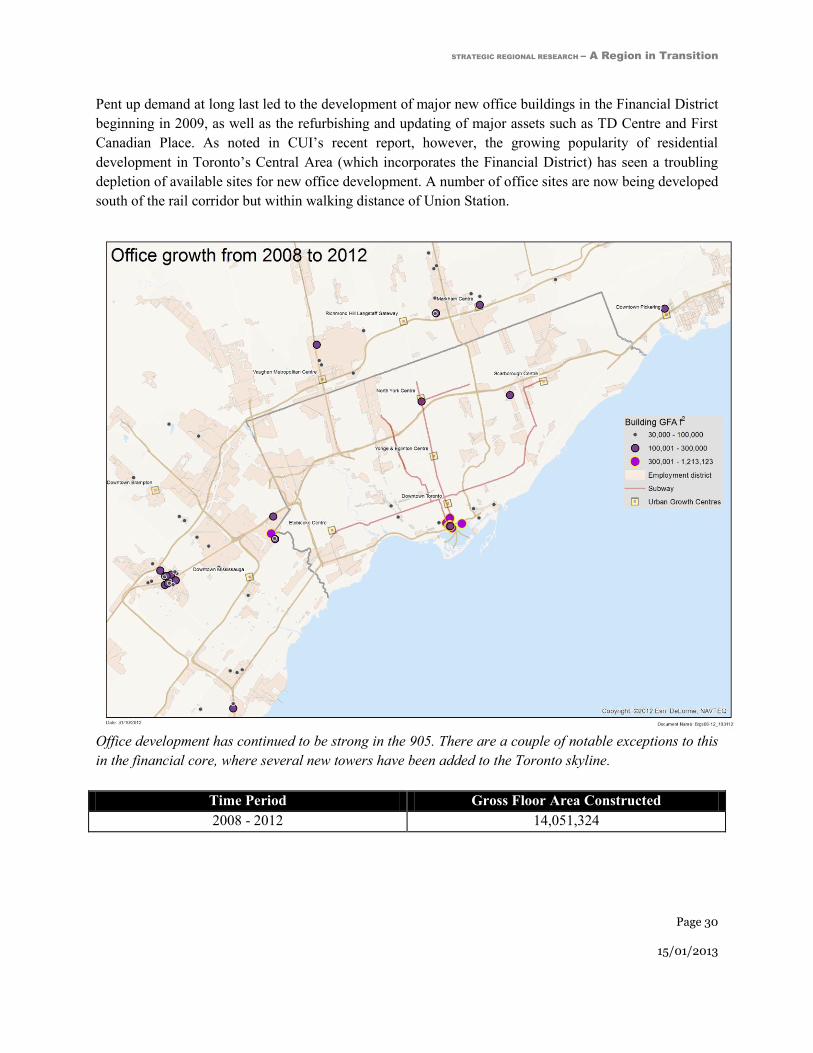
Pent up demand at long last led to the development of major new office buildings in the Financial District
beginning in 2009, as well as the refurbishing and updating of major assets such as TD Centre and First
Canadian Place. As noted in CUI’s recent report, however, the growing popularity of residential
development in Toronto’s Central Area (which incorporates the Financial District) has seen a troubling
depletion of available sites for new office development. A number of office sites are now being developed
south of the rail corridor but within walking distance of Union Station.
Office development has continued to be strong in the 905. There are a couple of notable exceptions to this
in the financial core, where several new towers have been added to the Toronto skyline.
Time Period Gross Floor Area Constructed
2008 - 2012 14,051,324

STRATEGIC REGIONAL RESEARCH – A Region in Transition
Page 31
15/01/2013
The new supply of residential space in multi-unit buildings is growing faster than the creation of space for
new jobs. This is a problem highlighted in downtown Toronto, where rush hour traffic is almost as
congested leaving the core as it is entering the core.
Development of office space and multi-residential housing in Toronto area
This graph illustrates Housing Starts for ‘Apartments and other Units’ in the Toronto CMA, against the
amount of office space built in the GTA over the same time period. It is noted that this data refers to
slightly different geographies.

STRATEGIC REGIONAL RESEARCH – A Region in Transition
Page 32
15/01/2013
Growth in the GTA is Creating Two Distinct
Working Environments Downtown Toronto: A Mixed-Use Transit Friendly Urban Success
Story Downtown Toronto has become an excellent example of an urban mixed use environment that works. The
Region’s population continues to grow, and the central area of Toronto – especially downtown - is
experiencing high levels of growth in high rise condominium development, largely because people want
to live and work in a place that offers a rich blend of amenities and exceptional transit access.26
The
walkability of the downtown core, which is the focal point of a successful Financial Services Sector
(FSS), is further enhanced with the transit-friendly PATH system, a 28 km underground network of shops
and amenities integrated with the downtown’s major office complexes, department stores, City Hall and
key transportation facilities like the Toronto Coach Terminal and Union Station. The latter facility is a
hub for the Region’s public transit system and inter-connects two subway lines, GO Transit trains and
buses. The capacity offered by this system is a key reason that only 24% of the work force drives to work
in this district. The quality of life this offering represents attracts talent from all over Ontario, Canada and
the world to live, work and play in an all-inclusive urban environment.
Not all is well, however. For the past ten years, the rate of residential growth has far out-stripped job
growth. Not all new residents in the central area of Toronto are able to find work in the core, and a
growing number of residents work in the 905. Continuing to achieve high modal splits in favour of transit,
cycling and walking in the central area will be an important challenge for the future.
Driving the employment success of the financial services sector is the health of Canada’s big five banks,
whose headquarters dominate the skyline. In the 1970s the core housed many types of industries
including: mining, forestry, medical sciences, information technology, publishing and data processing.
Nearly all the head offices in the Region and many in Canada were headquartered in the downtown. Many
have since left to go to other regions of the country or moved to lower cost suburban locations elsewhere
in the GTA. As a result, FSS and their support companies is now the dominant driver of job growth in the
financial core.
As companies representing a diverse range of sectors departed the financial core between 1992 to 2009,
the office space they had occupied was largely replaced by companies in the FSS sector. Since 2009, the
new buildings on the horizon have been generated by the expansion needs of the banks.27
Supply of new
26 City of Toronto - Planning Division, 2012, ‘Profile Toronto – Living in Downtown and the Centres,’ accessed at:
http://www.toronto.ca/planning/pdf/ldc2011_final_pressres.pdf 27
Commerce Court is a prime example of the transition. When it opened in the late 1970s, CIBC and Blake Cassels
a financial services law firm, occupied less than 25% of the building. The remainder was occupied by notable

STRATEGIC REGIONAL RESEARCH – A Region in Transition
Page 33
15/01/2013
office space in downtown has been almost exclusively in tall AAA buildings to service the financial
services sector. According to the major brokers, demand for office space since 1992 has averaged
approximately 650,000 sq ft. Looking ahead, the capacity for growth in the AAA market is defined by
sites that could be built without a great deal of site change (as close as building “as of right” gets in the
Toronto environment): this amounts to approximately 12M sq ft.28
Some of these sites are under
construction and some are in the planning stages. The best estimate based on the opinions of industry
professionals is that there is potential to construct approximately 12M sq ft. Projecting recent
performance forward (i.e. annual increments of 650,000 sq ft), this capacity would only meet the mid-
term (20 yrs) needs of the FSS, and makes no provision for demand from other sectors.
Demand for office space in the core is not limited to the FSS, however. On either side of the financial
core (which accounts for approximately 40M sq ft of buildings surrounding King and Bay), the Kings
(also referred to as the Brick and Beam area) currently house approximately about 90,000 office jobs,
many of which largely didn’t exist 15-20 years ago. The net effect on the City’s employment base has
largely been neutral however, because office jobs have simply replaced industrial jobs linked to clothing
manufacturing enterprises and similar functions. The same buildings have transitioned from housing
manufacturing jobs to office based jobs related either to the FSS or to cultural industries and other new
enterprises. The conversion of older industrial style buildings now amounts to over 18 million sq ft of
office space – a transition that foreshadows future trends. Even though new buildings are not being
created in the Kings, the companies located there today are driving job creation.
How many more of these former industrial buildings are left for conversion? According to a recent
survey, there is less than 1M sq ft of space left for potential conversion.29
This takes into account the fact
that there is also strong demand to convert industrial buildings to residential condominiums. These
buildings are often the place where new industries are incubated; they are relatively inexpensive and cater
to all the urban characteristics of the New Economy. Vacancy rates are extremely low and leasing rates
are rising, which will severely curb the new supply of this type of space.
Employers who choose more urban multi-functional locations are paying a premium for that choice. But
as the value gap between urban multi-functional locations and suburban office parks continues to shift to
the lower cost opportunity, both the FSS and the cultural industries are at risk because there are simply
not enough sites available for development. Over the next 30 years, in a business as usual scenario, there
tenants like Trans Canada Pipelines (7 floors), several mining companies and other industry leaders - all of which
have left the City and even the Province. 28
Major brokerage companies were surveyed on the range of current options for new ‘as of right’ office space in
the financial core. Each firm has different ways of measuring if a site is development ready. However, there was
general consensus that 12M sq ft of office space is on the high end of the core’s capabilities. A less conservative
number was used for this paper to allow for some unknown improvements to current ‘as of right’ conditions to
occur. Specifics cannot be provided due to client and strategic concerns. 29
RESC researched the inventory and estimated that as of Dec 31st 2010 the number of buildings that could be
transformed from current industrial buildings to offices in the core amounted to 1M sq ft. This figure does not
include live/work lofts or other quasi-residential/office mixed use.

STRATEGIC REGIONAL RESEARCH – A Region in Transition
Page 34
15/01/2013
are only enough sites to meet the half the needs projected for that period, unless new sites are made
available
Even the most attractive urban areas can be ignored by the office marketplace. The Bloor & Yonge node
in Toronto is one of the best served transit nodes in the country. It has nine million sq ft of office space
and on the surface would appear to have strong potential for growth, yet the area has not seen a new
commercial building in 23 years. The bulk of the buildings were built in the first ten years following
development of the subway. Even though vacancy rates are low, the south east corner of Yonge & Bloor
site, which had been assembled in the mid-1990s, and which was zoned commercial with an FSI of 11,
remained un-built.30
Yet since that time some 40M sq ft has been built in the Region. No employer chose
this site. Was it land economics? What prevented this site from being developed to its apparent potential?
No single explanation can be offered, although clearly those reasons do not include lack of transit or
planning effort. Office nodes that lose their relevance and are skipped over for either less expensive
locations or other considerations can become undervalued and unsustainable.
Downtown Toronto’s east end in the 1970s
Downtown Toronto’s east end today
30 The SE corner of Yonge & Bloor is now being developed as a major condominium building (One Bloor) with
ground floor retail.
Over the past few decades downtown
Toronto has been transformed into a
series of vibrant neighbourhoods that
each support a diverse range of land uses,
are distinctive, multi-functional, highly
walkable and accessible via transit.
Top photo courtesy of BlogTo website, accessed at:
http://www.blogto.com/upload/2011/10/20111011-
Toronto-parking-lots-history.jpg Bottom photo
from Bing Maps.

STRATEGIC REGIONAL RESEARCH – A Region in Transition
Page 35
15/01/2013
Business Parks: Extraordinary Growth but Lack of Urban
Amenities and Higher Order Transit One key challenge facing half a million office workers and their employers in the GTA is that they do not
work in the kind of mixed use urban environment that is available to workers in downtown Toronto.31
The result for the majority is that they are obliged to drive (or carpool). Most of the locations in which
these buildings are located are adjacent to the 400 series highways.32
When these districts and the
accompanying highway network were planned there was no expectation these districts would attract
100M sq ft of office space. The outcome for the people who work in these areas is the congestion that
they experience on the highways is continually worsening. Studies based on the Transportation
Tomorrow Survey33
confirm that the average auto occupancy during peak hours – particularly for longer
commutes - is at one of the lowest levels since the survey was instituted in 198634
illustrating the
increasing complexities associated with the daily commute and a growing number of vehicles on the road.
The idea that office job employment should be segregated from the rest of the community is becoming
less and less attractive to employers despite the low real estate costs. If left unchanged it is not
unreasonable to suggest that these areas could stagnate. What are the problems? For between 94 and 97
percent of employees in these parks, many of whom live in the City of Toronto, their working life is
defined by the daily commute and increasing congestion in these areas. All of these clusters have space to
grow. Between the three largest clusters (ACC, Meadowvale and the 404/407 cluster, which accounts for
40 million sq ft), these employment areas have the combined capacity to accommodate all of the regional
growth projected for the next 30 years, which is estimated to be 100 million sq ft of new space. But will
this happen and should it? If employers have difficulty recruiting new employers, the momentum for new
growth could stall.
There are three major motivators driving employers to locate office space in an industrial/office park: low
cost, availability of new product in a timely way, and, easy access to growing labour force.35
Policy which
looks to creating more employment areas faces critical challenges, including the risk of failure. These
existing clusters should be encouraged to allow amenity development and create high speed connectivity
to other clusters and residences. Encouraging new clusters to form (where there is presently no office
space) as is the case in some Urban Growth Centres risks dissipating the economies of agglomeration and
could potentially weaken existing clusters from attaining a measure of agglomeration.
31 It is estimated that 100 million sq ft of office space represents half a million jobs, based on each employee
typically requiring 200sq. ft. 32
Examples include; Airport Corporate Centre, Meadowvale, Sheridan Park and the Oakville/Burlington QEW Corridor
404/407 Markham in the 905 and Etobicoke/427, Scarborough, Consumers Road in the 416). 33
The Transportation Tomorrow Survey (TTS) is a survey carried out every five years by the Data Management
Group, managed by the University of Toronto. 34
The Greater Toronto Area - Cordon Count Program, ‘Transportation Trends 1991-2006,’ developed by MMM
Group Ltd. Greater Toronto Area 35
Free parking as an inducement for employers attracted many people in the early days of urban sprawl, but as was
pointed out in the book, ‘The High Cost of Free Parking’ by Donald Shoup it may be an effective inducement
initially but as congestion overtakes convenience the inducement becomes irrelevant.

STRATEGIC REGIONAL RESEARCH – A Region in Transition
Page 36
15/01/2013
Growth of the Region will continue, and although the principle of intensification is well accepted, no one
can say with certainty where it will occur from the perspective of employment. The challenge will be to
preserve the factors that allowed these areas to succeed in the first place by ensuring that issues like
increasing congestion do not cause them to lose their appeal to employers.
The GTA contains at least four growing clusters of employment that are connected only by road and
highway. Each of these clusters has unique challenges but between them they currently account for 50M
sq ft of office space. On paper, they have excellent growth prospects, sufficient land to develop a range of
amenities and a growth profile that is conducive to additional growth. The GTA has reached a turning
point, not unlike the situation faced in Washington, D.C. a decade ago when it was recognized that the
D.C. region had massive concentrations of office space that were not only completely dependent on the
automobile for access but which were disconnected from each other except by congested highways. (For
suggested solutions aimed at connecting office clusters with higher order transit and reworking the
industrial suburban block patterns to facilitate pedestrian and transit access, please refer to to the
following section of this report ‘Coordinating Policy, Infrastructure and Investment on the Ground.’)
The focus of most rapid transit solutions in the GTA since 1947 in Toronto has been on the core of the
City. Although the Growth Plan and other policies have started the process of shifting the focus of growth
away from the core, current infrastructure investment plans continue to allocate resources almost
exclusively to the 416. There is an urgent need to create effective transit linkages between 416 and the
905. As residential growth in Toronto continues to outpace employment, an increasingly large percentage
of Toronto residents will likely be working in the 905. At the present time, there are few options to reach
employment areas in the 905 from Toronto by public transit.
There is a risk that if the Region does not embark on improving connectivity to and between these
clusters, the productivity of the Region will continue to erode. Some of the historic clusters in the Region
have suffered noticeable stagnation in terms of employment, even in the outlying areas. An example is
Mississauga City Centre, which has not attracted a new office building since 1992. This situation may
occur in some of the newer, still-growing clusters as well if connectivity problems are not addressed.
Historically, transportation infrastructure such as roads, bridges, ports and rail defined where people lived
and worked. These investments create opportunities for people to work, start businesses, grow, prosper
and conduct trade. It is important that more public attention be focused on providing competitive
environments for businesses to compete.
Economic conditions play a critical role in determining where employers locate. These relate to tax
structures, land costs, incentives, approval times and ease of construction. In the past, high taxes and
complexities associated with new development in the GTA’s established business districts like the
financial core have driven businesses to locate in unconstrained, less expensive greenfield locations. This
has led the GTA to grow outward, compounded congestion and diminished the supply of available land.
As time goes by, conditions must be put in place to support development of commercial spaces in
urbanized environments.
Urban solutions, however, require different approaches. The “build it and they will come” can no longer
be the rationale for public investment in laying the backbone for growth. Linking existing clusters and
enabling growth to occur where business can thrive is a very different challenge. Shared investment in
STRATEGIC REGIONAL RESEARCH – A Region in Transition
Page 37
15/01/2013
connecting businesses to where people live is a more complex problem that needs a more complete
understanding of the elements of agglomeration.
By adopting a more integrated approach, the public sector can better maximize, coordinate and leverage
its policy efforts and investments, which in turn will inspire the private sector to deliver quality
developments that meet the needs of the New Economy.
This type of approach is evident in the London Crossrail project (described at length in the final section of
this report Connecting Home And Work: Approaches From Other Major Cities). The London case study
suggests that city builders have heavily invested in new transit services integrating these transit assets
with emerging mixed neighbourhoods, major employment areas and the airport. Importantly, the routings
of these transit investments have been validated by high levels of direct investment from private sector
developers. These efforts are further supported by a host of complementary measures as diverse as a
congestion tax and improved bicycle lanes. The GTA will need to consider all the different pieces and
how they fit together, so agencies can work on a variety of fronts to address the potentially crippling
challenge of congestion facing the Region.
Quantifying the economic benefits of agglomeration underpinned the business case for the Crossrail
project; it was considered that this investment would attract private sector development, increase the
density of jobs around stations, grow the pool of highly skilled labour and increase productivity.
Moreover, agglomeration studies went onto explore the wide ranging consequences of Crossrail on
taxation and regeneration and argued that the increased tax bill would cover the cost of building the
railway; as well, these studies examined the relationship between crowding on the transport system and
levels of employment.36
Overall, this ground-breaking approach integrated the concept of agglomeration
into policy and strengthened the links and understanding between employment density, connectivity and
productivity. Major employers were fully engaged in the planning that led to Crossrail, particularly in the
early discussions.37
Successful cities require a wide range of buildings (i.e. mix of size, age, structure type and price) to
support a diverse range of uses and functionalities. Affordable office space is a fundamental requirement
for almost all start ups. Most high-tech or creative companies can trace modest beginnings; for example
Research in Motion was once based in a ‘cramped office on the top floor of a strip mall’38
near the
University of Waterloo. Providing space for young entrepreneurs to start their companies and give them
opportunities to thrive will be crucial to the future strength and prosperity of the GTA and Canada as a
whole. This is why it is important that office buildings and transit investment be planned in tandem.
Employers are recognizing that the desire for a new generation to live in a complex urban environment
where living and working and playing in proximity is increasingly driving employee choices. From CUI
interviews, it was clear that the younger generation may not be prepared to commit to long commutes.
Policies are needed that will attract both established and start-up businesses to locate in areas close to
transit and urban amenities.
37 One of the first meetings was convened by a major developer at the developer’s expense.
38 Hicks, J., 2012, ‘Research, No Motion: How the BlackBerry CEOs Lost an Empire,’ accessed at:
http://www.theverge.com/2012/2/21/2789676/rim-blackberry-mike-lazaridis-jim-balsillie-lost-empire

STRATEGIC REGIONAL RESEARCH – A Region in Transition
Page 38
15/01/2013
Agglomeration Economics Agglomeration in the urban context describes the benefits businesses derive from locating near each
other. Economies of scale and network impacts are specifically urban-based office space drivers.
Companies locate in close proximity to acquire the benefits from the economies of scale and networking.
Costs and benefits of communicating are reduced; shared employee pools attract the best talent when
multiple opportunities for employment are co-located. Even related sectors and companies not in direct
competition benefit from multi-disciplinary interactivity. Toronto’s Central Area and downtown
exemplifies the principle of agglomeration economics. By adding multi functionality and improving
connectivity of suburban office clusters more benefits of agglomeration will be realized in these key
growth areas.
The existence of agglomeration economies is central to the explanation not just of how cities grow and
how they sustain that growth. The process leading to agglomeration is not prescriptive or even
predictable. It is easier to define where such benefits will not occur. The hallmarks of a successful
agglomeration include high levels of connectivity to and within an employment cluster, access to
amenities and the option of living in close proximity, as well as an attractive public realm. A key
criterion for success is when there is a sufficient critical mass of residents and workers to ensure that
transit investments are well used and deliver an acceptable return on investment.
Successful agglomeration economics calls for connectivity contributing to network linkages, usually close
enough to walk to complementary buildings and activity. Equally important is the connectivity with
residential growth associated with the business of the agglomerated area. Building mixed use and multi-
functional communities will be a major challenge requiring thoughtful solutions. These solutions are not
as easy to plan as mono-functional districts are. Yet, if done successfully mixed use communities provide
local jobs, create a critical mass of residents and heavily utilize transit investments.
People are moving to the GTA’s urban centres to enjoy the value of an amenity-rich lifestyle. Downtown
Toronto, Mississauga, Oakville and Burlington, as well as Markham Centre are all seeing strong
performance in their condominium markets. These burgeoning residential populations provide urban
centres with vitality and a population base able to support investments in transit, retailing, community and
cultural facilities. However, this growing condominium market creates new challenges for centralizing
office space in urban centres when building condominiums is not only more profitable but carries less
risk.
The economic challenges associated with building commercial office space in the face of a strong
condominium market were exemplified during the development of the Crossroads complex in Vancouver,
a transit-oriented development built in anticipation of the Canada Line. Originally planned as a residential
project, Crossroads had been planned as a residential project, given the strong return on investment from
condominiums. However, the City insisted on the need for office space and also argued that office space
generated higher levels of transit usage. Having instituted a moratorium on conversions from employment
to residential, the City undertook analysis showing that office space generates ten times more transit trips
per square foot of space. The project is proceeding with seven floors of office space in one tower and six

STRATEGIC REGIONAL RESEARCH – A Region in Transition
Page 39
15/01/2013
levels of residential in another tower. This important research illustrates how mixed use communities
contribute to more sustainable movement patterns.39
Another impact of the decentralization of office space is contributing to a phenomenon known as “reverse
commuting.” This is occurring for two key reasons: first, jobs are relocating out of the core as employers
seek cheaper and available office space; second, residential space in the Central Area of Toronto is
growing much faster than job opportunities – and therefore, office space. In 2007 it was reported that
seven commercial office projects were underway in Toronto, representing nearly five million square feet.
In comparison, there were 149 residential housing projects with a total of 39,398 units in the pipeline.
Assuming a conservative average unit size of 600 square feet, this is equivalent to 23.6 million square
feet.40
Achieving the conditions to support office growth and create a balanced mix of land uses in urban
centres will be critical to creating more sustainable transportation patterns.
Accommodating Growth in the Age of Acceleration Employers in all sectors are making what used to be long-term decisions on where to locate within much
shorter business cycles. In the post-war era, companies planned out facilities requirements over 10 and 20
year periods; today businesses grow and contract quickly. Facilities need to be found and created to react
to competitive forces in much shorter periods of time. Competitiveness is challenged by slow and
complex approvals processes, tax disincentives and the congestion in transportation networks. The
economy today is increasingly nimble while cities are becoming less so.
Public policy faces a dilemma: on the one hand, businesses are demanding quicker responses to their
spatial needs to create space to house their office needs. On the other hand, creating successful mixed use
environments that are attractive to employers is time consuming and complex, highlighting that transit
investments made without a strong certainty of success are inherently risky.
Cities that can find a solution to the shortening business cycles encountered by businesses will ultimately
be more attractive to new economy and traditional companies, which require flexibility in providing
facilities. This is similar to the flexibility enjoyed by manufacturers on large sites where additions to plant
and equipment are facilitated quickly and affordably. The same conditions will be required to service the
growing complexities of the office employment sector.
39 Bula, F., 2009, ‘Urban Rail is a New Engine for Development,’ from the Globe and Mail, published Sep. 29 2009,
accessed at: http://www.theglobeandmail.com/report-on-business/urban-rail-is-a-new-engine-for-
development/article1304977/ 40
Brown-Bowers, A., 2007, ‘A Globe: Reverse Commuters Reflect Shift in Land Use,’ from the Globe and Mail,
published Dec. 11, 2007, accessed at: http://urbantoronto.ca/forum/archive/index.php/t-
5562.html?s=5a3495793a01a2a855c72224776a305b

STRATEGIC REGIONAL RESEARCH – A Region in Transition
Page 40
15/01/2013
The GTA Urgently Needs an Integrated Plan
to Shape the Future The GTA is Expecting Sustained Growth "We shape our buildings; thereafter they shape us" - Winston Churchill’s famous quote underscores the
fact that once built, buildings impact us for a very long time.41
The location of office buildings and their
relationship to where people live defines to a great extent how a region functions on a daily basis, and as a
result, commuting patterns – the length and duration of a trip taken twice a day - defines quality of life for
a majority of residents.
For the half million employees whose only option is to drive, congestion represents a higher and higher
cost on quality of life. The stark reality of the development business is that once built, a building never
moves and rarely changes.42
A building can be altered but once an office building has been constructed it
generally functions as an office building for a very long time, in the same way that other major public
infrastructure investments like highways, rail and subway corridors are long-term commitments.
Shaping the physical future of a growing region is about where large scale investments are made by both
the public and private sector. This section explores what drives the creation of buildings, what influences
their location and why it is important that Higher Order Transit investments are coordinated with
employment clusters and in high density corridors that have proven acceptability to employers. These
clusters must have a proven capacity to grow in the immediate area surrounding the transit. Although no
one can predict how well a particular grouping of businesses will perform long-term, there is a symbiotic
relationship between public infrastructure like subways and buildings constructed in their vicinity.
The expectation of growth in the Region is strong. Where it lands on the ground is less predictable. Places
to Grow, the Province’s Growth Plan for the Greater Golden Horseshoe administered by the Ontario
Growth Secretariat (OGS), calls for the population of the Greater Toronto Area and Hamilton to reach 8.6
million people by 2031, and a gain of 2.8 million from the 5.8 million people living in the area in 2001.
Over the same period the Plan calls for employment to grow from 3.0 million in 2001 to 4.3 million by
2031, a gain of 1.3 million.
The latest projections from the Ontario Ministry of Finance (MOF) released in June of 2012 call for the
population of the GTAH to grow from 5.8 million in 2001 to 9.2 million in 2031, a gain of 3.4 million
over that span. In other words the Finance Ministry expects the population of the GTAH will grow by
41 According to author, Dr. Mardy Grothe, the original quote was "We shape our dwellings, and afterwards our
dwellings shape us." This intriguing observation comes from a speech Churchill made in the House of Commons on
October 28, 1944. A 1960 Time magazine article provided a slightly different version: "We shape our buildings;
thereafter they shape us," illustrating that in the beginning, buildings reflect the qualities of the people who design
and construct them. Once built, the people who live and work in them take on the qualities of these buildings. 42
RESC has documented and analyzed all the office buildings in the GTA over the last 60 years and fewer than 2%
have been removed or changed to another use.

STRATEGIC REGIONAL RESEARCH – A Region in Transition
Page 41
15/01/2013
400,000 more from 2001 to 2031 than called for by the Growth Plan. Furthermore, MOF projects the
population of the GTAH will continue to grow beyond 2031, reaching 9.8 million by 2036. The MOF
projections do not include forecasts for employment. If the MOF population projections turn out to be
more accurate than those of Places to Grow employment in the GTAH will grow by more than suggested
by the Growth Plan, probably to 4.6 million in 2031 and to 4.9 million by 2036.
Strategic Projections Inc’s (SPI’s) forecasts for population and employment growth in the GTAH fall
about midway between those of OGS and those of MOF. SPI foresees the population of the GTAH
reaching 9.0 million in 2031 (compared to OGS’s 8.6 million and MOF’s 9.2 million) and to 9.4 million
in 2036 (compared to MOF’s 9.8 million). It matters little which projection is correct. The most
important point is that all three projections are calling for significant growth through to 2031. A further
important point is that growth will not only continue at a brisk pace between 2031 and 2036 (as suggested
by MOF) but it will be brisk well beyond 2036. For example, SPI’s projections foresee the population of
the GTAH reaching 9.7 million in 2041, 10.2 million in 2051 and 11.0 million in 2061, with employment
continuing to grow in tandem.
In other words, there is a broad consensus that the GTAH will grow significantly through to at least 2031
or 2036. And at least one major forecaster suggests GTAH growth will continue for at least another
quarter century beyond 2036.43
Manufacturing and industrial job growth has remained relatively unchanged in the GTA for the last two
decades while jobs in office buildings have grown to the point where 55% of all jobs in the City of
Toronto are office based jobs. Extrapolating this number to the scale of the Region, suggests that there
are approximately 1 million office jobs in the GTA. Of those 1 million jobs, approximately half go to
work in dense, multi-purpose mixed use environments with transit and all the trappings of urban life.44
The other half million go to work in isolated uni-functional districts originally planned for manufacturing.
The projections for growth in the GTA show that another million or more jobs will be created in the
Region and the majority of those jobs created in the next 30 years will be housed in office buildings. The
most likely scenario is that the amount of space required to sustain this growth in the Region will exceed
100M sq. ft. of office space. This forecast is based in part on a recent study carried out for the City of
Toronto45
that states that the City’s office inventory will grow by a minimum of 60M sq ft in the next 30
years. Conservatively, the rest of the Region will grow by an additional 40M sq ft. The projections for
population growth for the Region exceed 2.6 million people. Based on the trajectory of growth identified
in these various projections, the GTA will need to find a place for 100M sq. ft of employment in office
buildings by 2041.
43 At the time of writing, the Ontario Ministry of Finance has just issued new forecasts, which have not been
incorporated into this paper. 44
The geography of these jobs includes downtown Toronto and the Yonge corridor to North York. 45
Malone Given Parsons, 2012, ‘Sustainable Competitive Advantage and Prosperity - Planning for
Employment Uses in the City of Toronto,’ Toronto

STRATEGIC REGIONAL RESEARCH – A Region in Transition
Page 42
15/01/2013
Business as Usual: Without Action, Keeping Pace with Growth is a
Challenge Where will the Region’s next half million new jobs be housed, and where will 100M sq. ft. of office space
be located? What impact will this have on infrastructure? Building on the conditions that exist in the
Region today, a large percentage of the growth will most likely occur where it has for the past 30 years.
There is ample room to grow in four static clusters in the 416, but weak demand. There is strong demand
but limited capability to grow in Toronto’s financial core and there are few buildings left to renovate in
the Kings.46
Meanwhile, the evidence shows that the 905 is suffering from severe congestion. This could
be interpreted as a tipping point where co-ordinated policy balancing and integrating the impact of all
three policy tools in the Region, planning, transit and economic development, could prove to be vital.
The 2005 Provincial Policy Statement requires that municipalities make provision for employment so that
each municipality can reserve the appropriate amount of land for employment growth. But although the
growth projections have been quite accurate at the scale of the Region, for the past 25 years the location
of development has not always followed policy. For example, the Sheppard corridor in 1992 was
designated as a transit corridor to attract employment but this did not materialize. The base of
employment has actually been reduced. The prospect of making provision for 100M sq ft. solely through
planning policy alone will not ensure the intended outcome. The same holds true for transit policy. There
are no guarantees that building a subway into a low employment area will stimulate enough growth to
produce sustaining ridership. Economic policy, tax incentives and the like without the corresponding land
economics in place may not have the intended results either.
In 1970, most of the Region’s office employment was in the downtown core, today the downtown core is
less than 40 percent of the Region and the financial core is less than 25 percent. Who works there has also
changed. As indicated earlier in this paper, many sectors like engineering, medical science, technology
and data processing have formed new clusters in the edges of the Region. These clusters are here to stay,
they are competitively priced and contain ample capacity with grow. This reality will continue to shape
the Region for a very long time.
If the existing office clusters in the 905 attract their share of growth over the next 30 years without an
alternative means of connecting those who work there with their homes the congestion on the highways
will continue to increase and conditions will deteriorate. The capacity of the highway system will be hard
pressed to manage intensification without viable new transit initiatives, together with a push to improve
the quality of the pedestrian environment in such locations. The transit success of the downtown core
hinges on multi-functionality; transforming the 905 clusters should aspire to the same conditions.
When looking ahead to determine the fortunes of business areas that are currently thriving, the area of
Don Mills serves as a cautionary tale. This area enjoyed strong growth from the late 1960s through the
next decade. It attracted new tech companies such as IBM, Olivetti, Honeywell and others, that took
46 Allied Properties REIT is constructing a 29-storey commercial office building for the corner site at Peter and
King Streets, designed by Hariri Pontarini Architects. The building would stand 129m high and contain 800,000
square feet of space.

STRATEGIC REGIONAL RESEARCH – A Region in Transition
Page 43
15/01/2013
advantage of the recently completed Don Valley Parkway extension. The cluster was wholly dependent
on the attractiveness of one industrial growth spurt and did not possess the characteristics necessary for
the creation the economies of agglomeration. Competition from similar clusters with lower costs soon
pulled growth north and Don Mills as an employment cluster has not grown since.47 Don Mills is a prime
example of what happens when an area, largely dependent on automobile access and lacking in amenities,
loses its appeal as an office cluster based on business type and has little to offer to the next generation of
employer.
Congestion is an outcome of increased demand without a corresponding increase in the capacity of roads
or transit infrastructure. If growth occurs unexpectedly or in unanticipated amounts, then infrastructure
can be overwhelmed. In 1990, for example, few expected Mississauga to have over 30M sq. ft. of office
space within 20 years. Few expected the expanded 400 series highways to have to cope with the current
load. Suburban growth was stimulated by very favourable conditions for employers compared to the
alternative in the core of the city. Since 1999 nearly 400 new office buildings have been built in the
Region, ranging in size from 10,000 sq ft to over 1M sq ft. The bulk of these buildings were located
outside of the City of Toronto (355). The average size of suburban buildings is just under 90,000 sq ft.
Most of these buildings were built for a single tenant.48
The same cannot be said for the core of the city
where most of the new supply originated in eight buildings, averaging 480,000 sq ft. The evidence
suggests that pre-leasing commitments were lower in larger buildings in the City of Toronto than in the
suburban locations, but still averaged 62% of gross floor area.
New buildings and where they are built is the prerogative of a very few decision makers in companies that
are sufficiently large and financially strong to attract the necessary capital and expertise. These decision
makers choose from options created as a result of decisions made by the public sector. Some policies have
had the effect of channeling growth to isolated business parks in the 905, while others like policy changes
in the Kings encouraged new uses in old buildings. When the economics of those choices are competitive
there is often very little choice in the matter. But when those policies create unintended outcomes or are
based on unrealistic economic conditions, road and transit capacity is unable to keep up with demand.
Even though planners have attempted to direct developers to mixed use centres in the 416 through the
process of designating these nodes in official plans, these efforts have not always proven successful.
Simply grafting a designation to a land use map without understanding the needs of the office
development market has not achieved the desired effect in all cases. The blend of permissive land use
policy, low taxes and efficient development approval processes has helped create a very large inventory
of new buildings in uni-functional office parks. The concern in the 905 is that low costs and ease of
building may not mitigate the inefficiencies of congestion. Helping these clusters transition into mixed
use communities without losing the advantages of the past will be challenging.
47 The National Post inherited the Southam Press headquarters which had moved to Don Mills in the 70s from Bloor
and Yonge. It recently announced that it was moving back to a building beside the building Southam vacated 40
years before near the corner of Bloor and Church. 48
RESC complied a private study which shows the average pre-lease commitment of the new supply of office space
was generated by an average of 81% prime tenant occupancy in the 905.

STRATEGIC REGIONAL RESEARCH – A Region in Transition
Page 44
15/01/2013
Shaping the competitiveness of the Region requires policy changes that improve the quality of life and the
competitiveness of business locations. Buildings are static but the environment around is dynamic. The
challenge in mixed-use environments is to create the opportunities for tenants to grow competitively. The
challenge in isolated uni-functional parks is to create mixed-use without destroying the economic
advantages of uni-functional parks.
Understanding Who Creates Buildings and Why Sustaining both auto-dependent uni-functional office parks and dense urban agglomerations is a
challenge. Each type of location requires very different tools to reposition them to ensure future
competitiveness. The role of large employers has a major impact on decisions affecting building location.
There are relatively few companies that can command the attention of real estate development companies
and investors who build new facilities. The decision makers at those companies are responsible for
choosing where buildings are built. Their decisions are complex involving financial, human resources,
customers, competitors, cost and other considerations. To add to the complexity, companies that cannot
have buildings built for them rely entirely on existing vacancy inventories. Start-ups, small and midsized
companies are often left with less than ideal circumstances and must rely on an increasingly risk averse
development industry to supply surplus space to grow in.
In the downtown core very few companies with fewer than 1,000 employees are large enough to start a
new building, while in the 905 the minimum size appears to be much lower, or about 150 employees.49
The impact of decisions regarding site selection defines where their employees work for 15 years or
longer. From a public policy perspective the location of that building will shape that community long
after the original tenant relocates. Thus an ideal outcome is when buildings are located in places that can
accommodate both changes in the size and character of the companies occupying the space as well as
ensuring that the accompanying infrastructure continues to perform to peak efficiency. This is why it is in
the public interest that these buildings succeed and continue to be connected with home and supporting
amenities.
Our analysis suggests that companies capable of creating new buildings can be divided into two separate
categories: Regional Mega Sized Enterprises (MegaCo) and Medium Sized Companies (MidCo).
MegaCos typically have more than 2,500 employees and occupy over 500,000 sq ft of space. They
include the major banks, insurance companies, public sector companies like CBC, governments and
“telcos.” These companies can have many self-sustaining divisions that perform specialized services or
service centres, often in different areas of the Region. This is not uncommon and in most cases offer a
company strategic advantages. Governments fall into this category. These companies are typically in
mature industries; occasionally these companies are fast growing new industry players and have very
immediate needs. Most of the “marquee” buildings that dominate the skyline in the financial district were
49 This number is a result of research conducted by RESC. It is based on the study of the last 500 buildings built in
the GTA. More specifically, this study examined where buildings were built and who drove construction and
location decisions. Typically, 150 office workers use approximately 30,000 sq. ft. of space and the bulk of buildings
created in the market exceeded 30,000sq. ft. There are new buildings built for less but the aggregate of those
buildings is less than 3% of the overall new supply.

STRATEGIC REGIONAL RESEARCH – A Region in Transition
Page 45
15/01/2013
at some point created for one of these companies and in some cases several of them serve the same
company. Companies that fall into the category of being able to generate a new building generally have
very strong balance sheets and are pursued by large public sector and private sector pension funds and
their managers.
MidCos which employ more than 150 employees, are usually located in a single location (if multiple
locations, this is suboptimal).50
These companies usually seek out smaller, midsized buildings comparable
to their own size. They do this to achieve their own growth targets in a controlled environment (big fish in
a small pond) or because the opportunity seems to meet more than just facility needs. Marketing, brand
identification, attracting employees are among the reasons these companies give for seeking out their own
buildings. There are exceptions. MidCos such as large law firms or accounting firms that generally cluster
with financial services in existing “AAA” financial core buildings often stay close to their clients. When
several of these companies commit together they can leverage themselves into a new building51
but this is
rare and usually occurs in the financial core.
Occasionally MidCos can leverage their own buildings elsewhere. One example is Deloitte Canada,
which leveraged their local business into a new building on a highway site in an industrial area of
Vaughan. The building has five floors of office space, of which Deloitte occupy three. Companies that do
not fit into these two categories often employ fewer than 150 employees and usually grow and thrive in
spaces that are already built. Start-ups, SMEs, new economy companies in the cultural industries and
traditional businesses rarely have the opportunity to cause buildings to be created.
Before decision makers can decide where to build, the conditions on the ground created by both policy
makers and developers have to be right. Increasingly, the policy makers are becoming more important
than individual investors in this process. Office buildings provide a place to work but unlike industrial
buildings,52
office buildings can exist in high density multi-functional environments. The type of office
job/task differs but an office building in Meadowvale Business Park could exist in downtown as easily as
it does in Meadowvale. The employees have the same workplace needs but do not enjoy the same
lifestyle. The only major impact an office building has on its immediate surroundings is the commuting
patterns of the workers, as well as any demands made on restaurant, retail and other business services.
There was a brief period of time after WWII and up to the mid-1990s when entrepreneurial developers
and development companies could build buildings without having commitments to lease from tenants.
Their initiative and vision created buildings in clusters. Some were more successful than others. The
majority of developments in the GTA during this period were developed with very little input from the
tenant community and minimal pre-leasing commitments.53
50 Corus Entertainment’s consolidation on the waterfront is a good example of locating in a single office building.
51 Brookfield’s recent 800,000 sq. ft. Bay Adelaide Building at 333 Bay Street was preleased by an accounting
practice and two major law firms. 52
Industrial buildings are generally not compatible with residential uses and most retailing activities, they require
large tracts of land and transportation infrastructure. Office buildings have very different impact on their
surroundings and are well suited to mixed use areas. 53
Buildings in the core were started with very little pre-leasing, Scotia Plaza for example had less than 15%
committed from the Bank of Nova Scotia when the Campeau Company commenced construction.

STRATEGIC REGIONAL RESEARCH – A Region in Transition
Page 46
15/01/2013
The process of creating a building of any type in that period was the prerogative of the developer. The
developer assembled land, re-zoned where necessary and generally prepared the land for development,
priced the construction, evaluated the risks and attempted to land the first tenant. Risk was high and
success not guaranteed. The developers of this era had an additional advantage because they were backed
by very strong banks that were able to offer competitive financing. The result was that Toronto became
home to some of the biggest and best public development companies in the world. An example is
Olympia & York, which for a period was one of the world’s most successful developers.
Today, if public policy hasn’t already created a good development site it is unlikely to occur in an
environment like downtown Toronto. The new investors in commercial real estate are risk adverse and
rarely take the long term risks associated with land improvement. This is particularly true in dense urban
environments. Transformation of land to commercially viable opportunities is becoming more and more
important as “natural sites” become more and more scarce.
Re-zoning or creating new sites for commercial office buildings requires considerable investment before a
tenant can be secured. Few development companies are taking those risks. Because tenants choose the
site and then negotiate with the developer/investor, the time taken to create a building is a very important
part of the equation. The value of tenants in the process is directly related to the risk the investor is
prepared to assume. More importantly, with respect to the issue of risk, the desirable degree of exposure
for a tenant is rarely longer than three years. This makes developing in high cost, complex environments
like downtown Toronto more challenging. Because the time to execute tends to push MidCos away from
the downtown, the result is that these MidCos rarely get the opportunity to stay in the urban core. Once
the decision has ruled out the core or some other transit-oriented location, this means that an auto-
dependent site is assured – or, as one interviewee remarked, “All bets are off.”
Understanding Development Conditions across the Region Office buildings require minimum floor sizes often greater than 25,000 sq. ft., which means buildings can
rarely be constructed on sites less than 40,000 sq. ft. Assemblies of 40,000 sq. ft. are difficult to find and
the core is rapidly running out of sites with a single owner of one acre. Building height is a much
misunderstood issue in commercial building. Tall buildings are a rarity, not the norm. The recent surge in
very tall condominium towers would leave the casual observer to believe that this is also the case for
office buildings. In fact, the opposite is true. Cost is a very important element and building height plays
into this consideration. Once a building requires more than a single elevator then this leads to higher costs
and most buildings are constructed in markets that cannot absorb the added cost. None of these problems
exist in business parks in the 905 because most of the land development risk has been removed by
restricting the range of uses to designations permitting offices. This keeps the price down and the
availability up. It also means tenants can execute their business plans and relocate in a new building in a
reasonable period of time with confidence that approvals will be forthcoming.
Buildings in industrial parks have to provide for a much higher number of cars and are surrounded by
parking lots capable of providing one spot for almost every employee and visitors. The office building in
a mixed use, transit-friendly environment requires far less parking and is more likely to be built closer to
the sidewalk, transit stops and bike lanes. The suburban model relies almost exclusively on the
automobile while the urban model relies on many options to get to work. The office worker in

STRATEGIC REGIONAL RESEARCH – A Region in Transition
Page 47
15/01/2013
Meadowvale, for example, likely drives (97% auto dependent modal split) while the worker in downtown
Toronto likely does not (24% auto dependent modal split). The worker in Meadowvale brings a lunch or
eats in the company cafeteria, and likely has to drive to reach face to face business meetings. The worker
in a mixed-use environment has many more options. The quality of workplace environment is very
different in these two environments, both of which are under pressure to change and adapt to the
competitive demands faced by employers in the New Economy.
Once the building has been built (in either environment) the tenant responsible for creating the building
often stays there for 15 years or longer but at some point the original tenant may leave. The building,
however, remains to be re-leased to another user, and so on. The challenge is designing in sufficient
flexibility to the building and the surrounding environment so that the location continues to meet the
needs of the next generation - long after the original beneficiary and decision maker has left.
Entire clusters in the GTA have suffered from this cycle. If the building, the tenant quality or the
economics of the area is not sustainable and is not part of a diverse and sustaining cluster of
complementary uses, it may become irrelevant and undervalued. If the policies that create these buildings
fail to recognize the need for change when the market changes then the impact on growth and
sustainability can be damaging.
Employers in all sectors are making what
used to be long-term decisions on where to
locate within much shorter business cycles.
Offices parks in the 905 benefit from this
trend, as they can readily provide cheaper,
unconstrained greenfield sites for new
development.

STRATEGIC REGIONAL RESEARCH – A Region in Transition
Page 48
15/01/2013
Financing Transit – Reducing Public Risk All levels of governments have limited funds in this post-stimulus era, yet the need to invest in
infrastructure has never been more compelling. As can be seen in the CrossRail case study (please refer to
to the final section of this report Connecting Home and Work: Approaches from Other Major Cities), user
fees and a wide variety of local taxes dedicated to transit are not the only way to finance Higher Order
Transit (HOT).54
This section of the study explores the principle of sharing the mitigation of operational
risk between the transit authorities and those making transit friendly real estate investments.
Since 1922, the entire risk inherent in long-term transit infrastructure investment has been carried by the
taxpayer. Choosing where transit is built and the assessments of ridership and public benefit have been
the prerogative of transit operators and politicians. Private consultants and contractors have been used for
their skills in some phases of the transit development process but the risk of operating losses has not been
taken up by the private sector.
A key challenge in the Toronto area is to plan and implement complex transit projects that extend beyond
multiple political cycles. The current approach creates the potential for sudden changes in transit
priorities, which discourages the private sector from investing in developments that would generate
ridership. In some other jurisdictions, where the private sector is engaged in – and invested in – the entire
process through involvement in construction management, operating costs and financing risk as well as
the development of adjacent lands, this increases the likelihood that a vision can be successfully
implemented over the long-term.
Ridership is the currency that defines the success of a transit project. All transit modes – buses, LRTs,
subways or commuter trains – have optimum ridership levels that cover operating costs. It is important
that these levels be reached within a reasonable period of time. Intensification of built form in the
immediate area of a transit project, either concentrations of residential and commercial development,
increases the potential for economic sustainability. Strategies for intensification – and thus involvement of
the private sector - have to be established at the same time that the transit project is being planned.
54 Metrolinx’s definitions of Higher Order Transit or Rapid Transit are as follows:
Rapid Transit: Transit service separated partially or completely from general vehicular traffic and therefore able to maintain higher levels
of speed, reliability and vehicle productivity than can be achieved by transit vehicles operating in mixed traffic.
Regional Rail: Diesel-electric or electric trains serving primarily longer-distance regional trips; approximate capacity at 10-minute
headways of 5,000 to 20,000 persons per hour peak direction (pphpd); service can be enhanced by electrification, enabling better train
performance (acceleration) and therefore higher average speeds even with relatively close station spacing. Average speed: 30 km/h with
two km station spacing; 50 km/h with wider station spacing or electrified trains. Example: GO Transit rail system.
Regional Rapid Transit Network: The network of Express Rail, Regional Rail, Subway and Other Rapid Transit services identified in
Schedules 1 and 2 of the RTP. Direct investment by the business and commercial and residential real estate investment sectors can make a
significant contribution.

STRATEGIC REGIONAL RESEARCH – A Region in Transition
Page 49
15/01/2013
Most of the conversation in the GTA about private sector involvement in transit financing surrounds
financing capital costs and outsourcing capital construction at the expense of the public sector.55
The
assumption of ridership risk has not been part of the conversation with the private sector because it has
always been assumed that the private sector will leverage the transit investment and capture its value
independently. Unfortunately, this is not always the case as many other factors influence the location of
development. Co-investing in the creation of stations and augmenting the operating costs of transit has
not been part of the transit finance discussion in the GTA, even though private sector development is
critical to ridership and sustainability of transit corridors. If transit is proposed in a location where the
private sector takes a portion of the risk then the risk of low ridership resulting from no intensification
will be reduced. If the private sector invests even a small proportion of the capital costs then it is very
likely that the private sector will be motivated to invest in ways other than direct payment for their
investment. To do this they must have the reasonable expectation that they will be able to build
employment and multi-residential development in a transit-friendly way where the creation costs and
benefits of transit are shared.
The majority of office building development in the GTA in the past 20 years has occurred in six areas as
outlined above.
55 The Gordon Chong/KPMG Report ‘Public Transit: Back on Track - Toronto Transit Infrastructure Limited’
specifically excludes the discussion of ridership and ongoing operation financing needs

STRATEGIC REGIONAL RESEARCH – A Region in Transition
Page 50
15/01/2013
Investors in commercial real estate and investors in transit have a shared interest and mutual dependency
on commuters taking the same trips twice a day. Although there are many other benefits linked to the
availability of higher order transit (non-work, recreational trips for example), revenues related to
commuting patterns are the principal economic driver for higher order transit. Developers of residential
projects benefit from adjacency to transit, but the value to the residents derives from the ability to reach
their places of employment.
Both commercial and residential developers benefit when employment location and transit capacity is
well balanced and so too does the ability for the transit system to reach into remote residential areas. A
system like the TTC essentially subsidizes some of the costs of servicing remote areas from high usage of
the subway and streetcar lines. Residential intensification is equally important as a part in the shared
value equation. Because the future operation of higher order transit systems is dependent on both forms of
intensification, the risk of attracting appropriate levels of employment and residential intensification is
greatly reduced when the employers and other real estate investors become partners in the transit creation
process.
One of the principal sources of infrastructure investment comes from publicly held pension fund
investors. These funds like OMERS, HOOP and the Ontario Teachers Pension Board are investing
prudently and under strict public policy guidelines in long-term real estate and infrastructure to meet the
needs of their pensioners. Commercial real estate has many of the same benefits, objectives and values as
transit investment. Both types of investment are:
High in capital cost and risk requiring special investment skills.
Rely heavily on future intensification.
Benefit when the communities they serve are financially healthy.
Dependent on commercial and residential development.
Pools of private capital like pension funds will be increasingly interested in transit investment when the
transit enables their real estate investments to benefit. The business case for a transit project becomes
more appealing from the perspective of the public sector when it is clear that the private sector is
interested in investing. If employers and investors in real estate have a long-term stake in transit’s
success, and therefore their own success, the risk of low ridership is reduced. The time is right for transit
infrastructure to be included in their portfolios and for government agencies to include the private
investment sector in the planning and funding of Higher Order Transit.
The long-term nature of transit investment requires co-ordinated long term political vision. Presently, this
is not occurring in the GTA or Canada. While the federal government recognizes the importance of
efficient transit to the economy and environment, it contributes less than 11% of transit funding through a
variety of one-off funds.56
These funds all have different objectives, priorities and reporting requirements.
56 Hjartarson, J., Hinton, K., & Szala, M., 2011, ‘Putting Canada on Track – A Blueprint for a National Transit
Framework,’ accessed at: http://www.mowatcentre.ca/pdfs/mowatResearch/38.pdf

STRATEGIC REGIONAL RESEARCH – A Region in Transition
Page 51
15/01/2013
It will be critical that all levels of government are able to come together around these critical regional
issues to build much needed transit infrastructure.
Governments are less likely to abandon investment projects in which they partner with the private sector.
Mutual risk taking generates a climate of shared value creation which is more likely to avoid the pitfalls
of political changes. Transit investment becomes less demonstratively political when the private
investment sector makes a significant financial contribution.

STRATEGIC REGIONAL RESEARCH – A Region in Transition
Page 52
15/01/2013
Coordinating Policy, Infrastructure and
Investment on the Ground Three Case Studies from the GTA This section applies some of the general policy coordination theories in this report to actual nodes in the
Region. The three nodes were chosen because they have benefited from public policy and investment
decisions in the past which defined strategic advantages for the employers who built buildings in them.
Each node in its own right has elements of agglomeration economics and has the potential to either
continue to grow with changes to policy or stagnate or, in the case of Downsview and Liberty Village,
even be reduced as employment hubs by the advance of residential development.
This Google map shows the relative distance from the financial core to the three nodes studied. The Circles are
4,000m in diameter. The Airport Corporate Centre is the circle on the left side (west); Downsview on the top
(north); and Liberty Village is the node to the west of the financial core.

STRATEGIC REGIONAL RESEARCH – A Region in Transition
Page 53
15/01/2013
Airport Corporate Centre
Context and Opportunity
Airport Corporate Centre (ACC) is a successful employment cluster based on a suburban industrial model
located directly south of Pearson International Airport. The area contains 65 office buildings or 8.6
million sq ft of office space, 56 industrial buildings57
and many acres of underutilized land. There are no
residences in the area (there are restrictions related to its proximity to the airport), very few retailers and
limited access to other amenities. Its proximity to the Airport and location at the confluence of the 401
and 427 regional highways, low taxes, quick development approval processes and accessible land
assemblies have attracted a wide variety of businesses. The area continues to attract strong market
demand. Approximately 55,000 employees drive in and out of the area every week day. With congestion
increasing yearly this area is at risk of stagnation unless the connectivity challenges are addressed. This
area has the opportunity to become a significant multi-functional employment cluster. With better transit
connectivity, employment density could be increased.
History
Created in the late 1970s58
as an industrial park to provide manufacturing and logistics facilities to serve
the needs of a growing airport, ACC rapidly attracted office investment almost from the outset. Late in
the 1980s, the City of Mississauga proposed a Bus Rapid Transit route to connect Mississauga City
Centre to Airport Corporate Centre. The long anticipated right of way is presently under construction on
the south edge of Eglinton Avenue.
Low taxes, ample surface parking and the proximity to the 427 and 400 are features that are typical of any
of the employment districts of the 905. The adjacency to the Airport is the benefit that distinguishes this
node from many other nodes with similar planning provisions and highway connectivity.
Planning Changes
Too often, the potential to re-urbanize or intensify areas like ACC are dismissed on the grounds that such
areas are too dispersed to accommodate higher order transit. When these areas were populated by large
industrial manufacturers, the dispersed low density of employment was not sufficient to justify rapid
transit. That changed when the office sector moved in. While there are challenges transforming buildings
that are ringed by parking lots to suit the needs of industry, the intensification of jobs is now great enough
to justify rapid transit.
The geography of ACC is deceptive. If Bloor & Yonge is compared to ACC, two things are apparent.
The area between Bay and Church is the same as ACC in both length and depth. The amount of office
space is similar. If urban amenities such as restaurants, retail and transit were to be added to ACC, the
employment intensification potential is triple that of Bloor & Yonge.59
57 Notably, some of these industrial buildings are now de facto office buildings and accommodate office uses within
a warehouse structure. 58
It was part of the first Official Plan started in 1976 and approved in 1981. 59
Based on calculations carried out in conjunction with the Mississauga Office Strategy Study, Canadian Urban
Institute, 200,8 Mississauga Office Strategy Study

STRATEGIC REGIONAL RESEARCH – A Region in Transition
Page 54
15/01/2013
The maps below show that the total area served within a 500m radius of a “main street” Matheson Road is
very similar to the area surrounding Bloor Street between Bay and Church Streets.’ Both maps were
sourced from Google Maps at the same altitude.
Airport Corporate Centre has the capacity to triple or more in size.
Bloor and Yonge has very little opportunity to expand its employment base.

STRATEGIC REGIONAL RESEARCH – A Region in Transition
Page 55
15/01/2013
The first step in improving the quality of working life and therefore the continued interest by employers
in the area would be to develop a shared vision for a carefully planned mixed use working environment
specifically aimed at creating a more walkable, pedestrian-friendly environment. Such a vision might
include workplace daycare, restaurants, health, recreation and educational training facilities, hotels and
meeting facilities, ancillary retail and other business services – functioning in a manner not unlike the mix
of services in Toronto’s PATH system. The new plan for ACC would aim to make more productive use of
existing open space in its various forms, and set the scene for an orderly transition over time that would
see the redevelopment of larger sites currently used for single storey manufacturing.
As documented elsewhere, the cost of providing structured or underground parking is prohibitive, given
current market conditions. The goal would be to introduce compatible land uses better able to
accommodate underground parking, thus replacing over time surface parking lots with more productive
uses. The precedent for this is Tyson’s Corners, in Washington, D.C. and is described in detail later in this
paper.
Economic Development
The driving force for the success of Airport Corporate Centre has been its proximity to the airport as well
as visibility afforded by Highway 401. Low cost land and buildings, low taxes and free parking induced
the first wave of development, but the area is suffering from congestion and a poor environment for
anything other than working. Areas like this are at risk if employers decide that it no longer offers value.
Discussions with brokers and investors in the area suggest that the appeal of the ACC could degrade as
the availability of development sites diminishes and congestion worsens. As in the Case of Tysons
Corners on the outskirts of Washington, the solution lies in a three way partnership to re-position the
district. Economic collaboration between public policy and the competitive needs of the employers could
achieve an important breakthrough by agreeing on ways to attract new investment and create a more
attractive working environment increasing the value of leasing offerings without increasing the cost of the
opportunity This would allow the district to reach its potential and allow employers to work with the City
of Mississauga’s economic development department to refresh and expand upon the “brand” of the area.
Transit
Congestion in the area will only increase without a viable way for employees to get to work. Given the
current densities of the buildings in the area and the location of where many of the employees who work
in the area live, it is recommended that a plan be drawn up to provide high speed rail connectivity with
the surrounding region including downtown Toronto. A transit corridor centred on Matheson Boulevard
East from the centre of the node would allow access to the greatest number of office buildings and build
on the potential to link directly to the airport and/or the Air Rail link to downtown Toronto, as well as to
Mississauga City Centre, and important employment clusters such as Meadowvale.
The maps below show that the relative distance between the financial core and ACC is very similar to the
distances between Washington DC and Tyson’s Corners. Tyson’s Corners looked much like ACC before
the new multi-use urban form was adopted at the same time the high speed transit solution was approved.
The solution in DC was a coordinated approach to planning, economic development and rapid transit. The
added advantage that ACC could realize with the same approach would be connecting to a Lester Pearson
International Airport.

STRATEGIC REGIONAL RESEARCH – A Region in Transition
Page 56
15/01/2013
Airport Corporate Centre is almost exactly the same distance from Toronto’s CBD as Tysons Corners is from
Washington DC’s CBD .
Tysons Corners is similar in size to the ACC but contains more office space and less industrial space. Both areas
have tremendous opportunities for mixed use functionality. Tysons Corner is beginning to accommodate retail,
hotel and residential uses and redefine itself as a ‘downtown’ core. The only dissimilarity between the two districts
is the lack of residential potential in ACC.
Recommendations
Undertake a secondary planning process in cooperation with land owners and tenants aimed at
enhancing multi-functionality, retail and linkages between buildings, and generally improve the
pedestrian environment to facilitate access to both amenities and transit.
Acknowledge the potential to connect ACC to the Region’s evolving rapid transit network by
establishing a collaborative vision for enhanced connectivity to the airport and the rest of the
Region.
As part of the collaborative engagement of owners and tenants, the City of Mississauga should
consider developing a strategy to maintain parking availability until such time as improved levels
of transit service justify a reasonable reduction in parking requirements.
In establishing the study area, the City of Mississauga should consider incorporating lands south
of Eglinton Avenue, west of Wood Creek Park.
STRATEGIC REGIONAL RESEARCH – A Region in Transition
Page 57
15/01/2013
Liberty Village
Context and Opportunity
Liberty Village was selected because several coordinated changes to public policy could potentially offer
considerably more public benefit. A recent study60
pointed out that the financial core is a desirable
location for employment but that there are few available places that meet the needs of small and midsized
companies. Situated near the junction of the CN and CP rail lines, the south-west section of Liberty
Village consists of employment lands presently zoned at industrial densities. The City of Toronto is
under pressure to change the employment use designation to accommodate additional residential uses and
some increased level of commercial density. The area has undergone considerable transformation. Many
industrial buildings have already been repurposed and the area has become a successful node
accommodating many small and medium sized businesses.
The opportunities to intensify this segment of Liberty Village have parallels with London’s Canary
Wharf. There is considerable potential to create a major office employment hub, uniquely positioned to
provide lower cost, highly accessible office space. Conservative estimates suggest that the area could
support more than 15 million sq ft of mid-rise, low cost office space, served by two transit systems
providing connectivity to residential areas in the Region, the financial core and Lester Pearson
International Airport.61
Transportation access is further enhanced by the existing network of streetcars and
buses, which already link the adjacent residential neighbourhoods. There is considerable residential
intensification to the north and east; the opportunity to create an affordable secondary intensified office
node in the financial core could make a significant contribution to Toronto’s need for small and medium
sized buildings for the expansion of the cultural sector.
History
Public policy created this area 150 years ago as an employment area62
bordered by the private investment
of two railroad companies, the CNR and the Grand Trunk Railway. These lines provide the north and
south boundary of this area. To the east and west residential areas have been expanding rapidly. Liberty
Village, or as it was known until the mid-1980s, the “Massey Lands,” has been an important employment
area since the Massey company began building steam powered tractors there in 1879 at a site chosen to
take advantage of access to both the CP and CN rail lines. The two lines remain today as commuter and
freight rights of way. In 1891, Massey Manufacturing merged with the A. Harris, Son & Co. Ltd. to
become Massey-Harris Company Limited - the largest agricultural equipment maker in the British
Empire.
The collection of factories, consisting of an 11 acres site with plant and Massey head office at 915 King
Street West, became a well-known feature of the city. For almost 100 years the company and the area
60 Malone Given Parsons, 2012, ‘Sustainable Competitive Advantage and Prosperity - Planning for
Employment Uses in the City of Toronto,’ Toronto 61
This estimate is based on a built form analysis. More study would be needed before policy changes could be
considered. 62
In 1889, the area also housed the regional prison and a psychiatric hospital. The jail is gone but a world class
regional public asset, the Centre for Addiction and Mental Health (CAMH) flourishes in this neighbourhood.

STRATEGIC REGIONAL RESEARCH – A Region in Transition
Page 58
15/01/2013
provided a high level of employment. The original Massey Lands ceased to be part of the company in the
early 1970s when the company consolidated manufacturing operations in Brantford and moved its head
office to the Sun Life Building in the financial core of the city.
Part of the investment consortium that purchased the Massey lands included the Reichmann family, who
had constructed First Canadian Place and created Canary Wharf in London (among other achievements).
Much of the Massey-owned property between Bathurst and Sudbury Street has since been developed in
high density residential but the lands north of Exhibition Place between Dufferin and Hanna Streets south
of King remain designated and zoned as employment lands.
Planning Changes
The employment designation that permits only limited density employment uses is still in place, with the
result that redevelopment has not yet taken place. The existing fabric comprises large lots with small
developments and a strong base of diversified businesses, many of which are digital-enabled start-ups. It
remains one of the few areas in the City that has the physical attributes conducive to employment
intensification. Combined with the potential to connect the area to other parts of the city by transit
options, this area has the beginnings of an affordable alternative for expansion of the Financial District.
The limit to employment allocation in this area is 1M sq ft. The capacity could potentially exceed 15M sq
ft. if intensified commercial development is permitted. To achieve this, it would be necessary to
increasing the FSI to to accommodate a mix of commercial office and retail. Achieving a capacity of this
magnitude would complement the extensive inventory of high density residential recently developed in
the area. The goal would also be to enhance connectivity and create an attractive public realm through
attention to urban design.
Economic Development Policy
To retain the attractiveness of this area to small and medium size businesses and businesses in a start-up
mode the value of the land and type of office accommodation to be built here must compete in many
ways: these include tax rates, development costs and strategies leading to timely development approvals.
Other incentives such as the relief of realty taxes on unoccupied space in new developments would
encourage the construction of growth space. These savings would be focused on translating into
competitive leasing rates.

STRATEGIC REGIONAL RESEARCH – A Region in Transition
Page 59
15/01/2013
Transit Policy
For 100 years the feasibility of this area as an employment node was built around the rail lines.
Connectivity in those days was all about shipping the products made there to market. Connectivity to the
new employment areas comprised of office space is all about improving the trip from home to work and
encouraging pedestrian mobility across the site to take advantage of natural synergies between different
tenants. The former attribute can be easily provided through access to streetcars and buses, but primarily
to the GO station. Adding to The Air Rail Link route the capacity to connect this employment area with
the rest of the Region would add a great deal of value to both the route and Liberty Village.
Liberty Village is bounded on the north and south by rail corridors. It was the home earlier in the 20th
Century of
Massey Ferguson the farm implement pioneer. In recent years over many condominium units have been built on its
borders. Linking the two rail corridors (same distance as Wellington to Queen in Bay St in the heart of the financial
core) and up-zoning what is currently a low density employment area would provide options for well-connected,
affordable overflow office space adjacent to the conventional core.
Recommendations
The recommendations are:
The current plan for the Air Rail link is to develop a sole purpose connector to serve the needs of
business travellers and visitors using the airport. Providing for access to an emerging employment
area such as Liberty Village would expand the market for ridership and mitigate operating
expenses expected on the current investment.
Enhance the user experience at the southern GO Station at Exhibition Place with more frequent
trains, traveler information, permanent shelters, an underground tunnel and ticket offices.
Study the potential to increase commercial density to as much as 15M sq ft from its current 1M sq
ft to complement adjacent residential development. This area would serve as a low cost, high
density office precinct conveniently located close to the financial core. Once the process for
increasing the employment density is in process, the City of Toronto should work with the
Province to put in place economic incentives to encourage small and medium size business.

STRATEGIC REGIONAL RESEARCH – A Region in Transition
Page 60
15/01/2013
Downsview Park & Vicinity
Context and Opportunity
This case study examines challenges associated with industrial employment in the area of Downsview
Park, centrally located in the City of Toronto, where transit investment and planning policies need very
little change, but where changes in economic public policy would greatly enhance the area and enable
existing public investment to be more productive. Despite the presence of two subway stations
(Downsview and Wilson) at the easterly edge of the area, the well-located employment lands have not
attracted investment. More recently, through the efforts of a federal crown corporation, an attractive new
park has been built, and housing developments are under way. A third subway station is under
construction, bringing the sunk costs in higher order transit infrastructure to several hundred million
dollars with prospects of future development limited to residential uses. A major impediment to growth is
the proximity of existing airport runways that serve Bombardier Aerospace; this severely restricts
building height. Taking a macro perspective on the economic development potential in the area but also
within the Region, the case study cites similarities with Tysons Corners outside of Washington, D.C., and
analyzes the option of tapping into the potential for building up an aerospace cluster, a strategy permitted
but not necessarily encouraged in a recently completed secondary plan.
Since it would appear that the commercial office market is not – and will not – be attracted to this area,
this case study examines the potential of the node to become a high tech industrial research and
development cluster. The principles of coordinating planning for greater public benefit are the same. The
aerospace industry is in transformation much like other large scale manufacturing industries, notably the
auto industry. It is driven by new manufacturing strategies based on assembly, engineering and
component outsourcing. The competition to build faster, lighter, greener airplanes with market-driven
functionality is fueled by the manufacturer’s ability to rapidly move “discovery from theory to assembly.”
Simply put, connecting the discovery of new technologies and systems to the means of production will
result in immediate growth and employment prospects on an otherwise unusable public asset. It is a rare
opportunity to stimulate change with relatively minor adjustments to policy.
Development activity within the 500m subway catchment areas during the past 30+ years has been big
box retail, and more recently, mid-rise condominiums located east of Allen Road. Ridership figures
attributed to the stations have remained unchanged for years and, according to TTC officials, are well
below levels that cover operating costs. If left to the private sector it is unlikely that these conditions will
change or enhanced when a third station located at the end of the airstrip comes on stream.
An aerospace cluster in this node, complete with the presence of an educational hub, based on training,
research and testing, would leverage the existing public investment consistent with provincial and City of
Toronto economic development plans. The alternative is to accept that there will be little or no interest
from the private sector in development adjacent to the third subway station currently under construction.
The present trajectory of events is that no benefits will accrue to the public as a result of the investment in
this additional subway station. Expanding the employment base by creating an R&D and Training focus
within the boundaries of Downsview Park will generate impetus for further investment in plants and jobs
by the aerospace industry.

STRATEGIC REGIONAL RESEARCH – A Region in Transition
Page 61
15/01/2013
History
Downsview Park has a long history of being used as an airstrip and logistics centre by the Department of
National Defense and by the private sector as a place to manufacture airplanes. Today Downsview is
surrounded mostly by residential development and a mid-sized industrial district to the north and has long
since been decommissioned as a military facility.63
In 1928 de Havilland began to make a succession of
well-known planes including the Tiger Moth. Today the site is home to Bombardier Aerospace Division
where it assembles its successful business jetliner the Global 7000 and the Global 8000 together with
construction of over 1,000 Q400s and Q400 NexGen turbo prop planes and the wings for the 45XR Lear
jet line assembled in Wichita, Kansas. In the early days, Downsview was a military facility located in a
remote field north of the City. Critical to the success of airplane manufacturing here is the airstrip and the
availability of experienced workers in the airspace sector.
Once the lands were deemed surplus to the needs of the Department of National Defense, the Federal
Government created a new entity, Parc Downsview Park Inc, in the late 1990s. Its mandate was to
improve and create value for the public out of the 572 acre site. Within this site, 250 acres of land on the
west side was specifically designated to build a park and recreational facilities. Downsview Park is one of
very few large scale urban parks built in the City within recent memory.
The centre piece of the Downsview property is a 7,000 foot runway (red Line) surrounded by Bombardier’s
manufacturing facility (light blue) a 200 hectare park and recreational area (light green), vast amounts of
greenfield lands, two subway stations Wilson and Downsview and a third under construction at the north end of the
airstrip.
63 Parts of this facility are still utilized by the Department of National Defence.
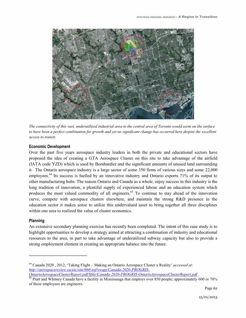
STRATEGIC REGIONAL RESEARCH – A Region in Transition
Page 62
15/01/2013
The connectivity of this vast, underutilized industrial area to the central area of Toronto would seem on the surface
to have been a perfect combination for growth and yet no significant change has occurred here despite the excellent
access to transit.
Economic Development
Over the past five years aerospace industry leaders in both the private and educational sectors have
proposed the idea of creating a GTA Aerospace Cluster on this site to take advantage of the airfield
(IATA code YZD) which is used by Bombardier and the significant amounts of unused land surrounding
it. The Ontario aerospace industry is a large sector of some 350 firms of various sizes and some 22,000
employees.64
Its success is fuelled by an innovative industry and Ontario exports 71% of its output to
other manufacturing hubs. The reason Ontario and Canada as a whole, enjoy success in this industry is the
long tradition of innovation, a plentiful supply of experienced labour and an education system which
produces the most valued commodity of all engineers.65
To continue to stay ahead of the innovation
curve, compete with aerospace clusters elsewhere, and maintain the strong R&D presence in the
education sector it makes sense to utilize this undervalued asset to bring together all three disciplines
within one area to realized the value of cluster economics.
Planning
An extensive secondary planning exercise has recently been completed. The intent of this case study is to
highlight opportunities to develop a strategy aimed at attracting a combination of industry and educational
resources to the area, in part to take advantage of underutilized subway capacity but also to provide a
strong employment element in creating an appropriate balance into the future.
64 Canada 2020 , 2012, ‘Taking Flight – Making an Ontario Aerospace Cluster a Reality’ accessed at:
http://aerospacereview.ca/eic/site/060.nsf/vwapj/Canada-2020-PROGRIS-
OntarioAerospaceClusterReport.pdf/$file/Canada-2020-PROGRIS-OntarioAerospaceClusterReport.pdf 65
Pratt and Whitney Canada have a facility in Mississauga that employs over 850 people; approximately 600 or 70%
of these employees are engineers.

STRATEGIC REGIONAL RESEARCH – A Region in Transition
Page 63
15/01/2013
Transit
Within a short period of time there will be three subway stations in the vicinity. The first station on that
extension is located south of the intersection of Sheppard Ave East and Chesswood and intersects with
GO commuter trains to Barrie. The station is located at the end of the main runway, and as a result, land
within 500 meters of the station is restricted to two storeys in height. The current ridership expectations
for this station are extremely low. Development in the area relative to the rest of the GTA is negligible.
Industrial growth is stagnant and the immediate area is in the heart of one of the least productive
employment areas of City.
Recommendations
Encourage the City of Toronto to pursue discussions with representatives of universities and
colleges focused on the aerospace sector that have already expressed interest in identifying
funding to facilitate creation of a critical mass of aerospace-related education and research.
Through the same initiative, identify incentives to have aerospace manufacturing and R&D
facilities locate at Downsview.
Continue to review and revise as appropriate land use controls, urban design and site planning
considerations related to implementing a GTA Aerospace Cluster as proposed by aerospace
stakeholders.
STRATEGIC REGIONAL RESEARCH – A Region in Transition
Page 64
15/01/2013
Connecting Home and Work: Approaches
from Other Major Cities The challenges described in this report are not unique to the Greater Toronto Area. Cities across the
world are facing growing populations, shifting demographics, rising congestion and the need for
infrastructure improvements. This section outlines some of the interesting and innovative approaches to
managing these challenges in London, England and the urbanization strategies employed at Tysons
Corner, located on the edge of Washington D.C.
The London Crossrail, U.K Crossrail is a new world‐class, affordable railway that will provide a high‐frequency, high-speed,
high‐capacity and accessible link across London. Crossrail will run 118 km from Maidenhead and
Heathrow in the west, through new twin-bore 21 km tunnels under central London to Shenfield and
Abbey Wood in the east. It will bring an additional 1.5 million people within 45 minutes commuting
distance of London's key business districts. Crossrail will increase the capacity of London’s rail transport
system by over 10% and help relieve congestion on both the transit system and the road network, as the
improvements resulting from Crossrail are expected to reduce car travel as well; it is also heavily
integrated into existing public transportation services, primarily the London Underground.66
At an estimated cost of £15.9B, Crossrail is the largest civil engineering project in Europe.67
The project
is being jointly funded by the Department for Transport (DfT) and Transport for London (TfL) and being
delivered by Crossrail Ltd, a special‐purpose subsidiary of TfL. This project also includes contributions
from the private sector; local businesses, the BAA Group (the international airport company that owns
London Heathrow), the Canary Warf Group (an integrated property development, investment and
management group of companies that has led the transformation of Canary Warf and the development of
over 15M square feet of office, retail and leisure spaces),68
as well as Berkley Homes Group (a residential
development company that is highly active in Woolwich and has planning approval for another 3,700
homes and a significant area of commercial space in the area).69
66 Cross Rail Business Plan, 2009, ‘2009-10-2017/18 – Transport for London and the Mayor of London,’ accessed
at: http://www.crossrail.co.uk/ 67
Ibid 68
Canary Wharf Group, 2012, ‘Company Profile,’ accessed at http://www.canarywharf.com/aboutus/Who-We-
Are/Company-Overview/ 69
London Department of Transport, 2012, ‘Funding Agreed for Woolwich Crossrail,’ accessed at:
http://www.crossrail.co.uk/news/press-releases/dft-press-release-funding-agreed-for-woolwich-crossrail-station-
box
STRATEGIC REGIONAL RESEARCH – A Region in Transition
Page 65
15/01/2013
The Crossrail project is being financed in three ways:
First, Crossrail customers will ultimately contribute around a third of the cost through future fare
box revenues in excess of operating costs.
Second, businesses in London will make direct contributions to capital costs and developer
contributions. More specifically, BAA Group will own the Heathrow Spur (the connection
between Heathrow Airport and Heathrow Tunnel Junction) and the Canary Wharf Group and
Berkley Homes Group have agreed to make contributions towards the cost of the Isle of Dogs
Station and the Woolwich Station Box respectively.70
Additionally, a Business Rate Supplement
(BRS) is being applied that is a levy on large local businesses to fund economic development and
infrastructure projects. 71
The BRS will generate between £150 million to £200 million each year
assuming the levy is set at 2p in the pound of rateable value for properties over £50,000.72
Third, national taxpayers will provide funding through DfT grants; this will account for the
remainder of the project costs. However, benefits resulting from reduced congestion on roads and
public transport, job growth, improved access and productivity gains will create a wide range of
returns to tax payer for years to come.
Crossrail has been in planning since 1989 and strong vision, high levels of cross-sectoral support and
growing demand for improved transit have allowed this project to become a reality. The support of the
private sector confirms the economic viability and necessity of this project, as the private sector
understand the development potential Crossrail will unlock across the region. With an anticipated
completion date of 2017, Crossrail has the potential to transform many London neighbourhoods, connect
and meet the needs of city businesses and dramatically reduce commuting times for the population of the
region.
London’s economy is of significance nationally and its strength makes a major contribution to the
prosperity of the entire nation. London is forecast to experience explosive levels of population and
employment growth. The latest draft London Plan, published in March 2010, expects that by 2031 nearly
1.3 million additional people and 750,000 new jobs will be in the capital. The projected 35% growth in
public transport trips will place additional pressures on the transport network, which is already highly
congested, with high levels of crowding on key National Rail, London Underground and Dockland Light
Railway services, particularly during peak periods.
However, London is taking this growth very seriously and major investment in Crossrail will add capacity
to the transportation system and reduce congestion. In terms of reducing congestion created by personal
vehicles, London has also placed a congestion charge of £10 to enter its Central Charge Zone (CCZ)
70 Linklaters LLP, 2007, ‘Head of Terms in relation to the Crossrail Project’ accessed at
http://webarchive.nationalarchives.gov.uk/+/http:/www.dft.gov.uk/adobepdf/165234/302038/headsofterms.pdf 71
HM Treasury, 2007, ‘Business rate supplements:a White Paper,’ accessed at http://www.hm-
treasury.gov.uk/d/pbr_csr07_businessrate266.pdf 72
London Department of Transport, 2012, ‘Crossrail’s wider economic boost to London and South East revealed’
Accessed at http://www.crossrail.co.uk/news/press-releases/crossrails-wider-economic-boost-to-london-south-east-
revealed#.UBbuIaDa-uI

STRATEGIC REGIONAL RESEARCH – A Region in Transition
Page 66
15/01/2013
Cross Rail is heavily integrated into the London Underground, and creates connections across the entire region.
Image courtesy of crossrail.co.uk
during business hours during the week.73
This tax was originally introduced in 2003 and has significantly
reduced congestion, as well as created a new source of revenue for the city.74
Overall, London has taken
many highly proactive and compatible measures to reduce congestion and respond to growth pressures.
Given the success of these measures in London, the GTA can look to these examples in working to
manage their own similar challenges into the future.
Crossrail, is seen to have the potential to facilitate large scale neighbourhood regeneration around the
stations, creating a willingness for private developers to invest in new station facilitates. Moreover, this
compounds greater development around Crossrail stations as businesses respond to agglomeration effects
and can see that the improved connections will serve their current employees better but also significantly
expand their access to a highly skilled market and provide greater choice for future employees. For
example, it is forecast that over 100,000 additional jobs could be created throughout the Thames Gateway
– with Crossrail directly serving Custom House, Woolwich and Abbey Wood as well as improving
connections to other networks in the area.
Transit development and implementation in the GTA since the first leg of the Yonge Subway was
completed in 1954 has relied on the principle of “build it and they will come” The private sector
employment community was not engaged in the decision to develop our subway system or involved
directly financially. The public and private direct investment in Crossrail shows why we can no longer
afford to construct subways or regional high speed transit service as a tool to induce development.
The GTA would benefit from this type of highly strategic investment, connecting major and established
employment nodes that employ hundreds of thousands of the region’s residents. Moreover, connecting
strategic sites or neighborhoods with significant development potential will likely generate much greater
enthusiasm from the private sector.
73Transport for London, 2008, ‘Central London Congestion Charging: Sixth Annual Report,’ Accessed at
http://www.tfl.gov.uk/assets/downloads/sixth-annual-impacts-monitoring-report-2008-07.pdf 74
Ibid 74
Buchanan, C., 2007, ‘The Economic Benefits of Crossrail,’
STRATEGIC REGIONAL RESEARCH – A Region in Transition
Page 67
15/01/2013
Tysons Corner, Virginia, U.S.A Tysons Corner provides an excellent example of the success that can be had transforming a former
suburban office park through the creation of policy that reflects market realities, highly strategic
investments and the integration of new transit infrastructure. Tysons Corner illustrates benefits of a
counter intuitive concept – reducing congestion by increasing density.
Located 12.5km west of Washington D.C.’s CBD, Tysons Corner has rapidly evolved from a rural
highway intersection to the quintessential post-war suburban office park. It is now among one of North
America’s largest business parks and is the nation’s twelfth largest employment centre. Tysons Corner
had sprawling parking, car-oriented design (~160,000 car parking spaces serve ~170,000 jobs and fewer
than 5,000 residents).
Nearly eight years ago, Fairfax County launched a two-phase project, the Comprehensive (or Tysons)
Plan. It envisions that “by 2050 Tysons will be transformed into a walkable, green urban centre. It will be
home to up to 100,000 residents and 200,000 jobs in that year.”75
The plan was catalyzed by the
impending 37km extension of the Silver Line of Washington’s Metropolitan Regional Transit System to
connect downtown Washington DC to the Dulles Airport. Phase one of this project involves the
establishment of four stations in Tysons Corner to be completed by 2013. The process of involving
employers with the transit design and planning changes created a number of innovative solutions to
transforming a car dependent suburban employment district into a more diverse and urban centre.
The plan delineates eight main districts, four of which are increasingly dense ‘villages’ that surround the
stations. Each district is functionally unique. Each serves an important role, ranging from a transit
gateway, an office space hub, shopping destination, and residential community. All new development
replaces existing surface parking. Targets for higher percentages of office and commercial use closer to
the stations are also included. These benchmarks were established with the intent of drawing people to the
area, and spur more residential use further away from these sections. Emphasis has also been placed on
creating a walkable and bike friendly environment.
One challenge that emerged in the implementation of the Tysons Plan is known as the ‘last mile’ problem.
Commuters disembarking at one of the new transit stations need to travel about a mile to access most of
the office buildings. In response, an amendment was adopted in June 2010 that revised density targets and
increased the focus on developing a new, mixed-use, urban centre comprised of new residential,
commercial and office space around and proximate to stations, which is envisioned to function as Fairfax
County’s downtown. Addressing this challenge is critical for Tysons Corner to become a Transit
Oriented Development, rather than a Transit Adjacent Development, which would have failed to draw
people away from the comfort of the car.
75 Government of Fairfax County, VA, 2012, ‘Wiehle Metro Garage,’ accessed at:
www.fairfaxcounty.gov/living/transportation/wiehle-metro-garage/

STRATEGIC REGIONAL RESEARCH – A Region in Transition
Page 68
15/01/2013
Retrofitting Tysons Corner is also supported by Tysons Partnership, a non-governmental organization that
performs the vital role in the remediation of surface parking by generating civic engagement and
collaborations between the public and private sectors. This facilitation has led to large scale developments
and private sector investments, including the development of urban street guidelines. These guidelines
sew together the gaps left by surface parking by bringing buildings closer together and promoting
walkability (one of the Plan’s defining principles).
Overall, Tysons Corner’s proposed development demonstrates a highly progressive approach to fostering
intensification, active transportation, and regional cohesion in an office park context. This was reinforced
during an interview with Cathy Hudgins, Board Supervisor at Hunter Mill District when she commented
“We are seeing a large scale developments in response to a combination of the transit and strategic
investments…We have experienced developers coming in….they have properties that are adjacent to the
new rail lines and they are anxious to build..” It is still to be seen whether Tysons becomes a success
story or falls short of expectations, this evolving neighbourhood has many critical pieces in place and will
likely provide an excellent model of how to diversify and increase the reliance of a mono-functional
office park.
“It is a traffic jam every day with all the commuters….so we are looking to develop a more walkable
community with housing, retail and transit [to complement the commercial office].”
Interview with Cathy Hudgins, Board Supervisor, Hunter Mill District

STRATEGIC REGIONAL RESEARCH – A Region in Transition
Page 69
15/01/2013
Bibliography Bascomb, N., 2003, ‘Higher: a Historic Race to the Sky and the Making of a City,’ Doubleday
Brown-Bowers, A., 2007, ‘A Globe: Reverse Commuters Reflect Shift in Land Use,’ from the Globe and
Mail, published Dec. 11, 2007, accessed at: http://urbantoronto.ca/forum/archive/index.php/t-
5562.html?s=5a3495793a01a2a855c72224776a305b
Bula, F., 2009, ‘Urban Rail is a New Engine for Development,’ from the Globe and Mail, published Sep.
29 2009, accessed at: http://www.theglobeandmail.com/report-on-business/urban-rail-is-a-new-engine-
for-development/article1304977/
Canadian Urban Institute, 1997, ‘GTA Urban Structure: An Analysis of Progress Towards the Vision,’
Toronto.
Canadian Urban Institute, 2005, ‘Business Competitiveness in the GTA: Why Toronto is Losing Ground,’
Toronto.
Canadian Urban Institute with Real Estate Search Corporation, 2011, ‘The New Geography of Office
Location and the Consequences of Business as Usual in the GTA,’ prepared for the Toronto Office
Coalition, accessed at:
http://www.canurb.com/sites/default/files/reports/2010/TOC_CUI_Report_April2011.pdf
Canary Wharf Group, 2012, ‘Company Profile,’ accessed at http://www.canarywharf.com/aboutus/Who-
We-Are/Company-Overview/
City of Toronto - Planning Division, 2012, ‘Profile Toronto – Living in Downtown and the Centres,’
accessed at: http://www.toronto.ca/planning/pdf/ldc2011_final_pressres.pdf
City of Toronto, 2011, ‘Tall Buildings, Inviting Change in Downtown Toronto’ accessed at:
http://www.toronto.ca/planning/tallbuildingstudy.htm#projectsummary
Cross Rail Business Plan, 2009, ‘2009-10-2017/18 – Transport for London and the Mayor of London,’
accessed at: http://www.crossrail.co.uk/
EMPORIS, 2012, ‘Toronto, North America's new high-rise metropolis,’, Oct. 24 2012 accessed at:
http://www.emporis.com/press/press-releases/toronto-north-americas-new-high-rise-metropolis
Gertler, M., 1991, ‘Toronto: the State of the Regional Economy,’ University of Toronto, Toronto
The Gordon Chong/KPMG Report ‘Public Transit: Back on Track - Toronto Transit Infrastructure
Limited’ specifically excludes the discussion of ridership and ongoing operation financing needs
Government of Canada, 2012, ‘Invest in Canada - Aerospace 2012,’ accessed at:
http://investincanada.gc.ca/download/830.pdf
STRATEGIC REGIONAL RESEARCH – A Region in Transition
Page 70
15/01/2013
Government of Fairfax County, VA, 2012, ‘Wiehle Metro Garage,’ accessed at:
www.fairfaxcounty.gov/living/transportation/wiehle-metro-garage/
Government of Ontario, 2005, ‘Greenbelt Plan,’ accessed at:
http://www.mah.gov.on.ca/Page189.aspx#greenbelt
Government of Ontario, 2006, ‘Places to Grow - The Growth Plan for the Greater Golden Horseshoe,’
accessed at: https://www.placestogrow.ca/index.php?option=com_content&task=view&id=9&Itemid=14
Government of Ontario, 2005, ‘Provincial Policy Statement,’ accessed at:
http://www.mah.gov.on.ca/Page1485.aspx
The Greater Toronto Area - Cordon Count Program, ‘Transportation Trends 1991-2006,’ developed by
MMM Group Ltd. Greater Toronto Area
Hicks, J., 2012, ‘Research, No Motion: How the BlackBerry CEOs Lost an Empire,’ accessed at:
http://www.theverge.com/2012/2/21/2789676/rim-blackberry-mike-lazaridis-jim-balsillie-lost-empire
Hjartarson, J., Hinton, K., & Szala, M., 2011, ‘Putting Canada on Track – A Blueprint for a National
Transit Framework,’ accessed at: http://www.mowatcentre.ca/pdfs/mowatResearch/38.pdf
HM Treasury (2007). Business rate supplements:a White Paper. Accessed at http://www.hm-
treasury.gov.uk/d/pbr_csr07_businessrate266.pdf
Levy, E., 2012, ‘Rapid Transit in Toronto: a Century of Proposals, Process, Politics, and Paralysis.’
Neptis Foundation, forthcoming publication
Linklaters LLP. (2007). Head of Terms in relation to the Crossrail Project. Accessed at
http://webarchive.nationalarchives.gov.uk/+/http:/www.dft.gov.uk/adobepdf/165234/302038/headsofterm
s.pdf
London Department of Transport, 2012, ‘Crossrail’s wider economic boost to London and South East
revealed,’ Accessed at http://www.crossrail.co.uk/news/press-releases/crossrails-wider-economic-boost-
to-london-south-east-revealed#.UBbuIaDa-uI
London Department of Transport, 2012, ‘Funding Agreed for Woolwich Crossrail,’ accessed at:
http://www.crossrail.co.uk/news/press-releases/dft-press-release-funding-agreed-for-woolwich-crossrail-
station-box
Malone Given Parsons, 2012, ‘Sustainable Competitive Advantage and Prosperity - Planning for
Employment Uses in the City of Toronto,’ Toronto
Metrolinx, 2008, ‘The Big Move – Transforming Transportation in the Greater Toronto and Hamilton
Area,’ accessed at: http://www.metrolinx.com/thebigmove/Docs/big_move/TheBigMove_020109.pdf.
Metrolinx website, 2012, ‘Air Rail Link,’ accessed on November 1, 2012 at:
http://www.metrolinx.com/en/projectsandprograms/airraillink/air_rail_link.aspx
STRATEGIC REGIONAL RESEARCH – A Region in Transition
Page 71
15/01/2013
Metrolinx website, 2012, ‘Toronto Light Rail and Transit Projects,’ accessed on November 1, 2012 at:
http://www.metrolinx.com/en/projectsandprograms/transitexpansionprojects/crosstownproject.aspx
Pecaut, D., 1996, ‘The Fourth Era,’ background report for the GTA Task Force
Perkins, T., 2012, ‘Toronto leads North American high-rise construction,’ The Globe and Mail, Oct. 22
2012 accessed at http://m.theglobeandmail.com/report-on-business/economy/housing/toronto-leads-north-
american-high-rise-construction/article4629888/?service=mobile:
Russell, V. L., 1984, ‘Forging a consensus: Historical essays on Toronto,’ published for the Toronto
Sesquicentennial Board by University of Toronto Press, Toronto
TD Economics, 2002, ‘Special Report: The GTA: Canada’s Primary Economic Locomotive in Need of
Repairs,’ Toronto.
Transport for London, 2008, Central London Congestion Charging: Sixth Annual Report. Accessed at
http://www.tfl.gov.uk/assets/downloads/sixth-annual-impacts-monitoring-report-2008-07.pdf
White, R., 2007, ‘The Growth Plan for the Greater Golden Horseshoe in Historical Perspective,’ Neptis
Foundation, Toronto.