Strategic Plan for Marine and Coastal Protected Areas ...
116
Page 1 of 116 Albania SPMCPA Project: “Improving Coverage and management effectiveness of MCPAs” Strategic Plan for Marine and Coastal Protected Areas (SPMCPAs) Plan Design and Development Final Draft Version April 2013 Prepared by: Institute of Nature Conservation in Albania Ministry of Environment, Forest and Water Administration United Nations Development Programme
Transcript of Strategic Plan for Marine and Coastal Protected Areas ...

Page 1 of 116Albania SPMCPAProject: “Improving Coverage and management effectiveness of MCPAs”
Strategic Plan for Marine and Coastal Protected Areas (SPMCPAs)
Plan Design and Development
Final Draft Version April 2013
Preparedby:
Institute of Nature Conservation in Albania
Ministry of Environment, Forest and Water Administration United Nations Development Programme

Page 2 of 116Albania SPMCPAProject: “Improving Coverage and management effectiveness of MCPAs”
Citation:INCA 2013 “Strategic Plan for Marine and Coastal Protected Areas (SPMCPAs)” developed with the support of UNDP in the frame of the Project “Improving Coverage and Management Effectiveness of Marine and Coastal Protected Areas”. Abbreviations&Acronyms ACCOBAMS Agreement on the Conservation of Cetacean of the Black Sea, Mediterranean
Sea and Contiguous Atlantic Area BD Biodiversity Directorate within the MoEFWA BSAP Biodiversity Strategy and Action Plan CBD Convention on Biological Diversity COP Conference of the Parties DCM Decision of Council of Ministers DFP Directorate of Fishery Policy DFS Directorates of Forestry Service EIA Environment Impact Assessment EU European Union GEF Global Environmental Facility GoA Government of Albania EU European union FAO Food and Agriculture organisation of the United Nations FMO Fisheries Management Organisation IMOC Inter-institutional Maritime Operational Centre IPA Instrument for Pre-accession Assistance IPA CBC IPA Cross-border Cooperation IUCN International Union for Conservation of Nature and Natural Resources MAFCP Ministry of Agriculture, Food and Consumer Protection MAP Mediterranean Action Plan MoEFWA Ministry of Environment, Forest and Water Administration MPA Marine Protected Area MCPA Marine and Coastal Protected Area NBSAP National Biodiversity Strategy and Action Plan NGO Non Governmental Organization PA Protected Area PESBLD Pan-European Strategy on Biological and Landscape Diversity RAC/SPA Regional Activity Center/Specially Protected Areas (Tunis) SPMCPAs Strategic Plan for Marine and Coastal Protected Areas RNPA Representative Network of the Protected Areas UNCCC United Nation Convention on Climate Change UNDP United Nations Development Program UNEP United Nations Environmental Program UNEP/MAP United Nations Environmental Program/Mediterranean Action Plan WB World Bank WCMC World Conservation Monitoring Centre WWF World Wildlife Fund

Page 3 of 116Albania SPMCPAProject: “Improving Coverage and management effectiveness of MCPAs”
Acknowledgements INCA would like to thank the following people and institutions for the help they provided in the preparation of this study. We thank the working group of experts (Dr. Zamir Dedej, Dr. Genti Kromidha, Prof. Lefter Kashta, MSc. Roland Kristo, Ermira Kocu) for their valuable expertise and contribution in the preparation of this study. Thanks are due to MSc. Valbona Simixhiu for her contribution in developing all the maps in this study. We are grateful to Anne Walton, NOAA for her valuable support in shaping the document and proof reading the English version. Particular thanks to Dr Alec Dawson Shepherd, International expert on marine biodiversity and Marine and Coastal Protected Area (MCPA) management for his helpful comments and suggestions and continuous support in the development of this study. INCA would like to express its gratitude to BirdLife international, for data and distribution range maps for birds, and IUCN Red list for data and distribution range maps for other species. Thanks are also due to the Ministry of Environment, Forest and Water Administration, particularly to Prof. Pellumb Abeshi, Director General of Environmental Policies, and the staff of the Directorate for Nature Conservation, for their constructive comments and suggestions for improving the study. Finally the professional and continuous support the project team, particularly to Dr. Violeta Zuna, Project Manager and Eno Dodbiba, Technical Officer and the financial contribution of UNDP are gratefully acknowledged. INCA April 2013

Page 4 of 116Albania SPMCPAProject: “Improving Coverage and management effectiveness of MCPAs”
EXECUTIVESUMMARY
Marine and Coastal Protected Areas (MCPAs) are globally recognised as one of the most effective tools for managing the marine and coastal environment where the threats to that environment are geographic (spatial) in nature and where the threats can be managed geographically (spatially). A “Strategic Plan for Marine and Coastal Protected Areas (SPMCPA)” is central to the “Improving Coverage and management effectiveness of marine and coastal protected areas” Project, hereinafter referred to as the “MCPAs project” and forms Output 1.1 of Outcome 1 of the “MCPAs project”. A significant additional output of the “MCPAs project” is to contribute to the revision of the Albanian National Biodiversity Strategy and Action Plan (NBSAP) with respect to marine and coastal protected areas (MCPAs) and to respond to Convention on Biological Diversity (CBD) Conference of the Parties (COP) Decision X/2 and with particular reference to the Aichi targets. The definition of an MCPA used to support this SPMCPA is based on a combination of the 2008 International Union for the Conservation of Nature (IUCN) definition of a protected area, the 2004 Ad Hoc Technical Expert Group (AHTEG) of the CBD definition of an MCPA; and a 2004 definition of the coastal zone:-
“An MCPA1 is a protected area2 that covers contiguous marine and coastal geographic areas comprising the coastal zone3 including such sea, tidal and terrestrial elements as are necessary to sustain ecosystem function”.
The above definition does not include the open sea, the deep sea bed or the terrestrial and exclusively freshwater environment. Whilst the conservation of these areas needs to be undertaken in coordination with the conservation of MCPAs their conservation is not the direct concern of this SPMCPA. This SPMCPA document comprises a situation analysis, criteria for selection of priority areas and species to be included in the SPMCPA and a set of key outcomes and associated actions required to deliver the SPMCPA. Chapter II of the SPMCPA provides the situation analysis. The situation analysis concludes that, despite the coastal area of Albania being one of the biodiversity hotspots in the Mediterranean Sea, there is a lack of information on the conservation status of key habitats and species, with which to develop an SPMCPA. Gap filling (providing this information) is, therefore, proposed to form a key outcome of the SPMCPA. The situation analysis indicates that Albanian marine and coastal ecosystems contribute to sustaining human health, lifestyle, and the food production needed for the economic development and well-being of the coastal population. However, Albanian marine and coastal ecosystems are under increasing pressure. The pressure primarily comes from a rapid increase in coastal urban development and the resulting increase in human use of coastal and marine ecosystems. The pressure will further increase
1 The Project document provides the definition of a “Marine and Coastal Protected Area” (MCPA) adopted by the
AHTEG (Ad Hoc Technical Expert Group) of the Convention of the Biological Diversity in 2004. According to this definition, “Marine and Coastal Protected Area” means any defined area within or adjacent to the marine environment, together with its overlying waters and associated flora, fauna, and historical and cultural features, which has been reserved by legislation or other effective means, including custom, with the effect that its marine and/ or coastal biodiversity enjoys a higher level of protection than its surroundings. The definition needs to be considered in the context of ecosystem function.2 “A clearly defined geographical space, recognised, dedicated and managed, through legal or other effective means, to achieve the long-term conservation of nature with associated ecosystem services and cultural values”. Dudley, N. (Editor) (2008). Guidelines for Applying Protected Area Management Categories. Gland, Switzerland: IUCN. x + 86pp. http://data.iucn.org/dbtw-wpd/edocs/PAPS-016.pdf 3 The interface between land and sea, delineated as the part of the land affected by its proximity to the sea, and the part of the sea affected by its proximity to the land (Mangor, Karsten. 2004. “Shoreline Management Guidelines”. DHI Water and Environment, 294pp.). Http://www.coastalwiki.org/coastalwiki/Coastal_zone

Page 5 of 116Albania SPMCPAProject: “Improving Coverage and management effectiveness of MCPAs”
if projected climate change takes place and air and sea temperature, sea-level, ocean acidification and the frequency and severity of storms and droughts rise. Despite the significance of marine and coastal ecosystems to the social and economic development of Albania and the increasing pressures that these marine and coastal ecosystems face there is a lack of administrative capacity and availability of financial and in kind resources with which to manage these pressures. Capacity building and financial resourcing are, therefore, proposed to form key outcomes of the SPMCPA. Chapter III of the SPMCPA reviews the criteria for selecting habitats and species to be included within the SPMCPA. These criteria reflect Albanian national and also international criteria for sustaining marine and coastal biodiversity. Criteria include: the Aichi targets; habitats and species specified in relevant national legislation; habitats and species specified in European Union (EU) directives and implementing instruments such as Natura 2000, the Barcelona Convention and its protocol concerning Specially Protected Areas of Mediterranean Importance (SPAMI); and the IUCN Red list of threatened species. A final and significant criterion, considering the limited available information, is the precautionary principle/approach4. Chapter IV of the SPMCPA comprises the following seven (7) budgeted outcomes and thirty two (32) subordinate contributing actions. The indicative budget for the 7 outcomes is USD 2’520’000 and the indicative duration is 8 years. The key outcomes and their indicative budgets and durations are listed below:-
Outcome Indicative budget Duration 1 Key information gaps filled USD 750’000 2 years 2 Key enabling legislation delivered USD 190’000 2 years 3 MCPAs Network co-ordination Unit USD 430’000 3 years 4 Network MCPAs gazetted USD 200’000 4 years 5 Network MCPAs management plans USD 600’000 6 years 6 Network species action plans USD 470’000 2 years 7 SPMCPA authorised USD 80’000 0.5 year
Total USD 2’720’000 8 years Outcome 8: Monitoring and Evaluation is also specified but is not budgeted at this time. Outcomes and subordinate contributing actions are listed below and elaborated further in the main text. OUTCOME 1: KEY INFORMATION GAPS FILLED Action 1.1: Status of Reefs determined Action 1.2: Status of Sand Dunes determined Action 1.3: Status of important species of community interest determined Action 1.4: Analysis of extent and impact of invasive/exotic alien species Action 1.5: Assessment of the impacts of inland hydrological interventions on coastal ecosystems Action 1.6: Analysis of socio-economic aspects influencing the management of marine and coastal
natural resources Action 1.7: Financing opportunities assessment Action 1.8: Examples and best practices on MCPA management OUTCOME 2: KEY ENABLING LEGISLATION DELIVERED Action 2.1: Amendment/Redrafting of the Protected Areas Law Action 2.2: Redrafting of the bylaws for the implementation of PA law Action 2.3: Redrafting of the fishing and aquaculture development regulations Action 2.4: Drafting of proposed Law “On marine and coastal PA”. Action 2.5: Protected Areas financing legislation
4 “Noting also that where there is a threat of significant reduction or loss of biological diversity, lack of full scientific certainty should not be used as a reason for postponing measures to avoid or minimize such a threat”. (Preamble to the Convention on Biological diversity). Also specified in the Barcelona Convention.
Page 6 of 116Albania SPMCPAProject: “Improving Coverage and management effectiveness of MCPAs”
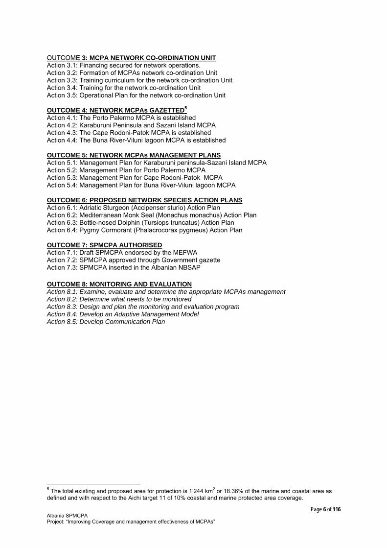
OUTCOME 3: MCPA NETWORK CO-ORDINATION UNIT Action 3.1: Financing secured for network operations. Action 3.2: Formation of MCPAs network co-ordination Unit Action 3.3: Training curriculum for the network co-ordination Unit Action 3.4: Training for the network co-ordination Unit Action 3.5: Operational Plan for the network co-ordination Unit OUTCOME 4: NETWORK MCPAs GAZETTED5 Action 4.1: The Porto Palermo MCPA is established Action 4.2: Karaburuni Peninsula and Sazani Island MCPA Action 4.3: The Cape Rodoni-Patok MCPA is established Action 4.4: The Buna River-Viluni lagoon MCPA is established OUTCOME 5: NETWORK MCPAs MANAGEMENT PLANS Action 5.1: Management Plan for Karaburuni peninsula-Sazani Island MCPA Action 5.2: Management Plan for Porto Palermo MCPA Action 5.3: Management Plan for Cape Rodoni-Patok MCPA Action 5.4: Management Plan for Buna River-Viluni lagoon MCPA OUTCOME 6: PROPOSED NETWORK SPECIES ACTION PLANS Action 6.1: Adriatic Sturgeon (Accipenser sturio) Action Plan Action 6.2: Mediterranean Monk Seal (Monachus monachus) Action Plan Action 6.3: Bottle-nosed Dolphin (Tursiops truncatus) Action Plan Action 6.4: Pygmy Cormorant (Phalacrocorax pygmeus) Action Plan OUTCOME 7: SPMCPA AUTHORISED Action 7.1: Draft SPMCPA endorsed by the MEFWA Action 7.2: SPMCPA approved through Government gazette Action 7.3: SPMCPA inserted in the Albanian NBSAP OUTCOME 8: MONITORING AND EVALUATION Action 8.1: Examine, evaluate and determine the appropriate MCPAs management Action 8.2: Determine what needs to be monitored Action 8.3: Design and plan the monitoring and evaluation program Action 8.4: Develop an Adaptive Management Model Action 8.5: Develop Communication Plan
5 The total existing and proposed area for protection is 1’244 km2 or 18.36% of the marine and coastal area as defined and with respect to the Aichi target 11 of 10% coastal and marine protected area coverage.

Page 7 of 116Albania SPMCPAProject: “Improving Coverage and management effectiveness of MCPAs”
Table of Contents I INTRODUCTION............................................................................................................... 10
I.1 ASSIGNMENTOVERVIEW..............................................................................................................10
I.2 WHATISANMCPA?..........................................................................................................................10
I.3 Structureofthedocument.............................................................................................................11
II SITUATION ANALYSIS ................................................................................................... 12
II.1 MARINEANDCOASTALRESOURCES........................................................................................12
II.1.1 Habitatsofconcern.................................................................................................................12
II.1.2 Speciesofconcern....................................................................................................................14
II.1.3 AlienmarinespeciesoccurringinAlbania....................................................................17
II.1.4 Ecosystemlinkagesandservices.......................................................................................18
II.2 Threatstotargetresources...........................................................................................................19
II.2.1 Humanusethreats...................................................................................................................19
II.2.2 Naturalperturbations............................................................................................................20
II.2.3 Climatechangevulnerabilities...........................................................................................21
II.2.4 HumanuseactivitieswithreferencetoanythatdependonMCPAecosystemderivedgoodsandservices..............................................................................................23
II.3 LEGALANDPOLICY..........................................................................................................................27
II.3.1 InternationalContext.............................................................................................................27
II.3.2 NationalContext.......................................................................................................................30
II.4 MANAGEMENT....................................................................................................................................32
II.4.1 ExistingMCPAs..........................................................................................................................34
II.4.2 Otherexistingmanagementareasofsignificance.....................................................36
II.4.3 AdditionallyproposedMCPAs/boundaryrevisionsofexistingMCPAs...........38
II.5 FINANCIALASPECTS........................................................................................................................39
II.6 Stakeholderanalysis.........................................................................................................................40
II.7 Informationgaps................................................................................................................................43
III CRITERIA FOR SELECTING MCPAs .......................................................................... 45
III.1 InternationalcriteriaforselectingMCPAs.............................................................................45
III.1.1 CBDcriteria.................................................................................................................................45
III.1.2 IUCNcriteria...............................................................................................................................46
III.1.3 EUcriteria....................................................................................................................................47
III.1.4 BarcelonaConventioncriteria............................................................................................49
III.2 NationalcriteriaforselectingMCPAs.......................................................................................50
III.3 THEMCPAsNETWORKINALBANIA........................................................................................50
III.3.1 ObjectivesofSPofMCPAnetwork...................................................................................50

Page 8 of 116Albania SPMCPAProject: “Improving Coverage and management effectiveness of MCPAs”
III.3.2 SiteselectioncriteriafortheMCPAsnetwork.............................................................51
III.4 SPMCPAsSITESSELECTION.........................................................................................................53
III.4.1 Targetresourcesforprotection(habitatsofconcern)............................................53
III.4.2 Targetresourcesforprotection(speciesofconcern)..............................................54
III.4.3 Selectionofsites.......................................................................................................................56
IV Proposed Strategic Plan ..................................................................................................... 58
IV.1 INTRODUCTION..................................................................................................................................58
IV.2 OUTCOME1:KEYINFORMATIONGAPSFILLED.................................................................58
IV.2.1 Action1.1:StatusofReefsdetermined...........................................................................58
IV.2.2 Action1.2:StatusofSandDunesdetermined..............................................................58
IV.2.3 Action1.3:Statusofimportantspeciesofcommunityinterestdetermined.59
IV.2.4 Action1.4:Analysisofextentandimpactofinvasive/exoticalienspecies....59
IV.2.5 Veprimi1.5:Vlerësimiindikimitteprojektevedhendërhyrjevetendryshmehidroteknikeneekosistemetbregdetare...................................................................59
IV.2.6 Action1.6:Analysisofsocio‐economicaspectsinfluencingthemanagementofmarineandcoastalnaturalresources...............................................................59
IV.2.7 Action1.7:Financingopportunitiesassessment........................................................59
IV.2.8 Action1.8:ExamplesandbestpracticesonMCPAmanagement........................60
IV.3 OUTCOME2:KEYENABLINGLEGISLATIONDELIVERED...............................................60
IV.3.1 Action2.1:Amendment/RedraftingoftheProtectedAreasLaw.......................60
IV.3.2 Action2.2:RedraftingofthebylawsfortheimplementationofPAlaw..........61
IV.3.3 Action2.3:Redraftingofthefishingandaquaculturedevelopmentregulations......................................................................................................................................................61
IV.3.4 Action2.4:DraftingofproposedLaw“OnmarineandcoastalPA”...................61
IV.3.5 Action2.5:ProtectedAreasfinancinglegislation......................................................62
IV.4 OUTCOME3:MCPANETWORKCO‐ORDINATIONUNIT..................................................62
IV.4.1 Action3.1:Financingsecuredfornetworkoperations...........................................62
IV.4.2 Action3.2:FormationofMCPAsnetworkco‐ordinationUnit..............................62
IV.4.3 Action3.3:Trainingcurriculumforthenetworkco‐ordinationUnit...............62
IV.4.4 Action3.4:Trainingforthenetworkco‐ordinationUnit........................................62
IV.4.5 Action3.5:OperationalPlanforthenetworkco‐ordinationUnit......................63
IV.5 OUTCOME4:NETWORKMCPAsGAZETTED.........................................................................63
IV.5.1 Action4.1:ThePortoPalermoMCPAisestablished................................................63
IV.5.2 Action4.2:KaraburuniPeninsulaandSazaniIslandMCPA..................................64
IV.5.3 Action4.3:TheCapeRodoni‐PatokMCPAisestablished.......................................64
IV.5.4 Action4.4:TheBunaRiver‐VilunilagoonMCPAisestablished..........................64
IV.6 OUTCOME5:NETWORKMCPAsMANAGEMENTPLANS.................................................65

Page 9 of 116Albania SPMCPAProject: “Improving Coverage and management effectiveness of MCPAs”
IV.6.1 Action5.1:ManagementPlanforKaraburunipeninsula‐SazaniIslandMCPA 65
IV.6.2 Action5.2:ManagementPlanforPortoPalermoMCPA.........................................65
IV.6.3 Action5.3:ManagementPlanforCapeRodoni‐PatokMCPA...............................65
IV.6.4 Action5.4:ManagementPlanforBunaRiver‐VilunilagoonMCPA...................65
IV.7 OUTCOME6:PROPOSEDNETWORKSPECIESACTIONPLANS.....................................65
IV.7.1 Action6.1:AdriaticSturgeon(Accipensersturio)ActionPlan............................66
IV.7.2 Action6.2:MediterraneanMonkSeal(Monachusmonachus)ActionPlan....66
IV.7.3 Action6.3:Bottle‐nosedDolphin(Tursiopstruncatus)ActionPlan.................66
IV.7.4 Action6.4:PygmyCormorant(Phalacrocoraxpygmeus)ActionPlan.............66
IV.8 OUTCOME7:SPMCPAAUTHORISED........................................................................................66
IV.8.1 Action7.1:DraftSPMCPAendorsedbytheMEFWA................................................66
IV.8.2 Action7.2:SPMCPAapprovedthroughGovernmentgazette...............................66
IV.8.3 Action7.3:SPMCPAinsertedintheAlbanianNBSAP..............................................66
IV.9 OUTCOME8:MONITORINGANDEVALUATION..................................................................67
IV.9.1 Action8.1:Examine,evaluateanddeterminetheappropriateMCPAsmanagementeffectivenessmonitoringandevaluationmodelstobeappliedattheMCPAsnetworklevel.................................................................................................................................67
IV.9.2 Action8.2:Determinewhatneedstobemonitored.................................................67
IV.9.3 Action8.3:Designandplanthemonitoringandevaluationprogram..............67
IV.9.4 Action8.4:DevelopanAdaptiveManagementModel.............................................67
IV.9.5 Action8.5:DevelopCommunicationPlans...................................................................67
V References ............................................................................................................................ 68
VI Annexes ................................................................................................................................ 71

Page 10 of 116Albania SPMCPAProject: “Improving Coverage and management effectiveness of MCPAs”
I INTRODUCTION I.1 ASSIGNMENT OVERVIEW Marine and coastal biodiversity and the ecosystem goods and services that this biodiversity supports have high environmental, social and economic value but are under unprecedented pressure both globally and in Albania from urban expansion, industrial pollution, overexploitation, and potentially from climate change. Marine and Coastal Protected Areas (MCPAs) are globally recognised as one of the most effective tools for managing the marine and coastal environment where the threats to that environment are geographic (spatial) in nature and where the threats can be managed geographically (spatially). A “Strategic Plan for Marine and Coastal Protected Areas (SPMCPA)” is central to the “Improving Coverage and management effectiveness of marine and coastal protected areas” Project, hereinafter referred to as the “MCPAs project” and forms Output 1.1 of Outcome 1 of the “MCPAs project”. Decision X/26, of the Conference of the Parties (COP) to the Convention of Biological Diversity (CBD), to which Albania is a party, adopted the Strategic Plan for Biodiversity 2011-2020 and the associated Aichi biodiversity targets. In the same decision, the COP urged Parties and other Governments to develop national and regional targets, using the Strategic Plan as a flexible framework, and to review, update and revise, as appropriate, their National Biodiversity Strategies and Action Plans (NBSAP) in line with the Strategic Plan and the guidance adopted in CBD Decision IX/9. The COP also urged Parties and other governments to support the updating of NBSAP as effective instruments to promote the implementation of the Strategic Plan and to use the revised and updated NBSAP as effective policy instruments for the integration of biodiversity targets into national development and poverty reduction policies and strategies, national accounting, economic sectors and spatial planning processes. The Albanian government intends to revise its 1999 NBSAP to respond to CBD Decision X/2. In addition to delivering Output 1.1 of the Project, a significant additional output of this assignment is to contribute to the revision of the NBSAP with a particular focus on marine and coastal protected areas (MCPAs) to respond to CBD Decision X/2 and with particular reference to the Aichi targets. I.2 WHAT IS AN MCPA? The definition of an MCPA is based on a combination of the 2008 IUCN definition of a protected area7, the 2004 Ad Hoc Technical Expert Group (AHTEG) of the CBD definition of an MCPA8; and a 2004 definition of the coastal zone9:-
“An MCPA10 is a protected area11 that covers contiguous marine and coastal geographic areas comprising the coastal zone12 including such sea, tidal and terrestrial elements as are necessary to sustain ecosystem function”.
6 http://www.cbd.int/doc/decisions/cop-10/cop-10-dec-02-en.pdf 7 “A clearly defined geographical space, recognised, dedicated and managed, through legal or other effective means, to achieve the long-term conservation of nature with associated ecosystem services and cultural values”. Dudley, N. (Editor) (2008). Guidelines for Applying Protected Area Management Categories. Gland, Switzerland: IUCN. x + 86pp. http://data.iucn.org/dbtw-wpd/edocs/PAPS-016.pdf 8 The Project document provides the definition of a “Marine and Coastal Protected Area” (MCPA) adopted by the
AHTEG (Ad Hoc Technical Expert Group) of the Convention of the Biological Diversity in 2004. According to this definition, “Marine and Coastal Protected Area” means any defined area within or adjacent to the marine environment, together with its overlying waters and associated flora, fauna, and historical and cultural features, which has been reserved by legislation or other effective means, including custom, with the effect that its marine and/ or coastal biodiversity enjoys a higher level of protection than its surroundings. The definition needs to be considered in the context of ecosystem function.9 The interface between land and sea, delineated as the part of the land affected by its proximity to the sea, and the part of the sea affected by its proximity to the land (Mangor, Karsten. 2004. “Shoreline Management Guidelines”. DHI Water and Environment, 294pp.). Http://www.coastalwiki.org/coastalwiki/Coastal_zone

Page 11 of 116Albania SPMCPAProject: “Improving Coverage and management effectiveness of MCPAs”
The above definition does not include the open sea, the deep sea bed or the terrestrial and exclusively freshwater environment. Whilst the conservation of these areas needs to be undertaken in coordination with the conservation of MCPAs their conservation is not the direct concern of this SPMCPA. I.3 Structure of the document This document is structured into 4 main Chapters. Chapter I provides the context and structure of this document. Chapter II provides a situation analysis with respect to the need for and the opportunities and constraints to developing and delivering the SPMCPAs. Chapter III reviews criteria that might be used to identify areas to form part of an MCPAs network and an inventory of existing and proposed MCPAs against the criteria specified and justifies their inclusion in a network of MCPAs. Chapter IV provides a description of the actions required for the development and delivery of the SPMCPAs. A list of References used is provided as Chapter V. The annexes in Chapter VI provide background materials. This document should be reviewed and revised at intervals suggested to be 7 years in duration to allow for lessons learned to be applied.
10
The Project document provides the definition of a “Marine and Coastal Protected Area” (MCPA) adopted by the AHTEG (Ad Hoc Technical Expert Group) of the Convention of the Biological Diversity in 2004. According to this definition, “Marine and Coastal Protected Area” means any defined area within or adjacent to the marine environment, together with its overlying waters and associated flora, fauna, and historical and cultural features, which has been reserved by legislation or other effective means, including custom, with the effect that its marine and/ or coastal biodiversity enjoys a higher level of protection than its surroundings. The definition needs to be considered in the context of ecosystem function.11 “A clearly defined geographical space, recognised, dedicated and managed, through legal or other effective means, to achieve the long-term conservation of nature with associated ecosystem services and cultural values”. Dudley, N. (Editor) (2008). Guidelines for Applying Protected Area Management Categories. Gland, Switzerland: IUCN. x + 86pp. http://data.iucn.org/dbtw-wpd/edocs/PAPS-016.pdf 12 The interface between land and sea, delineated as the part of the land affected by its proximity to the sea, and the part of the sea affected by its proximity to the land (Mangor, Karsten. 2004. “Shoreline Management Guidelines”. DHI Water and Environment, 294pp.). Http://www.coastalwiki.org/coastalwiki/Coastal_zone

Page 12 of 116Albania SPMCPAProject: “Improving Coverage and management effectiveness of MCPAs”
II SITUATION ANALYSIS This chapter presents a situation analysis of the current status of the marine and coastal environment in Albania, the threats to this environment, and the legal, policy, management and financial opportunities and constraints to managing these threats. Much of the situation analysis is incomplete due to the lack of available information. Any critical information gaps are specified in the text and are addressed as part of the SPMCPA. II.1 MARINE AND COASTAL RESOURCES The coastal area of Albania is one of the hot spots for biodiversity in the Mediterranean Sea. The coastal landscape is highly heterogeneous, including lagoons, wetlands, sand dunes and river deltas. Yet, in the last 20 years, Albania has undergone profound changes, almost without peer among other transition economies in the region. The effects of such transformation have become very visible in terms of spatial distribution of human activities, and in the standard of living in urban areas, especially for those areas that are growing rapidly (World Bank, 2007). In 2001, about 55% of the Albanian population lived in the lowlands near the coast; this number reached 60% in 2008. This migration combined with rapid and largely unregulated urban, tourism and industrial development has lead to water pollution, soil erosion and over fishing, threatening marine biodiversity and the sustainability of ecosystem goods and services. In Albania, mitigation of the effects of human activities is particularly challenging since a complex suite of stressors is presently operating in the sea and along the coast. The urgent need for an ecosystem-based spatial management strategy, ensuring sustainable development while conserving and managing natural biodiversity and resources, is a prerequisite to reducing the cumulative effect of stressors and accommodating the broad range of impacts on coastal habitats, so as to protect them from further deterioration. Marine and coastal ecosystems provide crucial goods and services that support communities and economies, including food security, recreational opportunities, and other benefits (Boero and Bonsdorff, 2007; Sala et al., 2008). Effective environmental management and protection help maintain high productivity and high diversity in marine systems, safeguarding social and economic development. The data summarised below reflects an evaluation of the marine and coastal studies and research work that have been undertaken in Albania. It needs to be recognised that the studies, to date, are limited as is the information from these studies. This limited information is a significant constraint to prioritising sites for designation as MCPAs. The available information does not allow for a particularly useful assessment of the conservation status of most of habitats and species of concern that are identified in Chapter III. As indicated in Chapter IV the precautionary principle13 therefore needs to be applied when selecting areas as possible MCPAs. It follows that a key focus for the SPMCPAs must be the filling of gaps concerning the conservation status of key habitats and species. II.1.1 Habitats of concern COASTAL AND HALOPHYTIC HABITATS Posidonia beds (Posidonia oceanica) - Priority habitat type of community interest; EU Habitats Directive code: 1120. The beds of Posidonia oceanica are amongst the most important Mediterranean marine ecosystem. , Their conservation is a high international priority - Posidonia oceanica is included in Annex I (strictly protected flora species) of the Berne Convention and Annex II (list of endangered or threatened species) of the Barcelona Convention. Posidonia oceanica is also included in the Red Book of Albanian Flora (Electronic version, 2006)
13 “Noting also that where there is a threat of significant reduction or loss of biological diversity, lack of full scientific certainty should not be used as a reason for postponing measures to avoid or minimize such a threat”. (Preamble to the Convention on Biological diversity). Also specified in the Barcelona Convention.

Page 13 of 116Albania SPMCPAProject: “Improving Coverage and management effectiveness of MCPAs” 28
The results of the mapping of Posidonia oceanica beds in Albania show that this habitat covers in total about 3000 ha of the shallow coastal area (Pititto et al., 2009). The most extensive meadows are those in the Ionian coast of the country, from Himara to the southern border with Greece. Recent studies of the distribution of Posidonia oceanica along the Albanian coast indicate that habitats of this sensitive sea grass are seriously disturbed, particularly along the Adriatic coast of Albania, and are reducing in extent and condition (Pititto et al., 2009; Maiorano et al., 2011). The main cause of sea grass decline is human disturbance, most notably resulting in eutrophication, physical destruction of habitat, and over fishing. For example, when humans drive motor boats over shallow sea grass areas, the propeller can tear out or cut the sea grass, and these damaged areas can further erode. Excessive input of nutrients (nitrogen, phosphorus) is directly toxic to sea grasses, but most importantly, it stimulates the growth of epiphytic and free-floating macro- and micro-algae. These algae filter out the sunlight, reducing the photosynthesis that is necessary for sea grass to grow. Decaying sea grass leaves and algae also fuel increasing algal blooms, resulting in a positive feedback. This can cause a complete regime shift from sea grass to algal dominance. Recent surveys also show an increasing prevalence of the invasive algae Caulerpa racemosa var. cylindracea, which is a strong competitor with sea grass beds (Kashta et al., 2005; 2007; Kashta, 2009). To safeguard these meadows, it is necessary to define their range and density, follow their developments in time, and in the case of deterioration, understand and manage the source of impact(s). Coastal lagoons - Priority habitat type of community interest; Habitat Directive code 1150 Lagoons are expanses of shallow coastal salt water, of varying salinity and water volume, wholly or partially separated from the sea by sand banks or shingle, or, less frequently, by rocks. In Albania these coastal lagoons exceed 15,000 hectares and have economic and ecological interest since they constitute important areas for fishing, as well as important sites for birds. These lagoons are important crossroad for the migration of birds, bats, and insects. The Patok area is an important feeding ground for sea turtles in the Mediterranean (White et al., 2011). These lagoons are areas of multiple ecological and economic values and uses, as they provide fish and wildlife habitats, support complex food webs, absorb water to reduce flooding and damage from storms, provide erosion control, improve the quality of water, and, in particular, provide open space and aesthetic value. It is estimated that coastal lagoons, as specific ecosystems between the land and the sea, are the most productive aquatic ecosystems (Troussellier 2007). All wetlands are threatened by a series of anthropogenic factors such as tourism, agriculture, fisheries, construction and erosion. Tourism activities are the main driver of impacts due to the uncontrolled urbanization that these areas are experiencing (buildings, roads, and inadequate solid and liquid waste management). At the other hand, there have been several assessments trying to identify the impacts human induced phenomena like flooding, hydrological regime changes, hydro-technical interventions along rivers (dikes, dams, coastal erosion barriers), coastal erosion, sand extraction, building of harbours (for small boats, yachts), oil spill pollution, etc, on marine and coastal ecosystems extension and functioning. Reefs - EU Habitats Directive code: 1170 According to the Interpretation Manual of European Union Habitats Eur27, we can mention the following most typical Mediterranean biocenosys as part of Reef habitat types present in Albania: Lithophyllum byssoides rims in the medio-littoral stage, Fucal forests (biocenoses with Cystoseira) in the infra-littoral stage, and the coralligenous in the circa-littoral stage. Lithophyllum byssoides rim This habitat, particularly characterized by the presence of calcareous algal formations (manly of red alga Lithophyllum byssoides), is common in the northern and central parts of the western Mediterranean and in the Adriatic Sea. This habitat is present in fragments along Ionian coast of

Page 14 of 116Albania SPMCPAProject: “Improving Coverage and management effectiveness of MCPAs”
Sazani-Karaburuni western side and the Himara area. The area and condition of this habitat has not yet been quantified in Albania. Fucal forests (biocenoses with Cystoseira spp.) The various species of the Cystoseira genus can occupy large areas in the marine ecosystems, where they form highly productive communities with remarkable biodiversity. The habitat known as "Fucal forest" in Albania is composed of C. amentacea, C. barbata, Cystoseira crinita, C. spinosa and Sargassum vulgare. This habitat is found mainly along Ionian coast (Sazani-Karaburuni western side, Himara, and Saranda area). The area and condition of this habitat has not yet been quantified in Albania. The ichthyofauna living at the level of this biocenosis is diverse and rich; and as such is subject to heavy pressure from commercial and leisure fishing. This habitat is particularly vulnerable to coastal development and organic pollutants. SAND DUNES Coastal sand dune systems are comprised of sand and gravel deposits within a marine beach system, including, frontal dunes, dune ridges, back dunes and other sand and gravel areas deposited by wave or wind action. Dunes play a major part in preserving beaches and protecting the forests, biological communities and human facilities that lie behind them. A healthy coastal sand dune system is also the least costly way to maintain a recreational beach for future generations. Sand dunes, as fragile and mobile systems, are subject to both natural and human-caused threats such as storm blowouts, mining efforts, development, and invasive species. Human activities such as sand extraction, trampling, vehicle driving and uncontrolled use of surrounding public or private lands are resulting in large scale erosion. In some coastal areas (Durres, Shengjin, Vlore) the construction of mass tourist facilities are responsible for extensive erosion of dunes. Embryonic shifting dunes - Habitat Directive code: 2110 Formations of the coast representing the first stages of dune construction constituted by ripples or raised sand surfaces of the upper beach or by a seaward fringe at the foot of tall dunes. The top of the beach is where the first vegetation starts to colonize so creating the opportunity for dune formation. On a prograding (building) dune system this vegetation may be the precursor to the main dune-building vegetation dominated by marram (Ammophila arenaria). This habitat type is of exceptional importance and is an indicator of the general structural and functional ‘health’ of a dune system. The area and condition of this habitat has not yet been quantified in Albania. Shifting dunes along the shoreline with Ammophila arenaria (white dunes) - Habitat Directive code: 2120 Mobile dunes forming the seaward cordon or cordons of dune systems of the coasts. This habitat represents a narrow zone of pioneer vegetation dominated by Elymus farctus and/or Ammophila arenaria. The area and condition of this habitat has not yet been quantified in Albania. Coastal dunes with Juniperus spp. - Priority habitat type of community interest; Habitat Directive code: 2250 Characteristic Plants: Juniperus oxycedrus ssp. macrocarpa, Euphorbia paralias, Elymus farctus, Lagurus ovata, Eryngium maritimum, Pancratium maritimum. This habitat type is better developed along coastal areas near Shkumbini and Vjosa rivers. The area and condition of this habitat has not yet been quantified in Albania. Wooded dunes with Pinus pinea and/or Pinus pinaster - Priority habitat type of community interest; Habitat Directive code: 2270 Coastal dunes colonised by Mediterranean and Atlantic thermophilous pines, Pinus pinea, P. pinaster, P. halepensis, This habitat is threatened by erosion, which in some areas is very aggressive,; especially in the north of the Drin River estuary. Other threats are tourism development, urbanization and other activities. The area and condition of this habitat has not yet been quantified in Albania. II.1.2 Species of concern
A. Fish species

Page 15 of 116Albania SPMCPAProject: “Improving Coverage and management effectiveness of MCPAs”
Acipenser naccarii (Bonaparte, 1836) Adriatic sturgeon IUCN Red List Category: Critically Endangered (CR) The species A. naccarii is listed in Annex 2 of the Council Directive 92/43/EEC of 21 May 1992 on the conservation of natural habitats and of wild fauna and flora of community interest whose conservation requires the designation of special areas of conservation. This species was also listed on CITES Appendix II in 1998. Adriatic Sea and its tributaries between Po (Italy) and Buna (Albania) drainages is considered as the range of its distribution Acipenser sturio (Linnaeus, 1758) - Baltic sturgeon IUCN Red List Category: Critically Endangered. Species of Annex II of Habitats Directive. The Atlantic or the European Sturgeon (Acipenser sturio), also known as common sturgeon, is a species of sturgeon found on most coasts of Europe. It is currently a critically endangered species. In Albania Acipenser sturio is known to be found in Shkodra Lake, Buna River and Buna-Sea (Schneider-Jacoby et al., 2006).
B. Reptile species Caretta caretta (Linnaeus, 1758) - Loggerhead, IUCN Red List Category: Endangered Chelonia mydas (Linnaeus, 1758) - Green Turtle, IUCN Red List Category: Endangered Dermochelys coriacea (Vandelli, 1761) - Leatherback, IUCN Red List Category: Critically Endangered All three of the sea turtle species listed above are found in Albanian waters, especially the loggerhead and green turtle. However, none nest on the Albanian coast. The green turtle feeds mostly in the Patok area in Albanian waters. The nearest nesting site is on the Greek coast. The Albanian coast seems to be an important migrating corridor for the loggerhead turtle Caretta caretta, from its nesting site in Zakynthos Island in Greece at the Ionian Sea, to the Patoku coast of the Albanian Adriatic Sea, which has recently been identified (MEDASET14 2012) as an important foraging site for this species. Testudo hermanni Gmelin, 1789 - Hermann's Tortoise IUCN Red List Category: Near Threatened. Species of Annex II of Habitats Directive. Testudo hermanni occurs in patchily in Mediterranean Europe. It is a common species all over Albania (Haxhiu 1998). The subspecies Testudo hermanni boettgeri occur in Former Yugoslavia, Albania, Romania, Bulgaria, Greece and Western Turkey. Where it still exists, their preferred habitat is the Mediterranean oak forest, though they are commonly found in maquis or garigue habitat on hillsides and farmland, or in dune scrubs or maritime grasslands. Threats: Habitat loss through urbanization, forest fires and tourism are of major concern for this species. The significance of coastal areas in Albania to the survival of this species is not known. Emys orbicularis (Linnaeus, 1758) - The European pond turtle IUCN Red List Category: Lower Risk/near threatened. Species of Annex II of Habitats Directive It is found in southern and central Europe, West Asia and North Africa. In Europe, it is largely confined to southern and central countries. Common in Albania - (Haxhiu 1998) prefers to live in wetlands surrounded by a large portion of natural, wooded, landscape. Emys orbicularis have become rare in most countries even though they are widely distributed in Europe. The significance of coastal areas in Albania to the survival of this species is not known.
C. Mammal species Delphinus delphis (Linnaeus, 1758) Short-beaked Common Dolphin IUCN Red List Category: Least Concern. The species is included on Appendix II of Habitats Directive The short-beaked common dolphin is an oceanic species that is widely distributed in tropical to cool temperate waters of the Atlantic and Pacific Oceans, from near shore waters to thousands of kilometers offshore. Once one of the most common species in the Mediterranean Sea, the short-beaked common dolphin has experienced a generalized and major decline during the last 40-50 years, particularly in the northern Adriatic Sea and the eastern Ionian Sea (Bearzi et al. 2004; 2006).
14 Action Plan for the conservation of sea turtles MEDASET 2012, approved by the MEFWA.

Page 16 of 116Albania SPMCPAProject: “Improving Coverage and management effectiveness of MCPAs”
In the eastern part of the Mediterranean the species is predominantly coastal. In the western part of the Mediterranean Sea the species is predominantly pelagic. The main factors thought to have contributed, singly or cumulatively, to the decline of Mediterranean short-beaked common dolphins include: incidental mortality in fishing gear, especially driftnets, reduced availability of prey caused by overfishing and habitat degradation, contamination by xenobiotic chemicals resulting in immunosuppressant and reproductive impairment. The significance of coastal areas in Albania to the survival of this species is not known. Lutra lutra (Linnaeus, 1758) Common Otter Red List Category: Near Threatened. The species is included on Annex II of Habitats Directive The Common otter - is a carnivore that has adapted well to aquatic life, always associated with rivers, streams, ponds, lakes, reservoirs, estuaries, or coastal habitats. Historically, its distribution extended over Europe and Asia but after the 1950s, the species declined substantially in Western Europe becoming absent from large areas of its former range. In Albania otters were widespread in much of the country, and healthy populations were localised in rivers and marshes in the north west and in the south. In the coastal plains, several rivers were grossly polluted and the growing agricultural and industrial development may endanger survival of otters. The significance of coastal areas in Albania to the survival of this species is not known. Monachus monachus (Hermann, 1779) Mediterranean Monk Seal IUCN Red List Category: Critically Endangered. Species of Appendix II of Habitats Directive. The Mediterranean monk seal is one of the most endangered species of mammals. The species is described as ”critically endangered” by the World Conservation Union (IUCN) and international legal mechanisms which recognise and attempt to address the monk seal’s critically endangered status include the Bonn Convention, the Bern Convention, the Convention on Biological Diversity, Convention on International Trade in Endangered Species (CITES) and the EU Habitats Directive. While there is little definitive information available on the status or habitat of the Mediterranean monk seal in Albanian waters, there is evidence of its presence in our waters. Rather than pointing to a resident population, sporadic sightings have been attributed to seasonal movements from the Ionian Islands of Greece (the last one took place in August 2012 in Karaburuni area). The caves along the Albanian coastline, especially those of the Western coast of the Karaburuni peninsula, may serve as a bridge for possible future monk seal repopulation of the Central and Northern Adriatic Sea, rather than just important shelters for “local” monk seal breeding populations. The main threats against the Mediterranean monk seal include: habitat deterioration and loss by coastal development, including disturbance by tourism and pleasure boating; accidental entanglement in fishing gear leading to death by drowning; and decreased food availability due to over-fishing pressures. Tursiops truncatus (Montagu, 1821) - Bottle-nosed Dolphin Red List Category: Least Concern. The species is included on Appendix II of Habitats Directive Common Bottlenose Dolphins are distributed worldwide through tropical and temperate inshore, the coastal, shelf, and oceanic waters where distinct ecotypes are known, the inshore forms frequent estuaries, bays, lagoons and other shallow coastal regions, occasionally ranging far up into rivers. Coastal and island-centered populations are especially vulnerable to hunting, incidental catch, and habitat degradation. The only Mediterranean area with quantitative historical information is the northern Adriatic Sea, where Bottlenose Dolphins are likely have declined by at least 50% over the past 50 years, largely as a consequence of historical killing in extermination campaigns to reduce competition for fish, followed by habitat degradation and over fishing. The significance of coastal areas in Albania to the survival of this species is not known.
D. Bird species of Annex I of the Birds Directive Pelecanus crispus (Bruch, 1832) Dalmatian Pelican IUCN Red List Category: Vulnerable. The species is included on Appendix II of Habitats Directive, and on Appendix II of the Bern Convention.

Page 17 of 116Albania SPMCPAProject: “Improving Coverage and management effectiveness of MCPAs”
The Dalmatian pelican is included in the list of strictly protected species, and is actually still under threat. Its population has been continuously decreasing. There were an estimated 200-250 breeding pairs in the ‘80’s. The current nesting population in Albania is estimated to be no more than 30 pairs (Kallfa et al., 2010). Among the factors that influence the survival and well being of the Dalmatian pelican’s colonies, it is worth mentioning: killing of individuals due to illegal hunting, destruction of nests and continuous disturbance of the nesting colony, destruction of hydrological regime and degradation of habitats for feeding and reproduction, competing with fishermen and inhabitants of the area for food (fish, etc.). Phalacrocorax aristotelis desmarestii (Payraudeau, 1826) The Mediterranean Shag This is a subspecies endemic to the Mediterranean and the Black Sea, and is of conservation concern. It is included on the Annex I of the EU’s Bird Directive. All experts agree on the fact that its population has undergone a decrease in numbers. It nests on rocky coasts and islets feeding on coastal fish. It is very sensitive to disturbance during breeding and at roosting sites. In Albania, small colonies are reported on the Karaburuni Peninsula. Phalacrocorax pygmeus (Pallas, 1773) Pygmy Cormorant IUCN Red List Category: Least Concern. It is included on Appendix II of Habitats Directive. The Pygmy Cormorant breeds in south-east Europe (east from Italy) and Asia, and winters primarily in Albania, Greece, and the Balkan states. The species occurs in reedbeds, transition zones between reedbeds and open waters, extensively grazed or mowed shores and wet meadows and, in winter, in coastal wetlands, along rivers, and sometimes on inland lakes (Crivelli et al. 2000, BirdLife International 2004). The preferred nesting habitat is willow Salix trees. Phoenicopterus roseus (Linnaeus, 1758) Greater Flamingo IUCN Red List Category: Least Concern. This species is included in the Annex I of Bird Directive. Greater Flamingo is one of the most spectacular birds. Its preferred habitats are saline lagoons, mudflats, and shallow brackish coastal or inland lakes. Flamingos live, mate, and feed in large flocks, which can consist of thousands of individuals. Over past years, large flocks of Flamingos are present during spring and summer in Salinas of Narta. Their preference for isolation has kept them largely apart from human areas. II.1.3 Alien marine species occurring in Albania An alien species is here defined as one that will have been intentionally or unintentionally spread by humans outside its natural range. The list of marine alien species is based on existing literature, unpublished monitoring and baseline surveys, and particularly the field survey during September 2010 along the Albanian coast (Zenetos et al., 2011). List of alien species in the Albanian coastal area Genera Species Reed algae (Rhodophyta) Asparagopsis taxiformis (Delile) Trevisan de Saint-Léon
Chondria pygmaea Garbary & Vandermeulen Ganonema farinosum (J.V. Lamouroux) K.C. Fan & Yung C. Wang Léon Lophocladia lallemandii (Montagne) F. Schmitz
Green algae (Chlorophyta)
Caulerpa racemosa var. cylindracea (Sonder) Verlaque, Huisman & Boudouresque
Brown algae (Phaeophyta)
Colpomenia peregrina (Sauvageau) Hamel
Seagrasses (Magnoliophyta)
Halophila stipulacea (Forsskål) Ascherson
Annelida Ficopomatus enigmaticus (Fauvel, 1923) Decapoda Callinectes sapidus Rathbun,
Marsupenaeus japonicus Bate Percnon gibbesi H. Milne Edwards
Molluscs (Mollusca) Cellana rota Gmelin

Page 18 of 116Albania SPMCPAProject: “Improving Coverage and management effectiveness of MCPAs”
Brachidontes pharaonis Fischer Crassostrea gigas Thunberg Pinctada radiata Leach Ruditapes philippinarum Adams & Reeve
Fishes (Pisces)
Hemiramphus far Forsskål Parexocoetus mento Valenciennes Saurida undosquamis Richardson Sphaeroides pachygaster Müller & Troschel
The following are alien marine species occurring in Albania and included in the list of “100 Worst Invasive Species” in the Mediterranean: Grape caulerpa (Caulerpa racemosa var. cylindracea): The invasive variety of C. racemosa, which has been spreading at a rapid rate throughout most of the Mediterranean Sea and the Atlantic, belongs to C. racemosa var. cylindracea (Sonder) Verlaque, Huisman et Boudouresque, an endemic taxon from the southwest coast of western Australia (Verlaque et al., 2004; Ruitton et al., 2005). Following the first record in Vlora bay in 2002, it seems to be common in wide range of depths (1-35m) and substrata (sand, mud, rocks, and especially dead matte of Posidonia) along the Albanian coast (Kashta et al., 2005, 2008; Maiorano et al., 2008). Possible consequences of Caulerpa racemosa invasion include modifications of physical and chemical conditions (water movement, sediment deposition, substrate characteristics) and the underwater landscape, as well as profound modifications of benthic assemblages (Klein & Verlaque, 2008). Blue crab (Callinectes sapidus): Is a decapod crustacean of the family Portunidae, which includes swimming crabs. The natural range of the blue crab Callinectes sapidus covers the Atlantic coast of America from Nova Scotia (Canada) to northern Argentina. The blue crab is the most common edible crab along the east coast of the United States. The species was first recorded in the Mediterranean in the 1940s, in Egypt. A few years after the first recording of its presence in Patoku lagoon (Beqiraj & Kashta, 2009), the blue crab was found in almost all the coastal lagoons of Albania, and now it can be found in the market. Nimble spray crab (Percnon gibbesi): is a primarily an algivorous crab of the shallow infra-littoral rocky shore, with wide native range. P. gibbesi rapidly increased its spatial distribution in the Mediterranean Sea, after its first recording in 1999 in Italy. At present, this crab seems to have colonized most Mediterranean coasts, especially in the middle latitudes. Sightings were recorded along the Albanian coast in 2010 in different localities: Saranda, Porto Palermo, Dhermi, Himara Port, Shen Jani- Karaburun, Sazani Island. (Katsanevakis et al., 2011). The invasion of this herbivore species in the shallow rocky infra-littoral of the Mediterranean Sea may add further stress to the already altered ecosystems. Further research is needed to assess the impact of the P. gibbesi invasion. II.1.4 Ecosystem linkages and services
Sea grasses are sometimes labelled ecosystem engineers, because they partly create their own habitat: the leaf blades slow down water-currents increasing sedimentation, and the sea grass roots and rhizomes stabilize the seabed. Their importance for associated species is mainly due to provision of shelter (through their three-dimensional structure in the water column), and for their extraordinarily high rate of primary production. As a result, sea grass provides coastal zones with a number of ecosystem goods and ecosystem services, for instance fishing grounds, wave protection, oxygen production and protection against coastal erosion. Sea grass meadows account for 15% of the ocean’s total carbon storage. Per hectare, sea grass meadows hold twice as much carbon dioxide as rain forests. Yearly, sea grasses all over the globe sequester about 27.4 million tons of CO2. Lagoons and their associated ecosystems are highly valued by society. These values also include ecosystem services that indirectly support human uses. Lagoons are valued for many reasons: as ecosystems that support an abundance of species on which livelihoods depend, as sites of historical tradition, as inspiration for creative pursuits, and as a source of a sense of place. For example, salt marshes provide nursery habitat for juvenile fish that support commercial fisheries and also protect developed shorelines by reducing the impact of severe storms. Scientific values are embodied in

Page 19 of 116Albania SPMCPAProject: “Improving Coverage and management effectiveness of MCPAs”
activities that seek to extend our knowledge about lagoon systems and include scientific inquiry and historical study. Scholarly manifestations often contribute to pragmatic values. For example, a better understanding of lagoons can improve management, potentially increasing commercial fisheries’ catch and tourism revenues. Society also values knowledge for its own sake (Hume 1999). Sand dunes provide a variety of ecosystem functions and services including coastal protection, erosion control, carbon sequestration, water purification, habitat for endemic plant and animal species, and tourism. Dune vegetation plays a key role in stabilizing soil, and will be an important factor in mediating the negative impacts of global climate change, including rising sea levels, severe storms, and drought. Dunes play a major part in preserving beaches and protecting the forests, biological communities and facilities that lie behind them. A healthy coastal sand dune system is also the least costly way to maintain a recreational beach for future generations. The locations of the main fish production areas also need to be noted in terms of the ecosystem linkages that sustain them and the services that they provide. The main fishery activities in the Albanian coastal area are commercial with fishing vessels (from 12 meter -30 meters). There are 193 trawlers, 4 purse seiners and 28 polyvalent (use both trawler net and purse seiners). The most important areas of commercial fishing activities are: from Ulqini crossbar to Drini bay, Durresi crossbar (from in front of Patok to Durres bay), in front of Karavasta lagoon, in front of Narta lagoon, in front of Himara and Corfu channel.
II.2 Threats to target resources II.2.1 Human use threats Albanian marine ecosystems are under significant pressure. The risks are linked to the intrinsic value of ecosystems, but also the loss of biodiversity and natural habitats which play a major role in human health, lifestyle, food production and availability of natural resources for the economic development and well-being of coastal populations. Hydro-technical interventions The situation of coastal lagoons in Albania has been strongly influenced by different human interventions in different historical periods (mainly during the 60-80s of last century). Drainage of lagoons for opening new agriculture land, establishment of extensive agriculture drainage systems, and/or building of dams along river (mainly for hydro power generation), have strongly influenced the extension and functioning of these lagoons causing destruction or loss of some of them and/or changes in the Albanian coastline (increased coastal erosion) as result of reduced sediments transported by the rivers. However, there is no full assessment and analysis evaluating and identifying problems caused by numerous interventions in the past and the impact they have had on coastal ecosystems of Albania, identifying as well measures that have to be taken to address them properly. Lack of Waste Management Approximately 60% of the Albanian population is living in the coastal areas. Point source pollution of coastal waters has significantly diminished, due to the fact that most of the industries are closed down, but there has been an increase of urban pollution in the coastal area caused by the tourism development mainly in the Adriatic coast and by the increasing number of inhabitants in the main Albanian cities like Tirana and Durres (waste water and solid waste discharge on rivers and then into the sea). During the last ten years tourist construction along the coastal zone has not been preceded or accompanied by necessary waste management infrastructure such as water supply and sewerage, collection, transport and sanitary disposal of solid wastes. This situation has increased the amount of solid waste that needs to be disposed of. Most of the waste waters are discharged without treatment in the surface waters and in the sea. However, the situation is likely to improve since, in the last few years 3-4 waste water treatment plants have been built. Impacts from Agriculture

Page 20 of 116Albania SPMCPAProject: “Improving Coverage and management effectiveness of MCPAs”
After land privatization, agriculture production has decreased rapidly. This reduction is due to the migration of people from the rural areas toward the more urban areas as well as abroad, and the increasing expenses associated with agricultural production so reducing profitability. One positive outcome of this trend is that the use of chemicals in agriculture has become quite limited. Coastal Development The impacts of coastal development, particularly from tourism and urbanisation have intensified over the last few years. This coastal demographic growth contributes to degraded landscapes, soil erosion, increased waste discharges into the sea, loss and fragmentation of natural habitats as well as deteriorating the state of vulnerable or endangered species. The development of the fishing industry, aquaculture, tourism, and urbanisation has created economic opportunities for some, but the loss of opportunities in declining sectors has had some adverse effects on local people’s standard of living. Aquaculture Development Aquaculture puts a localized and relatively strong pressure on the environment depending on the site and its development. Aquaculture is backed by many public policies and raises questions in terms of its impact, especially on the environment, fisheries and the associated stocks of raw material required to supply it. Aquaculture development can result in loss of or alterations to important coastal habitats. The use of feed, antibiotics and the accumulation of faecal matter may all contribute to poor water quality, The harvesting of fisheries resources for aquaculture feed puts additional pressure on those resources and for some fish provides a poor return considering the volume and weight of fish food required to feed cultured fish. It is essential to take into consideration the vulnerability of coastal and marine ecosystems and to balance the socio-economic and cultural aspects of traditional stakeholders in such a pressurized context, to ensure both the resilience of these ecosystems and to promote sustainable exploitation practices of renewable resources. As indicated in Chapter II.1 there is little or no information available on the distribution and status of habitats and species of concern in Albanian coastal waters. This lack of information limits the ability to identify priority management zones, objectives and targets. According to Protected Area managers, protected areas and the vulnerability of their natural and cultural resources is influenced mostly by the following factors:
o The ease of accessibility to area in which to conduct illegal activities. o The strong demand for vulnerable PA resources (illegal harvesting of valuable trees,
poaching, grazing) o Ability of the PA to recruit and retain employees, which is difficult considering challenging
working conditions, poor remuneration, and the fact that employment can be related to political changes
II.2.2 Natural perturbations An evaluation of human induced threats to target resources has to be undertaken in the context of natural perturbations which can be significant on a scale of ten to hundreds of years. Severe weather resulting in droughts and floods has always occurred but natural systems have evolved to cope with these occasional events. However, natural systems may not be able to cope with these perturbations when human use cumulatively impacts on their natural capacity to deal with them. Floods have always occurred but their impact has been minimized because forested watersheds have absorbed some of the floodwaters and floodplains have accommodated the floods. However, when watersheds are deforested and floodplains are converted to intensive agriculture or are built on when flooding occurs these uses are much more vulnerable. Shorelines have coped with the dynamics of coastal processes including erosion. However, when flooding events are made more severe by poor watershed and flood plain management practices then material can be washed out of the shoreline system so removing its ability to sustain shorelines and dune systems. Sand and gravel mining also removes material from shoreline nourishment systems. Finally the normal dynamics of erosion and deposition puts coastal infrastructure at risk if it is located within this dynamic zone.

Page 21 of 116Albania SPMCPAProject: “Improving Coverage and management effectiveness of MCPAs”
Once significant adverse consequence of imposing poorly managed human activities on natural perturbations is an increase in the incidence and severity of flooding. The areas of Buna, Mati and Vjosa are the most significant examples. The flooding effectively functions as a “washing mechanism” for the agriculture land. When the flood waters move down stream into the wetland areas they carry much sediment, agriculture runoff such as fertilizers, and debris, which blocks the natural flow of the channels. This negatively contributes not only to the water quality in general, but the natural flow and flushing of the system. Additionally, in areas of the Adriatic coast where the flooding of the river basin there are clear signs of coastal erosion. A secondary economic impact is the lack of necessary sediment contribution from the river to the gravel extraction happening along the river beds, particularly in the past 10 years. However, disturbances such as grazing, storms, and desiccation are an inherent part of seagrass ecosystem dynamics. Sea grasses display an extraordinarily high degree of phenotypic plasticity, adapting rapidly to changing environmental conditions. The capacity of natural systems to cope with human impacts is further challenged by that of rapid climate change. II.2.3 Climate change vulnerabilities
The Mediterranean Sea is also considered to be one of the seas where the consequences of climate change will be the most visible in the years to come. Many areas are already affected by these impacts, particularly coastal erosion from sea level rise and changes in precipitation. Many scientists and sea users have observed the arrival of alien/exotic species, some of which (Callinectes sapidus) are invasive due to changing climatic conditions An increase in sea level, temperature, ocean acidification, the duration and severity of precipitation, droughts and storms are projected to result from global climate change. All these increases are expected to adversely impact coastal and marine areas both directly and indirectly. These effects both separately and in combination will further reduce the capacity of, already stressed, natural systems to deliver social and economic goods and services. The expected Climate Change Scenario for Albania15 (CCSA), including seasonal and annual changes projects an annual increase in air temperature up to 1°C, 1.8°C, 3.6°C respectively by 2025, 2050 and 2100 and a decrease in precipitation up to - 3.8%, -6.1%, -12.5% by the same time horizons. The projected sea level rise of 48-61 cm for 2100 would result in direct flooding of coastal areas. Some coastal lagoons are expected to become more sea-like as sea-level rise results in a breach of the sand and gravel bars that separate them from the sea. Other consequences of expected warming include not only changes in total water amount and levels, but also erosion of riverbeds, and modification of turbidity and sediment load. The ground water supply will be affected by decreased percolation of water, due to decrease in the amount of precipitation and stream flow and as well as losses of soil moisture from increased evapo-transpiration when the demand for drinking water and water use for social and economic purposes may be expected to increase because of population growth. As regards the forest sector, extensions of vegetation flats are expected by 2025, 2050, and 2100. Species that can cope with high temperatures and severe long dry seasons will out compete and replace species that were prevalent under the earlier climatic regime. An increase in sea surface temperature is unlikely to have a direct, negative impact, since most sea grasses, including Posidonia and Cymodocea, are somewhat thermophylic. However, thermophylic algae and perhaps other sea plants may actively compete with native species. The plankton productivity could become significantly more variable in marine littoral and estuarine systems, and that change could have flow-on effects to system ecology and productivity. Ocean acidification will adversely impact the calcifying capacity of calcifying plankton, plants and animals with potentially severe consequences for marine food changes.
15 Demiraj et al 2004 Climate Change And The Expected Impact In Water Resources In Albania, BALWOIS 2004

Page 22 of 116Albania SPMCPAProject: “Improving Coverage and management effectiveness of MCPAs”
The natural communities associated with low lying coastal areas are expected to move inland due to expected gradual inundation, as long as there is the available undisturbed space for this migration. Certain communities including existing coastal dunes, saline marshlands and wetlands are likely to reduce in their area. The expected more open channels between the coastal wetlands with the sea in the future will change the present ecosystems, gradually to a complete saline ecosystem. Changes in these wetland areas will affect many bird species that are dependent on brackish systems through loss of nesting, breeding, staging and wintering habitat. It is expected that by 2100, the area of EU-Mediterranean evergreen forests of Lauretum in generally, would be increased from 42,9 % to 62,6 %. The area of EU-Mediterranean evergreen forest mixed with deciduous tree of Lauretum flat (Lm- middle Lauretum) would be reduced from 22,5 % to 7,0 % by 2100. Fishery activities along the coastal areas of Albania may already be affected by climate change. The combination of factors, some of which may be climate-change linked include an increase in sea level, water temperature, salinity and eutrophication in coastal lagoons cause unusual phenomena such as the bloom of toxic phytoplankton. Abnormally high levels of toxic phytoplankton have been detected in some bivalve mollusc harvesting areas. Different fisheries species favour different temperatures for their living environments. None welcomes a sudden change. The longer the unwelcome temperature lasts, and the nearer the species is to their upper limit of thermo-tolerance, the more pronounced their physiological stress will be. If this stress regularly reoccurs, it can lead to changes in a species’ geographical distribution or life cycle. Climate impacts may also lead to the killing off of one species and make room for another which is better suited to the new conditions. (Harvell et al., 1999, 2002; Hughes, 2000). These modifications obviously have repercussions on both species interactions and biodiversity, and markedly modify the aspect of the underwater landscapes. The Adriatic, known for its stocks of small pelagic, experienced a major decline in sprat stocks between 1992 and 1995 (Bombace, 2001). In the 1980s, anchovy stocks dropped considerably, from a biomass peak of 640,000 tons in 1978 to about 16,000 tons in 1987. According to Bombace, the collapse of this fishing cannot be linked to overfishing but rather to changes in the trophic network (i.e., fishes’ relative places in the food chain), and, especially, hydro climatic conditions (Salat, 1996) that may have affected the survival rate of anchovy eggs and larvae. In some cases, the effects on fisheries can result in changes in the life cycle. This phenomenon particularly concerns species that used to migrate in the autumn to their winter habitats but today stay longer in the northern and central Mediterranean (Bombace, 2001). This is the case, for example, for the amberjack Seriola dumerlii, whose winter quarters are usually in the southern Mediterranean, with a northward migration in the summer. Today, it happens increasingly frequently that this big pelagic remains until the winter in the northern basin. Similarly, the tuna Thunnus thynnus, a migrant from the Atlantic, today remains an increasingly long time in the north and the centre of the Adriatic Sea, thus offering itself to local fisheries over longer periods (Bombace, 2001). Drastic changes are taking place in various Mediterranean ecosystems, including underwater cave communities. Certain cave-dwelling crustaceans are rapidly disappearing. The flora and fauna of the eastern Mediterranean basin are being “tropicalized” with the permanent introduction of species from the Indian Ocean through the Suez Canal, either actively or passively on hulls of ships or carried in ballast water. (RAC/SPA 2008) The rise of mucilaginous aggregates is also a concern. This mystery slime has regularly been reported in the Tyrrhenian Sea and the Adriatic over the last twenty years. The origin of these phenomena differs according to the basin considered. In the eutrophic water of the Adriatic, these mucilage are produced by phytoplankton blooms, caused by sudden variations in the availability of nutrients. In most cases, the trigger usually is still remaining a mystery. Whatever the origin, by accumulating on the seabed these mucilage have harmful effects on the benthic populations. (UNEP-MAP-RAC/SPA)

Page 23 of 116Albania SPMCPAProject: “Improving Coverage and management effectiveness of MCPAs”
Extreme climate events can cause acute stress, which disturbs the normal functioning of a biological system. Species vary in how much heat they can take. They respond to variations in temperature by physiological, biochemical and molecular behavioural adjustments. But if conditions are intolerable, and they can’t flee, disease and death will claim them. Sessile species, those which are fixed in one place, are thus particularly affected. (UNEP-MAP-RAC/SPA)
The groups affected are mostly sponges and cnidarians (a phylum which includes corals and jellyfish) bryozoans (“moss animals”), molluscs and tunicates (saclike filter feeders) and echinoderms. Among the most often affected species are a high proportion of Mediterranean endemics, some species of great commercial value, and the basic elements of the ecosystems that can in some cases structure the landscapes (gorgonians). (UNEP-MAP-RAC/SPA)
II.2.4 Human use activities with reference to any that depend on MCPA ecosystem derived goods
and services The main human uses of coastal protected areas are fishing, tourism, and agriculture. All, to some extent, depend on the ecosystem health of existing or proposed coastal and marine protected areas. Protected areas which are predominantly marine support fishing and limited diving activities (only one centre recognised in Saranda and some professional divers distributed in the country). Fishing Along the Albanian coastline there are about 1400 registered fishermen and 510 registered fishing vessels/boat. In total in Albanian coast are about 470 artisanal fishing boats, which, together with coastal lagoon boats are about 670 fishing boats. At this number we can add 230 professional fishing vessels and in total the number of about 900 fishing vessels/boat from which about 190 are illegal. Illegal fishing is the first problem to be addressed in coastal waters reflected by the use of nets with small meshes and the catching of under-sized fish. Most of the fishermen (71%) live in the city or town, and about 25% of them live in the village/countryside. The highest number of fishermen is in the south urban areas from Vlora to Saranda and this number is increasing because some residential areas have acquired the town status like Orikum, Himara, Ksamil, and big city status for places like Vlora and Saranda. The coastline and fishing areas of Vlora and Saranda are not appropriate for industrial fisheries; instead they have developed artisanal fisheries. In both fishing ports the average engine power is smaller than in Durres and Shengjin ports which have almost the same average engine power, of about 300 Hp, despite the fact that Vlora fishing port is ranked second as far as the number of fishing vessels. The fishing profession is developed as a non-exclusive activity. In artisanal fisheries, 47% of fishermen claim they have develop a second income source, while 52% prefer not to answer, neither admitting or denying it.
Source: PHARE Programme 2002 Albania Strategy for Albanian Lagoon Management (updated)

Page 24 of 116Albania SPMCPAProject: “Improving Coverage and management effectiveness of MCPAs”
The main coastal lagoons that are part of the existing protected areas network are continuously used for fishing. The number of boats and fishermen using each of the lagoons varies, but as the following graph shows, in most of the lagoon there is a problem with “unlicensed” fishermen which are considered illegal.
Average production (t/year)
0
50
100
150
200
250
Karava
sta
Butrin
t
Narta
Orikum
Kune
VainVilu
n
Patok
t/ye
ar before 1990
2009
Source: PHARE Programme 2002 Albania Strategy for Albanian Lagoon Management (updated)
Data on production of these lagoons shows a remarkable decline in the average production and productivity for most of the lagoons compared to the situation before 1990, when the fishing activity was not liberalised. Main species are sea brass, sea bream, grey mullet, and eel. The Butrinti lagoon is also used for mussel production with an average production of 1200 t/year. Actually fishing is managed by private fishermen organised in private companies or cooperatives of fishermen. They are using small boats with an outboard of 5-10 hp and the main fishing gears include fish weir, selective nets, trawls, hooks.
Average productivity
0
20
40
60
80
100
120
140
160
180
Karav
asta
Butrin
t
Narta
Orik
umKun
eVain
Vilun
Patok
kg
/ha
/ye
ar
before 1990
2009
Source: PHARE Programme 2002 Albania Strategy for Albanian Lagoon Management (updated)
The average fish landing value for most of the lagoons is around 50-80 thousand euro per year, with the exception of the Karavasta and Butrint lagoons which produce respectively 340’000 and 218’000 Euro per year.

Page 25 of 116Albania SPMCPAProject: “Improving Coverage and management effectiveness of MCPAs”
Source: PHARE Programme 2002 Albania Strategy for Albanian Lagoon Management (updated)
Sea fishing is also present along the Adriatic and Ionian sea. The fleet composed of different types of vessels of different sizes is dominated by mid range trawlers and polyvalent small scale motorised vessels. The value of fish landing from the sea is shown in the graphic below:
Source GFCM task 1 - 2011
The geographical position of Albania in the Mediterranean basin, and the extensive coastline in the Adriatic and Ionian Sea, has created opportunity for the development of tourism in Albania. The coastline is its own asset for tourism development. The Albanian coastline offers a pure natural, and healthy environment, with clean waters, away from the influence of urban pollution, noise etc. The variety of geo-morphological forms and landscapes that are offered are the real treasures of tourism development. In Albania there are both low sand and gravel shorelines and high rocky shores that create natural harbours and other special landscapes. Albania's coastline has exceptional sights and splendid vistas that highlight the Albanian Riviera and attracts the attention of both local and foreign tourists. The majority of tourists’ reason for selecting Albania as a tourist destination is linked directly to the natural coastal environment (MTKRS 2011).

Page 26 of 116Albania SPMCPAProject: “Improving Coverage and management effectiveness of MCPAs”
Albania's coastline supports the majority of tourist activity in the country. As a result, most private sector investment in Albania's tourism industry is concentrated in the coastal area. Saranda, Vlora Velipoja, Shengjini are some of the preferred tourism destinations. In the future, the Albanian coast could become preferred destinations in Mediterranean region. At this time, it is difficult to measure the income generated and the pressure from the tourism activities due to lack of data specifically related to the coastal area. It is calculated that about 70% of the tourism in Albania is for sun and beach. The World Bank reports that the number of tourists entering Albania has increased significantly during the last 8 years. For the tourist activities the existing statistical information is very limited and taken from the border points, further elaborated by INSTAT-Albania’s central statistical agency, and Ministry of Tourism, Culture, Youth and Sport (MTCYS). The data are unreliable, and there is the need to establish a system for gathering and elaborating the tourism data according to the international standards. According to MTCYS, 80% of arrivals/visitors, are from neighbouring countries (Kosovo, Macedonia, Bosnia Herzegovina, etc) and ethnic Albanians, who are resident abroad. The table below provides a summary of available information suggesting that tourism has a significant contribution to GDP and employment. However, average overnights and bed capacity are relatively limited.
DIRECT CONTRIBUTION TO GDP (YEAR 2010) 7,4 %
DIRECT EMPLOYMENT 64,000
DIRECT + INDIRECT EMPLOYMENT 226,000
CAPITAL INVESTMENT IN TRAVEL & TOURISM 4,4%
Source: WTTC
BEDS IN ACCOMODATION UNITS (year 2010) 17,879
FOREIGNERS OVERNIGHTS 185,369
AVARAGE OVERNIGHTS 2,6
NUMBER OF Tour Operators/AGENCIES 443
CARRYING CAPACITY (arrivals/population) 0,57
Source: UNWTO

Page 27 of 116Albania SPMCPAProject: “Improving Coverage and management effectiveness of MCPAs”
II.3 LEGAL AND POLICY The international community and government of Albania have responded to the deteriorating status of marine and coastal areas through international and national legal measures as described below. II.3.1 International Context IUCN defines a Marine Protected Area as "any area of intertidal or subtidal terrain, together with its overlying water and associated flora, fauna, and cultural features, that has been reserved by law or other effective means to protect part of all of the enclosed environment" (Kelleher and Kenchington, 1991). This definition has subsequently been subsumed to the IUCN 2008 definition of a non-specific protected area namely "A clearly defined geographical space, recognized, dedicated and managed, through legal or other effective means, to achieve the long-term conservation of nature with associated ecosystem services and cultural values”16. However, marine and coastal protected areas still form a significant category of protected area with specific guidelines17. MPAs can serve different purposes, such as: protecting marine biodiversity through a representative subset of marine ecosystems protecting unique, outstanding ecological features, and promoting the recovery of degraded areas. MPAs are regarded as an important tool for ecosystem management. When well managed, they: protect the structure, function, and integrity of a segment of the ecosystem; increase knowledge and understanding of marine ecosystems; and function as a buffer against human exploitation, mismanagement, pollution, and disruption of ecological integrity. The Convention on Biological Diversity (CBD), first signed in 1992 and now ratified by 176 countries, is a comprehensive, international, legally binding agreement committing governments to protect the earth's biological resources. In 1995, through the Jakarta Mandate, the parties to the convention agreed on a set of actions to protect coastal and marine environments, including establishing (or consolidating) representative systems of marine and coastal protected areas, and emphasizing the protection of ecosystem functioning. Within the context of national and regional efforts to promote integrated marine and coastal area management (IMCAM), networks of marine and coastal protected areas, other conservation areas, and biosphere reserves, provide useful and important management tools for different levels of conservation, management and sustainable use of marine and coastal biological diversity and resources, consistent with customary international law. According to decision II/10, critical habitats for marine living resources should be an important criterion for the selection of marine and coastal protected areas, within the framework of IMCAM, and taking into consideration the objectives of the Convention. Conservation measures should emphasize the protection of ecosystem functioning, in addition to protecting specific stocks. The seventh meeting of the Conference of the Parties incorporated a substantial amount of new text on the topic of MCPAs into the programme of work, based on the work of the Ad Hoc Technical Expert Group on MCPAs and SBSTTA 8 (recommendation VIII/3). Noting the low level of development of MCPAs, the COP agreed that the goal for work related to MCPAs under the Convention should be the establishment and maintenance of MCPAs that are effectively managed, ecologically based and contribute to a global network of MCPAs, building on national and regional systems, and including a range of levels of protection. The COP, in both decision VII/5 on marine and coastal biological diversity and decision VII/28 on protected areas, adopted the target of developing such MCPA systems by the year 2012, echoing the
16 Dudley, N. (Editor) (2008). Guidelines for Applying Protected Area Management Categories. Gland, Switzerland: IUCN. x + 86pp. http://data.iucn.org/dbtw-wpd/edocs/PAPS-016.pdf 17 Day J., Dudley N., Hockings M., Holmes G., Laffoley D., Stolton S. & S. Wells, 2012. Guidelines for applying the IUCN Protected Area Management Categories to Marine Protected Areas. Gland, Switzerland: IUCN. 36pp. http://data.iucn.org/dbtw-wpd/edocs/PAG-019.pdf

Page 28 of 116Albania SPMCPAProject: “Improving Coverage and management effectiveness of MCPAs”
commitment made in the Plan of Implementation of the World Summit on Sustainable Development . The COP agreed on the establishment of a national framework of MCPAs consisting, in the context of integrated marine and coastal area management, of areas allowing sustainable uses and areas where extractive uses are excluded. Appendix 3 of decision VII/5 describes in detail these elements of a marine and coastal biodiversity management framework. In addition, the COP provided guidance for the development of a national marine and coastal biodiversity management framework and agreed upon a list of research and monitoring priorities that represent current knowledge gaps. Marine and coastal protected areas are also an element of the elaborated programme of work on marine and coastal biological diversity, contained in the annex to decision VII/5. Programme element 3 comprises:
Goal: The establishment and maintenance of marine and coastal protected areas that are effectively managed, ecologically based and contribute to a global network of marine and coastal protected areas (1), building upon national and regional systems, including a range of levels of protection, where human activities are managed, particularly through national legislation, regional programmes and policies, traditional and cultural practices and international agreements, to maintain the structure and functioning of the full range of marine and coastal ecosystems, in order to provide benefits to both present and future generations.
Several targets in the Aichi Strategic Plan for Biodiversity 2011-2020, endorsed by decisions taken at Rio + 20 and at COP XI Hyderabad in 2012, relate to MCPAs management. The most objective, relevant and quantitative target that can be delivered using MCPAs is Aichi Target 11 which specifies that by 2020:
“……10% of coastal and marine areas, especially areas of particular importance for biodiversity and ecosystem services, are conserved through effectively and equitably managed, ecologically representative and well connected systems of protected areas and other effective area-based conservation measures”
Aichi Target 5 relates to habitat loss, 6 relates to fisheries, 8 relates to pollution, 9 relates to alien invasive species, 10 relates to climate change,12 relates to species extinction, 14 relates to ecosystem services, 15 relates to ecosystem resilience and carbon sequestration, 17 relates to NBSAP, 18 relates to traditional/customary use, 19 relates to evidence (knowledge) based decision-making can also be delivered, in part, using MCPAs. A full listing of Aichi targets is given in Annex 1. The European Union (EU) Habitat Directive of 1992 legally obliges EU member states to designate and establish protected areas when specified selection criteria are fulfilled. National lists of proposed Sites of Common Interest (SCIs) have to be approved by regional biogeographic meetings. Once selected, a site is given the status of a Special Area of Conservation (SAC). The EU Habitat Directive (EU HD) envisages a comprehensive network of protected areas, Natura 2000, made up of SACs and Special Protection Areas (SPAs) for birds. Under Natura 2000, species and habitats under threat or in rapid decline are the main priority for the protected area system. The EU HD has the potential to be a strong legal instrument, but the selection criteria for marine habitats and species are not appropriate for protected areas in offshore waters. The EU Biodiversity Strategy for 2020 shows the importance of protecting biodiversity, developing networks of MPAs and managing Natura 2000 sites (Objective 1). It also reflects a desire to integrate biodiversity and other policies and tools by specifying in Objective 4 the importance of developing ambitious sustainable fisheries objectives, managing stocks "through fisheries management without adverse effects on other stocks, species and ecosystems, in order to achieve a good ecological status by 2020, complying with the Marine Strategy Framework Directive". MCPAs can help Albania in efforts to harmonise with EU directives and contribute to buffering the overall ecosystem integrity of the EU. In addition Albania is a party to the Barcelona Convention for the protection of the marine environment of the Mediterranean and its Protocols. The Barcelona Convention and its Protocols provide a framework for a series of cooperative, coordinative and mutual assisted processes aimed at protecting the Mediterranean marine environment, conserving its biological diversity and combating

Page 29 of 116Albania SPMCPAProject: “Improving Coverage and management effectiveness of MCPAs”
pollution. One of the Protocols18 relates to the designation and management of “specially protected areas of Mediterranean importance” (SPAMI) The Protocol formulates as a general obligation that every party shall take measures necessary to “protect, preserve and manage in a sustainable and environmentally sound way areas of particular natural or cultural value, notably by the establishment of specially protected areas”. To implement their objective concerning the marine protection the Convention established the list of Specially Protected Areas of Mediterranean Importance (SPAMI) as sites "of importance for conserving the components of biological diversity in the Mediterranean; contain ecosystems specific to the Mediterranean area or the habitats of endangered species; are of special interest at the scientific, aesthetic, cultural or educational levels",. UNCLOS provides that coastal States have exclusive jurisdiction for various matters over designated zones of the oceans along their coasts, including coastal zones (this area of jurisdiction usually extends up to 200 nautical miles from the baselines). At the same time, coastal States are obliged under Articles 192 and 61.2 to conserve and manage the living marine resources under their jurisdiction. States also have obligations to protect the marine environment and conserve its living resources beyond areas of national jurisdiction. In addition, States are obligated to share monitoring and assessment information and also to collaborate at the national level to undertake additional studies concerning the marine environment. Under UNCLOS, therefore, coastal States have every right to designate marine areas as protected, so long as they aim to fulfil their obligations to protect and preserve the marine environment (Art. 192) or ensure that the maintenance of living resources is not endangered by over-exploitation. Furthermore, by calling on States to collaborate in areas beyond national jurisdiction on a global and regional basis to protect and preserve the marine environment (Art. 197), UNCLOS opens the door to the designation of areas of the high seas as MPAs. The rights and obligations of States under UNCLOS are clearly and thoroughly reviewed in The Law of the Sea: Priorities and Responsibilities in Implementing the Convention (Kimball, 1995). World Heritage Convention. The World Heritage Convention (Convention Concerning the Protection of the World Cultural and Natural Heritage) aims to create international support for the protection and maintenance of sites demonstrating outstanding cultural and natural heritage of outstanding value. It provides for identification and protection of those sites under international law and encourages public and official attention to the value and the need of to preserve such sites. Each of the 146 Parties to the World Heritage Convention assumes an obligation to identify, protect, conserve and transmit to future generations its unique cultural and natural heritage. In addition, the World Heritage Committee selects sites nominated by Parties to be placed on the World Heritage List. The criteria for selecting sites were revised in 1994 to provide for identification of sites that are the most important and the most significant natural habitats for in situ conservation of biological diversity (cf. The Convention on Biological Diversity, above). The World Heritage Convention provides for identification of World Heritage sites within the “territory” of its Parties. Thus, Parties may nominate sites within their internal and territorial waters (which can extend up to 12 nautical miles from the baseline). The World Heritage Convention also sets up a World Heritage Fund to finance protection of World Heritage sites in developing countries. However, the amount of funding contributed by developed countries has been minimal, generally amounting to between U.S. $2-3 million per year. Measures under the World Heritage Convention are related to the obligations under the CBD to identify and protect ecosystems of particular importance, including marine ecosystems. Whilst most sites protected under the World Heritage Convention have been terrestrial areas, marine areas can and should be designated under the Convention, particularly through the designation of MPAs. UNESCO Biosphere Reserve Programme. The Biosphere Reserve concept derives from the Man and the Biosphere Programme (MAB), which aims to fill the need to preserve genetic resources systematically within representative ecosystems (Batisse, 1989). Biosphere reserves essentially serve three roles: a) a conservation role (providing protection of genetic resources, species and ecosystems on a world-wide basis; b) a logistic role (providing interconnected facilities for research and monitoring
18 Protocol concerning specially protected areas and biological diversity in the Mediterranean. 14 December 1999. Official Journal L 322, 14/12/1999 pp. 0003 - 0017. http://faolex.fao.org/docs/texts/eur18724.doc

Page 30 of 116Albania SPMCPAProject: “Improving Coverage and management effectiveness of MCPAs”
in the framework of an internationally coordinated scientific programme) and c) a development role (enhancing a sustainable use approach to the ecosystem). Biosphere reserves therefore clearly strike a balance between conservation and development, with core areas where uses are the most restricted and other areas (buffer zones) where more uses are permitted. The concept is clearly reminiscent of some MPA schemes where core areas are most protected and where other, adjacent areas are more open. While the concept of biosphere reserve was originally designed for terrestrial ecosystems, the concept has now been extended to marine areas, particularly in the coastal region. A major lesson to date from MPA initiatives across the globe is that marine protected areas contribute most to ecosystem-based management if they are set up as a network. Ideally this network should be incorporated into an integrated coastal or large marine ecosystem (LME) management plan – this requires transboundary cooperation of nations, which must be guided by intergovernmental bodies, such as those supporting the Barcelona Convention. More details on the international legal and institutional set up are provided in annex 2. II.3.2 National Context The Albanian Constitution aims to guarantee “…A healthy and ecologically adequate environment for the present and future generations; and rational exploitation of forests, waters, pastures and other natural resources on the basis of the principle of sustainable development; …”. This Constitutional guarantee justifies efforts to manage biodiversity and the ecosystem goods and services that this biodiversity sustains. Whilst protected areas (PAs) in general and MCPAs in particular are not specifically mentioned in the Albanian Constitution it is generally considered that sustainable development cannot proceed without the protection of biodiversity within specified areas. Significant effort has been made by Albania to ensure harmonisation with the European Union (EU) Directives applicable to the preservation and sustainable use of the marine environment. The Law on Biodiversity Protection No. 9587, dated 20 July 2006, established the legal basis for the conservation and sustainable use of biodiversity and for achieving the 2010 targets, which have been revised by the 2020 Aichi targets. Law 9587 aims to deliver the objectives of the CBD and other biodiversity-related conventions to which Albania is a Party, as well as related EU directives (e.g. Habitat Directive and Wild Bird Directive). The Law identifies the instruments for biodiversity planning including NBSAP, biodiversity inventorying and monitoring network, emergency plans and transboundary impact assessments). The management of PAs is based on Law No. 8906 On Protected Areas, dated 6 June 2002 as revised in 2008. The object of this law is:
“the declaration, preservation, government, management and use of protected areas and their natural and biological resources; and the facilitation of conditions for the development of environmental tourism, for the data and education of the general public and for direct or indirect economic profits, by the local people and the public and private sector”.
The Law specifies that:
“The categorization of areas, status and level of protection for each area is based on the criteria of World Center of Nature Conservation” (IUCN).
It follows that PAs should conform, to the extent possible with IUCN guidelines. MCPAs are not explicitly specified in this Law. However, the law requirement for “representative” and “ecological” networks of PAs can, in the marine and coastal environment, best be delivered by MCPAs.

Page 31 of 116Albania SPMCPAProject: “Improving Coverage and management effectiveness of MCPAs”
Law 64/2012 dated 31.5.2012 “On fisheries” contains the main principles and rules of EU Council Regulation (EC) No 1967/2006 of 21 December 2006 concerning management measures for the sustainable exploitation of fishery resources in the Mediterranean Sea. By this law “fishing protected areas” means a geographically-defined sea area in which all or certain fishing activities are temporarily or permanently banned or restricted in order to improve the exploitation and conservation of living aquatic resources or the protection of marine ecosystems. The Law establishes that the exploitation of fisheries resources needs to be applied using the precautionary approach in taking measures designed to protect and conserve living aquatic resources and marine ecosystems for their sustainable exploitation. In 2006 the MEFWA elaborated a strategy19 for strengthening and enlarging the protected areas system to cover up to 20% of the country’s territory by 2015 and the establishment of the PA’s Representative Network (PARN). In the framework of implementation of the CBD Albania took the responsibility for the development of the National Biodiversity Strategy and Action Plan (NBSAP), the integration of biodiversity concerns into relevant sectors, and active implementation of identified priorities in the NBSAP as an effective framework for the implementation of the objectives of the Convention. The main steps are related to the:
Establishment of the National Council for Nature and Biodiversity Monitoring program on Biodiversity Establishment of an interim Clearing House Mechanism Establishment of the Biodiversity Secretariat Biosafety program
The National Council for Nature and Biodiversity (NCNB) was created in the year 2000 by a decree of the GoA, and it was chaired by the Deputy Prime minister. This inter-ministerial Council had the responsibility for monitoring the implementation of the NBSAP. This structure did not function after the year 2002 when the Ministry of Environment was established.
In the framework of implementation of the CBD, country’s biodiversity (flora and fauna) of coastal lagoons has been monitored since 1999 under the state monitoring program which recently expanded to other wetlands. Several research institutions in the past, such as the Biological Research Institute (now the Faculty of Natural Sciences), Museum of Natural Sciences (MNS), Forest and Pasture Research Institute (now under the Agency of Environment and Forest) and Fishery Research Institute (now under the Agriculture University) were engaged in this monitoring program. Data are collected on an annual basis and these data are complemented with data published by other government bodies such as the Ministry of Agriculture and Food (MoAF), General Directorate of Forestry and Pastures (GDFP). A new Decision of the Council of Ministers has been adopted in 2009 "On the determination of the criteria for establishment of biodiversity inventory and monitoring network". So far this decision which was intended to establish a network of biodiversity monitoring has never been implemented. The Directorate of Nature Protection within the Ministry of Environment (MoE) is entitled to play the role of the biodiversity secretariat of the Council of Ministers. During these years a series of Strategy recommendations such as: drafting and implementation of the law "On biodiversity protection", 2006, the law "On protected areas", 2002, as amended, designation of new Protected Areas as well as the increase of protected areas coverage from 5 % to 12.57 %, have been implemented. The Environmental Cross-Cutting Strategy of 2007 includes objectives and main actions for biodiversity protection, protected areas, threatened species etc. On its part dealing with nature conservation the objective is to increase the coverage of protected areas and ensuring the protection of important habitats and species and maintaining a favourable conservation status. The goal of this program is to increase the coverage of protected areas at comparable level as the average of EU member states. Also, the government program 2009-2013 emphasizes the role of the state in ensuring sustainable use of natural resources.
19 Kromidha et al 2007 Working plan and the strategy for increasing the surface and strengthening the administration of protected areas in Albania, in Biodiversity enabling Activity MEFWA 2007

Page 32 of 116Albania SPMCPAProject: “Improving Coverage and management effectiveness of MCPAs”
Preparation and implementation of action plans for specific threatened and endemic species of wild fauna are part of plans for biodiversity. In this framework five action plans have been elaborated (2006-2007) including threatened species of flora and wild fauna. These include the action plan for cetaceans, little shag, alien/invasive species, as well as the action plan for the protection of sea turtles and their habitats approved by the Minister of MEFWA (Order No. 596, date 22.11.2012). The Strategy and Action Plan for Wetlands of 2006 is another document that complements the framework of plans for elements of biodiversity. The action plan for global environment regarding the implementation of three United Nations conventions, the so-called Rio Conventions (Biodiversity, Climate Change, and Desertification) is another national document. It is worth stating that the national plans for biodiversity include:
Increase in Protected Areas from 12, 57 % to 17 % in 2013; Implementation of existing management plans of Protected Areas and elaboration of new
plans for the remaining Protected Areas; Implementation of existing action plans for species and elaboration of new plans for globally
threatened and endemic species to ensure their favourable conservation status; Establishing the network for biodiversity monitoring and inventory in accordance with new
legal provisions in place; Implementation of the Emerald network of the Areas of Special Conservation Interest (ASCIs)
as a preparation for NATURA 2000 Identification and implementation of the National Ecological Network as a contribution to the
Pan-European Ecological Network (PEEN) and the Pan European Strategy on Biological and Landscape Diversity (PEBLDS).
Review of the national Programme of Work on Protected Areas in light of new developments from CDB and CoP 10 Nagoya (Japan), October 2010;
Assessment of the achievement for the objectives to halt the loss of biodiversity by 2010, in compliance with the approach of the European Environment Agency (EEA).
From 2006 the project “Improving coverage and management effectiveness of marine and coastal protected areas” (after the PoWPA Project as the first phase) financed by GEF/UNDP has focussed on the marine environment. II.4 MANAGEMENT There is little experience of MPA management in Albania. Management is in its early stages under the “MCPAs project” for the one MPA, Karaburuni-Sazani, gazetted in 2010. A Management Committee was formed on 16th August 201220. The MCPAs project is tasked with developing an administrative and management structure for Kararburuni-Sazani MPA and, once adopted should provide a basic framework to be delivered through the SPMCPA. The responsibility for nature protection and conservation issues lies mainly with the Ministry of Environment, Forests and Water Administration, through the Directorate of Biodiversity, under which the Department of Flora, Fauna and Soil, and the Department of Protected Areas and National Parks are organized. This Directorate covers issues related to policy drafting on nature protection, especially focused on protected area management; and is responsible for: drafting strategies and plans; drafting and enforcing laws; monitoring the implementation of laws on nature protection including the permitting and licensing of hunters; identifying the measures for the protection from desertification and land degradation and monitoring their implementation. There are also cooperating Directorates within the MoEFWA, as the Forest and Pastures Directorate part of the General Directorate of Environmental Policies in the ministry. Decree “On the administration of protected areas”, defines that the State Authority for the administration of protected areas was DGFP (now the MEFWA (Directorate for Nature Protection
20 MEFWA (2012). Order 446 dated 16th August 2012 on establishment of the Management Committee for the National Park Llogara, National Marine Park Karaburun-Sazani and nature complex Karaburun-Rreza Kanalit-Orikum-Tragjas-Dukat. Ministry of Environment, Forests and Water Administration (MEFWA), Government of Albania.

Page 33 of 116Albania SPMCPAProject: “Improving Coverage and management effectiveness of MCPAs”
Policies), which should establish separate administration for protected areas. The decree also defines the main duties and responsibilities of the administration. Following this decree the Directorate General of Forests and Pastures issued respective orders for the establishment of the separate administrations for 11 National Parks and 11 Managed Nature Reserves.
An important new part of the PAs Management structure is the Management Board, which is currently established. It provides the setup for a participatory management approach including all relevant technical structures as well as governmental structures at regional and local level. Also, other stakeholders such as non-governmental organizations and business associations are considered members of the board.
The existing administration of protected areas lacks both number and capacity of personnel. Almost all the staff working in protected areas management have a background in forestry. Lack of competitive and advantageous salary conditions influences the quality of staff at the expert level. Staffing of posts in public service is compromised and professional requirements have been reduced. The lack of experts in such field as economic and social aspects of biodiversity and related impacts, and adequate incentives are specifically the problem. There is a need for training courses for professionals aimed at the exchange of information and increasing knowledge in the biodiversity field. Offers of foreign courses and training are used, but command of the language of the course is the main limitation.
Although the main activity of PA managers is law enforcement, illegal activities within the PA are difficult to monitor since PA managers lack transportation infrastructure, especially in large PAs. Generally, PA managers are under pressure to unduly exploit PA resources whose market value is high (tourism development, mining, grazing). Traditional uses of PA natural resources are not considered as a factor of vulnerability to PA. Law enforcement is only one management problem for the existing MPA and for the establishment of any new MPAs. The main requirement now for Albania is the adoption of new legislation which adopts the relevant EU Directives. This legislation should assure that all the following aspects are taken into consideration and will be integrated in all relevant government policies pertaining to relevant sectors such as the tourism, fisheries, aquaculture, coastal development forestry, industry, defence and science, planning and managing of the MCPA by:
- Working together with the stakeholders, - planning for financial sustainability, - ensuring research, monitoring and evaluation procedures.
The Directorates of the Forestry Service (DFS) within the MEFWA, are established in every region (there are 36 at the moment, one for each region) and are responsible for the day-to-day administration of protected areas and for wildlife and game hunting in their regions. The tasks of each DFS are related to their areas of jurisdiction. In the beginning of 2009 a new institutional reform was proclaimed aiming at the establishment of 12 District (Qark) Forest Directorates, where all the services (including the protected areas management) would be concentrated, but so far no progress has been made in this direction. Fishing activity is a very important management element in the marine and coastal area. The need to better safeguard the marine environment and manage the use of the existing aquatic resources in a sustainable and responsible way is one of the main topics in fisheries management. In this context, the consideration of wider ecosystems, including the human component, is part of an ecosystem approach to fisheries. The establishment of Fishery Management Organizations on the basis of the harbours and water basin (lakes, lagoons) is a suitable solution in delegating power to the fishers, within their own organizations. The fresh water fishers have, in the last 3 years, been trying to organize themselves better and to be more efficient in their work. However, this example is not being followed in lagoon and sea fishing organizations. This is due in part to the low financial support given to such organizations, but also to the insufficient credibility of such organizations. Based on the legislation, the responsibility for managing and supervising fishery resources mainly lies with the MEFWA and the respective units. The Directorate of Fishery, part of the General Directorate of Water Administration, is in charge of the fisheries policy and its implementation, while the Fishing Inspectorate enforces the law on fisheries and the secondary legislation deriving from it. Since 2009, this inspectorate is part of the Directorate of Environmental Control, which does not have much

Page 34 of 116Albania SPMCPAProject: “Improving Coverage and management effectiveness of MCPAs”
relation to the fishery decision-making process. Located under the same Directorate with the Forest Police and Environmental Inspectorate (both with more personnel), their role is weakened in regards to enforcement capacity, but at the same time it is not depending on the same Directorate that was dealing with fisheries management before. The Inspectorate has a number of local branches throughout the country in order to ensure operational efficiency. Based on the Fishery Law in 2002, the Fishery Management Organizations (FMO) have been established, which are new public/private bodies that are expected to play an important role in managing the fishing sector throughout Albania. According to the law, the FMOs are directly involved in the management of fisheries resources. Each FMO is charged with the drafting of a management plan for fishing including defining the number of fishing licenses, and controlling and prohibiting fishing in specific areas during spawning time. In September 2009, there was a decision by the government to establish a new structure named the Inter-institutional Maritime Operational Centre (IMOC). This is an inter-ministry institution that has the responsibility to ensure the surveillance of the Albanian maritime space, in order to realize the organization, planning, coordination and direction of the operations on sea, in compliance with the national and international maritime legislation. The mission and duties of this institution include some environmental and fishing components such as:
Coastal operations for the control of the maritime border; Search and rescue operations, as well as first aid on sea; Anti-pollution operations; Operations to protect fishing; Operations to preserve the ecological equilibrium and the maritime environment; Operations for the protection and administration of fishing wealth (etiological bio-
measurement); Operations for safety at sea.
There are seven Ministries taking part in this institution named: Ministry of Interior, Ministry of Defense, Ministry of Finance, Ministry of Environment, Forests and Water Administration, Ministry of Public Work and Transportation, Ministry of Agriculture, Food and Consumers Protection, and the Ministry of Tourism, Culture, Youths and Sports. Tourism and recreation activities are still not well managed. The poorly planned development of the coastal area has been a negative and a weak point for a sustainable tourism development. The management model often used (Durres bay, Shengjini beach, etc) does not include any clear policy regarding coastal tourism development, and specifically does not address tourism development in coastal or marine areas, and is confusing the system, and the future approach for sound development. II.4.1 Existing MCPAs The list of existing Marine and coastal protected areas include (see map of existing PA):
National Marine Park Karaburun-Sazan Protected Landscape (IUCN V) of Buna river and surrounding wetlands (including Velipoja
and Viluni wetland area, ); Managed Nature Reserve (IUCN IV) of Kune –Vaini-Tale, Managed Nature Reserve of Patok-Fushekuqe (including the Patoku lagoon) Managed Nature Reserve of Rrushkulli National Park Divjake-Karavasta (including the Karavasta lagoon) Protected Landscape of Vjosa river (including the Narta lagoon) National Park Butrinti (Including the Butrinti lake)
Areas with International Protection Status include:
Butrinti lagoon is part of World Heritage site (UNESCO): Kune, Vaini, Patoku, Karavasta, Narta, Orikumi, Butrinti lagoons are identified as potential
Special Protected Areas (Barcelona Convention) and Important Bird Areas (IBAs): Velipoja, Viluni, Karavasta and Butrinti lagoons are designated as Wetlands of International
Importance (Ramsar Convention) The following provides a brief description of each existing marine and coastal protected area.

Page 35 of 116Albania SPMCPAProject: “Improving Coverage and management effectiveness of MCPAs”
The National Marine Park Karaburun-Sazani The National Marine Park (IUCN II) of Karaburun – Sazani, was established in 2010 (DCM No 289, date 28.04.2010), comprising a marine area of 12.570,82 ha. Karaburuni peninsula represents the western part of the Vlora bay and together with Sazani Island has been identified as a priority area by many recent environmental policy documents of the Government of Albania. The peninsula has a surface of 62 km2 and separates the Albanian coast of the Adriatic Sea from the Ionian Sea. A narrow sea channel, named Mezokanali (in English: middle channel) separates Karaburuni from the Sazani Island. Terrestrial areas adjacent to the national marine park Karaburun-Sazani are not protected. Protected Landscape of Buna river and surrounding wetlands The Protected Landscape (IUCN Category V) is established by Decision of Council of Minister No. 682, date 02.11.2005, comprising an area of 23,027 ha (6,217 ha state owned, 16, 810 ha privately owned). Part of this area include the Buna River basin, Velipoja’s beach and wetland area, Viluni lagoon, Gjo Lul wetland, “Maja e Zeze” peak, forests, and reforestations, hills and agriculture lands are the natural beautiful landscapes, Renci mountain, etc. Managed Nature reserve of Kune-Vain wetland complex The wetland system established around the Drini bay. Vain lagoon with Kune lagoon, Kenalla lake, Ceka wetland and other small marshes represent the wetland habitats that are the most valuable and sensitive components of the entire ecological complex of the delta of Drini. The shoreline, from the town (harbor) of Shëngjini to the mouth of river Drini, is oriented North-South, and is around 6 km long. The lake of Kënalla and the wetlands of Merxhani and Kune are covering about 5500 ha. Managed Nature Reserve of Patok Fushekuqe The area of the Nature Reserve extends around the Rodoni bay, which includes this wetland area, starts north of the mouth of Drini river and ends south at the basis of Rodoni cape. The coastline is about 8 km long. The Patoku lagoon and the surrounded area cover about 400 ha and is separated in two parts by a dyke on which is built a road. The northern part named “Patok i vjeter” resembles more a gulf, almost closed by a sand bar. The southern part is artificially communicating with the sea. The Patoku coast has recently been identified as an important foraging site for loggerhead turtle. Managed Nature Reserve of Rrushkulli This area is situated at the Lalzi Bay, between Rodoni cape in the north and Bishti Palles cape in the south. The Rrushkulli wetland area, with a total surface of 744 ha, consists of 380 ha of forest, 260 ha of open water surface and marshlands, 87 ha of sandy beaches and 17 ha of agricultural land. After some intervention for improving the fish production and the licence for hunting zone, the area is rapidly degrading. These impacts are damaging the natural values of the site causing habitat loss, degradation and fragmentation. National Park Divjake-Karavasta Located along the Adriatic coast, between the Shkumbin river (north) and the Seman river (south). The area is bordering the Adriatic Sea and the western hillside of Divjaka hills. The coastal line of Divjaka-Karavasta area has continuously modified its configuration due to accumulation of alluvium from the Seman and Shkumbin rivers and the swell of Adriatic Sea. The Divjaka-Karavasta coastal line is characterized by a soft muddy bottom. The Karavasta lagoon system (inner and outer wetlands, some of them named in Albanian “godulla”, the northern part named “Kulari”), together with the Shkumbin and Seman rivers outlets and the Terbufi and Myzeqe drainage channels form one of the most complicated and dynamic hydrological system in Albania. The open water surface of the Karavasta lagoon is about 4,330 ha; it has a maximum depth of 1.5 m, and is linked to the sea through three channels. Only the northern channel links directly the Karavasta lagoon with the sea; the central and the southern channels connect the Karavasta lagoon with another small lagoon named "Southern Godulla". Karavasta lagoon is the most important lagoon in Albania in terms of biodiversity. Karavasta lagoon is of great importance since it supports a breeding population of Dalmatian pelican Pelecanus crispus. Protected Landscape of Vjosa river The area is placed around the Narta Lagoon situated in the Vlora-Myzeqe area, in the southern part of the Vjosa River delta. It includes the area from the Vjosa Mouth till Triport Cape. The whole area from the Vjosa Mouth is characterized by the dominance of the coastal alluvial plain, which lies along

Page 36 of 116Albania SPMCPAProject: “Improving Coverage and management effectiveness of MCPAs”
the low sandy coasts. Narta lagoon has a total surface of 4,000 ha, and a maximum depth of 0.8 m. At present, 1/3 of the total surface is occupied by salt pans. Narta lagoon communicates with the sea through two artificial channels, a northern and a southern one. Connected to the laggon there is the biggest salina in Albania, and is an interesting described wetland from the Ramsar Convention. National Park Butrinti This area covers 35 km of coastline and is situated in the very south of the country near to the border with Greece. The Butrinti lagoon is surrounded by other wetlands such as the Bufi lake, Pavllo river outlet and Bistrica river. Butrinti Lake was originally a lake of tectonic origin with no access to the sea, which received the waters of the Vurg catchments and the Bistrica river. A 3.6 km long and 100 m large channel was built, linking the lake to the sea thus changing drastically the ecological balance of the area, which became brackish. Butrinti Lake now has a double system of opposite currents, which divides the water mass in two distinct layers with seasonally variable salinities, temperatures and hydro chemical characteristics at 5-6 m of depth. The lake is a large area of around 1600 ha with brackish water. II.4.2 Other existing management areas of significance The new law on fishery, Law 64/2012 date 31.05.2012 “On fisheries”, includes some restriction concerning the fishing activities, related to the conservation and protection. Based on Article 16, point 5 fishing with trawl nets, dredges, purse seines, boat seines, shore seines or similar nets above sea grass beds of, in particular, Posidonia oceanica or other marine phanerogams is prohibited. Based on Regulation No. 8 of 11.11.2009 “Concerning management measures for the sustainable exploitation of fishery resources in the Sea”, Article 12/1, the use of towed gears is prohibited within 3 nautical miles of the coast or within the 50 m isobaths where that depth is reached at a shorter distance from the coast. Based on Regulation No 1 date 29.03.2005 Article “For application of the legislation on fishery and aquaculture” (even with the new approved laws this Regulation should be redrafted):
Article 43/2: Is prohibited fishing in the area by 2 km radius from a mouth of River Buna and 1 km from the mouth of other Albanian Rivers.
Article 43/3/j: j. Is prohibited every fishing & aquaculture activity in outside part of Karaburuni shore from Kepi i Gjuhezes until Rruget e Bardha (Palase) in the distance of 1 marine mile shoreline or 50 m isobath in the case when this depth could be in smaller distance.
Article 44/1: It is prohibited to fish with trail net (trawl or pelagic) in the Vlora Bay (limited on the north from the basic line of the Bay of Karaburun up to Treport).
Article 45/1: Is prohibited fishing in the sea- lagoon communication channels as well as in the seaside area included within the arch with a radius of 2 km by a centre the outfall channel to the sea
Summary of areas protected from fishing (see map 24 in Annex 6)
Articles of law Areas protected from fishing Map Legend Area (km2)
% of territorial waters
Reg. No. 1, 2005: Art. 43/2
Buffer zone with 2 km radius from mouth of Buna River and 1 km radius from the mouth of other Albanian rivers where the fishing is prohibited
River mouths 18,40 0,31%
Reg. No. 1, 2005: Art. 43/3/j
Buffer zone in the distance of 1 NM shoreline or 50 m isobaths, outside part of Karaburuni shore from Kepi i Gjuhezes until Rruget e Bardha
Total fishing ban 6,50 0,11%
Reg. No. 1, 2005: Art. 45/1
buffer zone with 2 km radius from the mouth of sea lagoon communication channels
Lagoon channels 45,00 0,76%
Reg. No. 8, 2009: Art. 12/1
3 nautical miles or till the 50 m isobaths buffer zone of the coast where the use of bottom gears is prohibited
No use of bottom gears
1599,60 26,87%
Reg. No. 8, 2009: Art. 12/2
buffer zone 1.5 miles from shoreline where there use of towed gears is prohibited
No use of towed gears
1077,00 18,09%
Reg. No. 8, 2009: Art. 12/2
buffer zone of 0,3 nautical miles from shoreline where the use of hydraulic dredges is prohibited
No use of hydraulic dredges
220,00 3,69%
Reg. No. 8, 2009: Art. 12/3
300 m buffer zone from shore line where fishing of every kind gillnets and purse seine is prohibited
No use of gillnets/purse seine
143,00 2,40%

Page 37 of 116Albania SPMCPAProject: “Improving Coverage and management effectiveness of MCPAs”
Recently (10.04.2013) MEFWA approved (Minister order No. 283) the list of coastal wetlands that serve as habitats for migratory birds to be inlcuded in the list of Important Bird Areas (see the following table and map).
Site ID Name of the area Code Area ha
Lat. Long. Criteria
2899 Liqeni i Shkodrës AL001 14.000 42,167 19,333 A1, A4i, A4iii, B1i 2903 Laguna e Nartës AL005 4.180 40,583 19,383 A1, A4i, A4iii, B1i 2904 Laguna e Karavastasë AL006 5.450 40,883 19,417 A1, A4i, A4iii, B1i, B2 2905 Delta e Drinit AL007 2.188 41,783 19,617 A1, A4i, B1i 2908 Gjiri i Vlorës-Karaburun-Mali Çikës AL010 35.000 40,167 19,667 B2 2910 Liqeni i Butrintit AL012 1.900 39,833 20,000 B2 2911 Laguna e Patokut AL014 1.211 41,633 19,600 A1, A4i, B1i 2912 Gjiri i Lalzit AL015 800 41,300 19,500 B1i 2913 Velipoja AL013 1.500 41,867 19,433 A1

Page 38 of 116Albania SPMCPAProject: “Improving Coverage and management effectiveness of MCPAs”
II.4.3 Additionally proposed MCPAs/boundary revisions of existing MCPAs
There are no current proposals to extend the boundaries of any of the existing marine and coastal protected areas described above. The existing proposals for new protected areas are based on those described in the NBSAP approved in 2000. These proposals were reviewed and revised in 2010 under “Gap Assessment of the Protected Areas and Development of Marine Protected Areas Project21” The areas proposed are:
Reference map of additionally proposed MCPAs
Rodoni Cape-Lalzi bay Rodoni Cape is a hill that separates Erzeni watershed from Ishmi river; the highest top hill is 223 m in Likmetaj. The coastline, represented by Tortonian sandstone-clay banks, is an erosive area and generally barren. Terrestrial vegetation is dominated by Mediterranean macquis. The site includes several important habitats as per the EU HD as well as several species of conservation interests (See Annex for details). The site also includes the remains of Rodoni Castle (XV century) and the reconstructed Saint Antonio’s Church that enriches its historical value. Cape of Lagji -Turra Castle
21 Protected Area Gap Assessment Marine Biodiversity and Legislation on Marine Protected Areas.
RodoniCape
LagjiCape
PortoPalermo
GjipeCanyon
PaganeStillo
KakomeaBay

Page 39 of 116Albania SPMCPAProject: “Improving Coverage and management effectiveness of MCPAs”
Cape of Lagji-Turra Castle is situated in the northern edge of the Kryevidhi Hills, which are covered by Mediterranean forest and macquis. The most important species is the laurel Laurus nobilis, a relict species, which forms here a characteristic and unique forest in Albania. It includes important habitat and species of conservation interests. Canyon of Gjipe The Canyon of Gjipe is situated in south Albania, between Dhermi and Vuno; it is a narrow strait 10-20 m wide and over 800 m long and represents a unique geographical characteristic. In the upper part of the canyon grows up Hypericum haplophylloides, an endemic plant species. The site includes several important habitats and species of conservation interest. Porto Palermo Porto Palermo bay, known as Panorma bay in ancient times, is situated in southeast of Himara town, between peninsula of Panorma and peninsula of Kavadon, at the Ionian Sea. Inside of the bay there is an attractive rocky peninsula, which enters about 300 meters to the sea. It includes coastal habitats with Thermo-Mediterranean and pre-desert scrub (Natura 2000) with stands of Euphorbia dendroides, remarkable tertiary relict of Macaronesian origin. The site also includes several species of conservation interest. The fortress and the church constructed by Ali Pasha of Tepelena at the end of 18th century add more value to the site. Kakomea Bay and Qefali Cape The Bay of Kakomea is situated about 12 km north of Saranda, at the Ionian Sea. Quercus macrolepis forest and macquis species grow up very close to the sea. Posidonia oceanica beds*, which cover a large area from 3 meters until more than 21 meters depth make this an important site. It also incudes several other species of conservation interest. Pagane – Stillo Cape and Island This area is the most southern part of the Albanian coast. It is a hilly land with dense vegetation of Mediterranean macquis. The coast is rocky and steep. Quercus macrolepis forest, and laurel Laurus nobilis, present in natural conditions along the coast while Posidonia beds are present on rocky and sandy bottom from 5 to 25 meters depth. Many species of the area belong to the list of species of conservation interest as well as the National Red List species including 2 sea grasses, 5 sponges, 12 bivalves, 15 crustaceans, 3 echinoderms, 3 fishes, 1 reptile, 2 cetaceans (MEFWA/UNDP 201022). The site also includes alien species such as: Halophila stipulacea which form small meadows on sandy bottom enriched with fine particles, and Caulerpa racemosa var. cylindracea, Asparagopsis taxiformis. II.5 FINANCIAL ASPECTS
In Albania, during 2010 the state budget allocated to the MEFWA about 15 million USD for the management of environment and natural resources, which account for only 0.19% of GDP. During the same period, protected areas received only 1 million USD or 7% of this amount. Almost 60% of this amount goes for salaries and operational costs, and only 40% is used for investment and management activities in PAs. This does not include financial support from different donors supporting specific activities or particular PAs sites. Because PAs have no separate budget line, they are treated as any other Forestry Sector in the District offices. Due to this legal and institutional set up for protected area management, the allocation of funds is not based on the allocation of a budget but is decided on a case-by-case basis.
Since political changes in 1990s, Albania has benefited from international funds that have supported the country transition to a market economy and efforts towards economic development and European integration. The intensity of aid flows to Albania shows a declining trend, aid as a percentage of GDP falling from 12.7 % in 1999 to approximately 3 % in 200923, mainly due to the increase in the level of GDP and the global economic crisis. Multilateral donors are the main source of external aid, providing approximately 60 % of the total assistance in Albania with the EU accounting for 28.5 % of total aid contributions in the country. The EU is, and will remain, a critical international partner in the context of Albania’s ambition for full membership of the Union.
22 Protected Areas Gap assesment marine biodiversity and legislation on marine protected areas. 23 GOA, Department for Strategy and Donor Coordination

Page 40 of 116Albania SPMCPAProject: “Improving Coverage and management effectiveness of MCPAs”
There are several projects financed by international donors aimed at improving natural resources management and biodiversity protection capacities. Some of these projects are: Albania Forestry Project (finished June 2004) financed by World Bank, and Governments of Italy, Japan, Switzerland, which spent about 1.2 million USD on Protected areas and 2.5 million USD on institutional strengthening for DGFP; Lake Ohrid Project (finished January 2005) financed by the GEF/World Bank, aimed at strengthening trans-boundary protection and management of lake Ohrid and spent only for the Albanian part 2 million USD, MedWetCoast (Conservation of Wetland and Coastal Ecosystems in Mediterranean Region) project financed by GEF/UNDP aimed at improving the management of the Vjosa-Narta Protected Landscape spent about 2 million USD in the period 1998-2006; Coastal Zone Clean up and Integrated Management project financed mainly by the World Bank spent approximately 750’000 USD during the period 2004-2008 for improving the management and protection of the Kune-Vain Managed Nature Reserve; UNDP/GEF spent 4.1 million USD for improving the management of the Prespa Park (a trans-boundary PA) in Albania and FYROM; WB/GEF spent about 1 million USD for improving capacities for the management of the Butrinti National Park, WB/GEF spent approximately 10 million USD for the integrated management of Lake Shkodra in both Albania and Montenegro. All these examples show the important role played by international financing in improving natural resources management and building the necessary capacities for biodiversity preservation.
There are several development agencies providing substantial financial support on environmental protection and biodiversity preservation efforts of both government and non-government institutions. The Swedish International Development Agency (SIDA), Italian Cooperation, the Netherlands International Development Agency (SNV), the German Technical Cooperation Office (GTZ), the United States Agency for International Development (USAID) and several other embassies provide continuous financial support. The German Bank for Re-construction is financing about 432’000 USD for improving the management of forestry resources in the Prespa National Park. The Italian Government is spending approximately 2 million USD in cooperation with IUCN for improving protected areas management in Albania.
Recent rapid growth in the number and area of PAs has stretched the capacity of PA management authorities to increase their budgets accordingly. In addition, being a developing country, progressive economic liberalization, deregulation and decentralization processes have resulted in tighter public expenditure generally. In Albania, protected areas, long seen as a relatively low priority for public spending, have not been spared from budgetary cutbacks. Development assistance spending in general has also been stagnant or declining. The Protected areas law amended in 2008 provides no mechanisms for financing protected areas management. There is no budget allocation for Karaburun-Sazani MPA. Management of the area is limited using the existing administration of the Llogora National Park with patrolling and ranger costs met, in the short term, by the “MCPAs Project”. The financing mechanism in support of wetland protected areas has been associated with hydraulic works, maintenance of the mouths of flow channels between the sea and lagoons. Up to 2005, funds were dedicated from the Fisheries Directorate budget for this purpose. In 2005 the amount of this budget was about US$ 600,000 for hydraulic works and has been used for Narta lagoon, Karavasta lagoon, Vain lagoon and the freshwater supply channel of Butrinti lagoon. After 2005 this fund was no longer included, due to the fact that the license validity was extended to 10 years and no longer contributed to the fund. In 2009 - 2010, MoEFWA funded hydraulic works for the flow channel of Butrinti lagoon to the sea, with a value of about US$ 300,000. There are no public-private sector or private sector initiatives that could be used as a model to generate sustainable financing for any protected area let alone a new MCPAs network and there are no mechanisms to support such financing. For the foreseeable future any funding will have to come from development assistance. II.6 Stakeholder analysis
Public sector
The main institution dealing with environmental issues and nature protection in Albania is the Ministry of Environment, Forest and Water Administration (MEFWA). After 2005 MEFWA included in its structure forestry and protected areas management, fishery activities and water resources

Page 41 of 116Albania SPMCPAProject: “Improving Coverage and management effectiveness of MCPAs”
management. All these structures will be further elaborated in the section with the analysis of sectors. At a regional level, the Regional Environmental Agencies (REA), under the MEFWA, are responsible for the implementation of environmental legislation. There are 12 REA, one for each county, with a different office in the regional level (all the important municipalities) for a total of 36 offices. Also the Agency of Environmental and Forest, as the technical body of the Ministry, is envisaged to act as the central focus for environmental monitoring and to provide high quality reference and general laboratory services.
In Albania water management issues are covered by different ministries and institutions. The Council of Ministers is the highest body in the administrative system of Albania responsible for the approval of national strategies and plans. The ministry with overall competences on water resources management is the Ministry of Environment, Forestry and Water Administration (MEFWA). The main directorates within the MEFWA are: the Directorate of Water Resources and Fishery that includes the Sector for Water Resources; and the Directorate of Environmental Protection which includes the Sectors for Water, Air and Climate Change and Environmental Impact Assessment. These directorates deal with water administration water use, pollution, monitoring of water quality, etc., and also the preparation of permits for the activities entailing environmental impacts.
Following the spatial planning arrangements that are organised around national and the local level (regions and municipalities), multi institutional bodies for the decision making are established on these two levels: 1) the Council of Territory Adjustment that in case of the region or/and cities take the corresponding name of the region/city, and 2) on the national level it is the National Council of Territory (KKT). This is very crucial as it provides the possibility for local authorities to make decisions in regards to spatial planning in the area. With the new law on urban planning (Nr. 10119, dt. 23.4.2009), this was the starting point for the functioning of the National Agency for Territory Planning as the main technical body for the spatial planning in the country.
Based on the legislation, the responsibility for managing and supervising fishery resources mainly lies with the MEFWA, and the respective units. The Directorate of Fishery is in charge of the fisheries policy and its implementation, while the Fishing Inspectorate enforces the law on fisheries and the secondary legislation deriving from it. Since 2009, this inspectorate has been part of the Directorate of Environmental Control which has limited experience of fisheries management and being under the same Directorate as the Forest Police and Environmental Inspectorate (both with more personnel) has limited enforcement capacity. The Inspectorate has a number of local branches throughout the country in order to ensure operational efficiency.
The MEFWA is also aided by an Advisory Commission on Fishing and Aquaculture, based on the Law of Fishery (1995). The Commission has a consultative role defining the exploitation norms, and is in charge of drafting management and development plans, subject to periodic review. In the last 5 years this entity has been not very active, due to the scarcity of meetings and lack of any consultative process. Together with the Advisory Commission based on the Fishery Law, a new entity has also been established titled Fishery Management Organizations24 (FMO), which are new private bodies that are expected to play an important role in managing the fishing sector throughout Albania. According to law, the FMOs are directly involved in the management of fish resources. Each FMO is charged with the drafting of a management plan of fishing including defining number of fishing licenses and control and prohibition of fishing in spawning time and area.
Other institutions share competences on fisheries issues, such as the Ministry of Interior (MI), the Ministry of Defence (MD) and the Ministry of Economy, Trade and Energy (METE). The Ministry of Interior, General Directorate of Police, imposes fines when law violation is determined upon inspection. Also the General Directorate of Civil Emergency is a crucial body, preventing and managing civil emergencies caused by natural and human-made disasters. The Ministry of Defense through their controlling system is responsible for pollution caused from army activities, demolition and army hazard waste disposal. The Ministry of Economy, Trade and Energy through the Energy sector, controls and licenses activities regarding energy production (hydropower).
Forest management is under the responsibility of the Ministry of Environment, Forest and Water Administration, through the Forestry and Pastures Policy Directorate, which exercises duties of the planning and managing of natural heritage. Other competences of the directorate include the governance of national forests, pastures, natural environment, medicinal plants and other forestry and
24TheeffortbegununderaFisheriesDevelopmentProject(WorldBank,FAO,Italy)initiatedin2001toorganizeandstrengthenFMOs.

Page 42 of 116Albania SPMCPAProject: “Improving Coverage and management effectiveness of MCPAs”
non-forestry resources, along with access roads to these resources. At the regional level 36 Directorates of Forest Service (DFS) cover all the tasks related to the forest and pastures management and control in their areas of jurisdiction. From 2009 The Directorate is organized in 2 sectors: Sector of Extension Service and Communal Forest and Sector of Forestry Management.
The hunting activities are under the Directorate of Biodiversity (Section of Flora, Fauna and Land) but very little control, monitoring or enforcement is present. Most of the law enforcement work is done by the Forest Police inspectors at the district level but the law enforcement is very week.
The main government stakeholder in tourism is the Ministry of Tourism, Culture, Youth and Sports (MTCYS) that is responsible for the planning and approval of tourism policy. After the approval of the new sectoral strategy in 2008 the previous National Tourism Body (established in 2005) was transformed into the National Agency for Tourism (NAT) enlarging the competences and duties as the preparer of programs for financial assistance to support investors and tourism industry, development of a sustainable tourism plan, etc. The Agency is the implementing body for governmental policies in tourism. Through the participation in several promotional activities, inside and outside of Albania, NAT enables the tourist promotion of Albania.
Local level government
As mentioned before there are two levels of local authorities, the municipalities and the communes. They are very important actors concerning the decision-making process, particularly for the use of natural resources. There are two other institutions on the local level that take part in the decision making process, the Council of County (Keshilli i Qarkut) and the Prefecture.
Private sector
The private sector is present in the coastal areas with the group of business services (hotels/restaurants) in the beach area. The growing tourism presence has strengthened the role of the private sector in the management of the coastal area adjacent to the beach. In particular, they are important in issues related to the solid waste management and the waste water management. Another “group”, acting as an important stakeholder are people, mainly from big cities, having secondary houses in the beach area.
The fishermen organisations (FMOs) are another important private sector stakeholder. Its role is still weak and not well defined, but it is expected to grow stronger in the near future.
The civil society sector
The presence of environmental NGOs and civil society organizations is under a development process in Albania. There are lots of difficulties and bottlenecks identified for this sector; however, their involvement in the consultation and decision making processes, together with their human and financial capacities, is progressing.
International organizations
On the field of biodiversity and nature protection there are few programs that support activities and action in this regards: (i) EU IPA program and (ii) the GEF Small Grants Program. EU is trying to coordinate the financial support to Albania and different countries like Germany, Italy, Sweden, Switzerland, Austria, the Netherlands, etc, have their own bilateral programs of support through their cooperation and development agencies. On a national level several project regarding the protected areas are under implementation, and they are listed below:
KfW (German Bank) – “Transboundary Biosphere Reserve of Prespa-support to the Prespa National Park in Albania”, dealing with the management and development of the Prespa Lake area;
GEF/UNDP – “Identification and Implementation of Adaptation Response Measures in the Drini – Mati River Deltas”, covering the protected area of Kune-Vaine in the Drini-Mati river mouth;
GEF/UNDP – “Improving coverage and management effectiveness of marine and coastal protected areas”, focused on the marine biodiversity and marine protected areas;
Italian Cooperation/IUCN - The Project “Institutional support for protected areas in Albania” is a two-year project funded by the Italian Cooperation and implemented by IUCN. It aims to provide support to the Albanian Ministry of Environment, Forest and Water Administration by

Page 43 of 116Albania SPMCPAProject: “Improving Coverage and management effectiveness of MCPAs”
building capacity of government officials on the management of protected areas, namely “strengthen both central and local offices of the Ministry of Environment, Forest and Water Administration in developing technical, planning and implementation capacities to systematically plan and manage protected areas”.
There are also some projects that already finished but their results and outputs can be useful, including:
WB/SIDA – “Natural Resources Development Project”, supporting institutional and policy reforms of Albania’s forest and pasture sector and provide resources for investment
EU CARDS program 2004-2006 ELPA; Project “Environmental Legislation and Planning in Albania (ELPA)”. The overall objective was to support the Government’s objective of meeting Albania’s sustainable development principles in accordance with EU environmental requirements, and thus to prepare for EU accession talks. In this framework was prepared a study for the Pilot Physical Planning Component (Bay of Drini Zoning Plan, including Velipoja), Regional Environmental Action Plan for Shkodra and Lezha, LEAP for Velipoja.
European Council 2001-2008 “Emerald network in Albania”. The project had different stages and was seen as an exercise for the Natura 2000 approach. Recently the ETC/BD has started to re-activate the project with the aim of preparing the country with capacity for the Natura 2000 approach.
EU CARDS (WWF MedPO & INCA) 2009-2010 “Protect biodiversity - empower Albanian NGOs for promoting Natura 2000’. Was the first project implemented in Albania for the Natura 2000
II.7 Information gaps Lack of information with which to develop sustainable financing: It has been indicated above that there is a serious deficiency in funding for protected areas management and few, if any, models for enabling sustainable financing. Government is not in a position to provide substantial funding and the global financial crises has resulted in a reduction in international donor support. The only option is to seek novel options to deliver protected management through user-in-kind and user-pays sustainable support. Local authorities and communities have to be more effectively involved in protected areas and specifically their rights have to be more appropriately defined and respected. The involvement of local communities in protected area management has increased during the past decade, but there is still a long way to go. This is particularly important as local communities live in most of the high biodiversity regions in the country. It is acknowledged their vital role in the achievement of sustainable development, and is also recognizes local communities knowledge as an important element in managing natural landscapes and resources, specific sites, species, cultural and traditional values. Lack of information on the distribution and status of habitats and species of concern: Although a representative network of protected areas exists in Albania, and different associated projects are being run, Albania has not yet drawn up a comprehensive inventory of biodiversity data that could be used for further protected areas planning. Apart from the donor support (GEF) that assisted the development of the national strategy and action plan for biological and landscape diversity conservation, as well as the preparation of the Coastal Zone Management Project, Albania has received very little international assistance to protect biodiversity in the marine and coastal environment. In Albania there is little information on the inventory and distribution species and habitats along the coast and in the marine environment. There are some recent general studies by GEF/UNDP, RAC/SPA, and the Institute of Nature Conservation in Albania, which demonstrate the presence of different species and their range and distribution (mapped) (the case of P. oceanica). The lack of information is related also to the absence of a permanent institution for the coastal and marine studies. Albania receives its expertise from a group of experts from the university and from the non profit organisations, financially support mostly by donor projects. There is a need for establishing a research institution for the marine environment and the result of the CISM project under the INTERREG program (2008) can be used as a good basis.

Page 44 of 116Albania SPMCPAProject: “Improving Coverage and management effectiveness of MCPAs”
Despite the National Park of Karaburun-Sazani being recently established, there is no other Marine Protected Area (MPA) in Albania. The only other national parks that exist that are primarily protecting terrestrial ecosystems. While the number of terrestrial protected areas has tripled over the past 10 years this is not the case for coastal and marine protected areas. However, the information with which to create new coastal and marine protected areas is lacking so a precautionary approach is required. There is a need to consider and apply a range of models of protected areas, as well as those established and managed by the private sector. Protected areas are also increasingly being considered in the context of the wider landscape, ecological networks and trans-boundary protected areas. Such approaches are important as many protected areas have traditionally been cut off from the economic and social activities of the surrounding land and sea. Movement of species, nutrients and other environmental flows are not limited by protected area boundaries and socio-economic activities occur at the broader ecosystem level. Accordingly, there will be an increasing need to apply these models in the future. These initiatives also provide practical and important insights on how to apply the ecosystem management approach endorsed by the Convention on Biological Diversity. Lack of effective management systems: The lack of effective management of the existing protected areas is another gap identified in the MCPA. The coastal wetlands (lagoons) and their surrounding areas are commonly present in the coastal area of Albania and of special concern, particularly for the avifauna. In 3% of the territory that covers the coastal wetlands are present more then 70% of the countries biodiversity value. These wetlands serve as a haven for more than 6% of the wintering individuals of the European population of the Dalmatian Pelican Pelicanus crispus. A important population of marine turtle (Carreta carreta) is found in the Albania lagoon of Patok, with an average population of 300 animals a year. The Mediterranean monk seal Monachus monachus, a species threatened with extinction is also a very rare, occasional visitor to the Albanian coastal waters. All this resources need a better management and better trained staff. This has a direct correlation to the increase of financial support from the government institutions and the donors.

Page 45 of 116Albania SPMCPAProject: “Improving Coverage and management effectiveness of MCPAs”
III CRITERIA FOR SELECTING MCPAs III.1 International criteria for selecting MCPAs An ecologically representative network of MCPAs should, by definition, capture the full range of ecological variability and ensure ecosystem integrity and function of the area in question. The overriding purpose of a system of protected areas is to increase the effectiveness of in-situ biodiversity conservation. IUCN has suggested that the long-term success of in-situ conservation requires that the global system of protected areas comprise a representative sample of each of the world’s different ecosystems (Davey 1998). IUCN World Commission on Protected Areas characterizes a protected area system as having five linked elements (Davey 1998 with additions):
Representativeness, comprehensiveness and balance: including highest quality examples of the full range of environment types within a country; includes the extent to which protected areas provide balanced sampling of the environment types they purport to represent. The proposed Albania MCPA network will include representative examples of 80-100% of known marine and coastal habitats and/or ecological processes within the near shore territorial waters (i.e. 80-100% of all known eco-regions are within the network area).
Adequacy: integrity, sufficiency of spatial extent and arrangement of contributing units, together with effective management, to support viability of the environmental processes and/or species, populations and communities that make up the biodiversity of the country. The proposed Albania MCPA network will have the backing of an efficient combination of legislative instruments (e.g. statutes, laws, regulations) and administrative instruments (e.g. policies) at various levels (local/state/national), which collectively provide long-term protection for the Albania MCPA network and ensure its viability. The Albania MCPA network will also have the backing of an efficient combination of legislative instruments that can extend outside the spatial domain of the network if external threats need to be addressed.
Coherence and complementarity: positive contribution of each protected area towards the whole set of conservation and sustainable development objectives defined for the country.
Consistency: application of management objectives, policies and classifications under comparable conditions in standard ways, so that the purpose of each protected area within the system is clear to all and to maximize the chance that management and use support the objectives.
Cost effectiveness, efficiency and equity: appropriate balance between the costs and benefits, and appropriate equity in their distribution; includes efficiency: the minimum number and area of protected areas needed to achieve system objectives. the design and implementation of the proposed Albania MCPA network will consider the economic, social and cultural setting across all marine and coastal PAs in the network.
III.1.1 CBD criteria In 2004, the CBD Programme of Work on Protected Areas provided some criteria for protected area systems in the Programme’s overall objective to establish and maintain “comprehensive, effectively managed, and ecologically representative national and regional systems of protected areas”. These are now reflected in the CBD X/2 decision including the quantitative and semi-quantitative targets described in Chapter I. Some commonly used criteria (UNEP/CBD/AHTEG‐MCPA/1/2)for selecting MCPAs are listed below. Biological Diversity
- Area of abundance of terrestrial, marine, or other aquatic biological diversity - Area of abundance of diversity within species, between species and of
ecosystems - Area of other diversity determined to be of economic, social, scientific or cultural
importance - Area of sufficient size to preserve ecosystem dynamics
Biological Representation - Area representing a particular set of habitat or ecosystem characteristics - Area contributing to global representation of habitat or ecosystem types

Page 46 of 116Albania SPMCPAProject: “Improving Coverage and management effectiveness of MCPAs”
Pristine Wilderness - Area of no or negligible human-induced disturbance or degradation
Critical Species - Area containing large number of endemic species - Area containing large number of rare, threatened or endangered species - Area containing species determined to be essential for the survival of critical
species directly or through the maintenance of ecosystem function - Area containing species of economic, social, scientific or cultural importance
Critical Habitat - Area considered critical to the life history of terrestrial or aquatic migratory
species as breeding, birthing, nursery, feeding or resting areas - Area considered critical to the life history of terrestrial or aquatic critical species
as breeding, birthing, nursery, feeding or resting areas - Area associated with key evolutionary processes - Area associated with key biological/ecological processes
Economic Importance - Area containing wild relatives of domesticated or cultivated species - Area considered critical to the life history of domesticated or cultivated species - Area containing species of medical use or potential medical use - Area containing species of other genetic use or other potential genetic use - Area used for or adjacent to area used for recreation - Area used for or adjacent to area used for tourism - Area used for or adjacent to area used for other sustainable use
Social Importance - Area used for or adjacent to area used for education - Area of community acceptability for conservation and sustainable use - Area of political acceptability for conservation and sustainable use - Area of potential for the integration of conservation and sustainable use
Scientific Importance - Area of use or potential use as research sites into conservation and sustainable
use, such as indicator species - Area of use or potential use as monitoring sites into natural and human-induced
change Cultural Importance
- Area of sustainable traditional use by local or indigenous inhabitants - Area of recognized aesthetic value - Area of natural heritage
III.1.2 IUCN criteria IUCN defines a protected area, terrestrial and marine, as “A clearly defined geographical space, recognised, dedicated and managed, through legal or other effective means, to achieve the long-term conservation of nature with associated ecosystem services and cultural values” (IUCN, 2008). IUCN emphasises that protected areas should not be seen as isolated entities, but part of broader conservation landscapes, including both protected area systems and wider ecosystem approaches to conservation that are implemented across the landscape or seascape. Principles (IUCN) for establishing a network of PAs:
Only those areas where the main objective is conserving nature can be considered protected areas; this can include many areas with other goals as well, at the same level, but in the case of conflict, nature conservation will be the priority;
Protected areas must prevent, or eliminate where necessary, any exploitation or management practice that will be harmful to the objectives of designation;
The choice of category should be based on the primary objective(s) stated for each protected area;
The system is not intended to be hierarchical; All categories make a contribution to conservation but objectives must be chosen with respect
to the particular situation; not all categories are equally useful in every situation; Any category can exist under any governance type and vice versa;

Page 47 of 116Albania SPMCPAProject: “Improving Coverage and management effectiveness of MCPAs”
A diversity of management approaches is desirable and should be encouraged, as it reflects the many ways in which communities around the world have expressed the universal value of the protected area concept;
The category should be changed if assessment shows that the stated, long-term management objectives do not match those of the category assigned;
However, the category is not a reflection of management effectiveness; Protected areas should usually aim to maintain or, ideally, increase the degree of naturalness
of the ecosystem being protected; The definition and categories of protected areas should not be used as an excuse for
dispossessing people of their land. The IUCN identifies the following factors or criteria that can be used in deciding whether an area should be included in an MPA or in determining boundaries for an MPA:
Naturalness: the extent to which the area has been protected from, or has not been subject to human-induced change
Biogeographic importance: either contains rare biogeographic qualities or is representative of a biogeographic “type” or types. Contains unique or unusual geological features
Ecological importance: contributes to maintenance of essential ecological processes or life-support systems e.g. source for larvae for downstream areas integrity. The degree, to which the area either by itself or in association with other protected areas, encompasses a complete ecosystem. Contains a variety of habitats. Contains habitat for rare or endangered species. contains nursery or juvenile areas. contains feeding, breeding or rest areas. contains rare or unique habitat for any species. preserves genetic diversity i.e. is diverse or abundant in species terms
Economic importance: existing or potential contribution to economic value by virtue of its protection e.g. protection of an area for recreation, subsistence, use by traditional inhabitants, appreciation by tourists and others or as a refuge nursery area or source of supply for economically important species
Social importance: existing or potential value to the local, national or international communities because of its heritage, historical, cultural, traditional aesthetic, educational or recreational qualities.
Scientific importance: value for research and monitoring International or National significance: is or has the potential to be listed on the World or a
national Heritage List or declared as a Biosphere Reserve or included on a list of areas of international or national importance or is the subject of an international or national conservation agreement.
Practicality/feasibility: Degree of insulation from external destructive influences social and political acceptability, degree of community support, accessibility for education, tourism, recreation, compatibility with existing uses, particularly by locals, ease of management, compatibility with existing management regimes
III.1.3 EU criteria The Natura 2000 network is the EU-wide network of nature protection areas with the objective to assure the long-term survival of Europe's most valuable and threatened species and habitats. Its focus is to create a coherent network of protected areas, which includes both Special Protection Areas (SPAs) under the 1979 Birds Directive, and Special Areas of Conservation (SACs) under the 1992 Habitats Directive. The protection of the marine environment has been made part of this network. The key objectives of the EU Habitats Directive are to: contribute towards ensuring biodiversity through the conservation of natural habitats of wild fauna
and flora, and maintain or restore, at favorable conservation status, natural habitats and species of wild fauna
and flora of Community interest. Measures taken pursuant to the EU HD are to take account of economic, social, and cultural requirements and regional and local characteristics.

Page 48 of 116Albania SPMCPAProject: “Improving Coverage and management effectiveness of MCPAs”
Depending on the specific objectives of conservation of the marine SPAs and SAC, Member States may envisage the implementation of certain fisheries management and control measures (EU, 2007). The establishment of marine areas under Nature 2000 does not have to be so-called “no take zones”. It should be zones regulated on the basis of sustainable use of resources in an environmental friendly way. For this reason they may require specific fishery management measures for the purpose of conservation of those species and habitats for which the site has been designated. Fisheries management measures in those areas should be decided in the context of the Common Fisheries Policy taking into account the principles of proportionality and non discrimination. The criteria defined by the European directives can be summarised as following:
1. Site assessment criteria (Annex I habitats) i.) Representativeness ii.) Relative surface area of habitat iii.) Conservation of structure and function iv.) Global assessment
2. Site assessment criteria: Annex II species i.) Proportion of country population ii.) Conservation of features important for species survival iii.) Isolation of species populations iv.) Global assessment
3. Additional principles i.) Priority/non-priority status ii.) Geographical range iii.) Special country responsibilities iv.) Multiple interest v.) Rarity
The Convention for the Protection of the Marine Environment of the North-East Atlantic ("OSPAR25 Convention") provides a mechanism for the parties to the convention to take legally binding decisions, formulate recommendations, develop action plans, report on implementation, and assess and monitor the status of the North-East Atlantic. The OSPAR is using the following criteria for the selection of MCPA: Ecological criteria/considerations
1. Threatened or declining species and habitats/biotopes The area is important for species, habitats/biotopes and ecological processes that appear to be under immediate threat or subject to rapid decline as identified by the ongoing OSPAR (Texel-Faial) selection process.
2. Important species and habitats/biotopes The area is important for other species and habitats/biotopes as identified by the ongoing OSPAR selection process.
3. Ecological significance a high proportion of a habitat/biotope type or a biogeographic population of a species at any stage in its life cycle; important feeding, breeding, moulting, wintering or resting areas; important nursery, juvenile or spawning areas; or a high natural biological productivity of the species or features being represented.
4. High natural biological diversity The area has a naturally high variety of species (in comparison to similar habitat/biotope features elsewhere) or includes a wide variety of habitats/biotopes (in comparison to similar habitat/biotope complexes elsewhere).
5. Representativity The area contains a number of habitat/biotope types, habitat/biotope complexes, species, ecological processes or other natural characteristics that are representative for the OSPAR maritime area as a whole or for its different biogeographic regions and sub-regions.
6. Sensitivity The area contains a high proportion of very sensitive or sensitive habitats/biotopes or species.
7. Naturalness The area has a high degree of naturalness, with species and habitats/biotope types still in a very natural state as a result of the lack of human-induced disturbance or degradation.
25 OSPAR Convention has been signed and ratified by all of the Contracting Parties to the Oslo or Paris Conventions (Belgium, Denmark, the Commission of the European Communities, Finland, France, Germany, Iceland, Ireland, the Netherlands, Norway, Portugal, Spain, Sweden and the United Kingdom of Great Britain and Northern Ireland) and by Luxembourg and Switzerland.

Page 49 of 116Albania SPMCPAProject: “Improving Coverage and management effectiveness of MCPAs”
Practical criteria/considerations
1. Size The size of the area should be suitable for the particular aim of designating the area, including maintaining its integrity, and should enable the effective management of that area.
2. Potential for restoration The area has a high potential to return to a more natural state under appropriate management.
3. Degree of acceptance The establishment of the MPA has a comparatively high potential level of support from stakeholders and political acceptability.
4. Potential for success of management measures There is a high probability that management measures and the ability to implement them (such as legislation, relevant authorities, funding, and scientific knowledge) will meet the aims for designation.
5. Potential damage to the area by human activities It is an area where significant damage by human activity may happen in the short term.
6. Scientific value The area has a high value for scientific research and monitoring. III.1.4 Barcelona Convention criteria
The protocol of the Barcelona convention concerning specially protected areas and biological diversity in the Mediterranean highlights that in order to promote cooperation in the management and conservation of natural areas, as well as in the protection of threatened species and their habitats, the Parties shall draw up a "List of specially protected areas of Mediterranean importance", hereinafter referred to as the "SPAMI list". The SPAMI list may include sites which:
- are of importance for conserving the components of biological diversity in the Mediterranean, - contain ecosystems specific to the Mediterranean area or the habitats of endangered species, - are of special interest at the scientific, aesthetic, cultural or educational levels.
The Contracting Parties agree that the following general principles will guide their work in establishing the SPAMI list.
- The conservation of the natural heritage is the basic aim that must characterize a SPAMI. The pursuit of other aims such as the conservation of the cultural heritage, and the promotion of scientific research, education, participation, collaboration, is highly desirable in SPAMIs and constitutes a factor in favour of a site being included on the list, to the extent in which it remains compatible with the aims of conservation.
- No limit is imposed on the total number of areas included in the list or on the number of areas any individual Party can propose for inscription. Nevertheless, the Parties agree that sites will be selected on a scientific basis and included in the list according to their qualities; they will have therefore to fulfil the requirements set out by the Protocol and the present criteria.
- The listed SPAMIs and their geographical distribution will have to be representative of the Mediterranean region and its biodiversity. To this end the list will have to represent the highest number possible of types of habitats and ecosystems.
- The SPAMIs will have to constitute the core of a network aiming at the effective conservation of the Mediterranean heritage. To attain this objective, the Parties will develop their cooperation on bilateral and multilateral bases in the field of conservation and management of natural sites and notably through the establishment of trans-boundary SPAMIs.
- The sites included in the SPAMI list are intended to have a value of example and model for the protection of the natural heritage of the region. To this end, the Parties ensure that sites included in the list are provided with adequate legal status, protection measures and management methods and means.
To be eligible for inclusion in the SPAMI list, an area must fulfil at least one of the general criteria set in Article 8(2) of the Protocol. Several of these general criteria can in certain cases be fulfilled by the same area, and such a circumstance cannot but strengthen the case for the inclusion of the area in the list. The regional value is a basic requirement of an area for being included in the SPAMI list. The following criteria should be used in evaluating the Mediterranean interest of an area.
a) Uniqueness: The area contains unique or rare ecosystems, or rare or endemic species. b) Natural representativeness: The area has highly representative ecological processes, or
community or habitat types or other natural characteristics. Representativeness is the degree to which an area represents a habitat type, ecological process, biological community, physiographic feature or other natural characteristic.
c) Diversity: The area has a high diversity of species, communities, habitats or ecosystems.

Page 50 of 116Albania SPMCPAProject: “Improving Coverage and management effectiveness of MCPAs”
d) Naturalness: The area has a high degree of naturalness as a result of the lack or low level of human-induced disturbance and degradation.
e) Presence of habitats that are critical to endangered, threatened or endemic species. f) Cultural representativeness: The area has a high representative value with respect to the
cultural heritage, due to the existence of environmentally sound traditional activities integrated with nature which support the well-being of local populations.
To be included in the SPAMI list, an area having scientific, educational or aesthetic interest must, respectively, present a particular value for research in the field of natural sciences or for activities of environmental education or awareness or contain outstanding natural features, landscapes or seascapes. Besides the fundamental criteria specified in Article 8(2) of the Protocol, a certain number of other characteristics and factors should be considered as favourable for the inclusion of the site in the list. These include:
(a) the existence of threats likely to impair the ecological, biological, aesthetic or cultural value of the area;
(b) the involvement and active participation of the public in general, and particularly of local communities, in the process of planning and management of the area;
(c) the existence of a body representing the public, professional, non-governmental sectors and the scientific community involved in the area;
(d) the existence in the area of opportunities for sustainable development; (e) the existence of an integrated coastal management plan within the meaning of Article 4(3)(e)
of the Convention.
III.2 National criteria for selecting MCPAs The national criteria for developing MCPAs are provided in Law 8906 on protected areas as revised by Law 9868 of 2008 and include the following:
to have high species and / or habitats diversity; to have low density of species and / or habitats; to have representativeness; to have at least the minimum of the size of the ecosystem; to have naturalism, heritage and integrity; to have scientific value; to be ecologically sensitive /vulnerable species to be characterized by distinctiveness / endemic species; not to be compromised by the interference of human activities; to have the opportunity for the conservation of wild life.
These criteria basically reflect those specified under international law as reviewed above. III.3 THE MCPAs NETWORK IN ALBANIA III.3.1 Objectives of SP of MCPA network The overall goal of the SP of MCPA network as provided for in this document is:
“To take an ecosystem-based management approach to the protection of biodiversity, natural, landscape, historic, cultural, and archaeological resources of the Albanian marine and coastal environment to ensure that the natural, economic and aesthetic values are conserved for now and future generations”.
The SP objectives are:
1. Establish a sound ecological network of MCPAs in Albania which is representative and connected, and that will ensure appropriate and complementary conservation of biological diversity by bridging the existing gaps in the MCPA network in the country
2. Establish an effective, efficient and sustainable management structure for each MCPA in the network

Page 51 of 116Albania SPMCPAProject: “Improving Coverage and management effectiveness of MCPAs”
3. Develop a governance framework to support MCPAs, which is integrated on a territorial level and with the other sectors, while promoting the sharing of environmental and socio-economic benefits
4. Increase the allocation of financial resources to establish and maintain an ecological network of effectively managed MCPAs
III.3.2 Site selection criteria for the MCPAs network
A representative network of marine and coastal protected areas in Albania is the main goal of the SPMCPA. The list of criteria mentioned above provides a solid conceptual framework, which could be applied to Albania. This approach requires a systematic identification of habitats and species and their distribution and ecosystem linkages and the delineation of physical boundaries within which they can be sustained. Representativeness, based on good science and careful planning, is the essence of a protected area network that fulfills the requirements of the CBD. A representative system of MPAs is one that: samples the full range of environmental gradients, or habitat types, at a given scale is based on a systematic, scientific framework for site selection and subsequent monitoring. MCPAs should exist within the context of large sustainable-use management areas, rather than isolated, highly protected enclaves within otherwise unmanaged areas. The MCPAs themselves may consist of a range of uses and areas with different levels of protection. MCPAs can make a contribution to the long-term viability and maintenance of marine and coastal ecosystems if they are adequate in size and connectivity, and if they are part of a system of integrated coastal or marine management. Selection criteria for species and habitats The procedures described below consider that the selection should start with analysis of all habitats and species of the area, allowing for validating criteria such as sensitivity and ecological significance. The selection criteria for species are: 1. Global importance, when a high proportion (>75% when known) of the species, at any point in its
life cycle, occurs in Albania 2. Locally important, where a high proportion of the total population is restricted to a small number of
locations in Albania 3. Rarity, if the species occurs in a limited number of locations in the Albanian area, and in small
numbers 4. Sensitivity, if the species is very easily affected by human activity, and if it is expected to recover
over a long (>25 years) period, or not at all 5. Keystone, if the species has a controlling influence on a community 6. Decline in numbers, extent, or quality (life history parameters). Likewise, the selection criteria for habitats are similarly defined: 1. Global importance, when a high proportion (>75% when known) of the habitat occurs in Albania 2. Regional importance, where a high proportion (>75% when known) of the habitat occurs in a
specific biogeographic region in Albania 3. Rarity, if the habitat is restricted to few, small, and scattered locations in Albania 4. Sensitivity: very sensitive if the habitat is very easily affected by human activity, and if it is
expected to recover over a very long (>25 years) period; sensitive if it is easily adversely affected and would be expected to require 5-25 years to recover
5. Ecological significance, if the habitat is very important for the ecological processes, functions, and species that it supports (e.g., spawning, breeding, reproduction, feeding, resting areas; high natural productivity or diversity; endemic species; migratory routes, etc.
6. Decline in extent or quality. The last criterion (decline) indicates the priority for action, and is divided into four categories for both species and habitats: Extirpated Severely declined (≤25%) remaining Significantly declined (25-75%) remaining

Page 52 of 116Albania SPMCPAProject: “Improving Coverage and management effectiveness of MCPAs”
Probability of significant decline if no protection or management measures are taken. But, because the of lack of detailed distribution maps and data on conservation status for most of the marine and coastal habitats and species, at this stage, in the interest of representativeness, the selection of candidate sites to be designated as MCPA is done considering only those habitats and species which are already considered threatened or endangered (NATURA 2000, National red lists) and/or on precautionary grounds. Selection criteria for MCPAs Finally, the process for the identification and selection of Marine and coastal Protected Areas in Albania involves a three-stage process, and criteria for each stage are as follows: 1. Identification of sites according to ecological criteria
High natural biological diversity Representativeness Productivity Important for a species
2. Prioritization of sites for designation Species or habitats endangered, declining, or threatened with extinction Important for a habitat/biotope according to Natura 2000 list of habitats Important for a species according to Natura 2000 list of species of conservation interest Sensitivity Naturalness
3. Practical considerations Size Cultural/recreational values (dive sites, sea caves, archaeological sites, etc) Degree of acceptance Potential for restoration and success of management measures.
A simple three level scale (high=3, medium=1, low=0) will be used for the evaluation. The sum of detail evaluation will be used to score the value for the selection stage. Only those areas scoring high in the first level of evaluation will be assessed in the second level, and the same for the next level. The three objectives of representativeness, special features, and restoration could well be nested into one single, large, multiple-use marine protected area that is zoned accordingly. Likewise, management regimes of strict protection or sustainable use could apply to more than one type of MCPA. It is also recommended that MCPAs should be designated first and foremost on purely ecological criteria, i.e. on a scientific basis to determine a preliminary list of sites. Practical considerations should come into play only as modifying parameter to the proposed list of sites. The selection process should be kept as simple as possible, as the ultimate priority is to get some MCPAs declared. Selection criteria Site 1 Site 2 Site 3 Site n
1 Identification of sites according to ecological criteria
1,1 High natural biological diversity 1,2 Representativeness 1,3 Productivity 1,4 Important for a species 2 Prioritization of sites for designation
2,1 Species or habitats endangered, declining, or threatened with extinction
2,2 Important for a habitat/biotope 2,2 Important for a species 2,2 Sensitivity 2,2 Naturalness 3 Practical considerations 3,1 Size

Page 53 of 116Albania SPMCPAProject: “Improving Coverage and management effectiveness of MCPAs”
3,2 Cultural/recreational values 3,3 Degree of acceptance 3,4 Potential for restoration/success of management. Total
III.4 SPMCPAs SITES SELECTION III.4.1 Target resources for protection (habitats of concern) The selection of target resources for protection is based on selected habitats of community interests and species of conservation interests occurring in Albania. The following tables provide a general overview of the distribution and conservation status of these habitats and species in Albania. As we have targeted only important marine and coastal habitats they are all within the Albanian Mediterranean Biogeographical region (BGR= Mediterranean biogeographical region) List of habitats of community interest
No. Habitatname EUHDcode
AreaoftargetinAlbania
%oftargetinAlbanianpartofBGR
%oftotalareainthecountry
AreaoftargetinPA
%ofTargetinPA
Status
1 Posidoniabeds 1120 53,3 0,90% 0,19% 1.3 2,38% MAJORGAP2 Coastallagoons 1152 108.9 0,53% 0,41% 108.9 100,0% ADEQUATE3 Reefs 1172 9.4 0,16% 0,04% 2.4 25.53 MINORGAP4 Sanddunes 10,0 0,05% 0,04% 9,0 90,0% ADEQUATE
The information about the distribution of Posidonia Beds along the Albanian coast is taken from the project “Inventory and sustainable management of Posidonia meadows in Albania” implemented by INCA and GAO. The distribution of coastal lagoons is taken from the project Environmental Legislation and Planning in Albania” financed by the European Commission under the CARDS program, while the location of sand dunes is defined according to expert judgment using orthophotos of Albanian territory of 2008. There is little knowledge about the extension and conservation status of different types of Reefs along the Albanian costs. The reefs are defined based on expert judgement using the physical map of Albania. So, the area presented here is just indicative of the location of main reef habitats. The following map 1 shows an overall picture of the location of these four important habitats along the Albanian coast. The table shows that costal habitats as “costal lagoons” and “sand dunes” are adequately represented within the existing protected areas in Albania. In this regard the conservation of these important habitats will require an improvement and strengthening of the management of existing protected areas through improved human (numbers and capacities) and financial resources (operational costs and investments/rehabilitation works) and better law enforcement. However, there is no adequate and detailed information about the extension and conservation status of different types of sand dunes.

Page 54 of 116Albania SPMCPAProject: “Improving Coverage and management effectiveness of MCPAs”
Map 1: Important habitats along the Albanian
coast; Map 2: Important species richness along the
Albanian Coast The situation is quite different regarding the marine habitats. The Sazan Karaburun Marine National Park covers 25.53% of reefs and only 2.38% of the Posidonia beds. All the other locations of these habitats are not included in any protected area (although some of them are included within the areas where fishing is banned according to the law on fishing) and weak law enforcement capacities make it difficult to control activities occurring in these areas. III.4.2 Target resources for protection (species of concern) The regional importance index26 compares the actual distribution range of a species with the expected range of that species considering the share of national territories within the Mediterranean biogeographical region. The analysis of distribution ranges of selected species of community interest shows that Albanian coastal and marine areas are of regional importance for several species since
26 For example, considering that Albania covers only 0.238% of the marine part of the Mediterranean biogeographical region, it is expected that the distribution range of Adriatic sturgeon in Albania should be 0.238% * 82675 km2 = 196.90 km2. The distribution range of this species in Albania, from IUCN distribution range maps is 9458 km2. The regional importance index for Adriatic sturgeon is 9458.00 km2 / 196.90 km2 = 48.04.

Page 55 of 116Albania SPMCPAProject: “Improving Coverage and management effectiveness of MCPAs”
their regional importance index is higher then 1. This places more responsibilities on the Albanian institutions dealing with the management of these areas and preservation of these species. English name Area of target
in BGR % of target in whole
BGR area
Expected target Area in country
(A)
Area of target in Albania
(B)
Regional Importance
Index (B/A)
Adriatic sturgeon 82675,00 3,31% 196,90 9458.00 48,04
Baltic sturgeon 790330,00 31,61% 1.882,25 9353,30 4,97
Loggerhead turtle NO DATA NO DATA NO DATA NO DATA NO DATA
Green Turtle 2’577’035,30 103,08% 6.137,47 297,09 0.05
Leatherback turtle NO DATA NO DATA NO DATA NO DATA NO DATA
Hermann's Tortoise NO DATA NO DATA NO DATA NO DATA NO DATA
The European pond turtle NO DATA NO DATA NO DATA NO DATA NO DATA
Short-beaked Common Dolphin 2’579’395,80 103,18% 6.143,09 5.944,50 0.97
Common Otter 1’255’375,50 105,23% 2.989,80 20.325,00 6,80
Mediterranean Monk Seal 346’478,00 13,86% 825,17 597,90 0,72
Bottle-nosed Dolphin 2’579’362,90 103,17% 6.143,01 5.943,80 0,97
Dalmatian Pelican 339’196,70 28,43% 807,83 18.844,50 23,33
The Mediterranean Shag 73’200,00 6,14% 174,33 3.944,40 22,63
Pygmy Cormorant 102’720,40 8,61% 244,64 5.723,00 23,39
Greater Flamingo 65’438,30 5,49% 155,85 0,00 0,00
There is a huge information gap about the distribution range and conservation status of selected important species along the Albanian coast, especially fish and reptiles. For the distribution range of mammals and fish we have used the IUCN Red List Spatial Data. For the birds we have used the “Bird species distribution maps of the world. Version 2.0” courtesy of BirdLife International and NatureServe. At the other hand, the analysis of data on species distribution ranges already included in existing protected areas shows that for all species on which data exist there is a major or total gap on their representation within existing protected areas. This means that new protected areas has to be established or the area of existing protected areas has to be extended to include as much as possible the habitats that are important for these species.
No. English name IUCN
Red List code
Order AreaoftargetinAlbania
%oftargetinAlbanianpartofBGR
Areaoftargetin
PA
%ofTargetinPA
Status
1 Adriatic sturgeon CR Fish 9458.00 158,85% 224,4 2,37% MAJOR GAP2 Baltic sturgeon CR Fish 9353,30 157,09% 1097,0 11,73% MAJOR GAP3 Loggerhead turtle EN Reptile NO DATA4 Green Turtle EN Reptile 297,09 4,99% 0 0,00% TOTAL GAP5 Leatherback turtle CR Reptile NO DATA6 Hermann's
Tortoise NT Reptile NO DATA
7 The European pond turtle
LR/NT Reptile NO DATA
8 Short-beaked Common Dolphin
LC Mammal 5.944,50 99,84% 220,5 3,71% MAJOR GAP
9 Common Otter NT Mammal 20.325,00 98,92% 1136,5 5,59% MAJOR GAP10 Mediterranean
Monk Seal CR Mammal 597,90 10,04% 0 0,00% TOTAL GAP
11 Bottle-nosed LC Mammal 5.943,80 99,83% 220,5 3,71% MAJOR GAP

Page 56 of 116Albania SPMCPAProject: “Improving Coverage and management effectiveness of MCPAs”
Dolphin 12 Dalmatian Pelican V Bird 18.844,50 91,72% 1145,9 6,08% MAJOR GAP13 Mediterranean
Shag Bird 3.944,40 66,25% 811 20,56% MINOR GAP
14 Pygmy Cormorant LC Bird 5.723,00 96,12% 499,3 8,72% MAJOR GAP15 Great Flamingo LC Bird 0,00 0,00% NO PRESENCE
III.4.3 Selection of sites We are well aware that the accuracy of this information is very low and the format is not very adequate for such an analysis. But considering the lack of other information and the scale (national) and scope of this analysis (strategic proposals) we are sure that all this information is helpful in identifying the most important areas to be protected. Of course more detailed studies and surveys are necessary in the near future not only to support these proposals but also to fine tune their boundaries and develop suitable management plans. The map 2 shows that almost all the Albanian coast is important for protecting more than three species of community interest. Based on the above information and analysis we are proposing the following areas to be assessed according to the selection criteria established in the previous chapter:
1. The coastal area from Buna river mouth to Viluni lagoon 2. The coastal area in front of Kune-Vain Lagoon 3. The area from Cape Rodoni to Patoku lagoon 4. Bay of Drini and Mati (this area includes all three previous areas) 5. The area north of Durres (currila) to Bishtpalla 6. The area from Kalaja e Turres to Spille 7. The area from Vjosa river mouth to Sazan and Karaburun (the entire Vlora Bay) 8. The area in front of Himare-Porto-Palermo-Borsh 9. The Bay of Porto-Palermo 10. Northern Bay of Saranda 11. Southern bay of Saranda-Butrint

Page 57 of 116Albania SPMCPAProject: “Improving Coverage and management effectiveness of MCPAs”
The assessment results are as follows: (site numbering is according to the list above) Selection criteria Site 1 Site 2 Site 3 Site 4 Site 5 Site 6 Site 7 Site 8 Site 9 Site 10 Site 11
1 Identification of sites according to ecological criteria 2,0 1,0 2,5 2,0 1,5 2,0 3,0 2,0 2,5 1,5 2,0 1,1 High natural biological diversity 1 1 3 1 1 1 3 1 3 1 3 1,2 Representativeness 1 1 3 1 3 3 3 3 1 1 1 1,3 Productivity 3 1 1 3 1 1 3 3 3 1 1 1,4 Important for a species 3 1 3 3 1 3 3 1 3 3 3
2 Prioritization of sites for designation 1,6 0,0 2,2 2,6 2,2 2,2 2,0 2,2 2,6 0,8 1,2 2,1 Species or habitats endangered, declining, or threaten 3 0 3 3 3 3 3 1 3 1 1 2,2 Important for a habitat/biotope 1 0 3 3 3 1 3 3 3 1 1 2,3 Important for other species 3 0 1 3 1 3 1 3 3 1 3 2,4 Sensitivity 1 0 3 3 3 3 3 1 3 0 0 2,5 Naturalness 0 0 1 1 1 1 0 3 1 1 1
3 Practical considerations 2,5 0,0 1,5 1,3 1,5 1,5 1,8 1,3 2,0 0,0 1,8 3,1 Size 1 0 1 3 1 1 3 3 1 0 0 3,2 Cultural/recreational values 3 0 3 1 3 3 1 1 3 0 3 3,3 Degree of acceptance 3 0 1 0 1 1 0 0 3 0 3 3,4 Potential for restoration/success of management. 3 0 1 1 1 1 3 1 1 0 1
Total 2,0 0,3 2,1 2,0 1,7 1,9 2,3 1,8 2,4 0,8 1,7
Ranking
No. Ranking Score Proposed area (km2) % of territorial
waters Terrestrial Marine Total 1 9. The Bay of Porto-Palermo 2,3667 11 50 61 0,84%2 7. The area from Vjosa river mouth to Sazan and Karaburun (entire Vlora Bay) 2,25 98 768 866 12,90%3 3. The area from Cape Rodoni to Patoku lagoon 2,0667 42 233 275 3,91%4 1. The coastal area from Buna river mouth to Viluni lagoon 2,0333 0 42 42 0,71%5 4. Bay of Drini and Mati 1,95 42 822 864 13,81%6 6. the area from Kalaja Turres to Spille 1,9 7 81 88 1,36%7 8. the area in front of Himare-Porto-Palermo-Borsh 1,8167 11 253 264 4,25%8 5. the area north of Durres (currila) to Bishtpalla 1,7333 7 179 186 3,01%9 11. Southern bay of Saranda-Butrint 1,65 0 28 28 0,47%
10 10. Northern Bay of Saranda 0,7667 0 35 35 0,59%11 2. The coastal area in front of Kune-Vain Lagoon 0,3333 0 124 124 2,08%

Page 58 of 116Albania SPMCPAProject: “Improving Coverage and management effectiveness of MCPAs”
IV Proposed Strategic Plan IV.1 INTRODUCTION The proposed Strategic Plan for developing a network of Marine and Coastal Protected areas is based on the situation analysis presented on Chapter II, and the criteria for MCPAs selection and MCPAs selection in Chapter III. The proposed Strategic Plan for developing a network of Marine and Coastal Protected Areas comprises the following seven key outcomes and subordinate contributing actions detailed by section below. The key outcomes and indicative budget and duration are:-
Outcome Indicative budget Duration 1 Key information gaps filled USD 570’000 2 years 2 Key enabling legislation delivered USD 190’000 2 years 3 MCPAs Network co-ordination Unit USD 430’000 3 years 4 Network MCPAs gazetted USD 200’000 4 years 5 Network MCPAs management plans USD 600’000 6 years 6 Network species action plans USD 470’000 2 years 7 SPMCPA authorised USD 80’000 0.5 year
Total USD 2’720’000 8 years Outcome 8: Monitoring and Evaluation is detailed below but is not costed for at this time. Whilst a number of these outcomes can be delivered together a number are sequential. For example the level of recurrent budgets for operations of the network will determine the extent to which the network can be managed and the gazetting of MCPAs will determine which areas are to be managed. IV.2 OUTCOME 1: KEY INFORMATION GAPS FILLED Whilst the precautionary principle underpins the development of this SPMCPA this does not mean that efforts should not be made to fill key information gaps so to improve future management actions. The analysis made in chapter III shows clearly the huge gap in information and data related to the distribution and conservation status of important habitats and species of interest. There is also an information gap concerning the opportunities for sustainable financing for MCPA operations as well as best practices of management for MCPAs. IV.2.1 Action 1.1: Status of Reefs determined Reefs are identified as habitats of concern in Chapter II. The Chapter also indicates that there is relatively little or no information on their distribution and status with which to identify priority areas for conservation. comprehensive survey of the distribution and status of different types of reefs in Albania is therefore recommended including mapping (presence/absence) to a depth of 30m at a resolution of +/-100m. Surveys of well developed reefs should involve +/- 10m resolution and determine condition and the presence/absence of key indicators. The projected timescale for this activity is 1 year and the indicative budget is $US 100,000. IV.2.2 Action 1.2: Status of Sand Dunes determined Sand dunes are also identified as habitats of concern in Chapter II. The analysis in chapter III shows that there is little information about sand dunes distribution but there is almost no information about different types of sand dunes and their conservation status. A comprehensive survey of the distribution and status of sand dunes in Albania is therefore recommended including mapping (presence/absence and type) at a

Page 59 of 116Albania SPMCPAProject: “Improving Coverage and management effectiveness of MCPAs”
resolution of +/-100m. Surveys of well developed sand dunes should involve detailed studies to determine condition and the presence/absence of key indicators. The projected timescale for this activity is 1 year and the indicative budget is $US 80’000. IV.2.3 Action 1.3: Status of important species of community interest determined The analysis in chapter III shows that there is little or no information about the distribution range and status of most of the species of community interest. A comprehensive list of studies and other research is necessary to determine the status of the following key species that depend on the MCPAs network and/or depend on corridors and/or intervening areas so as to inform a possible species action plans.
Adriatic sturgeon Mediterranean Monk Seal Bottle-nosed Dolphin Dalmatian Pelican Pygmy Cormorant
The projected timescale for this activity is 2 years and the indicative budget is $US 200’000. IV.2.4 Action 1.4: Analysis of extent and impact of invasive/exotic alien species Alien species, intentionally or unintentionally introduced, could influence and threat the ecological status and distribution of other species of interests. The recognition of their extent and impact on natural ecosystems will help identify appropriate measures to address this issue. The projected timescale for this activity is 1 year and the indicative budget is $US 20’000. IV.2.5 Veprimi 1.5: Vlerësimi i ndikimit te projekteve dhe ndërhyrjeve te ndryshme hidro teknike ne
ekosistemet bregdetare Different intrventions implemented in years on coastal areas or along main Albanian rivers have significantly influenced the shrinking of the area or loss of functions of several important coastal ecosystems, as decribed in Chapter II. However, the existing knowledge and analysis of these activities, their extent and impacts on natural resources are insufficient to allow for an appropriate plan of measures to minimise and or avoid these adverse impacts. So it is necesary to conduct this study to identify measures to be taken for properly addresing these impacts. The projected timescale for this activity is 2 year and the indicative budget is $US 200’000. IV.2.6 Action 1.6: Analysis of socio-economic aspects influencing the management of marine and
coastal natural resources Human development is posing continuous pressure on marine and coastal areas, as already described in chapter II. However, the existing knowledge and analysis of these activities, their extent and impacts on natural resources are insufficient to allow for an appropriate plan of measures to minimise and or avoid these adverse impacts. The projected timescale for this activity is 1 year and the indicative budget is $US 70’000. IV.2.7 Action 1.7: Financing opportunities assessment The development of funding mechanisms for MCPA management is particularly important in the current economic crisis context where national budgets are being reduced rather than increased and international donor funding is also in decline. . It is vital to support and develop local or national initiatives to elaborate and manage national and local funding mechanisms in order to ensure an effective management for MCPAs and to create the institutional and legal enabling environment to support such initiatives.
Page 60 of 116Albania SPMCPAProject: “Improving Coverage and management effectiveness of MCPAs”
In addition to public funding, other options need to be investigated and assessed. In this context, applying a “polluter/payer” principle and the use of “users/contributors” and “payment for ecosystem services” concepts may provide significant resources for MCPAs. Raising additional and diversified financial sources for MCPAs on both national and local levels are recognised as some of the best ways to reduce the risk of inadequate funding and to improve MPA management effectiveness through:
private contributions and corporate sponsorships, government budget allocations, special taxes that are legally earmarked to support protected areas, sea user fees and fines that are earmarked to directly support protected areas and/or where an
important part is returned to the local territory, debt-for-nature measures in exchange for actions in favour of nature. carbon sequestration payments to sustain ecosystem services that sequester carbon dioxide.
Different national policies and financing mechanisms for protected areas have been developed throughout the world (including the establishment of legally independent foundations and trust funds for protected areas) opening great opportunities for developing similar mechanisms in Albania. This activity should involve an assessment of the opportunities for sustainable (and in-kind) financing for the management of the MCPAs network and any legal and other mechanisms that could be used to enable these opportunities. Recommendations from these activities should support the other outcome activities. The projected timescale for this activity is 0.5 years and the indicative budget is $US 50’000. IV.2.8 Action 1.8: Examples and best practices on MCPA management Bearing into consideration that the concept of MCPAs in Albania is a new one, it may require additional information and examples on best practices for MCPAs management. In this regard, of specific help may be the drafting of a manual of training, with clear tailor made indications for the experts of administration of protected areas, as well as other institutions playing a role in managing activities affecting the management of MCPAs. The projected timescale for this activity is 0.5 year and the indicative budget is $US 30’000. IV.3 OUTCOME 2: KEY ENABLING LEGISLATION DELIVERED Legislation closely related to the PA law includes valuable terms and tools that can be relevant for the regulation of MPAs. Revision of the law on protected areas could lead to the inclusion of cross-references of these relevant provisions. In other terms, national regulations may be drafted for that reason and for that, clear reference should be given first in law. National regulation should be a crucial tool not only for the management plans as such, but also for the practical clarifications of the main concepts such as MPAs and MCPAs. A special focus should be given to the Marine Areas. The legislation should clearly indicate the responsibilities that are attributed to the administration of the PA and the management committee. The organization, tasks and responsibilities should be described in a more comprehensive and detailed manner. IV.3.1 Action 2.1: Amendment/Redrafting of the Protected Areas Law Law Nо.8906, dated 6.6.2002 “On protected areas” rev. under Law No. 9868 dated 4.2.2008 should be revised to reflect the following issues:
The description of the categories and the activities that are prohibited are written from a purely terrestrial perspective and are not or are hardly relevant for marine protected areas. The provisions moreover provide non-exhaustive lists of prohibited activities, which create gaps. Reformulation of these categories might lead to the inclusion of the activities described in more

Page 61 of 116Albania SPMCPAProject: “Improving Coverage and management effectiveness of MCPAs”
general terms that not allow for exclusion or gaps (such as the extraction of natural resources rather that hunting or fishing).
The current PA law includes possibilities for exceptions on the basis of an environmental permit. It is not listed what types of activities can be covered by this, neither this has been subject to (parliamentary) debate. Including such broad options for exceptions could be subject to further discussion when drafting the law/amendment on the protection of marine protected areas. This will be of great impact also in the drafting and implementation of the management plans.
Article 13(1) of the PA law indicates the important position of stakeholders in the process of establishing a marine protected area. Revision of the law could lead to the inclusion of further and more specific stakeholder involvement, both in the process of the establishment and management of MCPA-s.
The provision that sets out the obligation for monitoring provides minimal information. The provision that formulates the task for monitoring could include more information about the process of monitoring, such as indicators or specific objectives of the management plan. However, this element should be further clarified with other projects running in Albania and which are responsible for the monitoring system in the Republic of Albania.
The law should also provide for other Decisions of the Council of Ministers (DCM)related to the implementation of the management plans. One provision is not enough to describe the way how the management plans should be implemented. Instead of DCMs, regulations may be a very useful mean for that reason.
The issue of enforcement should be explicitly included in the revised PA law. From the current PA law it is not clear who enforces the legislation. In the case of enforcement of the MCPA regulations, the law should not only include environmental inspectorates, but also the fisheries inspectorates and the Coast Guard. The projected timescale for this activity is 0.5 years and the indicative budget is $US 20’000. IV.3.2 Action 2.2: Redrafting of the bylaws for the implementation of PA law The redrafting of the Law on protected areas will require the drafting and/or redrafting of several bylaws that provide for its implementation, particularly on the marine and coastal issues. These bylaws will define the responsibilities and structures that have to be in place for the management of MCPA. The projected timescale for this activity is 1 year and the indicative budget is $US 40’000. IV.3.3 Action 2.3: Redrafting of the fishing and aquaculture development regulations Since the new law on fishery, Law 64/2012 date 31.05.2012 “On fisheries”, and considering the establishment and management of a network of marine and coastal protected areas there is a need to redraft Regulation No 1 date 29.03.2005 “For application of the legislation on fishery and aquaculture” as well as drafting of any additional regulation enabling the implementation of the law on fishery. It is necessary to draft a new regulation as implementation of DCM “Concerning management measures for the sustainable exploitation of fishery resources in the Sea” (in final stage of approval process and replace Regulation No. 8). The projected timescale for this activity is 0.5 years and the indicative budget is $US 20’000. IV.3.4 Action 2.4: Drafting of proposed Law “On marine and coastal PA”. The new reality of marine and coastal protected areas requires an appropriate legal framework to enable the appropriate management of these areas. These new law should address all issues already identified that are related or somehow hinder the sustainable management of MCPAs. It should also address at the clearest level possible the overlapping of responsibilities for the management of marine and coastal territories and their natural resources and related activities.

Page 62 of 116Albania SPMCPAProject: “Improving Coverage and management effectiveness of MCPAs”
The projected timescale for this activity is 1 year and the indicative budget is $US 40’000. IV.3.5 Action 2.5: Protected Areas financing legislation Based on the results and recommendations developed in Action 1.4 this action should propose and deliver revised and/or additional legislation to enable financing of the costs of more effective protected areas management. The projected timescale for this activity is 2 years and the indicative budget is $US 70’000. IV.4 OUTCOME 3: MCPA NETWORK CO-ORDINATION UNIT In addition to the requirements for managing individual MCPAs within the MCPAs network there is also a need to provide administrative co-ordination of the network at the national level where particular expertise can cover more than one MCPA so providing economies of scale. The proposals for an administrative and management structure for the Karaburuni Peninsula and Sazani Island Marine National Park and the training framework, both produced under the “MCPAs Project” and as endorsed by the stakeholders, should be accepted as the basis for developing the administrative and management structure for the MCPAs network as a whole. A network co-ordination unit should be formed, financed, trained and made operational to deliver this requirement. IV.4.1 Action 3.1: Financing secured for network operations. The recommendations from the financing gap analysis and legal revisions activities specified above should be implemented under this action so as to deliver effective financing. This action should identify, apply for and obtain the necessary recurrent financing to support: (a) the MCPAs network co-ordination Unit under this outcome and; (b) the operations of MCPAs within the network. The projected timescale for this activity is 1 year and the indicative recurrent budget is $US 20’000. IV.4.2 Action 3.2: Formation of MCPAs network co-ordination Unit An MCPAs network co-ordination unit should be formed within the Nature Protection Department of MEFWA. The core functionary staff that would be identified in accordance with MEFWA, should be recruited and their Terms of Reference (job description) developed. The projected timescale for this activity is 0.5 years and the indicative recurrent budget is $US 50’000. IV.4.3 Action 3.3: Training curriculum for the network co-ordination Unit The training curriculum and materials produced under the “Improving Coverage” Project should be revised, as necessary, to produce network co-ordination Unit operational procedures including network management performance monitoring and evaluation. The projected timescale for this activity is 0.5 years and the indicative budget is $US 10’000. IV.4.4 Action 3.4: Training for the network co-ordination Unit The network co-ordination Unit staff should be trained in the operational procedures developed under Action 3.3 above. The projected timescale for this activity is 3 years and the indicative budget is $US 200’000.

Page 63 of 116Albania SPMCPAProject: “Improving Coverage and management effectiveness of MCPAs”
IV.4.5 Action 3.5: Operational Plan for the network co-ordination Unit This activity should include support for development and public communications, provision of technical advice, network management effectiveness monitoring and evaluation and reporting on management effectiveness to government. In effect it should be a management plan for the network co-ordination unit. The projected timescale for this activity is 1.5 years and the indicative budget is $US 150’000. IV.5 OUTCOME 4: NETWORK MCPAs GAZETTED The current MCPA system is not representative of the marine and coastal habitats and ecosystems diversity. Indeed, most MCPAs are currently coastal (only one marine PA) and a number of coastal zones are still unprotected despite their essential ecological and socio-economical role on a national or Mediterranean level. 85% of the currently protected coastal sites are along the Adriatic coast which emphasises the low number of MCPAs on the Ionian coastlines. Existing MCPA in Albania cannot be defined as being part of an ecological network, but are initial systems from which a consistent and coherent network must be established, particularly integrating some MPAs in the open sea. The following areas are proposed for gazetting to form the Albanian network of Marine and Coastal Protected areas (areas are listed in terms of priority and the justification for proposing these areas is given in Chapter III).
The Bay of Porto-Palermo The area from Vjosa river mouth to Sazan and Karaburun (the entire Vlora Bay) The area from Cape Rodoni to Patoku lagoon The coastal area from Buna river mouth to Viluni lagoon
The total area proposed for protection is 1’244 km2 or 18.36% of the marine and coastal area as defined and with respect to the Aichi target 11 of 10% coastal and marine protected area coverage. The newly proposed MCPAs are not geographically and ecologically isolated. They have to be established to serve a representativeness and connectivity objective within a network, and not as a scientific and/or political compromise. The objectives of each MCPA should be to sustain the biodiversity and ecosystem health of the specified area, to contribute to the biodiversity and ecosystem health of the network and to contribute to biodiversity and ecosystem health nationally and internationally. The regulation gazetting each area should include the term Marine and Coastal Protected Area in the name, specify the IUCN category, the legal and other reasons for designation, the boundary co-ordinates and provide a map. The regulation should also require that a management plan be developed and implemented within a specified time period to deliver the specified objectives. IV.5.1 Action 4.1: The Porto Palermo MCPA is established The boundary and boundary co-ordinates of the proposed Porto Palermo Marine and Coastal Protected Area are specified in Annex 5, so as to secure the coastal landscape, biodiversity (Posidonia beds, reefs, other species), ecosystem processes and ecosystem goods and services (fish recovery, tourism) for the benefit of present and future generations of Albanians. The area should be titled the Porto Palermo Marine and Coastal Protected Area. The objectives of the area are firstly to contribute to the natural biodiversity and ecosystem integrity of the MCPAs network generally and secondly to sustain the natural biodiversity, ecosystems, ecosystem goods and services within the specified area. The area should be gazetted as IUCN category IV. The exact boundaries of the protected areas will be defined after a participatory consultation process with all stakeholders. The proposed boundaries are as shown in the map.
Page 64 of 116Albania SPMCPAProject: “Improving Coverage and management effectiveness of MCPAs”
A management plan should be prepared to deliver the above objectives within 1 year of the coming into force of the government decision for the establishment of the PA. The projected timescale for this activity is 1 year and the indicative budget is $US 50’000. IV.5.2 Action 4.2: Karaburuni Peninsula and Sazani Island MCPA The boundary of Karaburini and Sazani Island Marine National Park should be extended inshore, from the Vjosa River mouth to Orikumi (the entire Vlora Bay) (see the map in Annex 5) so as to secure the protection of important biodiversity elements as Posidonia beds, particular coastal landscape of Karaburuni Peninsula, ecosystem processes (production of plant matter, nutrient cycling, and fluxes of nutrients and energy), and ecosystem goods and services (fish stock recovery, tourism) for the benefit of present and future generations of Albanians. The area should be titled the Karaburuni and Sazani Island Marine and Coastal Protected Area. The objectives of the area are firstly to contribute to the natural biodiversity and ecosystem integrity of the MCPAs network generally and secondly to sustain the natural biodiversity, ecosystems, ecosystem goods and services within the specified area. The area should be gazetted as IUCN category V. The exact boundaries of the protected areas will be defined after a participatory consultation process with all stakeholders. The proposed boundaries are as shown in the map. A management plan should be prepared to deliver the above objectives within 1 year of the coming into force of the government decision for the establishment of the PA. The projected timescale for this activity is 1 year and the indicative budget is $US 50’000. IV.5.3 Action 4.3: The Cape Rodoni-Patok MCPA is established The boundary and boundary co-ordinates of the proposed Cape Rodoni-Patok Marine and Coastal Protected Area are specified in Annex 5, so as to secure the coastal landscape, biodiversity (loggerhead turtle, Posidonia), ecosystem processes and ecosystem goods and services (fish recovery, nutrients recycling) for the benefit of present and future generations of Albanians. The area should be titled the Cape Rodoni-Patok Marine and Coastal Protected Area. The objectives of the area are firstly to contribute to the natural biodiversity and ecosystem integrity of the MCPAs network generally (specify contribution) and secondly to sustain the natural biodiversity, ecosystems, ecosystem goods and services within the specified area. The area should be gazetted as IUCN category II. The exact boundaries of the protected areas will be defined after a participatory consultation process with all stakeholders. The proposed boundaries are as shown in the map. A management plan should be prepared to deliver the above objectives within 1 year of the coming into force of the government decision for the establishment of the PA. The projected timescale for this activity is 1 year and the indicative budget is $US 50’000. IV.5.4 Action 4.4: The Buna River-Viluni lagoon MCPA is established The boundary and boundary co-ordinates of the proposed Buna River-Viluni Lagoon Marine and Coastal Protected Area are specified in Annex 5, so as to secure the coastal landscape (specify), biodiversity (sturgeon), ecosystem processes and ecosystem goods and services (fish recovery, nutrient circulation, tourism) for the benefit of present and future generations of Albanians.

Page 65 of 116Albania SPMCPAProject: “Improving Coverage and management effectiveness of MCPAs”
The area should be titled the Buna River-Viluni Lagoon Marine and Coastal Protected Area. The objectives of the area are firstly to contribute to the natural biodiversity and ecosystem integrity of the MCPAs network generally and secondly to sustain the natural biodiversity, ecosystems, ecosystem goods and services (specify) within the specified area. The area should be gazetted as IUCN category IV. The exact boundaries of the protected areas will be defined after a participatory consultation process with all stakeholders. The proposed boundaries are as shown in the map. A management plan should be prepared to deliver the above objectives within 1 year of the coming into force of the government decision for the establishment of the PA. The projected timescale for this activity is 1 year and the indicative budget is $US 50’000. IV.6 OUTCOME 5: NETWORK MCPAs MANAGEMENT PLANS Management Plans should be developed for each of the proposed MCPAs making full use of the resources and economies of scale provided by MCPAs network co-ordination unit. The need to deliver resilience and adaptation to climate change should be addressed. The management plans should follow the IUCN guidelines with particular respect to table I-1, page 4227. Key elements of the plan, should deliver the objectives specified in the gazetting regulation and should elaborate:
1. Goals and objectives 2. Management tactics including zoning, and interpretative plan 3. Administration including staffing. Training, facilities and equipment, budget and business plan and
financial resources 4. Surveillance and enforcement 5. Monitoring and evaluation of plan effectiveness
IV.6.1 Action 5.1: Management Plan for Karaburuni peninsula-Sazani Island MCPA The projected timescale for this activity is 2 years and the indicative budget is $US 200’000 IV.6.2 Action 5.2: Management Plan for Porto Palermo MCPA The projected timescale for this activity is 2 years and the indicative budget is $US 150’000. IV.6.3 Action 5.3: Management Plan for Cape Rodoni-Patok MCPA The projected timescale for this activity is 2 years and the indicative budget is $US 200’000. IV.6.4 Action 5.4: Management Plan for Buna River-Viluni lagoon MCPA The projected timescale for this activity is 2 years and the indicative budget is $US 200’000. IV.7 OUTCOME 6: PROPOSED NETWORK SPECIES ACTION PLANS Species action plans should be developed and delivered for any key species that depend on a coherent network of MCPAs, and/or on corridors connecting these MCPAs and/or on other ecologically linked areas. Species subject to a species action plan can include exotic/alien species and resident and/or endemic species at risk. The need to deliver resilience and adaptation to climate change should be addressed. The accurate list of species for which an action plan will be developed will be finalised after the studies and research on most important species of community interest (Action 1.3) and exotic/alien species (Action 1.4) are finalised.
2727R.V. Salm, John Clark, and ErkkiSiirila (2000). Marine and Coastal Protected Areas: A guide for planners and managers. IUCN. Washington DC. Xxi + 371pp. 3rd Edition.http://www.iucn.org/themes/marine/pdf/mpaguid2.pdf

Page 66 of 116Albania SPMCPAProject: “Improving Coverage and management effectiveness of MCPAs”
IV.7.1 Action 6.1: Adriatic Sturgeon (Accipenser sturio) Action Plan A species action plan should be developed for Adriatic sturgeon to recognise its threats (both natural and human as illegal fishing) and identify appropriate measures to address them in order to allow for the recovery of this internationally important species. The projected timescale for this activity is 1 year and the indicative budget is $US 70’000. IV.7.2 Action 6.2: Mediterranean Monk Seal (Monachus monachus) Action Plan A species action plan should be developed for Mediterranean Monk Seal to recognise its threats (both natural and human as illegal fishing) and identify appropriate measures to address them in order to allow for the recovery of this internationally important species. The projected timescale for this activity is 1 year and the indicative budget is $US 150’000. IV.7.3 Action 6.3: Bottle-nosed Dolphin (Tursiops truncatus) Action Plan A species action plan should be developed for Bottle-nosed Dolphin to recognise its threats (both natural and human as illegal fishing) and identify appropriate measures to address them in order to allow for the recovery of this internationally important species. The projected timescale for this activity is 1 year and the indicative budget is $US 150’000. IV.7.4 Action 6.4: Pygmy Cormorant (Phalacrocorax pygmeus) Action Plan A species action plan should be developed for Pygmy Cormorant to recognise its threats (both natural and human as illegal fishing) and identify appropriate measures to address them in order to allow for the recovery of this internationally important species. The projected timescale for this activity is 1 year and the indicative budget is $US 100’000. IV.8 OUTCOME 7: SPMCPA AUTHORISED IV.8.1 Action 7.1: Draft SPMCPA endorsed by the MEFWA The draft SPMCPA should be considered as an agenda item by the Forum and recommended to the MEFWA to seek official approval. However, a full participatory consultation process should be implemented to involve all interested stakeholder in the discussion of this strategic action plan. Apart from several workshops and focus group discussions with particular stakeholders, it is important to organise four geographically focused (Lezhe, Durres, Vlore, Sarande) formal workshops with all the stakeholders together. The projected timescale for this activity is 0.5 year and the indicative budget is $US 40’000. IV.8.2 Action 7.2: SPMCPA approved through Government gazette The recommendation for approval should be forwarded to the MEFWA for official recognition including any necessary drafting of legislation, submission to the legislature and gazetting. The projected timescale for this activity is 0.5 year and the indicative budget is $US 20’000. IV.8.3 Action 7.3: SPMCPA inserted in the Albanian NBSAP Key element of the approved SPMCPA should be approved to be inserted in the Albanian NBSAP.

Page 67 of 116Albania SPMCPAProject: “Improving Coverage and management effectiveness of MCPAs”
The projected timescale for this activity is 0.5 years and the indicative budget is $US 20’000. IV.9 OUTCOME 8: MONITORING AND EVALUATION ‘Effective management’ is a multi-dimensional judgment that involves biophysical, socio-economic and governance issues consideration. Generally a range of different indicators will be needed to determine whether the goals and objectives of the MCPAs network are being met. Long-term monitoring programs, using appropriate indicators, are necessary to determine whether management actions are being implemented as described in the management plan and outcomes (conservation results) are being achieved. Ecosystem and biodiversity health and the well-being of local communities dependent on the MCPAs network should be monitored as well. IV.9.1 Action 8.1: Examine, evaluate and determine the appropriate MCPAs management effectiveness
monitoring and evaluation models to be applied at the MCPAs network level Examine the range and scope of existing models of MCPAs management effectiveness programs including an evaluation of staff competency (MCPAs staff proficiency standards), management structure implementation (successful implementation of MCPAs management plans, and results based (meeting management objectives) models. Make a determination on most suitable model(s) to be applied/adapted at the site and network level. IV.9.2 Action 8.2: Determine what needs to be monitored
Once the overall scope of the ME program has been determined, review and revise the proposed MCPAs goals and objectives, determine level and scope of existing baseline data, select indicators relevant to each goal and/or objective, review and prioritize the indicators IV.9.3 Action 8.3: Design and plan the monitoring and evaluation program Identify and/or design the monitoring methods, assess the resource needs to run the monitoring program, develop a comprehensive M&E work plan and timeline IV.9.4 Action 8.4: Develop an Adaptive Management Model Determine the process for evaluating and responding to the results of the monitoring program(s). Adaptive management protocols or responses provide a means for making corrective changes to specific management strategies or actions that are determined to not be effective in order to meet management objectives. IV.9.5 Action 8.5: Develop Communication Plans A major consideration in the development of an ME program are some of the purposes that an ME program are serving including: the need to be transparent with both stakeholders and the management authority about the effectiveness of MPA management,; to prioritize management actions so that they are targeted in producing results; and to inform funders on what kind of return on investment they are getting. Continuous communication of results from the management effectiveness program requires a consistent and coordinated communications plan be developed for the MPA network.

Page 68 of 116Albania SPMCPAProject: “Improving Coverage and management effectiveness of MCPAs”
V References ALUIZNI 2010 Orthophotos of Albanian territory 2008
Antolović, J., A. Vaso, L. Kashta, V. Shutina, S. Anagnosti, S. Bogdanović, Lj. Adamić and N. Antolović. 2001. Protection of the Mediterranean Monk Seal (Monachus monachus) and its habitats. - Rapport du 36e Congrés de la Commission Internationale pour l’Exploration Scientifique de la mer Méditerranée. Monte Carlo (Monaco), 36-230
Beqiraj S. & Kashta L. (2010): The establishment of blue crab Callinectes sapidus Rathbun, 1896 in the Lagoon of Patok, Albania (south-east Adriatic Sea). - Aquatic Invasions, Volume 5, Issue 2: 219-221, Doi: 10.3391/ai.2010.5.2.16
BirdLife International (2012) Important Bird Areas factsheet: Patoku lagoon. http://www.birdlife.org
BirdLife International (2012): Pelecanus crispus. In: IUCN 2012. IUCN Red List of Threatened Species. Version 2012.2. <www.iucnredlist.org>. Downloaded on 26 November 2012.
BirdLife International 2012. Phalacrocorax pygmeus. In: IUCN 2012. IUCN Red List of Threatened Species. Version 2012.2. <www.iucnredlist.org>.
BirdLife International and NatureServe (2012) Bird species distribution maps of the world. Version 2.0. BirdLife International, Cambridge, UK and NatureServe, Arlington, USA.
Boero, F. and Bonsdorff, E., 2007: “A conceptual framework for marine biodiversity and ecosystem functioning”. Marine Ecology, 28, 134–145.
Cataudella S., Reçi E., Loy P. (2002): Strategy for Albanian Lagoon Management. PHARE Programme Albania, Final Report.
Council Directive 92/43/EEC of 21 May 1992 on the conservation of natural habitats and of wild fauna and flora, O.J. L206, 22.07.92
Crivelli A. J. (1996): Action plan for the Dalmatian Pelican (Pelecanus crispus) in Europe. Pp. 53-66. In Heredia, B., Rose, L. & Painter, M. Globally threatened birds in Europe. Action plans. Council of Europe Publishing. Germany.
Day J., Dudley N., Hockings M., Holmes G., Laffoley D., Stolton S. & S. Wells, (2012): “Guidelines for applying the IUCN Protected Area Management Categories to Marine Protected Areas. Gland, Switzerland”; IUCN. 36pp.
Demiraj et al 2004 Climate Change And The Expected Impact In Water Resources In Albania, BALWOIS 2004
EEA 2007 Interpretation Manual of European Union Habitats Eur 27 July 2007
ELPA Shape file (polygons) of Albanian lagoons.
EU, (2007): “Guidelines for the establishment of the Natura 2000 network in the marine environment; application of the Habitats and Birds Directives”. Natura 2000. 112pp.
Fraschetti S., Terlizzi A., Guarnieri G., Pizzolante F., D’Ambrosio P., Maiorano P., Beqiraj S., Boero F., 2011: “Effects of Unplanned Development on Marine Biodiversity: A Lesson from Albania (Central Mediterranean Sea)”. Journal of Coastal Research, Special Issue No. 58, 2011, 106-115
GOA, 2011 “Donor support to Albania”, Department for Strategy and Donor Coordination
Hammond, P.S., Bearzi, G., Bjørge, A., Forney, K., Karczmarski, L., Kasuya, T., Perrin, W.F., Scott, M.D., Wang, J.Y., Wells, R.S. & Wilson, B. 2008. Delphinus delphis. In: IUCN 2012. IUCN Red List of Threatened Species. <www.iucnredlist.org>.
Haxhiu, I. (1998): The Reptilia of Albania: Species composition, distributing, habitats. Bunn Zool. Beitr bd 48, 35-37

Page 69 of 116Albania SPMCPAProject: “Improving Coverage and management effectiveness of MCPAs”
INCA & GAO 2011 “Inventory and sustainable management of Posidonia meadows in Albania” (DVD)
Instituti i Topografise Ushtarake 2013 Topographic maps of Albania, scale 1:100’000
IPA project, 2011: “Establishing and Strengthening a Monitoring, Control and Surveillance (MCS) System for Fisheries in Albania, Social Survey artisanal fisheries
IUCN Red List of Threatened Species 2012. Species Distribution maps http://www.iucnredlist.org/ technical‐documents/spatial‐data
Johnson W. M., Karamanlidis A. A., Dendrinos P., Fernández de Larrinoa P., Gazo M., Mariano González L., Güçlüsoy H., Pires R., Schnellmann M. Mediterranean Monk Seal (Monachus monachus) - http://www.monachus-guardian.org/factfiles/medit01.htm
Kashta L. & Pizzuto F.(1995): Sulla presenza di Halophila stipulacea (Forskaal) Ascherson nelle coste dell'Albania. - Boll.Acc. Gioenia Sci. Nat. Catania: 161-166.
Kashta L. (2009): Survey of sea grass Posidonia oceanica at the coastal areas of Saranda, Durresi and Lezha. GEF /World Bank, Integrated Water and Ecosystems Management Project, Environmental Management and Monitoring Component, Final Report.
Kashta L., Beqiraj S., Mato Xh., Xhulaj M., Gaçe A. & Mullaj A. 2005: The inventory of habitats with Posidonia oceanica and littoral habitats in Albania, APAWA, Tirana, supported by Ministry of Environment. (non published report)
Kashta L., Xhulaj M., Mato Xh., Beqiraj S., Gaçe A. 2007: The state of Posidonia meadows along the Albanian coast: general evaluation. In: United Nations Environment Programme (Ed.), Proceedings of the 3rd Mediterranean Symposium on Marine Vegetation, Marseille, France, 27–29 March 2007. Regional Activity Centre for Specially Protected Areas, Tunis, Tunisia, pp. 272-273.
Katsanevakis S., Poursanidis D., Yokes B., Mačić V., Beqiraj S., Kashta L., Ramzi Sghaier Y., Zakhama-Sraieb R., Benamer I., Bitar G., Bouzaza Z., Magni P., Bianchi C. N., Tsiakkiros L. & Zenetos A. (2011): Twelve years after the first report of the crab Percnon gibbesi (H. Milne Edwards, 1853) in the Mediterranean: current distribution and invasion rates. - Journal of Biological Research-Thessaloniki 16: 224 - 236.
Kelleher, G. and R. Kenchington. 1991. Guidelines for Establishing Marine Protected Areas. IUCN, Gland, Switzerland. 79pp.
Klein J. & Verlaque M. (2008): the Caulerpa racemosa invasion: A critical review.- Marine Pollution Bulletin 6: 20-225.
Kromidha et al 2007 Working plan and the strategy for increasing the surface and strengthening the administration of protected areas in Albania, in Biodiversity enabling Activity MEFWA 2007
Laffoley, D., C. Mondor and M. Crosby. 1997. Recommendations for improvement in marine and coastal protected area site selection methodologies. In: Crosby, M.P. et al. (eds.) Proceedings of the Second International Symposium and Workshop on Marine and Coastal Protected Areas: Integrating Science and Management. NOAA, Silver Spring, MD, USA. pp 127-131.
Maiorano, P. Mastrototaro F., Beqiraj S., Costantino G., Kashta L., Gherardi M., Sion L., D'ambrosio P., Tursi A. (2011): Bioecological study of the benthic communities on soft bottom of the Vlora gulf (Albania).- In: Tursi, A. and Corselli, C. (eds.), Coastal Research in Albania: Vlora Gulf. - Journal of Coastal Research, Special Issue No. 58, pp. 95–105. West Palm Beach (Florida), ISSN 0749-0208.
Mangor, Karsten. 2004. “Shoreline Management Guidelines”. DHI Water and Environment, 294pp.). Http://www.coastalwiki.org/coastalwiki/Coastal_zone
Marc Troussellier (Lead Author);Jean-Pierre Gattuso (Topic Editor) "Coastal lagoon". In: Encyclopedia of Earth. Eds. Cutler J. Cleveland (Washington, D.C.: Environmental Information Coalition, National Council for Science and the Environment). [First published in the Encyclopedia of Earth March 12, 2007; Retrieved November 12, 2012 <http://www.eoearth.org/article/Coastal_lagoon>

Page 70 of 116Albania SPMCPAProject: “Improving Coverage and management effectiveness of MCPAs”
MEDSASET 2012 “Action Plan for the conservation of Sea Turtles and their habitats in Albania”, January 2012
MEFWA (2012). Order 446 dated 16th August 2012 on establishment of the Management Committee for the National Park Llogara, National Marine Park Karaburun-Sazani and nature complex Karaburun-Rreza Kanalit-Orikum-Tragjas-Dukat. Ministry of Environment, Forests and Water Administration (MEFWA), Government of Albania.
MEFWA/UNDP 2010 “Protected Areas Gap assessment marine biodiversity and legislation on marine protected areas”.
Peja N., Sarigul G., Siki M., Crivelli A. J. (1996): The Dalmatian Pelican, Pelecanus crispus, nesting in Mediterranean lagoons in Albania and Turkey. Colonial Waterbirds 19: 184-189.
Pergent G. (Coordinator) 2002: Handbook for interpreting types of marine habitat for the selection of sites to be included in the national inventories of natural sites of conservation interest Types of marine habitat for the selection of sites to be included in the national inventories of natural sites of conservation interest. -UNEP, Action Plan for the Mediterranean, RAC/ SPA
Pititto F., Ventrice A., Grenci S., Dedej Z., Kashta L., Beqiraj S., Gace A., Acunto S., Bulgheri G., Cinelli F., Sivini N., Greco R., & Torchia G. (2009): Cartografia e protezione delle praterie di Posidonia oceanica lungo la costa albanese. - Biol. Mar. Mediterr., 16 (1): 324-325
Prigioni, C.; Bogliani, G.; Barbieri, F.1986, The otter Lutra lutra in Albania- Biological Conservation 36:375-383
Protocol concerning specially protected areas and biological diversity in the Mediterranean. 14 December 1999. Official Journal L 322, 14/12/1999 pp. 0003 - 0017. http://faolex.fao.org/docs/texts/eur18724.doc
R.V. Salm, John Clark, Erkki Siirila 2000. Marine and Coastal Protected Areas: A guide for planners and managers. IUCN. Washington DC. 3rd Edition. http://www.iucn.org/themes/marine/pdf/mpaguid2.pdf
Research Center for Flora and Fauna (2009): The monitoring of habitats and species of wild Flora and Fauna with European conservation interest along Adriatic coast (in Albanian) – Technical Report
Ruiz-Olmo, J., Loy, A., Cianfrani, C., Yoxon, P., Yoxon, G., de Silva, P.K., Roos, A., Bisther, M., Hajkova, P. & Zemanova, B. 2008. Lutra lutra. In: IUCN 2012. IUCN Red List of Threatened Species. Version 2012.2. <www.iucnredlist.org>. Downloaded on 26 November 2012.
Spanou, S., Verroios, G., Dimitrellos, G., Tiniakou, A., & Georgiadis, T. (2006): Notes on flora and vegetation of the sand dunes of western Greece. – Willdenowia 36 (Special Issue): 235-246.
Streftaris N. & Zenetos A. (2006): Alien marine species in the Mediterranean – the 100 “Worst Invasives” and their impact. – Mediterranean Marine Science, vol. 7/1: 87-118.
Wells, S. (ed.) 1998. Marine Protected Areas: WWF's Role in their Future Development. Banson, London.
White M., Boura L. and Venizelos L. (2011): The Green line, Sea Turtles in Albania.
World Bank, (Jun. 2007): “South East Europe Regular Economic Report No. 2”. World Bank Projects Significant Growth Project
WWF. 1999. Workshop Documentation: Workshop on Marine Protected Areas in the Northeast Atlantic. WWF North-East Atlantic Prog. c/o WWF Germany. Bremen. 125pp.
WWF. 1999b. The Outcome of the OSPAR Workshops on Selection Criteria for Species and Habitats and/or Habitat Classification and Biogeographic Regions in the Light of Annex V and the Strategy. Presented to the Working Group on Impacts on the Marine Environment (IMPACT), OSPAR Convention for the Protection of the Marine Environment of the North-East Atlantic. Brest, 15-19 November 1999.
WWF/IUCN. 1998. Creating a Sea Change: The WWF/IUCN Marine Policy. Banson, London. 64pp.
Zenetos, A., Katsanevakis, S., D., Beqiraj, S., Mačič, Poursanidis, V., & Kashta, L. (2011): Rapid assessment survey of marine alien species in the Albanian and Montenegrin coast. Technical report. RAC/SPA, N° 37/38/39/2010: 54 pp.

Page 71 of 116Albania SPMCPAProject: “Improving Coverage and management effectiveness of MCPAs”
VI Annexes Annex 1: Aichi target Annex 2: International institutional framework Annex 3: Guidelines for legislation in PA Annex 4: National and international measures for the Albanian fish species of international importance Annex 5: Proposed MCPA Annex 6: Strategic action plan on MCPA Annex 7: Maps
1. Physical map of Albania, showing main urban centres, main roads, rivers, cities, territorial water and traffic (ferries) lines, existing PA (terrestrial and marine)
Maps of habitats
2. Map of Posidonia Meadows (showing boundaries of existing PA including marine) 3. Map of Coastal Lagoons (showing boundaries of existing PA including marine) 4. Map of Sand dunes (showing boundaries of existing PA including marine) 5. Map of Reefs (showing boundaries of existing PA including marine)
Maps of species (showing boundaries of existing PA including marine)
6. Map of Acipenser nacarii, polygon and points, 7. Map of Acipenser sturio, polygon and points, 8. Map of Caretta caretta, polygon and points, 9. Map of Chelonia mydas, polygon and points, 10. Map of Dermochelys coriacea , polygon and points 11. Map of Testudo hermanni, polygon and points, 12. Map of Emys orbicularis, polygon and points, 13. Map of Delphinus delphis, polygon and points, 14. Map of Lutra lutra, polygon and points, 15. Map of Monachus monachus, polygon and points 16. Map of Tursiops truncatus, polygon and points, 17. Map of Pelecanus crispus, polygon and points, 18. Map of Phalacrocorax aristotelis desmarestii, polygon and points, 19. Map of Phalacrocorax pygmeus, polygon and points, 20. Map of Phoenicopterus roseus, polygon and points
21. Map of existing protected areas
Fishing maps
22. Map of important fishing areas 23. Map of areas where fishing is banned
Urban development and tourism maps
24. Map of urban development and tourism areas Maps of selected sites
25. Map of identified sites to be proposed as MCPA according to priority 26. Map of Porto Palermo Site 27. Map of Vlora bay Site 28. Map of South Saranda Site 29. Map of Buna river Viluni Site

Page 72 of 116Albania SPMCPAProject: “Improving Coverage and management effectiveness of MCPAs”
Annex 1: Main Aichi Targets, to which the Albanian Government should take priority of are as follows:
Strategic Goal A: Address the underlying causes of biodiversity loss by mainstreaming biodiversity across government and society
Target 1 - By 2020, at the latest, people are aware of the values of biodiversity and the steps they can take to conserve and use it sustainably.
Target 2 - By 2020, at the latest, biodiversity values have been integrated into national and local development and poverty reduction strategies and planning processes and are being incorporated into national accounting, as appropriate, and reporting systems.
Target 4 - By 2020, at the latest, Governments, business and stakeholders at all levels have taken steps to achieve or have implemented plans for sustainable production and consumption and have kept the impacts of use of natural resources well within safe ecological limits.
Strategic Goal B: Reduce the direct pressures on biodiversity and promote sustainable use Target 5 - By 2020, the rate of loss of all natural habitats, including forests, is at least halved and
where feasible brought close to zero, and degradation and fragmentation is significantly reduced. Target 6 - By 2020 all fish and invertebrate stocks and aquatic plants are managed and harvested
sustainably, legally and applying ecosystem based approaches, so that overfishing is avoided, recovery plans and measures are in place for all depleted species, fisheries have no significant adverse impacts on threatened species and vulnerable ecosystems and the impacts of fisheries on stocks, species and ecosystems are within safe ecological limits.
Target 7 - By 2020 areas under agriculture, aquaculture and forestry are managed sustainably, ensuring conservation of biodiversity.
Strategic Goal C: To improve the status of biodiversity by safeguarding ecosystems, species and genetic diversity
Target 11 - By 2020, at least 17 per cent of terrestrial and inland water, and 10 per cent of coastal and marine areas, especially areas of particular importance for biodiversity and ecosystem services, are conserved through effectively and equitably managed, ecologically representative and well connected systems of protected areas and other effective area-based conservation measures, and integrated into the wider landscapes and seascapes.
Target 12 - By 2020 the extinction of known threatened species has been prevented and their conservation status, particularly of those most in decline, has been improved and sustained.
Strategic Goal D: Enhance the benefits to all from biodiversity and ecosystem services
Target 14 - By 2020, ecosystems that provide essential services, including services related to water, and contribute to health, livelihoods and well-being, are restored and safeguarded, taking into account the needs of women, indigenous and local communities, and the poor and vulnerable.
Strategic Goal E: Enhance implementation through participatory planning, knowledge management and capacity building
Target 17 - By 2015 each Party has developed, adopted as a policy instrument, and has commenced implementing an effective, participatory and updated national biodiversity strategy and action plan.
Target 20 - By 2020, at the latest, the mobilization of financial resources for effectively implementing the Strategic Plan for Biodiversity 2011-2020 from all sources, and in accordance with the consolidated and agreed process in the Strategy for Resource Mobilization should increase substantially from the current levels. This target will be subject to changes contingent to resource needs assessments to be developed and reported by Parties.

Page 73 of 116Albania SPMCPAProject: “Improving Coverage and management effectiveness of MCPAs”
Annex 2: International institutional framework
1 On an international level, applicable to all the Mediterranean countries Within the Convention on Biological Diversity (CBD) framework, countries have committed to the "Aichi targets" which aim to ensure a better protection of biodiversity via a strategic plan for the 2011-2020 period. Through the Aichi Target 11 of the Strategic Plan for Biodiversity 20112020, countries have pledged to improve the biodiversity’s state by protecting ecosystems, species and genetic diversity. Moreover, MPAs through their multiple functions are important tools to achieve the Aichi target n°14 by highlighting the benefits of biodiversity and ecosystem services. In addition to the Aichi targets, the commitments made at the 11th Conference of Parties of the CBD in Hyderabad (8-19 October 2012) confirmed the importance of developing economic approaches and to highlight ecosystem services and strengthen national and international funding mechanisms for biodiversity. A decision was taken to double the funding linked to biodiversity in developing countries by 2015 and maintain it to 2020 and to strengthen national policies and plans for biodiversity. One of the elements at the CBD Conference in Hyderabad was also to “ recognise the importance of communities in supporting policies that integrate biodiversity. Moreover, to formally adopt the work on the State inventories of Ecological or Biologically Significant Areas (EBSA) and helped to show the importance of quality information on Mediterranean EBSA in order to achieve an effective setting up of a global scientific inventory of these areas. The Millennium Development Goals (MDGs) are strong international commitments that shape development policies in the Southern and Eastern Mediterranean countries. The targets and indicators of Goal 7 "Ensure environmental sustainability" will be adjusted in 2014 and 2015 to integrate MDG and CBD targets and indicators within a sustainable development indicator framework. These adjustments will no doubt have an impact on the regional variations of these commitments, especially in the Mediterranean. The Montego Bay Convention (1982) on the Law of the Sea (UNCLOS) declared that marine resources are a common good and commits States to protect and preserve the marine environment and to cooperate globally for this purpose. However, the development of ecosystembased approaches, gaps in legal texts are regularly singled out demonstrating the difficulty of regional agreements, the risks in the context of growing appeal for deep sea resources. The international fisheries regulations plan and implement, through RFMOs such as GFCM in the Mediterranean, the rules of exploitation/extraction in open sea areas and enable to assess whether these States comply with the regulations (prohibition of bottom trawling deeper than 1000 m, closed seasons for tuna fishing, ...). Such measures do not exist for biodiversity or MPAs. The limitations and challenges in developing MPAs in the open sea are important and are primarily of an institutional, political and regulatory nature. State positions are very varied and many discussions are underway to change measures or test options in certain subregions. Heads of State and governments made a commitment in the "Declaration of Rio +20" (paragraph 162) to implement the appropriate international instrument under the auspices of the United Nations Convention on the Law of the Sea (UNCLOS). 2 On a Mediterranean level It is obvious that one of the challenges for Mediterranean States in the coming years is to combine their efforts to reverse the degradation trends in the marine and coastal environment and ensure the long term conservation of biodiversity. This needs a multi-sector governance approach using the most

Page 74 of 116Albania SPMCPAProject: “Improving Coverage and management effectiveness of MCPAs”
appropriate tools, in accordance with the globally and regionally agreed targets for the conservation and sustainable use of natural resources. In this context, Mediterranean countries have embarked since 1975, through the Barcelona Convention and its Protocols, on a series of cooperative, coordinative and mutual assisted processes aimed at protecting the Mediterranean, conserving its biological diversity and combating pollution. The Mediterranean countries thus dedicated one of the Convention’s Protocols to the conservation of biodiversity, especially by developing MPAs. This protocol (SPA/BD) enables the creation of Specially Protected Areas of Mediterranean Importance which include areas beyond national jurisdiction. Determined to give new life to their collaborative effort, the Parties to the Barcelona Convention started in 2008 a process that led in 2012 to a high level of commitment by the riparian States in applying an ecosystem-based approach to the management of the Mediterranean’s marine environment. In parallel to this process, the development of a strategy has been underway since 2008 to promote protected areas incorporating areas beyond national jurisdiction. An important effort has been made by the Mediterranean States to ensure a harmonisation with the European Union’s Marine Strategy Framework Directive (MSFD). During their last meeting, held in Paris (February, 2012), the Contracting Parties to the Barcelona Convention renewed their pledge to reinforce effective regional cooperation for the protection of the marine environment and to take all necessary measures to make the Mediterranean clean, healthy and productive with preserved ecosystems and biodiversity. They adopted 11 Ecological Objectives to be achieved by 2020 as part of the application of the Ecosystem Approach (Decision IG 20/4). They particularly emphasised:
The need to implement the CBD recommendations regarding the designation of EBSAs and the use of MPAs as an instrument for protecting the marine environment, including in the open sea.
The importance of taking into consideration innovative governance options promoting the concepts of “Blue Economy” and “Ecosystem based services”. Many of the Mediterranean MPAs have the potential to serve as case studies for the application of these concepts.
There are other agreements which are applicable to the Mediterranean Sea and promote MPAs among the tools required to achieve their objectives. The ACCOBAMS Agreement provides for the establishment of MPAs in areas which serve as habitats for cetaceans and/or which provide important food resources for them. The General Fisheries Commission for the Mediterranean (GFCM), one of the regional fishery management organisations (RFMOs) created under the auspices of the FAO, recommends establishing fishing reserves and Fisheries Restricted Areas (FRAs) as tools for the management of fisheries and for the preservation of the marine environment, including in areas beyond the States’ jurisdiction. To date four FRA have been established by the GFCM. ICCAT (another RFMO to manage tuna) has established, particularly for bluefin tuna, various restrictions associated with stock recovery. Discussions among its members regularly address the relevance or not in using the "MPA" tool in the management of large pelagic species. The Convention on Wetlands, commonly known as the Ramsar Convention is an international treaty which was adopted in 1971 and entered into force in 1975. Its purpose is the conservation and sustainable use of wetlands and aims to halt their degradation or disappearance by recognising their ecological functions and their economic, cultural, scientific and recreational value. A Mediterranean initiative for these wetlands called "MedWet" was started in 1991 and aims under the Ramsar Convention to stop the erosion and degradation of Mediterranean wetlands and promote their sustainable use. All the Mediterranean countries, the European Union, UNDP, NGOs and international scientists are involved in the objective of conservation and management of these areas, several of which are key interfaces between land and sea.

Page 75 of 116Albania SPMCPAProject: “Improving Coverage and management effectiveness of MCPAs”
Agreement on the Conservation of Cetaceans in the Black Sea, Mediterranean Sea and Contiguous Atlantic Area CIESM is a scientific commission set up at the States’ initiative and which has grown from its original eight founding countries to 22 Member States today. These support a network of several thousand marine researchers, applying the latest scientific tools to better understand, monitor and protect a fast-changing, highly impacted Mediterranean Sea. Its aim is to enhance knowledge, promote exchanges between scientists, improve the quality of scientific output in the region and give impartial advice on various topics relevant to the Mediterranean’s marine area. 3 On a European level As members of the European Union, 7 Mediterranean countries are also bound to the European Directives applicable to the preservation and sustainable use of the marine environment. The Marine Strategy Framework Directive (MSFD) is the most recent of them. It aims to achieve by 2020 a Good Ecological Status for the marine environment in European waters by following an integrated process involving initial assessments, descriptors, indicators, measures and monitoring programmes on a national level. It includes steps for establishing a network of MPAs, which will reconcile the protection of the environment with sustainable fishing practices. This directive also complements the measures taken under the Water Framework Directive (WFD) and in the forthcoming years it will be necessary to develop strong synergies between the following two directives. The two European Directives "Birds" (EC 79/409) and "Habitats" (92/43). Faced with a significant erosion of marine biodiversity, the European Union has decided to provide an excellent and coherent network of natural sites which relies on the two European Directives: "Birds" (EC 79/409) and "Habitats" (92/43): the Natura 2000 Network. It is a network of sites which are of European interest and whose management will balance the conservation of biodiversity and maintaining human activities through a local think tank consisting of all the stakeholders within each site. This network will complement the other reserve networks or existing national parks. The European Union’s Biodiversity Strategy for 2020 shows the importance of protecting biodiversity, developing networks of MPAs and managing Natura 2000 sites (Objective 1). It also reflects a desire to integrate biodiversity and other policies and tools by specifying in one of its objectives (e.g. Objective 4) the importance of developing ambitious sustainable fisheries objectives, managing stocks "through fisheries management without adverse effects on other stocks, species and ecosystems, in order to achieve a good ecological status by 2020, complying with the marine strategy framework directive". The Common Fisheries Policy (CFP) is another instrument that involves binding measures and rules for the sustainable management of European fisheries for countries belonging to the European Union. Established in 1983, the CFP has been revised to reverse the decline of European fish stocks and reduce the negative impact of fishing on the marine environment. The new CFP will enter into force in 2013 and specific measures are being finalised and raise many technical and political arbitrations.

Page 76 of 116Albania SPMCPAProject: “Improving Coverage and management effectiveness of MCPAs”
Annex 3: Guidelines for legislation on MCPA28 The guidelines below (based mainly on Kelleher and Lausche, 1982) follow one of several possible logical progressions toward the development of legislation for coastal and marine protected areas. Each country has its particular legal style and tradition, which may require some changes or additions to these guidelines. The coastal zone approach. Where feasible, joint management of terrestrial and adjacent marine protected areas should be established by legislation in a coastal zone programme. Under this umbrella, water and land components of marine protected areas can be joined by extending marine areas landward or terrestrial areas into the marine environment. If possible, the seaward boundary of a combined terrestrial and marine protected area should be far enough offshore to protect the principal features of the marine area from threats, such as pollution, generated outside the protected area. Public interest. The active interest of citizens in planning, establishing, managing, and continuously monitoring marine protected areas is fundamental to the long-range success of the programme. The public should be involved as early as possible, while avoiding premature publicity that would spur land speculation or other actions likely to threaten the MPA proposal. One means of encouraging public participation at all levels is to take it into account explicitly in the legislation and, wherever possible, to specify the stages in the programme when and how the public is to participate. Legislation should also provide for strong programmes in public education. Providing benefits locally through operation of the protected area and responding to local needs and cultural values are two elements of public participation. Equity. The interests of users and community groups should be taken into account when this facilitates attaining the objectives of the protected area legislation. Legislation should, where practicable, provide for alternative sources of income for people whose economic activities are displaced or reduced by establishing a marine protected area. The co-operation of customary or traditional users can and should be encouraged by providing enforcement responsibilities and necessary material benefits, such as reduced fishing competition or participation in economic activities associated with the protected area. Existing rights in the area. The legal status, ownership, and use rights of the site to be designated as a protected area are primary considerations that may require different approaches in different countries. Public as well as private rights may be involved. The impacts of existing laws, traditions, and rights must be recognized and, where necessary, addressed through specific measures in the legislation, such as through appropriate acquisition or compensation procedures. Recognition of customary rights (e.g., for fishing and “ownership”) may need to be supported by special provisions in national law, but should be linked to demonstrated management responsibility by user groups. Multiple uses. Allowing the maximum variety of uses consistent with conservation is an important objective in protected area legislation, particularly where large areas are to be subject to the legislation, as in the Great Barrier Reef Marine Park. Ecological ramifications. Legislation for establishing and managing marine protected areas should explicitly recognize the connection between sustainable use of living resources and protecting ecological processes and life history patterns, such as the transfer by water of larvae, nutrients, and pollutants, and critical aspects of marine animals’ life cycles. Formulating goals. Goals and objectives should be clearly defined in policy and legislation for any marine protected area programme. This provides valuable guidance for those who must select, plan, manage, and administer an area. All activities in an area must ultimately be judged according to whether they advance or defeat the objectives for both the programme and the area. The specific legal regime for an area must be designed to support and accomplish these objectives.
28 These are valid for any type of protected areas and should be considered when drafting or amending related legislation

Page 77 of 116Albania SPMCPAProject: “Improving Coverage and management effectiveness of MCPAs”
Management plans. Legislation on marine protected areas should require that management plans be prepared for each site and should specify the constituent elements and essential considerations of the plan. The legislation should require periodic revision of zoning and management plans and scientific surveys, research, and monitoring of relevant ecological and socioeconomic conditions and processes in establishing protected areas and in developing, applying, and periodically revisingzoning and management plans. Sharing of authority. Whenever different authorities have jurisdiction over different parts of a marine protected area, or over different activities within a protected area, new legislation should clearly identify its own relationship with existing legislation. In such cases the legislation must designate a lead agency with primary responsibility for meeting the objectives of the protected area legislation. For major long-term programmes, creating a new agency, such as a joint authority, may be desirable, provided it will have the governmental support, power, and resources necessary to perform its function. In other cases, an existing agency may be designated as the lead agency, provided it can be motivated to carry out conservation management, has clearly stated objectives consistent with the objectives of the legislation, and is given the necessary responsibilities, powers, and administrative and technical resources. In either case the relationship between the lead agency and other concerned agencies must be clearly defined in legislation, particularly with regard to potential conflict or overlap in different pieces of legislation. Processes for resolving conflicts and for consultation between relevant agencies should be defined in the legislation, which should additionally specify that the lead agency has ultimate authority over marine conservation and area protection. Regulations. The legislation must provide authority for adequate regulation to control activities or, if necessary, prohibit them. Regulations are of three types: 1) those for the shoreland, coast, or MPA (with different degrees of protection being applied to different zones as appropriate); 2) those that are interim, maintaining the status quo until more complete regulation is in place; and 3) those required outside the coastal or marine protected area for activities that may adversely affect it. Efficiency of legislation. Without deviating from the principal conservation objectives, legislation and administrative arrangements should be as flexible and cost-effective as possible and should adhere to the following guidelines:
– New agencies should be created only where existing agencies cannot be adapted, motivated, and empowered to carry out adequately the conservation task.
– Existing agencies with jurisdiction over marine activities should be involved by interagency agreement to the extent necessary and appropriate to meet the conservation objectives.
– Existing uses should be disturbed as little as possible. – Continuing existing regulations and regulatory mechanisms should be considered when
they are consistent with conservation objectives. – Existing staff and technical resources should be used where possible. – Unnecessary conflict with existing legislation and administration should be avoided. – Regulations, zoning plans and management plans should be as simple as possible.
Legislative effectiveness. Legislation that creates an individual marine protected area must identify and where necessary establish institutional mechanisms with adequate authority and responsibility for managing and administering the area. Responsibility, accountability, and capacity must be specific and adequate to ensure that the basic purposes and benefits of an area can be realized. Institutional support involves not only government agencies, but also advisory bodies, fishery organizations, tourism interests, local institutions and individual citizens, conservation clubs, and other such non-governmental organizations. Legislation for specific areas. Each protected area should be established by law, with approval and any subsequent changes, including abolition, being subject to endorsement by the highest body responsible for legislative matters in the country or region, wherever possible. Establishment also includes the requirement that the legislation contain enough detail for proper implementation and compliance, delineation of boundaries, adequate authority, and resources for support of infrastructure to carry out the

Page 78 of 116Albania SPMCPAProject: “Improving Coverage and management effectiveness of MCPAs”
required tasks. To ensure the permanence of coastal and marine protected areas, and thus the lasting conservation of species and ecosystems, it is necessary that full investigation of possible sites and maximum coordination of planning and designation be undertaken with the support of top levels of government. Enforcement. A prerequisite for effective legislation is providing adequate enforcement duties and powers, including as many incentives as possible for the enforcement of rules and regulations by local people who use and benefit from the area. Special attention should be given to enforcement in offshore areas, including EEZs. Legislation should provide for strict penalties for breaches of regulations, including loss of access rights in cases of infringements by user groups empowered with management. Comprehensiveness. Omnibus legislation (i.e., that serving several objectives simultaneously) based on sustainable use of large marine areas should be seriously considered. Such umbrella legislation can be justified on the grounds that world-wide experience has shown that piecemeal protection of small marine areas together with conventional fisheries management in unprotected areas usually leads to the overexploitation of resources and the collapse, perhaps irreversible, of fish stocks. Umbrella legislation can provide for the following:
– Conservation management over large areas, while maximizing economic use, recreation, public education, and research
– Different degrees of use and protection in different zones within large areas – Continued harvesting, in some zones, of living resources at sustainable levels – Specification of the uses and activities that can proceed in each zone and the conditions
applying to these uses Financial aspects. Financing for coastal and marine protected areas should be identified or referenced in the legislation according to general practice. In addition, possibilities should be investigated for establishing special funds whereby revenue from these areas, for example from tourism, might be directed back to the protected area programme or to projects for local people without being deposited in or transiting through the national treasury. International coordination. Legislation and policy for marine protected areas must take into account any international, regional, or other multilateral treaties of which the country is or will likely be a member. The legislation and corresponding institutional programmes should be consistent with present or possible multilateral commitments and obligations. Levels of integration. Co-ordination and intergovernmental planning of protected marine areas is needed at four levels:
(1) the transnational level where areas are located at an international border or next to an international zone, or where species protected in one country naturally migrate to critical habitat inside other national boundaries;
(2) the national level, for general co-ordination with other development plans and policy; (3) the level of the marine programme, where different areas may need to be coordinated (regardless
of whether they are operated through one mechanism); and (4) the specific activity level, where local level sector plans and activities and community interests
require harmonization and collaboration. Form and content of legislation. The form and content of legislation must depend on the legal, institutional, and social practices and values of the nations and peoples enacting and governed by the legislation. Policy formulation. Each country should develop special policy on marine protected areas. This should be done at the national level for the country programme as a whole, at any appropriate sub-national level, and for each marine protected area. At each level policy should be based on ecological principles and also on economic, social, and political factors. Such policy should be an integral part of comprehensive economic and development policy.

Page 79 of 116Albania SPMCPAProject: “Improving Coverage and management effectiveness of MCPAs”
Annex 4: National and international measures for the Albanian fish species of international importance
A_CODE Species Fish Base Name Albanian Name NationalManagementMeasuresInternational Managementmeasures
AAA Acipenser naccarii Adriatic sturgeon Blini i bardhe Fishing is prohibited, Regulation 1
APU Acipenser sturio
Sturgeon Blini turigjate Fishing is prohibited (article 37 Law 64/2012 “On Fisheries”)
ALV Alopias vulpinus Thresher Peshkdhelper VU
ELE
Anguilla anguilla
European eel Ngjala As Implementation of CITES and in accordance with EC Regulation 338/97, import or export of eel in the EU is banned. Management plan is missing.
AFD Aphanius dispar Celiku EN
AFS
Aphanius fasciatus
Celiku ENProtocol concerning speciallyprotected areas and biologicaldiversityintheMediterraneanAnnexII(BarcelonaConvention)
AFJ Aphanius iberus Spanish toothcarp Lareza vizake EN
FIM Aphia minuta Transparent goby Lareza EN
MGR Argyrosomus regius Meagre Ame Minimum Size is established EN
BIX Balistes spp Grey triggerfish Peshk derr LR nt
CCTCarcharias taurus
Sand tiger shark Peshkaqen i eger Fishing prohibited by Recommendation GFCM/36/2012/3
WSH Carcharodon carcharias
Great white shark Peshkaqen njeringrenes Fishing is prohibited (article 37 Law 64/2012 “On Fisheries”)
Fishing prohibited by Recommendation GFCM/36/2012/3
CEO Centrolophus niger Rudderfish Murroku LR nt
BSK Cetorhinus maximus
Basking shark Peshkaqen shtegtar Fishing is prohibited (article 37 Law 64/2012 “On Fisheries”)
Fishing prohibited by Recommendation GFCM/36/2012/3
CMO Chimaera monstrosa Rabbit fish Kokenjersorja LR nt
CQL Caelorinchus caelorhincus
Hollowsnout grenadier Granadieri bishtgjatë DD
CSH Crangon crangon Common shrimps Karkaleci deti I kafenjte Minimum Size is established LR lc
DPV Dipturus batis
Blue skate Raje pendzezë Fishing prohibited by Recommendation GFCM/36/2012/3
GAG Galeorhinus galeus Tope shark Peshk qen Fishing prohibited by

Page 80 of 116Albania SPMCPAProject: “Improving Coverage and management effectiveness of MCPAs”
Recommendation GFCM/36/2012/3 SHO Galeus melastomus Blackmouth catshark Peshkaqen gojeziu LR nt
GSF Gambusia affinis Mosquitofish Barkaleci LR lc
GSR Gambusia echeagarayi Eastern mosquitofish Barkaleci pikalosh LR lc
SKB Gasterosteus spp Gjëmbaçi LR lc
HPI Hippocampus guttulatus
Long‐snouted seahorse Kal deti turigjate The entire genus Hippocampus is listed in Appendix II of CITES
HPH Hippocampus hippocampus
Short snouted seahorse Kal deti turishkurter The entire genus Hippocampus is listed in Appendix II of CITES
HIC
Hippocampus spp
Seahorse Kal deti The entire genus Hippocampus is listed in Appendix II of CITES. The Bern Convention lists both H.guttulatus and H. hippocampus in Appendix II.
LAR Lampetra fluviatilis kavalli EN
Lampetra zanandreai Po brook lamprey Kavalli i Moraçës EN
LEE Lichia amia Leerfish Lojba Minimum Size is established EN
HKZ Merlucciidae
Hakes
merlucet
Inoverfishing;Reducefishingmortalityby10%GFCM
HKE Merluccius merluccius
European hake merluci Inoverfishing;Reducefishingmortalityby10%.GFCM
RMM Mobula mobular
Devil fish Lope deti Fishing is prohibited (article 37 Law 64/2012 “On Fisheries”)
EN A4d
MOX Mola mola Ocean sunfish Hana LRnt
MOP Mola spp Gjuhez lekurore LRnt
LOO Odontaspis ferox
Smalltooth sand tiger Peshkaqen i eger Fishing prohibited by Recommendation GFCM/36/2012/3
ODL Oedalechilus labeo Boxlip mullet Buzemadhi DD
OXY Oxynotus centrina
Angular roughshark Peshkderr Fishing prohibited by Recommendation GFCM/36/2012/3
Parophidion vassali Njemjekrori DD
LPZ Patella spp Limpet patela VU A1c
SJA Pecten jacobaeus Scallop pekten VUA2c
KTZ Pecten spp Scallop pekten VUA2c
LAU Petromyzon marinus Sea lamprey Peshk kavall VU
FLE Platichthys flesus European flounder Ushojze e zeze Minimum Size is established VU

Page 81 of 116Albania SPMCPAProject: “Improving Coverage and management effectiveness of MCPAs”
OZOPosidonia oceanica
Mediterranean tapeweed
Bar deti Protocol concerning specially protected areas and biological diversity in the Mediterranean
TUR Psetta maxima rombi Minimum Size is established VU
RZV Ranzania laevis Slender sunfish Peshk lepur DD
REY Remora brachyptera Spearfish remora Venduza e murrme DDREO Remora remora Shark sucker Peshk venduze DDCTG Ruditapes decussatus Shell fish vongola verace Minimum Size is established VUA1a
AMB Seriola dumerili Greater amberjack Gofa Minimum Size is established EN
SUT Squatina oculata
Smoothback angelshark Skadhine Fishing prohibited by Recommendation GFCM/36/2012/3
AGN Squatina squatina
Angelshark Skadhine Fishing prohibited by Recommendation GFCM/36/2012/3
BLB Stromateus fiatola Blue butterfish Bukla LRlc
SHQ Syngnathus abaster Black‐striped pipefish Gjilpërëza shiritazezë NE
SGQ Syngnathus acus Greater pipefish Gjilperez EN
SGP Syngnathus phlegon Gjilperez NE
STX Syngnathus tenuirostris Narrow‐snouted pipefish Gjilperez turigjate NE
STQ Syngnathus typhle Broadnosed pipefish Gjilperez VU
BFT Thunnus thynnus
Atlantic bluefin tuna Toni TAC by ICCAT Minimum Size is established
TRP Trachipterus spp shiritet DD
TRQ Trachipterus trachipterus
Mediterranean dealfish Peshk shirit DD
UUC Uranoscopus scaber Stargazer Peshk çibuk DD
XYN Xyrichtys novacula Pearly razorfish Peshk krëhër LRlc
ZOM Zostera marina Alga LC
ZON Zostera noltii Alga VUA2d
GBO Zosterisessor ophiocephalus
Grass goby Burdullak CR
ZUC Zu cristatus Scalloped ribbonfish Peshk velundrues DD

Page 82 of 116Albania SPMCPAProject: “Improving Coverage and management effectiveness of MCPAs”
Annex 5: Proposed MCPA The Bay of Porto-Palermo Porto Palermo bay, known as Panorma bay in ancient times, is situated in southeast of Himara town, between peninsula of Panorma and peninsula of Kavadon, at the Ionian Sea. Inside of the bay there is an attractive rocky peninsula, which enters about 300 meters to the sea. Ecological criteria High natural biological diversity: It includes interesting marine and coastal habitats with a rich variety of habitats and species. Representativeness: It is representative of rocky coastal and infralittoral stage of the Ionian Sea Productivity: High productivity in relation to the natural and semi natural production (fish aquaculture) Important for a species: Monk seal Prioritization Species or habitats endangered, declining, or threatened with extinction: Posidonia, reefs Important for a habitat/biotope: Posidonia, reefs, euphorbia Important for other species: Despite limited data; many marine and terrestrial species are of international concern. Sensitivity: The Posidonia meadows are affected by the aquaculture activities in the area and human ones (bath, fishing boats, etc); they show sign of pressure. The negative effect can be observed also in the land habitats (particularly euphorbia) for the construction and fire during summer season. Naturalness: The area has gone some important human interventions around 60’s when the submarine tunnels were built. However, being a military area since then, it has well restored its naturalness and has been preserved. Practical considerations Size: the proposed area is relatively small. However, it encompasses a well defined natural landscape with clear boundaries, what makes it perfect for preservation. The fortress and the church constructed by Ali Pasha of Tepelena at the end of 18th century add more value to the site Potential for restoration: Being for a long time a closed area and under human threats only in the last 15 years, it has high potential for restoration. The presence of the military base, even not very active, can be a positive element along the restoration process. Degree of acceptance: The area has been secluded for years and local communities are generally used with the idea of a protected (off limit) area. Some reaction against the establishment of the PA could be expected by aquaculture development investors. Potential for success of management measures: The area had been recognized for the natural beauty, cultural values (the Ali Pasha castle) and economic potential (tourism, aquaculture). The management measures will be integrated in different field aiming in bringing the natural aspects. The role of the local authorities is very important. See Map 26.

Page 83 of 116Albania SPMCPAProject: “Improving Coverage and management effectiveness of MCPAs”
The area from Vjosa river mouth to Sazan and Karaburun (the entire Vlora Bay) The area includes the Vlora Bay area from the western part of the Vjosa river mouth. The eastern coast of Karaburuni peninsula starts from Pasha Limani upto Cape Karloveci bypassing capes Kallogjeri, Raguza, Sevasini, Shën Vasili, Gjatë, Dim Kushta and Shëngjani, including also the Orikumi lagoon. Ecological criteria High natural biological diversity: It includes interesting marine and coastal habitats with a rich variety of habitats and species. The presences of wetland (the lagoon of Orikum and wetland area of Narta) increase the diversity. Representativeness: It is representative of rocky and gravel coastal, as the last part of the Adriatic Sea. There are present also sandy dunes in the northern part Productivity: High productivity as a result of river flow nutrients Important for a species: Sea mammals, monk seal, fish species Prioritization of sites for designation Species or habitats endangered, declining, or threatened with extinction: Posidonia, fish species Important for a habitat/biotope: Posidonia, sandy dunes. Important for other species: Despite limited data, many marine and terrestrial species are present in the area. Sensitivity: The Posidonia meadows are affected by human activities (bath, fishing, river sediments, etc) as well as from the aquaculture activities in the area; they show sign of pressure. The negative effect can be observed also from the pollution of the harbor and the chaotic development of the tourism infrastructure. Naturalness: In the last 10 years the coastal area had been strongly developed and with illegal fishing activities, as well as the aquaculture development on the west coast of Karaburuni. In spite of this the area still preserves in most of the part its natural aspect and need very urgent intervention along the coastal development. Practical considerations Size: It is a vast area and can be divided in four parts: - the northern part which is the area after the Vjosa river mouth; the eastern side of the bay, with 14 km of coastline with increasing altitude from north (736 m at 2,5 km of the coast) to south (1136 m at 5 km); the southern section, 6 km long has a coastal road separating the sea and Orikumi lagoon; and the western side of the bay, includes the eastern side of Karaburuni peninsula which is relatively lower than western Karaburuni. Potential for restoration: The area has an urgent need for restoration on the coastal part from the Vjosa river mouth to the Orikumi wetland. On the other hand a solution should be find out for the sediments flow from the river Vjosa into the bay. Degree of acceptance: There is a strong debate for the protection measures and the wild development of the coastal part, where the community needs more regulation and integrated approach in the development. For the marine area the acceptance of protection is related to the traffic. Potential for success of management measures: There are clear indications for good potential for success of management measures, particularly for the beach area of Vlore-Orikum. See map 27.

Page 84 of 116Albania SPMCPAProject: “Improving Coverage and management effectiveness of MCPAs”
The area from Cape Rodoni to Patoku lagoon Rodoni Cape is a hill that separates Erzeni watershed from Ishmi river; the highest top hill is 223 m in Likmetaj. The coastline, represented by Tortonian sandstone-clay banks, is an erosive area and generally barren. Terrestrial vegetation is dominated by Mediterranean macquis. The site includes several important habitats as per HD as well as several species of conservation interests (See Annex for details). Ecological criteria High natural biological diversity: It includes interesting marine and coastal habitats with a rich variety of habitats and species. The presences of wetland near increased the natural biodiversity. Representativeness: It is representative of sandy and rocky coastal in the Adriatic Sea. Productivity: High productivity as a result of river affluent and wetlands presence Important for a species: Sea turtle, dolphins, etc Prioritization of sites for designation Species or habitats endangered, declining, or threatened with extinction: Posidonia, fish species, littoral habitats, etc Important for a habitat/biotope: Posidonia, sandy dunes. Important for other species: Sea turtle Sensitivity: The Posidonia meadows are affected by the human activities (fishing) and river pollution. Naturalness: The area includes the northern Posidonia meadows for Albania and is found as a permanent feed area for the loggerhead turtles. Practical considerations Size: The area is vast and includes a marine and a coastal wetland area. The site also includes the rests of Rodoni Castle (XV century) and the reconstructed Saint Antonio’s Church that enrich its historical values. Potential for restoration: The restoration is mostly related to the coastal area and the solid waste flow along the river Erzen-Ishem, deposit in the sea shore. Also the wetland and the rocky part of the Rodoni Cape have a high potential for restoration. Degree of acceptance: The community and institutions support the enlarging the protection of the area, as Patoku wetland already is. Potential for success of management measures: The measures for the solid waste should be taken far from the area and do present a high risk for success. The other measures regarding the marine and coastal part, have a high potential of success. See map 28

Page 85 of 116Albania SPMCPAProject: “Improving Coverage and management effectiveness of MCPAs”
The coastal area from Buna river mouth to Viluni lagoon It is found in the northern part of the country and include the marine and coastal part of the landscape protection area of Buna river. Ecological criteria High natural biological diversity: It includes interesting marine and coastal habitats with a rich variety of habitats and species. The presences of wetland near increased the natural biodiversity Representativeness: It is representative of sandy coastal habitats with natural dynamics. Productivity: High productivity as a result of river affluent and wetlands presence Important for a species: Adriatic Sturgeon Prioritization of sites for designation Species or habitats endangered, declining, or threatened with extinction: Adriatic sturgeon, littoral habitats, etc Important for a habitat/biotope: Coastal wetland Important for other species: Other commercial fish species that migrate in the river from the sea to the Lake Shkodra and vice versa. Sensitivity: The sturgeon species is nearby extend and the wetland areas are suffering human activities Naturalness: Is a natural dynamic coastal area from the river mouth sediments flow. The area in most of the territory is still natural in spite of the beach area. Practical considerations Size: The area is vast and includes a marine and a coastal wetland area. As mentioned before it is under continues changes and the erosion and accumulation of part of the coast are present. Potential for restoration: Due to the intervention of human activities for the Velipoja beach area there is a need for urgent intervention of restoration mostly in the coastal area. Degree of acceptance: The terrestrial part of the area is under protection by the Albanian law, as Category V “Landscape protection”, from this prospective there is already an agreement by the local authorities and communities. In the last period the aggressive request for investment in the area lead to a approval of intervention not in line with the protected area principe. Potential for success of management measures: The area has a great possibility of success implementing management measures, including also a transboundary context of their accomplishment. See map 29.

Page 86 of 116Albania SPMCPAProject: “Improving Coverage and management effectiveness of MCPAs”
Annex 6: Strategic action plan
No. Actions Timeframe (year)
Indicative cost (USD)
Responsible Agency
Priority
1 OUTCOME 1: KEY INFORMATION GAPS FILLED 750.000 1,1 Action 1.1: Status of Reefs determined 1 100.000 21,2 Action 1.2: Status of Sand Dunes determined 1 80.000 21,3 Action 1.3: Status of important species of community
interest determined (Adriatic sturgeon, Mediterranean Monk Seal, Bottle-nosed Dolphin, Dalmatian Pelican, Pygmy Cormorant)
2 200.000 2
1,4 Action 1.4: Analysis of extent and impact of invasive/exotic alien species
1 20.000 2
1,5 Action 1.5: Assessment of the impact of different projects and hydro technical interventions on coastal ecosystems
2 200.000
1,6 Action 1.6: Analysis of socio-economic aspects influencing the management of marine and coastal natural resources
1 70.000 2
1,7 Action 1.7: Financing opportunities assessment 0,5 50.000 11,8 Action 1.8: Examples and best practices on MCPA
management 0,5 30.000 2
2 OUTCOME 2: KEY ENABLING LEGISLATION DELIVERED
190.000
2,1 Action 2.1: Amendment/Redrafting of the Protected Areas Law
1 20.000 1
2,2 Action 2.2: Redrafting bylaws for the implementation of the law on protected areas
1 40.000 1
2,3 Action 2.3: Redrafting of the fishing and aquaculture development regulations
0,5 20.000 1
2,4 Action 2.4: Drafting of proposed Law for MPA 1 40.000 12,5 Action 2.5: Protected Areas financing legislation 2 70.000 1
3 OUTCOME 3: MCPA NETWORK CO-ORDINATION UNIT
430.000
3,1 Action 3.1: Financing secured for network operations. 1 20.000 13,2 Action 3.2: Formation of MCPAs network co-ordination
Unit 0,5 50.000 1
3,3 Action 3.3: Training curriculum for the network co-ordination Unit
0,5 10.000 1
3,4 Action 3.4: Training for the network co-ordination Unit 3 200.000 23,5 Action 3.5: Operational Plan for the network co-ordination
Unit 1,5 150.000 1
4 OUTCOME 4: NETWORK MCPAs GAZETTED 200.000 4,1 Action 4.1: The Porto Palermo MCPA is established 1 50.000 14,2 Action 4.2: Karaburuni Peninsula and Sazani Island
MCPA 1 50.000 2
4,3 Action 4.3: The Cape Rodoni-Patok MCPA is established 1 50.000 24,4 Action 4.4: The Buna River-Viluni lagoon MCPA is
established 1 50.000 3
5 OUTCOME 5: NETWORK MCPAs MANAGEMENT PLANS
600.000
5,1 Action 5.1: Management Plan for Karaburuni peninsula-Sazani Island MCPA
2 200.000 1
5,2 Action 5.2: Management Plan for Porto Palermo MCPA 2 100.000 2
Page 87 of 116Albania SPMCPAProject: “Improving Coverage and management effectiveness of MCPAs”
5,3 Action 5.3: Management Plan for Cape Rodoni-Patok MCPA
2 150.000 2
5,4 Action 5.4: Management Plan for Buna River-Viluni lagoon MCPA
2 150.000 3
6 OUTCOME 6: PROPOSED NETWORK SPECIES ACTION PLANS
470.000
6,1 Action 6.1: Adriatic Sturgeon (Accipenser sturio) Action Plan
1 70.000 2
6,2 Action 6.2: Mediterranean Monk Seal (Monachus monachus) Action Plan
1 150.000 2
6,3 Action 6.3: Bottle-nosed Dolphin (Tursiops truncatus) Action Plan
1 150.000 2
6,4 Action 6.4: Pygmy Cormorant (Phalacrocorax pygmeus) Action Plan
1 100.000 2
7 OUTCOME 7: SPMCPA AUTHORISED 80.000 7,1 Action 7.1: Draft SPMCPA endorsed by the Ministry 0,5 40.000 17,2 Action 7.2: SPMCPA approved through Government
procedures 0,5 20.000 1
7,3 Action 7.3: SPMCPA inserted in the Albanian NBSAP 0,5 20.000 1 Total 2.720.000

Page 88 of 116Albania SPMCPAProject: “Improving Coverage and management effectiveness of MCPAs”
Annex 7: Maps 1. Physical map of Albania

Page 89 of 116Albania SPMCPAProject: “Improving Coverage and management effectiveness of MCPAs”
2. Map of Posidonia Meadows

Page 90 of 116Albania SPMCPAProject: “Improving Coverage and management effectiveness of MCPAs”
3. Map of Coastal Lagoons

Page 91 of 116Albania SPMCPAProject: “Improving Coverage and management effectiveness of MCPAs”
4. Map of Sand dunes

Page 92 of 116Albania SPMCPAProject: “Improving Coverage and management effectiveness of MCPAs”
5. Map of Reefs

Page 93 of 116Albania SPMCPAProject: “Improving Coverage and management effectiveness of MCPAs”
6. Map of Acipenser nacarii,

Page 94 of 116Albania SPMCPAProject: “Improving Coverage and management effectiveness of MCPAs”
7. Map of Acipenser sturio,

Page 95 of 116Albania SPMCPAProject: “Improving Coverage and management effectiveness of MCPAs”
8. Map of Caretta caretta)

Page 96 of 116Albania SPMCPAProject: “Improving Coverage and management effectiveness of MCPAs”
9. Map of Chelonia mydas,

Page 97 of 116Albania SPMCPAProject: “Improving Coverage and management effectiveness of MCPAs”
10. Map of Dermochelys coriacea

Page 98 of 116Albania SPMCPAProject: “Improving Coverage and management effectiveness of MCPAs”
11. Map of Testudo hermanni,

Page 99 of 116Albania SPMCPAProject: “Improving Coverage and management effectiveness of MCPAs”
12. Map of Emys orbicularis,

Page 100 of 116Albania SPMCPAProject: “Improving Coverage and management effectiveness of MCPAs”
13. Map of Delphinus delphis,

Page 101 of 116Albania SPMCPAProject: “Improving Coverage and management effectiveness of MCPAs”
14. Map of Lutra lutra

Page 102 of 116Albania SPMCPAProject: “Improving Coverage and management effectiveness of MCPAs”
15. Map of Monachus monachus,

Page 103 of 116Albania SPMCPAProject: “Improving Coverage and management effectiveness of MCPAs”
16. Map of Tursiops truncatus,

Page 104 of 116Albania SPMCPAProject: “Improving Coverage and management effectiveness of MCPAs”
17. Map of Pelecanus crispus,

Page 105 of 116Albania SPMCPAProject: “Improving Coverage and management effectiveness of MCPAs”
18. Map of Phalacrocorax aristotelis desmarestii,

Page 106 of 116Albania SPMCPAProject: “Improving Coverage and management effectiveness of MCPAs”
19. Map of Phalacrocorax pygmeus,

Page 107 of 116Albania SPMCPAProject: “Improving Coverage and management effectiveness of MCPAs”
20. Map of Phoenicopterus roseus,

Page 108 of 116Albania SPMCPAProject: “Improving Coverage and management effectiveness of MCPAs”
21. Map of existing PA

Page 109 of 116Albania SPMCPAProject: “Improving Coverage and management effectiveness of MCPAs”
22. Map of important fishing areas

Page 110 of 116Albania SPMCPAProject: “Improving Coverage and management effectiveness of MCPAs”
23. Map of areas where fishing is banned

Page 111 of 116Albania SPMCPAProject: “Improving Coverage and management effectiveness of MCPAs”
24. Map of main urban and tourism development areas
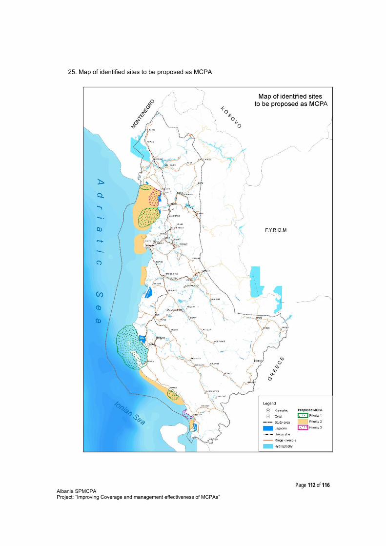
Page 112 of 116Albania SPMCPAProject: “Improving Coverage and management effectiveness of MCPAs”
25. Map of identified sites to be proposed as MCPA
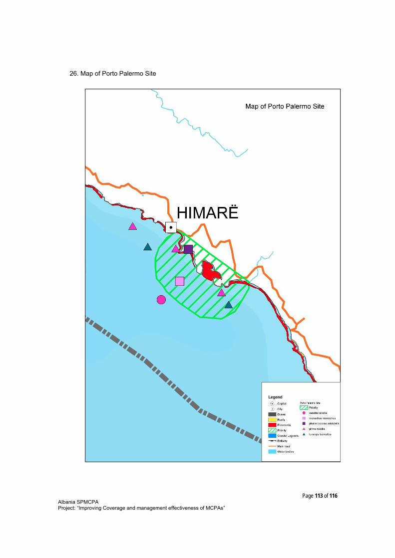
Page 113 of 116Albania SPMCPAProject: “Improving Coverage and management effectiveness of MCPAs”
26. Map of Porto Palermo Site

Page 114 of 116Albania SPMCPAProject: “Improving Coverage and management effectiveness of MCPAs”
27. Map of Vlora bay Site

Page 115 of 116Albania SPMCPAProject: “Improving Coverage and management effectiveness of MCPAs”
28. Map of South Saranda Site

Page 116 of 116Albania SPMCPAProject: “Improving Coverage and management effectiveness of MCPAs”
29. Map of Buna river Viluni Site