Strategic Goal 2: Expand scientific understanding of the ...P508-pt2-sg… · Strategic Goal 2:...
25
Management and Performance PERFORMANCE REPORTING AND PLANNING M&P-49 Strategic Goal 2: Expand scientific understanding of the Earth and the universe in which we live. OUTCOME 2.1: ADVANCE EARTH SYSTEM SCIENCE TO MEET THE CHALLENGES OF CLIMATE AND ENVIRONMENTAL CHANGE. The Earth system, like the human body, comprises diverse components that interact in complex ways. To understand the Earth system means understanding how Earth’s atmosphere, lithosphere, hydrosphere, cryosphere, and biosphere as a single connected system. It also means understanding how the planet is changing on all spatial and temporal scales. The purpose of NASA's Earth science program is to develop a scientific understanding of Earth's system and its response to natural or human-induced changes and to improve prediction of climate, weather, and natural hazards. The Earth Science Division uses a balanced portfolio of flight programs, research, technology development, and applied sciences to achieve its objectives and serve national and international needs in these areas. Earth Science partners with the National Oceanic and Atmospheric Administration (NOAA), the U.S. Geological Survey, and other Federal government agencies, local government, universities, international agencies, and others to provide science data products and applications that enable policy, business, and management decisions. Providing National Scientific Capabilities for Earth Science NASA continues to develop the Nation’s capabilities in support of this science objective by funding research and mission development performed by scientists and engineers at universities, research centers, the private sector, and NASA Centers. The vast majority of research awards also include funding for postdoctoral fellows, graduate students, and undergraduate students, thereby supporting the education and training of future scientists and engineers. Programs and activities serving this goal in FY 2012 include: • A broad based research program that is focused on global and environmental change, and the advancement of Earth System Science. • The Airborne Science Program, which conducted over 3,000 flight operation hours and 20 missions in support of NASA’s Earth science program during FY 2012, involved 129 undergraduate and 229 graduate students who directly participated in Airborne Science investigations and student-led flight projects. NASA Airborne Science platforms were actively engaged in mission definition activities, instrument development flights, gathering ice sheet observations as gap fillers, and satellite calibration and validation. Development of a Global Earth System Model capable of making multi-decadal projections of climate change. • Development of a Global Data Assimilation System capable of integrating multiple sources of observations. • Graduate fellowships through the New Investigator Program, the NASA Earth System Science
Transcript of Strategic Goal 2: Expand scientific understanding of the ...P508-pt2-sg… · Strategic Goal 2:...
Management and Performance
PERFORMANCE REPORTING AND PLANNING
M&P-49
Strategic Goal 2: Expand scientific understanding of the Earth and the universe in which we live.
OUTCOME 2.1: ADVANCE EARTH SYSTEM SCIENCE TO MEET THE CHALLENGES OF CLIMATE AND ENVIRONMENTAL CHANGE. The Earth system, like the human body, comprises diverse components that interact in complex ways. To understand the Earth system means understanding how Earth’s atmosphere, lithosphere, hydrosphere, cryosphere, and biosphere as a single connected system. It also means understanding how the planet is changing on all spatial and temporal scales. The purpose of NASA's Earth science program is to develop a scientific understanding of Earth's system and its response to natural or human-induced changes and to improve prediction of climate, weather, and natural hazards. The Earth Science Division uses a balanced portfolio of flight programs, research, technology development, and applied sciences to achieve its objectives and serve national and international needs in these areas. Earth Science partners with the National Oceanic and Atmospheric Administration (NOAA), the U.S. Geological Survey, and other Federal government agencies, local government, universities, international agencies, and others to provide science data products and applications that enable policy, business, and management decisions.
Providing National Scientific Capabilities for Earth Science
NASA continues to develop the Nation’s capabilities in support of this science objective by funding research and mission development performed by scientists and engineers at universities, research centers, the private sector, and NASA Centers. The vast majority of research awards also include funding for postdoctoral fellows, graduate students, and undergraduate students, thereby supporting the education and training of future scientists and engineers. Programs and activities serving this goal in FY 2012 include:
• A broad based research program that is focused on global and environmental change, and the advancement of Earth System Science.
• The Airborne Science Program, which conducted over 3,000 flight operation hours and 20 missions in support of NASA’s Earth science program during FY 2012, involved 129 undergraduate and 229 graduate students who directly participated in Airborne Science investigations and student-led flight projects. NASA Airborne Science platforms were actively engaged in mission definition activities, instrument development flights, gathering ice sheet observations as gap fillers, and satellite calibration and validation. Development of a Global Earth System Model capable of making multi-decadal projections of climate change.
• Development of a Global Data Assimilation System capable of integrating multiple sources of observations.
• Graduate fellowships through the New Investigator Program, the NASA Earth System Science
Management and Performance
PERFORMANCE REPORTING AND PLANNING
M&P-50
Fellowships program, NASA Post Doctoral Program and Presidential Early Career Award for Scientists and Engineers.
• NASA wide supercomputing capability to support scientific discovery, space exploration, and aeronautic research.
• Support, enhancement, and continuing use of a worldwide array of ground-based atmosphere observation networks.
• Continued operation of the U.S. contribution to the International Global Geodetic Networks and development of the next generation geodetic station prototype.
NASA’s Earth Science continued to operate 15 Earth-orbiting satellites employing a total of 78 distinct instruments. These included the Active Cavity Radiometer Irradiance Monitor Satellite (ACRIMSAT), Aqua, Aquarius/SAC-D, Aura, the Cloud-Aerosol Lidar and Infrared Pathfinder Satellite Observation (CALIPSO), CloudSat, Earth Observing (EO)-1, the Gravity Recovery and Climate Explorer (GRACE), Jason-1, Landsat-7, QuikSCAT, the Solar Radiation and Climate Experiment (SORCE), Suomi National Polar-orbiting Partnership (NPP), Terra, and the Tropical Rainfall Measuring Mission (TRMM). Earth Science makes comprehensive global data sets openly available, some in near-real time, via direct broadcast infrastructure. These make crucial contributions to researchers, first responders, weather forecasters, and decision makers. The Earth Observing System Data and Information System (EOSDIS) project provides science data to a wide community of users, including NASA, Federal agencies, international partners, academia, and the public. EOSDIS provides users with the services and tools they need in order to use NASA’s Earth science data in research and creation of models. EOSDIS archives and distributes data through standardized science data products, using algorithms and software developed by Earth Science investigators. This project funds the Elements of EOSDIS Evolution, aimed at improving the efficiency and effectiveness of EOSDIS while reducing the cost. It also supports the eight nationwide Distributed Active Archive Centers (DAAC) installations that collect, disseminate, and archive Earth science data. Each DAAC focuses on a specific Earth system science discipline and provides users with data products, services, and data-handling tools unique to that specialty. NASA requires that all funded research investigations publish their results in open, peer reviewed science literature, ensuring that data and knowledge are captured. Each year, the Earth Science Subcommittee of NASA’s external advisory Science Committee evaluates the progress made by NASA toward each science objective. In FY 2012, the subcommittee found that expectations had been fully met by research results leading to major scientific findings and discoveries, and major accomplishments.

Management and Performance
PERFORMANCE REPORTING AND PLANNING
M&P-51
Reported Multi-Year Performance Multi-Year Performance Goal 2.1.1.1: Provide national scientific capabilities through necessary skilled researchers and supporting knowledge base. (In support of objective 2.1.1: "Improve understanding of and improve the predictive capability for changes in the ozone layer, climate forcing, and air quality associated with changes in atmospheric composition.")
FY11 In the past year, NASA researchers participated in multiple Earth Venture-1 funded suborbital missions, including the Airborne Tropical Tropopause Experiment (ATTREX), Deriving Information on Surface Conditions from Column and Vertically Resolved Observations Relevant to Air Quality (DISCOVER-AQ), and the Carbon in Arctic Reservoirs Vulnerability Experiment (CARVE). Preliminary analyses of DISCOVER-AQ observations over the Baltimore–Washington corridor suggest that the expectation of a well-mixed boundary layer is often incorrect and that each pollutant can have a different vertical distribution. CARVE, which conducted its first science flights during May and June 2012, is designed to quantify correlations between atmospheric concentrations of carbon dioxide and methane with surface-atmosphere carbon fluxes and surface state control variables (soil moisture, freeze-thaw state, inundation state, and surface soil temperature) and clarify the sensitivities of Arctic carbon cycle processes to climate change. NASA researchers participated in several internationally coordinated activities to advance the state of knowledge of atmospheric ozone measurements and theory. Under the auspices of the World Climate Research Programme (WCRP) Stratosphere-troposphere Processes And their Role in Climate (SPARC) program, researchers are assessing and extending the current knowledge and understanding about measurements of the vertical distribution of ozone, with the aim of providing input to the next World Meteorological Organization Scientific Assessment of Ozone Depletion, anticipated for 2014. The SPARC Reassessment of Lifetimes of Long-Lived Atmospheric Trace Gas Lifetime Crucial to Ozone Depletion and Climate Change, co-led by NASA researchers, is reviewing estimates of the lifetimes of key atmospheric molecules crucial to understanding current and future atmospheric concentrations of ozone depleting substances and greenhouse gases. Using measurements from instruments aboard the Aura satellite Microwave Limb Sounder (MLS) and Ozone Monitoring Instrument (OMI), researchers found that the chemical ozone destruction over the Arctic in early 2011 was—for the first time in the observational record—comparable to that in the Antarctic ozone hole. Significant Arctic ozone loss was found to occur even with temperatures much milder than those in the Antarctic. However, it is still difficult to predict when such severe Arctic ozone depletion may be matched or exceeded. Numerous studies across the focus area continue to assess and improve the predictive capability of models for changes in composition, climate forcing and air quality. For example, multiple data sets, mostly from satellite observations (acquired by the Tropospheric Emission Spectrometer [TES] and MLS), were used to evaluate the performance of the Weather Research and Forecasting model with Chemistry (WRF-Chem) in simulating the distribution and evolution of aerosol, clouds, precipitation, and chemistry during the dry season in South America. The study demonstrated that satellite data are valuable to the evaluation of regional model simulations for climatologically important processes such as deep convection and biomass burning, especially in regions with little in situ observation.
Green FY12 Green
Management and Performance
PERFORMANCE REPORTING AND PLANNING
M&P-52
Update to Multi-Year Performance Goal
FY13 Update This performance goal remains the same in FY13. FY14 This performance goal remains the same in FY14.
Reported Annual Performance ES-12-1: Demonstrate planned progress in understanding and improving predictive capability for changes in the ozone layer, climate forcing, and air quality associated with changes in atmospheric composition. Progress relative to the objectives in NASA's 2010 Science Plan will be evaluated by external expert review. Contributing Theme: Earth Science Contributing Program(s): Multiple Programs
FY07 FY08 FY09 FY10 FY11 FY12 7ESS1 Green
8ES01 Green
9ES1 Green
10ES01 Green
ES-11-1 Green
ES-12-1 Green
Planned Annual Performance
FY13 Update ES-13-1: Demonstrate planned progress in understanding and improving predictive capability for changes in the ozone layer, climate forcing, and air quality associated with changes in atmospheric composition. Progress relative to the objectives in NASA's 2010 Science Plan will be evaluated by external expert review.
FY14 ES-14-1: Demonstrate planned progress in understanding and improving predictive capability for changes in the ozone layer, climate forcing, and air quality associated with changes in atmospheric composition. Progress relative to the objectives in NASA's 2010 Science Plan will be evaluated by external expert review.
Reported Multi-Year Performance Multi-Year Performance Goal 2.1.1.2: By 2015, launch at least two missions in support of objective 2.1.1.
FY11 The purpose of this performance goal is to launch satellites in support of objective 2.1.1, as outlined in the NASA Science Mission Directorate's 2010 Science Plan. NASA’s Earth Science program includes the design, development, and launch of a portfolio of new missions, along with the operation and provision of data from the existing fleet of Earth observing spacecraft. Launching missions in a timely way increases scientific capabilities and helps maintain data continuity. Once the satellites are operating on orbit, NASA uses these assets for scientific research and a range of Earth-observing capabilities. Earth Science launched the first satellite supporting this performance goal, Aquarius, in June 2011. Aquarius will observe and model seasonal and year-to-year variations of sea-surface salinity and how these variations relate to changes in the water cycle and ocean circulation, thereby influencing climate. During its three-year mission life, Aquarius will collect more sea surface salinity measurements than the entire 125-year historical record from ships and buoys. The next mission, Orbiting Carbon Observatory (OCO)-2, is planned for launch no earlier than 2014, but within the completion timeframe for the performance goal. NASA completed the OCO-2 Systems Integration Review on May 2, 2012, certifying that OCO-2’s systems were working together and could be integrated into the spacecraft bus for testing. OCO-2
Green FY12 Green
Management and Performance
PERFORMANCE REPORTING AND PLANNING
M&P-53
will be NASA’s first dedicated Earth remote sensing satellite to study atmospheric carbon dioxide from space.
Update to Multi-Year Performance Goal
FY13 Update This performance goal remains the same in FY13. FY14 This performance goal remains the same in FY14.
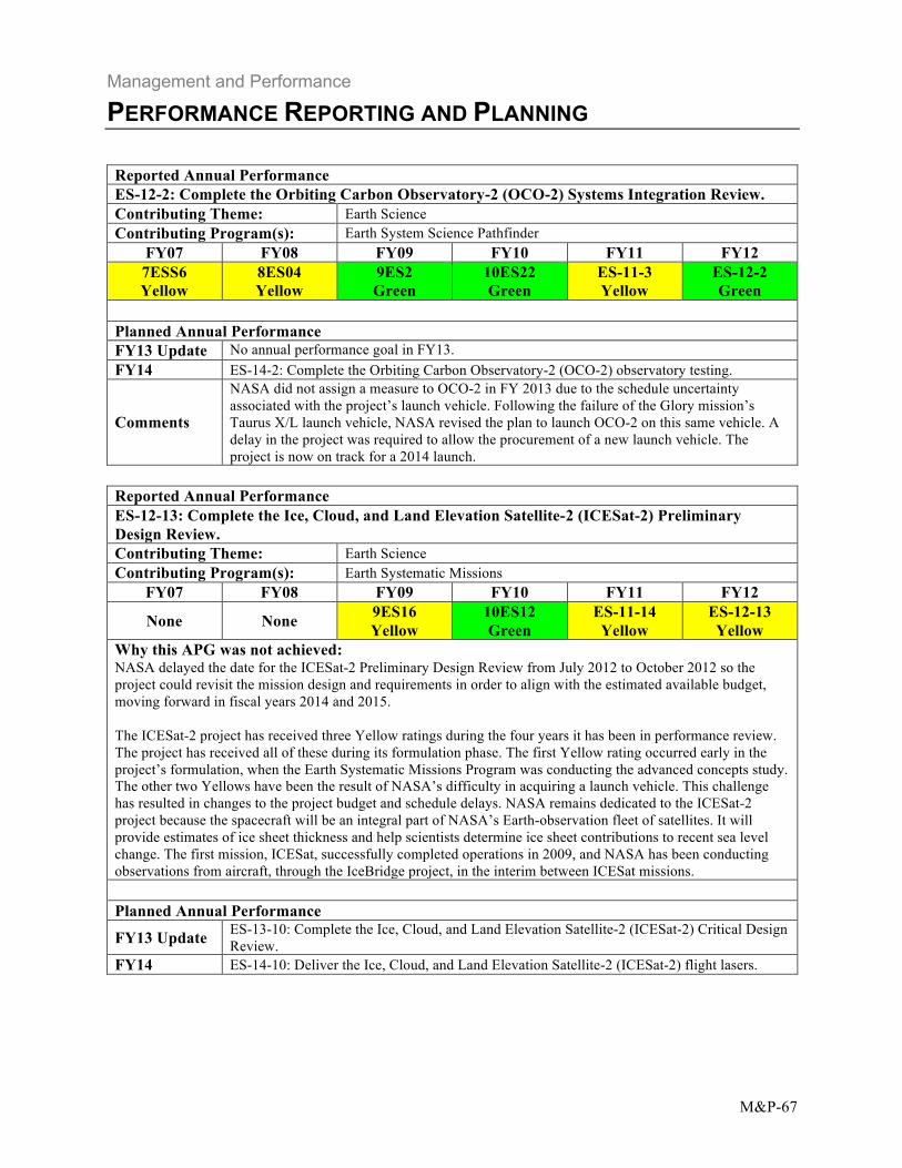
Reported Annual Performance ES-12-2: Complete the Orbiting Carbon Observatory-2 (OCO-2) Systems Integration Review. Contributing Theme: Earth Science Contributing Program(s): Earth System Science Pathfinder
FY07 FY08 FY09 FY10 FY11 FY12 7ESS6 Yellow
8ES04 Yellow
9ES2 Green
10ES22 Green
ES-11-3 Yellow
ES-12-2 Green
Planned Annual Performance FY13 Update No annual performance goal in FY13. FY14 ES-14-2: Complete the Orbiting Carbon Observatory-2 (OCO-2) observatory testing.
Comments
NASA did not assign a measure to OCO-2 in FY 2013 due to the schedule uncertainty associated with the project’s launch vehicle. Following the failure of the Glory mission’s Taurus X/L launch vehicle, NASA revised the plan to launch OCO-2 on this same vehicle. A delay in the project was required to allow the procurement of a new launch vehicle. The project is now on track for a 2014 launch.
Reported Annual Performance ES-12-3: Complete the Earth Venture-1 (EV-1) Investigation Readiness Reviews (IRR) and begin initial field campaigns. Contributing Theme: Earth Science Contributing Program(s): Earth System Science Pathfinder
FY07 FY08 FY09 FY10 FY11 FY12
None None None None ES-11-4 Green
ES-12-3 Green
Planned Annual Performance FY13 Update No annual performance goal in FY13. FY14 No annual performance goal in FY14.
Management and Performance
PERFORMANCE REPORTING AND PLANNING
M&P-54
Reported Multi-Year Performance Multi-Year Performance Goal 2.1.2.1: Provide national scientific capabilities through necessary skilled researchers and supporting knowledge base. (In support of objective 2.1.2: "Enable improved predictive capability for weather and extreme weather events.")
FY11 NASA sponsored research continued to gain new insight into weather and extreme-weather events by the use of data obtained from a variety of satellite platforms. Several studies have examined the robust signatures of internal gravity waves in Atmospheric Infrared Sounder Instrument (AIRS) data. AIRS has been used not only to understand the physics of gravity waves and its interactions with the large scale weather, but also to develop and improve more sophisticated gravity wave parameterizations for weather and climate prediction models. AIRS is increasingly being used to obtain a deeper understanding of the physics of the atmospheric boundary layer. It was shown that AIRS is capable of producing a realistic structure of temperature and water vapor in the boundary layer over the subtropical oceanic regions covered with shallow cumulus. AIRS also has been shown to be a useful tool for understanding the interactions between the key cloudy boundary layer characteristics and the climatological large scale circulation. This is absolutely essential to understand cloud-climate feedbacks, which are considered by the Intergovernmental Panel on Climate Change (IPCC) to be the main reason for uncertainty in current climate change projections. NASA’s Short-term Prediction Research and Transition (SPoRT) Center continues to transition experimental satellite data and forecast products to NOAA’s National Weather Service (NWS) forecast offices and NOAA/NWS/National Centers for Environmental Prediction, to advance current techniques for weather analysis and forecasting while also preparing forecasters for the next generation of geostationary and polar-orbiting satellite capabilities. NASA collaborates with the NOAA Geostationary Operational Environmental Satellite (GOES)-R and Joint Polar Satellite System (JPSS) Proving Grounds to demonstrate future forecasting capabilities by using Moderate Resolution Imaging Spectroradiometer (MODIS) data from Terra and Aqua, and more recently, the Visible Infrared Imaging Radiometer Suite (VIIRS) instrument launched aboard the Suomi National Polar Orbiting Partnership (NPP) in October 2011. Furthermore, SPoRT’s collaborations with NOAA have integrated NASA observations into the next generation decision support system AWIPS II used by NWS forecasters in analysis and emergency response applications. Using 12 years of Tropical Rainfall Measurement Mission (TRMM) rainfall data, NASA scientists find that a warmer tropical ocean favors a large increase in occurrence of extreme heavy rain events in a warmer climate (near doubling for every degree increase in tropical sea surface temperature). The increase is coupled to a modest reduction in light to moderate rain, and a slight increase in very light rain over the tropic. This shift in tropical rainfall distribution is similar to that found in previous studies for multi-decadal rainfall trend. The paper demonstrates that TRMM data, when used appropriately, can shed new light on how the tropical rainfall systems may respond in a warmer climate. Tropical cyclone are a form of extreme weather event with highly destructive power. Using TRMM and Global Precipitation Climatology project rainfall data, NASA scientists find that storms are becoming more energetic (wetter) in the North Atlantic, but less energetic (drier) in the North Pacific in the last two decades. These shifts are consistent with long-term changes in sea surface temperature and wind shear over the two ocean basins. This work also provides an alternative to the conventional way of classifying tropical cyclones based on instantaneous winds (i.e., the Saffir-Simpson scale) using rainfall in terms of latent
Green FY12 Green
Management and Performance
PERFORMANCE REPORTING AND PLANNING
M&P-55
energy per storm (EPS). The EPS classification has the advantage of being universal for all ocean basins, not subject to sampling errors involved in measurement of instantaneous winds. As the length of the satellite rainfall dataset increases, the EPS classification will become more important.
Update to Multi-Year Performance Goal
FY13 Update This performance goal remains the same in FY13. FY14 This performance goal remains the same in FY14.
Reported Annual Performance ES-12-4: Demonstrate planned progress in enabling improved predictive capability for weather and extreme weather events. Progress relative to the objectives in NASA's 2010 Science Plan will be evaluated by external expert review. Contributing Theme: Earth Science Contributing Program(s): Multiple Programs
FY07 FY08 FY09 FY10 FY11 FY12 7ESS2 8ES02 9ES7 10ES04 ES-11-5 ES-12-4 Green Green Green Green Green Green
Planned Annual Performance
ES-13-3: Demonstrate planned progress in enabling improved predictive capability for FY13 Update weather and extreme weather events. Progress relative to the objectives in NASA's 2010
Science Plan will be evaluated by external expert review. ES-14-3: Demonstrate planned progress in enabling improved predictive capability for
FY14 weather and extreme weather events. Progress relative to the objectives in NASA's 2010 Science Plan will be evaluated by external expert review.
Reported Multi-Year Performance Multi-Year Performance Goal 2.1.2.2: By 2015, launch at least two missions in support of objective 2.1.2.
FY11 The purpose of this performance goal is to launch satellites in support of objective 2.1.2, as outlined in the NASA Science Mission Directorate's 2010 Science Plan. NASA’s Earth Science program includes the design, development, and launch of a portfolio of new missions, along with the operation and provision of data from the existing fleet of Earth observing spacecraft. Launching missions in a timely way increases scientific capabilities and helps maintain data continuity. Once the satellites are operating on orbit, NASA uses these assets for scientific research and a range of Earth observing capabilities. NASA launched the first mission satisfying this performance goal, the NPOESS Preparatory Project (NPP), in October 2011. Once the satellite was on orbit and checked out, NASA renamed the mission Suomi National Polar-orbiting Partnership, in honor of the late Verner E. Suomi, a meteorologist at the University of Wisconsin who is recognized widely as “the father of satellite meteorology.” Suomi NPP, a bridge between NASA’s Earth Observing System satellites and the next-generation Joint Polar Satellite System, is collecting critical data to improve short-term weather forecasts and increase understanding of long-term climate change.
Green FY12 Green
Management and Performance
PERFORMANCE REPORTING AND PLANNING
M&P-56
The second mission, Global Precipitation Measurement (GPM), is planned for launch in February 2014, within the performance goal timeframe. NASA anticipated completing the Pre-Environmental Review (PER) in FY 2012, but a preceding review, the Comprehensive Performance Test, was delayed from September to October 2012 due to various integration and test issues. NASA successfully completed the PER on October 23, 2012. The GPM mission will advance the measurement of global precipitation, making possible high spatial resolution precipitation measurements. A joint mission with the Japanese Aerospace Exploration Agency (JAXA), GPM will provide the first opportunity to calibrate measurements of global precipitation (including the distribution, amount, rate, and associated heat released) across tropical, mid-latitude, and polar regions.
Update to Multi-Year Performance Goal
FY13 Update This performance goal remains the same in FY13. FY14 This performance goal remains the same in FY14.
Reported Annual Performance No annual performance goal in FY12 or trended performance. Contributing Theme: Earth Science Contributing Program(s): Earth System Science Pathfinder
FY07 FY08 FY09 FY10 FY11 FY12 None None None None None None
Planned Annual Performance FY13 Update ES-13-2: Complete the Earth Venture-2 (EV-2) Mission Definition Review (MDR).
FY14 ES-14-5: Complete Cyclone Global Navigation Satellite System (CYGNSS/EV-2) Preliminary Design Review.
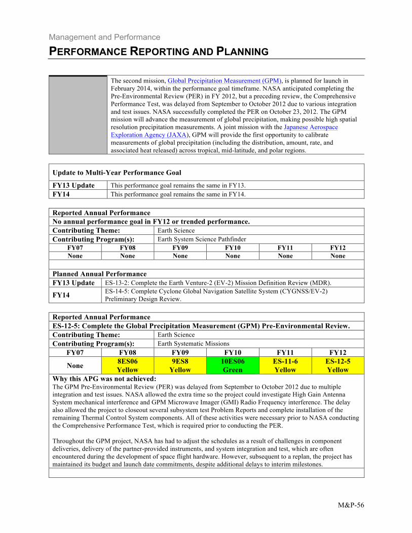
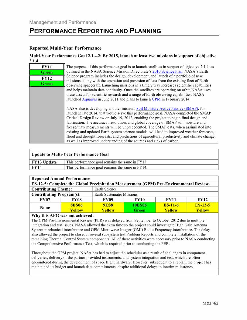
Reported Annual Performance ES-12-5: Complete the Global Precipitation Measurement (GPM) Pre-Environmental Review. Contributing Theme: Earth Science Contributing Program(s): Earth Systematic Missions
FY07 FY08 FY09 FY10 FY11 FY12
None 8ES06 Yellow
9ES8 Yellow
10ES06 Green
ES-11-6 Yellow
ES-12-5 Yellow
Why this APG was not achieved: The GPM Pre-Environmental Review (PER) was delayed from September to October 2012 due to multiple integration and test issues. NASA allowed the extra time so the project could investigate High Gain Antenna System mechanical interference and GPM Microwave Imager (GMI) Radio Frequency interference. The delay also allowed the project to closeout several subsystem test Problem Reports and complete installation of the remaining Thermal Control System components. All of these activities were necessary prior to NASA conducting the Comprehensive Performance Test, which is required prior to conducting the PER. Throughout the GPM project, NASA has had to adjust the schedules as a result of challenges in component deliveries, delivery of the partner-provided instruments, and system integration and test, which are often encountered during the development of space flight hardware. However, subsequent to a replan, the project has maintained its budget and launch date commitments, despite additional delays to interim milestones.
Management and Performance
PERFORMANCE REPORTING AND PLANNING
M&P-57
Planned Annual Performance
FY13 Update ES-13-4: Complete the Global Precipitation Measurement (GPM) mission observatory environmental testing.
FY14 ES-14-4: Launch the Global Precipitation Measurement (GPM) mission. Reported Multi-Year Performance Multi-Year Performance Goal 2.1.3.1: Provide national scientific capabilities through necessary skilled researchers and supporting knowledge base. (In support of objective 2.1.3: "Quantify, understand, and predict changes in Earth's ecosystems and biogeochemical cycles, including the global carbon cycle, land cover, and biodiversity.")
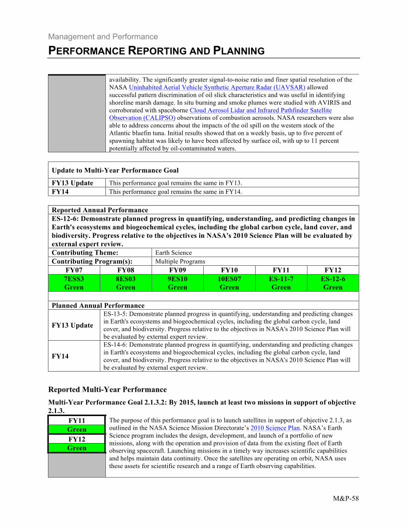
FY11 The discovery of massive phytoplankton (free-floating single-celled photosynthetic organisms at the base of the marine food web) blooms under Arctic sea ice is a major advance in understanding that resulted directly from the Impacts of Climate change on the Eco-Systems and Chemistry of the Arctic Pacific Environment (ICESCAPE) Program. Prior to this field program, estimates of pan-Arctic primary productivity assumed that the growth and biomass of phytoplankton were negligible in waters beneath ice because of insufficient light. However, the 2011 ICESCAPE cruise observed a bloom beneath the 0.8- to 1.3-meter-thick first-year sea ice on the Chukchi Sea continental shelf. The finding reveals a new consequence of the Arctic's warming climate and provides an important clue to understanding the impacts of a changing climate and environment on the Arctic Ocean and its ecology. The dynamics of Arctic and sub-Arctic vegetation was the topic of several individual research papers and a special issue of Environmental Research Letters published in late 2011. Arctic vegetation has been changing in response to changes in climate, and these changes are widespread through the circumpolar North. Understanding the details of these vegetation dynamics spatially and temporally, as well as the mechanisms of change, is crucial to projecting the future of this extensive, heterogeneous, and important biome. While the Arctic tundra has shown indications of ubiquitous increases in vegetation (“greening”), there are clearly areas that are not greening, and the boreal forest appears to be changing in many places in the opposite direction (i.e., “browning”). In 2012, the first remote sensing-based products from Carbon Monitoring System (CMS) pilot studies were released for review and further quality assessment. The biomass pilot study’s products included a U.S. forest biomass map, state biomass maps for California and Maryland, and local biomass maps for four sites in the eastern United States. The flux pilot study’s products included modeled carbon dioxide exchanges between terrestrial ecosystems and the atmosphere, and between the ocean and the atmosphere. The pilot products will guide the development of the CMS, which will estimate carbon budgets and monitor carbon sources and sinks. The first results from analysis of NASA’s remote sensing data collected over the 2010 Deepwater Horizon oil spill were published during the past year. An overview paper reported that spill and impact monitoring was aided by extensive airborne and spaceborne passive and active remote sensing. Oil slick thickness and oil-to-water emulsion ratios, key spill response parameters for containment or cleanup, were derived quantitatively for thick (more than 0.1 millimeter) slicks from NASA’s Airborne Visible/Infrared Imaging Spectrometer (AVIRIS) data. MODIS observations were used to extrapolate the AVIRIS-based estimates to the total slick. MODIS data proved to be critical for oil spill response decision making due to their frequent temporal coverage, broad spatial coverage, and timely
Green FY12 Green
Management and Performance
PERFORMANCE REPORTING AND PLANNING
M&P-58
availability. The significantly greater signal-to-noise ratio and finer spatial resolution of the NASA Uninhabited Aerial Vehicle Synthetic Aperture Radar (UAVSAR) allowed successful pattern discrimination of oil slick characteristics and was useful in identifying shoreline marsh damage. In situ burning and smoke plumes were studied with AVIRIS and corroborated with spaceborne Cloud Aerosol Lidar and Infrared Pathfinder Satellite Observation (CALIPSO) observations of combustion aerosols. NASA researchers were also able to address concerns about the impacts of the oil spill on the western stock of the Atlantic bluefin tuna. Initial results showed that on a weekly basis, up to five percent of spawning habitat was likely to have been affected by surface oil, with up to 11 percent potentially affected by oil-contaminated waters.
Update to Multi-Year Performance Goal
FY13 Update This performance goal remains the same in FY13. FY14 This performance goal remains the same in FY14.
Reported Annual Performance ES-12-6: Demonstrate planned progress in quantifying, understanding, and predicting changes in Earth's ecosystems and biogeochemical cycles, including the global carbon cycle, land cover, and biodiversity. Progress relative to the objectives in NASA's 2010 Science Plan will be evaluated by external expert review. Contributing Theme: Earth Science Contributing Program(s): Multiple Programs
FY07 FY08 FY09 FY10 FY11 FY12 7ESS3 Green
8ES03 Green
9ES10 Green
10ES07 Green
ES-11-7 Green
ES-12-6 Green
Planned Annual Performance
FY13 Update ES-13-5: Demonstrate planned progress in quantifying, understanding and predicting changes in Earth's ecosystems and biogeochemical cycles, including the global carbon cycle, land cover, and biodiversity. Progress relative to the objectives in NASA's 2010 Science Plan will be evaluated by external expert review.
FY14 ES-14-6: Demonstrate planned progress in quantifying, understanding and predicting changes in Earth's ecosystems and biogeochemical cycles, including the global carbon cycle, land cover, and biodiversity. Progress relative to the objectives in NASA's 2010 Science Plan will be evaluated by external expert review.
Reported Multi-Year Performance Multi-Year Performance Goal 2.1.3.2: By 2015, launch at least two missions in support of objective 2.1.3.
FY11 The purpose of this performance goal is to launch satellites in support of objective 2.1.3, as Green outlined in the NASA Science Mission Directorate’s 2010 Science Plan. NASA’s Earth
FY12 Science program includes the design, development, and launch of a portfolio of new missions, along with the operation and provision of data from the existing fleet of Earth observing spacecraft. Launching missions in a timely way increases scientific capabilities and helps maintain data continuity. Once the satellites are operating on orbit, NASA uses
Green
these assets for scientific research and a range of Earth observing capabilities.
Management and Performance
PERFORMANCE REPORTING AND PLANNING
M&P-59
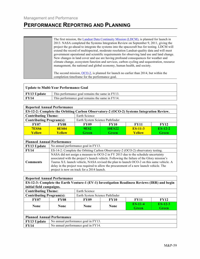
The first mission, the Landsat Data Continuity Mission (LDCM), is planned for launch in 2013. NASA completed the Systems Integration Review on September 9, 2011, giving the project the go-ahead to integrate the systems into the spacecraft bus for testing. LDCM will extend the record of multispectral, moderate resolution Landsat-quality data and will meet government operational and scientific requirements for observing land use and land change. New changes in land cover and use are having profound consequences for weather and climate change, ecosystem function and services, carbon cycling and sequestration, resource management, the national and global economy, human health, and society. The second mission, OCO-2, is planned for launch no earlier than 2014, but within the completion timeframe for the performance goal.
Update to Multi-Year Performance Goal
FY13 Update This performance goal remains the same in FY13. FY14 This performance goal remains the same in FY14.
Reported Annual Performance ES-12-2: Complete the Orbiting Carbon Observatory-2 (OCO-2) Systems Integration Review. Contributing Theme: Earth Science Contributing Program(s): Earth System Science Pathfinder
FY07 FY08 FY09 FY10 FY11 FY12 7ESS6 Yellow
8ES04 Yellow
9ES2 Green
10ES22 Green
ES-11-3 Yellow
ES-12-2 Green
Planned Annual Performance FY13 Update No annual performance goal in FY13. FY14 ES-14-2: Complete the Orbiting Carbon Observatory-2 (OCO-2) observatory testing.
Comments
NASA did not assign a measure to OCO-2 in FY 2013 due to the schedule uncertainty associated with the project’s launch vehicle. Following the failure of the Glory mission’s Taurus X/L launch vehicle, NASA revised the plan to launch OCO-2 on this same vehicle. A delay in the project was required to allow the procurement of a new launch vehicle. The project is now on track for a 2014 launch.
Reported Annual Performance ES-12-3: Complete the Earth Venture-1 (EV-1) Investigation Readiness Reviews (IRR) and begin initial field campaigns. Contributing Theme: Earth Science Contributing Program(s): Earth System Science Pathfinder
FY07 FY08 FY09 FY10 FY11 FY12
None None None None ES-11-4 Green
ES-12-3 Green
Planned Annual Performance FY13 Update No annual performance goal in FY13. FY14 No annual performance goal in FY14.
Management and Performance
PERFORMANCE REPORTING AND PLANNING
M&P-60
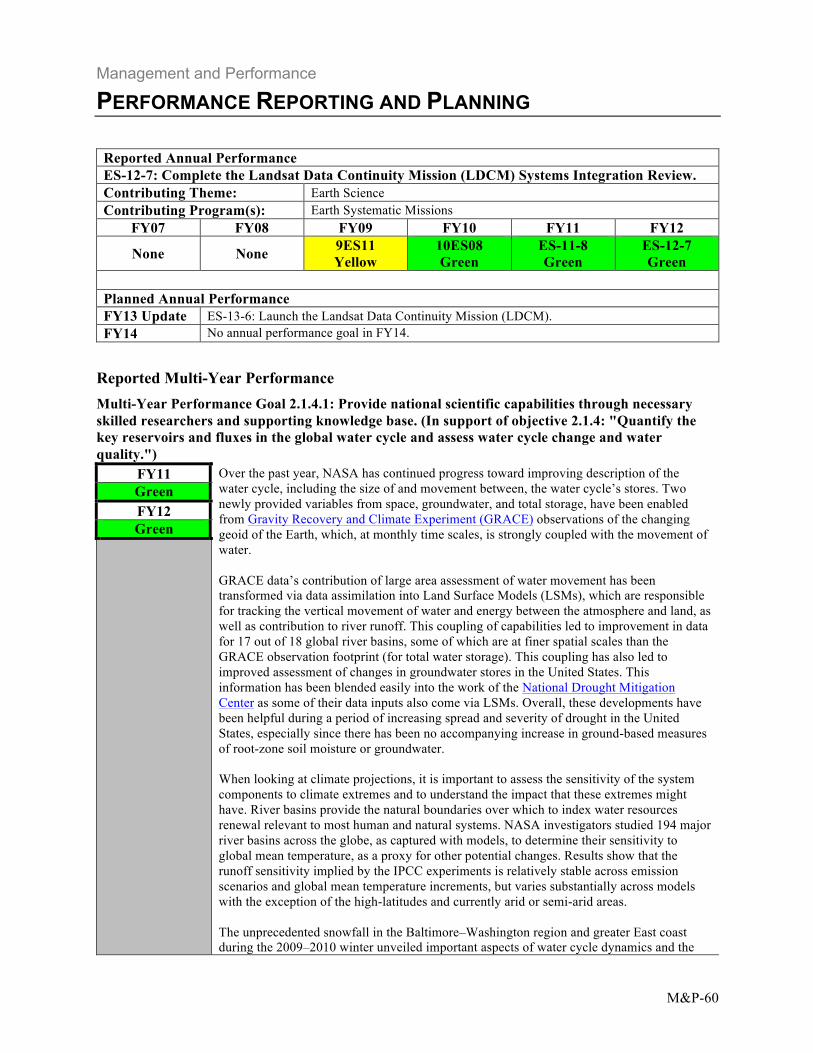
Reported Annual Performance ES-12-7: Complete the Landsat Data Continuity Mission (LDCM) Systems Integration Review. Contributing Theme: Earth Science Contributing Program(s): Earth Systematic Missions
FY07 FY08 FY09 FY10 FY11 FY12
None None 9ES11 Yellow
10ES08 Green
ES-11-8 Green
ES-12-7 Green
Planned Annual Performance FY13 Update ES-13-6: Launch the Landsat Data Continuity Mission (LDCM). FY14 No annual performance goal in FY14.
Reported Multi-Year Performance Multi-Year Performance Goal 2.1.4.1: Provide national scientific capabilities through necessary skilled researchers and supporting knowledge base. (In support of objective 2.1.4: "Quantify the key reservoirs and fluxes in the global water cycle and assess water cycle change and water quality.")
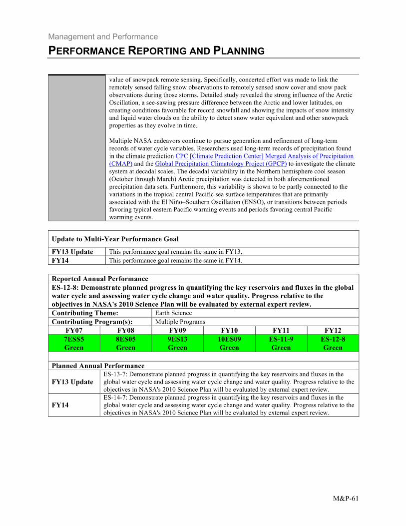
FY11 Over the past year, NASA has continued progress toward improving description of the water cycle, including the size of and movement between, the water cycle’s stores. Two newly provided variables from space, groundwater, and total storage, have been enabled from Gravity Recovery and Climate Experiment (GRACE) observations of the changing geoid of the Earth, which, at monthly time scales, is strongly coupled with the movement of water. GRACE data’s contribution of large area assessment of water movement has been transformed via data assimilation into Land Surface Models (LSMs), which are responsible for tracking the vertical movement of water and energy between the atmosphere and land, as well as contribution to river runoff. This coupling of capabilities led to improvement in data for 17 out of 18 global river basins, some of which are at finer spatial scales than the GRACE observation footprint (for total water storage). This coupling has also led to improved assessment of changes in groundwater stores in the United States. This information has been blended easily into the work of the National Drought Mitigation Center as some of their data inputs also come via LSMs. Overall, these developments have been helpful during a period of increasing spread and severity of drought in the United States, especially since there has been no accompanying increase in ground-based measures of root-zone soil moisture or groundwater. When looking at climate projections, it is important to assess the sensitivity of the system components to climate extremes and to understand the impact that these extremes might have. River basins provide the natural boundaries over which to index water resources renewal relevant to most human and natural systems. NASA investigators studied 194 major river basins across the globe, as captured with models, to determine their sensitivity to global mean temperature, as a proxy for other potential changes. Results show that the runoff sensitivity implied by the IPCC experiments is relatively stable across emission scenarios and global mean temperature increments, but varies substantially across models with the exception of the high-latitudes and currently arid or semi-arid areas. The unprecedented snowfall in the Baltimore–Washington region and greater East coast during the 2009–2010 winter unveiled important aspects of water cycle dynamics and the
Green FY12 Green
Management and Performance
PERFORMANCE REPORTING AND PLANNING
M&P-61
value of snowpack remote sensing. Specifically, concerted effort was made to link the remotely sensed falling snow observations to remotely sensed snow cover and snow pack observations during those storms. Detailed study revealed the strong influence of the Arctic Oscillation, a see-sawing pressure difference between the Arctic and lower latitudes, on creating conditions favorable for record snowfall and showing the impacts of snow intensity and liquid water clouds on the ability to detect snow water equivalent and other snowpack properties as they evolve in time. Multiple NASA endeavors continue to pursue generation and refinement of long-term records of water cycle variables. Researchers used long-term records of precipitation found in the climate prediction CPC [Climate Prediction Center] Merged Analysis of Precipitation (CMAP) and the Global Precipitation Climatology Project (GPCP) to investigate the climate system at decadal scales. The decadal variability in the Northern hemisphere cool season (October through March) Arctic precipitation was detected in both aforementioned precipitation data sets. Furthermore, this variability is shown to be partly connected to the variations in the tropical central Pacific sea surface temperatures that are primarily associated with the El Niño–Southern Oscillation (ENSO), or transitions between periods favoring typical eastern Pacific warming events and periods favoring central Pacific warming events.
Update to Multi-Year Performance Goal
FY13 Update This performance goal remains the same in FY13. FY14 This performance goal remains the same in FY14.
Reported Annual Performance ES-12-8: Demonstrate planned progress in quantifying the key reservoirs and fluxes in the global water cycle and assessing water cycle change and water quality. Progress relative to the objectives in NASA's 2010 Science Plan will be evaluated by external expert review. Contributing Theme: Earth Science Contributing Program(s): Multiple Programs
FY07 FY08 FY09 FY10 FY11 FY12 7ESS5 8ES05 9ES13 10ES09 ES-11-9 ES-12-8 Green Green Green Green Green Green
Planned Annual Performance
ES-13-7: Demonstrate planned progress in quantifying the key reservoirs and fluxes in the FY13 Update global water cycle and assessing water cycle change and water quality. Progress relative to the
objectives in NASA's 2010 Science Plan will be evaluated by external expert review. ES-14-7: Demonstrate planned progress in quantifying the key reservoirs and fluxes in the
FY14 global water cycle and assessing water cycle change and water quality. Progress relative to the objectives in NASA's 2010 Science Plan will be evaluated by external expert review.
Management and Performance
PERFORMANCE REPORTING AND PLANNING
M&P-62
Reported Multi-Year Performance Multi-Year Performance Goal 2.1.4.2: By 2015, launch at least two missions in support of objective 2.1.4.
FY11 The purpose of this performance goal is to launch satellites in support of objective 2.1.4, as outlined in the NASA Science Mission Directorate’s 2010 Science Plan. NASA’s Earth Science program includes the design, development, and launch of a portfolio of new missions, along with the operation and provision of data from the existing fleet of Earth observing spacecraft. Launching missions in a timely way increases scientific capabilities and helps maintain data continuity. Once the satellites are operating on orbit, NASA uses these assets for scientific research and a range of Earth observing capabilities. NASA launched Aquarius in June 2011 and plans to launch GPM in February 2014. NASA also is developing another mission, Soil Moisture Active Passive (SMAP), for launch in late 2014, that would serve this performance goal. NASA completed the SMAP Critical Design Review on July 19, 2012, enabling the project to begin final design and fabrication. The accuracy, resolution, and global coverage of SMAP soil moisture and freeze/thaw measurements will be unprecedented. The SMAP data, when assimilated into existing and updated Earth system science models, will lead to improved weather forecasts, flood and drought forecasts, and predictions of agricultural productivity and climate change, as well as improved understanding of the sources and sinks of carbon.
Green FY12 Green
Update to Multi-Year Performance Goal
FY13 Update This performance goal remains the same in FY13. FY14 This performance goal remains the same in FY14.
Reported Annual Performance ES-12-5: Complete the Global Precipitation Measurement (GPM) Pre-Environmental Review. Contributing Theme: Earth Science Contributing Program(s): Earth Systematic Missions
FY07 FY08 FY09 FY10 FY11 FY12
None 8ES06 Yellow
9ES8 Yellow
10ES06 Green
ES-11-6 Yellow
ES-12-5 Yellow
Why this APG was not achieved: The GPM Pre-Environmental Review (PER) was delayed from September to October 2012 due to multiple integration and test issues. NASA allowed the extra time so the project could investigate High Gain Antenna System mechanical interference and GPM Microwave Imager (GMI) Radio Frequency interference. The delay also allowed the project to closeout several subsystem test Problem Reports and complete installation of the remaining Thermal Control System components. All of these activities were necessary prior to NASA conducting the Comprehensive Performance Test, which is required prior to conducting the PER. Throughout the GPM project, NASA has had to adjust the schedules as a result of challenges in component deliveries, delivery of the partner-provided instruments, and system integration and test, which are often encountered during the development of space flight hardware. However, subsequent to a replan, the project has maintained its budget and launch date commitments, despite additional delays to interim milestones.
Management and Performance
PERFORMANCE REPORTING AND PLANNING
M&P-63
Planned Annual Performance
FY13 Update ES-13-4: Complete the Global Precipitation Measurement (GPM) mission observatory environmental testing.
FY14 ES-14-4: Launch the Global Precipitation Measurement (GPM) mission. Reported Annual Performance ES-12-9: Successfully complete the Soil Moisture Active-Passive (SMAP) Critical Design Review. Contributing Theme: Earth Science Contributing Program(s): Earth Systematic Missions
FY07 FY08 FY09 FY10 FY11 FY12
None None 9ES14 Green
10ES10 Yellow
ES-11-10 Yellow
ES-12-9 Green
Planned Annual Performance
FY13 Update ES-13-8: Complete the Soil Moisture Active Passive (SMAP) Systems Integration (SIR).
Review
FY14 ES-14-8: Complete Soil Moisture Active Passive (SMAP) Instrument Thermal Vacuum Test. Reported Multi-Year Performance Multi-Year Performance Goal 2.1.5.1: Provide national scientific capabilities through necessary skilled researchers and supporting knowledge base. (In support of objective 2.1.5: "Improve understanding of the roles of the ocean, atmosphere, land and ice in the climate system and improve predictive capability for its future evolution.")
FY11 Studies of sea level rise between 1961 and 2008, performed with a combination of radar altimetry, tide gage and other data, reveal a rate of +2.1 millimeter per year (+3.4 millimeter per year from 1993 through 2008). ENSO, which is associated with precipitation falling over the continents rather than the oceans, caused a two-year dip in the curve beginning in 2011. Over the past year, the first results from the Aquarius/SAC-D mission, launched in June 2011, began appearing in the scientific literature. Its global sea-surface salinity data provided the first observation of the salinity structure and propagation properties of tropical instability waves in the equatorial Pacific. Satellite data during the past year continued to show a decline in Arctic sea ice cover, both in extent and thickness. The Arctic sea-ice extent dropped to 3.41 million square kilometers, which is well below the previous record of 4.17 million square kilometers observed in 2007. Also, the drastic reduction of older perennial sea ice in the Arctic Ocean has resulted in a substantial increase of younger and saltier sea ice with the subsequent release of bromine monoxide and the reduction of atmospheric ozone and mercury. The thinning Arctic ice also appears to allow sunlight to reach the underlying water, catalyzing previously unobserved phytoplankton blooms; this yielded blooms with growth rates up to 10 times higher than those in adjacent open water. A large-scale survey of snow depth on sea ice was conducted using laser altimeter and ultra-wideband microwave radar data collected by Operation IceBridge. The results were consistent with historical climatology over multi-year ice, but showed larger differences over first-year ice, suggesting that the increasingly seasonal sea ice cover of the Arctic Ocean has led to an overall loss of snow. Researchers also used the collected snow depths to derive sea ice thicknesses, and both measurements were compared to in situ data, with mean
Green FY12 Green
Management and Performance
PERFORMANCE REPORTING AND PLANNING
M&P-64
differences of one centimeter for the former and five centimeters for the latter. In addition, satellite radar data, collected through a broad international collaboration with other space agencies, were processed to provide comprehensive views of glacier velocities in both Greenland and Antarctica. Decade-long time series were generated for nearly all of Greenland’s outlet glaciers, revealing complex, inter-regional, and intra-regional variability and suggesting that the ice sheet’s contribution to sea-level rise may be on the lower end of current predictions. In Antarctica, researchers found that ice flow is driven by a complex set of meandering, size-varying, speed varying, intertwined tributaries. This discovery challenged the traditional view that ice flow is constrained by internal deformation and disconnected from coastal regions. Furthermore, similar radar data, collected over the ice shelves that extend from Antarctica into the ocean, were used to establish a 30-year time series of elevation change. This will further efforts to understand the relative roles of surface mass balance and subsurface melting in driving the future evolution of both the ice shelves and the glaciers that feed them. Several modeling activities have contributed to better understanding the climate system and improving predictive capabilities. The Ice-Sheet System Model, a major new ice-sheet model that was recently completed and released, provides a high-resolution, physically based representation of the cryosphere for climate studies. Researchers completed a model of sub ice-shelf circulation and used it to demonstrate the importance of Pine Island ice-shelf melt rates to ocean circulation under the shelf. Modeling of atmospheric processes was pushed to a very high resolution on a global scale, which resulted in a global model with sufficient resolution to resolve cloud systems at the 3.5-kilometer scale.
Update to Multi-Year Performance Goal
FY13 Update This performance goal remains the same in FY13. FY14 This performance goal remains the same in FY14.
Reported Annual Performance ES-12-10: Demonstrate planned progress in understanding the roles of ocean, atmosphere, land, and ice in the climate system and improving predictive capability for future evolution. Progress relative to the objectives in NASA's 2010 Science Plan will be evaluated by external expert review. Contributing Theme: Earth Science Contributing Program(s): Multiple Programs
FY07 FY08 FY09 FY10 FY11 FY12 7ESS7 Green
8ES07 Green
9ES15 Green
10ES11 Green
ES-11-11 Green
ES-12-10 Green
Planned Annual Performance
FY13 Update ES-13-9: Demonstrate planned progress in understanding the roles of ocean, atmosphere, land, and ice in the climate system and improving predictive capability for future evolution. Progress relative to the objectives in NASA's 2010 Science Plan will be evaluated by external expert review.
FY14 ES-14-9: Demonstrate planned progress in understanding the roles of ocean, atmosphere, land, and ice in the climate system and improving predictive capability for future evolution. Progress relative to the objectives in NASA's 2010 Science Plan will be evaluated by external expert review.

Management and Performance
PERFORMANCE REPORTING AND PLANNING
M&P-65
Reported Annual Performance ES-12-11: Achieve mission success criteria for the Ocean Surface Topography Mission (OSTM). Contributing Theme: Earth Science Contributing Program(s): Earth Systematic Missions
FY07 FY08 FY09 FY10 FY11 FY12 7ESS9 Green
8ES08 Green None None None ES-12-11
Green Planned Annual Performance FY13 Update No annual performance goal in FY13. FY14 No annual performance goal in FY14.
Reported Multi-Year Performance Multi-Year Performance Goal 2.1.5.2: HPPG: Study Earth from space to understand climate change, weather, and human impact on our planet by launching at least two missions by 2015.
FY11 To achieve this goal, NASA planned to launch and successfully place in orbit two satellites: Glory and NPP. NASA launched NPP on October 28, 2011, and shortly after it began operations, renamed it Suomi NPP. Despite this success, NASA was unable to achieve this performance goal because Glory was lost during launch on March 4, 2011, due to the failure of the Taurus XL launch vehicle. Suomi NPP has orbited the Earth more than 5,000 times and begun returning images and data that provide critical weather and climate measurements of the complex Earth system. The data captured from Suomi NPP monitored this year's Antarctic Ozone Hole and is improving daily weather forecasts. Suomi NPP data is being connected to EOS data to help to monitor long-term environmental change. NASA has redirected the efforts of the Glory science team to use data from the Research Scanning Polarimeter (RSP), a version of the Glory Aerosol Polarimetry Sensor (APS) instrument, which was designed to be flown on an aircraft. RPS will allow the team to pursue some of the aerosol climate science that APS was meant to address. The team will use data from future flights of the RPS, as well as data that was previously collected and archived, to study some of the processes by which aerosols influence atmospheric conditions. In the absence of the Glory Total Irradiance Monitor (TIM) instrument, NASA continues to provide measurements of total solar irradiance measurements from two spacecraft that are in extended missions. These are the Active Cavity Radiometer Irradiance Monitor (AcrimSat), which was launched in 1999, and the Solar Radiation and Climate Experiment (SORCE) mission, which was launched in 2003. NOAA is considering options for launching the next instrument, called the Total Solar Irradiance Sensor (TSIS), which will continue this long-term record.
Red FY12 Red
Update to Multi-Year Performance Goal
FY13 Update No performance goal in FY13. FY14 No performance goal in FY14.
Management and Performance
PERFORMANCE REPORTING AND PLANNING
M&P-66
This was one of NASA’s original Priority Goals created in FY 2010. NASA reviewed the Comments goal and associated milestones with the Office of Management and Budget (OMB) during
FY 2012 and, with the OMB’s approval, has closed out this Priority Goal. Reported Annual Performance ES-12-12: Launch the National Polar-orbiting Operational Environmental Satellite System (NPOESS) Preparatory Project (NPP). Contributing Theme: Earth Science Contributing Program(s): Earth Systematic Missions
FY07 FY08 FY09 FY10 FY11 FY12
None None None None ES-11-12 Green
ES-12-12 Green
Planned Annual Performance FY13 Update No annual performance goal in FY13. FY14 No annual performance goal in FY14.
Reported Multi-Year Performance Multi-Year Performance Goal 2.1.5.3: By 2015, launch at least three missions in support of objective 2.1.5.
FY11 The purpose of this performance goal is to design, develop, and launch satellites in support Green of objective 2.1.5, as outlined in the NASA Science Mission Directorate’s 2010 Science
FY12 Plan. NASA’s Earth Science program includes the design, development, and launch of a portfolio of new missions, along with the operation and provision of data from the existing fleet of Earth observing spacecraft. Launching missions in a timely way increases scientific capabilities and helps maintain data continuity. Once the satellites are operating on orbit,
Green
NASA uses these assets for scientific research and a range of Earth observing capabilities. NASA launched Aquarius in June 2011 and NPP in October 2011, placing the Agency on track to complete the performance goal. The third mission, OCO-2, is planned for launch no earlier than 2014, but within the completion timeframe for the goal. NASA also has been working on the Ice, Cloud, and Land Elevation Satellite (ICESat)-2, which will study ice-sheet thickness and changes. The project is nearing the end of its formulation phase, and individual instruments are already in development.
Update to Multi-Year Performance Goal
FY13 Update This performance goal remains the same in FY13. FY14 This performance goal remains the same in FY14.
Management and Performance
PERFORMANCE REPORTING AND PLANNING
M&P-67
Reported Annual Performance ES-12-2: Complete the Orbiting Carbon Observatory-2 (OCO-2) Systems Integration Review. Contributing Theme: Earth Science Contributing Program(s): Earth System Science Pathfinder
FY07 FY08 FY09 FY10 FY11 FY12 7ESS6 Yellow
8ES04 Yellow
9ES2 Green
10ES22 Green
ES-11-3 Yellow
ES-12-2 Green
Planned Annual Performance FY13 Update No annual performance goal in FY13. FY14 ES-14-2: Complete the Orbiting Carbon Observatory-2 (OCO-2) observatory testing.
Comments
NASA did not assign a measure to OCO-2 in FY 2013 due to the schedule uncertainty associated with the project’s launch vehicle. Following the failure of the Glory mission’s Taurus X/L launch vehicle, NASA revised the plan to launch OCO-2 on this same vehicle. A delay in the project was required to allow the procurement of a new launch vehicle. The project is now on track for a 2014 launch.
Reported Annual Performance ES-12-13: Complete the Ice, Cloud, and Land Elevation Satellite-2 (ICESat-2) Preliminary Design Review. Contributing Theme: Earth Science Contributing Program(s): Earth Systematic Missions
FY07 FY08 FY09 FY10 FY11 FY12
None None 9ES16 Yellow
10ES12 Green
ES-11-14 Yellow
ES-12-13 Yellow
Why this APG was not achieved: NASA delayed the date for the ICESat-2 Preliminary Design Review from July 2012 to October 2012 so the project could revisit the mission design and requirements in order to align with the estimated available budget, moving forward in fiscal years 2014 and 2015. The ICESat-2 project has received three Yellow ratings during the four years it has been in performance review. The project has received all of these during its formulation phase. The first Yellow rating occurred early in the project’s formulation, when the Earth Systematic Missions Program was conducting the advanced concepts study. The other two Yellows have been the result of NASA’s difficulty in acquiring a launch vehicle. This challenge has resulted in changes to the project budget and schedule delays. NASA remains dedicated to the ICESat-2 project because the spacecraft will be an integral part of NASA’s Earth-observation fleet of satellites. It will provide estimates of ice sheet thickness and help scientists determine ice sheet contributions to recent sea level change. The first mission, ICESat, successfully completed operations in 2009, and NASA has been conducting observations from aircraft, through the IceBridge project, in the interim between ICESat missions. Planned Annual Performance
FY13 Update ES-13-10: Complete the Ice, Cloud, and Land Elevation Satellite-2 (ICESat-2) Critical Design Review.
FY14 ES-14-10: Deliver the Ice, Cloud, and Land Elevation Satellite-2 (ICESat-2) flight lasers.
Management and Performance
PERFORMANCE REPORTING AND PLANNING
M&P-68
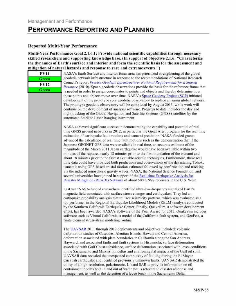
Reported Multi-Year Performance Multi-Year Performance Goal 2.1.6.1: Provide national scientific capabilities through necessary skilled researchers and supporting knowledge base. (In support of objective 2.1.6: "Characterize the dynamics of Earth's surface and interior and form the scientific basis for the assessment and mitigation of natural hazards and response to rare and extreme events.")
FY11 NASA’s Earth Surface and Interior focus area has prioritized strengthening of the global geodetic network infrastructure in response to the recommendations of National Research Council’s report Precise Geodetic Infrastructure: National Requirements for a Shared Resource (2010). Space-geodetic observations provide the basis for the reference frame that is needed in order to assign coordinates to points and objects and thereby determine how those points and objects move over time. NASA’s Space Geodesy Project (SGP) initiated development of the prototype core geodetic observatory to replace an aging global network. The prototype geodetic observatory will be completed by August 2013, while work will continue on the development of analysis software. Progress to date includes the day and night tracking of the Global Navigation and Satellite Systems (GNSS) satellites by the automated Satellite Laser Ranging instrument. NASA achieved significant success in demonstrating the capability and potential of real time GNSS ground networks in 2012, in particular the Great Alert program for the real time estimation of earthquake fault motions and tsunami prediction. NASA-funded grants advanced the calculation of real time fault motions such as the demonstration that if the Japanese GEONET GPS data were available in real time, an accurate estimate of the magnitude of the March 2011 Japan earthquake would have been available within two minutes of the rupture, nearly 12 minutes prior to the first inundation of the tsunami and about 18 minutes prior to the fastest available seismic techniques. Furthermore, these real time data could have provided both predictions and observations of the devastating Tohoku tsunamis using GPS-based crustal motion estimates followed by confirmation and tracking via the induced ionospheric gravity waves. NASA, the National Science Foundation, and several universities have joined in support of the Real-time Earthquake Analysis for Disaster Mitigation (READI) Network of about 500 GNSS receivers in the U.S. West. Last year NASA-funded researchers identified ultra-low-frequency signals of Earth's magnetic field associated with surface stress changes and earthquakes. They led an earthquake probability analysis that utilizes seismicity patterns, which was evaluated as a top performer in the Regional Earthquake Likelihood Models (RELM) analysis conducted by the Southern California Earthquake Center. Finally, QuakeSim, a software development effort, has been awarded NASA’s Software of the Year Award for 2012. QuakeSim includes software such as Virtual California, a model of the California fault system, and GeoFest, a finite element stress-strain modeling routine. The UAVSAR 2011 through 2012 deployments and objectives included: volcanic deformation studies of Cascades, Aleutian Islands, Hawaii and Central America, deformation associated with plate boundaries in California along the San Andreas, Hayward, and associated faults and fault systems in Hispaniola, surface deformation associated with Gulf Coast subsidence, surface deformation associated with levee conditions in the Sacramento and Mississippi deltas and environmental impacts of the Gulf oil spill. UAVSAR data revealed the unexpected complexity of faulting during the El Mayor–Cucapah earthquake and identified previously unknown faults. UAVSAR demonstrated the utility of a high-resolution, polarimetric, L-band SAR to provide information on oil containment booms both in and out of water that is relevant to disaster response and management, as well as the detection of a levee break in the Sacramento Delta.
Green FY12 Green
Management and Performance
PERFORMANCE REPORTING AND PLANNING
M&P-69
Update to Multi-Year Performance Goal
FY13 Update This performance goal remains the same in FY13. FY14 This performance goal remains the same in FY14.
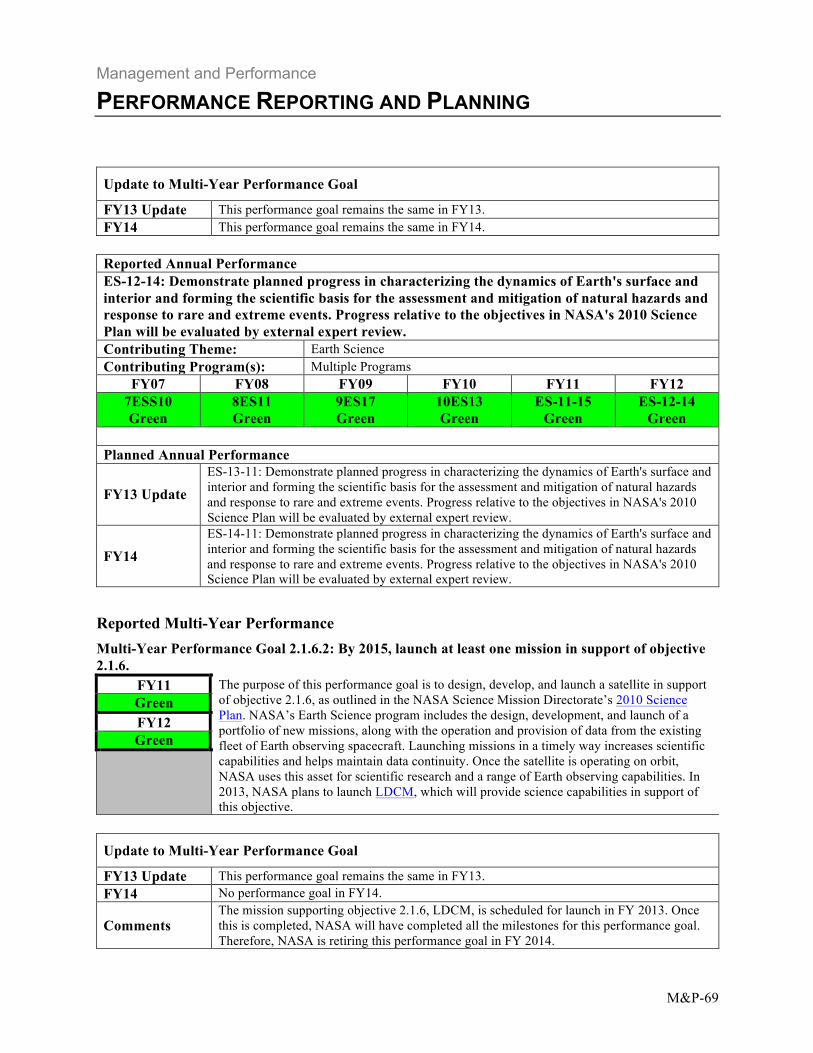
Reported Annual Performance ES-12-14: Demonstrate planned progress in characterizing the dynamics of Earth's surface and interior and forming the scientific basis for the assessment and mitigation of natural hazards and response to rare and extreme events. Progress relative to the objectives in NASA's 2010 Science Plan will be evaluated by external expert review. Contributing Theme: Earth Science Contributing Program(s): Multiple Programs
FY07 FY08 FY09 FY10 FY11 FY12 7ESS10 Green
8ES11 Green
9ES17 Green
10ES13 Green
ES-11-15 Green
ES-12-14 Green
Planned Annual Performance
FY13 Update ES-13-11: Demonstrate planned progress in characterizing the dynamics of Earth's surface and interior and forming the scientific basis for the assessment and mitigation of natural hazards and response to rare and extreme events. Progress relative to the objectives in NASA's 2010 Science Plan will be evaluated by external expert review.
FY14 ES-14-11: Demonstrate planned progress in characterizing the dynamics of Earth's surface and interior and forming the scientific basis for the assessment and mitigation of natural hazards and response to rare and extreme events. Progress relative to the objectives in NASA's 2010 Science Plan will be evaluated by external expert review.
Reported Multi-Year Performance Multi-Year Performance Goal 2.1.6.2: By 2015, launch at least one mission in support of objective 2.1.6.
FY11 The purpose of this performance goal is to design, develop, and launch a satellite in support Green of objective 2.1.6, as outlined in the NASA Science Mission Directorate’s 2010 Science
FY12 Plan. NASA’s Earth Science program includes the design, development, and launch of a portfolio of new missions, along with the operation and provision of data from the existing fleet of Earth observing spacecraft. Launching missions in a timely way increases scientific capabilities and helps maintain data continuity. Once the satellite is operating on orbit,
Green
NASA uses this asset for scientific research and a range of Earth observing capabilities. In 2013, NASA plans to launch LDCM, which will provide science capabilities in support of this objective.
Update to Multi-Year Performance Goal
FY13 Update This performance goal remains the same in FY13. FY14 No performance goal in FY14.
The mission supporting objective 2.1.6, LDCM, is scheduled for launch in FY 2013. Once Comments this is completed, NASA will have completed all the milestones for this performance goal.
Therefore, NASA is retiring this performance goal in FY 2014.
Management and Performance
PERFORMANCE REPORTING AND PLANNING
M&P-70
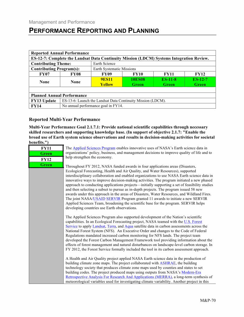
Reported Annual Performance ES-12-7: Complete the Landsat Data Continuity Mission (LDCM) Systems Integration Review. Contributing Theme: Earth Science Contributing Program(s): Earth Systematic Missions
FY07 FY08 FY09 FY10 FY11 FY12
None None 9ES11 Yellow
10ES08 Green
ES-11-8 Green
ES-12-7 Green
Planned Annual Performance FY13 Update ES-13-6: Launch the Landsat Data Continuity Mission (LDCM). FY14 No annual performance goal in FY14.
Reported Multi-Year Performance Multi-Year Performance Goal 2.1.7.1: Provide national scientific capabilities through necessary skilled researchers and supporting knowledge base. (In support of objective 2.1.7: "Enable the broad use of Earth system science observations and results in decision-making activities for societal benefits.")
FY11 The Applied Sciences Program enables innovative uses of NASA’s Earth science data in organizations’ policy, business, and management decisions to improve quality of life and to help strengthen the economy. Throughout FY 2012, NASA funded awards in four applications areas (Disasters, Ecological Forecasting, Health and Air Quality, and Water Resources), supported interdisciplinary collaboration and enabled organizations to use NASA Earth science data in innovative ways to improve decision-making activities. The program initiated a new phased approach to conducting applications projects—initially supporting a set of feasibility studies and then selecting a subset to pursue as in-depth projects. The program issued 58 new awards under this approach in the areas of Disasters, Water Resources, and Wildland Fires. The joint NASA/USAID SERVIR Program granted 11 awards to initiate a new SERVIR Applied Sciences Team, broadening the scientific base for the program. SERVIR helps developing countries use Earth observations. The Applied Sciences Program also supported development of the Nation’s scientific capabilities. In an Ecological Forecasting project, NASA teamed with the U.S. Forest Service to apply Landsat, Terra, and Aqua satellite data in carbon assessments across the National Forest System (NFS). An Executive Order and changes to the Code of Federal Regulations mandated increased carbon monitoring for NFS lands. The project team developed the Forest Carbon Management Framework tool providing information about the effects of forest management and natural disturbances on landscape-level carbon storage. In FY 2012, the Forest Service formally included the tool in its carbon assessment approach. A Health and Air Quality project applied NASA Earth science data in the production of building climate zone maps. The project collaborated with ASHRAE, the building technology society that produces climate zone maps used by counties and states to set building codes. The project produced maps using outputs from NASA’s Modern-Era Retrospective Analysis For Research And Applications (MERRA), a long-term synthesis of meteorological variables used for investigating climate variability. Another project in this
Green FY12 Green
Management and Performance
PERFORMANCE REPORTING AND PLANNING
M&P-71
focus area involved using NASA satellite remote sensing data to extend the coverage of aerosols in the southeastern United States by the CDC Environmental Public Health Tracking Network. This network provides data on environmental factors affecting health to the public, policy makers, and public health professionals. The Natural Disasters applications area works seamlessly with other agencies to aid the government in meeting the challenges associated with natural disaster response and to transfer technologies to other agencies as they become operational. With support from Applied Sciences, NASA contributed to the national response on numerous disasters in 2012, including the provision of satellite data on wildfires, drought, and Hurricanes Isaac and Sandy. The program also manages DEVELOP, a training and development internship program for young professionals. DEVELOP interns gain hands-on experience with satellite remote sensing and apply Earth observations to real-world issues facing state and local governments. The program fosters a corps of early-career professionals, cultivating advanced skills in Earth science applications and an understanding of science in decision-making. DEVELOP set new records during the year, with over 300 interns participating in 64 projects. DEVELOP opened new centers in Missouri and Colorado to expand its national scope.
Update to Multi-Year Performance Goal
FY13 Update This performance goal remains the same in FY13. FY14 This performance goal remains the same in FY14.
Reported Annual Performance ES-12-15: Advance at least 25 percent of decision-support projects at least one Applications Readiness Level. The Applications Readiness Level is a nine-stage index for tracking the advancement of an Earth science applications project along a continuum from initial concept through development and transition to operational use. Contributing Theme: Earth Science Contributing Program(s): Applied Sciences
FY07 FY08 FY09 FY10 FY11 FY12 7ESS11 Green
8ES12 Green
9ES18 Green
10ES14 Green
ES-11-16 Green
ES-12-15 Green
Planned Annual Performance
FY13 Update ES-13-12: Advance at least 25 percent of decision-support projects one Applications Readiness Level. The Applications Readiness Level is a nine-stage index for tracking the advancement of an Earth science applications project along a continuum from initial concept through development and transition to operational use.
FY14 ES-14-12: Advance at least 25 percent of decision-support projects one Applications Readiness Level. The Applications Readiness Level is a nine-stage index for tracking the advancement of an Earth science applications project along a continuum from initial concept through development and transition to operational use.
Management and Performance
PERFORMANCE REPORTING AND PLANNING
M&P-72
Reported Annual Performance ES-12-16: Increase the number of science data products delivered to Earth Observing System Data and Information System (EOSDIS) users. Contributing Theme: Earth Science Contributing Program(s): Earth Science Multi-Mission Operations
FY07 FY08 FY09 FY10 FY11 FY12
None 8ES13 Green
9ES19 Green
10ES15 Green
ES-11-17 Green
ES-12-16 Green
Planned Annual Performance
FY13 Update ES-13-13: Increase the number of science data products delivered to Earth Observing System Data and Information System (EOSDIS) users.
FY14 No annual performance goal in FY14.
Comments
NASA is retiring this APG as of FY 2014 because the program has increased significantly the number of science data products it delivers to users over the past several years. Based on this continued excellent performance, NASA has retired this measure. NASA is revisiting the performance measurement strategy and will add a measure for FY 2014 for the Big Earth Data Initiative during the development of FY 2015 Performance Plan.
Reported Annual Performance ES-12-17: Maintain a high level of customer satisfaction, as measured by exceeding the most recently available federal government average rating of the Customer Satisfaction Index. Contributing Theme: Earth Science Contributing Program(s): Earth Science Multi-Mission Operations
FY07 FY08 FY09 FY10 FY11 FY12
None 8ES14 Green
9ES20 Green
10ES16 Green
ES-11-18 Green
ES-12-17 Green
Planned Annual Performance
FY13 Update ES-13-14: Maintain a high level of customer satisfaction, as measured by exceeding the most recently available federal government average rating of the Customer Satisfaction Index.
FY14 ES-14-14: Maintain a high level of customer satisfaction, as measured by exceeding the most recently available federal government average rating of the Customer Satisfaction Index.
Earth Science Delivers
NASA’s Earth Observing System Data and Information System (EOSDIS) works to maintain high customer satisfaction in its ability to deliver data products to its customers. In FY 2012, the EOSDIS American Customer Satisfaction Index (ACSI) score was 77 out of a possible 100, the same result received each year since FY 2008. This continues to be a strong score and significantly exceeds the Federal government average of 67 (dated January 2012). EOSDIS improved in all three areas (Product Search, Selection and Order, and Documentation) recommended in the 2011 report by the Claes-Fornell International (CFI) Group.
Management and Performance
PERFORMANCE REPORTING AND PLANNING
M&P-73
ACSI is a leading national indicator of customer satisfaction for more than 225 companies and over 200 customer programs, services, and Web sites at 130 Federal agencies. CFI Group conducts this survey under contract with the Department of Interior’s Federal Consulting Group. Based on these consistent scores, the Federal Consulting Group recognized EOSDIS in January 2012 for its “committed and comprehensive approach to assessing and improving the satisfaction of world-wide customers obtaining science data, products, tools and services to advance the study of Earth from space.” The 2012 final report from CFI Group was released in November.