Strategic Framework and Practice of Sichuanggim.un.org/meetings/2017-Kunming/documents/Session 7 -...
21
23/05/2017 1 Zheng Quanhong Sichuan Bureau of Surveying Mapping and Geoinfomation PPT www.1ppt.com/moban/ Strategic Framework and Practice of Sichuan Provincial Emergency Surveying and Mapping Contents 1. Background 2. Strategic Framework of Sichuan Provincial Emergency Surveying and Mapping 3. Practice of Sichuan Provincial Emergency Surveying and Mapping 4. Challenges and Conclusions
Transcript of Strategic Framework and Practice of Sichuanggim.un.org/meetings/2017-Kunming/documents/Session 7 -...

23/05/2017
1
Zheng Quanhong
Sichuan Bureau of Surveying Mapping and Geoinfomation
PPT�����www.1ppt.com/moban/
Strategic Framework and Practice of Sichuan
Provincial Emergency Surveying and Mapping
� ����� �
Contents
1. Background
2. Strategic Framework of Sichuan Provincial Emergency
Surveying and Mapping
3. Practice of Sichuan Provincial Emergency Surveying
and Mapping
4. Challenges and Conclusions

23/05/2017
2
� ����� �
Sichuan province is located in the west
of China which is in the transitional
zone between Qinghai-Tibet plateau
and the middle and lower reaches of
Yangtze River plain with an area of
486,000 square kilometers and a
population of more than 90 million
The topograph of Sichuan is complex
and vary from east to west. The eastern
region are basin and hills where
elevations are between 500-2000 meters
while the western region are plateaus
and mountains where elevations are
over 4000 meters. This has formed the
famous Sichuan Basin.
1. Background
Shaded Relief
Map of Sichuan
� ����� �
Due to its special topography, Sichuan has a rich tourist resources and 5 are listed in the
UNESCO world heritage list.
1. Background

23/05/2017
3
� ����� �
Geological disaster risk map
Also because of it's complex
topography, Sichuan is the main
geological disaster area.
The three major earthquake
fault zones in Sichuan are in the
form of Y.
Sichuan has suffered from
earthquake, debris flow, floods
and other kinds of geological
disasters.
1. Background
Earthquake fault zone
� ����� �
After Wenchua earthquake in 2008 where about 80000 people died, Sichuan bureau of
Surveying mapping and Geoinfomaton (SCBSG) began to establish a new emergency surveying
and mapping security system using advanced GIS technology to improve the ability of
emergency response.
1. Background

23/05/2017
4
� ����� �
Contents
1. Background
2. Strategic Framework of Sichuan Provincial Emergency
Surveying and Mapping
3. Practice of Sichuan Provincial Emergency Surveying
and Mapping
4. Challenges and Conclusions
� ����� �
2.1 Governance and Policies
The Chinese Goverments at all levels have
attahed great importance to emergency
surveying and mapping .
Related laws and regulations have been made:
1. The Emergency Response Law of PRC
2. The Surveying and Mapping Law of PRC (It
was second revised in 27 April 2017)
3. The Mapping Results Management
Regulations of PRC
Other related planning includes:
� Disaster Preventon and Mitigation
Planning(2016-2010)
� Emergency Response Pre-plan
� The Medium and Long Term Plan for
Fundermental Surveying and Mapping (2016-
2030)
� The Thirteen Five -Year Plan for Surveying
Mapping and Geoinfomaton(2016-2020)

23/05/2017
5
� ����� �
2.1 Governance and Policies
The thirteen Five -Year Plan for Surveying Mapping and Geoinfomaton
In the Thirteen Five -Year Plan for Surveying Mapping and Geoinfomaton, both
NASG and SCBSG have proposed that emergency surveying and mapping
construction is one of the key tasks in the futrue work.
Geographic Information exchange and sharing management measures of Sichuan
province
In Januray 2017, Sichuan provincial goverment officially issued the Geographic
Information exchange and sharing management measures of Sichuan province. It is
required that the provincial surveying and mapping administrative department shall
responsible for the whole provincial geoinformation exchange and sharing, including
making standards and specifications for the provincial geoinformation public service
platform. Surveying and mapping adminstrative departments above county level
should establish emergency response mechanism, make emergency pre-plan and offer
timely high precision navigation positioning, aerospace remote sensing image ,
geoinformation data and other services.
�� ����� �
2.2 Awareness Raising and Capacity Building
Emergency Security System
SCBSG has put emergency surveying and mapping work in a very important position and
regards it as the key point to serve provincial government. The first provincial emergency
surveying and mapping response pre-plan was made in 2008, and it was revised in 2015. The pre-
plan has defined the coordinated response mechanism and procedure of data accqusision,
processing, distribution and services
����
���� !" #$ %��&�!'&!(&'&�%&!") "&!(&�
*+! " ,#$ %��&�!'&!(&'&�%&!") "&!(&�
�&( (-&. /#/(&�/ (+#( �!
�"( �#( !%,�&0,$#!
1&" / �!.&,$�)'
&!(
2&#'"�$$&"( �!
�"3+ � !%#!.
,��"&// !%.#(#
1#(#(�#!/'
// �! 4�#. !% .#(# (�,$#(5��'
6!0$ !& �7�/&�� "&
6,&!(-&
%�&&!"-#!!&$
8�$$&"( !%&9 /( !%�7� .#(#
1#(# �55&� !%
2-&'#( " '#,'#: !%
Procedure of emergency response
Pre-plan

23/05/2017
6
�� ����� �
2.2 Awareness Raising and Capacity Building
Emergency Security SystemSichuan provincal emergency
capacity building mainly around
three aspects:
� Emergency data acquisition
� Emergency database
constructon
� Emergency command and
dispatch
Through the capacity building, it
is aimed to establish a sky-earth
integrated, flexible and connective
emergency surveying and mapping
system
Capacity building
�� ����� �
2.2 Awareness Raising and Capacity Building
All-weather emergency monitoring
Automated rapid mapping
Real-time information transmission
Efficient command decision

23/05/2017
7
�� ����� �
2.2 Awareness Raising and Capacity Building
Emergency Security System
One SystemOne Database
Three Centers
Emergency Surveying and Mapping Security System
Sichuan provincal emergency surveying and mapping security system is consisted of one
database, three centers and one system.
�� ����� �
One database means the high resolution Geodatabase for disaster prevention and control .The
database contains high resolution aerial photograph and satellite image, topographic map and
thematic map used for geological disaster control.
2.2 Awareness Raising and Capacity Building
Three Centers
One Database

23/05/2017
8
�� ����� �
Three centers includes: one technology research center, one emergency safeguard center and
one emergency command center
2.2 Awareness Raising and Capacity Building
Three Centers
1. Disaster Prevention & Mitigation Engineering Technology Research Center
The center is mainly engaged in key technology research on emergency service
and disaster prevention & mitigation, and to carry out achievements
transformation.
Innovation System
Basic Research Technology InnovationAchievements
Transformation
is
2. Emergency Safeguard Center for Surveying and Mapping
The center mainly responsible for the informaton acquisition of disaster area.
3. Emergency Command Center for Surveying and Mapping
The command hall is about 200 square meters, and can hold 100 people. It is equipped with
teleconference system and a 3D emergency command platform . The on-site information can be
transmitted to the command center and loaded to the platform for remote decision and command .
�� ����� �
One system means Unmanned Aerial Vehicle (UAV) cluster disaster information acquiring
system . The system aims to acquire disaster information in a timely, efficiently, accurately
and comprehensively way. It integrates Emergency Surveying and Mapping UAV Platform ,
36 sets of multi dimension and multi source earth observation hardware, and 8 sets of
software.
2.2 Awareness Raising and Capacity Building
Three Centers

23/05/2017
9
�� ����� �
2.2 Awareness Raising and Capacity Building
;2<National Emergency
Surveying and Mapping
Capabilities Constructon
Another important capacity buildig
is that NASG launched a project of
National Emergency Surveying and
Mapping Capabilities Construction
in March 2017 . The total
investment of the project is 800
million yuan, and it will last for 3
years.
SCBSG is one of the key members of
the project.
�� ����� �
2.2 Awareness Raising and Capacity Building
(1) National aviation capacity building for
emergency surveying and mapping
Through this capacty building, 12 emergency
aviation bases will be set up across the
country. Each base will be equipped with
multiple sets of manned aerial vehicles,
medium-endurance and short -endurance
fixed-wing UAV as well as unmanned
helicopter.
Sichuan is one of the aviation bases.
This will greatly improve the ability of on-site
emergency information acquiring .
=>?@ABCDEFG� HIJ� KLMNJ� OPQRFG
STUV>?@ABCDEFG� HIJ� MNJ� WXYZ[\� ]^_`[\
V>ab?@ABCDEFG� HIJ� MNJ� WXYZ[\� ]^_`[\
cdefghijklmn
opqrs
tuvwxyz{
|}~�����z{
The project includes four kinds of capacities buildingManned Aerial Vehicles
Fixed-wing UAV
Unmanned helicopter
For large area
For major area
Flexible

23/05/2017
10
�� ����� �
2.2 Awareness Raising and Capacity Building
(2) Capacity building of natonal support teams for emergency surveying and mapping
Emergency support teams are mainly responsible for front-line emergency reconnaissance
tasks. 3 emergency support teams and 9 squads will be set up cross the country.Each team
will be equipped with one multi-function shelter, one life support vehicle and one set of
resource storage management system. SCBSM is one of the emergency teams.
�� ����� �
2.2 Awareness Raising and Capacity Building
(3) Capacity building of national emergency
surveying and mapping command center.
The command center will be equipped with:
One Emergency Rapid Data Processing System,
One Emergency Rapid Map Printing System,
One Emergency Rapid Information Service System,
One Emergency Data Storage Management System
One Emergency Command and Dispatch System.
The command center is located in Beijing.
On one hand it is connected with the
emergency command platform of State
Council, on the other hand, it is connected
with 5 remote consultation terminals and 25
video conference terminals through e-
government intranet to offer emergency
geospatial infomation services for national
goverment and emergency management and
rescue departments .

23/05/2017
11
�� ����� �
2.2 Awareness Raising and Capacity Building
(4) Capacity building of national
emergency data resources sharing
It will finally establish a fundamental
base map database, a fast transmission
network and a data resources sharing
platform. Through the data sharing
platform, it will realize 7*24 hours data
sharing with emergency office of the state
council and major ministries through E-
government intranet.
�����
�����
��
�����
��
����
����
���
¡¢
Fundamental base map database
Data resources
sharing platform
Fast transmission
network
�� ����� �
2.3 Data Management
During the Twelfth Five-Year (2011-2015), Sichuan Bureau invested 650 million yuan to build
Sichuan Geographic Informaton Public Service Platform.
By completing the tasks of :
� Spatial positioning datum construction
� Aerospace remote sensing image acquiring
� Geospatial information producing and updating
� Provincial geographic condition monitoring
� Geospatial information service system
construction
� Geological disaster prevention and control map
producing
The geospatial information resources of
Sichuan province have been greatly
enriched.

23/05/2017
12
�� ����� �
2.3 Data Management
Sichuan Geomatics Center is responsible for managing and maintaining the provincial
fundamental geospatial database, geospatial information sharing and data distribution.
�� ����� �
Data sources
Data import
Data
management
and query system
Data
distribution
system
Cloud storage
system
Data
processing
system
2.3 Data Management
The illustration decribes the process of data
management through:
� Data processing system
� Database management and query system
� Data distributionsystm
Sichuan provincial geodatabase is connected with
national geodatabase and 27 other provincial
geodatabase and 5 ministries database through the
national geoinformation sharing platform to offer
emergency data sharing and services.
£¤¥¦§¨©ª«
¬ ® ¯ °
±²³´µ¶
·¸¹ºª« »¹¼½ª«
¾¾ ¾¾

23/05/2017
13
�� ����� �
2.3 Data Management
Sichuan Geospatial Big Data Center is under construction. More and more thematic data for disaster
prevention and mitigation will be added to the center through data exchanging and sharing. The cloud
infrastructure for data storing, processing, computing, analysis, displaying will be even powerful.
Policy and
Standards
Data
updating
and sharing
mechanism
Cloud
Infrastructure
Data Resources
Application
Systems
Services Platform
�� ����� �
2.4 Common Infrastructure and Services
SCBSG has 8 subordinate units with 2100 employees including more than 1300 professionals .
It has formed a complete range of surveying and mapping service system covering geodetic
surveying, photogrammetry and remote sensing, geographic information system and database
management, underground pipeline surveying, engineering surveying, cadastral surveying, map
compiling and publishing, surveying and mapping results management and supply, surveying
and mapping products supervision and inspection, surveying and mapping technology education
and training, etc.
SCBSG
Sichuan Remote
Sensing
Information
Institute of
Surveying and
Mapping
Sichuan No.1
Engineering Institution
of Surveying and
MappingSichuan No.2
Engineering
Institution of
Surveying and
Mapping
Sichuan Quality
Supervising and
Testing Station
for Surveying
and Mapping
Products
Sichuan
Geomatics Center
Sichuan No.3
Engineering
Institution of
Surveying and
Mapping
Sichuan
Emergency
Safeguard
Center of
Surveying and
Mapping
Southwest Staff
Training Center
of Surveying and
Mapping

23/05/2017
14
�� ����� �
2.4 Common Infrastructure and Services
Data acquisition equipment
GPS RTK Measuring robot Ground radar Geological radar
Detector
Total Station
Level Tilt aerial camera Digital aerial camera
Mobile measuring
vehicle
�� ����� �
2.4 Common Infrastructure and Services
Data collecting and processing system
VirtuoZoPixelgrid Geoway
Digital photogrammetry system
StreetFactory
SAR Mapping Station
OneDataPro Editor
......

23/05/2017
15
�� ����� �
2.4 Common Infrastructure and Services
Data storage and management system, output device
Oracle storage
and computing
integrated
machine
Disk array
Quick printer
HP printer
Direct plate making machine
Printing and scanning
integrated machine
Color printing machine
�� ����� �
2.4 Common Infrastructure and Services
Sichuan geoinformation public service platform
SCBSG has established Sichuan geoinformation public service platform which is a node of the national
geoinformation public service platform (“Map World”) . This platform has integrated all kinds of public
geoinformation resources from provincial and municipal surveying and mapping administrative departments ,related
governments, enterprises and institutions and etc. It offers authoritative, standard and unified on-line
geoinformation services.

23/05/2017
16
�� ����� �
2.5 Rescource Mobilization
Technical rescources
SCBSG has set up four R&D platforms, two major alliances and one industry research institute which has
formed the science and technology innovation platform and team. 32 industry experts including 5
academicians and 20 professors have been invited to the innovation platform and team. It has greately
improved the ability of emergency surveying and mapping , achivements transformation and industry
development.
Four R&D Platforms
� Disaster Prevention & Mitigation Engineering Research Center
� Satellite Navigation and Location-Based Service Engineering Research Center
� National Geographic Condition & Environmental Resources Carrying Capacity Monitoring
Engineering Research Center
� NASG Key Laboratory of Digital Mapping and Land Information Application
Two Major Alliances
� Sichuan Beidou Satellite Navigation Industry Alliance
� GIS Collaborative Innovation Alliances of Yangtze River Economic Belt
�� ����� �
2.5 Rescource Mobilization
Humman rescource
SCBSG has established expert technical teams from both
inside and outside. From inside it has 6 expert teams
majoring in different bussiness scopes.
Sichuan Aerospace
Image Processing
and Emergency
Monitoring Center
Sichuan
Navigation and
LBS Center
Sichuan Map
Reviewing and
Printing Center
Sichuan
Geomatics Center
Sichuan
Geographic
Condition
Monitoring
Center
Sichuan
Emergency
Safeguard
Center of
Surveying and
Mapping
Sicuan
Emergency
Command
Center for
Surveying and
Mapping
¿ÀÁÂÃÄ
ÅÆÇÈÃÄ
From outside, SCBSG has coorperated with
related univercities, enterprices, institutions,
private commpanies and etc.

23/05/2017
17
�� ����� �
Contents
1. Background
2. Strategic Framework of Sichuan Provincial Emergency
Surveying and Mapping
3. Practice of Sichuan Provincial Emergency Surveying
and Mapping
4. Challenges and Conclusions
�� ����� �
Emergency drills ÉIn order to accumulate experience and improve the response ability, SCBSG will
hold an emergency drill jointly with Sichuan provincial emergency office or municipal goverment
every year.
3. Practice of Sichuan Provincial Emergency Surveying and Mapping
23/05/2017
18
�� ����� �
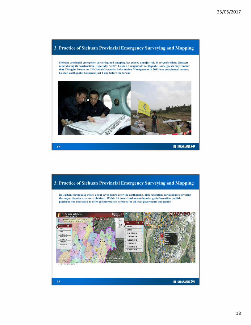
Sichuan provincial emergency surveying and mapping has played a major role in several serious disasters
relief during its construction. Especially “4.20” Lushan 7 magnitude earthquake, some guests may rember
that Chengdu Forum on UN Global Geospatial Information Management in 2013 was postphoned because
Lushan earthquake happened just 1 day before the forum.
3. Practice of Sichuan Provincial Emergency Surveying and Mapping
�� ����� �
In Lushan earthquake relief, about seven hours after the earthquake, high resolution aerial images covering
the major disaster area were obtained. Within 16 hours Lushan earthquake geoinformation publish
platform was developed to offer geoinformation services for all level goverments and public.
3. Practice of Sichuan Provincial Emergency Surveying and Mapping

23/05/2017
19
�� ����� �
The system has also been tested in “6.18” flood, “11.12” Kangding earthquake and Miangyang mountain
collapse relief
3. Practice of Sichuan Provincial Emergency Surveying and Mapping
�� ����� �
Contents
1. Background
2. Strategic Framework of Sichuan Provincial Emergency
Surveying and Mapping
3. Practice of Sichuan Provincial Emergency Surveying
and Mapping
4. Challenges and Conclusions

23/05/2017
20
�� ����� �
4. Challenges
Sichuan Emergency Surveying and Mapping is getting more and more mature after
serveral years construction and practice. It is expected to be further improved after
National Emergency Surveying and Mapping Capabilities Construction
However there are still some challenges we have to continously working on:
1. Data sharing and exchanging mechanism : the conflict between data security and
data sharing
2. Technology support for disaster prevention & mitigation such as big data and
cloud computing technology for disaster information fast interpretation, evaluation,
monitoring and early warning .
�� ����� �
4. Conclusions
There is an old chinese saying that: the sparrow is small but complete.
The stratege framwork and practice of Sichuan provincial emergency surveying and mapping may
provide a guidence and reference for the implementation of the UN-GGIM stratege framework
To implement UN-GGIM stratege framework, it is suggested to
� Establish a global coordinating mechanism
� Make rules to regulate data sharing measures and procedures
� Build a global cloud platform for emergency data sharing and services
� Practice and test the stratege framework

23/05/2017
21
�� ����� �
4. Conclusions
The beautiful world needs surveying, mapping and
geoinformation technology to protect and defend against
emergency disasters. Let's work together and make our
world more beartiful. Geoinformation workers are
always on the road.
�� ����� �
Thank you for your kind attention
XXXX
XXXXXXXXX
XXXXXXXXXXXXXXXXXX
XXXXXXX