Strategic Flood Risk Assessment Main Report.pdf · Final Report Knowsley and Sefton Metropolitan...
90
Knowsley Council Sefton Council Strategic Flood Risk Assessment Final June 2009
Transcript of Strategic Flood Risk Assessment Main Report.pdf · Final Report Knowsley and Sefton Metropolitan...

Knowsley Council Sefton Council
Strategic Flood Risk AssessmentFinal
June 2009

Page left blank intentionally

Knowsley Council and Sefton Council
Strategic Flood Risk Assessment
5074164/DG/003 Notice This report was produced by Atkins for Knowsley Council and Sefton Council for the specific purpose of the Strategic Flood Risk Assessment.
This report may not be used by any person other than Knowsley Council and Sefton Council without the express written permission of ATKINS. In any event, Atkins accepts no liability for any costs, liabilities or losses arising as a result of the use of or reliance upon the contents of this report by any person other than Knowsley Council and Sefton Council.
Atkins Limited
Document History
JOB NUMBER: 5074164 DOCUMENT REF: 5074164/DG/003
F3 Final OT SF OT MJ 22/06/09
F2 Final - corrected NB/TJ NM SF OT 01/06/09
F2 Final - resubmitted NB/TJ NM SF OT 21/05/09
F1 Final NB/TJ SF MH OT 23/03/09
D7 Final Draft NB/TJ EA SF OT 17/09/08
D1 Draft NB/TJ 09/2008
Revision Purpose Description Originated Checked Reviewed Authorised Date
/5074164_DG_062_003 KMBC requested changes 4-8-09.doc

Page left blank intentionally
/5074164_DG_062_003 KMBC requested changes 4-8-09.doc

Strategic Flood Risk Assessment June 2009 Final Report Knowsley and Sefton Metropolitan Borough Councils
5074164_DG_062_003 KMBC requested changes 4-8-09.doc Page 5
Contents Section Page 1. Introduction 9
1.1 Background to Study 9 1.2 Overview 9 1.3 Future Development within Knowsley and Sefton 10 1.4 Need for a Flood Risk Assessment 10 1.5 Objectives 11 1.6 Scope of this Document 11
2. Review of Planning Policy 12 2.1 Introduction 12 2.2 National Planning Policy Scope of this Document 12 2.3 Regional Planning Policy 15 2.4 Local Planning Policy 17
3. Data Collection and Review 25 3.1 Summary 25 3.2 Definition of Terms 26 3.3 Overview of the Knowsley District Area 26 3.4 Overview of the Sefton District Area 26 3.5 Knowsley Flood Risk Sources 27 3.6 Sefton Flood Risk Sources 29 3.7 Knowsley Flood Risk Information 33 3.8 Sefton Flood Risk Information 36 3.9 Knowsley Existing Flood Defences 38 3.10 Sefton Existing Flood Defences 39 3.11 Proposed and Potential Development Sites 40 3.12 Consultation 41
4. Analysis 43 4.1 Flood Risk Sensitivities 43
5. Combined Risk Matrix Mapping 48
6. PPS25 and the Sequential test for Knowsley and Sefton Unitary Development Plan and other allocations 49
6.1 Background 49 6.2 Sequential Test 49 6.3 Exception Test 49 6.4 Flood Zone Definition 50 6.5 Knowsley and Sefton PPS25 Flood Zones 52 6.6 Assessing Flood Risk Using the Sequential Test 53 6.7 Knowsley Summary of Results 54 6.8 Sefton Summary of Results 56 6.9 Windfall Sites 57
7. Flood Management 58 7.1 Options for Knowsley and Sefton 58

Strategic Flood Risk Assessment June 2009 Final Report Knowsley and Sefton Metropolitan Borough Councils
5074164_DG_062_003 KMBC requested changes 4-8-09.doc Page 6
7.2 River Corridor Maintenance 58 7.3 Emergency Evacuation Routes 59
8. Conclusions and Recommendations 60 8.1 Conclusions 60 8.2 Recommendations 62
List of Tables
Table 2.1: PPS25 Table D3 14 Table 3.1: Knowsley flooding hotspots Error! Bookmark not defined. Table 3.2: Environment Agency data used in the definition of PPS25 Flood Zones 33 Table 3.3: Environment Agency data used in the definition of PPS25 Flood Zones 36 Table 6.1: Environment Agency data used in the definition of PPS25 Flood Zones 50 Table 6.2: Flood Risk Vulnerability and Flood Zone ‘Compatibility’ 52 Table 6.3: Sequential Test Summary Results – Knowsley 55 Table 6.4: Sequential Test Summary Results – Sefton 56
Appendices Appendix A – Watercourses in the Borough Areas 65
Appendix B – Environment Agency Published Flood Maps with contours and flood warning areas 67
Appendix C – Flood Defence Assets and Areas Benefitting from Defences 69
Appendix D – United Utilities DG5 Surface Water Drainage and Surface Water Flooding from Council Records 71
Appendix E – Ground Water and Geology 73
Appendix F – PPS25 Updated Flood Zones 75
Appendix G – PPS25 Flood Zone 3a with Climate Change 77
Appendix H – Identified Development Sites and PPS25 Flood Zones 79
Appendix I – Sequential Test Results 81
Appendix J – Combined Risk Matrix Map 83
Appendix K – Guidance Notes 85
Appendix L – Culverts and Defences in the Boroughs 87

Strategic Flood Risk Assessment June 2009 Final Report Knowsley and Sefton Metropolitan Borough Councils
5074164_DG_062_003 KMBC requested changes 4-8-09.doc Page 7
Glossary
Acronym Description ABD Area Benefitting from Defences AEP Annual Exceedance Probability AOD Above Ordnance Datum CFMP Catchment Flood Risk Management Plan DG5 Register Register within the Director General of OFWAT's Report on Issue Number 5 DPD Development Plan Document
Flood Map Environment Agency mapping showing fluvial and tidal flood extents for various probabilities of storm event
Flood Zone PPS25 flood extents based on Flood Map data and supported by other relevant flood data where available
FRA Flood Risk Assessment (site specific) GEM Groundwater Emergence Maps LDD Local Development Documents LDF Local Development Framework LiDAR Light Detection and Ranging aerial survey LPA Local Planning Authority MEAS Merseyside Environmental Advisory Service NFCDD National Flood and Coastal Defence Database PAR Project Appraisal Report PPS1 Planning Policy Statement 1: Delivering Sustainable Development PPS10 Planning Policy Statement 10: Planning for Sustainable Waste Management PPS25 Planning Policy Statement 25: Development and Flood Risk PPS3 Planning Policy Statement 3: Housing RFRA Regional Flood Risk Assessment RPB Regional Planning Body RSS Regional Spatial Strategy SFRA Strategic Flood Risk Assessment SMP Shoreline Management Plan UDP Unitary Development Plan
Strategic Flood Risk Assessment June 2009 Final Report Knowsley and Sefton Metropolitan Borough Councils
5074164_DG_062_003 KMBC requested changes 4-8-09.doc Page 8
Page left blank intentionally

Strategic Flood Risk Assessment June 2009 Final Report Knowsley and Sefton Metropolitan Borough Councils
5074164_DG_062_003 KMBC requested changes 4-8-09.doc Page 9
1. Introduction 1.1 Background to Study
Knowsley and Sefton Borough Councils commissioned Atkins, in April 2008, to undertake a Strategic Flood Risk Assessment (SFRA) for the two Boroughs. The SFRA was undertaken in accordance with Government guidance set down in Planning Policy Statement 25 “Development and Flood Risk” (PPS25)1 and the best practice guide (“Planning Policy Statement 25: Development and Flood Risk Practice Guide”).
The SFRA is a hybrid of a Level 1 assessment at a Borough wide level for each Borough combined with a more detailed assessment. The detailed aspects incorporate elements of; a Level 2 SFRA for specified regeneration /development areas and sites; and sites identified in the strategic housing land assessment and employment land study.
The purpose of the SFRA is to clarify and refine available flood risk information and to inform the planning decision making processes. This will enable robust and reliable decisions to be made on locations for development and growth. The information is firstly used by Local Planning Authorities (LPAs), in preparing their Core Strategies and other future Local Development Documents (LDDs). It can also be used by developers in their appraisal of potential development sites and the scoping of site specific Flood Risk Assessment (FRAs) should they be necessary.
It is important to remember that this is intended to be a live document and therefore should be revised regularly to incorporate new information and understanding of flood risk as and when it becomes available for the Knowsley and Sefton areas.
1.2 Overview PPS25 states that a Strategic Flood Risk Assessment (SFRA) “should be carried out by the local planning authority to inform the preparation of its Local Development Documents, having regard to catchment-wide flooding issues which affect the area.” In June 2008 Atkins was commissioned by Knowsley and Sefton Councils to develop a Level 1 SFRA, with some Level 2 elements, to inform the preparation of the Core Strategies and Allocation Development Plan Documents for the Boroughs. A key aspect of the core strategies, to be prepared as part of the Local Development Framework (LDF), will be to provide frameworks for the future location of development within the Boroughs.
The Environment Agency have been consulted throughout the development of this SFRA and agree with the methodology adopted.
Knowsley
Knowsley has a population of approximately 150,000, mainly residing in the towns of Kirkby, Huyton, Prescot, Whiston and Halewood.
Knowsley underwent rapid urban growth up to the 1970’s as a result of overspill from the expansion of Liverpool at that time. This led to a very large council house building programme focused on young families with children. The recession of the 1970’s and 80’s resulted in a quick population decline in the area, connected with a poor choice of housing to buy, a surplus of education buildings and social difficulties. (Knowsley UDP, 2006)
Sefton
The Borough of Sefton has a population of approximately 281,000, mainly residing in the freestanding settlements of Southport, Formby and Maghull; and in Crosby and Bootle which form the northern part of the greater Liverpool conurbation. Around 50% of Sefton Borough is Green Belt
1 Planning Policy Statement 25: Development and Flood Risk. Department for Communities and Local Government (December 2006)
Strategic Flood Risk Assessment June 2009 Final Report Knowsley and Sefton Metropolitan Borough Councils
5074164_DG_062_003 KMBC requested changes 4-8-09.doc Page 10
land;- including the Sefton Coast which is internationally important for nature conservation, and other rural areas where agricultural land quality is generally high.
Economic activity is concentrated within a few strategic locations including the port and maritime zone, the industrial and commercial Dunnings Bridge Road Corridor in Bootle and Netherton, the central commercial and retail areas in Bootle and Southport, and Southport seafront. Sefton’s tourism industry is based around Aintree racecourse, Southport seaside resort and the large number of golf courses in the area.
1.3 Future Development within Knowsley and Sefton Good transport links exist within the Boroughs which can assist with further economic regeneration through employment and new housing developments. Both Knowsley and Sefton have proposed developments to the transport networks within their boundaries.
In addition to transport development of the Merseyside rail link, there are also plans to develop specific areas to improve the amount and quality of housing contained in the Boroughs. These locations are spread around the Knowsley and Sefton area, however a large concentration can be found in Bootle and North Huyton. Several sites are earmarked for industrial development, with a large cluster at Netherton and Knowsley Industrial Park. Other sites have been allocated to retail, employment and other development uses.
1.4 Need for a Flood Risk Assessment Flooding is the most widespread and frequently occurring of natural hazards and, therefore, flood risk is one of many factors that should influence the spatial planning process. All forms of flooding and their impact on the natural and built environment are significant planning considerations.
Planning Policy Statements set out the Government’s national policies on different aspects of land use planning in England. Planning Policy Statement 1: Delivering Sustainable Development (PPS1) sets out the Government’s objectives for the planning system and describes how planning should facilitate and promote sustainable patterns of development, avoiding flood risk and taking into consideration the impacts of climate change.
Planning Policy Statement 25: Development and Flood Risk (PPS25) complements other national planning policies and should be read in conjunction with National and European policies for flood risk and water management, including Making Space for Water2 and the Water Framework Directive3. The aims of PPS25 are to ensure that flood risk is taken into account at all stages of the planning process to avoid inappropriate development in areas at risk of flooding and to direct development away from areas at highest risk (the Sequential Test).
The Sequential Test splits the planning district into three distinct flood risk zones. Based upon the flood risk zone and subsequent land use definitions, PPS25 guidance is applied to determine development constraints. If for other planning reasons, new development is necessary in high risk areas the policy aims to make the development safe without increasing flood risk elsewhere and, where possible, reducing flood risk overall (the Exception Test).
PPS25 requires an assessment of flood risk to be carried out to an appropriate degree at all levels of the planning process viz:-
• a Regional Flood Risk Appraisal (RFRA) to inform the Regional Spatial Strategy (RSS);
• a Strategic Flood Risk Assessment (SFRA) to inform the Local Development Documents (LDDs); and
2 Making Space for Water programme, cross Government programme taking forward the developing strategy for flood and coastal erosion risk management in England. 3 EU Water Framework Directive 2000/60/EC, came into force 22 December 2000.

Strategic Flood Risk Assessment June 2009 Final Report Knowsley and Sefton Metropolitan Borough Councils
5074164_DG_062_003 KMBC requested changes 4-8-09.doc Page 11
• a site-specific Flood Risk Assessment (FRA) to be submitted with planning applications for development in areas of flood risk, under the circumstances identified in PPS.
The Planning and Compulsory Purchase Act 2004 requires that a Sustainability Appraisal is undertaken for Regional Spatial Strategies, Development Plan Documents and Supplementary Planning Documents. Regional planning bodies (RPBs) and Local Planning Authorities (LPAs) are required under PPS1 to prepare and to implement planning strategies that help deliver sustainable development.
In developing their policies and strategies, RPBs and LPAs should work with the Environment Agency and other relevant operating authorities and stakeholders in appraising, managing and reducing flood risk in accordance with PPS25. As part of this process, RPBs should prepare Regional Flood Risk Appraisals (RFRAs) and LPAs should prepare Strategic Flood Risk Assessments (SFRAs) as freestanding assessments to contribute to the Sustainability Appraisal of their plans. PPS25 states that it is mandatory for LPAs to consult with the Environment Agency for planning applications for sites over 1 hectare in size or within areas identified to be at risk of flooding.
1.5 Objectives The requirements for a Strategic Flood Risk Assessment are set out in PPS25 and a completed SFRA should:
• Provide sufficient data and information to enable the LPA to apply the Sequential Test to land use allocations and, where necessary, the Exception Test;
• Enable the LPA to prepare appropriate policies for the management of flood risk within the Local Development Documents (LDDs);
• Inform the Sustainability Appraisal so that flood risk is taken into account when considering options and preparing strategic land use policies;
• Identify the need for site specific FRAs in particular locations along with the level of detail required in these areas; and
• Enable LPAs to determine the acceptability of flood risk in relation to emergency planning capability.
1.6 Scope of this Document The Knowsley and Sefton Council SFRA has been carried out and documented in accordance with PPS25. It summarises the data collection phase and the initial steps of the Sequential Test on the sites identified within the Unitary Development Plans for each Borough.
The report firstly provides an overview of the planning of development with regard to flood risk within Knowsley and Sefton (Section 2). A summary of the flood risk data made available for this SFRA and a review of this data is provided (Section 3) which then forms a basis for the assessment of flood risk in the Boroughs (Section 4, 5 and 6). The preparation for the Sequential Test is outlined for each of the allocated sites for development (Appendix H).
The SFRA provides the evidence base for flood risk which is a reference document for the Core Strategy and subsequent Local Development Documents. The SFRA also provides a reference document for consideration when assessing future development opportunities.

Strategic Flood Risk Assessment June 2009 Final Report Knowsley and Sefton Metropolitan Borough Councils
5074164_DG_062_003 KMBC requested changes 4-8-09.doc Page 12
2. Review of Planning Policy 2.1 Introduction
This section provides an overview of planning policy in relation to flood risk and development within Knowsley and Sefton Council areas. Government guidance along with strategic and local planning policies provide the prevailing policy framework for the development of an SFRA and are identified below.
2.2 National Planning Policy Scope of this Document The Government’s overarching policy regime sets out national guidance on different aspects of land use planning. Regional Planning Bodies (RPBs) and Local Planning Authorities (LPAs) are required to take this into account for the preparation of Regional Spatial Strategies and Local Development Frameworks. The Government’s national policies are contained within Planning Policy Statements (PPS). The key PPSs which would directly influence the scope of the SFRA, and those which would be relevant to flooding and water management, have been reviewed below.
• PPS1: Delivering Sustainable Development
• PPS3: Housing
• PPS25: Development and Flood Risk
2.2.1 PPS1: Delivering Sustainable Development
PPS1 sets out the Government’s aims and objectives for delivering sustainable development through the planning system. One of the main components of planning, as set out in paragraph 1 of PPS1, is to ensure “that the right development takes place in the right location and at the right time.” One of the key principles set out in PPS1 is to ensure that new development encourages sustainability for the lifetime of the development, taking due account of the physical environment and the impacts of climate change.
As part of delivering the sustainable development objectives, through paragraph 13, PPS1 requires RPBs and LPAs to consider climate change impacts, including flood risk, when taking decisions on the location and design of new development. In addition to this, Paragraph 13 also requires development plans prepared by the RPBs and LPAs to identify natural hazards which may affect new development and take appropriate action. In the case of areas at risk of flooding or sea level rise, the action is to avoid development in these zones, if possible. PPS1 recommends, in paragraph 36, that Planning Authorities prepare robust policies on design and access for new development. These should include a key objective to ensure developments are sustainable, taking into account natural hazards and the impacts of climate change, and to ensure such proposals are safe, durable and adaptable.
PPS1 Supplement – Planning and Climate Change
A supplement to PPS 1 (Delivering Sustainable Development) was published in December 2007 detailing the Government’s views on how the planning system can contribute to reducing emissions and stabilising climate change; a key Government priority for the planning system. This supplement is intended to be read in conjunction with the national Planning Policy Statements and Guidance series.
The PPS1 Supplement reinforces PPS1 on issues of climate change. It makes recommendations, in paragraph 24, for issues the Local Planning Authorities should take into account when selecting land for development. These include known physical and environmental constraints such as sea-level rise and flood risk, and suggests that a “precautionary approach” is taken to increases in risk that could arise as a result of likely changes to the climate.

Strategic Flood Risk Assessment June 2009 Final Report Knowsley and Sefton Metropolitan Borough Councils
5074164_DG_062_003 KMBC requested changes 4-8-09.doc Page 13
2.2.2 PPS3: Housing
PPS3 sets out the national planning policy framework for delivering the Government’s housing objectives. The PPS provides advice and guidance relating to housing land delivery and requires that it should be taken into account by LPAs and RPBs in the preparation of their development plans. The Government’s housing objectives can be achieved through a number of “outcomes” (such as housing developments in suitable locations) listed in paragraph 10 of PPS3 which the planning system should seek to deliver. In order to achieve these outcomes, PPS3 sets out policies based on a number of concepts and principles listed in paragraph 11. These include meeting the sustainable development requirements set out in PPS1, whilst taking into account climate change and flood risk.
PPS3 encourages the allocation of housing development in appropriate locations. When identifying broad locations for new housing development, PPS3, in paragraph 38, advises LPAs to take account of the constraints of the physical environment and natural hazards, such as flooding.
PPS3 also states, in paragraph 10, that a key objective of LPA should be to continue to make effective use of land by re-using those areas which have has been previously developed. In addition, the PPS states in paragraph 41 that the national annual target is for at least 60% of new housing to be provided on previously developed land. However, PPS3 also recognises that LPAs and RPBs “will need to consider sustainability issues for some sites as they may not be suitable for housing”.
2.2.3 PPS25: Development and Flood Risk
PPS25 sets out the Government’s polices with respect to development and flood risk. This is the key policy document for planning and flood risk and provides guidance on developing flood risk assessments. The PPS was issued in December 2006 and replaces the former Planning Policy Guidance Note 25 (PPG25). PPS25 complements other national planning policies and should be read in conjunction with Government and European policies for flood risk and water management, including Making Space for Water4 and the Water Framework Directive5.
The aims of PPS25 are to ensure that flood risk is taken into account at all stages in the planning process to avoid inappropriate development in areas at risk of flooding, and to direct development away from areas at highest risk. As stated in paragraph 5 of PPS25, ‘Where new development is, exceptionally, necessary in such areas, policy aims to make it safe without increasing flood risk elsewhere and where possible, reducing flood risk overall’. The RPBs and LPAs are required to do this by Appraising Risk, Managing Risk, Reducing Risk and using a Partnership Approach. Of these requirements, Appraising the Risk is key to informing SFRAs and is undertaken by:
• Identifying land at risk, and the degree of risk of flooding from river, sea and other sources i.e. ground water and surface water ; and
• Preparing Regional Flood Risk Appraisals (RFRAs) or Strategic Flood Risk Assessments (SFRAs) as freestanding assessments that contributes to the sustainability appraisals of development plan documents.
In general, flood risk assessments assess the risks of all forms of flooding to and from development, taking into account climate change. At a regional level, the RFRA informs the Regional Spatial Strategy, taking into account any SFRAs that have been prepared.
PPS 25 requires that the SFRAs provide information at local (but not site specific) level regarding the catchment wide flooding issues which affect the area. They must also provide the information required by the LPA to inform the sustainability appraisal of Local Development Documents and to apply the Sequential Test. This information is then used as the evidence base to inform LPAs in the preparation of their LDF documents. These documents will include policies and site allocations, in
4 Making Space for Water programme, cross Government programme taking forward the developing strategy for flood and coastal erosion risk management in England. 5 EU Water Framework Directive 2000/60/EC, came into force 22 December 2000.

Strategic Flood Risk Assessment June 2009 Final Report Knowsley and Sefton Metropolitan Borough Councils
5074164_DG_062_003 KMBC requested changes 4-8-09.doc Page 14
order to direct development to avoid flood risk to people and property where possible, and manage it elsewhere.
Sequential and Exceptions Test
The Sequential Test has been clarified by PPS25 and is to be used by LPAs when they allocate sites for development, or determine planning applications. In using the sequential test, sites are “zoned” in order of preference according to the flood risk identified by the SFRA. Although focusing on Flood Zones, the Sequential Test must consider all other known flood risk sources. Appropriate land uses for each Flood Zone are also listed to provide guidance for LPAs when they are considering appropriate use of sites within each zone. These Flood zones are contained within table D.3 from PPS25, reproduced below:
Note: Only when there are no reasonably available sites in Flood Zones 1 or 2 should decision makers consider the suitability of sites in Flood Zone 3. Table 2.1: PPS25 Table D3
Paragraph D1 of PPS25 states that the Sequential Test is to be applied at all stages of planning, and its aim is to steer new development to areas at the lowest probability of flooding (Zone 1). Paragraph D5 of PPS25 explains that where there are no reasonably available sites in Flood Zone 1, the Sequential Test can be used to demonstrate that sites are allocated in areas of flood risk only when no sites of lower risk are reasonably available. The role of the SFRA is; to refine the reasonably available information on flood risk from all sources; to present this information for application of the Sequential Test; and to take into account other sources of flooding such as the impacts of climate change.
Where the Sequential Test cannot deliver appropriate, acceptable sites for development within areas of lower probability of flooding and development is required for “wider sustainable development reasons”, as suggested in Paragraph 19, PPS 25 requires undertaking an Exception Test and this should be done as early as possible in the planning process. Paragraph 18 of PPS25 states that the Exception Test provides a method of managing flood risk while still allowing necessary development to occur. If there is a need to apply the Exception Test, the scope of future updates of this SFRA will be widened to consider the impact of any required flood risk management on the frequency, impact, speed of onset, depth and velocity of flooding within the Flood Zone.

Strategic Flood Risk Assessment June 2009 Final Report Knowsley and Sefton Metropolitan Borough Councils
5074164_DG_062_003 KMBC requested changes 4-8-09.doc Page 15
In developing the SFRA, LPAs are required to work with the Environment Agency and other relevant operating authorities and stakeholders in appraising, managing and reducing flood risk. All forms of flooding should be considered, although the PPS25 Flood Zones are the main factor affecting Sequential Test results.
PPS25 Development and Flood Risk Practice Guide
A Practice Guide for PPS25 was published in June 2008 to provide further guidance on implementing the flood risk approach of “appraise, manage and reduce” identified within the PPS, showing how it can be achieved in practice.
Guidance is provided for all stages of flood risk assessment. It includes advice on how to apply the sequential test with case studies and examples of control and mitigation.
Chapter Three provides guidance on the differing levels of flood risk assessment and how the different types of flood risk should be assessed. Paragraph 3.35 states that Strategic Flood Risk Assessments:
“…provide(s) the essential information on flood risk, taking climate change into account that allows the local planning authority (LPA) to understand the risk across its area so that the Sequential Test can be properly applied.”
Advice and guidance on the general scope and role of the SFRA is provided in more detail, building on the policy provided in PPS25. In addition to this, paragraph 3.59 suggests that SFRAs should provide:
“…information on the variation of risk within flood zones which are protected by flood defence infrastructure, draw appropriate conclusions and make recommendations for each potential development site.”
Further guidance on how the Sequential and Exception Tests should be applied to local spatial planning is provided within Chapter Four, whilst flood risk management and mitigation advice is provided in Chapter Six.
The information within the Practice Guide is presented to provide LPAs with the most up to date guidance on assessing flood risk which will, in turn, provide robust evidence for land allocation in Development Plan Documents.
2.3 Regional Planning Policy 2.3.1 Regional Spatial Planning
The North West Regional Spatial Strategy (RSS) was published in September 2008. The RSS for the North West sets out the development vision for the region by 2021. It provides a framework for all development in the region and sets priorities for dealing with identified regional and sub-regional issues, such as environmental issues. The RSS also provides a spatial framework for the development of other regional strategies, such as the Regional Economic Strategy and Regional Housing Strategy. All new planning documents currently being prepared by Knowsley and Sefton Councils will be required to generally conform to the RSS. The RSS forms part of the Development Plan against which planning applications have to be considered.
Policy DP1 sets out a number of spatial principles that underpin the RSS. These principles include the promotion of environmental quality, the reduction of emissions and adaptation to climate change. These principles have not only shaped the RSS, but are to be applied to all plans and strategies in the North West that affect development and management of land uses as well as to individual proposals. Policy DP9 sets out in more detail the approach to reducing emissions and adapting to climate change. In particular, plans, strategies, proposals, schemes and investment decisions should identify, assess and apply measures to ensure effective adaptation to likely environmental, social and economic impacts of climate change. Adaptation measures cited include, for example:

Strategic Flood Risk Assessment June 2009 Final Report Knowsley and Sefton Metropolitan Borough Councils
5074164_DG_062_003 KMBC requested changes 4-8-09.doc Page 16
• minimising threats from, and the impact of, increased coastal erosion, increased storminess and flood risk, habitat disturbance, fragmentation and increased pressure on water supply and drainage systems; and
• Sustainable Urban Drainage.
Plans, strategies and schemes are, therefore, required by the RSS to address climate change by putting into place effective mitigation measures.
Two other polices of the RSS are of particular relevance to this report. They are:
Policy EM5 – Integrated Water Management
In achieving integrated water management and delivery of the EU Water Framework Directive, plans and strategies should have regard to River Basin Management Plans, Water Company Asset Management Plans, Catchment Flood Management Plans, and the Regional Flood Risk Appraisal. Local planning authorities and developers should protect the quantity and quality of surface, ground and coastal waters, and manage flood risk, by:
• working with the Water Companies and the Environment Agency when planning the location and phasing of development. Development should be located where there is spare capacity in the existing water supply and waste water treatment, sewer and strategic surface water mains capacity, insofar as this would be consistent with other planning objectives. Where this is not possible development must be phased so that new infrastructure capacity can be provided without environmental harm;
• producing sub-regional or district level strategic flood risk assessments, guided by the Regional Flood Risk Appraisal. Allocations of land for development should comply with the Sequential Test in PPS25. Departures from this should only be proposed in exceptional cases where suitable land at lower risk of flooding is not available and the benefits of development outweigh the risks from flooding;
• designing appropriate mitigation measures into the scheme, for any development which, exceptionally, must take place in current or future flood risk areas, to ensure it is protected to appropriate standards, provides suitable emergency access under flood conditions, and does not increase the risk of flooding elsewhere;
• requiring new development, including residential, commercial and transport development, to incorporate sustainable drainage systems and water conservation and efficiency measures to the highest contemporary standard;
• encouraging retrofitting of sustainable drainage systems and water efficiency within existing developments; and
• raising people’s awareness of flood risks (particularly for vulnerable groups) and the impacts of their behaviours and lifestyles on water consumption.
Policy EM6 – Managing the North West’s Coastline
Plans, strategies, proposals and schemes (including Shoreline Management Plans) should take a strategic and integrated approach to the long term management of flood and coastal erosion risk by:
• taking account of natural coastal change and the likely impacts of climate change, to ensure that development is sited or re-sited carefully to avoid:
o the risk of future loss from coastal erosion, land instability and flooding;
o unsustainable coastal defence costs; and
o damaging existing defences and the capacity of the coast to form natural defences or to adjust to future changes without endangering life or property.
• making provision for mitigation of and adaptation to natural coastal change and the predicted effects of climate change over the medium to long-term (100 years) and supporting a ‘whole shoreline approach’ being taken to coastal risk management;

Strategic Flood Risk Assessment June 2009 Final Report Knowsley and Sefton Metropolitan Borough Councils
5074164_DG_062_003 KMBC requested changes 4-8-09.doc Page 17
• minimizing the loss of coastal habitats and avoiding damage to coastal processes; and avoiding adverse impacts now and in the future on coastal sites of international nature conservation importance; and
• promoting managed realignment as a tool for managing flood and coastal erosion risk and delivering biodiversity targets and compensatory habitat requirements under the Habitats Directive.
2.3.2 Regional Spatial Strategy – Partial Plan Review 2008
A partial review of the RSS is proposed. However, this will be limited to matters relating to:
• Gypsies and Travellers; • Travelling Show people; and • Regional Car Parking Standards.
Subject to legislation, it is expected that the future wider review of RSS will be combined with that of the Regional Economic Strategy and prepared / published as a Single Regional Strategy.
4NW and the Regional Development Agency are to be responsible for its preparation.
2.4 Local Planning Policy 2.4.1 Knowsley Replacement Unitary Development Plan (Adopted June 2006)
The Knowsley Unitary Development Plan (UDP) was adopted in 2006. The development plan sets out the authorities’ policies and proposals for the development and use of land in its area. The Plan provides the detailed policies and land allocations within the area consistent with national and regional policy. It is intended that many policies of the UDP will be saved before gradually being replaced by other documents in the LDF.
The UDP was undertaken before policy guidance update from PPG25 and therefore does not comply with the requirements set out in PPS25. However, there are policies within the plan which are relevant to flood risk and they are set out below.
POLICY ENV7: FLOOD RISK AND DRAINAGE
1. Development at an unacceptable risk of flooding will not be permitted. Where a development would be within an area of flood risk, the applicant will be required to:
a) Submit evidence to establish that the development could not be practicably located within an area of lower or no flood risk.
b) submit a flood risk assessment, which will fully assess the risks of flooding associated with the development in accordance with the requirements of Planning Policy Guidance note 25 "Development and Flood Risk".
2. Development will not be permitted if it may cause an unacceptable risk of flooding elsewhere.
3. Mitigation measures will be required, where necessary, to manage flood risk associated with or caused by new development. These should:
a) Be derived from a flood risk assessment;
b) Be fully described in the planning application;
c) Be fully funded - including for the provision of long-term maintenance - as part of the development; and
d) Contribute to the biodiversity resource of the Borough.
4. New development will not be permitted unless a Sustainable Drainage System is incorporated into the overall design. Exceptions may be made where it can be demonstrated that:
a) The Sustainable Drainage System would be likely to cause either significant land or water pollution; or
Strategic Flood Risk Assessment June 2009 Final Report Knowsley and Sefton Metropolitan Borough Councils
5074164_DG_062_003 KMBC requested changes 4-8-09.doc Page 18
b) The site’s ground conditions would preclude the use of a Sustainable Drainage System; or
c) The size of the site precludes the use of a Sustainable Drainage System; or
d) The proposed Sustainable Drainage System could cause damage to adjacent buildings or sites.
POLICY DQ1: DESIGN QUALITY IN NEW DEVELOPMENT
New development should be of a high quality design which will:
Site surroundings
a) Respond to and, where appropriate, enhance the characteristics of the immediate surrounding area through the use of appropriate scale, density, massing, height and building lines;
b) Preserve or enhance views of important landscape features/buildings in surrounding areas; and
c) Protect the amenities of neighbouring occupiers;
Site characteristics
d) Preserve any existing buildings, walls or structures which (whilst not necessarily statutorily listed), are of intrinsic architectural or historic interest, or which contribute to the character of the area;
e) Preserve and manage any existing important natural features such as trees, hedgerows, green space, ponds, slopes and streams and where possible make use of these as design features; and
f) Include measures to accommodate protected species and their habitats where these are seen to be relevant on nature conservation grounds.
Access
g) Provide safe and convenient access for all by a choice of transport, including attractive secure and safe defined pedestrian links to any community, employment, public transport and shopping facilities in the area.
Site layout and landscaping
h) Achieve an efficient use of land;
i) Provide an appropriate form of landscape treatment;
j) Provide high quality open spaces, designed to be well used and appreciated;
k) Provide good levels of amenity for occupiers of the development;
l) Create a clear distinction between the public and private realm; and
m) Include any necessary noise attenuation and flood abatement measures as an integral part of design.
Buildings and structures
n) Achieve good design quality in all new buildings and structures in terms of their scale, style, materials, detailing and their relationship with each other;
o) Maximise environmental efficiency through efficient use of materials and resources, re-use of materials wherever practicable, and the promotion of energy efficiency
Links to other approved strategies

Strategic Flood Risk Assessment June 2009 Final Report Knowsley and Sefton Metropolitan Borough Councils
5074164_DG_062_003 KMBC requested changes 4-8-09.doc Page 19
Schemes for new development should take account of other relevant strategies and guidance drawn up by the local planning authority. In particular, regard should be had to the aims and objectives of any regeneration strategy which has been approved by the Council for the area concerned. Developers should also have regard to the Knowsley Council Design Guide which sets out appropriate design principles.
POLICY CP2: ENVIRONMENTAL ASSETS
1. All development should seek to either preserve or where possible enhance (both quantitatively and qualitatively) the following environmental assets within Knowsley:
• The openness and character of areas designated as Green Belt;
• The network of green spaces within and adjacent to Knowsley’s urban areas;
• Knowsley’s stock of Sites of Biological Interest, Nature Reserves, Sites of Local Geological Interest, and other sites, habitats and species which are identified as being of importance in the North Merseyside Biodiversity Action Plan;
• Knowsley’s stock of trees, woodland, hedges, rivers, streams, lakes and ponds; and
• The buildings, features and areas, together with archaeological remains which represent the best of Knowsley’s historic heritage.
2. New development will be required to contribute to the management and maintenance of environmental assets where this is necessary either to avoid long-term harm to the asset concerned or to ensure that environmental benefits associated with the development are achieved.
3. Development that would damage the above assets will only be permitted in exceptional circumstances where there is a clear and documented over-riding benefit arising from the development. In such cases, the Council will require mitigation measures to be implemented which will counter any loss in the environmental resource.
POLICY CP3: DEVELOPMENT QUALITY
All development proposals should seek to:
1. Provide an efficient use of land and buildings, which will minimise the need to build on undeveloped greenfield sites to meet overall development needs;
2. Provide a high design quality which will respond to and enhance the characteristics of the site and its surrounding area;
3. Protect and enhance the environment and amenities of people who live, work in and visit Knowsley;`
4. Avoid causing unacceptable levels of pollution of air, land or the water environment;
5. Avoid causing hazard from flood risk, the storage or use of notifiable hazardous substances, or land contamination or instability;
6. Include provision for safe and convenient accessibility to new development by a choice of transport, including walking, cycling and public transport; and
7. Reduce the threat of global warming, for example through environmentally efficient building design and the encouragement of the use of renewable energy sources.
POLICY MW5: WASTE MANAGEMENT AND TREATMENT FACILITIES
1. Proposals for new waste management facilities (or for the enlargement or amended operation of existing facilities) will be permitted where they are seen to be meeting the strategic

Strategic Flood Risk Assessment June 2009 Final Report Knowsley and Sefton Metropolitan Borough Councils
5074164_DG_062_003 KMBC requested changes 4-8-09.doc Page 20
objectives set out in Policy MW4, subject to an assessment of their likely environmental impact or other harm. In determining applications for new or enlarged waste management facilities regard will be had to whether the proposed development would cause significant and unacceptable harm to any of the following:
a) Environmental resources or assets;
b) The visual character of the surrounding area;
c) the amenities of occupiers of nearby property (particularly residential property or other environmentally sensitive uses such as schools, hospitals or specialist industrial or business uses such as food processing and high technology uses) in terms of visual amenity, noise, vibration, dust, windblown material, smells, litter, vermin, air, land or water or other nuisance;
d) air safety, (including the need to safeguard the airspace around Liverpool John Lennon Airport and avoid birdstrike hazard); and
e) Road safety and highway capacity.
2. Proposals for waste management facilities should also be compatible with any approved regeneration strategy for the area in which they are proposed to be located.
3. Proposals for waste management facilities must include facilities for the recovery of materials for re-use and recycling and / or the recovery of energy from waste.
4. Planning permissions for temporary waste management uses and facilities may be made subject to planning conditions requiring reinstatement of the site, followed by after-care, to enable the subsequent use of the site for purposes agreed with the local planning authority.
5. Proposals for new superstores, supermarkets and other appropriate large developments with their own car parks, which are acceptable in principle, will only be permitted provided that recycling facilities are designed as an integral part of the development, so as to minimise their impact on amenity and traffic circulation.
POLICY MW6: LANDFILL OR LANDRAISING
Any planning application for landfill and/or landraising operations will need to satisfy the following additional criteria:
a) The type of material used for filling and the degree of compaction should be compatible with the proposed after-use;
b) Where the proposed development is located on a floodplain, the proposals will not have an unacceptable detrimental impact on flood attenuation capacity and would not impede the flow of flood waters;
c) The visual impact of finished contours (pre-settlement and post-settlement) must be acceptable;
d) Landfill and landraising schemes must have a positive contribution to landform and landscape quality on completion; and
e) Satisfactory means (such as interim restoration) must be used to ensure that damage to restoration caused by subsidence or landfill gas is minimised.
POLICY ENV1: CONTROL OF POLLUTION IN NEW DEVELOPMENT
Development will not be permitted which is likely to cause significant harm to amenity as a result of impact on any of the following:
a) Air quality;
Strategic Flood Risk Assessment June 2009 Final Report Knowsley and Sefton Metropolitan Borough Councils
5074164_DG_062_003 KMBC requested changes 4-8-09.doc Page 21
b) The quality of land and soil (due to contamination); or
c) The quality of the water environment.
2.4.2 Knowsley Local Development Framework
The Council only recently produced a replacement UDP. The replacement UDP will be saved within the new system until replacement by the new Local Development Documents. It is envisaged that Knowsley Council will wish to save many of the UDP policies beyond the 3 years legislation automatically allows, and until at least the adoption of the Core Strategy which will form part of the Local Development Framework in 2011.
2.4.3 Sefton Unitary Development Plan (Adopted June 2006)
Sefton Council UDP was adopted in June 2006. Due to the latest requirement for local authorities to produce a Local Development Framework, the policies in the UDP will be saved before gradually being replaced by other documents in the Local Development Framework.
The UDP was produced and adopted pre PPS25 and therefore does not comply with policy set out in this planning guidance. In spite of this, there are policies set out in the UDP which are important to flood risk within Sefton. These are as follows:
POLICY CS2 RESTRAINT ON DEVELOPMENT AND PROTECTION OF ENVIRONMENTAL ASSETS
Development will not be permitted where it would cause significant harm to any of the following:
(a) The purposes of the Green Belt and its open character
(b) Rural landscape character
(c) The best and most versatile agricultural land
(d) The dune aquifer and associated coastal ecology
(e) The effectiveness of the open coast in forming a natural sea defence
(f) Sites and species of nature conservation importance
(g) Urban greenspace
(h) Sites of archaeological, historic or cultural importance.
Unavoidable losses must be compensated for by equivalent benefits, and in all cases development proposals and/or management regimes should seek to enhance the above assets.
POLICY CS3 DEVELOPMENT PRINCIPLES
The following general principles will be applied in the consideration of all development proposals:
(a) Development will provide for a choice of means of transport to and within the site, giving priority to pedestrians, cyclists and public transport users.
(b) Development would not be permitted if it would:
(i) Compromise road safety by site access or internal circulation issues; or
(ii) Cause significant harm to amenity, or to the character or appearance of the surrounding area; or

Strategic Flood Risk Assessment June 2009 Final Report Knowsley and Sefton Metropolitan Borough Councils
5074164_DG_062_003 KMBC requested changes 4-8-09.doc Page 22
(iii) Create risk to people and property as a result of flooding, air or water pollution, land contamination, or noise or light nuisance; or
(iv) Prejudice the comprehensive development of the area.
(c) Significant weight will be attached to the quality of building and site design and layout, in particular for development which would be prominent because of its scale or location. The design of development shall have regard to:
(i) The needs of people who have disabilities;
(ii) The need for efficiency in the use of water, land and of non-renewable resources, including natural resources and energy; and
(iii) The need to make the proposal as sustainable as practicable.
(d) Planning conditions and legal agreements will be used where appropriate to make the most of the social, economic and environmental benefits of development.
POLICY CPZ1 DEVELOPMENT IN THE COASTAL PLANNING ZONE
1. Within the Coastal Planning Zone defined on the Proposals Map development will be restricted to uses which depend upon a coastal location. In Sefton these are:
• Port-related uses within the Port and Maritime zone;
• Leisure- and tourism-related uses within Southport Seafront;
• Development required to assist the management of the natural areas and landscape features of the open coast or required for coastal defence;
• Development related to the use of the coast for informal, countryside recreation; and
• Development comprising landfall facilities for off-shore installations.
2. Proposals for any of these uses are acceptable in principle.
POLICY CPZ2 COAST PROTECTION
1. Development will not be permitted which would:
(a) Increase the risk of tidal flooding or coastal erosion through its impact on coastal processes, or
(b) Impair the capacity of the coast to form a natural sea defence or adjust to changes in conditions without risk to life or property.
2. Proposals for built development within areas likely to be affected by coastal erosion will only be permitted where erosion or landslips are not likely to occur during the lifetime of the building.
POLICY CPZ3 COASTAL LANDSCAPE CONSERVATION AND MANAGEMENT
1. Development which is likely to significantly harm the coastal landscape will not be permitted.
2. Development which is likely to significantly harm the quantity and quality of the groundwater in the dune aquifer and the ecological features it supports will not be permitted.
3. Development within or affecting the Coastal Planning Zone will be expected to support the integrated management of the coastal landscape as a corridor which allows wild species to migrate, disperse and breed successfully. Development which significantly harms these interests will not be permitted.
4. Planning conditions or legal agreements may be used to secure any of the above.

Strategic Flood Risk Assessment June 2009 Final Report Knowsley and Sefton Metropolitan Borough Councils
5074164_DG_062_003 KMBC requested changes 4-8-09.doc Page 23
POLICY DQ5 SUSTAINABLE DRAINAGE SYSTEMS
1. Proposals for new residential, commercial, industrial or leisure development will not be permitted unless a Sustainable Drainage System is incorporated into the overall design.
2. Exceptions may be made where it can be demonstrated that:
(a) the Sustainable Drainage System would be likely to cause either significant land or water pollution; or
(b) the site’s ground conditions would preclude the use of a Sustainable Drainage System; or
(c) the size of the site precludes the use of a Sustainable Drainage System; or
(d) the proposed Sustainable Drainage System could cause damage to adjacent buildings or sites.
Procedures
3. Where appropriate planning conditions or legal agreements will be used to ensure that Sustainable Drainage Systems are provided and maintained.
POLICY EP1 MANAGING ENVIRONMENTAL RISK
Development proposals should demonstrate that environmental risks have been evaluated and appropriate measures have been taken to minimise the risks of harm or damage to people, property and the natural environment, from:
(a) Pollution of land, surface water, ground water and the air;
(b) Previously contaminated land;
(c) Hazardous substances;
(d) Noise, vibration and light nuisance;
(e) Flooding.
POLICY EP8 FLOOD RISK
1. Where development is likely to be at risk of flooding or increase the risk of flooding elsewhere, a flood risk assessment shall be submitted as part of the planning application.
2. Development which would be at unacceptable risk of flooding or would be likely to increase the risk of flooding elsewhere will not be permitted, unless the proposal contains adequate flood protection or mitigation measures.
3. Development will not be permitted if it increases the need for additional civil engineering or other works to prevent flooding. Exceptions may be made where the developer pays for the capital and maintenance costs of the necessary works.
Procedures
4. Planning conditions or legal agreements will be used to ensure that development is not at risk of flooding or likely to cause flooding elsewhere.
2.4.4 Sefton Local Development Framework
As part of the new planning system, Sefton Council will produce a series of Development Plan Documents and Supplementary Documents within the Local Development Framework as set out in the Council’s Local Development Scheme which is updated annually.

Strategic Flood Risk Assessment June 2009 Final Report Knowsley and Sefton Metropolitan Borough Councils
5074164_DG_062_003 KMBC requested changes 4-8-09.doc Page 24
One of the Development Plan Documents is the Core Strategy which lays out a vision for Sefton up to 2030. One of the issues the Core Strategy must consider is how the Council should respond to the challenges of climate change and increased flood risk.
The Council is in the early stages of production of this document (with Issues and Options consultation taking place in early summer 2009) and a series of background studies is nearing completion.
2.4.5 Joint Merseyside Waste Development Plan Document (DPD)
A Joint Waste Development Plan Document is being prepared for six local authorities across the Merseyside area including Halton, St Helens, Wirral, Sefton and Knowsley Borough Councils and Liverpool City Council. This document aims to provide a policy framework for sustainable waste management of all waste streams across Merseyside in compliance with PPS10 – Planning for Sustainable Waste Management. This study will identify sites across Merseyside which are suitable for new and better waste management facilities. This work is being prepared by the Merseyside Environmental Advisory Service (MEAS).
The Issues and Options report was published for consultation in March 2007 and it set out the discussion topics relating to the treatment and disposal of all waste types in Merseyside. It is expected that the final adoption of the Waste DPD will take place in 2011.
One of the issues discussed was the preferred locations for waste facilities. A list of possible locations was provided, with a secondary list of absolute constraints or sensitive receptors which would affect the location of waste facilities. One of these constraints is the flood plain, specifically areas which have been identified as having a 1in 100 year probability of flooding. Identification of a site within this flood risk would remove the site from consideration. Therefore, the information contained within flood risk assessments can impact on the location of all types of development, including waste facilities.

Strategic Flood Risk Assessment June 2009 Final Report Knowsley and Sefton Metropolitan Borough Councils
5074164_DG_062_003 KMBC requested changes 4-8-09.doc Page 25
3. Data Collection and Review 3.1 Summary
The purpose of the data collection and review phase of the SFRA is to identify and obtain information regarding flood risk. It is during this phase that existing knowledge is collated with regards to; the sources and extent of flood risk; existing flood management measures; and the land use and development opportunities within the Knowsley and Sefton areas.
Consultations have been undertaken with Knowsley and Sefton Councils, adjoining planning authorities, the Environment Agency, British Waterways, United Utilities and the Merseyside Fire and Rescue Service.
The information gathered during this phase has been used to assess the potential extent and frequency of flood risk and the opportunities for flood management practices which may help mitigate or reduce future flood risk.
Figure 1 shows a flow diagram of the sequential approach of PPS25 with respect to siting appropriate land uses within areas of differing flood risk.
Figure 1: The Sequential Approach Adopted for the SFRA
Identify Allocated Development Sites from
Local Plan
Obtain latest EA Flood Maps
Differentiate PPS25 Flood Zones
Overlay Allocation Sites and Flood Zones (using
GIS)
Identify which Flood Zone each Allocation Site is located within
Update Flood Maps if applicable
Assess Appropriateness of Intended Land Uses
Identify and Collate Flood Risk information
from all Sources

Strategic Flood Risk Assessment June 2009 Final Report Knowsley and Sefton Metropolitan Borough Councils
5074164_DG_062_003 KMBC requested changes 4-8-09.doc Page 26
This section discusses the data collection stages of the SFRA and documents the data sources and the data that was made available to the SFRA.
3.2 Definition of Terms At this point in the report it will be beneficial to define the terms used to describe the different types of mapping data:
• Flood Map. This refers to published map data supplied by the Environment Agency that defines the areas susceptible to inundation from fluvial and tidal flooding events with given annual probabilities.
• Flood Zones. These are the areas defined by this SFRA report, based on the Flood Map data but also including other relevant flood data (such as recent hydraulic modelling, fluvial mapping and historical flooding), if available. Any additional data would have to be approved by the Environment Agency
3.3 Overview of the Knowsley District Area 3.3.1 Knowsley Catchment Characteristics
The Borough of Knowsley covers an area of around 86km2. The area is about 50% urban, with the remaining rural areas of various agricultural quality. Current estimates put the population at about 150,000.
The Borough contains the River Alt and Prescot, Netherley and Ditton Brooks. The Alt drains the north west of the Borough. Prescot Brook drains Prescot, Whiston and parts of the Huyton urban areas. Netherley, Dog Clog, Fox’s Bank and Ditton Brooks drain the rural southern parts of the Borough.
3.3.2 Knowsley Geology
The Knowsley area is underlain predominantly by Triassic sandstone and mudstone. There are, however, some areas of Upper Westphalian and Westphalian. Overlying drift geology consists mainly of sand and other course sediments, with some areas of composite solid rock. This information is presented in Appendix E.
3.3.3 Knowsley Groundwater
Groundwater level maps have been provided, with groundwater levels indicated in metres Above Ordnance Datum. This information is presented in Appendix E.
3.4 Overview of the Sefton District Area 3.4.1 Sefton Catchment Characteristics
Sefton Borough covers an area of around 150km2 with a population of just over 280,000 people (2001 census). Around half the Borough is green belt, with the other half being urban. Much of the agricultural land available is defined as being of high quality, and the Sefton Coast comprises nature sites of international importance.
The Borough of Sefton is largely contained within the Alt and Crossens catchments, with the southern sector falling within the Mersey Estuary catchment. Maghull is drained by Whinney Brook, whilst Netherton Brook drains the south west corner of the Borough. The areas of Formby, Ainsdale and Southport are, with the exception of a small area of Southport, drained by a network of drainage ditches and ordinary watercourses. A small area of north east Southport is drained by the Three Pools Waterway, one of the main arterial watercourses within the Crossens catchment. The Leeds and Liverpool Canal also passes through both catchments within the Borough.
Strategic Flood Risk Assessment June 2009 Final Report Knowsley and Sefton Metropolitan Borough Councils
5074164_DG_062_003 KMBC requested changes 4-8-09.doc Page 27
3.4.2 Sefton Geology
The Sefton area consists predominantly of Lower Westphalian and Triassic sandstone. Overlying drift geology consists mainly of Sand, Clay and Silt. This information is presented in Appendix E.
3.4.3 Sefton Groundwater
Groundwater level maps have been provided, with groundwater levels indicated in metres Above Ordnance Datum. This information is presented in Appendix E.
3.5 Knowsley Flood Risk Sources 3.5.1 Fluvial
Fluvial flooding defines flood risk that occurs as a result of out of bank flow of water from overland, natural, watercourses.
The primary source of flood risk in Knowsley is fluvial flooding. The areas identified at risk of fluvial flooding from Environment Agency Flood Maps are those bordering:
• The River Alt • Knowsley Brook • Croxteth Brook • Kirkby Brook • Court Hey Brook • Logwood Mill Brook
Knowsley is vulnerable from these watercourses independently and, in wider flood events, concurrently.
The River Alt is the primary watercourse flowing through the north of the Knowsley area and is fed by the smaller tributaries.
Appendix B delineates fluvial flood risk across the Knowsley Metropolitan Borough area. The Council’s area falls within two river catchments; the Alt catchment, in which the River Alt flows northwards into Sefton; and the Mersey catchment, where Ditton Brook and its tributaries flow southwards across the Council’s boundary towards the River Mersey.
Fluvial flood risk is prevalent at a number of locations:
• The northern fringes of Kirkby and Tower Hill and through Kirkby town centre from Kirkby Brook.
• South of Kirkby, along Knowsley Brook, Croxteth Brook and the confluence of both with the River Alt, a rural area bordering the M57 is identified to be at fluvial flood risk;
• Within the upper, northern reaches of the River Alt, at Woolfall Heath and Fincham; and
• The tributaries within the Mersey catchment i.e. Prescott Brook, Logwood Mill Brook, Fox’s Brook, Ochre Brook, Dog Clogg Brook, Mill Brook, Netherley Brook and Ditton Brook form the majority of fluvial flood risk to the central and southern parts of the Council’s area.
The flood risk areas along these tributaries predominantly affect rural areas within the Council’s boundaries. The exceptions to this are the areas along Prescot Brook and Logwood Mill Brook which run southward through Huyton Business Park.
3.5.2 Surface Water Drainage
Surface water flooding as a result of sewer infrastructure blockage, failure or insufficient capacity, groundwater, pluvial and overland flow all have the potential to contribute significant flood risk in urban areas. This is due to the rapid run-off rates associated with urban land use and the

Strategic Flood Risk Assessment June 2009 Final Report Knowsley and Sefton Metropolitan Borough Councils
5074164_DG_062_003 KMBC requested changes 4-8-09.doc Page 28
subsequent volumes of water flowing through infrastructure and overland in relatively short periods of time.
The sewerage undertaker for Knowsley Borough, United Utilities, holds records of flooding issues relating to surface and foul water sewers in a record system called the DG5 register. This register, records the number of properties reported to have been affected by flooding either internally, or externally. It does not however, record the number of properties considered to be at risk from external or internal flooding. United Utilities have been consulted during the development of the SFRA and the DG5 register shows that sewer flooding has been reported in Knowsley, Stockbridge, Longview, Huyton-with-Roby, Whiston and a small area of Tower Hill. More detailed information was unavailable from United Utilities for the purpose of the SFRA.
In addition to the United Utilities database, Knowsley Metropolitan Borough Council maintains a register of reported surface water flooding incidents within the Borough. The surface water flooding incidents are predominantly associated with highway flooding and are prevalent in all major conurbations within the Council’s boundaries i.e. Halewood, Cronton, Huyton, Prescot, Knowsley Village, Kirkby, Tower Hill and eastern areas of Fazakerley. This information is presented in Appendix D.
The surface water information gathered can be used to identify areas that have historically been affected by flood incidents.
3.5.3 Groundwater
The DEFRA Groundwater Flooding Scoping Study Report and Groundwater Emergence Maps (GEM) identify areas where ground water is rising and may therefore lead to an increase in flood risk. In the Mersey catchment, this area corresponds with the major aquifers within the Triassic Sandstone.
The GEM identifies areas where, in exceptionally wet winters, groundwater could be at or close to the ground level. Significant areas of the Ditton Brook sub catchment are shown on the GEM, with projected significant rises in groundwater. These areas correspond to the urban area of Huyton. This may change over time as the water table is subject to movement trends and therefore the map in Appendix E is only representative of the current understanding of present day risk.
Consideration should be given to groundwater rise within site specific Flood Risk Assessments to identify the potential impact and mitigation measure suitable for managing the likelihood and impact. Based upon information available during the preparation of this SFRA, it is concluded that groundwater flooding is not a significant and current risk.
3.5.4 Other Water Bodies
Residual risk from canal, reservoir breach, water mains and other infrastructure failures in the Council’s area remains a risk to both property and life. The zoning and delineation of this risk area is beyond the scope of this strategic assessment. Identification of these areas at risk is a complex assessment due to the site specific nature of such an occurrence.
Site specific Flood Risk Assessments should identify any known flood risk from these sources and developers and development proposals should provide flood mitigation and flood management measure as part of the design proposals and reduce the flood risk were appropriate.

Strategic Flood Risk Assessment June 2009 Final Report Knowsley and Sefton Metropolitan Borough Councils
5074164_DG_062_003 KMBC requested changes 4-8-09.doc Page 29
3.5.5 Historical Flood Events
[Subject to final confirmation].
3.6 Sefton Flood Risk Sources 3.6.1 Fluvial
Fluvial flooding defines flood risk that occurs as a result of out of bank flow of water from overland, natural, watercourses.
The primary source of flood risk in Sefton is fluvial flooding. The areas identified at risk of fluvial flooding from Environment Agency flood maps are those bordering:
• Three Pools Waterway • The Pool • Fine Jane’s Brook • Downholland Brook • River Alt • Dover’s Brook
In addition to the watercourses identified to be at risk by the Environment Agency Flood Map, Sefton Council have expressed concerns regarding the following watercourses: Whinney Brook, Bechers Brook, Dobbs Gutter, Hunts Brook, Larkhill Lane Ditch Maghull Brook and The Pool. The Council have also expressed concerns regarding flood risk to Andrews Lane, Bull Cop, Cable Street, Eight Acre Lane and Hoggs Hill Lane in Formby as well as the playing fields of the King George V College in Southport.
Appendix B delineates fluvial flood risk across the Sefton Borough area as shown on the Environment Agency Flood Map. The river centreline table used on these maps was provided by the Environment Agency and represents watercourses designated as Main Rivers only.
3.6.2 Surface Water Drainage
Surface water flooding as a result of sewer blockages, failure or insufficient capacity has the potential to contribute significant flood risk in urban areas, as does that from water flowing over the surface on

Strategic Flood Risk Assessment June 2009 Final Report Knowsley and Sefton Metropolitan Borough Councils
5074164_DG_062_003 KMBC requested changes 4-8-09.doc Page 30
its way to a drain/watercourse. This is due to the rapid run-off rates associated with urban land use and the volume of water that flows into the sewer systems in relatively short periods of time.
The sewerage infrastructure of the urban parts of the Borough of Sefton is largely based on Victorian sewers and there is a risk of localised flooding associated with the existing public sewerage system. The drainage system may be under capacity and/or subject to blockages resulting in localised flooding of roads and property. United Utilities is responsible for the management of the public sewerage system throughout the borough, including surface water, foul and combined sewerage.
United Utilities, holds records of flooding issues relating to surface and foul water sewers in a register that forms the Director General of OFWAT’s Report on Issue Number 5 (DG5 Register). This register, records the number of properties affected by flooding both internally, and externally. It does not, however, record the number of properties considered to be at risk from external or internal flooding. Appendix D contains maps of the DG5 data. The category boundaries shown in Appendix D were chosen after an analysis of the flooding frequency indicated in these areas. These categories indicate the differences between those areas having a low frequency of flooding, whilst also flagging up those areas with the highest frequency.
United Utilities has been consulted during this SFRA and the sewer flooding DG5 register shows that sewer flooding is an issue in Aintree, Bootle, Litherland, Orrell, Crosby, Thornton, Maghull, Formby, Ainsdale and Southport. It must be noted that the DG5 register is not a register of properties at risk of flooding, it is a list of properties that have been reported to have flooded, due to hydraulic inadequacy, insufficient capacity or failure of the public sewerage system. More detailed information from United Utilities, for the purpose of the SFRA, has not been made available.
An additional dataset provided by the Council identifies a number of urban locations around Sefton which have experienced surface water flooding in the past.
The Rimrose Valley watercourse is predominantly culverted and forms a public sewer, which drains south east Crosby. The culverts draining into Rimrose Valley watercourse experience blockage and cause flooding, this is likely to be due to poor maintenance by riparian owners. In central Southport, the Nile watercourse has all but disappeared. As developments took place, it has either been filled in, piped or integrated into the existing drainage and sewerage system. It is believed that water still collects and may follow the former route of the Nile; this may pose some surface water flood risk to property. In Maghull there is also a flood risk issue caused by undersized culverts through back gardens in the area around Sefton Lane and Liverpool Road South. There is further flood risk associated with culverts in the area of Little Altcar and Marshside, Southport.
Surface water flooding is likely to be high in frequency (occurring on an annual basis) with the potential to cause significant local impact. Sefton Council has provided specific data sets detailing surface water flooding issues and these are discussed below.
Council Datasets Sefton Council has reported that land drainage and surface water flood risk concerns have been raised by the local community and local councillors alike in Formby. The development of the Core Strategy has shown flood risk to be one of the most important concerns for Formby. An ongoing Formby Drainage Study is due for completion mid 2009 and should provide more detailed information about surface water issues in Formby. A similar study for the Thornton area is programmed for 2011/2012.
Sefton Council provided the following short history of flood risk in Formby:
“In Formby, the surface water system grew around the existing open channel network in the [formerly] largely agricultural area. The resultant drainage system comprises a series of small sub-catchments linked by ditches and watercourses. As Formby developed, the more minor channels where either culverted, laid with land drains and backfilled, or simply filled in. These have all led to a reduction in the efficiency of the original land drainage system, and frequent reports of flooding to the Council.

Strategic Flood Risk Assessment June 2009 Final Report Knowsley and Sefton Metropolitan Borough Councils
5074164_DG_062_003 KMBC requested changes 4-8-09.doc Page 31
Ultimately, all of Formby’s surface water drains via the ditches and watercourses (many of which are riparian) to the River Alt, either directly or via its tributary Downholland Brook to the east of Formby. However, the high level of the ground water table during wet conditions can result in high water levels in these ditches and watercourses, which prevents the sub-catchments from discharging surface water effectively. Additionally, high levels in the River Alt also prevent the ditches and watercourses from discharging into the river”
Appendix D includes all available geo-referenced information on surface water issues in the Sefton area. These locations, and notably the red circles representing ‘surface water issues’, are indicative only due to the scale of mapping and the generalised address nature of the original data. They represent general areas rather than individual addresses. These locations have been taken from reports and registers provided by Sefton Council including;
• the land drainage flooding correspondence from 2000 to 2007;
• the land drainage list 2006-2007; and
• a geo-referenced list of locations that has experienced surface water issues.
This information is provided in addition to the DG5 register data which has been provided by United Utilities. Historic flood extent outlines for fluvial and tidal events and specific, geo-referenced locations have not been available for this SFRA and, therefore, are not presented on these maps.
3.6.3 Canal Infrastructure
The Leeds and Liverpool Canal runs through Sefton Borough and responsibility for it is held by British Waterways. No information was made available for this SFRA. The risk of flooding from the canal is limited to areas where the canal is elevated above natural ground level. On 1st October 1994 the Leeds and Liverpool canal broke through into the Maghull Brook culvert. This led to a progressive collapse of the culvert allowing the canal to burst its bank. As a result, over 200 properties were flooded.
Canal breaches are rare and, therefore, the risk has a relatively low significance. The location of potential breaches is difficult to predict and could occur anywhere the canal is above the surrounding land level. Were a breach to occur between Liverpool docks and Appley Locks (a distance of 27 miles), the extent of flooding could potentially be significant, as there are no locks to automatically control the flow through a breach along this length.
3.6.4 Tidal
Sefton Borough Council’s Coastal Defence team were consulted regarding the potential impact of tidal flooding. The tidal areas of Sefton are covered by two separate Shoreline Management Plans (SMPs), including the tidal limits of the Mersey Estuary as far south and east as Warrington. Sefton Council’s coastal defence team are currently reviewing and revising the Shoreline Management Plans (SMPs) produced in 1999.
The Environment Agency Flood Map, refer to Appendix B, indicates those areas at risk from tidal flooding. In the Sefton area, this includes the Southport seafront, Marshside, an area to the east of Meol’s Hall and the low lying area at the confluence of the River Alt and Downholland Brook.
Tidal flood risk to the Sefton shoreline can be split into the risks from overtopping and from breach. Overtopping is a risk at Southport and Crosby, which is defended by coastal defences to a 20 year standard of protection. Under DEFRA climate change scenarios for the north west of England, sea level rise may increase the risk of overtopping to these areas even further, particularly around Crosby swimming baths and Hall Road West, Crosby. The coastal reach between these two areas is protected by soft defences in the form of retreating sand dunes. Current indications are that the coast at Hightown is likely to erode to the point where parts of the village may be lost to the sea and, under current climatic change scenarios, flooding may be more prevalent, unless coastal protection works are undertaken.
Strategic Flood Risk Assessment June 2009 Final Report Knowsley and Sefton Metropolitan Borough Councils
5074164_DG_062_003 KMBC requested changes 4-8-09.doc Page 32
Current advice from the Sefton Council’s coastal defence team for areas of new development in the Seafront area of Southport is to have a floor slab level of at least 6.5m AOD. This is above the current level to which existing defences offer protection, but below potential sea levels predicted by climate change scenarios over the next 100 years.
Defences to the north of Southport, including the seawall north of Fairway, are considered to be more at risk of breach due to their age. Given this risk, secondary defences, notably the former sea embankment north of Hesketh Road, are maintained in case of future need to realign the primary defence.
Sefton have undertaken a large amount of work to model, understand and map the effects of coastal erosion along their coastline. This indicates there are some areas where erosion is likely to dominate, potentially changing the flood risk at areas where natural features (such as dunes and beaches) form part of the natural defences. Where erosion occurs, this is likely to decrease the standard of defence offered at these points and therefore increase flood risk. The risk potentially posed is explained further in Section 4.1.3.
3.6.5 Groundwater
The groundwater contours shown in Appendix E, and indicated in Appendix J, relate to underlying ground water levels. It is known that perched ground water levels occur closer to ground level where soak-aways and existing land drainage are utilised for the removal of surface water. This is evident by the increase in reports of flooding particularly in Maghull, Aintree and including water damage to road sub-base due to high ground water levels in the Formby area.
Groundwater flooding issues have been identified in Maghull, central Bootle, the Rimrose Valley in Crosby and eastern Southport, Appendix J contains a map of the groundwater risk areas. This may change over time as the water table is subject to movement trends and therefore the map is only representative of the current understanding of present day risk.
Other than the groundwater flooding issues at Maghull, there are no other areas that have been identified as having experienced groundwater flooding in the past. The groundwater contours provided (Appendix E) indicate there may be potential issues at Lydiate and north Crosby along the 10m contour and also at Aintree. This may change over time as the water table is subject to movement trends and, therefore, future groundwater affected areas can not be identified at this stage.
There is an additional aquifer under the coastal dunes. Coastal modelling has indicated that these dunes are likely to retreat as they are eroded. This will change the size and location of the aquifer and any areas which are currently affected by it.
3.6.6 Historical Flood Events
Harrogate Way, Southport, experienced tidal flooding in November 1977 when a combination of severe storms and high tides resulted in water levels overtopping the defence on the Three Pools Watercourse; no further information is available regarding this defence. 110 houses were flooded to a depth of around 1m, although there were no injuries or loss of life.
The Thornton area experienced pluvial flooding in January 2008 which has been attributed to riparian owners not correctly maintaining their sections of watercourse. The “Watercourse Maintenance and Flooding in Sefton” report to the Scrutiny and Review Committee (Regeneration and Environmental Services) in February 2008, indicates a number of areas where highway and property flooding had occurred in the three years leading up to the report. Responsibilities for the flooding were considered as being split (in various cases) between United Utilities, Sefton Council and riparian owners, with the cause frequently being either land drainage or culvert capacity issues.
Information on historic surface water flooding has been presented in Section 3.5.2.

Strategic Flood Risk Assessment June 2009 Final Report Knowsley and Sefton Metropolitan Borough Councils
5074164_DG_062_003 KMBC requested changes 4-8-09.doc Page 33
3.7 Knowsley Flood Risk Information Section 3.4 identified the sources of flood risk, historic occurrences and identified areas considered to be at risk of flooding in the future. This section explains the information that is available to define the Flood Zones, in accordance with PPS25, for use in subsequent sequential testing.
The Environment Agency published Flood Map was the primary source of information to define the Flood Zones with some contribution from the CFMP for Functional Floodplain definition. Additional modelling was not undertaken as part of this SFRA to update the Flood Zone Maps. Upon approval of recent and future flood mapping study outputs, the defined Flood Zones for this SFRA should be revisited and updated as necessary in consultation with the Environment Agency.
3.7.1 Environment Agency Flood Map
The Environment Agency’s Flood Map was first published on the Internet in October 2004. The Flood Map is the Environment Agency’s current best estimate of the undefended flood outline for a range of probabilities of event. Flood Map 3 shows the 1% Annual Exceedance Probability (AEP) (100 year) fluvial event and the 0.5% AEP (200 year) tidal event. Flood Map 2 shows the 0.1% AEP (1000 year) fluvial and tidal floodplain. Flood Map 1 is the area outside the Flood Map 2 outline, i.e. areas with less than a 0.1% AEP (greater than a 1000 year) event.
The Flood Map outlines have been derived using a combination of a generalised model derived as part of the Flood Zone Project (a high level national mapping programme) with more detailed hydraulic modelling and historical flooding outlines. The Flood Map outlines, therefore, have a varying degree of accuracy dependent on the quality of the inputs and, in particular, the availability of detailed hydraulic modelling. The online Flood Map is updated on a quarterly basis as the Environment Agency’s knowledge of flooding is improved through detailed modelling studies, recent flood events and data from river level and flow monitoring stations. The Environment Agency Flood Maps within the Alt Crossens catchments are represented by flood risk mapping undertaken under the Strategic Flood Risk Mapping (SFRM) contract and the previous Section 105 Agreement6.
Climate change scenarios are not available on the Environment Agency website.
The Environment Agency Flood Map 3 presents indicative flood risk outlines for the fluvial 1% Annual Exceedance Probability (AEP) (100 year event) combined with the tidal 0.5% AEP (200 year event), and Flood Map 2 presents the 0.1% AEP (1000 year event).
Flood map 2 and 3 contribute to the definition of the PPS25 Flood Zones. It is important at this point to state clearly that the Environment Agency Flood Maps and the PPS25 Flood Zones are two separate sets of flood risk outlines.
The Flood Zones are described in Section 6.4 of this report at which point the PPS25 Sequential Test approach is introduced. To aid understanding at this stage, the following table illustrates how the Environment Agency Flood Maps are used to help define the PPS25 Flood Zones.
Flood Probability Environment Agency Flood Map PPS25 Flood Zone
<0.1% AEP Flood Map 1 Flood Zone 1
0.1% AEP Flood Map 2 Flood Zone 2
1% AEP Flood Map 3 Flood Zone 3a
4% or 5% AEP Outline from Alt Crossens CFMP study showing a 4% AEP
Flood Zone 3b ‘Functional Floodplain’
Table 3.1: Environment Agency data used in the definition of PPS25 Flood Zones
6 The Section 105 Agreement delivers the requirements of Section 105 of the Water Resources Act, 1991, as detailed in Circular 30/92.

Strategic Flood Risk Assessment June 2009 Final Report Knowsley and Sefton Metropolitan Borough Councils
5074164_DG_062_003 KMBC requested changes 4-8-09.doc Page 34
3.7.2 Hydraulic Modelling
A number of flood risk mapping studies have been carried out by the Environment Agency across Knowsley Borough. These studies have involved the development of detailed hydraulic models, providing a more robust understanding of the local flooding mechanisms and flow paths which are used to continually improve understanding of flood risk and to steer future flood risk management investments.
The detail of these studies varies depending upon the intended end use of the hydraulic model information. The Alt flood risk mapping study undertaken on behalf of the Environment Agency was carried out in accordance with Section 105 of the Water Resources Act and provides a level of detail of sufficient accuracy considered appropriate for the SFRA. Section 105 projects were commissioned following the introduction of Planning Policy Guideline 25 which required local authorities to manage future development (and redevelopment) in an effective and sustainable manner so as to ensure that the risk posed by flooding to future occupiers and/or neighbouring properties was minimised.
The modelling undertaken for the Alt Crossens CFMP was specifically developed to support the broad scale, catchment wide study and has not yet been reviewed by the Environment Agency. Therefore, the outlines produced as part of the CFMP have not been used to help refine the existing Flood Maps which in turn help define the Flood Zones used in the PPS25 Sequential Test. However, the 4% AEP (25 year event) flood outlines developed for the CFMP have been used to represent Flood Zone 3b, the Functional Floodplain, within Knowsley because no other information was available. The Environment Agency have agreed that this approach is appropriate.
Through consultation with the Environment Agency, it was found that hydraulic modelling studies have been undertaken on the following watercourses within the Knowsley area:
• River Alt • Croxteth Brook • Knowsley Brook • Fazakerley Brook • Ditton Brook • Whittle Brook
The hydraulic modelling is based on detailed cross-sectional survey and hydrological assessment, and the mapping of the flood levels is based on detailed Digital Terrain Model data provided by LiDAR aerial survey. Therefore, the flood extents derived from the detailed hydraulic modelling are considered to be more accurate than the original Flood Map which is derived from a National Generalised Model which cannot fully represent complexities in flood flow routes. The Environment Agency Flood Maps are discussed further in Section 3.7.1.
Other areas of flood risk mapping have been produced using less accurate modelling techniques and scales.
3.7.3 Recent and Ongoing Studies on Flood Risk
Catchment Flood Risk Management Plans (CFMPs) have recently been completed for both the Mersey Estuary and the Alt Crossens catchments by the Environment Agency. The aim of the CFMP is to identify flood risk management policies which will reduce flood risk to people and the built environment; maximise opportunities to work with the natural environment; contribute towards sustainable development and sustainable flood management practice; support implementation of EU directive and Government policies and targets; and support planning policies statutory land use plans and the implementation of the Water Framework Directive. The CFMP documents give an overview of the flood risk in the Mersey Estuary and Alt Crossens catchments and set out a preferred plan for sustainable flood risk management over the next 50 – 100 years. The delivery of sustainable flood risk management in line with the CFMP policies will rely on partnership working between the Environment Agency, Local Planning Authorities, water companies and a wider group of organisations involved with the management and use of land within the catchments.

Strategic Flood Risk Assessment June 2009 Final Report Knowsley and Sefton Metropolitan Borough Councils
5074164_DG_062_003 KMBC requested changes 4-8-09.doc Page 35
Figure 2 below shows the Knowsley and Sefton Borough boundaries and the Mersey and the Alt Crossens CFMP boundaries. As can be seen, Knowsley contains the Liverpool units of the Alt Crossens and Mersey Estuary CFMPs, as well as the Knowsley and Upper & Middle Sankey of the Mersey Estuary CFMP. The Widnes and St Helens policy units of the Mersey Estuary CFMP cover limited areas of the Knowsley Borough.
The policies selected for the relevant policy units in the two CFMPs are as follows:
• The Liverpool policy unit (for the Alt Crossens CFMP and affecting both Knowsley and Sefton Boroughs) policy was assessed as “Take further action to sustain the current scale of flood risk into the future (responding to the potential increases in flood risk from urban development, land use change, and climate change)”.
• The Knowsley policy was “to reduce existing flood risk management actions (accepting that flood risk will increase over time)”. The policy selected for the Upper & Middle Sankey unit was to “Take action with others to store water or manage run-off in locations that provide overall flood risk reduction or environmental benefits, locally or elsewhere in the catchment”.
The Logwood Mill Brook Flood Risk Mapping Study, is currently being prepared by the Environment Agency, and will be finished in 2009. This study in conjunction with the CFMP, will contribute to the understanding of flood risk within Knowsley.
Figure 2: CFMP policy unit areas and Borough boundaries
Strategic Flood Risk Assessment June 2009 Final Report Knowsley and Sefton Metropolitan Borough Councils
5074164_DG_062_003 KMBC requested changes 4-8-09.doc Page 36
3.8 Sefton Flood Risk Information Section 3.5 identified the sources of flood risk, historic occurrences and identified areas considered to be at risk of flood risk in the future. This section explains the information that is available to define the Flood Zones, in accordance with PPS25, for use in subsequent sequential testing.
The Environment Agency published Flood Map was the primary source of information to define the Flood Zones, with some contribution from the CFMP for Functional Floodplain definition. Additional modelling was not undertaken as part of this SFRA to update the Flood Zone Maps. Upon approval of recent and future flood mapping study outputs, the defined Flood Zones for this SFRA should be revisited and updated, as necessary, in consultation with the Environment Agency.
3.8.1 Environment Agency Flood Map
The Environment Agency’s Flood Map was first published on the Internet in October 2004. The Flood Map is the Environment Agency’s current best estimate of; the undefended 1% annual exceedance probability (AEP) (100 year event) and 0.1% AEP (1000 year event) fluvial floodplain; and the undefended 0.5% AEP (200 year event) and 0.1% AEP (1000 year event) tidal floodplain. Flood Maps are contained within Appendix B.
The Flood Map outlines have been derived using a combination of a generalised model created as part of the Flood Zone Project (a high level national mapping programme) with more detailed hydraulic modelling and historical flooding outlines. The Flood Map outlines, therefore, have a varying degree of accuracy dependent on the quality of the inputs and, in particular, the availability of detailed hydraulic modelling. The online Flood Map is updated on a quarterly basis as the Environment Agency’s knowledge of flooding is improved through detailed modelling studies, recent flood events and data from river level and flow monitoring stations. The Environment Agency Flood Maps within the Alt Crossens catchments are represented by flood risk mapping undertaken under the Strategic Flood Risk Mapping Study (SFRM) contract and the previous Section 1057 Agreement.
Climate change scenarios are not available on the Environment Agency website.
The Environment Agency Flood Map 3 presents indicative flood risk outlines for the fluvial 1% Annual Exceedance Probability (AEP) (100 year event) combined with the tidal 0.5% AEP (200 year event), and Flood Map 2 presents the 0.1% AEP (1000 year event).
Flood Map 2 and 3 contribute to the definition of the PPS25 Flood Zones. It is important at this point to state clearly that the Environment Agency Flood Maps and the PPS25 Flood Zones are two separate sets of flood risk outlines.
The Flood Zones are described in Section 6.4 of this report at which point the PPS25 Sequential Test approach is introduced. To aid understanding at this stage, the following table illustrates how the Environment Agency Flood Maps are used to help define the PPS25 Flood Zones.
Flood Probability Environment Agency Flood Map PPS25 Flood Zone
<0.1% AEP Flood Map 1 Flood Zone 1
0.1% AEP Flood Map 2 Flood Zone 2
1% AEP Flood Map 3 Flood Zone 3a
4% or 5% AEP Outline from Alt Crossens CFMP study showing a 4% AEP
Flood Zone 3b ‘Functional Floodplain’
Table 3.2: Environment Agency data used in the definition of PPS25 Flood Zones
7 The Section 105 Agreement delivers the requirements of Section 105 of the Water Resources Act , 1991, as detailed in Circular 30/92.
Strategic Flood Risk Assessment June 2009 Final Report Knowsley and Sefton Metropolitan Borough Councils
5074164_DG_062_003 KMBC requested changes 4-8-09.doc Page 37
3.8.2 Hydraulic Modelling
A number of flood risk mapping studies have been carried out by the Environment Agency across the Sefton Borough. These studies have involved the development of detailed hydraulic models, providing a more robust understanding of the local flooding mechanisms and flow paths which are used to continually improve understanding of flood risk and to steer future flood risk management investments.
The detail of these studies varies depending upon the intended end use of the hydraulic model information. Section 105 modelling was originally conducted for the Alt catchment and this was followed by a Strategic Flood Risk Mapping (SFRM) project. Outlines from both the Section 105 and SFRM mapping projects have been combined to produce the Environment Agency’s Flood Maps, which are used as the basis for Flood Zones 2 and 3a in this study (shown in Appendix F).
The modelling undertaken for the Alt Crossens CFMP was specifically developed to support the broad scale, catchment wide study and has not yet been reviewed by the Environment Agency. Therefore, the outlines produced as part of the CFMP have not been used to help refine the existing Flood Maps which in turn help define the Flood Zones used in the PPS25 Sequential Test. However, the 4% AEP (25 year event) Flood Map outlines developed for the CFMP have been used to represent Flood Zone 3b, the Functional Floodplain, within Sefton because no other information was available. The Environment Agency have agreed that this approach is appropriate.
No watercourses modelled for the Mersey Estuary CFMP fall in the Sefton area.
Watercourses for which hydraulic modelling has been undertaken in Sefton, during the completion of the River Alt Section 105 and the Alt Crossens CFMP, include the following:
• River Alt • Dover’s Brook • Downholland Brook • Wham Dyke • Fine Jane’s Brook • Boundary Brook
The hydraulic modelling is based on cross-sectional survey data and hydrological assessment, and the mapping of the flood levels in non 2D modelling areas is based on detailed Digital Terrain Model data provided by LiDAR aerial survey. The Environment Agency Flood Maps were discussed further in Section 3.8.1 and are provided within Appendix B.
Watercourses passing through the centre of Maghull, such as Whinney Brook, were not modelled as part of the CFMP.
Other areas of flood risk mapping have been produced using less accurate modelling techniques and scales.
Tidal modelling has also been undertaken to analyse tidal flood risk. This information has been included in the Shoreline Management Plans affecting the Sefton coastline. These are the Liverpool Bay SMP (sub cell 11a) and Ribble Estuary SMP (sub cell 11b). At the time of writing these Shoreline Management Plans were under revision. Other studies with relevance to flood risk have been undertaken or are currently being completed. A Strategy Study is currently being finalised for the coastal area from Crosby Marine Lake to Formby Point, setting out detailed policies for this length of coast for the next hundred years. Reference to this study should be made when considering any development in this area.
3.8.3 Recent and Ongoing Studies on Flood Risk
The Alt Crossens and Mersey Estuary Catchment Flood Management Plans (CFMPs) are completed and are currently available for consultation. These CFMPs set out the delivery of flood risk management into the medium and long term future. A number of recommendations have been made for the different policy units that they contain. Figure 2 shows the locations of the Knowsley and Sefton Boundaries and the policy units used in the two CFMPs.

Strategic Flood Risk Assessment June 2009 Final Report Knowsley and Sefton Metropolitan Borough Councils
5074164_DG_062_003 KMBC requested changes 4-8-09.doc Page 38
The Borough of Sefton is covered by policy units Liverpool, Middle Urban Alt, Altcar and Ince, Formby, Martin Mere (although this covers very little of the Borough) and Southport of the Alt Crossens CFMP, and the Liverpool policy unit of the Mersey Estuary CFMP.
In the Alt Crossens CFMP, the following policies are selected for relevant policy areas:
• The Liverpool policy unit (also affecting Knowsley Borough), Formby, and Southport units have been allocated the policy "take further action to sustain the current level of flood risk into the future (responding to the potential increases in risk from urban development, land use change and climate change)”.
• The Middle Urban Alt, and Martin Mere policy units were allocated the policy of “continue with existing or alternative actions to manage flood risk at the current level”.
• The Altcar and Ince policy unit was allocated the policy “take action with others to store water or manage run-off in locations that provide overall flood risk reduction or environmental benefits. Locally or elsewhere in the catchment”.
The policy selected for the Liverpool policy unit of the Mersey Estuary CFMP was:
• “Take further action to sustain the current scale of flood risk into the future (responding to the potential increases in flood risk from urban development, land use change, and climate change)”.
The Environment Agency is currently undertaking the Lower Alt Project Appraisal Report (PAR) and Alt and Crossens combined strategy studies. When information becomes available from these studies, future updates of the SFRA should make reference to these studies. These studies in conjunction with the CFMP, will contribute to the understanding of flood risk within Sefton.
The Sefton coastline falls within 2 discrete sub-cells, each Sub cell has its own Shoreline Management Plan (SMP). The policies set out in each of the SMP’s were incorporated in Sefton’s Coastal Defence Issues and Strategy document which takes account of both Plans findings and recommendations. This document is a comprehensive coastal defence strategy. Strong attention has been paid to the role the natural dune system plays in coastal defence. This includes how effective management will complement the role of artificial defence systems along the Coastline and the fundamental importance they have in protecting large areas of the Sefton Coastline. Other studies with relevance to flood risk have been undertaken or are currently being completed. A Strategy Study is currently being finalised for the coastal area from Crosby Marine Lake to Formby Point, setting out detailed policies for this length of coast for the next hundred years. Reference to this study should be made when considering any development in this area.
3.9 Knowsley Existing Flood Defences 3.9.1 Environment Agency Flood Defences
Information on flood defences is required to indicate areas where there is protection from fluvial flood risk, the level of protection provided by the defence, as well as its predicted life.
Flood defences are raised structures which prevent floodwater from inundating surrounding areas either by altering the natural flood flow paths from a watercourse or by retaining flood water. Flood defences are categorised as ‘formal’ defences or ‘informal’ defences. A ‘formal’ defence is a structure that was built specifically to defend land or property from flooding and is maintained for this purpose by the Environment Agency, Local Authority, or a riparian landowner. An ‘informal’ defence is a structure that has not been specifically built to retain floodwater and is not maintained for this specific purpose but may afford some protection against flooding. ‘Informal’ defences include boundary walls, industrial buildings, railway line and road embankments.
The extent, condition and standard of protection of the defences owned and maintained by the Environment Agency are recorded within the National Flood and Coastal Defence Database (NFCDD). A full table of defence information extracted from the NFCDD is given in Appendix L, detailing the location of defences and the standard of protection provided.

Strategic Flood Risk Assessment June 2009 Final Report Knowsley and Sefton Metropolitan Borough Councils
5074164_DG_062_003 KMBC requested changes 4-8-09.doc Page 39
There are formal flood defences along the River Alt in the form of raised linear embankments. Although NFCDD defence data obtained from the Environment Agency suggests these structures provide less than a 1% AEP (100 year event) defence provision.
Appendix L lists the raised defences contained on the Environment Agency NFCDD in conjunction with those identified by Knowsley Council.
3.9.2 Culverts
Data collected for the purpose of the SFRA has identified several culverted sections of watercourses along the tributaries of Ditton Brook and the River Alt. However, without further detailed information regarding these culverts, assessment of the impacts of these culverted watercourses to flow regimes, and subsequent flood risk, is not possible. Development within areas surrounding culverted watercourses, particularly the inlet of structures, should consider the risk associated with blockage and performance issues. A list of culverts contained in the NFCDD for the Knowsley area is given in Appendix L.
3.9.3 Flood Warning
There are no Flood Warning areas in the Knowsley area.
3.10 Sefton Existing Flood Defences 3.10.1 Review of Existing Defences
Both fluvial and tidal defences exist in the Sefton Borough area. The locations and extents of these are provided in Appendix C.
There are hard defences of different types at both Southport and Crosby. These provide a 5% AEP (20 year event) design standard, and experience limited overtopping during a 4% AEP (25 year) event. The most recent coastal defence inspection report, available on the Sefton Council’s website, is from 2006 and indicates that some areas of the defence network require immediate or short term remedial action, however most stretches are in acceptable condition.
Most of the remaining defences contained in the Sefton area are, according to the National Flood and Coastal Defence Database (NFCDD), designed to a 2% AEP (50 year event) standard. Some areas have defences stated as being to a higher 1.4% AEP (70 year event) standard, although some areas have a lower 4% AEP (25 year event) standard.
The extent, condition and standard of protection of the defences owned and maintained by the Environment Agency are recorded within the NFCDD. A full table of defence information extracted from the NFCDD is given in Appendix L, detailing the location and design standard of the defences.
There are two main Areas Benefitting from Defences (ABDs) in the Borough of Sefton. Only areas benefiting from a 1% AEP (100 year event) standard of protection are identified, in accordance with Environment Agency guidance for ABDs. The first of these is to the south of Formby, around the River Alt/Downholland Brook confluence and most of this area is shown as being rural. The other area benefiting from defences is to the north of Southport, including parts of the seafront which are not built up, as well as a large area of Marshside and Crossens.
3.10.2 Flood Defence Structures
Flood Defence Assets Within the Borough of Sefton there are some key flood defence assets which are not linear, raised defences. The two main defences of this type are Altmouth pumping station and Crossens pumping station, two of the largest pumping stations in Europe. These pumping stations are managed by the Environment Agency and further information is available in the Alt Crossens Catchment Flood Management Plan.
The Altmouth pumping station is currently awaiting a major refurbishment, which will alter the number and type of pumps contained in the station, but will continue to provide the existing standard of protection. Crossens pumping station located at Banks, to the north of Southport, is fed by three
Strategic Flood Risk Assessment June 2009 Final Report Knowsley and Sefton Metropolitan Borough Councils
5074164_DG_062_003 KMBC requested changes 4-8-09.doc Page 40
main gravity drained channels with numerous minor tributary drains at lower levels served by satellite pumping stations.
Sefton Council owns or maintains pumping stations at Broad Lane, Lunt, and Sefton Meadows, both of which pump surface water to the River Alt. The Broad Lane station serves a mainly agricultural area, the Sefton Meadows station serves an area including some rural land and commercial and residential areas in the west of Maghull.
Information regarding the height of defences was not available within the NFCDD.
Raised Formal Defences According to the Environment Agency’s NFCDD, there are a number of formal raised defences in the Borough of Sefton, which have a standard of protection of between 4% and 2% AEP (between 25 and 50 year events). There are many watercourses which have Environment Agency maintained channels. A section of The River Alt at the M57 and M58 junction is protected to a 1.4% AEP (70 year event) standard. Downstream of Downholland Brook, defences are generally to a design standard of 2% AEP (50 year event). There is no defined standard of protection for some of the defences around the Altmouth area. All other defences are stated as being of a 2% AEP (50 year event) standard.
Appendix L lists the raised defences contained on the Environment Agency NFCDD.
Informal Raised Defences There are a large number of privately maintained informal defences within the Borough. These defences include man-made, formal structures such as walls that provide some form of flood defence and man-made topographic features such as earth embankments. Without extensive ground investigations and data collection, specific details of these defences will remain unknown. These informal defences are not included in NFCDD and are not included in Appendices C or L.
Culverts No major culverts controlling flow are identified in either the Mersey or Alt and Crossens CFMP catchments. However, many minor culverts are identified by the NFCDD dataset as being liable to increase flood risk when they become blocked. These include a number of culverts in the Maghull area, mainly under major roads, several culverts in the south Formby area, around Little Altcar, and several culverts under the Marshside area of Southport. Surface water flooding issues at these locations have been identified by Sefton Council’s drainage team. Additional information was provided by Sefton Council regarding flood risk associated with watercourses, including culverts, and this information has been presented in Section 3.5.1.
Section 3.5.2 details issues related to surface water flooding from culverts and sewers. A list of culverts contained in the NFCDD for the Sefton area is given in Appendix L.
3.10.3 Flood Warning
No fluvial flood warning provision has been identified in the Alt Crossens or Mersey Estuary CFMPs within the Sefton area.
Tidal flood warning is provided for coastal areas from 3 Flood Warning areas: Lancashire tidal breach at Marshside, Merseyside coastline at Southport and Merseyside Coastline at Crosby. The locations of these are shown in Appendix B.
3.11 Proposed and Potential Development Sites 3.11.1 Knowsley
Information on land allocations within the Knowsley Borough has been provided by the Planning Team of Knowsley Borough Council. The sites are identified from the Unitary Development Plan. The analysis undertaken in this SFRA (Appendix I) is based on these sites.

Strategic Flood Risk Assessment June 2009 Final Report Knowsley and Sefton Metropolitan Borough Councils
5074164_DG_062_003 KMBC requested changes 4-8-09.doc Page 41
There are 8 housing development sites, 7 action areas and opportunity sites, 36 economic development areas and 8 transport areas planned.
The location of all of these allocated sites are shown on the figures located in Appendix H.
3.11.2 Sefton
Information on land allocations within the adopted Unitary Development Plan and existing Local Development Framework documents within Sefton Borough has been provided by the Planning Team of Sefton Borough Council. The analysis undertaken in this SFRA (Appendix I) is based on these sites.
10 housing sites, 16 industrial sites and two specific retail sites have been identified. In addition, 5 strategic employment sites have been identified, along with 2large development briefs at Klondyke and Queens Bedford. There are also 14 potential transport and 7 other developments. Many of the potential transport sites are small park and ride sites near Mersey Rail stations.
3.12 Consultation 3.12.1 Knowsley and Sefton Borough Councils
The Forward Planning Teams at both Knowsley and Sefton Councils have been consulted in an effort to identify both the areas under pressure from development and the sites which have been allocated for potential development within the adopted Unitary Development Plan and existing Local Development Framework documents.
Sefton’s Coastal Defence team and the drainage teams at both Sefton and Knowsley have also been consulted to gain an understanding of local flood risk issues. Information received through this consultation exercise has been included in this SFRA.
3.12.2 Environment Agency
The Boroughs of Knowsley and Sefton lie within the Environment Agency’s North West Region’s South and Central Areas, which are based at Appleton House in Birchwood, Warrington and at Lutra House, Preston, respectively. The Development Control, Flood Risk Mapping and Data Management teams within the Agency have been consulted to obtain information on sources of flood risk, hydraulic modelling, flood defences and flood warning as well as to discuss future sustainable flood risk management and mitigation measures.
3.12.3 United Utilities
The sewerage infrastructure of the older, urban parts of the Boroughs of Knowsley and Sefton is largely based on Victorian sewers and there is a risk of localised flooding associated with the existing public sewerage system. The drainage system may be under capacity and/or subject to blockages resulting in localised flooding of roads and property. United Utilities is responsible for the management of the public sewerage system throughout the two boroughs, including surface water, foul and combined sewerage.
United Utilities take the issue of surface and foul water flooding very seriously and have invested £52 million over recent years to reduce flooding from these sources in the North West.
United Utilities were consulted to obtain information on the number of recorded incidences of sewer flooding. Information was provided only as a summary of the number of recorded incidents by post code area so it was difficult to pinpoint locations with any known capacity problems or infrastructure at particular risk of failure. This information is shown in Appendix D.
3.12.4 British Waterways
British Waterways have been consulted to obtain information on their assets located on the Leeds Liverpool Canal. Unfortunately they have not been able to provide any information on their assets, and therefore this can not be considered in this SFRA at present. The information was requested because it would help define potential flood risk associated with canal infrastructure.

Strategic Flood Risk Assessment June 2009 Final Report Knowsley and Sefton Metropolitan Borough Councils
5074164_DG_062_003 KMBC requested changes 4-8-09.doc Page 42
Future updates of the SFRA should incorporate this information, should it become available.
3.12.5 Merseyside Fire and Rescue Service
Consultation was undertaken with the Fire and Rescue Service to identify locations at which they have been involved in flood incident management in the last 5 years. Unfortunately this information was not available for inclusion in this SFRA. Future updates of the SFRA should incorporate this information, should it become available.
3.12.6 Neighbouring Planning Authorities
Neighbouring planning authorities have been consulted to identify potential upstream developments that could cause increased flood risk within the Knowsley and Sefton Boroughs.
For the purposes of this SFRA only local authorities having land boundaries with fluvial catchments have been considered.
Knowsley is bordered by West Lancashire, St Helens, Halton, Liverpool and Sefton. There is limited watercourse interaction with Halton, Liverpool and St Helens.
Sefton is bordered by West Lancashire, Knowsley and Liverpool. It is recognised that Sefton also has boundaries with Fylde and Wirral but these are formed by the tidal estuaries of the River Ribble and River Mersey respectively and any developments within those boroughs would have no impact on Sefton.
Upstream Authorities Knowsley and West Lancashire are upstream of the Sefton area. In line with PPS25, any developments in these areas should be designed not to increase flood risk, and therefore should not impact downstream flooding. There is minimal watercourse interaction between the Boroughs of St Helens and Knowsley and therefore any development in St Helens is not likely to increase flood risk in Knowsley. It is unlikely that there is any significant interaction between Liverpool and neighbouring areas, because of the highly urban nature of the catchment.
Downstream Authorities There are no authorities downstream of Sefton, however Sefton is in the downstream limits of the River Alt catchment of which the Knowsley area forms part. Parts of Sefton Borough lie in the Crossens catchment and due to the low lying, flat nature of this catchment there is the potential for interaction with West Lancashire District Council.
West Lancashire is downstream of Knowsley although the scope for interaction of flood risk is limited, likewise, downstream impacts to St Helens and Halton from development within Knowsley are also considered to be minimal.

Strategic Flood Risk Assessment June 2009 Final Report Knowsley and Sefton Metropolitan Borough Councils
5074164_DG_062_003 KMBC requested changes 4-8-09.doc Page 43
4. Analysis 4.1 Flood Risk Sensitivities
Having described the flood risks in Knowsley and Sefton in the previous sections it is necessary to make an assessment of the sensitivity of these risks to climate change and variability associated with developments, particularly urban development.
Altmouth and Crossens pumping stations are physical barriers and the most significant structures in their catchment. The Environment Agency Flood Map (shown in Appendix B) ignores the presence of defences (i.e. assumes no defences) and so the Flood Maps take into account possible breaches of these pumping station defences The impact of failure of these structures was specifically included in the Alt Crossens CFMP, which found that the Environment Agency Flood Map undefended, extents were indeed more extensive than the breach extents. Other defences in the study area have standards of service below the 1% annual probability of flooding level and therefore have limited significance to this SFRA.
Both the Mersey Estuary and Alt Crossens CFMPs have identified that the major cause of increased flood risk in the future will be climate change.
4.1.1 Flood Sensitivity to Climate Change.
As a result of climate change, it is widely expected that winter floods will happen more often and that rainfall events will be of higher intensities (Table B.2, Annex B, PPS25, Dec 2006). Within urban areas, the frequency and severity of flooding from these high intensity events is expected to increase due to limitations of existing surface water drainage systems. However, without the availability of detailed models and flood outlines for surface water flooding it is difficult to provide a detailed assessment of this. Given that surface water systems are generally designed to a 30 year event standard it is likely that in Knowsley and Sefton, as elsewhere nationally, increased storminess and rainfall intensities will lead to increased flooding from surface water systems.
With regard to fluvial flood risk, recent guidance from DEFRA on assessing climate change sensitivity recommends assuming a 10% increase in fluvial flow up to 2025 and then an increase of 20% thereafter. In consultation with the Environment Agency and in line with their advice, it was agreed that in the absence of bespoke modelling data for a climate change event, the Environment Agency Flood Map 2 outline (where the annual probability of flooding is 0.1% Annual Exceedance Probability (AEP) or 1 in 1000 year event)) could be used in the SFRA to represent the fluvial and tidal climate change up to 2050 for Flood Zone 3a. This 0.1% AEP (1000 year event) outline is likely to be much larger than the 1% AEP (100 year event) with climate change outline and is, therefore, a conservative (worst case) estimate of the potential impacts of climate change. This Flood Map Outline is shown in Appendix G. Only Flood Zone 3a has an adjustment applied because there is a lack of data to estimate the effect of climate change on other zones. This approach has been accepted by the Environment Agency as the best solution to the current lack of data.
The possible effects of climate change on the fluvial flood regime through Knowsley and Sefton can be seen on the main watercourses of the River Alt, Fazakerley Brook, Knowsley Brook, Croxteth Brook, Boundary Brook, Netherley Brook and Logwood Mill Brook. As a result of increased fluvial flow rates, additional properties in the locations identified may fall within the 1% AEP outline (100 year event). Properties affected would include commercial, residential and industrial property and are shown in Appendix G.
For the tidal climate change scenario, this is represented by a staged increase, depending on how far into the future is being represented. Recommended contingency allowance for net sea level rise along the northwest of England coastline is: 2.5mm/yr until 2025, 7mm/yr between 2025 and 2055, 10mm/yr between 2055 and 2085, and 13mm/yr between 2085 and 2115 (Table B1, Annex B,

Strategic Flood Risk Assessment June 2009 Final Report Knowsley and Sefton Metropolitan Borough Councils
5074164_DG_062_003 KMBC requested changes 4-8-09.doc Page 44
PPS25, Dec 2006). Climate change could affect the rate of erosion and deposition along the coastline, as well as increasing the current risks of overtopping.
The impacts of this broad scale representation of climate change upon the specific sites assessed within this SFRA are discussed later within this document. Appendix G shows the extents of these additional areas affected by the climate change scenario.
The sequential approach applied within the SFRA considers existing flood risk rather than the potential, future impacts to flood risk of climate change. The potential impacts of climate change should however be considered as part of the planning process with regards to sustainability.
4.1.2 Flood Sensitivity to Increased Urban Development.
It is clear from the Mersey Estuary and Alt Crossens CFMPs that opportunities exist to plan future urban development and regeneration whilst giving consideration to the management of flood risk within Knowsley and Sefton.
Appreciating the risk and reducing this risk by locating new developments appropriately or by making proposed developments resilient to flooding forms part of this strategic managed approach. This can be achieved through careful planning and development control.
Sensitive location, design and situation of development sites and buildings as well as mitigation measures can all contribute to reducing the risk of flooding, including:
• Steering developments outside of the floodplain, e.g. re-assessing potential site locations , land uses and designs;
• Applying property and location specific flood protection measures, e.g. use of removable flood gates, ground floor parking, water resistant construction etc.;
• Improving property resilience to flood damage, e.g. use of materials, raise level of electrical fittings;
• Identifying river corridors and the natural flood plain with the potential to provide riverside flood storage and urban river corridors in built up areas;
• Applying sustainable urban drainage techniques for new developments;
• Minimising surface water run-off.
Huyton and Prescot, both in the Borough of Knowsley, are identified within the RSS as areas for potential economic development. The port area of Sefton Borough is an area of significant economic importance and potential future development.
New developments tend to increase the impermeability of sites through the construction of buildings and paved surfaces. This can result in increases in surface water run-off from the site that, in turn, can cause flooding elsewhere. Surface water run-off from new developments will generally need to be controlled to prevent an increase in flood risk. To do this, developers will need to carry out a Drainage Impact Assessment on these sites to demonstrate that proposed drainage infrastructure designs will mitigate the potential increases of site run-off as a result of development. The need to control surface water runoff is as equally important for the development of ‘greenfield’ sites as it is for the redevelopment of ‘brownfield’ sites. In both cases, it may be possible to use new developments as an opportunity to reduce existing flood risk in an area.
In some areas it may be appropriate to implement some form of sustainable urban drainage system (SUDS). However, it is beyond the scope of this SFRA to determine which approach would be suitable for specific areas. However, a geology map has been provided in Appendix E and this can be used to guide which types of SUDS may be appropriate. Issues such as potential contamination of brownfield sites should be considered as part of a site specific flood risk assessment when identifying SUDS for sites. In high and moderate permeability areas, infiltration and combined

Strategic Flood Risk Assessment June 2009 Final Report Knowsley and Sefton Metropolitan Borough Councils
5074164_DG_062_003 KMBC requested changes 4-8-09.doc Page 45
systems are likely to be suitable, whilst in low permeability areas attenuation systems are likely to be more suitable.
• Infiltration systems allow surface water to discharge directly into the ground. These systems are only appropriate where ground conditions permit;
1) a suitable water acceptance potential and
2) in locations where groundwater recharge will not adversely affect drinking water aquifers as identified by the Environment Agency’s source protection zones. These are available on the Environment Agency website.
• Attenuation systems use measures to store surface water. If designed at ground level, these can take up large areas of development sites, and therefore early consideration of such constraints is essential. Combined system SUDS designs can include a combination of infiltration and attenuation systems.
• Where these systems are not appropriate, other measures may be applicable; such as green roofs and rainwater recycling.
The Regional Spatial Strategy for the North West indicates that between 2003 and 2021 and beyond there should be a total of 8,100 new homes provided in the Knowsley area (65% of which should be on brownfield sites), whilst Sefton is expected to produce 9,000 new homes, at least 60% of which (averaged across Sefton and West Lancashire) should be on brownfield sites.
In relation to employment land in Merseyside (which includes both Knowsley and Sefton), the same document (under Policy W3) highlights a need for 1440ha of land over the period to 2021, 1728ha (including a flexibility factor) and for an extra allocation over the 2005 supply levels of 494ha. The Regional Spatial Strategy does not highlight what portion of these figures should be provided by Knowsley and Sefton respectively, however it does highlight the need for such land allocations in the area in the future.
A significant proportion of these new housing and economic developments will be on ‘brownfield’ sites, due to the large amount of green belt land in the Boroughs. Section 2.47 of the PPS25 Practice Guide states that “both the rates and volumes of run-off from new developments should be no greater than the rates prior to the proposed development, unless specific off-site arrangements are made which result in the same net effect”’.
Section 6 below and Appendix I indicate that some development sites or parts of sites in the Knowsley and Sefton Unitary Development Plans are within Environment Agency Flood Maps 2 and 3. As described above, development should be sensitively located and designed to reduce and mitigate the risks of flooding. PPS25 forms the framework for this process.
4.1.3 Raised Defence Breach and Overtopping Analysis
Overview
Areas behind flood defences are at risk due to the potential overtopping or breach of flood defences resulting in the rapid onset of fast-flowing and deep water flooding with little or no warning. Local Planning Authorities and developers need to consider these residual risk issues relating to a development.
The level of residual risk behind flood defences is dependent on the distance from and the relative elevation of the land in relation to the water source. Figure 3 below illustrates the various risk zones behind a river flood defence.

Strategic Flood Risk Assessment June 2009 Final Report Knowsley and Sefton Metropolitan Borough Councils
5074164_DG_062_003 KMBC requested changes 4-8-09.doc Page 46
DefenceRiver
High Risk "Rapid Inundation Zone"
High Risk Deep Flooding
Medium Risk Shallow Flooding
Figure 3: Risk Zone behind Flood Defences
A Rapid Inundation Zone is an area which is at risk of rapid flooding should a flood defence structure be breached or overtopped. The zone at highest risk from rapid inundation is the area located close behind a flood defence.
Breach of Defences
The breaching of a flood defence is a worst-case scenario for a flood event. During a breach event, a section of the flood defence fails, allowing large quantities of flood water to pass through the opening in the defence. The likelihood and scale of a breach is dependent on many factors, in particular, the material composition and condition of the defence.
DEFRA guidance FD23208 illustrates schematically, replicated below in Figure 4, how danger to people or flood hazard varies in relation to the distance from a defence (or breach location).
Figure 4: Flood Hazard from a Breach of Flood Defences
Overtopping of Defences
Where the existing defences have a standard of protection less than 1% Annual Exceedance Probability (AEP) (100 year event) they may be overtopped and even submerged during a 1% AEP (100 year event) flood event, refer to Figure 5. Out of bank flow will occur in a manner almost as if no defences existed. In these circumstances flood depths, velocities and extent can be expected to be similar to the undefended situation. Most of the defences do not offer a 1% AEP (100 year event) or greater standard of protection, and therefore do not influence the Flood Zones or development decision making, consequently, they have not been considered for site-specific breach and overtopping analysis.
8 Flood Risk Assessment Guidance for New Development: Phase 2 R&D Technical Report FD2320/TR2; DEFRA, October 2005
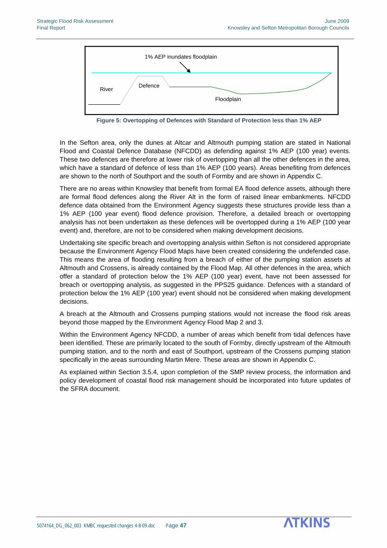
Strategic Flood Risk Assessment June 2009 Final Report Knowsley and Sefton Metropolitan Borough Councils
5074164_DG_062_003 KMBC requested changes 4-8-09.doc Page 47
DefenceRiver
Floodplain
1% AEP inundates floodplain
Figure 5: Overtopping of Defences with Standard of Protection less than 1% AEP
In the Sefton area, only the dunes at Altcar and Altmouth pumping station are stated in National Flood and Coastal Defence Database (NFCDD) as defending against 1% AEP (100 year) events. These two defences are therefore at lower risk of overtopping than all the other defences in the area, which have a standard of defence of less than 1% AEP (100 years). Areas benefiting from defences are shown to the north of Southport and the south of Formby and are shown in Appendix C.
There are no areas within Knowsley that benefit from formal EA flood defence assets, although there are formal flood defences along the River Alt in the form of raised linear embankments. NFCDD defence data obtained from the Environment Agency suggests these structures provide less than a 1% AEP (100 year event) flood defence provision. Therefore, a detailed breach or overtopping analysis has not been undertaken as these defences will be overtopped during a 1% AEP (100 year event) and, therefore, are not to be considered when making development decisions.
Undertaking site specific breach and overtopping analysis within Sefton is not considered appropriate because the Environment Agency Flood Maps have been created considering the undefended case. This means the area of flooding resulting from a breach of either of the pumping station assets at Altmouth and Crossens, is already contained by the Flood Map. All other defences in the area, which offer a standard of protection below the 1% AEP (100 year) event, have not been assessed for breach or overtopping analysis, as suggested in the PPS25 guidance. Defences with a standard of protection below the 1% AEP (100 year) event should not be considered when making development decisions.
A breach at the Altmouth and Crossens pumping stations would not increase the flood risk areas beyond those mapped by the Environment Agency Flood Map 2 and 3.
Within the Environment Agency NFCDD, a number of areas which benefit from tidal defences have been identified. These are primarily located to the south of Formby, directly upstream of the Altmouth pumping station, and to the north and east of Southport, upstream of the Crossens pumping station specifically in the areas surrounding Martin Mere. These areas are shown in Appendix C.
As explained within Section 3.5.4, upon completion of the SMP review process, the information and policy development of coastal flood risk management should be incorporated into future updates of the SFRA document.

Strategic Flood Risk Assessment June 2009 Final Report Knowsley and Sefton Metropolitan Borough Councils
5074164_DG_062_003 KMBC requested changes 4-8-09.doc Page 48
5. Combined Risk Matrix Mapping In an effort to assist the Councils in their understanding of flood risk in their areas, a Combined Risk Map has been produced (Appendix J). The map provides indicative zoning of combined flood risk to the Boroughs using fluvial and tidal flood zone maps, surface water flooding prevalence and ground water emergence mapping. For the purpose of this exercise, the combined risk mapping has utilised the Environment Agency Flood Maps to represent the PPS25 Flood Zones 1 and 2. The Flood Zones do not include areas at risk of breach or overtopping as the Environment Agency Flood Maps represent the undefended situation (the Flood Maps are shown in Appendix B).
The zoning categorisation of High, Medium and Low reflects the indicative level of importance flood risk will have on planning policy in both Knowsley and Sefton Council areas.
The High Risk Zone represents an area where a flood event could occur as a consequence of its location on Flood Maps 2 and 3 combined with surface water or ground water flooding. The combined flood risk issues in these areas are complex and potentially significant to future development policy in this zone. The high risk zone does not exclude development in these areas but it is likely that further, more detailed, investigations of flood risk in these areas will be required to satisfy planning procedure. Areas benefiting from defences have been included in this category, as the exact nature of the defence and the standard of protection offered cannot be guaranteed. The influence of any defences should be assessed by site specific flood risk assessments where appropriate.
The Medium Risk Zone represents an area which is outside of the Environment Agency fluvial and tidal Flood Maps 2 and 3, i.e. PPS25 Flood Zone 1, yet, information received from Knowsley Council, Sefton Council and the Environment Agency suggest the zone has a prevalence of surface water flooding and ground water emergence issues. This zone does not suggest the consequences of a flood event are less severe than in the High Risk Zone, more that flood risk is potentially less significant to future development policy.
The Low Risk Zone is an area where groundwater emergence poses the greatest risk. The severity and consequence of a flood event in this Low Risk Zone maybe similar in severity and consequence to an event in the Medium Risk Zone, yet flood risk is of low significance to future development policy within the Knowsley and Sefton Council areas.
The unshaded areas of the map indicate that the areas are outside of the Environment Agency Flood Map boundaries and have not been identified as an area of potential groundwater emergence or surface water flooding prevalence after review of available information. It does not suggest that these areas have no flood risk, it indicates that the best available information does not identify these areas to be at risk.
Appendix J shows the zoning of these areas for both Knowsley and Sefton Councils. The Combined Risk Map is not intended to be used in the Council’s sequential testing of future developments, such as windfall sites. It is intended to provide an initial reference tool for determining the broad scale risks potentially affecting specific sites. The Risk Matrix does not replace or amend the requirements for site specific flood risk assessments which are described within PPS25.
Strategic Flood Risk Assessment June 2009 Final Report Knowsley and Sefton Metropolitan Borough Councils
5074164_DG_062_003 KMBC requested changes 4-8-09.doc Page 49
6. PPS25 and the Sequential test for Knowsley and Sefton Unitary Development Plan and other allocations 6.1 Background
The Government expects Local Planning Authorities (LPAs) to apply a risk-based approach to the preparation of development plans and their decisions on development control. Planning Policy Statement 25: Development and Flood Risk (PPS25) requires LPAs, when allocating land in their DPDs for development, to apply the Sequential Test to demonstrate that there are no reasonably available sites in areas with a lower probability of flooding that would be appropriate for the proposed development.
To assist the LPAs to steer development away from areas affected by flood risk, the Environment Agency Flood Maps can be used to divide the local planning district into zones of high, medium or low flood risk. PPS25 is the key guidance for planners managing flood risk as it clearly defines the appropriateness of development type for each of the defined flood risk zones.
Guidance notes for developers and Local Planning Officers for appropriate use of this document, including when undertaking Sequential Testing, can be found in Appendix K.
6.2 Sequential Test
The Sequential Test should be applied throughout an entire planning authority district to ensure that all available sites are considered with reference to flood risk so that alternative sites are easily identifiable, should proposed land uses be deemed inappropriate.
A Sequential Test approach has been undertaken using the proposed land allocations as identified by both Knowsley and Sefton Councils within their adopted Unitary Development Plan(s) and existing Local Development Framework documents. Information available included proposed land uses and the boundary extents of these sites. Some details of intended uses have been provided but specific site plans for each site boundary have not. The analysis of the sequential testing on specific sites is provided in Appendix I. Furthermore, where required, sites which require Exception Testing have been identified.
The results of the Sequential Test detailed within this SFRA document provide the information required to ensure appropriate land uses are adopted for the level of flood risk across the Knowsley and Sefton Council areas.
6.3 Exception Test If, after application of the Sequential Test, it is not possible to locate all proposed developments within areas of lower probability of flooding it may be appropriate to apply the Exceptions Test. PPS25 introduces the Exceptions Test.
If an authority can demonstrate, by way of the Sequential Test, that there are no reasonable available sites for development at a lower probability of flooding suitable for the intended use and type then the Exception Test can be applied. The Test provides a means by which an LPA can demonstrate that the proposed development is required for wider, sustainability reasons beyond the management of flood risk alone.

Strategic Flood Risk Assessment June 2009 Final Report Knowsley and Sefton Metropolitan Borough Councils
5074164_DG_062_003 KMBC requested changes 4-8-09.doc Page 50
PPS25 paragraph D9 states that for the Exception Test to be passed;
1. it must be demonstrated that the development provides wider sustainability benefits to the
community that outweigh flood risk, informed by a SFRA where one has been prepared. If the DPD has reached the ‘submission’ stage – see Figure 4 of PPS12: Local Development Frameworks – the benefits of the development should contribute to the Core Strategy’s Sustainability Appraisal;
2. the development should be on developable previously-developed land or, if it is not on previously developed land, that there are no reasonable alternative sites on developable previously-developed land; and
3. a FRA must demonstrate that the development will be safe, without increasing flood risk elsewhere, and, where possible, will reduce flood risk overall.
The Exceptions Test has not been undertaken for any sites as part of the SFRA, the Test should be applied by either Sefton or Knowsely Council where appropriate.
6.4 Flood Zone Definition 6.4.1 Introduction
This section describes the existing Environment Agency Flood Map, the process by which the existing Flood Zones were updated for the purpose of the SFRA utilising newly available information, and the application of the PPS25 Sequential Test.
6.4.2 Existing Flood Map
The Environment Agency Flood Map was described in detail within Section 3 of this SFRA. The Flood Map has informed the PPS25 Flood Zone definition as described by the table below.
Flood Probability Environment Agency Flood Map PPS25 Flood Zone
<0.1% AEP Flood Map 1 Flood Zone 1
0.1% AEP Flood Map 2 Flood Zone 2
1% AEP Flood Map 3 Flood Zone 3a
4% or 5% AEP Outline from Alt Crossens CFMP study showing a 4% AEP
Flood Zone 3b ‘Functional Floodplain’ (not applicable within Knowsley)
Table 6.1: Environment Agency data used in the definition of PPS25 Flood Zones
6.4.3 PPS25 Flood Zones and Flood Risk Vulnerability Classifications
PPS25 identifies 4 separate Flood Zones and 5 classes of development vulnerability. These are used to determine the suitability of proposed development uses when considering flood risk. These Flood Zones represent flooding without flood defences in place.
Flood Risk Vulnerability Classifications
Table D2 within Annex D of PPS25 classifies various types of development and land use in terms of its vulnerability to flood risk, as summarised below:
Vulnerability Class
Land Use
Essential Infrastructure
Essential transport infrastructure (including mass evacuation routes) which has to cross the area at risk, and strategic utility infrastructure, including electricity generating power stations and grid and primary substations.

Strategic Flood Risk Assessment June 2009 Final Report Knowsley and Sefton Metropolitan Borough Councils
5074164_DG_062_003 KMBC requested changes 4-8-09.doc Page 51
Highly Vulnerable
• Police stations, Ambulance stations and Fire stations and Command Centres and Telecommunications installations required to be operational during flooding
• Emergency dispersal points. • Basement dwellings. • Caravans, mobile homes and park homes intended for permanent residential
use. • Installations requiring hazardous substances consent
More Vulnerable
• Hospitals. • Residential institutions such as residential care homes, children’s homes,
social services homes, prisons and hostels. • Buildings used for: dwelling houses; student halls of residence; drinking
establishments; nightclubs; and hotels. • Non–residential uses for health services, nurseries and educational
establishments. • Landfill and sites used for waste management facilities for hazardous waste • Sites used for holiday or short-let caravans and camping, subject to a
specific warning and evacuation plan.
Less Vulnerable
• Buildings used for: shops; financial, professional and other services; restaurants and cafes; hot food takeaways; offices; general industry; storage and distribution; non–residential institutions not included in ‘more vulnerable’; and assembly and leisure.
• Land and buildings used for agriculture and forestry. • Waste treatment (except landfill and hazardous waste facilities). • Minerals working and processing (except for sand and gravel working). • Water treatment plants. • Sewage treatment plants (if adequate pollution control measures are in place).
Water Compatible
• Flood control infrastructure. • Water transmission infrastructure and pumping stations. • Sewage transmission infrastructure and pumping stations. • Sand and gravel workings. • Docks, marinas and wharves. • Navigation facilities. • MOD defence installations. • Ship building, repairing and dismantling, dockside fish processing and
refrigeration and compatible activities requiring a waterside location. • Water-based recreation (excluding sleeping accommodation). • Lifeguard and coastguard stations. • Amenity open space, nature conservation and biodiversity, outdoor sports and
recreation and essential facilities such as changing rooms. • Essential ancillary sleeping or residential accommodation for staff required by
uses in this category, subject to a specific warning and evacuation plan.
Flood Zones
Table D1 within Annex D of PPS25 defines and describes the Flood Zones, the appropriate uses and the policy aims within each zone, as summarised below:-
Flood Zone 1 is defined as ‘Low Probability’ of flooding and incorporates areas where the annual probability of flooding is lower than 0.1% AEP (1000 year event) in any year. PPS 25 imposes no constraints upon development here. It should be noted that flood risk should still be considered during development, despite the low probabilities and lack of prescribed methods of consideration.
Flood Zone 2 is defined as ‘Medium Probability’ with an annual probability of flooding between 0.1% AEP and 1.0% AEP (between 100 and 1000 year events) in any year for fluvial and 0.1% AEP and

Strategic Flood Risk Assessment June 2009 Final Report Knowsley and Sefton Metropolitan Borough Councils
5074164_DG_062_003 KMBC requested changes 4-8-09.doc Page 52
0.5% AEP (between 1000 and 200 year event) in any year for tidal and coastal flooding. PPS25 recommends that Flood Zone 2 is suitable for most development with the exception of Highly Vulnerable uses, as defined within Table D.2 of PPS25.
Flood Zone 3 is defined as ‘High Probability’ with an annual probability of flooding of 1.0% AEP (100 year event) or greater in any year for fluvial and 0.5% AEP (200 year event) or greater in any year for tidal or coastal. PPS25 recommends that appropriate development is based upon a further classification of Flood Zone 3 into: 3a High Probability and 3b Functional Floodplain.
Functional Floodplain is defined as an area used for either flood storage or flood conveyance during periods of flood, and typically, represented by the 5% AEP (20 year) event or an area designed to flood in an extreme event such as a 0.1% AEP (1000 year) event. Greater constraints are placed upon development within Flood Zone 3b ‘Functional Floodplain’ compared to any other Flood Zone, refer to Table 6.2 for details.
As no data on fluvial climate change exists, it is considered that the most appropriate indication of the impacts of climate change is to use the existing Flood Zone 2 outline to represent Flood Zone 3a with climate change. This is a best practice approach and is fully endorsed by the Environment Agency as it overestimates (rather than underestimating) the risk posed by climate change. In accordance with PPS25, the climate change outline has not been used during the sequential approach adopted within this SFRA. With regards to the application of an Exception Test, the impacts of climate change to flood risk will be only one of many sustainability factors considered. Climate change impacts on flood risk are detailed in Section 4.1.1.
Essential infrastructure
Water Compatible
Highly Vulnerable
More Vulnerable
Less Vulnerable
Zone 1 (Low Probability)
Zone 2 (Medium Probability)Exception
Test required
Zone 3a (High Probability)Exception
Test requiredException
Test required
Zone 3b 'Functional Floodplain'Exception
Test required
Development is appropriateDevelopment should not be permitted
Flood Risk Vulnerability Classification (See Table D.2 of PPS25)
Floo
d Zo
ne (S
ee
tabl
e D
.1 o
f PP
S25
)
Table 6.2: Flood Risk Vulnerability and Flood Zone ‘Compatibility’
6.5 Knowsley and Sefton PPS25 Flood Zones For the purpose of this SFRA, Flood Map 2 will be used to represent the PPS25 Flood Zone 2 and Flood Map 3 will be used to represent the PPS25 Flood Zone 3a. The Flood Map data is being used because it is Environment Agency approved and the best data available for the SFRA Flood Zones. The Flood Zones are presented in Appendix F.
6.5.1 Flood Zone 3b, Functional Floodplain
For both the Knowsley and Sefton Council areas, definition of the PPS25 Flood Zone 3b, Functional Floodplain, is less straightforward. Functional Floodplain is defined as floodplain used for the purpose of storage or conveyance of water during high magnitude events. Where there is no specific information available, the 4 or 5% AEP (25 or 20 year event) outline is a reasonable representation of these areas and this method is approved by the Environment Agency. There was no information available for functional floodplains within the Boroughs, so other sources were investigated.
It was found that for areas within Sefton and the northern part of Knowsley, the Alt and Crossens CFMP base case output could be used to represent the functional floodplain. The return period chosen represents a probability of flooding of 4% AEP (25 year event) in any given year, compared to the 5% (20 year event) usually used to define the functional floodplain. Combined with other

Strategic Flood Risk Assessment June 2009 Final Report Knowsley and Sefton Metropolitan Borough Councils
5074164_DG_062_003 KMBC requested changes 4-8-09.doc Page 53
anecdotal information and flood history along the river corridor, adoption of this methodology is deemed suitable by the Environment Agency.
The 4% AEP (25 year event) outline defined as part of the Alt Crossens CFMP does not identify flood risk within the southern half of the Knowsley area and in the absence of other information no functional floodplain within this area has been represented within the SFRA. It is recognised, however, that this is due to the absence of data and information rather than a demonstration that there is no flood risk, therefore, for the purpose of the Sequential Test a conservative approach has been adopted and the Flood Zone 3 outline has been used to identify sites potentially within the functional floodplain.
Flood Studies scheduled for delivery in April 2009 should provide a much clearer understanding of this flood zone definition which should be used to update the SFRA at a later date.
6.6 Assessing Flood Risk Using the Sequential Test 6.6.1 Overview
The Sequential analysis has been undertaken in two stages, the first stage is a preliminary analysis of flood risk across the Knowsley and Sefton areas to identify the different PPS25 Flood Zones and to identify the constraints that are imposed upon development within these zones. This initial assessment will provide council planners and developers the information that they will need to locate future development outside of flood risk areas or, at least, to low risk areas.
The second stage of the analysis includes a comparison of the potential housing and economic sites that have been identified by the Knowsley and Sefton Councils against these flood risk zones. Sites have been assessed to see what proposed uses would be appropriate given the levels of flood risk for each site. A summary is provided of these sites in Appendix I.
PPS25 states that when assessing flood risk to potential development sites, the worst case situation should be adopted, for example, a site with a small area within Flood Zone 3b and the majority within Flood Zone 1 would be classed as Flood Zone 3b. The sequential approach should be applied on a site specific basis, during separate site specific flood risk assessments, to inform the site planning process. An analysis was undertaken as part of this SFRA to identify the percentages of each site within each Flood Zone, Appendix I contains this information.
6.6.2 Methodology
Figure 6-1 below sets out the methodology adopted to undertake the Sequential Test in the form of a flow diagram. This diagram identifies the steps undertaken to identify the Flood Zones where each of the development allocation sites reside, these steps are outlined below;
1. Obtain the latest editions of the Environment Agency Flood Map and overlay within a Geographic Information System (GIS) for review (Appendix B).
2. Based upon catchment flood knowledge and other additional fluvial flood risk extents (as
detailed in Section 3, define PPS25 Flood Zone 2 and 3. (Appendix F)
3. Identify Functional Floodplain (Flood Zone 3b), using existing 4% AEP (10 year event) flood outlines (Alt Crossens CFMP) and historic data if available. (Appendix F)
4. Consult with both Knowsley and Sefton Councils to identify all allocation sites within the
Boroughs.
5. Overlay the GIS data for the allocation sites and the Flood Zone Map. (Appendix H)
6. Determine in which Flood Zone each of the allocation sites are located and tabulate the results.
7. Identify whether the intended use of each site is appropriate under PPS25 and make recommendations for additional assessment.
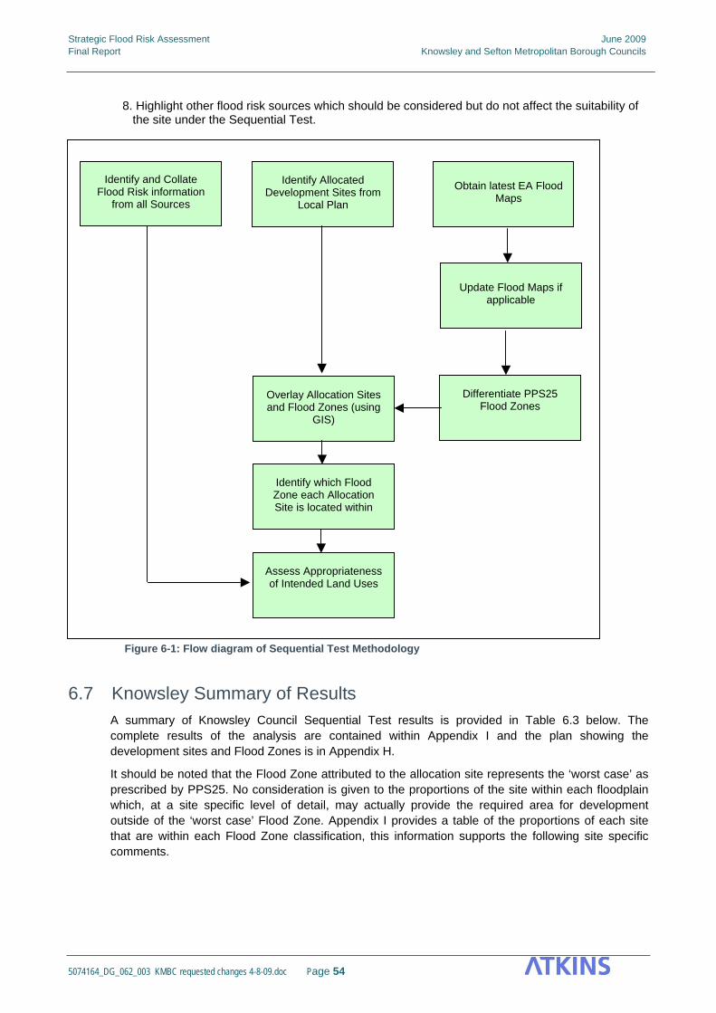
Strategic Flood Risk Assessment June 2009 Final Report Knowsley and Sefton Metropolitan Borough Councils
5074164_DG_062_003 KMBC requested changes 4-8-09.doc Page 54
8. Highlight other flood risk sources which should be considered but do not affect the suitability of
the site under the Sequential Test.
Identify Allocated Development Sites from
Local Plan
Obtain latest EA Flood Maps
Differentiate PPS25 Flood Zones
Overlay Allocation Sites and Flood Zones (using
GIS)
Identify which Flood Zone each Allocation Site is located within
Update Flood Maps if applicable
Assess Appropriateness of Intended Land Uses
Identify and Collate Flood Risk information
from all Sources
Figure 6-1: Flow diagram of Sequential Test Methodology
6.7 Knowsley Summary of Results A summary of Knowsley Council Sequential Test results is provided in Table 6.3 below. The complete results of the analysis are contained within Appendix I and the plan showing the development sites and Flood Zones is in Appendix H.
It should be noted that the Flood Zone attributed to the allocation site represents the ‘worst case’ as prescribed by PPS25. No consideration is given to the proportions of the site within each floodplain which, at a site specific level of detail, may actually provide the required area for development outside of the ‘worst case’ Flood Zone. Appendix I provides a table of the proportions of each site that are within each Flood Zone classification, this information supports the following site specific comments.

Strategic Flood Risk Assessment June 2009 Final Report Knowsley and Sefton Metropolitan Borough Councils
5074164_DG_062_003 KMBC requested changes 4-8-09.doc Page 55
Type of Allocation Total Sites
Flood Zone 1 Low Probability
Flood Zone 2 Medium Probability
Flood Zone 3a High Probability
Potential Flood Zone 3b Functional Floodplain
Housing Development 8 7 - 1 1
Action Areas and Development
Opportunity Sites 7 5 1 1 - Employment Development 36 32 - 4 4
Transport 8 7 1 - Table 6.3: Sequential Test Summary Results – Knowsley
6.7.1 Housing Development – Knowsley Council
Of the 8 housing development sites within the Borough, 7 sites fall within Flood Zone 1 ‘Low Probability’ and 1 site falls within Flood Zone 3a ‘High Probability’. Therefore, no constraint is imposed by PPS25 to restrict residential development on the 8 sites. The site which falls within Flood Zone 3a ‘High Probability’ will require an Exception Test.
The housing development site identified to be within Flood 3a ‘High Probability’ is located in an area where Functional Floodplain extents are not currently available. Therefore, the conservative approach has been taken and the site has been attributed to FZ3b for the purpose of this SFRA. It is recommended that this is reviewed once the Functional Floodplain outline is available.
6.7.2 Action Areas and Opportunity Sites- Knowsley Council
In total, there are 7 Action Areas and Opportunity Sites, 6 of these fall within Flood Zone 1 ‘Low Probability’ and 1 partially falls within Flood Zone 3a ‘High Probability’, and therefore designated to be within Flood Zone 3a. The regeneration of these areas will provide new schools and new dwellings which better suit the areas and under PPS25, for the sites within Flood Zone 3a the intended uses are subject to passing the Exception Test. There are no constraints on the areas which fall within Flood Zone 1.
6.7.3 Employment Development - Knowsley Council
Of the 36 Employment Development Sites, 32 are located within Flood Zone 1 ‘Low Probability’, and therefore have no restrictions under PPS25. The remaining 4 are located within Flood Zone 3a ‘High Probability’, all with the potential inclusion within the Functional Floodplain.
Location of the ‘Less Vulnerable’ type developments in Flood Zone 3a would be deemed appropriate and no Exception Test would be required.
For the 4 areas which have the potential to fall within Flood Zone 3b, PPS25 would classify the developments inappropriate for use. It is considered sensible to review the 4 identified sites once Functional Floodplain information becomes available.
6.7.4 Transport - Knowsley Council
There are 8 Transport development sites listed, 1 of these, the proposed Mersey Tram Route 2, falls within Flood Zone 2 ‘Medium Probability’. This type of proposed development is deemed compatible and appropriate for development under PPS25.
The 7 other Transport development sites are located within Flood Zone 1 ‘Low Probability’ and, therefore, are not subject to constraints under PPS25.
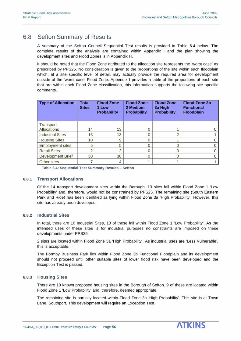
Strategic Flood Risk Assessment June 2009 Final Report Knowsley and Sefton Metropolitan Borough Councils
5074164_DG_062_003 KMBC requested changes 4-8-09.doc Page 56
6.8 Sefton Summary of Results
A summary of the Sefton Council Sequential Test results is provided in Table 6.4 below. The complete results of the analysis are contained within Appendix I and the plan showing the development sites and Flood Zones is in Appendix H.
It should be noted that the Flood Zone attributed to the allocation site represents the ‘worst case’ as prescribed by PPS25. No consideration is given to the proportions of the site within each floodplain which, at a site specific level of detail, may actually provide the required area for development outside of the ‘worst case’ Flood Zone. Appendix I provides a table of the proportions of each site that are within each Flood Zone classification, this information supports the following site specific comments.
Type of Allocation Total
Sites Flood Zone 1 Low Probability
Flood Zone 2 Medium Probability
Flood Zone 3a High Probability
Flood Zone 3b Functional Floodplain
Transport Allocations 14 13 0 1 0Industrial Sites 16 13 0 2 1Housing Sites 10 9 0 1 0Employment sites 5 5 0 0 0Retail Sites 2 2 0 0 0Development Brief 30 30 0 0 0Other sites 7 4 1 1 1
Table 6.4: Sequential Test Summary Results – Sefton
6.8.1 Transport Allocations
Of the 14 transport development sites within the Borough, 13 sites fall within Flood Zone 1 ‘Low Probability’ and, therefore, would not be constrained by PPS25. The remaining site (South Eastern Park and Ride) has been identified as lying within Flood Zone 3a ‘High Probability’. However, this site has already been developed.
6.8.2 Industrial Sites
In total, there are 16 Industrial Sites, 13 of these fall within Flood Zone 1 ‘Low Probability’. As the intended uses of these sites is for industrial purposes no constraints are imposed on these developments under PPS25.
2 sites are located within Flood Zone 3a ‘High Probability’. As industrial uses are ‘Less Vulnerable’, this is acceptable.
The Formby Business Park lies within Flood Zone 3b Functional Floodplain and its development should not proceed until other suitable sites of lower flood risk have been developed and the Exception Test is passed.
6.8.3 Housing Sites
There are 10 known proposed housing sites in the Borough of Sefton. 9 of these are located within Flood Zone 1 ‘Low Probability’ and, therefore, deemed appropriate.
The remaining site is partially located within Flood Zone 3a ‘High Probability’. This site is at Town Lane, Southport. This development will require an Exception Test.

Strategic Flood Risk Assessment June 2009 Final Report Knowsley and Sefton Metropolitan Borough Councils
5074164_DG_062_003 KMBC requested changes 4-8-09.doc Page 57
6.8.4 Employment sites
All 5 employment sites within the Borough fall in Flood Zone 1, Low Probability and, therefore, are not subject to constraints under PPS25.
6.8.5 Retail sites
Both retail development sites within the Borough fall in Flood Zone 1, Low Probability and, therefore, are not subject to constraints under PPS25.
6.8.6 Development brief locations
All 30 development brief locations within the Borough fall in Flood Zone 1, Low Probability and, therefore, are not subject to constraints under PPS25. These individual sites contribute to wider SPG and SPD areas which have not been assessed independently within this SFRA.
6.8.7 Other sites
There are 7 other sites within the Borough. Four fall in Flood Zone 1, Low Probability and, therefore, are not subject to constraints under PPS25.
One site, Altcar Rifle Range falls into Flood Zone 2, Medium Probability, and where a highly vulnerable development will require an Exception Test. However other developments will be acceptable. Just over 20% of this site falls in Flood Zone 2, with the rest in Flood Zone 1.
Another further site, Ashworth Hospital, falls into Flood Zone 3a, High Probability, meaning that ‘Essential Infrastructure’ and ‘More Vulnerable’ developments will require an Exception Test, whilst a ‘Highly Vulnerable’ development would be unsuitable. Just under 3% of the site falls in Flood Zone 3a, with just over 1% of the site falling in Flood Zone 2 and the remainder of the site falling in Flood Zone 1.
One site, the Power House Site, falls within Flood Zone 3b, Functional Floodplain, where ‘Highly’, ‘More’ and ‘Less Vulnerable’ developments are considered inappropriate and Essential Infrastructure developments will require an Exception Test. 0.5% of the site falls in Flood Zone 3b, 81.4% in Flood Zone 3a, 10.5% of the site is in Flood Zone 2 and the remainder (7.6%) is in Flood Zone 1.
Appendix H contains a map showing the location of all 84 land allocations and the Flood Zones within which they are located.
6.9 Windfall Sites Proposed development for “windfall sites” will by definition not derive from any potential development sites that have been assessed within this section. The Sequential Test will need to be carried out and, if necessary, the Exception Test at the planning application stage. Appendix K provides guidance notes to developers on how to use the Sequential Test for development sites including windfall sites. The combined risk matrix map contained in Appendix J gives indicative zoning of combined flood risk using fluvial and tidal flood zones, surface water flooding prevalence and ground water emergence mapping. The Combined Risk Map allows an initial visualisation of the relevance of flood risk to any development proposal and should be used only as a guide.
Application of the Sequential Test for windfall sites will require consideration of the PPS25 Flood Zones as shown in Appendix F as the primary source of information and will be supported by information in Appendices A, C, D, E and J.

Strategic Flood Risk Assessment June 2009 Final Report Knowsley and Sefton Metropolitan Borough Councils
5074164_DG_062_003 KMBC requested changes 4-8-09.doc Page 58
7. Flood Management 7.1 Options for Knowsley and Sefton 7.1.1 Fluvial Flood Risk
As described within Sections 3.7.3 and 3.8.2, a number of studies are currently ongoing within the Knowsley and Sefton areas to assess the level of flood risk through the built environment. These include the Catchment Flood Management Plan (CFMP) studies which are broad scale strategic investigations that make flood risk management policy recommendations rather than site specific recommendations. The broad scale recommendations of the Alt Crossens and Mersey Estuary CFMPs for long term flood risk management within the areas of Sefton and Knowlsey are;
• to maintain the current standard of protection (accepting that flood risk will increase over time);
• to take further action to sustain the current level of flood risk;
• or in one area only, to increase the frequency of flooding to reduce flood risk elsewhere. v
The Environment Agency recommends this increased frequency of flooding policy in the rural and unpopulated area of Altcar and Ince for the benefit of inhabitants in Formby and Maghull.
At present there are a number of studies which are underway that may recommend flood management options as part of study outcomes. As these projects have not yet been finalised, it is not possible to include their recommendations in this document. However when available, the findings should be included in future updates of this SFRA.
7.1.2 Surface Water Flood Risk
The promotion of sustainable water management techniques for developers should contribute towards a reduction or at least a stabilisation of surface water flood risk. The geology maps contained within Appendix E can be used to identify areas where opportunities for SUDS may exist. For example, the use of soakaways on permeable bedrock goes some way to reducing future flood risk, where contamination of brownfield sites is not a consideration. Other techniques include increasing permeability of driveways and the use of green roofs. Further investigation of such schemes is recommended.
There is a risk of flooding from the Leeds Liverpool canal, but this is very difficult to predict and, therefore, manage.
7.1.3 Groundwater Flood Risk
There is little national guidance on reducing the risk of groundwater flooding. It is suggested that the Environment Agency be contacted to get the latest advice.
7.1.4 Tidal Flooding
When considering the risks from tidal flooding, it is important to refer to the Council SMP and any coastal defence work that has been carried out. In this case, this information can be obtained from Sefton Council.
7.2 River Corridor Maintenance One of the main contributory factors to flood risk through urban environments is the constriction of watercourses. These constrictions may take the form of blockages by vegetation, in channel shoals and berms, bank collapse or failure in part of bankside walls, culverts or bridges.

Strategic Flood Risk Assessment June 2009 Final Report Knowsley and Sefton Metropolitan Borough Councils
5074164_DG_062_003 KMBC requested changes 4-8-09.doc Page 59
7.2.1 Main Rivers
Sefton contains a large number of defence embankments which serve to protect communities from tidal and fluvial flood risk, albeit at higher frequency events. These defences should be maintained in order to provide the standard of service for which they were designed. This is the responsibility of the Environment Agency. Similarly, Altmouth and Crossens pumping stations should be serviced and maintained to ensure they are able to provide the expected standard of defence.
7.2.2 Ordinary and other Watercourses
Routine and regular maintenance of the watercourses through urban areas is undertaken in Knowsley and will contribute to controlling the overall level of flood risk in these areas. Despite these efforts, there still remain some areas where flood risk remains from undersized and blocked culverts.
Regular and routine maintenance is not carried out by Sefton to the majority of watercourses, unless by individual riparian owners. Dobbs Gutter in Formby is cleared on an annual cycle, whilst other watercourses are cleaned on a four yearly basis. Apart from the ditch cleaning and the regular clearing of debris screens in Formby no other routine maintenance of watercourses in the Sefton area is undertaken.
Within the Knowsley area, it is known that Stockbridge Village along the River Alt has suffered in the past due to culvert blockage. Also, areas of Southport and Maghull experience the risk of flooding from structure blockage. This is the responsibility of both Councils, as well as riparian owners of watercourse reaches. It is recommended that these maintenance works are undertaken to keep the channels clear of debris.
7.3 Emergency Evacuation Routes For the purpose of emergency planning, consideration should be given to the likelihood of flood risk occurring, and hampering, the safe evacuation of people along main arterial transport routes during large scale emergencies, for example a terrorism event in Liverpool.
Evacuation of Knowsley would utilise the M62 and A58 to escape to either the east or west during such an emergency, and the A580 to escape to the east. These routes are not shown to be within Flood Zone 3. Although a small section of the Liverpool to St Helens train line is located within the extents of the Flood Zone, it is probable that the route could be used as a means of evacuation to the east and west.
The major evacuation routes from the south part of Sefton are the M57, M58 and A59. The north of the borough would likely evacuate along the A565 and A570. Southport and Liverpool/Maghull train lines could also be used. These transport links are identified to be partially located within the extents of the Environment Agency Flood Zone 3 and therefore it is considered that they may not be passable during a severe flood event.
Strategic Flood Risk Assessment June 2009 Final Report Knowsley and Sefton Metropolitan Borough Councils
5074164_DG_062_003 KMBC requested changes 4-8-09.doc Page 60
8. Conclusions and Recommendations 8.1 Conclusions 8.1.1 Flood Risk to the Boroughs
It has been found that the main source of flood risk throughout the boroughs is associated with flooding within the Alt and Crossens catchments and their tributaries in both Knowsley and Sefton and the Mersey tributary of Ditton Brook in the southern areas of Knowsley. After consultation with key stakeholders it has been established that there are other sources of flood risk but none on a similar scale to the fluvial flood risk. This information is collated in Appendix J.
Flood risk from surface water flooding is the secondary source of flood risk. This is supported by information collected from Knowsley and Sefton Borough Councils and United Utilities. Both districts are potentially affected by surface water flood risk. The sewerage system throughout the two boroughs is largely Victorian and may be under capacity or susceptible to blockages which result in this risk. The nature of surface water flooding prevalence can be seen in Appendix D. Areas of surface water flooding occurrence have been identified in both Boroughs and, whilst the locations of these areas should be considered by the Councils when making decision on development, the presence of surface water flooding does not, on its own, direct the results of sequential testing. Little information is currently available on the levels of risk posed by surface water flooding, however, modelling would enable the level of risk posed to be better understood.
The possible effects of climate change to the fluvial flood regime through Knowsley and Sefton can be seen on the main watercourses of the River Alt, Fazakerley Brook, Knowsley Brook, Croxteth Brook, Boundary Brook, Netherley Brook and Logwood Mill Brook. Climate change will also have a potential impact on surface water flooding; research indicates that the frequency and intensity of storm events will increase as a result of climate change leading to increased flow into the surface water drainage networks.
Climate change could also affect the rate of erosion and deposition along the coastline of Sefton, as well as increasing the present risks of overtopping of the natural and artificial flood defences in both Knowsley and Sefton Council areas.
As a result of these increased levels of flood risk, additional properties in the locations identified above may fall within the 1% Annual Exceedance Probability (AEP) (100 year event) extent as a result of climate change compared to the present day 1% AEP (100 year event).
Areas behind flood defences are at risk due to the potential overtopping or breach of flood defences resulting in the rapid onset of fast-flowing and deep water flooding with little or no warning. Local Planning Authorities and developers need to consider these residual risk issues relating to a development.
There already exists some flood risk to the Borough of Sefton from tidal sources. The areas most at risk have been identified as being Southport and Crosby, with parts of Hightown village likely to be at risk in the future because of erosion in that area, unless some coastal protection works are undertaken within the next few years.
Groundwater emergence zones, where groundwater can reach the surface, do exist across the two Boroughs. Areas for which groundwater flood risk is identified include Maghull, Kirkby, Huyton and Lydiate. There is little national guidance on reducing the risk of groundwater flooding. It is suggested that the Environment Agency be contacted to get the latest advice.
Information on the implications of these risks, found through the Sequential Test and how they impact development plans, is set out for each Borough under separate headings below.

Strategic Flood Risk Assessment June 2009 Final Report Knowsley and Sefton Metropolitan Borough Councils
5074164_DG_062_003 KMBC requested changes 4-8-09.doc Page 61
8.1.2 The Sequential Test for Knowsley and Sefton Unitary Development Plan and other Allocations
With regard to fluvial flood risk, for the purpose of this SFRA, the worst case has been used to assess the implications of flood risk upon proposed development sites and intended land uses. Flood Zones used within this study represent the undefended situation regardless of any protection provided by any formal, informal or other structures which afford some degree of flood protection. Secondly, in applying the Sequential test of PPS25, the proposed development sites have been assessed on the basis of the greatest flood risk that affects any part of the site regardless of the proportion of the site that is affected.
There are fluvial flood defence structures within Sefton and Knowlsey that do provide some form of protection. Only the dunes by the pumping station assets at Altmouth and Crossens have a standard of protection sufficient for a 1% AEP (100 year) event. Therefore only these assets should be considered during planning decision making.
As part of the Sequential Test, areas benefiting from defences are not included in the analysis as they are not considered as separate areas. However, areas benefiting from defences should be considered preferentially as part of exception testing which does not form part of this SFRA. There are no areas benefiting from defences in the Knowsley area, however there are some areas to the north of Southport and to the south of Formby that are shown (in Appendix C) to benefit from defences.
Using the available information the following conclusions have been drawn in relation to the potential development sites identified within the Boroughs of Knowsley and Sefton.
Knowsley
Of the 8 potential housing sites, 7 are located within Flood Zone 1 and are, therefore, suitable, under PPS25, for housing development. The remaining site has been identified within Flood Zone 3a, and potentially within Flood Zone 3b, and therefore requires an Exception Test at the stage of any future land allocations under the LDF to justify development in this high probability flood risk area. In the interim period, should any planning application come forward for housing development at the site there would be a requirement for a detailed site specific FRA to be submitted with the planning application. Through the FRA the implications of flood risk, and (if appropriate) mitigation measures, for the developability of the site would be fully assessed.
Of the 7 Action Areas and Opportunity Sites, 6 are located within either Flood Zone 1 or 2 and, therefore, are appropriate for the proposed developments. Flood Zone 3a intrudes into a small area of the remaining Action Area site, North Huyton, however this site has already been extensively developed.
32 of the 36 Economic development sites are located within Flood Zone 1 and are considered appropriate for the proposed development use. The 4 remaining sites are located partially within Flood Zone 3a and potentially within Zone 3b. Should these sites be found to be in Flood Zone 3b then they are considered inappropriate, whereas, Flood Zone 3a is considered appropriate for the intended usages.
7 of the 8 Transport Areas are located within Flood Zone 1 and the remaining site is located within Flood Zone 2, therefore, all sites are appropriate for the proposed developments.
Sefton
Flood risk to the Borough of Sefton occurs from a variety of sources. Fluvial and tidal risk is of concern in areas adjacent to some watercourses and along the coastline. This forms the main constraint on sites being suitable for development use. In addition, there are a number of urban areas where surface water flooding has been highlighted as an issue. Whilst the prevalence of surface water flooding itself does not result in a site being deemed unsuitable for development, its presence should be considered and accounted for where a site specific flood risk assessment is

Strategic Flood Risk Assessment June 2009 Final Report Knowsley and Sefton Metropolitan Borough Councils
5074164_DG_062_003 KMBC requested changes 4-8-09.doc Page 62
undertaken. Groundwater flooding has also been highlighted as being of concern in some areas. Again, the presence of groundwater flooding issues would not in itself preclude a site from being deemed suitable for use, but its presence should be noted and included in any site specific flood risk assessment. Indications of the locations of these different risks are given in the risk matrix map in Appendix J and Section 3.
Of the 10 potential housing sites, 9 are located within Flood Zone 1 and are therefore suitable, under PPS25, for housing development. Part of 1 of these sites, Town Lane housing site, Kew, has been identified within Flood Zone 3a and, therefore, requires an Exception Test to justify development in this high probability flood risk area.
13 of the 14 Transport Sites are located within Flood Zone 1 and therefore are appropriate for the proposed developments. The remaining site, Southport Park and Ride site, is within Flood Zone 3a and, therefore, requires an Exception Test if it is to be pursued as a development site. This is no longer relevant because the site has already been developed. 2 of these sites, North Mersey Railway and Southeastern Park and Ride, require site specific FRAs due to their size. However proposed station sizes have not been provided, and any development sites with an area greater than 1 hectare will also require a site specific FRA.
15 of the 16 Industrial Areas are located within Flood Zone 1, 2 or 3a and therefore are appropriate for the proposed developments. The remaining site, at Stephenson Way, Formby, is within Flood Zone 3b and is, therefore, considered to be in a location unsuitable for development.
All 5 of the proposed employment sites fall in Flood Zone 1 and are, therefore, considered appropriate for the proposed developments.
Both of the proposed retail sites fall in Flood Zone 1 and are, therefore, considered appropriate for the proposed developments.
All 30 of the development brief sites are located within Flood Zone 1 and are therefore appropriate for the proposed development uses.
5 of the other development sites are located within Flood Zone 1 or 2 and therefore are appropriate for the proposed developments. One site, Ashworth Hospital, is contained in Flood Zone 3a and therefore considered appropriate while the remaining site, Power House Site, is located within Flood Zone 3b which is deemed inappropriate for the intended use.
The conclusions of this SFRA have been drawn together to support the Council’s planning process and to inform planners of the potential flood risks across the Borough and the implications of those risks for development. This document and the supporting information should be used to help steer future developments to areas of least risk using a sequential approach to flood risk as detailed within the document.
8.2 Recommendations 8.2.1 Development of Core Strategy and Future Allocations Development Plan Documents
This SFRA document should be used to inform planning decision making and policy setting and therefore, future development of the Core Strategy and Allocations Development Plan Documents will need to consider the information set out here and in future revisions of this document.
Appendix F displays the PPS25 Flood Zones which inform the sequential approach. These figures are supported by the Risk Matrix Map in Appendix J and the flood risk information in Appendices A, C, D and E.
8.2.2 Site Specific Flood Risk Assessments
The site-based assessment has indicated that the majority of proposed UDP sites within Sefton require no further action, however a number of sites in Knowsley require site specific FRAs; in most cases because they are over 1 hectare in size. A greater level of detail should be provided by these
Strategic Flood Risk Assessment June 2009 Final Report Knowsley and Sefton Metropolitan Borough Councils
5074164_DG_062_003 KMBC requested changes 4-8-09.doc Page 63
assessments with respect to flood risk and any protection afforded to the site, including from formal or informal flood defences.
Site specific FRAs may also be required for new sites such as windfall sites. All sites located within Flood Zones 2 or 3 or that are over 1Ha in size will require a FRA during the planning process. Refer to PPS25 for further details regarding requirement for site specific flood risk assessments.
Consideration should be given to the proportion of the site located within each of the PPS25 Flood Zones and the implications of this upon the planned layout of the site. This analysis will allow developments and land uses of greater vulnerabilities to flooding to be located on higher ground.
Where required, the Exception Test should be undertaken as part of the site specific FRAs. Refer to Appendix K for further guidance.
The Environment Agency would also point developers to the website www.pipernetworking.com/floodrisk for further and updated information concerning FRAs.
8.2.3 Channel Maintenance
The routine maintenance currently undertaken on the watercourses throughout the Boroughs of Knowsley and Sefton should be continued to ensure that the channels stay clear of debris and vegetation growth. This will reduce the risk of in-channel debris contributing to channel blockage, for example at upstream faces of culverts. Condition assessments of the bridges and engineered channel sections should continued on a regular basis.
Increasing the frequency of regular channel maintenance of watercourses, especially through urban areas and culverted watercourses, should be considered in areas of known flooding as this will help to reduce and manage flood risk.
8.2.4 Emergency Evacuation
The transport links used to evacuate Sefton Borough are identified to be partially located within the extents of the Environment Agency Flood Map 3. It is therefore considered that they may not be passable during a severe flood event. It is recommended that both Councils review and update, where necessary, their emergency flood risk response plans as a result of the findings and recommendations of the SFRA.
8.2.5 Review and update of the SFRA
It is recommended that this SFRA is revised regularly to incorporate new information and understanding of flood risk as and when it becomes available for the Knowsley and Sefton areas. This will provide planners and decision makers an evidence base which reflects current understanding of flood risk upon which informed decisions can be based. An example of this additional information would be the results and conclusions from the ongoing Formby Drainage study and other relevant studies.
This review should consider the following:
• Planning legislation
• National, regional and local planning policy
• Local planning aspirations
• Latest understanding of flood risk and flood management

Strategic Flood Risk Assessment June 2009 Final Report Knowsley and Sefton Metropolitan Borough Councils
5074164_DG_062_003 KMBC requested changes 4-8-09.doc
Page left blank intentionally

Strategic Flood Risk Assessment June 2009 Final Report Knowsley and Sefton Metropolitan Borough Councils
5074164_DG_062_003 KMBC requested changes 4-8-09.doc
Appendix A – Watercourses in the Borough Areas

Strategic Flood Risk Assessment June 2009 Final Report Knowsley and Sefton Metropolitan Borough Councils
5074164_DG_062_003 KMBC requested changes 4-8-09.doc
Page left blank intentionally

Strategic Flood Risk Assessment June 2009 Final Report Knowsley and Sefton Metropolitan Borough Councils
5074164_DG_062_003 KMBC requested changes 4-8-09.doc
Appendix B – Environment Agency Published Flood Maps with contours and
flood warning areas

Strategic Flood Risk Assessment June 2009 Final Report Knowsley and Sefton Metropolitan Borough Councils
5074164_DG_062_003 KMBC requested changes 4-8-09.doc
Page left blank intentionally

Strategic Flood Risk Assessment June 2009 Final Report Knowsley and Sefton Metropolitan Borough Councils
5074164_DG_062_003 KMBC requested changes 4-8-09.doc
Appendix C – Flood Defence Assets and Areas Benefitting from Defences

Strategic Flood Risk Assessment June 2009 Final Report Knowsley and Sefton Metropolitan Borough Councils
5074164_DG_062_003 KMBC requested changes 4-8-09.doc
Page left blank intentionally

Strategic Flood Risk Assessment June 2009 Final Report Knowsley and Sefton Metropolitan Borough Councils
5074164_DG_062_003 KMBC requested changes 4-8-09.doc
Appendix D – United Utilities DG5 Surface Water Drainage and Surface Water Flooding
from Council Records
Strategic Flood Risk Assessment June 2009 Final Report Knowsley and Sefton Metropolitan Borough Councils
5074164_DG_062_003 KMBC requested changes 4-8-09.doc
Page left blank intentionally

Strategic Flood Risk Assessment June 2009 Final Report Knowsley and Sefton Metropolitan Borough Councils
5074164_DG_062_003 KMBC requested changes 4-8-09.doc
Appendix E – Ground Water and Geology

Strategic Flood Risk Assessment June 2009 Final Report Knowsley and Sefton Metropolitan Borough Councils
5074164_DG_062_003 KMBC requested changes 4-8-09.doc
Page left blank intentionally
Strategic Flood Risk Assessment June 2009 Final Report Knowsley and Sefton Metropolitan Borough Councils
5074164_DG_062_003 KMBC requested changes 4-8-09.doc
Appendix F – PPS25 Updated Flood Zones

Strategic Flood Risk Assessment June 2009 Final Report Knowsley and Sefton Metropolitan Borough Councils
5074164_DG_062_003 KMBC requested changes 4-8-09.doc
Page left blank intentionally

Strategic Flood Risk Assessment June 2009 Final Report Knowsley and Sefton Metropolitan Borough Councils
5074164_DG_062_003 KMBC requested changes 4-8-09.doc
Appendix G – PPS25 Flood Zone 3a with Climate Change

Strategic Flood Risk Assessment June 2009 Final Report Knowsley and Sefton Metropolitan Borough Councils
5074164_DG_062_003 KMBC requested changes 4-8-09.doc
Page left blank intentionally

Strategic Flood Risk Assessment June 2009 Final Report Knowsley and Sefton Metropolitan Borough Councils
5074164_DG_062_003 KMBC requested changes 4-8-09.doc
Appendix H – Identified Development Sites and PPS25 Flood Zones

Strategic Flood Risk Assessment June 2009 Final Report Knowsley and Sefton Metropolitan Borough Councils
5074164_DG_062_003 KMBC requested changes 4-8-09.doc
Page left blank intentionally

Strategic Flood Risk Assessment June 2009 Final Report Knowsley and Sefton Metropolitan Borough Councils
5074164_DG_062_003 KMBC requested changes 4-8-09.doc
Appendix I – Sequential Test Results

Strategic Flood Risk Assessment June 2009 Final Report Knowsley and Sefton Metropolitan Borough Councils
5074164_DG_062_003 KMBC requested changes 4-8-09.doc
Page left blank intentionally

Strategic Flood Risk Assessment June 2009 Final Report Knowsley and Sefton Metropolitan Borough Councils
5074164_DG_062_003 KMBC requested changes 4-8-09.doc
Appendix J – Combined Risk Matrix Map

Strategic Flood Risk Assessment June 2009 Final Report Knowsley and Sefton Metropolitan Borough Councils
5074164_DG_062_003 KMBC requested changes 4-8-09.doc
Page left blank intentionally

Strategic Flood Risk Assessment June 2009 Final Report Knowsley and Sefton Metropolitan Borough Councils
5074164_DG_062_003 KMBC requested changes 4-8-09.doc
Appendix K – Guidance Notes

Strategic Flood Risk Assessment June 2009 Final Report Knowsley and Sefton Metropolitan Borough Councils
5074164_DG_062_003 KMBC requested changes 4-8-09.doc
Page left blank intentionally

Strategic Flood Risk Assessment June 2009 Final Report Knowsley and Sefton Metropolitan Borough Councils
5074164_DG_062_003 KMBC requested changes 4-8-09.doc
Appendix L – Culverts and Defences in the Boroughs

Strategic Flood Risk Assessment June 2009 Final Report Knowsley and Sefton Metropolitan Borough Councils
5074164_DG_062_003 KMBC requested changes 4-8-09.doc
Page left blank intentionally

Page left blank intentionally