Strategic Evaluation of the Biogeoclimatic Ecosystem ...
11
Strategic Evaluation of the Biogeoclimatic Ecosystem Classification for the Coast Forest Region Background and Rationale • The biogeoclimatic ecosystem classification in BC provides a foundation for ecological management; the framework provides context for silvicultural prescriptions, protected areas planning, representation analysis, wildlife habitat assessments. • The previous field guides incorporating the Coast Region’s land base were published in 1993 and 1994; the sampling available for certain site series was limited at that time. • Geographic data are limited for many plots within the Region, making verification and reassessment of data difficult for seral classifications or as conditions (e.g., climate) change • Evaluation of the existing data, its geographic accuracy and coverage over the Region is necessary to support strategic sampling for a solid foundation of the biogeoclimatic classification and revisions to the Region’s field guide Objectives • Locate and evaluate (quality, geographic accuracy) existing hard copy data for plots currently in the Regional BEC database. • Evaluate existing data (e.g., TEM) not in the database for inclusion. • Analyze sampling adequacy with respect to site series, geographic location (e.g., forest district). • Provide recommendation for strategic sampling to improve rigour of the current classification, support management needs, and guide development of the classification in the advent of future stresses (e.g., climate change). Anticipated Schedule • Review of existing hard copy data, summer 2006 • Acquisition of additional data for incorporation into database, fall 2006 • Spatial and statistical (gap) analysis of regional data, winter 2006-7 • Report on problem analysis and sampling recommendations, spring2007 Contact: Andy MacKinnon RPBio, RPF, Sari Saunders, RBio, PhD Coast Forest Region [email protected] [email protected]
Transcript of Strategic Evaluation of the Biogeoclimatic Ecosystem ...

Strategic Evaluation of the Biogeoclimatic Ecosystem Classification for the Coast Forest Region
Background and Rationale
• The biogeoclimatic ecosystem classification in BC provides a foundation for ecological management; the framework provides context for silvicultural prescriptions, protected areas planning, representation analysis, wildlife habitat assessments.
• The previous field guides incorporating the Coast Region’s land base were published in 1993 and 1994; the sampling available for certain site series was limited at that time.
• Geographic data are limited for many plots within the Region, making verification and reassessment of data difficult for seralclassifications or as conditions (e.g., climate) change
• Evaluation of the existing data, its geographic accuracy and coverage over the Region is necessary to support strategic sampling for a solid foundation of the biogeoclimaticclassification and revisions to the Region’s field guide
Objectives
• Locate and evaluate (quality, geographic accuracy) existing hardcopy data for plots currently in the Regional BEC database.
• Evaluate existing data (e.g., TEM) not in the database for inclusion.
• Analyze sampling adequacy with respect to site series, geographic location (e.g., forest district).
• Provide recommendation for strategic sampling to improve rigour of the current classification, support management needs, and guide development of the classification in the advent of future stresses (e.g., climate change).
Anticipated Schedule
• Review of existing hard copy data, summer 2006• Acquisition of additional data for incorporation into database, fall 2006• Spatial and statistical (gap) analysis of regional data, winter 2006-7• Report on problem analysis and sampling recommendations,
spring2007
Contact: Andy MacKinnon RPBio, RPF, Sari Saunders, RBio, PhDCoast Forest [email protected]@gov.bc.ca

Variability in structure, composition, and function of old growth across a biogeoclimatic gradient
Background and Rationale
• Coastal temperate rainforests span broad, latitudinal gradients in temperature, moisture, and continentality from OR, WA through BC to southeast AK; however, limited data are available from coastal BC
• Standardized, comparative studies of these forests would contribute to comprehensive models of natural structure and function, to management for old growth restoration, and to representation planning
• Initiatives such as ecosystem-based management, managing for ecological resilience, anticipating climate change effects require empirical data on structure-function relationships across climatic conditions.
Objectives:
• Establish 15 1 ha plots within protected areas of Vancouver Island (yellow outline on map) to study old growth across 5 biogeoclimatic variants: CWHvh1; vm1; vm2; mm1; xm1/2.
• Sample species composition for overstory, shrubs, and ground cover; complete digital mapping of all overstory trees, snags, and coarse woody debris; map distribution of canopy gaps.
• Coordinate with international researchers for comprehensive analysis – USDA FS in Oregon, Washington, Alaska
• Complete report on comparative analysis of species composition, vertical structure, horizontal inter/intra specificspatial relationships.
• Complete report on logistics and research practicalities of establishment of the regional old growth plot network
Anticipated Schedule • Initial scoping for plot sites spring, 2007• Establishment and sampling of 6 plots (2 variants), summer 2007• Initial analysis and reporting on 2 variants, winter 2007-8• Initial report on logistic development and research opportunities
from network, winter 2007-8• Establishment and sampling of 9 plots (3 variants), summer 2008• Final comparative report on all old growth variants, winter 2008-9
Contact: Andy MacKinnon RPBio, RPF, Sari Saunders, RBio, PhDCoast Forest [email protected]@gov.bc.ca

Ecosystem Recovery Following Disturbance
Background and Rationale
• LRMP tables and EBM initiatives use predicted ecosystem recovery rates and the distribution and abundance of second growth vs. old-growth forests as a basis for environmental risk assessment.
• Without quantitative second growth ecosystem recovery data, the modelling results are questionable and they provide only minimal guidance to SFM and EBM planning.
• Ecosystem attributes to be assessed will include tree species composition, growth and yield, understory composition, epiphytic composition, soil properties (including soil fauna), and stand structure.
Objectives:
• Quantify selected second growth (30 to 200 yr old stands) forest ecosystem attributes in order to provide a field-based assessment of ecosystem recovery following natural and human-caused disturbance.
• Compare stand attribute data with analogous data collected from old-growth stands of similar BEC units.
• Use this information to guide site- and landscape-level ecosystem-based management (EBM) and Ecosystem Resilience Management (ERM).
• Expand this work into other coastal and interior sub zones.
Schedule• Initial CWHvh data collection completed June, 2006• Analysis and interpretation during winter 2006-2007• CWHvh Extension Note by March 2007; journal paper by Dec.,
2007• Northern Interior ICH sampling summer, 2006• CWHvm and CWHws sampling summer, 2007
Contact: Allen Banner RPBio, RPF, Phil LePage RPFAndy MacKinnon RPBio, RPF, Rod Negrave RPF, PAgNorthern Interior Forest Region / Coast Forest [email protected]@gov.bc.ca

Partial Cutting on Steep Slopes in the CWHvh2
Impact
• Provision of firm guidelines for partial cutting practices in the CWHvh2. These guidelines will be used by field foresters planning partial cutting treatments and by decision makers in regulatory agencies for assessing the effectiveness of partial cutting practices and managing silvicultural costs.
• A better understanding of the effects of partial cutting on stand growth. Analysts will use this information to better estimate timber supply.
• Assistant in the development and calibration of natural regeneration recruitment and growth models for existing forest growth models.
Objectives:
• Determine residual stand health, 1992-2006 volume incrementand loss of residual stand to windthrow
• Measure growth of planted regeneration• Measure recruitment and growth of natural regeneration• Structure and composition of the non-timber understory• Use data and growth relationships to calibrate and test growth
and yield models • Provide guidance for policy, support for decision makers and
definition of objectives for improved forest management in the Queen Charlotte Islands and other outer coastal areas.
• Publication and dissemination of results as extension materials and journal article(s)
Schedule• Data collection complete by early winter 2006• Analysis and interpretation during winter 2006-’07• Contract report, MoFR Technical Report and extension note
by March 2007• Journal article(s) during 2007
Contact: Dr. Roderick NegraveCoast Forest Region(250) 751 – [email protected]

Prescribed Fire and Thinning in the IDFww: Regeneration Response
Impact• Improved ability to predict and rely on natural regeneration to
meet regeneration standards• Better management of early stand growth through improved
understanding of the influence of site and residual stand conditions on regeneration development
• Improved species deployment through improved knowledge of comparative species performance under different conditions
• Development of guidelines for the recruitment of natural regeneration and growth of planted regeneration in combined partial cutting and prescribed burning treatments in the IDFwwBEC unit.
• Improved forest growth and timber supply modelling capacity
Objectives:• Document, under combined partial cutting and burning
regimes: 1) the recruitment of natural regeneration and its association with site and stand variables and 2) growth of planted regeneration
• Compare the growth of planted Douglas-fir and yellow pine, in order to identify the better performing species under a range ofconditions, including competition
• Examine the importance of environmental and vegetation variables on regeneration growth
• Use of knowledge from this study to guide policy, support decision makers and set objectives for improved forest resources management in coast-interior transition areas
• Articulation of results to the forest management and technical community through extension products and submission of a journal article
Schedule• Data acquisition during summer and fall 2006• Analysis completed by late winter 2007• Completion of contract report, MoFR Technical Report and
extension note by spring of 2007• Peer reviewed journal article in 2007-’08
• Contact: Dr. Rod Negrave

Using Stereoscopic High Resolution Satellite Imagery to Assess Landscape and Stand Level Characteristics
Background and Rationale
• The current year objective for this project is to work out the methodology and determine the best composite satellite image products for stereoscopic viewing and interpreting landslides, landscape and stand level characteristics. For example, guided principal component analysis (PCA) and/or factor analysis could be used to derive new image information which can be viewed in stereo, so we do not need to rely solely on traditional natural colour, and false colour infrared colour composites.
• The second objective for the first year is to acquire imagery in the summer, fall and winter time periods to determine which season, or combination of seasons provides the most useful image interpretation products.
• The long term objective of this project is to acquire multitemporalimagery over the study site(s), and to determine the best types of image products to determine changes in the forest over time. Again, statistical techniques such as (PCA) could be applied to the multitemporal imagery.
Schedule
• Acquire stereo Ikonos Imagery of Escalante area, summer 2006• Ground truth field work component, fall 2006• Acquisition of stereo Ikonos Imagery of Area of Interest, fall 2006 as
comparison• Visual interpretation, spatial, spectral and statistical analysis of
regional data, winter 2006-7• Submission of continuing project plan to FIA-FSP, January 2007• Report on analysis and sampling recommendations, spring 2007• Acquisition of stereo Ikonos Imagery of Central Coast area, summer
2007
Contact: Dr. Denis Collins,Coast Forest Region
Objectives
• This project is an outcome from the report, “Managing Landslide Risk from Forest Practices in British Columbia”, Forest Practices Board, FPB/SIR/14, July 2005. Some of the recommendations from this report are:
• The Ministry of Forests and Range should regularly conduct inventories of landslides as part of the Forest and Range Evaluation Program, as there is no FRPA requirement for licensees to report landslides.
• High spatial resolution, multispectral data collection, and stereoscopic viewinggreatly improve the ability of a sensor for landslide detection. High spatialresolution, multispectral data collection, and stereoscopic viewing greatlyimprove the ability of a sensor for landslide detection.
• IKONOS and QUICKBIRD imagery out performed SPOT imagery for landslide detection
• Imagery used for landslide detection should combine three properties: high spatial resolution, multispectral data collection, and if possible, stereoscopic viewing.

Roberts Creek Study Forest: Silvicultural Systems Research in Douglas-fir Forests
OBJECTIVES• Design and demonstrate a range of silvicultural
systems in the lower elevation forests along the Sunshine coast.
• Monitor attributes of interest (including regeneration and remaining overstory), and comparing actual outcomes with forecasts.
• Develop and apply subsequent treatments necessary to meet target stand objectives making systems operationally relevant.
• Disseminate results of research to operational staff to guide subsequent harvesting in applicable ecosystem.
BENEFITS & RELEVANCE• Research has highlighting a range of issues related
to the transition from clearcutting to alternative retaining trees (retention).
• Research stimulated interest in the establishment of trials in other districts.
• Trial area has been a heavily utilized for extension promoting the discussion of alternatives to clearcutting in these ecosystems.
• Implications of alternatives to regeneration growth have been highlighted
KEY COMPONENTS• Harvesting economics provide harvesting costs for a
range of cutting patterns and comparisons to clearcutting and highlighted operational issues
• Monitoring of residual trees determines the long term fate of trees including description of pattern and abundance of windthrow.
• Monitoring of understory regeneration describes the development of subsequent stands and implications to meeting free-growing conditions.
• Science support for development and implementation of FREP
• Species at Risk recovery team membership and input to policy

Partial Cutting in the Coast-Interior Transition (East Anderson)
OBJECTIVES• In the coast-interior transition (Boston Bar) design and
demonstrate dispersed retention over a range of densities to improve regeneration success and provide structural attributes for meeting biodiversity objectives.
• Monitor attributes of interest (including regeneration and remaining overstory), and comparing actual outcomes with forecasts.
• Develop and apply subsequent treatments necessary to meet target stand objectives making systems operationally relevant.
• Disseminate results of research to operational staff to guide subsequent harvesting in applicable ecosystem.
BENEFITS & RELEVANCE• Research has highlighting the effect of windthrow in
the short and long-term and implications from meeting long-tern stand objectives
• Interaction between windthrow and bark beetle attack has been highlighted.
• establishment of Trial area has been a heavily utilized for extension promoting the discussion of alternatives to clearcutting in these ecosystems.
• Implications of alternatives to regeneration growth have been highlighted.
KEY COMPONENTS• Harvesting economics provide harvesting costs for a
range of cutting patterns and comparisons to clearcutting and highlighted operational issues
• Monitoring of residual trees determines the long term fate of trees including description of pattern and abundance of windthrow.
• Monitoring of understory regeneration describes the development of subsequent stands and implications to meeting free-growing conditions.
• Science support for development and implementation of FREP
• Species at Risk recovery team membership and input to policy
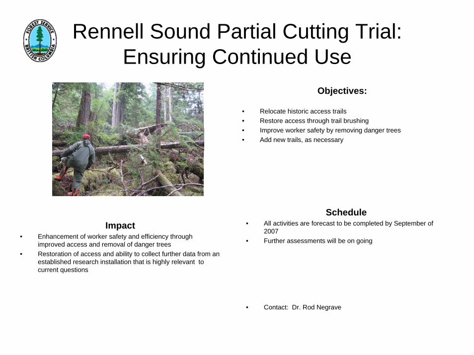
Rennell Sound Partial Cutting Trial: Ensuring Continued Use
Impact• Enhancement of worker safety and efficiency through
improved access and removal of danger trees• Restoration of access and ability to collect further data from an
established research installation that is highly relevant to current questions
Schedule• All activities are forecast to be completed by September of
2007• Further assessments will be on going
• Contact: Dr. Rod Negrave
Objectives:
• Relocate historic access trails• Restore access through trail brushing• Improve worker safety by removing danger trees• Add new trails, as necessary

The Gregory Creek Project, Queen Charlotte Islands Forest District
Relevance• Will determine the sensitivity of small headwater
streams, which are critical components of aquatic ecosystems, to alternative harvesting practices.
• Will provide scientific data as to the influence of large scale forest harvesting practices on peak flows and sediment production.
• Will determine if alternative harvesting practices such as single tree selection and patch cutting when combined with aerial extraction techniques help to preserve the quality of aquatic ecosystems.
Objective• Hydrology research into suspended sediment.• To determine how partial cutting and helicopter
extraction affects the runoff and suspended sediment regime of small headwater streams.
• To provide operational guidelines to forest harvesting around small streams.
Schedule• Summer 2003 - establish three suspended sediment
monitoring sites and 1 meteorological site and start to collect pre-treatment data.
• Summer 2005 – conduct the partial cutting and helicopter extraction harvesting upon the two treatment blocks.
• Fall 2007 – analyse collected data to quantify the effects of the treatment.
• Winter 2007 – publish results of the study.
• For further information contact [email protected]

Landslides Triggered by Road Construction in Organic Soils on Gentle and Moderately-Steep Slopes
Impact
• Increase awareness and understanding of problem• Provide detailed operational guidelines to prevent future
landslides.• Improve worker safety.• Decrease road construction and site rehabilitation costs.• Ongoing monitoring and research to continue to provide
improve understanding and guidance.
Objectives:• Promote awareness of the problem• Provide detailed description of the problem• Review of historic landslide events in organic soils• Examination of triggering mechanisms• Provide detailed description of site conditions most prone to
landslides during road construction.• Provide operational guidelines for road construction in similar
site conditions.• Establish contact person for BCTS to report future events to
and seek operational guidance. • Create database for ongoing monitoring of any future slides.
Schedule• Background research completed by Sept, 2006• Draft report completed and peer reviewed by Sept. 30, 2006• Extension note sent to BCTS operational staff by Nov., 2006
• Contact: Tom Millard, M.Sc., P.Geo.• Coast Forest Region, Research Section• 250-751-3132• [email protected]