Str et Eunice - UNI TD SA...Eunice Airport Koch Airport S andB S Landing Strip Luscombe Lane 1...
1
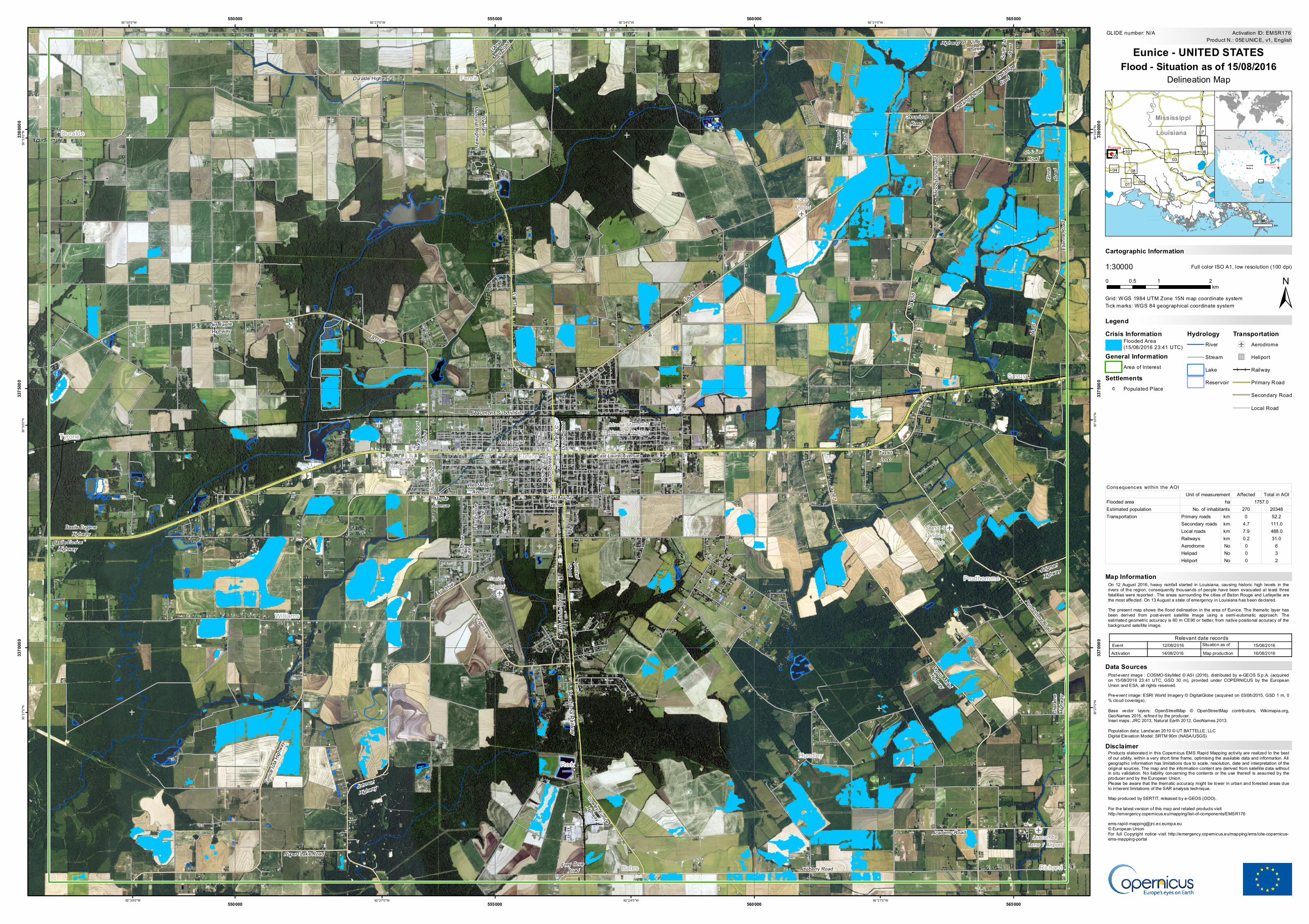
Crisis Information Flooded Area (15/08/2016 23:41 UTC) General Information Area of Interest Settlements ! Populated Place Hydrology River Stream Lake Reservoir Transportation ! r Aerodrome " ) u Heliport Railway Primary Road Secondary Road Local Road " ) u " ) u ! r ! r ! r ! r ! ! ! ! ! ! ! ! ! ! ! L and L Sandblasting Heliport Moosa Memorial Hospital Heliport Eunice Airport Koch Airport S and S Landing Strip Luscombe Lane 1 Airport Acadiana Railway Beaumont Subdivision Chataniger Road Lsu Drive East South 1st Street Clinne Road College Road South Bobcat Drive Lsu Eunice Drive W o o d s t o n e R o a d M o n a r c h R o a d L'Anse Meg Road Maple Avenue Lsu Drive North Bobcat Drive Brigman Highway Etienne Road Rupert Lake Road F r e y C o v e R o a d T a s s o L o o p Choupique Road La 367 West Maple Avenue S t J u l i en R o ad L a 9 5 La 757 East Ardoin Street Tiger Lane Prudhomme Road Academy Road Duralde Highway Charlene Highway L a 7 5 8 Chatangia Road Atteberry Road Old Basile Highway Johnson Highway La 29 B a y o u M a l l e t H i g hw a y Eunice Iota Highway Vine Street Highway 95 East Maple Avenue South C C Duson Street North C C Duson Street Basile Eugene Highway Basile Eunice Highway Aymond Street East Laurel Avenue West Laurel Avenue Veterans Memorial Highway La 13 Crowley Eunice Highway Duralde Tyrone Williams Fenris Eunice Rork Bates Hundley Prudhomme Savoy Richard 92°21'0"W 92°21'0"W 92°24'0"W 92°24'0"W 92°27'0"W 92°27'0"W 92°30'0"W 92°30'0"W 30°33'0"N 30°33'0"N 30°30'0"N 30°30'0"N 30°27'0"N 30°27'0"N 550000 550000 555000 555000 560000 560000 565000 565000 3370000 3370000 3375000 3375000 3380000 3380000 GLIDE number: N/A ! ( ! ( 01 02 03 04 05 06 08 09 10 07 Louisiana Mississippi Eunice ^ ^ Canada Cuba Haiti Me xi c o United State s Washing to n, D. C. Cartographic Information 1:30000 ± Grid: WGS 1984 UTM Zone 15N map coordinate system Full color ISO A1, low resolution (100 dpi) On 12 August 2016, heavy rainfall started in Louisiana, causing historic high levels in the rivers of the region, consequently thousands of people have been evacuated at least three fatalities were reported . The areas surrounding the cities of Baton Rouge and Lafayette are the most affected. On 13 August a state of emergency in Louisiana has been declared. The present map shows the flood delineation in the area of Eunice. The thematic layer has been derived from post-event satellite image using a semi-automatic approach. The estimated geometric accuracy is 60 m CE90 or better, from native positional accuracy of the background satellite image. Products elaborated in this Copernicus EMS Rapid Mapping activity are realized to the best of our ability, within a very short time frame, optimising the available data and information. All geographic information has limitations due to scale, resolution, date and interpretation of the original sources. The map and the information content are derived from satellite data without in situ validation. No liability concerning the contents or the use thereof is assumed by the producer and by the European Union. Please be aware that the thematic accuracy might be lower in urban and forested areas due to inherent limitations of the SAR analysis technique. Map produced by SERTIT, released by e-GEOS (ODO). For the latest version of this map and related products visit http://emergency.copernicus.eu/mapping/list-of-components/EMSR176 [email protected] © European Union For full Copyright notice visit http://emergency.copernicus.eu/mapping/ems/cite-copernicus- ems-mapping-portal Legend Tick marks: WGS 84 geographical coordinate system Product N.: 05EUNICE, v1, English Activation ID: EMSR176 Post-event image : COSMO-SkyMed © ASI (2016), distributed by e-GEOS S.p.A. (acquired on 15/08/2016 23:41 UTC, GSD 30 m), provided under COPERNICUS by the European Union and ESA, all rights reserved. Pre-event image: ESRI World Imagery © DigitalGlobe (acquired on 03/08/2015, GSD 1 m, 0 % cloud coverage). Base vector layers: OpenStreetMap © OpenStreetMap contributors, Wikimapia.org, GeoNames 2015, refined by the producer. Inset maps: JRC 2013, Natural Earth 2012, GeoNames 2013. Population data: Landscan 2010 © UT BATTELLE, LLC Digital Elevation Model: SRTM 90m (NASA/USGS) 0 1 2 0.5 km Eunice - UNITED STATES Flood - Situation as of 15/08/2016 Delineation Map Map Information Relevant date records Event Situation as of 12/08/2016 15/08/2016 Activation Map production 14/08/2016 16/08/2016 Disclaimer Data Sources 40 km Affected Total in AOI Flooded area Estimated population 270 20348 Primary roads km 0 52.2 Secondary roads km 4.7 111.0 Local roads km 7.9 488.0 Railways km 0.2 31.0 Aerodrome No 0 6 Helipad No 0 3 Heliport No 0 2 Transportation Consequences within the AOI Unit of measurement ha 1757.0 No. of inhabitants
Transcript of Str et Eunice - UNI TD SA...Eunice Airport Koch Airport S andB S Landing Strip Luscombe Lane 1...
Crisis InformationFlooded Area(15/08/2016 23:41 UTC)
General InformationArea of Interest
Settlements! Populated Place
HydrologyRiver
Stream
Lake
Reservoir
Transportation!
r
Aerodrome
")u Heliport
Railway
Primary Road
Secondary Road
Local Road
")u
")u
!
r
!
r
!
r
!
r
!
!
!
!
!
!
!
!
!
!
!
!
!
L and LSandblasting
Heliport
Moosa MemorialHospital Heliport
EuniceAirport
KochAirport
S and SLanding
Strip
LuscombeLane 1 Airport
Acadiana Railway
Beaumont Subdivision
Chataniger
Road
Lsu D
rive
East
South
1st
Stree
t
Clinn
eRo
ad
Colle
geRo
ad
South
Bob
cat
Drive
Lsu E
unice
Drive
Wood
stone
Road
Mona
rchRo
ad
L'Anse
Meg Road
MapleAvenue
Lsu Drive
North
Bob
cat
Drive
Brigman
Highway
Etien
ne R
oad
Rupert Lake RoadFrey Cove
Road
TassoLoop
ChoupiqueRoad
La 367West Maple
Avenue
St JulienRoad
La95
La 757
East
Ardo
in Str
eet
Tiger Lane
Prudhomme Road
Academy Road
Duralde Highway
Char
lene
Highw
ay
L a75
8
Chatangia Road
Atteberry Road
Old BasileHighway
JohnsonHighway
La 29
Bayou Mallet
Highway
Eunic
e Iota
High
way
VineStreet
Highway 95
East MapleAvenue
South
C C
Duso
n Stre
etNo
rth C
CDu
son S
treet
Basile EugeneHighway
Basile EuniceHighway
AymondStreet
East Laurel Avenue
West LaurelAvenue
VeteransMemorial Highway
La 13
Crowley Eunice
Highway
Duralde
Tyrone
Williams
Fenris
Eunice
Rork
Bates
Hundley
Prudhomme
Savoy
Richard
92°21'0"W
92°21'0"W
92°24'0"W
92°24'0"W
92°27'0"W
92°27'0"W
92°30'0"W
92°30'0"W30
°33'0
"N
30°3
3'0"N
30°3
0'0"N
30°3
0'0"N
30°2
7'0"N
30°2
7'0"N
550000
550000
555000
555000
560000
560000
565000
565000
3370
000
3370
000
3375
000
3375
000
3380
000
3380
000
GLIDE number: N/A
!(!(
01
02
03
04
0506
08
09
10
07LouisianaMississippi
Eunice
GULF OFMEXICO
^
^
Canada
CubaHait i
Me xi co
Uni tedState s
NORTHATLANTIC
OCEAN
NORTHPACIFICOCEAN
CaribbeanSea
Gulf ofMexico
HudsonBay
Bah’a deCam peche
JamesBay
SargassoSea
Washing to n,D. C.
Cartographic Information
1:30000
±Grid: WGS 1984 UTM Zone 15N map coordinate system
Full color ISO A1, low resolution (100 dpi)
On 12 August 2016, heavy rainfall started in Louisiana, causing historic high levels in therivers of the region, consequently thousands of people have been evacuated at least threefatalities were reported . The areas surrounding the cities of Baton Rouge and Lafayette arethe most affected. On 13 August a state of emergency in Louisiana has been declared.The present map shows the flood delineation in the area of Eunice. The thematic layer hasbeen derived from post-event satellite image using a semi-automatic approach. Theestimated geometric accuracy is 60 m CE90 or better, from native positional accuracy of thebackground satellite image.
Products elaborated in this Copernicus EMS Rapid Mapping activity are realized to the bestof our ability, within a very short time frame, optimising the available data and information. Allgeographic information has limitations due to scale, resolution, date and interpretation of theoriginal sources. The map and the information content are derived from satellite data withoutin situ validation. No liability concerning the contents or the use thereof is assumed by theproducer and by the European Union.Please be aware that the thematic accuracy might be lower in urban and forested areas dueto inherent limitations of the SAR analysis technique.Map produced by SERTIT, released by e-GEOS (ODO).For the latest version of this map and related products visithttp://emergency.copernicus.eu/mapping/list-of-components/[email protected]© European UnionFor full Copyright notice visit http://emergency.copernicus.eu/mapping/ems/cite-copernicus-ems-mapping-portal
Legend
Tick marks: WGS 84 geographical coordinate system
Product N.: 05EUNICE, v1, EnglishActivation ID: EMSR176
Post-event image : COSMO-SkyMed © ASI (2016), distributed by e-GEOS S.p.A. (acquiredon 15/08/2016 23:41 UTC, GSD 30 m), provided under COPERNICUS by the EuropeanUnion and ESA, all rights reserved.Pre-event image: ESRI World Imagery © DigitalGlobe (acquired on 03/08/2015, GSD 1 m, 0% cloud coverage).Base vector layers: OpenStreetMap © OpenStreetMap contributors, Wikimapia.org,GeoNames 2015, refined by the producer.Inset maps: JRC 2013, Natural Earth 2012, GeoNames 2013.Population data: Landscan 2010 © UT BATTELLE, LLCDigital Elevation Model: SRTM 90m (NASA/USGS)
0 1 20.5km
Eunice - UNITED STATESFlood - Situation as of 15/08/2016
Delineation Map
Map Information
Relevant date recordsEvent Situation as of12/08/2016 15/08/2016Activation Map production14/08/2016 16/08/2016
Disclaimer
Data Sources
40km
Affected Total in AOIFlooded areaEstimated population 270 20348
Primary roads km 0 52.2Secondary roads km 4.7 111.0Local roads km 7.9 488.0Railways km 0.2 31.0Aerodrome No 0 6Helipad No 0 3Heliport No 0 2
Transportation
Consequences within the AOIUnit of measurement
ha 1757.0No. of inhabitants