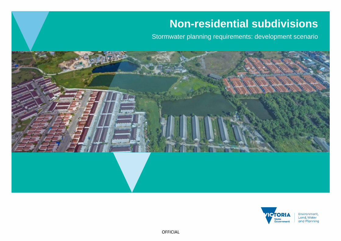
Stormwater planning requirements: development scenario
32
OFFICIAL Non-residential subdivisions Stormwater planning requirements: development scenario
Transcript of Stormwater planning requirements: development scenario
OFFICIAL
Non-residential subdivisions Stormwater planning requirements: development scenario
i
delwp.vic.gov.au
Acknowledgment
We acknowledge and respect Victorian Traditional Owners as the original custodians of Victoria's land and waters, their unique ability to care for Country and deep spiritual connection to it. We honour Elders past and present whose knowledge and wisdom has
ensured the continuation of culture and traditional practices.
We are committed to genuinely partner, and meaningfully engage, with Victoria's Traditional Owners and Aboriginal communities to support
the protection of Country, the maintenance of spiritual and cultural practices and their broader aspirations in the 21st century and beyond.
© The State of Victoria Department of Environment, Land, Water and Planning 2020
This work is licensed under a Creative Commons Attribution 4.0 International licence. You are free to re-use the work under that licence, on the condition that you credit the State of Victoria as author. The licence does not apply to any images, photographs or branding, including the Victorian Coat of Arms, the Victorian Government logo and the Department of Environment, Land, Water and Planning (DELWP) logo. To view a copy of this licence, visit http://creativecommons.org/licenses/by/4.0/
ISBN 978-1-76105-231-6 (pdf/online/MS word)
Disclaimer
This publication may be of assistance to you but the State of Victoria and its employees do not guarantee that the publication is without flaw of any kind or is wholly appropriate for your particular purposes and therefore disclaims all liability for any error, loss or other consequence which may arise from you relying on any information in this publication.
Accessibility
If you would like to receive this publication in an alternative format, please telephone the DELWP Customer Service Centre on 136186,
email [email protected] or via the National Relay Service on 133 677 www.relayservice.com.au. This document is also
available on the internet at www.delwp.vic.gov.au.

ii
delwp.vic.gov.au
Introduction ....................................................................................................................... 1
Planning requirements .................................................................................................................................... 1
Objectives of Clause 53.18 ............................................................................................................................. 3
Standards ......................................................................................................................................................... 3
Worked example ............................................................................................................... 5
A: Proposed development description .......................................................................................................... 5
B: Hydrology and hydraulics ........................................................................................................................ 10
C: Design for cooling and amenity .............................................................................................................. 14
D: Design for best practice stormwater quality improvement .................................................................. 14
E: Concept design considerations .............................................................................................................. 20
F: Site management plan – interim works .................................................................................................. 22
G: Asset maintenance program ................................................................................................................... 26
Contents
Non-residential subdivisions
Stormwater planning requirements: development scenario
1 delwp.vic.gov.au
This development scenario is a support tool for those complying with stormwater planning requirements. The intended audience is both design practitioners
submitting applications, as well as council planners assessing development applications.
A checklist indicates the minimum information that should be included in a stormwater report lodged with the planning application. This worked example for an
industrial subdivision development demonstrates how an application should be designed to satisfy the objectives and standards of the relevant clauses. The right
column of the example (green boxes ) indicate which sections of the report respond to which checklist items. The call out text boxes (blue boxes ) offer
resources and links for both designers and assessors.
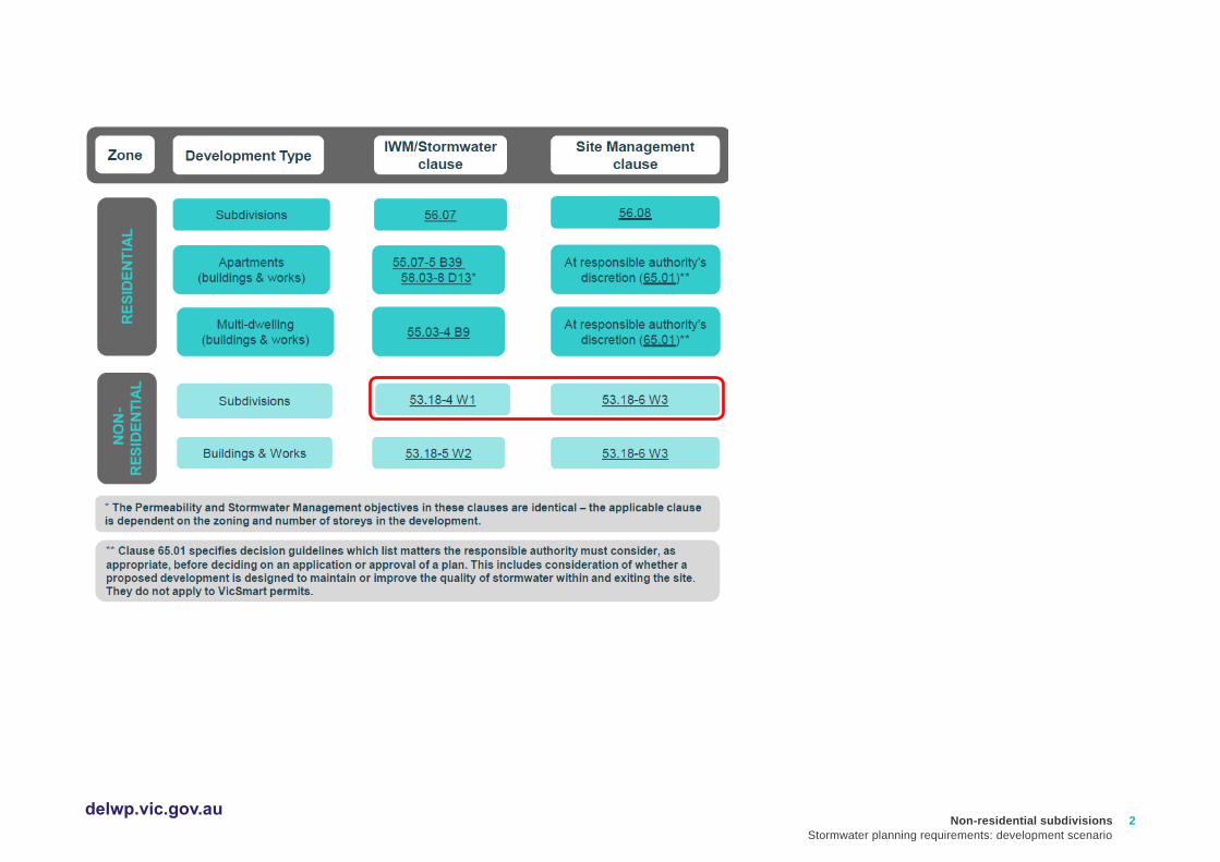
Planning requirements
The example is for an industrial land subdivision. The required provisions for the works in this example regarding stormwater management are covered by Clause
53.18-4 (Stormwater management objectives for subdivision) and Clause 53.18-6 (Site management objectives).
This example can be used for other non-residential subdivisions, such as commercial and industrial subdivisions. In this example the site is a large industrial
development. It can be adapted for smaller industrial and commercial developments following a similar approach.
The development will need to meet all planning scheme requirements for the land and the development type. This may include local controls. Applicants are
encouraged to check with their local council if they are not sure which planning scheme provisions apply and complete a site layout plan before starting the
stormwater report.
Introduction
Non-residential subdivisions
Stormwater planning requirements: development scenario
2 delwp.vic.gov.au

Non-residential subdivisions
Stormwater planning requirements: development scenario
3 delwp.vic.gov.au
Objectives of Clause 53.18
53.18-4 Stormwater management objectives for subdivision
• To minimise damage to properties and inconvenience to the public from stormwater.
• To ensure that the street operates adequately during major storm events and provides for public safety.
• To minimise increases in stormwater and protect the environmental values and physical characteristics of receiving waters from degradation.
• To encourage stormwater management that maximises the retention and reuse of stormwater.
• To encourage stormwater management that contributes to cooling, local habitat improvements and provision of attractive and enjoyable spaces.
53.18-6 Site management objectives
• To protect drainage infrastructure and receiving waters from sedimentation and contamination.
• To protect the site and surrounding area from environmental degradation prior to and during construction of subdivision works.
Standards
The requirements for Standard W1 and W3 are listed below.
CLAUSE Standards
53.18-4 Standard W1:
The stormwater management system should be:
• Designed and managed in accordance with the requirements and to the satisfaction of the relevant drainage authority.
• Designed and managed in accordance with the requirements and to the satisfaction of the water authority where reuse of stormwater is proposed.
• Designed to meet the current best practice performance objectives for stormwater quality as contained in the Urban Stormwater - Best Practice Environmental
Management Guidelines (Victorian Stormwater Committee, 1999).
• Designed to ensure that flows downstream of the subdivision site are restricted to pre-development levels unless increased flows are approved by the relevant
drainage authority and there are no detrimental downstream impacts.
• Designed to contribute to cooling, improving local habitat and providing attractive and enjoyable spaces.
The stormwater management system should be integrated with the overall development plan including the street and public open space networks and landscape
design.
For all storm events up to and including the 20% Average Exceedance Probability (AEP) standard:
• Stormwater flows should be contained within the drainage system to the requirements of the relevant authority.
Non-residential subdivisions
Stormwater planning requirements: development scenario
4 delwp.vic.gov.au
• Ponding on roads should not occur for longer than 1 hour after the cessation of rainfall.
For storm events greater than 20% AEP and up to and including 1% AEP standard:
• Provision must be made for the safe and effective passage of stormwater flows.
• All new lots should be free from inundation or to a lesser standard of flood protection where agreed by the relevant floodplain management authority.
• Ensure that streets, footpaths and cycle paths that are subject to flooding meet the safety criteria da Vave< 0.35m2/s (where da = average depth in metres and
Vave = average velocity in metres per second).
The design of the local drainage network should:
• Ensure stormwater is retarded to a standard required by the responsible drainage authority.
• Ensure every lot is provided with drainage to a standard acceptable to the relevant drainage authority. Wherever possible, stormwater should be directed to the
front of the lot and discharged into the street drainage system or legal point of discharge.
• Ensure that inlet and outlet structures consider the effects of obstructions and debris build up. Any surcharge drainage pit should discharge into an overland flow
in a safe and predetermined manner.
• Include water sensitive urban design features to manage stormwater in streets and public open space. Where such features are provided, an application must
describe maintenance responsibilities, requirements and costs.
Any flood mitigation works must be designed and constructed in accordance with the requirements of the relevant floodplain management authority.
53.18-6 Standard W3:
An application should describe how the site will be managed prior to and during the construction period and may set out requirements for managing:
• Erosion and sediment.
• Stormwater.
• Litter, concrete and other construction wastes.
• Chemical contamination.
All applications must be accompanied by details of the proposed stormwater management system, including drainage works and retention, detention
and discharges of stormwater to the drainage system.
Non-residential subdivisions
Stormwater planning requirements: development scenario
5 delwp.vic.gov.au
The stormwater management strategy presented by the applicant should provide all the information listed in the checklist.
This example is conceptual level and focuses on the elements required to satisfy the relevant criteria of Clauses 53.18-4 and
53.18-6 (standards W1 and W3) only. Councils will require further engineering detail and proof of calculation (generally through
a functional design report) for aspects of the stormwater network design than presented here. The schematic is not intended as
an accurate representation of all other planning requirements for a development of this nature.
Information requirements regarding the delivery of the Water Sensitive Urban Design (WSUD) measures (including Quality
Assurance and hold points, contractual details, and staging details indicating timing of drainage works relating to subdivision
build, etc.) will vary depending on the site location. Within the Melbourne Water region, these are covered through the relevant
Development Services Scheme (DSS), where applicable. Sites outside DSS areas will need to check the requirements of their
local authority.
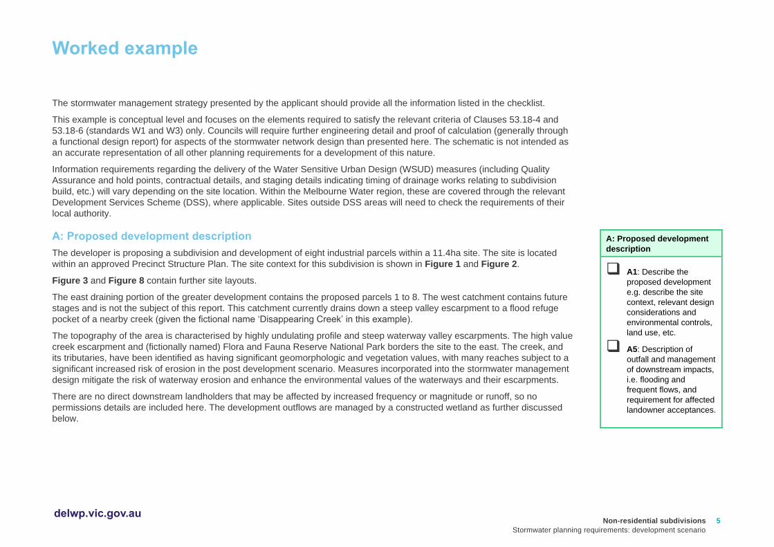
A: Proposed development description
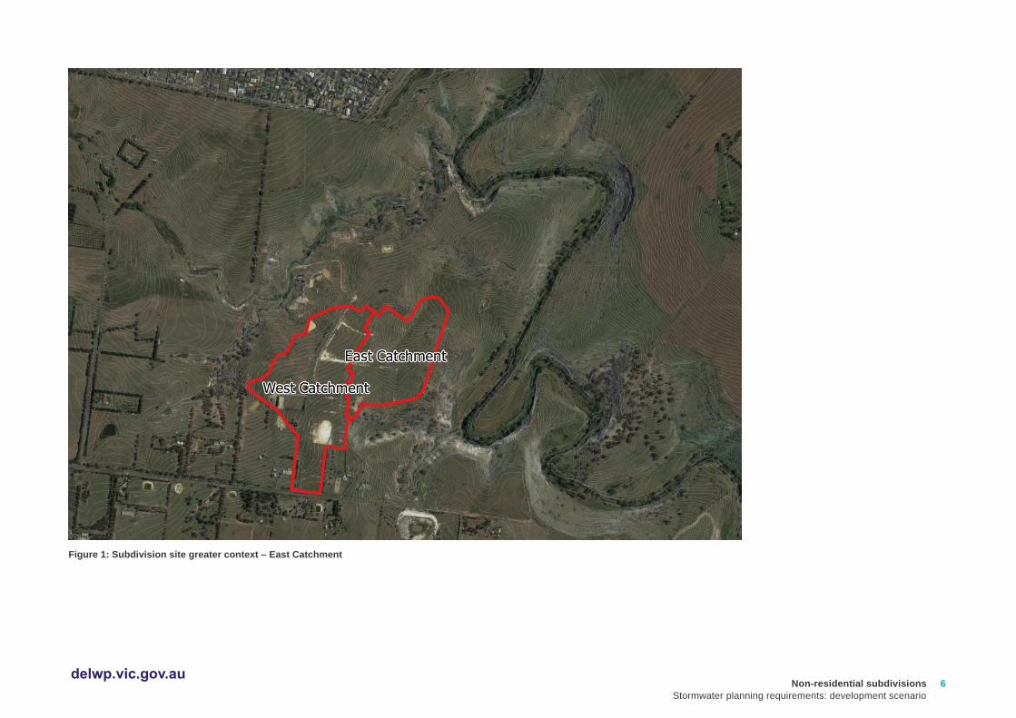
The developer is proposing a subdivision and development of eight industrial parcels within a 11.4ha site. The site is located
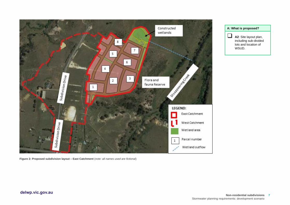
within an approved Precinct Structure Plan. The site context for this subdivision is shown in Figure 1 and Figure 2.
Figure 3 and Figure 8 contain further site layouts.
The east draining portion of the greater development contains the proposed parcels 1 to 8. The west catchment contains future
stages and is not the subject of this report. This catchment currently drains down a steep valley escarpment to a flood refuge
pocket of a nearby creek (given the fictional name ‘Disappearing Creek’ in this example).
The topography of the area is characterised by highly undulating profile and steep waterway valley escarpments. The high value
creek escarpment and (fictionally named) Flora and Fauna Reserve National Park borders the site to the east. The creek, and
its tributaries, have been identified as having significant geomorphologic and vegetation values, with many reaches subject to a
significant increased risk of erosion in the post development scenario. Measures incorporated into the stormwater management
design mitigate the risk of waterway erosion and enhance the environmental values of the waterways and their escarpments.
There are no direct downstream landholders that may be affected by increased frequency or magnitude or runoff, so no
permissions details are included here. The development outflows are managed by a constructed wetland as further discussed
below.
A: Proposed development
description
❑ A1: Describe the
proposed development
e.g. describe the site
context, relevant design
considerations and
environmental controls,
land use, etc.
❑ A5: Description of
outfall and management
of downstream impacts,
i.e. flooding and
frequent flows, and
requirement for affected
landowner acceptances.
Worked example
Non-residential subdivisions
Stormwater planning requirements: development scenario
6 delwp.vic.gov.au
Figure 1: Subdivision site greater context – East Catchment
Non-residential subdivisions
Stormwater planning requirements: development scenario
7 delwp.vic.gov.au
Figure 2: Proposed subdivision layout – East Catchment (note: all names used are fictional)
A: What is proposed?
❑ A2: Site layout plan,
including sub-divided
lots and location of
WSUD.

Non-residential subdivisions
Stormwater planning requirements: development scenario
8 delwp.vic.gov.au
A summary of the catchments and the proposed land use is provided in Table 1 and Figure 2:
Table 1: Land use summary
Land use summary Catchment area (ha) Fraction impervious
Industrial 7.4 0.75
Open space 0.5 0.1
Road reserve 3.5 0.6
TOTALS 11.4 68%
What is proposed?
Design response summary
The strategy for servicing future development of the subject land will consist of:
• Underground pipe drainage system for conveyance of low flows;
• Roadways, a culvert crossing and waterway tributaries for conveyance of high flows;
• All stormwater from industrial lots managed for toxicants and industrial pollutants to EPA best practice standards;
• Stormwater quality treatment for whole of subdivision catchment runoff in constructed wetlands;
• Streetscape tree plantings to create a cooler, more aesthetically pleasing urban landscape;
• Wetlands with landscaping to provide amenity and cooler urban landscapes;
• Outfall works consisting of pipes, pits and diversion structures;
• Interim works may be required to service development stages until such a time that ultimate works are delivered.
A: What is proposed?
❑ A3: Summary table of land
use, catchment area and
fraction impervious.
❑ A4: Descriptive summary of
design response.

Non-residential subdivisions
Stormwater planning requirements: development scenario
9 delwp.vic.gov.au
Design response plan
Figure 3: Design response plan
B: Hydraulic calculations
❑ B4: Design response plan
showing, flow paths and
critical infrastructure.
❑ B5: The design of the local
drainage network should:
❑ Ensure stormwater is
retarded to a standard
required by the
responsible drainage
authority.
❑ Ensure every lot is
provided with drainage to
a standard acceptable to
the relevant drainage
authority.
❑ Ensure that inlet and
outlet structures consider
the effects of obstructions
and debris build up. Any
surcharge drainage pit
should discharge into an
overland flow in a safe
and predetermined
manner.
❑ Include water sensitive
urban design features to
manage stormwater in
streets and public open
space. Where such
features are provided, an
application must describe
maintenance
responsibilities,
requirements and costs.
Non-residential subdivisions
Stormwater planning requirements: development scenario
10 delwp.vic.gov.au
B: Hydrology and hydraulics
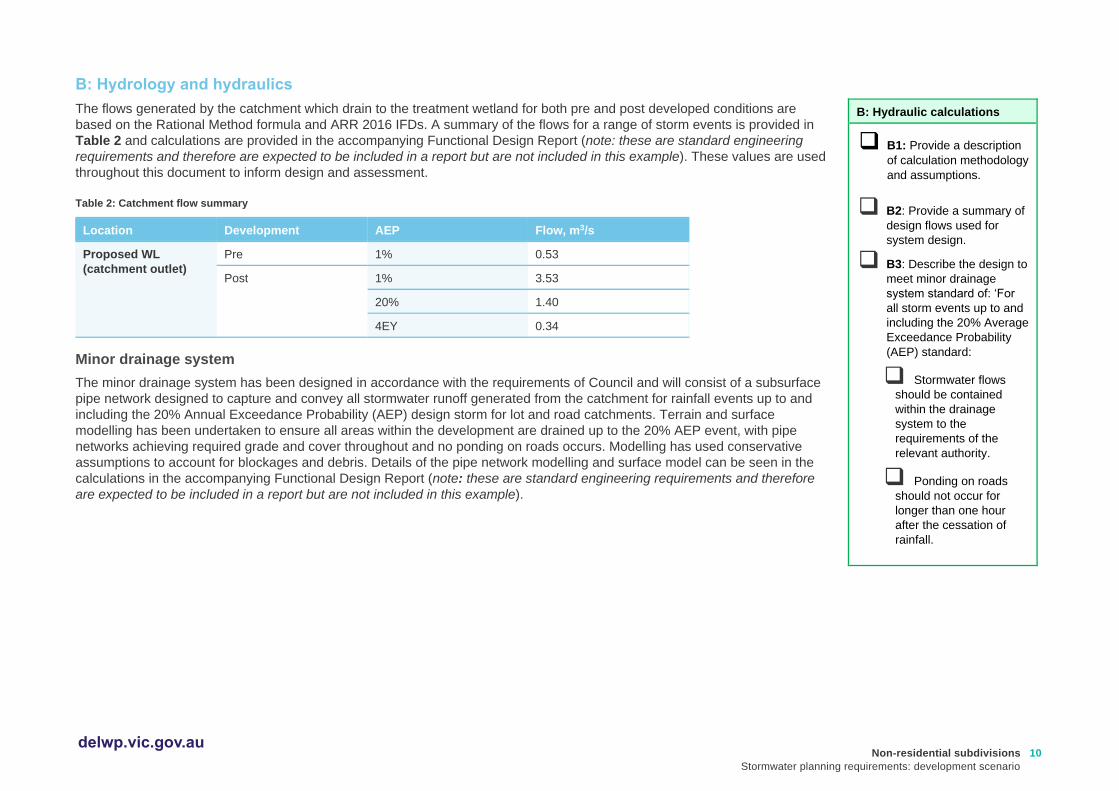
The flows generated by the catchment which drain to the treatment wetland for both pre and post developed conditions are
based on the Rational Method formula and ARR 2016 IFDs. A summary of the flows for a range of storm events is provided in
Table 2 and calculations are provided in the accompanying Functional Design Report (note: these are standard engineering
requirements and therefore are expected to be included in a report but are not included in this example). These values are used
throughout this document to inform design and assessment.
Table 2: Catchment flow summary
Location Development AEP Flow, m3/s
Proposed WL
(catchment outlet)
Pre 1% 0.53
Post 1% 3.53
20% 1.40
4EY 0.34
Minor drainage system
The minor drainage system has been designed in accordance with the requirements of Council and will consist of a subsurface
pipe network designed to capture and convey all stormwater runoff generated from the catchment for rainfall events up to and
including the 20% Annual Exceedance Probability (AEP) design storm for lot and road catchments. Terrain and surface
modelling has been undertaken to ensure all areas within the development are drained up to the 20% AEP event, with pipe
networks achieving required grade and cover throughout and no ponding on roads occurs. Modelling has used conservative
assumptions to account for blockages and debris. Details of the pipe network modelling and surface model can be seen in the
calculations in the accompanying Functional Design Report (note: these are standard engineering requirements and therefore
are expected to be included in a report but are not included in this example).
B: Hydraulic calculations
❑ B1: Provide a description
of calculation methodology
and assumptions.
❑ B2: Provide a summary of
design flows used for
system design.
❑ B3: Describe the design to
meet minor drainage
system standard of: ‘For
all storm events up to and
including the 20% Average
Exceedance Probability
(AEP) standard:
❑ Stormwater flows
should be contained
within the drainage
system to the
requirements of the
relevant authority.
❑ Ponding on roads
should not occur for
longer than one hour
after the cessation of
rainfall.
Non-residential subdivisions
Stormwater planning requirements: development scenario
11 delwp.vic.gov.au
Major drainage system
The primary objective of the major drainage system is to provide flood protection for the allotments based on the 1% AEP storm
event and to ensure the overland flow can be safely conveyed through the development.
Overland flow paths
Flows up to and including the 1% AEP storm event are managed throughout the site via a series of overland flow paths. Road
reserves are to be designed to safely convey the gap flow in accordance with DELWP’s overland flow flood safety criteria.
The Melbourne Water website gives guidance on appropriate flood safety criteria to adopt for residential streets acting as an
overland flow path. The applicable criteria are:
1. da Vave must be less than 0.35m;
2. da must be less than 0.3m
where Vav and da is the average velocity and average depth of flow through the critical road cross section, respectively.
The critical road cross sections and direction of overland flows are identified in Figure 3 above. The critical road cross sections
are selected based on where the gap flow is expected to be greatest. This approach ensures the most conservative results
when assessing against floodway safety criteria.
A typical 16m wide road cross section has been created in HEC-RAS1 with a Manning’s roughness coefficient of 0.02 for the
roadway and 0.05 for nature strip. A 3.5m wide single lane road pavement is assumed for each direction with an average
crossfall of 5% and kerb height of 180mm. A longitudinal grade of 1% is assumed. Adoption of this sample road geometry is
considered very conservative for assessing floodway safety criteria as the actual road cross sections are likely to be
considerably larger.
1 HEC-RAS is the Hydrological Engineering Center River Analysis System.
B: Hydraulic calculations
❑ B6: Describe the design
to meet major drainage
system standard of: ‘For
storm events greater
than 20% AEP and up to
and including 1% AEP
standard:
❑ Provision must be
made for the safe and
effective passage of
stormwater flows.
❑ All new lots should
be free from inundation
or to a lesser standard
of flood protection
where agreed by the
relevant floodplain
management authority.
❑ Ensure that streets,
footpaths and cycle
paths that are subject
to flooding meet the
safety criteria da Vav<
0.35m2/s (where da =
average depth in
metres and Vave =
average velocity in
metres per second).
Non-residential subdivisions
Stormwater planning requirements: development scenario
12 delwp.vic.gov.au
Overland flood way - critical section
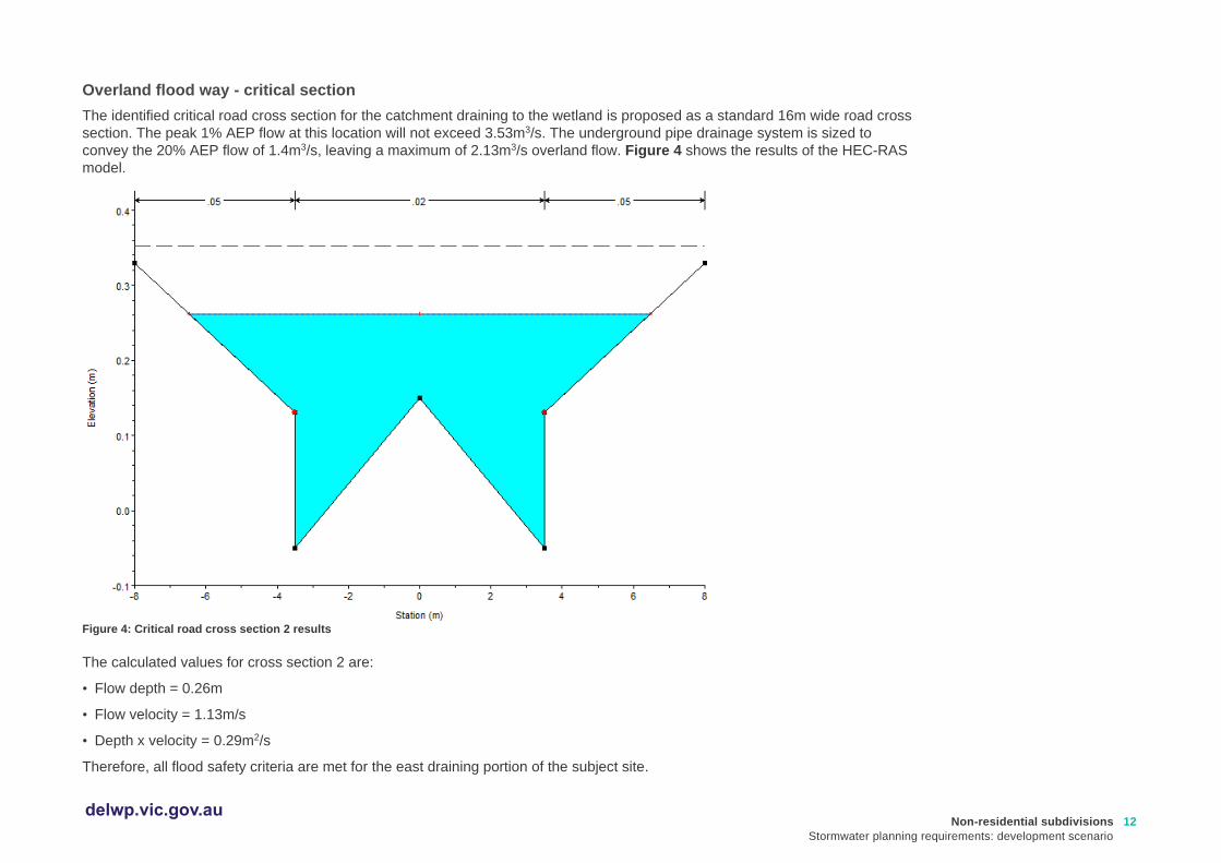
The identified critical road cross section for the catchment draining to the wetland is proposed as a standard 16m wide road cross
section. The peak 1% AEP flow at this location will not exceed 3.53m3/s. The underground pipe drainage system is sized to
convey the 20% AEP flow of 1.4m3/s, leaving a maximum of 2.13m3/s overland flow. Figure 4 shows the results of the HEC-RAS
model.
Figure 4: Critical road cross section 2 results
The calculated values for cross section 2 are:
• Flow depth = 0.26m
• Flow velocity = 1.13m/s
• Depth x velocity = 0.29m2/s
Therefore, all flood safety criteria are met for the east draining portion of the subject site.

Non-residential subdivisions
Stormwater planning requirements: development scenario
13 delwp.vic.gov.au
.
Relevant links
• Guidelines for Development in Flood Affected Areas (DELWP) - refer Section 8 ‘Flood Safety’: https://www.water.vic.gov.au/__data/assets/pdf_file/0025/409570/Guidelines-for-Development-in-Flood_finalAA.pdf
The following (or similar) software may be used to perform design checks on critical sections:
• PC-Convey (Integrity Software): http://www.integritysoftware.com.au/
• HEC-RAS (US Army Corps of Engineers Hydrologic Engineering Center) https://www.hec.usace.army.mil/software/hec-ras/download.aspx)
Requirements for retardation
As per the Precinct Structure Plan, no flood retarding basins are required to service development of the subject site. This is due
to substantial flood flow capacity available in the receiving waterways of the creek.
Detention of regular flow events will be provided via extended detention in the proposed wetland. This detention, along with
regular flow bypass pipes, ensures the risk of erosion to local waterway tributaries is maintained to an acceptable level and
ecological values are maintained and enhanced where possible. This is addressed in detail below.
No retardation basins or stormwater harvesting is proposed for this development and all design has been carried out according
to the requirements of the relevant authorities.
.
B: Hydraulic calculations
❑ B7: Provide a description of
design to meet standard
requirement: ’Designed to
ensure that flows downstream
of the subdivision site are
restricted to pre-development
levels unless increased flows
are approved by the relevant
drainage authority and there
are no detrimental
downstream impacts’.
❑ B8: Statement of stormwater
compliance: ‘Designed and
managed in accordance with
the requirements and to the
satisfaction of the relevant
drainage authority’.
❑ B9: Statement of re-use
compliance ‘Designed and
managed in accordance with
the requirements and to the
satisfaction of the water
authority where reuse of
stormwater is proposed’.

Non-residential subdivisions
Stormwater planning requirements: development scenario
14 delwp.vic.gov.au
C: Design for cooling and amenity
The streetscape design includes a minimum of one canopy tree per lot frontage, which is designed to contribute to nearby
cooling, providing local habitat to encourage wildlife and providing attractive and enjoyable spaces for the workers in the
subdivision, in line with urban greening targets.
The wetlands at the north-eastern corner of the development, are designed to meet the water quality improvement targets, but
also to act as an aesthetically pleasing community space. This element of the stormwater management system will be
integrated with the overall development through landscape design, walkways and seating and tables – to provide a cool green
urban space where people can enjoy lunch or a break.
D: Design for best practice stormwater quality improvement
Under Clause 53.18-4, development is required to be designed to meet the current best practice performance objectives for
stormwater quality as contained in the Urban Stormwater - Best Practice Environmental Management Guidelines (Victorian
Stormwater Committee, 1999) (BPEM). BPEM is currently defined as post-development reductions in the following
contaminants:
• Total suspended solids (TSS) – 80%
• Total phosphorus (TP) – 45%
• Total nitrogen (TN) – 45%
• Litter – 70%
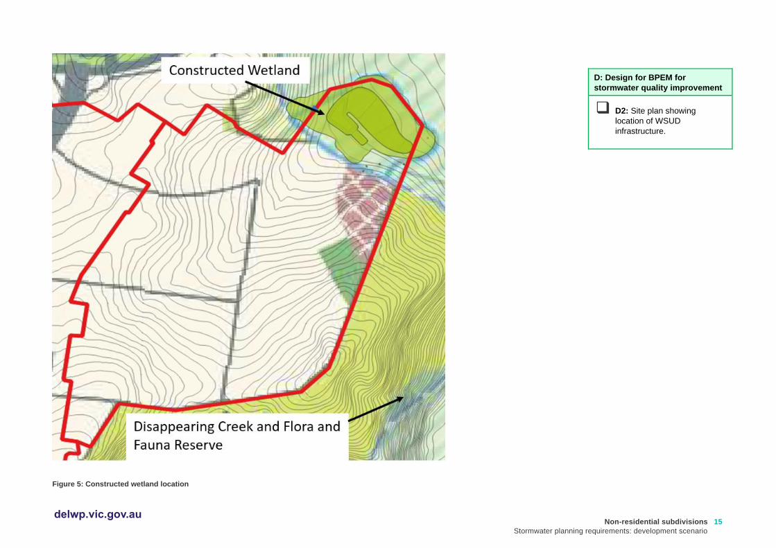
The proposed ultimate stormwater quality treatment works consist of a constructed wetland as shown in Figure 5 below.
C: Cooling and amenity
❑ C1: Describe design
contribution to local
cooling, improving local
habitat outcomes and
providing attractive/
enjoyable spaces, and
integration with open
space and landscape
design.
D: Design for BPEM for
stormwater quality
improvement
❑ D1: Designed to meet
the current best practice
performance objectives
for stormwater quality as
contained in the Urban
Stormwater - Best
Practice Environmental
Management Guidelines
(Victorian Stormwater
Committee, 1999).
.
Non-residential subdivisions
Stormwater planning requirements: development scenario
15 delwp.vic.gov.au
Figure 5: Constructed wetland location
D: Design for BPEM for
stormwater quality improvement
❑ D2: Site plan showing
location of WSUD
infrastructure.
Non-residential subdivisions
Stormwater planning requirements: development scenario
16 delwp.vic.gov.au
Stormwater quality modelling
The treatment of the catchment runoff is achieved by construction of a treatment wetland within the area shown in Figure 5. A
preliminary functional design of the proposed wetland asset has been completed. Calculations and MUSIC modelling was
undertaken to size the treatment components and configure the layout of the asset. The design meets all functional
requirements specified in Melbourne Water’s Constructed Wetlands Design Manual (2016).
Performance of the wetland with regards to meeting BPEM requirements is verified by the associated MUSIC model. An
earthworks model has been produced in 12D to verify the asset footprint and includes consideration of batters back to natural
surface level at a maximum 1 in 5 slope. Care has been taken to ensure an efficient treatment asset is proposed that:
• Provides adequate treatment to meet all BPEM target reductions;
• Services the whole catchment to the asset, including future development of adjacent land;
• Maximises the adjacent property owners’ developable area; and
• Meets the objectives of the relevant Precinct Structure Plan.
Relevant links
• MUSIC software (eWater): https://ewater.org.au/products/music/
• MUSIC Guidelines (Melbourne Water): https://www.melbournewater.com.au/sites/default/files/2018-02/Music-tool-guidelines-2018.pdf
D: Design for BPEM for
stormwater quality
improvement
❑ D3: Description of
modelling approach.
❑ D4: Table of MUSIC
model inputs.
Non-residential subdivisions
Stormwater planning requirements: development scenario
17 delwp.vic.gov.au
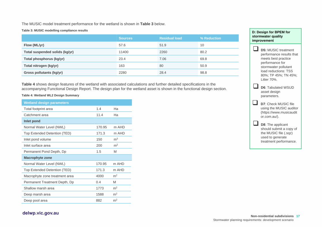
The MUSIC model treatment performance for the wetland is shown in Table 3 below.
Table 3: MUSIC modelling compliance results
Sources Residual load % Reduction
Flow (ML/yr) 57.6 51.9 10
Total suspended solids (kg/yr) 11400 2260 80.2
Total phosphorus (kg/yr) 23.4 7.06 69.8
Total nitrogen (kg/yr) 163 80 50.9
Gross pollutants (kg/yr) 2280 28.4 98.8
Table 4 shows design features of the wetland with associated calculations and further detailed specifications in the
accompanying Functional Design Report. The design plan for the wetland asset is shown in the functional design section.
Table 4: Wetland WL2 Design Summary
Wetland design parameters
Total footprint area 1.4 Ha
Catchment area 11.4 Ha
Inlet pond
Normal Water Level (NWL) 170.95 m AHD
Top Extended Detention (TED) 171.3 m AHD
Inlet pond volume 150 m3
Inlet surface area 200 m2
Permanent Pond Depth, Dp 1.5 M
Macrophyte zone
Normal Water Level (NWL) 170.95 m AHD
Top Extended Detention (TED) 171.3 m AHD
Macrophyte zone treatment area 4000 m2
Permanent Treatment Depth, Dp 0.4 M
Shallow marsh area 1773 m2
Deep marsh area 1588 m2
Deep pool area 882 m2
D: Design for BPEM for
stormwater quality
improvement
❑ D5: MUSIC treatment
performance results that
meets best practice
performance for
stormwater pollutant
load reductions: TSS
80%; TP 45%; TN 45%;
Litter 70%.
❑ D6: Tabulated WSUD
asset design
parameters.
❑ D7: Check MUSIC file
using the MUSIC auditor
(https://www.musicaudit
or.com.au/).
❑ D8: The applicant
should submit a copy of
the MUSIC file (.sqz)
used to generate
treatment performance.
Non-residential subdivisions
Stormwater planning requirements: development scenario
18 delwp.vic.gov.au
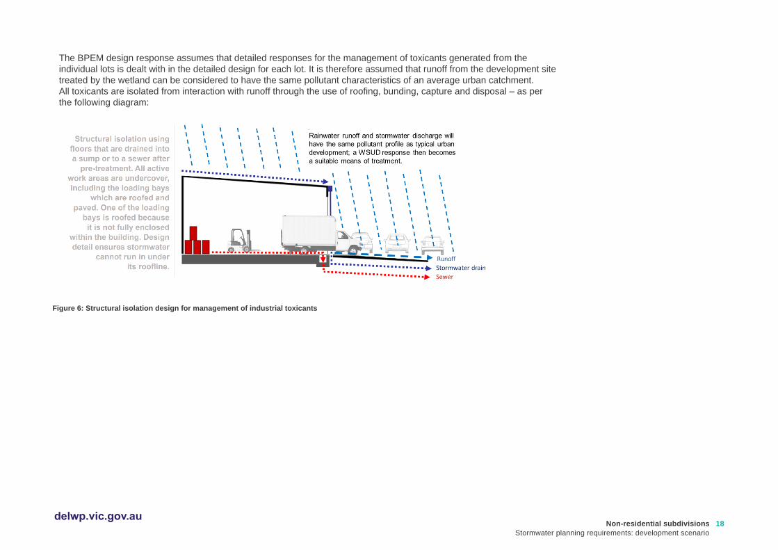
The BPEM design response assumes that detailed responses for the management of toxicants generated from the
individual lots is dealt with in the detailed design for each lot. It is therefore assumed that runoff from the development site
treated by the wetland can be considered to have the same pollutant characteristics of an average urban catchment.
All toxicants are isolated from interaction with runoff through the use of roofing, bunding, capture and disposal – as per
the following diagram:
Figure 6: Structural isolation design for management of industrial toxicants
Non-residential subdivisions
Stormwater planning requirements: development scenario
19 delwp.vic.gov.au
Relevant links
• WSUD Engineering Procedures Stormwater (Melbourne Water):
https://www.publish.csiro.au/book/4974/#contents
• Infrastructure Design Manual (IDM) (Local Government Infrastructure Design Association): https://www.designmanual.com.au/download-idm
• Trees for Cooler and Greener Streetscapes - Guidelines for Streetscape Planning and Design (DELWP) https://www.planning.vic.gov.au/policy-and-strategy/planning-for-melbourne/plan-melbourne/cooling-greening-melbourne/trees-for-cooler-and-greener-streetscapes
• Designing for a cool city – Guidelines for passively irrigated landscapes (CRC for Water Sensitive Cities): https://watersensitivecities.org.au/content/designing-for-a-cool-city-guidelines-for-passively-irrigated-landscapes/
A useful reference for suitable streetscape WSUD plant species is Moreland City Council’s WSUD streetscape raingarden
and tree pit design package (refer to Planting Palette Extract) located at:
• https://www.moreland.vic.gov.au/environment-bins/environment/water/wsud-design-package/
As part of the assessment of the planning application the assessor should review the MUSIC file submitted.
• The MUSIC Auditor tool can be accessed at: https://www.musicauditor.com.au/
In order to use the MUSIC Auditor tool:
• Register as a user or login at https://www.musicauditor.com.au/user/register
• Create a summary report from your MUSIC model – find help on how to do this at https://musicauditor.com.au/FAQ
• Upload your summary report file by using the ‘Choose File’ radio button and press ‘Submit’.
• Download the pdf report to review.
Non-residential subdivisions
Stormwater planning requirements: development scenario
20 delwp.vic.gov.au
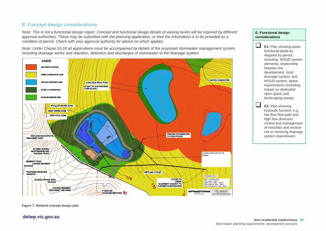
E: Concept design considerations
Note: This is not a functional design report. Concept and functional design details of varying levels will be required by different
approval authorities. These may be submitted with the planning application, or else the information is to be provided as a
condition of permit. Check with your approval authority for advice on which applies.
Note: Under Clause 53.18 all applications must be accompanied by details of the proposed stormwater management system,
including drainage works and retention, detention and discharges of stormwater to the drainage system.
Figure 7: Wetland concept design plan
E: Functional design
considerations
❑ E1: Plan showing asset
functional detail as
required by permit,
including: WSUD system
elements, relationship
between the
development, local
drainage system, and
WSUD system, space
requirements (including
impact on dedicated
open space and
landscaping areas).
❑ E2: Plan showing
hydraulic function; e.g.
low flow flow-path and
high flow diversion,
control and management
of velocities and erosion
risk to receiving drainage
system downstream.
5-YEAR ARI OUTLET TO CREEK

Non-residential subdivisions
Stormwater planning requirements: development scenario
21 delwp.vic.gov.au
Table 5: Plant species preferences
Recommendations for plant types*
Ephemeral batter Baumea rubiginosa (Soft Twig-rush)
Carex appressa (Tall Sedge)
Juncus flavidus (Yellow Rush)
Poa labillardierei (Common Tussock)
Lomandra longifolia (Spiny-headed Matt-rush)
Shallow marsh Bolboschoenus medianus (Marsh Club-rush)
Eleocharis acuta (Common Spike-rush)
Schoenoplectus tabernaemontani (River Club-rush)
Deep marsh Baumea articulata (Jointed Club-rush)
Bolboschoenus medianus (Marsh Club-rush)
Schoenoplectus tabernaemontani (River Club-rush)
For a development of this size a density of 2-6 plants/m2 is proposed. For purposes of aesthetics other species may also be used to add variety. The planting list in the Melbourne Water Constructed Wetland Design Manual should be used to develop a planting list with species, the wetland zone and planting densities all summarised within a table.
Relevant links
• WSUD Engineering Procedures: Stormwater (CSIRO): https://www.publish.csiro.au/book/4974/#contents
• Constructed Wetland Design Manual (Melbourne Water): https://www.melbournewater.com.au/building-and-works/developer-guides-and-resources/standards-and-specifications/constructed-wetlands
• Functional Design guidance (Melbourne Water): https://www.melbournewater.com.au/planning-and-building/stormwater-management/functional-design
• Standard drawings and guidelines (Melbourne Water): https://www.melbournewater.com.au/planning-and-building/developer-guides-and-resources/guidelines-drawings-and-checklists
• Infrastructure Design Manual (IDM) (Local Government Infrastructure Design Association): https://www.designmanual.com.au/download-idm
E: Site management plan
❑ E3: Plan to indicate any
structural issues,
consideration for public
safety, and maintenance
requirements (e.g.
access for staff/
machinery, slope).
❑ E4: Levels for each
WSUD treatment
including surface level,
extended detention
depth, filter layers and
depth, under drain
systems, levels of inlet
and outlet structures.
(refer to Functional
Design Report).
❑ E5: Plant species and
planting densities to be
used in any vegetated
treatment systems.
Non-residential subdivisions
Stormwater planning requirements: development scenario
22 delwp.vic.gov.au
F: Site management plan – interim works
All construction activities relating to subdivision development will be carried out under the guidance of a detailed interim site
management plan (an excerpt is included below). Consideration has been given to protecting downstream waterways from
sediment and topsoil that may leave the site during construction due to wind, rainfall and runoff.
Site management plans help you record the way you manage risk and may help with your planning. If a pollution incident
happens, they may also help demonstrate to Environment Protection Authority (EPA) Victoria what steps you have taken to
meet your general environmental duty (from 1 July 2021) by reducing or eliminating the risk of harm to human health and the
environment. The EPA Victoria website also provides information about following a risk-based approach to preventing and
minimising impacts from erosion and sedimentation.
Development progress and asset delivery timing has been considered to ensure that interim and ultimate works are delivered to
meet stormwater conveyance, retention and treatment requirements in line with construction activity. It is proposed to stage the
construction of the wetland system in line with development progress. This ensures that adequate treatment of stormwater is
achieved both during and after construction of the proposed industrial estate, protecting the receiving waterway and
downstream system from excessive erosion risk and pollutant loads, as well as protecting the wetland from excessive sediment
loads during build out of the subdivision.
It is intended that the vegetated wetland be completed (excavated and planted out) only after 75% of on lot building and works
are completed. Each lot is bound by Clause 53.18-5 (Stormwater management objectives for buildings and works) which
requires a site construction plan for the minimisation of sediment and erosion risk.
The interim drainage solution diverts the low flows generated by the development (up to 1EY) into the sediment basin (using the
location and excavation for the proposed constructed wetland for treatment). High flows (>1EY) exit the sediment pond via a
high flow bypass pipe into Disappearing Creek. This arrangement is considered appropriate for the timescale of the build out
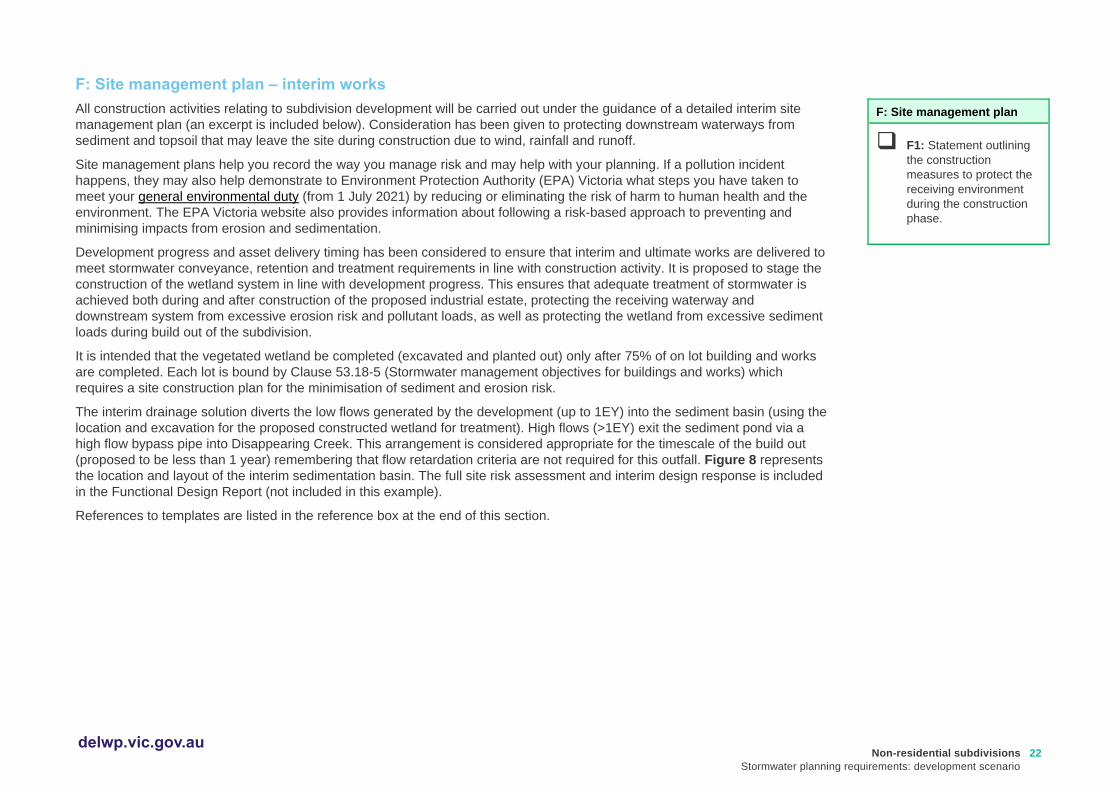
(proposed to be less than 1 year) remembering that flow retardation criteria are not required for this outfall. Figure 8 represents
the location and layout of the interim sedimentation basin. The full site risk assessment and interim design response is included
in the Functional Design Report (not included in this example).
References to templates are listed in the reference box at the end of this section.
F: Site management plan
❑ F1: Statement outlining
the construction
measures to protect the
receiving environment
during the construction
phase.
Non-residential subdivisions
Stormwater planning requirements: development scenario
23 delwp.vic.gov.au
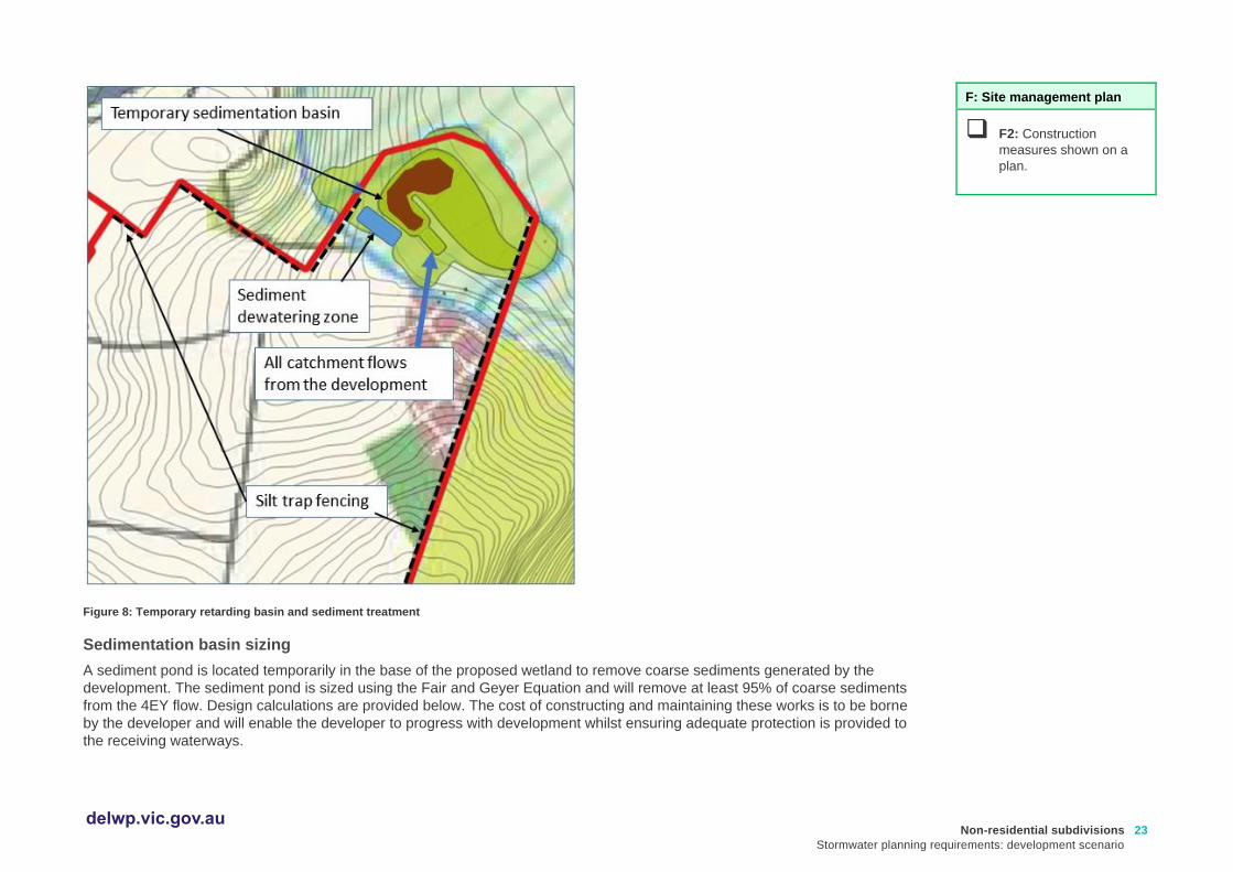
Figure 8: Temporary retarding basin and sediment treatment
Sedimentation basin sizing
A sediment pond is located temporarily in the base of the proposed wetland to remove coarse sediments generated by the
development. The sediment pond is sized using the Fair and Geyer Equation and will remove at least 95% of coarse sediments
from the 4EY flow. Design calculations are provided below. The cost of constructing and maintaining these works is to be borne
by the developer and will enable the developer to progress with development whilst ensuring adequate protection is provided to
the receiving waterways.
F: Site management plan
❑ F2: Construction
measures shown on a
plan.
Non-residential subdivisions
Stormwater planning requirements: development scenario
24 delwp.vic.gov.au
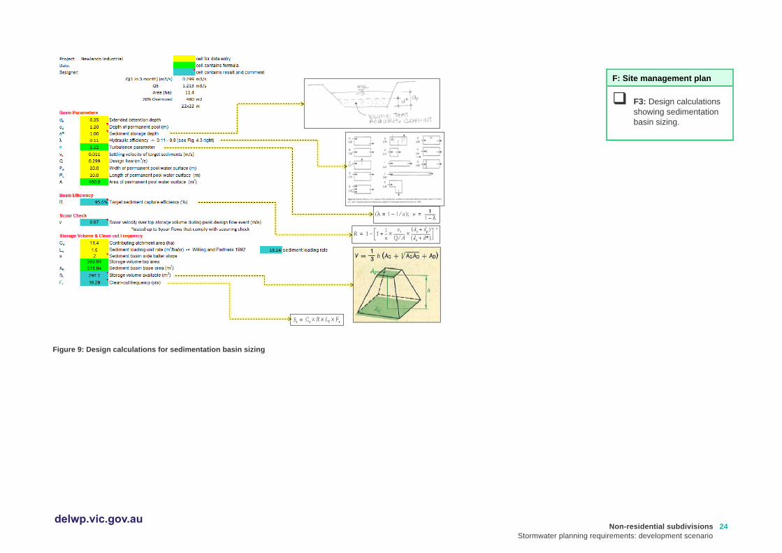
Figure 9: Design calculations for sedimentation basin sizing
F: Site management plan
❑ F3: Design calculations
showing sedimentation
basin sizing.

Non-residential subdivisions
Stormwater planning requirements: development scenario
25 delwp.vic.gov.au
Relevant links
For larger scale developments (10 or more dwellings or over 1000m2), consider developing a site management plan that addresses environmental risk, or an Environmental Management Plan (EMP) – guidelines are available at:
• Environmental Management Plan Guidelines (Commonwealth of Australia): https://www.environment.gov.au/system/files/resources/21b0925f-ea74-4b9e-942e-a097391a77fd/files/environmental-management-plan-guidelines.pdf
Other useful resources include:
• Site Environmental Management Plan kit (Melbourne Water): https://www.melbournewater.com.au/planning-and-building/developer-guides-and-resources/standards-and-specifications/develop-site
• Guidance on reducing erosion and sedimentation risk (EPA Victoria): https://www.epa.vic.gov.au/for-business/find-a-topic/erosion-and-sediment/advice-for-businesses
• Assessing and controlling risk: A guide for business – EPA publication 1695 (EPA Victoria): https://www.epa.vic.gov.au/about-epa/publications/1695-1 This guide is also available in languages other than English.
• Construction techniques for sediment pollution control – EPA publication 275 (EPA Victoria): https://www.epa.vic.gov.au/about-epa/publications/275
• Construction – Guide to preventing harm to people and the environment – EPA publication 1820 (EPA Victoria):
https://www.epa.vic.gov.au/about-epa/publications/1820
Outlines how to manage risks in construction, provides an outline of your legal obligations, what actions you can take to comply with the new laws, and contains a list of common hazards and information about how to manage waste. The guide does not tell you about the controls to put in place to suit your circumstances.
• Civil construction, building and demolition guide – EPA publication 1834 (EPA Victoria):
https://www.epa.vic.gov.au/about-epa/publications/1834
Supports industry to eliminate or reduce the risk of harm to human health and the environment through good environmental practice. It provides an overview of the duties under the new laws, outlines a risk based approach for assessing and managing risks, and includes information on controls that you can put in place to manage your risks.
Non-residential subdivisions
Stormwater planning requirements: development scenario
26 delwp.vic.gov.au
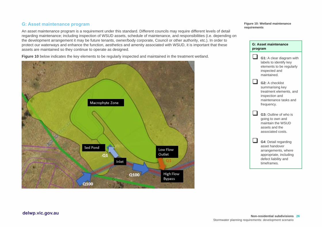
G: Asset maintenance program
An asset maintenance program is a requirement under this standard. Different councils may require different levels of detail
regarding maintenance; including inspection of WSUD assets, schedule of maintenance, and responsibilities (i.e. depending on
the development arrangement it may be future tenants, owner/body corporate, Council or other authority, etc.). In order to
protect our waterways and enhance the function, aesthetics and amenity associated with WSUD, it is important that these
assets are maintained so they continue to operate as designed.
Figure 10 below indicates the key elements to be regularly inspected and maintained in the treatment wetland.
Figure 10: Wetland maintenance
requirements
G: Asset maintenance
program
❑ G1: A clear diagram with
labels to identify key
elements to be regularly
inspected and
maintained.
❑ G2: A checklist
summarising key
treatment elements, and
inspection and
maintenance tasks and
frequency.
❑ G3: Outline of who is
going to own and
maintain the WSUD
assets and the
associated costs.
❑ G4: Detail regarding
asset handover
arrangements, where
appropriate, including
defect liability and
timeframes.

Non-residential subdivisions
Stormwater planning requirements: development scenario
27 delwp.vic.gov.au
The constructed wetland asset will be owned and operated by Council after the defects liability period is satisfactorily completed.
Table 6 below summarises the inspection and maintenance tasks and frequency for the on-going maintenance of the wetland.
Useful reference material regarding construction checklists, hold-points, asset handover and maintenance scheduling are
included at the end of this section.
Table 6: Maintenance tasks and frequency (adapted from Melbourne Water’s Constructed Wetland Maintenance Checklist:
https://www.melbournewater.com.au/media/664/download)
Inspection task Frequency (post
defects liability period)
Maintenance action required
Litter accumulation within gross pollutant trap (cleanout required)?
Every 3 months Cleanout as required
Sediment accumulation at inflow points? Every 6 months “
Sediment accumulation within inlet zone (record depth, remove if > 2/3 full)?
Every 6 months “
Litter or debris within inlet structure? Every 6 months “
Litter within inlet or aquatic plant (macrophyte) zone? Every 6 months "
Overflow structure integrity satisfactory? yearly Repair as required
Outlet structure free of debris? Every 6 months Cleanout as required
Maintenance drain operational? yearly “
Settling or erosion of bunds or batters present? yearly Track changes to determine the cause, remediate as required
Terrestrial vegetation condition satisfactory? (density, weeds, disease, pest infection, stunted growth or dead plants)
Every 6 months Weeding, replanting, report any issues with vegetation or pests, develop a remediation plan and execute over time
Aquatic vegetation condition satisfactory? (density, weeds, disease, pest infection, stunted growth or dead plants)
Every 6 months “
Replanting required? Every 6 months “
Evidence of damage or vandalism? yearly Report and repair
Evidence of dumping (building waste, oils etc.) yearly “
Evidence of algal scums? yearly Track changes to determine the cause , remediate as required
Evidence of odours? yearly “

Non-residential subdivisions
Stormwater planning requirements: development scenario
28 delwp.vic.gov.au
An in-depth inspection and maintenance checklist is included in the Appendices.
Within the defects liability period, the construction contractors (the proponents of the application) will be responsible for all
maintenance tasks. Within this period, all maintenance inspections (and subsequent actions) shall occur at a minimum
frequency of once every three months. This is particularly important in the establishment phase for vegetation to ensure dead
plants are replaced quickly so weeds do not have a chance to dominate. The defects liability period will last one year from
practical completion of the wetland construction. Within this period, the wetland should be proven to be operating successfully
according to design, without defects, before handover to Council ownership occurs.
Prior to the full plant out of the wetland, the excavation will serve as a sediment basin to protect downstream waterways. Within
this time period, it is the responsibility of the proponent to ensure maintenance of the sediment basin and sediment removal
occurs at a frequency to successfully protect downstream waterways from sediment loads. The cleanout frequency is dictated
by the design as well as feedback from inspections. This is described further in the ‘Interim Design’ section in this example.
Note: Where stormwater treatment assets are proposed to remain in private ownership, it is suggested that councils recommend
to property owners that they record the location and details of their buried on-site stormwater devices and attach it to property
title documents. Councils should also consider recording information about the location of buried stormwater infrastructure on
private land where required as part of a planning permit, to support future asset management and/or enforcement.
Relevant links
• WSUD Maintenance Guidelines (Melbourne Water): https://www.melbournewater.com.au/media/636/download
• WSUD Audit Guidelines (Stormwater Victoria): https://www.musicauditor.com.au/node/36
• Construction and Handover - hold points information (Melbourne Water): https://www.melbournewater.com.au/planning-and-building/stormwater-management/construction-and-handover
• WSUD Maintenance resources (Blacktown City Council): https://www.blacktown.nsw.gov.au/Plan-build/Stage-2-plans-and-guidelines/Developers-toolkit-for-water-sensitive-urban-design-WSUD/WSUD-maintenance-resources

Non-residential subdivisions
Stormwater planning requirements: development scenario
29 delwp.vic.gov.au
delwp.vic.gov.au