Stonnington Flood Management Plan - Graces revised version October 2013
80
Flood Management Plan For City of Stonnington and Melbourne Water April 2013
-
Upload
stonnington -
Category
Government & Nonprofit
-
view
708 -
download
3
Transcript of Stonnington Flood Management Plan - Graces revised version October 2013

Flood Management Plan For City of Stonnington and Melbourne Water April 2013

Table of contents
Stonnington Flood Management Plan Melbourne Water i
List of Figures ii List of Photos ii Approval iii Executive Summary iv 1. Introduction 1 2. Background 1 3. Purpose 2 4. Objectives 2 5. Scope 3 6. Stonnington’s Waterways and Drainage System 3
6.1. The City of Stonnington 3
6.2. Waterways in Stonnington 5
6.3. The Drainage System 7
6.4. Flood History and Issues 11
6.5. Flood Data, Information and Intelligence 15 7. Flood Risk 15
7.1. Flood Risk Assessment 16
7.2. Existing Flood Risks within the Municipality 17
7.3. Future Flood Risks 22 8. Flood Management and Mitigation 23
8.1. Drainage Strategy 23
8.2. Flood Modelling and Mapping 24
8.3. Asset Management 26
8.4. Planning Controls 28
8.5. Capital Works 32
8.6. Flood Emergency Planning 34
8.7. Community Education and Awareness 35
8.8. Flood Warning Systems 37
8.9. Drainage studies and guidelines 39 9. Roles and Responsibilities 40 10. Communication 41 11. Improvement Plan 42 12. Monitoring and Review 59 13. How this document was developed 60 14. Acknowledgements 60 Abbreviations and Acronyms 61 Glossary 62 References 63 Appendix A – Asset List 64 Appendix B – Roles and Responsibilities 65

Table of contents continued
ii Melbourne Water Stonnington Flood Management Plan
Appendix C – Flood Risk Assessment 68 Appendix D – Workshop attendees 70
List of Figures
Figure 1: Stonnington Municipality and Suburbs 4
Figure 2: Melbourne Water Main Drains, Waterways and 6 Ancillary Drainage Infrastructure
Figure 3: Melbourne Water and City of Stonnington Drains 8
Figure 4: Melbourne Water Defined Drainage Catchments 9
Figure 4a: Council Defined Drainage Catchments 10
Figure 5: Historical Recorded Flood Locations 14
Figure 6: Melbourne Water Catchment Risk Rating and 18 City of Stonnington Identified Hot Spots
Figure 7: Properties Waterways Identified as Flood-Prone 20
Figure 8: Safety Risk in Roads 21
Figure 9: Melbourne Water and City of Stonnington Flood Extents 25 for 20yr, 50yr and 100yr Events
Figure 10: Drains, Waterways and 100yr Flood Extents 27
Figure 11: Flood Overlays 30
Figure 12: Key Services and Vulnerable Locations 36
List of Photos
Photo 1: Flooding in Prahran 3
Photo 2: Gardiners Creek in flood 11
Photo 3: Flooding on Toorak Road 17
Photo 4: Tree leaves and drain 28
Photo 5: New drainage pits, South Yarra 34

Stonnington Flood Management Plan Melbourne Water iii
Approval This Plan has been developed in consultation with the City of Stonnington, Melbourne Water and Victoria State Emergency Service. The Plan will continually evolve as improved information becomes available to help manage flood risks across the Stonnington municipality.
As lead stakeholders for managing flood risks across the region, Melbourne Water and the City of Stonnington will endeavour to implement the recommendations made in this plan and also to review and update it as required on an annual basis.
Approved by
Signature Date
Phillip Neville Manager Floodplain Services Melbourne Water
Rick Kwasek Manager Public Spaces and Capital Works City of Stonnington

iv Melbourne Water Stonnington Flood Management Plan
Executive Summary This Stonnington Flood Management Plan (this Plan) outlines roles and responsibilities and describes, at a high level, City of Stonnington and Melbourne Water’s key flood planning and management activities. This Plan identifies a series of specific actions to improve flood management in the City of Stonnington over the next five years. This Plan has been jointly developed by the City of Stonnington and Melbourne Water to implement the objectives of the Port Phillip and Westernport Region Flood Management and Drainage Strategy (Melbourne Water, 2007a).
Flood risk in Stonnington
Melbourne Water has identified five extreme risk catchments within the Stonnington municipality: the Murrumbeena Main Drain; Scotchmans Creek; Chadstone Main Drain; Prahran Main Drain; and Tooronga Road Main Drain; within which there are 4,859 residential and commercial/industrial properties at risk of flooding. The City of Stonnington has also identified 5,322 properties as being subject to flooding for a storm with an Average Recurrence Interval (ARI) of 1 in 100 years (4,945 properties in the Special Building Overlay (SBO) and 377 properties to be included with future Council SBO revisions). In total, there are approximately 10,500 properties at risk of flooding in Stonnington.
Agreed Responsibilities and Collaboration
City of Stonnington, Melbourne Water, Victoria State Emergency Service (VICSES) and other agencies have important roles and responsibilities relating to drainage and flood management. Melbourne Water will provide Council with technical and financial assistance to ensure an ongoing partnership approach to the further development and implementation of this Plan. The City of Stonnington will seek a collaborative approach in facilitating the delivery of any prioritised works and activities.
Key Improvement Plan Actions
The Stonnington Flood Management Plan identifies a series of actions to reduce flood risk. Key actions (numbered in accordance with the Improvement Plan) are:
St-1: City of Stonnington to update the Council SBO to incorporate revised flood extents (to be reported to Council by December 2016);
St-3: Melbourne Water to review the naming convention of the SBO to enhance clarity and community understanding (by December 2014);
St-9: Melbourne Water and City of Stonnington (along with other organisations) to consider if an integrated flood study is required of the Union Street Main Drain catchment, Prahran (by December 2013);
St-10: City of Stonnington to review its maintenance and operations plan for drainage assets (by December 2013);
Stonnington Flood Management Plan Melbourne Water v
St-12 and St-14: VICSES and City of Stonnington to prepare a Flood Emergency Plan and develop a community flood education program (to be completed in several stages by June 2013 and then ongoing); and
St-15: City of Stonnington to further investigate options for providing general information on storm warning systems so that occupants and property owners of buildings prone to localised flooding can take appropriate action (by December 2014).
This Plan was developed by a wide range of City of Stonnington and Melbourne Water staff with input from other agencies, particularly VICSES. The development of the Plan included data gathering, GIS mapping, meetings, site visits and workshops to gather the background information, identify flood risk management and mitigation activities, undertake a gap analysis and develop an improvement plan.
Melbourne Water will be responsible for initiating annual review and updates of this Flood Management Plan with the City of Stonnington. Melbourne Water and City of Stonnington will track and report to each other on actions in the Improvement Plan on an annual basis. The Plan will be revised at least every five years to reflect achievement of objectives and changes to work program priorities.

Stonnington Flood Management Plan Melbourne Water 1
1. Introduction This document is the Flood Management Plan for the City of Stonnington and Melbourne Water. It has been developed in response to an identified need to improve collaboration between flood management agencies and for City of Stonnington and Melbourne Water to work at a local level to implement the objectives of the Port Phillip and Westernport Region Flood Management and Drainage Strategy (Melbourne Water, 2007a).
The Flood Management Plan outlines roles and responsibilities and describes City of Stonnington’s and Melbourne Water’s key flood planning and flood management activities. It details the flood risks for the municipality, particularly identifying any hot spot or problem areas, and also contains an improvement plan detailing the actions required to address any key gaps identified in developing the Plan.
2. Background The Port Phillip and Westernport Region Flood Management and Drainage Strategy (Melbourne Water, 2007a), prepared by Melbourne Water in consultation with government departments, councils, emergency service organisations and other agencies, recognises that no single organisation and no single approach can deliver an effective response to flood management issues. A coordinated and collaborative approach by flood managers and communities is required.
The five key objectives of the Strategy are: Objective 1: Completing the knowledge base (through flood mapping and
understanding social impacts). Objective 2: Identifying potential long-term future pressures on existing
drainage systems (such as development in established areas and climate change).
Objective 3: Determining an agreed approach to managing existing regional flood problems (understanding intolerable flood risks).
Objective 4: Enhancing community education, flood awareness and preparation.
Objective 5: Agreeing on responsibilities and improving collaboration between flood management agencies (through implementation of an integrated framework and flood management plans).
One of the key outcomes from the strategy was the commitment from Melbourne Water to work with each municipality within the region to produce a detailed local Flood Management Plan. This document is the result of delivery on that commitment for the City of Stonnington.

2 Melbourne Water Stonnington Flood Management Plan
3. Purpose This Plan is aimed at assisting the City of Stonnington and Melbourne Water to undertake their flood management responsibilities and ensure that suitable measures have been (or are being) implemented where possible to manage the existing risks associated with flooding. It is aimed at ensuring the objectives of the Port Phillip and Westernport Region Flood Management and Drainage Strategy can be implemented in the Stonnington municipality in a coordinated and effective manner at a local level, within an integrated flood management framework. It is also aimed at fostering preparedness for flood events and an ability to respond in an informed and appropriate manner within the City of Stonnington and its communities.
While the Plan has due regard for current flood related legislation and supporting policies and strategies, it recognises that no single organisation and no single approach can deliver an effective response to flood management issues. It also recognises that it is not possible to eliminate areas subject to flooding within the Stonnington municipality; a residual risk will remain.
This Flood Management Plan has been prepared in conjunction with Melbourne Water as part of a joint focus on managing existing, residual and future flood risks within the City of Stonnington. The genesis for that focus is provided in the Port Phillip and Westernport Region Flood Management and Drainage Strategy.
4. Objectives The objectives in developing and maintaining this Flood Management Plan for the Stonnington municipality are to: Facilitate coordination and cooperation in the implementation of the five key
strategies outlined in the Port Phillip and Westernport Region Flood Management and Drainage Strategy with particular attention to existing flood risks;
Promote improved collaboration between the City of Stonnington, Melbourne Water and the Victoria State Emergency Service (VICSES);
Understand flood risks and identify the range of low, medium, high and extreme (or intolerable) flood risks and hot spot areas in the Stonnington municipality;
Identify gaps and improvement actions that are needed to address these risks and better prepare for and manage floods;
Ensure that drainage and flood management matters within Stonnington are effectively managed and coordinated through flood management agency collaboration and partnership between City of Stonnington, Melbourne Water and VICSES; and
Clarify the roles and responsibilities of stakeholders in addressing existing flood risks.

Stonnington Flood Management Plan Melbourne Water 3
5. Scope While management of and preparedness for floods arising from waterways and drainage systems involves many different agencies, this Plan is largely aimed at outlining the key activities, roles and responsibilities for Melbourne Water and the City of Stonnington within a total system framework that recognises their joint responsibility for the management and ownership of the drainage system.
Emergency response planning does not form part of this plan and will be the subject of a Flood Emergency Plan which will be prepared separately by VICSES and City of Stonnington (see Improvement Plan Action St-12).
6. Stonnington’s Waterways and Drainage System
6.1. The City of Stonnington The City of Stonnington is located in Melbourne’s inner south-eastern suburbs covering an area of 25.62 square kilometres. The City of Stonnington consists of the suburbs of Prahran, Windsor (part), South Yarra (part), Toorak, Armadale, Malvern, Malvern East, Kooyong and Glen Iris (part) (City of Stonnington, 2011a).
The Yarra River and Gardiners Creek form the northern boundary of the municipality and the City of Stonnington shares this boundary with the Cities of Yarra and Boroondara; Punt Road is the western boundary with the City of Melbourne; Warrigal Road forms the eastern boundary with the City of Monash; and Dandenong Road and Princes Highway/Queens Way form the southern boundary with the Cities of Port Phillip and Glen Eira (see Figure 1).
Photo 1: Flooding in Prahran


Stonnington Flood Management Plan Melbourne Water 5
In 2012, the City of Stonnington had an estimated population of 101,489. By 2031, the municipality is forecast to grow to 117,779 with a population growth rate of approximately 0.86 percent per year. In 2012 there were an estimated 46,496 households with over 30 percent of these as single person households (forecast.id®, 2012).
Stonnington has a relatively young population with 50 percent of the population younger than 35 years, and 30 percent of the population aged 20 to 34 years. Nineteen percent of the community were born in non-English speaking countries, with the top five non-English languages being Greek, Chinese, Italian, Russian and Indonesian. The three most common occupational categories in Stonnington are professionals, managers and administrative workers. Around 22 percent of Stonnington workers are employed within the municipality (City of Stonnington, 2011a).
The City is primarily a residential area, with some commercial, industrial and institutional land uses. Stonnington has significant commercial centres along Chapel Street, Toorak Road, High Street, Glenferrie Road and at the Chadstone Shopping Centre in East Malvern. Stonnington has a variety of parks, gardens and open space including Victoria Gardens, Central Park and the Glen Iris Wetlands. Recreation facilities include the Malvern Valley Golf Club, two aquatic centres, sports grounds, tennis centres and bicycle paths.
Stonnington has a range of business sectors with the largest being property and business services, retail trade, construction, manufacturing, finance and insurance, health and community services, cultural and recreational services, accommodation, cafes and restaurants (City of Stonnington, 2010). Stonnington has major transport networks passing through the municipality including primary and secondary arterial roads, and railway lines.
6.2. Waterways in Stonnington The City of Stonnington has three major waterways: Yarra River; Gardiners Creek; and Scotchmans Creek. Gardiners Creek and Scotchmans Creek flow into the Yarra River which enters Port Phillip Bay at Port Melbourne (see Figure 2). Ancillary drainage infrastructure including Melbourne Water’s stream gauges and a water quality monitoring site are also shown in Figure 2.
Stonnington’s waterways are impacted by water pollution and degradation from: channelling and erosion from inappropriate land and water management; erosion caused by loss of vegetation along creek banks; and pollution from urban run-off. Sections of Gardiners Creek and the Yarra River that lie within Stonnington are largely bordered by open space, and the level of remnant and Indigenous vegetation is generally poor (City of Stonnington and Melbourne Water, 2010).


Stonnington Flood Management Plan Melbourne Water 7
6.3. The Drainage System Melbourne Water is responsible for the installation and maintenance of its main drains, including drain capacity and flood mitigation works, and for managing Melbourne’s waterways. Generally, Melbourne Water is responsible for catchments above 60ha.
Within the Stonnington municipality, stormwater is collected by a network of drains and channels and diverted to main drains and then waterways to make its way to Port Philip Bay. Figure 3 shows Melbourne Water and City of Stonnington main drains and local drains. Figure 4 shows the Melbourne Water defined drainage catchments and Figure 4a shows the Council defined drainage catchments.
City of Stonnington is responsible for the network of drains and channels (other than the main drains) throughout the municipality. This network of underground pipes, open drains, culverts and channels incorporated with street paving (kerb and channel) provides an industry standard level of drainage protection for properties, footpaths and roads. City of Stonnington is responsible for maintenance of the local drainage system, assessment of land-use and development applications, administration and enforcement of local laws and emergency management. All properties are required to have a (private) stormwater drainage system that effectively collects and discharges the stormwater runoff from that property into the drainage network.
The City of Stonnington has an estimated 315km of drains and there are approximately 13,654 drainage pits.1
Within the City of Stonnington, new drainage in known areas of flooding is designed, where possible, for a 1 in 20 year level of protection; however, drainage options and capacity are at times limited. There is limited ability to use retarding basins in the Stonnington municipality given extensive urban development and high land value for residential and commercial development.
Older parts of the underground drainage system were generally designed to accommodate a 1 in 5 year Average Recurrence Interval (ARI) storm for the existing building development at that time. New development may result in a reduction in this design standard. Council has a policy of upgrading drains in these areas from a 1 in 5 year to a 1 in 10 year ARI storm based on the anticipated future development.
The length, diameter and location of City of Stonnington’s drains and associated infrastructure are stored in the Council’s Geographic Information System (GIS). This information has been compiled from detailed construction plans and drainage maps, and from site inspections which have then been accurately recorded on base plans.
1 City of Stonnington 2010, Drainage Asset Valuation Summary as at June 2010.


Stonnington Flood Management Plan Melbourne Water 11
There are also some drains, associated with major roads, owned and maintained by VicRoads within the Stonnington municipality. Examples of freeways and highways in the municipality include the South Eastern (Monash) Freeway, Princes Highway and Dandenong Road. There are also some VicTrack drains associated with railways.
6.4. Flood History and Issues Historically, the Stonnington municipality was significantly impacted by flooding from the Yarra River. In the Great Flood of 1891, for example, the Yarra River rose 14 metres above its normal level in some areas. It flooded many riverside suburbs including Prahran and caused extensive damage. There was also extensive flooding along the Yarra River in 1934. Since the 1891 flood, extensive remedial work has been carried out on the lower Yarra River, including widening and redirecting its course to Port Phillip Bay. As a result, the impact of riverine flooding on the community has now been substantially reduced (Melbourne Water, 2007a).
The Stonnington municipality is impacted by localised flooding from major storm events; for example, over the last 20 years Melbourne Water has recorded major storm events and flooding in the following Stonnington catchments (Melbourne Water, 2012a):
Gardiners Creek catchment: 3 December 2003; 29 January 2004; 3 February 2005; 25 February 2006; and 20 December 2007;
Murrumbeena Main Drain catchment: 1 January 1996; 30 January 2004; and 4 February 2011;
Scotchmans Creek catchment: 3 December 2003; 3 February 2005; 20 December 2007; and 5 February 2011; and
Tooronga Road Main Drain catchment: 3 December 2003; 29 January 2004; 3 February 2005; 25 February 2006; 20 December 2007; and 4 February 2011.
Photo 2: Gardiners Creek in flood

12 Melbourne Water Stonnington Flood Management Plan
Storm events and descriptions as identified by City of Stonnington are outlined in Table 6.1.
Table 6.1: Storm Events and Descriptions, City of Stonnington
Date Rainfall Intensity Comments 24 and 28 March 1974
1 in 25 and 1 in 100 year ARI
The storms occurred one week apart with the same properties being flooded twice. This resulted in future drainage works being carried out to a higher design standard, particularly in areas subject to flooding.
14 December 1993
1 in 60 year ARI Critical storm duration 18 minutes
27 December 1999
Greater than 1 in 100 year ARI
Critical storm duration 30 minutes to 1 hour. Flooding mainly in Windsor, Prahran and South Yarra areas.
29-30 January 2004
Greater than 1 in 100 year ARI
Critical storm duration 20 minutes to 1 hour. Flooding mainly along the southern part of the municipality.
25 January 2006
1 in 67 year ARI
Critical storm duration 1 hour to 2 hours.
20/21 December 2007
1 in 50 year ARI
Critical storm duration 12 minutes to 30 minutes. Flooding mainly in the southern and eastern part of the municipality.
6 March 2010 1 in 55 year ARI
Critical storm duration 12 minutes to 30 minutes. Flooding mainly in the South Yarra, Toorak and Malvern areas.
4 February 2011
Greater than 1 in 100 year ARI and estimated to be greater than 1 in 200 year ARI
Critical storm duration 18 minutes to 24 hours. All areas of municipality affected.
The last major flooding within the Stonnington municipality was in February 2011 when large areas across the municipality were affected. The storm caused significant basement flooding with some evacuations of residential and commercial property. It also affected public areas and infrastructure (City of Stonnington, 2011b).
Table 6.2 shows flood class levels for Gardiners Creek at Gardiner (Melbourne Water, 2012b).
Table 6.2: Flood Class Levels for Gardiners Creek at Gardiner
Minor Moderate Major
Flood Class Level (m) 3.4 4.4 4.8

Stonnington Flood Management Plan Melbourne Water 13
Table 6.3 shows flood events since 1978 that exceeded flood class levels for Gardiners Creek at Gardiner (Melbourne Water, 2012b). There was a major flood event in February 2011, and four moderate events in December 1978, September 1984, November 1988 and February 2006.
Table 6.3: List of Floods Exceeding Flood Class Levels for Gardiners Creek at Gardiner
Date and Time Peak Level (m) Flood Class
25/12/1978 Time: 19:54
4.76 Moderate
6/10/1979 Time: 5:00
3.41 Minor
25/05/1981 Time: 16:30
3.40 Minor
18/09/1984 Time: 19:36
4.77 Moderate
22/11/1988 Time: 9:12
4.42 Moderate
22/03/1991 Time: 8:06
3.80 Minor
27/12/1993 Time: 15:00
3.96 Minor
8/03/1995 Time: 6:12
3.48 Minor
3/02/2005 Time: 5:18
4.15 Minor
25/02/2006 Time: 15:48
4.49 Moderate
20/12/2007 Time: 17:18
3.53 Minor
4/02/2011 Time: 20:06
5.60 Major
12/04/2011 Time: 5:48
3.63 Minor
Figure 5 identifies historical recorded flood locations in the Stonnington municipality i.e. locations that have flooded where a flood level was recorded.


Stonnington Flood Management Plan Melbourne Water 15
6.5. Flood Data, Information and Intelligence There is a range of flood data, information and intelligence held across Melbourne Water and the City of Stonnington that makes up the existing flood knowledge base. Table 6.4 briefly summarises where this information is held.
Table 6.4: Available Flood Related Information for Stonnington municipality
Summary of flood related information available from Melbourne Water
Asset management system with details of pipes, pits, retarding basins, etc.
Mapping of flood extents for multiple Annual Exceedance Probability (AEP) events for main waterways and main drains.
Flood heights and floor levels for properties within areas delineated in the Melbourne Planning Scheme as either the Land Subject to Inundation Overlay (LSIO) or the Special Building Overlay (SBO).
Some knowledge of flow characteristics within Melbourne Water catchments (e.g. flow, velocity, etc).
The municipal cadastre along with knowledge of land use within flood zones and overlays.
An understanding of flood history and impacts for Melbourne Water catchments.
Summary of flood related information available from the City of Stonnington
Drainage asset base on GIS with details of pipes, pits, drainage catchments and retarding basins.
Mapping of flood extents for 100yr AEP (primarily upstream of Melbourne Water flood mapping).
The municipal cadastre along with knowledge of land use within flood zones and overlays.
The City of Stonnington Planning Scheme including flood zones and overlays.
7. Flood Risk This Section introduces Melbourne Water’s Flood Risk Assessment Framework (Melbourne Water, 2010), and outlines existing and future flood risk within the Stonnington municipality.

16 Melbourne Water Stonnington Flood Management Plan
7.1. Flood Risk Assessment Melbourne Water uses a Flood Risk Assessment Framework (Melbourne Water, 2010) to identify and assess flood risks, based on a triple bottom line assessment, considering economic, social and safety factors. The Framework was developed in consultation with metropolitan Councils and other stakeholders to provide a more transparent process to help people understand the decision making and flood mitigation prioritisation process.
The Melbourne Water Flood Risk Assessment Framework assesses flood risk by catchment based on the following criteria:
Economic
The cost of flooding, calculated as Average Annual Damages per property.
Safety (Hazard)
Depth of above-floor flooding (95th percentile); Safety factor – product of the depth and velocity of floodwater
(95th percentile); Time for floodwaters to peak (indicator of rate of rise); and The primary land use within the catchment.
Social
Historical above-floor flood frequency; Ratio of floors affected in 20-year ARI flood event to floors affected in a
100-year ARI event; Disruption to the community based on flood-affected area; and Vulnerability of the community within the flood-affected area.
Community
Community preparedness, i.e. preparedness of the community to deal with a flood via non-structural flood mitigation measures.
The Flood Risk Assessment Framework classifies flood risks, by catchment, as low, medium, high or extreme. Extreme flood risks are those considered to be ‘intolerable’. While flooding is a natural occurrence, in some cases the risks from flooding may be considered intolerable – that is so high that measures should be put in place to reduce the risks. For those, a range of control measures embracing both engineering works and non-structural approaches will be considered with the aim of reducing the risk to a more tolerable level. In most cases the risk will be reduced but not removed; a residual risk will remain.
As catchments and municipal boundaries do not necessarily coincide, it is possible that matters giving rise to or contributing to a flood risk may be outside a municipal boundary (or vice versa). In such circumstances, Melbourne Water will ensure that the issue will be recognised and considered within the flood risk prioritisation, particularly in cases where the risk is assessed as being intolerable.

Stonnington Flood Management Plan Melbourne Water 17
7.2. Existing Flood Risks within the Municipality There are a range of existing flood risks within the Stonnington municipality. Modelling undertaken by Melbourne Water to date has identified 4,859 residential and commercial/industrial properties within the municipality that are affected by flooding from waterways and overland flows.
The current list of Melbourne Water flood risks, by catchment, within the Stonnington municipality is provided in Appendix C. The Melbourne Water catchment risk ratings for the Stonnington municipality are illustrated in Figure 6.
The Murrumbeena Main Drain2, Scotchmans Creek, Chadstone Main Drain, Prahran Main Drain3 and Tooronga Road Main Drain4
The East Malvern Main Drain has yet to be assessed under the risk framework and Melbourne Water will be able to continue to update the framework as it receives new information.
catchments are all classified as extreme risk. Gardiners Creek, Canberra Road Main Drain, Darling Road Main Drain, Hedgeley Dene Main Drain and Yarra Street Drain catchments are classified as high risk (Melbourne Water, 2012a).
The City of Stonnington has identified a range of sites which are considered to have a high risk of flooding.5
Photo 3: Flooding on Toorak Road
The sites listed in Table 7.1 and mapped in Figure 6 are described as flood hot spots. The flood hot spots have a history of repeated flooding, reported flood drainage, resident responses and high priority for implementing drainage improvements to Council’s present design standards.
2 The Murrumbeena catchment in Stonnington includes the Chadstone Main Drain subcatchment and Murrumbeena Drain
subcatchment (downstream of the railway line). 3 The Prahran Main Drain Catchment includes the Prahran Main Drain, Essex Street Main Drain, Williams Road Diversion Drain
and Beatty Avenue Main Drain subcatchments. 4 The Tooronga Road catchment in Stonnington includes the Tooronga Road Main Drain and the Creswick Street Main Drain
subcatchments. 5 The City of Stonnington identified high risk sites have not been assessed against the Melbourne Water Flood Risk Assessment
Framework.


Stonnington Flood Management Plan Melbourne Water 19
Table 7.1: City of Stonnington Flood Hot Spots
Note: not in any order of priority
Site Street Suburb
1 Claremont Street/Yarra Street South Yarra
2 King Street/Cliffton Street/Anchor Place Prahran
3 Chapel Street/Union Street/Windsor Railway Station Windsor
4 Park Road/McMicken Lane Prahran
5 Ross Street Toorak
6 Lansell Road/Dalriada Street Toorak
7 Thanet St/Dixon Street Malvern
8 Edgar Street/Aintree Road/Creswick Street Glen Iris
9 Dorrington Avenue/Sacre Coeur Glen Iris
10 Right of way between Vickery Street and Manning Road Malvern East
11 Millewa Avenue Malvern East
City of Stonnington has identified flash flooding as a risk for the municipality in the City of Stonnington Municipal Emergency Management Plan 2011 (MEMP).
A number of properties have been identified as flood-prone along Melbourne Water drains and waterways; and these properties are mapped in Figure 7.
The Stonnington municipality has a range of challenges which influence the impact, management and risk of flooding. Stonnington is a major hub for entertainment, recreation and leisure within greater Melbourne. A challenge lies in effectively mitigating the risks associated with potentially having a large number of visitors present during a large scale storm event which may cause flooding and disrupt transport networks. The City of Stonnington could work closely with VICSES and other stakeholders to focus on emergency management for both residents and visitors (also see Section 8.7 on community education).
Figure 8 identifies locations where there is a safety risk associated within flooded roads (to the limited extent that information is available). Risk levels are defined as:
High risk: depth is greater than 0.8 m, and/or velocity times depth is greater than 0.8 m2/s;
Moderate risk: depth is greater than 0.4m but less than 0.8m; and/or, velocity times depth is greater than 0.4m2/s but less than 0.8 m2/s; and
Low Risk: depth is less than 0.4 m; and velocity times depth is less than 0.4 m2/s.


22 Melbourne Water Stonnington Flood Management Plan
There is an opportunity for City of Stonnington to review and identify safety risks in known flood risk areas to increase community understanding of risks and improve safety. This may require quantifying and measuring safety risk in roadways (flood depth and velocity) and the threat to the community (school children, elderly, commuters etc). It could lead to installation of warning and depth signs at known hot spots (see Improvement Plan Action St-5), such as recently completed by City of Port Phillip.
7.3. Future Flood Risks Future flood risks and long term pressures on the drainage system may emerge from infill development and climate change.
Urban Consolidation and Infill Development
As an established urban area, the Stonnington municipality is largely fully developed with no significant greenfield development sites remaining. Future residential development will involve higher density, infill development. Significant large development sites have been identified in parts of South Yarra, Prahran, Armadale and Malvern East while Malvern, Toorak-Kooyong and Windsor have numerous moderate level developments (forecast.id®
The Forrest Hill precinct, bound by Chapel Street, Toorak Road, Alexandra Avenue and Yarra Street, will have a significant impact on the northern end of the city. It is projected that by 2031, Forrest Hill will accommodate 2,500 dwellings, office space of 22,000 square metres and retail space over 9,000 square metres. The precinct is currently undergoing substantial change with some $2 billion in Capital Improved Value based on current development and existing proposals (City of Stonnington, 2011a).
, 2010).
Infill development may affect overland flow paths and create drainage problems or exacerbate existing problems in Stonnington. In some locations, the impervious area may increase to around 80 percent. A key priority for Melbourne Water and the City of Stonnington will be to continue to understand the condition and capacity of the drainage system and maintain overland flow paths in key development areas, especially where infill and higher density developments are planned to occur (see Improvement Plan Action St-4).
To help manage development impacts, Melbourne Water undertakes ‘Redevelopment Services Schemes’ (RSS). A RSS is an overall plan to identify how the additional stormwater runoff can be catered for by the existing Melbourne Water drainage infrastructure and what upgrades may be required to mitigate or reduce large-scale flooding. There are RSS in Stonnington for the: Prahran; Canberra Road; Murrumbeena; Lara Street; Moonga Road and Tooronga Road Main Drains. Melbourne Water is undertaking a general review of RSSs to find a more effective way of managing infill development.
With ongoing redevelopment in the City of Stonnington, there are increasing demands for higher design standards in respect of flood management by residents and the community. A challenge for City of Stonnington is the

Stonnington Flood Management Plan Melbourne Water 23
additional cost associated with meeting this demand with increasing higher density development.
Climate Change
Climate change has the potential to increase flood risk within the Port Phillip and Westernport region, including the Stonnington municipality. While the latest predictions are for a long-term reduction in storage yield (i.e. a reduction in runoff volumes) it is likely that the intensity of extreme rainfall events will increase. The change in rainfall patterns is likely to lead to less frequent (but possibly larger) riverine flooding and more frequent flash flooding and overland flow events associated with localised storm activity.
Increased rainfall intensities will impact on Stonnington’s drainage system and waterways. To improve understanding of possible impacts, Melbourne Water now includes a climate change scenario when flood modelling and mapping a catchment. This modelling will be further refined given that the Australian Rainfall and Runoff (ARR) data on which rainfall estimates in Australia are typically based is currently being revised to include an improved understanding of rainfall under current and climate change conditions (Melbourne Water, 2011b).
City of Stonnington has yet to fully consider potential impacts from climate change on flooding and adaptation responses. For example, it has not considered the potential impacts of climate change as part of flood modelling. However, City of Stonnington is responding to a perceived increase in frequency of storm events that has drainage asset management and resourcing implications. It will be valuable if Melbourne Water and City of Stonnington can share information on climate change scenarios, impacts and the implications for flood mitigation.
8. Flood Management and Mitigation This Section captures what is being done within the Stonnington municipality to understand, identify and treat flood risks as well as what is planned to further improve the management of existing, future and residual flood risks.
8.1. Drainage Strategy The City of Stonnington has a range of plans and strategies that inform and guide drainage management within the municipality including the:
Asset Management Plan (final draft, 2012)
Stormwater Management Plan (2002)
Water Sensitive Urban Design (WSUD) Guidelines (2010).
The City of Stonnington has had a rolling 5-year plan aimed at increasing flood protection for flood-prone properties in its local catchments to accommodate a 1 in 20yr storm event. The City of Stonnington has undertaken many drainage

24 Melbourne Water Stonnington Flood Management Plan
studies to investigate flood impacts of projects within the municipality and to solve existing flooding problems on a case by case basis. Following major storms and flooding in 2010 and 2011, the City of Stonnington is continuing to invest in drainage upgrades and flood mitigation as part of ongoing drainage system renewal.
In 2005, the performance of the City of Stonnington in managing the drainage system was audited by the Victorian Auditor-General as part of a broader audit of stormwater management across Melbourne. The City of Stonnington was selected as it had a number of properties in flood-prone areas built before the late 1970s when drainage capacity standards were increased. The Victorian Auditor-General found that City of Stonnington was managing its drainage assets effectively and on some measures rated “excellent” (Victorian Auditor-General, 2005).
The City of Stonnington has committed to implementing drainage upgrades in high risk areas through 2012/13 and beyond (see Section 8.5).
8.2. Flood Modelling and Mapping Accurate survey and modelling of floodplains and overland flow paths is required to determine flood depths and delineate areas subject to inundation on floodplains and along overland flow paths. This information is aimed at improving community safety through informed planning (ensuring that new development is designed to take into account floodplain and overland flow paths and associated flow depths) and emergency response. The mapped information is therefore required not only by Melbourne Water as the floodplain management authority, but also by municipal planning departments, emergency response organisations, other infrastructure providers, land developers, prospective land purchasers and existing land owners and occupiers.
Melbourne Water has undertaken flood modelling of all of its defined main drains and waterways within the Stonnington municipality. This modelling was carried out from the mid-1990s to the present. Presently, Melbourne Water is mapping the following main drains and catchments:
Gardiners Creek (at data acceptance stage);
Prahran Main Drain (remapping completed and at flood risk assessment stage); and
Murrumbeena Drain (flood risk assessment has been largely completed and at flood mitigation options assessment stage pending further engagement with CityLink).
Melbourne Water has also considered climate change scenarios as part of flood modelling for Murrumbeena and Scotchmans Creek.
The Melbourne Water and City of Stonnington flood extents as modelled for 20yr, 50yr and 100yr events for waterways and drains in Stonnington are shown in Figure 9. The Melbourne Water modelled flood extents are limited to areas directly serviced by Melbourne Water assets (i.e. main drains and waterways).


26 Melbourne Water Stonnington Flood Management Plan
Drains, waterways and 100yr flood extents as modelled in the Stonnington municipality are shown in Figure 10.
The City of Stonnington has undertaken extensive flood modelling and mapping of the local drainage network since the late 1990s. It is one of a handful of Councils in Melbourne to have done this. The City of Stonnington has used this flood mapping to prioritise mitigation works and identify areas in the SBO in the City of Stonnington Planning Scheme (see Section 8.4).
8.3. Asset Management Melbourne Water and the City of Stonnington have a range of flood mitigation and drainage assets as outlined in Appendix A.
Melbourne Water Asset Management Drainage and flood mitigation assets are maintained to a ‘fit for purpose’ state to ensure they work as designed during a flood. All Melbourne Water drainage assets and waterways have an ongoing inspection and maintenance program.
Melbourne Water drainage assets are managed in accordance with the Asset Management Guidelines and Strategic Asset Management Plans; for example, with a level of service of ‘no failure/collapse of significant drains’. Melbourne Water main drain conditions are assessed and reported annually in the State of the Assets Report.
CCTV inspections are undertaken as specified in Strategic Asset Management Plans (SAMP). Further investigations are carried out based on the outcomes of the CCTV inspection.
Melbourne Water also responds to and undertakes activities, such as:
Drain repairs as identified in CCTV programs; Retarding Basin repairs as identified in inspections; Mitigation of underground blockages and subsidence; De-silting of drainage channels and sediment traps; Tree/vegetation management on Melbourne Water land; and Emergency response to pollution spills.
Through each year, Melbourne Water removes litter, debris and excess sediment from waterways, installs fences for protection, removes and sprays weeds, cuts grass, plants native trees, plants grasses and manages erosion. Melbourne Water also responds to events that may cause risk to the public, assets or environment. In 2010/11, for example, Melbourne Water undertook a range of works in Stonnington including (Melbourne Water, 2011a):
Bank stabilisation and flood repair work on Gardiners Creek between High Street and Burke Street, Glen Iris; and
General maintenance of waterways across Stonnington, such as weed control, litter and debris removal, grass management in drainage reserves and retarding basins, and responses to pollution events.


28 Melbourne Water Stonnington Flood Management Plan
City of Stonnington Asset Management Development of a City of Stonnington Asset Management Plan is anticipated to be completed in 2013.
City of Stonnington has a proactive bi-annual hot spot drain clearing program, undertaken in March/April and August/September, to ensure that drains are clear and maintained at maximum capacity. In 2012/13, the City of Stonnington is undertaking a review of its maintenance and operations plan for drainage assets to determine if the plan is efficient and effective (see Improvement Plan Action St-10).
On-ground investigations occasionally reveal “new” drains and these need to be assessed to determine if they could be accepted as a Council responsibility or remain as a private drain. It could be useful to establish a policy for how these “new” drains may be assessed and accepted or rejected by Council.
Vegetation is an important part of the natural character and amenity of the Stonnington municipality. However, some tree species can block drains and dislodge kerbs, causing significant cost to the City of Stonnington as it seeks to maintain drainage assets and reduce flood risk. Recent drainage improvement designs often result in new drains being located underneath the middle of roads to reduce impacts on the drainage system and trees in the nature strip.
Photo 4: Tree leaves and drain
8.4. Planning Controls Melbourne Water is the Regional Floodplain and Drainage Authority for the Port Phillip and Westernport region. Applications for subdivision and developments in areas covered by the Land Subject to Inundation Overlay (LSIO) and Special Building Overlay (SBO) are referred by Councils Planning Unit to either Melbourne Water or Council’s Infrastructure Unit. Some types of minor works are excluded from requiring a planning permit (and referral). Melbourne Water comments on development applications and, if necessary, places conditions on planning permits to ensure that the drainage system continues to function properly and any new developments are adequately

Stonnington Flood Management Plan Melbourne Water 29
designed to protect people and property from floods and to protect the health of local waterways (Melbourne Water, 2012c).
The Municipal Strategic Statement (MSS) in the City of Stonnington Planning Scheme is a concise statement of the key strategic planning, land use and development objectives for the municipality, and the strategies and actions for achieving the objectives. The MSS contains the vision for land use development within the municipality.
In terms of flood risk, key issues in the MSS are (Clause 21.02-01):
Management of the Yarra River and Gardiners Creek floodplains is critical to maintaining the ecological values of these waterways and to lessening the risks of inundation.
It is important that the risks of inundation of properties are considered when assessing planning proposals and to avoid inappropriately located uses and development.
Key strategies relating to flood management in the MSS are (Clause 21.02-01):
Yarra River and Gardiners Creek: ensure development along the Yarra River and Gardiners Creek and their floodplains is consistent with floodplain management objectives.
Land Liable to Inundation: ensure development on land subject to inundation is managed to provide for the passage and temporary storage of floodwaters and to minimise flood damage.
To implement the MSS strategies, the Stonnington Planning Scheme includes two planning overlays which identify areas subject to flooding in a 1 in 100yr storm event (see Figure 11):
The Land Subject to Inundation Overlay (LSIO) (Clause 44.04) – this overlay identifies areas subject to flooding when Gardiners Creek and the Yarra River are in flood. The flood mapping has been carried out by Melbourne Water and is a Melbourne Water responsibility to revise and amend as necessary.
The Special Building Overlay (SBO) (Clause 44.05) – this overlay identifies areas subject to flooding when Melbourne Water Main Drains and City of Stonnington local drains are flowing at full capacity:
o Mapping associated with Melbourne Water Main Drains was carried out by Melbourne Water and is a Melbourne Water responsibility to revise and amend as necessary.
o Mapping associated with the Council drainage system was carried out by City of Stonnington and is a Council responsibility to revise and amend as necessary.
The broad purpose of the LSIO and SBO is to identify land which is subject to flooding, to manage development in these areas and to manage flood risk to people and flood damage to property.


Stonnington Flood Management Plan Melbourne Water 31
Schedule 1 to the Special Use Zone covering Kooyong Lawn Tennis Club, St Kevin’s College and Vision Australia Foundation is to provide for the use and development of education centres and recreation facilities potentially affected by floodwaters of the Yarra River. It is to also ensure that development maintains the free passage and temporary storage of floodwaters, minimises flood damage, is compatible with the flood hazard and local drainage conditions and will not cause any significant rise in flood level or flow velocity.
The City of Stonnington has 4,945 properties that have been modelled as being within the 1 in 100 year flood extent and a further 377 properties modelled in recent flood mapping that need to be included in the SBO. A high priority action for the City of Stonnington is to update the SBO in the Planning Scheme (see Improvement Plan Action St-1).
The City of Stonnington has a major focus on considering drainage and flooding impacts and risks as part of the assessment of planning permit applications. There has been effective integration and communication between Council’s engineering and planning units, and also with Melbourne Water. The continued assessment of drainage and flood risks at the planning permit application stage has resulted in more appropriate development in known flood risk areas in Stonnington (see Improvement Plan Action St-6).
Accurate flood levels are required to inform effective planning and development controls. Council’s Infrastructure Unit require a developer to submit a “Plan of Survey” for a site, prepared by a licensed surveyor, showing existing ground and design levels to A.H.D. These levels are compared with the flood mapping data to ensure accuracy in the establishment of planning conditions such as minimum floor levels and conditions for maintaining an overland flow path around and/or clear of obstructions. In some areas there are potential discrepancies which need to be referred back to the Melbourne Water and Council mapping consultants for review (see Improvement Plan Action St-2).
Drainage and flooding issues are not always considered at the design stage of a development. There is a potential role for City of Stonnington to provide information to developers and architects on the importance of appropriate design and mitigation of drainage and flooding risks (see Improvement Plan Action St-13).
The flood-related strategies and planning controls in the City of Stonnington Planning Scheme will be supported by the development and implementation of this Flood Management Plan, for example through increased coordination between Melbourne Water and the City of Stonnington with ongoing revision and updating of flood overlays.
In the medium term, Melbourne Water could work with the Department of Planning and Community Development to review the naming of the SBO (see Improvement Plan Action St-3). The current naming of the SBO does not clearly indicate that the overlay is to target flooding and mitigate flood risk. However, any name change would have state-wide implications and would need to be carefully reviewed.
32 Melbourne Water Stonnington Flood Management Plan
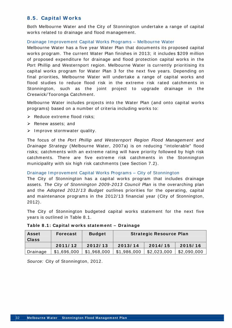
8.5. Capital Works Both Melbourne Water and the City of Stonnington undertake a range of capital works related to drainage and flood management.
Drainage Improvement Capital Works Programs – Melbourne Water Melbourne Water has a five year Water Plan that documents its proposed capital works program. The current Water Plan finishes in 2013; it includes $209 million of proposed expenditure for drainage and flood protection capital works in the Port Phillip and Westernport region. Melbourne Water is currently prioritising its capital works program for Water Plan 3 for the next five years. Depending on final priorities, Melbourne Water will undertake a range of capital works and flood studies to reduce flood risk in the extreme risk rated catchments in Stonnington, such as the joint project to upgrade drainage in the Creswick/Tooronga Catchment.
Melbourne Water includes projects into the Water Plan (and onto capital works programs) based on a number of criteria including works to:
Reduce extreme flood risks; Renew assets; and Improve stormwater quality.
The focus of the Port Phillip and Westernport Region Flood Management and Drainage Strategy (Melbourne Water, 2007a) is on reducing “intolerable” flood risks; catchments with an extreme rating will have priority followed by high risk catchments. There are five extreme risk catchments in the Stonnington municipality with six high risk catchments (see Section 7.2).
Drainage Improvement Capital Works Programs – City of Stonnington The City of Stonnington has a capital works program that includes drainage assets. The City of Stonnington 2009-2013 Council Plan is the overarching plan and the Adopted 2012/13 Budget outlines priorities for the operating, capital and maintenance programs in the 2012/13 financial year (City of Stonnington, 2012).
The City of Stonnington budgeted capital works statement for the next five years is outlined in Table 8.1.
Table 8.1: Capital works statement – Drainage
Asset Class
Forecast
Budget
Strategic Resource Plan
2011/12 2012/13 2013/14 2014/15 2015/16 Drainage $1,696,000 $1,968,000 $1,986,000 $2,023,000 $2,090,000
Source: City of Stonnington, 2012.

Stonnington Flood Management Plan Melbourne Water 33
In its 2012/13 budget statement, City of Stonnington has identified that it will continue with a series of strategic activities relating to drainage and flood management including (City of Stonnington, 2012):
Continuing to undertake footpath and drainage improvements to the Glenferrie Road Shopping Centre, Malvern;
Undertaking the drainage pit modernisation program to improve system performance;
Continuing to undertake improvements to the drainage system to extend drain life, improve stormwater flow and flood impacts in selected sites;
Continuing to revise the Special Building Overlay flood mapping to identify drainage improvement options.
Continuing to undertake stormwater CCTV surveys to monitor the condition of Council’s drain network to determine future drain relining and maintenance programs; and
Undertaking a stormwater drain pollution trap and pit maintenance and cleaning program to reduce rubbish entering waterways.
In 2012/13, City of Stonnington has budgeted to spend approximately $1.97 million on Council’s drainage assets including (City of Stonnington, 2012):
Edgar Street/Osbourne Avenue drainage works ($0.95 million); Millewa Avenue drainage works ($0.4 million); Nott Street drainage improvements ($0.3 million); and A drainage relining program ($0.15 million).
The City of Stonnington and Melbourne Water are seeking to find efficiencies in capital works, for example, joint upgrade projects, such as the Edgar Street drain.
The continuing large-scale development and extension of the Chadstone Shopping Centre will impact on flooding and waterway quality. There may be potential to incorporate drainage improvements under the proposed extension. The City of Stonnington has approached the Chadstone Shopping Centre regarding a potential financial contribution to fund works around Gardiners Creek.
Over time, Melbourne Water and City of Stonnington could seek to establish a partnership with the Chadstone Shopping Centre to achieve better drainage and waterway outcomes. This would also contribute to the further identification of opportunities to enhance Gardiners Creek and its tributaries in terms of flood mitigation and erosion control. Melbourne Water has an existing project to widen a section of Gardiners Creek to increase flood protection for local residents.
In the future, there is potential for an integrated flood study of the Union Street Main Drain catchment, Prahran. This is a low-lying area and there are limited flood risk mitigation options to City of Stonnington. This study will require involvement from Melbourne Water, the Cities of Stonnington and Melbourne (as

34 Melbourne Water Stonnington Flood Management Plan
the area crosses the municipal boundary), and potentially from other organisations, such as VicRoads (see Improvement Plan Action St-9).
Photo 5: New drainage pits, South Yarra
8.6. Flood Emergency Planning Planning is crucial to ensuring an effective proactive emergency response to flooding. Planning must be conducted within the legislated framework as well as having a process that is established and well understood by all stakeholders. Further, planning must be based on a sound understanding of flood risk. In addition, communication and consultation are essential in achieving ownership of flood emergency plans by all stakeholders, especially the community. Ownership of flood emergency plans ensures that stakeholders are more likely to respond to floods in accordance with strategies and arrangements detailed in the plan.
Municipal Emergency Management Plan (MEMP) and Flood Emergency Plan
Flood response and recovery arrangements are as detailed in the City of Stonnington Municipal Emergency Management Plan 2011 (MEMP) and MEMP Flood Emergency Plan.
The City of Stonnington MEMP outlines that key control measures are already in place to assist with flash flooding caused by a heavy downpour and rapid inundation of low-lying areas. These include the Flood Management Plan, warnings on Council’s website, mapping and maintenance of stormwater drains, enforcement of Building Codes, Recovery Sub Committee processes and MEMP Communications. In addition, the VICSES, Victoria Police and Melbourne Fire Brigade are equipped to respond (City of Stonnington, 2011b).
VICSES has implemented a Regional Flood Response Plan which, together with the State Flood Response Plan, will facilitate a consistent and coordinated approach to flood response within the Municipality in the lead up to, during and after a flood event.

Stonnington Flood Management Plan Melbourne Water 35
In developing this Flood Management Plan, Melbourne Water and the City of Stonnington have collated a range of information relating to flooding from waterways and overland flows within the Municipality. The intelligence in this information will be used as a basis for the development of a Flood Emergency Plan with VICSES, as a sub-plan of the Municipal Emergency Management Plan (MEMP) (see Improvement Plan Action St-12).
Linkage with MEMP Flood Emergency Plan
All information and intelligence developed and collated as part of this Flood Management Plan and as a result of the studies and work that flow from its implementation should, as a matter of course, be made available to the MERO for consideration and incorporation into the Flood Emergency Plan.
Similarly, during and immediately after a flood it is important that key aspects of the event are recorded so that the MEMP Flood Emergency Plan and its associated actions can be improved, and future flood damage better contained. Arrangements for data collection and collation are detailed in the MEMP Flood Emergency Plan. The information collected and intelligence extracted therefore needs to be used to inform this Flood Management Plan.
Figure 12 identifies a number of key services and vulnerable areas within the Stonnington municipality that could be affected by flooding including: emergency services; hospitals; schools; and childcare facilities.
Individual Flood Preparedness Plans There is no information on whether any individual flood preparedness plans have been developed or are planned for development by businesses or organisations within the Stonnington municipality. If prepared, these plans could be listed within the Flood Emergency Plan, for example, for areas of high risk from flash flooding and overland flows.
8.7. Community Education and Awareness City of Stonnington, Melbourne Water and VICSES are committed to working together before, in the lead up to and during periods of flooding, to create awareness within the community of preparedness measures that have been and should be taken.
VICSES is implementing a number of flood management education programs, including StormSafe and FloodSafe, across Victoria. City of Stonnington recognises the need to work to ensure that residents, business owners and operators, and visitors are aware of the flood risk and of appropriate flood response actions. VICSES and City of Stonnington will be able to work together to develop and implement an appropriate community education program (see Improvement Plan Action St-14).


Stonnington Flood Management Plan Melbourne Water 37
Flood zones and overlays in the Stonnington Planning Scheme also raise community awareness of flooding issues. The notification of the amendment, along with the inclusion of flood maps as overlay controls, makes flooding information readily accessible to the community and ensures that site constraints and likely development requirements are flagged to developers and property owners. Planning information, including flooding overlays, is disclosed to prospective purchasers through planning certificates issued under Section 199 of the Planning and Environment Act (1987) and included as a compulsory part of the vendor’s statement issued under Section 32 of the Sale of Land Act (1962).
8.8. Flood Warning Systems Flood warning systems and services aim to reduce the losses and hardship caused by flooding and are important flood mitigation measures. Flood warning systems and services are an integral part of emergency management and influence community response during flood events, by reducing avoidable damage, the potential for loss of life, and disruption to normal community activities caused by flooding (Bureau of Meteorology, 2001).
Emergency warnings are intended to achieve two important outcomes; firstly to inform those at risk of an impending or current threat, and secondly that appropriate actions are taken by those at risk. As no one method of providing a warning will reach all the intended recipients, a variety of warning methods are generally used including: radio; television; email; telephone – voice message and short message service (SMS) or text alerts; doorknocking; internet including social media (such as Twitter and Facebook); and verbal (face to face, community meetings, etc) (Emergency Management Australia, 2009).
Within the City of Stonnington, Melbourne Water has a flood warning system in place at Gardiners Creek at Great Valley Road, Gardiner. However, flood warnings are not issued for the catchment due to the short response times. Melbourne Water does inform the VICSES about potential local flooding issues. The highest recorded flood level for the Gardiners Creek monitoring site is 5.6 metres on 4 February 2011.
Occupants of an apartment building in Malvern have expressed concerns to the City of Stonnington about localised flooding and damage to vehicles and property in a basement car park resulting from flash flooding caused by major storms. The City of Stonnington is not responsible for providing storm warnings to property owners, local residents and businesses but it could provide general information on flood/storm warning systems, such as on the Council website.
Aspects to be considered with the design and implementation of any flood or storm warning system by property owners, local residents and businesses include:
How to effectively gather and receive data on potential storm events or flash flooding for a localised area (such as Bureau of Meteorology storm warnings or Melbourne Water flood warnings);

38 Melbourne Water Stonnington Flood Management Plan
How much time is required for action to be taken by residents and businesses once a warning is received, for example, to enable safe removal of vehicles from basement car parks;
What are the most appropriate communication methods (further discussed below);
The content and language of the warning message (i.e. would it instruct occupants to take action or prompt them to seek further information?);
Documentation of the decision-making process and delegation of power for issuing a warning or alert; and
The legal implications of providing a warning to residents and businesses including the risks of legal action if there were inaccurate warnings.
As outlined above, a range of communication methods are available but for timely and accurate warnings, telephone, SMS or email alerts are considered the most effective. An alert system could broadcast pre-recorded voice or text messages to specific telephones and mobile phones simultaneously, providing residents and businesses with flood/storm warning information. A further option could involve placing warning sirens in at-risk buildings.
Several issues with implementation of telephone- or message-based warning systems are:
How to develop and maintain an accurate register of telephones and mobile phones for each resident and business in at risk buildings with basement car parks (noting this may be difficult in buildings with high turnover of residents or businesses);
How to address language and accessibility issues in terms of providing a clear but succinct warning message; and
If required, how to confirm receipt and acknowledgment of the warning message.
Vision Australia on Glenferrie Road has a flood warning system for its building and basement car park. The building manager is alerted if flood levels are reached and the emergency response plan can be activated. This approach could be further investigated for at-risk apartment buildings within Stonnington by the property owners.
An alert system that directs residents to a ‘floodwatch’ website and/or emergency preparedness website would support residents and businesses in making well-informed decisions about their actions and safety, including when to inform neighbours about received alerts. Education programs could also inform residents and businesses about the variety of Federal, State and local emergency warning systems and encourage residents to register and/or update telephone contact details for emergency warning registers, such as the federal Emergency Alert6 or The Australia Early Warning Network7
6 Source: http://www.emergencyalert.gov.au/
.
7 Source: http://www1.ewn.com.au/register/register.aspx

Stonnington Flood Management Plan Melbourne Water 39
Following development of this Flood Management Plan, there is an opportunity for the City of Stonnington to further investigate options for providing general information on storm warning systems where this is considered appropriate (see Improvement Plan Action St-15).
8.9. Drainage studies and guidelines Melbourne Water, City of Stonnington and other organisations have undertaken a range of waterway and drainage studies, and developed plans and guidelines to address flooding and stormwater management.
Guidelines for Development in Flood-prone Areas Melbourne Water has developed guidelines to assist property owners, developers, designers and builders to understand the broad principles and specific requirements that apply to property development in flood-prone areas within the Melbourne metropolitan area. The guidelines address requirements in both floodplain and overland flow path areas and supplement the Land Development Manual (Melbourne Water, 20108
Drainage Studies
).
Various drainage studies have been completed within the City of Stonnington focussing on areas at high risk of flooding and to support drainage upgrades.
Water Sensitive Urban Design Guidelines The City of Stonnington together with Melbourne Water have developed Water Sensitive Urban Design (WSUD) guidelines (City of Stonnington and Melbourne Water, 2010). The WSUD Guidelines inform Council staff, developers and residents on how to apply WSUD principles to urban developments or local water reuse projects. These guidelines provide information, strategic advice and practical tips on implementing WSUD in a structured way. A key outcome of implementing WSUD is to reduce the impact of increased stormwater runoff on the drainage system.
Increased development and runoff due to an increase in impervious areas, especially in the east of the city, will bring further opportunities for potential application of WSUD and integrated water management solutions. There is potential to investigate the effectiveness of rainwater tanks as opposed to detention tanks for the management of runoff.
Sustainable Water Management The City of Stonnington has also demonstrated leadership in sustainable water management through the adoption and implementation of its Stormwater Management Plan (2002) and Sustainable Water Management Strategy (2005).
8 Melbourne Water (2010), Land Development Manual (note that this is an online document subject to ongoing updates).

40 Melbourne Water Stonnington Flood Management Plan
9. Roles and Responsibilities The Port Phillip and Westernport region faces significant flood management and drainage challenges that require a coordinated approach between agencies. The aim to reduce existing and future flood risk and manage residual flood risk includes a variety of structural and non-structural measures. Examples are retarding basins, levees, floodplains, capacity works, floodgates, flood warning systems and education programs. It is not possible for one agency or stakeholder to deliver on all these measures; therefore, an integrated approach is required.
A clear understanding and common agreement on roles and responsibilities is necessary for effective collaboration between Melbourne Water, local councils and VICSES. A summary of key stakeholder roles and responsibilities is provided in Appendix B. A description of these roles for Melbourne Water and City of Stonnington is provided below.
In the context of the Port Phillip and Westernport Region Flood Management and Drainage Strategy and this Flood Management Plan, the above leads to the following expectations within each agency’s area of management.
Agreed Responsibilities That Melbourne Water will:
Provide Councils with technical and financial assistance in the preparation and maintenance of a Flood Management Plan (this document) that identifies existing flood risks, intolerable risks, and prioritises works and activities aimed at reducing risks and improving regional flood management;
Assist with funding and management of prioritised works and activities identified in the Flood Management Plan and in their implementation (as required) at a regional level;
Provide financial and technical support to Councils and VICSES to deliver community flood education, awareness and preparedness across the region;
Continue to support the City of Stonnington in land use management and other activities aimed at reducing existing and future flood risk; and
Provide the City of Stonnington with the results of studies and analysis as well as data gathered during and after flood events for inclusion in the Flood Emergency Plan.
That City of Stonnington will:
Work with Melbourne Water to prepare and maintain a Flood Management Plan (this document) that identifies existing flood risks, identifies intolerable risks and prioritises works and activities aimed at reducing that risk and improving regional flood management;
Assist in facilitating the delivery of prioritised works and activities identified in the Flood Management Plan and in their implementation (as required) within the municipality with due regard for inter-municipality issues;

Stonnington Flood Management Plan Melbourne Water 41
Incorporate flood mapping outputs into the Planning Scheme as appropriate zones and overlays and ensure that the flood provisions are sufficient and consistent with assessed risk and the aim of reducing existing and future flood risk and damages;
Support VICSES in the delivery of programs aimed at enhancing community flood education, awareness and preparedness across the municipality; and
Maintain the Flood Emergency Plan as a joint owned plan with VICSES, through routine review and incorporation of intelligence extracted from relevant studies and analyses and through operational experience.
Improved Collaboration
Melbourne Water, Councils and other flood management stakeholders have recognised the need for an integrated and sustainable approach where responsibility for activities is assigned on the capability of the agency to deliver. While key agencies can demonstrate the provision of specialised flood management skills in the planning for, response to and recovery from flooding, there are opportunities to strengthen regional flood management arrangements through greater collaboration and more efficient use of resources. The collaborative development of this Flood Management Plan and the Flood Emergency Plan for Stonnington provides a basis for improved coordination and collaboration involving both technical and financial contributions. There has been significant collaboration already between Melbourne Water and City of Stonnington concerning flooding and drainage issues.
10. Communication Flood management agencies have a responsibility to communicate with each other in order to share information, ensure effective planning and coordination, and identify opportunities for collaboration. This is achieved through the communication objectives below:
Raising the profile of Flood Management Plans; Improving understanding of Melbourne Water’s and City of Stonnington’s role
and challenges in flood management; Promoting achievements of the collaboration between City of Stonnington
and Melbourne Water; Aligning flood mitigation objectives/priorities; and Aligning of external affairs; the City of Stonnington and Melbourne Water
have joint responsibility for flood and drainage management in communications with residents, councillors, politicians and media. Also ‘cc’ each other into relevant correspondence issued by either organisation.
Agencies also are required to share information with the public to ensure they have access to information about flooding and flood risk. This is achieved through:

42 Melbourne Water Stonnington Flood Management Plan
Responding to requests for Property Information Statements which contain information on land liable to flooding and City of Stonnington drains external to the property (City of Stonnington);
Providing an on-line 24-hour a day rainfall and river level monitoring network (Melbourne Water); and
Providing community flood education information (VICSES and Melbourne Water).
Melbourne Water provides a range of information to City of Stonnington through the sharing of the following datasets (in respect of the assets that it manages):
Underground Drain Locations (Abandoned Centreline, Centreline and Alignment);
Channel Locations (Alignment, Centreline) and Structures; Natural Waterways (Alignment, Centreline); Retarding Basins; Underground Drain Manholes; Natural Drain Features; Melbourne Water Catchments; and 1 in 100yr Flood Extent – Underground Drain and Natural Waterways.
Continued information sharing, especially of strategic priorities, flood mapping programs and five year plans, will support effective flood management across agencies (see Improvement Plan Action St-7).
11. Improvement Plan This Section of the Stonnington Flood Management Plan lists activities planned by the City of Stonnington in conjunction with Melbourne Water (and other organisations) in order to reduce flood risk and the associated level of intolerability. It reflects an understanding of the flood risks and proposes a program for mitigating those risks within Stonnington that are assessed as being appropriate with regard to local and regional issues and priorities.
The actions below outline the agreed approach to managing existing regional flood problems within Stonnington. The actions were identified through a gap analysis performed on flood mitigation and management measures to identify areas requiring improvement. The relative priority of each action was determined by assessing:
The feasibility of an action being implemented as Low (L), Medium (M) or High (H); and
The benefit of that action being implemented as Low (L), Medium (M) or High (H).
The result of these assessments determined an overall priority grading of high priority, medium-high priority, and medium priority actions. The lead organisation responsible for each action is identified in bold.

Stonnington Flood Management Plan Melbourne Water 43
Action Plan: Proposed Activities Aimed at Reducing Flood Risks in the Stonnington Municipality
Action Context (why is it an
issue)
Feasib-ility
Benefit Priority Tasks Timing Respons-ibility
Comments
A. Flood Mapping and Mitigation
St-1 Update the City of Stonnington SBO to incorporate revised flood extents
Accurate planning overlays will assist with identification of flood risk and promote more appropriate development in areas of known flood risk.
Medium High High CoS to update the SBO with revised flood extents.
Dec 2016 (report to Council)
CoS/MW Council and Melbourne Water have completed flood mapping for both Council and Melbourne Water drains. In 2004 these maps were included in the Stonnington Planning Scheme as a SBO. Subsequent Council mapping revisions indicate there are approximately 377 more properties which need to be included.

44 Melbourne Water Stonnington Flood Management Plan
Action Context (why is it an
issue)
Feasib-ility
Benefit Priority Tasks Timing Respons-ibility
Comments
St-2 Review flood levels
Accurate flood levels are required to inform planning and development controls.
High High High a. CoS to provide MW with potential locations to improve the accuracy of flood levels.
b. MW to review sample of flood levels and determine if there is a problem and an appropriate response.
June 2013
June 2013
CoS/MW Accurate flood levels are required to inform planning and development controls. There is a concern that in some areas the mapping is inaccurate. Such areas need to be referred to the flood mapping consultants for possible revision.
For properties within the SBO, Council requires a developer to submit a plan by a qualified surveyor with levels to A.H.D. to check any inaccuracies in the flood mapping.
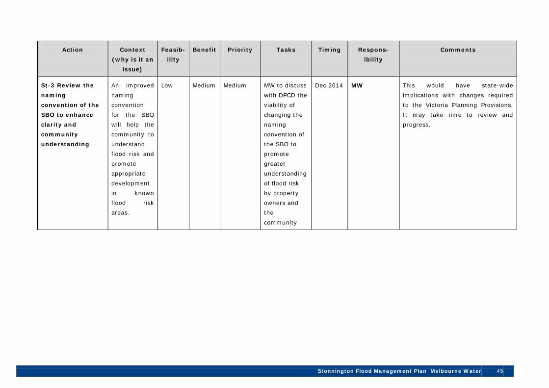
Stonnington Flood Management Plan Melbourne Water 45
Action Context (why is it an
issue)
Feasib-ility
Benefit Priority Tasks Timing Respons-ibility
Comments
St-3 Review the naming convention of the SBO to enhance clarity and community understanding
An improved naming convention for the SBO will help the community to understand flood risk and promote appropriate development in known flood risk areas.
Low Medium Medium MW to discuss with DPCD the viability of changing the naming convention of the SBO to promote greater understanding of flood risk by property owners and the community.
Dec 2014 MW This would have state-wide implications with changes required to the Victoria Planning Provisions. It may take time to review and progress.

46 Melbourne Water Stonnington Flood Management Plan
Action Context (why is it an
issue)
Feasib-ility
Benefit Priority Tasks Timing Respons-ibility
Comments
B. Planning, Information and Coordination
St-4 Continue to improve protection of overland flow paths
Protection of overland flow paths will help to minimise flood risk and promote more appropriate development in known flood risk areas.
Medium High Medium – High
a. Continue to protect overland flow paths by implementing appropriate planning conditions on new developments.
b. Consider purchasing properties to maintain overland flow paths where there is significant value to Council.
Ongoing CoS In some catchments overland flow paths have been protected by their development as public gardens, recreation areas (sports fields, natural bush) or roads. However, the overland flow paths often become partly obstructed where building allotments and roads have been set out across natural valleys. It is also becoming increasingly difficult to maintain or reduce the existing degree of obstruction as allotments become more intensely developed.

Stonnington Flood Management Plan Melbourne Water 47
Action Context (why is it an
issue)
Feasib-ility
Benefit Priority Tasks Timing Respons-ibility
Comments
St-5 Review approach to safety risks at known flood hot spots
Identification of safety risks in known flood risk areas will increase community understanding of risks and improve safety.
Medium Medium Medium a. CoS to consider warning signs at known flood hot spots (e.g. installing warning and depth signs).
Dec 2013 (ongoing)
CoS
Presently there are no warning signs at locations on roads where flooding occurs.

48 Melbourne Water Stonnington Flood Management Plan
Action Context (why is it an
issue)
Feasib-ility
Benefit Priority Tasks Timing Respons-ibility
Comments
St-6 Continue to assess drainage and flooding issues as a part of planning permit applications
Assessment of flood risk at the planning permit application stage will promote more appropriate development in known flood risk areas.
High High High a. Continue to assess drainage and flooding issues as a part of planning permit applications.
b. Consider establishing an internal procedure to formalise this assessment process.
Ongoing CoS This process has been developed to a high standard since the adoption of the LSIO and SBO. Continual effort and co-operation is needed between respective organisations and departments involved in the planning and building process.

Stonnington Flood Management Plan Melbourne Water 49
Action Context (why is it an
issue)
Feasib-ility
Benefit Priority Tasks Timing Respons-ibility
Comments
St-7 Exchange of flood mapping and other information
Exchange of flood mapping and other information will support effective flood management across organisations.
High Medium Medium – High
a. CoS to also provide MW with latest flood extents/ shapes to support consistent planning advice.
b. CoS and MW to improve information sharing and exchange respective 5 year plans.
Ongoing CoS/MW A range of Council divisions and areas have an interest in drainage and flood management.

50 Melbourne Water Stonnington Flood Management Plan
Action Context (why is it an
issue)
Feasib-ility
Benefit Priority Tasks Timing Respons-ibility
Comments
St-8 Hold an annual FMP review meeting
An annual meeting will help ensure progress is being made with key actions and that the FMP is current.
High Medium Medium – High
a. Organise and hold annual review meetings.
b. Consider any joint proposals for projects to mitigate flood risk.
Dec 2013 (ongoing)
MW/CoS/ VICSES
Melbourne Water and Council will be able to continue to share information on flood mapping priorities, investigations and upgrade works. This is already occurring but an annual review meeting will support more rapid and increased transfer of information.
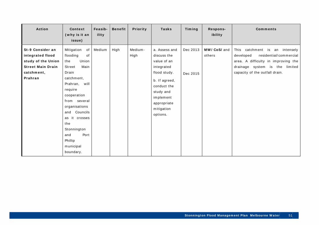
Stonnington Flood Management Plan Melbourne Water 51
Action Context
(why is it an
issue)
Feasib-
ility
Benefit Priority Tasks Timing Respons-
ibility
Comments
St-9 Consider an
integrated flood
study of the Union
Street Main Drain
catchment,
Prahran
Mitigation of flooding of the Union Street Main Drain catchment, Prahran, will require cooperation from several organisations and Councils as it crosses the Stonnington and Port Phillip municipal boundary.
Medium High Medium-High
a. Assess and discuss the value of an integrated flood study.
b. If agreed, conduct the study and implement appropriate mitigation options.
Dec 2013
Dec 2015
MW/CoS/and others
This catchment is an intensely developed residential/commercial area. A difficulty in improving the drainage system is the limited capacity of the outfall drain.

52 Melbourne Water Stonnington Flood Management Plan
Action Context (why is it an
issue)
Feasib-ility
Benefit Priority Tasks Timing Respons-ibility
Comments
C. Maintenance and Asset Management
St-10 Review drainage asset maintenance by City of Stonnington
Effective drainage maintenance will support flood risk management and help maintain drainage asset condition.
Medium High Medium – High
Undertake the scheduled review of the CoS maintenance and operations plan for drainage assets.
Dec 2013 (ongoing)
CoS
Council is currently preparing a Drainage Asset Management Plan.

Stonnington Flood Management Plan Melbourne Water 53
Action Context (why is it an
issue)
Feasib-ility
Benefit Priority Tasks Timing Respons-ibility
Comments
St-11 Share information on drainage maintenance regimes and priorities
Information sharing on maintenance regimes will allow for more efficient and greater coverage of drainage maintenance, an increased understanding of CoS and MW drainage maintenance and priorities.
Medium Medium Medium CoS and MW to share information on drainage maintenance regimes.
Ongoing MW/CoS

54 Melbourne Water Stonnington Flood Management Plan
Action Context (why is it an
issue)
Feasib-ility
Benefit Priority Tasks Timing Respons-ibility
Comments
D. Flood Education and Emergency Planning
St-12 Prepare a Flood Emergency Plan
To facilitate a consistent and coordinated flood response by CoS and VicSES.
High High High a. Prepare a City of Stonnington Flood Emergency Plan.
b. Implement actions in the City of Stonnington Flood Emergency Plan (if contains actions).
June 2013 / Ongoing
VICSES/CoS (and others)
To follow after preparation of this Flood Management Plan.

Stonnington Flood Management Plan Melbourne Water 55
Action Context (why is it an
issue)
Feasib-ility
Benefit Priority Tasks Timing Respons-ibility
Comments
St-13 Consider providing information to developers and architects on mitigation of drainage and flooding risk and appropriate design
Drainage and flooding issues are not always considered at the design stage of a development.
Medium – Low
Medium Medium a. Investigate the development of an information sheet (or similar) to increase awareness and mitigate drainage and flood risk at the design stage.
b. If prepared, provide the information sheet to developers and architects and consider a targeted education program.
Dec 2014 (ongoing)
CoS (plus others MW, DPCD, MAV, etc)
This action may be able to be considered jointly with neighbouring councils and/or industry associations.
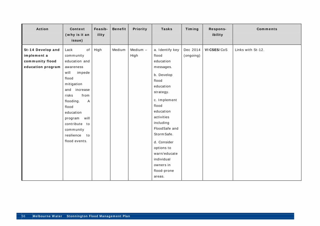
56 Melbourne Water Stonnington Flood Management Plan
Action Context (why is it an
issue)
Feasib-ility
Benefit Priority Tasks Timing Respons-ibility
Comments
St-14 Develop and implement a community flood education program
Lack of community education and awareness will impede flood mitigation and increase risks from flooding. A flood education program will contribute to community resilience to flood events.
High Medium Medium – High
a. Identify key flood education messages.
b. Develop flood education strategy.
c. Implement flood education activities including FloodSafe and StormSafe.
d. Consider options to warn/educate individual owners in flood-prone areas.
Dec 2014 (ongoing)
VICSES/CoS Links with St-12.

Stonnington Flood Management Plan Melbourne Water 57
Action Context (why is it an
issue)
Feasib-ility
Benefit Priority Tasks Timing Respons-ibility
Comments
St-15 Further investigate provision of general information on flood warning systems
Effective flood warning systems may assist property owners to mitigate or limit damage from localised flooding.
Low High Medium – High
a. Further investigate options for providing general information on storm warning systems so that occupants and property owners of buildings prone to localised flooding can take appropriate action.
Dec 2014 CoS This is a particular issue where buildings have been constructed prior to the adoption of the LSIO and SBO. Warning times are very short for properties in the SBO (less than 30 minutes) but it may be possible to provide a warning system for “Body Corporate” sites with basement parking. This action also links with St-14.
Key:
MW= Melbourne Water
CoS= City of Stonnington
VICSES= Victorian State Emergency Service
DPCD= Department of Planning and Community Development

58 Melbourne Water Stonnington Flood Management Plan
MAV= Municipal Association of Victoria.
Note: In each of the four categories of improvement actions (i.e. Flood mapping and mitigation; Planning, information and coordination; Maintenance and asset management; and Flood education and emergency planning), the improvement actions are listed in relative order of priority. These actions were identified and discussed over two workshops held in May and June 2012 at City of Stonnington and were subsequently prioritised in terms of feasibility and benefit.

Stonnington Flood Management Plan Melbourne Water 59
12. Monitoring and Review This Flood Management Plan is a “living document”. As such it will need to be reviewed each year at an annual meeting to ensure that it continues to accurately reflect flood risks and their treatment within the City of Stonnington as well as prevailing statutory and policy requirements (see Improvement Plan Action St-8). It should also be revised at least every five (5) years to reflect achievement of work program objectives and changes to work program priorities. While Melbourne Water will assist with the revision process, it will need to be driven and managed by the City of Stonnington.
Unless scheduled otherwise, it is suggested that the review and revision processes should occur immediately before the annual budget cycle so that maximum opportunity can be made of available funding sources and processes in partnership with stakeholder entities.
Melbourne Water will be responsible for initiating review and updates with the City of Stonnington. Melbourne Water and the City of Stonnington will track and report to each other on actions in the Improvement Plan on a twelve monthly basis.
Document control This version:
Version Number Rev 3 Date April 2013 Frequency of Review Five yearly or earlier as required Next Review Due By end December 2017 Responsible Melbourne Water officer
Project Manager Flood Strategy Implementation, Floodplain Services, Melbourne Water
Responsible Council officer Team Leader, Infrastructure Design and Project Management, City of Stonnington
Melbourne Water Approved by Manager Floodplain Services, Melbourne Water
Council Approved by Manager Public Spaces and Capital Works, City of Stonnington
Document history:
Version Date Comments/changes Issue 1, Rev 0 18 June 2012 Draft Plan Issue 1, Rev 1 3 October 2012 Final Draft Plan Issue 1, Rev 2 17 December 2012 Final Plan Issue 1, Rev 3 8 April 2013 Final Plan (Revised)

60 Melbourne Water Stonnington Flood Management Plan
13. How this document was developed Melbourne Water, City of Stonnington and the Victoria State Emergency Service worked in partnership with a consultancy, Halcrow Pacific Pty Ltd (Halcrow), to develop this Flood Management Plan.
The plan was developed through a series of interviews, file reviews, meetings, site visits and workshops to gather the background information, identify flood risk management and mitigation activities and arrangements, undertake a gap analysis and develop an improvement plan. A list of workshop attendees is presented in Appendix D.
This document was prepared by Halcrow with significant input from Melbourne Water, City of Stonnington, VICSES and VicRoads.
14. Acknowledgements Melbourne Water acknowledges the contribution of employees of City of Stonnington, VICSES, VicRoads, and the Halcrow project team, in preparing this document.

Stonnington Flood Management Plan Melbourne Water 61
Abbreviations and Acronyms The following abbreviations and acronyms are used in this Flood Management Plan.
AEP Annual Exceedance Probability
ARI Average Recurrence Interval
CBD Central Business District
CCTV Closed Circuit Television
GIS Geographic Information System
LSIO Land Subject to Inundation Overlay
MEMP Municipal Emergency Management Plan
MERO Municipal Emergency Resource officer
SBO Special Building Overlay
VICSES Victoria State Emergency Service
WSUD Water Sensitive Urban design

62 Melbourne Water Stonnington Flood Management Plan
Glossary Below are terms defined for the purpose of this Plan. Term Definition
Drainage system
A series of drains and waterways into which surface and stormwater flows. Features of a drainage system can include underground pipe drains, open channels, retarding basins, floodways, waterway improvements, water quality works and environment protection measures.
Overland flooding
Inundation by local runoff caused by heavier than usual rainfall. Overland flooding can be caused by local runoff exceeding the capacity of an urban stormwater drainage system or by the backwater effects of mainstream flooding causing urban stormwater drainage system to overflow.
Floodplain
Area of land adjacent to a creek, river, estuary, lake, dam or artificial channel, which is subject to inundation by the probable maximum flood.
Natural drainage systems
Flowpaths which are largely undeveloped by human sources, these include rivers, streams, natural depressions and wetlands. All natural systems greater than 60 ha are managed by Melbourne Water.
Hot spot A known flood problem area which has a history of repeat flooding of a road, crossing or property, often highlighted through anecdotal information and customer complaints. It is a localised issue which will vary from council to council.
Runoff The amount of rainfall that enters the stormwater drainage system, (underground pipes, overland flow paths, floodway and waterways) after losses, such as infiltration has been taken into account.
Flash flooding Sudden unexpected flooding caused by local heavy rainfall or rainfall in another area. Often defined as flooding which occurs within six hours of the rain which causes flooding.
Stonnington Flood Management Plan Melbourne Water 63
References Bureau of Meteorology (2001): Arrangements for Flood Warning Services in Victoria.
City of Stonnington (2012): Adopted 2012/2013 Budget.
City of Stonnington (2011a): City of Stonnington Annual Report 2010/11.
City of Stonnington (2011b): Municipal Emergency Management Plan 2011.
City of Stonnington (2010): Economic Snapshot.
City of Stonnington and Melbourne Water (2010): City of Stonnington WSUD Guidelines, Applying the Model WSUD Guidelines.
Emergency Management Australia (2009): Manual 21 – Flood Warning, Attorney-General’s Department, Barton.
Forecast.id® (2012): City of Stonnington Population Forecasts, http://forecast2.id.com.au/Default.aspx?id=249&pg=5000, accessed 13/6/12.
Forecast.id® (2010): City of Stonnington City Council Population and Household Forecasts.
Melbourne Water (2012a): Flood Risk Matrix (Extract), May 2012.
Melbourne Water (2012b): List of Floods Exceeding Flood Class Levels for Gardiners Creek at Gardiner, Melbourne.
Melbourne Water (2012c): Information for Developers, http://www.melbournewater.com.au/content/planning_and_building/information_for_developers/information_for_developers.asp?bhcp=1, accessed 12/6/12.
Melbourne Water (2011a): Waterways Local Update: City of Stonnington, July 2011, Melbourne.
Melbourne Water (2011b): Melbourne Water Floodplain Modelling and Mapping Specifications, Melbourne.
Melbourne Water (2010): Flood Risk Assessment Framework, June 2010, Melbourne.
Melbourne Water (2007a): Port Phillip and Westernport Region Flood Management and Drainage Strategy, November 2007, Melbourne.
Melbourne Water (2007b): Port Phillip and Westernport River Health Strategy, Melbourne.
Victorian Auditor-General (2005): Managing stormwater flooding risks in Melbourne, Melbourne.

64 Melbourne Water Stonnington Flood Management Plan
Appendix A – Asset List This Appendix contains a list of waterways, drainage assets and other related infrastructure (e.g. drainage pipes, retarding basins and levees) within the City of Stonnington.
Melbourne Water Main Drains and Waterways
Melbourne Water has 18 Main Drains and Drains within the Stonnington municipality (see Table A1.1) with an approximate length of 22.6km.
There are three major waterways: the Yarra River, Gardiners Creek and Scotchmans Creek.
Table A1.1: Melbourne Water Main Drains/Drains
Murrumbeena Main Drain Chadstone Main Drain
East Malvern Main Drain Scotchmans Creek Main Drain
Darling Road Main Drain Hedgeley Dene Main Drain
Creswick Street Main Drain Tooronga Road Main Drain
Lara Street Main Drain Moonga Road Main Drain
Beatty Avenue Main Drain Prahran Main Drain
Canberra Road Main Drain Williams Road Main Drain
Surrey Road Main Drain Essex Street Main Drain
Union Street Main Drain Yarra Street Drain, Prahran
Table A1.2: Melbourne Water Ancillary Drainage Infrastructure
Hydrographic monitoring stations
Yarra River at Burnley
Gardiners Creek at Glenferrie Road (Hawthorn)
Gardiners Creek at Gardiner
City of Stonnington Drainage Assets
City of Stonnington drainage asset information was derived from the drainage asset valuation summary as at June 2010 and the City of Stonnington GIS:
The City of Stonnington has approximately 315km of drains including concrete pipes, rectangular section culverts, PVC pipes and ovoid brick lined drains.
The City of Stonnington has 13,654 drainage pits.

Stonnington Flood Management Plan Melbourne Water 65
Appendix B – Roles and Responsibilities Various agencies and organisations at different levels are directly involved in managing different aspects of flooding within Victoria, as set out in Table B1 (as at June 2012). Primary and secondary roles in flood management are outlined in Table B2.
Table B1: Flood Management Roles and Responsibilities
Level Organisation Core role National Bureau of Meteorology Flood forecast and warning
Warnings of weather conditions likely to cause flash flooding
Department of Regional Australia, Local Government, Arts and Sport
Financial assistance for planning, warning and mitigation initiatives
Australian Emergency Management
Emergency management planning and coordination
Department of Human Services (and Centrelink)
Financial and other support services for affected areas
State of Victoria Victoria Police Regional emergency planning and response
coordination Victoria State Emergency Service
Responsible for flood response as well as assisting council with their Municipal Emergency Management Planning, can assist council with education, awareness, warning systems and emergency management planning.
Department of Human Services
Impart expertise in emergency recovery management, and can assist with the development of Municipal Emergency Management Plans and public health sub plans.
Environment Protection Authority
Assess environmental impact of flood emergencies
Department of Sustainability and Environment
Has the primary responsibility for the development of strategies and policy in relation to flood and stormwater management at a state-wide level

66 Melbourne Water Stonnington Flood Management Plan
Department of Planning and Community Development
Land use and development policy
Department of Justice State-wide Emergency Management Policy Financial assistance and grants for those affected by flooding
Regional Melbourne Water Primary responsibility for identification of
flood extents, providing flood warning advice for major waterways, controlling development in floodplains, providing advice on flooding to local councils and the community, developing plans, and undertaking actions to minimise flooding and flood damage in the Port Phillip and Westernport region
VicRoads Drainage for major arterial roads Local Municipal Councils
(such as City of Stonnington)
Manage local urban (street and property) and upstream drainage Management of open spaces along waterway corridors Manage flooding issues to reduce risks and impacts Ensure flood information is available to inform decisions Establish and maintain a Planning Scheme that includes relevant flood provisions (i.e. administer and enforce planning provisions and building regulations for flood affected land) Implement and maintain local flood warning systems Maintain and enhance local flood information Support community education and awareness on flood risks Develop and implement flood emergency response plans

Stonnington Flood Management Plan Melbourne Water 67
Table B2: Primary and secondary responsibilities in delivery of flood management
Sta
te L
egis
latu
re
Sta
te T
reas
ury
Dep
artm
ent
of S
usta
inab
ility
and
En
viro
nmen
t
Reg
iona
l Flo
odpl
ain
Aut
hori
ty
Loca
l Cou
ncil
VIC
SES
Bur
eau
of M
eteo
rolo
gy
Dep
artm
ent
Just
ice
/ Vic
Pol
ice
Dep
artm
ent
Hum
an S
ervi
ces
Dep
artm
ent
of P
lann
ing
and
Com
mun
ity
Dev
elop
men
t
Bui
ldin
g C
omm
issi
on
Oth
er in
stitu
tion
s an
d th
e co
mm
unity
Address legal/institutional gaps
√ √ √
Analyse and map flood risks √ √ √ √ √
Publish flood risk details √ √ √ √ √
Provide flood intelligence data
√ √ √ √ √ √
Implement development controls
√ √ √ √ √
Education and awareness √ √ √ √ √ √
Contingency planning √ √ √ √ √ √ √ √
Flood warnings and alerts √ √ √ √ √ √ √ √
Emergency response √ √ √ √ √ √
Smart urban renewal √ √ √ √ √ √
Runoff reduction √ √ √ √ √ √
Rural levee reform √ √ √

68 Melbourne Water Stonnington Flood Management Plan
Appendix C – Flood Risk Assessment The relevant sections of the Melbourne Water Risk Assessment Matrix for the Stonnington municipality, by catchment, are outlined below identifying the catchments with medium, high or extreme (‘intolerable’) risk rating (as at May 2012) (also see Figure 6).
Any future projects to mitigate flood risk will need to be categorised, discussed and prioritised with due consideration of City of Stonnington and Melbourne Water priorities, aims, work programs and targets (see Improvement Plan Action St-8). This process will also need to recognise residual risks and propose management measures that are likely to include improved community awareness, flood response planning and preparedness.
Any proposed land use planning or controls to be implemented or investigated should be included in the program.
Catchment Name (and Number)
No of Commercial/
Industrial Properties
Flooded
No of Residential Properties
Flooded
No. properties
Total
Flood Risk Rating
(extreme, high,
medium, low)
Murrumbeena Entire Catchment9 97
(4850)
1649 1746 Extreme
Murrumbeena Catchment, Chadstone Main Drain (4851)
4 63 67 Extreme
Prahran Main Drain10 352
(4811) 891 1243 Extreme
Scotchmans Creek (4860) 82 907 989 Extreme
Tooronga Road11
70
(4823) 312 382 Extreme
Canberra Road Main Drain (4816)
0 27 27 High
9 The Murrumbeena catchment in Stonnington includes the Chadstone Main Drain subcatchment and Murrumbeena Drain
subcatchment (downstream of the railway line). 10 The Prahran Main Drain Catchment includes the Prahran Main Drain, Essex Street Main Drain, Williams Road Diversion
Drain and Beatty Avenue Main Drain subcatchments. 11 The Tooronga Road catchment in Stonnington includes the Tooronga Road Main Drain and the Creswick Street Main
Drain subcatchments.

Stonnington Flood Management Plan Melbourne Water 69
Catchment Name (and Number)
No of Commercial/
Industrial Properties
Flooded
No of Residential Properties
Flooded
No. properties
Total
Flood Risk Rating
(extreme, high,
medium, low)
Darling Road (4842)
2 6 8 High
Gardiners Creek (Glen Iris) (4840)
0 101 101 High
Gardiners Creek (Hawthorne) (4820)
23 112 135 High
Hedgeley Dene (4841) 0 64 64 High
Yarra Street Drain, Prahran (4801)
68 4 72 High
Lara Street Main Drain (4822)
0 18 18 Medium
Moonga Road Main Drain (4821)
0 7 7 Medium
Union Street Main Drain (4911)
Not rated
East Malvern Drain (4844)
Insufficient data
available to calculate
Flood Risk
Source: Melbourne Water flood risk matrix, June 2012.

70 Melbourne Water Stonnington Flood Management Plan
Appendix D – Workshop attendees This Appendix outlines the two workshops held as part of the preparation of this Flood Management Plan.
Workshop 1: Stonnington drainage and flood strategy, maintenance, flooding hot spots, and emergency management coordination
Date: 25 May 2012
Attendees:
Name Position Organisation
Jayantha Balasuriya Asset Management Development
VicRoads
Erin Davie Team Leader Flood Strategy
Melbourne Water
James Edmond Infrastructure Planning and Works Coordinator
City of Stonnington
Drew Flowers Investigations Engineer Melbourne Water
Phil Garner Design Engineer City of Stonnington
John Gowan Asset Planning Engineer, Team Leader
City of Stonnington
Phil Hughes Principal Consultant/ Project Manager
Halcrow Pacific
Ray Jaspar Regional Manager, Emergency Management
Victoria State Emergency Service
Ken MacMahon Senior Hydrographer Melbourne Water
Ewa Madon Environmental Consultant Halcrow Pacific
Katherine O’Connell Coordinator- Roads and Drains Maintenance
City of Stonnington
Andrew Robison Development Engineer (Infrastructure Design & Project Management)
City of Stonnington
Abhiram (Abhi) Sulur Asset Management Engineer
Melbourne Water
Ade Sutherland Engineer/Flood Modeller Halcrow Pacific
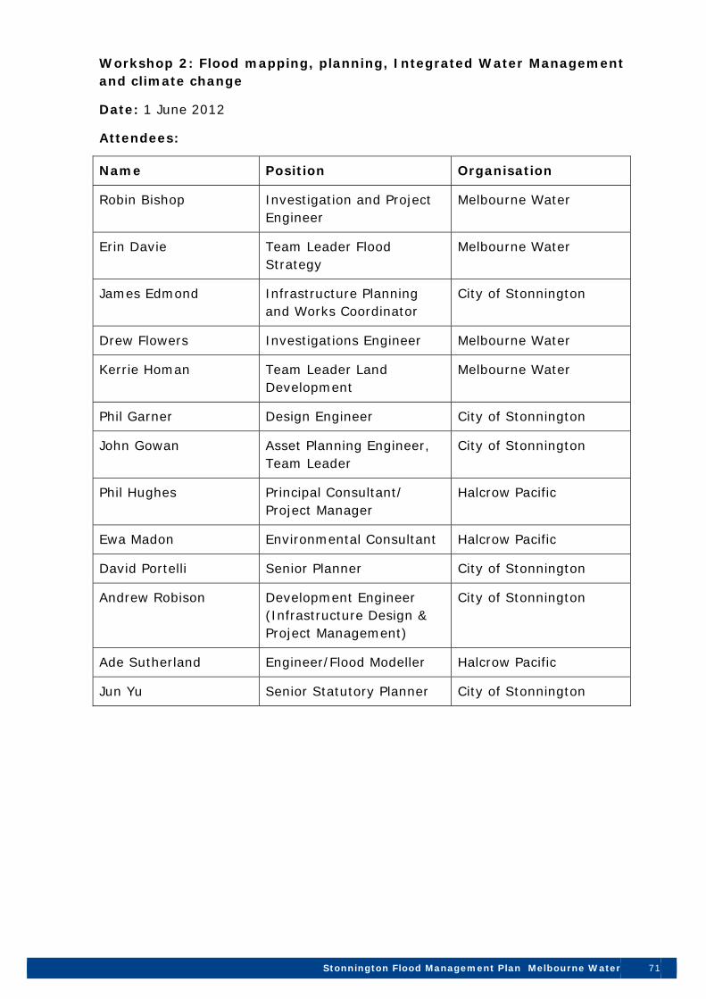
Stonnington Flood Management Plan Melbourne Water 71
Workshop 2: Flood mapping, planning, Integrated Water Management and climate change
Date: 1 June 2012
Attendees:
Name Position Organisation
Robin Bishop Investigation and Project Engineer
Melbourne Water
Erin Davie Team Leader Flood Strategy
Melbourne Water
James Edmond Infrastructure Planning and Works Coordinator
City of Stonnington
Drew Flowers Investigations Engineer Melbourne Water
Kerrie Homan Team Leader Land Development
Melbourne Water
Phil Garner Design Engineer City of Stonnington
John Gowan Asset Planning Engineer, Team Leader
City of Stonnington
Phil Hughes Principal Consultant/ Project Manager
Halcrow Pacific
Ewa Madon Environmental Consultant Halcrow Pacific
David Portelli Senior Planner City of Stonnington
Andrew Robison Development Engineer (Infrastructure Design & Project Management)
City of Stonnington
Ade Sutherland Engineer/Flood Modeller Halcrow Pacific
Jun Yu Senior Statutory Planner City of Stonnington

Stonnington Flood Management Plan Melbourne Water 73