Stirling regional centre structure plan review · ARCHAEOLOGICAL & HERITAGE MANAGEMENT SOLUTIONS...
74
ARCHAEOLOGICAL & HERITAGE MANAGEMENT SOLUTIONS Stirling City Centre Structure Plan Area, City of Stirling, Perth WA Site Identification Surveys • August 2013 0 Aboriginal Archaeological and Ethnographic Site Identification Survey, Stirling City Centre Structure Plan Area Stirling City Centre Alliance Report August 2013
Transcript of Stirling regional centre structure plan review · ARCHAEOLOGICAL & HERITAGE MANAGEMENT SOLUTIONS...

ARCHAEOLOGICAL & HERITAGE MANAGEMENT SOLUTIONS
Stirling City Centre Structure Plan Area, City of Stirling, Perth WA
Site Identification Surveys • August 2013 0
Aboriginal Archaeological and Ethnographic Site Identification Survey, Stirling City Centre Structure Plan Area
Stirling City Centre Alliance
Report
August 2013
ARCHAEOLOGICAL & HERITAGE MANAGEMENT SOLUTIONS
Stirling City Centre Structure Plan Area, City of Stirling, Perth WA
Site Identification Surveys • August 2013 0
Stirling City Centre Structure Plan, City of Stirling, Perth, WA
Site Identification Report
July 2013 Sponsor: Stirling City Centre Alliance
Cultural Heritage Advisor: Darren Cooper
Author: Darren Cooper
Prepared by Archaeological & Heritage Management Solutions (AHMS) Pty Ltd on behalf of Stirling City Centre Alliance
PLEASE NOTE THIS REPORT MAY CONTAIN PICTURES OF AND INFORMATION ABOUT PEOPLE WHO MAY HAVE PASSED AWAY

ARCHAEOLOGICAL & HERITAGE MANAGEMENT SOLUTIONS
Stirling City Centre Structure Plan Area, City of Stirling, Perth WA
Site Identification Surveys • August 2013 1
AUTHOR/HERITAGE ADVISOR Darren Cooper
PROPONENT Stirling City Centre Alliance
PROJECT NAME WAPC Stirling Alliance
DATE August 2013
AHMS INTERNAL REVIEW/SIGN OFF
WRITTEN BY DATE VERSION REVIEWED APPROVED
DC 05/08/13 1 SB SB
DC 14/08/13 2 Stirling Alliance/SB SB
DC 21/10/13 2 SWALSC SB
Copyright and Moral Rights Historical sources and reference materials used in the preparation of this report are acknowledged and referenced in figure captions or in text citations. Reasonable effort has been made to identify, contact, acknowledge and obtain permission to use material from the relevant copyright owners.
Unless otherwise specified in the contract terms for this project AHMS:
Vests copyright of all material produced by AHMS (but excluding pre-existing material and material in which copyright is held by a third party) in the client for this project (and the client’s successors in title);
Retains the use of all material produced by AHMS for this project for AHMS ongoing business and for professional presentations, academic papers or publications.

ARCHAEOLOGICAL & HERITAGE MANAGEMENT SOLUTIONS
Stirling City Centre Structure Plan Area, City of Stirling, Perth WA
Site Identification Surveys • August 2013 1
EXECUTIVE SUMMARY
In May 2013 Stirling City Centre Alliance engaged Archaeological and Heritage Management Solutions Pty Ltd (AHMS) to undertake an archaeological and ethnographic Aboriginal Site Identification survey of the Stirling City Centre Alliance Structure Plan Area, City of Stirling, Perth, Western Australia. This report details the results of those surveys.
The archaeological Site Identification survey was undertaken on 1 July 2013, and the ethnographic Site Identification surveys were undertaken on 31 May, 5 June and 1 July 2013. Their purpose was to identify any Aboriginal archaeological and ethnographic sites in the Stirling City Centre Structure Plan Area and record them to a level of detail that would allow the Aboriginal Cultural Material Committee (ACMC) to determine whether or not they constitute Aboriginal heritage sites, as defined by Sections 5 and 39 (2) of Aboriginal Heritage Act 1972 (WA).
The archaeological survey was carried out by Senior Heritage Consultant Darren Cooper (AHMS). The ethnographic surveys were conducted by anthropologists Dr Amanda Harris, Dr Carina Hemmers, Teri O’Neill and Dr Guy Wright (Big Island Research). Hannelie Evans, Jennifer Catto (Stirling City Centre Alliance) and Kerry O’Flaherty (Syrnix) assisted with the surveys. Representatives from the Combined Metropolitan Native Title Holders, the Bona Fide Bloodline Traditional Owners of the Swan Valley, the Ballaruks People, the Independent Aboriginal Environment Group, the Bibulmun Group and Whadjuk Traditional Owners, nominated by the South West Aboriginal Land and Sea Council, participated in the surveys.
The physical environment of the study has been significantly impacted upon through urban development with little of the original land surface evident. What does remain has been impacted upon by dumping of rubbish, and was covered in a blanket of thick grasses.
The archaeological survey found no Aboriginal cultural material within the survey area.
The ethnographic surveys found no new ethnographic sites within the survey area.
The recommendations resulting from these Site Identification Surveys are as follows:
1. The registered Aboriginal Site DAA Site ID 3585 (Herdsman Lake) and Other Heritage Place DAA Site ID 4405 (Jackadder Lake) should be retained in situ, in accordance with the principles and processes of the Australia ICOMOS Burra Charter; These sites are located outside of the Stirling Structure Plan area.
2. All other areas in this report that have been surveyed have archaeological and ethnographic clearance for ground disturbance to proceed;
3. If DAA Site ID 3585 and DAA Site ID 4405 cannot be avoided during future development, then consent to develop land incorporating the identified sites should be obtained from the Minister for Aboriginal Affairs by making an application for consent to disturb a site in accordance with Section 18 of the Aboriginal Heritage Act 1972 (WA);
4. All employees, personnel and contractors be notified of the location and significance of Aboriginal Sites DAA Site ID 3585 and DAA Site ID 4405, and avoid them completely during future works;
5. Prior to future ground disturbing works, sufficient time should be allowed to conduct consultation with relevant Aboriginal community groups prior to the works commencing;
6. Stirling City Centre Alliance engage further with the Nyoongar community for the purpose of progressing the representation of Nyoongar heritage in the proposed Stirling City Centre development;
7. The registered stakeholders should be provided with the opportunity to review, comment and participate in any archaeological and ethnographic investigations undertaken before and/or during development;

ARCHAEOLOGICAL & HERITAGE MANAGEMENT SOLUTIONS
Stirling City Centre Structure Plan Area, City of Stirling, Perth WA
Site Identification Surveys • August 2013 2
8. If any Aboriginal objects and/or sites are identified during any proposed development, works in the immediate vicinity must stop and a suitably qualified archaeologist be notified to inspect the material and provide further advice. The Department of Aboriginal Affairs (WA) should be contacted to identify the relevant legislative requirements and protocols to appropriately manage the Aboriginal objects and/or sites; and
9. If any human skeletal remains are identified during any proposed development, work must stop in the vicinity of the find, and the police, in the first instance, should be contacted to identify the relevant legislative requirements and protocols to appropriately manage the remains.
ARCHAEOLOGICAL & HERITAGE MANAGEMENT SOLUTIONS
Stirling City Centre Structure Plan Area, City of Stirling, Perth WA
Site Identification Surveys • August 2013 3
CONTENTS
EXECUTIVE SUMMARY ........................................................................................... 1
1 INTRODUCTION ................................................................................................. 6
1.1 Survey Area ............................................................................................................................. 6
1.2 Project Brief ............................................................................................................................. 6
1.3 Project Objectives ................................................................................................................... 6
1.4 Report Structure ...................................................................................................................... 7
1.5 Authorship ............................................................................................................................... 7
1.6 Acknowledgements ................................................................................................................. 7
2 ENVIRONMENTAL BACKGROUND ................................................................ 10
2.1 Landscape ............................................................................................................................. 10
2.2 Soils and Geology ................................................................................................................. 12
2.3 Vegetation ............................................................................................................................. 13
2.4 Wetlands ............................................................................................................................... 13
2.5 Climate .................................................................................................................................. 14
3 ABORIGINAL HISTORY .................................................................................. 15
3.1 The Traditional Owners ......................................................................................................... 15
3.2 Early Occupation ................................................................................................................... 15
3.3 Contact History ...................................................................................................................... 16
3.3.1 Non-Indigenous Occupation of Perth ............................................................................ 16
3.3.2 Impact on Aboriginal People of Perth ........................................................................... 16
4 METHODS ........................................................................................................ 18
4.1 Background Research ........................................................................................................... 18
4.2 Aboriginal Community Consultation ...................................................................................... 18
4.3 Field Survey .......................................................................................................................... 18
4.3.1 Archaeological Survey Methods .................................................................................... 18
5 RESULTS ......................................................................................................... 20
5.1 Aboriginal Community Consultation ...................................................................................... 20
5.2 Previously Recorded Aboriginal Sites ................................................................................... 20
5.2.1 DAA Aboriginal Sites Register ...................................................................................... 20
5.2.2 Structure Plan Area ....................................................................................................... 21
5.3 Previous Heritage Surveys .................................................................................................... 23
5.4 Predictive Modelling .............................................................................................................. 23
5.5 Archaeological Survey .......................................................................................................... 23
5.5.1 Survey Coverage........................................................................................................... 24
5.5.2 Southern Section ........................................................................................................... 24
5.5.3 Central Section .............................................................................................................. 24
5.5.4 Northern section ............................................................................................................ 27

ARCHAEOLOGICAL & HERITAGE MANAGEMENT SOLUTIONS
Stirling City Centre Structure Plan Area, City of Stirling, Perth WA
Site Identification Surveys • August 2013 4
5.6 Ethnographic Survey ............................................................................................................. 29
6 DISCUSSION .................................................................................................... 30
7 CONCLUSION AND RECOMMENDATIONS ................................................... 31
BIBLIOGRAPHY ...................................................................................................... 33
APPENDIX 1 - APPLICABLE LEGISLATION ......................................................... 36
APPENDIX 2 - ETHNOGRAPHIC HERITAGE SURVEY REPORTS ...................... 39

ARCHAEOLOGICAL & HERITAGE MANAGEMENT SOLUTIONS
Stirling City Centre Structure Plan Area, City of Stirling, Perth WA
Site Identification Surveys • August 2013 5
LIST OF TABLES
Table 1. Summary of DAA Aboriginal Sites Register listing of sites within the survey area and its immediate surrounds ............................................................................................................................. 21 Table 2. Survey coverage data ....................................................................................................... 24
LIST OF FIGURES
Figure 1. Location of survey area ....................................................................................................... 9 Figure 2. Landforms within the Perth region of the Swan Coastal Plain (reproduced from Seddon 1972: 158) 11 Figure 3. Results of DAA AHIS search for Structure Plan Area ....................................................... 22
LIST OF PLATES
Plate 1. Part of the pre-loading embankment, looking west ........................................................... 25 Plate 2. Concrete debris along central track on top of embankment, looking south ...................... 26 Plate 3. Building rubble and debris on top of embankment, looking west ...................................... 26 Plate 4. View of open drain west of the embankment, looking north. Note lush vegetation to the right of frame, which continues up to and on top the embankment ...................................................... 27 Plate 5. View uphill along proposed road alignment showing lawns over the one time rubbish dump, looking north-north-east ............................................................................................................. 28 Plate 6. View looking north across playing fields along the alignment after crossing Cedric Street. City of Stirling administrative buildings are located in the background right of image .......................... 28

ARCHAEOLOGICAL & HERITAGE MANAGEMENT SOLUTIONS
Stirling City Centre Structure Plan Area, City of Stirling, Perth WA
Site Identification Surveys • August 2013 6
1 INTRODUCTION
In May 2013 Stirling City Centre Alliance (Stirling Alliance) engaged Archaeological and Heritage Management Solutions Pty Ltd (AHMS) to undertake an archaeological and ethnographic Aboriginal Site Identification survey of the Stirling Alliance Structure Plan Area, City of Stirling, Perth, Western Australia. This report details the results of those surveys.
1.1 Survey Area
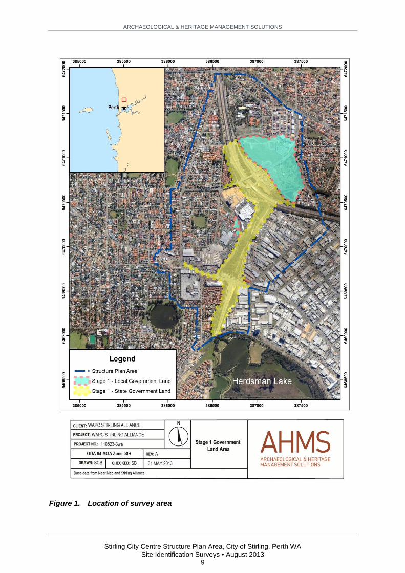
Due to extensive ground disturbance and modification, the survey area for the archaeological survey focused on the land for the proposed extension of Stephenson Avenue from Scarborough Beach Road north over the Mitchell Freeway terminating at Civic Place, City of Stirling, approximately 10 km north of the Perth CBD. It extends from Jon Sanders Drive, on the northern side of Herdsman Lake, north across the Mitchell Freeway to the administrative buildings of the City of Stirling, terminating on Civic Place (Figure 1). The survey area can be divided into three individual areas:
i. Southern section: Either side of the current length of Stephenson Avenue from Jon Sanderson Drive to Scarborough Beach Road;
ii. Central section: Scarborough Beach Road to Mitchell Freeway. Bounded to the west by Ellen Stirling Boulevard and Flax Way, and Sarich Court and a light industrial area backing off Carbon Court; and
iii. Northern section: Mitchell Freeway to where the proposed Stephenson Venue extension will terminate on Civic Place. The area bounded by the Mitchell Freeway, Civic Place, Puccini Court, Telford Crescent and Talia Drive.
The ethnographic survey was conducted for the entire Structure Plan Area (Figure 1).
1.2 Project Brief
AHMS was commissioned by Stirling Alliance to conduct archaeological and ethnographic Site Identification surveys, as defined by the Department of Aboriginal Affairs, WA (DAA) (DIA 2010: 2), of the survey area.
The purpose of the Site Identification surveys were to locate and record any newly identified Aboriginal heritage sites, and document them in a report that may be employed to support an application to the Minister for Aboriginal Affairs (WA) for ‘Consent to Certain Uses’ of land incorporating the newly identified Aboriginal heritage sites, in accordance with Section 18 of the Aboriginal Heritage Act 1972 (WA) (AHA) (see Appendix 1 for relevant legislation).
1.3 Project Objectives
The specific objectives of the surveys were to:
Locate and record any newly identified Aboriginal heritage sites within the survey area; Assess the heritage significance of any newly identified Aboriginal archaeological and
ethnographic material recorded during the survey;
ARCHAEOLOGICAL & HERITAGE MANAGEMENT SOLUTIONS
Stirling City Centre Structure Plan Area, City of Stirling, Perth WA
Site Identification Surveys • August 2013 7
Consult with the nominated representatives from the appropriate Aboriginal groups regarding the proposed future development of the area; and
Provide consideration and recommendations for the future management of any identified heritage values within the survey area.
1.4 Report Structure
Following this introduction, the structure of this report is as follows:
Section 2 contains information regarding the environmental context of the survey area. This section covers a general background including landscape characteristics, soils and geology, vegetation and climate;
Section 3 contains an overview of the Aboriginal history and European settlement in the region. This section discusses the Traditional Owners and their lifestyle as well as contact history with early settlers and the impact it had on the Aboriginal people;
Section 4 discusses the methods used to conduct the recording and prepare this report. This includes relevant research undertaken, Aboriginal consultation, the archaeological survey and reporting;
Section 5 comprises the results of the archaeological and ethnographic Site Identification surveys, including results of Aboriginal Community Consultation, background heritage information of the region in which the survey area is located, and a description of the archaeological and ethnographic field survey results;
Section 6 contains a discussion of the work undertaken and conclusions regarding the extent to which the survey objectives where fulfilled; and
Section 7 details the management recommendations that are given, following guidelines from the DAA, the results of the archaeological and ethnographic recording, and analysis of the impact of proposed development within the area surveyed.
1.5 Authorship
This report was written by Darren Cooper (Senior Heritage Consultant, AHMS). The final draft of the report was reviewed by Dr Samantha Bolton (WA Manager, AHMS).
1.6 Acknowledgements
AHMS would like to acknowledge the assistance provided during the archaeological and ethnographic recording by the following Aboriginal representatives:
Combined Metropolitan Native Title Holders
Marie Baker, Bella Bropho, Naomi Bropho, Natasha Bropho, Albert Corunna, Gwen Corunna, Vanessa Corunna, Greg Garlett, Jarrod Garlett, Kelvin Garlett, Shannon Garlett, Irene Jones, Jordan Warrell, Victor Warrell, Alison Wilkes, Linley Wilkes, Olive Wilkes, and Richard Wilkes.
Bona Fide Bloodline Traditional Owners of the Swan Valley
Jade Dolman, Cedric Jacobs, Karen Jacobs and Ezra Jacobs-Smith.

ARCHAEOLOGICAL & HERITAGE MANAGEMENT SOLUTIONS
Stirling City Centre Structure Plan Area, City of Stirling, Perth WA
Site Identification Surveys • August 2013 8
Ballaruks People
Stephen Anderson, Corrie Bodney, Tanya Bodney and Violet Bodney.
Independent Aboriginal Environment Group
Patrick Hume, Rebecca Hume, Jocelyn Indich and Gladys Yarran.
Bibulmun Group
Esandra Colbung, Lalita Colbung, Gillian King and Melanie King.
South West Aboriginal Land and Sea Council (SWALSC)
Albert Corunna, Vanessa Corunna, Ron Gidgup Snr, Russel Gidgup, Patrick Hume, Rebecca Hume, May McGuire, Noel Morich, Gladys Yarran and Glenys Yarron.
We would also like to acknowledge Hannelie Evans and Jennifer Catto (Stirling Alliance) for help in assisting in the coordination and for on-site input during consultations; Kerry O’Flaherty of Syrnix; Séan O'Hara and Kim Brewster of SWALSC assisted in putting together nominations for survey team; and Dr Amanda Harris, Dr Carina Hemmers, Teri O’Neil and Dr Guy Wright from Big Island Research, who conducted the ethnographic surveys.
ARCHAEOLOGICAL & HERITAGE MANAGEMENT SOLUTIONS
Stirling City Centre Structure Plan Area, City of Stirling, Perth WA
Site Identification Surveys • August 2013 9
Figure 1. Location of survey area

ARCHAEOLOGICAL & HERITAGE MANAGEMENT SOLUTIONS
Stirling City Centre Structure Plan Area, City of Stirling, Perth WA
Site Identification Surveys • August 2013 10
2 ENVIRONMENTAL BACKGROUND
The physical location and the environmental setting of an archaeological site can influence the nature of the remains, and the local and regional contexts in which the site can be interpreted. Issues such as the availability of fresh water, plant and animal resources, and the availability of stone materials were primary concerns for Aboriginal people living a traditional lifestyle, while access to food and water, transportation infrastructure and development potential of land were of concern to European peoples. The remains of these past activities can be affected by ongoing natural processes that occur within the environment. An understanding of the setting in which archaeological sites are found is therefore essential to understanding the archaeological record.
2.1 Landscape
The Perth region is dominated by two distinct landforms - the Darling Scarp and the Swan Coastal Plain. The Darling Scarp is a surface expression of the Darling Fault, a fracture in the Earth's crust that extends from the east of Shark Bay in the north to Point D'Entrecasteaux in the south (Gozzard 2007: 6). The Swan Coastal Plain is a low-lying gently undulating region largely composed of Pleistocene and Holocene coastal-dune shoreline deposits, with belts of alluvium in front of the Darling Scarp and along the river valleys (Smith 1985: 8). It is characterised by sand dunes, wetlands, alluvial river flats and outcrops and larger exposures of coastal limestone (McKenzie et al 2003: 94). The Swan River is the only major water course within the general region of the survey area. It has its origins as part of the Avon River in the north-east, and meanders across the plain from Guildford to Perth, and then towards Fremantle (Figure 2).
The sands of the Swan Coastal Plain are a conglomerate of overlapping sedimentary sands that began to be deposited during the Ordovician period, and prevailed through to the early Cretaceous period. The breakaway of Greater India saw the Perth Basin go through a period of uplift where the accumulated sedimentary rocks were exposed, and then inundated, as the land surface once again subsided beneath the waters.
Accumulation of surface soils then occurred in the Quaternary period with the addition of both alluvial soils in the east and aeolian sands in the west. Alluvial soils were deposited from erosion of the Darling Scarp and are represented by the Ridge Hill Shelf and the Pinjarra Plain formations. Aeolian, or windblown, sediments are represented by the various sand dune formations such as the Bassendean, Spearwood and Quindalup dunes. The predominantly westerly winds have resulted in the formation of the long linear dune systems that line the southern Western Australian Coast.
The position of the coastline has changed with the rise and fall of sea levels due to the onset and amelioration of global glacial conditions. It has been broadly accepted that during the last glacial maximum (ca. 18,000 BP) that the coastline was located to the west of Rottnest Island, and that the Swan River discharged approximately 5 km north of that island. As sea levels have risen to current levels the former land surfaces were inundated (Seddon 1972: 72-75). Wetlands developed in the swales between the linear dunes forming large inland lakes and swamps such as Lake Joondalup, Herdsman Lake, Lake Monger, Lake Claremont and Bibra Lake. When European first settled the Swan River Colony extensive systems of inland lakes existed throughout the western part of the Swan Coastal Plain. These were rich ecosystems that provided a range of plant and animal resources for local Aboriginal populations that moved from one wetland to another as part of their nomadic lifestyle. Over the past 180 years many of these wetlands have been filled in and used for market gardens to take advantage of the rich soils, or as sporting fields or housing.

ARCHAEOLOGICAL & HERITAGE MANAGEMENT SOLUTIONS
Stirling City Centre Structure Plan Area, City of Stirling, Perth WA
Site Identification Surveys • August 2013 11
Figure 2. Landforms within the Perth region of the Swan Coastal Plain (reproduced
from Seddon 1972: 158)

ARCHAEOLOGICAL & HERITAGE MANAGEMENT SOLUTIONS
Stirling City Centre Structure Plan Area, City of Stirling, Perth WA
Site Identification Surveys • August 2013 12
2.2 Soils and Geology
The aeolian sediments are made up of the Bassendean Sands, Spearwood and Quindalup dune formations. The Bassendean Sands are the oldest of the three formations and are the eastern-most aeolian formation, located adjacent to the alluvial Pinjarra Plains formation. The Pinjarra Plains formation is estimated to be approximately 240,000 years old (Gozzard 2007: 16), although it has been estimated to be much older, to the order of 800,000 years (see Bolland 1998: 3). These are believed to 'represent a Pleistocene accumulation of beach sands along an old coastline' that have been reworked and eroded to their present height (Seddon 1972: 10). Over the millennia, rainwater has leached of calcium carbonates from the soil leaving only insoluble quartz sand grains giving it its distinctive bleach white appearance.
West of the Bassendean Sands is the Spearwood Dune formation. It forms a 3-15 km wide belt of "large-scale, convex, asymmetric, topographically irregular ridges that reach heights of up to 95 m in places...The shapes of the dunes suggest that they formed as large-scale, bare, dune sheets that advanced over the land surface" (Gozzard 2007: 16). The Spearwood dunes are one of the younger dune formations of the Swan Coastal Plain, being late Pleistocene/Holocene in age. As sea levels dropped during the last glacial period, former sea floor deposits were eroded and the resulting sands were blown onto the shores (itself a former marine surface of sediments and marine organisms) forming firstly the Bassendean Sands formation and then the Spearwood Dune formation, followed most recently the Quindalup Dunes. However, it has been argued (see Tapsell et al. 2003) that the Spearwood Dune sands may have also be blown in from inland regions.
Beneath the Spearwood Dunes is the Tamala Limestone formation. Tamala Limestone is made of medium to course grained calcarenite, which itself is composed of broken mollusc and Forminifera shell debris and various amounts of quartz sand (Gozzard 2007: 16, 28). The aeolian origins of the limestone are betrayed in the distinctive cross bedding that can be seen in the exposed outcrops of limestone in coastal areas and the riverine terraces in North Fremantle, Mosman Park, Cottesloe and Peppermint Grove. These sands were subsequently lithified by solution, and the redeposition of the calcium carbonate formed the limestone (Playford (1976) cited in Smith 1985: 10). This limestone formation underlies the Cottesloe area, and exposures of the formation are seen in Cottesloe’s coastal areas and the margins of the Swan River. Tamala Limestone was recognised as a plentiful building material and many of the Swan River Colony's early buildings are made from it. Distinctive topographic examples of Tamala Limestone were the 'Seven Sisters' formation that overlooked the Rocky Bay and Mosman Park areas, and Arthur Head, Fremantle. The Seven Sisters were almost completely quarried for use as a raw material in the construction of the North and South Moles of the Port of Fremantle in the 1890s. Arthur Head was quarried down to its current level as part of the same harbour expansion works.
The overlying sands comprise the aeolian parts of the eroding Tamala Limestone. These sands are red/brown, yellow and pale yellow/gray sands. The colour of the sands is a result of iron and aluminium oxides that coat the sand particles, with the iron oxide the dominate factor in determining the colour of the sand (Bolland 1998: 2). The sands are further divided into Karrakatta Sands and Cottesloe Sands – the former are a deep leached yellow and brown sands, and the latter are shallow yellow and brown neutral soils (Seddon 2004).
The youngest sand dune is the Quindalup Dune system. It is found on the western-most margins of the Swan Coastal Plain. It consists of unconsolidated calcareous sands and forms distinctive coastal parabolic dunes. This formation is very recent, having formed in the last 10,000 years, and is still active today. This dune system also covers the Tamala Limestone formation and exposures of coastal limestone are common.

ARCHAEOLOGICAL & HERITAGE MANAGEMENT SOLUTIONS
Stirling City Centre Structure Plan Area, City of Stirling, Perth WA
Site Identification Surveys • August 2013 13
2.3 Vegetation
The survey area is in the Perth subregion of the Swan Coastal Plain bioregion, as classified in the Interim Biogeographic Regionalisation for Australia (IBRA) (ERIN 2005a; 2005b). Within this bioregion, the different vegetation regimes are observed to consistently align with the three main soil formations although general characterisation tends to overlook shared fringes of formation boundaries (Bolland 1998; Gozzard 2007; Seddon 1972; 2004; Smith 1985). The natural vegetation has been greatly affected by urbanisation, especially of the coastal area and in some more developed suburbs only remnant stands of the original vegetation exist today.
The Bassendean sands are covered with a variety of vegetation types including low open forests of banksia and sheoaks, jarrah-banksia woodlands, and fringing woodlands of Eucalyptus rudis (flooded gums) (Seddon 1972: 166). This is reflective of the poor nutrient levels within the majority of the soils and the intrusion of species from the neighbouring landforms, or the presence of wetlands.
The Spearwood Dunes are dominated by a broad belt of tall open forests of Eucalyptus gomphocephala (tuart), E. calophylla (marri) and E. marginate that extends from the coast inland for approximately 10 kms. Within this forest belt are ’pure stands’ of each of these species of trees, but in most areas a continuous mix of these species occurs (Seddon 1972: 159). Smaller trees such as Banksia attenuata, B. menziesii, B. grandis, Casuarina fraseriana and Agonis flexuosa (in order of importance) are common as too are the distinctive Xanthorrhoea preissi and Macrozamia reidei (zamia palm). A rich low-shrub layer made up of numerous smaller species is also present (see Seddon 1972: 159-160).
The Quindalup dune system is very different from the previous formations. The landscape is dominated by coastal scrub vegetation including beach front strand plants (Cakile maritima and Arctoletheca populifolia), a large variety of shrubs (for example, Pelargonium capitatum, Myoporum decumbens, Scaevola crassifolia, Olearia axillaris, Lepidosperma gladiatum), and wattles (Acacia rostellifera and A. Cyclopis) (Smith 1985: 14-15). Few tree species are found on this formation and these are mainly on Rottnest Island and Garden Island.
Much of the natural vegetation within the survey area has been cleared for residential buildings; however an insight into its original appearance was given by Captain F.C. Irwin in 1829 (cited in James 2007: 8):
The country near the coast generally presents either an open forest, plains covered with short brushwood mixed with grass, or open downs. Numerous lakes, fresh and slat, extend along the coast, as do also hills and ridges of calcareous formation. A great variety of flowering shrubs cover the country in many parts, and occasionally, lofty trees with wide spreading branches embellish its surface.
It is apparent that prior to European settlement, the Swan Coastal Plain supported a rich and diverse ecosystem that was defined by the underlying geology and the overlying systems of sand dunes. This ecosystem has slowly been reduced in size and diversity by ongoing urban development to a point where only small pockets of remnant vegetation remain.
2.4 Wetlands
The main types of water sources found on the Swan Coastal Plain are a series of major rivers formed by the numerous tributaries flowing off the Darling Scarp conjoining to form the Swan and Canning Rivers, and the small and large lakes, and wetlands, found within the swales between the linear dune systems of the Spearwood Dunes and the Bassendean Sands. Near to the survey area, the Swan

ARCHAEOLOGICAL & HERITAGE MANAGEMENT SOLUTIONS
Stirling City Centre Structure Plan Area, City of Stirling, Perth WA
Site Identification Surveys • August 2013 14
River is the only major river system. Natural drainage of the Bassendean sands occurs from swamp to swamp and then into the Swan River (Seddon 1972: 16-18). This has been supplemented by human-made drainage lines. There is no natural drainage from the Spearwood Dunes, and this is evident by the presence of larger lakes and wetlands (e.g. Lake Joondalup, Lake Monger, Herdsman Lake). Prior to European settlement it is estimated that there were twice as many lakes as are present today, however a continuous process of draining lakes and infilling for both market gardens and residential expansion, and use as rubbish dumps, has greatly reduced that number. Direct human impact through dredging, introduction of exotic species of plants and animals, and clearing of native vegetation have all contributed to a reduction of range and diversity of native flora and fauna.
Smith (1985: 17-18) describes the vegetation of the lakes and swamps as:
The littoral communities of these wetlands are dominated by the Paperbark tree, Melaleuca rhaphiophylla, which forms a tree belt between high water mark of winter and low water level of late summer. Just above high water mark, communities of Banksia littoralis, Melaleuca parviflora and Eucalyptus rudis form the upshore limit of the fringing lacustrine woodland. Few species of shrubs and sedges occur in this woodland, the notable exception being dense stands of the sedge, Gahnia trifida. The herbaceous species of the woodland include Centella cordifolia, Apium prostratum, A. annuum, Lobelia tenuior, Samolus repens and Cotual coronopifolia…The submerged benthic vascular flora of these lakes includes Triglochin procera, Lepilaena preissii, Najas marina, Ruppia maritime, Potamogeton pectinatus and P. ochreatus. The aquatics rarely occur in large stands, due perhaps to the deposits of suspended lingo-peat, up to a depth of 60 cm, over much of the floors of these lakes…The floating aquatics of these lakes include duckweeds, Lemna minor, L. disperma and Spirodela punctate. The floating fern, Azolla filiculoides occurs in wind sheltered embayments of coastal lakes from spring to autumn before perenating on the lake floor through the winter.
The wetlands are a rich source of fauna, including birds, mammals, reptiles and amphibians and are important breeding grounds. Using Herdsman Lake as a representative example of other local wetlands, McCotter (n.d.: 24) notes that there are at least 20 breeding species of waterbird there alone. The presence of birds is both year round and seasonal. Seasonal birds include the Ephthianura albifrons (white-front chats) and Anthus novaeseelandiae (Richard’s pipits) in summer, and in winter the area is frequented by ducks and water birds taking advantage of the deeper water. Water birds include Cygnus atratus (black swan), Porphyrio porphyio (swamphen) and Acrocephalus stentoreous (reed warblers). Birds of prey (e.g. Falco peregrinus [peregrine falcon]) are also found in the area. While no mammal species are now found in the vicinity of Herdsman Lake. However, kangaroos, possums, wallabies are known to have utilised the lake system in the past, and this is likely to be replicated in other lake systems. Reptiles including snakes, skinks, lizards, frogs and tortoises are also found in this lake.
2.5 Climate
The Swan Coastal Plain experiences a temperate climate characterised by warm, dry summers with an average temperature range of 15-32°C, and cool, wet winters with average temperature ranging between 8-19°C (Bureau of Meteorology 2011). Rainfall is seasonal and falls mostly in the winter months between May and August, with an average annual rainfall of 773 mm (Bureau of Meteorology 2011). This is offset by an average annual evaporation rates are between 1,800 – 2,000 mm (Bureau of Meteorology 2003).

ARCHAEOLOGICAL & HERITAGE MANAGEMENT SOLUTIONS
Stirling City Centre Structure Plan Area, City of Stirling, Perth WA
Site Identification Surveys • August 2013 15
3 ABORIGINAL HISTORY
3.1 The Traditional Owners
At the time of European settlement the Aboriginal people of the Swan Coastal Plain were known as the Whadjuk. These people were described as 'a stylish people, with rich clothing and ornamentation. Bodies were painted with red ochre over which were drawn white lines' (Horton 1994: 1139). The lands north of the Swan River to Lake Joondalup were known as Mooro Yellowgonga’s Territory, and were bounded by the ocean to the west, Waylo’s Territory to the north, and the Swan River through to the Avon River (see Green 1984: 50). The Whadjuk people are part of the Nyoongar group, who live in the south-west of Western Australia (Horton 1994: 814).
3.2 Early Occupation
Archaeological evidence has shown that the south-west region of Western Australia has been occupied by Aboriginal people for more than 40,000 years. The site of Upper Swan, 35 km north-east of Perth, has been dated to around 38,000 years Before Present (BP) (Pearce and Barbetti 1981: 177), and the site of Devil's Lair, in the lower South West region was dated to 48,000 years BP (Turney et al. 2001; Dortch 1984; Dortch and Dortch 1996).
Academic research into the Swan Coastal Plain (see Anderson 1984; Hallam 1975; Green 1984) and ethnographic observations from early settlers and researchers (Bates 1985; Hammond 1933) have demonstrated and recorded the nomadic nature of south-west Aborigines, including their methods of looking after the land, seasonal movement of groups to avoid depletion of plant foods, interaction of family groups, and use of stone resources for stone tool production.
Noongar groups divided the year into six seasons: Biro (December-January), Burnoru (February-March), Geran (April-May), Maggoro (June-July), Jiba (August-September), and Kambarang (October-November) (Green 1984: 10), and during each season different resources were utilised. In the winter months and heading into spring, family groups would occupy the wooded inland regions such as on the Darling Scarp, and forests of the south-west. Working together, they would hunt animals such as kangaroos, by herding them into traps, where they could be easily dispatched with clubs and spears (Green 1984: 10). In spring there was an abundance of root vegetables. In the summer months, family groups worked together conducting spear fishing, collected shell fish, and built fish traps in the rivers, such as the Swan River (Green 1984: 10-11). The variety of food resources available in the various seasons included kangaroos, emu, birds, ducks, frogs, turtles, fish, marron, root crops, yams, grasses, berries and fruits (Green 1984: 3).
Early Aboriginal occupation of the Swan Coastal Plain focused on the areas of availability of resources including animal, stone and wood resources. Of particular relevance to the current study, the use of wetlands as a food source was particularly important. Prior to European settlement, Herdsman Lake was known as Ngoogenboro, and was situated within the tribal lands of Mooro Yellowgonga (Green 1984: 49-50). The wetlands were important during the seasons of Burnoru, Maggoro and Jiba when the climate was mild and local Aboriginal peoples could target the wetlands for birds, tortoises, frogs, fish, small game animals nuts and root plants (Ujim 2012: 36, 55).
The possessions of Aboriginal people were varied, and were made of a diverse range of animal, plant and stone materials. Animal products, such as skins, were used for clothing, bags, and baby carriers; bones were used as drills and sewing implements; timber bowls were cut out of tree trucks; and branches and tree roots were used for spears.
ARCHAEOLOGICAL & HERITAGE MANAGEMENT SOLUTIONS
Stirling City Centre Structure Plan Area, City of Stirling, Perth WA
Site Identification Surveys • August 2013 16
Historical accounts from early European explorations of the Swan River documented the presence of Aboriginal groups in the area. In many instances no Aboriginal people were observed, but their camps were discovered, while at other times large groups were encountered. This could reflect the land use pattern of nomadic groups, who may have retreated to the inland wooded areas to escape the winter storms of the coastal areas. Initially the interaction between Europeans and the Aboriginal groups were friendly, but over time these relationships diminished as a result of negative events (Green 1984: 33-34).
Areas along the foreshore of the Swan River were traditional water sources and associated camping grounds, in the area of the former Emu Brewery, along what is now Mounts Bay Road (O'Connor cited in Fisher et al. 2003: n.p.). Reminiscences by Perth settlers recalled Aboriginal groups spearing fish (cobblers) in the area, between the Barrack and William Street jetties, prior to the land reclamation works of the 1870s-1880s (Hammond 1980 [1936] 185; 1932: 16; Kennedy 1927: 7).
3.3 Contact History
3.3.1 Non-Indigenous Occupation of Perth
European exploration of the Swan River began in the 1600s, with an expedition party sent by Willem de Vlamingh in January 1697. The party made its way from the coast, stopping briefly at Mount Eliza, before continuing east along the river foreshore (Playford 1999: 31-34). The French explored the area in 1800s and the English in the 1820s.
Ujim (2012: 59) notes that early usage of the area surrounding Herdsman Lake included grazing and market gardening, rubbish disposal, drainage management and also as a possible water supply. In the 1830s farms on the surrounding lands were well established with fenced areas and established wells supporting livestock. In the 1850s an abattoir was established on ‘low lying fertile ground surrounds the lake’ (Ujim 2012: 60). In 1854 the Roman Catholic Church also established vineyards in the local area that required extensive clearing of the native vegetation in and around the lake. The area was further cultivated in the 1870s with the establishment of Chinese market gardens.
In 1921, work began on draining the lake and the surrounding catchment area for the purposes of farming by Returned Solders (The West Australian 1921). This involved the digging of extensive drainage tunnels from the lake to the ocean, but also the construction of a number of minor drains including the drains seen in the current survey area. Completed in 1926, the prospects of farming this area were proved to be unsuccessful and the farming gave way to residential development from the mid-1930s.
Digital maps of the area (Landgate n.d.) show that by the mid-1960s the area to the immediate west of the survey area had been established as a light industrial area. This area was developed over the past 50 years, and steadily became more densely occupied. The area that forms the northern part of the survey area was used as a rubbish tip through to the 1980s, ceasing operation at about the time that the Mitchell Freeway was extended through the area. This roadwork project required major earthworks to stabilise the soft sands of the area (Edmonds 1997). The area to the south of the freeway route, the current site of the IKEA store, was also extensively modified at this time. The central part of the survey area is shown to be the last remnant greenbelt within the area north of Herdsman Lake, with residential infilling, light industrial development, and the establishment of commercial shopping centres now occupying all other areas.
3.3.2 Impact on Aboriginal People of Perth
As with Aboriginal people throughout Australia, the traditional life of Aboriginal people in the Perth region was broken through the course of the nineteenth and twentieth centuries. The introduction of

ARCHAEOLOGICAL & HERITAGE MANAGEMENT SOLUTIONS
Stirling City Centre Structure Plan Area, City of Stirling, Perth WA
Site Identification Surveys • August 2013 17
diseases such as smallpox and influenza wreaked havoc among the Aboriginal population, with individual epidemics killing large numbers of people.
Early white settlement of traditional hunting lands deprived Aboriginal groups of sources of food and access to camping and ceremonial sites. This forced individuals to either relocate into the potentially hostile lands of neighbouring Aboriginal groups, to partially integrate into colonial society as fringe dwellers, or to resist. White settlers and the colonial administration often met resistance by Aboriginal groups with retaliatory actions. The Aboriginal people of Perth often killed white settlers. In retaliation and in order to protect themselves, the settlers killed many Aboriginal people, although they were rarely punished for it (Battye 1924: 304-305). A combination of these factors led to the demise of traditional lifestyles and a decrease in the Aboriginal population in the Perth region.

ARCHAEOLOGICAL & HERITAGE MANAGEMENT SOLUTIONS
Stirling City Centre Structure Plan Area, City of Stirling, Perth WA
Site Identification Surveys • August 2013 18
4 METHODS
The Site Identification recording required completion of a number of tasks including background research, Aboriginal community consultation and field survey. Specific details of the methods used to complete each task are described below.
4.1 Background Research
Background research completed to inform the survey work entailed:
Searching the DAA Aboriginal Sites Register (AHIS) to determine the type and distribution of Aboriginal sites previously recorded in and around the survey area; and
A review of previously completed archaeological investigations in the survey area and its surrounding locality in order to provide a comparison with the results of this recording.
4.2 Aboriginal Community Consultation
Representatives from the local Aboriginal community participated in the archaeological and ethnographic surveys. Their views and recommendations regarding the cultural heritage significance of the survey area were noted and taken into consideration during the recording.
4.3 Field Survey
An archaeological and ethnographic Site Identification survey was conducted within the survey area. The aims of Site Identification surveys are to (DIA 2010: 2):
Establish whether the survey area contains physical evidence of past Aboriginal occupation and use, and/or any Aboriginal ethnographic heritage values;
Conduct detailed recording of areas of Aboriginal heritage material and/or values, in order to establish whether they could be considered Aboriginal heritage sites in accordance with Section 5 of the AHA;
Assess and make recommendations regarding the management of any such identified Aboriginal heritage material, with specific reference to the impact of proposed development in the survey area; and
Collate all information required for the purpose of reporting any identified Aboriginal heritage material to the Registrar of Aboriginal Sites.
In addition, the survey area was assessed to determine the degree to which previous land-use and landscape modification has disturbed the original landscape. An assessment of this disturbance and its implications for the preservation of archaeological deposits within the survey area was made.
4.3.1 Archaeological Survey Methods
Specific survey methods employed during the archaeological survey may be summarised as follows:
Targeted areas within the survey area (see Section 5.5, Archaeological Survey) were traversed on foot;

ARCHAEOLOGICAL & HERITAGE MANAGEMENT SOLUTIONS
Stirling City Centre Structure Plan Area, City of Stirling, Perth WA
Site Identification Surveys • August 2013 19
Ground surfaces were examined for visible archaeological evidence such as stone artefacts, charcoal and shell; and
Mature trees were examined for evidence of scarring or carving and rock surfaces were examined for engravings or axe grinding grooves.
The archaeological survey was restricted to existing tracks due to the undulating and modified nature of the terrain land surface.
ARCHAEOLOGICAL & HERITAGE MANAGEMENT SOLUTIONS
Stirling City Centre Structure Plan Area, City of Stirling, Perth WA
Site Identification Surveys • August 2013 20
5 RESULTS
This section presents the results of the Site Identification Recording, including the outcomes of the Aboriginal Community Consultation.
5.1 Aboriginal Community Consultation
The survey area is subject to three currently active Native Title claims. These are the:
Whadjuk People (Tribunal number WC2011/009, Federal Court number WAD242/2011), represented by SWALSC, claim accepted for registration;
Swan River People 2 (Tribunal number WC2011/002, Federal Court number WAD24/2011), represented by Albert Corunna, claim is currently identified for registration decision; and
Single Noongar Claim (Area 1) (Tribunal number WC2003/006, Federal Court Number WAD6006/2003), represented by SWALSC, claim not yet accepted for registration.
Representatives nominated by SWALSC and from the Swan River People 2 claim participated in this survey. Other representatives from the Aboriginal community, who are recognised as appropriate spokespeople for the area, were also consulted. Full details are provided in Appendix 2.
The Aboriginal representatives were briefed on site at the beginning of fieldwork about the survey objectives, scope of work and the proposed recording methods that would be employed to record Aboriginal cultural material. The representatives verbally indicated that they were satisfied with the proposed methods used during the Site Identification recording. Further details of the results of the Aboriginal community consultation during the archaeological and ethnographic surveys are provided below (see Sections 5.5 and 5.6)
5.2 Previously Recorded Aboriginal Sites
5.2.1 DAA Aboriginal Sites Register
A search of the DAA Aboriginal Heritage Inquiry System (AHIS) was undertaken to identify previously recorded Aboriginal sites within and around the survey area that are listed on the DAA Aboriginal Sites Register. When an Aboriginal site is submitted to the DAA, it is assessed by the ACMC as to whether it constitutes a site under Section 5 of the AHA. As soon as the information is lodged with the DAA, sites are given a status. These are:
L Lodged The site information has been lodged with the DAA and is awaiting assessment
R Registered The ACMC decision has been made and the site is a registered Aboriginal site
I Insufficient Information
The ACMC decision has been made and there is insufficient information to determine whether the site is an Aboriginal site under the AHA
S Stored Data The ACMC decision has been made and the area has been determined as either not a site, or the site no longer exists

ARCHAEOLOGICAL & HERITAGE MANAGEMENT SOLUTIONS
Stirling City Centre Structure Plan Area, City of Stirling, Perth WA
Site Identification Surveys • August 2013 21
Sites that have been lodged (L) or require further information (I), need to be treated as potential Aboriginal sites, and they should not be disturbed by development until the assessments are completed by the ACMC.
5.2.2 Structure Plan Area
The DAA AHIS was searched for the Structure Plan Area and its immediate surrounds. There are no registered sites within the Structure Plan Area. There is one site listed as Insufficient Information (DAA Site ID 4405), and four sites that are Stored data. In the vicinity of the Structure Plan Area there is one registered site (DAA Site ID 3585, see below) and two sites with stored data. A summary of the sites is provided in Table 1 and the sites are shown in Figure 3.
Table 1. Summary of DAA Aboriginal Sites Register listing of sites within the
survey area and its immediate surrounds
DAA Site ID
Site Name Status
Site Type Additional Information Within Survey Area
3585 Herdsman Lake R Skeletal material/Burial
Camp, Hunting Place No
4405 Jackadder Lake I Artefact Scatter Yes
3207 Jackadder Lake West S Artefacts/Scatter
Yes
3208 Scarborough Beach Road
S Artefacts/Scatter
Yes
3209 Herdsman Lake N S Artefacts/Scatter
Yes
3210 Herdsman Lake NE S Artefacts/Scatter
No
21537
TC/01 – Waterway S Mythological Water Source No
21538
Stirling Wetlands S Mythological Meeting Place, Camp, Hunting Place, Named Place, Water Source
Yes
Registered site DAA Site ID 3585, Herdsman Lake, is located at the southern end of the survey area, outside the Structure Plan Area. It will not be impacted upon during the proposed works.
DAA Site ID 4405, Jackadder Lake, is listed as Insufficient Information and further information is required before it can be assessed by the ACMC. It is also located at the southern end of the survey area.
ARCHAEOLOGICAL & HERITAGE MANAGEMENT SOLUTIONS
Stirling City Centre Structure Plan Area, City of Stirling, Perth WA
Site Identification Surveys • August 2013 22
Figure 3. Results of DAA AHIS search for Structure Plan Area

ARCHAEOLOGICAL & HERITAGE MANAGEMENT SOLUTIONS
Stirling City Centre Structure Plan Area, City of Stirling, Perth WA
Site Identification Surveys • August 2013 23
5.3 Previous Heritage Surveys
Several heritage surveys have previously been conducted within the boundaries of the current survey area. These include the Herdsman Lake area (MacIntyre 1993; Ujim 2012), in the area of a new wetland constructed within the northern section of the current survey area (Parker 2003), and an Aboriginal site survey of a residential estate in the City of Stirling (Australian Interaction Consultants 2004). No archaeological material was observed during these investigations.
In 2011, AHMS undertook an archaeological survey of a drilling program related to the current project (see AHMS 2012), in which no Aboriginal cultural heritage material was identified. The assessment was made at this time that the potential of finding in situ archaeological material within the current survey area was low.
5.4 Predictive Modelling
The archaeological sites mentioned in Section 5.2.2 are physical evidence for the presence of Aboriginal people in the area surrounding Herdsman Lake and Jackadder Lake. In summary, these sites consisted of a small number of stone artefacts. Historical research has shown that lakes and wetlands were an important resource for the Aboriginal people who moved across the Swan Coastal Plain as part of their seasonal round.
Since European settlement, the area surrounding Herdsman Lake has been significantly modified by drainage excavation, industrialisation, infrastructure construction, urban development and commercial development, leaving little of the original land surface intact or unaltered. Therefore, the potential of finding in situ surface archaeological material is assessed as being very low. It is however, possible that buried in situ archaeological material may be encountered during earthworks that intersect with the original land surface.
5.5 Archaeological Survey
The archaeological survey described in this report was conducted on 1 July 2013 by Darren Cooper (Senior Heritage Consultant, AHMS).
The two prominent features of the survey area are a large embankment located in the central part of the survey area, and a drain that runs through all three parts of the survey area. The embankment was formed through dumping a large volume of limestone/sand in what is termed ‘pre-loading’ as a precursor to earthworks as part of the construction of a bridge. The drain flows from a triangular shaped human-made lake in the northern part, through and open drain that flows along the western part of the central part, and then enters the southern part through underwater drains to the eastern side of that area. The waters then flow south towards Herdsman Lake before being diverted to the sea by another main drain. The drain is feed by stormwater runoff and a ground water stream.
The alignment of the proposed road was then walked from the Stirling Gardens car park towards the Mitchell Freeway (southern end) finishing at the drain leading from the human-made lake, and then back towards the northern end across Cedric Street and towards Civic Place.

ARCHAEOLOGICAL & HERITAGE MANAGEMENT SOLUTIONS
Stirling City Centre Structure Plan Area, City of Stirling, Perth WA
Site Identification Surveys • August 2013 24
5.5.1 Survey Coverage
Effective coverage is calculated by multiplying the percentage visibility by the actual area surveyed. The calculation indicates the effectiveness of the surface survey in detecting archaeological sites and accordingly, the validity of the survey results.
Table 2 shows the survey coverage data collected during the survey. This data indicates that effective coverage was generally moderate.
Table 2. Survey coverage data
Survey Area
Landform Unit Transect Area (m2)
Average Visibility (%)
Degree of Soil Disturbance
Estimate of Effective Coverage (m2)
Southern Section
Low lying drainage area with regrowth bush land. Human-made drainage channel and embankment
85,456 20 High 17,091
Central Section
Low lying drainage area with regrowth bush land. Human-made drainage channel and vehicle tracks
162,100 20 High 34,420
Northern Section
Landscaped park land 146,040 90 High 131,436
TOTAL 393,596 43 High 182,947
5.5.2 Southern Section
Due to the embankment, it was necessary to use the track on top of the embankment to gain access to the southern parts of the survey area. The sides of the embankment were too steep to either ascend or descend safely, so access to the adjoining lower land could not be accessed in this way. Ground surface visibility was estimated to be between 0-5% due to the presence of thick lush winter vegetation
The southern section of the survey area has been disturbed from the building of the drainage channel in the 1920s and from road building activities during the construction of Scarborough Beach Road and Stephenson Avenue. During proposed new roadworks in the survey area, there will be limited development of the southern section. If this occurs, the development will be restricted to the previously disturbed north-east and west corners, towards the intersection of Stephenson Avenue and Scarborough Beach Road.
No cultural heritage material was identified in the southern section of the survey area.
5.5.3 Central Section
The central section was the largest of the three areas, and relatively the least developed. Little of the original land surface is visible, and even that has been disturbed. The area was heavily vegetated with tall (>6 m) Eucalyptus spp. trees and an understorey of small shrubs and thick, long winter grasses. The survey of the central section was restricted to access tracks through the area. A large human-made embankment was built along the length of the central section, in preparation for the building of an overpass over the freeway (Plate 1). The embankment is approximately 8-10 m wide, and is at least 10 m high. An unsealed irregular vehicle track runs along the top of the embankment,
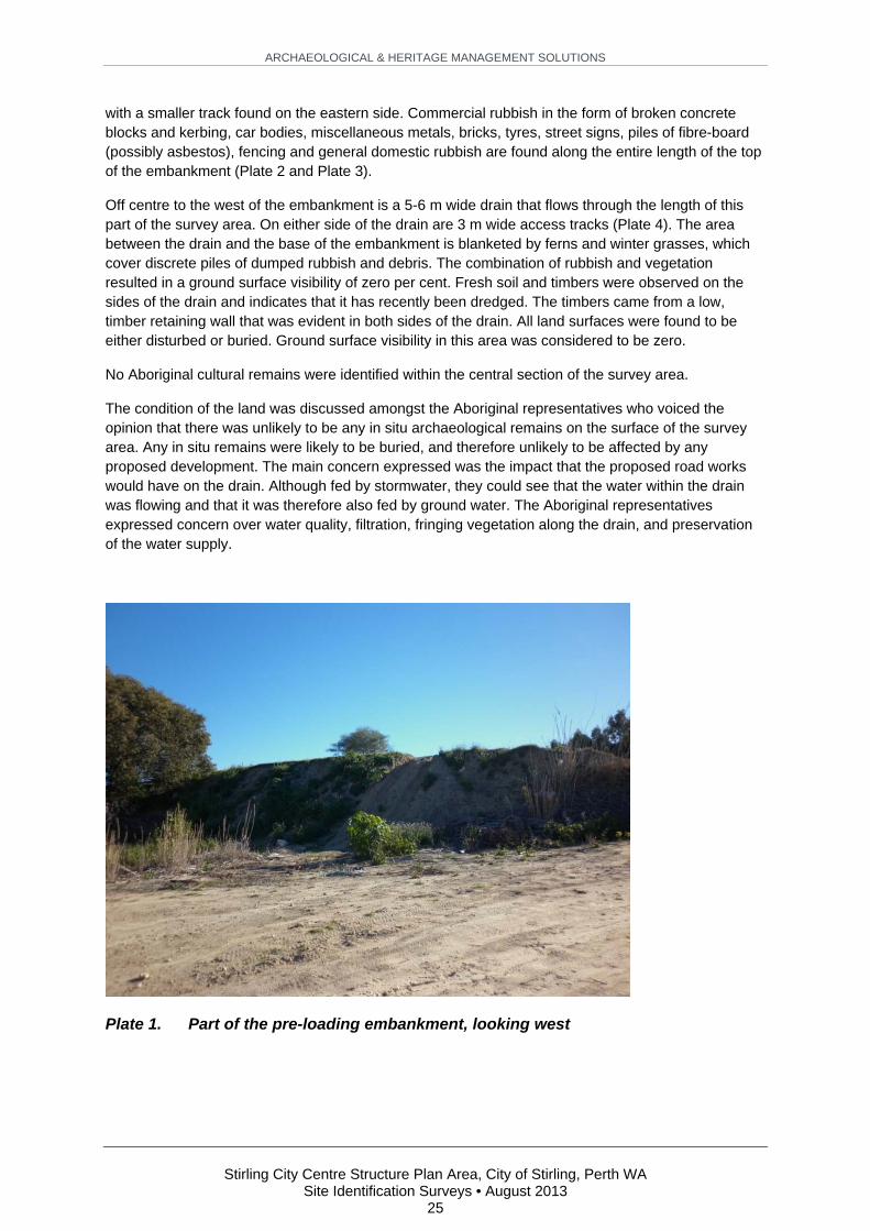
ARCHAEOLOGICAL & HERITAGE MANAGEMENT SOLUTIONS
Stirling City Centre Structure Plan Area, City of Stirling, Perth WA
Site Identification Surveys • August 2013 25
with a smaller track found on the eastern side. Commercial rubbish in the form of broken concrete blocks and kerbing, car bodies, miscellaneous metals, bricks, tyres, street signs, piles of fibre-board (possibly asbestos), fencing and general domestic rubbish are found along the entire length of the top of the embankment (Plate 2 and Plate 3).
Off centre to the west of the embankment is a 5-6 m wide drain that flows through the length of this part of the survey area. On either side of the drain are 3 m wide access tracks (Plate 4). The area between the drain and the base of the embankment is blanketed by ferns and winter grasses, which cover discrete piles of dumped rubbish and debris. The combination of rubbish and vegetation resulted in a ground surface visibility of zero per cent. Fresh soil and timbers were observed on the sides of the drain and indicates that it has recently been dredged. The timbers came from a low, timber retaining wall that was evident in both sides of the drain. All land surfaces were found to be either disturbed or buried. Ground surface visibility in this area was considered to be zero.
No Aboriginal cultural remains were identified within the central section of the survey area.
The condition of the land was discussed amongst the Aboriginal representatives who voiced the opinion that there was unlikely to be any in situ archaeological remains on the surface of the survey area. Any in situ remains were likely to be buried, and therefore unlikely to be affected by any proposed development. The main concern expressed was the impact that the proposed road works would have on the drain. Although fed by stormwater, they could see that the water within the drain was flowing and that it was therefore also fed by ground water. The Aboriginal representatives expressed concern over water quality, filtration, fringing vegetation along the drain, and preservation of the water supply.
Plate 1. Part of the pre-loading embankment, looking west

ARCHAEOLOGICAL & HERITAGE MANAGEMENT SOLUTIONS
Stirling City Centre Structure Plan Area, City of Stirling, Perth WA
Site Identification Surveys • August 2013 26
Plate 2. Concrete debris along central track on top of embankment, looking
south
Plate 3. Building rubble and debris on top of embankment, looking west

ARCHAEOLOGICAL & HERITAGE MANAGEMENT SOLUTIONS
Stirling City Centre Structure Plan Area, City of Stirling, Perth WA
Site Identification Surveys • August 2013 27
Plate 4. View of open drain west of the embankment, looking north. Note lush
vegetation to the right of frame, which continues up to and on top the
embankment
5.5.4 Northern section
A proposed bridge over the Mitchell Freeway will enter into the area of the former City of Stirling rubbish dump. The rubbish dump, itself made on a former wetland, once covered the area bounded by Civic Place, Puccini Court, Telford Crescent and Talia Drive, but has now been rehabilitated and appears as manicured lawns and formal gardens. A triangular human-made lake occupies the eastern part of the survey area adjacent to the freeway, and a drain flows under the freeway and into the central section of the survey area. An inspection of the edge of the landscaped land adjacent to the drain shows the extent of material added to the site. The vertical height from the bank of the drain (likely to be near the original level of the former land surface) to the grass lawn above is approximately 4-5 m. Rubbish and debris was visible protruding from the side of the embankment. The height of the land surface increases substantially to the top of the hill overlooking Stirling Gardens (Plate 5).
There are paved paths and a cenotaph overlooking small human-made lakes and stream. The area is divided by Cedric Street. The proposed development will not impact on the triangular lake or the central part of Stirling Civic Gardens. The rough alignment of a proposed road follows an avenue of brown wood chips that has been planted out with gum trees and olive trees. The proposed road will continue beyond Cedric Street towards Civic Place cutting across Stirling Park (Plate 6).

ARCHAEOLOGICAL & HERITAGE MANAGEMENT SOLUTIONS
Stirling City Centre Structure Plan Area, City of Stirling, Perth WA
Site Identification Surveys • August 2013 28
Plate 5. View uphill along proposed road alignment showing lawns over the one
time rubbish dump, looking north-north-east
Plate 6. View looking north across playing fields along the alignment after
crossing Cedric Street. City of Stirling administrative buildings are
located in the background right of image

ARCHAEOLOGICAL & HERITAGE MANAGEMENT SOLUTIONS
Stirling City Centre Structure Plan Area, City of Stirling, Perth WA
Site Identification Surveys • August 2013 29
The northern section of the survey is of similar height to the southern side Cedric Street and is therefore likely to have a large amount of imported rubbish and fill beneath the current ground level. Along the common edge of Stirling Park and the adjacent car park are numerous mounds of dirt that have been created by tipping of dirt from a dump truck. The other areas of vegetation, between the freeway on ramps and off ramps, are unlikely to be affected by the development, but have all been disturbed through construction of the freeway and revegetated in the last 20 years.
No Aboriginal cultural remains were identified within the northern section of the survey area.
5.6 Ethnographic Survey
The ethnographic surveys described in this report were conducted on 31 May, 5 June and 1 July 2013 by Dr Amanda Harris, Dr Carina Hemmers, Teri O’Neil and Dr Guy Wright (anthropologists, Big Island Research).
The full results of the ethnographic surveys are provided in Appendix 2.
In summary, no new Aboriginal ethnographic sites were identified in the survey area.

ARCHAEOLOGICAL & HERITAGE MANAGEMENT SOLUTIONS
Stirling City Centre Structure Plan Area, City of Stirling, Perth WA
Site Identification Surveys • August 2013 30
6 DISCUSSION
The archaeological survey of the current survey area found no Aboriginal cultural heritage material. All of the land surfaces within the survey area have been severely affected either by previous road building, construction of the electrical sub-station, drainage excavation, pre-loading of soil into the area, or dumping of both commercial and domestic waste. There was no evidence of any unaltered original land surface within the survey area.
The survey area was heavily vegetated with tall (>6 m) Eucalyptus spp. trees and an understorey of small shrubs and thick, long winter grasses on the lower levels adjacent the drainage line. This reduced the visibility of the ground in general and was a major inhibiting factor to the identification of archaeological material. In the vicinity of the embankment the original land surface was buried with no potential of identify sites.
The small lake or swamp that was originally the northern section of the survey area was transformed into the City of Stirling rubbish dump. The archaeological survey found that that many metres of rubbish (>10 m) was deposited at the site resulting in the creation of a large hill. It is likely that as part of the rehabilitation of the site, the rubbish was buried under several metres of clean fill that has been landscaped forming the current lawns, parks and playing field either side of Cedric Street. The overall impact in relation to this survey is that any Aboriginal cultural material deposited in and on the fringes of this former wetland is now buried under many metres of refuse and fill. The proposed earthworks will not be deep enough to impact upon the original ground surface.
Archaeological material, in the form of isolated artefacts and small clusters of artefacts have been previously identified south of the survey area on the fringes of Herdsman Lake. This material provides physical evidence of Aboriginal occupation as described in historical and ethnographic texts. Most of the surrounding land has been extensively modified through residential development, landscaping for parks, or road infrastructure. Even Herdsman Lake has been significantly modified from draining in the early twentieth century, and today is only a meagre representation of what it once was. The dearth of archaeological material found during this survey therefore is suggested to be symptomatic of a changing environment and the altered landscape of the built environment surrounding Herdsman Lake inclusive of the current survey area.

ARCHAEOLOGICAL & HERITAGE MANAGEMENT SOLUTIONS
Stirling City Centre Structure Plan Area, City of Stirling, Perth WA
Site Identification Surveys • August 2013 31
7 CONCLUSION AND RECOMMENDATIONS
Previous studies of the Stirling Alliance Structure Plan Area have assessed the archaeological potential of the area as being low. The results of the current survey are in line with these previous assessments. However, the potential remains for archaeological material to be buried within the survey area, given the amount of imported fill into the various parts of the survey area. Future earthworks that involve digging into the ground to a depth that may intersect the original land surface may encounter in situ archaeological material and therefore the following recommendations are made.
Under Section 17 of the AHA, it is an offence to excavate, destroy, damage, conceal or in any way alter any Aboriginal site. It is also an offence to in any way alter, damage, remove, destroy, conceal, or deal with in a manner not sanctioned by relevant custom, or assume the possession, custody or control of, any object on or under an Aboriginal site or consent from the Minister for Aboriginal Affairs under Section 16 or Section 18 of the AHA. Therefore Section 18 approval is required prior to further work in any registered Aboriginal Sites.
The following recommendations are based upon:
Guidelines provided by the Western Australian Department of Aboriginal Affairs; Results of the archaeological and ethnographic investigations documented in this report; Consultation with the Aboriginal representatives during the survey; and An analysis of the impact of development.
The recommendations of this Site Identification survey are as follows:
1. The registered Aboriginal Site DAA Site ID 3585 (Herdsman Lake) and Other Heritage Place DAA Site ID 4405 (Jackadder Lake) should be retained in situ, in accordance with the principles and processes of the Australia ICOMOS Burra Charter;;
2. All other areas in this report that have been surveyed have archaeological and ethnographic clearance for ground disturbance to proceed;
3. If DAA Site ID 3585 and DAA Site ID 4405 cannot be avoided during future development, then consent to develop land incorporating the identified sites should be obtained from the Minister for Aboriginal Affairs by making an application for consent to disturb a site in accordance with Section 18 of the Aboriginal Heritage Act 1972 (WA);
4. All employees, personnel and contractors be notified of the location and significance of Aboriginal Sites (DAA Site ID 3585 and DAA Site ID 4405) and avoid them completely during future works;
5. Prior to future ground disturbing works, sufficient time should be allowed to conduct consultation with relevant Aboriginal community groups prior to the works commencing;
6. Stirling City Centre Alliance engage further with the Nyoongar community for the purpose of progressing the representation of Nyoongar heritage in the proposed Stirling City Centre development;
7. The registered stakeholders should be provided with the opportunity to review, comment and participate in any archaeological and ethnographic investigations undertaken before and/or during development; and
8. If any Aboriginal objects and/or sites are identified during any proposed development, works in the immediate vicinity must stop and a suitably qualified archaeologist be notified to inspect the material and provide further advice. The Department of Aboriginal Affairs (WA) should be contacted to identify the relevant legislative requirements and protocols to appropriately manage the Aboriginal objects and/or sites; and
9. If any human skeletal remains are identified during any proposed development, work must stop in the vicinity of the find, and the police, in the first instance, should be contacted to

ARCHAEOLOGICAL & HERITAGE MANAGEMENT SOLUTIONS
Stirling City Centre Structure Plan Area, City of Stirling, Perth WA
Site Identification Surveys • August 2013 32
identify the relevant legislative requirements and protocols to appropriately manage the remains.

ARCHAEOLOGICAL & HERITAGE MANAGEMENT SOLUTIONS
Stirling City Centre Structure Plan Area, City of Stirling, Perth WA
Site Identification Surveys • August 2013 33
BIBLIOGRAPHY
Anderson, J. 1984 Between Plateau and Plain: Flexible Responses to Varied Environments in Southwestern Australia, Department of Prehistory, Research School of Pacific Studies, Australian National University.
Archaeological and Heritage Management Solutions Pty Ltd (AHMS) 2012 Report of an Aboriginal Site Identification Survey & Monitoring Stirling Project Area Unpublished report prepared for Stirling Alliance, April 2012, Perth, WA.
Australian Interaction Consultants 2004 Report on an archaeological and ethnographic survey of the proposed Princeton Estate Residential Development in Stirling, Western Australia. Unpublished report prepared for Australian Interaction Consultants, Perth.
Bates, Daisy (ed) 1985 The Native Tribes of Western Australia. Canberra: National Library of Australia.
Battye, J.S. 1924 Western Australia: a History from its Discovery to the Inauguration of the Commonwealth, Clarendon Press, Oxford.
Bolland, Mike 1998 Soils of the Swan Coastal Plain: Department of Agriculture and Food, Government of Western Australia. Bulletin 4359. Available from http://www.agric.wa.gov.au/PC_92469.html?s=0.
Bureau of Meteorology 2003 Average evaporation annual. Retrieved 10 December 2009 from: http://www.bom.gov.au/climate/map/evaporation/evap_ann.shtml.
Bureau of Meteorology 2011 Climate statistics for Australian locations - Perth Airport. Retrieved 29 June 2011 from: http://www.bom.gov.au/climate/averages/tables/cw_009021.shtml.
Department of Aboriginal Affairs (WA) 2010 Aboriginal Heritage: Site Identification Survey Brief. Retrieved 15 November 2011 from: http://www.dia.wa.gov.au/Documents/HeritageCulture/Resources/SiteIdentificationSurveyBrief.doc.
Dortch, C.E. 1984 Devil's Lair: a study in prehistory, Western Australian Museum.
Dortch, C.E. and Joe Dortch 1996 Review of Devil's Lair artefact classification and radiocarbon chronology. Australian Archaeology 43:28-32.
Edmonds, Leigh 1997 The Vital Link: A History of Main Roads Western Australia 1926 - 1996, University of Western Australia, Nedlands, Western Australia.
ERIN 2005a Interim Biogeographic Regionalisation for Australia, Version 6.1, Commonwealth of Australia, Canberra.
ERIN 2005b Interim Biogeographic Regionalisation for Australia, Version 6.1 Sub-regions, Commonwealth of Australia, Canberra.

ARCHAEOLOGICAL & HERITAGE MANAGEMENT SOLUTIONS
Stirling City Centre Structure Plan Area, City of Stirling, Perth WA
Site Identification Surveys • August 2013 34
Fisher, S., M. Morris and M. Waite 2003 Report on an ethnographic survey of the proposed redevelopment of the old Emu Brewery site, Part Lot 200 Mounts Bay Road, Perth, WA Unpublished report prepared for Emu Brewery Developments Pty Ltd c/-Westpoint Corporation Pty Ltd.
Gozzard, J.R. 2007 Geology and Landforms of the Perth Region, Department of Industry and Resources, Government of Western Australia, Perth, WA.
Green, Neville 1984 Broken Spears: Aborigines and Europeans in the Southwest of Australia, Focus Education Services, Perth, WA.
Hallam, S.J. 1975 Fire and Hearth: A Study of Aboriginal Usage and European Usurpation in South-Western Australia, Aboriginal Studies Press.
Hammond, J.E. 1932 The Perth Water Front. Journal and Proceedings of the Royal Western Australian Historical Society 2(11):16-18.
Hammond, J.E. 1933 Winjan's people: the story of the South-West Australian Aborigines, Imperial Printing Company, Perth.
Hammond, J.E. 1980 [1936] Western Pioneers: The Battle Well Fought, Hesperian Press, Victoria Park ,WA.
Heritage Council of Western Australia (HCWA) 2010 Different Heritage Lists - State Heritage Register. Retrieved 8 February 2010 from: http://www.heritage.wa.gov.au/how-heritage-works/Different-Heritage-Lists.html.
Horton, David (ed) 1994 The Encyclopaedia of Aboriginal Australia: Aboriginal and Torres Strait Islander history, society and culture. Canberra: Aboriginal Studies Press for the Australian Institute of Aboriginal and Torres Strait Islander Studies.
James, R.M. 2007 Cottesloe A Town of Distinction, Town of Cottesloe, Cottesloe.
Kennedy, J. 1927 Perth in my boyhood. Journal and Proceedings of the Royal Western Australian Historical Society:7-10.
Landgate n.d. Mapviewer. Retrieved 05 Aug 2013 from: https://www.landgate.wa.gov.au/bmvf/app/mapviewer.
MacIntyre, K. 1993 Report on an Ethnographic Survey at herdsman Lake.
McCotter, Mitchell, Brendan Dooley, Tim Bowra, Sandra Hohloch, Brian Loughton and Daniel Rajah n.d. Herdsman Lake Regional Park 2004-2013. Perth, WA
Parker, Ronald T. 2003 Ethnographic and Archaeological site avoidance survey under the Aboriginal heritage Act (1972) of a Proposed Wetland Rehabilitation Project at Telford Crecent in the City of Stirling Western Australia.

ARCHAEOLOGICAL & HERITAGE MANAGEMENT SOLUTIONS
Stirling City Centre Structure Plan Area, City of Stirling, Perth WA
Site Identification Surveys • August 2013 35
Pearce, R.H. and Mike Barbetti 1981 A 38,000-year-old archaeological site at Upper Swan, Western Australia. Archaeology in Oceania 16(1):173-178.
Playford, P. 1999 Voyage of discovery to Terra Australis, By Willem de Vlamingh in 1696-97, Western Australia Museum, Perth.
Seddon, G. 1972 A Sense of Place, University of Western Australia, Nedlands, Western Australia.
Seddon, G. 2004 Sence of Place, University of Western Australia, Nedlands, Western Australia.
Smith, G.G. 1985 A Guide to the Coastal Flora of South-Western Australia., Western Australian Naturalist's Club., Perth.
Tapsell, P., D. Newsome and L. Bastian 2003 Origin of yellow sand from Tamala Limestone on the Swan Coastal Plain, Western Australia. Australian Journal of Earth Sciences 50(3):331-342.
The West Australian 1921. The West Australian. 02 April:10.
Turney, C.S.M., M.I. Bird, L.K. Fifield, R.G. Roberts, M. Smith, C.E. Dortch, R. Grun, E. Lawson, L.K. Ayliffe, G.H. Miller, J. Dortch and R.G. Cresswell 2001 Early Human Occupation at Devil's Lair, Southwestern Australia 50,000 years Ago. Quarternary Research 55(1):10.
Ujim, Susan Ann 2012 A Comparative Study of Indigenous People's and Early European Settlers' Usage of Three Perth Wetlands, Western Australia 1829-1939, Faculty of Education and Arts, Edith Cowan University,

ARCHAEOLOGICAL & HERITAGE MANAGEMENT SOLUTIONS
Stirling City Centre Structure Plan Area, City of Stirling, Perth WA
Site Identification Surveys • August 2013 36
APPENDIX 1 - APPLICABLE LEGISLATION
Introduction
The Aboriginal Heritage Act 1972 (WA) provides statutory protection for Aboriginal sites, objects and places in Western Australia. The Aboriginal and Torres Strait Islander Heritage Protection Act 1984 (Commonwealth) and the Environmental Protection and Biodiversity Conservation (EPBC) Act 1999 (Commonwealth also provide heritage protection at a Federal level). The implications of this statute are described below.
Aboriginal Heritage Act 1972 (WA)
The provisions of the Aboriginal Heritage Act 1972 (WA) provide blanket protection for Aboriginal objects (material evidence of indigenous occupation) and Aboriginal places (areas of cultural significance to the Aboriginal community).
The following sections of the AHA are relevant to the investigation described in this report:
Section 5 states that:
This Act applies to —
(a) any place of importance and significance where persons of Aboriginal descent have, or appear to have, left any object, natural or artificial, used for, or made or adapted for use for, any purpose connected with the traditional cultural life of the Aboriginal people, past or present;
(b) any sacred, ritual or ceremonial site, which is of importance and special significance to persons of Aboriginal descent;
(c) any place which, in the opinion of the Committee, is or was associated with the Aboriginal people and which is of historical, anthropological, archaeological or ethnographical interest and should be preserved because of its importance and significance to the cultural heritage of the State;
(d) any place where objects to which this Act applies are traditionally stored, or to which, under the provisions of this Act, such objects have been taken or removed.
Section 15 states that anyone who discovers an Aboriginal object is obliged to report the discovery to the Registrar of Aboriginal Sites.
Section 17 states that it is an offence to excavate, destroy, damage, conceal or in any way alter any Aboriginal site and it is an offence to in any way alter, damage, remove, destroy, conceal, or deal with in a manner not sanctioned by relevant custom, or assume the possession, custody or control of, any object on or under an Aboriginal site without consent from the Minister under Section 16 or Section 18 of the AHA.
Section 19 makes provision for protection of ‘Protected Areas’ or locations of special significance to Aboriginal culture.

ARCHAEOLOGICAL & HERITAGE MANAGEMENT SOLUTIONS
Stirling City Centre Structure Plan Area, City of Stirling, Perth WA
Site Identification Surveys • August 2013 37
Heritage Act of Western Australia 1990
The Heritage Act of Western Australia 1990 (Heritage Act) provides statutory protection for non-Aboriginal places that are listed on the State Heritage Register. In order to be listed, Section 47 (1) (a) states that a place:
is of cultural heritage significance; or
possesses special interest related to or associated with the cultural heritage, and is of value for the present community and future generations.
A place is defined as (Section 3):
an area of land sufficiently identified by survey, description or otherwise as to be readily ascertainable, and includes —
an area of land situate below low water mark on the sea shore or on the bank of tidal waters, or in the bed of any watercourse, lake or estuary;
any works or buildings situated there, their contents relevant to the purposes of this Act and such of their immediate surroundings as may be required for the purposes of the conservation of those works or buildings; and
as much of the land beneath the place as is required for the purposes of its conservation;
A place can include, but is not limited to, buildings, structures, gardens, cemeteries, landscapes and archaeological sites (HCWA 2010).
Under Section 79 (1) of the Act:
Subject to subsection (2), where any place is entered in the Register, a person who —
(a) damages or despoils that place or any part of, or thing in, that place; or
(b) removes anything from that place,
or who authorises, causes or permits any other person to do any of those things, otherwise than in the course of works of the kind referred to in section 63 or which are authorised by a decision-making authority pursuant to this Act, commits an offence.
Penalty: $5,000.
Daily penalty: $500.
A person may, on payment of the prescribed fee, make application to the Council in writing for a permit authorising the doing of anything that might otherwise contravene subsection (1) but would not contravene any applicable Conservation Order.
It is worth noting that although a site may not be listed for its archaeological values, the Heritage Act still applies to any archaeological material on the site.
Aboriginal and Torres Strait Islander Heritage Protection Act 1984 (Commonwealth)
The Aboriginal and Torres Strait Islander Heritage Protection Act 1984 (Commonwealth) was enacted at a Federal level to preserve and protect areas (particularly sacred sites) and objects of particular significance to Aboriginal Australians from damage or desecration. Steps necessary for the protection

ARCHAEOLOGICAL & HERITAGE MANAGEMENT SOLUTIONS
Stirling City Centre Structure Plan Area, City of Stirling, Perth WA
Site Identification Surveys • August 2013 38
of a threatened place are outlined in a gazetted Ministerial Declaration (Sections 9 and 10). This can include the prevention of development.
As well as providing protection to areas, it can also protect objects by Declaration, in particular Aboriginal skeletal remains (Section 12). Although this is a Federal Act, it can be invoked if a State is unwilling or unable to provide protection for such sites or objects.
There are no Aboriginal sites or places within the survey area that are currently subject to a Declaration.
Environmental Protection & Biodiversity Conservation Act 1999 (Commonwealth)
The Environmental Protection & Biodiversity Conservation (EPBC) Act 1999 (Commonwealth) provides protection for natural and cultural heritage places at a Federal level. The Act deals with four heritage lists: the World Heritage List, and the National Heritage, Commonwealth and Overseas Places of Historic Significance to Australia lists. World heritage items are those protected through the act, for their outstanding international heritage values. National heritage items are assessed as having natural or cultural significance at a national level. The World and National lists may include items on private or State crown land. The Commonwealth list only includes items on land owned or leased or occupied by the Commonwealth.
Items on the registers described above are protected under the terms of the EPBC Act. The Act requires approval before any action takes place which has, will have, or is likely to have, a significant impact on the heritage values of a listed place. Proposals for actions which could affect such values are rigorously assessed. The EPBC Act is administered by the Australian Heritage Council.
There are no items within the survey area that are currently listed as items of National or World heritage.

ARCHAEOLOGICAL & HERITAGE MANAGEMENT SOLUTIONS
Stirling City Centre Structure Plan Area, City of Stirling, Perth WA
Site Identification Surveys • August 2013 39
APPENDIX 2 - ETHNOGRAPHIC HERITAGE SURVEY REPORTS

ETHNOGRAPHIC HERITAGE CONSULTATIONS FINAL REPORT Metropolitan Area Indigenous Groups Stirling City Centre Development, City of Stirling Prepared for Stirling City Centre Alliance Guy Wright PhD, Amanda Harris PhD, Carina Hemmers PhD and Teri O’Neill BA
31 May, 5 June and 1 July 2013

1
Big Island Research (2013). Stirling Alliance
Ownership of Information
This report has been prepared for submission to the Stirling City Centre Alliance. Any
cultural information contained within the report is the property of the people who
provided the information. This report and the information it contains may not be copied
in whole or part without written consent of the Stirling City Centre Alliance and Big
Island Research Pty Ltd.
Maps
All maps in this report were provided by Stirling Alliance.
Report Authors
Written by Guy Wright PhD, Amanda Harris PhD, Carina Hemmers PhD
and Teri O’Neill BA
Disclaimer
Big Island is not responsible for omissions and inconsistencies that may result from
information not available at the time this report was prepared.

2
Big Island Research (2013). Stirling Alliance
Contents Introduction .................................................................................................................................... 3
Project Brief ...................................................................................................................... 3 Synopsis ........................................................................................................................................... 3
Location, Environment and Disturbance ..................................................................... 3 Heritage Framework ...................................................................................................................... 5
Ethnographic Context ..................................................................................................... 5 Previously Recorded Sites ............................................................................................... 5
Survey Participants ......................................................................................................................... 7 Ethnographic Survey ................................................................................................................... 10
Survey Method ................................................................................................................ 10 Results .............................................................................................................................. 12
General Conclusions ................................................................................................................... 19 Recommendations ....................................................................................................................... 19 References ..................................................................................................................................... 20 Appendix One .............................................................................................................................. 21
Abbreviations
AHA Aboriginal Heritage Act 1972
Big Island Big Island Research Pty Ltd
CMNTH Combined Metropolitan Native Title Holders
DAA Western Australian Department of Aboriginal Affairs
IAEG Independent Aboriginal Environment Group
Stirling Alliance Stirling City Centre Alliance
(a Public Private Community Partnership)

3
Big Island Research (2013). Stirling Alliance
Introduction
Big Island Research Pty Ltd (Big Island) was commissioned by the Stirling City Centre
Alliance (Stirling Alliance) in May 2013 to provide Indigenous cultural heritage
consultancy services to inform the ongoing design of the Stirling City Centre
Development Project. This sizable development, minutes from Perth City, will include a
mix of retail, office and residential properties. The development will be defined by a
corridor of public open space and waterway elements running from the north through
the project area, terminating at Herdsman Lake to the south, and a regional transport
network that will link the development to Perth City and surrounding areas. An aim of
Stirling Alliance is to “make the heart of Stirling a contemporary version of what it once
was for the local Nyoongar people: a place of plenty; a place of celebration; a place of
trade” (http://www.stirlingcitycentre.com.au). The area subject to the ethnographic
consultations is a mix of freehold or Crown Land vested in the City of Stirling, and lies
within the City of Stirling Local Government Area.
Project Brief
Initial designs of the development have been completed and the Stirling Alliance now
seeks advice from the Nyoongar community on appropriate ways to incorporate and
represent Nyoongar cultural heritage within the site. In other words, the purpose of these
consultations is to identify and ascertain elements of cultural heritage significance and
how Nyoongar people would like to see these meld with the development. The purpose
of these heritage consultations therefore differs from the investigation conducted by
ACHM in 2010 in relation to the Stirling City Centre Development that entailed a
desktop study of past heritage surveys and issues pertaining to the project area
(Czerwinski 2010).
Synopsis
Location, Environment and Disturbance
The project area is located approximately 6.5 kilometres northwest of Perth City and
immediately north of Herdsman Lake. It comprises approximately 328 hectares of land.
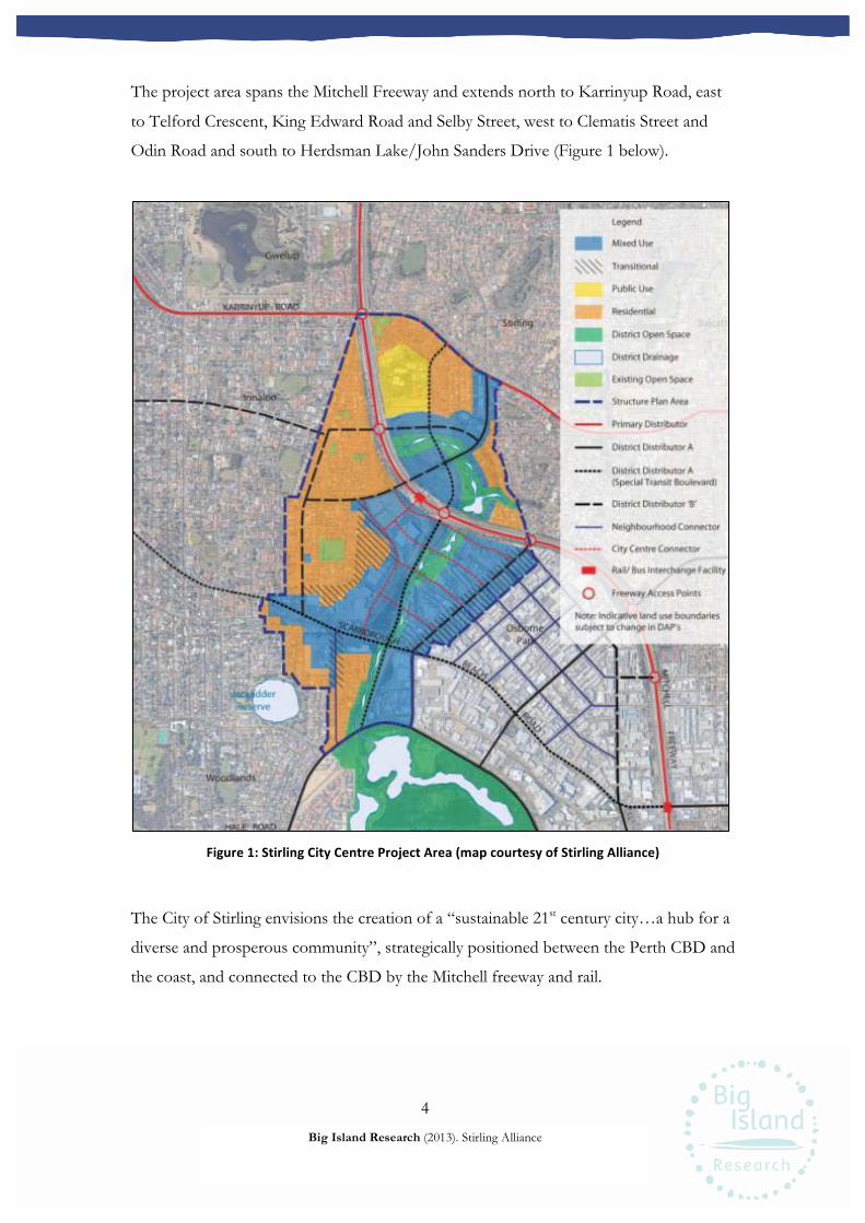
4
Big Island Research (2013). Stirling Alliance
The project area spans the Mitchell Freeway and extends north to Karrinyup Road, east
to Telford Crescent, King Edward Road and Selby Street, west to Clematis Street and
Odin Road and south to Herdsman Lake/John Sanders Drive (Figure 1 below).
Figure 1: Stirling City Centre Project Area (map courtesy of Stirling Alliance)
The City of Stirling envisions the creation of a “sustainable 21st century city…a hub for a
diverse and prosperous community”, strategically positioned between the Perth CBD and
the coast, and connected to the CBD by the Mitchell freeway and rail.
16
Structure Plan Three key structural
elements will shape the future of the Stirling City Centre.
These are:
• open space system • waterway system • transport system

5
Big Island Research (2013). Stirling Alliance
A central element of the development is a “living/urban stream” that will run through
the commercial area and retrace the natural water flow of water that dominated the area
in the past. As noted above, Stirling Alliance wishes to acknowledge the Aboriginal
heritage of the area and highlight this in the context of a modern development. This has
been proposed to be achieved through a variety of methods including place naming, a
heritage trail, various other interpretive or artistic works and the revival of earlier
waterways which will take centre stage in the new city centre. At this stage no timeline
has been established for project commencement and construction.
The project area has been the subject of heritage consultations in the past, conducted in
2011 in relation to drilling that was undertaken to investigate the stream that loops
through the project area towards Herdsman Lake to the south. Aboriginal monitoring
was undertaken at that time during all ground disturbing works. This report was
unavailable to Big Island.
Heritage Framework
Ethnographic Context
The survey area is located within a region that has been, and continues to be, of
particular social, spiritual and economic importance to Aboriginal groups living in and
around the Perth metropolitan area. Present day Perth was once an area of lakes and
swamps that formed a key strategic centre for Nyoongar groups, a gathering place, an
‘administrative’ centre and an important source of food, water and other resources. The
area in and around the City of Stirling was a key part of this network of lakes and
waterways. This has been addressed in the earlier heritage report for the area
commissioned for the project (Czerwinski 2010), and in eleven other heritage reports
that have been conducted in the area and adequately summarised in that report.
Previously Recorded Sites
Five heritage places are listed on the DAA register as being within the project area (Table
1). None of these are Registered Sites. Accordingly, there is no legislative requirement for
the City of Stirling to apply for permission under Section 18 of the Aboriginal Heritage Act
1972 (WA) (AHA) to impact these places.
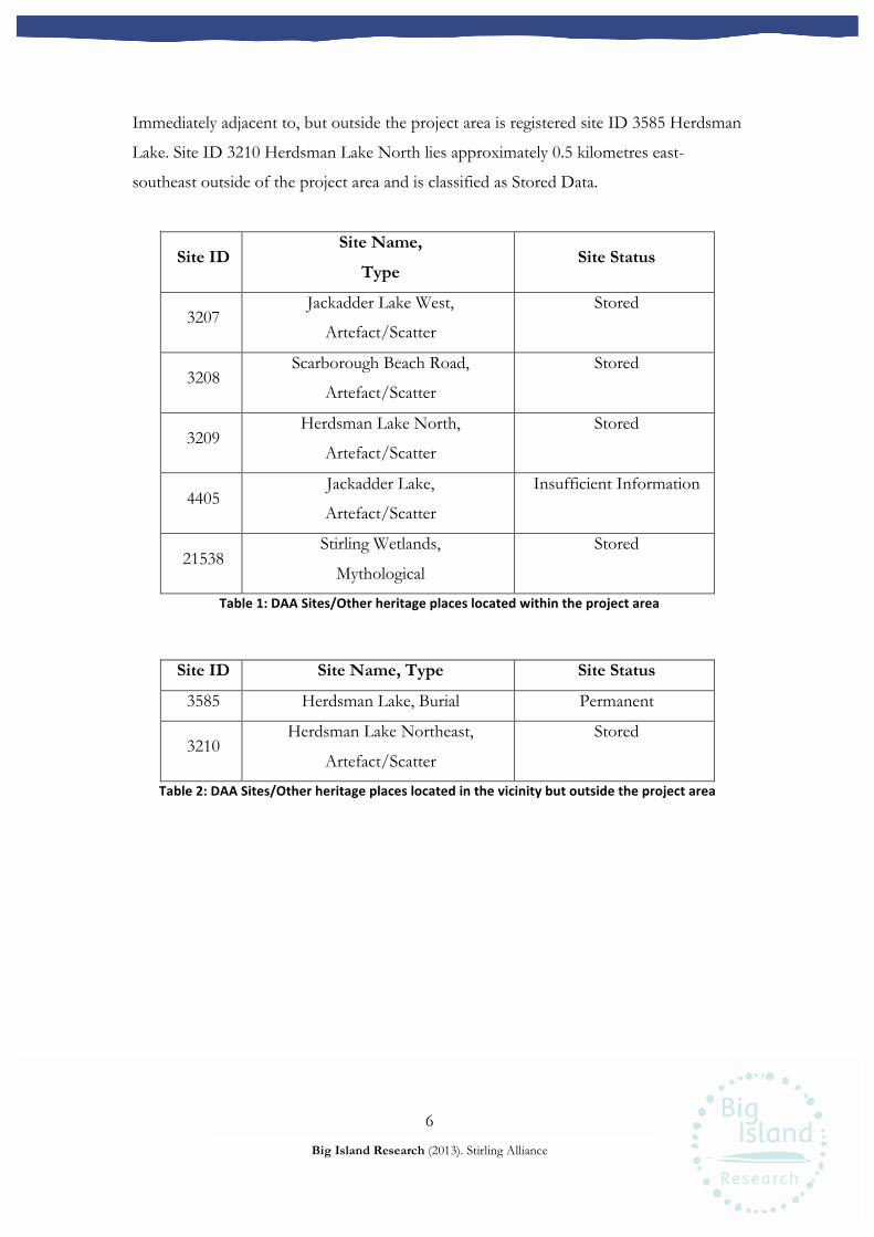
6
Big Island Research (2013). Stirling Alliance
Immediately adjacent to, but outside the project area is registered site ID 3585 Herdsman
Lake. Site ID 3210 Herdsman Lake North lies approximately 0.5 kilometres east-
southeast outside of the project area and is classified as Stored Data.
Site ID Site Name,
Type Site Status
3207 Jackadder Lake West,
Artefact/Scatter
Stored
3208 Scarborough Beach Road,
Artefact/Scatter
Stored
3209 Herdsman Lake North,
Artefact/Scatter
Stored
4405 Jackadder Lake,
Artefact/Scatter
Insufficient Information
21538 Stirling Wetlands,
Mythological
Stored
Table 1: DAA Sites/Other heritage places located within the project area
Site ID Site Name, Type Site Status
3585 Herdsman Lake, Burial Permanent
3210 Herdsman Lake Northeast,
Artefact/Scatter
Stored
Table 2: DAA Sites/Other heritage places located in the vicinity but outside the project area
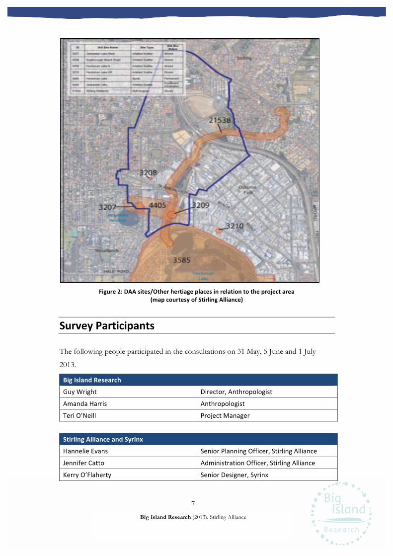
7
Big Island Research (2013). Stirling Alliance
Figure 2: DAA sites/Other hertiage places in relation to the project area
(map courtesy of Stirling Alliance)
Survey Participants
The following people participated in the consultations on 31 May, 5 June and 1 July
2013.
Big Island Research
Guy Wright Director, Anthropologist
Amanda Harris Anthropologist
Teri O’Neill Project Manager
Stirling Alliance and Syrinx
Hannelie Evans Senior Planning Officer, Stirling Alliance
Jennifer Catto Administration Officer, Stirling Alliance
Kerry O’Flaherty Senior Designer, Syrinx
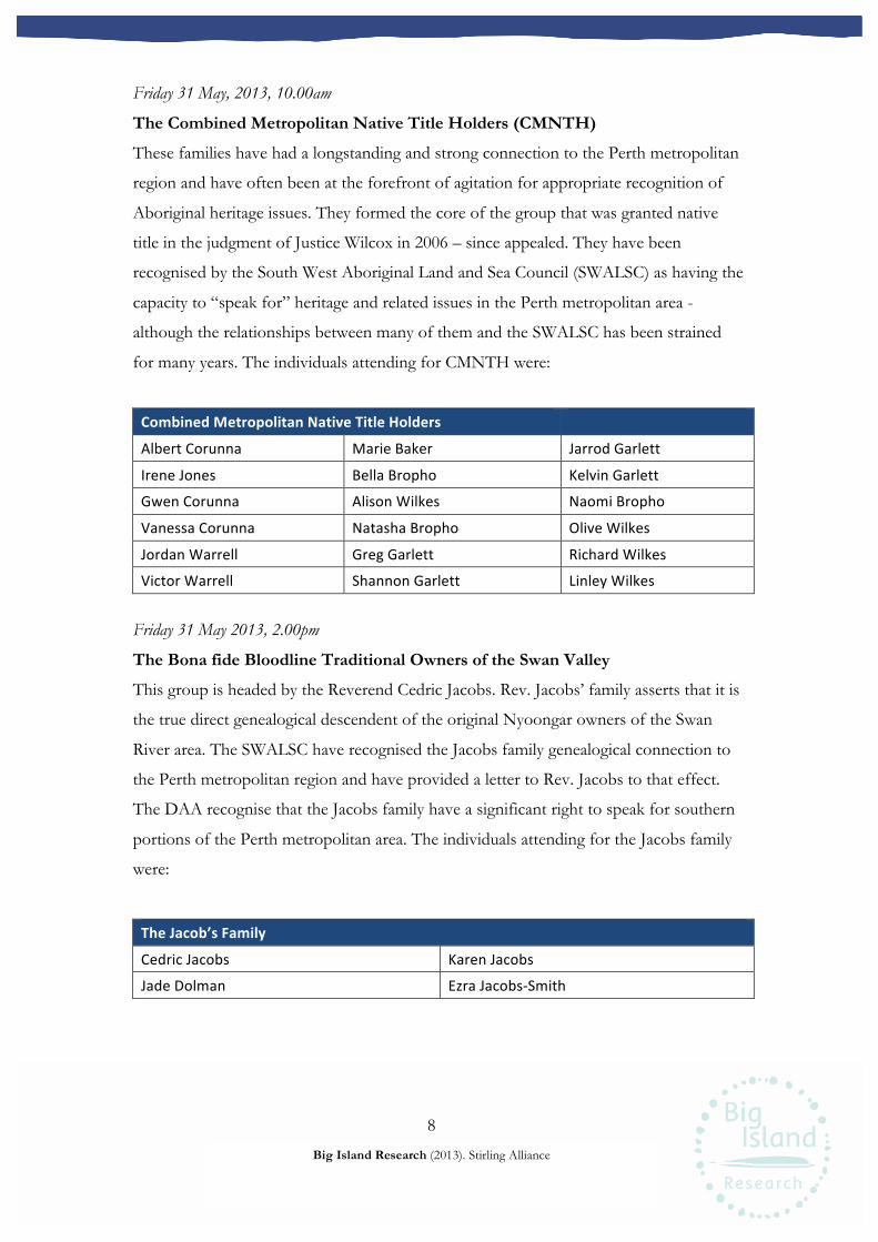
8
Big Island Research (2013). Stirling Alliance
Friday 31 May, 2013, 10.00am
The Combined Metropolitan Native Title Holders (CMNTH)
These families have had a longstanding and strong connection to the Perth metropolitan
region and have often been at the forefront of agitation for appropriate recognition of
Aboriginal heritage issues. They formed the core of the group that was granted native
title in the judgment of Justice Wilcox in 2006 – since appealed. They have been
recognised by the South West Aboriginal Land and Sea Council (SWALSC) as having the
capacity to “speak for” heritage and related issues in the Perth metropolitan area -
although the relationships between many of them and the SWALSC has been strained
for many years. The individuals attending for CMNTH were:
Combined Metropolitan Native Title Holders
Albert Corunna Marie Baker Jarrod Garlett
Irene Jones Bella Bropho Kelvin Garlett
Gwen Corunna Alison Wilkes Naomi Bropho
Vanessa Corunna Natasha Bropho Olive Wilkes
Jordan Warrell Greg Garlett Richard Wilkes
Victor Warrell Shannon Garlett Linley Wilkes Friday 31 May 2013, 2.00pm
The Bona fide Bloodline Traditional Owners of the Swan Valley
This group is headed by the Reverend Cedric Jacobs. Rev. Jacobs’ family asserts that it is
the true direct genealogical descendent of the original Nyoongar owners of the Swan
River area. The SWALSC have recognised the Jacobs family genealogical connection to
the Perth metropolitan region and have provided a letter to Rev. Jacobs to that effect.
The DAA recognise that the Jacobs family have a significant right to speak for southern
portions of the Perth metropolitan area. The individuals attending for the Jacobs family
were:
The Jacob’s Family
Cedric Jacobs Karen Jacobs
Jade Dolman Ezra Jacobs-‐Smith

9
Big Island Research (2013). Stirling Alliance
Wednesday 5 June 2013, 10.00am
The Ballaruks People
This group includes Mr Christopher Robert (Corrie) Bodney. Mr Bodney has been a
prominent figure in Aboriginal heritage matters in the Perth metropolitan area for more
than 30 years and is generally recognised as having significant knowledge of heritage
issues. The individuals attending for this group were:
The Ballaruks People
Corrie Bodney Violet Bodney
Tanya Bodney Stephen Anderson
The Independent Aboriginal Environment Group (IAEG)
This group consists mainly of the Hume family group, headed by Mr Patrick Sullivan
(Sully) Hume. The Hume’s are eligible to be members of the CMNTH group, but choose
not to participate in the process with the other members. Mr Hume is well recognised as
a senior Elder with significant knowledge of the Perth metropolitan region. Similarly, his
family members have had long-term interests in protecting Aboriginal heritage values in
the related area. The individuals attending for the IAEG group were:
The Independent Aboriginal Environment Group
Rebecca Hume Gladys Yarran
Patrick Hume Jocelyn Indich
The Bibulmun Group
The late Mr Ken Colbung headed this group. Mr Colbung did not claim to hold native
title rights in the Perth metropolitan region. However, like Mr Bodney for the Ballaruks
People, he had a long association with heritage issues in Perth and was widely respected
for his knowledge. He was often Chairman of the Aboriginal Cultural Material
Committee (ACMC) during the 1970s-90s. The individuals attending for this group were:
The Bibulmun Group
Esandra Colbung Melanie King
Lalita Colbung Gillian King

10
Big Island Research (2013). Stirling Alliance
Monday 1 July 2013, 10.00am and 1.00pm
An Aboriginal heritage survey was run concurrently with the ethnographic consultations
on 1 July, and will be reported on by AHMS separately. However, this survey provided
Big Island a further opportunity to engage with Nyoongar people, particularly South
West Aboriginal Land and Sea Council (SWALSC) nominees, and record their
aspirations of how Aboriginal cultural heritage may be incorporated into Stirling
Alliance’s development.
South West Aboriginal Land and Sea Council
Independently of the consultations with the above groups, the SWALSC typically
nominates four people who are thought eligible to assert native title primarily because of
their genealogical connection to the Perth area. A larger list of potential participants for
this heritage survey was determined at a Native Title Working Party meeting and
supplied to AHMS who organised the survey. A number of these people were contacted
by AHMS and were available to attend on short notice. Note that there is some overlap
in those people nominated to attend the heritage survey and those who were present at
the previous ethnographic consultation sessions. Those who attended the survey were:
Morning Session
Rebecca Hume Patrick Hume
Gladys Yarran Noel Morich
Russell Gidgup Ronald Gidgup Snr
May Maguire Glenys Yarran
Afternoon Session
Albert Corunna Vanessa Corunna
Greg Garlett was also invited to this meeting but did not arrive.
Ethnographic Survey
Survey Method
Anthropologists Dr Guy Wright and Dr Amanda Harris, and Project Manager Teri
O’Neill of Big Island met with relevant Nyoongar groups at the Herdsman Lake Wildlife
11
Big Island Research (2013). Stirling Alliance
Centre on 31 May and 5 June 2013. While not in the project area per se, participants felt
familiar with the area and appreciated the venue and the presentation provided by the
Stirling Alliance.
Dr Amanda Harris and Dr Carina Hemmers of Big Island met with nominees from the
SWALSC and staff from AHMS at the project area on 1 July 2013 to undertake the
heritage survey.
Personnel from the Stirling Alliance and Syrinx were also present during these sessions.
At each session Dr Wright or Dr Harris provided an overview of the project and
introduced representatives from Stirling Alliance and Syrinx. Ms Hannelie Evans, Senior
Planning Officer with the Stirling Alliance, provided groups with a PowerPoint
presentation that outlined the proposed development, the history of the area and
previous research and heritage surveys relevant to the development. Groups were
provided with printed copies of the presentation, including maps, schematic diagrams
and Aboriginal heritage information. Ms Evans explained to the groups that Stirling
Alliance wished to represent Nyoongar history and culture in the new development
through interpretive material and a heritage trail. Thus, these meetings were an
opportunity to begin the “place making process” by considering the stories, experiences
and past events that people felt were important and were comfortable sharing.
It was explained to meeting participants that the Stirling Alliance also planned to
undertake an archaeological and heritage assessment of the Structure Plan Area to re-
record and verify the location of previously recorded sites and identify any previously
unrecorded Aboriginal sites (this was completed as the heritage survey on 1 July 2013).
When Nyoongar participants were satisfied with the discussions held with representatives
of the Stirling Alliance and Syrinx, the latter moved to a separate room so a private
discussion could continue between the anthropologists and Nyoongar participants. The
position and views of each group were discussed further and clarified before Stirling
Alliance and Syrinx representatives were invited back. Any further questions were then
answered and the views of each group on the development were summarised.
12
Big Island Research (2013). Stirling Alliance
Results
Substantial cultural, historic and environmental knowledge of the project area and
surrounding region, as well as a strong sense of connection to place was demonstrated by
the Nyoongar participants. Several families spoke about living in the area as children,
working on the roads, collecting peat, and gathering in the old Nookenburra Hotel along
Scarborough Beach Road. It was apparent that the project area was and continues to be a
culturally important place to Nyoongar people. As has been discussed elsewhere (e.g.
McDonald 2005, O’Connor et al. 1989), the area was part of a key wetland and resource
area that has since been devastated by development. Nearby Herdsman Lake was also
said to be a site of a massacre of Aboriginal people by European settlers in the 1800’s.
The key heritage concerns and stories of the groups relating to the project area are
summarised below. These represent issues that Nyoongar consultants wish to have
addressed as part of the Stirling City Centre development.
A massacre
Mr Albert Corunna spoke of a massacre by the 63rd regiment that occurred at Herdsman
Lake. He described how people hid in the reeds and how one man climbed into the trees
and yelled at the soldiers to “go away, we have women and children here!”. Mr Victor
Warrell suggested a plaque should be installed in a visible place acknowledging the
massacre. Nyoongar consultants said this one was just one of a number of “massacres”
that occurred before and after the Pinjarra Massacre.
Investigations into this event have found that the violence seems to have actually
occurred at nearby Lake Monger, on May 3, 1830 (see Appendix One for the Western
Mail article (dated 9 January 1914) on the event). However, further research is
recommended.
A key resource area for past Nyoongar groups
Mr Richard Wilkes described the area around Herdsman Lake and north into the project
area as akin to a “supermarket”: a source of water and other resources, including water
fowl, turtles and crustaceans. Ms Bella Bropho spoke of how her ancestors fished and
camped in the area. Both accounts underlined the importance of the area as a key

13
Big Island Research (2013). Stirling Alliance
meeting place for Nyoongar people around Perth. The group described the impact of
development that had already occurred in the area as “wilful damage”. They shared a
strong sense of loss over what they saw as the desecration of the country.
Nyoongar patterns of land use and movement
Nyoongar consultants requested that any interpretive works convey the way that
Nyoongar people moved through the land in a manner that bears no relation to
boundaries and divisions that are imposed on the country by Europeans. As stated by Ms
Rebecca Hume, “We want people to look at the country without whitefella boundaries”.
It was felt that recognition be given to ‘all the different Aboriginal groups that moved
through this place’.
Nyoongar place names
The groups asked that Nyoongar names are used throughout the development in
acknowledgment of the strong Nyoongar heritage in the area. The Nyoongar name of
Herdsman Lake was discussed – Nookenburra - meaning “sweet water”. Recognition of
this original name would be appreciated.
Nyoongar cultural heritage trail
The groups were pleased to hear of possible plans for a heritage trail through the
development. They saw this as an opportunity to ensure continuity between Nyoongar
interpretive works across Perth from Herdsman Lake and Lake Monger to Kings Park,
the proposed memorial to Midgegooroo, Elizabeth Quay and further up the Swan River.
Mr Richard Wilkes commented on the work done by the City of Swan in developing a
heritage trail and suggested it presented a good model.
Reference was made to statues that had been installed in Maylands commemorating
Nyoongar heritage. Several participants requested the commission of artworks of a
similar standard in the new Stirling City Centre development.
Ms Gladys Yarran asked that Nyoongar people be described in interpretive works as
“hunters and gatherers” and “first nation people”, rather than “Aboriginal”.

14
Big Island Research (2013). Stirling Alliance
It was important to participants that Stirling Alliance develop a pamphlet on Nyoongar
cultural heritage. Reference was made to the pamphlet developed by Perth Airport which
has been well received. Ms Rebecca Hume suggested that it include a picture of a
Nyoongar hand holding a quartz artefact.
Mr Victor Warrell commented on the lack of representation in the Stirling Alliance
‘screen savers’ that appeared throughout the consultations during discussion sessions.
Concerns were raised relating to there being no Aboriginal people in the displays despite
their claims of “community” and “diversity”. It was requested that such public
documents be reviewed and future presentations include Aboriginal people and culture.
Yellagonga’s country
Mr Corrie Bodney reminded all that this would have been part of Yellagonga’s country
and this should be acknowledged in interpretive works in the development. Yellagonga
was a renowned leader of the Mooro people, or “King of Perth” as suggested by Mr
Noel Morrich.
It was also suggested that reference could also be made to one of Yellagonga’s
grandsons, Tommy Dower, who was a well respected Aboriginal tracker, leader of the
Perth Aboriginal community and advocate for Aboriginal rights (Bolton & Gregory
1999; http://www.valuingheritage.com.au/SwanRiverColony).
A history of being “pushed out” from the area
All groups consulted spoke about their ongoing experience of being progressively
displaced from Perth, including the project area, once a foremost location within
Nyoongar society. Mr Richard Wilkes said, “We could afford to live there then but not
now. Development pushes us out. We’ve become poor . . . We need to be part of the
development and develop with it . . . regain some status and have the chance to compete
in the workforce. We’ve never ceded the land, as far as we’re concerned we still own it.”
The experience of being “pushed out” due to Aboriginality resonated with people’s
experiences in the Perth CBD that has emerged during other significant consultations for
the developments in the region.

15
Big Island Research (2013). Stirling Alliance
Ms Vanessa Corunna spoke of the loss of Aboriginal organisations and resources as
homes in the area were “taken over by non-Indigenous people”. It was suggested that a
counter to this experience could be found in the adoption of Welcome to Country
ceremonies by Nyoongar people by the City of Stirling. The positive experience of this
practice by Nyoongar consultants in the Town of Bassendean was relayed.
Meaningful Nyoongar involvement and responsibility in the project
Groups requested that a Steering Group or Committee be established to formalise
ongoing Nyoongar involvement in the development. The Jacobs family specifically asked
to be included in any technical and environmental design decisions.
Mr Victor Warrell and Mr Greg Garlett spoke of their shared frustration at being
brought into the design process after a substantial number of decisions have already been
made. They argued that the overall conceptual design is culturally relevant and aspirations
for the area held by Nyoongar people in regards to this are overlooked.
Mr Warrell questioned the “core values” in the presentation and argued that these did
not reflect values common to Nyoongar people. Nyoongar people premise these views
on an understanding that the country remains theirs, that it was never ceded and that
they are forced to live within a socio-cultural world that is overly determined by people
of European decent. Thus, inclusion of Aboriginal people in the consultation process at
even this relatively early stage underscores their sense of disempowerment and social
marginalisation.
Nyoongar consultants also asked for employment opportunities. They requested
opportunities in the construction of the development but more so within the City of
Stirling itself. Ms Rebecca Hume spoke on behalf of many families in arguing they
demonstrate some “goodwill” and ensure Nyoongar representation on relevant
committees, and within its staff.
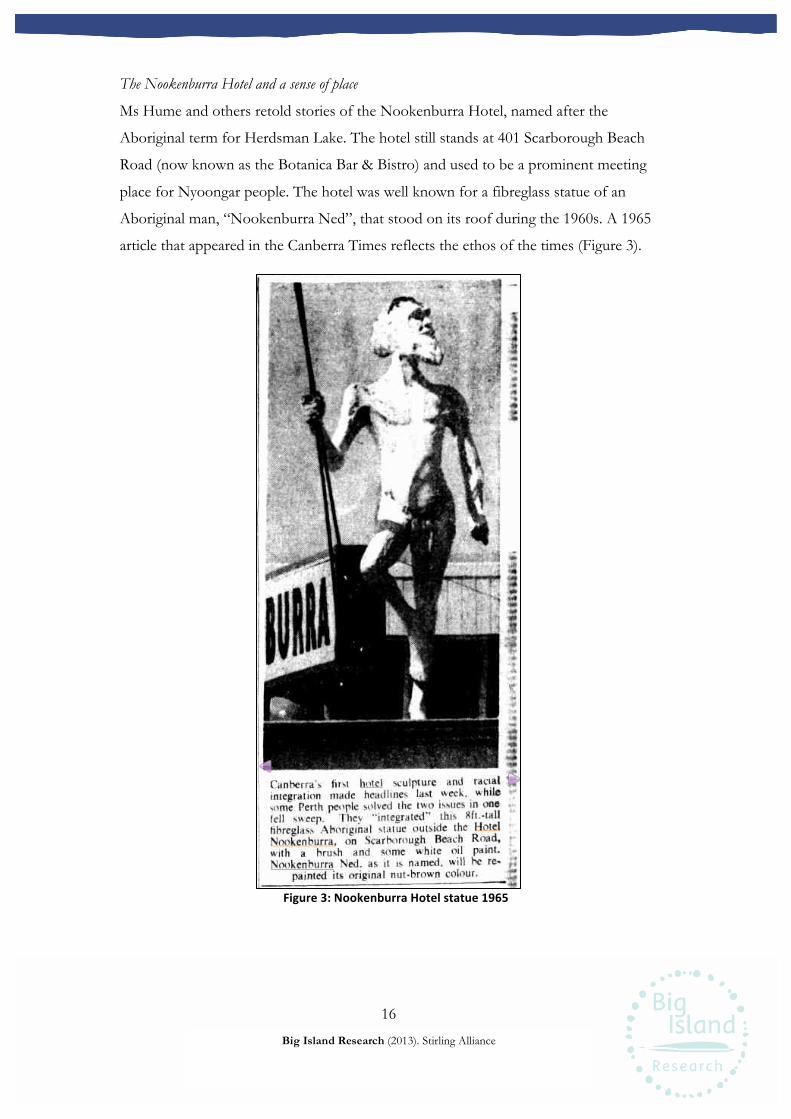
16
Big Island Research (2013). Stirling Alliance
The Nookenburra Hotel and a sense of place
Ms Hume and others retold stories of the Nookenburra Hotel, named after the
Aboriginal term for Herdsman Lake. The hotel still stands at 401 Scarborough Beach
Road (now known as the Botanica Bar & Bistro) and used to be a prominent meeting
place for Nyoongar people. The hotel was well known for a fibreglass statue of an
Aboriginal man, “Nookenburra Ned”, that stood on its roof during the 1960s. A 1965
article that appeared in the Canberra Times reflects the ethos of the times (Figure 3).
Figure 3: Nookenburra Hotel statue 1965
17
Big Island Research (2013). Stirling Alliance
Ms Hume also spoke of collecting nearby peat that was stored, smoke emerging, in the
stables located beside the hotel when she was sixteen. Around the hotel “all the rest was
bush, and water would run underneath,” she said. Several families recalled the old road
layout before the construction of Scarborough Beach Road and many days spent
labouring on them by hand, shovel and horse.
A mourning place
Consultants posed the question of a dedicated meeting place for Nyoongar people as
part of the new City of Stirling development. In particular, they would like such a place
to use for mourning members of their community that have passed away. Many
participants questioned why they have to rent halls for mourning purposes and believe
that they should have their own dedicated mourning place.
Environment
The Jacobs family in particular expressed concerns about the impact of the development
on the environment. However, the extensive disturbance to the project area that has
already occurred was noted. Mr Ezra Jacobs-Smith wished to see priority given to the
“flow of water over the flow of traffic” and any natural interconnectivity between water
bodies retained or restored. While plans to enhance waterways in the development were
welcomed, the family said they would prefer to see the creek running through the project
area and into Herdsman Lake, sometimes known as Jackadder Creek, widened and
surrounded by parkland. They suggested that the road planned for beside the creek could
be relocated further east to run through Osborne Park. Mr Jacobs-Smith also stated that
no further pollution should enter the creek and inquired about plans for contamination
testing before and after construction. Maintaining the purity of the water, both above
and below ground were important to the Jacobs family. Ms Evans from the Stirling
Alliance explained that the quality of the water in the stream is continuously monitored
and as part of the Stirling City Centre development measures would be introduced on-
site to improve the water quality. However, this is still in the early stages of development
and no details were available at the time.
It has since been communicated to Nyoongar consultants that the water flowing down
the creek does not enter Herdsman Lake but is directed into the sea through a system of

18
Big Island Research (2013). Stirling Alliance
storm water drains that was established in the 1920s, known as the Nookenburra
Drainage system. In addition, no changes to this drainage system are planned for the
development. The existing stream is fed by a combination of surface water drainage and
ground water. As could be seen at the site, there are a number of storm water drain
outlets opening into the stream. These form part of the network of pipes known as the
Nookenburra Drainage system. Ms Evans provided (via Big Island) interested
consultants with details on this system.
Mr Jacobs-Smith asked about the Stirling Alliance’s plans for environmental remediation,
including revegetation of drains. He suggested that proper planting of native flora along
Jackadder Creek could render the creek a natural filtration system. Rev. Cedric Jacobs
said he would like to see a return to native flora in areas throughout the development,
reflective of the past environment.
Ms Karen Jacobs raised concerns about the removal of peat from the areas north of the
freeway and the risk of subterranean gases being released during ground disturbing
works. Ms Jacobs said she would like to see the wetlands that once existed there re-
established and expressed sadness that Ikea now sits on part of that former wetland
system.
The Jacobs family suggested some restoration of a river/creek that they believe to run
under Scarborough Beach be undertaken.
Mr Ron Gidgup and Mr Patrick Hume spoke of the destruction of habitat that previously
supported native fauna. They said they would like to see the development incorporate
planting of native species along green corridors and spaces.
All of the Nyoongar groups consulted recommended that the restoration of the natural
environment is not just environmental, but an important reflection of a Nyoongar
traditional way of life and cultural heritage.
19
Big Island Research (2013). Stirling Alliance
General Conclusions
A range of fairly clear cut modalities for the recognition of Nyoongar cultural heritage
emerged through the consultations. Several of these – a pamphlet, heritage trail,
Nyoongar place names, art work and statue – received immediate support from Stirling
Alliance representatives. Other suggestions will require further consideration and
discussion. Palpable among all groups was an overriding sense of loss – of ownership,
habitat, culture, status, agency and belonging – and these consultations have been a
valuable step in redressing this shared experience.
Groups appreciated the exchange offered by the Stirling Alliance, albeit they felt this was
at a later stage in the design of the development than they would have preferred, and
look forward to further positive and productive consultations. They asked that all
heritage interpretive works draw on detailed research, including face to face interviews
with knowledgeable Elders, to ensure that works are accurate, and capture the particular
spirit of this country and its people. Moreover, they remain hopeful that the absence of
any recognition of Nyoongar people in the general vicinity of the City of Stirling will
soon be relegated to the past.
Recommendations
Big Island Research Pty Ltd recommends:
1. The Stirling City Centre Alliance engage further with the Nyoongar community for
the purpose of progressing the representation of Nyoongar heritage in the proposed
Stirling City Centre development.
20
Big Island Research (2013). Stirling Alliance
References
Bolton, G. and Gregory, J. Claremont: a history, UWA Press, Nedlands 1999, pp.i-xi, 1-
244
Czerwinski, 2010. Preliminary Investigation of Aboriginal Heritage – City of Stirling
Structure Plan, Prepared by ACHM for the Stirling Alliance, February 2010
O’Connor, R., Quartermaine, G. and Bodney, C. 1989 Report on an Investigation on to
Aboriginal Significance of Wetlands and Rivers in the Perth‐Bunbury Region. Report
prepared for the Western Australian Water Resources Council
McDonald, E. 2005 Study of Groundwater ‐ Related Aboriginal Cultural Values on the
Gnangara Mound, Western Australia. Report prepared for Estill Associates

21
Big Island Research (2013). Stirling Alliance
Appendix One The following article can be found at,
http://trove.nla.gov.au/ndp/del/article/44879885?searchTerm=troops%20first%20figh
t%20with%20natives&searchLimits= , (viewed 23 July 2013).
Western Mail (Perth, WA : 1885 - 1954), Friday 9 January 1914, page 38
National Library of Australia http://nla.gov.au/nla.news-article44879885
A BATTLE HEAft PERTH.I
TROOPS FIRST FIGHT WITH NATIVES.
AN INCIDENT OF EARLY WESTERNAUSTRALIAN HISTORY.
(By B.C.)
The initial circumstances of the earlysettlers in Western Australia, potentiallyrich though they might be, were of such a
nature as to bring upon them all the tribula-tions and trials generally associated withpioneering efforts. handing at Fremantleunder dangerous conditions in the middleof a more toan ordinarily inclement winter in
the year 1829, without adequate shelter,
and with only the rudest material at handto construct the same, their position was
indeed unenviable. However, all the disa-bilities were borne with that spirit and for-
titude which has made the British race thepioneers of exploration through centures oftime.
1
During September of the year mentioned,I
the civil .establishment was removed fr^m| Fremantle to the site of Perth, and the lat-
ter city had its genesis in this early encamp-ment of the settlers.
j One of the gravest difficulties of pioneer-ing, the adverse and militant attitude of the
I
existent aboriginal population, had beenI
however, absent from their many trials, tot
the greatest amity and goodwill had up roithe present prevailed. But the policy ofindiscriminate charity and kindness whichhad charactrised the actions of the admrnstration in their dealings with the natives was
to have, owing to shortage of commodities, a
very undesirable result.
The attitude of the settlers towards tbe
aboriginal population, prompted as it was
by kindness, from which the fear of other-wise hostile action on thc part of the nativeswas not altogether absent, had turned theaborigines into a horde of lazy "cadgers."The kindness of the whites was no doubtgreatly appreciated by the original inhabi-tants, but when it became impossible to con-tinue the gifts, the persistent beggar be-came an equally persistent thief. Cut ott
from what they considered to be, by reason
of general practice, their undoubted rights,
the natives began to show a turbulent dis-
position in place of their quiet inoffensive
manners, and to take by force what was
now denied to them- Eventually the situa-
tion culminated in a strongly hostile demon-stration by the aborigines, which needed a
strong display of force to quell
Early on the morning of May 3, 1830, thenatives visited the cantonment of the mili'
tary in Perth. The body, which was accom-
panied by a large number of women andchildren, formed only one portion of thevisitors, as another and still larger body was
found to be following the bank of the SwanRiver towards Mt. Eliza. Both partiesware strongly armed in the native fashion,and the whole displayed a truculent disposi-
tion never before exhibited. The partythat visited the tt>
that visited the military camp appeared tt>
be absolutely bent upon plunder and mis-chief, and showed a determination to
destroy any property and goods they were
prevented from carrying away. The otherportion also were guilty of many small acts
of plunder, and the alarm of the settlersat' these many overt acts on the part of a
hitherto inoffensive aboriginal populationcan be imagined. Until now their depreda-tions had been of the "sneak thief" order,and occasioned more annoyance than harm,and this present attitude had been unheardof before. Then again it was ascertained thatthe leaders of what was how uncommonlylike a raid were wild aborigines and unknownto any of the white population, and thcalarm was thereby increased. In their pre-vious visits to the military camp, where a
kindly welcome had always been extended,they had displayed a very inoffensive anlharmless demeanour, any thefts they com-
tnitted being of a very petty nature, butseveral - attempts were now made to spearand carry off the live stock, and only a de-
termined display of force prevented them:
from executing their design.With absolute effrontery they forced them-;
selves jato, the huts of the men, and in seve-
ral cases could not be persuaded to retire,
which Sed to their forcible ejection hy the
angry soldiers, and a generally hostile and ir-
ri tated feeling was the outcome of their visit.
The action of the soldiery in forcibly eject-
ing them from the camp nearly precipitatedan action at this stage, but the natives were
]
eventually persuaded to retire without anj
open breach being made.During the morning the feeling of alarm
increased, and the military force was placedin a stnte of readiness should further andmore serious action be rendered necessary.
|
The Lieutenant-Governor, Captain Jamesj
Stirling, was absent on an exploring expedí-¡tion at Port Leschenault, and the responsi-
j
bilit" of dealing with the serious positiondevolved on Major Irwin, the officer com-
mending the troops. About ll a.m. the,
body of natives, which had now joined,forces, visited the workshop of Mr. Trigg,,and caused a considerable amount of annoy-ance not unmingled with alarm. The atti*
j
tude of the leaders at last became so
threatening that Mr. Trigg produced his1
gun, and it was only by plain intimationthat unless they withdrew action would fol-i
low that they were induced to retire. Con-tinuing their journey towards Mt Eliza, thenow augmented body of aborigines, still dis-
playing their truculent attitude, no
doubt helped by the visible alarm
they were plainly causing visited the boat-shed of Mr. Edwards, where they again out-lined their determination to provoke a con-
flict. Any attempt to proceed with theusual routine of work was impossible,everything movable was seized upon, all
small tools being immediately used for hairornaments, pieces of wroupTit iron beingtaken, and a boat then on thc stocks TOiighlv overturned and greatly damaged. WhenEdwards attempted to remonstrate with theleaders he was threatened with the poised
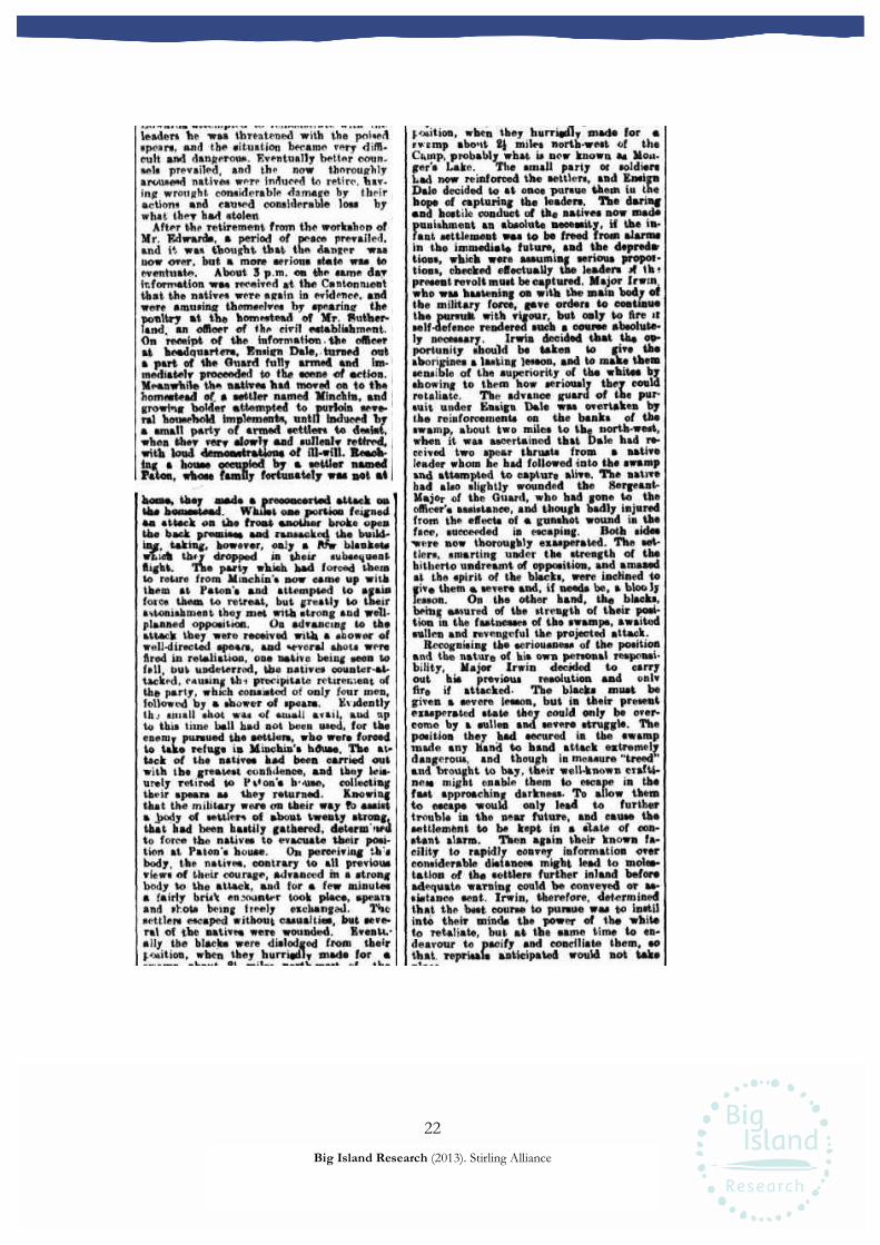
22
Big Island Research (2013). Stirling Alliance
leaders he was threatened with the poisedspears, and the situation became very .diffi-
cult and dangerous. Eventually better coun-
sels prevailed, and the now thoroughlyarousesd natives were induced to retire, hav-ing wrought considerable damage by theiractions and caused considerable loss bywhat they had stolen.After the retirement from the workshop of
Mr. Edwards, .a period of peace prevailed,and it was thought that the danger -was
noar over, but a more:serious state was toeventuate. About 3 p.m. on tibe esme dayInformation -was received at the Cantonmentthat the natives were again in evidence,, andwere amusing themselves by spearing theponttry at the homestead of Mr. Suther-land, an officer of the civil establishment..On receipt of the information. the officerat headquarters, Ensign Dale,.turned outa part of the Guard fully armed and immediately proceeded to the scene of action,Meanwhile the natives had moved on to thehomestead of. a settler named Minchin, and
j
growing bolder attempted to purloin seve-1ral household implements, until induced hya small party of armed settlers to desist,when they very slowly and sullenly retired,
j
with loud demonstrations of ill-will. Beach- j
lng a house occupied .hy a settler namedPaton, whose family fortunately was not at
j
hom», they made a. preconcerted attack osthe homestead. Whilst ons portion feignedan attack on the front another broke openthe back premise» and ransacked the build-ing, taking, hoverer, only a ft?w blanketswnich they dropped in their subsequentflight. The party which had forced themto retire from Minchin's now came up withthem at Paton's and attempted to againforce them tc retreat, but greatly to theirastonishment they met with strong and wellplanned opposition. On advancing to theattach they were received with a shower cfwell-directed spears, and several shots werefired in retaliation, one native being seen tofall, but undeterred, the natives counter-at-tacked, causing th-) precipitate retirement ofthè party, which consisted of only four men,followed by a shower of spears. Evidentlyth j small shot was of email avail, and upto this time ball had not been used, for theenemy pursued the settlers, who were forcedto take refuge in Minchin's house. The at-
tack of the natives had been carried outwith the greatest confidence, and they leis-
urely retired to Piton's b'<use, collectingtheir spears as they returned. Knowingthat the military were on their way to assista body of settlers of about twenty strong,that had been hastily gathered, determ uedto force the natives to evacuate their posi-tion at Paton's house. On perceiving th'sbody, the natives, contrary to all previousviews of their courage, advanced tn a strongbody to the attack, and for a few minutesa fairly brisk encounter took place, spearsand shots being freely exchanged. Thesettlers escaped without casualties, but seve-ral of the natives were wounded. Eventvally the blacks were dislodged from theirposition, when they hurriedly made for a
position, when they hurriedly made for a
swsmp about 2£ miles north-west of theCump, probably what is now known as Mon-ger's Lake. The small party or soldiers
had now reinforced the settlers, and EnsignDale decided to at once pursue them iu thehope of capturing the leaders. The daringend hostile conduct of the natives now madspunishment an absolute necessity, if the in-
fant settlement was to be freed from alarmsin tho immediate future, and the depreda-tions, which were assuming serious propoitions, checked effectually the leaders if th;present revolt must be captured. Major Irwin,who was hastening on with the main body ofthe military force, gave orders to continuethe pursuit with vigour, but only to fire it
self-defence rendered such a course absolute-ly necessary. Irwin decided that the op-portunity should be taken to give theaborigines a lasting lesson, and to make themsensible .of the superiority of the whites byshowing to them how seriously they couldretaliate. The advance guard of the pur-suit under Ensign Dale was overtaken bythe reinforcements on the banks of theswamp, about two miles to the north-west,when it was ascertained that Dale had re-
ceived two spear thrusts from a nativeleader whom he had followed into the swampand attempted to capture alive. The nativehad also slightly wounded the SergeantMa j or of the Guard, who had gone to theofficer's assistance, and though badly injuredfrom the effects of a gunshot wound in theface, succeeded in escaping. Both sides?were now thoroughly exasperated. The set-tlers, smarting under the strength of thehitherto undreamt of opposition, and amazedat the spirit of the blacks, were inclined iogive them a severe and, if needs be, a Woo Jylesson. On the other hand, the blacks,being assured of the strength of their posi-
tion in the fastnesses of tho swamps, awaitedsullen and revengeful the projected attack.
Recognising the seriousness of the positionand the nature of his own personal responsi-bility,
_
Major Irwin decided to carryout his previous resolution and onlvfire if attacked. The blacks must begiven a severe lesson, but in their presentexasperated 6tate they could only' be over-
come by a sullen and severe struggle. Theposition they had secured in the swampmade any hand to hand attack extremelydangerous, and though in measure "treedand brought to bay, their well-known crafti-
ness might enable them to escape in thefast approaching darkness. To allow themto escape would only lead to furthertrouble in the near future, and cause thesettlement to be kept in a state of con-
stant alarm. Then again their known fa-cility to rapidly convey information over
considerable distances might lead to moles-tation of the settlers further inland beforeadequate warning could he conveyed or as-
sistance sent. Irwin, therefore, determinedthat the best course to pursue was to instil
into their minds the power of the whiteto retaliate, but at the same time to en-
deavour to pacify and conciliate them, so
that, reprisals anticipated would not take

23
Big Island Research (2013). Stirling Alliance
that, reprisals anticipated would not takeplace.
- The combined forces of the settlers and
the military, for every man who possessed
arms had turned out, were divided yoho
two parties. One party was placed underthe command of Mr. Dale, whose wounds-frere not so severe as to incapacitate himirom further action, and Major Irwin re-
tained command of\tho other portion.Dale's command made a detour and movedto the northward of the lagoon, so as to
place the blacks between two fires. On as-
suming position, Dale's party were prompt-ly attacked by the natives, who now re-
cognised their precarious position, as it
waa possible for the attack to advance and
practically "rake" the lagoon with fire. The
.attack of the natives on the portion of the
force commanded hy Dale was not alto-
gether -unsuccessful, for they succeeded in i
severely wounding the senior non-commis-sioned officer. The party retaliated and
opened fire on the natives concealed in thescrub, which formed no protection from
j
bullets. Groans were heard proceeding|
from the swamp, and it was soon made j
manifest thatsevcral natives had been severe-j
ly wounded. On the outbreak of fire Majorj
Irwin hastened to the spot, being greatly
concerned that his hopes for conciliation
were now at an end, and it would be ne-
cessary to attack the concealed enemy with
his full strength. This action he was ex-
tremely reluctant to take, as it was cer-
tain that the natives had been accompaniedby a number of women and children, who,though, no doubt, concerned in the pilfer-
ing, could not be held responsible for the
acts of violence during the day.The natives now evinced a desire to parley,
on which Irwin advanced- unattended to the
edge of the swamp, and endeavoured to getthem to. surrender* or at least deliver up
their leaders. To these requests the natives
declined to accede, and the officer withdrew.Darkness had now fallen, and patrols were
told off to completely surround the lagoons
and prevent, if possible, any movement dur-
ing the hight. Fer a considerable time voices
were heard in the lagoon, hut in a whilesilence reigned. Yet the patrols had not re-
ported any movement cn the patt of theblacks. At daybreak next morning the com-
mander of the troops endeavoured to get into
communication with the blacks and, if pos-sible, re-establish friendly feelings, when it
was found that the lagoon was practically
deserted by the enemy.The military cordon had reported no move-
ment during the hours of darkness, hut tbathick soruh made the matter of reconnaisance.
very difficult. In a little while, however, the[
patrol* to the eastward reported that the
enemy were in the act of crossing the riverat what is now the Causeway, having clodedthe vigilance of the reconnoitring parties,travelling, no doubt, along the chainof swamps which than extend«! to what is
now Bast Perth. Cfc agi ned" that the blackshad escaped, but still considering that bytheir stealthy retreat they had shown tb it
retreat they had tb it
a salutary lesson had been given. Major Ir-
win withdrew the troops and returned to thecantonment. A patrol at East Perth sur-
prised a party' of three natives and broughtthem as prisoners into camp, when they were
questioned on the result of the action of theprevious day. The Commandant was assuredthat several native* bad fallen in the attackby Dale's party on the swamp, and to set hisown doubts at rest; the prisoner«, understrong guard were taken to the scene of theencounter, but nothing was found to provetheir statement. The groans of the wound-ed, however, had been laearâ during th»night, so it was inferred that those who fell
had been carried off by tho enemy duringtheir stealthy retreat.
During the day a party of natives visited
tho cantonment and made overtures of amityand friendship, which were accepted. How-ever, it was deemed expédient for a few daysto keep a strong guard under arms to rapid-ly deal with any contingency which mightarise.
The result of the action was certainly in* -
conclusive, but the blacks gathered fromthe attack of the previous day that thewhites could not be molested with impunity.No reprisals took place, and the settlementsoon returned to its wonted attitude-ofpeaceful industry.However, the desire of Major Irwin to pre-
vent retaliation was nbt entirely successful,
though no fuither trouble was encountoradfor some time in the immediate vicinity ofPerth end Fremantle. Unfortunately, to thisencounter, on the other hand, could be tracedthe beginnings of those long year* of troublewith the natives, where isolated settlers were
murdered under disti easing circumstances.These acts of aggression however, were-innearly all cases prompted by a spirit of re-
taliation for injuries, either fancied or real.

ETHNOGRAPHIC HERITAGE SURVEY REPORT Metropolitan Area Indigenous Groups Stirling City Centre Development, City of Stirling Prepared for Stirling City Centre Alliance Guy Wright PhD, Amanda Harris PhD, Carina Hemmers PhD and Teri O’Neill BA
1 July 2013

1
Big Island Research (2013). Stirling Alliance Ethnographic Heritage Survey.
Ownership of Information
This report has been prepared for submission to the Stirling City Centre Alliance via
Archaeological and Heritage Management Solutions. Any cultural information contained
within the report is the property of the people who provided the information. This
report and the information it contains may not be copied in whole or part without
written consent of the Stirling City Centre Alliance and Big Island Research Pty Ltd.
Report Authors
Written by Guy Wright PhD, Amanda Harris PhD and Carina Hemmers PhD
and Teri O’Neill BA
Disclaimer
Big Island Research Pty Ltd is not responsible for omissions and inconsistencies that
may result from information not available at the time this report was prepared.
2
Big Island Research (2013). Stirling Alliance Ethnographic Heritage Survey.
Contents Introduction ............................................................................................................................................. 3 Survey Participants ................................................................................................................................... 4 Ethnographic Survey ................................................................................................................................ 5
Survey Method ........................................................................................................................... 5 Results ........................................................................................................................................ 6
Recommendations ................................................................................................................................... 6 References ................................................................................................................................................ 7 Appendix 1 – Site Definitions ................................................................................................................... 7
Abbreviations
AHA Aboriginal Heritage Act 1972 (WA)
AHMS Archaeological and Heritage Management Solutions
Big Island Big Island Research Pty Ltd
DAA Western Australian Department of Aboriginal Affairs
Stirling Alliance Stirling City Centre Alliance (a Public Private Community
Partnership)
3
Big Island Research (2013). Stirling Alliance Ethnographic Heritage Survey.
Introduction
Big Island Research Pty Ltd (Big Island) was commissioned by the Stirling City Centre
Alliance (Stirling Alliance) in May 2013 to provide Indigenous cultural heritage
consultancy services to inform the ongoing design of the Stirling City Centre
Development Project. This ethnographic heritage survey report is intended as
supplementary to the report on the archaeological heritage survey of the project area, or
Structure Plan Area, provided to Stirling Alliance by Archaeological and Heritage
Management Solutions (AHMS). It also follows a more expansive report prepared by Big
Island on previous consultations undertaken with relevant Nyoongar groups that
addressed the integration of Indigenous heritage elements into the development (Wright
et al. 2013). For unavoidable logistical reasons arising from efforts by Stirling Alliance to
consult as widely as possible, consultations for both reports prepared by Big Island
overlapped and many of the issues discussed are common to both. In order to avoid
unnecessary duplication, this report is intentionally brief. Reference can be made to the
previous report referred to above (Wright et al. 2013) for a more expanded discussion of
the range of heritage issues that arose during the consultations, as well as the
ethnographic context of the project area and details of previously recorded sites.
In summary, the project area contains no Western Australian Department of Aboriginal
Affairs (DAA) Registered (ethnographic) Sites and therefore the Stirling Alliance is not
required to seek permission to impact a site under Section 18 of the Aboriginal Heritage
Act 1972 (WA) (AHA). The purpose of the consultations that took place with the South
West Aboriginal Land and Sea Council (SWALSC) nominees on 1 July 2013 was to
ensure that there was no further ethnographic information on the area that would
warrant a reconsideration of the status of the five ‘other heritage places’ in the project
area by the Aboriginal Cultural Material Committee (ACMC) or the possible registration
of any new sites.

4
Big Island Research (2013). Stirling Alliance Ethnographic Heritage Survey.
Survey Participants
The following people participated in the consultations on 1 July 2013.
Big Island Research
Amanda Harris Senior Anthropologist
Carina Hemmers Senior Anthropologist
Stirling Alliance
Hannelie Evans Senior Planning Officer
AHMS
Darren Cooper Senior Heritage Consultant/ Archaeologist
Monday 1 July 2013, 10.00am and 1.00pm
South West Aboriginal Land and Sea Council
A larger list of potential participants for this heritage survey was determined at a
Whadjuk Native Title Working Party meeting and was supplied to AHMS who organised
the survey. A number of these people were contacted by AHMS and were available to
attend on short notice. Note that there is some overlap in those people nominated to
attend the heritage survey and those who were present at the previous ethnographic
consultation sessions (Wright et al. 2013). Those who participated in the heritage survey
were:
Morning Session
Rebecca Hume Patrick Hume
Gladys Yarran Noel Morich
Russell Gidgup Ronald Gidgup Snr
May Maguire Glenys Yarran
Afternoon Session
Albert Corunna Vanessa Corunna
Greg Garlett was also expected at the afternoon session but did not arrive.

5
Big Island Research (2013). Stirling Alliance Ethnographic Heritage Survey.
Ethnographic Survey
Survey Method
Dr Amanda Harris and Dr Carina Hemmers of Big Island met with nominees from the
SWALSC and staff from AHMS and Stirling Alliance inside the project area on 1 July
2013 to undertake the heritage survey. Participants met to discuss the project at the
corner of Sarich Ct and Pitino Ct, Innaloo. The location is to the immediate east of the
man-made waterway that will be developed as part of ‘living/urban stream’ that will run
through the proposed Stirling City Centre.
The ethnographic survey ran concurrently with the archaeological survey. SWALSC
nominees had the opportunity to view the project area while walking through it during
the archaeological survey, which took place prior to discussions on the ethnographic
values of the area.
Dr Harris outlined the purpose of the ethnographic heritage survey and Ms Hannelie
Evans from the Stirling Alliance provided detail on the proposed Stirling City Centre
development and supplied a printout of a PowerPoint presentation containing
information on the proposed development and previous, relevant research and heritage
surveys. The presentation included maps, schematic diagrams, a brief history of the area
and Aboriginal heritage information.
When Nyoongar participants were satisfied with the discussions held with the
representative of the Stirling Alliance, the latter moved aside so a private discussion
could continue between the anthropologists and the attendees. The position and views of
both groups were discussed further and clarified before Ms Evans re-joined the
discussion. Any further questions were then answered and the views of each group on
the development were summarised.

6
Big Island Research (2013). Stirling Alliance Ethnographic Heritage Survey.
Results
Ethnographic heritage consultations for the Structure Plan Area of the proposed Stirling
City Centre Development have been completed. No new ethnographic sites were
identified and the recording of existing ‘other heritage places’ was considered satisfactory
to Nyoongar participants. There is no legislative requirement for the Stirling Alliance to
seek permission under Section 18 of the AHA to proceed with the proposed
development, as no DAA Registered Sites will be impacted.
As was the case with the earlier consultations addressing the integration of Nyoongar
heritage into the development, participants demonstrated substantial cultural, historic
and environmental knowledge of the project area and surrounding region, as well as a
strong sense of connection to place. The groups appreciated that the Stirling Alliance was
consulting widely with the Nyoongar community, seeking input into the representation
of Nyoongar culture and history into the development. The overriding concern of
groups was that their requests for an honest and meaningful representation resulted in
tangible outcomes. Attendees also shared concerns about the impact of the development
on the environment, especially water quality. Details of these issues are contained in
Wright et al. (2013). Finally, attendees requested ongoing consultation with the Stirling
Alliance to progress these concerns and issues.
Recommendations
Big Island Research Pty Ltd recommends:
1. There is no need for the Stirling City Centre Alliance to seek permission under
Section 18 of the Aboriginal Heritage Act 1972 (WA) to proceed with the proposed
development;
2. The Stirling City Centre Alliance engage further with the Nyoongar community for
the purpose of progressing the representation of Nyoongar heritage in the proposed
Stirling City Centre development.

7
Big Island Research (2013). Stirling Alliance Ethnographic Heritage Survey.
References
Wright G., Harris A., Hemmers, C. & O’Neill, T. 2013. Ethnographic Heritage
Consultations, Metropolitan Area Indigenous Groups, Stirling City Centre Development,
City of Stirling.
Appendix 1 – Site Definitions
The following links provide site definitions as defined by the Western Australian
Department of Aboriginal Affairs:
http://www.dia.wa.gov.au/en/Heritage-and-Culture/Aboriginal-heritage/Aboriginal-
sites/
and
http://www.dia.wa.gov.au/en/Heritage-and-Culture/Aboriginal-heritage/Aboriginal-
sites/Aboriginal-site-types/