Stefan Jensen & Jan Bliki
30
Stefan Jensen & Jan Bliki GEOINFO 2011 03-05.10.2011 Uppsala
Transcript of Stefan Jensen & Jan Bliki

Stefan Jensen & Jan Bliki
GEOINFO 2011 03-05.10.2011 Uppsala

Who are we
Governance
Content
Infrastructure
Services
Communities


The SEIS principles are basis for EEA‘s SDI work Data and information are: • Managed as close as possible to its source. • Collected once, and shared with others for many purposes. • Readily available to easily fulfil reporting obligations. • Easily accessible to all users. • Accessible to enable comparisons at the appropriate geographical
scale, and citizen participation. • Fully available to the general public, and at the national level in the
relevant national language(s). • Supported through common, free open software standards.

1. Shared (institutional cooperation)
– Political commitment (legislative/non-legislative)
– Partnership (win-win)
– Networking (connecting)
2. Environmental Information (content)
– Horizontal integration (thematic)
– Vertical integration (local to global)
– Online access (near real time)
– For policy makers and public (multi-purpose)
3. System (infrastructure)
– Existing ICT Infrastructure
– New e-Services (e-Government)
– Inspire, Reportnet, GMES,...

Development o Strengthening the EEA-SDI as a node in ESDI and
sharing (pan)European spatial data sets
o Improving bi-directional data flows / reporting between MS and EEA using spatial information as a kind of common reference framework
Implementation (in scope of EEA-SDI) o Extended reference versions of thematic environmental
data ( (pan)European )
o Specific operational services
Communication o Addressing cross-domain requirements
o Co-relations: INSPIRE, SEIS, GMES, GEOSS, …, regional cooperation (outside EU)
MS SDI MS SDI MS SDI MS SDI MS SDI MS SDI MS SDI MS SDI
EEA SDI
I N
S P
I R
E

Datasets produced and/or used by the EEA which are:
Stable
Used in assessments and publications
With an implicit or explicit spatial component
With accompanying metadata

Air • Zones and
air quality thresholds
• Air quality database
• Noise
Water • Rivers,
lakes • River basin
districts • Bathing
waters status
Land • CORINE
land cover and changes
Nature/ Biodiversity • Natura 2000 • Biogeographic
regions • Species • Ecological
regions
Climate change • Meteorological
data • Droughts • Precipitation

•data and services
•different technologies used
•environmental reporting obligations (EU)
•voluntary participation, (Eionet; priority data flows)
•3rd parties
•Thematic and
•Cross-cutting •including QA/QC
procedures
Data production workflow
Analysis and assessments
Product Dissemination
Acquiring the data resources
Provide Use/Disseminate

Data production Quality control
SDI registration
External publication

Additional functionality
Adoption of
Inspire Directive
Implementing Rules
Technical Guidelines
OGC specifications KML, SWE,WMS,WCS,…
ISO standards
Metadata
feature catalogue
Latest technilogical trends
Interoperability / Standardization
Anticipating future technical trends

Commercial Data
providers
Member Countries
EEA SDI Data repository
Thematic Experts (European topic
centres)
Eye on Earth (communities)
Other institutions
Data warehouse
Web services
Web Applications
Internal SDI Data providers External SDI Community access
ESA
JRC
GMES
DG Env
MACC
UNEP
WHO
...
ES NL
DK FR
...
Outside EEA

Internal metadata catalogue (full metadata records)
Public metadata catalogue
INSPIRE related spatial data sets (conformant in the future)
INSPIRE spatial datasets
INS
PIR
E@
EC
Part of spatial data sets
All spatial data sets used in EEA
Catalogue harvesting
www

File-based and database storage
Simple and robust directory structure
Data repositories accessible to EEA staff and partners without prejudice to applicable intellectual property rights

Dataset level metadata compliant with ISO 19115 and Inspire metadata regulation.
All Inspire mandatory and optional elements
Additional elements provided under ISO19115
Metadata catalogues (based on GeoNetwork)
Internal catalogue with full metadata records
Public catalogue with simplified metadata records
Inspire catalogue for Inspire related datasets
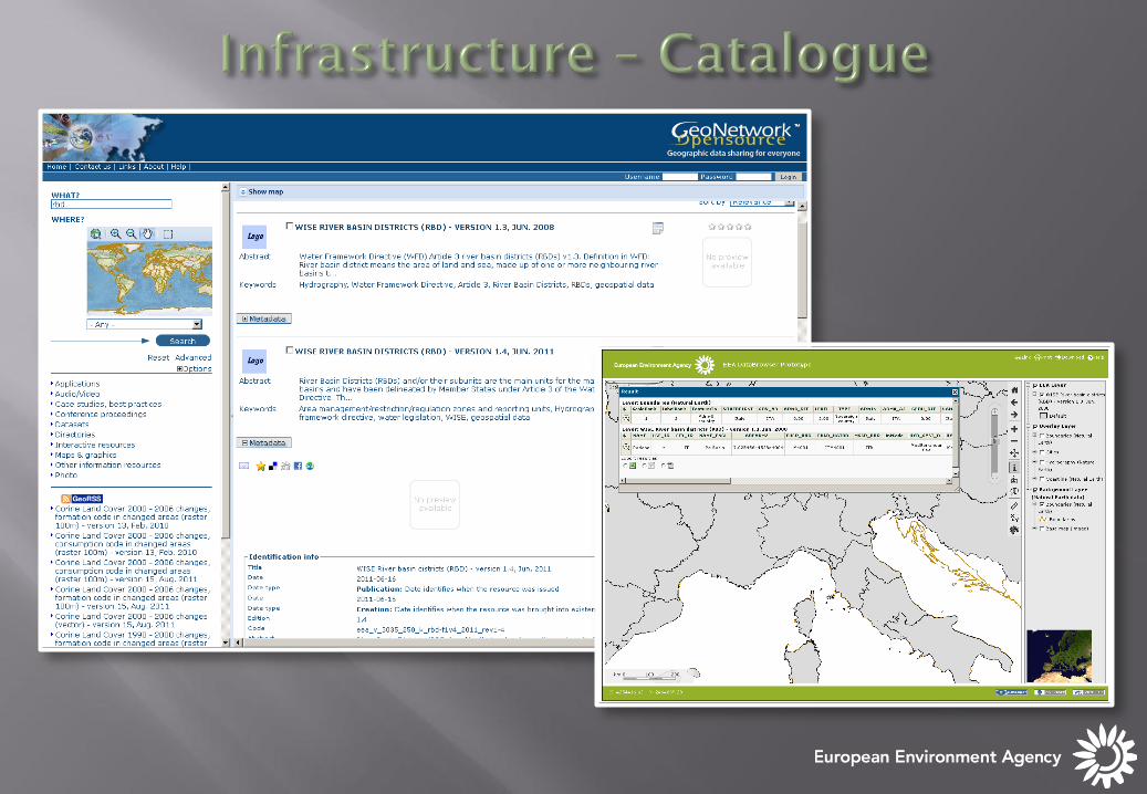
http://www.eea.europa.eu/data-and-maps/data


GPX – GPS Exhange format KML – Google keyhole file CSV – Comma seperated file SHP – Esri Shape file
ArcGis – Esri web-services WMS – OGC services KML – OGC / Google services
Intelligent tools
Web services
Applications
File based sources

Web site
Create Users •Link to web-services
•Link to web app’s (url)
•Upload data/tools/app (zip)
•Upload web-service (zip)
•Create map’s (mashup)
Create Groups •Invite users
•Add resources
•Secure content

Citizen Data
Operational Layers
Basemaps
My location My
observation My
statistics


Floods in Europe
Floods in Twitter and Flickr

All EEA Applications and available web-services + Some from external Int. Org. + Some from countries.


![Triangularpolynomialmapsincharacteristic · arXiv:1106.5800v3 [math.AG] 23 Jan 2013 Triangularpolynomialmapsincharacteristicp Stefan Maubach Jacobs University Bremen Bremen, Germany](https://static.fdocuments.in/doc/165x107/605fe646487b4d51d30bff6b/triangularpolynomialmapsincharacteristic-arxiv11065800v3-mathag-23-jan-2013.jpg)