
State of the Trails 2015
34
Accomplishments, Active Projects, and Next Steps 2015 STATE OF THE URBAN TRAILS
-
Upload
paul-schumann -
Category
Government & Nonprofit
-
view
205 -
download
0
Transcript of State of the Trails 2015

Accomplishments, Active Projects, and Next Steps
2015 STATE OF THE URBAN TRAILS

Agenda
• What is an Urban Trail?
• Accomplishments
• Active Projects
• Next Steps

What is an Urban Trail?
Goals of Urban Trail Program: 1. Provide easy access to both transporta3on and recrea3on users from all
parts of the City.
2. Connect to the on-‐street bicycle and sidewalk network around them.
3. Ensure adequately sized to accommodate both recrea3on and transporta3on uses.
4. Incorporate trail ameni=es and features that transform from a paved surface to unique greenways that reflect the City around them.
5. Provide adequate funding and resources to maintain and operate.
6. Ensure that all are context-‐sensi=ve and environmentally sustainable as well as preserve and improve upon wildlife habitat.

Accomplishments Tejano Walking Trail
• 5-mile trail includes sidewalks, streets without sidewalks, and the Butler trail.
• Designated National Recreational Trail • Highlights historical and cultural points
of interest. • Implements the East Cesar Chavez
Neighborhood Plan (1999).
Floyd McGown House (Flickr, ‘10)

Accomplishments Tejano Walking Trail
• 65 wayfinding tiles installed on sidewalks.
• 11 iZone signs installed near historical and cultural markers.

Accomplishments Southern Walnut Creek Trail Kiosks
• 3 kiosks purchased for wayfinding and informational purposes. • Installation to occur this winter at the Govalle Park Trailhead, the Austin Tennis
Center Trailhead, and the YMCA Trailhead.

Accomplishments Southern Walnut Creek Trail Signs • 13 Wayfinding Signs • 16 Mile Marker Signs • Installation to occur this
winter. • Worked
interdepartmentally (PDR, PWD, PARD, APD, AFD, EMS) to approve design.
• Design will become standard for future urban trail wayfinding.

Accomplishments Southern Walnut Creek & Austin to Manor Trail Maintenance
• Re-constructed approximately 100 feet of trail.
• Repaired erosion and stability issues at 5+ unique locations.
• Quickly constructed the repairs with minimal closures and phased construction for weekend use
• Preventative maintenance work preemptively protected trail from recent rains.

Accomplishments Trail Counters
3 permanent counters (1 additional permanent counter to be installed December 2015)
1 temporary counter
Trail Counters
(3 counters combined): 27,432 trail users
since June 1 Average of 2,400 trail
users per day 58% pedestrian, 42%
cyclist usage
Permanent Counter Stats

Accomplishments
Temporary Counter Stats
Trail Counters
North Acres Bridge
North Acres Bridge • 649 cyclists during 4
week period • Average of 34 trail
users per day • Manual counts
estimate ~69 students use the bridge per day to get to school.
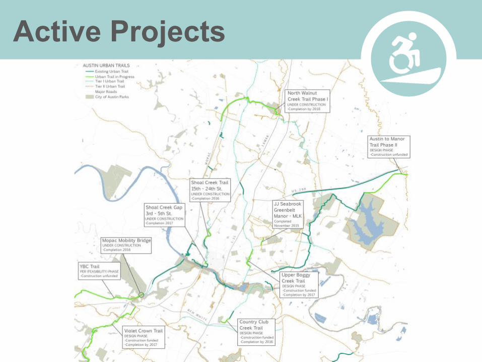
Active Projects
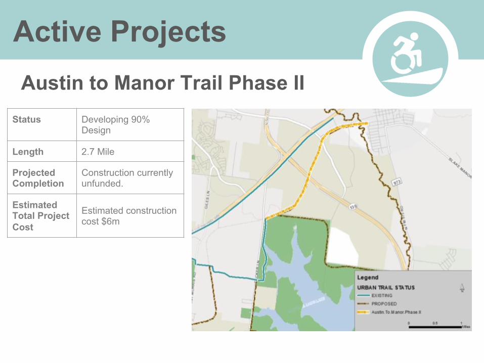
Active Projects Austin to Manor Trail Phase II
Status Developing 90% Design
Length 2.7 Mile
Projected Completion
Construction currently unfunded.
Estimated Total Project Cost
Estimated construction cost $6m

Active Projects Country Club Creek Trail Phase I
Status Developing 90% Design
Length 0.25 Mile
Projected Completion Summer 2016
Estimated Total Project Cost
Estimated construction cost $415k
Looking northeast from Burleson Road. Existing trail along electric transmission easement.

Active Projects JJ Seabrook Greenbelt: Manor - MLK
Status Complete
Length 0.4 Mile
Projected Completion November 2015
Estimated Total Project Cost
$2.2m

Active Projects
Mopac Mobility Bridges Status Construction
Length 1 Mile
Projected Completion
Phase I - December 2015, Phase II - March, 2016
Estimated Total Project Cost
$13 M

Active Projects
Northern Walnut Creek Trail Phase I
Status Construction
Length 3.6 Mile
Projected Completion Fall 2017
Estimated Total Project Cost
$10 M

Active Projects
Northern Walnut Creek Trail Phase II Status Design
Length 1.6 Mile
Projected Completion Construction unfunded
Estimated Total Project Cost
Construction unfunded

Active Projects
Shoal Creek Trail: Gap Project 3rd to 5th Street
Status Construction
Length 0.12 Mile
Projected Completion January 2017
Estimated Total Project Cost
$6.8 M

Active Projects Shoal Creek Trail: Preliminary Engineering Report (5th - 15th)
Status PER
Length 0.8 Mile
Projected Completion
PER completion winter 2016
Estimated Total Project Cost
$400,000 (for PER). Construction cost unknown

Active Projects
Shoal Creek Restoration Project: 15th to 24th Street
Status Construction
Length 0.75 Mile
Projected Completion February 2016
Estimated Total Project Cost
Trail-related costs: $900,000

Active Projects
Upper Boggy Creek Trail: MLK Station to 12th Street.
Status Design
Length 0.4 Mile
Projected Completion December 2017
Estimated Total Project Cost $2.2M


Active Projects Violet Crown Trail: Phase 2 “North & South” Status Design
Length 2.4 Miles
Projected Completion Summer 2017
Estimated Total Project Cost
$2.4 M

Active Projects
Violet Crown Trail: Phase 2 “Circle C Ranch Metro Park Veloway” Status Design
Length 3 Miles
Projected Completion Winter 2016
Estimated Total Project Cost $2.8 M

Active Projects
Violet Crown Trail: Phase 2 Neighborhood Partnering Project Status Design
Length 0.25 Miles
Projected Completion Spring 2016
Estimated Total Project Cost $250,000

Active Projects
YBC Trail: “Y” at Oak Hill to Barton Creek
Status PER
Length Approx. 5 miles
Projected Completion
Construction Unfunded
Estimated Total Project Cost
$10 - 12M

Active Projects
CTRMA - Shared Use Paths OPEN TO TRAFFIC Miles
Manor Expressway
US 183 interchange to Parmer Lane 5.6
UNDER CONSTRUCTION
MoPac Parmer Ln. to Loop 360 3
Bergstrom Expressway US 290 to SH 71 8
SH 71 Express
Bergstrom Expressway to Onion Creek Greenway 4.5
UNDER STUDY
MoPac South Lacrosse Ave to Lady Bird Lake 9
Oak Hill Parkway
US 290: MoPac - Circle Drive SH 71: US 290 - Silvermine
5.3 1.2
183 North SH 45N to MoPac 7.6
Active Projects
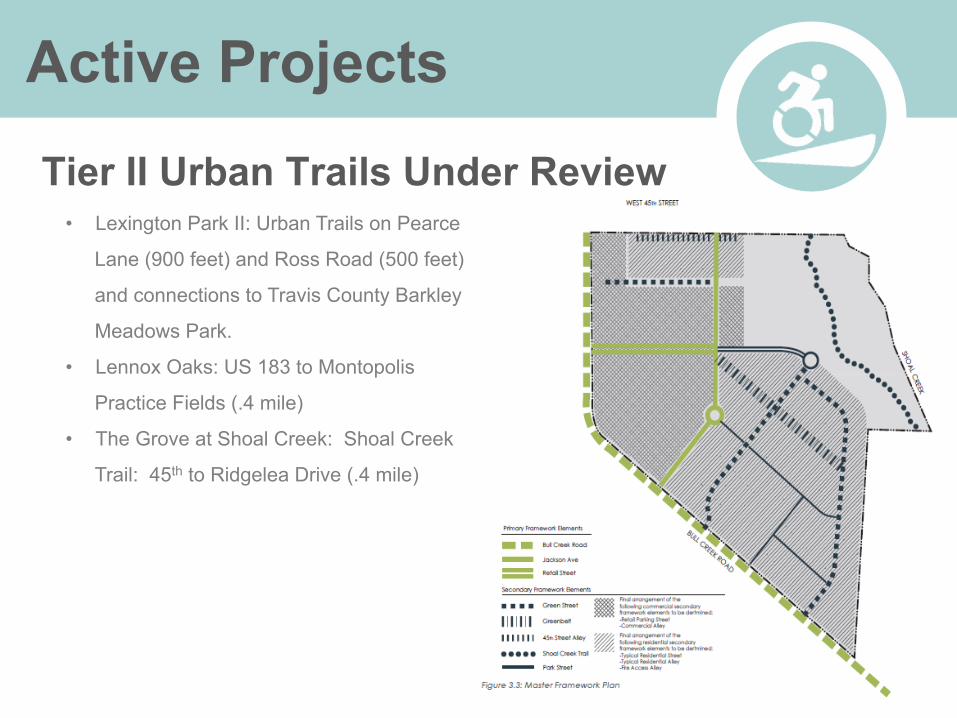
Tier II Urban Trails Under Review • Lexington Park II: Urban Trails on Pearce
Lane (900 feet) and Ross Road (500 feet)
and connections to Travis County Barkley
Meadows Park.
• Lennox Oaks: US 183 to Montopolis
Practice Fields (.4 mile)
• The Grove at Shoal Creek: Shoal Creek
Trail: 45th to Ridgelea Drive (.4 mile)

Next Steps Tejano Walking Trail
• Kiosk boards to be installed at Comal
parking lot near Butler Trail
• 11 additional iZone signs to be
purchased and installed for a total of 22
identified sites.
• Plaza Saltillo informational board to be
installed.
• Continue to work with Sidewalk
Program to complete the sidewalk
network along the trail route.
Cesar Chavez Statue at Terrazas Library (Flickr, ‘10)
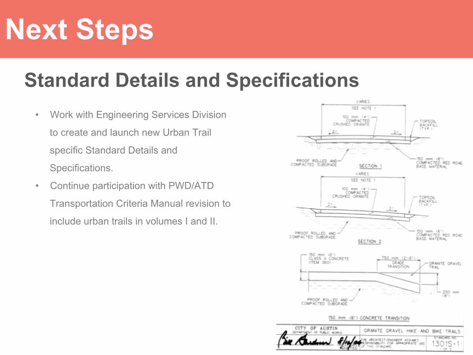
Next Steps Standard Details and Specifications
• Work with Engineering Services Division
to create and launch new Urban Trail
specific Standard Details and
Specifications.
• Continue participation with PWD/ATD
Transportation Criteria Manual revision to
include urban trails in volumes I and II.
Cesar Chavez Statue at Terrazas Library (Flickr, ‘10)

Next Steps
Cesar Chavez Statue at Terrazas Library (Flickr, ‘10)
Train DSD on Standards

Next Steps
Cesar Chavez Statue at Terrazas Library (Flickr, ‘10)
Citywide MOU and Maintenance Map
• Identifies responsible parties for various segments of all trails within COA
• Boulder, CO example

Next Steps
Cesar Chavez Statue at Terrazas Library (Flickr, ‘10)
Build Urban Trails Network
• Continue working interdepartmentally to identify opportunities for build-out.
• Continue working with community groups and neighborhoods to identify new trail connection opportunities.
• Prepare for future funding opportunities (bond, grant, foundation, etc.)