State of Oregon Indemnity Selection
113
STATE OF OREGON INDEMNITY SELECTION United States Department of the Interior BUREAU OF LAND MANAGEMENT ROSEBURG DISTRICT ENVIRONMENTAL ASSESSMENT EA-OR-104-05-11 CASE FILE OR 061026 February 2007 i
Transcript of State of Oregon Indemnity Selection

STATE OF OREGON
INDEMNITY SELECTION
United States Department of the Interior
BUREAU OF LAND MANAGEMENT
ROSEBURG DISTRICT ENVIRONMENTAL ASSESSMENT
EA-OR-104-05-11
CASE FILE OR 061026
February 2007
i

U.S. Department of the Interior, Bureau of Land Management Roseburg District Office 777 NW Garden Valley Blvd. Roseburg, Oregon 97470 Comments on this environmental assessment, including the names and addresses of respondents, will be made available for public review at the above address during regular business house, 8:00 A.M. to 4:30 P.M., Monday through Friday, except holidays. Individual respondents may request confidentiality. Such requests will be honored to the extent allowed by the law. If you wish to withhold your name or street address from public review or disclosure under the Freedom of Information Act, this must be stated prominently at the beginning of your written comment. All submissions from organizations or businesses, and individuals identifying themselves as representatives or officials of organizations or businesses, will be available for public inspection in their entirety. In keeping with Bureau of Land Management policy, the Roseburg District posts Environmental Assessments, Environmental Impact Statements, Findings of No Significant Impact, and Decision Records/Documentation on the District website under Planning and Environmental Analysis, at www.or.blm.gov/roseburg, on the same day in which the legal notices of availability for public review and notices of decision are published in The News-Review, Roseburg Oregon. Individuals desiring a paper copy of such documents will be provided upon request. Individuals with the ability to access these documents on-line are encouraged to do so as this reduces paper consumption and administrative costs associated with copying and mailing.
ii

TABLE OF CONTENTS Chapter 1. PURPOSE AND NEED FOR PROPOSED ACTION..........................1
A. PURPOSE AND NEED FOR PROPOSED ACTION .......................................... 1 B. CONFORMANCE WITH LAND USE PLANS.................................................... 2 C. RELATIONSHIP TO STATUTES, REGULATIONS, OR OTHER PLANS..... 4 D. ISSUES AND RESOURCES ELIMINATED FROM FURTHER ANALYSIS.. 4
Chapter 2. PROPOSED ACTION AND ALTERNATIVES ....................................7 A. PROPOSED ACTION ............................................................................................. 7 B. ALTERNATIVES ..................................................................................................... 8 C. ALTERNATIVES CONSIDERED BUT NOT ANALYZED IN DETAIL .......... 8
Chapter 3. AFFECTED ENVIRONMENT.............................................................9 A. GENERAL DESCRIPTION OF THE AFFECTED ENVIRONMENT ............. 9 B. PARCEL DESCRIPTIONS.................................................................................. 19
Chapter 4. ENVIRONMENTAL CONSEQUENCES ...........................................33 A. ENVIRONMENTAL CONSEQUENCES OF PROPOSED .............................. 33 ACTION....................................................................................................................... 33 B. ENVIRONMENTAL CONSEQUENCES OF NO ACTION.............................. 54 ALTERNATIVE.......................................................................................................... 54 C. COMPARISON OF ENVIRONMENTAL CONSEQUENCES BY PARCEL . 55 D. CUMULATIVE EFFECTS ................................................................................... 77
Chapter 5. CONSULTATION AND COORDINATION .......................................86 A. FEDERAL AGENCIES ......................................................................................... 86 B. STATE AND LOCAL AGENCIES ....................................................................... 86 C. PUBLIC CONTACT AND NOTIFICATION...................................................... 86 D. LIST OF PREPARERS ......................................................................................... 87
Chapter 6. ATTACHMENTS..............................................................................88 APPENDIX A. MAPS................................................................................................. 88 APPENDIX B. PEAK FLOW ANALYSIS DISCUSSION.................................... 100 APPENDIX C. ESSENTIAL FISH HABITAT ASSESSMENT ........................... 105 REFERENCES AND LITERATURE CITED ....................................................... 107
iii

Chapter 1. PURPOSE AND NEED FOR PROPOSED ACTION This chapter discusses the purpose and need for the federal action, the federal decision and factors for decision-making, how the action must comply with relevant authorities, and issues eliminated from further analysis.
A. PURPOSE AND NEED FOR PROPOSED ACTION The Bureau of Land Management (BLM) is required to transfer federal land to the State of Oregon (the State) in order to fulfill a legal obligation dating back to Oregon Statehood. The State filed an application with BLM on August 16, 2006 requesting the transfer of approximately 180 acres of public lands to its management. This request was made as an indemnity selection for school lands granted under the provisions of the Oregon Admission Acts, approved February 14, 1859 (11 Stat. 383). A 1992 US District Court decision in Oregon v. Bureau of Land Management, Civil No. 85-646-MA, found the State was entitled to select 5,202.29 acres of Public Domain lands administered by BLM “in lieu” of certain “base” lands to which the State was entitled under the Admission Acts, but which were unavailable for transfer to the State for various reasons (such as the lands were within a National Forest or otherwise conveyed prior to survey). Base lands represent the State's right to select eligible public lands elsewhere to compensate for those rights lost to the State when the original grant lands were unavailable. The value of base lands is then compared to the value of lands that the State selects; this value is to be “roughly equivalent in value” as provided in the US Supreme Court decision in Andrus v. Utah, 446 US 500 (No. 78-1522, May 19, 1980). The 1992 US District Court decision in Oregon v. Bureau of Land Management, Civil No. 85-646-MA ordered BLM to allow land transfers to the State to proceed to patent. The final judgment concluded that there were 11,947.47 acres of unused base lands and 6,745.47 acres of overdrawn base lands, leaving the balance of the above mentioned 5,202.29 acres of land due to the state of Oregon as indemnity. The Court identified a list of unused base lands, but did not specify which unused base lands could be selected or which would be used to offset the overdrawn base lands. As such, BLM and Department of State Lands (DSL) agreed that DSL may use any of the unused 11,947.47 acres as base lands to make its remaining selections. The base lands identified for use in the indemnity selections on the Roseburg District BLM consist of two parcels managed by the Mt. Hood National Forest; these parcels are on the Court’s list of parcels contained in the final judgment. BLM and DSL will evaluate the value of the base lands and selected lands from the Roseburg District and determine that they are roughly equivalent in value. The court decision also stated that “each clear list issued will contain a value certification by BLM for both the base and selected lands”. BLM is responsible for satisfying this federal obligation of land roughly equivalent in value to the base lands to the State of Oregon as part of fulfilling statehood land grant
1

rights. Satisfaction of indemnity selection rights and disposal of parcels for that purpose are considered to serve the national interest in the context of Section 102(a)(1) of the Federal Land Policy and Management Act of 1976. Undertaking the proposed action (Chapter 2) would satisfy approximately 180 acres of this 5,202.29 acre federal obligation. Other indemnity selections are occurring elsewhere in the State to completely satisfy the federal obligation. Federal Decision to be Made BLM’s transfer of lands to the State is Court-ordered under the 1992 decision. BLM must determine which parcels are the best suited to transfer, however. Factors to be considered in making this determination are:
• Whether the transfer of the parcels conforms to law and policy; and • The degree to which the transfer may affect threatened or endangered species.
B. CONFORMANCE WITH LAND USE PLANS The lands proposed for selection by the State are managed under the direction of the Roseburg District Record of Decision and Resource Management Plan (ROD/RMP 1995). Implementation of the proposed action must conform to the requirements of the ROD/RMP, which incorporates as management direction the standards and guidelines of the Record of Decision for Amendments (ROD) to Forest Service and Bureau of Land Management Planning Documents Within the Range of the Northern Spotted Owl (USDA, USDI 1994b), as amended by the Record of Decision and Standards and Guidelines for Amendments to the Survey and Manage, Protection Buffer, and other Mitigation Measures Standards and Guidelines in Forest Service and Bureau of Land Management Planning Documents Within the Range of the Northern Spotted Owl (USDA, USDI 2001b (S&M ROD)) and Record of Decision to Clarify Provisions Relating to the Aquatic Conservation Strategy (USDA, USDI 2004b). This Environmental Assessment (EA) will consider the environmental consequences of the proposed action and no action alternatives in order to provide sufficient evidence for determining suitability of the parcels for transfer. The EA will also determine whether the anticipated impacts would exceed those considered in the Roseburg District PRMP/EIS and require the preparation of a Supplemental Environmental Impact Statement (SEIS). In addition to the PRMP/EIS, this analysis is tiered to assumptions and analysis of consequences provided by:
• The Final Supplemental Environmental Impact Statement (FSEIS) on
Management of Habitat for Late-Successional and Old-Growth Related Species Within the Range of the Northern Spotted Owl (USDA, USDI 1994a);
• The FSEIS for Amendments to the Survey and Manage, Protection Buffer, and
other Mitigation Measures Standards and Guidelines in Forest Service and Bureau of Land Management Planning Documents Within the Range of the Northern Spotted Owl (USDA, USDI 2001a); and
2

• The FSEIS to Clarify Provisions Relating to the Aquatic Conservation Strategy (USDA, USDI 2004a).
The ROD/RMP assigned all lands administered by the Roseburg District BLM to one of three Land Tenure Zones. All of the parcels considered for conveyance in this analysis are Public Domain lands assigned as Tenure Zone 2. While the ROD/RMP objectives for these lands include guidance to “block up” areas in Zone 2 with significant resource values and exchange other lands in Zone 2 to “block up” areas in Zones 1 and 2 with significant resource values, the ROD/RMP also directs that BLM make administered lands in Zones 1, 2, and 3 available for a variety of uses as authorized by section 302 of the Federal Land Policy and Management Act. The sale of Zone 1 and 2 lands is generally prohibited, but Zone 2 lands may be transferred to other public agencies or managed under some form of cooperative agreement. Zones 1 and 2 lands would generally remain under BLM administration. (ROD/RMP p.67-68) In accordance with the ROD/RMP, BLM generally does not dispose of Zone 2 lands. However, the disposal of parcels under an indemnity selection is considered to serve the national interest in the context of Section 102(a)(1) of FLPMA, and BLM policy is to accommodate the State’s request to the extent possible (BLM Manual 2621 – Indemnity Selections, .6B,C). As such, BLM is making Zone 2 lands available to meet the State’s selection. Two of the parcels considered for conveyance are within the Late-Successional Reserve (LSR) land use allocation. The Roseburg ROD/RMP (p. 29) states the objective of Late-Successional Reserves is to “protect and enhance conditions of late-successional and old-growth forest ecosystems, which serve as habitat for late-successional and old-growth forest-related species including the northern spotted owl and marbled murrelet.” Under the ROD/RMP, review by the Regional Ecosystem Office is required for all actions that are deemed to have adverse effects on the above stated LSR objectives (ROD/RMP p.29). The Regional Ecosystem Office delegated this authority to the Late-Successional Reserve Working Group in its memorandum dated May 14, 2003 (Delegation of RIEC authority to review specific changes to Northwest Forest Plan (NWFP) standards and guidelines and land allocations). Review by the Late-Successional Reserve Working Group would be required prior to any transfer of ownership of LSR parcels in order to ensure conformance with the land use plan. These two LSR parcels are also located in designated Critical Habitat for listed threatened and endangered species. The Roseburg ROD/RMP (p.42) directs that “habitat essential for the survival or recovery of listed and proposed species” be retained under federal management or other appropriate management organization. Two of the parcels considered for conveyance are within designated critical habitat for threatened or endangered species, which under the Endangered Species Act is habitat essential to the conservation of a species (ROD/RMP p.103). Because critical habitat is habitat essential to survival or recovery of a listed species, if BLM should select parcels containing critical habitat for transfer, an RMP amendment would be necessary prior to any transfer of ownership to ensure conformance with the land use plan.
3

C. RELATIONSHIP TO STATUTES, REGULATIONS, OR OTHER PLANS The State of Oregon application for Indemnity School Land selections has been filed pursuant to Sections 2275 and 2276 of the Revised Statues, as amended (43 U.S.C. 851, 852), Sec. 102(a) of the Federal Land Policy and Management Act of October 21, 1976 (43 U.S.C. 1701, 1712), and Sec. 7 of the Taylor Grazing Act of 1934 (43 U.S.C. 315f). The authority to transfer “in lieu” lands to the State is found in Sections 2275 and 2276 of the Revised Statutes, as amended (43 U.S.C. 851, 852), and guided by regulations found at 43 CFR 2621. In accordance with Sec. 120 (h) of the Comprehensive Environmental Response, Compensation, and Liability Act (CERCLA), a Level I Hazardous Materials Survey has been completed on all parcels. Parcel 4 was determined to have illegally-dumped solid waste debris on the parcel; prior to any transferal, the pieces of debris would be removed. No hazardous substances and no petroleum products or their derivatives are known to have been released or disposed of on any of the other nine parcels analyzed in this environmental assessment (EA). In accordance with Section 7 of the Endangered Species Act of 1973, as amended (16 U.S. C. 1531 et seq.), the Bureau of Land Management has prepared a biological assessment and will complete consultation with the US Fish and Wildlife Service prior to conveyance. In accordance with Section 106 responsibilities under the National Historic Preservation Act, cultural resource surveys were conducted on five of the ten parcels. The remaining parcels are exempt under the 1998 Protocol for Managing Cultural Resources on Lands Administered by the Bureau of Land Management in Oregon. In accordance with the Magnuson-Stevens Fishery Conservation and Management Act, an Essential Fish Habitat assessment was prepared (Appendix C, Essential Fish Habitat Assessment).
D. ISSUES AND RESOURCES ELIMINATED FROM FURTHER ANALYSIS CRITICAL ELEMENTS OF THE HUMAN ENVIRONMENT “Critical elements” are listed in Appendix 5 of the BLM National Environmental Policy Handbook (NEPA Handbook H-1790-1, BLM, October 1988). The following critical elements are not found in the project area or are not affected by the Proposed Action, and are thus not relevant to the proposed action and eliminated from further analysis: air quality, ACEC, cultural resources, prime or unique farmlands, flood plains, Native American religious concerns, wild and scenic rivers, wilderness, invasive and nonnative species, and environmental justice.
4

SURVEY AND MANAGE SPECIES The transfer of ownership from the federal government to the State of Oregon is not a habitat-disturbing activity. The Regional Ecosystem Office determined that land tenure adjustments do not require Survey and Manage protocol in a memorandum dated March 27, 1997. Therefore, because the proposed action is a land tenure adjustment, it does not require Survey and Manage protocol. OTHER RESOURCES The following resources were considered and eliminated from detailed analysis for reasons listed below:
• Mineral Resources – All ten parcels are non-mineral in character; there are no existing mineral claims on any of the ten parcels.
• Visual Resource Management - All ten parcels are within the Visual Resource Management Class IV, which allows for major modifications of the existing character of the landscape (ROD/RMP, p.53).
• Recreation - Recreational use is limited to areas where public access is available over roads wholly under the control of the BLM. Only Parcels 4 and 9 have public access, and no parcels have developed recreational facilities or areas proposed for recreational development. Recreational opportunities are limited to those of a dispersed nature, which could include hiking, picnicking, wildlife observation, and hunting. Off-highway vehicle use is “limited” exclusively to existing roads and designated trails (ROD/RMP, p. 58). Other forms of off-highway vehicle recreation are not recognized as an authorized use of the public lands. Because the access and recreational opportunities provided on the parcels are extremely limited, effects to recreational resources are not analyzed.
• Cultural Resources - The three parcels (4, 7, and 9) in the Western Cascades were surveyed for cultural resources; none were found. Two of the coast range parcels (1 and 5) were surveyed for cultural resources; none were found. The remaining five Coast Range parcels (2,3,6,8, and 10) fall under the Coast Range exemption of the 1998 Protocol for Managing Cultural Resources on Lands Administered by the Bureau of Land Management in Oregon. As surveys did not reveal cultural resources and five parcels are exempt according to the 1998 Protocol, further analysis on effects to cultural resources is unnecessary. BLM has completed its Section 106 responsibilities under the 1997 Programmatic Agreement among the Bureau of Land Management, the Advisory Council on Historic Preservation, and the National Conference of State Historic Preservation Officers regarding the manner in which BLM will meet its responsibilities under the National Historic Preservation Act (the National Programmatic Agreement).
• Soils – Because the Oregon Forest Practices Act would guide any subsequent timber harvest, providing best management practices to protect water quality, effects to soils are expected to be negligible and are not analyzed.
• Wild Horse and Burro Management Areas– None of the parcels are part of a wild horse or burro management area.
• Rangeland Resources – None of the parcels are rangelands.
5

• Water rights - There are no registered water rights within any of the proposed parcels or within one mile downstream of any parcels. Since there are no existing water rights, they will not be further discussed in this document.
6

Chapter 2. PROPOSED ACTION AND ALTERNATIVES This chapter describes both the proposed action and the no action alternative analyzed in this EA.
A. PROPOSED ACTION The BLM proposes to convey approximately 180 acres of Public Domain lands to the State of Oregon in response to the State’s indemnity selection application, in partial fulfillment of the land grants made to the State of Oregon when it entered the Union in 1859. The lands being considered for transfer to the State are scattered parcels found entirely within the north half of the Roseburg District. Site specific descriptions of each parcel are in Chapter 3, the Affected Environment, and maps of each parcel are found in Appendix A, Maps. The State and BLM selected ten parcels for analysis and potential transfer to the State based upon several criteria:
• Parcels are all non-mineral in character; • Parcels are all Public Domain lands; • Parcels all contain late-successional growth; and • Parcels are similar to base lands in character.
The State may pursue selection of any of the ten parcels analyzed in this EA (totaling 464.05 acres) in any combination, but final selection is based upon negotiations of those parcels found to be the most suitable for conveyance. Though analyzing the effects of transferring each parcel, BLM only proposes to convey the approximate acreage necessary to meet its federal obligation under this application. These parcels are already small, scattered tracts; for management purposes BLM would not split the parcels into partial parcels for transfer – this may result in slightly more than 180 acres being transferred. Beyond the Federal action of conveyance, there is the possibility that the State may transfer the parcels into private ownership to satisfy State of Oregon land debts. Regardless of whether the State retains ownership or transfers the parcels, BLM assumes, for analytical purposes, that the land will be managed for timber production under Oregon Forest Practices Act requirements. Because of the inter-dependent nature of the federal conveyance and subsequent harvest by either the State or a private owner, future timber harvest would be an indirect effect of the BLM action.
7
B. ALTERNATIVES NO ACTION ALTERNATIVE Under the "No Action" alternative, BLM would retain all of the above-mentioned parcels in their entirety. These parcels would be managed according to their specific Land Use Allocations as described in the RMP. Such management would likely include timber harvest on parcels in the Matrix land allocations.
C. ALTERNATIVES CONSIDERED BUT NOT ANALYZED IN DETAIL BLM considered “partial selection” alternatives, with predetermined combinations of parcels, but did not analyze them in detail because the Proposed Action already serves this function by analyzing more acreage (464.05 acres) than the State will select (approximately 180 acres). Alternative parcels were also considered but not analyzed in detail because:
• There is an adequate amount of acreage for the State to select from; • The BLM is responding to a State request for specific parcels and types of land;
and • Other parcels did not meet criteria for disposal eligibility (as discussed in the
description of the proposed action).
8

Chapter 3. AFFECTED ENVIRONMENT This chapter describes the resources that are present, or potentially present, and which may be affected by the proposed action. The description of the current conditions inherently represents the cumulative effects of the past resource management activities undertaken by the BLM and private entities. This section forms the baseline for comparison of the effects of the alternatives under consideration.
A. GENERAL DESCRIPTION OF THE AFFECTED ENVIRONMENT The ten parcels analyzed for suitability and potential transfer to the State are all within the BLM Roseburg District’s Swiftwater Resource Area, and entirely within Douglas County, Oregon (see Appendix A, Maps). These parcels are within the mountainous terrain of the Coast Range and Cascade Range of Western Oregon. Lands in this area are predominantly public, State, and private timberlands managed for timber production and related forest values. The selected parcels are mostly composed of Douglas-fir forests ranging from mature stands to old growth, with limited young-mid seral stands on a few parcels. Other habitat types include grassy meadows and riparian areas with mixed deciduous and conifer species. Under the ROD/RMP, all ten parcels are Public Domain lands, not Oregon and California (O & C) Grant Lands. The parcels are classified as Land Tenure Zone 2 and are available for transfer to the State (ROD/RMP p.68). The parcels’ land use allocations vary from Riparian Reserves to Late Successional Reserve (LSR) to Matrix (composed of both Connectivity/Diversity Blocks and General Forest Management Areas). Wildlife – General Description The parcels are widespread across the District; all contain late-successional habitat and all are in proximity to a variety of other habitat types. The State of Oregon indemnity selection has been determined to have no effect on two federally listed wildlife species, including the Fender’s blue butterfly (Icaricia icarioides fenderi) or Canada lynx (Lynx canadensis), as the proposed parcels do not contain suitable habitat or are outside the range of these species. The project area is within the range of three federally threatened listed wildlife species: the Northern spotted owl (Strix occidentalis caurina), the marbled murrelet (Brachyramphus marmoratus), and the bald eagle (Haliaeetus leucocephalus). All ten parcels contain suitable habitat for the Northern spotted owl, and many of the parcels also contain suitable habitat for marbled murrelets and/or bald eagle. Suitable habitat for the Northern spotted owl consists of habitat used by owls for nesting, roosting and foraging; suitable habitat also functions as dispersal habitat. Generally this habitat is 80 years of age or older, multi-storied and has sufficient snags and down wood to provide opportunities for nesting, roosting, and foraging. The canopy closure generally exceeds 60 percent. The unit wildlife biologist makes site-specific determinations and delineations of suitable habitat. Currently, there are approximately 222,208 federal acres of suitable spotted owl nesting, roosting, and foraging habitat on District of which approximately 156,179 acres (70 percent) are protected in Reserves. There is an
9

10
additional 106,614 federal acres of dispersal-only habitat of which 66,098 acres (62 percent) are protected in Reserves. There are approximately 610 northern spotted owl activity centers on District (includes 365 master sites) of which 550 activity centers (90 percent) are protected in Reserves. Suitable habitat for the marbled murrelet consists of habitat used by murrelets for nesting. Generally this habitat is 80 years of age or older, contains multiple canopy layers, and contains platforms or nesting branches ≥ 5.9 inches (15 cm ) in diameter (Burger 2002, Nelson & Wilson 2002: 24, 27, 42, 97, 100). There are approximately 97,595 federal acres of suitable marbled murrelet nesting habitat, of which 83,186 acres (85 percent) are protected in Reserves. There are 12 known marbled murrelets sites on District, of which all (100 percent) are protected in Reserves. Suitable habitat for the bald eagle typically is multi-layered, uneven-aged, and contains old-growth conifer stands that are located within approximately one mile of large bodies of water (Anthony et al. 1982). There are approximately 25,177 federal acres of suitable bald eagle nesting habitat on District, of which approximately 19,023 acres (76 percent) are protected in Reserves. There are 10 known nesting territories on District, with all but one territory (which is located along the North Umpqua River) located on the Mainstem of the Umpqua River within the Swiftwater Resource Area. Six of these territories (60 percent) are protected in Reserves, while the remaining four territories are located on private lands. The following table describes habitat for these listed species within the project area.

11
Table 1. Listed Species and Critical Habitat Concerns by Parcel P T-R-S
LOCATION
ACRES LISTED SPECIES AND CRITICAL HABITAT CONCERNS PER PARCEL SPOTTED OWL MARBLED MURRELET BALD EAGLE4
KNOWN ACTIVITY CENTER1
NUMBER OF HOME RANGES3
OVERLAP WITH A PARCEL
SUITABLE HABITAT
CRITICAL HABITAT
KNOWN OCCUPIED SITE
S BLE UITAHABITAT
CRITICAL HABITAT
KNOWN SITE
SUITABLE HABITAT
UMPQUA RIVER CORRIDOR HABITAT
MGMT AREA
1 20S-06W-3 40.00 0 4 YES OR-53 NO YES OR-04-I NO NO NO 2 2 21S-06W-06 64.545 0 2 YES OR-53 NO YES OR-04-I NO NO NO 3 21S-07W-10 40.00 0 1 YES NO NO YES NO NO NO NO
4 22S-04W-34 40.00 0 YES 1 ADJACENT TOOR-23
OUT OF RANGE NO NO NO NO NO
5 22S-07W-28 39.06 0 1 YES NO NO YES NO NO YES NO 0 4 YES NO NO YES NO NO YES NO 6 22S-07W-26 80.45
7 23S-04W-04 40.00 0 YES NO OUT OF R E NO NO NO NO NO 0
ANG
8 23S-07W-24 22.006 0 5 YES AD O A O JACENT TO 57 R- NO YES DJACENT T
OR-04-F NO YES NO
9 25S-03W-32 40.00 12 1 YES NO OUT OF RANGE NO N NO O YES NO
10 25S-07W-14 40.00 0 2 YES NO NO YES N N NO O YES O 1. Activi ay in nown O Activity (KOAC thin 0. cel.ty center, which m clude a K wl Center ), is wi 25 miles of a par 2. Activi a 10 AC, conti able abitat wi habitat l. ty center includes 0-acre KO which is guous suit NRF h th the in the parce3. Pr = 1.5 miles; Cascades = 1.2 milesovincial Home Range: Coast Range 4. Critic been ted for t bald eagle. al Habitat has not designa he 5. Of the 64. 0 acres is suitable habitat for spotte mar elet, gle. 54-acre parcel, a total of 60. d owl, bled murr and bald ea6. Of the a tot 0 acres is suitabl marbled ur elet, and 40.0-acre parcel, al of 22. e habitat for spotted owl, m r bald eagle.

Additionally, many of the Bureau Sensitive and Assessment species are suspected to occur within any or all of the parcels. Surveys have not been conducted for Special Status Species on all of the parcels. The BLM is responsible for responding to the State’s indemnity selection in a timely manner. The seasonality of surveys and staffing limitations prevented BLM from performing surveys for Special Status wildlife on the parcels. As an alternative methodology, BLM analysis assumes the presence of these species based on likelihood of occurrence due to habitat availability and nearby occurrences. The table below includes those Special Status wildlife species which are documented or suspected to occur within the Roseburg District; some of these species may be present in the project area. Table 2. Special Status Wildlife Species that May be Present in the Project Area.
PRESENT IN STATUS1SPECIES PROJECT GENERAL HABITAT REQUIREMENTS
AREA?2
BUREAU SENSITIVE
Am egrine Falcon erican PerFa anatum BS, SE Suspected
Parcel 10 Cliffs, rock outcrops; open habitats for hunting birds; known peregrine sites are within 2 miles of Parcels 8 and 10 lco peregrinus
Chace Sideband Mo chaceana BS Out of Range Rocky, talus habitats in the Klamath Province and southwards nadenia
Co White Tailed Deer lumbianOdocoileus virginianus leucurus BSO, CR Suspected
Parcels 4,7 Bottomlands, oak/hardwood forests; cover for fawning; Parcels 4,7,10 are within the range of the deer
Cr e Tightcoil ater LakPristiloma arcticum crateris BSO Out of Range Perennially wet areas in late seral forests above 2000ft elevation and east of
Interstate-5; seeps, springs, riparian areas
Gr band een SideMonadenia fidelis beryllica BSO
Suspected Parcels
1,2,3,5,6,8,10
Coast Range, riparian forests at low elevations; deciduous trees & shrubs in wet, undisturbed forest
Kl ail-Dropper amath TPr nov. BS Out of Range Moist, open areas along streams or springs in Ponderosa Pine forests; as far
North as Crater Lake ophysaon sp.
Lewis’ Woodpecker Melanerpes lewis BSO, CR Out of Range Open woodland habitat near water; open woodland canopy and large diameter
dead/dying trees, snag cavities
Northern Goshawk Accipiter gentilis BSO, XC, CR Suspected
All parcels Mature and older conifer forests; multi-storied canopies and great structural diversity; Parcels 1 and 2 are within 1.3 and 0.8 miles of a known nest site
Northwestern Pond Turtle Clemmys marmorata marmorata BSO, XC, CR
Suspected Parcels
1,3,4,5,7,8
Ponds, low gradient rivers; upland over-wintering habitat, coarse woody debris
Oregon Shoulderband Helminthoglypta hertleini BSO Suspected
Parcel 10 Talus and rocky substrates, grasslands or other open areas with low-lying vegetation
Oregon Vesper Sparrow Pooecetes gramineus affinis BSO, CR No habitat Open habitats such as grasslands, meadows, farmlands
Purple Martin Progne subis BSO, CR Suspected
Parcel 8 Snags cavities in open habitats (i.e.,grasslands, brushlands, open woodlands)
Rotund Lanx Lanx subrotundata BSO No Habitat Major rivers and large tributaries with cold, well-aerated water and rocky
substrate
Scott’s Apatanian Caddisfly BSO Out of Range High-elevation (>4,000ft), cold streams in the mountainous regions of OregonAllomyia scotti
12

SPECIES STATUS1PRESENT IN
PROJECT AREA?2
GENERAL HABITAT REQUIREMENTS
Spotted Tail-dropper Prophysaon vannattae pardalis BS
Suspected Parcels 1,3,5,6,8
Mature conifer forests in the Coast Range; associated with sigdeciduous tree/shrub component
nificant
Townsend's Big-eared Bat Corynorhinus townsendii BSO, XC, CR Suspected
All parcels Late successional forests; Caves, mines, buildings, bridges, tunnels
BUREAU ASSESSMENT
Foothill Yellow-legged Frog Rana boylii BAO, XC, V Suspected
Parcel 7 Low gradient streams/ponds; gravel/cobble, bedrock pools
Fringed Myotis Myotis thysanodes All parcels bridges, rock crevices BAO, XC, V Suspected Late-successional conifer forests, associated with water; caves, mines,
Harlequin Duck Histrionicus histrionicus BAO, XC, U Out of Range Mountain Streams in forested areas on west slope of the Cascade Mountains
Pacific Pallid Bat ntrozous p ficus
rocky outc near evergreen forests allidus paci BA Suspected
All parcels Usually roppings near open, dry open areas; occasionally
A
Pallid Bat ntrozous pallidus BA Suspected
All parcels Usually rocky outcroppings near open, dry open areas; occasionally near evergreen forests A
White-Tailed Kite Elanus leucurus BAO
Suspected
4,
Open grasslands, meadows, emergent wetlands, farmlands, lightly, wooded Parcels 05,6,7,8,9,1 areas; wooded riparian habitats close to open hunting; tall trees and shrubs
1. Status abbreviations: FE--Federal Endangered, FT- Threatened, XC--Former Federal -Federal Threatened, SE--State Endangered, ST--State Candidate, CR--ODFW Critical, V--ODFW ab au Sensitive in Vulner le, P--ODFW Peripheral/Naturally Rare, U--ODFW Undetermined, BS-- BureOregon and Washington, BSO-- Bureau Se e in O reau nsitiv regon, BA-- Bureau Assessment Species in Oregon and Washington, BAO--BuAssessment Species in Oregon, BT--Bureau Tracking in Oregon and Washington, BTO--Bureau Tracking in Oregon 2. Suspected = species has not been doc owe numented, h ver based o literature review, species is expected to occur.
Botany – General Description
rea is within th ge o ia threatened pla gered Species Act.
is known fr theaid’s lupine in Douglas County is open woodland and meadow edges,
sides, assoc it canopy cover. Most of the Douglas County populations
twith canopy cover of 50 to 80 percent (Barnes 2004). These plants are found in wooded
cif2004).
pulations inc e north and to the south of the ten populations in Douglas County, Oregon, represent the furthest
e current range. In Douglas County, Kincaid’s lupine occurs at i 0.
l lands and six sites on priv s. Four of the sites on private lands are only erbarium spec s an
d critic bitn Agreement for Kincaid’s Lupi
The project a e ran f a Kincnt species
d’s lupine (Lupinus sulphureus var. under the Endankincaidii), which is
Kincaid’s lupine om Willamette Valley and Douglas County. The primary habitat for Kincoften near road iated w h Pacific madrone, incense cedar, and Douglas-fir trees with a relatively openappear to tolerate more shaded habi at conditions than the Willamette Valley populations
areas dominated by Douglas-fir, Pa ic madrone, and other trees and shrubs (Barnes
There are extant po of K aid’s lupine to thparcels. Kincaid’s lupinesouthern extent of thfourteen sites ranging in son Federa
ze from 21 to 3.55 acres. There are approximately eight sites ate land
known from h imen d haven’t been seen since the collection date.
There is no designate al ha at in Douglas County as a result of the Programmne in Douglas County, com
atic pleted in 2006. Conservatio
13

This agreement documents the strategy of the BLM, US Fish and Wildlife Service, and US Forest Service to protect, conser of Kincaid’s lupine and its h federal la dd , three timbecontain habitat for Kincaid’s lupine, are working cooperatively with federal agencies to implement conservation and recovery activities for this species on their private
y of the indemnity parcels. All of the y o
nd the South Douglas County populations. Because habitat Douglas C pulations include sites with canopy cover
e c en
Plagiobothrys hirtus
nge. As such, effects to the ssment.
mary of Listed Bota bitat Concerns by Parcel
ted parcels are within the range of and have potential suitable habitat for several
ve, and contribute to the recoveryitionallyabitat on nds. A r companies, whose lands
properties.
There are no known Kincaid’s lupine sites on anparcels for this indemnit selection ccur between the Willamette Valley Kincaid’s lupine populations adescriptions for the southfrom 0 to 80 percent, it is
ounty po reasonabl to expe t potential suitable habitat on all of the t
parcels.
The Rough popcorn flower ( ) occurs in Douglas County and is listed as endangered under the Endangered Species Act. However, the ten parcels analyzed in this EA are outside of its ra rough popcorn flower were not analyzed in this asse
Table 3. Sum nical Species and Ha
The selecSpecial Status Species. Roseburg District BLM has 62 Special Status flora species that occur on the District or are suspected to occur. The species listed below in Table 4 are those species whose habitat most closely fits the habitat found in the parcels being considered for transfer. Surveys have not been conducted for Special Status Species on all of the parcels. The BLM is responsible for responding to the State’s indemnity selection in a timely manner. The seasonality of surveys and staffing limitations prevented BLM from performing surveys for Special Status botanical species on all of the parcels. As the parcels are widespread across the District, all contain late-successional
T-R-S LOCATION
P
A LISTED BOTANICAL SPECIES AND HABITAT CONCERNS PER PARCEL
KINCAID’S LUPINE ROUGH POPCORN FLOWER
KNOWN SURVEY STATUSKNOWN SUITABLE S SURVEY UITABLE
SITE HABITAT SITE HABITAT STATUS
20S-0 -32 1 40.0 0 YES INCOMPLETE 0 NO N/A 6W21S-0 YES INCOMPLETE 0 NO N/A 6W-06 2 64.54 0 21S-07W-10 3 40.0 0 YES COMPLETE 0 NO N/A 22S-04W-34 4 40.0 0 YES COMPLETE 0 NO N/A 22S-0 /A 7W-28 5 39.06 0 YES COMPLETE 0 NO N22S-0 N/A 7W-26 6 80.45 0 YES INCOMPLETE 0 NO 23S-0 N/A 4W-04 7 40.0 0 YES INCOMPLETE 0 NO 23S-0 N/A 7W-24 8 40.0 0 YES INCOMPLETE 0 NO 25S-0 N/A 3W-32 9 40.0 0 YES INCOMPLETE 0 NO 25S-07W-14 10 40.0 0 YES INCOMPLETE 0 NO N/A
14

habitat and are in proximity to various other habitat types, many of the Sensitive and Assessment species are suspected to occur within any or all of the parcels. Botanical surveys were conducted on three parcels with the highest potential for species based on aerial photo interpretation and proximity to known and historical sites.three parcels
These were determined to have the highest potential for Special Status Species
at l
based upon the diversity of habitat within the parcel, such as rock outcrops, meadows, and streams. The diversity of habitat increased the number of Special Status Species thwould potentially be found on the parcel. Table 4 details the Special Status botanicaspecies that may be present in the project area. Table 4. Special Status Botanical Species that May be Present in the Project Area.
WITHIN SPECIES SPECIES
RANGE?
HABITAT PRESENT? GENERAL HABITAT REQUIREMENTS
BUREAU SENSITIVE Chiloscyphus gemmiparus Liverwort Yes No Rocks in the bed of cold water streams
Trematodon boasii Moss No No Riparian in the subalpine
Ar a cangeliella camphoratF Yes No Western
Hemlock. Fruits in Spring and Fall Forms sporocarps beneath the soil surface associates with Douglas-fir and
ungus
Bridge iliss s oporus nob imuGiant polypore fungus Range of Pacific Silver Fir and Noble Fir. No No
Dermocybe humboldtensis Fungus Yes ssp.
Yes Sporocarps usually occur in association with the roots of various Pinaceae Fruits in Fall.
Phaeocollybia californica Fungu Yes Yes Associated with the roots of Douglas-fir and Western Hemlock. Fruits in Spring and
Fall s
Phaeocollybia gregaria Fungus Yes Yes Associated with the roots of Douglas-fir. Fruits in the Fall.
Phaeocollybia olivacea Fungus No No Scattered or in arcs in mixed forests containing Fagaceae or Pinaceae in coastal
s. F its in the Fall. lowland ru
Phaeocollybia oregonensis Fungus Yes Yes ted with the roots of Douglas Western uits inAssocia -fir and Hemlock. Fr the fall.
Ramaria spinulo . sa vardiminutiv Yes Yes s in hum tures abo d, associated with Pinaceae ssp.
s in the Fruit
ruus or soil and ma
Fall. e Fungus
ve the grounF it
Rhizopogon chamalelotinus Fungus Yes Yes d underg ation with roots of Doug r and SugarFoun round in associ the las-fi Pine.
Rhizopogon exiguus Fu estern He
Eucephal s Wayside Mixe
ngus Yes Yes d in ass oots of Douglas-fir and W mlock Foun ociation with the r
us vialiaster Yes Yes d evergr rests typically with open canopies. een/hardwood fo
Calochortus coxii Crinite mariposa-lily Yes No pen slo canopies on serpentine soDry o pes or under open ils.
Calochortus umpquaensis Umpqua mariposa-lily Yes No Grassland and forests on serpentine soils.
Arabis koehleri var. koehleri Koehler's rockcress Yes No Dry, rocky serpentine slopes, ridges.
Bensoniella oregana Bensonia Yes No Along the margins of bogs, wet meadows, and springs in mixed conife
partial and full sun. rous forests in
Cimicifuga elata Tall bugbane Yes Yes Woods and thickets at low elevations.
15

Frasera umpquaensis Umpqua swertia Yes No Moist meadows and moist coniferous forest. Mostly grows in sh
can also occur in full sun. aded conditions but
Horkelia congesta ssp. congesta Shaggy horkelia Yes Yes Meadows and open woods.
Kalmiopsis fragrans Fragrant kalmiopsis Yes No Dry, stony mountain slopes.
Lathyrus holochlorus Thin-leaved peavine Yes Yes Fencerows and partially cleared land, Willamette Valley, s. to Roseburg, OR.
Limnanthes gracilis var. gracilis Slender meadow-foam
Yes No Vernally moist to wet rocky slopes and meadows on various substrate inserpentine
cluding
Perideridia erythrorhiza Red-rooted yampah Yes Yes Moist meadows or along the edge of coniferous forest.
Romanzoffia thompsonii Thompson's mistmaiden Yes Yes Seasonally wet rock outcrops on open slopes
Sisyrinchium hitchcockii Hitchcock's blue-eyed grass Yes Yes Valley grasslands and oak savannahs
BUREAU ASSESSMENT Crumia latifolia Moss Yes No Wet calcarious cliffs near the coast.
Diplophyllu m plicatumLiverwort
Bark of hardwoods a ecaying wood, primarily in cool, moist sites Yes No nd conifers, on thin soil over rock, and on d
Funaria muhlenbergii Moss Yes Yes Shaded forests on fine textured soil.
Pseudoleskeella serpentinensis Moss Yes No Serpentine endemic
Schistostega pennata Moss Yes No On damp rocks, soil and decaying wood , in dark places.
Tayloria serrata Moss Yes Yes Soil and rotten wood enriched by old dung.
Tetraphis geniculata Moss Yes Yes Decomposing stumps and logs of coniferous trees.
Tetraplodon mnioides Moss Yes Yes Soil and rotten wood enriched by old dung.
Tripterocladium leucocladulum Moss Yes Yes Shaded to exposed rocks, cliffs and bark of hardwoods.
Bryoria subcana Lichen No Bark and wood of conifers in forest in stream and high precipN/A itation ridges within
30 mile of the ocean.
Calicium adspersum Lichen Yes Yes Cool microsites. Habitat not well known, rarely collected.
Lobaria linita Lichen Yes Yes Mature forests in the Western Hemlock Zone.
Pannaria rubiginosa Lichen Yes Yes Mature Douglas-fir/western hemlock forest.
Pilophorus nigricaulis Lichen Yes Yes Non-forest communities on talus slopes, cliffs, and rock outcrops.
Stereocaulon spathuliferum Lichen Yes No Cascades; cool N-facing talus slopes.
Sulcaria badia Lichen Yes Yes Bark and wood mainly from oak and maple.
Adiantum jordanii California maiden-hair s and trees. Yes Yes Shaded hillsides, moist woods on damp banks at base of rock
Asplenium septentrionale Grass-fern Yes Yes Volcanic or granite rock crevices and ledges under a forest canopy.
Carex brevicaulis Short stemmed sedge No No Coastal.
16

Carex comosa Bristly sed No ge Yes Marshes, lakeshores and wet meadows.
Carex gynodynama Hairy sedge Yes Yes Moist meadows, open forests.
Carex serratodens Saw-tooth sedge Yes No Wet Meadows.
Cicendia quadrangularis Timwort Yes No Meadows
Eschscholzia caespitosa Gold poppy Yes Yes Fields and brushy slopes of the foothills and valleys
Festuca elmeri Elmer's fescue Yes Yes Forest and Woodland.
Horkelia tridentata ssp. tridentate Three-toothed horkelia
Yes Yes Dry open coniferous forest.
Iliamna latibracteata California globe-mallow Yes Yes Stream banks and moist ground in the shade or open.
Pellaea andromedifolia Coffee fern Yes Yes Dry rock outcrops mostly in the open sun but at times along shaded stream banks.
Polystichum californicum California sword-fern Yes Yes Rock outcrops beneath forest canopies
overhangs or on shear bluffs and cliffs or on open slopes. Often inside rock
Scirpus subterminalis Water clubrush Yes No Shallow water (aquatic).
Utricularia gibba Humped bladderwort Yes No Shallow water in the valleys and mountains. Utricularia minor Lesser bladderwort Yes No ing water. Shallow standing or slow mov
Wolffia borealis Dotted water-meal Yes No Lakes, ponds, and pools of standing water. Wolffia Columbiana Columbia water-meal f standing water. Yes No Lakes, ponds, and pools o
Fisheries – General Description derally listed fish sp es rcels are of and have potential suitable habitat for several Special Status Species.
eys have not been co cted f p e parcels. The re nding the y manner.
seasonality of surveys and staffing limitations prevented BLM from completing pecial Status h spe on
ted based upon specie range and habitat information.
the Oregon De tment Fi o characterize s. Streamnet data is a standard used by National Marine Fisheries Service, Oregon
Forestry an rego ep r fish distribution. considered accurat for planning proposes. However, as with any
eir pr ity t sse ams and riparian areas cels Five and Seven were surveyed in May 2006 by BLM fisheries personnel.
s the Special Status fis
There are no fe eci in the project area. The selected pawithin the rangeSurv ndu or S ecial Status Species on all of thBLM is responsible for spo to State’s indemnity selection in a timelThe surveys for S fis cies all of the parcels; however, potential presence has been predic s BLM used par of sh and Wildlife Streamnet data tparcelDepartment of d O n D artment of Fish and Wildlife foStreamnet data is e remote sensing data, field verification would be necessary for specific on-the-ground activities. Due to th oxim o E ntial Fish Habitat, the strein Par Table 5 detail h species that may be present in the project area.
17
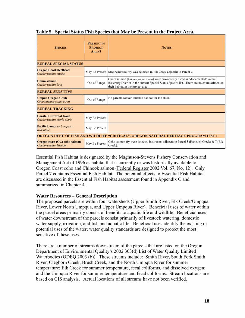
Table 5. Special Status Fish Species that May be Present in the Project Area.
SPECIES PRESENT IN
PROJECT NOTES AREA?
BUREAU SPECIAL STATUS
Oregon Coast steelhead Onchorynchus mykiss Be Pres tee s detected in Elk Creek adjacent to Parcel 7. May ent S lhead trout fry wa
Chum sal Out of Range chorynchus keta) were erroneously listed as “documented” in the
Roseburg District in the current Special Status Species list. There are no chum salmon or heir
Chum salmon (Onmon Onchorynchus keta habitat in the project area. t
BUREAU SENSITIVE
Umpua Oregon Chub Oregonichtys kalawatseti of Rang o p abitat for the chub.
Out e N arcels contain suitable h
BUREAU TRACKING
Coastal Cutthroat trout Onchorynchus clarki clarki Be PresMay ent
Pacific Lamprey Lampetra tridentate May Be Present
OREGON DEPT. OF FISH AND ILDLI CR 1 W FE “ ITICAL”, OREGON NATURAL HERITAGE PROGRAM LISTOregon coast (OC) coh May Be Present oh jacent to Parcel 5 (Hancock Creek) & 7 (Elk
Creek). Co salmon
Onchorynchus kisutch o salmon fry were detected in streams ad
Essential Fish Habitat is d nated th onservation and
Act of 1996 as habitat that is currently or was historically available to oho and C ook sa on
esig by e Magnuson-Stevens Fishery CManagementOregon Coast c hin lm (Federal Register 2002 Vol. 67, No. 12). Only
tains Essentia sh Ha t. tial Fish Habitat abitat assessment found in Appendix C and
hapter 4 Wa r Resources – General Description
ur watersheds (Upper Smith River, Elk Creek/Umpqua thin
here are a number of streams downstream of the parcels that are listed on the Oregon
are
Parcel 7 con l Fi bita The potential effects to Essenare discussed in the Essential Fish Hsummarized in C .
teThe proposed parcels are within foRiver, Lower North Umpqua, and Upper Umpqua River). Beneficial uses of water withe parcel areas primarily consist of benefits to aquatic life and wildlife. Beneficial uses of water downstream of the parcels consist primarily of livestock watering, domestic water supply, irrigation, and fish and aquatic life. Beneficial uses identify the existing or potential uses of the water; water quality standards are designed to protect the most sensitive of these uses. TDepartment of Environmental Quality’s 2002 303(d) List of Water Quality Limited Waterbodies (ODEQ 2003 (b)). These streams include: Smith River, South Fork Smith River, Cleghorn Creek, Brush Creek, and the North Umpqua River for summer temperature; Elk Creek for summer temperature, fecal coliforms, and dissolved oxygen; and the Umpqua River for summer temperature and fecal coliforms. Stream locationsbased on GIS analysis. Actual locations of all streams have not been verified.
18

Economic Contributions – General Description
arious federal accounts. Four percent of net revenue from land or resource sales is paid to the State of Oregon. These parcels are exempt from property taxation, but the federal government makes payments in lieu of taxes on public domain land acreage. These parcels are not O&C Lands from which the local government receives timber revenue.
B. PARCEL DESCRIPTIONS Maps illustrating the location and access for each parcel may be found in Appendix A. Parcel 1 – (SE¼ NE¼, Section 32, T20S, R6W, WM. (40 ac.))
Under federal ownership, most revenue generated from these tracts is distributed to v
General Setting - The 40.00 acre parcel is within the Upper Smith River fifth-field watershed, in the Coast Range overlooking County Road 37 and Smith River. This parcel is within a Tier 1 watershed1. The parcel is within a Late-Successional Reserve (LSR) land use allocation and includes Critical Habitats for Northern spotted owl and marbled murrelet. Access – Parcel 1 has no secured public access2. Timber - Dominated by a well-stocked, 250 year-old Douglas-fir conifer forest cover. Trees are mainly 10-30 inches diameter at breast height. No timber management activities are on record. Threatened & Endangered Wildlife - Parcel 1 is within designated Northern spotted owl Critical Habitat (Unit OR-53) and Late Successional Reserve (RO264). This parcel contains suitable habitat for the spotted owl. Parcel 1 does not contain a Known Owl Activity Center or any known spotted owl nest sites. Parcel 1 contains suitable marbled murrelet habitat and is within designated marbled murrelet Critical Habitat (Unit OR-04-i), within Marbled Murrelet Inland Management Zone 2.3 There are no known marbled murrelet nest sites in this parcel.
1 A tier one watershed is “a watershed that contributes directly to conservation of at-risk ... fish species, [and has] a high potential of being restored as part of a watershed restoration program” (RMP, pg. 20)). 2 Secured public access occurs where BLM has acquired access rights for the Federal Government and the American public via easement. 3 The Federal Ecosystem Management Assessment Team (FEMAT) identified two zones of murrelet habitat based on observed use and expected occupancy. In Oregon, zone 1 extends 0-35 miles inland from the marine environment. The majority of murrelet occupied sites and sightings occur in this zone. Zone 2 encompasses areas inland from the eastern boundary of zone 1 to 50 miles from the marine environment and is typified by relatively low numbers of murrelet sightings, which is partially a function of fewer inventories (FEMAT 1993).
19

There are no known bald eagle nest sites within 2.0 miles of the parcel. The parcel is more than 8.2 miles from a major water source and is not expected to be used for nesting or roosting by bald eagles. Water Resources - Parcel 1 is in the Upper Smith River Watershed. This parcel provides drainage to an unnamed tributary to Elk Creek (Tributary to Smith River) and
o Smith River. According to GIS data, this parcel contains eam se s
interm s which would stop
es - Parcel 1 contains non-fish bearing streams undaries. The stream at the northwestern portion of the parcel is
3 miles fr ond stream is in n of the parcel and s approximately 0.6 stream mile from the main
(a fish-bearing river). A third stream runs parallel to and just outside dary of the parcel and also drains to Smith River. The parcel is tream Fish Habitat for coho salmon (Elk Creek).
ned & Endangered Plants - Parcel 1 is forested, with some potential suitable
in
two unnamed tributaries tthree first order str
ittent streamgments4. These streams would most likely be classified a
flowing during the dry season.
the headwaters of two Fisheries Valuwithin the parcel boapproximately 0.the southern portio
om Elk Creek, a fish bearing stream. The sec i
stem of Smith Riverof the eastern bounapproximately 0.3 s mile from Essential Threatehabitat for Kincaid’s lupine. This parcel is situated midway between the Willamette Valley populations of K caid’s lupine and the south Douglas County populations. Surveys were not conducted for Special Status Species flora on this parcel. Because the parcel contains late-successional habitat, BLM expects that the parcel contains potentiallysuitable habitat for many of the botanical species on the Special Status Species list. BLMexpects that there is a reasonable likelihood of finding at least one of these species present.
asements - None. E Permits/Reciprocal Agreements5 – R-645 (Wooley) and R-645A (Seneca Jones Timber Co.) Parcel 2 – (Govt. Lot 7 and SE¼ SW¼, Section 6, T21S, R6W, WM. (64.54 ac.)) General Setting - The 64.54 acre parcel is within the Upper Smith River fifth-field
atershed, in the Coast Rw ange overlooking the South Fork Smith River. This parcel is e
within a Tier 1 watershed. The 250 year-old Douglas-fir stand is within an LSR land usallocation and includes Critical Habitat for Northern spotted owl and marbled murrelet. 4 Stream Order refers to the classification of a stream's position within the drainage basin network. A first order stream is the smallest unbranched tributary. A first order stream begins at its inception point (the point at which a stream begins) and continues until it joins with another first order stream, at that point it becomes a second order stream. 5 Reciprocal right-of-way agreements are agreements exchanging access rights between BLM a
ermittee pursuant to 43 CFR 2812 regulations. Additionally, BLM grants permits to individuand a ls or
mpanies that must utilize or cross BLM-administered land for activities such as timber hauling. pco
20

The parcel also has four acres of 20 year-old second growth. A portion of the parcel is
Douglas-fir conifer forest. Trees are mainly 10-30 inches diameter at breast height. No mber management activities are on record.
by well-stocked, 20 year-old Douglas-fir conifer
l
tat and is within designated marbled ent
ajor water source and is not expected to be used for nesting
GIS data, this parcel rder
l
Fisheries Values - Parcel 2 contains the headwaters of two non-fish bearing streams and one fish-bearing stream within the parcel boundaries. The non fish-bearing stream in the
ately 0.4 stream mile from South Fork Smith
of
non-forested (due to factors such as roads). Access – Parcel 2 has no secured public access. Timber - Fifty-eight acres of the parcel are dominated by a well-stocked, 250 year-old
ti
Four acres of the parcel are dominated forest cover. Trees are mainly 5 inches diameter at breast height. Area was clear-cut in 984 as a salvage sale and natural seeding reforested the area. It was pre-commercially 1
thinned in 2001 to 222 trees per acre. Threatened & Endangered Wildlife –Parcel 2 is in designated Northern spotted owCritical Habitat (Unit OR-54) and Late Successional Reserve (R0256). This parcel contains suitable habitat for the spotted owl. Parcel 2 does not contain a designated Known Owl Activity Center or any known spotted owl nest sites. This parcel contains suitable marbled murrelet habi
urrelet Critical Habitat (Unit OR-04-i) within Marbled Murrelet Inland ManagemmZone 2 (FEMAT 1993). There are no known marbled murrelet nest sites in this parcel. There are no known bald eagle nest sites within 2.0 miles of the parcel. The parcel is
ore than 6.5 miles from a mmor roosting by bald eagles. Water Resources - Parcel 2 is in the Upper Smith River Watershed. This parcel provides drainage to two unnamed tributaries to South Fork Smith River and two
nnamed tributaries to Little South Fork Smith River. According to ucontains ten first order stream segments, three second order segments, and one third osegment. These streams would most likely be classified as intermittent streams which would stop flowing during the dry season. However, the third order segment has otentia to provide perennial (year-round) flow. p
northern portion of the parcel is approximRiver, a fish bearing stream. The non fish-bearing stream in the eastern portion of the parcel is approximately 0.6 mile from South Fork Smith River. The fish-bearing stream is a third order perennial stream containing suitable habitat for coastal cutthroat trout and Pacific lamprey. This stream is in the southwestern portion the parcel and is a tributary to Little South Fork Smith River, also a fish-bearing stream.The parcel is approximately 0.4 stream mile from Essential Fish Habitat for coho salmon(South Fork Smith River).
21

Threatened & Endangered Plants - Parcel 2 is forested, with some potential suitable habitat for Kincaid’s lupine. This parcel is situated midway between the Willamette
alley populations of Kincaid’s lupine and the south Douglas County populations.
g at least one of ese species present.
r
arcel 3 - (NE¼ SE¼, Section 10, T21S, R7W, WM. (40 ac.))
V Surveys were not conducted for Special Status Species flora on this parcel. Because theparcel contains late-successional timber stands, BLM expects that the parcel contains potentially suitable habitat for many of the botanical species on the Special Status Species list. BLM expects that there is a reasonable likelihood of findinth Easements – None Permits/Reciprocal Agreements – R-645 (Wooley) & R-645-A (Seneca Jones TimbeCo.) P
1 e
atrix land use allocation, with 11 acres of General Forest Management Area (GFMA)
ominated by a well-stocked, 120 year-old Douglas-fir conifer forest cover. rees are mainly 10-20 inches diameter at breast height. No timber management
rd.
ng habitat for the Northern spotted owl. Parcel 3 does not contain a designated nown Owl Activity Center or any known spotted owl nest sites.
arcel 3 is within suitable marbled murrelet habitat and is within Marbled Murrelet est
or roosting by bald eagles.
d nt
General Setting – The 40.00 acre parcel is within the Upper Smith River fifth-field watershed in the Coast Range, overlooking Cleghorn Creek. Parcel 3 is within a Tierwatershed. This parcel contains 120 year-old Douglas-fir forest. Parcel 3 is within thMsurrounding 29 acres of Riparian Reserve. Access – Parcel 3 has no secured public access. Timber - DTactivities are on reco Threatened & Endangered Wildlife – Parcel 3 contains suitable nesting, roosting, and foragiK PInland Management Zone 1 (FEMAT 1993). There are no known marbled murrelet nsites in this parcel. There are no known bald eagle nest sites within 2.0 miles of the parcel. The parcel is more than 5.0 miles from a major water source and is not expected to be used for nesting
Water Resources - Parcel 3 is in the Upper Smith River Watershed. This parcel provides drainage to an unnamed tributary to Cleghorn Creek. According to GIS data, this parcel contains four first order stream segments, three second order segments, anone third order segment. These streams would most likely be classified as intermitte
22

streams which would stop flowing during the dry season. However, the third order segment has potential to provide perennial (year-round) flow.
rs of a non-fish bearing third order erennial stream within the parcel boundaries. The stream runs south to north through
almon and steelhead trout and coastal
utthroat trout. The parcel is located approximately 0.4 stream mile from Essential Fish
the Willamette Valley populations of Kincaid’s pine and the south Douglas County populations. Surveys were conducted for Special
.
arcel 4 - (NE¼ SE¼, Section 34, T22S, R4W, WM. (40 ac.))
Fisheries Values - Parcel 3 contains the headwatepthe center portion of the parcel. Parcel 3 is on a tributary approximately 0.4 mile from Cleghorn Creek. Cleghorn Creek is a fish-bearing stream that supports habitat for Pacificlamprey, resident non-anadromous fish, coho scHabitat for coho salmon (Cleghorn Creek). Threatened & Endangered Plants - Parcel 3 is within the range of Kincaid’s lupine. This parcel is situated midway betweenluStatus Species and no occurrences were found. BLM conducted surveys for Special Status Species in accordance to Bureau standards and found no occurrences.6 Easements – Route 1: RE-R-292 (Molly Hancock). Route 2: None Permits/Reciprocal Agreements – None P
in
las-fir forest. This parcel is within the Matrix land use llocation, with 29 acres of the parcel within Connectivity/Diversity Block 85,
d d
ld Douglas-fir conifer forest cover. rees are mainly 10-30 inches diameter at breast height. No timber management
General Setting – The 40.00 acre parcel is in the Elk Creek fifth-field watershed withthe western foothills of the Cascade Range, overlooking County Road 8. The parcel contains 150 year-old Dougasurrounding an 11 acre corridor of Riparian Reserve. When conducting the standarhazardous materials review, BLM staff discovered the presence of illegally dumpedebris. Access - Parcel 4 has secured public access. Timber - Dominated by a well-stocked, 150 year-oTactivities are on record. Threatened & Endangered Wildlife – Parcel 4 contains suitable nesting, roosting, andforaging habitat for the Northern spotted owl. Parcel 4 does not contain a designated Known Owl Activity Center or any known spotted owl nest sites. The parcel is outside the range of the marbled murrelet.
6 Special Status Species surveys are conducted in a meandering pattern throughout the parcel, with complete surveys when habitat for one of the species is found. For species with seasonality, these surveys were conducted during the appropriate season for establishing the identity of the species.
23
There are no known bald eagle nest sites within 2.0 miles of the parcel. The parcel is
ater Resources - Parcel 4 is in the Elk Creek/Umpqua River Watershed. This parcel
stop
isheries Values - Parcel 4 contains the headwaters of a single non-fish bearing stream. t to east along the southern portion of the parcel and is
pproximately 0.7 stream mile from Bennet Creek, a fish bearing stream. The parcel is
).
hreatened & Endangered Plants - Parcel 4 is within the range of Kincaid’s lupine. pulations of Kincaid’s
ial
rmits/Reciprocal Agreements – None
more than 10.0 miles from a major water source and is not expected to be used for nesting or roosting by bald eagles. Wprovides drainage to the upper portion of Bennet Creek and an unnamed tributary to Bennet Creek. According to GIS data, this parcel contains one first order stream segment. This stream would most likely be classified as intermittent which would flowing during the dry season. FThe stream runs wesaapproximately 0.7 stream mile from Essential Fish Habitat for coho salmon (Bennet Creek TThis parcel is situated midway between the Willamette Valley polupine and the south Douglas County populations. BLM conducted surveys for SpecStatus Species in accordance to Bureau standards and found no occurrences. Easements – RE-R-330 (Weyerhaeuser Timber Co.), RE-R-254 (Douglas County) Pe Parcel 5 - (Govt. Lot 1, Section 28, T22S, R7W, WM. (39.06 ac.)) General Setting – The 39.06 acre parcel is within the Elk Creek fifth-field watersthe Coast Range, overlook
hed in ing Hancock Creek. The parcels contain 110 - 250 year-old
ouglas-fir forest. The parcel is within the Matrix land use allocation, with 15.06 acres
ccess – Parcel 5 has no secured public access.
er forest. Trees are mainly 10-30 inches diameter at breast height. o timber management activities are on record.
are mainly 10-20 inches diameter at breast height. No ompleted timber management activities are on record.
Dwithin Connectivity/Diversity Block 75 surrounding 24 acres of Riparian Reserve. A portion of the parcel is non-forested (due to factors such as roads). A Timber - Twenty-seven acres of the parcel are dominated by a well-stocked, 250 year-old Douglas-fir conifN Eleven acres of the parcel are dominated by a well-stocked, 110 year-old Douglas-fir conifer forest cover. Trees c Threatened & Endangered Wildlife – Parcel 5 contains suitable nesting, roosting, andforaging habitat for the Northern spotted owl. Parcel 5 does not contain a designated Known Owl Activity Center or any known spotted owl nest sites.
24
Parcel 5 contains suitable marbled murrelet habitat and is within Marbled Murrelet Inland
anagement Zone 1 (FEMAT 1993). Surveys of the suitable habitat were completed in
el.
el
p
earing streams ithin the parcel boundaries. The stream at the northwestern portion of the parcel is
ek, a fish bearing stream. The second stream in the eastern portion of the parcel and is approximately 0.1 miles from Hancock reek. The parcel is approximately 0.1 mile from Essential Fish Habitat for coho salmon
prey, coho salmon,
e. incaid’s
al
asements – None
ermits/Reciprocal Agreements – R-421 (Robert Whipple)
rcel 6 - (SE¼NE¼ and NE¼SE¼ Section 26, T22S, R7W, WM. (80.45 ac.))
M2000 and 2001 with no detections of murrelets. There are no known marbled murreletnest sites in this parcel. There are no known bald eagle sites in the parcel. The parcel is near major waterways, within one mile of Elk Creek to the north and within 2.0 miles of the Umpqua River tothe west. Repeated eagle sightings within the immediate area indicate possible within the parcel itself or within the vicinity of the parc Water Resources - Parcel 5 is in the Elk Creek/Umpqua River Watershed. This parcprovides drainage to four unnamed tributaries to Hancock Creek. According to GIS data,this parcel contains five first order stream segments, and one second order segment. These streams would most likely be classified as intermittent streams which would stoflowing during the dry season. Fisheries Values - Parcel 5 contains the headwaters of two non-fish bwapproximately 0.5 miles from Hancock CreisC(Hancock Creek). Hancock Creek supports habitat for Pacific lamcoastal cutthroat, steelhead trout and resident non-anadromous fish. Threatened & Endangered Plants - Parcel 5 is within the range of Kincaid’s lupinThis parcel is situated midway between the Willamette Valley populations of Klupine and the south Douglas County populations. BLM conducted surveys for SpeciStatus Species in accordance to Bureau standards and found no occurrences. E P Pa
on, and has 32.45 cres of GFMA surrounding 48 acres of the Riparian Reserve land use allocation.
Access - Parcel 6 has no secured public access.
General Setting – The 80.45 acre parcel is within the Elk Creek fifth-field watershed in the Coast Range, northeast of Hancock Creek. The parcel contains 150 year-old Douglas-fir forest. The parcel is within the Matrix land use allocatia
25

Timber - Dominated by a well-stocked, 150 year-old Douglas-fir conifer forest cover. Trees are mainly 10-30 inches diameter at breast height. No timber management activities are on record. Threatened & Endangered Wildlife – Parcel 6 contains suitable nesting, roosting, and foraging habitat for the Northern spotted owl. Parcel 6 does not contain a designatedKnown Owl Activity Center or any known spotted owl nest sites. Parcel 6 contains suitable marble
d murrelet habitat, and is within Marbled Murrelet land Management Zone 2 (FEMAT 1993). There are no known marbled murrelet nest
.0
e Umpqua River to the west and southwest. Repeated eagle sightings within e immediate area indicate possible nesting within the parcel or within the vicinity of the
IS data,
is parcel contains four first order stream segments, one second order segment, and one ified
s intermittent streams which would stop flowing during the dry season. The fourth order ial (year-round) flow.
isheries Values - Parcel 6 contains a portion of a fish-bearing fourth order perennial This stream
hreatened & Endangered Plants - - Parcel 6 is forested, with some potential suitable d midway between the Willamette
alley populations of Kincaid’s lupine and the south Douglas County populations.
ects that the parcel contains potentially itable habitat for many of the botanical species on the Special Status Species list. BLM
asements – None
Insites in this parcel. There are no known bald eagle sites in the parcel. Parcel 6 contains suitable habitat andis near major waterways, within 2.0 miles of Elk Creek to the northwest and within 3miles of ththparcel. Water Resources - Parcel 6 is in the Elk Creek/Umpqua River Watershed. This parcelprovides drainage to two unnamed tributaries to Brush Creek. According to Gthfourth order segment. The first and second order streams would most likely be classasegment would most likely provide perenn Fstream flowing west to east through the central portion of the parcel. supports habitat for Pacific lamprey, resident non-anadromous fish, and coastal cutthroat trout. This stream is approximately 0.2 miles from Brush Creek, which is also fish-bearing. The parcel is approximately 0.2 miles from Essential Fish Habitat for coho salmon (Brush Creek). Thabitat for Kincaid’s lupine. This parcel is situateV Surveys were not conducted for Special Status Species flora on this parcel. Because the parcel contains late-successional habitat, BLM expsuexpects that there is a reasonable likelihood of finding at least one of these species present. E Permits/Reciprocal Agreements –R-645P (Juniper Properties)
26

Parcel 7 - (NW¼ SE¼, Section 4, T23S, R4W, WM. (40 ac.))
rrounding 35 acres of Riparian Reserve.
0 inches diameter at breast height. No mber management activities are on record.
ber
hreatened & Endangered Wildlife - Parcel 7 contains suitable nesting, roosting, and wn
be used for esting or roosting by bald eagles.
sixth order gment. The first and second order streams would most likely be classified as
which would stop flowing during the dry season. The sixth order gment (Elk Creek) provides perennial (year-round) flow.
lk Creek is listed on the Oregon Department of Environmental Quality’s 2002 303(d) ist of Water Quality Limited Waterbodies (ODEQ 2003 (b)). Elk Creek is listed for xceeding the summer temperature standard in this area of the watershed.7
ek
ent on-anadromous fish species. Parcel 7 contains both Oregon Coast steelhead and
General Setting – The 40.00 acre parcel is within the Elk Creek fifth-field watershed in the western foothills of the Cascade Range, straddling Elk Creek. The parcel contains 110 - 250 year-old Douglas-fir forest. Parcel 7 is within the Matrix land use allocation,with 5 acres of GFMA su Access - Parcel 7 has no secured public access. Timber - Eighteen acres of the parcel are dominated by a well-stocked, 250 year-old Douglas-fir conifer forest. Trees are mainly 10-3ti Twenty-two acres of the parcel are dominated by a well-stocked, 110 year-old Douglas-firconifer forest cover. Trees are mainly 10-30 inches diameter at breast height. No timmanagement activities are on record. Tforaging habitat for Northern spotted owl. Parcel 7 does not contain a designated KnoOwl Activity Center or any known spotted owl nest sites. Parcel 7 is outside the range of the marbled murrelet. There are no known bald eagle nest sites within 2.0 miles of the parcel. The parcel is more than 10.0 miles from a major water source and is not expected ton Water Resources - Parcel 7 is in the Elk Creek/Umpqua River Watershed. This parcelprovides drainage to the main stem of Elk Creek. According to GIS data, this parcel contains four first order stream segments, two second order segments, and oneseintermittent streams se ELe Fisheries Values - Parcel 7 contains the main stem of Elk Creek and three non-fish bearing tributary streams within the parcel boundaries. The main stem of Elk Creflows from the southern portion of the property to the western portion and supports habitat for coho salmon, steelhead, Pacific lamprey, coastal cutthroat trout and residn
7 The Department of Environmental Quality’s 303(d) list contains the names of water bodies that do not meet water quality standards and where Total Maximum Daily Loads will be developed. Waterbodies are listed regardless of ownership.
27

Oregon Coast coho salmon and their habitat. The parcel contains Essential Fish Habitatfor coho salmon (main stem Elk Creek).
hreatened & Endangered Plants - - Parcel 7 is forested, with some potential suitable
urveys were not conducted for Special Status Species flora on this parcel. Because the tially
reasonable likelihood of finding at least one of these species
resent.
Thabitat for Kincaid’s lupine. This parcel is situated midway between the Willamette Valley populations of Kincaid’s lupine and the south Douglas County populations. Sparcel contains late-successional habitat, BLM expects that the parcel contains potensuitable habitat for many of the botanical species on the Special Status Species list. BLMexpects that there is ap Easements – None Permits/Reciprocal Agreements – R-763P (Juniper Properties) Parcel 8 - (NE¼ NE¼, Section 24, T23S, R7W, WM. (40 ac.)) General Setting – The 40.00 acre parcel is within the Upper Umpqua fifth-field watershed in the Coast Range, north of Martin Creek. This parcel is a mix of approximately 22 acres of 250 year-old Douglas-fir and approximately 16 acres of 20 year-old second growth. Parcel 8 is within the Matrix land use allocation, with 15 acres f GFMA surrounding 25 acres of Riparian Reserve. A portion of the parcel is non-
ld . Trees are mainly 10-30inches diameter at breast height. No
mber management activities are on record.
r
988, broadcast burned in 1989, and planted with Douglas-fir in 1990. The unit was pre-
n d with Douglas-fir in 1989, and pre-commercially thinned in 2001 to 303
ees per acre.
hreatened & Endangered Wildlife – Parcel 8 contains suitable nesting, roosting, and ntain a designated
nown Owl Activity Center or any known spotted owl nest sites.
oforested (due to factors such as roads). Access - Parcel 8 has no secured public access. Timber - Twenty-two acres of the parcel are dominated by a well-stocked, 250 year-oDouglas-fir conifer forestti Six acres of the parcel are dominated by well-stocked, 20 year-old Douglas-fir conifeforest. Trees are mainly 5 inches diameter at breast height. The area was clear-cut in1commercially thinned in 2001 to 303 trees per acre. Ten acres of the parcel are dominated by well-stocked, 20 year-old Douglas-fir conifer forest. Trees are mainly 5 inches diameter at breast height. The area was clear-cut i1988, plantetr Tforaging habitat for the Northern spotted owl. Parcel 8 does not coK
28
Parcel 8 contains suitable marbled murrelet habitat and is within Marbled Murrelet InlandManagement Zone 2 (FEMAT 1993). There are no known marbled murrelet nest sites this parcel.
in
here are no known bald eagle sites in Parcel 8. The closest known bald eagle site is 1.4 the Umpqua River and contains
itable habitat expected to be used by eagles for nesting and roosting.
rads Creek. According to GIS data, this arcel contains five first order stream segments and two second order segments. The first
isheries Values - Parcel 8 contains portions of an unnamed tributary to Brads Creek. A
rtion of the parcel and is a on-fish bearing stream. The parcel is approximately 1.2 stream miles from Essential
le e
ine and the south Douglas County populations.
ially
es
asements – None
Tmiles west of the parcel. Parcel 8 is 1.6 miles fromsu Water Resources - Parcel 8 is in the Upper Umpqua River Watershed. This parcel provides drainage to an unnamed tributary to Bpand second order streams would most likely be classified as intermittent streams which would stop flowing during the dry season. Fsmall segment of a fish-bearing stream is in the extreme northwest portion of the parcel and supports habitat for non-anadromous resident fish and coastal cutthroat trout. Another tributary flows south to north through the center ponFish Habitat for coho salmon (Brads Creek). Threatened & Endangered Plants - - Parcel 8 is forested, with some potential suitabhabitat for Kincaid’s lupine. This parcel is situated midway between the WillamettValley populations of Kincaid’s lup Surveys were not conducted for Special Status Species flora on this parcel. Because the parcel contains late-successional habitat, BLM expects that the parcel contains potentsuitable habitat for many of the botanical species on the Special Status Species list. BLM expects that there is a reasonable likelihood of finding at least one of these specipresent. E Permits/Reciprocal Agreements – R-600 (Darryl Ray), R-880 (Roseburg Resources Co.) Parcel 9 - (SE¼ SE¼, Section 32, T25S, R3W, WM. (40 ac.)) General Setting – The 40.00 acre parcel is within the Lower North Umpqua fifth-field watershed in the western foothills of the Cascade Range, east of French Creek. The parcel contains 250 year-old Douglas-fir forest. Parcel 9 is within the Matrix land use allocation, with 11 acres of GFMA surrounding 29 acres of Riparian Reserve. Access – Parcel 9 has secured public access.
29

Timber - Dominated by a well-stocked, 250 year-old Douglas-fir conifer forest with
cense-cedar. Trees are mainly 10-30 inches diameter at breast height. No timber
and raging habitat for the Northern spotted owl. Parcel 9 does not contain a designated
arcel 9 is outside the range of the marbled murrelet.
here are no known bald eagle sites in Parcel 9. The closest known bald eagle site is 2.8 rth Umpqua River and
ontains suitable habitat expected to be used by eagles for nesting and roosting.
ater Resources - Parcel 9 is in the Lower North Umpqua Watershed. This parcel rding to GIS data, this
ne classified
r
ish-bearing stream and two non-fish bearing reams within the parcel boundaries. The fish-bearing stream is a third order perennial
pports habitat for Pacific lamprey, oastal cutthroat trout and non-anadromous resident fish species. The parcel is
hreatened & Endangered Plants - - Parcel 9 is forested, with some potential suitable
s flora on this parcel. Because the arcel contains late-successional habitat, BLM expects that the parcel contains potentially
asements – RE-R-55, RE-R-55A, RE-R-625, RE-R-639
Inmanagement activities are on record. Threatened & Endangered Wildlife – Parcel 9 contains suitable nesting, roosting,foKnown Owl Activity Center or any known spotted owl nest sites. However, the parcel isimmediately adjacent to the French Creek Northern spotted owl designated 100-acre Known Owl Activity Center. This Known Owl Activity Center is contiguous with the forest stand in Parcel 9. The activity center is less than 0.2 miles from the parcel. P Tmiles northwest of the parcel. The parcel is 1.7 miles from the Noc Wprovides drainage to an unnamed tributary to French Creek. Accoparcel contains one first order stream segment, three second order segments, and othird order segment. The first and second order streams would most likely be as intermittent streams which would stop flowing during the dry season. The third ordesegment would most likely provide perennial (year-round) flow. Fisheries Values - Parcel 9 contains one fststream in the western portion of the parcel and sucapproximately 0.8 stream mile from Essential Fish Habitat for coho salmon (French Creek). Thabitat for Kincaid’s lupine. This parcel is situated midway between the Willamette Valley populations of Kincaid’s lupine and the south Douglas County populations. Surveys were not conducted for Special Status Speciepsuitable habitat for many of the botanical species on the Special Status Species list. BLMexpects that there is a reasonable likelihood of finding at least one of these species present. E Permits/Reciprocal Agreements – None
30

Parcel 10 - (SE¼ SE¼, Section 14, T25S, R7W, WM. (40 ac.)) General Setting – The 40.00 acre parcel is within the Upper Umpqua fifth-field watershed in the Coast Range, east of Calapooya Creek and west of Sutherlin. Parcel 10 ontains 250 year-old Douglas-fir forest. This parcel is within the Matrix land use
s
cel 10 contains suitable nesting, roosting, and raging habitat for the Northern spotted owl. Parcel 10 does not contain a designated
t t
d murrelets were not detected. The parcel as not been surveyed for murrelets and no murrelet sites are known to occur within the
le abitat for the bald eagle and is less than one mile from the Umpqua River. Additionally,
el inage to an unnamed tributary to the Umpqua River. According to GIS data,
is parcel contains one first order stream segment. This first stream would most likely termittent stream which would stop flowing during the dry season.
within the parcel boundaries The stream is at the southern portion of the parcel is pproximately 1.1 stream miles from the main stem Umpqua River, a fish bearing stream. he parcel is approximately 1.1 stream miles from Essential Fish Habitat for coho salmon nd Chinook salmon (Umpqua River).
e
urveys were not conducted for Special Status Species flora on this parcel. Because the expects that the parcel contains potentially
callocation, with 34 acres of GFMA surrounding 6 acres of Riparian Reserve. Access - Parcel 10 has no secured public access. Timber - Dominated by a well-stocked, 250 year-old Douglas-fir conifer forest. Treeare mainly 10-30 inches diameter at breast height. No timber management activities are on record. Threatened & Endangered Wildlife – ParfoKnown Owl Activity Center or any known spotted owl nest sites. Parcel 10 contains suitable marbled murrelet habitat and is within Marbled MurreleInland Management Zone 2 (FEMAT 1993). There are no known marbled murrelet nessites in this parcel. Intensive surveys in section 13 were completed in 1999-2001 in suitable habitat adjacent (east) to the parcel, anhparcel. The closest known murrelet site is 3.6 miles northwest of the parcel. There are no known bald eagle nest sites within the parcel. The parcel contains suitabhthe parcel is 1.2 miles east from the Bottle Creek bald eagle nest site and 2.8 miles southeast from the Golden Bar nest site. Water Resources - Parcel 10 is in the Upper Umpqua River Watershed. This parcprovides drathbe classified as an in Fisheries Values - Parcel 10 contains the headwaters of a non-fish bearing first order streamaTa Threatened & Endangered Plants - - Parcel 10 is forested, with some potential suitablhabitat for Kincaid’s lupine. This parcel is situated midway between the Willamette Valley populations of Kincaid’s lupine and the south Douglas County populations. Sparcel contains late-successional habitat, BLM
31

suitable habitat for many of the botanical species on the Special Status Species list. BLM
asements – None
expects that there is a reasonable likelihood of finding at least one of these species present. E Permits/Reciprocal Agreements – R-257 (Dean Henry)
32

Chapter 4. ENVIRONMENTAL CONSEQUENCES
on, in and of itself, would
s, to the State of Oregon. The conveyance of 180 acres would diminish the
assumption that the lands will be harvested;
characterized management under the Oregon
of
This Chapter discusses the environmental consequences of the federal action.
A. ENVIRONMENTAL CONSEQUENCES OF PROPOSED
ACTION he federal action of conveying the land to the State of OregT
not have any environmental effects; it is simply a transfer of ownership, meeting the purpose and need for action. Under the proposed action, BLM would transfer approximately 180 acres of public land, selected by the State from a combination of ten
bject tractsuland base of the Roseburg District BLM by .04 percent. Once transferred, the subject lands would no longer be under the jurisdiction and management of the federal government and therefore would not be available for planned multiple use activities by
e public in accordance to the Roseburg District RMP. th BLM anticipates that the State may transfer parcels into private ownership in the future; BLM is not aware of confirmed plans between the State and private parties at this time. The BLM assumes, for analytical purposes, that once under State or private management, the parcels would be managed for timber production and would eventually be harvested in line with prevailing zoning restrictions and the Oregon Forest Practices Act. Because f the inter-dependent nature of the federal conveyance and subsequent harvest by either o
the State or a private owner, future timber harvest is projected to be a likely indirect effect of the BLM action, even though BLM is not aware of management or harvest plans for any of the parcels at this time.
he following effects analysis is based on the Thowever, BLM is precluded from in-depth, site-specific effects analysis of the proposedaction because of the variables related to potential, non-federal timber harvest at an undefined point in the future. BLM is also precluded from such analysis of the effects of the no action alternative, as BLM has no harvest plans for any of these parcels at this
me. Without plans, BLM cannot reasonably predict such important factors as when tiharvest may occur, where roads may be placed, or what harvest and yarding techniquesmay be used. The effects analysis is presented in several ways. The following table (Table 6) compares general management under the Roseburg ROD/RMP to general management under the
regon Forest Practices Act. BLM has OForest Practices Act by summarizing published guidance (Oregon’s Forest Protection Laws (Logan 2002) and Oregon Department of Forestry Forest Practices Administrative Rules and Forest Practices Act, Chapter 629) and working with Oregon Department
orestry staff. It must be noted that these are generalizations of management under the FForest Practices Act. The goals and objectives of private timber landowners may be different from those of the State on non-federal public land; this would likely result in different management styles.
33

This section contains both general discussion of effects by resource and analysis of effects on a parcel by parcel basis, in a tabular format. Table 6. Comparison of Management Scenarios by Alternative
RESOURCE NO ACTION ALTERNATIVE PROPOSED ACTION (SUMMARY OF MANAGEMENT UNDER THE CURRENT (SUMMARY OF MANAGEMENT UNDER THE
RESOURCE MANAGEMENT PLAN) OREGON FOREST PRACTICES ACT)
LSR*: While thinning and other management activities are permitted within the LSR, the two parcels in this EA are dominated by 250 year-old Douglas fir. The age and composition of these stands makes it unlikely that BLM would pursue treatment options to achieve late-successional characteristics. (Parcels 1, 2) C/D*: Managed on a 150 year area control rotation. Retain 12-18 green trees per acre within regeneration harvest units. Leave 120 linear feet of logs per acre ≥ 16 inches in diameter and 16 feet long. (Parcels 4, 5)
TIMBER RESOURCES
GFMA*: Managed for harvest at or above the culmination of the mean annual increment, the age range producing the maximum average growth over the life of the stand. This typically means harvesting between 80-100 years of age, though harvest may occur at age 60 to produce desired age class distribution. Retain 6-8 green trees per acre within regeneration harvest units. Leave 120 linear feet of logs per acre ≥ 16 inches in diameter and 16 feet long. (Parcels 3, 6, 7, 8 ,9, 10)
- The Oregon Forest Practices Act (OFPA) does not establish rotations for timber management; this is at the landowner’s discretion. Based upon management of private timber lands adjacent to BLM-administered lands in Douglas County, BLM assumes that private lands are managed intensively on a 40-60 year rotation. - BLM did not assume a rotation age for non-federal public forest land, only that the land would be managed for eventual timber harvest.
RIPARIAN RESERVES & WATER RESOURCES
-Protection of water resources is achieved through management of Riparian Reserves. Riparian Reserves are land use allocations whose widths are determined by watershed. Riparian Reserve widths are equal to the distance of two site-potential trees for all fish bearing streams and one site-potential tree for all non-fish bearing perennial and intermittent streams. The Riparian Reserve widths apply to both sides of the stream. -Generally, no timber felling, yarding, or loading occurs within the Riparian Reserve. However, BLM may do density management within the Riparian Reserve to control stocking and manage stands to acquire desired vegetation characteristics needed to obtain Aquatic Conservation Strategy objectives. (ROD/RMP p. 25).
- Protection of water resources is achieved through management of the Riparian Management Areas (RMA). - Water bodies are classified by size and type. The size, use, and type of the waterbody determines the riparian management zone. The waterbodies affected by this proposal are all streams. - Small streams – average annual flow of 2 cubic feet/second or less, or any stream with a drainage area less than 200 acres. Generally small streams are those less than 4 feet wide - Medium streams – average annual flow greater than 2 but less than 10 cubic feet/second. Generally, medium streams are between 4 and 10 feet wide. - Large streams – average annual flow exceeds 10 cubic feet/second.
34

RESOURCE NO ACTION ALTERNATIVE (SUMMARY OF MANAGEMENT UNDER THE CURRENT
RESOURCE MANAGEMENT PLAN)
PROPOSED ACTION (SUMMARY OF MANAGEMENT UNDER THE
OREGON FOREST PRACTICES ACT)
Parcels 1, 2, and 3: Generally no timber harvest entry into Riparian Reserves. 200 foot buffer for non-fish bearing streams, 400 foot for fish bearing streams Parcels 4, 5, 6, and 7: Generally no timber harvest within Riparian Reserves. 200 foot buffer for non-fish bearing streams, 400 foot buffer for fish bearing streams. Parcels 8, 10: Generally no timber harvest entry into Riparian Reserves. 180 foot buffer for non-fish bearing streams, 360 foot buffer for fish bearing streams.
RIPARIAN RESERVES & WATER RESOURCES (CONTINUED)
Parcel 9: Generally no timber harvest entry into Riparian Reserves. 180 foot buffer for non-fish bearing streams, 360 foot buffer for fish bearing streams.
bearing (Type F), used for domeswater and is non-fish bearing (TyD), or is neither fish-bearing ordomestic (Type N). The Riparian Management Area widths apply to both sides of the stream (i.e. an RMA of 100 feet on each side ofthe stream totals 200 feet of special protection).
Generally large streams are wider than 20 feet.
ment Areas range t along the slope,
depending upon the size of the stream and whether it is fish
tic pe
Large
- Riparian Managefrom 50 ft – 100 f
Type F Streams – 100 feet Type D Streams – 70 feet Type N Streams – 70 feet Medium Type F Streams – 70 feet Type D Streams – 50 feet Type N Streams – 50 feet Small Type F Streams – 50 feet Type D Streams – 20 feet Type N Streams – varies, but most small Type N Streams do not require a vegetated RMA. Certain water protection requirements are still applicable, however, such as placing skid roads away from the stream.
LSR: Design projects to improve conditions for wildlife if they provide late-successional habitat benefits or if their effect on late-successional associated species is negligible. CRITICAL HABITAT: Any activities within Parcels 1 and 2 would be designed to be consistent with recovery plans for listed species for which the critical habitat has been designated. Protect primary constituent elements for the survival and recovery of listed species.
WILDLIFE RESOURCES
- Critical Habitat for Northern spotted owl and marbled murrelnot
C/D: Maintain 25-30 percent of each block in late-successional forest at any point in time. Protect established 100-acre Known Owl Activity Centers. Retain snags within harvest units to support cavity nesting species at 40 percent of potential population levels. Retain
et is protected.
- For harvests of 25 acres or less, no wildlife trees or downed logs are
e
ites
required. For harvests > 25 acres, wildlife trees and downed logs are required. The requirement may bmet by leaving 2 down logs and 2 snags or green trees per acre. 50percent of these must be conifers. Each log must be at least 10 cubic feet. - OFPA requires 70-acre core areasfor Northern spotted owl nest sand activity centers. Forest operations that may cause
35

RESOURCE NO ACTION ALTERNATIVE (SUMMARY OF MANAGEMENT UNDER THE CURRENT
RESOURCE MANAGEMENT PLAN)
PROPOSED ACTION (SUMMARY OF MANAGEMENT UNDER THE
OREGON FOREST PRACTICES ACT)
green trees for future snag recruitment.
GFMA: O s to suppor ercent
Protect established 100-acre Known wl Activity. Retain snags within harvest unit
t cavity nesting species at 40 pof potential population levels. Retain green trees for future snag recruitment. - For all land use allocations, manage forconservation of federal listed and proposed
the
e to the spotted owl are d within a quarter mile of
nest site d S- O
tions that
of-sight
the .
The Oregon Department of orestry determines site-specific
protection measures with the landowner for other species with sensitive sites (such as marbled murrelet and peregrine falcon). - The State performs surveys for threatened and endangered species
species and their habitats to achieve their recovery. Protect and manage Special StatusSpecies so as not to elevate their status to any higher level of concern. - When BLM prepares timber sales, BLMfollows current policies pertaining to wildlife management, such as, Survey and Manage protocol.
disturbancnot allowe
s between March 1 aneptember 30.
FPA requires protection of baldeagle nesting sites between January 1 and August 31. A forested buffer is required around these sites that include the nest tree, alternate nest trees, perching and fledging trees. In addition, forest operamay disturb the bald eagles are not allowed, within a quarter mile of nest or perch trees, or a half mile if the eagles have a line-vision from the trees to the disturbance. Roosting sites are similarly protected between November 15 and March 15 inproject area- F
on State land prior to harvest activity.
FISHERIES RESOURCES
- Protection of fisheries is achieved through attainment of the Aquatic Conservation Strateobjectives. Riparian Reserves, Key Watershed provisions, and Timber Production Capability Classifications assist in meeting fish habitat objectives. - Project design features and best management practices (BMPs) associated to the Resource
anagement Plan and cont
gy
ained within the ped
felling and yarding) to fisheries
ources. Late Successional Reserves with stands over e age of 80 years typically would not have
ny commercial harvest activities.
st
t s
eams.
Mtimber sale contract are specifically develoto minimize all impacts to the aquatic environment, including non-fish bearing intermittent streams. - General Forest Management Areas would have full Riparian Reserves. These reserves would be sufficient to prevent adverse impacts through the regeneration harvest related actions
ber (timesr
- tha
- The Riparian Management Areasas defined under the Oregon ForePractices Act are designed to minimize impacts to fish-bearing streams. However, there would be minimal protection for intermittenheadwater non-fish bearing streamthat feed into fish-bearing str- Current state forest practice rulesdo not adequately protect ecologicaleffectiveness nor provide any margin for error to accommodate natural disturbance or uncertainties in knowledge. Habitat conditions on private and state lands are inadequate to provide well distributed, stabilized populations of salmonids (FEMAT 1993, V-61) - Oregon Department of Forestry may develop site-specific protections for threatened and endangered fish species such as
36

RESOURCE NO ACTION ALTERNATIVE (SUMMARY OF MANAGEMENT UNDER THE CURRENT
RESOURCE MANAGEMENT PLAN)
PROPOSED ACTION (SUMMARY OF MANAGEMENT UNDER THE
OREGON FOREST PRACTICES ACT)
- Riparian Reserves would only have timbeharvest through commercial thinning activities to address density management concerns for those stands. Currently
r
within the Swiftwater
h ive
idth may be expanded to
ied
me non-fish bearing streams when certain conditions, as described below, are met. - Variation from the standard 40-foot buffer would be based on site level review of soils, hydrology, vegetation, and riparian habitat. Specifically, soils would be reviewed for the presence or absence of steep slopes, potential erosion, sedimentation, and displacement issues; hydrology would be reviewed for overland and groundwater flow conditions (perennial, seasonal, ephemeral classification, wetlands, seeps, and springs); vegetation would be reviewed for diversity and crown characteristics (ground cover, vegetative composition, stream shading, etc); riparian habitat would be reviewed for the presence of key habitat components (aspect, vegetative composition and structure, snags, downed
m ths
s,
ditions
me
which fisheries may
n)
r large wood near reams.
Resource Area, BLM establishes a variable width streamside no harvest buffer along allstreams, to protect aquatic resources within Riparian Reserves. In general, the buffer widtwill be 40 feet from the outer edge of the actstream channel for all non-fish bearing streams and a minimum of 100 feet from the outer edge of the active stream channel for all fish bearing streams. The buffer winclude areas of instability, wide areas of riparian vegetation, or sensitive areas identifduring site review. Likewise, the buffer width may decrease along so
wood, etc). At the very minimum, a one-tree retention would be maintained along the streabank for bank stability. Minimum buffer widare expected to be used primarily on first or second order, ephemeral or intermittent streamwhich lack riparian vegetation and where riparian habitat components are also absent. - The degree to which fisheries may be affected by timber harvest depends on harvest con(such as felling practices, yarding techniques and season of operation) and activities within the riparian management area. - Certain forest operations can improve the condition of the stream and riparian area. Soforest operations can improve fisheries throughplacement of large wood, road improvements, and management for large wood near streams.
Oregon chub. - The degree tobe affected by timber harvest depends on harvest conditions (suchas felling practices, yarding techniques and season of operatioand activities within the riparian management area. - Certain forest operations can improve the condition of the streamand riparian area. Some forest operations can improve fisheries through placement of large wood,road improvements, and management fost
37

RESOURCE NO ACTION ALTERNATIVE (SUMMARY OF MANAGEMENT UNDER THE CURRENT
RESOURCE MANAGEMENT PLAN)
PROPOSED ACTION (SUMMARY OF MANAGEMENT UNDER THE
OREGON FOREST PRACTICES ACT)
BOTANY RESOURCES
d ecies would
lso be protected where needed to conserve andidate species, according to established
,
owners are not
vest, to
e may use broad site
- The BLM Special Status Species policyensures that BLM is not contributing to the need to list botanical species. The bureau implements these policies to protect rare botanical resources. Special Status botanical species sites would be protected where needeo avoid listing of species. Such spt
acrecommendations (ROD/RMP p.40). - When BLM prepares timber sales, BLM follows current policies pertaining to botanysuch as, Survey and Manage protocol. - BLM employs herbicides only for noxious weeds controls; herbicides are not aerially applied.
- Riparian management areas are designed to protect vegetation along waterbodies. - Private propertyrequired to survey for nor protect threatened or endangered plants on private property, even if the population is known before the activity begins. The State surveys for threatened and endangered plantspecies prior to ground disturbing activity on State land. Threatened and endangered plants are protected on State lands. - Herbicide use is common on private timber land after harprevent competition to new tree growth. Aerial application iscommon practice on private timber land. The Statspectrum herbicides as part ofpreparation.
*LSR – LATE-SUCCESSIONAL RESERVE, *C/D – CONNECTIVITY DIVERSITY BLOCK, *GFMA – GENERAL FOREST MANAGEMENT AREA
Wildlife – General Discussion
lly th d muby th r
oosting, foragin sp rom federal ma pen
selected for transfer, up to 180 acres of suita t for eagle could also Taloss of habitat fr spoand bald eagle. Table 7. Summary of Impacts to Suitable Habitat for T
The federabe affected
reatened Northern spotted owl, marblee proposed action. Approximately 180 acg, and dispersal habitat for the Northernnagement through this conveyance. De
ble habita
rrelet, and bald eagle, would es of suitable nesting, otted owl would be removedding upon which parcels are the marbled murrelet and bald ble 7 summarizes the potential tted owl, marbled murrelet,
rf
be removed from federal management. om federal ownership for the Northern
hreatened Wildlife Species PARCEL NUMBER LAND USE
ALLOCATION 1 2 3 4 5 6 7 8 9 10 NORTHERN SPOTTED OWL - SUITABLE HABITAT
MATRIX, RIPARIAN RESERVES1 (ACR
0 40.00 40.00 39.06 40.00 ES) 0 80.45 40.00 22.00 40.00
LATE SUCCESSIONAL RESERVES (ACR
0 ES)
40.00 60.00 0 0 0 0 0 0 0
38

39
MARBLED MURRELET - SUITABLE HABITAT
MATRIX, RIPARIAN RESERVES1 (ACR
39.06 80.4 40.00 ES) 0 0 40.00 0 5 0 22.00 0
LATE SUCCESSIONAL RESERVES (ACR
0 ES)
40.00 60.00 0 0 0 0 0 0 0
BALD EAGLE- SUITABLE HABITAT MATRIX, RIPARIAN RESERVES1 (ACR
.06 40.00 ES) 0 0 40.00 0 39 80.45 0 22.00 40.00
LATE SUCCESSIONAL RESERVES (ACR
0 ES)
0 0 0 0 0 0 0 0 0
1. Matrix lands include General Forest Management Areas and Connectivity/ Diversity Blocks land use allocations.
Suitable Habitaspotted owl hom h parcel is shown in Smith River, have two parcels which fall within and the effects of the loss of suitable habitat would able 9). The Bell Mountain owl homtotal acres), of which 619 federal acres (foraging, and dispersal habitat. This hom passes both Parcels 5 and 6 and would lose 19 percent of the suitable hab home range if both parcels, totaling 119.5 acres, are transf l home range currently has 2,507 federal acres (55 percent of 4,524 total percent) are suitable nesting, l habitat. This home range encompasses both Parcels 1 and 2 and would lose ent of the suitable habitat within the home range if both parcels, to sferred.
t -- The amount of suitable habitat lost withe range and the percentage loss of total ava
Table 8. Two owl home ranges, Bell Mountain and the South Fork of each of their ranges
be compounded if both parcels are transferred (Te r
in each individual Northern ilable suitable habitat for eac
ange currently has 1,196 federal acres (26 percent of 4,524 52 percent) are suitable nesting, roosting,
e range encomitat within the
erred. The SF Smith River owacres), of which 2,251 federal acres (90
roosting, foraging, and dispersa 5 perc
taling 120 acres, are tran

Table 8. Summary of Impacts to Northern Spotted Owl Sites and Habitat
KOAC PROVINCIAL HOME RANGE
FEDER S AL LANDWITH IN HOME
RANGE
SUITABLE NRF HABITAT
DISPERSAL HABITAT2
CRITI CALHABITAT
NORTHERN SPOTTED SITE OWL ACTIVITY CENTER1IDENTIFICATION
N (NUMBER OF ACTIVITY UMBER
ACRES PROVINCE ACRECENTERS) REMOVED REMOVED REMOVED ACRES (%) ACRES (%) S ACRES (%) ACRES (%)ACRES (%) ACRES (%) ACRES (%)
P 1 ARCEL
CLEVENGER CREEK (1) 1918 1,9 1,266 (64) ) 40 (2) 0 Coast 4,524 82 (44 1,509 (76) 40 (3) 1,982 (100) 40 (3)
EL AVER RE 0016 2,0 772 (38) 4 0 (4) K BE C EK (1) 0 Coast 4,524 13 (44 1,137 (56) 40 (4) 1,091 (54) 4) 0 (5)
HE REEK (2 2040A 941 (46) 1 (0.5) FTY C ) 0 Coast 4,524 2,066 (46) 0 (1) 1,353 (65) 10 (0.7) 2,018 (98) 10
SF TH RIVER3 0260 ,524 2,251 (90) 4 40 (2) SMI (5) 0 Coast 4 2,507 (55) 2,347 (94) 40 (2) 2,507 (100 (2) 0)
PARCEL 2
SF SMITH ER3 0260 ,524 2,507 (55) 2,251 (90) 6 .5 (3) RIV (5) 0 Coast 4 2,347 (94) 60 (3) 2,507 (100) 640 (3)
U OR O 4664 ,524 2,568 (57) 1,565 (35) 2 .5 (3) PPER N TH F RK (1) 0 Coast 4 1,673 (65) 28 (2) 2,298 (51) 648 (2)
PARCEL 3
AMBERSON E ) 300A ,524 3,435 (76) 860 (25) 40 (5) 2,019 (59) 528 (15) 0 (0) CRE K (1 2 0 Coast 4 40 (2)
PARCEL 4
UPPER COX E ) 3902 ,895 1,040 (36) 0 (0) CR EK (1 0 Cascades 2 359 (35) 40 (11) 768 (74) 40 (5) 922 (89)
PARCEL 5
BELL MOUNTAIN 3263 ,524 1,196 (26) 0 (0) 4 (4) 110 Coast 4 619 (52) 39.1 (6) 934 (78) 39.1 (4) 0 (0)
PARCEL 6
BELL MOU N4 (4) 3263 ,524 1,196 (26) 3 0 (0) 110 Coast 4 619 (52) 80.5 (1 ) 934 (78) 80.5 (9) NTAI 0 (0)
40

KOAC PROVINCIAL HOME RANGE
FEDERAL LANDS WITHIN HOME
RANGE
SUITABLE NRF HABITAT
DISPERSAL HABITAT2
CRITICAL HABITAT
NORTHERN SPOTTED SITE OWL ACTIVITY CENTER1IDENTIFICATION
(NUMBER OF ACTIVITY NUMBER CENTERS) ACRES PROVINCE ACRES ACRES (%) ACRES (%) REMOVED ACRES (%) ACRES (%) REMOVED
ACRES (%) ACRES (%) REMOVED ACRES (%)
DEADMAN BUTTE (1) 0267 89 Coast 4,5 1, 5) 0 (0) 80.5 ( 767 (45) 24 1,713 (38) 1,271 (74) 80.5 (6) 561 (91)
HANCOCK CREEK (1) 1816 104 Coast 4,5 1, (85 0 (0) 80.5 (5) 148 (7) 24 2,016 (45) 947 (21) 80.5 (9) 720 )
SQUAW TRIB (1) 2201B 0 Coast 4,5 2, (9 .3) 2 ( 0 (0) 24 2,626 (58) 1,645 (63) 7.1 (0.4) 358 0) 7.1 (0 2,07 79)
PARCEL 7
There are no spotted owl activity centers that encompass this parcel within a home range.
PARCEL 8
MARTINS TRIB (2) 3904 0 Coast 4,5 2 130 ( (0) 22 ( ) 8) 024 1,582 (35) 830 (52) 22 (3) 1,090 (69)
NORTH MARTIN (1) 1923 0 Coast 4,5 1, ( 2 6 (2 (0) 22 ( ) 55 6) 024 2,107 (47) 1,115 (53) 22 (2) 377 65)
NORTH MARTIN II (1) 4661 0 Coast 4,5 2 764 (4 (0) 24 1,707 (38) 980 (57) 22 (2) 1,229 (72) 22 ( ) 5) 0
UPPER BRADS CREEK (3) 0269A 90 Coast 4,5 2 1,223 (62) (0) 22 ( ) 024 1,984 (44) 869 (44) 22 (3) 1,291 (65)
UPPER MARTIN CREEK (1) 1803 0 Coast 4,5 . 623 (3 (0) 24 1,986 (44) 1,120 (56) 3.8 (0.3) 1,323 (67) 3.8 (0 3) 1) 0
PARCEL 9
FRENCH CREEK (1) 4014 97 Cascades 2,895 40 (6) 0 (0) (0) 1,103 (38) 447 (41) 40 (9) 714 (65) 0
PARCEL 10
BAR BOTTLE (1) 3266 71 Coast 4,524 1,083 (88) 40 (4) 448 (36) 0 (0) 1,229 (27) 651 (53) 40 (6)
BOTTLE CREEK (1) 1993 0 Coast 4,524 1,760 (82) 2) 1,209 (57) 0 (0) 2,138 (47) 1,147 (54) 40 (3) 40 (
41

42
KOAC PROVINCIAL HOME RANGE
FEDERAL LANDS WITHIN OME H
RANGE
SUITABLE NRF HABITA T
DISPERSAL HABITAT2
CRITICAL HABITAT
NORTHERN SPOTTED O A C 1WL CTIVITY ENTER ( NUMBER OF ACTIVITY
CENTERS)
SITE IDEN TION TIFICA
N UMBERACRES PROVINCE ACRES ACRES (%) ACRES (%) REMOVED
ACRES (%) ACRES (%) REMOVED ACRES (%) ACRES (%) REMOVED
ACRES (%) 1. If activity centers occurred within th e activity centers wer sin en rep and is.e same contiguous stand, th e analyzed together as one site u g the activity c ter that best resents the st for this analys 2. Dispersal Habitat includes all suitable habitat and dispersal-only habitat (stands with 65). a birth date ≤ 193. See Table 20 for impacts to this spotted owl site if par e b ected. cels 1 and 2 ar oth sel4. See Table 20 for impacts to t ted owl site if par his spot cels 5 and 6 are both selected.
s to Kno orther Spot w th Par thiProvincial Home Range.
Table 9. Impact wn N n ted O l Activity Centers that Encompass More an One cel wi n their
KOAC PROVINCIAL HOME RANGE
F ANDS EDERAL LWITHIN OH ME
RANGE
SUITABLE NRFHABITAT
DISPERSAL HABITAT1
CRITICAL HABITAT
NORTHERN SPOTTED
OWL ACTIVITY CENTER(S)
PARCEL SITE
I CATION DENTIFINUMBER
ACRES PROVINCE ACRES ACRES (%) ACRES (%) REMOVED A (%) CRES
ACRES (%) REMOVED A (%) CRES
ACRES (%)REMOVED A (%) CRES
SF SMITH RIVER 1 0260 0 Coast 4,524 2,507 (55) 2,251 (90) 40 (2) 2,347 (94) 40 (2) 2,507 (100) 40 (2)
SF SMI R ER 2 0260 0 2,507 (55) 2,251 (90) 64.5 (3) ) ) 2,507 (100)TH IV Coast 4,524 2,347 (94 64.5 (3 64.5 (3)
TOTAL 104.5 (5) 104.5 (5) 104.5 (4)
BELL MOUNTAIN 5 3263 110 1,196 (26) 619 (52) 39 (6) ) 0 (0) Coast 4,524 934 (78 39 (4) 0 (0)
BELL MOUNTAIN 6 3263 110 Coast 4,524 619 (52) 80.5 (13) 934 (78) 80.5 (9) 0 (0) 0 (0) 1,196 (26)
0 (0) TOTAL 119.5 (19) 119.5 (13)

Critical tat -- Designated Critical Habitats for the Northern spotted owl and marbled murrelet may be removed from federal management, if Parcels 1 and/or 2 are transferred. T 10 d summ e the impacts h itical Habitats for the Northern spotted owl and m b m e Critical Habit designated only on federal lands; if parcels containing Critical Hab are transferred th tate, those lands would not retain a U.S. Fish and Wildlife Service Critical Habitat designation, and would not receive special protection under the Oregon Forest Practices Act. Ta 0. Su a of pacts to Nor rn o O l Critical Habitat
Habi
ables anar
11led
arizlet. itat
to tat is to
e Cr
e Surr
ble 1 mm ry Im the Sp tted wNO E SP TE WRTH RN OT D O L
NESTING OSTIN R G F) D SAL H AT , RO G, FO AGIN (NR AND ISPER ABIT
T OTAL NRF/ PERSA AB DIS L H ITATIN CHU
NRF/ HABITDISPERSAL AT AFFECTED IN CHU
TO HTAL C U AFFECTED
CRITICAL HABITAT UNI T
Acres Acres Acres Percent Percent OR-53 50 20,547 5 5 ,593 104. 0. 0.2
Ta 1. Summary of Impacts to Marbled Murrelet Critical Habitat ble 1
M L U EL ARB ED M RR ET SU E TI AB ITABL NES NG H ITAT
TOTAL SUITABLE
HAB CHU WITHIN ITAT INDI T STRIC
SUITABLE ITAT HABAFFECTED IN CHU
TOTAL CHU AFFECTED
CRITICAL HABITAT UNIT
Acres Acres Acres Percent Percent OR-04-I 83 7 04 0,990 15,29 1 .5 0.7 .1
Connectivity / Diversity -- Of the eight proposed parcels on Matrix lands, parcels 4 and 5 are located within Conn vity/D rsity oc 85 d r ctive Impacts to the Connectivity / Diversity Blocks are summariz n le . necti / Div ityBlocks are expected to provide habitat to facilitate spotted owl movem and survival between LSRs (USDA/ n the Connectivity/Diversity Blocks, RMP di tion o in n to 30 p ent o ac lo in - cessio fore apoint in time. If Parcel 4 is selec within Connectivity Block 85, 39.06 acres would be rem ed m l u lloca , rep n 7.7 percent the la ucce nahabitat within the block; thus, 25.5 percent of Connectivity Block 85 would consist of late-successional habitat, above the District’s Resource Management Plan standard of 25 percent. If Parcel 5 is selected within Connectivity Block 75, 40.0 acres would be rem rom l u llocation, rep n 13.2 percent of the late-successional habitat within the block; tlate-successional habitat, above the District’s Resource Management Plan standard of 25 percent.
ive
ercted tion
Bl ks ed i
anTab
75, 12
espeCon
ly. vity ers
ecti
ent
nalUSDI 1994a). W25
ithif erec is t ma tai h b ck late suc st at ny
ov fro the and se a rese ting of te-s ssio l
oved f the and se ahus, 43.1 percent of the Connectivity Block 85 would consist of
rese ting

Table 12. Impacts to Connectivity/Diversity Blocks on Matrix Lands.
TOTAL TOTAL LATE-
SUCCESSIONAL HABITAT
LOSS ATE-OF LSUCCESSIONAL
H TABI AT DUE TO PR S CTION OPO ED A
REMAINING LATE-SUCCESSIONAL HABITAT POST
TRANSFER OF PARCELS
C / DIV ONN
BLPARCEL
OCK NUMBER BER NUM
Acres Acres Percent Acres P t ercen Acres Percent
4 85 1,832 7 27.7 .9 25.5 50 39.06 7.7 4675 75 608 2 13 43.1 30 49.7 40.00 .2 262
Special S u ecies -- As discussed in Chapter 3, BLM did not com e veys for Special S s ecies on each of arcels. As such, BLM assumes, for analytical purposes, that some of the Special tus Species ma prese y or a f pa ls. y the BLM Specia tus Sp es ar e d d rivate m em e effects of timber harvest on these species depend upon the species’ ha n a preferences. A summary of the management effects on Special Status Species under both the ROD/RMP and Oregon Forest Practices t is f d Table 13. Table 13. Summary of Management Effects to Special Status Wildlife Species
tattatu
s Sp Sp
ofThnd
plet surthe p Stal Sta
y be e not
nt octe
n an un
ll otate
theor prce
anabi
Manent.
eeds
eci prot er Sg
tat Ac oun in
SPECIES STATUS1PRESENT IN
PROJECT AREA?2
MANAG N F EME T EF ECTS POTENT ANAGEMENT EFFECTSIAL MU R NDE THE
NO ACTI AL E ON TERNATIV(RO PSEBURG RM )
OF ROPOSED ACTION THE P ( G OREST PRACTICES ACT) ORE ON F
BUREAU SENSITIVE
A n P inmerica eregr e Falcon Falco peregrinus an BS, SE cel 10
and ex g s r ed. e fo
t so as not to contribute to d to t.
atum Suspected Par
NewManaghabitathe nee
istinr the species and its
ites p otect
New and existing sites protected.
re-lis
Chace Sideband M denia c ean BS t of Rangea Ou ona hac
Colu ian White Tmb ailed Deer Od eus v ia BSO, CR arcels 4,7
Manage for the species and its at so a to contribute to eed to t.
Manage to avoid need to re-list through con anded use of protective measures. nus leucurus
Suspected P habit
the ns notre-lis
tinued or expocoil irgin
Cr ke htcater La Tig oil Pristiloma arcticum BSO t of Range crateris Ou
Gre nd en SidebaMo elis b BSO Parcels
3,5,6,8,10
Man he species and its habitat so as not to contrithe need to list. Rehardw
eryllica
Suspected
1,2,
age for t
oods.
bute to tain No ct nder OFPA. prote ion unadenia fid
Klama ail-Dropth T per Prophysaon sp. nov BS Range. Out of
Le dpeckewis’ Woo r Melanerpes lewis BSO, CR RangeOut of
N awkorthern Gosh Accipiter gentilis BSO, XC, C cted
rcels
New and existing sites protectedage
t to ibute to
anage to avoid need to list through nt d o pa use of protective asures.
R SuspeAll pa
. Mcome
Manhabthe
for the species and its o as no to list.
itat sneed
contr inue r ex nded
N n Pond orthwester Turtle C rmorat BSO, XC, C
cted
5,7,8
spe nt to ibute to
c ds
Manage to avoid need to list through con anded use of protective measures. a marmorata R
SuspeParcels
1,3,4,
Mahabthe need to rlemmys ma
nageitat s
for theo as no
e-list.
cies acontrProte
d its
t pontinued or exp
44

SPECIES STATUS1PRESENT IN
PROJECT AREA?2
MANAGEMENT EFFECTS UNDER THE
NO ACTION ALTERNATIVE (ROSEBURG RMP)
POTENTIAL MANAGEMENT EFFECTS OF THE PROPOSED ACTION
(OREGON FOREST PRACTICES ACT)
and reserve coarse woody debris.
Oregon Shoulderband Helminthoglypta hertleini BSO Suspected
Parcel 10
or the species and its habitat so as not to contribute to the need to list.
Manage fNo protection under OFPA.
Oregon Vesper Sparrow Pooecetes gramineus affinis BSO, CR No habitat
Purple M artin Progne subis BSO, CR Suspected Manage for the species and its Manage to a
con d oParcel 8 habitat so as not to contrthe nee
ibute to to lis etain snags.
tinueasured
void need to list through of protective
s. t. R mer expanded use
Rotund Lanx Lan data BSO No tat Habi x subrotun
Scott’s Apatanian Caddisfly BSO Out of Range Allomyia scotti
Spotted Tail-dropper Prophysaon vannattae pardalis 1,
BS Suspected
P
Manage for the species and its habitat so as not to contribute to arcels
6,8 the need to list. Retain 3,5, hardwoods.
No protection under OFPA.
Townsend's Big-eared Bat Corynorhinus townsendii BSO, XC
Manage for the species and its t so as ed to li
retained, kno s and hibernacula otected
anage to levate status ough con , CR Suspected
All parcels
habitathe ne
not to contribute to st. Snags will be M
thr eavoid need to
servation actions.wn roostwill be pr .
BU SMENREAU ASSES T
Foothill Yellow-legged Frog Rana boylii Parcel 7 status. measures.
BAO, XC, V Suspected Manage for the species and its habitat so as not to elevate its
Manage to avoid need to list through continued or expanded use of protective
Fringed Myotis Myotis thysanodes BAO, XC, V Suspected
All parcels
Manage for the species and its habitat so as not to elevate its status. Snags will be retained, known roosts and hibernacula will be protected.
Manage to avoid need to list thcontinued or expanded use of measures.
rough protective
Harlequin Duck Histrionicus histrionicus BAO, XC, U Out of Range
Pacific Pallid Bat Antrozous pallidus pacificus BA Suspected
All parcels
Manage for the species and its habitat so as not to elevate its status. Snags will be retained, known roosts and hibernacula will be protected.
No protection under OFPA.
Pallid Bat Antrozous pallidus BA Suspected
All parcels
Manage for the species and its habitat so as not to elevate its status. Snags will be retained, known roosts and hibernacula will be protected.
No protection under OFPA.
White-Tailed Kite Elanus leucu BAO
Suspected Parcels
New and existing nest sites protected. Manage for the species
rus 4,5,6,7,8,9, 10
and its habitat so as not to elevate its status.
No protection under OFPA.
1. Status abbreviations: FE--Federal Endangered, FT--Federal Threatened, SE--State Endangered, ST--State Threatened, XC--Former Federal Candidate, CR--ODFW Critical, V--ODFW Vulnerable, P--ODFW Peripheral/Naturally Rare, U--ODFW Undetermined, BS-- Bureau Sensitive in Oregon and Washington, BSO-- Bureau Sensitive in Oregon, BA-- Bureau Assessment Species in Oregon and Washington, BAO--Bureau Assessment Species in Oregon, BT--Bureau Tracking in Oregon and Washington, BTO--Bureau Tracking in Oregon 2. Suspected = species has not been documented, however based on literature review, species is expected to occur.
45

Water Resources – General Discussion Timber harvest on Federal lands is managed according to the Northwest Forest Plan, under which in water qualit d due to n of tRe d st s an lines est F gned twa . ing transfer, harvest on State or pri s under the Oregon Forest Practices A tho am uff les whrequired under federal management, Oregon Revised Statutes 527.765 directs the StateBoard of Forestry to establish best management practices to ensure st op ons d
ot impair the achievement or maintenance of water quality standards for the State of regon.
rest
temperature increases at a watershed (or sub-basin) scale is uncertain.
practices may result in short-term (two t re increases on so e N stream s e of potential temperatuN streams to downstream fish s shscale is uncertain.
• All other streams: Influences on stream ade levels resulting p ptio r
gs specific to m and s Type F streams, and given the higher level tion retention on large Type F streams, it is likely that the standard is
rge tr
nd small T st nitoring data indicate the assumptions ine basal area targets for small and medium streams in western
n may not be consistent ement Areas are owing a th shows
harvest operations occurring along fish-bearing streams do not result in nt within th ipa gement Areas. There is a reasonable
rrent rules, some of these streams are not likely to the “desire c in a timely manner, as described in the
goals of the Oregon Forest Practices A
• Small Type N streams: There is increa fic evidenc all non-fish-br
ish habitat. W
no change y is expecteof the Northw
the protectioorest Plan desivate timber land
he Riparian o protect
is covered serve anter quality
andard d guide Follow
ct. Al ugh stre side b ers are s than at is
fore erati o nO In 2002, the Oregon Department of Forestry (ODF) and Department of Environmental Quality (DEQ) conducted a sufficiency analysis evaluating the effectiveness of the FoPractices Act in protecting water quality. This report made the following evaluations regarding specific stream types and sizes:
• RMA prescriptions for western Oregon may result in short-term temperature increases on some Type F streams; however the significance of the potential
• Small Type N streams: Current research and monitoring results show current
o three years) temperatume Typ s. The ignificanc
-bearingre increas s on Type e
treams and at a water ed (or sub-basin)
temperatures from she other stream catego
, in light of the data and from specific BMPbeen assessed due to a lack of relevant data. However
rescri ns for th y types have not
findin edium mall of vegetabeing met on la Type F s eams.
• Medium a ype F reams: Mo s
used to determOrego with what the Riparian Manag
s. The data alsocapable of gr long ese stream that 60 percent of
manageme e R rian Manapossibility that, under the cu
inresult d future ondition” ct.
sing scienti
e that smbearing streams prfor downstream f
one to de is flows provide an important sse streams are providin
ource of large wood g some level of hile the
46

functional large wood inputs and shade production under the current rules, the rules were not specifically designed to r rcan in these a t, unrules, some of these streams are not likely to adequately support functions and processes important to downstream fish use waters, as described in the goals of the Oregon Forest Practices Act.
eams: Inf ces
management practices for the other st ry types have not been assessed n a rity. However, given the higher level of
vegetation retention on large Type F s all
on these streams.
Removal of trees tends to increase soil moisture and base streamflow in summer when ration are high; these summertime effects only last a few years
(Ziemer and Lisle 1998). The additio n represent only a small hed’s a al y
increases in summer flow at the proje arian areas, which are often moisture limited during the summer.
e rainy season in chaSeveral studies have shown that the first storm most increase in peak flow from acher 1973, Harr et al
iLar id-winter after soil ture deficits are s in both logged and unlogged watersheds (Ziemer and es
c gcausing the channel to downcut and increase S n increased
heir findings on how much increase in flow would result from a mber h o agree that the effects of harvest treatment
decreases as the flow event size increases (Rothacher 1971, Rothacher 1973, Wright et al. ctable fo ows l l.
1975, Ziem as and Meg ahan 2001).
mining 94 watershed experi Bosch and Hewlett ed that water d inc ab
percent of the forest cover has been removed.
al ns are sensitive to management activities. mflow response of larger basins is governed
nd runoff er unit area is higher. As small streams form increasingly larger drainage networks, the bility of individual small watersheds to affect flow decreases (Garbrecht 1991). As a
etain significant sou es of large wood d shade reas. There is a reasonable possibility tha der the current
• All other str luen o tn habi at modification resultinream catego
g from specific best
since they were co sidered lower priotreams, and in light ofstreams, it is likely the
the data and findings standard is being met specific to medium and sm T ype F
rates of evapotranspinal quai a
tities of stream flow rr 1976, Reiter and Beswould benefit rip
component of a waters nnu eld (Hct level
chta 1995). Slight
With the onset of th the fall, the soil becomes re
s of the fall have therged with moisture.
pre-logging conditions (Roth . 1975, Harry small and geomorph mois
, et al. 1979, cally inconsequential. atisfied
Ziemer 1981). These fallge peaks flows occur m
storms are generall
Lisle 1998). Increasorphology by flushin
stream bank failures.
in peak or storm smaller substrate, tudies o
flows in winter and spring can alter hannel m
peak flows are varied in tgiven amount of ti arvest. M st studies
1990) and is not deteer 1981, Thom
r fl with a two year return interva98, Thomas and Meg
or greater (Harr et aahan 19
After exa ments conducted worldwide, re usually only detect
(1982) conclud yiel reases a le when at least 20
Stormflow response of sm l basi is affected primarily by hillslope processes, which Stor
primarily by the geomorphology of the channel network, which is less likely to be affected by management activities (Robinson et al 1995). Also, runoff response time is generally shorter for small watersheds when compared to larger watersheds, apa
47

result, peak flow increases following harvesting or other forest practices at the drainage
m
otential impact from past timber harvest was assessed for each AHU. An quivalent Clearcut Area (ECA) was calculated for each AHU using remote sensing
re
d
Nex fbankfucalcula ystem
uck 2000). Then, at the point where these AHUs joined the closest downstream fish stream,calculathen dethe poi e water yield changes of 5 percent and less are indistinguishable from natural variation in
rge watersheds (Huff et al. 2000). This anpeak flowhere c The maChanne ent was used to determine the streams apacity to absorb potential increases in stream energy associated with increases in peak
flows. below. BotanyIf BLM ion and the End to be “may a d not occdetermave no requirements to protect or preserve any Federally Listed floral species or State
Lis
One fedDepend
level are likely to be undetectable farther downstream. Based on the relationships described above, the potential risk of increased peak flow frothis project was assessed. Twenty Analytical Hydrologic Units (AHUs) were defined within the project area to assess the potential impacts. Peak flow was analyzed for each AHU. A summary of the analysis is provided below. See Appendix C for details of thisanalysis. First, the pEimagery (Healey et al. 2003) and GIS to determine hydrologic recovery conditions befoand after the proposed treatments. AHUs which had ECA values of less than 20 percent (Bosch and Hewlett 1982), where considered to have no risk of peak flow increases anwere dropped from further analysis.
t, or those AHUs which had ECA values of 20 percent or greater, an estimated ll discharge (which has a return interval between one and two years) was ted based on the regional curve developed for the South Umpqua river s
(K the total area above that point was calculated and another bankfull flow was ted for that area. The amount of flow contributed to that point by the AHU was termined. Those AHU’s which contributed 5 percent or less of the total flow at nt of nearest fish where also considered to have no risk of peak flow increase sinc
la
alysis indicated that five AHUs have the potential for measurable increases in ws. These AHUs provide drainage to parcels 2, 3, 4, and 5. Those AHUs which onsidered to have the potential for increases in peak flow received further review. in stream draining these AHUs was visited and evaluated using the Pfanchuch l Stability rating system. This assessm
cA summary of the potential effects from each parcel are included in the table Details of these effects are included in Appendix C.
– General Discussion has not conducted surveys for a listed plant, the District Biological Opinangered Species Act require that BLM determine the effects to a listed plantffect, likely to adversely affect”. There would be no effect to the species if it diur on the parcel, but because BLM has not been able conduct surveys, the ination is that the proposed action may affect Kincaid’s lupine. Private entities
hted floral species. Bureau Special Status Species only pertain to federal lands.
erally listed plant, Kincaid’s lupine, could be affected by the proposed action. ing upon which parcels are selected for transfer, up to 131.8 acres of suitable
48
habitat federalRemovspeciesmanagepopulat damaged or eradicated in areas of heavy
rface disturbance (such as road building or landings). Parcelsfor the er of theseand Wilupine, if any of these parcels are selected for transfer.
ely ulti-aged stand structure, thereby removing
abitat for late-successional dependent species. The potential aerial application of
ble
(less than 80 percent canopy cover) for Kincaid’s lupine could be removed from ownership. Kincaid’s Lupine prefers upland prairie or meadow edge habitat. al of the tree canopy could help create such habitat, providing a benefit to the . However, any use of herbicides, which is more likely under State or private ment, would preclude Kincaid’s lupine from realizing this benefit. Undetected ions of Kincaid’s lupine would be
su
3, 4, and 5 were surveyed; no Kincaid’s lupine was found. The lack of surveys Federally Listed Kincaid’s lupine on parcels 1, 2, 6, 7, 8, 9 and 10 puts the transf parcels out of compliance with BLM’s current Biological Opinion with US Fish
ldlife Service, making this a may affect, likely to adversely affect for Kincaid’s
Approximately 180 acres of suitable habitat for several of the species on the Roseburg Districts Special Status Species would be removed from federal ownership. Timber harvest on these parcels under the Oregon Forest Practices Act would have different effects on different botanical species; each species has its own habitat needs and preferences. Continued management under the Oregon Forest Practices Act would likprevent the stands from reaching complex, mhherbicides to the parcels following timber harvest would likely cause mortality among some or all of the species that might survive the initial harvest. Due to the large number of Special Status botanical species that could potentially be found in the project area, the effects to these species have been consolidated in the tabelow (Table 14), rather than discussed on an individual parcel-by-parcel basis. Table 14. Special Status Botanical Species Effects from non-Federal Timber Harvest
SPECIES WITHIN SPECIES RANGE?
HABITAT PRESENT? POTENTIAL EFFECTS
BUREAU SENSITIVE
Dermocybe humboldtensis Fungus
Yes Yes
1. Loss of food supply. 2. Changes in environmental conditnear the forest floor that effect fruiting (temperature, humidity light levels). 3. Changes in soil conditions (compaction, summand early autu
ions and er
mn moisture levels, distribution of rotting wood and 1organic matter in the soil profile , litter layer).
Phaeocollybia californica Fungus
Yes Yes
1. Loss of food supply. 2. Changes in environmental conditionnear the forest floor that affect fruiting (temperature, humidity and light levels). 3. Changes in soil conditions (compactionand early autumn moisture levels, distribution of rotting woodorganic matter in the soil profile , litter layer).
s
, summer and
1
Phaeocollybia gregaria Fungus Yes Yes
1. Loss of food supply. 2. Changes in environmental conditionsnear the forest floor that affect fruiting (temperature, humidity and light levels). 3. Changes in soil conditions (compaction, sum
mer
49

and early autumn moisture levels, distribution of rotting wood andorganic matter in the so 1
il profile , litter layer).
Phaeocollybia oregonensis Fungus
Yes Yes near the forest floor that affect fruiting (temperature, humidity andlight levels). 3. Changes in soil conditions (compaction, summeand early autumn moisture levels, distribution of rotting wood andorganic matter in the soil profile , litter layer).
1. Loss of food supply. 2. Changes in environmental conditions
r
1
Ramaria spinulosa var. diminutive Fungus and early autumn moisture levels, distribution of rotting w
organic matter in the soil profile , litter layer).
Yes Yes
s near the forest floor that affect fruiting (temperature, humidity and light levels). 3. Changes in soil conditions (compaction, summer
ood and
1. Loss of food supply. 2. Changes in environmental condition
1
Rhizopogon chamalelotinus Fungus
Yes Yes
1. Loss of food supply. 2. Changes in environmental conditions near the forest floor that affect fruiting (temperature, humidity and light levels). 3. Changes in soil conditions (compaction, summand early autumn moisture levels, distribution of rotting wood andorg
er
anic matter in the soil profile , litter layer).1
Rhizopogon exiguus Fungus Yes Yes
1. Loss of food supply. 2. Changes in environmental connear the forest floor that affect fruiting (temperature, humlight levels). 3. Changes in soil conditions (compactand early autumn moisture levels, distribution of rotting woorganic matter in the soil profile , litter layer).
ditions idity and
ion, summer od and
1
Eucephalus vialis Wayside aster Yes Yes
An increase in light exposure would benefit this specie, buspecie would not be expected to survive the application of herbicides, burial or soil disturbance.
t the
Cimicifuga elata Tall bugbane Yes Yes
An increase in light exposure would benefit this specie, but the specie would not be expected to survive the application of herbicides, burial or soil disturbance.
Horkelia congesta ssp. congesta Shaggy horkelia
Yes Yes specie would not be expected to survive the application of herbicides, burial or soil disturbance.
An increase in light exposure would benefit this specie, but the
Lathyrus holochlorus Thin-leaved peavine Yes Yes
An increase in light exposure would benefit this specie, but the specie would not be expected to survive the application of herbicides, burial or soil disturbance.
Perideridia erythrorhiza Red-rooted yampah
Yes Yes An increase in light exposure would benefit this specie, but the specie would not be expected to survive the application of herbicides, burial or soil disturbance.
Romanzoffia thompsonii Thompson's mistmaiden
Yes Yes o determine the effect of the action on this species. Information is not available t
Sisyrinchium hitchcockii Hitchcock's blue-eyed grass
Yes Yes An increase in light exposure would benefit this specie, but the specie would not be expected to survive the application of herbicides, burial or soil disturbance.
BUREAU ASSESSMENT
Funaria muhlenbergii Moss Yes Yes Decline in populations due to loss of shade and moisture. No
to survive the application of herbicides, burial or soil disturbat likely nce.
Tayloria serrata Moss this species. Yes Yes Information is not available to determine the effect of the action on
Tetraphis geniculata Moss Yes Yes Decline in populations due to loss of decomposing stumps and logs
50

of coniferous trees, shade and moisture. Not likely to survive tapplication of herbicides, burial or soil disturbance.
he
Tetraplodon mnioides Moss Yes Yes Information is not available to determine the effect of the a
this species. ction on
Tripterocladium leucocladulum Moss
Yes Yes Information is not available to determine the effect of the actithis species.
on on
Calicium adspersum Lichen Yes Yes , however humidity would decrease and
temperatures would raise altering cool micro sites. Habitat is not well known
Lobaria linita Lichen Yes Yes Humidity would decrease and temperatures would raise altering c
micro sites where this species has been found. ool
Pannaria rubiginosa Lichen Yes Yes Information is not available to determine the effect of the action
this species. on
Pilophorus nigricaulis affected by the action. Yes Yes Habitat is unlikely to beLichen
Sulcaria badia Lichen Yes Yes Habitat is unlikely to be affected by the action.
Adiantum jordanii California maiden-hair
Yes Yes Decline in plant populations due to loss of shade and moistlikely to survive application of herbicide, burial or soil dist
ure. Not urbance
Asplenium septentrionale Grass-fern
Yes Yes Information is not available to determine the effect of the action othis species.
n
Carex gynodynama Hairy sedge Yes Yes Will survive canopy loss. Not likely to survive application o
herbicides, burial or soil disturbance. f
Eschscholzia caespitosa Gold poppy
Yes Yes ly to survive application of herbicides, burial or soil disturbance.Will survive canopy loss. Not like
Festuca elmeri Elmer's fescue Yes Yes Will survive canopy loss. Not likely to survive application of
herbicides, burial or soil disturbance. Horkelia tridentata ssp. tridentate Three-toothed horkelia
Yes Yes Will survive canopy loss. Not likely to survive application of herbicides, burial or soil disturbance.
Iliamna latibracteata California globe-mallow
Yes Yes n of herbicides, burial or soil disturbance. Will survive canopy loss. Not likely to survive applicatio
Pellaea andromedifolia Coffee fern
Will survive canopy lo plication of herbicides, burial or soil disturbance. Yes Yes ss. Not likely to survive ap
Polystichum californicum California sword-fern
Yes Yes Will survive canopy loss. Not likely to survive application of herbicides, burial or soil disturbance.
1 Pilz, Dave. PNW Forest My y Team.colog HJ Andrews. Fungi information http://www.fs.fed.us/pnw/mycology/studies/index.
Fisheries – General Discussion nt activities within non-f
n the dow eam f riesfisheries habitat would depend on thorganic debris within small headwater stream
an ateri haks. Much of the stream’s la
Managemes o
ish bearing headwater streams could have direct habitat. The degree of impacts on downstream e proximity and stream channel conditions. Large
impact nstr ishe
s affects channel morphology, storage of bitat diversity, as well as the stability of streambed rge organic debris enters as top, limbs, or whole trees
sediments and org ic m als,and ban
51
blown down by strong winds. The streams within the proposed parcels ability of large organic debris to the stream ch
tely 15 years). Large rednt would ersely lue
nutrient resources (McDade 1987). specifics of the stream channel stability, s
tat fur dow eamntation (turbidity and course
salmonid spawning migrations, and habitats. Delays in spawning migration and h
nd can lead to increased f bed c esult i be
oxygenated water to incubating egghatch. If large amounts of course sedimstart to fill in, further reducing the a
hat ld pot ally Large organic debris helps form a st hich the stream series of lo
ades (S nson l. 1 Swanson 1979, Keller and Tally 197 e energy available
ecreased sediment tranitat diver than han
Lienkaimper 1978). Large organic tial in-stream ov ong pe s o
lly 197 Mosle 981capacity serves as a buffer, reducing
f hi edim np Tally 1979).
assessme f the ct
to the wide range of occur within the Riparian Management Areas (RMAFor exam the Act alloent Area based on basal area calculations. However, consideration of retained within the Riparian Mana
e t with os ht mean the difference between 2 r 80 percent trees per
acent to the stream channels (i.e. large trees have greater diameter alin more b l ar
fic information gardin e bvailable a this tim due
ls. Assessmen impac asso rge woody debris, shading, stream bank c ma input ter
removal of adjacent timber from the headwater would reduce and/or eliminate the availannel until the reestablishment of riparian vegetation uction in large organic debris within the headwater nce channel morphology, invertebrate habitat, and The amount of influence would depend on the
(approximanmeenviro adv inf
ubstrate, bank stability, and flow dynamics.
would be affected by these influences through sediment). Increases in turbidity may delay adult may force juvenile fish to avoid rearing
Fisheries habi ther nstrsedime
abitat avoidance both result in use of a fish’s energy ish mortality. Increases in course sediment deposits dded spawning gravels, thereby reducing the flow of
s and reducing the number of eggs that successfully
reserves, astreamon the an r n em
ents enter the stream channel, pools may also mount and quality of the habitat, and reducing the rear there.
epped profile in headwater streams, in w
number of fish t cou enti
is composed of asc
ng, low-gradient reaches separated by short, steep 976, Swanson and Lienkaemper 1978, Keller and9). The result is a decrease in th
falls and ca wa et. a
for erosion, d sport capabilities, slower routing of detritus and nels with more even gradients (Swanson and
debris also provides for substangreater hab sity in c
sediment storage er l9,
riody 1
f time (Beschta 1977, Keller and Swanson 1979, , Megahan 1982). This high sediment storage Keller and Ta the effect of sedimentation on downstream areas ut (Meehan et. al. 1977, Swanson and Lienkaemper during periods o gh s ent i
1978, Keller and
A detailed nt o impa s of future management options on fisheries is not management actions that could practicable due
designated s) under the Oregon Forest Practices Act ws management actions within the Riparian (OFPA).
Managemple,
basal area gement Areas is dependent on the diameter at breast e areas. A difference in the diameter at breast heig0 percent of the trees per acre o
height (dbh) of thcould
rees in th
acre being retained adjbreast height equ g
reasag th
ea per tree, resulting in less trees retained). Site asal area within each parcel’s Riparian Management speci
Area is not a tt of
ets
to the lack of a forest management plan for the ciated to laparce
stability, organi tter , wa quality and riparian microclimate is dependent on
52

which trees have been removed andparcel by parcel effects analysis (Ta
s fro no streamsid
harvest actions such asd) and s m cro gs fect the impacts on fisheries
habitat through sedimentation and/ossum under pr
ould be engineered to beyarding woul comp d o arding would
not be used. crossing woe fish passage
ary of Essential Fish H itared an E tial F Ha to Essential
nd to determine whether consultation with National Marine Fisheries cessa Of th pa
ntial Fish Habitat within its bou-stream m en mile from e d E
ld be no ct effe isin o EFH caused by the federal land to the state (uire consu ion w the
EFH m cur as a result of subsequentncludin mber est
EFH standpoint, a detailed assessment of the ment options on cticab ue to:
ack of any federal discre gement of these ed lands;
ck of a te tim mathe wide range of management actions that could occur within the designated
rian Ma emen asd lack of d il rega g s
use arding cti sed) and stream
Only until a management alternative is identified can effects be specifically analyzed. At n, those possible effects can be evaluated to determine
se
how many trees are left adjacent to the stream. The bles 15-24) assumes an average range of impacts
within the RMA m e protection to full retention with the riparian areas. Other timber
nd base roadways, yarding practices (cable, helicopter,
could substantially afgrou trea ssinr fish passage impacts. However, for analytical ivate harvest operations that newly constructed purposes, it is a ed the
roadways w stable to prevent landslides and erosion. Ground n relatively flat ground and helicopter ybased d be lete
All stream uld be designed to minimize sedimentation and provid . Summ ab t Assessment BLM prepa ssen ish bitat Assessment to determine the effectsFish Habitat aService was neEsse
ry. e 10 rcels considered for transfer, only Parcel 7 contains ndary. Parcels 1, 2, 3, 4, 5, 6, and 9 are all located
within onem
ile of doc docum
umnte
ted EFH. Parcels 8 and 10 are located greater than FH. one-strea
There wou dire ct r g to the level of adverse effect ttransfer ofwould re
transfer of title) as defined under 50 CFR 600 which National Marine Fisheries Service. Indirect effects to q
ay ocltat ith
management of the parcel under state , and are considered in this EA. However, from an
impacts of future manageownership, i g ti harv
EFH is not pra le d• the l tion regarding subsequent mana
transferr• the la•
Sta ber nagement plan for these parcels;
Ripa nag t Are (RMA’s) under the Oregon Forested Practices Act; an
• the eta, y
rdin pra
pecific harvest actions such as road construction andces (cable, helicopter, ground baseason of
crossings.
that time, with specific informatioif they rise to the level of adverse effect and consultation under EFH is needed. Therefore, because the federal action before us now does not rise to the level of advereffect, consultation under the MSA is not required.
53

Once a State timber harvest plan has been developed for the transferred parcels, the National Marine Fisheries Service may choose to provide conservation recommendatioto the State if they believe the proposed State actions would adversely affect EFH. Economic Impact – General Discussion Transferring approximately 180 acres to the State would reduce the BLM Roseburg District’s land base by 0.04 percent. The estimated volume of timber on these parcels i
ns
s pproximately 7.6 million board feet. The Roseburg District’s annual allowable sale
ouglas County tax rolls and timber ould be subject to the State Timber Severance taxes.
id
not meet the purpose and need for the action, as it does
,
aquantity is 45 million board feet (ROD/RMP p. 60). Given the amount of available timber on the rest of the District, the reduction in BLM-managed land base does not affect the Roseburg District’s ability to achieve its annual allowable sale quantity. Upon transfer to the State of Oregon, the approximately 180 acres would remain exempt from property taxation, but federal payments in lieu of taxes for those acres to the State would cease. The State of Oregon would no longer receive payment of four percent of the timber sale receipts from forest management activities by the Bureau of Land Management on these parcels. Should the State then transfer parcels into private ownership, the acreage would be placed on the Dw Access and Reciprocal Right-of-Way Agreements – General Discussion BLM would convey all parcels subject to any reciprocal rights of way agreements. Valexisting rights would remain; as such, these rights are not affected, and are not discussedbelow.
B. ENVIRONMENTAL CONSEQUENCES OF NO ACTION
ALTERNATIVE The No Action Alternative doesnot respond to the State’s request to transfer federal land to the State. The obligation of the United States to convey lands to the State in lieu of unavailable base is required by law, with the final entitlement established by the District Court in 1992. The No Action Alternative denies the State’s current selection and the legal obligation to transfer land would remain. It would be reasonable to expect that eventually the State would select other lands for the fulfillment of the identified obligation. Tracts that would remain under federal management would continue to be managed according to the land use allocations in the ROD/RMP. Tracts not conveyed to the State of Oregon could still be harvested under standards and guidelines for timber harvest under the Northwest Forest Plan. Timber harvest under both the Northwest Forest Plan and the Oregon Forest Practices Act would typically eliminate some or all of the roostingnesting, and foraging habitat for the Northern spotted owl, nesting habitat for the marbled murrelet, and nesting and roosting habitat for bald eagles. Timber harvest under the Northwest Forest Plan usually requires larger Riparian Reserves, a greater number of
54

green trees, and a larger amount of down woody material and snags be retained after harvest than the Oregon Forest Practices Act. The effects of timber harvest conducted under the guidelines of the ROD/RMP were
SDI
n posed action, by parcel, based upon the different management
previously, this effects analysis is
retention on harvest units. Additionally,
analyzed in the Plan’s Environmental Impact Statement, to which this EA is tiered (UBLM 1994).
C. COMPARISON OF ENVIRONMENTAL CONSEQUENCES BYPARCEL Tables 15-24 summarize and compare potential environmental effects of the no actiolternative and the proa
scenarios presented above in Table 6. As discussedbroad; the analysis compares reasonably foreseeable management under the BLM with that of management under the Oregon Forest Practices Act, rather than site-specific effects analysis of planned timber harvest. The Oregon Forest Practices Act provides the State or private landowner(s) with flexibility as to how the rules are implemented. For example, landowners have various
ays to achieve necessary wildlife tree and snagwlandowners have different objectives for their resources; these objectives would result in different management decisions. As BLM cannot predict the details of possible future harvest, BLM cannot predict precisely how the Oregon Forest Practices Rules would be implemented on the ground, or how exactly the harvest would affect the environment. Instead, BLM assumes management and effects that may reasonably occur over time on lands selected by the State, based upon current State management policies.
55
Table 15. Environmental Effects to Parcel 1 (40 acres). 8
RESOURCE POTENTIAL EFFECTS OF THE NO ACTION ALTERNATIVE
(CONTINUED MANAGEMENT UNDER THE
POTENTIAL EFFECTS OF THE PROPOSED ACTION
(MANAGEMENT UNDER THE OREGON FOREST ROSEBURG RMP) PRACTICES ACT)
TIMBER - No timber harvested (due to the age of the timber and the Late Successional Reserve allocation).
- 40.0 acres timber harvested.
RIPARIAN RESERVES & WATER RESOURCES
- No special Riparian Reserve management direction because the land is already withdrawn under the Late Successional Reserve land use allocation.
- Likely Small Type N streams. - No streamside retention. - Harvest of this parcel would not rein any peak flow effects at the pointnearest fish.
sult of
WILDLIFE - 40.0 acres of designated Northern - 40.0 acres of suitable Northern spotted
g, and and
res of suitable habitat. abitat unlikely to develop beyond
the
- Habitat unlikely to develop into suitable marbled murrelet nesting habitat in the future. - May affect, likely to adversely affect
arbled h the
removal of 40 acres of their respective primary constituent elements (those physical and biological features of
spotted owl and marbled murrelet critical habitat retained. -Projects implemented would improve or enhance late-successional wildlife habitats as recommended in the applicable LSR Assessment.
owl nesting, roosting, foraging, and dispersal habitat would be lost. - Three owl home ranges would be affected by the loss of 40 acres of suitable nesting, roosting, foragindispersal habitat for the spotted owla fourth home range would lose 10.2ac- Hdispersal spotted owl habitat infuture. - Loss of 40 acres of suitable nesting habitat for the marbled murrelet.
spotted owl Critical Habitat and mmurrelet Critical Habitat throug
Critical Habitat essential to a species’ conservation). - May affect, likely to adversely affect Northern spotted owl marbled murrelet. - Special Status Species would not receive protection on private land.
FISHERIES -Projects implemented would improve or enhance aquatic habitats as
- No direct impacts from the harvest oftimber
recommended in the applicable LSR
on the parcel to fisheries due to
the lack of habitat and/or species present. ebris
le
Assessment. Any restorative activities that may cause adverse impacts to Essential Fish Habitat (i.e. stream culvert replacements and In stream placements) would be consulted on by National Marine Fisheries Service.
Although the loss of large organic dfrom the riparian areas would directly affect the channel conditions within the parcel, this effect would be diminishaband discountable to the fisheries habitatfurther downstream.
8 Stream types and sizes appearing in Tables 15-24 are defined in Table 6 of the EA, the Comparison of Management Scenarios.
56

BOTANY - Natural disturbance will cause stand dynamics to change over time. For example, diseased trees may die and
- Botanical species would be affected
fall,
by timber harvest and associated activities. See Table 11 for a summary of effects.
creating new gaps within the stand and changing some of the potential habitat for flora.
- Special Status Species would not receive protection on private land.
Table 16. Environmental Effects to Parcel 2 (64.54 acres).
RESOURCE POTENTIAL EFFECTS OF THE NO ACTION ALTERN ATIVE
(CONTINUED MANAGEMENT UNDER THE ROSEBURG RMP)
POTENTIAL EFFECTS OF THE PROPOSED A CTION
(MANAGEMENT UNDER THE OREGON FOREST PRACTICES ACT)
TIMBER - No timber harvested (due to the age of the timber and the Late Successional Reserve allocation).
- Harvest approximately 62.54 acres timber. Approximately 2 acres would left as a Riparian Management Area.
of be
RIPARIAN RESERVES & WATER
ESOURCES Late
Successional Reserve land use allocation.
n. - One fish bearing stream is likely Small Type F stream.
50 feet
t
found to have adequate stream structure to dissipate any potential increase in stream energy. Therefore, no impact from increased peak flows would occur.
- No special Riparian Reserve management direction because the land is already withdrawn under the
- Most streams are likely Small Type N streams with no streamside retentio
- Riparian Management Area ofon Type F stream. Some harvest may beallowed within this area depending on the basal area of this location. - Harvest of this parcel may result in increased peak flows of up to 20 percenor up to approximately 2 cubic feet per second more during a bankfull event in the fish bearing stream draining this parcel. This stream was assessed for channel stability and was
R
WILDLIFE - 64.54 acres of designated Northern spotted owl Critical Habitat and marbled murrelet Critical Habitat retained. -Projects implemented would improve or enhance late-successional wildlife habitats as recommended in the applicable LSR Assessment.
- Loss of suitable nesting, roosting, foraging, and dispersal habitat for the spotted owl would affect one owl home range, losing 60 acres; a second home range would lose 28 acres. - Habitat unlikely to develop beyond dispersal spotted owl habitat in the future. - Loss of 64.54 acres of suitable habitat for marbled murrelet. - Habitat unlikely to develop into marbled murrelet nesting habitat in the future. - May affect, likely to adversely affect spotted owl Critical Habitat and marbled murrelet Critical Habitat through the removal of 64.54 acres of their respective primary constituent elements (those physical and biological features of critical habitat essential to a species’
57

conservation).
Northern spotte led murrelet.
receive prote
- May affect, likely to adversely affect d owl marb
- Special Status Species would not ction on private land.
FISHERIES
plicable LSR tivities
ert
would be consulted on by National
the harvest of timber along the non-fish bearing streams to fisheries due to the
. Area along
, large organic debris and
ult
y aying adult
Delays in spawning migration e
es in
n embedded spawning
in,
d reducing the number
5
t
of the stream (McDade et al, 1988). In addition, Thomas et al (1993) found that in-stream
m
-Projects implemented would improve orenhance aquatic habitats as recommended in the apAssessment. Any restorative acthat may cause adverse impacts to Essential Fish Habitat (i.e. stream culvreplacements and In stream placements)
Marine Fisheries Service.
- There would be no direct impacts from
lack of habitat or species present- The Riparian Managementside the fish bearing stream within the parcel would minimize impacts to sedimentationstream temperatures. However, some degree of sedimentation and stream shade loss would be expected. - The impacts to fisheries from the discharge of sediment would be a resof two distinct mechanisms - increased turbidity and increased deposition of course sediment. Increases in turbiditcan impact salmonids by delsalmonid spawning migrations, and byforcing juvenile fish to avoid rearing habitats.and habitat avoidance both result in usof a fish’s energy reserves, and can lead to increased fish mortality. Increascourse sediment deposits on the stream bed can result igravels, thereby reducing the flow of oxygenated water to incubating eggs and reducing the number of eggs that successfully hatch. If large amounts of course sediments enter the stream channel, pools may also start to fill further reducing the amount and qualityof the habitat, anof fish that could potentially rear there.The impact of sediment would be
has persistent until the affected riparian been re-vegetated (approximately 1years). - Studies in Western Oregon indicate thathe majority (>80 percent) of large wood pieces found in stream channels originate from within 30 meters (~100 feet) of the stream channel (Lienkamper and Swanson, 1987). Of this instream large wood, 60-70 percent of the larger, channel-influencing conifers originate from within 15 meters
large woody material can originate fro
58

as far as 60 meters (~200 feet) away from the stream channel. Therefore, riparian timber harvest that removes large conifers from within 60 meterstream channel would reduce the
s of a
potential for large wood recruitment into that stream. Over time, this loss of potential large wood recruitment would
quatic habitat that is simple in ithout the complex lar e wood
ing high qu t. Without
y
result in anature, w gfeatures (like logjams) that are critical to
ality habitform alarge wood, there would be little
spawning gravels, retention of fewer deep pools, higher water velocities, and an overall reduction in the number of fish that could potentially rear there. - The reduction in large wood potential would be most pronounced on smaller, non fish-bearing streams that would not receive a protective buffer. On fish bearing streams, implementation of a 50-foot buffer would partially offset the loss of mitigate source input for large wooddebris. - Additional management within the Riparian Management Area could remove potential wood recruitment into the stream channel. In addition, loss of shade trees could impact stream temperature. The degree of this impact would depend on the intensity of the management action.
BOTANY - Natural disturbance will cause stand dynamics to change over time. For
fall, d
s. example, diseased trees may die and
creating new gaps within the stand anchanging some of the potential habitat for flora.
- Botanical species would be affected by timber harvest and associated activitieSee Table 11 for a summary of effects. - Special Status Species would not receive protection on private land.
59

Table 17. Environmental Effects to Parcel 3 (40 acres).
RESOURCE POTENTIAL EFFECTS OF THE POTENTIAL EFFECTS OF THE PROPOSED
ACTION (MANAGEMENT UNDER THE OREGON FOREST
NO ACTION ALTERNATIVE (CONTINUED MANAGEMENT UNDER THE
PRACTICES ACT) ROSEBURG RMP) TIMBER - 11.0 acres of timber harvested (29.0
acres withdrawn) - 6-8 green trees would be retained peacre on regeneration harvest units. - 120 linear feet of logs per acre ≥ 1inches in diameter and 16 feet long would be left on the units. - No BLM sale plans exist at this time.
r
6
.
- Approximately 37 acres of timber harvested. Approximately 3 acres would be left as a Riparian Management Area
RIPARIAN RESERVES & WATER RESOURCES
rve would ot be harvested.
- Non fish-bearing streams would have a riparian buffer of 200 feet. - Fish-bearing streams would have a riparian buffer 400 feet. - BLM timber harvest would not result in any peak flow effects. The Forest Ecosystem Management Assessment Team (FEMAT) report cites a case study in which a one site potential tree buffer (in this case 200 feet) was deemed adequate to prevent harvest-related sediment increases in stream channels (p. V-28). No increase in stream temperature would be expected since the Riparian Reserve would remain intact and existing stream shade would be maintained. Therefore, BLM management would not result in an incremental change to water quality.
s
all
a
y
pacts
- Most streams are likely Type N streamwith no streamside retention. - One fish-bearing stream is likely Sm
- 29.0 acres of Riparian Resen
Type F stream. - Type F stream would have a Riparian Management Area of 50 feet. Some harvest may be allowed within this aredepending on the basal area of this location. Harvest of this parcel may result in increased peak flows flows of up to 20 percent or up to approximatel3 cubic feet per second more during a bankfull event in the fish bearing stream draining this parcel. This stream was assessed for channel stability and was found to have a wide flood plain with good sinuosity to help dissipate streamenergy. Instream structure appears to be adequate to dissipate potential increases in stream energy. Therefore, no imfrom increased flows would occur.
WILDLIFE - 11.0 acres timber harvested, removing habitat elements such as large-diameter trees with nesting cavities or platforms, multiple canopy layers, and hunting perches. - Removal of these elements would subject spotted owls to reduced nesting, roosting, foraging and dispersal opportunities. - Reducing foraging and nesting opportunities makes it more difficult for owls to successfully fledge young. - Removal of individual trees with potential nesting platforms would reduce nesting habitat for marbled murrelets. - Harvest will remove habitat elements necessary for nesting bald eagles, specifically large-diameter trees with platform structures and multiple canopy layers.
s of
l spotted owl habitat in the
the
tat
- 40.0 acres of suitable Northern spotted owl nesting, roosting, foraging, and dispersal habitat lost. - One owl home range would be impacted with the loss of 40.0 acresuitable habitat. - Habitat unlikely to develop beyond dispersafuture. - 40.0 acres of suitable marbled murrelet habitat in Marbled Murrelet Inland Management Zone 1 (FEMAT 1993) lost. - Habitat unlikely to develop into marbled murrelet nesting habitat infuture - 40.0 acres of suitable bald eagle habilost. - Habitat unlikely to develop into bald eagle habitat in the future.
60

- Once these elements are removed, bald eagles would be subjected to reduced nesting and roosting opportunities. -Special habitat features would be retained such as coarse woody debris, snags, hardwoods, ponds to benefit and protect various Special Status Species.
the et,
- May affect, likely to adversely affectNorthern spotted owl, marbled murreland bald eagle. - Special Status Species would not receive protection on private land.
FISHERIES - There would be no adverse impacts to fisheries during regeneration harvest due to the implementation of the Riparian Reserves. - There would be no adverse impacts associated to density management actions within the Riparian Reserves due to implementation of the RMP’s best management practices and site specific project design features such as variable buffer widths and seasonal restrictions to minimize sedimentation. - Any restorative activities that may cause adverse impacts to Essential Fish Habitat (i.e., stream culvert replacements and In stream placements) would be consulted on by National Marine Fisheries Service.
the
diment. Increases in turbidity lt
by
in use
in its on the stream
s of course sediments enter the stream channel, pools may also start to fill in, further reducing the amount and quality of the habitat, and reducing the number of fish that could potentially rear there. The impact of sediment would be persistent until the affected riparian has been re-vegetated (approximately 15 years). - Due to the stable conditions of the stream channel, the impact of sedimentation would expect to be localized. - Studies in Western Oregon indicate that the majority (>80 percent) of large wood pieces found in stream channels originate from within 30 meters (~100 feet) of the stream channel (Lienkamper and
- There would be no direct impacts fromthe harvest of timber along the non-fish bearing streams to fisheries due to the lack of habitat or species present. - The Riparian Management Area alongside the fish bearing stream withinparcel would minimize impacts to sedimentation, large organic debris and stream temperatures. - However, minor sedimentation and stream shade loss would be expected dueto timber harvest activities within the riparian management zone. - The impacts to fisheries from the discharge of sediment would be a result of two distinct mechanisms - increased turbidity and increased deposition of course secan impact salmonids by delaying adusalmonid spawning migrations, andforcing juvenile fish to avoid rearing habitats. Delays in spawning migration and habitat avoidance both resultof a fish’s energy reserves, and can lead to increased fish mortality. Increases course sediment deposbed can result in embedded spawning gravels, thereby reducing the flow of oxygenated water to incubating eggs and reducing the number of eggs that successfully hatch. If large amount
61
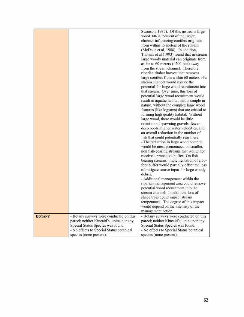
Swanson, 1987). Of this instream large
channel-influen rs originate
(McDade et ition, eam
from the stream channel. Therefore, riparian timber harvest that removes large conifers from within 60 meters of a stream channel would reduce the potential for large wood recruitment into
d
0-s
ct he
wood, 60-70 percent of the larger, cing conife
from within 15 meters of the stream al, 1988). In add
Thomas et al (1993) found that in-strlarge woody material can originate from as far as 60 meters (~200 feet) away
that stream. Over time, this loss of potential large wood recruitment would result in aquatic habitat that is simple in nature, without the complex large wood features (like logjams) that are critical toforming high quality habitat. Without large wood, there would be little retention of spawning gravels, fewer deep pools, higher water velocities, anan overall reduction in the number of fish that could potentially rear there. - The reduction in large wood potential would be most pronounced on smaller, non fish-bearing streams that would not receive a protective buffer. On fish bearing streams, implementation of a 5foot buffer would partially offset the losof mitigate source input for large woody debris. - Additional management within the riparian management area could remove potential wood recruitment into the stream channel. In addition, loss of shade trees could impact stream temperature. The degree of this impawould depend on the intensity of tmanagement action.
BOTANY this
nical
y - Botany surveys were conducted onparcel; neither Kincaid’s lupine nor any Special Status Species was found. - No effects to Special Status bota
- Botany surveys were conducted on this parcel; neither Kincaid’s lupine nor anSpecial Status Species was found. - No effects to Special Status botanical species (none present). species (none present).
62

Table 18. Enviro crnmental Effects to Parcel 4 (40 a es). POTENTIAL EFFECTS OF THE NO ACTION ALTERNATIVE
(CONTINUED MANAGEMENT UNDER THE ROSEBURG RMP)
POTENTIAL EFFECTS OF THE PROPOSED A CTION
(MANAGEMENT UNDER THE OREGON FORESTRESOURCE
PRACTICES ACT)
TIMBER
ft on the unit. .
- 40.0 acres of timber harvested
- 29.0 acres of timber harvested - 12-18 green trees would be retained peracre within regeneration harvest units. - 120 linear feet of logs per acre ≥ 16 inches in diameter and 16 feet long would be le- No BLM sale plans exist at this time
RIPARIAN RESERVES & WATER RESOURCES
uld
a
lt in
er
t harvest-related ediment increases in stream channels (p.
V-28). No increase in stream temperature would be expected since the Riparian Reserve would remain intact and existing stream shade would be maintained. Therefore, BLM management would not result in an incremental change to water quality.
could result in an
am was
as
- Non-fish-bearing stream is likely a small Type N stream. - No streamside retention. - Harvest of this parcel
- 11.0 acres of Riparian Reserve wonot be harvested. - Non fish-bearing stream would haveriparian buffer of 200 feet. - Fish-bearing stream would have a riparian buffer of 400 feet. - BLM timber harvest would not resuany peak flow effects. The Forest Ecosystem Management Assessment Team (FEMAT) report cites a case study in which a one site potential tree buff(in this case 200 feet) was deemedadequate to prevens
increase in peak flows of up to 20 percent or up to approximately 3 cubic feet per second more during a bankfullevent in this stream. This streassessed for channel stability and wfound to have adequate stream structure to dissipate any potential increase in stream energy. Therefore, no impact from increased peak flows would occur.
WILDLIFE - 29.0 acres of timber harvested, removing habitat elements such as large-diameter trees with nesting cavities or platforms, multiple canopy layers, and hunting perches. - Removal of these elements would subject spotted owls to reduced nesting, roosting, foraging and dispersal opportunities. -Reducing foraging and nesting opportunities makes it more difficult for owls to successfully fledge young. - Removal of individual trees with potential nesting platforms would reduce nesting habitat for marbled murrelets. -Special habitat features would be retained such as coarse woody debris, snags, hardwoods, ponds to benefit and protect various Special Status Species.
d - 40.0 acres of suitable Northern spotteowl nesting, roosting, foraging, and dispersal habitat lost. - One owl home range would be impacted with the loss of 40.0 acres of suitable habitat. - Habitat unlikely to develop beyond dispersal spotted owl habitat in the future. - May affect, likely to adversely affect the Northern spotted owl. - Special Status Species would not receive protection on private land.
FISHERIES - There would be no adverse impacts to fisheries during regeneration harvest due to the implementation of the Riparian
- No direct impacts from the harvest of timber from the proposed parcel to fisheries due to the lack of habitat and/or
63

Reserves. - There would be no adverse impacts associated to density management actions within the Riparian Reserves due to implementation of the RMP’s best management practices and site specific project design features such as variable buffer widths on all streams and seasonal restrictions to minimize sedimentation. - Any restorative activities that may cause adverse impacts to Essential Fish Habitat (i.e. stream culvert replacements and In stream placements) would be consulted on by National Marine Fisheries Service.
e
species present. - Although the loss of large organic debris from the riparian areas would directly affect the channel conditions within the parcel, this effect would bdiminishable and discountable to the fisheries habitat further downstream.
BOTANY - Botany surveys were conducted on this parcel; neither Kincaid’s lupine nor any Special Status Species was found. - No effects to Special Status botanical species (none present).
- Botany surveys were conducted on this parcel; neither Kincaid’s lupine nor any Special Status Species was found. - No effects to Special Status botanical species (none present).
Table 19. Environmental Effects to Parcel 5 (39.06 acres).
RESOURCE POTENTIAL EFFECTS OF THE POTENTIAL EFFECTS OF THE PROPOSED
ACTION (MANAGEMENT UNDER THE OREGON FOREST
PRACTICES ACT)
NO ACTION ALTERNATIVE (CONTINUED MANAGEMENT UNDER THE
ROSEBURG RMP) TIMBER - 15.06 acres of timber harvested (24
acres withdrawn). - 12-18 green trees would be retained per acre within regeneration harvest units. - 120 linear feet of logs per acre ≥ 16 inches in diameter and 16 feet long would be left on units. - Part of this parcel was previously offered in a sold unawarded sale. No BLM sale plans exist at this time.
- 39.06 acres of timber harvested
RIPARIAN RESERVES & WATER RESOURCES
- BLM timber harvest would not result in any peak flow effects. The Forest Ecosystem Management Assessment Team (FEMAT) report cites a case study in which a one site potential tree buffer (in this case 200 feet) was deemed adequate to prevent harvest-related sediment increases in stream channels (p. V-28). No increase in stream temperature would be expected since the
rcent or up to approximately 2 cubic feet per second more during a bankfull event in one of the tributaries draining this parcel. This tributary is on private land and could not be accessed to assess the stream condition. Hancock Creek, which this stream drains to, was assessed for channel stability and was found to not have adequate structure to dissipate increased stream energy. It is unlikely
- 24.0 acres of Riparian Reserve would not be harvested. - Non-fish-bearing stream would have ariparian buffer 200 feet.
- Likely small Type N streams. - No streamside retention. - Harvest could result in an increase in peak flows of up to 20 pe
64

Riparian Reserve would remain intact the poand emaintamaincremental uality.
tential increase in flow from the
stream energy s bic feet per
natural range cock
creased peak flows would occur.
xisting stream shade would be ined. Therefore, BLM
nagement would not result in an change to water q
tributary would result in excessive ince a 2 cu
second increase would be well within the of flows for Han
Creek. Therefore, no impact fromin
WILDLIFE e-
r d
s to reduced nesting,
predation
ng
nd
- 39.06 acres of suitable Northern spotted owl nesting, roosting, foraging, and dispersal habitat lost. - One owl home range would be impacted with the loss of 39.06 acres of
velop beyond t in the
- Habitat unlikely to develop into bald eagle habitat in the future. - May affect, likely to adversely affect the Northern spotted owl, marbled murrelet, and bald eagle. - Special Status Species would not receive protection on private land.
- 15.06 acres of timber harvested, removing habitat elements such as largdiameter trees with nesting cavities oplatforms, multiple canopy layers, anhunting perches. - Removal of these elements would subject spotted owlroosting, foraging and dispersal opportunities and increasedrisk. - Reducing foraging and nestiopportunities makes it more difficult for owls to successfully fledge young. - Removal of individual trees with potential nesting platforms would reduce nesting habitat for marbled murrelets. - Harvest will remove habitat elements necessary for nesting bald eagles, specifically large-diameter trees with platform structures and multiple canopy layers. - Once these elements are removed, bald eagles would be subjected to reduced nesting and roosting opportunities. -Special habitat features would be retained such as coarse woody debris,
it asnags, hardwoods, ponds to benefprotect various Special Status Species.
suitable habitat. - Habitat unlikely to dedispersal spotted owl habitafuture. - 39.06 acres of suitable marbled murrelet habitat in Marbled Murrelet Inland Management Zone 1 (FEMAT 1993) lost. - Habitat unlikely to develop into marbled murrelet nesting habitat in the future. - 39.06 acres of suitable bald eagle habitat lost.
FISHERIES e
es due best
onal
ts
ffect
.
on
k ude
Hancock Creek by the stream flow from the upstream drainage area. In addition, the relative magnitude of this impact would be further diminished the further downstream from the confluence of the
- The loss of large organic debris fromthe riparian areas would directly athe channel conditions within the parcelLoss of stream side vegetation would increase erosion. The increase in sediment would have a direct impact fisheries habitat in Hancock Creek. However, this impact would be concurrent with increases in background sediment levels within Hancock Creeduring the wet season. The magnitof this impact would be diluted in
- There would be no adverse impacts to fisheries during regeneration harvest duto the implementation of the Riparian Reserves. - There would be no adverse impacts associated to density management actions within the Riparian Reservto implementation of the RMP’s management practices and site specific project design features such as variable
sbuffer widths on all streams and searestrictions to minimize sedimentation. - Any restorative activities that may
Fish cause adverse impacts to Essential Habitat (i.e. stream culvert replacemenand In stream placements) would be consulted on by National Marine Fisheries Service.
affected tributary. Due to this diminishing effect, the increase in sedimentation would not be expected to
65

impact more than 0.05 mile of Hancock ite he
-
deposition of course sediment. Increases in turbidity can impact salmonids by delaying adult salmonid spawning migrations, and by forcing juvenile fish to avoid rearing habitats. Delays in spawning migration and habitat avoidance both result in use of a fish’s energy reserves, and can lead to
g
bating eggs and reducing the number of eggs that successfully hatch. If large amounts of course sediments enter the stream channel, pools may also start to fill in, further reducing the amount and quality of the habitat, and reducing the number
potentially rear there.
years).
Creek downstream from the project sand would not impact Elk Creek. - Timpacts to fisheries from the dischargeof sediment into Hancock Creek wouldbe a result of two distinct mechanismsincreased turbidity and increased
increased fish mortality. Increases in course sediment deposits on the stream bed can result in embedded spawningravels, thereby reducing the flow of oxygenated water to incu
of fish that couldThe impact of sediment would be persistent until the affected riparian has been re-vegetated (approximately 15
BOTANY re conducted on this
tany surveys were conducted on this parcel; neither Kincaid’s lupine nor any Special Status Species was found. - No effects to Special Status botanical species (none present).
- Botany surveys weparcel; neither Kincaid’s lupine nor any Special Status Species was found. - No effects to Special Status botanicalspecies (none present).
- Bo
nviro 45 Table 20. E nmental Effects to Parcel 6 (80. acres).
RESOURCE POTENTIAL EFFECTS OF THE NO ACTION ALTERNATIVE
(CONTINUED MANAGEMENT UNDER THE ROSEBURG RMP)
POTENTIAL EFFECTS OF THE PROPOSED ACTION
(MANAGEMENT UNDER THE OREGON FOREST PRACTICES ACT)
TIMBER
- 32.45 acres of timber harvested (48 acres withdrawn). - 6-8 green trees would be retained per acre on regeneration harvest units. - 120 linear feet of logs per acre ≥ 16inches in diameter and 16 feet long would be left on the units. - No BLM sale plans exist at this time.
- Approximately 77.45 acres of timber harvested. Approximately 3 acres would be left as a Riparian Management Area.
RIPARIAN - 48.0 acres of Riparian Reserve would - Non fish-bearing streams are likely
66

RESERVES & WATER RESOURCES
e a
- BLM timber harvest would not result in any peak flow effects. The Forest
t harvest-related s (p.
ince the
isting stream shade would be
e
am. this
may result in ercent
bankfull event in
tability and was found to have
ate .
ould occur.
small Type N streams with no streamsidretention. - Fish-bearing stream is likely a small Type F stream. - Riparian Management Area of 50 feeton each side of the small type F streSome harvest may be allowed withinarea depending on the basal area of this location. - Harvest of this parcelincreased peak flows of up to 20 por up to approximately 4 cubic feet per second more during a the fish-bearing stream draining this parcel. This stream was assessed forchannel s
not be harvested. - Non fish-bearing stream would havriparian buffer of 200 feet. - Fish-bearing stream would have a riparian buffer of 400 feet.
Ecosystem Management AssessmentTeam (FEMAT) report cites a case study in which a one site potential tree buffer(in this case 200 feet) was deemed adequate to prevensediment increases in stream channelV-28). No increase in stream temperature would be expected sRiparian Reserve would remain intact and ex adequate stream structure to dissip
any potential increase in stream energyTherefore, no impact from increased peak flows w
maintained. Therefore, BLM management would not result in an incremental change to water quality.
WILDLIFE ng
foraging and dispersal
duce ts.
d ld be subjected to reduced
d
potted
habitat lost.
the loss of 80.45 acres of
t Inland Management Zone 2 (FEMAT 1993) lost. - Habitat unlikely to develop into
p .
- 80.45 acres of suitable Northern sowl nesting, roosting, foraging, and dispersal- Three owl home ranges would be impacted withsuitable habitat and a fourth home rangewould lose 7.05 acres. - Habitat unlikely to develop beyond dispersal spotted owl habitat in the future. - 80.45 acres of suitable marbled murrelet habitat in Marbled Murrele
- 32.45 acres timber harvested, removihabitat elements such as large-diameter trees with nesting cavities or platforms, multiple canopy layers, and hunting perches. - Removal of these elements would subject spotted owls to reduced nesting, roosting, opportunities. - Removal of individual trees with potential nesting platforms would renesting habitat for marbled murrele- Harvest will remove habitat elementsnecessary for nesting bald eagles, specifically large-diameter trees with
marbled murrelet nesting habitat in the future. - 80.45 acres of suitable bald eagle habitat lost. Habitat unlikely to develointo bald eagle habitat in the future- May affect, likely to adversely affect, the Northern spotted owl, marbled murrelet, and bald eagle. - Special Status Species would not receive protection on private land.
platform structures and multiple canopy layers. - Once these elements are removed, baleagles wounesting and roosting opportunities. - Special habitat features would be retained such as coarse woody debris, snags, hardwoods, ponds to benefit anprotect various Special Status Species.
FISHERIES
es due of the RMP’s best
anagement practices and site specific project design features such as variable
fish-
g
bris and inor
- There would be no adverse impacts to fisheries during regeneration harvest dueto the implementation of the RiparianReserves. - There would be no adverse impacts associated to density management actions within the Riparian Reservto implementation m
- There would be no direct impacts fromthe harvest of timber along the nonbearing streams to fisheries due to the lack of habitat or species present. - The Riparian Management Area alonside the fish bearing stream within the parcel would minimize impacts to sedimentation, large organic destream temperatures. However, msedimentation and stream shade loss
67

buffer widths on all streams and seasonal restrictions to minimize sedimentation. - Any restorative activities that may cause adverse impacts to Essential Fish Habitat (i.e. stream culvert replacements and In stream placements) would be consulted on by National Marine Fisheries Service.
adult
n
ad ases in
ning
f
l in,
ber
tation would be localized. Additional management within the
of
of this impact would depend on the intensity of the management action. - Source for large woody debris (pieces 50 feet long and 24 inches dbh) to the stream channel can be up to one tree
feet) from the stream
Implementation foot riparian
the loss of so ge woody
aring habitat.
would be expected. - The impacts to fisheries from the discharge of sediment would be a result of two distinct mechanisms - increased turbidity and increased deposition of course sediment. Increases in turbidity can impact salmonids by delaying salmonid spawning migrations, and by forcing juvenile fish to avoid rearing habitats. Delays in spawning migratioand habitat avoidance both result in use of a fish’s energy reserves, and can leto increased fish mortality. Increcourse sediment deposits on the stream bed can result in embedded spawgravels, thereby reducing the flow of oxygenated water to incubating eggs andreducing the number of eggs that successfully hatch. If large amounts ocourse sediments enter the stream channel, pools may also start to filfurther reducing the amount and quality of the habitat, and reducing the numof fish that could potentially rear there. The impact of sediment would be persistent until the affected riparian has been re-vegetated (approximately 15 years). Due to stable conditions of the stream channel, impacts from increased sedimen- Riparian Management Area could remove potential wood recruitment into the stream channel. In addition, lossshade trees could impact stream temperature. The degree
height (200channel (Thomas et al. 1993).
of the 50-management area would partially offset
urce input for lardebris Loss of recruitment potential forlarge woody debris to the stream channel would indirectly impact spawning and re
BOTANY d - Botanical species would be affected by timber harvest and associated activities. See Table 11 for a summary of effects. - Special Status Species would not
- Special Status botanical species woulreceive protection.
receive protection on private land.
68
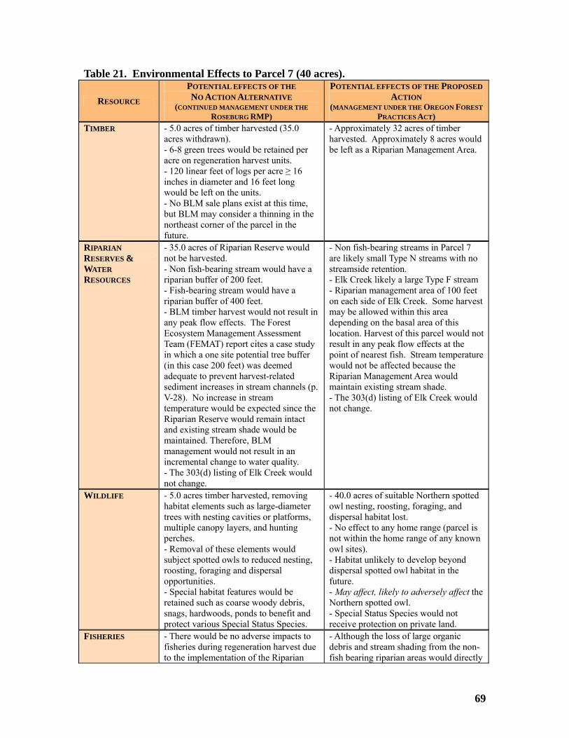
Table 21. Enviro s to Parcel 7 (40 acrnmental Effect es).
RESOURCE POTENTIAL EFFECTS OF THE NO ACTION ALTERNATIVE
(CONTINUED MANAGEMENT UNDER THE ROSEBURG RMP)
POTENTIAL EFFECTS OF THE PROPOSED ACTION
(MANAGEMENT UNDER THE REGON ORESTO F PRACTICES ACT)
TIMBER
r
ing in the
- 5.0 acres of timber harvested (35.0 acres withdrawn). - 6-8 green trees would be retained peacre on regeneration harvest units. - 120 linear feet of logs per acre ≥ 16 inches in diameter and 16 feet long would be left on the units. - No BLM sale plans exist at this time, but BLM may consider a thinnnortheast corner of the parcel in the future.
- Approximately 32 acres of timber harvested. Approximately 8 acres would be left as a Riparian Management Area.
RIPARIAN RESERVES & WATER RESOURCES
ld
a
Management Assessment udy
vent harvest-related ls (p.
e
tal change to water quality.
Type F stream
vest his area
temperature
isting stream shade. ould
- 35.0 acres of Riparian Reserve wounot be harvested. - Non fish-bearing stream would have riparian buffer of 200 feet. - Fish-bearing stream would have a riparian buffer of 400 feet. - BLM timber harvest would not result inany peak flow effects. The Forest EcosystemTeam (FEMAT) report cites a case stin which a one site potential tree buffer (in this case 200 feet) was deemed adequate to presediment increases in stream channeV-28). No increase in stream temperature would be expected since theRiparian Reserve would remain intact and existing stream shade would bmaintained. Therefore, BLM management would not result in an incremen- The 303(d) listing of Elk Creek would not change.
- Non fish-bearing streams in Parcel 7 are likely small Type N streams with no streamside retention. - Elk Creek likely a large - Riparian management area of 100 feet on each side of Elk Creek. Some harmay be allowed within tdepending on the basal area of this location. Harvest of this parcel would notresult in any peak flow effects at the point of nearest fish. Streamwould not be affected because the Riparian Management Area would maintain ex- The 303(d) listing of Elk Creek wnot change.
WILDLIFE ng
Removal of these elements would
abitat features would be
and
d
own
ct the
- 5.0 acres timber harvested, removihabitat elements such as large-diameter trees with nesting cavities or platforms, multiple canopy layers, and hunting perches. - subject spotted owls to reduced nesting, roosting, foraging and dispersal opportunities. - Special hretained such as coarse woody debris, snags, hardwoods, ponds to benefit protect various Special Status Species.
- 40.0 acres of suitable Northern spotteowl nesting, roosting, foraging, and dispersal habitat lost. - No effect to any home range (parcel is not within the home range of any knowl sites). - Habitat unlikely to develop beyond dispersal spotted owl habitat in the future. - May affect, likely to adversely affeNorthern spotted owl. - Special Status Species would not receive protection on private land.
FISHERIES
ctly
- There would be no adverse impacts to fisheries during regeneration harvest dueto the implementation of the Riparian
- Although the loss of large organic debris and stream shading from the non-fish bearing riparian areas would dire
69

Reserves. - There would be no adverse impacts associated to density management actions within the Riparian Reserves dueto implementation of the RMP’s best management practices and site specifproject design features such as variable buffer widths on al
ic
l streams and seasonal strictions to minimize sedimentation.
- Any restorative activities that may cause adverse impacts to Essential Fish Habitat (i.e. stream culvert replacements and In stream placements) would be consulted on by National Marine Fisheries Service.
ditions within the ring
3).
ally
affect the channel conparcel, this effect to the non fish-beastreams would be diminishable and discountable to fisheries habitat and Essential Fish Habitat further downstream. - The Riparian Management Area along side the fish-bearing stream within the parcel would minimize impacts to sedimentation, large organic debris and stream temperatures. - Source for large woody debris (pieces 50 feet long and 24 inches diameter at breast height) to the stream channel can be up to one tree height (200 feet) fromthe stream channel (Thomas et al. 199Implementation of the 100 foot riparian management area would only partioffset the loss of source input for large woody debris. Loss of recruitment potential for large woody debris to the stream channel would indirectly impact spawning and rearing habitat.
re
BOTANY - Special Status botanical species would receive protection
ities.
protection on private land.
- Botanical species would be affected by timber harvest and associated activSee Table 11 for a summary of effects. - Special Status Species would not receive
70
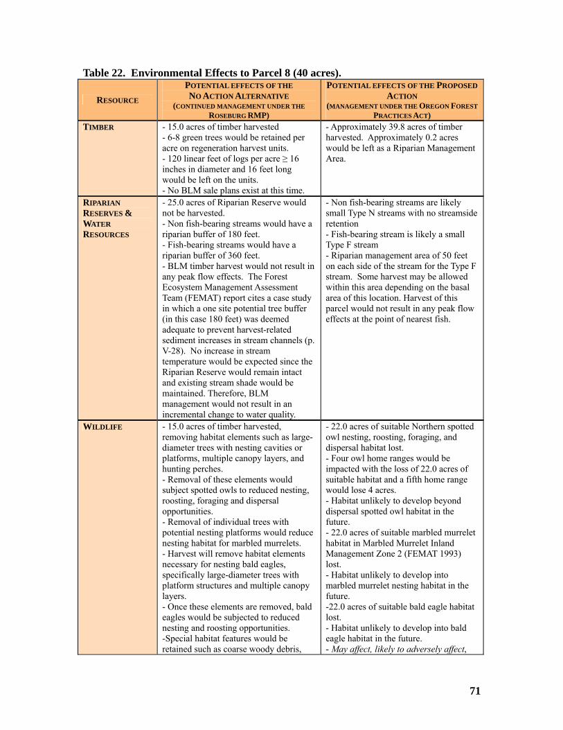
Table 22. Environmental Effects to Parcel 8 (40 acres).
RESOURCE POTENTIAL EFFECTS OF THE NO ACTION ALTERNATIVE
(CONTINUED MANAGEMENT UNDER THE ROSEBURG RMP)
POTENTIAL EFFECTS OF THE PROPOSED ACTION
(MANAGEMENT UNDER THE OREGON FOREST PRACTICES ACT)
TIMBER - 15.0 acres of timber harvested - 6-8 green trees would be retained per
this time.
rea. acre on regeneration harvest units. - 120 linear feet of logs per acre ≥ 16inches in diameter and 16 feet long would be left on the units. - No BLM sale plans exist at
- Approximately 39.8 acres of timberharvested. Approximately 0.2 acres would be left as a Riparian Management A
RIPARIAN RESERVES & WATER RESOURCES
ve a ffer of 180 feet.
0 feet.
Forest
a case study
e the ct
- Non fish-bearing streams are likely small Type N streams with no streamside retention - Fish-bearing stream is likely a small
m for the Type F
k flow
- 25.0 acres of Riparian Reserve would not be harvested. - Non fish-bearing streams would hariparian bu- Fish-bearing streams would have a riparian buffer of 36- BLM timber harvest would not result inany peak flow effects. The Ecosystem Management AssessmentTeam (FEMAT) report citesin which a one site potential tree buffer (in this case 180 feet) was deemed adequate to prevent harvest-related sediment increases in stream channels (p. V-28). No increase in stream temperature would be expected sincRiparian Reserve would remain intaand existing stream shade would be maintained. Therefore, BLM management would not result in an incremental change to water quality.
Type F stream - Riparian management area of 50 feet on each side of the streastream. Some harvest may be allowed within this area depending on the basal area of this location. Harvest of this parcel would not result in any peaeffects at the point of nearest fish.
WILDLIFE as large-
r d
these elements would
esting platforms would reduce .
, ge-diameter trees with
opy
- 22.0 acres of suitable Northern spotted owl nesting, roosting, foraging, and dispersal habitat lost. - Four owl home ranges would be impacted with the loss of 22.0 acres of suitable habitat and a fifth home range
bitat in the
rbled Murrelet Inland
unlikely to develop into
bitat
- 15.0 acres of timber harvested, removing habitat elements suchdiameter trees with nesting cavities oplatforms, multiple canopy layers, anhunting perches. - Removal of subject spotted owls to reduced nesting,roosting, foraging and dispersal opportunities. - Removal of individual trees with potential nnesting habitat for marbled murrelets- Harvest will remove habitat elements necessary for nesting bald eaglesspecifically larplatform structures and multiple canlayers. - Once these elements are removed, baldeagles would be subjected to reduced
would lose 4 acres. - Habitat unlikely to develop beyonddispersal spotted owl hafuture. - 22.0 acres of suitable marbled murrelet habitat in MaManagement Zone 2 (FEMAT 1993) lost. - Habitatmarbled murrelet nesting habitat in the future. -22.0 acres of suitable bald eagle halost.
nesting and roosting opportunities. -Special habitat features would be retained such as coarse woody debris,
- Habitat unlikely to develop into baldeagle habitat in the future. - May affect, likely to adversely affect,
71

snags, hardwoods, ponds to benefit and
the Northern spotted owl, marbled murrelet, and the bald eagle. - Special Status Species would not receive protection on private land.
protect various Special Status Species.
FISHERIES o
ic
l streams and seasonal strictions to minimize sedimentation.
- Any restorative activities that may cause adverse impacts to Essential Fish Habitat (i.e. stream culvert replacements and In stream placements) would be consulted on by National Marine Fisheries Service.
s from timber along the non-fish
g
pacts to
eter at
an fset
the loss of source input for large woody debris. Loss of recruitment potential for large woody debris to the stream channel would indirectly impact spawning and rearing habitat.
- There would be no direct impactthe harvest of bearing streams to fisheries due to the lack of habitat or species present. - The riparian management area alonside the fish bearing stream within the parcel would minimize imsedimentation, large organic debris and stream temperatures. - Additional management within the riparian management area could remove potential wood recruitment into the stream channel. In addition, loss of shade trees could impact stream temperature. The degree of this impact would depend on the intensity of the management action. - Source for large woody debris (pieces 50 feet long and 24 inches diambreast height) to the stream channel can be up to one tree height (200 feet) from the stream channel (Thomas et al. 1993). Implementation of the 50 foot riparimanagement area would partially of
- There would be no adverse impacts tfisheries during regeneration harvest dueto the implementation of the Riparian Reserves. - There would be no adverse impacts associated to density management actions within the Riparian Reserves dueto implementation of the RMP’s best management practices and site specifproject design features such as variable buffer widths on alre
BOTANY - Special Status botanical species would receive protection
- Botanical species would be affected by timber harvest and associated activities. See Table 11 for a summary of effects. - Special Status Species would not receive protection on private land.
72

Table 23. Environmental Effects to Parcel 9 (40 acres).
RESOURCE POTENTIAL EFFECTS OF THE NO ACTION ALTERNATIVE
(CONTINUED MANAGEMENT UNDER THE ROSEBURG RMP)
POTENTIAL EFFECTS OF THE PROPOSED ACTION
(MANAGEMENT UNDER THE OREGON FOREST PRACTICES ACT)
TIMBER - 11.0 acres of timber harvested (29.0 acres withdrawn) - 6-8 green trees would be retained per
long
uld
acre on regeneration harvest units. - 120 linear feet of logs per acre ≥ 16inches in diameter and 16 feetwould be left on the units. - No BLM sale plans exist at this time.
- Approximately 36 acres of timber harvested. Approximately 4 acres wobe left as a Riparian Management Area.
RIPARIAN RESERVES & WATER RESOURCES
rian Reserves would
uld have a
d have a
sult in
ffer
hannels (p.
e t
d be
ty.
N streams with no streamside
is likely a medium
- Harvest of this parcel would not result in any peak flow effects at the point of nearest fish.
- 29.0 acres of Ripanot be harvested. - Non fish-bearing streams woriparian buffer of 180 feet. - Fish-bearing streams woulriparian buffer of 360 feet. - BLM timber harvest would not reany peak flow effects. The Forest Ecosystem Management Assessment Team (FEMAT) report cites a case studyin which a one site potential tree bu(in this case 180 feet) was deemed adequate to prevent harvest-related sediment increases in stream cV-28). No increase in stream temperature would be expected since thRiparian Reserve would remain intacand existing stream shade woulmaintained. Therefore, BLM management would not result in an incremental change to water quali
- Non fish-bearing streams are likely small Type retention - Fish-bearing streamtype F stream. - Medium Type F stream would receive a riparian management area of 70 feet on each side of the stream. Some harvest may be allowed within this area depending on the basal area of this location.
WILDLIFE
ers, and hunting
esting, ing and dispersal
nopy
uld be subjected to reduced
and
ted raging, and
ever in Parcel 9 is contiguous with a
es ble nesting, roosting, and
he
wl suitable nesting, roosting,
at unlikely to develop beyond
t
- 11.0 acres timber harvested, removing habitat elements such as large-diametertrees with nesting cavities or platforms,multiple canopy layperches. - Removal of these elements would subject spotted owls to reduced nroosting, foragopportunities. - Harvest will remove habitat elements necessary for nesting bald eagles, specifically large-diameter trees with platform structures and multiple calayers. - Once these elements are removed, bald eagles wonesting and roosting opportunities. - Special habitat features would be retained such as coarse woody debris, snags, hardwoods, ponds to benefitprotect various Special Status Species.
- 40.0 acres of suitable Northern spotowl nesting, roosting, fodispersal habitat lost. - One owl home range would be impacted with the loss of 40.0 acres of suitable habitat. - The parcel does not include habitat within the designated core area, howthe standstand included in a Known Owl Activity Center. - 40.0 acres lost (32 percent of 126 acrof suitaforaging habitat) within 0.25 miles of tactivity center through the removal of spotted oforaging and dispersal habitat. - Habitdispersal spotted owl habitat in the future. - 40.0 acres of suitable bald eagle habita
73

lost. - Habitat unlikely to develop into bald
ct, eagle habitat in the future. - May affect, likely to adversely affethe Northern spotted owl and the bald eagle. - Special Status Species would not receive protection on private land.
FISHERIES o t due
ic
. y
Essential Fish abitat (i.e. stream culvert replacements
nd In stream placements) would be onsulted on by National Marine isheries Service.
he
ent Area along e
nd or
oss
. ies from the
eposits on the stream
s of course sediments enter the stream channel, pools may also start to fill in, further reducing the amount and quality of the habitat, and reducing the number of fish that could potentially rear there. The impact of sediment would be persistent until the affected riparian has been re-vegetated (approximately 15 years). Sedimentation within the stream channel would be expected to be localized to the area of impact. - Additional management within the Riparian Management Area could remove potential wood recruitment into the stream channel. In addition, loss of shade trees could impact stream temperature. The degree of this impact
- There would be no adverse impacts tfisheries during regeneration harvesto the implementation of the Riparian Reserves. - There would be no adverse impacts associated to density management actions within the Riparian Reserves due to implementation of the RMP’s best management practices and site specifproject design features such as variable buffer widths on all streams and seasonal restrictions to minimize sedimentation- Any restorative activities that macause adverse impacts toHacF
- There would be no direct impacts fromthe harvest of timber along the non-fishbearing streams to fisheries due to tlack of habitat or species present. - The Riparian Managemside the fish bearing stream within thparcel would minimize impacts to sedimentation, large organic debris astream temperatures. However, minsedimentation and stream shade lwould be expected from harvest activities within the management area- The impacts to fisherdischarge of sediment would be a result of two distinct mechanisms - increased turbidity and increased deposition of course sediment. Increases in turbidity can impact salmonids by delaying adult salmonid spawning migrations, and by forcing juvenile fish to avoid rearing habitats. Delays in spawning migration and habitat avoidance both result in use of a fish’s energy reserves, and can lead to increased fish mortality. Increases incourse sediment dbed can result in embedded spawning gravels, thereby reducing the flow of oxygenated water to incubating eggs and reducing the number of eggs that successfully hatch. If large amount
74

would depend on the intensity of the
- Source for larg ebris (pieces
breast heigh annel can
anagement area would partially offset the loss of source input for large woody debris. Loss of recruitment potential for large woody debris to the stream channel would indirectly impact spawning and
management action. e woody d
50 feet long and 24 inches diameter at t) to the stream ch
be up to one tree height (200 feet) fromthe stream channel (Thomas et al. 1993). Implementation of the 50 foot riparian m
rearing habitat. BOTANY - Special Status botanical species would
est and associated activities.
Species would not
receive protection
- Botanical species would be affected by timber harvSee Table 11 for a summary of effects. - Special Statusreceive protection on private land.
75

Table 24. Environmental Effects to Parcel 10 (40 acres).
RESOURCE POTENTIAL EFFECTS OF THE POTENTIAL EFFECTS OF THE PROPOSED
ACTION (MANAGEMENT UNDER THE OREGON FORES
NO ACTION ALTERNATIVE (CONTINUED MANAGEMENT UNDER THE T
PRACTICES ACT) ROSEBURG RMP) TIMBER - 34.0 acres of timber harvested (6 acres
withdrawn). - 6-8 green trees would be retained per
ft on the units. .
cres of timber harvested
acre on regeneration harvest units. - 120 linear feet of logs per acre ≥ 16 inches in diameter and 16 feet long would be le- No BLM sale plans exist at this time
- 40.0 a
RIPARIAN RESERVES & WATER RESOURCES
ld not
a
n
al as
prevent harvest-lated sediment increases in stream
hannels. No increase in stream mperature would be expected since the iparian Reserve would remain intact nd existing stream shade would be
maintained. Therefore, BLM management would not result in an incremental change to water quality.
f
- Non-fish bearing stream likely small Type N stream. - No streamside retention. - Harvest of this parcel would not result in any peak flow effects at the point onearest fish.
- 6.0 acres of Riparian Reserve woube harvested. - Non fish-bearing streams would haveriparian buffer of 180 feet. - Fish-bearing streams would have a riparian buffer of 360 feet. - BLM timber harvest would not result iany peak flow effects. The Forest Ecosystem Management Assessment Team (FEMAT) report (p. V-28) cites a case study in which a one site potentitree buffer (in this case 180 feet) wdeemed adequate torecteRa
WILDLIFE - 34.0 acres timber harvested, removing habitat elements such as large-diameter trees with nesting cavities or platforms, multiple canopy layers, and hunting perches. - Removal of these elements would subject spotted owls to reduced nesting, roosting, foraging and dispersal opportunities. - Removal of individual trees with potential nesting platforms would reduce nesting habitat for marbled murrelets. - Harvest will remove habitat elements necessary for nesting bald eagles, specifically large-diameter trees with platform structures and multiple canopy layers. - Once these elements are removed, bald eagles would be subjected to reduced nesting and roosting opportunities. - Special habitat features would be
s of
n the
abitat
40.0 acres of suitable Northern spotted owl nesting, roosting, foraging, and dispersal habitat lost. - Two owl home ranges would be impacted with the loss of 40.0 acresuitable habitat. - Habitat unlikely to develop beyond dispersal spotted owl habitat in the future. 40.0 acres of suitable marbled murrelet habitat in Marbled Murrelet Inland Management Zone 2 (FEMAT 1993) lost. - Habitat unlikely to develop into marbled murrelet nesting habitat ifuture. - 40.0 acres of suitable bald eagle hlost. - Habitat unlikely to develop into bald eagle habitat in the future. - May affect, likely to adversely affect,
76

retained such as coarse woody debris, snags, hardwoods, ponds to benefit and protect various Special Status Species.
eagle. the Northern spotted owl, marbled murrelet, and the bald - Special Status Species would not receive protection on private land.
FISHERIES - There would be no adverse impacts to fisheries during regeneration harvest due to the implementation of the Riparian Reserves. - There would be no adverse impacts associated to density management actions within the Riparian Reserves due to implementation of the RMP’s best management practices and site specific project design features such as variable
ize sedimentation.
Any restorative activities that may ause adverse impacts to Essential Fish
Habitat (i.e. stream culvert replacements and In stream placements) would be consulted on by National Marine Fisheries Service.
urther downstream buffer widths on all streams and seasonalrestrictions to minim- c
- No direct impacts from the harvest of timber from the proposed parcel to fisheries due to the lack of habitat and/or species present. - Although the loss of large organic debris from the riparian areas would directly affect the channel conditions within the parcel, this effect would be diminishable and discountable to the fisheries habitat f
BOTANY - Special Status botanical species would receive protection
- Botanical species would be affected by timber harvest and associated activities. See Table 11 for a summary of effects. - Special Status Species would not receive protection on private land.
D. CUMULATIVE EFFECTS Cumulative effects are the environmental effects of the action when added to the effects of other past, present, and reasonably foreseeable future actions, regardless of which agency or person undertakes these actions (40 CFR 1508.7). The effects of past actions are not specifically identified; the description of the current environment inherently includes the effects of the past actions. An analysis of the cumulative effects of the proposed action is presented for those resources likely to be affected by the action. Cumulative effects were analyzed by fifth-field watershed, as this scale allows for consideration of effects in the larger context of BLM management.
77

Upper Smith River: Parcels 1, 2, 3 There are approxima ely watershed, of which approximately 56,570 acres (59 pe Of
cres (74 p R in the Federal Reserve S ction of Parcels 1, 2, and/or 3 could result in up to approximately 14 anagement.
WILDLIFE
Currently, approx f federal lands within the watershed t are in a
uppo bitats for the bald eagle tted owl, marbled t and late- i
of th nt ob and private lands in the watershed do, how rovidspotted owls, as w y be used as connectivity between blocks of late-sera federal reserves. Suitable habitat conditions for the ecies are not expected to improve substantially on n able future. Within the watershed, private and state l 970 acres (41 percent). There are approxi ites within the watershed, which includes 39 know cts to spotted owls are an ongoing concern and woul n the project area and the State of Oregon. Oregon otection of a 70-acre core area around active nest sites; t tection or conservation of other surrounding habit up to several thousand acres of habitat to persist, these rule ination of active spotted owl sites (USDI
). Con areventually render an is the likely outcom
There are no know n this murrelets are an o onaction area and th the Oreg not adopted any regulations that specifically provide protection to murrelets.
Currently, there isprotections in the rot st sites, both from ti ng eeding season. Because of these State-requir any lost on non-Feder
BOTANY
The Upper Smith arine likely to support those spe ty and e
trcent) are in federal ownership.
95,540 acres within the total federal acres, approximately
41,720 a ercent), including 16,570 acres of ystem. Sele
iparian Reserves, are located
5 acres transferring out of BLM m
imately 44 percent (11,332 acres) oon Districwatershed, smurrelethe viability
mature or old-growth forests. State rt marginal ha
nd private lands within this , northern spo
seral dependent Special Status Spec es and do not notably contribute tojectives for those lands. The Statee some dispersal habitat for
ese species given the managemeever, p
ell as other wildlife species, and mal habitat contained within the
se late-successional dependent sponfederal lands within the foreseeands comprise approximately 38,
mately 14 spotted owl Master Sn activity centers. Cumulative effed likely continue in the future withiForest Practices Rules require prhe rules do not provide any proat. For a species that requires s allow for the progressive elim
FWS 2005 tinuous removal of suitable habitat the core nest areas non-functionale (USDI FWS 2005).
ound 70-acre cores would d displacement of spotted owls
n marbled murrelet sites withingoing concern and would likely ce State of Oregon. To date,
watershed. Cumulative effects totinue in the future within the on Forest Practices Rules have
no known bald eagle nest located w Oregon Forest Practice Rules to p
ithin this watershed. There are ect eagle nests, perches, and roo the brmber harvest and disturbance duri
ed protections, it is unlikely thatal lands in the short term.
currently occupied sites would be
River parcels have more of a m influence and are more cies that require higher humidi lower temperatures. This drainag
78

has western heml or c e higher humidity a
Throughout the range of Kincaid’s lupine, habitat is rant activ nd d
fragmentation are itStatus Species fac ncaidegradation due t eed species are depen t; rotat s practiced on lands d o develop for botan uccapplication of her edu l species to survive
On State lands, K d and endangered species are protected; the Sta acts to such species. There are no requirements for p serve federally listed or state listed botanical species.
RESOUR
BLM lands in the ver Fifth-Field WateWatershed which contribute directly to conservation o have a high potential of being restored as part of a wat
ransfer of these parcels would result in the loss of approximately 105 acres of Late uccessional Reserve and approximately 29 acres of Riparian Reserve from BLM anagement (less than 0.005 percent of Riparian Reserves within this watershed). The
s habitat from the loss of riparian habitat along the e proposed project area and would not be
of
ock and western red cedar as majnd lower temperature.
omponents, an indication of th
pidly disappearing due to developme ities, forestry practices, grazing, a
degrading populations throughout e many of the same threats as Ki
roadside maintenance. Weeds ans range. The District’s Special d’s lupine, such as habitat loss and
o factors like development and wdant on mature trees for habita managed for timber production, reical species associated with late sbicides following timber harvest r over the long term.
incaid’s lupine and other threatene
introduction. Some of these ion ages of less than 80 years, auces the opportunity for habitat tessional forest habitat. Aerial ces the opportunity for botanica
te employs measures to reduce imprivate landowners to protect or pre
WATER CES & FISHERIES
pper Smith Ri U rshed are managed as a Tier 1 Key s andf at-risk anadromous salmonid
ershed restoration program. TSmimpact to water resources and fisheriestream channels would be limited to thdiscernible at the fifth-field watershed scale. The proposed project would not have any discernible impact on the ability of the agencies to achieve the goals of the Aquatic Conservation Strategy.
Loss of these parcels would eliminate federal restoration opportunities in these areashe watershed. t
Elk Creek/Umpqua River: Parcels 4, 5, 6, 7 There are approximately 187,000 acres within the watershed, of which approximately 42,580 acres (23 percent) are in federal ownership. Of total federal acres, approximately 30,453 acres (72 percent), including 12,330 acres of Riparian Reserves, are located in the Federal Reserve System. Selection of Parcels 4, 5, 6 and/or 7 could result in up to approximately 199.51 acres transferring out of BLM management. Currently, the Bell Mountain Commercial Thinning is proposed near Parcel 5. The proposed action is to thin 151 acres. The pre-decisional EA (#OR-104-06-09) and pre-decisional Finding of No Significant Impact (FONSI) were recently released for public comment; no decision has
79

been made on the proposed action. The Bell Mountain commercial thinning of 151 acres not anticipated to have any significant effects to the human environment. In sum, the
proximately 40 percent (16,805 acres) of federal lands within the watershed or old-growth forests. State and private lands within this watershed,
bility
ese
tate
hich cludes 82 known activity centers. Cumulative effects to spotted owls are an ongoing
e of
s (USDI
have been detected, but nesting behavior has not
vide
s in the Oregon Forest Practice Rules to rotect eagle nests, perches, and roost sites, both from timber harvest and disturbance
breeding season. Because of these State-required protections, it is unlikely rrently occupied sites would be lost on non-Federal lands in the short term.
isBell Mountain project and the transfer of all parcels within the Elk Creek watershed could affect 350.51 acres or .18 percent of the total watershed. At this scale, no cumulative effect would be discernible.
ILDLIFE W
Currently, apare in maturesupport marginal habitats for the bald eagle, northern spotted owl, marbled murrelet and late-seral dependent Special Status Species and do not notably contribute to the viaof these species given the management objectives for those lands. The State and privatelands in the watershed do, however, provide some dispersal habitat for spotted owls, as well as other wildlife species, and may be used as connectivity between blocks of late-seral habitat contained within the federal reserves. Suitable habitat conditions for thlate-successional dependent species are not expected to improve substantially on nonfederal lands within the foreseeable future. Within the watershed, private and slands comprise approximately 144,420 acres (77 percent). There are approximately 34 spotted owl Master Sites within the watershed, winconcern and would likely continue in the future within the project area and the StatOregon. Oregon Forest Practices Rules require protection of a 70-acre core area aroundactive nest sites; the rules do not provide any protection or conservation of other surrounding habitat. For a species that requires up to several thousand acres of habitat topersist, these rules allow for the progressive elimination of active spotted owl siteFWS 2005). Continuous removal of suitable habitat around 70-acre cores would eventually render the core nest areas non-functional and displacement of spotted owls is the likely outcome (USDI FWS 2005).
There are two known marbled murrelets sites on federal lands within the watershed; thereare four additional sites where murreletsbeen observed. There are no known murrelet sites on private lands within this watershed.Cumulative effects to marbled murrelets are an ongoing concern and would likely continue in the future within the action area and the State of Oregon. To date, the Oregon Forest Practice Rules have not adopted any regulations that specifically proprotection to murrelets
There are no known bald eagle nest sites within the watershed; however, based on observation data, it is believed there is at least one nesting pair near Elk Creek. Availablebald eagle habitat on non-Federal lands could potentially be harvested within the next several years. In addition, there are protectionpduring the that any cu
80

BOTANY
The Elk Creek/Umpqua River parcels contain a wide variety of habitats. Some of the ing well
d
production, reduces the opportunity for habitat to l
aid’s lupine and other threatened and endangered species are rotected; the State employs measures to reduce impacts to such species. There are no
protect or preserve federally listed or State listed
f
d
y discernible impact on the ability of the agencies to achieve
cels would eliminate federal restoration opportunities in these areas of e watershed.
parcels have large south facing rock outcrops, while others contain cool north facforested slopes. As such, any of the species listed in Table 14 may be present in these parcels.
Throughout the range of Kincaid’s lupine, habitat is rapidly disappearing due to development activities, forestry practices, grazing, and roadside maintenance. Weeds anfragmentation are degrading populations throughout its range. The District’s Special Status Species face many of the same threats as Kincaid’s lupine, such as habitat loss anddegradation due to factors like development and weed introduction. Some of these species are dependant on mature trees for habitat; rotation ages of less than 80 years, as practiced on lands managed for timberdevelop for botanical species associated with late successional forest habitat. Aeriaapplication of herbicides following timber harvest reduces the opportunity for botanical species to survive over the long term.
On State land, Kincprequirements for private landowners tobotanical species.
WATER RESOURCES & FISHERIES
Transfer of Parcels 4, 5, 6 and/or 7 would result in a potential loss of up to118 acres oRiparian Reserves (less than 0.01 percent of Riparian Reserves from this watershed). Theimpact to water resources and fisheries habitat from the loss of riparian habitat along the stream channels would be limited to the proposed project area and would not be discernible at the fifth-field watershed scale. (Impacts within Parcels 4 and 6 would be limited to the proposed project areas, and impacts associated to Parcels 5 and 7 would belimited to within 0.5 mile downstream from the proposed project sites). The proposeproject would not have anthe goals of the Aquatic Conservation Strategy.
Loss of these parth
ower North Umpqua River: Parcel 9L There are approximately 106,200 acres within the watershed, of which approximately 12,330 acres (12 percent) are in federal ownership. Of total federal acres, approximately 8,490 acres (8 percent), including 2,295 acres of Riparian Reserves, are located in the Federal Reserve System. Selection of Parcel 9 could result in approximately 40 acres transferring out of BLM management. The Green Thunder Regeneration Harvest and Commercial Thinning addendum (EA #OR-104-06-02, revising #OR-104-99-04) decision was protested and appealed to the Interior Board of Land Appeals (IBLA). Concurrently, the United States Ninth Circuit Court of Appeals issued a ruling in
81

Klamath Siskiyou Wildlands Center v. Boody, No. 06-35214. The remedy of this ruling, to be issued by the District Court, may affect the Green Thunder appeal. As such, BLM’motion to IBLA for a temporary stay of proceedings on the Green Thunder appeal wagranted. BLM will state its position regarding further proceedings in the Green Tappeal within ten days of issuance of the r
s s
hunder emedy in the Klamath-Siskiyou Wildlands
Center v. Boody case. BLM does not know when the remedy will be issued, and does not know when the Green Thunder appeal process will resume.
ove substantially on tate
round 70-acre cores would eventually render the
d me. In addition, there are protections in the Oregon Forest
est
consequently
WILDLIFE
Currently, approximately 51 percent (6,190 acres) of federal lands within the watershed are in mature or old-growth forests. State and private lands within this watershed, support marginal habitats for the bald eagle, northern spotted owl, marbled murrelet and late-seral dependent Special Status Species and do not notably contribute to the viabilityof these species given the management objectives for those lands. The State and private lands in the watershed do, however, provide some dispersal habitat for spotted owls, as well as other wildlife species, and may be used as connectivity between blocks of late-seral habitat contained within the federal reserves. Suitable habitat conditions for these ate-successional dependent species are not expected to imprl
nonfederal lands within the foreseeable future. Within the watershed, private and slands comprise approximately 93,870 acres (88 percent). There are approximately 5 spotted owl Master Sites within the watershed, which includes6 known activity centers. Cumulative effects to spotted owls are an ongoing concern andwould likely continue in the future within the project area and the State of Oregon. Oregon Forest Practices Rules require protection of a 70-acre core area around active nest sites; the rules do not provide any protection or conservation of other surrounding habitat. For a species that requires up to several thousand acres of habitat to persist, these rules allow for the progressive elimination of active spotted owl sites (USDI FWS 2005). Continuous removal of suitable habitat acore nest areas non-functional and displacement of spotted owls is the likely outcome (USDI FWS 2005).
There is one known bald eagle nest sites within the watershed and is located on federal lands. Available bald eagle habitat on non-Federal lands could potentially be harvested within the next several years, however, 82 percent of all suitable habitat for bald eagles within the watershed are on federal lands and this habitat is expected to persist anincrease in LSRs over tiPractice Rules to protect eagle nests, perches, and roost sites, both from timber harvand disturbance during the breeding season. Because of these State-required protections, it is unlikely that any currently occupied sites would be lost on non-Federal lands in theshort term.
82

BOTANY
Throughout the range of Kincaid’s lupine, habitat is rapidly disappearing due to development activities, forestry practices, grazing, and roadside maintenance. Weeds and fragmentation are degrading populations throughout its range. The District’s Special Status Species face many of the same threats as Kincaid’s lupine, such as habitat loss and
se
o
al management (approximately 0.01 percent of the Riparian Reserves ithin this watershed). The impact to water resources and fisheries habitat from the loss
nnels would be limited to the proposed project ct
f the
degradation due to factors like development and weed introduction. Some of thespecies are dependant on mature trees for habitat; rotation ages of less than 80 years, as practiced on lands managed for timber production, reduces the opportunity for habitat to develop for botanical species associated with late successional forest habitat. Aerial application of herbicides following timber harvest reduces the opportunity for botanical species to survive over the long term.
On State lands, Kincaid’s lupine and other threatened and endangered species are protected; the State employs measures to reduce impacts to such species. There are nrequirements for private landowners to protect or preserve federally listed or State listed botanical species.
WATER RESOURCES & FISHERIES
Transfer of Parcel 9 would result in the loss of approximately 29 acres of Riparian Reserve from federwof riparian habitat along the stream chaarea and would not be discernible at the fifth-field watershed scale. The proposed projewould not have any discernible impact on the ability of the agencies to achieve the goals of the Aquatic Conservation Strategy.
Loss of this parcel would eliminate federal restoration opportunities in this area owatershed.
Upper Umpqua River: Parcels 8, 10 There are approximately 169,700 acres within the watershed, of which approximately 58,730 acres (35 percent) are in federal ownership. Of total federal acres, approximately 0,950 acres (87 percent), including 5,780 acres of Riparian Reserves, are located in the ederal Reserve System. Selection of Parcel 8 and/or 10 could result in up to
BLM management. In 2003, BLM signed a ecision on the Upper Umpqua Watershed Plan (EA #OR-104-02-09). This Plan
g
to have s
een
5Fapproximately 80 acres transferring out ofdanalyzed the effects of multiple projects within the Upper Umpqua Watershed, includinapproximately 8000 acres of density management and commercial thinning. Individual project decisions are being made from this EA; several timber management activities have taken place since 2003. Currently, the Bare Cupboard project proposes approximately 223 acres of commercial thinning and density management, analyzed under the Upper Umpqua Watershed Plan. The proposed action is not anticipated significant effects to the human environment; the Upper Umpqua Watershed Plan wafound to have no significant impact to the human environment. No decision has b
83
made on this proposal, but a decision is expected in February or March, 2007. In sum, the 223 acre Bare Cupboard project and the transfer of these parcels would affect 303 acres. This is .17 percent of the Upper Umpqua Watershed. At this scale, no cumulativeffects of the actions would be discernible.
WILDLIFE
e
urrently, approximately 56 percent (29,334 acres) of federal lands within the watershed e in mature or old-growth forests. State and private lands within this watershed support
itats for the bald eagle, northern spotted owl, marbled murrelet and late-
going
f a 70-acre core area around ctive nest sites; the rules do not provide any protection or conservation of other
e
e
on area and the State of Oregon. To date, the Oregon Forest Practice
table
tections, it is unlikely that any currently occupied sites would be lost on non-ederal lands in the short term.
Carmarginal habseral dependent Special Status Species and do not notably contribute to the viability of these species given the management objectives for those lands. Portions of these lands also do not provide any habitat. These lands however, support some dispersal habitat for spotted owls and may be used as connectivity between blocks of late-seral habitat contained within the federal reserves. Habitat conditions on these lands are not expected to improve substantially within the foreseeable future. Within the watershed, private and state lands comprise approximately 110,970 acres (65 percent).
There are approximately 51 spotted owl Master Sites within the watershed, which includes 139 known activity centers. Cumulative effects to spotted owls are an onconcern and would likely continue in the future within the project area and the State of Oregon. Oregon Forest Practices Rules require protection oasurrounding habitat. For a species that requires up to several thousand acres of habitat to persist, these rules allow for the progressive elimination of active spotted owl sites (USDI FWS 2005). Continuous removal of suitable habitat around 70-acre cores would eventually render the core nest areas non-functional and displacement of spotted owls is the likely outcome (USDI FWS 2005).
There are six known marbled murrelets sites on federal lands within the watershed; therare five additional sites where murrelets have been detected, but nesting behavior has not been observed. There are no known murrelet sites on private lands within this watershed. Cumulative effects to murrelets are an ongoing concern and would likely continue in thfuture within the actiRules have not adopted any regulations that specifically provide protection to murrelets.
There are nine known bald eagle nest sites within the watershed, of which eight are located on federal lands. Available bald eagle habitat on non-Federal lands could potentially be harvested within the next several years, however, 85 percent of all suihabitat for bald eagles within the watershed are on federal lands and this habitat is expected to persist and increase in LSRs over time. In addition, there are protections in the Oregon Forest Practice Rules to protect eagle nests, perches, and roost sites, both from timber harvest and disturbance during the breeding season. Because of these State-required proF
84

BOTANY
These parcels are along the valley fringes and could contain remnant valley openthese are impossible to determine from aerial photos or the other information that the BLM collects on these stands. Some of the botanical species requiring cooler temperatures and higher humidity may not occur here.
Throughout the range of Kincaid’s lupine, habitat is rapidly disappearing due to development activities, forestry practices, grazing, and roadside maintenance. Weeds andfragmentation are degrading populations throughout its range. The District’s Special Status Species face many of the same threats as Kincaid’s lupine, such as habitat loss anddegradation due to factors like development and weed introduction. Some of these species are dependant on mature trees
ings;
for habitat; rotation ages of less than 80 years, as itat to
er the long term.
n State lands, Kincaid’s lupine and other threatened and endangered species are to reduce impacts to such species. There are no
isted
nt of the Riparian Reserves within this watershed). g
the fifth-field watershed scale. The proposed project would not have any iscernible impact on the ability of the agencies to achieve the goals of the Aquatic onservation Strategy.
ederal restoration opportunities in these areas of
practiced on lands managed for timber production, reduces the opportunity for habdevelop for botanical species associated with late successional forest habitat. Aerial application of herbicides following timber harvest reduces the opportunity for botanical species to survive ov
Oprotected; the State employs measures requirements for private landowners to protect or preserve federally listed or State lbotanical species.
WATER RESOURCES & FISHERIES
Transfer of Parcels 8 and/or 10 would result in the total loss of up to approximately 31 acres of Riparian Reserve (0.005 perceThe impact to water resources and fisheries habitat from the loss of riparian habitat alonthe stream channels would be limited to the proposed project area and would not be discernible atdC
Loss of these parcels would eliminate fthe watershed.
85

Chapter 5. CONSULTATION AND COORDINATION
A. FEDERAL AGENCIES U.S. Fish and Wildlife Service
B. STATE AND LOCAL AGENCIES
ification of public lands for state indemnity
will ssify
The BLM worked closely with these agencies in preparation of this EA: Oregon Department of State Lands Oregon Department of Forestry
The following State agencies were notified and their comments requested:
Oregon Department of Environmental Quality Oregon Department of Fish & Wildlife Oregon Department of Geology and Mineral Industries Oregon Department of Land Conservation & Development Oregon State Parks Division Oregon Water Resources Department
The following local government agencies were also notified and their comments requested:
Douglas County Board of Commissioners Douglas County Planning Division
C. PUBLIC CONTACT AND NOTIFICATION The BLM announced the proposed classselection through a legal notice in local newspapers in the Roseburg area on September 12 and 19 of 2006 and provided the public with a 30-day comment period. Comments were received and considered. Following completion of the environmental review, a notice announcing the availability of this environmental assessment and initial classification decision was published in the local newspapers in the Roseburg area on February 6, and a 30-day public comment period provided. Timely and substantive comments will be considered and responded to before the final decision. Upon completion of the Finding of No Significant Impact, a Final Classification Decision be published under the procedures specified in 43 CFR Part 2400, proposing to claselected parcels as suitable for transfer to the State of Oregon.
86

D. LIST OF PREPARERS The following BLM resource specialists have examined the proposed action and provideither written or verbal input utilized in this assessment: Participant Title Resource Value
ed
Minerals
Natural Resource Specialist Hazardous Materials im Votaw Hazardous Materials Hazardous Materials
Charlene Rainville Lead Realty Specialist Access Project Coordinator Bill O’Sullivan Management Representative Meagan Conry Natural Resource Specialist Planning and NEPA Writer-Editor A.C. Clough Fishery Biologist Fisheries Melanie Roan Wildlife Biologist Wildlife Elizabeth Gayner Wildlife Biologist Wildlife Julie Knurowski Botanist Botany Eric Heenan Geologist Isaac Barner Archeologist Cultural Resources Dan Dammann Hydrologist Water Resources Diann Rasmussen Realty Specialist Hazardous Materials Fred Larew Hazardous Materials Spec. Hazardous Materials
Harvey JimT Coordinator Robert Gilster Roads Right of Way Access Specialist Chuck White Roads Right of Way Access Specialist
87

88
Chapter 6. ATTACHMENTS APPENDIX A. MAPS


90

91

92
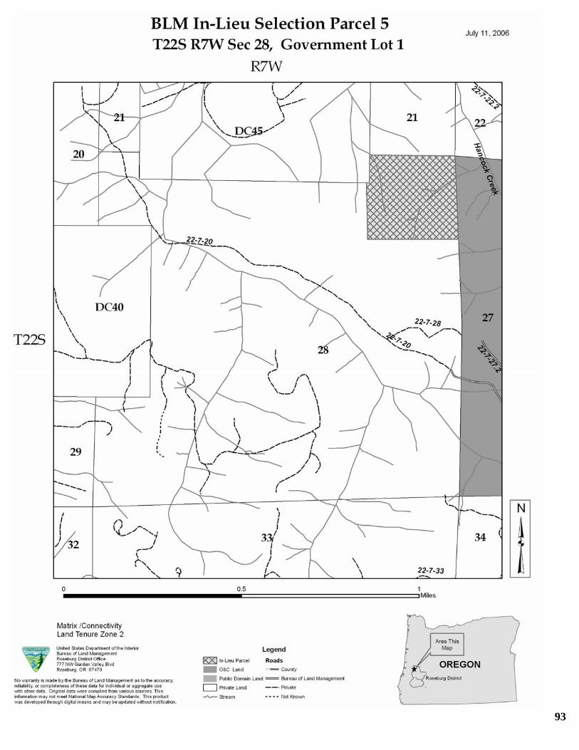
93

94

95

96

97

98

This page intentionally left blank.
99

APPENDIX B. PEAK FLOW ANALYSIS DISCUSSION Because water yield and peak flows are dependent upon the capture and runoff of precipitation, they are determined by analyzing the entire drainage network of a given area. Therefore, when analyzing and interpreting these flows it may be inaccurate to disregard any drainage area that is upstream of the extent of the proposed action or is contributing to effects associated with peak flow. Even though this area may not be directly or indirectly impacted by the proposed action, it is contributing to current stream flow conditions and must be considered. The potential risk of increased peak flow from this project was assessed. Twenty Analytical Hydrologic Units (AHUs) were developed to assess the potential impacts. These areas were designated based on the locations of the proposed parcels, fish distribution, and drainage areas potentially contributing to project area stream channel conditions. All AHUs were delineated to the point of nearest coho salmon distribution. Although there are currently no federally listed species in the project area, since Oregon coast coho have been federally listed in the recent past, it was considered to be the most sensitive beneficial use and was used for the basis of this analysis. These AHUs are considered to be the finest scale within which the risk of increased peak flows can accurately and meaningfully be assessed. Each AHU includes all the land draining into these streams and range from 11 to 2300 acres in size.
Past timber harvest (vegetation removal) can result in increases in water yield due to a decrease in evapotranspiration and interception (Satturlund and Adams, 1992). If a forested area is greater than 30 years of age, it is assumed to be hydrologically recovered (i.e., water yield increases have disappeared) since the last harvest. All of the proposed parcels are greater than 30 years of age. The Transient Snow Zone (TSZ) is defined as that area between 2,000 to 5,000 foot elevation that may alternately receive snow or rain. A TSZ effect is caused by a warm rain-on-melting snow event in openings created within the TSZ where there is less vegetation to intercept snowfall. If a large acreage of timber harvest or burned area is within the TSZ, there may be increased peak flows if a rain-on-snow event occurs. Only one of the parcels (Parcel 10) is within the TSZ. Roads and landings may modify storm flow peaks by reducing infiltration on compacted surfaces, allowing rapid surface runoff, or by intercepting subsurface flow and surface runoff, and channeling it more directly into streams (Ziemer, 1981). However, effects from peak flows have been shown to increase significantly only when roads occupy at least 12 percent of the watershed (Harr, et al. 1975), which is not the case in this project since the area in roads ranges from 0 to 6 percent within all the AHUs. Removal of trees tends to increase soil moisture and base streamflow in summer when rates of evapotranspiration are high; these summertime effects only last a few years (Ziemer and Lisle, 1998). The additional quantities of stream flow represent only a small component of a watershed’s annual yield (Harr, 1976 and Reiter and Beschta, 1995).
100

Slight increases in summer flow at the project level would benefit riparian areas, which are often moisture limited during the summer With the onset of the rainy season in the fall, the soil becomes recharged with moisture. Several studies have shown that the first storms of the fall have the most increase in peak flow from pre-logging conditions (Rothacher 1973, Harr, et al. 1975, Harr, et al. 1979, Ziemer, 1981). These fall storms are generally small and geomorphically inconsequential. Large peaks flows occur m -winter after soil moisture deficits are satisfied in both logged and unlogged watersheds (Ziemer and Lisle, 1998). Increases in peak or storm flows in winter and spring can alter channel morphology by flushing smaller substrate, causing the channel to dow cut and increase stream bank failures. Studies on increased peak flows are varied in uch increase in flow would result from a given amount of timber harvest. Most studies agree that the effects of harvest treatment decreases as the flow event size increases (Rothacher 1971; Rothacher 1973, Wright et al. 1990) and is not detectable for flows with a two year return interval or greater (Harr et al. 1975, Ziemer 1981, Thomas and Megahan 1998, Thomas and Megahan 2001). After examining 94 watershed experiments conducted worldwide, Bosch and Hewlett (1982) concluded that water yield increases are usually only detectable when at least 20 percent of the forest cover h rshed Study (AWS) documents the affects of forest management activities on stream flows in the Coast Range of Oregon. One objective of the AWS was to compare the impact of two patterns of clearcutting on water yield. In 1965, ridge-line roads were constructed into Deer Creek (750 acres) and Needle Branch (175 acres). In 1966, Deer Creek was patch-cut in three units covering about 25 percent (187 acres) of the watershed. The units were separated from streams by buffer strips from 50-100 feet wide. Needle Branch was 82 percent clearcut with no buffer strips along streams. Average increase in water yield for Needle Branch was 27 percent. Deer Creek exhibited smaller yield increases. The average increase in annual yield for the patch-cut with stream buffer watershed was only 5 percent (Harr 1976). The results from Deer Creek in the AWS study indicate partial cutting within a watershed combined with riparian buffers of 50-100 feet can reduce increases in water yield. Therefore, given the design criteria for BLM timber sales which utilize Riparian Reserves of 180 to 400 feet on all streams, resulting increases in water yield are expected to be much less than 5 percent , and probably undetectable. For this analysis, it was assumed that if increases in water yield are undetectable, then increases in peak flows would also be undetectable. Timber harvest under private ownership is conducted according to the Oregon Forest Practices Act which utilized Riparian Management Areas of 0 to 100 feet depending on stream type. Where private harvest units utilize Riparian Management Areas of at least 50 feet, potential increases in water yield are expected to be decreased as shown in the Alsea Watershed Study. However, the Oregon Forest Practices Act does allow some harvest within the Riparian Management Area depending on basal area conditions at the
.
,
id
n their findings on how m
as been removed. The Alsea Wate
101

site. Because of this, it is difficult to estimate how much harvest would be allowed under ent
d
n
to be approximately 20 percent.
hich are imarily
by management
all heds to sting or
ream.
this tical Hydrologic Units (AHUs) were
defined within the project area to assess the potential impacts. Peak flow was analyzed for each
recovery conditions before and after the roposed treatments. The data layer Stand-replacing Harvests and Fires in Oregon, 1972-
The
96 and NOAAF et al. 2003) is xpressed as a percentage. A 15 percent ECA value can represent 15 percent of the actual
oes
originally was the case by the developer. (Galbraith 1975) Furthermore, the ECA method
private ownership of the proposed parcels and how much of the Riparian ManagemArea would be left. Adams and Ringer (1994) summarized numerous studies conductein the Pacific Northwest looking at the effects of timber harvest on water quantity. Fourteen studies reported increases in peak flows ranging from 0 percent to 48 percentfollowing timber harvest of 30 to 100 percent of a watershed. The average increase ipeak flows of these 14 studies was 20 percent. Based on this, potential increases in peak flows for the Proposed Action are expected Stormflow response of small basins is affected primarily by hillslope processes, wsensitive to management activities. Stormflow response of larger basins is governed prby the geomorphology of the channel network, which is less likely to be affected activities (Robinson et al 1995). Also, runoff response time is generally shorter for small watersheds when compared to larger watersheds, and runoff per unit area is higher. As smstreams form increasingly larger drainage networks, the ability of individual small watersaffect flow decreases (Garbrecht 1991). As a result, peak flow increases following harveother forest practices at the drainage level are likely to be undetectable farther downst Based on the relationships described above, the potential risk of increased peak flow fromproject was assessed. As described above, twenty Analy
AHU. First, the potential impact from past timber harvest was assessed for each AHU. An Equvilent Clearcut Area (ECA) was calculated for each AHU using remote sensing imagery and GIS to determine hydrologic p2002 (Healey et al 2003) was used to determine the degree of change to the forest landscape within the Action Area over the last 30 years. The ECA method (Galbraith 1975) was originally developed to predict potential increases in annual water yield. type of ECA analysis commonly used accounts for acres of created forest openings anduses partial recovery coefficients for regrowth of young forest stands. The ECA indicator as used in fisheries ESA consultations (NMFS 19eacres in a watershed if those acres had the forest canopy entirely removed in one year, and the remainder of the acres in that watershed was at full recovery (defined as some percentage of canopy closure). The 15 percent value may represent greater actual acreages in a watershed in various states of hydrologic recovery. It was originally developed for forested lands in Montana and Idaho where snowmelt processes are the dominant hydrological events. ECA values have not been demonstrated to have meaningful correlation to runoff response or changes to stream channel morphology. This is because the ECA index dnot address the underlying causal geomorphological and hydrological mechanisms. There is little or no calibration of vegetative treatments with flow response such as
102

was never intended for precipitation-dominated areas, such as the analysis area, but rathefor permanent snow accumulation elevations. In
r contrast, the analysis area is low
levation, rain-dominated, and snow storage seldom occurs, is transitory and confined to
yield was e
has
ations
, and lowland precipitation dominated areas. Furthermore, many
sers have coupled ECA with an Aggregate Recovery Percentage (ARP) procedure, s
ed
f
ulty ences in rain and snow processes leading to varying runoff regimes.
orest stand characteristics, necessary to modify snow accumulation or melt rates leading
r
,
ith this in mind, an ECA value was calculated for each AHU in the analysis area. e
ea very limited portion of the drainage. The ECA procedure was meant to track changes in annual water yield, and this was assumed to be proportional to the increase in area logged. Increased waterassumed to be proportional to an increase in spring snowmelt runoff that may influencpeak flows. Although regeneration harvest generally does increase water yields, the assumed correlation between an increase in water yield and an increase in peakflow not been established. There is no agreed upon ECA procedure in use and many derivatives are being applied. NMFS (1996) does not provide guidance on which derivative to use. ECA calculhave been undertaken for all precipitation-runoff processes, for all watershed elevations (beyond intended uses) including permanent snowpack accumulation areas, rain-on-snowintermediate elevationsuwhich was developed to index potential increased peak flows in rain-on-snow elevation(Christner 1981). The result is a hybrid procedure, being called ECA that is really an acres accounting system. Vegetative age classes are determined, starting from a regeneration harvest or open condition, including roads, meadow areas, or agricultural land, and then adding in various young stand ages up to a stand condition that is assumto represent hydrologic maturity in terms of some combination of age, height, canopy cover, or diameter. Coefficients are applied for partial recovery. This procedure is assumed to indicate increased annual yield with types and patterns oforest tree removal, and this increase is assumed to cause increased peak flows, or be problematic when an indicated ECA threshold is surpassed. However, an ECA procedure, used without reservation across the landscape, leaves the user with difficassimilating the differFto differences in streamflow, may have no effect in rain only watersheds. Coefficients for partial recovery without extensive calibration are suspect in describing water yield orunoff processes. Therefore, the ECA procedure is not a sufficiently precise tool be relied upon for process based decisions. In common practice by the BLM and Forest ServiceECA and similar indices are used as a coarse screen to indicate when further field evaluation is needed, or as a means to compare alternatives during project analysis. WAHUs which had ECA values of less than 20 percent (Bosch and Hewlett 1982), wherconsidered to have no risk of peak flow increases and were dropped from further analysis. Eight AHUs met this criterion under the proposed action. Next, for those AHUs which had ECA values of 20 percent or greater, an estimated bankfull discharge (which has a return interval between 1 and 2 years) was calculated
103
based on the regional curve developed for the South Umpqua river system (Kuck, 2000). Then, at the point where these AHUs joined the closest downstream fish stream, the totaarea above that point was calculated and another bankfull flow was calculated for that area. The amount of flow contributed to that point by the AHU was then determinedThose AHU’s which contributed 5 percent or less of the total flow at the point of nearesfish where also considered to have no risk of peak flow increase since water yield changes of 5 percent and less are indistinguishable from natural variation in large watersheds (Huff et al. 2000). Seven of the remaining AHUs met these criter
l
. t
ia under the roposed action.
he main stream draining these AHUs was visited and evaluated using the Pfanchuch
in these streams. The stream providing drainage to Parcel 3 was rated as Fair ondition. This stream does have a wide flood plain with good sinuosity to help dissipate
. ld not
. It is am
p This analysis indicated that five AHUs have the potential for measureable increases in peak flows under the proposed action. These AHUs provide drainage to parcels 2, 3, 4, 5, and 6. Estimating a 20 percent increase in peak flows with a return internal of 2 years or less would mean an increase of 2-4 cubic feet per second (depending on size of the AHU) during a bankfull flow event. This amount of increase would be well within the natural range of flows for these streams. However, as an extra precaution, those AHUs which where considered to have the potential for increases in peak flow received further review. TChannel Stability and condition rating system (Pfankuch 1975). The stream channels providing drainage to Parcels 2, 4, and 6 were rated as Good condition and have adequate stream structure to dissipate stream energy. No impacts from increased flows are expectedcstream energy. Instream structure does appear to be adequate to dissipate potential increases in stream energy. Therefore, no impacts from increased flows are expectedOne of the streams providing drainage to Parcel 5 is located on private land and coube accessed. Hancock Creek, which this stream drains to, was rated as Poor condition and does not appear to have adequate structure to dissipate increased stream energyunlikely the potential increase in flow from the tributary would result in excessive streenergy since a two cubic feet per second increase (which is a 20 percent increase of a bankfull flow for this stream) would be well within the natural range of flows for Hancock Creek. Therefore, no impact from increased peak flows would occur.
104

APPENDIX C. ESSENTIAL FISH HABITAT ASSESSMENT 1) Description of the Action: The proposed federal action analyzed in this EA is the transfer of approximately 180 acres to the State of Oregon under the 1992 Federal Court
er me
ur,
to EFH caused by the
o
rom an
lly ated
determine if they rise to the level of adverse effect and consultation under EFH is
red parcels, the ational Marine Fisheries Service may choose to provide conservation recommendations
decision (Oregon v. Bureau of Land Management, Civil No. 85-646-MA). The transfitself is a required (i.e. non-discretionary) action; however the BLM does maintain sodiscretion over which parcels will be submitted for consideration. Refer to page 3, for additional details on this action 2) Analysis of the potential adverse effects of the action on EFH and the managed species Of the 10 parcels considered for transfer, only Parcel 7 contains Essential Fish Habitat within its boundary. This parcel is located adjacent to the upper mainstem of Elk Creek, with approximately 1,500 linear feet of Elk Creek flowing through it (see page 32). Parcels 1, 2, 3, 4, 5, 6, and 9 are all located within one stream mile of documented EFH. Parcels 8 and 10 are located greater than one stream miles from documented EFH. Potential effects of timber harvest activities on each parcel are described in Chapter FoEnvironmental Consequences, pages 53 to 73. 3) Conclusion about the effects of the action on EFH: There would be no direct effect rising to the level of adverse effecttransfer of federal land to the state (transfer of title) as defined under 50 CFR 600 which would require consultation with the National Marine Fisheries Service. Indirect effects tEFH may occur as a result of subsequent management of the parcel under state ownership, including timber harvest, and are considered in this EA. However, fEFH standpoint, a detailed assessment of the impacts of future management options on EFH is not practicable due to: 1) the lack of any federal discretion regarding subsequent management of these transferred lands; 2) the lack of a State timber management plan for these parcels; 3) the wide range of management actions that could occur within the designated Riparian Management Areas (RMA’s) under the Oregon Forested PracticesAct; and 4) the lack of detail regarding specific harvest actions such as road construction and season of use, yarding practices (cable, helicopter, ground based) and stream crossings. Only until a management alternative is identified can effects be specificaanalyzed. At that time, with specific information, those possible effects can be evalutoneeded. Therefore, because the federal action before us now does not rise to the level ofadverse effect, consultation under the MSA is not required. Once a State timber harvest plan has been developed for the transferNto the State if they believe the proposed State actions would adversely affect EFH.
105

4) Proposed Mitigation: The BLM is not able to encumber any transferred title with management stipulations nospelled out in applicable laws. Therefore, there is no proposed mitigation to go along with this action.
t
106

REFERENCES AND LITERATURE CITED Adams, P.W. and Ringer, J.O. 1994. The Effects of Timber Harvesting and Forest Roads on Water
Quantity and Quality in the Pacific Northwest: Summary and Annotated Bibliography. Forest Engineering Department, Oregon State University, Corvallis, OR. 147p.
Anthony, R.G., R.L. Knight, G.T. Allen, B.R. McClelland, and J.I. Hodges. 1982. Habitat use by nesting
roosting bald eagles in the Pacific and
Northwest. Trans. N. Am. Wildl. Nat. Res. Conf. 47:332-342.
ive Society of Oregon. 37: 95-103
Vegetation Changes on Water Yield and Evapotraspiration. J. of Hydrology 55: 3-23.
y, e Service.
anaged areas of the Willamette National Forest. Willamette National Forest, Eugene, OR.
eric Administration, USDC
ealey, S, W. Cohen, and M. Lefsky. 2003. Stand-Replacing Harvests and Fires in Oregon, 1972-2002.
Barnes, M. 2004. Habitat Variation and Experimental Management of Kincaid’s Lupine, Bulletin of the Nat
Plant Beschta R.L. 1977. Effects of debris removal upon sediment movement. IN: Logging Debris in Streams Workshop II. Oregon State University, Corvallis. Bosch, J.M. and Hewlet, J.D. 1982. A Review of Catchment Experiments to Determine the Effects of
Burger, Alan E. 2002. Conservation assessment of marbled murrelets in British Columbia, a review of biolog
populations, habitat associations and conservation. Pacific and Yukon Region, Canadian Wildlif168 pp.
Christner, J. 1981. Changes in peak streamflows from m
FEMAT) USDA Forest Service, USDC National Oceanic and Atmosph(
National Marine Fisheries Service, USDI Bureau of Land Management, USDI Fish and Wildlife Service, USDI National Park Service, and Environmental Protection Agency. 1993. Forest Ecosystem Management: An Ecological, Economic, and Social Assessment. Report of the Forest Ecosystem Management Team.
Galbraith, A.F. 1975. Method for predicting increases in water yield related to timber harvesting and site
conditions. In: Water Management Symposium. Am. Soc. Civil Engrs. Logan, Utah, Aug. 1975 pp. 169-184.
Garbrecht, J. 1991. Effects of spatial accumulation of runoff on watershed response. Journal of
Environmental Quality. 20:31-35. Harr, R.D. 1976. Forest Practices and Streamflow in Western Oregon. USDA Forest Service General
Technical Report PNW-49. Pacific Northwest Forest and Range Experiment Station, Portland, OR. Harr, R.D., W.C. Harper, J.T. Krygier, and F.S. Hsieh. 1975. Changes in Storm Hydrographs after Road
Building and Clear-Cutting in the Oregon Coast Range. Water Resources Research, 11(3):536-444 Harr, R.D., R.L. Fredriksen, J. Rothacher. 1979. Changes in Streamflow following Timber Harvest in
Southwestern Oregon. USDA Forest Service Research Paper PNW-249. 22p. H
www.fsl.orst.edu/larse/nwfp_disturb/index.html Huff, D.D., B. Hargrove, M.L. Tharp, and R. Graham. 2000. Managing Forests for Water Yield The
Importance of Scale. Journal of Forestry, 98(12): 15-19.
107

Keller, E.A. and F. J. Swanson. 1979. Effects of large organic material on channel form and fluvial rocesses. Earth Surface Process. 4:361-380
posium. D.D. Rhodes and G.P. Williams, eds. pp. 169-197. State Univ. of New York, Binghamton.
uck, T. 2000. Regional Hydraulic Geometry Curves of the South Umpqua Area in Southwestern Oregon. in Stream Notes, January 2000. Rocky Mountain Research Station, Stream Systems Technology Center, Fort Collins, CO.
ogan, Robert. 2002. Oregon’s Forest Protection Laws, An Illustrated Manual. Prepared by the Oregon Forest Resources Institute in cooperation with the Oregon Department of Forestry. 160 pp.
cDade, Mary Helen. 1987. The source area for course woody debris in small streams in western Oregon and Washington. Oregon State University.
Meehan W.R., F.J. Swanson, and J.R. Sedell. 1977. Influences of riparian vegetation on aquatic ecosystem with particular reference to salmonid fishes and their food supply. IN: Importance, Preservation, and Management of Riparian Habitat: a Symposium. R.R. Johnson and D.A. Jones, tech. cords. USDA Forest Service General Technical Report RM-43. Rocky Mountain Forest and Range Exp. Stn., Fort Collins, Colorado. Megahan, W.F. 1982. Channel sediment storage behind obstructions in forest drainage basins draining the granitic bedrock of the Idaho batholith. IN: Sediment Budgets and Routing in Forested Drainage Basins. F.J. Swanson, R.J. Janda, T. Dunne, and D.N. Swanson, eds. pp. 114-121. USDA Forest Service General Technical Report PNW-141. Pacific Northwest Forest and Range Exp. Stn., Portland, Oregon. Mosley, M.P. 1981. The influence of organic debris on channel morphology and bedload transport in a New Zealand forest stream. Earth Surface Process. Landform 6: 572-579. Nelson, S. Kim, and Amanda K. Wilson. 2002. Marbled murrelet habitat characteristics on state lands in
western Oregon. Corvallis, OR: Oregon Cooperative Fish and Wildlife Research Unit, OSU, Department of Fisheries and Wildlife. 151 pages.
NMFS, Environmental and Technical Services Division Habitat Conservation Branch, August 1996.
Making Endangered Species Act Determinations of Effect for Individual or Grouped Actions at the Watershed Scale.
NOAA Fisheries; USDA Forest Service; USDI Bureau of Land Management and USDI Fish and Wildlife
Service, Analytical Procedure Group Product July 2003. Analytical Process for Development of Biological Assessments for Consultation on Federal Actions affecting Fish Proposed or listed under the Endangered Species Act within the Northwest Forest Plan Area.
Oregon Department of Forestry. January 1, 2007. Forest Practice Administrative Rules and Forest
Practices Act. Chapter 629. Oregon Department of Forestry and Oregon Department of Environmental Quality. 2002. Oregon
Department of Forestry and Department of Environmental Quality Sufficiency Analysis: A Statewide Evaluation of FPA Effectiveness in Protecting Water Quality
Pfankuch, D.F. 1975. Stream Reach Inventory and Channel Stability Evaluation. USDA Forest Service,
R1-75-002. Govt Printing Office #696-260/200, Wash. D.C. 26pp. Pilz, Dave. PNW Forest Mycology Team. HJ Andrews Fungi information
p Keller E.A. and T. Tally. 1979. Effects of large organic debris on channel form and fluvial processes in thecoastal redwood environment. IN: Adjustments of the Fluvial System. Proceedings of the Tenth AnnualGeomorphology Sym
K
L
M
108

http://www.fs.fed.us/pnw/mycology/studies/index.
ractices on Water in Cumulative effects of forest practices in Oregon: literature and synthesis.
Rob annel l catchments. Water
ot
wa anagement
wa . and G.W. Lienkaemper. 1978. Physical consequences of large organic debris in Pacific
Pac Tho rge
es, Oregon: A second opinion, Water Resources Research, Vol. 34(12): 3393-
Tho
ents to orthern
ureau of Land Management, Portland, OR. 2 vols. and appendices.
l
land,
tal n
ent Planning
SDA gement. 2001b. Record of Decision for Amendments to es in rthern
Reiter, M.L., and R.L. Beschta. 1995. Chapter 7, Effects of Forest P Prepared for Oregon Dept. of Forestry, Salem OR. March, 1995.
inson, J.S., M. Sivapalan, and J.D. Snell. 1995. On the Relative Roles of hillslope processes, chrouting, and network geomorphology in the hydrologic response of naturaResources Research. 31:3089-3101.
hacher, J. 1971. Regimes of streamflows and their modification by logging. Pages 55-63 in RProceedings of the symposium of forest land use and stream environment. Oregon State University, Corvallis, Oregon.
Rothacher, J. 1973. Does harvest in west slope Douglas-fir increase peak flow in small streams? USDA
Forest Service Research Paper PNW-163, 13 pp. Portland, Oregon. Satterlund, D.R., Adams, P.W. 1992 Wildland Watershed Management. John Wiley & Sons, Inc.
nson, F.J. and G.W. Lienkaemper, and J.R. Sedell. 1976. History, physical effects, and mSimplications of large organic debris in Western Oregon Streams. USDA Forest Service General Technical Rep. PNW-56. Pacific Northwest Forest and Range Exp. Stn., Portland, Orgeon.
nson, F.JSNorthwest streams. USDA Forest Service General Technical Report PNW-69. Pacific Northwest Forest and Range Exp. Stn., Portland, Oregon. Thomas, J.W., Raphael, M.G., Anthony, Robert G. and others. 1993. Viability assessments and management considerations of species associated with late-successional and old-growth forests of the
ific Northwest. Report of the Scientific Analysis Team. USDA Forest Service.
mas, R.B. and W.F. Megahan. 1998. Peak flow responses to clear-cutting and roads in small and labasins, western Cascad3403.
mas, R.B. and W.F. Megahan. 2001. Reply, Water Resource Research, Vol 37(1): 181-183.
USDA Forest Service and USDI Bureau of Land Management. 1994a. Record of decision for amendm
Forest Service and Bureau of Land Management planning documents within the range of the nspotted owl. U.S. Forest Service, B
USDA Forest Service and USDI Bureau of Land Management. 1994b. Final supplemental environmenta
impact statement on management of habitat for late-successional and old-growth forests related species within the range of the northern spotted owl. U.S. Forest Service, Bureau of Land Management, PortOR.
USDA Forest Service and USDI Bureau of Land Management. 2001a. Final Supplemental Environmen
Impact Statement for Amendments to the Survey and Manage, Protection Buffer, and other MitigatioMeasures Standards and Guidelines in Forest Service and Bureau of Land ManagemDocuments Within the Range of the Northern Spotted Owl.
Forest Service and USDI Bureau of Land ManaU
the Survey and Manage, Protection Buffer, and other Mitigation Measures Standards and GuidelinForest Service and Bureau of Land Management Planning Documents Within the Range of the NoSpotted Owl.
109

USDA Forest Service and USDI Bureau of Land Management. 2004a. Final Supplemental EnvironmImpact Statement to Clarify Provisions Re
ental lating to the Aquatic Conservation Strategy.
Service, USDI Bureau of Land Management and Fish and Wildlife Service. 2006. Programmatic Conservation Agreement for Kincaid’s Lupine in Douglas County. 12 pp.
USD
SDI Bureau of Land Management. 1994. Roseburg District Proposed Resource Management
SDI Bureau of Land Management. 1995. Record of Decision and Resource Management Plan. Roseburg
SDI Fish and Wildlife Service. 2005. Biological Opinion: Roseburg Bureau of Land Management FY 2005-
iemer, R.R. 1981. Storm flow response of road building and partial cutting in small streams of Northern
. 43-68.
USDA Forest Service and USDI Bureau of Land Management. 2004b. Record of Decision to Clarify
Provisions Relating to the Aquatic Conservation Strategy. USDA Forest
I Bureau of Land Management. 1984. Manual 2621 – Indemnity Selections.
UPlan/Environmental Impact Statement. Roseburg, Oregon, USA. 3 Vols.
UDistrict. Roseburg, Oregon, USA. 216 pp.
U2008 Management Activities. Ref. # 1-15-05-F-0512. August 29, 2005.
Wright, K.A., K.H. Sendek, R.M. Rice, and R.B. Thomas. 1990. Logging effects on streamflow: Storm
runoff at Caspar Creek in Northwestern California, Water Resources Research, Vol. 26: 1657-1667. Z
California, Water Resources Research, Vol. 17 (4): 907-917. Ziemer, R.R. and T.E. Lisle. 1998. Hydrology. in River Ecology and Management: Lessons from the
Pacific Coastal Ecoregion. eds. R.J. Naiman and R.E. Bilby. Springer-Verlag, New York, pp
110