State of Mississippi - mdeq.ms.gov€¦ · quality monitoring program is described in this report....
142
MISSISSIPPI DEPARTMENT OF ENVIRONMENTAL QUALITY State of Mississippi Water Quality Assessment 2016 Section 305 (b) Report
Transcript of State of Mississippi - mdeq.ms.gov€¦ · quality monitoring program is described in this report....

MISSISSIPPI DEPARTMENT OF
ENVIRONMENTAL QUALITY
State of Mississippi Water Quality Assessment
2016 Section 305 (b) Report

ii

i
State of Mississippi
Water Quality Assessment
2016 Section 305(b) Report
June 23, 2016
Prepared by:
Office of Pollution Control
Field Services Division
Post Office Box 2261
Jackson, MS 39225
(601) 961-5171
www.deq.state.ms.us
Department of Environmental Quality

ii
iii
ABSTRACT
Section 305(b) of the Federal Clean Water Act (CWA) requires each state to describe the
quality of their water resources in a report for the United States Environmental Protection
Agency (USEPA), Congress, and the public on a biennial basis. The Mississippi
Department of Environmental Quality (MDEQ), as the lead agency for environmental
protection in Mississippi, is the state agency responsible for generating this report. The
purpose of Mississippi's 2016 Water Quality Assessment §305(b) Report is to
comprehensively describe for USEPA, Congress, and the public the status of the quality
of the state's surface waters. This 2016 §305(b) report fulfills all reporting requirements
under §305(b) of the CWA. Along with the water quality assessment information, the
report also describes the state’s assessment methodology and gives the causes, where
known, for those waters identified as impaired. Additionally, Mississippi’s surface water
quality monitoring program is described in this report.

iv
ACKNOWLEDGEMENTS
The authors would like to express their appreciation to the staff of the Surface Water
Division’s Basin Management Section and the Modeling and TMDL Branch who
contributed to this report. It should also be noted that without the help and support from
the staff in the Data Integration Division who helped with all database needs and GIS
support, development of this report would not have been possible. Special thanks is
extended to the staff of the Field Services Division for their data collection and laboratory
efforts in providing most of the data used in this assessment cycle, as well as their
contributions to this narrative report. The Water Quality Assessment Section would also
like to thank Jeff Thomas and Kosalram Gopalsamy without whom this effort would have
been impossible.

v
TABLE OF CONTENTS TABLE OF CONTENTS ............................................................................................................................. v TABLE OF FIGURES ................................................................................................................................ vi TABLE OF TABLES .................................................................................................................................. vi List of Acronyms ........................................................................................................................................ vii PART I .......................................................................................................................................................... 1 INTRODUCTION ........................................................................................................................................ 1 Introduction .................................................................................................................................................. 2
Background and Purpose ............................................................................................................................ 2 Mississippi’s Surface Waters ...................................................................................................................... 3
PART II ......................................................................................................................................................... 5 SURFACE WATER ASSESSMENT METHODOLOGY AND STATEWIDE ASSESSMENT
SUMMARY ................................................................................................................................................... 5 Assessment Methodology ............................................................................................................................. 6
Introduction ................................................................................................................................................ 6 Water Quality Standards ............................................................................................................................. 7 Mississippi 2016 §305(b) Assessment Methodology ................................................................................. 7 Data Representativeness ............................................................................................................................. 8 Data Quality ..............................................................................................................................................10 Waterbody Use Support Determination .....................................................................................................10 Assessment Database (ADB) .....................................................................................................................10
Statewide Assessment Summary ................................................................................................................13 Designated Use Support-Rivers and Streams ............................................................................................13 Causes and Sources of Impairment of Designated Uses-Rivers and Streams ...........................................16 Assessment Summary for ALUS and Recreation ......................................................................................18 Designated Use Support – Estuaries and Coastal Waters ..........................................................................20 Aquatic Life Use Support (ALUS) Assessment ........................................................................................20 Recreation Use Support Assessment .........................................................................................................22 Lakes: Statewide Assessment Summary ...................................................................................................23 Lake Water Quality ...................................................................................................................................23 Use Support Determinations ......................................................................................................................23
Assessment Summary for ALUS Determinations .............................................................................24 Section 314 Reporting-Trophic Status.......................................................................................................26 Lake Pollution Control Methods ...............................................................................................................31
PART III ......................................................................................................................................................33 PUBLIC HEALTH CONCERNS AND ADVISORIES ...........................................................................33 Public Health Concerns and Advisories ....................................................................................................34
Introduction ...............................................................................................................................................34 Fish Tissue Contamination ........................................................................................................................35 Mercury Contamination in Fish Tissue .....................................................................................................38 DDT Contamination in the Delta ...............................................................................................................38 Other Toxicants in Fish Tissue ..................................................................................................................41 Fish Kills ...................................................................................................................................................41 Shellfish Restrictions .................................................................................................................................43 Beach Advisories .......................................................................................................................................44
PART IV .......................................................................................................................................................45 SURFACE WATER MONITORING AND ASSESSMENT PROGRAM SUMMARY .......................45 Basin Management Approach ....................................................................................................................46 MDEQ Surface Water Monitoring Program ............................................................................................49
Introduction ...............................................................................................................................................49 Surface Water Monitoring Strategy ...........................................................................................................49
Description of MDEQ Sampling Networks ...............................................................................................52 Status & Trends Ambient Monitoring Networks .......................................................................................52

vi
Ambient Bridge Network ..........................................................................................................................53 Ambient Fish Tissue Monitoring Networks ..............................................................................................53 Ambient Biological Network .....................................................................................................................55 Ambient Recreational Monitoring Network ..............................................................................................57 Ambient Beach Monitoring Network ........................................................................................................59 Mississippi Coastal Assessment Program .................................................................................................59
LITERATURE CITED ...............................................................................................................................63 Appendix A ..................................................................................................................................................65
Introduction ...............................................................................................................................................66
TABLE OF FIGURES Figure 1: Mississippi River Basins and Delta ................................................................................................12 Figure 2: Monitoring Locations in Mississippi .............................................................................................14 Figure 3: Assessed Stream Mileage Perennial Rivers and Streams ...............................................................15 Figure 4: Summary of Use Support Impairment Causes: Rivers and Streams ..............................................17 Figure 5: Aquatic Life Use Support Summary ..............................................................................................18 Figure 6: Recreation Use Support Summary .................................................................................................19 Figure 7: Aquatic Life Use Support Summary: Lakes..................................................................................24 Figure 8: Summary of Use Support Impairment Causes: Lakes ....................................................................25 Figure 9: Map of Fish Advisories in Mississippi ...........................................................................................37 Figure 10: Advisory Area for Delta Region of Mississippi ...........................................................................40 Figure 11: Annual Number of Fish Kills Investigated from 2010-2014 ........................................................42 Figure 12: Distribution of Fish Kill Causes from 2010-2014 ........................................................................43 Figure 13: Mississippi’s Nine Major Drainage Basins ..................................................................................47 Figure 14: Mississippi’s Basin Groups ..........................................................................................................48 Figure 15: Ambient Bridge Network .............................................................................................................54 Figure 16: Ambient Biological Network .......................................................................................................56 Figure 17: Ambient Recreational Monitoring Network ................................................................................58 Figure 18: Ambient Beach Monitoring Network ...........................................................................................61 Figure 19: Mississippi Coastal Assessment 2010-2014.................................................................................62
TABLE OF TABLES Table 1: Mississippi Atlas .............................................................................................................................. 4 Table 2: Total Sizes of Waters According to Use Classification .................................................................... 4 Table 3: Summary of Use Support Impairment Causes for Rivers and Streams ...........................................17 Table 4: Aquatic Life Use Support Summary for Perennial Rivers and Streams ..........................................18 Table 5: Recreation Use Support Summary for Perennial Rivers and Streams .............................................19 Table 6: MCA Conventional Parameter Summary – All MS Coastal Waters ...............................................21 Table 7: MCA Conventional Parameter Summary – MS Coastal Waters by Strata ......................................21 Table 8: Carlson’s Trophic State Index (Adapted from Addy and Green 1996). ..........................................27 Table 9: Carlson’s Tropic Status of Lakes ....................................................................................................29 Table 10: Fish Tissue Advisories in Mississippi ...........................................................................................36

vii
List of Acronyms
ADB Assessment Database
ALUS Aquatic Life Use Support
AU Assessment Unit
BEACH Beaches Environmental Assessment and Coastal Health
BOD Biochemical Oxygen Demand
CALM Consolidated Assessment and Listing Methodology
CWA Clean Water Act
DDT Dichloro-Diphenyl-Trichloroethane
DO Dissolved Oxygen
EMAP Environmental Monitoring and Assessment Program
FDA US Food and Drug Administration
FSD Field Services Division
GCRL University of Southern Mississippi Gulf Coast Research Laboratory
GIS Geographic Information Systems
M-BISQ Mississippi Benthic Index of Stream Quality
MDEQ Mississippi Department of Environmental Quality
MDMR Mississippi Department of Marine Resources
MDWFP Mississippi Department of Wildlife Fisheries and Parks
NCA National Coastal Assessment
NCTF Nutrient Criteria Task Force
NHD National Hydrography Dataset
NHEERL
USEPA Gulf Ecology Division National Health and Environmental
Effects Research Laboratory
NOAA National Oceanic and Atmospheric Administration
NPDES National Pollutant Discharge Elimination System
NPS Non Point Source
NRCS National Resource Conservation Service
NSSP National Shellfish Sanitation Program
OPC Office of Pollution Control
ORD US EPA Office of Research and Development
PCBs Polychlorinated Biphenyls
QAPP Quality Assurance Project Plans
QC Quality Control
RU Reporting Unit
SI Stressor Identification
SOP Standard Operating Procedures
STORET STOrage and RETrevial System
SWMP Surface Water Monitoring Program

viii
TDS Total Dissolved Solids
TMDL Total Daily Maximum Load
TSI Trophic State Index
TVA Tennessee Valley Authority
USACE United States Army Corps of Engineers
USDA United States Department of Agriculture
USEPA US Environmental Protection Agency
USFWS US Fish and Wildlife Service
USGS US Geological Survey
USM University of Southern Mississippi
USNPS US National Park Service
WADES Water Assessment Data Entry System
WQS Water Quality Standards

1
PART I
INTRODUCTION

Mississippi 2016 §305(b) Water Quality Assessment Report
2
Introduction
Background and Purpose
According to the Federal Clean Water Act (CWA), §305(b) requires each state to describe the
quality of their water resources, both surface water and ground water, in a report for the United
States Environmental Protection Agency (USEPA), Congress, and the public on a biennial basis.
The Mississippi Department of Environmental Quality (MDEQ), as the lead agency for
environmental protection in Mississippi, is the state agency responsible for generating this report.
MDEQ is committed to ensuring that everyone, regardless of race, culture, or income enjoys a
healthy environment in which to live, learn, and work. For more information on the agency’s
mission, organizational structure, programs, and contacts, visit MDEQ’s web site at
www.deq.state.ms.us.
Historically, §305(b) reporting has involved comprehensive statewide assessments every two
years since CWA was passed in 1972. Section 305(b) ground water assessments are updated
separately. This report is designed to be comprehensive in nature, based upon the most current
updated information applicable for statewide assessment of Mississippi’s surface waters.
For §305(b) assessment, surface water quality data and other environmental information
collected on the state’s streams, rivers, lakes, estuaries, and coastal waters are compiled,
summarized, and analyzed. In addition, ground water data and information are also assessed for
the aquifers in the state. Monitoring data are routinely collected by MDEQ statewide through
several different monitoring activities. These activities include Ambient Monitoring Networks,
Program Support Monitoring Network, intensive surveys, and other special water quality studies.
Data are used for many varied purposes, and are collectively analyzed and considered for
assessment as part of the §305(b) water quality assessment process. In order to provide a
thorough assessment, data are also solicited from and provided by other agencies, institutions,
and private entities that conduct monitoring activities in the state.
The purpose of Mississippi's 2016 Water Quality Assessment §305(b) Report is therefore to
comprehensively describe for USEPA, Congress, and the public the status of the quality of the
state's surface waters. Along with the water quality assessment information, the report also
describes the state’s assessment methodology and gives the causes for those waters identified as
impaired.
This 2016 §305(b) report is a comprehensive statewide report of surface water quality based on
data collected from January 2010-December 2014. This report presents a compilation and
summary of data collected statewide; only data collected within the reporting window are used
for assessment. Beginning in 2001, more rigorous data quality and quantity requirements have
been employed by MDEQ to ensure only scientifically-defensible data are used in the §305(b)
assessment process.
For the §305(b) report, all data and information are considered for assessment but only water
quality data that meet data quantity and quality requirements according to the state’s
Consolidated Assessment and Listing Methodology (CALM) (DEQ 2016) are assessed. MDEQ
follows USEPA guidance for the development of the §305(b) report and the CALM (USEPA

Mississippi 2016 §305(b) Water Quality Assessment Report
3
1997, USEPA 2002, USEPA 2006). Assessment involves analysis of monitoring data and
information to determine if a waterbody meets its designated use or uses. Water bodies are
assigned one or more designated use(s) based on waterbody classifications as outlined in the
state’s Water Quality Standards (11 Miss. Admin. Code Pt. 6, Ch. 2) {WQS}. Designated uses
assessed are: aquatic life support, water contact recreation, fish/shellfish consumption, and/or
drinking water supply. Waters assessed as not attaining their use(s) in the §305(b) assessment
process become candidates for listing on Mississippi’s §303(d) list (MDEQ 2016).
Mississippi’s Surface Waters
Mississippi lies predominantly within the East Gulf Coastal Plain physiographic region except
for a small part of northeastern Mississippi which is part of the Interior Low Plateaus Province.
The state is characterized with low to moderate topographic elevations, and slopes generally
from the north southward to the Gulf of Mexico. The climate of the state is humid and
subtropical with climatic variations influenced by the large land mass to the north and the Gulf of
Mexico to the south. Mean annual precipitation ranges from 50 inches in the north to 65 inches
near the coast. Most rainfall occurs in the spring for the majority of the state; but on the coast,
July, August and September often have more rainfall. Fall is the driest season statewide with
streams and rivers generally reaching their lowest stage for the year during October.
Temperatures in the state vary with latitude and in the winter average from 31oF in the north to
43oF on the coast. Summer temperatures throughout Mississippi average 90oF with frequent
excursions above 100oF especially in the south.
Mississippi has a population in excess of 2,938,618 (US Census Bureau 2006 Projection) and
covers a surface area of 47,689 square miles. The state is divided into ten major river basins
with a total length of streams in excess of 82,000 miles. Of these miles, 32% are perennial
characterized by flowing water throughout the year. Intermittent streams which flow during
rainy seasons but are dry during summer months represent 65% of Mississippi’s total stream
mileage. There are over 2,400 miles of man-made ditches and canals in the state. The
Mississippi River (approximately 400 miles) and the Pearl River (approximately 80 miles) form
Mississippi's border with Arkansas and Louisiana on the west side of the state. The state is
covered with hundreds of publicly owned lakes, reservoirs and ponds covering a combined area
of approximately 260,000 acres. According to landuse information, wetlands cover an estimated
2,728,000 acres with tidal marsh comprising approximately 53,000 acres of this total. The
southern edge of Mississippi's contiguous land mass borders the Mississippi Sound with the
coastline along the Mississippi Sound totaling approximately 84 miles. The total area of
estuarine waters is approximately 758 square miles. This area includes the St. Louis Bay, Back
Bay of Biloxi, Pascagoula Bay, Mississippi Sound, and the portion of the Gulf of Mexico that
extends three miles south of the Barrier Islands. A tabular summary of the information given
above can be found in Table 1.

Mississippi 2016 §305(b) Water Quality Assessment Report
4
Table 1: Mississippi Atlas
State Population .....................................................................................................2,938,618 State surface area (square miles) .................................................................................47,689 Number of river basins.......................................................................................................10 Total number of river and stream miles* ..................................................................82,154 - Number of perennial river miles (subset)* ..............................................................26,379 - Number of intermittent stream miles (subset)* .......................................................53,351 - Number of ditch and canal miles ..............................................................................2,424 Number of lakes/reservoirs/ponds (>25 acres) .............................................................1,251 Acres of lakes/reservoirs/ponds (>25 acres) .............................................................259,533 Square miles of estuaries/harbors/bays ............................................................................753 Number of coastal miles ....................................................................................................84 - Number of Public Recreational Beach Miles ................................................................42 Acres of freshwater wetlands ................................................................................2,728,072 Acres of tidal wetlands...............................................................................................52,875
*From USEPA NHD estimates
All waters of the state are classified for uses consistent with the goals of the Clean Water Act.
Waters are classified according to one or more of the following classifications: Public Water
Supply, Shellfish Harvesting, Recreation, Fish and Wildlife, and Ephemeral Stream. These
classifications are explained fully in the state's water quality standards (WQS 11 Miss) available
on MDEQ’s web site. A summary of classified uses of state waters is found in Table 2.
Table 2: Total Sizes of Waters According to Use Classification
Classified Use
Total Size According to Classification
Rivers (miles) Lakes (acres)
Estuaries
(sq. miles)
Coastal
Shoreline
(miles)
Fish & Wildlifea 82,154 140,627
Public Water
Supplyab 87 13,597
Recreationb 1,043 93,159 728 84
P. Water Supply &
Rec.ab 22,577
Shellfish
Harvestingbc 6
Recreation/Shellfishb 32
Ephemeral 113 aAlso suitable for Secondary Contact Recreation bAlso suitable for Fish and Wildlife cAlso suitable for Recreation

Mississippi 2016 §305(b) Water Quality Assessment Report
5
PART II
SURFACE WATER ASSESSMENT
METHODOLOGY AND STATEWIDE
ASSESSMENT SUMMARY
Mississippi 2014 §305(b) Water Quality Assessment Report
6
Assessment Methodology
Introduction
Surface water quality assessments are technical reviews of physical, chemical,
bacteriological, biological, and/or toxicological monitoring data as well as other
information to determine the quality of surface water resources. A primary goal of
surface water quality assessments, as required by §305(b), is to determine if the state’s
surface waters are meeting the fishable and swimmable goals of the CWA. A secondary
goal of the §305(b) assessment process is to provide the necessary information on
waterbody impairment for use in the development of the state’s §303(d) list.
Surface water quality assessments are general characterizations of waterbody health and
involve comparing data to the state’s Water Quality Standards (WQS). Mississippi’s
WQS specify the appropriate levels for which various water quality parameters or
indicators support a waterbody’s designated use(s). Each use assessed for a waterbody is
determined to be either “Attaining” or “Not Attaining” in accordance with the applicable
water quality standards and USEPA guidelines for assessments pursuant to §305(b). A
waterbody’s use is said to be impaired when, based on current and reliable site-specific
data of sufficient quantity, quality, and frequency of collection, it is not attaining its
designated use(s). Where data and information of appropriate quality and quantity
indicate non-attainment of a designated use or uses for an assessed waterbody, the
waterbody will be placed on the Mississippi 2016 Section 303(d) List of Impaired Water
Bodies (MDEQ 2016) and be subject to further monitoring and/or Total Maximum Daily
Load (TMDL) development. Assessments are necessary to answer basic questions like:
Does this waterbody support a healthy and diverse aquatic life for fish and other
aquatic organisms?
Is this waterbody safe for swimming?
Are fish caught in this waterbody safe to eat?
To achieve the goals of the CWA, it is necessary to have requirements and guidelines for
how water quality data are collected, analyzed, and assessed. A consistent and
scientifically-defensible assessment methodology provides the mechanism to enable and
support sound decision-making. The USEPA has developed, with state and public input,
a national guidance document for the §305(b) assessment and §303(d) listing process.
This Consolidated Assessment and Listing Methodology (CALM), finalized by USEPA
in 2002, provides a framework for states to document and report how they collect and use
water quality data and information for their §305(b) reporting and §303(d) listing
process. USEPA recommended the use of the CALM guidance for the 2016 assessment
but also allowed states flexibility and the option of using previous §305(b) guidance for
water quality assessment purposes. For the Mississippi 2016 assessment, MDEQ has
developed a document entitled Mississippi Consolidated Assessment and Listing
Methodology (CALM) 2016 Assessment and Listing Cycle (MDEQ 2016) which can be
provided upon request or found at www.deq.state.ms.us. The purpose of this document is

Mississippi 2014 §305(b) Water Quality Assessment Report
7
to specify MDEQ’s data requirements and assessment guidelines for the 2016 §305(b)
assessment and §303(d) listing cycle. Mississippi’s CALM document primarily reflects
USEPA CALM recommendations but also retains some elements of previous §305(b)
guidance.
Water Quality Standards
Surface waters in Mississippi are used for a number of purposes. Waters are used for
drinking and food processing, shellfishing, recreation, fishing, and aquatic life support.
Water bodies are classified and assigned various use classifications by MDEQ in the
state’s Water Quality Standards based on the use of the waterbody identified by the
public and other entities. The use classifications and associated USEPA designated uses
for water quality assessment purposes recognized by the State of Mississippi are as
follows:
Use Classification USEPA Associated Designated Use
Public Water Supply Drinking Water Supply
Recreation Contact Recreation
Fish and Wildlife Aquatic Life Use, Fish Consumption,
Secondary Contact Recreation
Shellfish Harvesting Shellfish Consumption
Most of Mississippi’s waters are classified as Fish and Wildlife. For each of the use
classifications listed above, there are various water quality criteria or standards that apply
to those waterbody uses. These criteria are used in the assessment process. A waterbody
(part or all of a stream, river, lake, estuary or coastline) should support one or more of
these uses. A complete description of Mississippi’s waterbody use classifications and
water quality standards can be found in the state’s WQS.
Mississippi 2016 §305(b) Assessment Methodology
Water quality data and information can take many different forms, from simple
observations to routine fixed network monitoring and intensive surveys with extensive
water chemistry, biology, and physical data sampling. For §305(b) Water Quality
Assessment Reports, MDEQ assesses the state’s streams, rivers, lakes, and estuaries by
considering all existing and readily available information. This process is not limited to
data collected only by MDEQ. MDEQ solicits available water quality data and
information from various state, federal, public, and private sources. Data solicitation is
facilitated through Mississippi’s Basin Management Approach. The public may also
submit water quality data for consideration at any time. This broad spectrum of available
data is considered when making water quality assessments.

Mississippi 2014 §305(b) Water Quality Assessment Report
8
Data Representativeness
Previous USEPA §305(b) guidance, Guidelines for Preparation of the Comprehensive
State Water Quality Assessments (§305(b) Reports) and Electronic Updates: Supplement
(USEPA 1997), promoted the use of two types of assessments: “evaluated” and
“monitored”. MDEQ historically used evaluated and monitored assessments to make
broader water quality statements to compensate for limited monitoring coverage. A
waterbody assessed using evaluated data is defined as one for which the use support
decision is based on information other than site-specific monitoring data. Such
information includes land use surveys, incidents of pollution spills/fish kills, point source
discharge data, and monitoring data greater than 5 years old. These data generally have a
greater degree of uncertainty in characterizing in-stream water quality condition than
assessments based upon site-specific in-stream monitoring data. Prior to 2002, this
evaluated information was used in the assessment process as specified by USEPA
§305(b) guidance.
MDEQ, as a general rule, will only use site-specific monitoring data of sufficient quality
and quantity for making final water quality §305(b) assessments and §303(d) listing
decisions. Any remaining information and monitoring data not meeting CALM
requirements for data sufficiency will be used for a non-attainment assessment decision
when those data and information demonstrate compelling evidence of water quality
degradation of the overall condition of a waterbody, as defined in Mississippi’s CALM
document, and data quality documentation is available. If there is no documented data
quality information, data do not meet data quality objectives, and/or data demonstrate
potential impairment but at a lesser degree, the waterbody will be placed on a targeted
monitoring list to confirm the actual water quality condition.
Section 305(b) water quality assessments are based on one or more different types of
monitoring data that have been grouped together by waterbody and then analyzed
collectively in order to determine the water quality status or condition of the waterbody.
Monitoring data used for §305(b) assessments primarily consist of one or more of the
following data types: physical/chemical, biological, habitat, bacteriological, and/or
toxicological. Current site-specific ambient monitoring data are considered to most
accurately portray water quality conditions. A waterbody is classified as monitored if
sufficient (both in quantity and quality) physical, chemical, biological, bacteriological,
and/or fish tissue data were collected on the waterbody at any time within the data
window established for the §305(b) reporting period. For the 2016 §305(b) report, this
data window is from 2010-2014.
Physical and chemical data include parameters such as pH, temperature, dissolved
oxygen, nutrients, suspended solids, turbidity, specific conductance, and certain water
column toxicants. Chemical monitoring data are compared to applicable numeric water
quality criteria as found in MDEQ’s most current version of the WQS document (WQS
11 Miss). This allows MDEQ to determine which pollutant specific numeric criteria are

Mississippi 2014 §305(b) Water Quality Assessment Report
9
violated. These criteria are used for aquatic life, recreation, shellfish consumption, and
drinking water use assessment.
Biological data may include the community structure of aquatic insects and other benthic
macroinvertebrates, fish, or algae as well as the condition of biological habitat in the
waterbody. The biota of a waterbody reflect the physical, chemical, and biological
integrity of the system and are considered to be direct indicators of Aquatic Life Use
Support (ALUS). For Mississippi §305(b) assessments, benthic macroinvertebrate
community data are the biological indicator primarily used to determine ALUS.
Biological data collected as part of the Mississippi Benthic Index of Stream Quality (M-
BISQ), MDEQ’s biological monitoring network for wadeable streams, have been the
primary source of data for ALUS assessments in Mississippi waters, due to rigorous
project data quality objectives and a robust data set.
Bacteriological data include water column surveys for fecal coliform bacteria or other
bacteriological indicators (i.e., enterococci). These data are used to assess the recreation
use for waters to protect the public in swimming and other water related activities. For
the 2016 §305(b) assessment, bacteriological data identified as meeting Mississippi
CALM requirements were provided by the MDEQ Beach Monitoring Program and
MDEQ Recreational Monitoring Network. Fecal coliform data are also used indirectly
for assessment of the Shellfish Consumption use. Shellfish Consumption use assessment
is accomplished through the review of the current shellfish harvesting classification of
Mississippi coastal waters established by the National Shellfish Sanitation Program
(NSSP) in Mississippi. The NSSP is administered by the Mississippi Department of
Marine Resources (MDMR), and classifies coastal waters in Mississippi as either
approved, conditionally approved, restricted or prohibited, based on results of fecal
coliform monitoring conducted by MDMR.
Fish tissue data include the analyses of fish flesh for the presence of toxic organic
chemicals and metals. For this report, the Fish Consumption Use is assessed only for
non-attainment based on whether MDEQ and the Mississippi Department of Health have
issued a Fish Tissue Advisory for a waterbody in the state. If an advisory for “restricted”
or no consumption is in place and is supported by waterbody-specific fish tissue
monitoring, the waterbody is assessed as not attaining this use.
The length of record of the data, the type of data and the frequency of data collection are
considered when making use support determinations. According to the Mississippi
CALM, at least 10 data points within a five-year period are required for conventional
parameters and 10 data points within three years are required for assessment of toxicants.
For bacteria data, not including data from the MDEQ Beach Monitoring Program, a
minimum of five fecal coliform samples collected over a 30-day period in each season
(summer and winter) over two years are necessary for bacteriological assessment. For
MDEQ beach monitoring data, a total of 20 enterococci samples are needed in each
season over a period of two years to meet CALM requirements.

Mississippi 2014 §305(b) Water Quality Assessment Report
10
In general, data utilized in §305(b) assessments are collected, analyzed, and interpreted in
a manner consistent with state and USEPA guidelines.
Data Quality
The ability to make meaningful and scientifically defensible statements about the overall
status of a waterbody depends directly on the vigor and quality under which the data are
collected, analyzed, and reported. Data generated by MDEQ, other agencies, and
individuals should be of the quality and quantity necessary to make credible and realistic
assessment decisions on the condition of the state’s waters. Whenever possible, data
need to be of the highest quality and developed using sampling and analytical protocols
and standard operating procedures recognized by state and USEPA quality assurance
(QA) program plans. Data will not be assessed from data-reporting entities that do not
provide data quality information or documented SOPs or procedures to support the data.
Waterbody Use Support Determination
Use support decisions are made based on a cumulative evaluation of all the monitoring
data coupled with any other existing and readily available information for an individual
waterbody. A detailed description of the assessment methodology used by MDEQ for the
2016 §305(b) Assessment and §303(d) Listing process is provided upon request. The
Mississippi CALM describes the minimum data quantity and quality needed to meet data
sufficiency requirements for assessment. Decision-making criteria for attainment and
non-attainment of each designated use are also presented in that document. These
guidelines apply, as appropriate, to rivers, streams, lakes, estuaries, and coastal waters.
Within the water quality assessment process, a certain degree of uncertainty is inherent
for any assessment decision made. The correctness of data analysis is directly dependent
on study design, data quantity, data quality, and the accuracy and rigor of the methods
used in collection, laboratory analysis, and the assessment process itself. All data used to
make formal assessments of the quality of the state’s waters, regardless of its source, will
be evaluated in keeping with the requirements and guidelines contained in Mississippi’s
CALM document.
Assessment Database (ADB)
All information collected during the assessment process is placed in Mississippi’s version
of USEPA’s Assessment Database (ADB), which has been customized to facilitate
Mississippi’s assessment and reporting needs. The ADB is useful for maintaining the
quality and consistency of waterbody assessments. Information placed in ADB for each
waterbody includes location and description, designated use, assessment types,
assessment category (1-5 according to USEPA’s Integrated Listing protocol), use support
determinations, causes of impairment, and sources of impairment. The ADB allows for
the linking of impairment causes and sources with different uses for the same waterbody
and is used to generate the various required summary tables for each waterbody type.

Mississippi 2014 §305(b) Water Quality Assessment Report
11
Electronic ADB files for the §305(b) assessment are submitted to USEPA for compilation
with data from the other states.
All water bodies cataloged in the ADB are also geo-referenced. Using Arc Info software,
in conjunction with the National Hydrography Dataset (NHD) coverage, all waterbody
assessments are assigned a unique identifier or assessment unit (AU) that is designated
according to where the waterbody is located within a 12-digit subwatershed. The 12-digit
subwatershed is referred to as the reporting unit (RU). The combination of the RU and
the AU results in a 6 digit unique identifier that is cataloged in the ADB to store and track
assessment information. The first number identifies the basin in which the waterbody is
located. The major basins in the state are numbered 1 through 9 in alphabetical order (e.g.
1 is the Big Black River basin, and 9 is the Yazoo River Basin (Figure 1)). The next three
digits in the identifier refer to the specific 12 digit subwatershed within the basin, starting
with 001 (e.g. 146 located in the Big Black Basin would be 1146). The final two digits in
the identifier refer to a specific stream segment within the subwatershed beginning with
11. For instance, Beaver Creek, with waterbody ID 521413 is stream segment 13 in
subwatershed 214 in the Pearl River Basin.
All geo-referenced information is provided to USEPA electronically. In addition,
individual segment assessment information, similar to what is provided to USEPA
Region IV via electronic data files, can be found in Appendix A. These assessments
reflect the attainment status and corresponding category designation as of April 1, 2016.

Mississippi 2016 §305(b) Water Quality Assessment Report
12
Figure 1: Mississippi River Basins and Delta

Mississippi 2016 §305(b) Water Quality Assessment Report
13
Statewide Assessment Summary
Designated Use Support-Rivers and Streams
For the 2016 §305(b) Water Quality Assessment Report, MDEQ assessed approximately
11% (2,793 miles) of Mississippi's total 26,379 miles of perennial streams and rivers for
one or more uses. The status of water quality on the remaining 89% (23,586 miles) of the
state’s perennial rivers and streams is unknown. MDEQ collected monitoring data at
more than 900 sites in the state (Figure 2).
The low percentage of assessed waters relative to the total stream and river mileage in the
state is not an indication of MDEQ’s lack of monitoring efforts. The mathematical
calculation of miles monitored/assessed is surprisingly low when compared to the total
miles of water resources in the state. The resulting assessed mileage is not an accurate
depiction of the amount of importance MDEQ places on monitoring the state’s surface
water resources. It is more a factor of the amount of water resources in the state,
available resources, and limitations recommended by USEPA §305(b) guidance on
assigning assessed mileage to a monitoring station. As Mississippi’s situation attests, it is
not practical for a state to monitor all waters for a comprehensive assessment when the
state has 82,154 miles of streams and rivers. MDEQ recognizes the need for a
combination of monitoring and assessment approaches to address this situation in future
assessments. One such tool is probability-based monitoring surveys. This is a more cost-
effective and efficient way to produce a statistical estimate, of known confidence,
describing the condition of a resource based on a random sampling design.
Recommended by USEPA for §305(b) assessments, a state can assess 100% of its waters
utilizing a probabilistic approach. MDEQ is currently using this methodology as part of
the Mississippi Coastal Assessment Program and is planning to expand the probabilistic
approach to the state’s freshwater resources as funding allows.

Mississippi 2016 §305(b) Water Quality Assessment Report
14
Figure 2: Monitoring Locations in Mississippi

Mississippi 2016 §305(b) Water Quality Assessment Report
15
For water bodies with multiple uses assessed, the ADB automatically assigns the
waterbody mileages according to the Integrated Reporting category system. This
categorization system assigns a waterbody use into one of five categories:
Category 1: Attaining all uses
Category 2: Attaining some uses but insufficient information for assessment of
other uses
Category 3: Insufficient information to assess any use
Category 4: Not attaining a use but a TMDL is not necessary
Category 5: Not attaining a use and a TMDL is needed
USEPA defines a Category 1 water as having sufficient data to prove there is no
impairment for any potential designated use of that waterbody. Mississippi currently has
no water bodies assigned to Category 1 due to USEPA requirements that all uses be
assessed. Mississippi’s assessments are placed in categories 2-5.
Of Mississippi's 26,379 total perennial stream and river miles, approximately 11% (2,793
miles) were assessed (Figure 3).
Figure 3: Assessed Stream Mileage Perennial Rivers and Streams

Mississippi 2016 §305(b) Water Quality Assessment Report
16
Causes and Sources of Impairment of Designated Uses-
Rivers and Streams
Causes and sources of impairment were assigned for streams and rivers having one or
more uses impaired. Total assessed sizes of streams and rivers affected by various cause
categories are given in Table 3 and depicted in Figure 4. The largest percentage (36%) of
miles of assessed water bodies not meeting their designated uses are categorized as
biologically impaired. For the biologically impaired waters, the next step in the water
quality management process is to conduct stressor identification analyses to identify the
stressor(s) causing the impairment. Once the stressor(s) are identified, the TMDL
process, where applicable, can proceed. For stressors identified that are attributed to
pollution (i.e., a dam or levee) where TMDLs cannot be generated, other water quality
management actions will be considered through the Basin Management Approach.
Seventeen percent of impairments are caused by sediment. Most of these impairments
were determined during the stressor identification process. Pathogens are indicated as the
cause of impairment in 14% of the non-attaining water bodies. Other impairments were
attributed to pH, nutrients, and organic enrichment/low dissolved oxygen.
The largest percentage of impairment is identified as biological, and the specific sources
of the impairment are yet to be determined. As a result, unknown sources contribute to
the majority of river miles assessed as not attaining one or more uses. To a lesser extent,
pollutants are contributed by contaminated sediments, unspecified nonpoint source
activities (i.e., urban, agricultural, silvicultural, and/or industrial runoff), and other
smaller sources. As stated above, stressor identification analyses will be conducted for
biologically impaired waters to identify sources of pollution contributing to impairment.

Mississippi 2016 §305(b) Water Quality Assessment Report
17
Table 3: Summary of Use Support Impairment Causes for Rivers and Streams
Cause Categories Total
Size
Miles Biological Impairment** 818
Nutrients 441
Sedimentation/Siltation 391
Pathogens 316
Organic Enrichment/Low DO 201
pH 134
Total*** 2,301
**Definitive cause identification is not possible at the time of assessment.
Designation used to report on waters where biological indicators
(macroinvertebrates) were used and impairment was indicated but further
investigation needed to identify the cause of the impairment.
***Total exceeds number of actual impaired miles due to presence of
multiple impairment causes per assessed waterbody.
Figure 4: Summary of Use Support Impairment Causes: Rivers and Streams

Mississippi 2016 §305(b) Water Quality Assessment Report
18
Assessment Summary for ALUS and Recreation
Assessments for miles of perennial rivers and streams are cataloged by use. A waterbody
may have several different uses assessed. Therefore, numbers represented in Tables 4
and 5 are different from the mileages presented earlier in this chapter. The following
tables and figures provide the assessment summaries for Aquatic Life Use Support and
Recreation Use Support. Fish Consumption use has also been assessed and can be found
in Part III of this report. These mileages represent the attainment status assessed for a
specific use. Figures 5 and 6 give a summary of use support according to the individual
uses assessed.
Table 4: Aquatic Life Use Support Summary for Perennial Rivers and Streams
Status Miles
Attaining 1,398
Unknown 23,586
Total Not Attaining 1,395
TMDL not needed 525
TMDL needed 869.94
Total Perennial Miles 26,379
Figure 5: Aquatic Life Use Support Summary

Mississippi 2016 §305(b) Water Quality Assessment Report
19
Table 5: Recreation Use Support Summary for Perennial Rivers and Streams
Status Miles
Attaining 71
Unknown 26,352
Total Not Attaining 316
TMDL not needed 316
Total Perennial Miles 26,739
Figure 6: Recreation Use Support Summary

Mississippi 2016 §305(b) Water Quality Assessment Report
20
Designated Use Support – Estuaries and Coastal Waters
Mississippi has approximately 84 miles of coastal shoreline between the
Alabama/Louisiana state boundaries and 758 square miles of coastal waters including
large estuaries, smaller bays and tidal rivers, creeks, and bayous. Inland or bay type
estuaries include St. Louis Bay, Back Bay of Biloxi, and Pascagoula Bay. The state's
largest estuary (550 square miles) is the Mississippi Sound which extends from the
southern edge of the state's contiguous land mass to the Gulf of Mexico and a chain of
barrier islands (Cat, Ship, Horn, and Petit Bois Islands) located approximately 11 miles
offshore. The state also classifies the Gulf of Mexico as an estuary within Mississippi
waters to the state boundary located three miles south of the barrier islands.
Aquatic Life Use Support (ALUS) Assessment
Through the establishment of the Mississippi Coastal Assessment Program (MCA),
MDEQ has continued to coordinate the sampling effort that was initiated as part of
USEPA’s National Coastal Assessment (NCA) monitoring. This monitoring builds upon
the data generated through NCA by using the same probabilistic station selection process
and collecting data at 25 sites annually. MDEQ’s MCA program monitors the core
ecological indicators established by the NCA program. Each year, a new set of 25
randomly selected sites are sampled from July – September by MDEQ in cooperation
with the University of Southern Mississippi Gulf Coast Research Laboratory (GCRL) in
the state’s estuaries representing two different strata: large estuaries and small estuaries.
Probabilistic site selection is provided by USEPA-Gulf Breeze.
Assessments were based on three conventional parameters: dissolved oxygen, pH, and
temperature. These data were used to assess ALUS attainment. Based on MCA data
analysis, approximately 98% of all Mississippi coastal waters fully support aquatic life
use for these three parameters (Table 6). Results can be further broken down by
waterbody type and are provided in Table 7.

Mississippi 2016 §305(b) Water Quality Assessment Report
21
Table 6: MCA Conventional Parameter Summary – All MS Coastal Waters
Classification Dissolved Oxygen Temperature pH
All
Mississippi
Coastal
Waters
Attaining 100 % Attaining 98% Attaining 100%
Not
Attaining 0%
Not
Attaining 2%
Not
Attaining 0%
Table 7: MCA Conventional Parameter Summary – MS Coastal Waters by Strata
Classification Dissolved Oxygen Temperature pH
Large
Estuaries Attaining 100% Attaining 98.2% Attaining 100%
Not attaining 0% Not attaining 1.8% Not attaining 0%
Small
Estuaries
Attaining 97.2% Attaining 94.4% Attaining 100%
Not
Attaining 2.8%
Not
Attaining 5.6%
Not
Attaining 0%
Tidal Rivers
and Bayous
Attaining 100% Attaining 100% Attaining 100%
Not
Attaining 0%
Not
Attaining 0%
Not
Attaining 0%
The larger percentage of low dissolved oxygen in small estuaries is due to several factors.
Low dissolved oxygen conditions are common in constricted coastal waters such as
estuarine creeks and bayous with most of these conditions naturally occurring during the
summer months. Although localized dissolved oxygen problems due to anthropogenic
pollution sources can and do occur, naturally high water temperatures, saline/freshwater
stratification, and salt marsh interactions are prevalent in Mississippi estuarine waters and
frequently combine to cause periods of low dissolved oxygen.

Mississippi 2016 §305(b) Water Quality Assessment Report
22
Recreation Use Support Assessment
For the 2016 §305(b) assessment, data from the MDEQ Coastal Beach Monitoring
Program were used to assess recreation use support in Mississippi estuarine and coastal
shoreline waters. MDEQ, in conjunction with the GCRL, conducts routine bacteria and
water chemistry sampling activities at 22 beach stations located along Mississippi’s Gulf
Coast. The bacterial indicator used for recreation use support assessment purposes in
marine and estuarine waters is enterococci. Further information on this monitoring
program can be found in Part IV: Coastal Beach Monitoring Network.
Of the 42 miles of Mississippi’s public beaches, 28 miles were assessed using the MDEQ
Beach Monitoring Program data. Based on these data, 28 miles or 60% of the beaches in
Mississippi were attaining primary contact recreation. It should be noted that this
assessment represents a five-year reporting period. Beaches are routinely monitored and
are safe for swimming unless a beach advisory is in effect. To learn more about
Mississippi’s beach advisories, see Part III of this report.

Mississippi 2016 §305(b) Water Quality Assessment Report
23
Lakes: Statewide Assessment Summary
Lake Water Quality
Mississippi is covered with hundreds of publicly owned lakes, reservoirs, and ponds
totaling approximately 260,000 acres. The largest lakes in Mississippi are man-made
reservoirs. Grenada Reservoir, Enid Reservoir, Sardis Reservoir and Arkabutla Reservoir
in the Yazoo River Basin are used for flood control. The Ross Barnett Reservoir (Pearl
River Basin) is used as a source of drinking water for the City of Jackson. All of these
large reservoirs support numerous other recreational activities. Pickwick Lake, in the
state’s northeast corner, is an impoundment of the Tennessee River and is shared with
Alabama and Tennessee.
Lake Lee Washington County MS. Photo taken by Charles E. Sullivan
Use Support Determinations
For the 2016 §305(b) Water Quality Assessment report, MDEQ assessed approximately
60% of Mississippi’s total 259,533 lake acres for trophic status (see discussion under
Section 314 reporting), and 14% for Aquatic Life Use Support. No lakes data were
available for recreation use support assessment. Fish consumption use support
assessment for lakes can be found in Part III of this report.
In 2009, MDEQ re-established the Ambient Lakes Monitoring Program as part of the
Statewide Ambient Network. As part of the lakes monitoring, MDEQ focuses on
monitoring public lakes and reservoirs. MDEQ collects samples from approximately 20
public lakes (greater than 100 acres in size) annually. Lakes are monitored for traditional
physical, chemical, and biological water quality parameters using the protocol that was
developed for nutrient criteria development. A list of these lakes can be found in
MDEQ’s Surface Water Monitoring Plan (2015).

Mississippi 2016 §305(b) Water Quality Assessment Report
24
Assessment Summary for ALUS Determinations
Aquatic life use support determinations for all lakes assessed for the 2016 §305(b) report
were based upon comparison of measurements of specific chemical parameters
(temperature, pH, dissolved oxygen, specific conductivity and total dissolved solids) to
water quality standard values presented in the Assessment Methodology section of
CALM, or compelling evidence of impairment of nutrient enrichment. Of the lakes
assessed for ALUS, 82% were attaining, while 18% were not attaining and need a TMDL
(Figure 7). Lakes needing a TMDL were determined to be impaired due to a primarily
nutrients and organic enrichment/low dissolved oxygen (Figure 8).
Figure 7: Aquatic Life Use Support Summary: Lakes

Mississippi 2016 §305(b) Water Quality Assessment Report
25
Figure 8: Summary of Use Support Impairment Causes: Lakes

Mississippi 2016 §305(b) Water Quality Assessment Report
26
Section 314 Reporting-Trophic Status
Section 314 of the Clean Water Act directs each state to prepare or establish the
following: an identification and classification according to eutrophic conditions of all
publicly-owned lakes in such state; a description of procedures, processes, and methods
(including land use requirements), to control sources of pollution of such lakes; a
description of methods and procedures, in conjunction with appropriate federal agencies,
to restore the quality of such lakes; methods and procedures to mitigate the harmful
effects of high acidity; a list and description of lakes for which uses are known to be
impaired and an assessment of the status and trends of water quality in lakes.
Requirements such as these have led to the development of various indices that enable
researchers to classify water bodies based on the amount of biological production that is
occurring within that waterbody (Brezonik 1984, Carlson 1977). These indices vary in
approach with respect to variables and their classification index range, but they are based
on the same concepts: that the trophic state of a lake is an important component in
determining the productivity of a waterbody; that an index can be useful in determining
the trophic state of a waterbody; and that indicating whether it is suitable for fishing or
swimming.
Trophic state is not synonymous with water quality. Although the terms are related, they
should not be used interchangeably. Trophic state is a scale that describes the condition
of a waterbody based on its productivity. The trophic scale is a division of variables used
in the definition of trophic state and is not subject to change because of the attitude or
biases of the observer (Carlson and Simpson 1996).
The most widely used index for classifying lake trophic status is Carlson’s Trophic State
Index (USEPA 2006). This index is based on the relationship that changes in nutrient
levels cause changes in algal biomass which results in changes in lake clarity. Simply, it
is a measure of a lake’s trophic state from oligotrophy (very clear water, nutrient poor
and with high dissolved oxygen year round) to eutrophy (more productive, more plant
biomass and high nutrient level) (Carlson and Simpson 1996). Three variables are
commonly used to calculate Carlson’s Trophic State Index (TSI) for a lake: Secchi
Depth; Chlorophyll a; and Total Phosphorus.
The TSI for each parameter is calculated according to the following formulas:
Secchi Depth:
TSI = 60- [14.41 ln Secchi depth (meters)]
Chlorophyll a:
TSI = [9.81 ln Chlorophyll a (ppb)]+ 30.6
Total Phosphorus:
TSI = [14.42 ln Total Phosphorus (ppb)] +4.15

Mississippi 2016 §305(b) Water Quality Assessment Report
27
Table 8 shows the typical ranges of TSI scores and water quality parameters associated
with the three trophic states of a lake.
Table 8: Carlson’s Trophic State Index (Adapted from Addy and Green 1996).
TSI
Secchi Depth
(m)
Chlorophyll a
(ppb)
Total Phosphorus
(ppb)
Oligotrophic <39 >4 <2.6 <12
Mesotrophic 40-
50
2-4 2.6-7.2 12-24
Eutrophic 50-
110
<2 >7.2 >24
Carlson’s index was developed to be used with lakes that have few rooted aquatic plants
and little non-algal turbidity.
Based on these assumptions, this index is not ideally suited for the majority of
Mississippi lakes. However a literature review indicated that Carlson’s index is the most
commonly used trophic state assessment tool in the Southeast, and it appears to be the
most appropriate index currently available.
These trophic assessments are based on data collected in during the 2010-2014 reporting
window. The lakes were sampled a minimum of six times, once in the spring, once in the
fall and four times during the summer.
Based on these data, the Carlson Index indicated that all but two of the lakes sampled
were eutrophic. Bay Springs Lake in the Tombigbee Basin and Lake Mohawk in the
North Independent Streams are mesotrophic. The TSI based on secchi depth seems to
provide the best assessment of trophic status for Mississippi lakes. This could be due to
the fact that nutrients in Mississippi often enter water bodies along with soil particles
from agricultural fields or other runoff. Therefore, low secchi depth may also be
correlated with increased nutrients and productivity. For example, lakes may be muddy
during the spring and early summer months with limited light penetration preventing
significant algal growth. However, as water clears later in the summer and fall, the
available nutrients can cause rapid phytoplankton growth. The trophic status for each
lake is provided in Table 9.
Clay, turbidity, and pH also affect the bio-availability of phosphorus. Low pH reduces
the solubility while phosphorus binds onto the clay preventing it from dissolving
efficiently into the water column (Reicke 2005, Oldham 2003, Greenwood and Earnshaw
2002). Thus, TSI for phosphorus may not be an appropriate variable to measure in
Mississippi for use in this index.
Oligotrophy vs. mesotrophy vs. eutrophy is not a reflection of whether a waterbody is
“good,” “fair,” or “poor” as different trophic states are suitable for different activities.
An oligotrophic lake may be more desirable for swimming, whereas a eutrophic lake may
be more desirable for fishing (Addy and Green 1996). An oligotrophic or a eutrophic

Mississippi 2016 §305(b) Water Quality Assessment Report
28
lake has attributes of production that remain constant regardless of the use of the water or
where the lake is located (Carlson and Simpson 1996). Some lakes are naturally
eutrophic, because trophic state is a reflection of a lake’s physical condition. Size and
shape of the lake, residence time, geology, soils and size of the watershed all play a role
in trophic state. Additionally, man-made reservoirs tend to become eutrophic more
rapidly than natural lakes, since there is a tendency for these reservoirs to revert back to
their original states, typically a stream system or marsh. Natural eutrophication occurs
over thousands of years; but human activities can accelerate the process by introducing
fertilizers, pesticides and sediments (Addy and Green 1996).

Mississippi 2016 §305(b) Water Quality Assessment Report
29
Table 9: Carlson’s Tropic Status of Lakes
Basin Lake Carlson's TSI Status
Big Black River Lake Lorman Eutrophic
North Independent Streams Horn Lake Eutrophic
North Independent Streams Lake Mohawk Mesotrophic
Pascagoula River Archusa Creek Water Park Eutrophic
Pascagoula River Beaver Lake Eutrophic
Pascagoula River Bonita Reservoir Eutrophic
Pascagoula River Flint Creek Reservoir Eutrophic
Pascagoula River Geiger Lake (Paul B Johnson
State Park)
Eutrophic
Pascagoula River Hennington Lake Eutrophic
Pascagoula River Little Black Creek Reservoir Eutrophic
Pascagoula River Long Creek Reservoir Eutrophic
Pearl River Anchor Lake Eutrophic
Pearl River Beaver Lake Eutrophic
Pearl River Crystal Lake Eutrophic
Pearl River Dixie Springs Lake Eutrophic
Pearl River Lake Hide-A-Way Eutrophic
Pearl River Ross Barnett Reservoir Eutrophic
South Independent Streams Artonish Lake Eutrophic
South Independent Streams Butler Lake Eutrophic
South Independent Streams Fields Lake Eutrophic
South Independent Streams Flatland Lake Eutrophic
South Independent Streams Gillirad Lake Eutrophic
South Independent Streams Hurricane Lake Eutrophic
South Independent Streams Lake Copiah Eutrophic
South Independent Streams Lake Mary Eutrophic
Tombigbee River Aberdeen Lake Eutrophic
Tombigbee River Bay Springs Lake Mesotrophic
Tombigbee River Davis Lake Eutrophic
Tombigbee River Lake Tom Bailey Eutrophic
Tombigbee River Loakfoma Lake Eutrophic
Tombigbee River Pool C Eutrophic
Tombigbee River Trace State Park Lake Eutrophic
Upper Mississippi River Lake Chotard Eutrophic
Yazoo River Arkabutla Lake Eutrophic
Yazoo River Bailey Lake Eutrophic
Yazoo River Bee Lake Eutrophic
Yazoo River Chewalla Lake Eutrophic
Yazoo River Desoto Lake Eutrophic
Yazoo River Dump Lake Eutrophic
Yazoo River Eagle Lake Eutrophic
Yazoo River Eagle Lake (Little) Eutrophic
Yazoo River Enid Lake Eutrophic
Yazoo River Flower Lake Eutrophic
Yazoo River Hard Cash Lake Eutrophic

Mississippi 2016 §305(b) Water Quality Assessment Report
30
Table 9: Carlson’s Tropic Status of Lakes (Continued)
Basin Lake Carlson's TSI Status
Yazoo River Lake Beulah Eutrophic
Yazoo River Lake Bolivar Eutrophic
Yazoo River Lake George Eutrophic
Yazoo River Lake Henry Eutrophic
Yazoo River Lake Jackson Eutrophic
Yazoo River Lake Lee Eutrophic
Yazoo River Lake Washington Eutrophic
Yazoo River Lake Whittington Eutrophic
Yazoo River Long Lake Eutrophic
Yazoo River Lower Lake Eutrophic
Yazoo River Moon Lake Eutrophic
Yazoo River Mossy Lake Eutrophic
Yazoo River Roebuck Lake Eutrophic
Yazoo River Sixmile Lake Eutrophic
Yazoo River Snow Lake Eutrophic
Yazoo River Tchula Lake Eutrophic
Yazoo River Tunica Cutoff Eutrophic
Yazoo River Walnut Lake Eutrophic
Yazoo River Wasp Lake Eutrophic

Mississippi 2016 §305(b) Water Quality Assessment Report
31
Lake Pollution Control Methods
There several state and local programs with oversight of pollution sources for lakes in
Mississippi. Point sources are regulated by MDEQ through issuance and enforcement of
NPDES permits ensuring that lake water quality complies with Mississippi’s water
quality standards. If an existing or proposed point source discharge is found to be
detrimental to a lake’s water quality, alternative discharge sites are investigated.
Nonpoint source pollution is the major source of pollution to Mississippi’s lakes. Several
lakes have been targeted for demonstration projects in the Nonpoint Source (NPS)
Program. Mississippi’s NPS Program has identified control measures to address
nonpoint source problems and is working with the agencies and groups which will
implement the measures.
Local units of government can play an important role in protecting lakes. Counties or
municipalities may adopt land use ordinances or regulations that can be more effective
than statewide programs in protecting lakes.
MDEQ’s Wetlands Program also plays a role in protecting lakes. Wetlands serve as
valuable fish and wildlife habitat, and as effective natural filters of pollutants entering
streams and lakes. MDEQ strives to minimize wetlands losses around lakes. In addition,
the creation or restoration of wetland acres is a measure to control NPS pollution entering
lakes.

Mississippi 2016 §305(b) Water Quality Assessment Report
32

Mississippi 2016 §305(b) Water Quality Assessment Report
33
PART III
PUBLIC HEALTH CONCERNS AND
ADVISORIES

Mississippi 2016 §305(b) Water Quality Assessment Report
34
Public Health Concerns and Advisories
Introduction
Toxic pollutants and pathogenic organisms in our environment are a widespread and
growing public concern. As MDEQ turns its attention more toward risk assessment and
public health, levels of toxic pollutants and pathogens in water, sediment, and fish tissue
become increasingly important.
Monitoring for toxins and bacteriological indicators of pathogens in surface waters is
accomplished through several data collection activities by MDEQ as well as other state
and federal agencies. MDEQ monitoring activities for toxicants and bacteria include
water column, sediment, and/or fish tissue sampling from: ambient fixed station network
program monitoring, emergency response to pollutant spills or discharges, hazardous
waste program investigations, and special monitoring studies for pollutants of state,
regional, or national environmental concern (e.g., mercury, dioxin).
Results from these
monitoring
activities may lead
MDEQ and/or
other partnering
state agencies to
issue public health
advisories or
restrictions on the
use of affected
water bodies when
unsafe levels of
pollutants are
detected. In some
cases, a “blanket”
public health
advisory may be
issued as a general
precaution for
areas where the pollutant(s) may impact a broad area, is pervasive, and/or the pollutant
source is not readily controllable (i.e., atmospheric deposition of mercury). Monitoring
of the affected geographic area is continued and expanded as necessary to ensure the
public health advisory is maintained as long as warranted.

Mississippi 2016 §305(b) Water Quality Assessment Report
35
Fish Tissue Contamination
Most of the water bodies in Mississippi with elevated levels of toxicants have some form
of the toxicant present in fish tissue. In addition, with one of the CWA goals being to
maintain fishable waters and ensure attainment of fish consumption use, fish tissue
monitoring and assessment are of primary importance in water quality management
activities. Major fish toxicant issues currently under investigation by MDEQ include
continued concern over pesticides in the Yazoo River Basin (Delta region) and mercury
contamination in several areas of the state. To address these issues, as well as to monitor
general status and trends in fish tissue contaminants, MDEQ maintains a comprehensive
fish tissue monitoring program.
The Ambient Monitoring Network includes fish tissue sampling annually at a minimum
of 25 stations across the state. These sites are rotated among the different waterbody
types. Additional tissue sampling for fish kill investigations, monitoring of fish advisory
areas, and for special studies is also conducted. The fish consumption advisories and
commercial fishing bans presently in effect are listed in Table 10 and shown in Figure 9.

Mississippi 2016 §305(b) Water Quality Assessment Report
36
Table 10: Fish Tissue Advisories in Mississippi
MISSISSIPPI'S FISH TISSUE ADVISORIES
AND COMMERCIAL FISHING BANS
July 2011
WATERBODY CHEMICAL DATE ISSUED ACTION
Little Conehoma Creek and Yockanookany River in Attala and Leake Counties. From Hwy
35 near Kosciusko, downstream to Hwy 429
near Thomastown
PCB's June 1987
Consumption Advisory
All Species Commercial Fishing Ban
Lake Susie, Oxbow Lake of Old Tallahatchie River in Panola County west of Batesville.
PCB's Nov. 1989 Same as above
Escatawpa River from the Alabama state line to
I-10. Mercury May 1995
Limit Consumption Advisory for largemouth bass and
large catfish (>27 in.)*
Bogue Chitto River, entire length in MS. Mercury May 1995 Same as above
Yockanookany River, entire length. Mercury May 1995 Same as above
Pearl River from Hwy 25 near Carthage,
downstream to the Leake County Water Park. Mercury June 2001 Same as above
Enid Reservoir Mercury May 1995 Same as above
Yocona River from Enid Reservoir downstream to the confluence with the Tallahatchie River.
Mercury Sept. 1996 Same as above
Pascagoula River, entire length. Mercury Sept. 1996 Same as above
Archusa Creek Water Park Mercury Sept. 1996 Same as above
Grenada Lake and Yalobusha River from the dam downstream to Holcomb.
Mercury June 2001 Same as above
Mississippi Delta - all waters from the mainline Mississippi River Levee on the West to the Bluff
hills on the East except where removed
below.**
DDT, Toxaphene June 2001 Limit Consumption Advisory for carp, buffalo, gar, and
large catfish (>22 in.)****
Gulf of Mexico Mercury May 1998 King Mackerel <33" - no limit, 33-39" limit consumption***, >39" - do not eat
* The Mississippi State Health Department recommends that people limit the amount of bass and large catfish that they eat from these areas, because of high levels
of mercury in the fish. Children under seven and women of child bearing age should eat no more than one meal of these fish every two months. Other adults
should eat no more than one meal of these fish every two weeks. ** Steele BayouBlack Bayou Bee Lake Recon Lake Lake Charlie Capps *** The Mississippi State Health Department recommends that people limit the amount of 33-39" King Mackerel they eat from the Mississippi Gulf Coast.
Children under seven and women of child bearing age should eat no more than one meal of these fish every two months. Other adults should eat no more than one
meal of these fish every two weeks. ****The Mississippi State Health Department recommends that people limit amount of carp buffalo, gar and large catfish from these areas, because of high levels
of DDT and Toxaphene in the fish. Adults should eat no more than 2 meals per month.

Mississippi 2016 §305(b) Water Quality Assessment Report
37
Figure 9: Map of Fish Advisories in Mississippi

Mississippi 2016 §305(b) Water Quality Assessment Report
38
Mercury Contamination in Fish Tissue
The presence of mercury in fish tissue continues to be an issue of concern to MDEQ.
The agency continues to commit resources to determining the status of mercury
contamination in Mississippi's waters. Mississippi currently has 14 water bodies under
fish consumption advisories for mercury including the Gulf of Mexico. The advisories
are for the larger predator species such as largemouth bass and large catfish in freshwater
systems and king mackerel in the Gulf.
Current monitoring efforts are targeting additional species of different trophic levels
within existing advisory areas. This includes species such as bluegill, crappie, buffalo and
smaller catfish. Additional marine species are also being sampled.
The information gained from additional species is important because historical
monitoring efforts have focused on the predator species which were known to have the
highest concentrations. However, new health effects studies indicate that mercury may
be harmful at lower levels than previously believed, so additional data on species with
lower mercury concentrations are now critical. Additional data on marine species are
important for the same reasons. Most of the existing data are for king mackerel.
Several other efforts are underway in Mississippi to address the issue of mercury in fish.
The Pat Harrison Waterway District is liming Archusa Creek Reservoir in an effort to
improve the water quality for fish production and to evaluate its effectiveness in reducing
mercury levels. MDEQ FSD is analyzing fish and sediment samples in support of the
project. Also mercury TMDLs for the Escatawpa and Bogue Chitto Rivers and for Enid
Reservoir and the Yocona River have been completed.
DDT Contamination in the Delta
DDT contamination in the Mississippi Delta has been a concern ever since the harmful
effects of pesticide contamination first became a national issue. DDT was banned for use
in Mississippi in 1972; and, although DDT concentrations in fish tissue have decreased
ten-fold since that time, levels remain among the highest in the nation.
The Mississippi Fish Advisory Task Force was convened in 2000 to address the
protection of those who routinely consume fish from the Delta. The task force consisted
of scientists, engineers, and medical doctors from MDEQ, Mississippi Department of
Health, Mississippi Department of Agriculture and Commerce, Mississippi Department
of Wildlife, Fisheries and Parks, and Mississippi Department of Marine Resources. This
group is charged with developing criteria for issuing fish consumption advisories for
Mississippi. With input from a Technical Advisory Group made up of experts outside of
state government in the fields of toxicology and aquatic biology, the Task Force
developed new risk based criteria for DDT, toxaphene and PCB’s. A complete report on
the process is provided in the document Fish Advisory Criteria For Organochlorine
Compounds (Mississippi Fish Advisory Task Force, 2001).

Mississippi 2016 §305(b) Water Quality Assessment Report
39
Concurrent with this criteria development, MDEQ began collecting new fish tissue data
from the Delta. MDEQ collected fish tissue samples from ten sites located on four lakes
and five rivers or bayous in the Mississippi Delta Region of Mississippi. The data from
the 2000 study were evaluated along with existing fish tissue data from MDEQ’s 1999
Ambient Monitoring Program to determine the need for advisories in the Delta. The data
indicated that all ten sites and all nine water bodies sampled in the study warranted some
type of advisory. Based on this information, the task force recommended a regional
advisory for the Delta (Figure 10), rather than a patchwork of discrete advisories for each
of the ten sites. The data from this study support previous data collected by MDEQ and
other agencies, which indicate that these pesticide concentrations were common for this
part of the state.
On June 26, 2001, MDEQ issued an advisory for the Delta region of Mississippi. This
advisory recommended that people limit the amount of carp, buffalo, gar, and large
catfish (catfish larger than 22”) they eat to no more than two meals per month. This
advisory applies to the entire Delta from Memphis to Vicksburg, from the Mississippi
River Levee on the west to the bluff hills on the east. The advisory includes all natural
waters including lakes, rivers, bayous and sloughs.
In addition, for Roebuck Lake in Leflore County, the advisory recommends that people
do not eat buffalo from this waterbody. In August 2001, MDWFP issued a commercial
fishing ban for Roebuck Lake.
The Delta advisory, which is still in effect today, does not apply to the Mississippi River
or the river-connected oxbow lakes located west of the Mississippi River Levee. These
lakes rise and fall each year with the Mississippi River and are flushed out regularly.
Perhaps more importantly, the periodic flooding of these areas has made them less
desirable for row cropping and therefore there has been less historical application of these
now banned pesticides. The advisory also does not apply to bass, bream, crappie,
freshwater drum and smaller catfish (catfish < 22” in length), nor does it apply to farm
raised catfish. A complete report on this study is available in the document Mississippi
Delta Fish Tissue Study 2000, Final Report (MDEQ 2001).
In July of 2011, the Fish Tissue Task Force modified the Delta Fish Tissue Advisory.
The following waterbodies were removed from the Delta Fish Advisory:
Steele Bayou (Issequena, Sharkey, Warren and Washington Counties)
Black Bayou (Washington County)
Bee Lake (Holmes County)
Recon Lake or Rainey’s Lake (Bolivar County)
Lake Charlie Capps (Bolivar County)

Mississippi 2016 §305(b) Water Quality Assessment Report
40
Figure 10: Advisory Area for Delta Region of Mississippi
Mississippi 2016 §305(b) Water Quality Assessment Report
41
Other Toxicants in Fish Tissue
In addition to the pesticides, mercury and ambient monitoring described above, MDEQ
investigated several additional water bodies for contaminants in fish. The two primary
chemicals of concern have been PCBs and dioxin. Dioxin concentrations in Mississippi
fish have declined markedly over the last decade, primarily as a result of changes in the
bleaching process in the paper industry. The dioxin advisory on the Leaf River, which
originated in 1989, was removed in 1995. Dioxin concentrations in the Escatawpa River
declined as well, and the Limit Consumption Advisory for fish was removed in 1996.
MDEQ continues to monitor fish from the Leaf River near New Augusta and the Tenn-
Tom Waterway near Columbus to confirm that these concentrations remain low. In
addition, in 2001, MDEQ removed the fish advisory on Country Club Lake near
Hattiesburg, originally issued in 1990, after multiple samplings showed dioxin levels
declined in that waterbody.
PCBs continue to be a concern in industrial areas and around natural gas compressor
stations. MDEQ continues to sample fish in the vicinity of existing advisories on the
Yockanookany River in Attala County and Lake Susie in Panola County, and these
advisories remain in effect.
Fish Kills
From January 2010 through December 2014, the MDEQ investigated 43 fish kills (Figure
11). Thirty-five percent of these were associated with low dissolved oxygen levels and
other natural causes (Figure 12). Twenty-eight percent were those related to nutrient
overloads, sewage spills or un-permitted discharges. In 12% percent of the investigations
the cause could not be determined.
The leading cause of kills was attributed to natural causes such as low dissolved oxygen,
in those cases the cause was listed as “low D.O./natural”. In some of the fish kills
investigated the fish had deteriorated to the point that the cause was difficult or
impossible to discern. When the cause could not be determined, the kill was categorized
as“unknown”.

Mississippi 2016 §305(b) Water Quality Assessment Report
42
Figure 11: Annual Number of Fish Kills Investigated from 2010-2014

Mississippi 2016 §305(b) Water Quality Assessment Report
43
Figure 12: Distribution of Fish Kill Causes from 2010-2014
Shellfish Restrictions
The National Shellfish Sanitation Program (NSSP), administered by MDMR, opens and
closes shellfish harvesting areas according to a classification system for the coastal
waters of Mississippi. For current status of the classifications and maps of these waters,
visit the MDMR web site (www.dmr.state.ms.us).
Most of the major shellfish harvesting areas in Mississippi waters are routinely classified
as either “conditionally approved” or “restricted”. The restrictions are due primarily to
the effects of nonpoint source pollution from urban runoff and unsewered communities.
Studies by MDMR of fecal coliform data, the indicator utilized by the NSSP, have
historically shown wide fluctuations in fecal counts (MPN) due to rainfall and/or high
river stages. This continues despite significant improvements in wastewater treatment and
collection systems in the coastal area. These fluctuations are likely a result of private
septic systems and other nonpoint pollution sources located in watersheds that drain into
these waters. When coliform levels exceed water quality standards, oyster harvesting is
halted by MDMR until approved conditions are met.
For some coastal waters, the restriction or prohibition classification is based solely on
geographic location (i.e., proximity to a shoreline or NPDES-permitted wastewater
Mississippi 2016 §305(b) Water Quality Assessment Report
44
discharge points where human contamination of shellfish beds is more likely) regardless
of the fecal coliform levels measured. Due to this “semi-permanent” condition unrelated
to actual water quality data, according to the MDEQ CALM (MDEQ 2016), these water
bodies will not be assessed. For the 37 sq. miles of shellfish harvesting areas, TMDLs
have already been developed for 28 sq. miles that were assessed as not attaining the
shellfish harvesting use in 2004. These estuarine water bodies are periodically impacted
by urban nonpoint source runoff and failing septic tanks.
Because of hurricane damage sustained in 2005, all shellfish beds were closed for 2006.
They remained closed until 2010. In 2010, shellfish beds were closed in response to
potential oiling from the MC-252 Deepwater Horizon incident. The Shellfish Harvesting
Use was not assessed for this report due to the shellfish bed replenishment underway after
the destruction of beds from Hurricane Katrina, as well as closures in response to the oil
spill. Shellfish harvesting beds were reopened for some limited harvesting in 2012. For
current information about shellfish harvesting areas, please contact MDMR’s Shellfish
Bureau.
Beach Advisories
Sampling for enterococci bacteria and chemical water quality parameters occurs weekly
to monthly along the entire length of Mississippi’s Gulf Coast public beaches at a total of
22 stations. Results from the sampling and information on the program are readily
available to the public on a web site developed for the program. The web site is
accessible through MDEQ’s web site (http://opcgis.deq.state.ms.us/beaches/).
In 2000, USEPA amended the Clean Water Act through the BEACH (Beaches
Environmental Assessment and Coastal Health) Act to require all states to add more
stringent sampling and public notification requirements to their water quality programs.
MDEQ’s Beach Program already met the federal requirements with the exception of the
formal adoption of enterococci bacteria as the new bacterial indicator in the state’s water
quality standards (WQS). Enterococci criteria were adopted into the Mississippi WQS in
2007.
For the period 2010 – 2014, the Mississippi Beach Monitoring Task Force issued 188
advisories or closures resulting from high bacteria levels, hurricane debris or re-
nourishment projects. The cause of most of these advisories was urban runoff following
storm events; however, several were caused by sewer leaks, spills or breaks.

Mississippi 2016 §305(b) Water Quality Assessment Report
45
PART IV
SURFACE WATER MONITORING AND
ASSESSMENT PROGRAM SUMMARY

Mississippi 2016 §305(b) Water Quality Assessment Report
46
Basin Management Approach
Mississippi’s plan for achieving comprehensive, statewide assessment of its surface waters
involves coordination of various levels of MDEQ surface water monitoring activities and data
sharing with other monitoring agencies using the agency’s Basin Management Approach.
Mississippi’s Basin Management Approach is a process to conduct comprehensive water quality
planning and to foster implementation of practices that will result in water quality protection on a
basin wide scale. This approach recognizes the interdependence of water quality on the many
related activities that occur in a drainage basin. Some of these activities include monitoring,
assessment, problem identification, problem prioritization, planning, permitting, water use, and
land use. These activities are integrated by basin and result in watershed management plans and
implementation strategies that serve to focus on water quality protection efforts.
The purpose of Mississippi’s Basin Management Approach is to restore and protect the quality of
Mississippi's water resources by developing and implementing effective management strategies
that address water quality issues while fostering sound economic growth. The majority of water
quality management activities in Mississippi are now based on a repeating multi-year
management cycle.
MDEQ initiated the basin management approach to manage its water programs on a basin wide
scale. These basins serve as the hydrological boundaries that guide MDEQ’s water quality
activities. The waters of Mississippi are divided into nine major drainage areas or basins. These
nine basins are the Big Black River Basin, Coastal Streams Basin, North Independent Streams
Basin, Mississippi River Basin, Pascagoula River Basin, Pearl River Basin, South Independent
Streams Basin, Tennessee River Basin, Tombigbee River Basin, and Yazoo River Basin. The
boundaries for each basin are shown in Figure 13.
Through this approach, Mississippi’s ten drainage basins have been placed into four basin
groups, allowing all of the basins to receive equal focus. Each of these basin groups is
configured to represent approximately one-fourth of the state. Figure 14 depicts the four basin
groups. The Basin Management Approach strategy is supported by various water quality
monitoring activities that take place as part of the program support monitoring conducted by
MDEQ and other resource partners that augments the statewide ambient monitoring network
with supplemental monitoring sites in the large drainage basins. One objective of program
support monitoring is to increase the total coverage of waters monitored in Mississippi and fill
data gaps identified in the planning phase of the basin cycle. Concentrating monitoring and
assessment resources in specific drainage basins maximizes sampling efficiency to achieve this
objective and enhances collaboration among participating resource agencies.
Supplemental watershed monitoring takes place during the data gathering phase of the basin
management cycle and during pre and post-implementation monitoring associated with §319
Nonpoint Source funded watershed implementation projects. These monitoring efforts involve
sampling of multiple parameters (water chemistry, bacteria, algae, fish, benthic
macroinvertebrates and/or sediment) needed to address watershed data collection needs.

Mississippi 2016 §305(b) Water Quality Assessment Report
47
Figure 13: Mississippi’s Nine Major Drainage Basins

Mississippi 2016 §305(b) Water Quality Assessment Report
48
Figure 14: Mississippi’s Basin Groups

Mississippi 2016 §305(b) Water Quality Assessment Report
49
MDEQ Surface Water Monitoring Program
Introduction
Surface water monitoring activities provide the foundation for assessment of the water
quality condition in Mississippi’s waters. Without monitoring data and information, the
state’s water quality management and regulatory programs cannot accurately and
effectively report on the status of the state’s water resources, identify and solve problems,
characterize water pollution causes and effects, and/or evaluate the overall effectiveness
of state management regulatory actions.
MDEQ’s Office of Pollution Control (OPC) is the state agency responsible for the
conservation of the quality of the natural resources of Mississippi and has primary
responsibility for providing an effective statewide surface water monitoring and
assessment program. This responsibility, coupled with legislative mandates set forth by
the Mississippi Air and Water Pollution Control Law (Sections 49-17-1 to 49-17-43) and
the Federal Clean Water Act (Sections 106, 204, 303, 305, and 314), serves as the main
purpose for development and implementation of the Surface Water Monitoring Program
(SWMP). Other state and federal government agencies and public/private groups are also
involved in monitoring surface water quality. These other monitoring organizations
include the United States Geological Survey (USGS), United States Army Corps of
Engineers (USACE), Tennessee Valley Authority (TVA), United States Environmental
Protection Agency (USEPA), National Oceanic and Atmospheric Administration
(NOAA), Mississippi Department of Marine Resources (MDMR), Mississippi Band of
Choctaw Indians, University of Southern Mississippi Gulf Coast Research Laboratory
(GCRL), United States Department of Agriculture (USDA) National Sedimentation
Laboratory, USDA Forest Service, USDA Natural Resource and Conservation Service,
United States Fish and Wildlife Service (USFWS), Mississippi Department of Wildlife,
Fisheries, and Parks (MDWFP), as well as other federal, state and local agencies,
research institutions, universities, and private groups. MDEQ actively solicits their
contribution of information to the evaluation and assessment of Mississippi waters. This
is accomplished through the use of the agency’s Basin Management Approach in which
the various state, federal, and private representatives partner with MDEQ in this water
management planning process.
Surface Water Monitoring Strategy
In order to successfully develop, implement, and maintain a surface water monitoring
program, a strategy is necessary to steer and guide the broad range of multi-faceted
monitoring activities carried out in support of program objectives. MDEQ’s SWMP
strategy, State of Mississippi Surface Water Monitoring Program Strategy for Fiscal
Years 2016-2018 (MDEQ 2015) can be provided upon request.

Mississippi 2016 §305(b) Water Quality Assessment Report
50
MDEQ’s main reporting avenue for SWMP data is through the §305(b) Water Quality
Assessment Report. In addition to the §305(b) Report, MDEQ provides a list of all
impaired water bodies without TMDLs required under §303(d) of the CWA. Upon being
reported on the §303(d) list, a Total Maximum Daily Load (TMDL) is developed for the
cause(s), and strategies for restoring the waterbody back to attaining its designated use(s)
are developed. When the TMDL has been completed or monitoring data show that the
waterbody is no longer impaired, the waterbody is taken off the §303(d) list. The State’s
2016 §303(d) List is also available from the MDEQ web site (www.deq.state.ms.us).
MDEQ also reports on SWMP activities and water quality issues through various other
EPA-required reports. These include annual reporting of summary activities and
individual projects for various EPA CWA grants, (i.e., §104(b), §106(e), §205(j), §319,
§406(b)), and surface water programs (i.e., WQS, TMDL, NPDES, Basin Approach,
Beach Monitoring). Reporting formats are presented in project/program-specific
technical reports, brochures, posters, oral presentation, newspaper articles and MDEQ
Internet access. Data generated are uploaded to national databases (i.e., EPA
STORET/WQX) for the purpose of stakeholder outreach, education, public information,
and to meet other federal grant and/or state legislative requirements. Additionally,
MDEQ responds to individual requests from phone, web, or personal inquiries for water
quality data and information.
Mississippi’s current Plan for Nutrient Criteria Development was submitted to July 2010
and was mutually agreed upon with EPA Region IV in October 2010. The purpose of this
plan was to provide EPA with a better understanding of Mississippi’s approach to
numeric nutrient criteria development. The focus of this strategy will be to develop
nutrient criteria based primarily on the linkage between nutrient concentrations and the
impairment of designated uses. Conceptually, three forms of nutrient criteria are defined
and include: 1) causal and/or response variables expressed as numerical concentrations
and/or mass quantities or loadings; 2) causal and/or response variables expressed as
narrative statements with a translator mechanism to derive or calculate numerical
concentrations and/or mass quantities or loadings; and 3) causal and/or response variables
expressed as narrative statements only. The causative variables may include phosphorus
and/or nitrogen and response variables may include chlorophyll a and turbidity.
Mississippi is applying a multiple lines of evidence approach to the development of
numeric nutrient criteria. Potential criteria values are being developed by applying
various criteria development methods including a reference condition approach, an
effects-based approach, scientific literature, and mechanistic modeling. Potential criteria
values are established for every method in which sufficient data are available. The
multiple lines of evidence approach will be used for each of the state’s waterbody types
including: 1) non –Delta lakes, reservoirs, and oxbows, 2) coastal waters and estuaries,
3) non-Delta streams, and 4) Delta waters.
Currently, MDEQ plans for non-Delta lakes and reservoirs to be the first water bodies on
our proposed schedule, aiming for a public notice date in the summer of 2016. Criteria
development efforts will continue with the other waterbody types in a sequential manner.

Mississippi 2016 §305(b) Water Quality Assessment Report
51
MDEQ is currently working on a revision to the MS Nutrient Criteria Development Plan
which will include a new timeline and updated information for each waterbody type. Data
collection and analysis continue to be conducted in order to derive protective numeric
nutrient criteria for Mississippi’s waters.

Mississippi 2016 §305(b) Water Quality Assessment Report
52
Description of MDEQ Sampling Networks
Monitoring information from multiple programs is needed to fully achieve a
comprehensive understanding of water quality in Mississippi’s surface waters. Routine
ambient, program support, and special project monitoring activities administered by
MDEQ contribute information for the evaluation and assessment of water quality in
Mississippi. While all of these monitoring efforts contribute information for use in the
§305(b) Water Quality Assessment Report, the ambient monitoring networks serve as the
foundation for the statewide water quality assessment process.
Status & Trends Ambient Monitoring Networks
In Mississippi, ambient monitoring is designed to characterize and assess statewide water
quality status and trends in the state’s streams, lakes, estuaries and coastal waters for
general reporting in the §305(b) Water Quality Assessment report. Subsequently, waters
identified as impaired are placed on the state’s §303(d) list. Ambient monitoring also
supports the design and implementation of MDEQ’s surface water management programs
including NPDES, non-point source, water quality standards, TMDL development, basin
initiatives and water quality planning/management. This type of monitoring is also used
by MDEQ to evaluate program effectiveness and to address economic development
interests and concerns.
Ambient Monitoring Network stations are distributed throughout the northern, central,
and southern regions of the state in streams, rivers, bayous, and estuaries. These stations
are located to establish baseline conditions and in streams below critical discharges to
establish long-term trends and/or observe improvements where pollution control
measures are implemented. Streams representing a composite of a large watershed allow
broad evaluations of overall abatement programs and waters of general concern (i.e.,
major streams entering or leaving the state and near-coastal waters).
To be included in Ambient Monitoring Networks, each station not only must meet the
monitoring objectives of the program but also must meet specific selection criteria for
station locations. The specific criteria utilized for the location and establishment of
ambient stations are: major perennial stream; major lake or estuary; at or close to a
hydrological recording station (required for most physical/chemical stations); strategic
watershed location (lower end of watershed, confluence of major streams, mouth of
major tributary, maximum spatial coverage, etc.); high recreational activity or designated
use; interstate waters; waters of some ecological, public health, or economic significance
(below major pollution sources, fish advisory area, ecoregional reference site, high
quality waters, endangered/threatened species, high economic interest, etc.); and other
logistical and administrative criteria (safety, accessibility, multi-agency coordination,
historical data record).

Mississippi 2016 §305(b) Water Quality Assessment Report
53
Ambient Bridge Network
The Ambient Bridge Network design is conventional (i.e., targeted). Each station is
required to meet the monitoring objectives and selection criteria for station locations. The
network of statewide stations was established for systematic water quality sampling at
regular intervals and for uniform parametric coverage to monitor water quality status and
trends over a long-term period. Sampling is carried out by MDEQ FSD scientists from
each of three regional offices (northern, central, and southern regions). Each office is
responsible for the stations in its region and there are currently 10 stations per region for
a total of 30 stations statewide. Laboratory analyses for the samples are carried out by
MDEQ’s laboratory located in Pearl, Mississippi. Several stations in the sampling
network are historical stations that have monitoring dating back to the 1970's. Figure 15
shows the locations of the bridge stations.
Ambient Fish Tissue Monitoring Networks
Ambient Fish Tissue Monitoring
Network consists of sampling at a
minimum of 25 stations annually
across the state. These stations
are rotated through the different
waterbody types. Fish tissue
sampling for fish kill
investigations, monitoring of fish
advisory areas, and special studies
requires more resources and
results in more intensive
monitoring than ambient fixed
station network sampling. Fish
samples are normally collected
from early spring through fall
depending on ambient conditions. Target species include one predator or carnivore, such
as flathead catfish or largemouth bass, and one bottom feeder or omnivorous species,
such as channel catfish or smallmouth buffalo. Ideally, fillet composite samples
consisting of five individuals are analyzed where all fish in the composite are at least
75% of the weight of the largest fish in the composite. The MDEQ laboratory has the
capability to analyze fish tissue samples for approximately 36 organic compounds, PCBs,
PCP, and 7 heavy metals.

Mississippi 2016 §305(b) Water Quality Assessment Report
54
Figure 15: Ambient Bridge Network

Mississippi 2016 §305(b) Water Quality Assessment Report
55
Ambient Biological Network
In addition to extensive water chemistry and fish tissue analyses, the MDEQ relies
heavily on the use of biological indicators to determine attainment status. The purpose of
ambient biological monitoring is to assess the health or biological integrity of the aquatic
community as a long-term indicator of stream water quality. The MDEQ Ambient
Biological Monitoring Program collects benthic macroinvertebrate community surveys in
wadeable freshwater streams and chlorophyll a levels in lentic, marine and estuarine
waters.
In 2001, MDEQ updated the biological monitoring methodology in response to §303(d)
issues and workloads. This initiative led to the development of a Mississippi-calibrated
Index of Biological Integrity (IBI) Development and Application of the Mississippi
Benthic Index of Stream Quality
(M-BISQ) (MDEQ 2003b) for use
in assessment of wadeable streams
in Mississippi and resulted in
monitoring efforts that have
greatly increased the number of
biological assessments conducted
on state waters. The Mississippi
Benthic Index of Stream Quality
(M-BISQ) and the established
sampling and analytical
methodology contained therein
now serves as the foundation for
routine biological monitoring in
MDEQ statewide Ambient
Monitoring Network. In 2015, the M-BISQ was recalibrated using data and information
collected from 2001-2012. The recalibration report, Evaluation and Recalibration of the
Mississippi Benthic Index of Stream Quality (M-BISQ) (MDEQ 2016), is available upon
request. Figure 16 shows the M-BISQ where data were collected in 2010-2014.

Mississippi 2016 §305(b) Water Quality Assessment Report
56
Figure 16: Ambient Biological Network

Mississippi 2016 §305(b) Water Quality Assessment Report
57
Ambient Recreational Monitoring Network
MDEQ maintains a monitoring network for flowing waters in the state that are used for
primary contact recreation. A listing of these waters can be found in Mississippi’s WQS.
These sites are located on the recreational water bodies to monitor fecal coliform for the
safety of Mississippi citizens that use these waters for recreational purposes. Monitoring
is done at these locations in order to collect 5 samples within a 30-day period. This
sample frequency allows for the calculation of a geometric mean for the fecal coliform
data. Each location is monitored in both the contact (May-October) and non-contact
(November-April) seasons. Figure 17 shows these monitoring locations.

Mississippi 2016 §305(b) Water Quality Assessment Report
58
Figure 17: Ambient Recreational Monitoring Network

Mississippi 2016 §305(b) Water Quality Assessment Report
59
Ambient Beach Monitoring Network
MDEQ’s Ambient Beach Monitoring Program, conducts routine bacteria and water
chemistry sampling at 22 beach stations located along Mississippi’s Gulf Coast (Figure
18). MDEQ is just one partner within a multi-agency Beach Monitoring Task Force
composed of the EPA Gulf of Mexico Program, the Mississippi Department of Marine
Resources, and the Mississippi State Department of Health. This Beach Monitoring Task
Force oversees the program and issues beach advisories when needed.
MDEQ and the Beach Monitoring Task Force
rely on data collected under this program to
assess health safety issues for users of
Mississippi’s recreational beaches. When
enterococci bacteria concentrations reach
unsafe levels, beach advisories are issued. In
addition, the monitoring data provide
information concerning the seasonal water
quality conditions of the immediately
accessible waters along the public bathing
beaches. Beach water quality conditions are
made available to the public via a Beach
Monitoring Web (http://opcgis.deq.state.ms.us/beaches/). This web site contains beach
advisory statuses, location of monitored sites, data associated with those monitored
locations, and a history of beach advisories.
There are 22 beach monitoring stations that are sampled weekly. Any station is re-
sampled if enterococci bacteria levels exceed 104 colonies/100ml
Mississippi Coastal Assessment Program
Through the establishment of the
Mississippi Coastal Assessment Program
(MCA), MDEQ has continued to coordinate
the sampling effort that was initiated as part
of USEPA’s National Coastal Assessment
(NCA) monitoring. This monitoring builds
upon the data generated through NCA by
using the same probabilistic station selection
process and collecting data at 25 sites
annually. MDEQ’s MCA program monitors
the core ecological indicators established by
the NCA program. Figure 19 depicts all of
the monitoring locations that have been
sampled for 2010-2014.

Mississippi 2016 §305(b) Water Quality Assessment Report
60

Mississippi 2016 §305(b) Water Quality Assessment Report
61
Figure 18: Ambient Beach Monitoring Network

Mississippi 2016 §305(b) Water Quality Assessment Report
62
Figure 19: Mississippi Coastal Assessment 2010-2014

Mississippi 2016 §305(b) Water Quality Assessment Report
63
LITERATURE CITED
11 Miss. Code Ann. Admin. Code Pt. 6, Ch. 2 Web 2013
Addy, K. and L Green. 1996. Phosphorus and lake aging. Natural Resources Facts, Fact
sheet No. 96-2. University of Rhode Island.
Brezonik, P.L. 1984. Trophic state indices: rational for multivariate approaches. Pages
441-445 in Lake and Reservoir Management, October 18-23, Knoxville, TN.
EPA 440/5-84-001 US EPA Washington D.C.
Carlson, R.E. 1977. A trophic state index for lakes. Limnology and Oceanography,
22:361-369.
Carlson, R.E. and J. Simpson. 1996. A Coordinator’s Guide to Volunteer Lake
Monitoring Methods. North American Lake Management Society. 96 pp.
Greenwood, N.N. and A. Earnshaw. 2002. Chemistry of the Elements. Butterworth
Heinmann, NY.
(MDEQ) Mississippi Department of Environmental Quality. 2001. Mississippi Delta
Fish Tissue Study 2000, Final Report. October 2001. Mississippi Department of
Environmental Quality, Jackson, MS.
(MDEQ) Mississippi Department of Environmental Quality. 2003. Development and
Application of the Mississippi Benthic Index of Stream Quality (M-BISQ). June
2003. Mississippi Department of Environmental Quality, Jackson, MS.
(MDEQ) Mississippi Department of Environmental Quality. 2015. State of Mississippi
Surface Water Monitoring Program Strategy for Fiscal Years 2016-2018.
May 2009. Mississippi Department of Environmental Quality, Jackson, MS.
(MDEQ) Mississippi Department of Environmental Quality. 2016. The Mississippi
Benthic Index of Stream Quality (M-BISQ): Recalibration and Testing. January
2016. Mississippi Department of Environmental Quality, Jackson, MS.
(MDEQ) Mississippi Department of Environmental Quality. 2016. Mississippi 2014
Section 303(d) List of Impaired Water Bodies. April 2016. Mississippi
Department of Environmental Quality, Jackson, MS.
(MDEQ) Mississippi Department of Environmental Quality. 2016. Mississippi CALM
(Consolidated Assessment and Listing Methodology) 2016 Assessment and
Listing Cycle Data Requirements and Assessment and Listing Methodology to
Fulfill the Requirements of Sections 305(b) and 303(d) of the Clean Water Act

Mississippi 2016 §305(b) Water Quality Assessment Report
64
(CWA). April 2012. Mississippi Department of Environmental Quality, Jackson,
MS.
Mississippi Fish Advisory Task Force. 2001. Fish Advisory Criteria For Organochlorine
Compounds. February 2001. Mississippi Department of Environmental Quality,
Jackson, MS.
Oldham, L. 2003. Phosphorus in Mississippi Soils. Information Sheet 871.
http://msucares.com/pubs/infosheets/is0871.pdf
(USEPA) U.S. Environmental Protection Agency. 1997. Guidelines for Preparation of
the Comprehensive State Water Quality Assessments (305(b) Reports) and
Electronic Updates: Report Contents. September 1997. U.S. Environmental
Protection Agency. Office of Water. Washington, D.C. EPA-841-B-97-0002A.
(USEPA) U.S. Environmental Protection Agency. 2000. Stressor Identification
Guidance Document. December 2000. U.S. Environmental Protection Agency.
Office of Water. Washington, D.C. EPA/822/B-00/025
(USEPA) U.S. Environmental Protection Agency. 2001. EPA Requirements for Quality
Assurance Project Plans. March 2001. U.S. Environmental Protection Agency.
Office of Environmental Information. Washington, D.C. EPA/240/B-01/003
(USEPA) U.S. Environmental Protection Agency. 2002. Consolidated Assessment and
Listing Methodology Toward a Compendium of Best Practices. First Edition.
July 2002. U.S. Environmental Protection Agency. Office of Wetlands, Oceans,
and Watersheds. Washington, D.C.
(USEPA) U.S. Environmental Protection Agency. 2 February 2006.
http://www.epa.gov/bioiweb1/aquatic/carlson.html. Carlson’s Trophic State
Index. Aquatic Biodiversity

Mississippi 2016 §305(b) Water Quality Assessment Report
Appendix A
65
Appendix A
State of Mississippi
Individual Waterbody Assessments
2016 Section 305(b) Report

Mississippi 2016 §305(b) Water Quality Assessment Report
Appendix A
66
Introduction
MDEQ manages its surface water programs on a river basin scale and has established a process
that coordinates the water assessment and management activities of numerous state and federal
agencies. This process, the Mississippi Basin Management Approach, is responsible for the
development of and recurring updates to, basin management plans for Mississippi’s major river
basins. This appendix provides water quality assessment information specific to each of the
state’s major river basins. The information in this appendix is strictly a representation of the
statewide §305(b) assessments broken down by river basin.
Hydraulically, the waters of Mississippi are divided into ten major drainage areas or river basins.
These ten basins are the Big Black River Basin, Coastal Streams Basin, Mississippi River Basin,
North Independent Streams Basin, Pascagoula River Basin, Pearl River Basin, South
Independent Streams Basin, Tennessee River Basin, Tombigbee River Basin and Yazoo River
Basin. For MDEQ management purposes, the Mississippi River Basin has been divided into
upper and lower portions. The upper portion has been grouped with the Yazoo River Basin and
the lower portion has been grouped with the South Independent Streams Basin.
In the following sections, surface water quality assessment data are presented in the form of an
alphabetical listing of all individual waterbody assessments made for the 2010 §305(b) report.
With each waterbody entry, pertinent information regarding waterbody ID number, reach
location, assessed use, assessment status and numeric category designation are shown. This table
also provides the necessary information to cross-reference §305(b) assessments with the 2016
§303(d) list. It should be noted that the assessment information provided in the detailed listing is
accurate as of April 1, 2016, which may be different from the 2016 §303(d) list.
The integrated assessment guidance from USEPA allows segments to be assigned to one of five
categories at the designated use level. This results in water bodies with multiple uses that often
have multiple categories. This categorization system assigns a waterbody to one of five
categories by use:
Category 1: Attaining all uses
Category 2: Attaining some uses but insufficient information for assessment of
other uses.
Category 3: Insufficient information to assess any use
Category 4: Not attaining a use but a TMDL is not necessary
Category 5: Not attaining a use and a TMDL is needed.
USEPA defines a Category 1 water as having sufficient data to prove there is no impairment for
any potential designated use of that waterbody. Since Mississippi rarely has data for all
designated uses on a specific waterbody, Mississippi currently has no water bodies assigned to
Category

Mississippi 2016 §305(b) Water Quality Assessment Report
Appendix A
67
This file was created by Oracle Reports. View
this document in Page Layout mode.
BIG BLACK RIVER
ATWOOD CREEK
BAKERS CREEK
BIG BLACK RIVER
BOGUE CHITTO CREEK
CALABRELLA CREEK
COX CREEK
DOAKS CREEK
WATERSHED NAME
103012
109211
107811
107111
101111
107612
105411
ASSESSMENT UNIT
Aquatic Life Support
Aquatic Life Support
Aquatic Life Support
Aquatic Life Support
Aquatic Life Support
Aquatic Life Support
Aquatic Life Support
USE
Attaining
Not Attaining, Tmdl Completed
Not Attaining
Not Attaining, Tmdl Completed
Not Attaining, Tmdl Completed
Not Attaining, Tmdl Completed
Attaining
ASSESSMENT STATUS
N/A
109211
N/A
MS436E
N/A
MS437E
N/A
§ 303(d) ID
NEAR KOSCIUSKO FROM HEADWATERS TO MOUTH AT APOOKTA CREEK
FROM CONFLUENCE WITH FLEETWOOD CREEK TO CONFLUENCE WITH FOURTEEN MILE
CREEK
FROM CONFLUENCE WITH BEAR CREEK TO CONFLUENCE WITH CLEAR CREEK
FROM CONFLUENCE WITH LIMEKILN CREEK TO MOUTH AT BIG BLACK RIVER
FROM HEADWATERS TO MOUTH AT BIG BLACK RIVER
FROM HEADWATERS TO MOUTH AT PORTER CREEK
FROM CONFLUENCE WITH DRY CREEK TO MOUTH AT BIG BLACK RIVER
LOCATION:
LOCATION:
LOCATION:
LOCATION:
LOCATION:
LOCATION:
LOCATION:
2
4A
5
4A
4A
4A
2
CATEGORY
11/16/15
11/16/15
11/30/15
11/16/15
11/16/15
11/16/15
11/16/15
ASSESSMENT DATE

Mississippi 2016 §305(b) Water Quality Assessment Report
Appendix A
68
BIG BLACK RIVER
HAMER BAYOU
LAKE LORMAN
LIMEKILN CREEK
MIDDLE BYWY CREEK
SAND CREEK
SCOOBACHITA CREEK
STRAIGHT FENCE CREEK
WATERSHED NAME
109312
106912
106911
100911
101112
102712
107011
ASSESSMENT UNIT
Aquatic Life Support
Aquatic Life Support
Aquatic Life Support
Aquatic Life Support
Aquatic Life Support
Aquatic Life Support
Aquatic Life Support
USE
Not Attaining
Attaining
Attaining
Not Attaining
Not Attaining
Attaining
Attaining
ASSESSMENT STATUS
109312
N/A
N/A
N/A
101112
N/A
N/A
§ 303(d) ID
FROM HEADWATERS TO MOUTH AT BIG BLACK RIVER
NEAR MADISON NEAR SPILLWAY
FROM HEADWATERS TO MOUTH AT BOGUE CHITTO CREEK
FROM HEADWATERS TO THE MOUTH AT BIG BYWY DITCH
FROM HEADWATERS TO MOUTH AT CALABRELLA CREEK
FROM HEADWATERS TO MOUTH AT ZILPHA CREEK
FROM HEADWATERS TO MOUTH AT BOGUE CHITTO CREEK
LOCATION:
LOCATION:
LOCATION:
LOCATION:
LOCATION:
LOCATION:
LOCATION:
5
2
2
5
5
2
2
CATEGORY
11/16/15
12/02/15
11/16/15
11/16/15
11/16/15
11/20/15
11/16/15
ASSESSMENT DATE

Mississippi 2016 §305(b) Water Quality Assessment Report
Appendix A
69
BIG BLACK RIVER
TACKETTS CREEK
ZILPHA CREEK
WATERSHED NAME
103711
102711
ASSESSMENT UNIT
Aquatic Life Support
Aquatic Life Support
USE
Not Attaining, Tmdl Completed
Attaining
ASSESSMENT STATUS
N/A
N/A
§ 303(d) ID
FROM HEADWATERS TO MOUTH AT BIG BLACK RIVER
FROM CONFLUENCE TO MOUTH AT BIG BLACK RIVER
LOCATION:
LOCATION:
4A
2
CATEGORY
11/16/15
11/16/15
ASSESSMENT DATE

Mississippi 2016 §305(b) Water Quality Assessment Report
Appendix A
70
COASTAL STREAMS
BAY ST LOUIS BEACH
BAYOU LA TERRE
BAYOU LA TERRE
BILOXI EAST BEACH
BILOXI PORTER AVENUE BEACH
BILOXI RIVER
BILOXI WEST CENTRAL BEACH
WATERSHED NAME
250111
204111
204112
250318
250317
201311
250314
ASSESSMENT UNIT
Primary Contact (Recr)
Aquatic Life Support
Aquatic Life Support
Primary Contact (Recr)
Primary Contact (Recr)
Aquatic Life Support
Primary Contact (Recr)
USE
Attaining
Attaining
Attaining
Attaining
Attaining
Attaining
Attaining
ASSESSMENT STATUS
N/A
N/A
N/A
N/A
N/A
N/A
N/A
§ 303(d) ID
FROM WASHINGTON STREET TO THE CULVERT JUST NORTH OF RAMANEDA STREET
FROM CONFLUENCE OF UNNAMED TRIB TO MWS 2040 BOUNDARY AT CONFLUENCE WITH
ROTTEN BAYOU
FROM HEADWATERS TO CONFLUENCE WITH UNNAMED TRIB
FROM DUKATE STREET TO LEE STREET
FROM ST PETER STREET TO ST FRANCIS STREET
FROM MWS 2009 BOUNDARY TO MWS BOUNDARY 2020
FROM TRAVIA TO I'BERVILLE DRIVE
LOCATION:
LOCATION:
LOCATION:
LOCATION:
LOCATION:
LOCATION:
LOCATION:
2
2
2
2
2
2
2
CATEGORY
10/28/15
11/16/15
11/16/15
10/28/15
10/28/15
12/02/15
10/28/15
ASSESSMENT DATE

Mississippi 2016 §305(b) Water Quality Assessment Report
Appendix A
71
COASTAL STREAMS
BUCCANEER STATE PARK BEACH
CATAHOULA CREEK
COURTHOUSE ROAD BEACH
CRANE CREEK
DEAD TIGER CREEK
EDGEWATER BEACH
FLAT BRANCH
WATERSHED NAME
250113
203311
250315
205211
203711
250316
200914
ASSESSMENT UNIT
Primary Contact (Recr)
Aquatic Life Support
Primary Contact (Recr)
Aquatic Life Support
Aquatic Life Support
Primary Contact (Recr)
Aquatic Life Support
USE
Attaining
Not Attaining
Attaining
Attaining
Not Attaining
Attaining
Attaining
ASSESSMENT STATUS
N/A
203311
250315
N/A
203711
250316
200914
§ 303(d) ID
1OO YARDS EAST TO 100 YARDS WEST OF SAMPLE LOCATION
FROM HEADWATERS TO CONFLUENCE WITH JOURDAN RIVER
FROM VA MAIN ENTRANCE TO COURTHOUSE ROAD
FROM HEADWATERS TO MOUTH AT WOLF RIVER
NEAR KILN FROM HEADWATERS TO CONFLUENCE WITH CATAHOULA CREEK
FROM DEBUYS ROAD TO EDGEWATER DRIVE
FROM HEADWATERS TO MOUTH AT SAUCIER CREEK
LOCATION:
LOCATION:
LOCATION:
LOCATION:
LOCATION:
LOCATION:
LOCATION:
2
5
2
2
5
2
2
CATEGORY
10/28/15
11/16/15
10/28/15
11/16/15
11/16/15
10/28/15
11/20/15
ASSESSMENT DATE

Mississippi 2016 §305(b) Water Quality Assessment Report
Appendix A
72
COASTAL STREAMS
FRONT BEACH
GULFPORT CENTRAL BEACH
GULFPORT EAST BEACH
GULFPORT HARBOR BEACH
GULFPORT WEST BEACH
JOURDAN RIVER
LAKESHORE BEACH
WATERSHED NAME
202613
250312
250313
250311
250212
203911
250114
ASSESSMENT UNIT
Primary Contact (Recr)
Primary Contact (Recr)
Primary Contact (Recr)
Primary Contact (Recr)
Primary Contact (Recr)
Aquatic Life Support
Primary Contact (Recr)
Primary Contact (Recr)
USE
Attaining
Attaining
Attaining
Attaining
Attaining
Attaining
Not Attaining, Tmdl Completed
Attaining
ASSESSMENT STATUS
N/A
N/A
250313
N/A
N/A
N/A
N/A
§ 303(d) ID
FROM YACHT CLUB TO JACKSON STREET
FROM ALFONSO DRIVE TO VA MAIN ENTRANCE
FROM LAUREL DRIVE TO ANNISTON AVENUE
FROM 15TH STREET TO THORNTON AVENUE
FROM MARIE AVENUE TO CAMP AVENUE
FROM CONFLUENCE WITH BACON BAYOU TO MWS 2042 BOUNDARY
NEAR LAKESHORE DRIVE EXTENDING 700 METERS EITHER SIDE OF SAMPLE LOCATION
FROM THE SILVER SLIPPER CASINO TO POINTSET AVENUE
LOCATION:
LOCATION:
LOCATION:
LOCATION:
LOCATION:
LOCATION:
LOCATION:
2
2
2
2
2
2
4A
2
CATEGORY
10/28/15
10/28/15
10/28/15
10/28/15
10/28/15
11/30/15
10/21/15
11/03/15
ASSESSMENT DATE

Mississippi 2016 §305(b) Water Quality Assessment Report
Appendix A
73
COASTAL STREAMS
LONG BEACH
MILL CREEK
MILL CREEK
OLD FORT BAYOU
PALMER CREEK
PASCAGOULA BEACH EAST
PASCAGOULA BEACH WEST
WATERSHED NAME
250213
204011
203611
202511
200915
250512
250511
ASSESSMENT UNIT
Primary Contact (Recr)
Aquatic Life Support
Aquatic Life Support
Primary Contact (Recr)
Aquatic Life Support
Primary Contact (Recr)
Primary Contact (Recr)
USE
Attaining
Attaining
Attaining
Attaining
Not Attaining
Attaining
Attaining
ASSESSMENT STATUS
N/A
N/A
N/A
N/A
200915
N/A
N/A
§ 303(d) ID
FROM OAK GARDENS TO GIRARD
FROM HEADWATERS TO MOUTH AT ROTTEN BAYOU
FROM HEADWATERS TO MOUTH AT CATAHOULA CREEK
FROM BAYOU TALLA TO THE 2024 WATERSHED BOUNDARY AT WASHINGTON ST BRIDGE
FROM HEADWATERS TO MOUTH AT BILOXI RIVER
FROM WESTWOOD STREET TO GRAND OAKS
FROM OLIVER STREET TO WESTWOOD
LOCATION:
LOCATION:
LOCATION:
LOCATION:
LOCATION:
LOCATION:
LOCATION:
2
2
2
2
5
2
2
CATEGORY
10/28/15
11/16/15
11/16/15
11/03/15
11/16/15
10/28/15
10/28/15
ASSESSMENT DATE

Mississippi 2016 §305(b) Water Quality Assessment Report
Appendix A
74
COASTAL STREAMS
PASS CHRISTIAN CENTRAL
PASS CHRISTIAN EAST BEACH
PASS CHRISTIAN WEST BEACH
SHEARWATER BEACH
ST ANDREWS BEACH
TCHOUTACABOUFFA RIVER
TIGER CREEK
WATERSHED NAME
250215
250211
250214
202612
250412
201511
200912
ASSESSMENT UNIT
Primary Contact (Recr)
Primary Contact (Recr)
Primary Contact (Recr)
Primary Contact (Recr)
Primary Contact (Recr)
Primary Contact (Recr)
Aquatic Life Support
USE
Attaining
Attaining
Attaining
Attaining
Attaining
Not Attaining, Tmdl Completed
Attaining
ASSESSMENT STATUS
N/A
N/A
N/A
N/A
N/A
MS117M1
200912
§ 303(d) ID
FROM HENDERSON AVENUE TO HIERN AVENUE
FROM EPSY AVENUE TO HAYDEN STREET
FROM FORT HENRY AVENUE TO ELLIOT STREET
FROM WEEKS BAYOU TO HALSTEAD ROAD
FROM BULKHEAD AT WEST END OF S BELLE FONTAINE DR TO 5000 E BELLE FONTAINE
DR
FROM CONFLUENCE WITH RAMSEY CREEK TO CONFLUENCE WITH TUXACHANIE CREEK
FROM HEADWATERS TO MOUTH AT BILOXI RIVER
LOCATION:
LOCATION:
LOCATION:
LOCATION:
LOCATION:
LOCATION:
LOCATION:
2
2
2
2
2
4A
2
CATEGORY
10/28/15
10/28/15
10/28/15
10/28/15
10/28/15
10/27/15
11/16/15
ASSESSMENT DATE

Mississippi 2016 §305(b) Water Quality Assessment Report
Appendix A
75
COASTAL STREAMS
TURKEY CREEK
TURKEY CREEK
TUXACHANIE CREEK
UNNAMED TRIBUTARY TO BAYOU
LASALLE
UNNAMED TRIBUTARY TO ROTTEN
BAYOU
WAVELAND BEACH
WEST CREEK
WATERSHED NAME
202211
202214
201911
204013
204012
250112
201012
ASSESSMENT UNIT
Aquatic Life Support
Primary Contact (Recr)
Primary Contact (Recr)
Aquatic Life Support
Primary Contact (Recr)
Aquatic Life Support
Aquatic Life Support
Primary Contact (Recr)
Aquatic Life Support
USE
Not Attaining
Not Attaining, Tmdl Completed
Not Attaining, Tmdl Completed
Attaining
Not Attaining, Tmdl Completed
Not Attaining
Not Attaining
Attaining
Not Attaining
ASSESSMENT STATUS
202211
N/A
N/A
N/A
N/A
N/A
200912
§ 303(d) ID
FROM CONFLUENCE WITH CANAL NUMBER 2 TO HWY 49 BRIDGE
FROM HWY 49 TO MOUTH AT BERNARD BAYOU
FROM MWS BOUNDARY TO 2018 TO MOUTH AT TCHOUTACABOUFFA RIVER
FROM HEADWATERS TO MOUTH AT BAYOU LASALLE
FROM HEADWATERS TO MOUTH AT ROTTEN BAYOU
FROM OAK STREET TO FARVE STREET
FROM CONFLUENCE WITH MCHENRY BRANCH TO MOUTH AT SAUCIER CREEK
LOCATION:
LOCATION:
LOCATION:
LOCATION:
LOCATION:
LOCATION:
LOCATION:
5
4A
4A
2
4A
5
5
2
5
CATEGORY
02/21/12
10/27/15
10/27/15
12/01/15
10/27/15
11/16/15
11/16/15
10/28/15
11/16/15
ASSESSMENT DATE

Mississippi 2016 §305(b) Water Quality Assessment Report
Appendix A
76
COASTAL STREAMS
WOLF CREEK
WOLF RIVER
WOLF RIVER
WATERSHED NAME
205312
205315
205414
ASSESSMENT UNIT
Aquatic Life Support
Aquatic Life Support
Primary Contact (Recr)
Primary Contact (Recr)
USE
Not Attaining
Attaining
Not Attaining, Tmdl Completed
Not Attaining, Tmdl Completed
ASSESSMENT STATUS
205312
N/A
MS111M1
§ 303(d) ID
FROM HEADWATERS TO MOUTH AT WOLF RIVER
FROM CONFLUENCE WITH CANE CREEK TO HWY 53 BRIDGE
FROM MWS 2053 BOUNDARY TO BELLS FERRY ROAD
LOCATION:
LOCATION:
LOCATION:
5
2
4A
4A
CATEGORY
11/16/15
02/17/12
10/27/15
11/05/15
ASSESSMENT DATE

Mississippi 2016 §305(b) Water Quality Assessment Report
Appendix A
77
NORTH INDEPENDENT STREAMS
BEARMAN CREEK
BRIDGE CREEK
BRIDGE CREEK
BYNUM CREEK
EASTES CREEK
ELAM CREEK
FOURTH CREEK
WATERSHED NAME
302412
301912
301011
300413
301112
301012
301913
ASSESSMENT UNIT
Aquatic Life Support
Aquatic Life Support
Aquatic Life Support
Secondary Contact
Aquatic Life Support
Aquatic Life Support
Aquatic Life Support
Aquatic Life Support
USE
Not Attaining
Attaining
Not Attaining, Tmdl Completed
Not Attaining, Tmdl Completed
Not Attaining
Not Attaining
Not Attaining, Tmdl Completed
Not Attaining
ASSESSMENT STATUS
N/A
N/A
MS203BE
N/A
N/A
N/A
N/A
§ 303(d) ID
FROM THE HEADWATERS TO N35°
FROM HEADWATERS TO HATCHIE RIVER
AT CORINTH FROM HEADWATERS TO CONFLUENCE WITH TUSCUMBIA RIVER CANAL
FROM HEADWATERS TO MOUTH AT HINKLE CREEK
FROM THE CONFLUENCE WITH UNDERWOOD CREEK TO THE MOUTH AT TUSCUMBIA
RIVER CANAL
FROM HEADWATERS TO MOUTH AT BRIDGE CREEK
FROM HEADWATERS TO MOUTH AT HATCHIE RIVER
LOCATION:
LOCATION:
LOCATION:
LOCATION:
LOCATION:
LOCATION:
LOCATION:
5
2
4A
4A
5
5
4A
5
CATEGORY
11/16/15
11/16/15
11/16/15
12/02/09
11/16/15
11/16/15
11/16/15
11/16/15
ASSESSMENT DATE

Mississippi 2016 §305(b) Water Quality Assessment Report
Appendix A
78
NORTH INDEPENDENT STREAMS
GRAYS CREEK
HATCHIE RIVER
HINKLE CREEK
HORN LAKE CREEK
OWL CREEK
PORTERS CREEK
ROBINSON BOTTOM
WATERSHED NAME
303511
302411
300412
304311
301412
302811
303211
ASSESSMENT UNIT
Aquatic Life Support
Aquatic Life Support
Aquatic Life Support
Aquatic Life Support
Aquatic Life Support
Aquatic Life Support
Aquatic Life Support
USE
Attaining
Not Attaining, Tmdl Completed
Not Attaining
Not Attaining, Tmdl Completed
Not Attaining
Attaining
Attaining
ASSESSMENT STATUS
N/A
N/A
N/A
N/A
301412
N/A
N/A
§ 303(d) ID
FROM HEADWATERS TO TN STATE LINE
FROM THE MWS 3019 BOUNDARY TO THE MS/TN STATE LINE
FROM HEADWATERS TO MOUTH AT TUSCUMBIA RIVER CANAL
FROM HEADWATERS TO MS/TN STATE LINE
FROM HEADWATERS TO MOUTH AT LITTLE HATCHIE RIVER
FROM HEADWATERS TO TN STATE LINE
ROBERSON CREEK FROM HEADWATERS TO MOUTH AT WOLF RIVER
LOCATION:
LOCATION:
LOCATION:
LOCATION:
LOCATION:
LOCATION:
LOCATION:
2
4A
5
4A
5
2
2
CATEGORY
11/16/15
11/30/15
11/16/15
11/30/15
11/16/15
11/16/15
11/16/15
ASSESSMENT DATE

Mississippi 2016 §305(b) Water Quality Assessment Report
Appendix A
79
NORTH INDEPENDENT STREAMS
TAREBREECHES CREEK
TURKEY CREEK
TUSCUMBIA RIVER CANAL
WEST PRONG MUDDY CREEK
WATERSHED NAME
301212
302112
301211
302011
ASSESSMENT UNIT
Aquatic Life Support
Aquatic Life Support
Aquatic Life Support
Aquatic Life Support
USE
Not Attaining
Not Attaining
Not Attaining, Tmdl Completed
Not Attaining
ASSESSMENT STATUS
301212
N/A
N/A
302011
§ 303(d) ID
FROM HEADWATERS TO MOUTH AT TUSCUMBIA RIVER CANAL
FROM HEADWATERS TO MOUTH AT MUDDY CREEK
FROM CONFLUENCE WITH EASTES CREEK TO CONFLUENCE WITH TAREBREECHES
CREEK
FROM HEADWATERS TO MOUTH AT MUDDY CREEK
LOCATION:
LOCATION:
LOCATION:
LOCATION:
5
5
4A
5
CATEGORY
11/16/15
11/16/15
12/01/15
11/16/15
ASSESSMENT DATE

Mississippi 2016 §305(b) Water Quality Assessment Report
Appendix A
80
PASCAGOULA RIVER
ANDERSON BRANCH
BEAVER CREEK
BEAVER LAKE
BEAVERDAM CREEK
BIG CREEK
BIG CREEK
BIG CREEK
WATERSHED NAME
401711
421212
418913
419511
419012
409911
406711
ASSESSMENT UNIT
Aquatic Life Support
Aquatic Life Support
Aquatic Life Support
Aquatic Life Support
Primary Contact (Recr)
Aquatic Life Support
Aquatic Life Support
Aquatic Life Support
USE
Not Attaining
Not Attaining
Attaining
Attaining
Attaining
Attaining
Not Attaining
Attaining
ASSESSMENT STATUS
401711
421212
N/A
N/A
N/A
N/A
N/A
§ 303(d) ID
FROM HEADWATERS TO MOUTH AT OKAHATTA CREEK
FROM HEADWATERS TO MOUTH AT HICKORY CREEK
NEAR PURVIS
FROM CONFLUENCE OF BOWENS BAY AT 4194 BOUNDARY TO MWS 4196 BOUNDARY
FROM HEADWATERS TO MOUTH AT BLACK CREEK
FROM MWS 4098 BOUNDARY TO MOUTH AT LEAF RIVER
FROM CONFLUENCE WITH LITTLE CREEK MOUTH AT CHICKASAWHAY RIVER
LOCATION:
LOCATION:
LOCATION:
LOCATION:
LOCATION:
LOCATION:
LOCATION:
5
5
2
2
2
2
5
2
CATEGORY
12/02/15
11/20/15
12/02/15
02/21/12
10/20/15
11/20/15
11/20/15
11/20/15
ASSESSMENT DATE

Mississippi 2016 §305(b) Water Quality Assessment Report
Appendix A
81
PASCAGOULA RIVER
BIG CREEK
BIG CREEK
BLACK CREEK
BLACK CREEK
BLACK CREEK
BLACK CREEK
BLUFF CREEK
WATERSHED NAME
406911
417211
418711
421511
419611
421111
417811
ASSESSMENT UNIT
Aquatic Life Support
Aquatic Life Support
Primary Contact (Recr)
Primary Contact (Recr)
Primary Contact (Recr)
Aquatic Life Support
Primary Contact (Recr)
Aquatic Life Support
USE
Attaining
Attaining
Not Attaining, Tmdl Completed
Not Attaining, Tmdl Completed
Not Attaining, Tmdl Completed
Attaining
Not Attaining, Tmdl Completed
Attaining
ASSESSMENT STATUS
N/A
N/A
N/A
421511
N/A
421111
N/A
§ 303(d) ID
FROM CONFLUENCE OF HELL HOLE CREEK TO CONFLUENCE WITH MASON CREEK
FROM HEADWATERS TO MWS 4173 BOUNDARY
FROM MWS 4186 BOUNDARY TO CONFLUENCE AT LITTLE BLACK CREEK
FROM MWS BOUNDARY 4211 TO MWS BOUNDARY 4216
FROM CONFLUENCE WITH MACKLIN CREEK TO CONFLUENCE WITH CYPRESS CREEK
FROM CONFLUENCE WITH CYPRESS CREEK TO MWS 4215 BOUNDARY
FROM MWS 4177 BOUNDARY TO CONFLUENCE WITH MOUNGERS CREEK
LOCATION:
LOCATION:
LOCATION:
LOCATION:
LOCATION:
LOCATION:
LOCATION:
2
2
4A
4A
4A
2
4A
2
CATEGORY
11/20/15
11/20/15
10/20/15
10/20/15
10/20/15
01/23/14
10/20/15
11/20/15
ASSESSMENT DATE

Mississippi 2016 §305(b) Water Quality Assessment Report
Appendix A
82
PASCAGOULA RIVER
BLUFF CREEK
BOWIE RIVER
BOWIE RIVER
CEDAR CREEK
CHICKASAWHAY RIVER
CHICKASAWHAY RIVER
CHICKASAWHAY RIVER
WATERSHED NAME
420611
425012
411611
408611
405911
406212
404412
ASSESSMENT UNIT
Aquatic Life Support
Primary Contact (Recr)
Primary Contact (Recr)
Aquatic Life Support
Primary Contact (Recr)
Primary Contact (Recr)
Aquatic Life Support
USE
Attaining
Not Attaining, Tmdl Completed
Not Attaining, Tmdl Completed
Not Attaining
Attaining
Not Attaining, Tmdl Completed
Attaining
ASSESSMENT STATUS
N/A
N/A
MS084M
N/A
N/A
N/A
N/A
§ 303(d) ID
FROM HEADWATERS TO CONFLUENCE WITH RED CREEK
FROM CONFLUENCE WITH DRY CREEK TO MWS 4118 BOUNDARY AT I59
FROM CONFLUENCE WITH HAYDEN CREEK TO MWS 4250
FROM HEADWATERS TO MOUTH AT QUARTERLIAH CREEK
FROM MWS BOUNDARY 4053 TO CONFLUENCE WITH EUCUTTA CREEK
FROM CONFLUENCE WITH YELLOW CREEK TO COUNTY ROAD BRIDGE
FROM CONFLUENCE WITH OKATIBBEE CREEK TO RIVER ROAD BRIDGE CROSSING AT
STONEWALL
LOCATION:
LOCATION:
LOCATION:
LOCATION:
LOCATION:
LOCATION:
LOCATION:
2
4A
4A
5
2
4A
2
CATEGORY
11/20/15
10/20/15
10/20/15
11/13/15
10/21/15
10/21/15
12/01/15
ASSESSMENT DATE

Mississippi 2016 §305(b) Water Quality Assessment Report
Appendix A
83
PASCAGOULA RIVER
CHICKASAWHAY RIVER
CHICKASWAY RIVER
CHUNKY CREEK
CHUNKY RIVER
CHUNKY RIVER
CLEAR CREEK
COLDWATER CREEK
WATERSHED NAME
424011
407711
401811
402312
402611
409212
404011
ASSESSMENT UNIT
Primary Contact (Recr)
Aquatic Life Support
Aquatic Life Support
Aquatic Life Support
Aquatic Life Support
Primary Contact (Recr)
Aquatic Life Support
Aquatic Life Support
USE
Not Attaining, Tmdl Completed
Attaining
Attaining
Not Attaining
Not Attaining
Attaining
Attaining
Attaining
ASSESSMENT STATUS
N/A
N/A
401811
N/A
N/A
N/A
N/A
§ 303(d) ID
FROM MWS 4045 TO CONFLUENCE WITH FALLEN CREEK
FROM BOUNDARY WITH MWS 4075 TO MWS BOUNDARY 4078
FROM CONFLUENCE WITH SMITH BRANCH TO MOUTH AT OKAHATTA CREEK
FROM CONFLUENCE WITH CHUNKY CREEK AND POTTERCHITTO CREEK TO THE MWS4026
BOUNDARY
FROM CONFLUENCE WITH POSSUM CREEK TO MOUTH AT CHICKASAWHAY RIVER
FROM HEADWATERS TO MOUTH AT OAKOHAY CREEK
FROM HEADWATERS TO MOUTH AT BUCKATUNNA CREEK
LOCATION:
LOCATION:
LOCATION:
LOCATION:
LOCATION:
LOCATION:
LOCATION:
4A
2
2
5
5
2
2
2
CATEGORY
10/20/15
11/30/15
11/20/15
11/19/15
11/30/09
10/21/15
11/20/15
11/19/15
ASSESSMENT DATE

Mississippi 2016 §305(b) Water Quality Assessment Report
Appendix A
84
PASCAGOULA RIVER
CYPRESS CREEK
CYPRESS CREEK
DRY CREEK
DRY CREEK
ESCATAWPA RIVER
ESCATAWPA RIVER
EUCUTTA CREEK
WATERSHED NAME
420512
421011
403811
411111
422911
423011
405811
ASSESSMENT UNIT
Aquatic Life Support
Aquatic Life Support
Aquatic Life Support
Aquatic Life Support
Aquatic Life Support
Fish Consumption
Aquatic Life Support
Fish Consumption
Aquatic Life Support
USE
Attaining
Attaining
Not Attaining
Not Attaining
Not Attaining, Tmdl Completed
Not Attaining, Tmdl Completed
Not Attaining, Tmdl Completed
Not Attaining, Tmdl Completed
Not Attaining
ASSESSMENT STATUS
N/A
N/A
403811
N/A
MS107M1
MS107M1
405811
§ 303(d) ID
FROM HEADWATERS TO CONFLUENCE WITH RED CREEK
FROM HEADWATERS TO MWS 4211 BOUNDARY
FROM HEADWATERS TO MOUTH AT BUCKATUNNA CREEK
NEAR TERRELL FROM HEADWATERS TO MOUTH AT BOWIE CREEK
NEAR AGRICOLA FROM MS/AL STATE LINE TO CONFLUENCE WITH RED CREEK
FROM CONFLUENCE WITH RED CREEK TO MWS 4231 BOUNDARY
FROM OUTFALL OF SMALL UNNAMED POND TO CONFLUENCE WITH CHICKASAWHAY
RIVER
LOCATION:
LOCATION:
LOCATION:
LOCATION:
LOCATION:
LOCATION:
LOCATION:
2
2
5
5
4A
4A
4A
4A
5
CATEGORY
11/20/15
11/20/15
11/20/15
11/20/15
12/03/15
01/20/10
12/01/15
01/20/10
11/20/15
ASSESSMENT DATE

Mississippi 2016 §305(b) Water Quality Assessment Report
Appendix A
85
PASCAGOULA RIVER
FALLEN CREEK
FLINT CREEK
GAINES CREEK
GORDON CREEK
HORTONS MILL CREEK
HOUSTON CREEK
INDIAN CREEK
WATERSHED NAME
424012
420211
415911
405011
406111
400312
417612
ASSESSMENT UNIT
Aquatic Life Support
Aquatic Life Support
Aquatic Life Support
Aquatic Life Support
Aquatic Life Support
Aquatic Life Support
Aquatic Life Support
USE
Attaining
Not Attaining
Attaining
Not Attaining
Attaining
Not Attaining
Not Attaining
ASSESSMENT STATUS
N/A
420211
N/A
405011
N/A
N/A
417612
§ 303(d) ID
FROM HEADWATERS TO MOUTH AT CHICKASAWHAY RIVER
FROM OUTFALL OF FLINT CREEK RESERVOIR TO MOUTH AT RED CREEK
FROM THE CONFLUENCE OF SAND HILL CREEK AND PINEY WOODS CREEK TO THE
MWS4160 BOUNDARY
FROM HEADWATERS TO MOUTH AT SOUENLOVIE CREEK
FROM HEADWATERS TO CONFLUENCE WITH CHICKASAWHAY RIVER
FROM HEADWATERS TO MOUTH AT OKATIBBEE CREEK
FROM HEADWATERS TO MOUTH AT PASCAGOULA RIVER
LOCATION:
LOCATION:
LOCATION:
LOCATION:
LOCATION:
LOCATION:
LOCATION:
2
5
2
5
2
5
5
CATEGORY
11/20/15
11/20/15
11/19/15
11/20/15
11/19/15
11/19/15
11/20/15
ASSESSMENT DATE
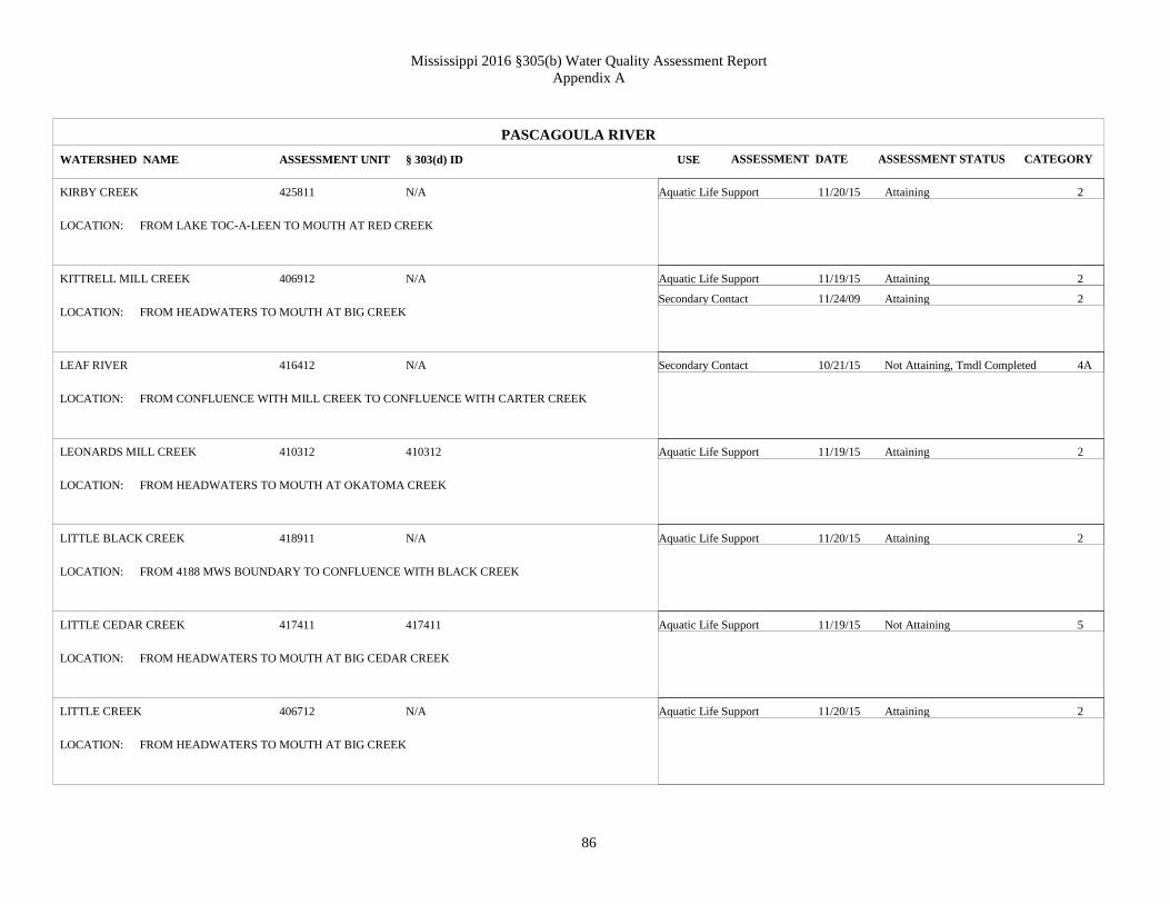
Mississippi 2016 §305(b) Water Quality Assessment Report
Appendix A
86
PASCAGOULA RIVER
KIRBY CREEK
KITTRELL MILL CREEK
LEAF RIVER
LEONARDS MILL CREEK
LITTLE BLACK CREEK
LITTLE CEDAR CREEK
LITTLE CREEK
WATERSHED NAME
425811
406912
416412
410312
418911
417411
406712
ASSESSMENT UNIT
Aquatic Life Support
Aquatic Life Support
Secondary Contact
Secondary Contact
Aquatic Life Support
Aquatic Life Support
Aquatic Life Support
Aquatic Life Support
USE
Attaining
Attaining
Attaining
Not Attaining, Tmdl Completed
Attaining
Attaining
Not Attaining
Attaining
ASSESSMENT STATUS
N/A
N/A
N/A
410312
N/A
417411
N/A
§ 303(d) ID
FROM LAKE TOC-A-LEEN TO MOUTH AT RED CREEK
FROM HEADWATERS TO MOUTH AT BIG CREEK
FROM CONFLUENCE WITH MILL CREEK TO CONFLUENCE WITH CARTER CREEK
FROM HEADWATERS TO MOUTH AT OKATOMA CREEK
FROM 4188 MWS BOUNDARY TO CONFLUENCE WITH BLACK CREEK
FROM HEADWATERS TO MOUTH AT BIG CEDAR CREEK
FROM HEADWATERS TO MOUTH AT BIG CREEK
LOCATION:
LOCATION:
LOCATION:
LOCATION:
LOCATION:
LOCATION:
LOCATION:
2
2
2
4A
2
2
5
2
CATEGORY
11/20/15
11/19/15
11/24/09
10/21/15
11/19/15
11/20/15
11/19/15
11/20/15
ASSESSMENT DATE

Mississippi 2016 §305(b) Water Quality Assessment Report
Appendix A
87
PASCAGOULA RIVER
MARTIN CREEK
MARTIN CREEK
MAYNOR CREEK
MILL CREEK
MONROE CREEK
MOUNGERS CREEK
OAKEY WOODS CREEK
WATERSHED NAME
407813
407812
406411
404211
418411
417911
425111
ASSESSMENT UNIT
Aquatic Life Support
Aquatic Life Support
Aquatic Life Support
Aquatic Life Support
Aquatic Life Support
Aquatic Life Support
Aquatic Life Support
USE
Attaining
Not Attaining
Attaining
Attaining
Attaining
Attaining
Attaining
ASSESSMENT STATUS
N/A
N/A
N/A
N/A
N/A
N/A
N/A
§ 303(d) ID
FROM HEADWATERS TO LEAKSVILLE POTW OUTFALL
FROM LEAKSVILLE POTW OUTFALL DOWNSTREAM TO MOUTH AT CHICKASAWHAY
RIVER
FROM MAYNOR CREEK WATER PARK TO MOUTH AT BIG CREEK
FROM HEADWATERS TO MOUTH AT BUCKATUNNA CREEK
FROM HEADWATERS TO MOUTH AT BLACK CREEK
FROM HEADWATERS TO CONFLUENCE WITH BLUFF CREEK
FROM HEADWATERS TO MOUTH AT LEAF RIVER
LOCATION:
LOCATION:
LOCATION:
LOCATION:
LOCATION:
LOCATION:
LOCATION:
2
5
2
2
2
2
2
CATEGORY
11/20/15
11/20/15
11/19/15
11/20/15
11/20/15
11/20/15
11/20/15
ASSESSMENT DATE

Mississippi 2016 §305(b) Water Quality Assessment Report
Appendix A
88
PASCAGOULA RIVER
OKATIBBEE CREEK
OKATOMA CREEK
OKATOMA CREEK
OKATOMA CREEK
OKATOMA CREEK
PASCAGOULA RIVER
PATTON CREEK
WATERSHED NAME
401011
410811
410311
410011
410511
418111
406211
ASSESSMENT UNIT
Aquatic Life Support
Primary Contact (Recr)
Aquatic Life Support
Aquatic Life Support
Aquatic Life Support
Fish Consumption
Primary Contact (Recr)
Aquatic Life Support
USE
Not Attaining
Attaining
Attaining
Attaining
Not Attaining
Not Attaining, Tmdl Completed
Not Attaining, Tmdl Completed
Attaining
ASSESSMENT STATUS
401011
N/A
N/A
N/A
N/A
MSPASRM1
N/A
§ 303(d) ID
FROM CONFLUENCE OF SOWASHEE CREEK TO MWS 4011 BOUNDARY
FROM MWS 4107 BOUNDARY TO CONFLUENCE WITH BOUIE RIVER
FROM CONFLUENCE OF MCLAUREN CREEK TO CONFLUENCE WITH SHELBY CREEK
FROM CONFLUENCE WITH DRY CREEK TO MWS 4102 BOUNDARY
FROM CONFLUENCE WITH ROGERS CREEK TO CONFLUENCE WITH BIG SWAMP CREEK
FROM MWS BOUNDARY 4176 TO MWS BOUNDARY 4182
NEAR WAYNESBORO FROM WAYNESBORO LAKE TO MOUTH AT CHICKASAWHAY RIVER
LOCATION:
LOCATION:
LOCATION:
LOCATION:
LOCATION:
LOCATION:
LOCATION:
5
2
2
2
5
4A
4A
2
CATEGORY
11/30/15
10/21/15
11/19/15
11/20/15
12/02/15
01/20/10
10/21/15
11/20/15
ASSESSMENT DATE

Mississippi 2016 §305(b) Water Quality Assessment Report
Appendix A
89
PASCAGOULA RIVER
PENANTLY CREEK
POPLAR CREEK
PRIESTS CREEK
RED CREEK
RED CREEK
RED CREEK
REESE CREEK
WATERSHED NAME
404712
419212
416112
420911
419711
420511
416212
ASSESSMENT UNIT
Aquatic Life Support
Aquatic Life Support
Aquatic Life Support
Aquatic Life Support
Primary Contact (Recr)
Aquatic Life Support
Primary Contact (Recr)
Aquatic Life Support
USE
Not Attaining
Attaining
Attaining
Attaining
Not Attaining, Tmdl Completed
Attaining
Not Attaining, Tmdl Completed
Attaining
ASSESSMENT STATUS
404712
N/A
N/A
MS103RM
N/A
N/A
N/A
§ 303(d) ID
FROM HEADWATERS TO MOUTH AT SOUENLOVIE CREEK
FROM HEADWATERS TO CONFLUENCE WITH BLACK CREEK
FROM HEADWATERS TO MOUTH AT LEAF RIVER
FROM CONFLUENCE WITH FLURRY MILL POND BRANCH TO MOUTH AT BLACK CREEK
FROM HEADWATERS TO MWS 4198 BOUNDARY
FROM CONFLUENCE WITH OLD CREEK TO MWS 4207 BOUNDARY
FROM TEMPLE RD TO MOUTH AT LEAF RIVER
LOCATION:
LOCATION:
LOCATION:
LOCATION:
LOCATION:
LOCATION:
LOCATION:
5
2
2
2
4A
2
4A
2
CATEGORY
12/02/15
11/20/15
11/20/15
11/30/15
10/27/15
11/16/15
10/27/15
11/20/15
ASSESSMENT DATE

Mississippi 2016 §305(b) Water Quality Assessment Report
Appendix A
90
PASCAGOULA RIVER
ROCKY CREEK
SCOTCHENFLIPPER CREEK
SHELTON CREEK
SHUBUTA CREEK
SOWASHEE CREEK
STATION CREEK
TALLABOGUE CREEK
WATERSHED NAME
426211
404612
410812
405511
400911
425112
424611
ASSESSMENT UNIT
Aquatic Life Support
Aquatic Life Support
Aquatic Life Support
Aquatic Life Support
Aquatic Life Support
Aquatic Life Support
Aquatic Life Support
USE
Not Attaining
Attaining
Not Attaining
Attaining
Not Attaining
Attaining
Attaining
ASSESSMENT STATUS
N/A
N/A
410812
N/A
400911
N/A
N/A
§ 303(d) ID
FROM HEADWATERS TO MOUTH AT ESCATAWPA RIVER
FROM HEADWATERS TO MOUTH AT SOUENLOVIE CREEK
FROM HEADWATERS TO MOUTH AT OKATOMA CREEK
FROM CONFLUENCE WITH HOLLICAR CREEK TO CONFLUENCE WITH BOGUE HOMO
FROM CONFLUENCE WITH UNNAMED TRIB AT MWS 4237 BOUNDARY TO CONFLUENCE
WITH OKATIBBEE CREEK
FROM HEADWATERS TO MOUTH AT OAKEY WOODS CREEK
FROM HEADWATERS TO MOUTH AT LEAF RIVER
LOCATION:
LOCATION:
LOCATION:
LOCATION:
LOCATION:
LOCATION:
LOCATION:
5
2
5
2
5
2
2
CATEGORY
11/20/15
11/20/15
11/19/15
11/20/15
11/19/15
11/20/15
11/20/15
ASSESSMENT DATE

Mississippi 2016 §305(b) Water Quality Assessment Report
Appendix A
91
PASCAGOULA RIVER
TALLAHALA CREEK
TALLAHALLA CREEK
TALLAHATTAH CREEK
THOMPSON CREEK
TWISTWOOD CREEK
UPPER LEAF RIVER
WEST BOUIE CREEK
WATERSHED NAME
415511
413511
413611
415211
423811
408111
411212
ASSESSMENT UNIT
Aquatic Life Support
Aquatic Life Support
Aquatic Life Support
Aquatic Life Support
Aquatic Life Support
Aquatic Life Support
Aquatic Life Support
USE
Not Attaining
Attaining
Attaining
Attaining
Not Attaining
Not Attaining, Tmdl Completed
Not Attaining
ASSESSMENT STATUS
N/A
N/A
N/A
N/A
N/A
MS073UE
411212
§ 303(d) ID
FROM CONFLUENCE WITH COURTNEY CREEK TO MWS 4156 BOUNDARY
FROM MWS 4135 BOUNDARY TO CONFLUENCE WITH TALLAHATTAH CREEK AT MWS 4137
BOUNDARY
FROM HEADWATERS TO MWS 4135 BOUNDARY
FROM HEADWATERS AT THOMPSON CREEK SEGMENT 12 TO MWS 4165 BOUNDARY
FROM CONFLUENCE OF NORTH AND SOUTH TWISTWOOD CREEK TO MOUTH AT
SOUINLOVIE CREEK
FROM HEADWATERS TO CONFLUENCE WITH TALLABOGUE CREEK
FROM HEADWATERS TO MOUTH AT BOUIE RIVER
LOCATION:
LOCATION:
LOCATION:
LOCATION:
LOCATION:
LOCATION:
LOCATION:
5
2
2
2
5
4A
5
CATEGORY
12/01/15
12/02/15
11/20/15
11/20/15
11/20/15
11/20/15
11/19/15
ASSESSMENT DATE

Mississippi 2016 §305(b) Water Quality Assessment Report
Appendix A
92
PASCAGOULA RIVER
WEST LITTLE THOMPSON CREEK
WATERSHED NAME
415112
ASSESSMENT UNIT
Aquatic Life Support
USE
Attaining
ASSESSMENT STATUS
MS093T1E
§ 303(d) ID
FROM HEADWATERS TO MOUTH AT THOMPSON CREEK LOCATION:
2
CATEGORY
11/19/15
ASSESSMENT DATE

Mississippi 2016 §305(b) Water Quality Assessment Report
Appendix A
93
PEARL RIVER
ANCHOR LAKE
BAHALA CREEK
BAHALA CREEK
BEAR CREEK
BIG BRANCH
BIG CREEK
BOGUE CHITTO
WATERSHED NAME
520013
514111
513811
514611
519213
513211
521711
ASSESSMENT UNIT
Aquatic Life Support
Aquatic Life Support
Aquatic Life Support
Aquatic Life Support
Aquatic Life Support
Aquatic Life Support
Fish Consumption
Primary Contact (Recr)
USE
Attaining
Attaining
Not Attaining, Tmdl Completed
Attaining
Attaining
Not Attaining
Not Attaining, Tmdl Completed
Not Attaining, Tmdl Completed
ASSESSMENT STATUS
N/A
N/A
N/A
N/A
N/A
N/A
MSBGCHTRM4
§ 303(d) ID
NEAR CARRIER SPILLWAY
FROM CONFLUENCE WITH LITTLE BAHALA CREEK TO MOUTH AT PEARL RIVER
FROM HEADWATERS TO CONFLUENCE WITH RUSSELL CREEK
FROM HEADWATERS TO MOUTH AT FAIR RIVER
FROM HEADWATERS TO MOUTH AT LITTLE HELL CREEK
FROM MWS 5131 BOUNDARY TO MOUTH AT STRONG RIVER
FROM PIKE/WALTHALL COUNTY LINE TO MWS BOUNDARY 5218
LOCATION:
LOCATION:
LOCATION:
LOCATION:
LOCATION:
LOCATION:
LOCATION:
2
2
4A
2
2
5
4A
4A
CATEGORY
12/02/15
11/19/15
11/19/15
11/19/15
11/23/15
11/18/15
01/25/10
10/20/15
ASSESSMENT DATE

Mississippi 2016 §305(b) Water Quality Assessment Report
Appendix A
94
PEARL RIVER
BOGUE CHITTO
BOONE CREEK
BRUSHY CREEK
CANE CREEK
CANEY CREEK
CLABBER CREEK
CLEAR CREEK
WATERSHED NAME
522811
521113
510911
507411
511411
521412
521512
ASSESSMENT UNIT
Aquatic Life Support
Fish Consumption
Primary Contact (Recr)
Aquatic Life Support
Aquatic Life Support
Aquatic Life Support
Aquatic Life Support
Aquatic Life Support
Aquatic Life Support
USE
Attaining
Not Attaining, Tmdl Completed
Not Attaining, Tmdl Completed
Not Attaining
Attaining
Not Attaining, Tmdl Completed
Not Attaining
Attaining
Attaining
ASSESSMENT STATUS
MSBGCHT
N/A
N/A
N/A
N/A
N/A
N/A
§ 303(d) ID
FROM MAGEES CREEK TO LA STATE LINE
FROM HEADWATERS TO MOUTH AT BOGUE CHITTO
FROM HEADWATERS TO MOUTH AT PEARL RIVER
NEAR GOSHEN SPRINGS FROM HEADWATERS AT RAILROAD TRACKS SOUTH OF HWY 43
TO ROSS BARNETT RESERVOIR FLOOD POOL
FROM HEADWATERS TO MOUTH AT STRONG RIVER
FROM HEADWATERS TO MOUTH AT BOGUE CHITTO RIVER
FROM HEADWATERS TO MOUTH AT BOGUE CHITTO (521511)
LOCATION:
LOCATION:
LOCATION:
LOCATION:
LOCATION:
LOCATION:
LOCATION:
2
4A
4A
5
2
4A
5
2
2
CATEGORY
12/01/15
01/25/10
10/20/15
11/18/15
11/19/15
11/20/15
11/18/15
11/19/15
11/18/15
ASSESSMENT DATE

Mississippi 2016 §305(b) Water Quality Assessment Report
Appendix A
95
PEARL RIVER
CLEAR CREEK
CLEAR CREEK
COFFEE BOGUE
COLE CREEK
COON CREEK
DABBS CREEK
EAST FORK GREENS CREEK
WATERSHED NAME
517611
508611
507811
506111
503713
512611
515412
ASSESSMENT UNIT
Aquatic Life Support
Aquatic Life Support
Aquatic Life Support
Aquatic Life Support
Aquatic Life Support
Aquatic Life Support
Aquatic Life Support
USE
Attaining
Not Attaining
Not Attaining, Tmdl Completed
Not Attaining
Not Attaining
Not Attaining, Tmdl Completed
Attaining
ASSESSMENT STATUS
N/A
N/A
N/A
N/A
N/A
MS167DE
N/A
§ 303(d) ID
NEAR SANDY HOOK FROM HEADWATERS TO MOUTH AT PEARL RIVER
FROM HEADWATERS TO MOUTH AT PELAHATCHIE CREEK
FROM 5077 MWS BOUNDARY TO MOUTH AT PEARL RIVER
FROM HEADWATERS TO MWS 5059 BOUNDARY
FROM HEADWATERS TO MOUTH AT LOBUTCHA CREEK
FROM MWS 5125 BOUNDARY TO MOUTH AT STRONG RIVER
FROM HEADWATERS TO CONFLUENCE WITH WEST FORK GREENS CREEK
LOCATION:
LOCATION:
LOCATION:
LOCATION:
LOCATION:
LOCATION:
LOCATION:
2
5
4A
5
5
4A
2
CATEGORY
11/18/15
11/19/15
11/18/15
11/16/15
11/19/15
11/19/15
11/19/15
ASSESSMENT DATE

Mississippi 2016 §305(b) Water Quality Assessment Report
Appendix A
96
PEARL RIVER
FAIR RIVER
FANNEGUSHA CREEK
HALBERT BRANCH
HALLS CREEK
HARPER CREEK
HOLIDAY CREEK
HONTOKALO CREEK
WATERSHED NAME
514511
508111
521012
515011
516512
516211
504711
ASSESSMENT UNIT
Aquatic Life Support
Aquatic Life Support
Aquatic Life Support
Aquatic Life Support
Aquatic Life Support
Aquatic Life Support
Aquatic Life Support
USE
Attaining
Not Attaining, Tmdl Completed
Not Attaining, Tmdl Completed
Attaining
Attaining
Attaining
Not Attaining
ASSESSMENT STATUS
N/A
MS151FE
MS187HE
N/A
N/A
N/A
N/A
§ 303(d) ID
FROM CONFLUENCE WITH BEAR CREEK TO CONFLUENCE WITH PEARL RIVER
FROM CONFLUENCE WITH ROLLISON CREEK TO MOUTH AT ROSS BARNETT RESERVOIR
AT BROOKHAVEN FROM HEADWATERS TO CONFLUENCE WITH EAST BOGUE CHITTO
CREEK
NEAR MONTICELLO FROM HEADWATERS TO MOUTH AT THE PEARL RIVER
FROM HEADWATERS TO MOUTH AT PEARL RIVER
FROM HEADWATERS TO CONFLUENCE WITH UNNAMED TRIB AT MWS 5163 BOUNDARY
NEAR STEEL FROM HEADWATERS TO MOUTH AT LITTLE (SOUTH) CANAL
LOCATION:
LOCATION:
LOCATION:
LOCATION:
LOCATION:
LOCATION:
LOCATION:
2
4A
4A
2
2
2
5
CATEGORY
11/18/15
11/18/15
11/19/15
11/18/15
11/19/15
11/19/15
11/18/15
ASSESSMENT DATE

Mississippi 2016 §305(b) Water Quality Assessment Report
Appendix A
97
PEARL RIVER
JAYBIRD CREEK
JOFUSKA CREEK
LAND CREEK
LITTLE COPIAH CREEK
LOVE CREEK
LOWER LITTLE CREEK
LOWER LITTLE CREEK
WATERSHED NAME
516011
501911
500911
513312
521713
517911
517711
ASSESSMENT UNIT
Aquatic Life Support
Aquatic Life Support
Aquatic Life Support
Aquatic Life Support
Aquatic Life Support
Aquatic Life Support
Aquatic Life Support
USE
Attaining
Attaining
Not Attaining
Not Attaining
Attaining
Attaining
Attaining
ASSESSMENT STATUS
N/A
N/A
N/A
513312
N/A
N/A
N/A
§ 303(d) ID
FROM HEADWATERS TO MOUTH AT WHITE SAND CREEK
FROM HEADWATERS TO WETLAND ADJACENT TO THE PEARL RIVER AT MWS BOUNDARY
5027
FROM HEADWATERS TO MOUTH AT BOGUE CHITTO RIVER
FROM HEADWATERS TO MOUTH AT COPIAH CREEK
FROM HEADWATERS TO MOUTH AT BOGUE CHITTO
FROM CONFLUENCE WITH HURRICANE CREEK TO MOUTH AT PEARL RIVER
FROM HEADWATERS TO CONFLUENCE WITH GULLY CREEK
LOCATION:
LOCATION:
LOCATION:
LOCATION:
LOCATION:
LOCATION:
LOCATION:
2
2
5
5
2
2
2
CATEGORY
11/19/15
11/16/15
11/16/15
11/19/15
11/19/15
11/19/15
11/23/15
ASSESSMENT DATE

Mississippi 2016 §305(b) Water Quality Assessment Report
Appendix A
98
PEARL RIVER
LUKFAPA CREEK
MAGEES CREEK
PEARL RIVER
PEARL RIVER
PEARL RIVER
PEARL RIVER
PEARL RIVER
WATERSHED NAME
502111
522611
509111
510711
520611
516511
508911
ASSESSMENT UNIT
Aquatic Life Support
Aquatic Life Support
Primary Contact (Recr)
Aquatic Life Support
Secondary Contact
Aquatic Life Support
Primary Contact (Recr)
Primary Contact (Recr)
Primary Contact (Recr)
Aquatic Life Support
Secondary Contact
USE
Attaining
Attaining
Not Attaining, Tmdl Completed
Not Attaining, Tmdl Completed
Not Attaining, Tmdl Completed
Not Attaining, Tmdl Completed
Not Attaining, Tmdl Completed
Attaining
Attaining
Not Attaining, Tmdl Completed
Not Attaining, Tmdl Completed
ASSESSMENT STATUS
N/A
N/A
N/A
510711
N/A
N/A
N/A
§ 303(d) ID
FROM HEADWATERS TO MOUTH AT PEARL RIVER
FROM CONFLUENCE OF DRY CREEK IN TYLERTOWN TO MOUTH AT BOGUE CHITTO
FROM CONFLUENCE WITH HANGING MOSS CREEK TO MWS 5092 BOUNDARY
FROM MWS BOUNDARY 5106 TO CONFLUENCE WITH WEEKS MILL CREEK
FROM MWS 5204 BOUNDARY TO MWS 5207 BOUNDARY
FROM CONFLUENCE WITH HOLIDAY CREEK TO MWS BOUNDARY 5166
FROM ROSS BARNETT RESERVOIR TO CONFLUENCE WITH HANGING MOSS CREEK
LOCATION:
LOCATION:
LOCATION:
LOCATION:
LOCATION:
LOCATION:
LOCATION:
2
2
4A
4A
4A
4A
4A
2
2
4A
4A
CATEGORY
11/20/15
11/18/15
10/21/15
12/11/15
12/19/13
12/11/15
10/21/15
10/21/15
10/27/15
12/11/15
12/19/13
ASSESSMENT DATE

Mississippi 2016 §305(b) Water Quality Assessment Report
Appendix A
99
PEARL RIVER
PEARL RIVER
PEARL RIVER
PEARL RIVER
PEARL RIVER
PEARL RIVER
PELAHATCHIE CREEK EMBAYMENT
ROSS BARNETT RESERVOIR
PICKENS CREEK
WATERSHED NAME
510012
514711
518211
510011
502011
508812
504112
ASSESSMENT UNIT
Aquatic Life Support
Primary Contact (Recr)
Primary Contact (Recr)
Aquatic Life Support
Primary Contact (Recr)
Aquatic Life Support
Aquatic Life Support
Aquatic Life Support
USE
Not Attaining, Tmdl Completed
Not Attaining, Tmdl Completed
Not Attaining, Tmdl Completed
Not Attaining, Tmdl Completed
Not Attaining, Tmdl Completed
Attaining
Attaining
Not Attaining
ASSESSMENT STATUS
N/A
N/A
N/A
N/A
N/A
N/A
N/A
§ 303(d) ID
FROM CONFLUENCE OF BIG CREEK TO MWS 5106 BOUNDARY
FROM CONFLUENCE WITH PRETTY BRANCH TO MWS BOUNDARY 5149
FROM CONFLUENCE WITH BIG CREEK TO MWS BOUNDARY 5184 BELOW HIGHWAY 26
FROM CONFLUENCE WITH TRAYHON CREEK TO CONFLUENCE WITH BIG CREEK
FROM CONFLUENCE OF KENTAWKA CANAL TO THE MWS 5028 BOUNDARY
PELAHATCHIE CREEK EMBAYMENT OF THE ROSS BARNETT RESERVOIR, RANKIN
COUNTY
FROM HEADWATERS TO MOUTH AT COBBS CREEK
LOCATION:
LOCATION:
LOCATION:
LOCATION:
LOCATION:
LOCATION:
LOCATION:
4A
4A
4A
4A
4A
2
2
5
CATEGORY
12/11/15
10/21/15
10/26/15
12/01/15
12/01/15
12/01/15
12/02/15
11/19/15
ASSESSMENT DATE

Mississippi 2016 §305(b) Water Quality Assessment Report
Appendix A
100
PEARL RIVER
PRETTY BRANCH
PURVIS CREEK
PUSHEPATAPA CREEK
RASPBERRY CREEK
RAWLS CREEK
ROSS BARNETT RESERVOIR
RUSSELL CREEK
WATERSHED NAME
514811
511711
518511
511611
517311
507511
513812
ASSESSMENT UNIT
Aquatic Life Support
Aquatic Life Support
Aquatic Life Support
Aquatic Life Support
Aquatic Life Support
Aquatic Life Support
Aquatic Life Support
USE
Attaining
Not Attaining
Attaining
Attaining
Attaining
Attaining
Attaining
ASSESSMENT STATUS
N/A
N/A
N/A
N/A
N/A
N/A
N/A
§ 303(d) ID
NEAR FERGUSON FROM HEADWATERS TO THE PEARL RIVER
FROM HEADWATERS TO MOUTH AT STRONG RIVER
FROM HEADWATERS TO LA STATE LINE
FROM HEADWATERS TO MOUTH AT STRONG RIVER
FROM HEADWATERS TO MOUTH AT RAWLS BAY IN PEARL RIVER FLOODPLAIN
ROSS BARNETT RESERVOIR AT JACKSON, MS
FROM HEADWATERS TO MOUTH AT BAHALA CREEK
LOCATION:
LOCATION:
LOCATION:
LOCATION:
LOCATION:
LOCATION:
LOCATION:
2
5
2
2
2
2
2
CATEGORY
11/18/15
11/19/15
11/18/15
11/19/15
11/19/15
12/02/15
11/19/15
ASSESSMENT DATE

Mississippi 2016 §305(b) Water Quality Assessment Report
Appendix A
101
PEARL RIVER
SILVER CREEK
SIMON CREEK
STEEL CREEK
STEEN CREEK
STRONG RIVER
STRONG RIVER
TENMILE CREEK
WATERSHED NAME
521812
513711
513511
510311
512911
511911
517211
ASSESSMENT UNIT
Aquatic Life Support
Aquatic Life Support
Aquatic Life Support
Aquatic Life Support
Aquatic Life Support
Primary Contact (Recr)
Aquatic Life Support
Aquatic Life Support
USE
Attaining
Attaining
Not Attaining
Attaining
Attaining
Not Attaining, Tmdl Completed
Attaining
Attaining
ASSESSMENT STATUS
N/A
N/A
N/A
N/A
N/A
N/A
N/A
§ 303(d) ID
FROM HEADWATERS TO MOUTH AT BOGUE CHITTO
FROM HEADWATERS TO MOUTH AT IRVING CREEK
FROM HEADWATERS TO MOUTH AT THE PEARL RIVER
FROM MWS 5102 BOUNDARY TO MOUTH AT PEARL RIVER
FROM 5124 MWS BOUNDARY TO MOUTH AT PEARL RIVER
NEAR D'LO FROM MWS 5115 BOUNDARY TO MWS 5124 BOUNDARY
FROM HEADWATERS TO MOUTH AT PEARL RIVER
LOCATION:
LOCATION:
LOCATION:
LOCATION:
LOCATION:
LOCATION:
LOCATION:
2
2
5
2
2
4A
2
2
CATEGORY
11/19/15
11/19/15
11/19/15
11/18/15
12/18/09
10/27/15
11/30/15
11/18/15
ASSESSMENT DATE

Mississippi 2016 §305(b) Water Quality Assessment Report
Appendix A
102
PEARL RIVER
TIBBY CREEK
TOPISAW CREEK
TOWN CREEK
TURTLE SKIN CREEK
TUSCOLAMETA CREEK
UNNAMED TRIB TO HOLIDAY CREEK
UPPER LOBUTCHA CREEK
WATERSHED NAME
505811
522211
503211
520511
505111
516212
503511
ASSESSMENT UNIT
Aquatic Life Support
Aquatic Life Support
Aquatic Life Support
Aquatic Life Support
Aquatic Life Support
Aquatic Life Support
Aquatic Life Support
USE
Not Attaining
Not Attaining
Not Attaining
Not Attaining
Not Attaining, Tmdl Completed
Attaining
Not Attaining, Tmdl Completed
ASSESSMENT STATUS
N/A
N/A
N/A
N/A
N/A
N/A
N/A
§ 303(d) ID
FROM CONFLUENCE WITH ROBINSON BRANCH TO 5056 MWS BOUNDARY
FROM 5219 MWS BOUNDARY TO CONFLUENCE AT BOGUE CHITTO
AT CARTHAGE FROM HEADWATERS TO THE PEARL RIVER
NEAR SANTA ROSA FROM HEADWATERS TO CONFLUENCE WITH MIKES RIVER
FROM HEADWATERS AT MWS 5046 BOUNDARY TO MOUTH AT PEARL RIVER
FROM HEADWATERS TO MOUTH AT HOLIDAY CREEK
FROM 5034 MWS BOUNDARY TO MWS BOUNDARY 5036
LOCATION:
LOCATION:
LOCATION:
LOCATION:
LOCATION:
LOCATION:
LOCATION:
5
5
5
5
4A
2
4A
CATEGORY
11/16/15
11/18/15
11/16/15
11/19/15
11/16/15
11/19/15
12/02/15
ASSESSMENT DATE

Mississippi 2016 §305(b) Water Quality Assessment Report
Appendix A
103
PEARL RIVER
UPPER LOBUTCHA CREEK
WEST FORK GREENS CREEK
WEST FORK PUSHEPATAPA CREEK
WHITE SAND CREEK
YOCKANOOKANY RIVER
YOCKANOOKANY RIVER
WATERSHED NAME
503411
515413
522711
516111
505911
506811
ASSESSMENT UNIT
Aquatic Life Support
Aquatic Life Support
Aquatic Life Support
Aquatic Life Support
Aquatic Life Support
Aquatic Life Support
Fish Consumption
USE
Not Attaining, Tmdl Completed
Attaining
Attaining
Attaining
Attaining
Attaining
Not Attaining, Tmdl Completed
ASSESSMENT STATUS
N/A
N/A
N/A
516111
N/A
MS147E
§ 303(d) ID
FROM HEADWATERS TO MWS BOUNDARY 5035
FROM HEADWATERS TO CONFLUENCE WITH EAST FORK GREENS CREEK
FROM HEADWATERS TO LA STATE LINE
FROM CONFLUENCE WITH LITTLE WHITE SAND CREEK (JAYBIRD CREEK) TO MOUTH AT
PEARL RIVER
FROM CONFLUENCE OF UNNAMED TRIB AT MCCOOL TO MWS BOUNDARY 5062
NEAR THOMASTOWN FROM MWS BOUNDARY 5067 TO MWS BOUNDARY 5069
LOCATION:
LOCATION:
LOCATION:
LOCATION:
LOCATION:
LOCATION:
4A
2
2
2
2
2
4A
CATEGORY
12/02/15
11/19/15
11/19/15
11/19/15
11/16/15
11/19/15
01/21/10
ASSESSMENT DATE
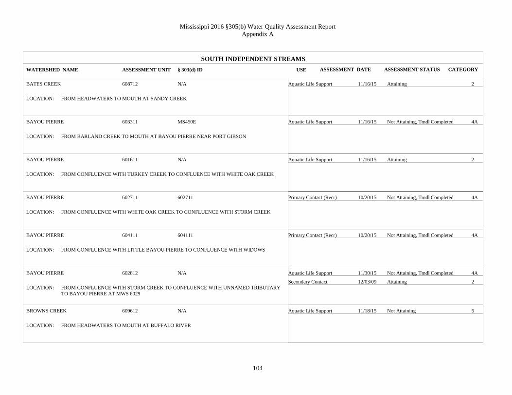
Mississippi 2016 §305(b) Water Quality Assessment Report
Appendix A
104
SOUTH INDEPENDENT STREAMS
BATES CREEK
BAYOU PIERRE
BAYOU PIERRE
BAYOU PIERRE
BAYOU PIERRE
BAYOU PIERRE
BROWNS CREEK
WATERSHED NAME
608712
603311
601611
602711
604111
602812
609612
ASSESSMENT UNIT
Aquatic Life Support
Aquatic Life Support
Aquatic Life Support
Primary Contact (Recr)
Primary Contact (Recr)
Aquatic Life Support
Secondary Contact
Aquatic Life Support
USE
Attaining
Not Attaining, Tmdl Completed
Attaining
Not Attaining, Tmdl Completed
Not Attaining, Tmdl Completed
Not Attaining, Tmdl Completed
Attaining
Not Attaining
ASSESSMENT STATUS
N/A
MS450E
N/A
602711
604111
N/A
N/A
§ 303(d) ID
FROM HEADWATERS TO MOUTH AT SANDY CREEK
FROM BARLAND CREEK TO MOUTH AT BAYOU PIERRE NEAR PORT GIBSON
FROM CONFLUENCE WITH TURKEY CREEK TO CONFLUENCE WITH WHITE OAK CREEK
FROM CONFLUENCE WITH WHITE OAK CREEK TO CONFLUENCE WITH STORM CREEK
FROM CONFLUENCE WITH LITTLE BAYOU PIERRE TO CONFLUENCE WITH WIDOWS
CREEK
FROM CONFLUENCE WITH STORM CREEK TO CONFLUENCE WITH UNNAMED TRIBUTARY
TO BAYOU PIERRE AT MWS 6029
FROM HEADWATERS TO MOUTH AT BUFFALO RIVER
LOCATION:
LOCATION:
LOCATION:
LOCATION:
LOCATION:
LOCATION:
LOCATION:
2
4A
2
4A
4A
4A
2
5
CATEGORY
11/16/15
11/16/15
11/16/15
10/20/15
10/20/15
11/30/15
12/03/09
11/18/15
ASSESSMENT DATE

Mississippi 2016 §305(b) Water Quality Assessment Report
Appendix A
105
SOUTH INDEPENDENT STREAMS
BRUSHY CREEK
BRUSHY CREEK
BRUSHY CREEK
BUFFALO RIVER
CARS CREEK
CASTON CREEK
COMITE CREEK
WATERSHED NAME
607711
601011
607012
610111
612112
607611
613211
ASSESSMENT UNIT
Aquatic Life Support
Aquatic Life Support
Aquatic Life Support
Aquatic Life Support
Aquatic Life Support
Aquatic Life Support
Secondary Contact
Aquatic Life Support
USE
Attaining
Attaining
Attaining
Attaining
Not Attaining
Attaining
Attaining
Attaining
ASSESSMENT STATUS
N/A
N/A
N/A
N/A
N/A
N/A
N/A
§ 303(d) ID
FROM HEADWATERS TO MOUTH AT HOMOCHITTO RIVER
FROM HEADWATERS AT CONFLUENCE WITH THOMPSON CREEK TO MOUTH AT BAYOU
PIERRE
FROM HEADWATERS TO MOUTH AT MIDDLE FORK HOMOCHITTO RIVER
FROM MWS BOUNDARY 6098 TO MWS BOUNDARY 6104
NEAR LIBERTY FROM HEADWATERS TO MOUTH AT EAST FORK AMITE RIVER
FROM HEADWATERS TO MOUTH AT HOMOCHITTO RIVER
NEAR CENTREVILLE FROM HEADWATERS TO MOUTH AT LOUISIANA STATE LINE
LOCATION:
LOCATION:
LOCATION:
LOCATION:
LOCATION:
LOCATION:
LOCATION:
2
2
2
2
5
2
2
2
CATEGORY
11/16/15
11/16/15
11/16/15
11/18/15
12/02/15
11/16/15
11/30/09
11/18/15
ASSESSMENT DATE

Mississippi 2016 §305(b) Water Quality Assessment Report
Appendix A
106
SOUTH INDEPENDENT STREAMS
CROOKED CREEK
DAYS CREEK
DOWD CREEK
DRY BAYOU
DRY CREEK
EAST FORK AMITE RIVER
FORDS CREEK
WATERSHED NAME
609011
612312
600211
608611
608211
612111
610011
ASSESSMENT UNIT
Aquatic Life Support
Aquatic Life Support
Aquatic Life Support
Secondary Contact
Aquatic Life Support
Aquatic Life Support
Aquatic Life Support
Primary Contact (Recr)
Aquatic Life Support
USE
Attaining
Not Attaining
Attaining
Not Attaining, Tmdl Completed
Not Attaining
Not Attaining
Attaining
Not Attaining, Tmdl Completed
Attaining
ASSESSMENT STATUS
N/A
N/A
MS452E
N/A
608211
N/A
N/A
§ 303(d) ID
FROM HEADWATERS TO MOUTH AT HOMOCHITTO RIVER
FROM HEADWATERS TO MOUTH AT WEST FORK AMITE RIVER
FROM HEADWATERS TO MOUTH AT RODNEY LAKE
FROM HEADWATERS TO MOUTH AT CANEY BRANCH
FROM HEADWATERS TO MOUTH AT HOMOCHITTO RIVER
FROM MWS BOUNDARY 6120 TO LOUISIANA STATE LINE
FROM HEADWATERS TO MOUTH AT BUFFALO RIVER
LOCATION:
LOCATION:
LOCATION:
LOCATION:
LOCATION:
LOCATION:
LOCATION:
2
5
2
4A
5
5
2
4A
2
CATEGORY
11/18/15
11/18/15
11/16/15
11/24/09
11/16/15
11/16/15
02/15/12
11/10/15
11/18/15
ASSESSMENT DATE

Mississippi 2016 §305(b) Water Quality Assessment Report
Appendix A
107
SOUTH INDEPENDENT STREAMS
FOSTER CREEK
FOSTER CREEK
HOMOCHITTO RIVER
HOMOCHITTO RIVER
LITTLE BAYOU PIERRE
LITTLE BEAVER CREEK
LONG CREEK
WATERSHED NAME
608014
601711
607812
606111
603211
612912
601311
ASSESSMENT UNIT
Aquatic Life Support
Aquatic Life Support
Aquatic Life Support
Primary Contact (Recr)
Aquatic Life Support
Primary Contact (Recr)
Aquatic Life Support
Aquatic Life Support
USE
Attaining
Attaining
Not Attaining
Not Attaining, Tmdl Completed
Attaining
Not Attaining, Tmdl Completed
Attaining
Attaining
ASSESSMENT STATUS
N/A
N/A
N/A
N/A
MS450E
N/A
N/A
§ 303(d) ID
FROM HEADWATERS TO MOUTH AT HOMOCHITTO RIVER
FOSTER CREEK FROM HEADWATERS TO CONFLUENCE WITH JACKSON CREEK
FROM THE MWS 6074 BOUNDARY TO THE CONFLUENCE WITH DRY CREEK
FROM MWS 6059 BOUNDARY TO MWS6074 BOUNDARY
FROM MWS BOUNDARY 6031 TO CONFLUENCE WITH BARLAND CREEK AT MWS 6033
BOUNDARY
FROM HEADWATERS TO MOUTH AT BEAVER CREEK
FROM HEADWATERS TO MOUTH AT BAYOU PIERRE
LOCATION:
LOCATION:
LOCATION:
LOCATION:
LOCATION:
LOCATION:
LOCATION:
2
2
5
4A
2
4A
2
2
CATEGORY
11/16/15
11/16/15
11/30/15
10/21/15
01/09/14
10/20/15
11/18/15
11/16/15
ASSESSMENT DATE

Mississippi 2016 §305(b) Water Quality Assessment Report
Appendix A
108
SOUTH INDEPENDENT STREAMS
MCCALL CREEK
MCCALL CREEK
MIDDLE FORK HOMOCHITTO RIVER
MIDDLE FORK HOMOCHITTO RIVER
MIDDLE FORK THOMPSON CREEK
MILLBROOK CREEK
NORTH DRY CREEK
WATERSHED NAME
606411
606611
607011
607211
611511
610512
606112
ASSESSMENT UNIT
Aquatic Life Support
Aquatic Life Support
Aquatic Life Support
Aquatic Life Support
Aquatic Life Support
Aquatic Life Support
Aquatic Life Support
USE
Attaining
Attaining
Attaining
Attaining
Attaining
Attaining
Not Attaining
ASSESSMENT STATUS
N/A
N/A
N/A
N/A
N/A
N/A
N/A
§ 303(d) ID
FROM CONFLUENCE OF BLUE CREEK TO CONFLUENCE OF HURRICANE CREEK
FROM CONFLUENCE OF HURRICANE CREEK TO MOUTH AT HOMOCHITTO RIVER
FROM HEADWATERS TO CONFLUENCE OF CAMERON CREEK AT MWS 6072 BOUNDARY
FROM CONFLUENCE OF CAMERON CREEK TO MOUTH AT HOMOCHITTO RIVER
FROM HEADWATERS TO LA STATE LINE
FROM HEADWATERS TO MOUTH AT BUFFALO RIVER
FROM HEADWATERS TO MOUTH AT HOMOCHITTO RIVER
LOCATION:
LOCATION:
LOCATION:
LOCATION:
LOCATION:
LOCATION:
LOCATION:
2
2
2
2
2
2
5
CATEGORY
12/02/15
11/16/15
11/16/15
11/16/15
11/18/15
11/18/15
11/16/15
ASSESSMENT DATE

Mississippi 2016 §305(b) Water Quality Assessment Report
Appendix A
109
SOUTH INDEPENDENT STREAMS
PERCY CREEK
PICKNEYVILLE CREEK
PRETTY CREEK
REDDING CREEK
RICHARDSON CREEK
SANDY CREEK
TALLAHALLA CREEK
WATERSHED NAME
610611
611211
608311
608012
607911
608811
602611
ASSESSMENT UNIT
Aquatic Life Support
Aquatic Life Support
Aquatic Life Support
Aquatic Life Support
Aquatic Life Support
Aquatic Life Support
Aquatic Life Support
USE
Attaining
Not Attaining
Attaining
Attaining
Attaining
Not Attaining
Not Attaining, Tmdl Completed
ASSESSMENT STATUS
N/A
N/A
608311
N/A
N/A
N/A
MS448E
§ 303(d) ID
FROM HEADWATERS TO MOUTH AT BUFFALO RIVER
FROM HEADWATERS TO MOUTH AT LITTLE BAYOU SARA
FROM HEADWATERS TO MOUTH AT HOMOCHITTO RIVER
FROM HEADWATERS TO MOUTH AT FOSTER CREEK
FROM HEADWATERS TO MOUTH AT HOMOCHITTO RIVER
FROM CONFLUENCE OF SWAFFORD CREEK TO MOUTH AT HOMOCHITTO CREEK
FROM CONFLUENCE WITH LITTLE TALLAHALLA CREEK TO MOUTH AT WHITE OAK
CREEK
LOCATION:
LOCATION:
LOCATION:
LOCATION:
LOCATION:
LOCATION:
LOCATION:
2
5
2
2
2
5
4A
CATEGORY
11/18/15
11/18/15
11/16/15
11/16/15
11/16/15
11/16/15
11/16/15
ASSESSMENT DATE

Mississippi 2016 §305(b) Water Quality Assessment Report
Appendix A
110
SOUTH INDEPENDENT STREAMS
TANGIPAHOA RIVER
TAR CREEK
TERRYS CREEK
THOMPSON CREEK
TICKFAW RIVER
WEST FORK AMITE RIVER
WEST FORK THOMPSON CREEK
WATERSHED NAME
613811
608011
614211
611311
613311
612511
611411
ASSESSMENT UNIT
Aquatic Life Support
Aquatic Life Support
Aquatic Life Support
Aquatic Life Support
Aquatic Life Support
Primary Contact (Recr)
Aquatic Life Support
USE
Attaining
Attaining
Attaining
Attaining
Attaining
Not Attaining, Tmdl Completed
Attaining
ASSESSMENT STATUS
N/A
N/A
614211
N/A
N/A
N/A
N/A
§ 303(d) ID
FROM CONFLUENCE WITH LITTLE TANGIPAHOA RIVER TO THE MS/LA STATE LINE
FROM HEADWATERS TO MOUTH AT FOSTERS CREEK
FROM HEADWATERS TO MS/LA STATE BOUNDARY
FROM HEADWATERS NEAR CENTERVILLE TO LA STATE LINE
FROM HEADWATERS NEAR MIXON TO MWS BOUNDARY 6134
FROM MWS BOUNDARY 6124 TO LA STATE LINE
FROM HEADWATERS TO LA STATE LINE
LOCATION:
LOCATION:
LOCATION:
LOCATION:
LOCATION:
LOCATION:
LOCATION:
2
2
2
2
2
4A
2
CATEGORY
12/01/15
11/16/15
11/18/15
11/18/15
12/02/15
10/21/15
11/18/15
ASSESSMENT DATE

Mississippi 2016 §305(b) Water Quality Assessment Report
Appendix A
111
SOUTH INDEPENDENT STREAMS
WHITE CREEK
WHITES CREEK
ZEIGLER CREEK
WATERSHED NAME
610612
609311
607811
ASSESSMENT UNIT
Aquatic Life Support
Aquatic Life Support
Aquatic Life Support
USE
Attaining
Not Attaining, Tmdl Completed
Attaining
ASSESSMENT STATUS
N/A
MS469WE
N/A
§ 303(d) ID
FROM HEADWATERS TO MOUTH AT PERCY CREEK
FROM HEADWATERS TO MOUTH AT SECOND CREEK
FROM HEADWATERS TO MOUTH AT HOMOCHITTO RIVER
LOCATION:
LOCATION:
LOCATION:
2
4A
2
CATEGORY
11/18/15
11/18/15
11/16/15
ASSESSMENT DATE

Mississippi 2016 §305(b) Water Quality Assessment Report
Appendix A
112
TENNESSEE RIVER
BEAR CREEK
CANEY CREEK
CHAMBERS CREEK
CRIPPLE DEER CREEK
HOLLY BRANCH
INDIAN CREEK
LEITCH MILL BRANCH
WATERSHED NAME
701111
700312
701811
701411
701211
700711
700314
ASSESSMENT UNIT
Aquatic Life Support
Aquatic Life Support
Aquatic Life Support
Aquatic Life Support
Aquatic Life Support
Aquatic Life Support
Aquatic Life Support
USE
Not Attaining
Attaining
Attaining
Attaining
Attaining
Attaining
Attaining
ASSESSMENT STATUS
N/A
N/A
N/A
701411
N/A
N/A
N/A
§ 303(d) ID
NEAR BURNSTOWN FROM UNNAMED TRIBUTARY NORTH OF COUNTY ROAD 86 TO
ALABAMA
FROM HEADWATERS TO CONFLUENCE WITH LEITCH MILL BRANCH
FROM TN STATE LINE TO TN STATE LINE
FROM HEADWATERS TO CONFLUENCE WITH LITTLE CRIPPLE DEER CREEK
NEAR IUKA FROM HEADWATERS TO MOUTH AT CEDAR CREEK
FROM HEADWATERS TO MOUTH AT PICKWICK LAKE
FROM HEADWATERS TO CONFLUENCE WITH CANEY CREEK
LOCATION:
LOCATION:
LOCATION:
LOCATION:
LOCATION:
LOCATION:
LOCATION:
5
2
2
2
2
2
2
CATEGORY
12/01/15
11/18/15
11/19/15
11/18/15
11/18/15
11/18/15
11/18/15
ASSESSMENT DATE

Mississippi 2016 §305(b) Water Quality Assessment Report
Appendix A
113
TENNESSEE RIVER
LITTLE CRIPPLE DEER CREEK
LITTLE YELLOW CREEK
PENNYWINKLE CREEK
WATERSHED NAME
701412
701911
701511
ASSESSMENT UNIT
Aquatic Life Support
Aquatic Life Support
Aquatic Life Support
USE
Not Attaining
Attaining
Attaining
ASSESSMENT STATUS
N/A
N/A
N/A
§ 303(d) ID
NEAR TISHOMINGO FROM HEADWATERS TO MOUTH AT CRIPPLE DEER CREEK
FROM HEADWATERS TO CONFLUENCE WITH CANEY CREEK
FROM HEADWATERS TO ALABAMA STATE LINE
LOCATION:
LOCATION:
LOCATION:
5
2
2
CATEGORY
11/18/15
11/19/15
11/18/15
ASSESSMENT DATE

Mississippi 2016 §305(b) Water Quality Assessment Report
Appendix A
114
TOMBIGBEE RIVER
ABERDEEN LAKE
ALAMUCHEE CREEK
BAY SPRINGS LAKE
BIG BROWN CREEK
BIG REED CREEK
BOGUEFALA CREEK
BRIAR CREEK
WATERSHED NAME
803111
818411
800111
800711
817811
819211
802212
ASSESSMENT UNIT
Aquatic Life Support
Aquatic Life Support
Aquatic Life Support
Aquatic Life Support
Secondary Contact
Aquatic Life Support
Aquatic Life Support
Aquatic Life Support
USE
Attaining
Not Attaining
Attaining
Attaining
Attaining
Attaining
Not Attaining
Attaining
ASSESSMENT STATUS
N/A
818411
N/A
N/A
N/A
N/A
N/A
§ 303(d) ID
NEAR ABERDEEN
FROM LITTLE ALMUCHEE CREEK TO ALABAMA STATE LINE
RESERVOIR OF THE UPPER TENN-TOM WATERWAY, TISHIAMINGO COUNTY
FROM CONFLUENCE OF HURRICANE CREEK TO CONFLUENCE WITH LITTLE BROWN
CREEK
FROM HEADWATERS TO MOUTH AT PONTA CREEK
FROM HEADWATERS TO CONFLUENCE WITH GREENWOOD CREEK
FROM HEADWATERS TO MOUTH AT BULL MOUNTAIN CREEK
LOCATION:
LOCATION:
LOCATION:
LOCATION:
LOCATION:
LOCATION:
LOCATION:
2
5
2
2
2
2
5
2
CATEGORY
12/02/15
12/02/15
12/02/15
12/02/15
11/24/09
11/19/15
11/19/15
11/19/15
ASSESSMENT DATE

Mississippi 2016 §305(b) Water Quality Assessment Report
Appendix A
115
TOMBIGBEE RIVER
BROWNING CREEK
BUTTAHATCHEE RIVER
CEDAR CREEK
CHIWAPA CREEK
CHUQUATONCHEE CREEK
COOPER CREEK
FULLER CREEK
WATERSHED NAME
812913
806711
810711
805611
807011
809913
804112
ASSESSMENT UNIT
Aquatic Life Support
Aquatic Life Support
Secondary Contact
Aquatic Life Support
Aquatic Life Support
Aquatic Life Support
Aquatic Life Support
Aquatic Life Support
USE
Not Attaining
Not Attaining
Attaining
Not Attaining, Tmdl Completed
Not Attaining, Tmdl Not Applicable
Not Attaining, Tmdl Completed
Not Attaining
Not Attaining
ASSESSMENT STATUS
812913
N/A
MS031CE
N/A
MS020CE
N/A
N/A
§ 303(d) ID
FROM HEADWATERS TO MOUTH AT NOXUBEE RIVER
FROM CONFLUENCE WITH SIPSEY CREEK TO MWS 8068 BOUNDARY
FROM HEADWATERS TO MOUTH AT ALICEVILLE POOL ON TENN-TOM WATERWAY
FROM BOUNDARY WITH 8055 MWS TO CONFLUENCE WITH TUBBALUBBA CREEK AND
TALLABINNELA CREEK
FROM MWS 8069 BOUNDARY TO MWS 8208 BOUNDARY
NEAR STEEN FROM CONFLUENCE OF MAYHEW CREEK TO CONFLUENCE WITH YELLOW
CREEK
FROM HEADWATERS TO MOUTH AT TOWN CREEK
LOCATION:
LOCATION:
LOCATION:
LOCATION:
LOCATION:
LOCATION:
LOCATION:
5
5
2
4A
4C
4A
5
5
CATEGORY
11/19/15
12/01/15
10/20/15
11/19/15
11/19/15
12/02/15
11/19/15
11/19/15
ASSESSMENT DATE

Mississippi 2016 §305(b) Water Quality Assessment Report
Appendix A
116
TOMBIGBEE RIVER
GOODFOOD CREEK
GREENWOOD CREEK
GUM CREEK
HANG KETTLE CREEK
HOWARD CREEK
JOES CREEK
LAKE TOM BAILEY
WATERSHED NAME
807012
802611
801913
804212
810012
813911
818113
ASSESSMENT UNIT
Aquatic Life Support
Aquatic Life Support
Secondary Contact
Aquatic Life Support
Aquatic Life Support
Aquatic Life Support
Aquatic Life Support
Aquatic Life Support
USE
Not Attaining
Not Attaining, Tmdl Completed
Not Attaining, Tmdl Completed
Attaining
Not Attaining, Tmdl Completed
Not Attaining, Tmdl Completed
Not Attaining, Tmdl Completed
Attaining
ASSESSMENT STATUS
N/A
802611
N/A
MS011E
N/A
MS083M
N/A
§ 303(d) ID
FROM HEADWATERS TO MOUTH AT CHUQUATONCHEE CREEK
FROM HEADWATERS TO MOUTH AT BOGUEFALA CREEK
FROM ALABAMA STATE LINE TO CONFLUENCE WITH CHUBBY CREEK AT MWS8020
BOUNDARY
FROM HEADWATERS TO CONFLUENCE WITH TOWN CREEK
FROM HEADWATERS TO UNNAMED TRIBUTARY NEAR MOUNT PLEASANT CHURCH
FROM HEADWATERS TO CONFLUENCE AT NOXUBEE RIVER
AT TOOMSUBA FROM OUTFLOW TO TOOMSUBA CREEK
LOCATION:
LOCATION:
LOCATION:
LOCATION:
LOCATION:
LOCATION:
LOCATION:
5
4A
4A
2
4A
4A
4A
2
CATEGORY
11/19/15
11/19/15
11/23/09
11/19/15
11/19/15
12/02/15
12/02/15
12/02/15
ASSESSMENT DATE

Mississippi 2016 §305(b) Water Quality Assessment Report
Appendix A
117
TOMBIGBEE RIVER
LOAKFOMA LAKE
LONG BRANCH
LONG BRANCH
LUXAPALLILA CREEK
MACEDONIA CREEK
MANTACHIE CREEK
MAYHEW CREEK
WATERSHED NAME
812911
808512
808312
821611
814211
801611
809914
ASSESSMENT UNIT
Aquatic Life Support
Aquatic Life Support
Aquatic Life Support
Aquatic Life Support
Aquatic Life Support
Aquatic Life Support
Aquatic Life Support
USE
Not Attaining
Not Attaining
Not Attaining
Not Attaining
Attaining
Not Attaining
Attaining
ASSESSMENT STATUS
N/A
N/A
N/A
N/A
N/A
N/A
N/A
§ 303(d) ID
NEAR OKTOC NEAR DAM
NEAR STARKVILLE FROM HEADWATERS TO TRIM CANE CREEK
FROM HEADWATERS TO MOUTH AT LINE CREEK
FROM MWS 8094 BOUNDARY NEAR MS/AL STATE LINE TO CONFLUENCE AT YELLOW
CREEK
FROM CONFLUENCE WITH RUNNING WATER CREEK TO MOUTH AT NOXUBEE RIVER
FROM HEADWATERS TO HWY 371
FROM HEADWATERS TO MOUTH AT COOPER CREEK
LOCATION:
LOCATION:
LOCATION:
LOCATION:
LOCATION:
LOCATION:
LOCATION:
5
5
5
5
2
5
2
CATEGORY
12/02/15
11/02/15
11/19/15
12/01/15
11/19/15
11/19/15
11/19/15
ASSESSMENT DATE

Mississippi 2016 §305(b) Water Quality Assessment Report
Appendix A
118
TOMBIGBEE RIVER
MCCRARY CREEK
MCKINLEY CREEK
MILL CREEK
NOXUBEE RIVER
PANTHER CREEK
PAWTICFAW CREEK
POOL C
WATERSHED NAME
810111
804011
811911
811811
802012
817411
819312
ASSESSMENT UNIT
Aquatic Life Support
Aquatic Life Support
Aquatic Life Support
Aquatic Life Support
Aquatic Life Support
Aquatic Life Support
Aquatic Life Support
USE
Attaining
Attaining
Attaining
Attaining
Attaining
Attaining
Attaining
ASSESSMENT STATUS
N/A
N/A
N/A
N/A
N/A
N/A
N/A
§ 303(d) ID
FROM AL STATE LINE TO MOUTH AT LUXAPALILLA CREEK
FROM 8039 MWS BOUNDARY TO MOUTH OF TOMBIGBEE RIVER
FROM HEADWATERS TO MOUTH AT NOXUBEE RIVER
FROM HEADWATERS AT LAKE CHOCTAW TO 8119 MWS BOUNDARY
FROM HEADWATERS TO MOUTH AT GUM CREEK
FROM 8172 MWS BOUNDARY MOUTH AT SUCARNOOCHEE RIVER
NEAR FULTON NEAR INLET TO FULTON POOL
LOCATION:
LOCATION:
LOCATION:
LOCATION:
LOCATION:
LOCATION:
LOCATION:
2
2
2
2
2
2
2
CATEGORY
11/19/15
11/19/15
11/19/15
11/19/15
11/19/15
11/19/15
12/02/15
ASSESSMENT DATE

Mississippi 2016 §305(b) Water Quality Assessment Report
Appendix A
119
TOMBIGBEE RIVER
POOL C
PUNCHEON CREEK
RAY BRANCH
RED BUD CREEK
SAND CREEK
SAND CREEK
SHY HAMMOCK CREEK
WATERSHED NAME
819313
801613
801912
800312
801612
821212
815711
ASSESSMENT UNIT
Aquatic Life Support
Aquatic Life Support
Aquatic Life Support
Aquatic Life Support
Aquatic Life Support
Aquatic Life Support
Aquatic Life Support
USE
Attaining
Not Attaining
Not Attaining
Attaining
Not Attaining
Not Attaining
Not Attaining, Tmdl Completed
ASSESSMENT STATUS
N/A
N/A
N/A
800312
N/A
N/A
MS045E
§ 303(d) ID
AT FULTON NEAR FULTON LOCK & DAM
FROM HEADWATERS TO MOUTH AT MANTACHIE CREEK
FROM HEADWATERS TO MOUTH AT GUM CREEK
FROM HEADWATERS TO MOUTH AT TENNESSEE-TOMBIGBEE WATERWAY
FROM HEADWATERS TO MOUTH AT MANTACHIE CREEK
FROM HEADWATERS TO CONFLUENCE WITH OLD FIELD CREEK
NEAR GILES FROM HEADWATERS TO PUSHACOONA CREEK
LOCATION:
LOCATION:
LOCATION:
LOCATION:
LOCATION:
LOCATION:
LOCATION:
2
5
5
2
5
5
4A
CATEGORY
12/02/15
11/19/15
11/19/15
11/19/15
11/19/15
11/19/15
12/02/15
ASSESSMENT DATE

Mississippi 2016 §305(b) Water Quality Assessment Report
Appendix A
120
TOMBIGBEE RIVER
SMITH CREEK
SPRING CREEK
STINSON CREEK
TALLABINNELA CREEK
TOWN CREEK
WET WATER CREEK
WOLF CREEK
WATERSHED NAME
802411
804213
804313
805711
820211
813812
818811
ASSESSMENT UNIT
Aquatic Life Support
Aquatic Life Support
Aquatic Life Support
Aquatic Life Support
Aquatic Life Support
Aquatic Life Support
Aquatic Life Support
USE
Attaining
Not Attaining
Not Attaining, Tmdl Completed
Not Attaining, Tmdl Completed
Not Attaining
Not Attaining
Not Attaining
ASSESSMENT STATUS
N/A
804213
MS012E
MS015TE
N/A
N/A
818811
§ 303(d) ID
NEAR TENN. FROM HEADWATERS TO CONFLUENCE WITH JIM'S CREEK
NEAR VINTON FROM HEADWATERS TO CONFLUENCE WITH HANG KETTLE CREEK
AT COLUMBUS AIRFORCE BASE FROM HEADWATERS TO COLUMBUS LAKE
FROM CONFLUENCE WITH BALLS BRANCH TO CONFLUENCE WITH CHIWAPA CREEK
FROM THE MWS 8201 BOUNDARY TO THE CONFLUENCE WITH SHOAL CREEK
NEAR BROOKSVILLE FROM HEADWATERS TO NOXUBEE RIVER
FROM HEADWATERS TO MOUTH AT TWENTYMILE CREEK
LOCATION:
LOCATION:
LOCATION:
LOCATION:
LOCATION:
LOCATION:
LOCATION:
2
5
4A
4A
5
5
5
CATEGORY
11/19/15
11/19/15
11/19/15
12/02/15
12/01/15
11/19/15
11/19/15
ASSESSMENT DATE

Mississippi 2016 §305(b) Water Quality Assessment Report
Appendix A
121
TOMBIGBEE RIVER
WOODWARD CREEK
YAZOO CREEK
YONABA CREEK
WATERSHED NAME
815411
817112
804511
ASSESSMENT UNIT
Aquatic Life Support
Aquatic Life Support
Aquatic Life Support
USE
Not Attaining, Tmdl Completed
Attaining
Not Attaining
ASSESSMENT STATUS
MS043E
N/A
N/A
§ 303(d) ID
FROM 8153 MWS BOUNDARY TO AL STATE LINE
FROM HEADWATERS TO MOUTH AT PAWTICFAW CREEK
FROM CONFLUENCE OF BRIDGE CREEK TO CONFLUENCE OF TOWN CREEK
LOCATION:
LOCATION:
LOCATION:
4A
2
5
CATEGORY
11/19/15
11/19/15
11/19/15
ASSESSMENT DATE

Mississippi 2016 §305(b) Water Quality Assessment Report
Appendix A
122
YAZOO RIVER
ABIACA CREEK
ARKABUTLA CREEK
ASCALMORE CREEK
BAILEY LAKE
BEAR CREEK
BIG BOGUE
BIG SPRING CREEK
WATERSHED NAME
920011
912311
918411
918812
913812
917311
903511
ASSESSMENT UNIT
Aquatic Life Support
Aquatic Life Support
Aquatic Life Support
Aquatic Life Support
Aquatic Life Support
Aquatic Life Support
Aquatic Life Support
USE
Not Attaining
Not Attaining, Tmdl Completed
Not Attaining, Tmdl Completed
Attaining
Not Attaining
Not Attaining
Attaining
ASSESSMENT STATUS
N/A
N/A
N/A
N/A
N/A
917311
N/A
§ 303(d) ID
FROM CONFLUENCE OF COILA CREEK TO MWS BOUNDARY 9411
FROM MWS 9121 TO MWS 9124 BOUNDARY
FROM HEADWATERS TO CONFLUENCE WITH SHOOK CREEK
NEAR WINONA NEAR DAM
FROM HEADWATERS TO MOUTH AT TOPASHAW CREEK CANAL
FROM HEADWATERS TO CONFLUENCE WITH WILKINS CREEK
FROM HEADWATERS TO MOUTH AT TIPPAH RIVER
LOCATION:
LOCATION:
LOCATION:
LOCATION:
LOCATION:
LOCATION:
LOCATION:
5
4A
4A
2
5
5
2
CATEGORY
11/23/15
11/23/15
11/23/15
12/02/15
11/23/15
12/02/15
11/18/15
ASSESSMENT DATE

Mississippi 2016 §305(b) Water Quality Assessment Report
Appendix A
123
YAZOO RIVER
BIG SUNFLOWER RIVER
BLACKWATER CREEK
BLISS CREEK
BYNUM CREEK
CAMP CREEK
CANE CREEK
CANE CREEK
WATERSHED NAME
938712
904111
923411
907711
909511
916811
900311
ASSESSMENT UNIT
Aquatic Life Support
Aquatic Life Support
Aquatic Life Support
Aquatic Life Support
Aquatic Life Support
Aquatic Life Support
Secondary Contact
Aquatic Life Support
USE
Not Attaining, Tmdl Completed
Not Attaining, Tmdl Completed
Not Attaining
Not Attaining
Not Attaining, Tmdl Completed
Attaining
Not Attaining, Tmdl Completed
Attaining
ASSESSMENT STATUS
N/A
904111
N/A
N/A
N/A
916811
N/A
§ 303(d) ID
FROM CONFLUENCE OF JONES BAYOU AT MWS9388 TO CONFLUENCE OF PORTER BAYOU
AT MWS 9405
FROM HEADWATERS TO MOUTH AT SARDIS LAKE
NEAR REDWOOD FROM HEADWATERS TO THE YAZOO RIVER
FROM HEADWATERS TO MOUTH AT ENID RESERVOIR
FROM HEADWATERS TO MWS 9094 BOUNDARY
FROM HEADWATERS TO MOUTH AT YALOBUSHA RIVER
FROM HEADWATERS TO CONFLUENCE WITH LITTLE TALLAHATCHIE RIVER
LOCATION:
LOCATION:
LOCATION:
LOCATION:
LOCATION:
LOCATION:
LOCATION:
4A
4A
5
5
4A
2
4A
2
CATEGORY
12/01/15
11/18/15
11/23/15
11/19/15
11/23/15
11/23/15
11/23/09
11/18/15
ASSESSMENT DATE

Mississippi 2016 §305(b) Water Quality Assessment Report
Appendix A
124
YAZOO RIVER
CHERRY CREEK
COILA CREEK
COWPEN CREEK
COWPEN CREEK
DUMP LAKE
EAGLE LAKE
FANNEGUSHA CREEK
WATERSHED NAME
901212
920012
914512
915312
923011
948812
920911
ASSESSMENT UNIT
Aquatic Life Support
Aquatic Life Support
Aquatic Life Support
Aquatic Life Support
Aquatic Life Support
Aquatic Life Support
Aquatic Life Support
USE
Not Attaining
Attaining
Not Attaining, Tmdl Completed
Not Attaining
Attaining
Not Attaining
Not Attaining
ASSESSMENT STATUS
N/A
N/A
N/A
915312
N/A
N/A
920911
§ 303(d) ID
FROM HEADWATERS TO MOUTH AT LAPPATUBBY CREEK
FROM MWS BOUNDARY 9199 TO MOUTH AT ABIACA CREEK
FROM HEADWATERS TO MOUTH AT GRENADA LAKE FLOOD POOL
FROM HEADWATERS TO MOUTH AT SKUNA RIVER
NEAR SATARTIA OFF DUMP LAKE ROAD NEAR BOAT RAMP
AT EAGLE LAKE BEND NNW OF PUBLIC BOAT RAMP
FROM HEADWATERS AT CARROLL/HOLMES COUNTY LINE TO MWS BOUNDARY 9211
LOCATION:
LOCATION:
LOCATION:
LOCATION:
LOCATION:
LOCATION:
LOCATION:
5
2
4A
5
2
5
5
CATEGORY
11/18/15
11/23/15
11/23/15
11/13/15
12/02/15
11/30/15
11/23/15
ASSESSMENT DATE

Mississippi 2016 §305(b) Water Quality Assessment Report
Appendix A
125
YAZOO RIVER
FANNEGUSHA CREEK
GRAHAM MILL CREEK
HARD CASH LAKE
HICKAHALA CREEK
HORSE PEN CREEK
JASPER CREEK
JOHNSON CREEK
WATERSHED NAME
921111
903812
945611
910511
914312
900511
911811
ASSESSMENT UNIT
Aquatic Life Support
Aquatic Life Support
Aquatic Life Support
Aquatic Life Support
Aquatic Life Support
Aquatic Life Support
Aquatic Life Support
USE
Attaining
Attaining
Attaining
Not Attaining, Tmdl Completed
Not Attaining, Tmdl Completed
Not Attaining
Not Attaining, Tmdl Completed
ASSESSMENT STATUS
N/A
N/A
N/A
N/A
N/A
N/A
N/A
§ 303(d) ID
FROM MWS BOUNDARY 9209 TO MWS BOUNDARY 9212
FROM HEADWATERS TO MOUTH AT LEE CREEK
SOUTH OF BELZONI OFF HWY49W
FROM MWS 9104 TO MOUTH AT SENATOBIA CANAL
FROM HEADWATERS TO MWS 9139 BOUNDARY
NEAR NEW ALBANY FROM HEADWATERS TO MOUTH AT LITTLE TALLAHATCHIE RIVER
FROM HEADWATERS TO MWS 9119 BOUNDARY
LOCATION:
LOCATION:
LOCATION:
LOCATION:
LOCATION:
LOCATION:
LOCATION:
2
2
2
4A
4A
5
4A
CATEGORY
11/23/15
11/18/15
12/02/15
11/23/15
11/23/15
11/18/15
11/16/15
ASSESSMENT DATE

Mississippi 2016 §305(b) Water Quality Assessment Report
Appendix A
126
YAZOO RIVER
LAKE HENRY
LAPATUBBY CREEK
LITTLE BOGUE
LITTLE EAGLE LAKE
LITTLE TALLAHATCHIE RIVER
LITTLE TALLAHATCHIE RIVER
LITTLE TALLAHATCHIE RIVER
WATERSHED NAME
938312
901311
917111
941712
904711
901711
901911
ASSESSMENT UNIT
Aquatic Life Support
Aquatic Life Support
Aquatic Life Support
Aquatic Life Support
Primary Contact (Recr)
Aquatic Life Support
Secondary Contact
Aquatic Life Support
USE
Not Attaining
Not Attaining, Tmdl Completed
Not Attaining
Attaining
Attaining
Not Attaining
Attaining
Not Attaining
ASSESSMENT STATUS
N/A
N/A
N/A
N/A
N/A
N/A
N/A
§ 303(d) ID
JUST SOUTH OF BELZONI OFF HWY 49W
FROM MWS 9012 BOUNDARY TO MOUTH AT LITTLE TALLHATCHIE RIVER
FROM CONFLUENCE WITH POWELL CREEK TO CONFLUENCE WITH BATUPAN BOGUE
LITTLE EAGLE LAKE IN HUMPHREYS COUNTY
FROM SARDIS LOWER LAKE OUTFALL TO MWS BOUNDARY 9048
FROM CONFLUENCE WITH MUD CREEK TO MWS BOUNDARY 9019
FROM MWS BOUNDARY 9017 TO CONFLUENCE WITH FICE CREEK
LOCATION:
LOCATION:
LOCATION:
LOCATION:
LOCATION:
LOCATION:
LOCATION:
5
4A
5
2
2
5
2
5
CATEGORY
12/02/15
11/18/15
11/23/15
12/02/15
11/05/15
12/01/15
11/24/09
01/22/16
ASSESSMENT DATE

Mississippi 2016 §305(b) Water Quality Assessment Report
Appendix A
127
YAZOO RIVER
LITTLE TALLAHATCHIE RIVER
LITTLE TALLAHATCHIE RIVER
LITTLE TOPASHAW CREEK
LOCKES CREEK
LONG CREEK
LONG LAKE
LOWER LAKE
WATERSHED NAME
900412
900111
913712
901811
908511
935711
904712
ASSESSMENT UNIT
Aquatic Life Support
Aquatic Life Support
Aquatic Life Support
Aquatic Life Support
Aquatic Life Support
Aquatic Life Support
Aquatic Life Support
USE
Not Attaining, Tmdl Completed
Attaining
Not Attaining
Not Attaining
Not Attaining, Tmdl Completed
Attaining
Attaining
ASSESSMENT STATUS
MS221E
N/A
N/A
N/A
N/A
N/A
N/A
§ 303(d) ID
FROM CONFLUENCE OF CANE CREEK TO THE CONFLUENCE OF KING CREEK
FROM HEADWATERS TO 9002 MWS
NEAR WOODLAND FROM HEADWATERS TO TOPASAW CREEK
FROM HEADWATERS TO MOUTH AT LITTLE TALLAHATCHIE RIVER
FROM HEADWATERS TO CONFLUENCE WITH GOODWIN CREEK
NEAR LOMBARDY AT SOUTH END OF LAKE
NEAR SARDIS ABOVE WEIR
LOCATION:
LOCATION:
LOCATION:
LOCATION:
LOCATION:
LOCATION:
LOCATION:
4A
2
5
5
4A
2
2
CATEGORY
11/02/15
11/18/15
11/23/15
11/23/15
11/23/15
12/02/15
12/02/15
ASSESSMENT DATE

Mississippi 2016 §305(b) Water Quality Assessment Report
Appendix A
128
YAZOO RIVER
LYON CREEK
MOSSY LAKE
MUSSACUNNA CREEK
NORTH FORK TILLATOBA CREEK
OAKLIMETER CREEK
OKACHICKIMA CREEK
PERRY CREEK
WATERSHED NAME
901111
942211
911511
906611
903111
916211
922912
ASSESSMENT UNIT
Aquatic Life Support
Aquatic Life Support
Aquatic Life Support
Aquatic Life Support
Aquatic Life Support
Aquatic Life Support
Aquatic Life Support
USE
Not Attaining
Attaining
Not Attaining, Tmdl Completed
Attaining
Not Attaining, Tmdl Completed
Not Attaining
Not Attaining
ASSESSMENT STATUS
N/A
N/A
MS306M
N/A
N/A
N/A
922912
§ 303(d) ID
NEAR PONTOTOC FROM HEADWATERS TO CONFLUENCE WITH LAPPATUBBY CREEK
NEAR SWIFTOWN
FROM HERNANDO SOUTH POTW TO MOUTH AT ARKABUTLA LAKE
FROM HEADWATERS TO MOUTH AT TILLATOBA CREEK
FROM HEADWATERS TO CONFLUENCE OF TIPPAH RIVER
NEAR HARDY FROM HEADWATERS TO MOUTH AT TURKEY CREEK
NEAR OIL CITY FROM HEADWATERS TO MOUTH AT O'NEAL CREEK
LOCATION:
LOCATION:
LOCATION:
LOCATION:
LOCATION:
LOCATION:
LOCATION:
5
2
4A
2
4A
5
5
CATEGORY
12/02/15
12/02/15
11/23/15
11/18/15
12/02/15
12/02/15
11/23/15
ASSESSMENT DATE

Mississippi 2016 §305(b) Water Quality Assessment Report
Appendix A
129
YAZOO RIVER
PINEY CREEK
RED BANKS CREEK
ROCK CREEK
ROEBUCK LAKE
SAND CREEK
SENATOBIA CREEK
SHELTON CREEK
WATERSHED NAME
922411
910212
911612
938212
900913
910711
908411
ASSESSMENT UNIT
Aquatic Life Support
Aquatic Life Support
Aquatic Life Support
Aquatic Life Support
Fish Consumption
Aquatic Life Support
Aquatic Life Support
Aquatic Life Support
USE
Not Attaining
Not Attaining
Not Attaining, Tmdl Completed
Attaining
Not Attaining, Tmdl Completed
Attaining
Not Attaining, Tmdl Completed
Not Attaining
ASSESSMENT STATUS
MS366E
N/A
N/A
N/A
N/A
MS304M1
N/A
§ 303(d) ID
FROM 9223 MWS TO CONFLUENCE WITH YAZOO RIVER
FROM MWS 9101 BOUNDARY TO MOUTH AT PIGEON ROOST CREEK
FROM HEADWATERS TO MOUTH AT COLDWATER RIVER
NEAR ITTA BENA
FROM HEADWATERS TO MOUTH AT OKANNATIE CREEK
FROM HEADWATERS TO THE CONFLUENCE WITH MATTIC CREEK
NEAR CROWDER FROM HEADWATERS TO THE YOCONA RIVER
LOCATION:
LOCATION:
LOCATION:
LOCATION:
LOCATION:
LOCATION:
LOCATION:
5
5
4A
2
4A
2
4A
5
CATEGORY
11/23/15
11/23/15
11/23/15
12/02/15
01/26/10
11/18/15
11/23/15
11/19/15
ASSESSMENT DATE

Mississippi 2016 §305(b) Water Quality Assessment Report
Appendix A
130
YAZOO RIVER
SHORT CREEK
SHORT FORK CREEK
SHUTISPEAR CREEK
SKUNA RIVER
SKUNA RIVER CANAL
SNOW LAKE
SPLINTER CREEK
WATERSHED NAME
922711
909413
914011
915413
915311
903011
907412
ASSESSMENT UNIT
Aquatic Life Support
Aquatic Life Support
Aquatic Life Support
Fish Consumption
Secondary Contact
Aquatic Life Support
Aquatic Life Support
Aquatic Life Support
USE
Not Attaining, Tmdl Completed
Not Attaining
Not Attaining
Not Attaining, Tmdl Completed
Attaining
Not Attaining
Attaining
Attaining
ASSESSMENT STATUS
MS368E
N/A
N/A
MS333LSE
N/A
N/A
N/A
§ 303(d) ID
FROM HEADWATERS TO MOUTH AT YAZOO RIVER
FROM HEADWATERS TO MOUTH AT COLDWATER RIVER
FROM HEADWATERS TO MWS 9139 BOUNDARY AT THE YALOBUSHA RIVER FLOOD PLAIN
AT BRUCE FROM PERSIMMON CREEK TO MWS BOUNDARY 9156
FROM CONFLUENCE WITH OLD RIVER RUN TO CONFLUENCE WITH THOMPSONS CREEK
NEAR ASHLAND OFF HWY 4
FROM HEADWATERS TO MOUTH AT YOCONA RIVER
LOCATION:
LOCATION:
LOCATION:
LOCATION:
LOCATION:
LOCATION:
LOCATION:
4A
5
5
4A
2
5
2
2
CATEGORY
11/23/15
11/23/15
11/02/15
01/25/10
10/27/15
11/24/15
12/02/15
11/19/15
ASSESSMENT DATE

Mississippi 2016 §305(b) Water Quality Assessment Report
Appendix A
131
YAZOO RIVER
SPRING BRANCH
THOMPSON CREEK
TILLATOBA CREEK
TOPASHAW CREEK
TOPASHAW CREEK
TURKEY CREEK
UNNAMED TRIBUTARY TO LITTLE
TALLAHATCHIE RIVER
WATERSHED NAME
941411
922811
906511
913711
913811
915911
901713
ASSESSMENT UNIT
Aquatic Life Support
Aquatic Life Support
Aquatic Life Support
Aquatic Life Support
Aquatic Life Support
Aquatic Life Support
Aquatic Life Support
USE
Not Attaining
Attaining
Not Attaining, Tmdl Completed
Not Attaining, Tmdl Completed
Not Attaining, Tmdl Completed
Attaining
Not Attaining
ASSESSMENT STATUS
N/A
N/A
N/A
N/A
N/A
N/A
N/A
§ 303(d) ID
FROM HEADWATERS TO MOUTH AT MILLSTONE BAYOU
FROM HEADWATERS TO MOUTH AT PERRY CREEK
FROM MWS BOUNDARY 9062 TO CONFLUENCE OF NORTH FORK TILLATOBA CREEK
FROM HEADWATERS TO MWS BOUNDARY 9138
FROM MWS BOUNDARY 9137 TO MWS BOUNDARY 9136
FROM HEADWATERS TO MWS 9160 BOUNDARY
NEAR PINEDALE FROM HEADWATERS TO THE CONFLUENCE WITH UNNAMED
TRIBUTARY
JUST DOWNSTREAM OF COUNTY ROAD 46.
LOCATION:
LOCATION:
LOCATION:
LOCATION:
LOCATION:
LOCATION:
LOCATION:
5
2
4A
4A
4A
2
5
CATEGORY
11/23/15
11/23/15
11/19/15
11/23/15
11/23/15
11/23/15
11/23/15
ASSESSMENT DATE

Mississippi 2016 §305(b) Water Quality Assessment Report
Appendix A
132
YAZOO RIVER
WHITES CREEK
YALOBUSHA RIVER
YAZOO RIVER
WATERSHED NAME
930111
913311
941212
ASSESSMENT UNIT
Aquatic Life Support
Aquatic Life Support
Aquatic Life Support
Fish Consumption
USE
Not Attaining
Not Attaining, Tmdl Completed
Attaining
Not Attaining, Tmdl Completed
ASSESSMENT STATUS
N/A
N/A
N/A
§ 303(d) ID
FROM HEADWATERS TO THE LAKE CORMORANT BAYOU
FROM CONFLUENCE WITH NARON CREEK TO CONFLUENCE WITH MILES CREEK
FROM THE MSWS9409 BOUNDARY TO THE CONFLUENCE OF SNAKE CREEK
LOCATION:
LOCATION:
LOCATION:
5
4A
2
4A
CATEGORY
11/23/15
11/23/15
12/01/15
01/25/10
ASSESSMENT DATE