STATE OF MAINE LAND USE REGULATION … OF MAINE LAND USE REGULATION COMMISSION ... 2011 Andrew...
18
1 STATE OF MAINE LAND USE REGULATION COMMISSION In the Matter of Development Permit, Bowers Mountain Wind Power Project Pre-filed Testimony of Andrew Buckman Submitted on behalf of the Partnership for the Preservatuion of the Downeast Lakes Watershed June 10, 2011 Andrew Buckman Darrow Camp P.O. Box 9 Grand Lake Stream, ME 04637 540-493-5240 [email protected]
Transcript of STATE OF MAINE LAND USE REGULATION … OF MAINE LAND USE REGULATION COMMISSION ... 2011 Andrew...
1
STATE OF MAINE LAND USE REGULATION COMMISSION
In the Matter of Development Permit, Bowers Mountain Wind Power Project Pre-filed Testimony of Andrew Buckman Submitted on behalf of the Partnership for the Preservatuion of the Downeast Lakes Watershed June 10, 2011
Andrew Buckman Darrow Camp P.O. Box 9 Grand Lake Stream, ME 04637 540-493-5240 [email protected]
2
Introduction
My first canoe trips through the Downeast Lakes were in 1966 - 1968 as a camper at Darrow
Camp, a wilderness trip camp for youth based in Junior Bay of West Grand Lake. These early
experiences inspired a lifetime of professional teaching and wilderness leadership. Since 1973 I
have logged many thousands of miles as a trip leader and guide leading recreational wilderness
canoe, snowshoe, and dogsled trips through many significant wilderness areas of Maine and
Canada. I am a Registered Maine Guide, a Maine Youth Camp Trip Leader Instructor, and a
member of the Maine Youth Camp Association, the American Camp Association, the Maine
Wilderness Guides Organization, and the Maine Professional Guides Association. I worked for
many years as a Trip Leader at Darrow Camp, as Head Staff at Camp Wabun, Temagami,
Ontario, and I owned and operated Northwest Expeditions, a wilderness canoe and dogsled trip
business serving adults, families, and school groups. Since 2005 I have served as Executive
Director of Darrow Camp, supervising all aspects of marketing, business management, staff
hiring and training, client relations, planning, and execution of wilderness trips for youth of two
to six weeks duration in Maine, Ontario, Quebec, New Brunswick, and Labrador. Since 2006 I
have served as a member of the Downeast Lakes Land Trust Trails Committee. I hold BA and
Masters degrees in Political Science and I am employed in the canoeing “off season” as a high
school teacher and community college professor. All of these experiences have given me a deep
understanding of recreational and scenic issues facing the jurisdiction. The views expressed in
this testimony are solely my own. They do not reflect positions or policies of the Darrow
Foundation, a 501c3 Maine based not for profit corporation, or of the Downeast Lakes Land
Trust.
3
Summary
I am a strong supporter of both protecting the scenic and recreational resources of the state of
Maine and of developing renewable energy as one part of a strategy to limit pollution and
climate change. I believe that the Maine Wind Energy Act (35-A MRSA § 3401) can provide a
balanced approach for achieving both of these goals.
After reviewing the Bowers Mountain Wind Project I have concluded that the proposed turbines
do not meet the legal criteria set forth in 12 M.R.S.A. §685-B(4)(C) and 35-A M.R.S.A. §3452
regarding the effect of the proposed project on scenic character, natural and historic character,
and existing uses related to scenic character. The turbines would be prominently visible from
Pleasant Lake, Scraggly Lake, Bottle Lake, Junior Lake, and the northern ends of Junior Stream
and Sysladobsis Lake, resources of state and national significance, and would change the scenic
character from a landscape with minimal evidence of human activity to one with wind turbines
that would be extensively visible by recreational canoeists, kayakers, boaters, and anglers.
Statutory Criteria for Evaluating Scenic Impacts 12 M.R.S.A. §685-B (4)(C) sets forth the legal criteria for determining scenic impacts:
Adequate provision has been made for fitting the proposal harmoniously into the existing natural environment in order to assure there will be no undue adverse effect on existing uses, scenic character, and natural and historic resources in the area likely to be affected by the proposal…
In making a determination under this paragraph, regarding an expedited wind energy development, as defined in Title 35-A, section 3451, subsection 4, the commission shall consider the development’s effects on scenic character and existing uses related to scenic character in accordance with Title 35-A, section 3452.
4
35-A M.R.S.A. §3452 (1) further defines the standard for determining scenic impact as:
…whether the development significantly compromises views from a scenic resource of state or national significance such that the development has an unreasonable adverse effect on the scenic character or existing uses related to scenic character of the scenic resource of state or national significance.
Significance of the Potentially Affected Scenic Areas The areas of state or national significance that would be affected by the installation of 25 to 27
turbines on Bowers Mountain include Pleasant Lake, Scraggly Lake, Junior Lake, Bottle Lake,
and the northern part of Sysladobsis Lake, Junior Stream, and the northern part of Junior Bay, all
of which lie within the statutory 8 mile radius of the proposed wind power project. For purposes
of this testimony this will subsequently be referred to as the potentially “impacted area.”
Impact on Natural and Historic Character
Pleasant Lake, Scraggly Lake, Junior Lake, Bottle Lake, the north part of Sysladobsis Lake,
Junior Stream, and the north part of Junior Bay Junior Bay are the hub of an ancient system of
interconnected lakes, streams, and carries (a.k.a. ahwangan, or portage trails) that form historic
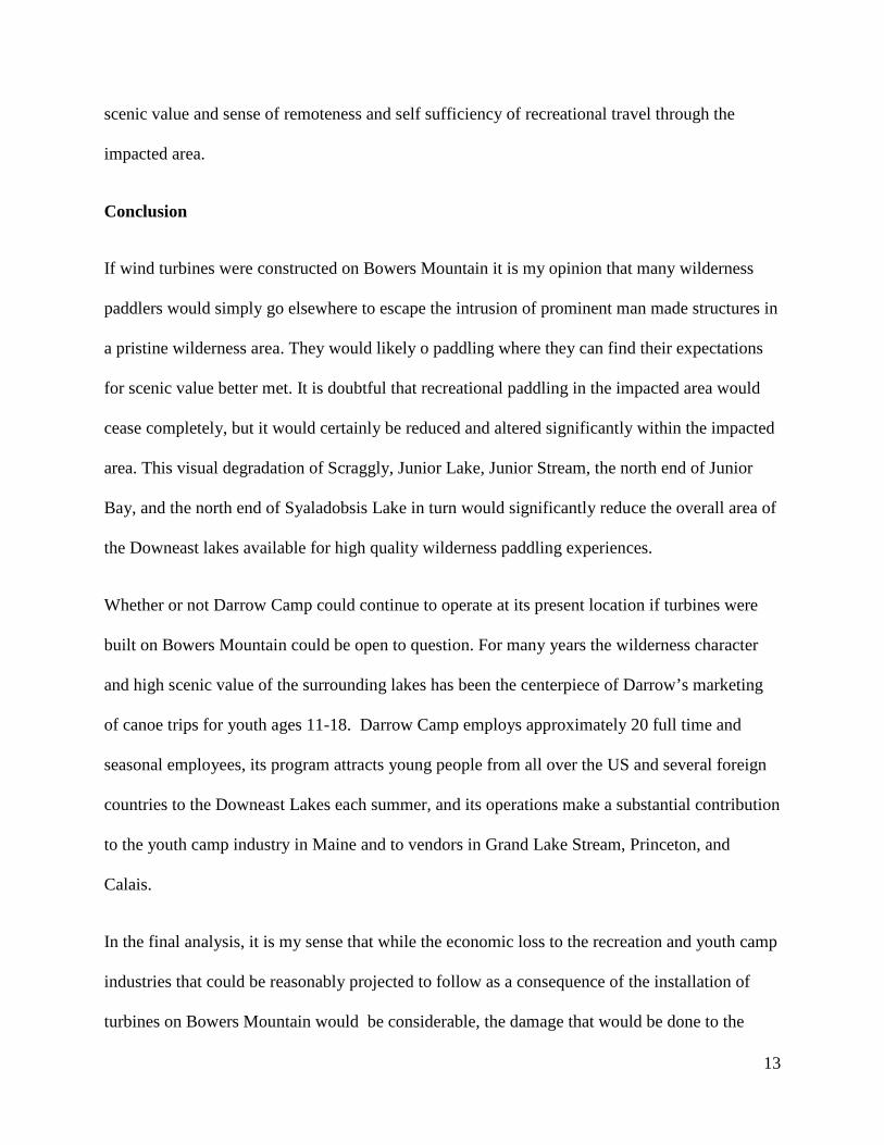
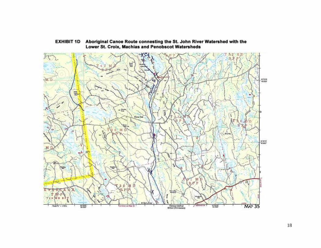
canoe routes that are still in use to this day.1 As documented by W.F. Ganong’s 1895 map2 and
text, the aboriginal canoe route through these lakes was the water trail “highway” that connected
the historic Maliseet Trail canoe route from the St John River watershed with the lower the St.
Croix, Machias, and Penobscot watersheds.3
1 Cook, David S. Above the Gravel Bar: The Native Canoe Routes of Maine Polar Bear and Company: Solon, Maine, 1985, 1999,2007 pg. 9 2 http://www.maliseettrail.com/GanongRoTMap12.htm 3 http://www.maliseettrail.com/NeptureMap1798.htm
5
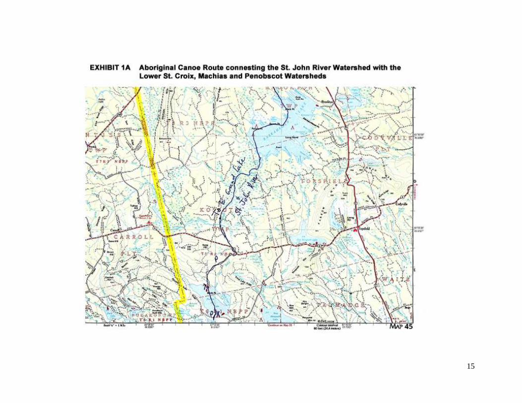
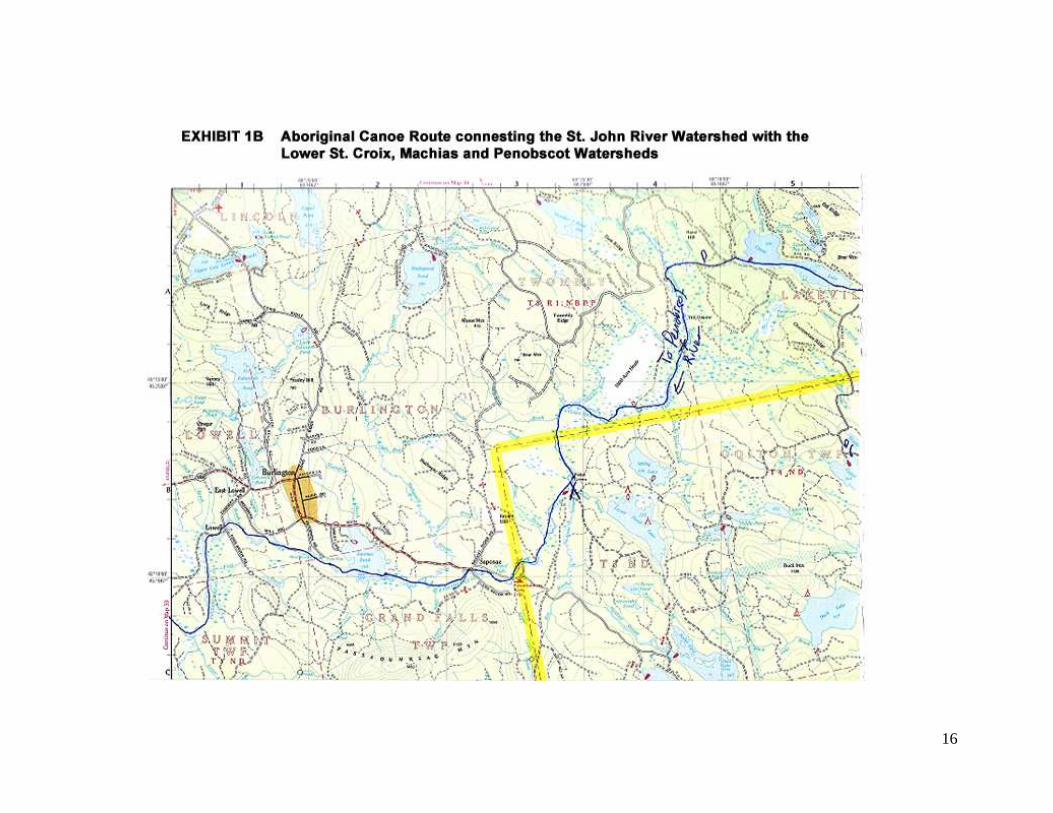
Departing from The Maliseet Trail at Baskehegan Lake, a historic canoe route documented by
both Ganong in 1895 and by Cook in 1985 follows Baskehegan Stream south, across a carry into
Pleasant Lake, across Pleasant Lake to a carry into Scraggly Lake, and south by water into
Junior Lake (see Exhibits 1A, 1B, 1C and 1D). From Junior Lake one historic route leads south
via Junior Stream into Junior Bay and West Grand Lake, then downstream to the St Croix River.4
A second route goes west from Junior Lake up Bottle Lake Stream into Bottle Lake goes across a
carry into Sysladobsis Lake, a carry into Upper Sysladobsis Lake, and a carry west to the
Passadumkeag River and downstream to the Penobscot River. A third route leads south from
Junior Lake through Horseshoe Lake into Sysladobsis Lake, with a carry into 4th Machias Lake
and the Machias River, and a fifth route leads south from Junior Lake in to Junior Bay, south into
Pocumcus Lake, and Wabassus Lake and the Getchel Pugs to Third Machias Lake and the
Machias River.
According to Ganong these canoe routes were intrinsic to the economy and culture of the
Wabnaki tribes during the pre-contact period, and also played a significant role in the cultural
interactions of the Wabnaki tribes and early French and English colonists, as well as the military
history of the French and Indian War.
According to local history and the working knowledge of local Maine Guides, this and other
local canoe routes were followed by the early timber cruisers, lumbermen, forest wardens, game
wardens, and early Maine Guides and recreational sportsmen and sportswomen. Due to the lack
of woods roads and the impracticability of overland transportation through the dense vegetation,
the canoe (and snowshoe/toboggan) routes were the only means of access to this region until the
4 Cook, David S. Above the Gravel Bar: The Native Canoe Routes of Maine Polar Bear and Company: Solon, Maine, 1985, 1999,2007 pg. 90, map pg 100
6
post WWII period, and the same ancient carry footpaths documented by Ganong are evident on
USGS topographic maps of the mid 20th century.
The existence of these historic canoe routes and their continued use into the present makes
Pleasant Lake, Scraggly Lake, Junior Lake, Bottle Lake, the north part of Sysladobsis lake,
Junior Stream, the north part of Junior Bay Junior Bay areas of natural and historic resources of
state and national significance, and a living museum of the cultural heritage of the region and the
State of Maine. In my view the construction of wind turbines on Bowers Mountain would have a
undue adverse effect on these natural and historic resources. It would no longer be possible to
travel by canoe through these areas and have anything like the experience of undeveloped
wilderness that characterized the historic past and still characterizes the present.
Impact on Existing Uses
The Downeast lakes, the heart of which are Pleasant Lake, Scraggly Lake, Junior Lake, Bottle
Lake, the north part of Sysladobsis Lake, Junior Stream, and the north part of Junior Bay, are one
of the largest remaining wilderness areas in the northeastern United States. The attraction of this
area for recreational canoe trippers and kayakers is the network of water routes interconnecting
multiple lakes of outstanding natural character. Within this area it is still possible to go on multi
day, week long, or longer canoe or kayak trips in an area within which there is very little visual
evidence of human activity. In this sense the Downeast lakes are comparable to other relatively
accessible wilderness areas of North America where multi-day canoe and kayak trips are
possible, such as the Allagash Wilderness Waterway, the Temagami region of northern Ontario,
Algonquin Park, and the Boundary Waters of Minnesota. However unlike any of these areas, the
Downeast lakes, and especially Pleasant Lake, Scraggly Lake, Junior Lake, the north part of
7
Sysladobsis lake, Junior Stream, and the north part of Junior Bay, offer freedom from crowds,
minimal regulation, minimal motorboat traffic, minimal competition for campsites, no daily user
fees, and no system of required reservations. Many places along the routes through these lakes
are only accessible by canoe or kayak. Such areas can offer excellent fishing for smallmouth
bass, pickerel, and white and yellow perch with minimal pressure from other anglers, creating an
additional attraction to the area for a paddling trip. These factors make exceptionally high quality
wilderness paddling trip experiences possible in the area impacted by the Bowers Mountain
project.
Present day recreational canoe and kayak trip usage follows the traditional canoe routes very
closely, though most of the carry footpaths have been modified by road building. The most
popular public access points for present day paddling trips within the 8 mile radius of the
proposed project are Bottle Lake, Sysladobsis Lake, and Pleasant Lake, and Dennison’s Portage,
Elsemore Landing, and the village of Grand Lake Stream in the surrounding lakes. Many canoe
and kayak trippers choose to make a loop of several days to a week or more, returning to their
initial access point, while others choose to end their trip at a different road access point. The
most popular routes are documented and publicized in the Appalachian Mountain Club’s Quiet
Water Canoe Guide: Maine5 as well as in other published guidebooks. All of these routes pass
through some part of the area of Pleasant Lake, Scraggly Lake, Junior Lake, Bottle Lake, the
north part of Sysladobsis Lake, Junior Stream, and the north part of Junior Bay that would be
affected by the Bowers Mountain Wind Project. The Downeast Lakes Water Trail, established
and publicized by the Downeast Lakes Land Trust, also interconnects at Junior Bay with the
5 Quiet Water Canoe Guide: Maine, Wilson, Alex and Hayes, John eds. Boston: Appalachian Mountain Club Books. 1995
8
routes through the impacted area, creating additional recreational opportunities for extended
paddling trips in both areas.
Along these canoe routes are a number of traditional “primitive” campsites that have been in use
for many years and have been approved for campfires by permit from the Maine Forest Service,
many of which are documented and publicized in the AMC Quiet Water Canoe Guide: Maine.
The combination of the dense vegetation and rugged natural shorelines of these lakes and the
existence of well established, attractive campsites with approved fire rings effectively
concentrates virtually all camping on these lakes to these specific sites, minimizing fire danger
and localizing and limiting environmental impact. Campsite maintenance is periodically
undertaken by the Forest Service, but most maintenance is done on an ongoing basis by canoeists
and kayakers, the canoe trip camps, and shore lunch users as a courtesy to the next visitor.
On Junior Lake there are traditional campsites at Junior Stream, McKinney Point, the island west
of McKinney Point (labeled on some maps as Mosquito Island), and on Bottle Island. On
Scraggly Lake there are campsites at Hasty Cove Landing, the Thoroughfare, Hasty Point, and
an unnamed island campsite. On the north end of Sysladobsis Lake is the Cranberry Cove
campsite. Most of these campsites are located with northern and western exposure on the shore
of islands and on points in places that offer relative freedom from heat and biting insects by
being exposed to the prevailing westerly winds, and exceptional scenic vistas to the north. The
view of Bowers Mountain is a prominent feature at many of these sites.
Present day paddling trip users include organized youth camp and scout groups, organized
guided trips for adults, small groups of adults and families, and solo paddlers. Darrow
Wilderness Trip Camp, based on an island in Junior Bay, is by far the most frequent paddling
9
trip user, sending from 8 to 12 multiday or longer canoe trips per summer of 6-12 people (3-6
canoes) each on the traditional canoe routes and campsites that fall within into the 8 mile area
impacted by the Bowers Mountain Wind Project. A number of other camps and organizations
both from Maine and from away send trips by canoe and/or kayak through the impacted area
each summer, including Flying Moose Lodge and various Scout troops and YMCA, church, and
youth groups. Canoe trips for adults led by Maine Guides such as those run by Mahoosuc Guide
Service travel through the impacted area regularly. Small parties of adults and families account
for part of the recreational paddling trips through the impacted area each summer. Usually
paddling trips will include two or more canoes to carry the food and gear required for a multi day
trip, though an occasional canoeist or kayaker travels through the area solo. Camps, youth
groups, guide adult trips, and adult and family trips that travel through the impacted area attract
people from all over the eastern US and Canada to the Downeast Lakes region of Maine.
In addition, many people who own camps (cabins) by the lakeshores within the impacted area
enjoy recreational paddling for fishing, wildlife observation, birding, and evening relaxation, and
for some camp owners a canoe trip is a regular part of their recreational experience.
To my knowledge no quantitative data exists regarding recreational paddling use for the
impacted area. This is a reflection of the unregulated character of this wilderness region.
However as the director of Darrow Camp I do receive periodic inquiries about canoe routes,
campsites, fire permits, and local conditions and I provide useful information to recreational
paddlers and users as a courtesy and as a safety measure. There is general agreement among
local Maine Guides and recreational users that recreational paddling trip use has declined since
the closing of Maine Wilderness Canoe Basin on Pleasant Lake, the only canoe livery in the area,
but this has enhanced, rather than detracted from, the appeal of the area for many other paddlers
10
and has enhanced the quality of recreational experience available to canoe trippers and kayakers
within the impacted area.
In my opinion the construction of wind turbines on Bowers Mountain would substantially
degrade the high quality wilderness paddling and wilderness tripping experiences available in
Pleasant Lake, Scraggly Lake, Junior Lake, the north part of Sysladobsis Lake, Junior Stream,
and the north part of Junior Bay. The wilderness scenic character of the area would be
substantially degraded by the presence of wind turbines towering over the lakes and landscape.
Since the orientation of a paddled craft is largely determined by boating safety, route, and wind
considerations, it would be virtually impossible to turn ones canoe or kayak to avoid viewing
human alteration of the environment on top of Bowers Mountain.
Impact on Scenic Character
For the same reason that little or no statistical data exists about usage, little or no quantitative
data exists about paddler’s expectations for scenic value. However in the many conversations I
have had over the years with wilderness paddlers, and in the presentations of speakers at the
annual Wilderness Paddlers Gatherings held in Hulbert,Vermont and in Toronto, there are a set
of expectations so frequently expressed and so widely agreed upon by paddlers that they appear
to be of substantive value in qualitative assessment of the impact of the Bowers Mountain on
expectations for scenic value within the area under study.
Wilderness paddlers widely agree that it is the absence of manmade sounds, the absence of
manmade conveniences, and the absence of manmade intrusions on natural scenic vistas that
defines the appeal of a given area for a wilderness paddling experience. It is this wilderness
character and scenic appeal that attracts recreational paddlers and ecotourists to the few
11
remaining relatively accessible wilderness areas of North America in general, and particularly to
the wilderness area of the Downeast lakes of Maine and to the impacted area impacted by the
Bowers Mountain project in particular. When seen from a canoe, the natural character of much
Pleasant Lake, Scraggly Lake, Junior Lake, the north part of Sysladobsis Lake, Junior Stream,
and the north part of Junior Bay shows minimal evidence of human intervention. Though a
number of cabins (locally called camps) have been built along the shores, most of the buildings
are partially or fully hidden by vegetation, especially when viewed from a distance over water.
Generally, those that are visible are rustic in character, built of logs or other local materials, and
are in keeping with the character of historical and present recreational uses of the area.
Wilderness paddlers generally do not find such buildings unacceptably intrusive. Cabins on these
lakes tend to be clustered in specific areas, and extensive areas of the shorelines of these lakes
are completely natural and undeveloped. Paddlers may well have higher expectations for
unaltered natural scenery than do boaters or people focused on fishing. When you are paddling,
the lakes and the landscape are the focus of your attention for hours on end; they unroll in front
of a paddled canoe or kayak as a slowly ever changing scenic vista filled with constant surprises
and discoveries. The focus is on the land, the water, and your relationship with them.
Wilderness tripping is a challenging sport that requires sustained physical effort to reach a distant
goal. The labor required can vary from mild to prodigious. The reasons that people choose to go
on wilderness paddling trips are numerous and varied, but one of the factors they almost
invariably identify is the expected scenic value of a wilderness paddling trip. Canoeists and
kayakers are willing to work hard work to reach and travel through areas such as those impacted
by the Bowers Mountain Wind Project in which there is very little or no apparent evidence of
human alteration of natural scenic values, and it is the self-propelled canoe or kayak that makes
12
such areas accessible and that makes multi day trips involving multiple carries between lakes or
waterways possible. For their investment of physical effort and skill, paddlers expect to be
“rewarded” with the beauty of “discovering” or revisiting areas with minimal evidence of human
alteration and exceptional scenic value. Pleasant Lake, Scraggly Lake, Junior Lake, the north
part of Sysladobsis Lake, Junior Stream, and the north part of Junior Bay Junior Bay are pristine
examples of the finest canoe country that the United States has to offer. The AMC Quiet Water
Guide: Maine guidebook rates the Junior /Pocumus/Syaladobsis loop route as “one of the best
extended quiet water loop trips in the state, especially when one detours for a few days into
Scraggly Lake.”6
Perhaps the most radical visual impact of the installation of wind turbines on Bowers Mountain
would occur at night. Wilderness paddlers consistently state that one of the most highly valued
parts of a wilderness trip is the relative absence of artificial illumination. This serves to intensify
the scenic value of the inky blue blackness of the clear night sky and the clarity and brilliance of
the moon and stars. Though the existing beacon near Route 6 is visible from some parts of
Scraggly Lake, Junior Lake, and the northern end of Junior Stream, in many other places within
the impacted area it is blocked by local topography or is minimally intrusive. The degradation of
expected scenic value by the existing beacon is minimal in comparison to the illumination of red
aircraft warning lights on 27 wind turbines stretched across the northern horizon, even if the
lights were equipped with radar aircraft sensors for intermittent operation. Sitting around the
campfire on a quiet dark night the visual intrusion of the lights would significantly degrade the
6 Quiet Water Canoe Guide: Maine, Wilson, Alex and Hayes, John eds. Boston: Appalachian Mountain Club Books. 1995 p.153
13
scenic value and sense of remoteness and self sufficiency of recreational travel through the
impacted area.
Conclusion
If wind turbines were constructed on Bowers Mountain it is my opinion that many wilderness
paddlers would simply go elsewhere to escape the intrusion of prominent man made structures in
a pristine wilderness area. They would likely o paddling where they can find their expectations
for scenic value better met. It is doubtful that recreational paddling in the impacted area would
cease completely, but it would certainly be reduced and altered significantly within the impacted
area. This visual degradation of Scraggly, Junior Lake, Junior Stream, the north end of Junior
Bay, and the north end of Syaladobsis Lake in turn would significantly reduce the overall area of
the Downeast lakes available for high quality wilderness paddling experiences.
Whether or not Darrow Camp could continue to operate at its present location if turbines were
built on Bowers Mountain could be open to question. For many years the wilderness character
and high scenic value of the surrounding lakes has been the centerpiece of Darrow’s marketing
of canoe trips for youth ages 11-18. Darrow Camp employs approximately 20 full time and
seasonal employees, its program attracts young people from all over the US and several foreign
countries to the Downeast Lakes each summer, and its operations make a substantial contribution
to the youth camp industry in Maine and to vendors in Grand Lake Stream, Princeton, and
Calais.
In the final analysis, it is my sense that while the economic loss to the recreation and youth camp
industries that could be reasonably projected to follow as a consequence of the installation of
turbines on Bowers Mountain would be considerable, the damage that would be done to the

14
existing uses, scenic character, and natural and historic resources in the area likely to be affected
by the proposal would be irreparable. For these reasons I believe that the proposed installation of
turbines on Bowers Mountain does not meet the statutory criteria set forth herein.
15
16
17
18