STATE OF FLORIDA DEPARTMENT OF ... 46 Docs/091417_SR 46_Type2CE.pdfTopic No. 650-000-001 Project...
58
Topic No. 650-000-001 Project Development and Environment Manual Type 2 Categorical Exclusions Effective: June 14, 2017 1 STATE OF FLORIDA DEPARTMENT OF TRANSPORTATION TYPE 2 CATEGORICAL EXCLUSION DETERMINATION FORM 1. PROJECT DESCRIPTION AND PURPOSE AND NEED a. Project Information: Project Name: State Road 46 Widening PD&E Study Project Limits: From East of State Road 415 to County Road 426 County: Seminole ETDM Number (If applicable): 4972 Financial Management Number: 240216-4-28-01 Federal-Aid Project Number: TCSP-045-U Project Manager: Mary McGehee, E.I. b. Proposed Improvements: SR 46 is an east-west arterial highway that extends from US 441 in Mount Dora (Lake County) to US 1 in Mims (Brevard County). The limits of the PD&E Study extend from east of SR 415 (MP 3.660) in unincorporated Seminole County to CR 426 (MP 11.047) in Geneva, Florida, an unincorporated census-designated place (see Figure 1.1). The length of the project is approximately 7.4 miles. SR 46 serves as a major evacuation route for residents of south Volusia, north Brevard and eastern Seminole Counties. The closest evacuation routes to SR 46 on I-95 are SR 44, 25 miles to the north and SR 50, eight miles to the south. Within the project limits, SR 46 is a two-lane rural principal arterial comprised of one 12-foot lanes in each direction with six-foot shoulders (four-foot paved). Stormwater sheet flows off the roadway into roadside ditches. Bridge No. 770094 spans Lake Jesup/St. Johns River within the project limits. The bridge was constructed in 2009 and is 3,740 feet long. The bridge typical section consists of one 12-foot travel lane in each direction and 10-foot shoulders. The existing roadway is centered within 100 feet of right-of-way for most of the length of the project. However, the right-of-way widens to approximately 127 feet on the north side of SR 46, extending approximately 3,200 feet west of the bridge. The existing right-of-way varies at both bridge approaches. There are two signalized intersections within the project limits; one at SR 415 and another at CR 426. The four-laning of SR 46 from Mellonville Road to east of SR 415 is under construction as of June 2017.
Transcript of STATE OF FLORIDA DEPARTMENT OF ... 46 Docs/091417_SR 46_Type2CE.pdfTopic No. 650-000-001 Project...

Topic No. 650-000-001 Project Development and Environment Manual Type 2 Categorical Exclusions Effective: June 14, 2017
1
STATE OF FLORIDA DEPARTMENT OF TRANSPORTATION
TYPE 2 CATEGORICAL EXCLUSION DETERMINATION FORM
1. PROJECT DESCRIPTION AND PURPOSE AND NEED
a. Project Information:Project Name: State Road 46 Widening PD&E Study
Project Limits: From East of State Road 415 to County Road 426
County: Seminole
ETDM Number (If applicable): 4972
Financial Management Number: 240216-4-28-01
Federal-Aid Project Number: TCSP-045-U
Project Manager: Mary McGehee, E.I.
b. Proposed Improvements:
SR 46 is an east-west arterial highway that extends from US 441 in Mount Dora (LakeCounty) to US 1 in Mims (Brevard County). The limits of the PD&E Study extend from east ofSR 415 (MP 3.660) in unincorporated Seminole County to CR 426 (MP 11.047) in Geneva,Florida, an unincorporated census-designated place (see Figure 1.1). The length of theproject is approximately 7.4 miles. SR 46 serves as a major evacuation route for residents ofsouth Volusia, north Brevard and eastern Seminole Counties. The closest evacuation routesto SR 46 on I-95 are SR 44, 25 miles to the north and SR 50, eight miles to the south. Withinthe project limits, SR 46 is a two-lane rural principal arterial comprised of one 12-foot lanes ineach direction with six-foot shoulders (four-foot paved). Stormwater sheet flows off theroadway into roadside ditches.
Bridge No. 770094 spans Lake Jesup/St. Johns River within the project limits. The bridgewas constructed in 2009 and is 3,740 feet long. The bridge typical section consists of one12-foot travel lane in each direction and 10-foot shoulders. The existing roadway is centeredwithin 100 feet of right-of-way for most of the length of the project. However, the right-of-waywidens to approximately 127 feet on the north side of SR 46, extending approximately 3,200feet west of the bridge. The existing right-of-way varies at both bridge approaches.
There are two signalized intersections within the project limits; one at SR 415 and another at CR 426. The four-laning of SR 46 from Mellonville Road to east of SR 415 is under construction as of June 2017.

Topic No. 650-000-001 Project Development and Environment Manual Type 2 Categorical Exclusions Effective: June 14, 2017
2
Figure 1.1 – Project Location Map

Topic No. 650-000-001 Project Development and Environment Manual Type 2 Categorical Exclusions Effective: June 14, 2017
3
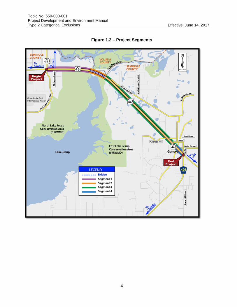
During the PD&E Study, a number of residents objected to the proposed capacity improvements based on their opinion that traffic volumes on SR 46 within the project limits are too low to justify the proposed widening. The FDOT has decided, based on continued communication between area residents, Seminole County staff and Seminole County elected officials that the final design of the Recommended Alternative will commence when the overall arterial operations from SR 415 to CR 426 operate at LOS E, which is currently projected to occur in approximately 2021. The design of the SR 46 widening will not commence until such time as traffic volumes, substantiated by traffic counts, indicate the widening is required. Construction of the Recommended Alternative will require acquisition of approximately 30.1 acres of adjacent property for roadway construction, 33 acres for stormwater management and 35.7 acres for floodplain compensation. For the purpose of the study, the SR 46 widening project was subdivided into four segments. Figure 1.2 shows the limits of each segment as described below: • Segment 1 - SR 46 from 415 to the western terminus of Lake Jesup Bridge • Segment 2 – The Lake Jesup Bridge (which carries SR 46 over Lake Jesup • Segment 3 – SR 46 from the eastern terminus of Lake Jesup Bridge to Hart Road • Segment 4 – SR 46 from Hart Road to CR 426
Proposed Roadway Improvements
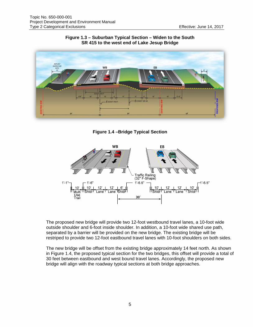
The Recommended Alternative consists of the following improvements for each Segment: Segment 1 improvements consist of widening the existing two-lane rural roadway to a four-lane suburban roadway section from SR 415 to the west end of the Lake Jesup Bridge. The proposed widening will occur primarily on the south side of SR 46 specifically to avoid the Bergmann Tract mitigation bank located north of SR 46. Initially, widening to the north is required at SR 415 to tie into the ongoing widening west of SR 415. A transition to the north, just west of Old Geneva Road, is necessary to tie into the proposed new bridge that will be constructed on the north side of the existing bridge. The proposed suburban typical section for this segment consists of two 12-foot travel lanes in each direction with four-foot inside shoulders and 6.5-foot outside shoulders. The travel lanes are separated by a 22-foot median. A 10-foot shared use path is proposed on the north side of the roadway. A five-foot sidewalk is proposed on the south side. The sidewalk and path are separated from the travel lanes by a grassed median. The total width of the proposed right-of-way is 148 feet. The proposed typical section is illustrated in Figure 1.3. Segment 2 improvements consist of construction of a new, two-lane bridge over Lake Jesup, parallel to, and north of, the existing bridge. The proposed bridge would be of similar design and approximate length as the existing bridge. The existing bridge will provide the future eastbound lanes. The proposed westbound lanes will be constructed on the previous alignment of the old bridge and causeway that was removed for construction of the existing bridge. The proposed typical section for the parallel bridges is shown in Figure 1.4.
Topic No. 650-000-001 Project Development and Environment Manual Type 2 Categorical Exclusions Effective: June 14, 2017
4
Figure 1.2 – Project Segments
Topic No. 650-000-001 Project Development and Environment Manual Type 2 Categorical Exclusions Effective: June 14, 2017
5
Figure 1.3 – Suburban Typical Section – Widen to the South
SR 415 to the west end of Lake Jesup Bridge
Figure 1.4 –Bridge Typical Section
The proposed new bridge will provide two 12-foot westbound travel lanes, a 10-foot wide outside shoulder and 6-foot inside shoulder. In addition, a 10-foot wide shared use path, separated by a barrier will be provided on the new bridge. The existing bridge will be restriped to provide two 12-foot eastbound travel lanes with 10-foot shoulders on both sides. The new bridge will be offset from the existing bridge approximately 14 feet north. As shown in Figure 1.4, the proposed typical section for the two bridges, this offset will provide a total of 30 feet between eastbound and west bound travel lanes. Accordingly, the proposed new bridge will align with the roadway typical sections at both bridge approaches.

Topic No. 650-000-001 Project Development and Environment Manual Type 2 Categorical Exclusions Effective: June 14, 2017
6
Segment 3 consists of the expansion of a two-lane rural roadway to a four-lane suburban roadway segment from the east end of the Lake Jesup Bridge to Hart Road. In order to minimize the impacts to the natural, physical and social environments within this segment, both the Suburban Widen to the South (Figure 1.5) and Suburban Widen to the North (Figure 1.6) typical sections will be used. The combination of these typical sections for the Recommended Alternative is referred to as the “Suburban Best Fit Alternative” in the Preliminary Engineering Report prepared for this project. Both of these suburban typical sections require 148 feet of right-of-way.
Figure 1.5 – Suburban Typical Section – Widen to the South
Figure 1.6 – Suburban Typical Section – Widen to the North
Segment 4 consists of the expansion of a two-lane rural roadway to a four-lane urban roadway segment between Hart Road and CR 426. The proposed urban section only requires 100 feet of right-of-way and is proposed in Segment 4 to minimize impacts to the commercial properties in downtown Geneva. Figure 1.7 illustrates the proposed urban typical section.

Topic No. 650-000-001 Project Development and Environment Manual Type 2 Categorical Exclusions Effective: June 14, 2017
7
Figure 1.7 – Urban Typical Section – Centered Widening
The proposed urban typical section provides two 11-foot lanes in each direction separated by a 19.5-foot median. Seven-foot buffered bike lanes will be provided on both sides of the roadway. Six-foot sidewalks are proposed on both sides of the road.
Proposed Drainage Improvements
SR 46 is located within the jurisdiction of the St. Johns River Water Management District (SJRWMD). The project limits lie within the Middle St. Johns River Basin of which Lake Jesup is a tributary. The Middle St. Johns River Basin is considered an open basin that discharges to the St. Johns River, which is not considered an Outstanding Florida Water (OFW). However, the Florida Department of Environmental Protection (FDEP) has adopted total maximum daily loads (TMDL) for both nitrogen and phosphorus for any basin discharging to the St. Johns River above Lake Monroe, Lake Jesup near the St. Johns River, and the St. Johns River above Lake Jesup. Also, 100-year floodplains are found within the project limits with the majority being located around the bridge over Lake Jesup. Stormwater and floodplain compensation ponds have been designed to provide water quality treatment, quantity (attenuation) and compensation for any loss of floodplain volumes. Pond site locations for the Recommended Alternative were determined by evaluating the potential environmental impacts of pond site alternatives. This evaluation is documented in the Pond Siting Report (April 2014) published separately for this project. Pond site recommendations were based on pond sizes and locations determined from preliminary calculations, reasonable engineering judgment, and assumptions.

Topic No. 650-000-001 Project Development and Environment Manual Type 2 Categorical Exclusions Effective: June 14, 2017
8
c. Purpose and Need:
The purpose of this project is to evaluate alternatives to increase capacity of SR 46 within the project limits to improve both the existing and projected future Levels of Service (LOS) and to evaluate the profile grade elevation of the roadway to ensure it is above flood elevation. System Linkage The western project terminus connects to SR 415, which is a four lane divided facility. East Lake Mary Boulevard is a four-lane divided facility that intersects SR 46 at SR 415 and provides a direct connection to the Orlando-Sanford International Airport and the Seminole County Expressway (SR 417). Four-laning of SR 46 from Mellonville Road to SR 415 is under construction as of June 2017. CR 426 at the eastern terminus of the project provides a direct connection to the City of Oviedo, a large residential suburb of Orlando. CR 426 is policy-constrained to two-lanes by Seminole County. Capacity The Florida Department of Transportation (FDOT) has classified the segment of SR 46 between SR 415 and Richmond Avenue as an urban principal arterial with an LOS standard of D. East of Richmond Avenue, SR 46 is classified as a rural principal arterial with an LOS standard of C. Existing average annual daily traffic (AADT) volumes along SR 46 result in LOS D conditions on SR 46 from Osceola Road to Woodridge Drive. Increasing traffic volumes as identified in the Design Traffic Technical Memorandum (May 2012) are projected to result in capacity and over capacity conditions by the Design Year (2035). Providing additional capacity on SR 46 within the project limits will ensure that future projected traffic can be accommodated safely and efficiently. Safety Crash records for the project corridor between just east of SR 415 and CR 426 from January 1, 2006 through May 31, 2012 were compiled and analyzed (the crash data does not include the intersection of SR 46 and SR 415 since improvements to this intersection are included in the SR 46 widening project from Mellonville Road to SR 415) . One hundred sixty-seven crashes were recorded during this time period on SR 46 from SR 415 to CR 426. The statewide annual crash rate for facilities similar to SR 46 (two lane rural roadways) is 0.525 crashes per million vehicle miles travelled (C/MVM). The segment of SR 46 from SR 415 to CR 426 experienced a crash rate of 1.006 C/MVM, almost two times the statewide average. In addition to crash rates higher than the statewide average, there have been six fatalities and 90 injuries during the analysis period. The majority of crashes occurred during daylight hours. Detailed information regarding crash data can be found in in Section 3.5 of the SR 46 Design Traffic Technical Memorandum (May 2012) published separately. According to the ETDM Summary Report published on 09/20/2010, portions of SR 46 were completely inundated by high water resulting in the closure of this road within the study limits during hurricane season. SR 46 serves as a major evacuation route for Northern Brevard and Southern Volusia Counties. The potential for flooding along SR46 was evaluated within the

Topic No. 650-000-001 Project Development and Environment Manual Type 2 Categorical Exclusions Effective: June 14, 2017
9
study limits. This evaluation indicated that there is no history of flooding between SR 415 and CR 426. The flooding occurred in the past east of CR 426 near the County line. The project was screened via ETDM in 2005. At that time, the project limits extended to the County line. Since then, the County has raised the profile grade above the flood elevation in this area.
d. Project Planning Consistency: disregard providing historical details, instead focus on future phases of segments being advanced. If more than one segment is being advanced additional tables should be added.
Currently Adopted CFP-LRTP
This project is listed in the 2040 LRTP for MetroPlan Orlando and is included in the most recently adopted Cost Feasible Plan. The project is also included in the Seminole County Comprehensive Plan and is ranked number 17on MetroPlan Orlando’s “Orlando Urban Area FY 2022/23 – 2039/40 Prioritized Project List”, adopted on July 12, 2017.
Yes
PHASE
Currently Approved
TIP
Currently Approved
STIP
TIP/STIP
$ TIP/STIP
FY
COMMENTS
PE (Final Design)
Y
Y
$5.205M 2021/22
R/W
N
N N/A N/A
Construction N N N/A N/A
* Pages from TIP/STIP/LRTP included in Appendix A

Topic No. 650-000-001 Project Development and Environment Manual Type 2 Categorical Exclusions Effective: June 14, 2017
10
2. COOPERATING AGENCIES [ ] USACE [ ] USCG [ ] USFWS [ ] EPA [ ] NMFS [X] NONE
3. ENVIRONMENTAL ANALYSIS Significant Impacts?*
Issues/Resources Yes No Enhance NoInv Supporting Information**
A. SOCIAL & ECONOMIC 1. Social [ ] [X] [ ] [ ] See Section A.1 2. Economic [ ] [ ] [X] [ ] See Section A.2 3. Land Use Changes [ ] [X] [ ] [ ] See Section A.3 4. Mobility [ ] [X] [ ] [ ] See Section A.4 5. Aesthetic Effects [ ] [X] [ ] [ ] See Section A.5 6. Relocation Potential [ ] [X] [ ] [ ] See Section A.6 7. Farmland [ ] [X] [ ] [ ] See Section A.7
B. CULTURAL 1. Section 4(f) [ ] [X] [ ] [ ] See Section B.1 2. Historic Sites/Districts [ ] [X] [ ] [ ] See Section B.2 3. Archaeological Sites [ ] [X] [ ] [ ] See Section B.3 4. Recreational Areas [ ] [X] [ ] [ ] See Section B.4
C. NATURAL 1. Wetlands and Other
Surface Waters [ ] [X] [ ] [ ] See Section C.1 2. Aquatic Preserves and
Outstanding FL Waters [ ] [ ] [ ] [X] 3. Water Quality and Water
Quantity [ ] [X] [ ] [ ] See Section C.3 4. Wild and Scenic Rivers [ ] [ ] [ ] [X] 5. Floodplains [ ] [X] [ ] [ ] See Section C.5 6. Coastal Zone Consist. [ ] [X] [ ] [ ] See Section C.6 7. Coastal Barrier
Resources [ ] [ ] [ ] [X] 8. Protected Species and
Habitat [ ] [X] [ ] [ ] See Section C.8 9. Essential Fish Habitat [ ] [X] [ ] [ ] See Section C.9
D. PHYSICAL 1. Highway Traffic Noise [ ] [X] [ ] [ ] See Section D.1 2. Air Quality [ ] [X] [ ] [ ] See Section D.2 3. Contamination [ ] [X] [ ] [ ] See Section D.3 4. Utilities and Railroads [ ] [X] [ ] [ ] See Section D.4 5. Construction [ ] [X] [ ] [ ] See Section D.5 6. Bicycles and Pedestrians[ ] [ ] [X] [ ] See Section D.6 7. Navigation [ ] [ ] [ ] [X]
a. [X] A USCG Permit IS NOT required. b. [ ] A USCG Permit IS required.
* Significant Impacts?: Yes = Significant Impact; No = No Significant Impact; Enhance = Enhancement; NoInv = Issue absent, no involvement **Supporting information is documented in the referenced attachment(s).

Topic No. 650-000-001 Project Development and Environment Manual Type 2 Categorical Exclusions Effective: June 14, 2017
11
E. ANTICIPATED PERMITS SJRWMD – Environmental Resource Permit (ERP) for stormwater facilities FDEP – National Pollutant Discharge Elimination System (NPDES) US Army Corps of Engineers (ACOE) – Nationwide Permit FFWCC – Bald Eagle Disturbance Permit FFWCC – Gopher Tortoise Relocation Permit
4. COMMITMENTS
• FDOT will investigate options to minimize habitat impacts west and near the Lake Jesup Bridge as well as opportunities to improve habitat connectivity in those locations during permitting and design.
• FDOT will ensure that roadway design and construction does not compromise the ability to access and manage conservation lands effectively.
• FDOT will conduct wildlife surveys to verify findings of the SR 46 Natural Resources Evaluation Report during permitting and prior to construction within the proposed right-of-way as well as all mobilization and staging areas.
• FDOT will conduct an osprey nest survey prior to construction and obtain all necessary permits for nest removal as necessary.
• Any culverts larger than eight inches in diameter will be grated to prevent manatee entrapment. The spacing between the bridge pilings will be at least 60 inches apart to allow for manatee movement in between the pilings.
• Barges will be equipped with fender systems that provide a minimum standoff distance of four feet between wharves, bulkheads and vessels moored together to prevent crushing manatees between the barges or between the barge and work site. All existing slow speed or no wake zones will apply to all work boats and barges associated with the construction.
• FDOT will initiate consultation with USFWS for the Florida manatee if dredging is deemed necessary for construction.
• There will be no blasting in manatee sensitive areas. • Field surveys for crested caracara, Florida sandhill crane, and Florida burrowing owl will be
accomplished prior to construction. • Subsequent crested caracara surveys will be conducted during the design phase. If at that time
survey reveals additional nests, then FDOT will reinitiate consultation with USFWS. • FDOT will include bat friendly structural components within or adjacent to the bridge during
design and construction; providing bat exclusions during construction. • FDOT will conduct eagle nest surveys and agency coordination during the design phase to
determine whether a disturbance permit is necessary. • When possible, schedule construction work within 660 feet of eagle nests outside of nesting
season. • FDOT will provide conservation measures (including minimization measures) for any
construction proposed within 330 feet of an active nest. • The presence of road kill is a significant factor affecting juvenile bald eagle and caracara
mortality; therefore, FDOT will integrate wildlife-friendly components within culverts for small and meso-sized wildlife.
• FDOT will ensure that the Contractor Requirements for Unexpected Interaction with Certain Protected Species During Work Activities is followed during construction.
• The two sites assigned a contamination risk rating of “high” (The Pantry, Inc. at 4140 E SR 46 & SR 415 and the former Trombley’s Auto Body at 2740 SR 46 W), and the two sites assigned a
Topic No. 650-000-001 Project Development and Environment Manual Type 2 Categorical Exclusions Effective: June 14, 2017
12
a contamination risk rating of “medium” (Lake Jesup Groves maintenance area at 2017 SR 46 W and Geneva Food Store/MJM Food Store at 140 SR 46 W) should undergo Preliminary Contamination Assessments (PCAs) consisting of soil and groundwater sampling during the design phase of the project.
Commitments may be revised or added after the Public Hearing.
5. PUBLIC INVOLVEMENT
1. [ ] A public hearing is not required. 2. [X] A public hearing will be held on October 12, 2017. This draft document is
publically available and comments can be submitted to FDOT until October 23, 2017 District Contact Information: Mary McGehee, E.I.
Project Manager Florida Department of Transportation 719 S. Woodland Blvd. Deland, FL 32720 Phone: (386) 943-5063 Email Address: [email protected]
3. [ ] A public hearing was held on (insert date) and the transcript is available. 4. [ ] An opportunity for a public hearing was afforded and was documented
(insert date).
6. DISTRICT DETERMINATION
This project has been developed without regard to race, color, national origin, age, sex, religion, disability, or family status.
/ / FDOT Project Manager Date
/ / FDOT Environmental Manager or Designee Date
7. OFFICE OF ENVIRONMENTAL MANAGEMENT CONCURRENCE
Signature below constitutes Location and Design Concept Acceptance:
The environmental review, consultation, and other actions required by applicable federal environmental laws for this project are being, or have been, carried out by the Florida Department of Transportation (FDOT) pursuant to 23 U.S.C. § 327 and a Memorandum of Understanding dated December 14, 2016 and executed by the Federal Highway Administration and FDOT.
/ /
Director of the Office of Environmental Management Date or Designee
13
8. SUPPORTING INFORMATION A.1 SOCIAL The following Degrees of Effect assigned by review agencies and the Summary Degree of Effect assigned by FDOT for Social in the ETDM Programming Screen Summary Report are presented below. Summary DOE: Minimal DCA DOE: None USEPA DOE: Minimal Community Cohesion
The U.S. Environmental Protection Agency (EPA) provided comments on this issue noting that widening of SR 46 could result in growth and development along this rural corridor. Since the County's Future Land Use Element of their Comprehensive Plan designates this area as within the Rural Boundary Area, and the policies and objectives of this designation call for the preservation of the rural character, we believe the potential for future non compatible land uses to be low. Community Services There are five elementary, three middle and two high schools located in Seminole County which are offered as public education options to residents along the project corridor via districting or the “cluster schools” School Choice option. Seminole County Public Transportation Services operates bus routes throughout the project corridor to service these schools. Comments from local residents concerned about motorists ignoring school buses along SR 46 were received during the public involvement efforts for this project. The comments stated that some motorists passed the school bus when stopped, crossing the centerline, and others passed speeding in the opposite direction. Residents expressed concern for safety of students using the bus, especially since some school pick up times are before sunrise. Widening SR 46 to a divided four lane facility is likely to improve safety of students who depend on the bus for transportation to school. One fire station, Seminole County Fire Station #42, is located within the project limits on the north side of SR 46 at the intersection with North Hart Road. An emergency signal (flashing yellow) is provided on SR 46 at this location. A full median opening is proposed at this location. Adverse impacts to the fire station or emergency response time are not anticipated as a result of the proposed improvements. In fact, widening the existing roadway to increase capacity will improve the level of service in this section of SR 46 which could improve emergency response time. Nondiscrimination Considerations The census block group that includes the area of the project north of SR 46 between east of SR 415 and the St Johns River/Lake Jesup has a minority population of greater than 40% and a per capita income of less than $26,000; however, in the area of the project this census block group is largely unpopulated and no impacts to communities within this block group are anticipated. The remaining census block groups have minority populations of less than 40% and per capita incomes greater than $26,000. This project has been developed in accordance with Title VI and Title VIII of the Civil Rights Act of 1964, as amended by the Civil Rights Act of 1968. Title VI provides that no person shall, on the grounds of race, color, religion, sex, national origin, marital status, handicap, or family composition, be excluded from participation in, or be denied the benefits of, or be otherwise subject to discrimination under any program of the federal, state, or local government. Title VIII guarantees each person equal

14
opportunity in housing. This project is not expected to impact any distinct minority, ethnic, elderly or handicapped groups. Along with the Civil Rights Act, Executive Order 12898, Federal Actions to Address Environmental Justice in Minority Populations, signed by the President on February 11, 1994 directs federal agencies to take appropriate and necessary steps to identify and address disproportionately high and adverse effects of federal projects on the health or environment of minority and low-income populations to the greatest extent practicable and permitted by law. No minority or low-income populations have been identified that would be adversely impacted by the proposed project, as determined above. Therefore, in accordance with the provisions of Executive Order 12898 and FHWA Order 6640.23a, no further Environmental Justice analysis is required. Title VI information was made available at the Public Information Meeting and will be made available at the Public Hearing. In order to ensure that all households within the project area were notified of the Public Information Meeting and will be notified of the Public Hearing, announcements were sent to property owners within 300 feet of each build alternative (per the PD&E Manual). Controversy Potential SR 46 is a principal arterial on the state highway system that extends from US 441 in Mount Dora to US 1 in Mims and interchanges with I-4 and I-95. In addition, it is the main evacuation route to inland areas from north Brevard County, south Volusia County and eastern Seminole County. Within the study limits, SR 46 traverses a largely rural section of Seminole County, including the unincorporated community of Geneva. While the main community of Geneva is clustered around Osceola Road north of SR 46 (since Osceola Road was the original alignment of SR 46), the area along SR 46 from Lake Jesup to the east is within the boundaries of what is considered part of Geneva. Because of the rural nature of this area, many of the residents are opposed to widening SR 46, as they believe that a widened facility will lead to additional development. Geneva is considered a Seminole County Rural Area, and as such has strict planning in place to preserve the rural character of the area. In 2006 Seminole County established a Rural Character Plan and during meetings with the community came up with seven distinct topics addressing an integral element that is considered necessary to understand and maintain a rural lifestyle. The seventh topic addresses rural infrastructure. The primary objective expressed within these issues is the need to balance the need for providing adequate and safe infrastructure within the Rural Area and the need to continue to provide rural levels of service within the Rural Area. While residents identified widening of roads as potentially affecting the rural character of the area, the Rural Character Plan identifies SR 46 as part of a regional transportation network and identifies the widening of SR 46 as being included in the Long Range Transportation Plan. The Recommended Alternative was developed within the context of the surrounding area and no provisions are included for a potential widening to six lanes. Through the public involvement process, many residents of Geneva have expressed concern to the project team that the widening of SR 46 to four lanes would be a detriment to the rural nature of the area. In addition to comments received at the Public Information Meeting, the project team received numerous comments via the project website and a petition signed by 510 individuals in opposition to the widening of SR 46. While the project team understands the concern of those individuals opposed to the project, much of the information presented to the community by the petition writers was opinion rather than facts based on engineering or environmental analyses. Results of the engineering and environmental analyses performed as part of the PD&E Study was addressed in written responses to each signatory. Furthermore, several residents of Geneva also expressed support for the project, through the same channels, citing increased congestion as a concern.
15
As a result of the letters in opposition to the project, further discussions with the community, elected representatives of Seminole County, Seminole County staff and FDOT have agreed to defer the final design of the widening until traffic volumes have increased to a point where SR 46 has reached capacity (level of service E) for a two-lane arterial roadway. The construction of safety improvements that will immediately address the issue of the high crash rate along this segment of SR 46 is scheduled to begin in June 2017. A full summary of public involvement activities for the project is included in the Public Involvement Plan and will be submitted as part of the final documentation after the Public Hearing. Potential impacts to the social environment resulting from construction of the Recommended Alternative are not expected to be significant. A.2 ECONOMIC The following Degrees of Effect assigned by review agencies and the Summary Degree of Effect assigned by FDOT for Economic in the ETDM Programming Screen Summary Report are presented below. Summary DOE: Enhanced No comments were received for economic issues. Geneva is a rural residential community with few commercial land uses. In general, residents desire to maintain the rural character of the community. We do not believe the project will have economic impacts to Geneva. However, SR 46 provides access to the Sanford Orlando International Airport, which is a Strategic Intermodal System (SIS) facility and provides a connection to SR 417 via the East Lake Mary Boulevard. Due to the increased level of service and accessibility that a four lane divided roadway would provide there is the potential for economic enhancement to the SIS facility and surrounding communities. A.3 LAND USE CHANGES The following Degrees of Effect assigned by review agencies and the Summary Degree of Effect assigned by FDOT for Land Use Changes in the ETDM Programming Screen Summary Report are presented below. Summary DOE: Moderate DCA DOE: Moderate
The Department of Community Affairs (DCA), now known as the Department of Economic Opportunity (DEO), stated that the proposed project is located within the Rural Boundary Area as identified in the Seminole County Comprehensive Plan Future Land Use Element and is identified as an evacuation route on the “Airport, Port, and Rail Facilities Evacuation Routes 2025” map. DCA also noted that the project is consistent with the Seminole County Comprehensive Plan. DCA also stated that the project should be developed in accordance with the following policies of the Strategic Regional Policy Plan – East Central Florida Regional Planning Council:
Policy 5.26 Design of regionally significant transportation facilities - and improvements to existing regionally
significant facilities - should incorporate measures to minimize adverse impacts of such facilities on the tranquility and viability of residential neighborhoods and communities.
16
Policy 5.27 New transportation facilities or improvement of existing facilities that promotes leapfrog or sprawl
development and adversely impacts other public facilities and services should not be undertaken. The following should be adhered to in implementing this policy:
e. Consistency with adopted state, regional and local comprehensive plans, relevant to transportation
systems and land uses. Since the County's Future Land Use Element of their Comprehensive Plan designates this area as
within the Rural Boundary Area, and the policies and objectives of this designation call for the preservation of the rural character, it is anticipated that the potential for future non compatible land uses will be low.
Potential land use changes resulting from construction of the Recommended Alternative are not expected to be significant.
A.4 MOBILITY The following Degrees of Effect assigned by review agencies and the Summary Degree of Effect assigned by FDOT for Mobility in the ETDM Programming Screen Summary Report are presented below. Summary DOE: Enhanced No comments were received for economic issues. A four-lane divided roadway connecting SIS facilities and serving as an evacuation route will provide for Enhanced mobility. A.5 AESTHETIC EFFECTS The following Degrees of Effect assigned by review agencies and the Summary Degree of Effect assigned by FDOT for Aesthetics in the ETDM Programming Screen Summary Report are presented below. Summary DOE: Minimal No comments were received for aesthetic issues. It is anticipated that the proposed improvements will have minimal impacts to the aesthetics of the area. The surrounding area is primarily rural and there are no residences located in the vicinity of the Lake Jesup Bridge. In addition, the County’s Comprehensive Plan includes policies which aim to preserve the rural character of the project corridor. Potential impacts to aesthetics resulting from construction of the Recommended Alternative are not expected to be significant. A.6 RELOCATION POTENTIAL The following Degrees of Effect assigned by review agencies and the Summary Degree of Effect assigned by FDOT for Relocation in the ETDM Programming Screen Summary Report are presented below. Summary DOE: Minimal Agency DOE: No Agency Review

17
The Recommended Alternative includes a suburban typical section that requires a minimum of 148 feet of right-way. Existing right of way along SR 46 within the project limits is generally 100 feet with an extra 27 feet on the north side of SR 46 west of the Lake Jesup bridge from approximately Sta. 58+91.69 to approximately Sta. 83+44.20. Additional right-of-way will need to be acquired from the beginning of the project east of SR 415 to Hart Road. At Hart Road, the Recommended Alternative tapers down to a reduced urban typical section that can be built within the existing right-of-way. Additional right-of-way will be acquired at the skewed intersection of SR 46 with CR 426 to provide for additional turn lanes and adequate pavement to accommodate turns by the design vehicle. Right-of-way will also be required to construct the stormwater management and floodplain compensation areas. Table 1 lists the right-of-way acquisition area required for the roadway and ponds for the Recommended Alternative.
Table 1 – Recommended Alternative Right-of-Way Requirements
Roadway Feature Right-of-Way Required (ac.)
Roadway 30.09 Stormwater Management 33.32 Floodplain Compensation 35.11
TOTAL 98.52 Although 68 parcels, including ten business, 20 residential and 38 unimproved parcels, will be impacted, only two residential relocations will result from the construction of the Recommended Alternative. The two residential relocations are located on the south side of SR 46 east of Richmond Street, at 4545 and 4565 E. SR 46. In order to minimize the unavoidable effects of right of way acquisition and displacement of people, FDOT will carry out a Right of Way and Relocation Program in accordance with Florida Statute 339.09 and the Uniform Relocation Assistance and Real Property Acquisition Policies Act of 1970 (Public Law 91-646 as amended by Public Law 100-17). The FDOT provides advance notification of impending right of way acquisition. Before acquiring Right of Way, all properties are appraised on the basis of comparable sales and land use values in the area. Owners of property to be acquired will be offered and paid fair market value for their property rights. No person lawfully occupying real property will be required to move without at least 90 days written notice of the intended vacation date, and no occupant of a residential property will be required to move until decent, safe and sanitary replacement housing is made available. “Made available” means that the affected person has either by himself obtained and has the right of possession of replacement housing, or that FDOT has offered the relocatee decent, safe and sanitary housing which is within his financial means and available for immediate occupancy. At least one relocation specialist is assigned to each highway project to carry out the Relocation Assistance and Payments program. A relocation specialist will contact each person to be relocated to determine individual needs and desires, and to provide information, answer questions, and give help in finding replacement property. Relocation services and payments are provided without regard to race, color, religion, sex, or national origin. All tenants and owner-occupant displacees will receive an explanation regarding all options available to them, such as (1) varying methods of claiming reimbursement for moving expenses; (2) rental replacement housing, either private or publicly subsidized; (3) purchase of replacement housing; and (4) moving owner-occupied housing to another location.
18
Financial assistance is available to the eligible relocatee to:
Reimburse the relocate for the actual reasonable costs of moving from homes, businesses and farm operations acquired for a highway project.
Make up the difference, if any, between the amount paid for the acquired dwelling and the cost of a comparable decent, safe and sanitary dwelling available on the private market, as determined by the FDOT.
Provide reimbursement of expenses, incidental to the purchase of a replacement dwelling. Make payment for eligible increased interest cost resulting from having to get another
mortgage at a higher interest rate. Replacement housing payments, increased interest payments and closing costs are limited to $31,000 total.
A displaced tenant may be eligible to receive a payment, not to exceed $7,200, to rent a replacement dwelling or room, or to use as down payment, including closing costs, on the purchase of a replacement dwelling. The brochures that describe in detail the FDOT’s Relocation Assistance Program and Right of Way acquisition program are “Residential Relocation Under the Florida Relocation Assistance Program”, “Relocation Assistance Business, Farms and Non-profit Organizations”, “Sign Relocation Under the Florida Relocation Assistance Program”, “Mobile Home Relocation Assistance”, and “Relocation Assistance Program Personal Property Moves”. All of these brochures are distributed at all public hearings and made available upon request to any interested persons. Comparable replacement housing for sale and rent is available in Seminole County. However, there may be some last resort rent supplements and last resort replacement housing payments necessary. Last resort housing payments would be used in order to place the relocatees in decent, safe, and sanitary housing, if necessary. Should last resort housing be constructed, the housing would be available before the displacees are required to vacate their dwellings. There are numerous residential lots available for new construction within the Seminole County area. Information regarding lot sizes and prices will be made available through the Conceptual Stage Relocation Plan developed during the design phase. Relocation potential resulting from construction of the Recommended Alternative is not expected to be significant. A.7 FARMLANDS The following Degrees of Effect assigned by review agencies and the Summary Degree of Effect assigned by FDOT for Farmlands in the ETDM Programming Screen Summary Report are presented below. Summary DOE: Moderate NRCS DOE: Moderate The Natural Resources Conservation Service (NRCS) stated that although the GIS analysis indicates that there are no Prime Farmland Soils located in the project vicinity, there are areas of Unique Farmland Soils within the project area. A Farmlands Evaluation was prepared in accordance with Part 2, Chapter 6 of the FDOT PD&E Manual in coordination with the NRCS. The Recommended Alternative will require acquisition of approximately 94.4 acres of additional land for roadway and stormwater pond construction. The Farmlands Evaluation indicates that approximately 17.7 acres (based on 2004 SJRWMD land classification data) of the area to be acquired is currently used for agriculture. Based on USDA-NRCS soils data, approximately 1.29 acres of the 98.8 acres to be acquired is considered “Unique Farmlands”.
19
Part I and III of Form AD-1006 (Farmland Conversion Impact Rating) was filled out and sent to NRCS, who assigned a Land Evaluation Criterion Relative Value of Farmland to be Converted of 58.3 (on a scale of 0 to 100). Part VI of Form AD-1006 (Site Assessment Criteria), completed as part of the PD&E Study, resulted in total site assessment points of 49. The total site assessment score as noted in Part VII is 107.3, below the threshold of 160 where farmlands would be given stronger consideration for protection. No additional sites are required to be evaluated. Therefore, potential impacts to farmlands resulting from construction of the Recommended Alternative are not expected to be significant. B.1 SECTION 4(f)
The following Degrees of Effect assigned by review agencies and the Summary Degree of Effect assigned by FDOT for Section 4(f) in the ETDM Programming Screen Summary Report are presented below. Summary DOE: Moderate FHWA DOE: Moderate FHWA requested that a Section 4(f) Determination of Applicability (DOA) be provided for three potential Section 4(f) properties, Cameron Wight Park, Lake Jesup Conservation Area (LJCA) and Lake Jesup Bridge if it is anticipated that there would be any impacts to these resources. In addition, FHWA stated that the bridge should first be evaluated for eligibility for the National Register of Historic Places (NRHP) under Section 106. The Lake Jesup Bridge was evaluated for eligibility for the NRHP in a previous project and was found to be ineligible for NRHP listing. Accordingly, a DOA is not required for this property. Cameron Wight Park, owned and operated by Seminole County, is a three-acre park used as a boat launching facility into the St. Johns River basin. It is located approximately five miles east of US 17-92 on State Road 46 at the west end of the Lake Jesup Bridge. The park is open 24 hours a day. Old Geneva Road provides access to the park from SR 46. Access to the park will be maintained during construction. The proposed roadway improvements in this area will not result in direct or indirect adverse impacts to the use of the park. Accordingly, a DOA is not required for this property. The LJCA is 6,220 acres in size and is owned and managed by the SJRWMD. This conservation area is composed of three tracts, the Marl Bed Flats Tract, the North Cameron Tract and the East Lake Jesup Tract. According to the SJRWMD website, the North Lake Jesup Tract was initially purchased to meet legislative requirements established for mitigation of the Seminole County portion of the Eastern Beltway. Now these lands contribute to the enhancement and protection of water resource and increase flood protection and the protection of ecological functions and habitats in the Lake Jesup area. The North Cameron Tract (of the Lake Jesup Conservation Area) is located south of SR 46 west of Lake Jesup, adjacent to the existing two-lane roadway. Approximately 4.25 acres of right-of-way will be acquired from this tract for the proposed roadway widening. Functional losses from direct and secondary impacts will be offset through the appropriate mitigation. Cumulative wetland impacts are not anticipated when appropriate mitigation is provided within the same mitigation basin as defined by the SJRWMD. The proposed project is not anticipated to cause water quality impacts based on the storm water design guidelines to be implemented. A Section 4(f) DOA was prepared and submitted to FHWA in July 2015. On August 27, 2015 FHWA concurred that Section 4(f) does not apply to the North Cameron Tract of the LJCA.

20
Potential impacts to Section 4(f) Lands resulting from construction of the Recommended Alternative are not expected to be significant. B.2 HISTORIC SITES/DISTRICTS The following Degrees of Effect assigned by review agencies and the Summary Degree of Effect assigned by FDOT for Historic and Archaeological Sites in the ETDM Programming Screen Summary Report are presented below. Summary DOE: Moderate FHWA DOE: Moderate SWFWMD DOE: N/A/No Involvement Miccosukee Tribe of Indians of Florida DOE: Moderate SHPO DOE: Moderate A review of the GIS analysis data indicates that the following resources are located within the 500 foot buffer distance:
- Four previously identified Florida Site File (FSF) Historic Standing Structures are located within the 500-foot buffer.
- Two previously identified FSF Archaeological or Historic Sites are located within the 200-foot buffer.
- One RESOURCE GROUP(S) - STATE ROAD 46 (SE01953) - within close vicinity of the proposed project area. The resource is in the 100 foot buffer zone and was determined to be ineligible for listing in the NRHP by State Historic Preservation Officer (SHPO).
- A cluster of historic resources is located near the project corridor as the roadway extends through Geneva's historic central business district.
During the ETDM screening process, SHPO, the Miccosukee Tribe of Indians of Florida, and the FHWA recommended that a Cultural Resource Assessment Survey (CRAS) be conducted to identify and evaluate any resources that may be eligible for listing in the NRHP. The Miccosukee Tribe of Indians of Florida further stated that if the CRAS shows there are no archaeological sites that will be impacted by the project, then no further consultation is needed. A Cultural Resource Assessment Survey, conducted in accordance with the procedures contained in 36 CFR Part 800 and including background research and a field survey coordinated with the SHPO, was performed for the project. As a result of the assessment, 13 historic resources (8SE2190, 8SE2759-8SE2769, 8SE1953) were identified. FHWA, after application of the NRHP Criteria for Evaluation, found that the historic resources identified within the project APE did not meet the eligibility criteria for inclusion in the National Register. SHPO concurred with this evaluation. No additional historic resources are expected to be encountered during subsequent project development. Therefore, FHWA, after consultation with SHPO, has determined that no historic properties will be affected by the proposed project. The FHWA determination and SHPO coordination letter are attached in Appendix B. Potential impacts to historic sites or districts resulting from construction of the Recommended Alternative are not expected to be significant. B.3 ARCHAEOLOGICAL SITES The following Degrees of Effect assigned by review agencies and the Summary Degree of Effect assigned by FDOT for Historic and Archaeological Sites in the ETDM Programming Screen Summary Report are presented below.

21
Summary DOE: Moderate FHWA DOE: Moderate SWFWMD DOE: N/A/No Involvement Miccosukee Tribe of Indians of Florida DOE: Moderate SHPO DOE: Moderate A review of the GIS analysis data indicates that two previously identified FSF Archaeological or Historic Sites are located within the 200-foot buffer. During the ETDM screening process, SHPO, the Miccosukee Tribe of Indians of Florida, and the FHWA recommended that a Cultural Resource Assessment Survey (CRAS) be conducted to identify and evaluate any resources that may be eligible for listing in the NRHP. The Miccosukee Tribe of Indians of Florida further stated that if the CRAS Cultural Resources Survey does show that no archaeological sites will be impacted by this project, then further consultation with the Miccosukee Tribe is not needed. A Cultural Resource Assessment Survey, conducted in accordance with the procedures contained in 36 CFR Part 800 and including background research and a field survey coordinated with the State Historic Preservation Officer (SHPO), was performed for the project. As a result of the assessment, three archaeological sites (8SE1145, 8SE1788, 8SE2757) were identified. FHWA, after application of the NRHP Criteria for Evaluation, found that the archaeological sites identified within the project APE did not meet the eligibility criteria for inclusion in the National Register. SHPO concurred with this evaluation. No additional archaeological sites are expected to be encountered during subsequent project development. Therefore, FHWA, after consultation with SHPO, has determined that no historic properties will be affected by the proposed project. The FHWA determination and SHPO coordination letter are attached in Appendix B. Potential impacts to the archaeological sites resulting from construction of the Recommended Alternative are not expected to be significant. B.4 RECREATIONAL AREAS The following Degrees of Effect assigned by review agencies and the Summary Degree of Effect assigned by FDOT for Recreation Areas in the ETDM Programming Screen Summary Report are presented below. Summary DOE: Moderate FHWA DOE: Moderate FDEP DOE: Moderate The FDEP stated that the following public conservation lands, owned and managed by the SJRWMD are located within 500 feet of SR 46 within the project limits: Flagler Trail North, Lake Jesup Conservation Area and Lake Monroe Conservation Area. FDEP further stated that it is interested in preserving the area's natural communities, wildlife corridor functions, natural flood control, stormwater runoff filtering capabilities, aquifer recharge potential and recreational trail opportunities. In addition, FDEP stated that under Article X, Section 18 of the Florida Constitution (as amended in 1998), dispositions of state-owned conservation lands are restricted to those lands "no longer needed for conservation purposes. “If the proposed roadway/bridge construction activities necessitate right-of-way expansion, the FDOT may need to request that the SJRWMD Governing Board determine whether the subject properties are no longer needed for conservation purposes. This requirement must be met before the conveyance of these lands can proceed.” FHWA stated that impacts to Cameron Wright Park, City of Sanford Park and Seminole County Park should be avoided.

22
The Lake Jesup Conservation Area is 6,220 acres in size and is owned and managed by the SJRWMD. This conservation area is composed of three tracts, the Marl Bed Flats Tract, the North Cameron Tract and the East Lake Jesup Tract. According to the SJRWMD website, the North Lake Jesup Tract was initially purchased to meet legislative requirements established for mitigation of the Seminole County portion of the Eastern Beltway. Now these lands contribute to the enhancement and protection of water resource and increase flood protection and the protection of ecological functions and habitats in the Lake Jesup area. The North Cameron Tract (of the Lake Jesup Conservation Area) is located south of SR 46 west of Lake Jesup, adjacent to the existing two-lane roadway. Approximately 4.25 acres of right-of-way will be acquired from this tract for the proposed roadway widening. Functional losses from direct and secondary impacts will be offset through the appropriate mitigation. Cumulative wetland impacts are not anticipated when appropriate mitigation is provided within the same mitigation basin as defined by the SJRWMD. The proposed project is not anticipated to cause water quality impacts based on the storm water design guidelines to be implemented. Coordination with FDEP and SJRWMD concerning anticipated impacts to the Lake Jesup Conservation Area has been ongoing throughout the study. FDEP indicated that any impacts to the Lake Jesup Conservation Area would require mitigation both for the land being acquired as well as for the conservation easement over the land. No recreation areas within the Lake Jesup Conservation Area will be impacted by the proposed improvements. Cameron Wight Park, owned and operated by Seminole County, is a three-acre park used as a boat launching facility into the St. Johns River basin. It is located approximately five miles east of US 17-92 on SR 46 at the west end of the Lake Jesup Bridge. The park is open 24 hours per day. Old Geneva Road provides access to the park from SR 46. Access to the park will be maintained during construction. The proposed roadway improvements in this area will not result in direct or indirect adverse impacts to the use of the park. There are no other City of Sanford or Seminole County parks within the project area. Potential impacts to recreational areas resulting from construction of the Recommended Alternative are not expected to be significant. C.1 WETLANDS AND OTHER SURFACE WATERS The following Degrees of Effect assigned by review agencies and the Summary Degree of Effect assigned by FDOT for Wetlands in the ETDM Programming Screen Summary Report are presented below. Summary DOE: Moderate FDEP DOE: Moderate USEPA DOE: Moderate USFWS DOE: Moderate NMFS DOE: Moderate According to the EST, there are 71.6 acres of palustrine wetlands, 3.8 acres of riverine wetlands and 1.2 acres of lacustrine wetlands within the 200-ft. project buffer zone. USEPA stated that the proposed widening of SR 46 would involve impacts to the St. Johns River and adjacent wetlands. Project impacts to the river, wetlands and adjacent Heath Spring should be minimized and fully mitigated. Staff recommends that the proposed roadway expansion include modification of existing culverts and elevated structures to allow for increased wildlife movement underneath the roadway.

23
The National Marine Fisheries Service (NMFS) stated that although no impacts to Essential Fish Habitat are anticipated, adverse impacts to wetlands should be sequentially avoided and minimized. Unavoidable impacts should be offset in a manner that precludes a net loss of wetland function. USFWS stated that review of GIS databases indicate federally listed species occurring within the vicinity of the proposed improvements include the wood stork, bald eagle, Florida manatee and Audubon’s Crested Caracara. Wildlife surveys were recommended for the caracara. The Service recommended further environmental review to reduce impacts on the wetlands, floodplains and riverine systems. Other alternatives should be considered that would avoid further fragmentation of this rural, undeveloped, agricultural land. The USFWS stated that it would support the use of elevated highways to reduce road kill and maintain the hydrologic connections without degrading the habitat. However, the Service would not support any action that would compromise the ability of land managers to manage conservation land, such as the Lake Jesup and Lake Monroe Conservation areas, within the footprint of the project. An assessment of potential impacts to wetlands was conducted in accordance with procedures outlined in the PD&E Manual, Part 2, Topics and Analysis, Chapter 9 Wetlands and Other Surface Waters (FDOT, revised June 14, 2017), and as established in the FHWA Technical Advisory T6640.8A (FHWA, October 30, 1987). The project study area currently supports 37 land use types/vegetative communities, which includes uplands, wetlands, and other surface waters. These land use types/vegetative communities were identified using the Florida Land Use, Cover and Forms Classification System, Level III [FLUCFCS FDOT, January 1999 and SJRWMD, November 2011, 2009 Land Cover and Land Use (GIS data file)]. Table 2 lists the land cover types, classifications, and acreages of wetlands located within the project study area. The total study area comprised approximately 2,173 acres. Approximately 1,009 acres of the area were classified as wetlands.
Table 2 – Wetland Communities within the Project Study Area
FLUCFCS Code Description Acres 510 Streams, Waterways, and Ditches 33.5 520 Lakes 34.6 530 Reservoirs 34.8 611 Bay Swamps 2.8 617 Mixed Wetland Hardwoods 204.5 621 Cypress 2.8 625 Hydric Pine Flatwoods 2.4 630 Wetland Forested Mixed 40.5 632 Cabbage Palm Hammock 209.0 641 Freshwater Marshes 198.6 643 Wet Prairies 120.8 644 Emergent Aquatic Vegetation 2.9 646 Mixed Scrub-Shrub Wetland 122.0
TOTAL 1,009.2 Recommended Alternative – Anticipated Wetland Impacts A preliminary estimate of wetland acreage that will be directly impacted by the Recommended Alternative is approximately 26.43 acres. A majority of the wetland impacts occur within forested wetlands (approximately 26.17 acres) and approximately 0.26 acres occur within herbaceous

24
wetlands. More detailed information can be found in the Natural Resources Evaluation (June 2017), published separately for this study. Secondary impacts are anticipated to occur within wetland areas that remain within 25 feet of the roadway improvements, new pond areas, and pond expansion areas. The width of the anticipated secondary impacts is estimated and based on the fact that the project is a road widening project within an area that has experienced various anthropogenic impacts. The 25-foot distance was determined using the assessors’ best scientific judgment in analyzing what type of secondary impacts will be expected during and following construction and how far into a wetland those effects will be experienced per SJRWMD and USACE criteria. Secondary impacts typically include noise, light infiltration, and adverse alterations to the wetland plant species composition such as increases in upland, nuisance, and/or exotic plant species occurrences. A preliminary estimate of wetland acreage that may be adversely affected by secondary impacts associated with the Recommended Alternative is 9.89 acres. Man-made drainage ditches (roadside drainage ditches) that cut through existing wetlands are considered wetland-cut ditches. These surface waters are considered jurisdictional by the state and federal agencies. Approximately 1.33 acres of wetland-cut ditches may be impacted by the Recommended Alternative. For this study, an evaluation of impacts to emergent wetland vegetation, not open water, was conducted for the new parallel bridge over the St. Johns River. It was determined that the new parallel bridge span may result in adverse effects to emergent wetland vegetation due to shading by the bridge and possibly by pile construction. If the emergent wetland vegetation would not be directly impacted due to the height of the proposed bridge then the impact may be considered to be a secondary wetland impact due to shading. The determination was based on the information contained within the Type 2 Categorical Exclusion Environmental Document conducted for the Lake Jesup Bridge Replacement in 2003 and the UMAM scores for the bridge replacement project (SJRWMD Permit No. 4-117-95925-1). An estimation of direct wetland impacts resulting from pile construction was not practical since information on the number of piles needed to support the structure was not available. Therefore, the analysis resulted in only the estimation of secondary impacts resulting from the additional bridge span, which totaled approximately 4.26 acres. Avoidance and Minimization Specific measures have been taken in an effort to minimize wetland impacts. The Recommended Alternative has incorporated avoidance of impacts in keeping a large portion of the proposed project within the existing right-of-way and footprint of SR 46, with the exception of the wetland impacts for the pond sites. The Recommended Alternative also eliminated potential impacts by proposing a short wall at the toe of slope along the north side of the roadway just west of the existing Lake Jesup Bridge. The proposed wall will avoid both wetland and utility impacts and the need to acquire additional right-of-way for the project. The project includes a parallel bridge over the St. Johns River. The new bridge will completely span the wetlands and there is existing fill land to support the proposed bridge abutment foundations (west and east bridge abutments). Conceptual Mitigation Wetland impacts which will result from the construction of this project will be mitigated pursuant to Section 373.4137, F.S., to satisfy all mitigation requirements of Part IV. Chapter 373, F.S. and 33 U.S.C. s.1344. Wetland mitigation for the proposed impacts will be coordinated and approved by the USACE and the SJRWMD during the permitting process. All mitigation will occur within the same drainage basin as the project impacts to avoid any cumulative wetland impacts. The wetlands within the study area occur within two (2) different regulatory mitigation basins, which include Mitigation Basin 23 (Lake Jesup) and Mitigation Basin 18 (St. Johns River – Canaveral Marshes to Wekiva). The preliminary

25
assessment of potential impacts associated with the Recommended Alternative shows that the functional loss of wetland functions may total approximately 15.53 functional units. The estimated functional loss within Basin 23 (Lake Jesup) totals 1.39 functional units and the estimated functional loss within Basin 18 (St. Johns River – Canaveral Marshes to Wekiva) totals 14.14 functional units. The mitigation alternative for Basin 18 (St. Johns River – Canaveral Marshes to Wekiva) may consist primarily of off-site mitigation through the purchase of mitigation bank credits at an approved mitigation bank. This portion of the project is located within approved mitigation bank service areas and compensatory mitigation credits are available for the proposed impacts. Agency Coordination Meetings were held with the SJRWMD and the FDEP during the study to discuss the proposed roadway improvements and the proposed impacts within wetlands, conservation easements, and permitted mitigation areas. The meeting with SJRWMD staff was held on August 22, 2012; the meeting with FDEP staff was held on August 28, 2012. These meetings included discussions about mitigation for the proposed impacts. Coordination with the regulatory agencies will continue throughout the permitting phase of the project to insure that all potential wetland mitigation concepts are evaluated and to identify and analyze viable options that could be implemented. Potential impacts to wetlands and other surface waters resulting from construction of the Recommended Alternative are not expected to be significant. C.3 WATER QUALITY AND WATER QUANTITY The following Degrees of Effect assigned by review agencies and the Summary Degree of Effect assigned by FDOT for Water Quality in the ETDM Programming Screen Summary Report are presented below. Summary DOE: Moderate FDEP DOE: Moderate USEPA: Moderate The current roadway (SR 46) crosses Lake Jesup, which is a Class III waterbody. Lake Jesup has a surface area totaling approximately 10,660 acres and drains a watershed of approximately 87,331 acres to the St. Johns River, which is located on the northeast side of the Middle St. Johns Basin. A majority of the watershed occurs within Seminole County, but a small portion extends into Orange County. The lake was verified by FDEP as impaired for nutrients and unionized ammonia due to elevated annual average Trophic State Index (TSI) values and exceedances of the unionized ammonia criterion and was included on the Verified List of impaired waters for the Middle St. Johns Basin that was adopted by Secretarial Order on May 27, 2004. The Total Maximum Daily Load (TMDL) report for nutrients and unionized ammonia for Lake Jesup (including Lake Jesup outlet) was completed in 2006. Heath Spring is located within the eastern portion of the study corridor and approximately 1 mile northwest of Geneva, Florida. Heath Spring is composed of several seeps in a steep sand slope on the southeast edge of a large sinkhole. The spring is located approximately 200 feet north of the existing right-of-way within private property. USEPA stated that further impairment to these surface water bodies, along with other small tributaries, creeks, and streams located within the project area is a concern. The project will have both direct and indirect impact to the water due to construction activities, stormwater runoff, and future development (residential, commercial and industrial). In addition the proposed improvements may directly and indirectly impact the Volusia-Floridan Sole Source Aquifer, which serves as a primary drinking water source.

26
FDEP stated that the proposed project could cause adverse impacts to the St. Johns River and associated wetlands and floodplains. Heath Spring is also located adjacent to the road. Impacts should be minimized to maximum extent possible. Stormwater runoff from the road and bridge surface may alter groundwater and adjacent surface waters and other wetlands through increased nutrient and pollutant loading. FDEP also stated that every effort should be made to maximize the treatment of stormwater runoff from the proposed road/bridge project to prevent ground and surface water contamination. Stormwater treatment should be designed to maintain the natural predevelopment hydroperiod and water quality, as well as to protect the natural functions of adjacent wetlands and springs. They recommend that the PD&E study include an evaluation of existing stormwater treatment adequacy and details on the future stormwater treatment facilities. Retro-fitting of stormwater conveyance systems would help reduce impacts to ground and surface water quality. In general, stormwater discharged from SR 46 is not treated within the project limits. The existing typical section of SR 46 is crowned and the travel lanes and outside shoulders slope to the outside into existing roadside ditches. The roadside ditches then convey the stormwater runoff to several existing cross drains. The cross drains then conveys the runoff into various wetland areas found within the project limits, which ultimately discharge to the St. Johns River. The only area currently treated is within the limits of the bridge replacement project over Lake Jesup, which was constructed in 2009. The new bridge and approaches are being treated by wet detention pond(s) 1 and 2. The ponds are located west and east of the bridge, respectively. Stormwater runoff from the high point of the bridge to the west end of the project is collected and conveyed to existing Pond 1 by a series of shoulder gutter inlets and ditch bottom inlets. Stormwater runoff from the high point of the bridge to the east end of the project is collected and conveyed to existing Pond 2 by a series of bridge scuppers, shoulder gutter inlets, and ditch bottom inlets. An Individual Environmental Resource Permit (ERP) will be required from SJRWMD for the proposed improvements. Runoff from all new impervious surfaces resulting from construction of the Recommended Alternative will require water quality treatment. The proposed design for stormwater retention and treatment will comply with all state and Federal regulatory requirements for maintaining water quality within the project area. Functional losses from direct and secondary impacts to wetlands will be offset through the appropriate mitigation. Cumulative wetland impacts are not anticipated when appropriate mitigation is provided within the same mitigation basin as defined by the SJRWMD. The proposed project is not anticipated to cause water quality impacts based on the storm water design guidelines to be implemented. A Water Quality Impact Evaluation (WQIE) has been completed for this project. The proposed stormwater facility design will include, at a minimum, the water quantity requirements for water quality impacts as required by the SJRWMD in Chapter 62-330.301 F.A.C. All stormwater designs will be in compliance with the goals of the Clean Water Act, as amended and ground water evaluations will be carried out consistent with the Safe Drinking Water Act, as amended. Potential impacts to water quality and water quantity resulting from construction of the Recommended Alternative are not expected to be significant. C.5 FLOODPLAINS The following Degrees of Effect assigned by review agencies and the Summary Degree of Effect assigned by FDOT for Floodplains in the ETDM Programming Screen Summary Report are presented below.
27
Summary DOE: Moderate USEPA DOE: Moderate EPA stated that a review of GIS analysis data (DFIRM Flood Hazard Zones and FEMA Special Flood Hazard Areas) in the EST at the programming screen phase of the project indicated that approximately 30% of the project area immediately surrounding the proposed project lies within the 100-year floodplain, as designated by Zones A and AE of the flood hazard zone designation. This project has the potential to impact floodplains and their functions in the area. EPA further stated that the PD&E phase of the project should include an evaluation of floodplain impacts. Alternatives to avoid adverse effects and incompatible development in the floodplains should be considered. Efforts should be made to avoid or minimize impacts to floodplain resources and functions. Engineering design features and hydrological drainage structures should be such that stormwater transport, flow, and discharge meet or exceed flood control requirements. Consultation and coordination with appropriate flood management agencies should occur relating to regulatory requirements, avoidance, minimization and/or mitigation strategies. In accordance with the requirements set forth in 23 CFR 650A, the project corridor was evaluated to determine the effects, if any, of the proposed alternatives on the hydrology and hydraulics of the area. SR 46 crosses several floodplain areas longitudinally. Floodplain locations were determined using the Federal Emergency Management Agency (FEMA) Flood Insurance Rate Maps (FIRM) for Seminole County, Florida and incorporated areas. The following Community-Panel Numbers were used in reference:
12117C0090F 12117C0095F 12177C0185F 12117C0205F
FEMA FIRM identified three floodplain zones present within the limits of this project. These zones are defined as follows:
Zone AE – Base flood elevation determined (Elev. 9.0 feet, NAVD) Zone AE – Base flood elevation determined (Elev. 29.0 feet , NAVD) Zone A – No base flood elevation determined
Effective dates of these panels are September 28, 2007. SR 46 within the limits of this project was constructed on fill, and according to available information it appears that the highway is currently above the 100-year floodplain. An evaluation of 100-year floodplain conditions for this project has been performed to determine the impacts from the embankment required for the proposed widening and proposed ponds. By superimposing the FEMA FIRM maps onto the preferred roadway build alternative, the 100- year floodplain encroachment locations have been determined. The 100-year floodplain impacts and compensation analysis was based on the Recommended Alternative and Recommended stormwater treatment ponds. The analysis identified five floodplain boundary encroachments within the project limits. A total of 33.13 acre-feet of floodplains will be impacted by the proposed improvements (see Table 3 below). Three of the five floodplains which occur within the project corridor will be impacted. For additional information and the locations of the floodplains, please refer to the Locations Hydraulics Report (April 2014), published separately for this project.

28
Compensation for impacts will be provided in two Floodplain Compensation ponds and by construction of roadside ditches (see Table 3).
Table 3 – Floodplain Impacts
Proposed Condition Floodplain Impact
Volume (ac-ft)
Floodplain Compensation Volume
(ac-ft) SR 46 Widening Floodplain No. 1 32.25 35.36 Floodplain No. 2 0.69 0.69 Floodplain No. 3 0.19 0.22
Project Total 33.13 36.27 The proposed increase in the number of travel lanes will result in both longitudinal and transverse impacts to the floodplain. Longitudinal impacts will be minimized by utilizing the maximum allowable roadway embankment slope. The existing roadway bisects the floodplain. There are no economically feasible avoidance alternatives. The transverse floodplain impacts from the project occur due to the extension and/or replacement of the existing cross drains and construction of the new bridge. Cross Drain Analysis shows that there will be no net increase in the existing backwater elevations at each proposed cross drain. The proposed cross drains and floodplain compensation areas will mitigate for all floodplain impacts associated with the proposed roadway improvements. The modifications to drainage structures included in this project will result in no change in their capacity to carry floodwater. The proposed structures will perform hydraulically in a manner equal to or greater than the existing structure and backwater surface elevations are not expected to increase. Floodplain compensation areas will mitigate for all floodplain impacts associated with the proposed roadway improvements. As a result, there will be no significant adverse impacts on natural and beneficial floodplain values. There will be no change in flood risk, and there will not be a significant change in the potential for interruption or termination of emergency service or emergency evacuation routes. Therefore, it has been determined that this encroachment is not significant. It has been determined, through consultation with local, state, and federal water resources and floodplain management agencies that there is no regulatory floodway involvement on the proposed project and that the project will not support base floodplain development that is incompatible with existing floodplain management programs. Potential impacts to floodplains resulting from construction of the Recommended Alternative are not expected to be significant. C.6 COASTAL ZONE CONSISTENCY The following Degrees of Effect assigned by review agencies and the Summary Degree of Effect assigned by FDOT for Coastal and Marine in the ETDM Programming Screen Summary Report are presented below. Summary DOE: Minimal NMFS DOE: Minimal According to the ETDM Program Screening Tool Track Clearinghouse Projects Report for this project, the State of Florida has determined that this project is consistent with the Florida Coastal Zone Management Plan (FCMP). The State’s final concurrence of the project’s consistency with the FCMP

29
will be determined during the environmental permitting process in accordance with Section 373.428, Florida Statutes. C.8 PROTECTED SPECIES AND HABITAT The following Degrees of Effect assigned by review agencies and the Summary Degree of Effect assigned by FDOT for Wildlife and Habitat in the ETDM Programming Screen Summary Report are presented below. Summary DOE: Moderate USFWS DOE: Moderate FFWCC DOE: Moderate USFWS stated review of GIS databases indicate federally listed species occurring within the vicinity of the proposed improvements include the wood stork (two Core Foraging Areas), bald eagle, Florida manatee and Audubon’s Crested Caracara. Wildlife surveys were recommended for the caracara. The Service recommended further environmental review to reduce impacts on the wetlands, floodplains and riverine systems. Other alternatives should be considered that would avoid further fragmentation of this rural, undeveloped, agricultural land. The USFWS stated that it would support the use of elevated highways to reduce road kill and maintain the hydrologic connections without degrading the habitat. However, the Service would not support any action that would compromise the ability of land managers to manage conservation land, such as the Lake Jesup and Lake Monroe Conservation areas, within the footprint of the project. FFWCC stated GIS analysis within 500 feet of the proposed project right-of-way indicates that the project area is rural in nature, and supports a diverse and significant acreage of native upland and wetland plant community types in addition to agriculture. The habitat in the project area is rated as good to excellent in terms of habitat quality. They stated that, based on range and preferred habitat type, the following species could potentially occur within or adjacent to the project area (E – Endangered; T – Threatened; SSC – Species of Special Concern): Eastern indigo snake (T), short-tailed snake (T), sand skink (T), Florida pine snake (SSC), gopher tortoise (T), gopher frog (SSC), Sherman's fox squirrel (SSC), Florida manatee (E), Everglades snail kite (E), Florida burrowing owl (SSC), tricolored heron (SSC), little blue heron (SSC), white ibis (SSC), snowy egret (SSC), red- cockaded woodpecker (SSC), limpkin (SSC), Florida sandhill crane (T), wood stork (E), Florida scrub jay (T), Southeastern American kestrel (T), Atlantic sturgeon (SSC), and possibly the Florida black bear. Their screening shows that six bald eagle nests are located within 1 mile of the project area. FFWCC also noted the following wildlife species, while not officially listed, have a high agency priority for habitat conservation and protection due to prior habitat loss, and may occur within this region's upland and wetland plant community types: swallow-tailed kite, river otter, Florida mottled duck, Florida box turtle, Eastern diamondback rattlesnake, Eastern king snake, Northern bobwhite, red-headed woodpecker, common ground dove, bald eagle, Eastern cottontail rabbit, and possibly the Southern hognose snake. Wetlands within and adjacent to the project area may provide habitat for waterfowl, including blue and green winged teal, ring necked duck, mallard, pintail, wood duck, hooded merganser, gadwall and other ducks. In addition, important habitat is also provided for species including the Northern harrier; the short-tailed hawk also potentially occurs in the areas adjacent to the project. FFWCC stated direct effects from the project could be at least moderate based on the total length of the project, and the extent and quality of wetlands and upland habitat that occur within and adjacent to the project footprint. Indirect and cumulative effects resulting from habitat fragmentation, increased road kills, potential impacts to water quality and future increased residential and commercial development could also be at least moderate.

30
FFWCC recommended the following:
Avoidance and minimization of impacts to upland and wetland habitat and public conservation lands
Surveys for listed species were requested in areas proposed to be impacted Coordination/consultation on the Atlantic Sturgeon Development and implementation of customized Best Management Practices for dredging
and filling, control of siltation and turbidity and nutrient loading associated with discharge of roadside runoff
Consideration of strategically placed fencing along the right-of-way to minimize road kills Further coordination with Terry Gilbert during the study
The National Marine Fisheries Service (NMFS) stated that they are not aware of any threatened or endangered species or critical habitat under their purview occurring within the project area. NMFS also recommended wildlife crossings; however, neither USFWS nor FFWCC indicated the inclusion of wildlife crossings should be considered as part of this project. A Natural Resources Evaluation (NRE) (June 2017) was conducted in accordance with the Project Development and Environment Manual, Part 2, Analysis and Documentation, Chapter 27: Protected Species and Habitat (FDOT, revised August 26, 2016). The following tasks were completed:
Project land uses, and vegetated communities, including wetlands and surface waters were delineated on aerial photographs.
Species distribution, habitat needs, and other biological requirements were evaluated. Potential project impacts to wildlife, wildlife habitat, and listed species were evaluated. Alternatives analysis, minimization measures, and mitigation measures were addressed. Consultation/coordination with FWS, NMFS and other agencies was initiated.
Meetings were held with the SJRWMD and the FDEP during the PD&E process to discuss the proposed roadway improvements and the proposed impacts within wetlands, conservation easements, and permitted mitigation areas. Another focus of the agency meetings was to discuss mitigation for the proposed impacts, which included the discussion of various mitigation alternatives. Coordination with FFWCC was conducted regarding “element occurrence ranking” of wildlife and protected species as well as wildlife habitat. Coordination with FFWCC and USFWS regarding potential impacts to eagle nest was also initiated. Project biologists performed reviews of available databases and literature and conducted pedestrian wildlife surveys in February and March, 2012. A species specific survey for the crested caracara was conducted between January and April 2015. The field surveys conducted for the PD&E Study revealed occurrences of wading birds, eagles, osprey and other raptors, small passerine birds, and amphibians in the area. Evidence of deer and wild hogs was also clearly marked as was evidence of mesomammals (e.g. raccoons, opossums). While portions of the study area have clearly been impacted by human activity, substantial portions of natural areas as well as agricultural and ruderal lands remain providing habitat to numerous wild and human habituated species. The FWC bald eagle nest database provides a source of information statewide regarding nest identification numbers, nest locations, and status of nest activities within the past five years. Reported nest locations are accurate to within one-tenth of a mile. Four nests have been reported within one-half mile of the project. These nests are SE 034, SE 036, SE 051, and SE 082. Nest SE 034 - Nest SE 034 is located about 2,100 feet southwest of SR 46 within the City of Sanford Water Reclamation Facility and will not be impacted by this project.

31
Nest SE 036 - The nearest active eagle nest, SE 036, is located approximately 100 feet northeast of the maintained SR 46 right-of-way, opposite the entrance to the City of Sanford Water Reclamation Facility. The last FWC eagle nest survey (2015) documented that this nest was active. In 2016, project biologists verified this nest as still active. Nest SE 051 - According to the FFWCC eagle nest database, the location of SE 051 is approximately 350 feet west of a proposed compensating storage pond (FPC 1). The FWC database documents that the nest has been inactive since 2008. Aerial photographs indicate that the location of this eagle nest is within a residential subdivision that was constructed in 2009. Project biologists verified that this nest was no longer present in 2016. Residents of the Sterling Meadows subdivision reported (in 2012) that a pair of eagles had successfully nested in a nearby cell tower located approximately 2,300 feet southwest of SE 051. It has not been confirmed whether eagles or osprey are using this new nest. However, the project does not propose any construction activity within 660 feet of this nest. Nest SE 082 - Nest SE 082 is located approximately 2,500 feet northeast of the SR 46 right-of- way. The last FFWCC eagle nest survey within this County (2015) documented that this nest was active. This project does not propose any construction activity within 660 feet of this nest. Table 4 summarizes the anticipated effect of the project upon protected animals species identified within the project area. There are no "may affect" determinations for the 29 protected animal species identified as occurring or potentially occurring within the project area.
Table 4 – Protected Species Identified within Project Area - Determination of Effect
FDOT Determination of Effect Federally/State Protected Species
“may affect, not likely to adversely affect”
Florida manatee crested caracara
bald eagle wood stork
Eastern indigo snake
“no effect”
Florida panther Florida scrub jay
red-cockaded woodpecker snail kite
sand skink Atlantic sturgeon
Species Only Protected by the State
“may affect, not likely to adversely affect”
Sherman’s fox squirrel Florida black bear
little blue heron tricolored heron
Florida sandhill crane osprey
gopher tortoise short-tailed snake Florida pine snake
“no effect”
Florida burrowing owl southeastern American kestrel
roseate spoonbill bluenose shiner
Although no longer listed as a threatened species by either state or federal agencies, the bald eagle is protected under the Migratory Bird Treaty Act of 1917 and the Bald and Golden Eagle Protection Act of 1940. The National Bald Eagle Management Guidelines (May 2007) provide guidance for human-eagle interaction and are consistent with the USFWS clearance letter of June 5, 2006 which states
32
that projects that are greater than 660 feet from an active eagle nest tree do not need to contact USFWS Office of Migratory Birds. The proposed project may cause a disturbance to eagle nest SE 036 due to the proximity of the proposed roadway improvements and the realignment of Osceola Road. However, because the design phase of this project is not scheduled until 2021 and this corridor has a large regional population of eagles, it is likely that conditions could change in the next four (4) years. As such, it is too early to determine whether this project will affect the bald eagle. FDOT will perform additional surveys for eagle nests and agency coordination during the design phase of the project to ascertain whether a federal disturbance permit will be necessary. This information was provided via letter to both USFWS and FFWCC on December 1, 2016; subsequent email concurrences were received on April 11, 2017 (see Appendix B). Manatee protection measures that may be required by FFWCC could include Standard Manatee Conditions for In-Water Work, restrictions on blasting, monitoring of turbidity barriers, exclusionary grating on culverts, presence of manatee observers during in-water work, a defined or limited construction window, and no nighttime work. A 100% gopher tortoise survey of all proposed construction and mobilization areas will be required prior to construction. A gopher tortoise relocation permit from FFWCC will be required prior to the disturbance and/or excavation of any gopher tortoise burrows. On May 29, 2014 USFWS provided a letter of response regarding the submittal of the original Endangered Species Biological Assessment (March 2014) (see Appendix B). USFWS concurred with the finding of “no effect” for scrub jays and sand skinks. USFWS concurred with the finding of “may affect, not likely to adversely affect” for the Florida manatee. At the time, USFWS did not have enough information to provide concurrence or non-concurrence with the remaining determinations. The FDOT submitted a revised Natural Resources Evaluation (June 2017) to USFWS on July 12, 2017. On August 10, 2017, USFWS provided a letter of concurrence (see Appendix B) agreeing with FDOT’s finding of “may affect, not likely to adversely affect” for Audubon’s crested caracara, wood stork and eastern indigo snake. Based on the results of the Natural Resources Evaluation (June 2017) and agency coordination, potential impacts to protected species and habitat resulting from construction of the Recommended Alternative are not expected to be significant. C.9 ESSENTIAL FISH HABITAT The following Degrees of Effect assigned by review agencies and the Summary Degree of Effect assigned by FDOT for Coastal and Marine in the ETDM Programming Screen Summary Report are presented below. Summary DOE: Minimal NMFS DOE: Minimal NOAA’s National Marine Fisheries Service (NMFS) stated that their comments in the ETDM Planning Screen indicated that wetlands in the project corridor are designated as essential fish habitat (EFH) by the South Atlantic Fishery Management Council (SAFMC). At that time, SAFMC managed red drum under the Magnuson-Stevens Act. Effective November 5, 2008, management of Atlantic stocks of red drum was no longer authorized through the Magnuson-Stevens Act, which also removed the EFH designations for red drum. Based on these changes, NMFS determined that wetlands likely to be affected by the project are not EFH.

33
Based on the project location, information provided in the ETDM website, and GIS-based analysis of impacts, the NMFS concluded that the proposed improvements would not directly impact areas that support EFH. NMFS has no comments or recommendations to provide pursuant to the EFH requirements of the Magnuson-Stevens Fishery Conservation and Management Act (P.L. 104-297); and this project will not require an EFH Assessment. Further EFH consultation on this matter is not necessary unless modifications are proposed that may result in adverse impacts to EFH. NMFS staff did identify highly functional wetlands, such as bay swamps, cabbage palm hammock, emergent aquatic vegetation, freshwater marsh, wet prairies, and a mix of scrub-shrub, hardwoods, and forested wetlands, within the proposed project corridor. Although they do not provide EFH, they are important to downstream fisheries in the St. Johns River. NMFS also recommended a number of measures to minimize wetland impacts. This project is not located within and will not adversely affect areas identified as EFH; therefore, an EFH consultation is not required. Accordingly, based on the conclusions of the Natural Resources Evaluation (June 2017) and agency comments, potential impacts to essential fish habitat resulting from construction of the Recommended Alternative are not expected to be significant. D.1 HIGHWAY TRAFFIC NOISE A noise study analysis was performed for this project following FDOT procedures that comply with Title 23 Code of Federal Regulations (CFR), Part 772, Procedures for Abatement of Highway Traffic Noise and Construction Noise. The Noise Study Report for this project is available from the District Office, located at 719 South Woodland Boulevard, DeLand, Florida 32720. The evaluation used methodologies established by the FDOT and documented in the PD&E Manual, Part 2, Chapter 18 (June 14, 2017). The prediction of traffic noise levels, with and without the proposed improvements (replacement of the Beckett Bridge), was performed using the FHWA’s Traffic Noise Model (TNM-Version 2.5).
Sixty-seven receptor areas were chosen to represent 74 potential noise sensitive sites along the SR 46 within the project limits. Predicted noise levels for these receptor sites for the Existing Year (2013) and the Design Year (2035) No Build and Build alternatives were determined using the Federal Highway Administration (FHWA) Traffic Noise Model (TNM) Version 2.5. Noise levels at 20 noise sensitive receptor sites are predicted to approach or exceed the FHWA Noise Abatement Criteria (NAC) of 67 dB(A) for each Build Alternative. Compared to the existing conditions, no noise sensitive receptor sites are expected to experience a substantial increase (>15 dB(A)) in traffic noise as a result of this project. Based on impacts to the noise sensitive sites that approached or exceeded the NAC, noise abatement measures were evaluated within the project corridor. For this evaluation of noise abatement measures, impacted sites were grouped into three noise sensitive areas (NSAs) based on their proximity, similar characteristics and geography. Although feasible, traffic management, alternative alignments, and property acquisitions were determined to be unreasonable methods of reducing predicted traffic noise impacts to the affected receptors. Based on predicted noise levels exceeding the NAC, noise barrier evaluations were performed as potential abatement for noise sensitive sites contained in NSA 1, NSA 2, and NSA 3. The results of these barrier evaluations indicate that the construction of noise barriers does not appear to be a feasible or cost reasonable method of reducing traffic noise impacts for any of the proposed improvements to SR 46. Therefore, based on the noise analyses performed to date, there appears to be no apparent solutions available to mitigate the noise impacts at the 20 noise sensitive receptor sites predicted to approach or exceed the NAC for each Build Alternative.

34
Specific information regarding the noise analysis and barrier evaluations can be found in the Noise Study Report (January 2014).
Construction of the proposed project would result in temporary construction-related noise and
vibration. It is anticipated that the application of the FDOT Standard Specifications for Road and Bridge Construction will minimize or eliminate this noise and/or vibration. Should unanticipated noise or vibration issues arise during the construction process, the Project Engineer, in coordination with the Contractor, will investigate additional methods of controlling these impacts. Potential impacts from highway traffic noise resulting from construction of the Recommended Alternative are not expected to be significant. D.2 AIR QUALITY The following Degrees of Effect assigned by review agencies and the Summary Degree of Effect assigned by FDOT for Air Quality in the ETDM Programming Screen Summary Report are presented below. Summary DOE: Minimal USEPA: Minimal
Seminole County has not been designated non-attainment or maintenance for ozone, carbon monoxide (CO) or particulate matter (PM) in accordance with the Clean Air Act. According to EPA, there are no violations of National Ambient Air Quality Standards (NAAQS). EPA recommended that the environmental review phase of this project include air impact analyses which documents the current pollutant concentrations recorded at the nearest air quality monitors, an evaluation of anticipated emissions, and air quality trend analyses. It is also recommended that environmental reviews of the project include hot spot analyses at the points in time and places where congestion are expected to be greatest or in areas of sensitive receptors. The project is located in an area which is designated attainment for all of the National Ambient Air Quality Standards under the criteria provided in the Clean Air Act. Therefore, the Clean Air Act conformity requirements do not apply to the project.
The project is expected to improve traffic flow by adding one additional travel lane in each direction, which should reduce operational greenhouse gas emissions.
The project alternatives were subjected to a carbon monoxide (CO) screening model that makes various conservative worst-case assumptions related to site conditions, meteorology, traffic, and receptor locations. The Florida Department of Transportation’s screening model, COFlorida 2012 (version 1.01 January 9, 2012), uses the latest versions of the U.S. Environmental Protection Agency-approved software for detailed mobile source air quality modeling (MOVES2010a) for emissions and CAL3QHC2 for dispersion to produce estimates of one-hour and eight-hour CO concentrations at default air quality receptor locations. The one-hour and eight-hour estimates can be directly compared to the one- and eight-hour NAAQS for CO which are 35 parts per million (ppm) and 9 parts per million (ppm), respectively. Based on the results from the screening model, the highest project-related CO one- and eight-hour levels are not predicted to exceed the one- or eight-hour NAAQS for this pollutant with either the No Build or Build alternative. As such, the project “passes” the screening model. Additional information can be found in the Air Quality Technical Memorandum (November 2013), prepared for this project. Construction activities will cause short-term air quality impacts in the form of dust from earthwork and unpaved roads. The impacts will be minimized by adherence to all applicable State and local regulations and to the FDOT Standard Specifications for Road and Bridge Construction.
35
Potential impacts to air quality resulting from construction of the Recommended Alternative are not expected to be significant. D.3 CONTAMINATION The following Degrees of Effect assigned by review agencies and the Summary Degree of Effect assigned by FDOT for Contaminated Sites in the ETDM Programming Screen Summary Report are presented below. Summary DOE: None USEPA DOE: None
A Contamination Screening Evaluation Report (CSER) was prepared as part of the SR 46 PD&E Study as required by FDOT’s PD&E Manual, Part 2, Chapter 20 (revised June 14, 2017) and in accordance with the FHWA Technical Advisory T 6640.8a (dated October 30th, 1987). Consistent with this guidance and based on environmental records searches, land use surveys, field surveys and other screening methodologies cited within the PD&E Manual, forty-one properties within the project area were assessed for potential contamination and assigned risk ratings. Of these 41 properties, 12 were assigned potential contamination risk ratings of low, medium or high. Two sites were rated “medium”, two sites were rated “high”, and eight sites were rated “low”. Detailed information regarding potential contamination sites can be found in the Contamination Screening Evaluation Report (February 2014).
It is recommended the two sites assigned a contamination risk rating of “high” (The Pantry at 4140 E
SR 46 & SR 415 and the former Trombley’s Auto Body at 2740 SR 46 W), and the two sites assigned a contamination risk rating of “medium” (Lake Jesup Groves maintenance area at 2017 SR 46 W and Geneva Food Store/MJM Food Store at 140 SR 46 W) should undergo Level 2 Contamination Assessments consisting of soil and groundwater sampling during the design phase of the project. A copy of the CSER for this project is available from the District Office, located at 719 South Woodland Boulevard, DeLand, Florida 32720.
This proposed project contains no known significant contamination. D.4 UTILITIES AND RAILROADS
The following Degrees of Effect assigned by review agencies and the Summary Degree of Effect assigned by FDOT for Infrastructure in the ETDM Programming Screen Summary Report are presented below. Summary DOE: Minimal No agency comments were received for this issue. A large number of utilities were identified to be located within the project corridor, based on contacting Sunshine One Call and subsequent coordination with utility owners. Based on information received during the PD&E Study, the only conclusive determination of potential utility impacts is that the Recommended Alternative will require the relocation of power poles along various segments of the project. Table 5 lists the limits of this relocation and estimated costs provided by the utility agency/owner. It is possible that other utilities could be impacted during construction of the proposed improvements. Detailed utility location and impacts will be finalized during final design and permitting when additional survey can be performed and impacts can be quantified in detail. There are no railroads within the project corridor.

36
Table 5 – Estimated Utility Relocation Costs Station Limits Utility Number of Poles Estimated Costs
75+50 to 90+00 FPL Transmission/Distribution 5 $600,000
144+00 to 174+00 FPL Distribution 10 $100,000 191+00 to 238+00 FPL Distribution 16 $160,000 261+00 to 302+00 FPL Distribution 14 $140,000 323+00 to 339+00 FPL Distribution 6 $60,000
TOTAL $1,060,000 Accordingly, potential impacts to utilities and railroads resulting from construction of the Recommended Alternative are not expected to be significant. D.5 CONSTRUCTION Construction activities for the proposed improvements will have air, noise, water quality and traffic flow impacts for those residents and travelers within the immediate vicinity of the project. The air quality impact will be temporary and will primarily be in the form of emissions from diesel powered construction equipment and dust from embankment and haul road areas. Air pollution associated with the creation of airborne particles will likely be effectively controlled through the use of watering or the application of calcium chloride in accordance with FDOT’s Standard Specifications for Road and Bridge Construction as directed by the County Project Manager. Noise and vibration impacts will be from the heavy equipment movement and construction activities, such as demolition, pile driving and vibratory compaction of embankments. Noise control measures will likely include those contained in FDOT’s Standard Specifications for Road and Bridge Construction. Water quality impacts resulting from erosion and sedimentation will likely be controlled in accordance with FDOT’s Standard Specifications for Road and Bridge Construction and through the use of Best Management Practices. Stormwater pollution prevention measures will likely be developed per FDOT standards and in accordance with National Pollutant Discharge Elimination System (NPDES) permit requirements. Maintenance of traffic and sequence of construction will be planned and scheduled to minimize traffic delays throughout the project. Signs will be used as appropriate to provide notice of detours, lane closures and other pertinent information to the traveling public. The local news media will be notified in advance of detour lane closings and other construction-related activities, which could excessively inconvenience the community. A sign providing the name, address, and a contact telephone number will be displayed on-site to assist the public in obtaining immediate answers to questions and logging complaints about project activity. In general, the objective of the maintenance of traffic plan for the project will be to detour traffic away from the construction zone. No temporary roads or temporary bridges will be required. Construction of the roadway may require minor excavation of unsuitable material (muck). Construction of the roadway will require placement of embankments, and use of materials such as lime rock, asphaltic concrete, and Portland cement concrete. Although not anticipated, if demucking is required, it will likely be performed in accordance with Section 120 of the FDOT Standard Specifications for Road and Bridge Construction. The removal of structures and debris will be in accordance with local and State regulatory agencies permitting this operation. The contractor is responsible for methods of controlling pollution on haul roads (if used); in borrow pits, other materials pits, and areas used for disposal of waste materials from the project. Temporary erosion control features, as specified in the FDOT’s Standard Specifications for Road and Bridge Construction,
37
Section 104, will likely consist of temporary grassing, sodding, mulching, sandbagging, hay bales, slope drains, sediment basins, sediment checks, artificial coverings, and berms. Potential construction impacts of the Recommended Alternative are not expected to be significant.
D.6 BICYCLES AND PEDESTRIANS
The following Degrees of Effect assigned by review agencies and the Summary Degree of Effect assigned by FDOT for Mobility in the ETDM Programming Screen Summary Report are presented below. Summary DOE: Enhanced DCA DOE: Enhanced No agency comments were received on this issue. Currently, there are no accommodations for pedestrians along SR 46 between SR 415 and CR 46. Four-foot paved shoulders are provided adjacent to the travel lanes; however, these are not sufficiently wide enough to function as undesignated bicycle lanes per current FDOT design criteria. The Recommended Alternative provides both pedestrian and bicycle facilities for SR 46 throughout the project limits. Bicyclists are accommodated on the roadway within a 6.5-foot shoulder between SR 415 and Hart Road. From Hart Road to CR 426, there is a designated four-foot bicycle lane adjacent to the travel lanes. In addition to the bicycle lanes, bicyclists can use the 10-foot asphalt shared-use path provided on the north side of SR 46 that transitions to an eight-foot sidewalk at Hart Road within the urban typical section. In addition to the shared use path on the north side of SR 46, pedestrians may also use a five-foot sidewalk that will be provided on the south side of SR 46 from SR 415 to Hart Road. East of Hart Road, pedestrians may use of the eight-foot sidewalk on the north side of SR 46 or a five-foot sidewalk on the south side of SR 46 to CR 426. The proposed bridge over Lake Jesup, which will accommodate two lanes of westbound traffic, will also include a barrier-separated shared-use path adjacent to the outside westbound shoulder for use by both bicyclists and pedestrians. The 10-foot outside shoulder in each direction may also be used by bicyclists. Accommodations shall be provided to safely direct pedestrians on the south side of SR 46 to the shared-use path on either end of the proposed bridge.

APPENDIX A Planning Consistency Documentation

28
2040 Long Range Transportation Plan: Technical Report 3
TABLE 7: STRATEGIC INTERMODAL SYSTEM (SIS) PROJECTS
Roadway From To Improvement Phase(s) Funded by
I-4 Polk/Osceola County Line
SR 435/Kirkman Rd Ultimate Configuration for General Use & Managed Lanes
D,R,C 2025
I-4 SR 434 Seminole/Volusia Co. Line
Ultimate Configuration for General Use & Managed Lanes
D,R,C 2025
Wekiva Parkway ** US 441 I-4 New Expressway D,R,C 2025
* Transportation Improvement Program (TIP 2016-2020)** Refer to Prioritized Project List (PPL) P = Project Development & Engineering (PD&E), D = Design, R = Right of Way (ROW), C = Construction All facilities owned by Florida’s Turnpike Enterprise (FTE) are part of the SIS. However for consistency, FTE projects in the Cost Feasible Plan are reported in Table 12: Toll Facilities
TABLE 8: FEDERAL & STATE FUNDED COST FEASIBLE PROJECTS
Roadway From To Improvement Phase(s) to be funded
Funded by
SR 426/CR 419 Pine Ave Avenue B Widen to 4 Lanes - Phase 2 R,C, 2025
CR 419 Avenue B W of Lockwood Blvd
Widen to 4 Lanes - Phase 3 R,C, 2025
SR 50 E Old Cheney Hwy SR 520 Widen to 6 Lanes R,C, 2025
Innovation Way North / Dowden Rd Ext
SR 417 SR 528 / Beachline Exwy
New 4 Lane Roadway C, 2025
SR 46 SR 415 CR 426 Safety Improvements - Phase 1 P,D,R,C, 2025
SR 436 Newburyport Ave CR 427/Ronald Reagan Blvd Intersection Improvements P,D,R,C, 2025
SR 15/Conway Rd at Gatlin Ave Add Turn Lanes P,D,R,C, 2025
SR 500/US 441at Piedmont Wekiva Rd 0 Add Turn Lanes P,D,R,C, 2025
SR 424/Edgewater Dr at SR 423/Lee Rd 0 Add Turn Lanes P,D,R,C, 2025
SR 500/US 441at Plymouth Sorrento Rd 0 Add Turn Lanes P,D,R,C, 2025
SR 527/Orange Ave SR 482/Sand Lake Rd SR 15/Hoffner Ave Multimodal Context/Sensitive
Improvements P,D,C, 2025
SR 434/Alafaya Tr SR 50 McCulloch Rd Multimodal Context/Sensitive Improvements
P,D,C, 2025
SR 424/Edgewater Drat SR 426/Fairbanks Ave 0 Add Turn Lanes P,D,R,C, 2025
SR 426/Aloma Ave SR 436 Orange/Seminole Co. Line
Multimodal Context/Sensitive Improvements P,D,C, 2025
SR 423/Lee Rd at I-4 0 Add Turn Lanes P,D,R,C, 2025
SR 50 N Tampa Ave Hughey Ave Multimodal Context/Sensitive Improvements P,D,C, 2025
SR 500/US 441 US 192 Osceola Pkwy Multimodal Context/Sensitive Improvements
P,D,C, 2025
SR 527/Orange Ave Pineloch Ave Anderson St Multimodal Context/Sensitive Improvements P,D,C, 2025
SR 527/Orange Ave SR 50 Princeton St Multimodal Context/Sensitive Improvements P,D,C, 2025
US 17/92 SR 50 Princeton St Multimodal Context/Sensitive Improvements
P,D,C, 2025
SR 15/600/US 17/92 &Lee Rd Ext
Norfolk Ave SR15/600/US 17/92
Monroe St/Denning Dr
Constr medians/improve Intersection/Extend Road
P,D,R,C, 2030
SR 46 SR 415 CR 426 Widen to 4 Lanes - Phase 2 P,D,R,C, 2030
John Young Pkwy Pleasant Hill Rd Portage St Widen to 6 Lanes P,D,R,C, 2030
SR 535 Orange/Osceola Co. Line I-4 Widen to 6 Lanes (2 miles) P,D,R,C, 2030
chris.rizzolo
Rectangle

MetroPlan OrlandoFY 2022/23 - 2039/40 Prioritized Project List
State Road System ProjectsCandidates for Surface Transportation Program (SU),
District Dedicated Revenue (DDR) & Transportation Regional Incentive Program (TRIP) Funds
Project ProjectPriority #/ Phase(s) EstimatedFDOT Work Project Project Name or Length Latest Project Remaining Remaining Cost Program # Jurisdiction(s) Designation From To (Miles) Work Description Phase Funded Unfunded (Present-Day)
11 Longwood US 17/92 Dog Track Rd. Shepard Rd. 2.50 Context Sensitive Improvements --- PE/CST $1,500,000 (PE)
12 / 4372001 Osceola Co. US 17/92 Polk/Osceola Co. Line 1,900' W of Poinciana Blvd. 4.53 Widen to 4 Lanes PD&E 2019/20 PE/ROW/CST to be determined
13 Seminole Co. SR 436 Maitland Ave. (CR 427) Palm Springs Dr. 0.50 Add 4th Lane - Aux lane --- PE/CST $3,250,000Weathersfield Ave. Lynchfield Dr. 0.50
14 Sanford US 17/92 SR 417 SR 46/1st St. 2.80 Context Sensitive Improvements Planning Study underway PE/CST $1,500,000 (PE)
15 Orlando SR 527/Orange Ave. SR 50 Princeton St. 1.30 Context Sensitive Improvements --- PE/CST $1,000,000 (PE)
16 Orange Co. SR 15/Conway Rd. at Gatlin Ave. Add Turn Lanes --- PD&E/PE/ $500,000ROW/CST (PD&E/PE)
17 / 2402168 Seminole Co. SR 46 SR 415 CR 426 8.56 Widen to 4 Lanes - Phase 2 PE 2021/22 ROW/CST $85,740,000
18 Orange Co. SR 424/Edgewater Dr. at SR 426/Fairbanks Ave. Add Turn Lanes --- PD&E/PE/ $500,000ROW/CST (PD&E/PE)
19 Orange Co. SR 500/US 441 at Piedmont Wekiva Rd. Add Turn Lanes --- PD&E/PE/ $500,000ROW/CST (PD&E/PE)
20 Orange Co. SR 551/Goldenrod Rd. SR 408 SR 50 2.00 Context Sensitive Improvements --- PE/CST $1,432,500 (PE)
21 Orange Co. SR 424/Edgewater Dr. at SR 423/Lee Rd. Add Turn Lanes --- PD&E/PE/ $500,000ROW/CST (PD&E/PE)
22 Orange Co. SR 426/Aloma Ave. SR 436 Orange/Seminole Co. Line 1.50 Context Sensitive Improvements --- PE/CST $1,185,000 (PE)
23 Orange Co. SR 482/Sand Lake Rd. SR 500/US 441 SR 527/Orange Ave. 2.30 Context Sensitive Improvements --- PE/CST $1,695,000 (PE)
24 Orlando SR 50 Bumby Ave. Old Cheney Hwy. 1.90 Context Sensitive Improvements --- PE/CST $1,500,000 (PE)
25 Orlando SR 552/Curry Ford Rd. Crystal Lake Dr. SR 436 2.03 Context Sensitive Improvements --- PE/CST $1,000,000 (PE)
26 Orange Co. SR 423/Lee Rd. at I-4 Add Turn Lanes --- PD&E/PE/ $500,000ROW/CST (PD&E/PE)
27 Orlando SR 435/Kirkman Rd. SR 482/Sand Lake Rd. SR 50 7.00 Context Sensitive Improvements --- PE/CST $500,000 (PE)
28 Alt. Springs SR 434 Maitland Blvd. SR 436 2.00 Context Sensitive Improvements --- PE/CST $750,000 (PE)
July 2017 10
Those projects that are candidates for state funds for only the PD&E and/or design (PE) phases have cost estimates available just for those phases. The full cost estimates for these projects will eventually also include the right-of-way (if applicable) and construction phases, and these full cost estimates will be shown on this list once they have been provided by the local jurisdictions. Once the full cost estimates for these projects have been provided, the projects may eventually be reprioritized in order to maximize funding equity among the three counties.
chris.rizzolo
Rectangle

Project Description Historic Estimated
FDOT Cost Future TotalFinancial Prior to Cost After Project
Management Project Name or Length 2040 LRTP 2017/18 Funding Project 2021/22 Cost ResponsibleNumber Designation From To (Miles) Work Description Reference ($000's) 2017/18 2018/19 2019/20 2020/21 2021/22 Sources Phases ($000's) ($000's) Agency
2401961 SR 15/600/US 17/92 Shepard Rd. Lake Mary Blvd. 3.65 Widen to 6 Lanes Tech. Rep. 3 0 154 0 0 0 DDR CST FDOTpage 8 66,235 0 154 0 0 0 Total 0 66,389
2402002 SR 46/429/Wekiva Pkwy. Wekiva River Rd. Orange Blvd. 3.53 New Road Construction Tech. Rep. 3 9,338 2,296 4,462 0 0 DDR ROW FDOTSIS Project page 47 500 0 0 0 0 DIH ROW
4,517 0 0 0 0 SA ROW3,024 11,087 0 0 0 WKOC ROW
66,561 0 0 0 0 ACNP CST1,458 0 0 0 0 CM CST
901 1,200 0 0 0 DDR CST895 0 0 0 0 DIH CST
34,136 0 0 0 0 PKED CST23,563 0 0 0 0 SA CST16,468 0 0 0 0 STED CST
6,089 0 0 0 0 WKOC CST65,992 167,450 14,583 4,462 0 0 Total 0 252,487
2402003 SR 46/Wekiva Pkwy. W of Center Rd. I-4 1.88 Widen to 6 Lanes Tech. Rep. 3 0 21,611 0 0 0 ACNP CST FDOTSIS Project page 47 0 79 0 0 0 DDR CST
0 238 0 0 0 DIH CST2,008 0 21,928 0 0 0 Total 0 23,936
2402004 SR 46/429/Wekiva Pkwy. Orange Blvd. W of I-4 2.64 New Road Construction Tech. Rep. 3 2,472 0 0 0 0 DDR PE FDOTSIS Project page 47 25,400 5,412 2,819 3,775 0 DDR ROW
0 0 3,809 0 0 DI ROW30 29 0 0 0 DIH ROW
750 1,800 0 0 0 WKOC ROW0 103,169 0 0 0 ACNP DSB0 0 1,800 0 0 DDR DSB0 1,498 0 0 0 DIH DSB0 24,399 0 0 0 PKED DSB0 107,947 0 0 0 WKOC DSB
49,287 28,652 244,254 8,428 3,775 0 Total 0 334,396
2402162 SR 46 Mellonville Ave. SR 415 2.83 Widen to 4 Lanes Tech. Rep. 3 0 115 0 0 0 DDR CST FDOT page 48 103 0 0 0 0 DS CST
0 590 0 0 0 DDR INC0 15,460 0 0 0 DDR Payback
35,308 103 16,165 0 0 0 Total 0 51,576
2402168 SR 46 SR 415 CR 426 8.56 Widen to 4 Lanes Tech. Rep. 3 0 0 0 0 5,175 DDR PE FDOTpage 48 0 0 0 0 30 DIH PE
0 0 0 0 0 5,205 Total TBD TBD
4150303 SR 426/CR 419 Pine Ave. Avenue B 1.41 Widen to 4 Lanes Tech. Rep. 3 3,749 700 5,500 2,679 0 DDR ROW FDOTpage 48 0 115 0 0 0 DIH ROW
1,217 150 60 0 0 LF ROW0 7,000 0 0 0 SA ROW
11,151 4,966 7,965 5,560 2,679 0 Total 32,321
July 2017
MetroPlan OrlandoTransportation Improvement Program
State Highway ProjectsSeminole County
Project Status and Cost
($000's)
V-8
chris.rizzolo
Rectangle


chris.rizzolo
Rectangle

39
APPENDIX B Agency Concurrence


From: Kirkpatrick, Ulgonda [mailto:[email protected]] Sent: Tuesday, April 11, 2017 11:01 AM To: Dinardo, Mike <[email protected]> Subject: Fwd: FW: SR 46 improvements
Ulgonda Kirkpatrick
USFWS Migratory Bird Division
Mailing Address:
MIGRATORY BIRD PERMIT OFFICE
1875 CENTURY BOULEVARD, NE
ATLANTA, GEORGIA 30345
321-972-9089 office (MAIN)
352-406-6780 cell For more information on eagles in the Southeast Region, please visit: http://www.fws.gov/southeast/birds/eagle.html
---------- Forwarded message ----------
From: Kirkpatrick, Ulgonda <[email protected]>
Date: Tue, Apr 11, 2017 at 10:58 AM
Subject: Re: FW: SR 46 improvements
To: "Vandeventer, Michelle" <[email protected]>
Cc: "Dinardo, Mike" <IMCEAMAILTO-
I concur with Michelle. If the project will not occur for several years, a nest survey of the area
within 660ft of project activities is advised to best determine how to proceed.
Please let me know if you need anything further.
Ulgonda Kirkpatrick
USFWS Migratory Bird Division
Mailing Address:
MIGRATORY BIRD PERMIT OFFICE
1875 CENTURY BOULEVARD, NE
ATLANTA, GEORGIA 30345
321-972-9089 office (MAIN)
352-406-6780 cell For more information on eagles in the Southeast Region, please visit: http://www.fws.gov/southeast/birds/eagle.html
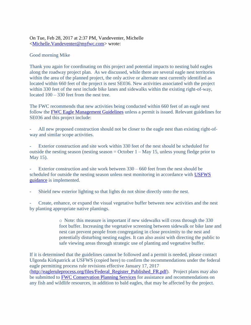
On Tue, Feb 28, 2017 at 2:37 PM, Vandeventer, Michelle
<[email protected]> wrote:
Good morning Mike
Thank you again for coordinating on this project and potential impacts to nesting bald eagles
along the roadway project plan. As we discussed, while there are several eagle nest territories
within the area of the planned project, the only active or alternate nest currently identified as
located within 660 feet of the project is nest SE036. New activities associated with the project
within 330 feet of the nest include bike lanes and sidewalks within the existing right-of-way,
located 100 – 330 feet from the nest tree.
The FWC recommends that new activities being conducted within 660 feet of an eagle nest
follow the FWC Eagle Management Guidelines unless a permit is issued. Relevant guidelines for
SE036 and this project include:
- All new proposed construction should not be closer to the eagle nest than existing right-of-
way and similar scope activities.
- Exterior construction and site work within 330 feet of the nest should be scheduled for
outside the nesting season (nesting season = October 1 – May 15, unless young fledge prior to
May 15).
- Exterior construction and site work between 330 – 660 feet from the nest should be
scheduled for outside the nesting season unless nest monitoring in accordance with USFWS
guidance is implemented.
- Shield new exterior lighting so that lights do not shine directly onto the nest.
- Create, enhance, or expand the visual vegetative buffer between new activities and the nest
by planting appropriate native plantings.
o Note: this measure is important if new sidewalks will cross through the 330
foot buffer. Increasing the vegetative screening between sidewalk or bike lane and
nest can prevent people from congregating in close proximity to the nest and
potentially disturbing nesting eagles. It can also assist with directing the public to
safe viewing areas through strategic use of planting and vegetative buffer.
If it is determined that the guidelines cannot be followed and a permit is needed, please contact
Ulgonda Kirkpatrick at USFWS (copied here) to confirm the recommendations under the federal
eagle permitting process rule revisions effective January 17, 2017
(http://eagleruleprocess.org/files/Federal_Register_Published_FR.pdf). Project plans may also
be submitted to FWC Conservation Planning Services for assistance and recommendations on
any fish and wildlife resources, in addition to bald eagles, that may be affected by the project.

Given the timeframes of the project, and the possibility that eagle nest locations may shift over
time, follow up on the project may be appropriate closer to the design phase in the planning
process to confirm relevant guidelines and permitting recommendations at that time.
If you have any additional questions or need further assistance, please don’t hesitate to contact
me.
Best regards,
Michelle van Deventer
Office: 941.894.6675
Cell: 941.356.6551