STATE OF CALIFORNIA Project is a water supply and hydroelectric power project located on the South...
48
STATE OF CALIFORNIA STATE WATER RESOURCES CONTROL BOARD In the Matter of Water Quality Certification for the SOUTH FEATHER WATER AND POWER AGENCY SOUTH FEATHER POWER PROJECT FEDERAL ENERGY REGULATORY COMMISSION PROJECT NO. 2088 SOURCES: South Fork Feather River, Sly Creek, Lost Creek, and Slate Creek COUNTIES: Butte, Yuba, and Plumas WATER QUALITY CERTIFICATION FOR FEDERAL PERMIT OR LICENSE Comments on the draft certification must be received by 12:00 pm (noon) on January 19, 2018*. Comments can be submitted to Ms. Meiling Colombano by: Email: [email protected] or Mail: Meiling Colombano State Water Resources Control Board Division of Water Rights – Water Quality Certification Program P.O. Box 2000 Sacramento, CA 95812-2000 * Comment deadline extended from December 20, 2017 to January 19, 2018.
Transcript of STATE OF CALIFORNIA Project is a water supply and hydroelectric power project located on the South...
STATE OF CALIFORNIA STATE WATER RESOURCES CONTROL BOARD
In the Matter of Water Quality Certification for the
SOUTH FEATHER WATER AND POWER AGENCY SOUTH FEATHER POWER PROJECT
FEDERAL ENERGY REGULATORY COMMISSION PROJECT NO. 2088
SOURCES: South Fork Feather River, Sly Creek, Lost Creek, and Slate Creek COUNTIES: Butte, Yuba, and Plumas
WATER QUALITY CERTIFICATION FOR FEDERAL PERMIT OR LICENSE
Comments on the draft certification must be received by 12:00 pm (noon) on January 19, 2018*.
Comments can be submitted to Ms. Meiling Colombano by:
Email:
or
Mail: Meiling Colombano
State Water Resources Control Board Division of Water Rights – Water Quality Certification Program
P.O. Box 2000 Sacramento, CA 95812-2000
* Comment deadline extended from December 20, 2017 to January 19, 2018.

DRAFT WATER QUALITY CERTIFICATION FOR SOUTH FEATHER POWER PROJECT
November 2017 ii
TABLE OF CONTENTS 1.0 Project Description............................................................................................. 4
1.1 Sly Creek Development .............................................................................................. 5
1.2 Woodleaf Development .............................................................................................. 6
1.3 Forbestown Development........................................................................................... 7
1.4 Kelly Ridge Development ........................................................................................... 8
1.5 Water Rights ................................................................................................................ 9
2.0 Federal Energy Regulatory Commission Proceedings .................................. 9
2.1 Kelly Ridge Powerhouse Settlement Agreement ..................................................... 9
3.0 Regulatory Authority ........................................................................................ 10
3.1 Water Quality Certification and Related Authorities ................................................10
3.2 Water Quality Control Plans and Related Authorities .............................................11
3.3 Construction General Permit .....................................................................................12
3.4 California Environmental Quality Act ........................................................................12
4.0 Rationale for Water Quality Certification Conditions .................................... 13
4.1 Rationale for Condition 1: Minimum Instream Flow Requirements........................14
4.2 Rationale for Condition 2: Gaging.............................................................................14
4.3 Rationale for Condition 3: Ramping Rates...............................................................15
4.4 Rationale for Condition 4: Water Quality ..................................................................15
4.5 Rationale for Condition 5: Slate Creek Diversion Dam Sediment Management ..16
4.6 Rationale for Condition 6: Geomorphic Flows in Lost Creek..................................16
4.7 Rationale for Condition 7: Fish Monitoring ...............................................................16
4.9 Rationale for Condition 9: Benthic Macroinvertebrate Monitoring .........................17
4.10 Rationale for Condition 10: Riparian Vegetation Monitoring and Management....17
4.11 Rationale for Condition 11: Construction General Permit and Water Quality Monitoring and Protection ..................................................................................................17
4.12 Rationale for Condition 12: Recreation Management .............................................17
4.13 Rationale for Condition 13: Large Woody Material .................................................17
4.14 Rationale for Condition 14: Annual Consultation.....................................................18
4.15 Rationale for Condition 15: Potential Reintroduction of Anadromous Fish ...........18
4.16 Rationale for Condition 16: Kelly Ridge Powerhouse Settlement Agreement ......18
4.17 Other General Conditions ..........................................................................................19

DRAFT WATER QUALITY CERTIFICATION FOR SOUTH FEATHER POWER PROJECT
November 2017 iii
5.0 Conclusion ........................................................................................................ 19
6.0 Water Quality Certification Conditions ........................................................... 20
CONDITION 1. MINIMUM INSTREAM FLOW (MIF) REQUIREMENTS ....................20
CONDITION 2. GAGING .................................................................................................25
CONDITION 3. RAMPING RATES .................................................................................26
CONDITION 4. WATER QUALITY .................................................................................27
CONDITION 5. SLATE CREEK DIVERSION DAM SEDIMENT MANAGEMENT .....29
CONDITION 6. GEOMORPHIC FLOWS IN LOST CREEK .........................................29
CONDITION 7. FISH MONITORING ..............................................................................30
CONDITION 8. AMPHIBIAN MONITORING .................................................................31
CONDITION 9. BENTHIC MACROINVERTEBRATE MONITORING .........................32
CONDITION 10. RIPARIAN VEGETATION MONITORING AND MANAGEMENT ...33
CONDITION 11. CONSTRUCTION GENERAL PERMIT AND WATER QUALITY MONITORING AND PROTECTION ..................................................................................33
CONDITION 12. RECREATIONAL RESOURCES MANAGEMENT ...........................34
CONDITION 13. LARGE WOODY MATERIAL .............................................................37
CONDITION 14. ANNUAL CONSULTATION ................................................................38
CONDITION 15. POTENTIAL REINTRODUCTION OF ANADROMOUS FISH ........38
CONDITION 16. KELLY RIDGE POWERHOUSE SETTLEMENT AGREEMENT.....38
Attachments Attachment A: Project Maps

November 2017 4
STATE OF CALIFORNIA STATE WATER RESOURCES CONTROL BOARD
In the Matter of Water Quality Certification for the
SOUTH FEATHER WATER AND POWER AGENCY SOUTH FEATHER POWER PROJECT
FEDERAL ENERGY REGULATORY COMMISSION PROJECT NO. 2088
SOURCES: South Fork Feather River, Sly Creek, Lost Creek, and Slate Creek COUNTIES: Butte, Yuba, and Plumas
WATER QUALITY CERTIFICATION FOR FEDERAL PERMIT OR LICENSE
BY THE EXECUTIVE DIRECTOR:
1.0 Project Description On March 26, 2007, the South Feather Water and Power Agency (SFWPA)1, applied to the Federal Energy Regulatory Commission (Commission or FERC) for a new license for the South Feather Power Project (Project). The Project is also referred to as FERC Project No. 2088. The Commission issued the original Project license on July 21, 1952. The original license expired on March 31, 2009. Since that time, the Project has operated under annual licenses issued by the Commission. The Project is a water supply and hydroelectric power project located on the South Fork Feather River, Lost Creek, Sly Creek, and Slate Creek, in Butte, Yuba, and Plumas counties, California (Attachment A). The Project occupies approximately 1,977 acres of federal lands administered by the Plumas National Forest and 10.57 acres of federal lands administered by the United States Bureau of Land Management. The Project can store approximately 172,000 acre-feet (ac-ft) of water (gross storage), and annually generates an average of about 514.1 gigawatt-hours of power. In addition to power generation, Project facilities are used for water storage and delivery to provide: (a) irrigation water to a service area of more than 49,000 acres; and (b) domestic water to approximately 6,500 households. SFWPA proposes no new capacity and no new construction.
1 SFWPA was known as the Oroville-Wyandotte Irrigation District until May 27, 2003, at which time its Board of Directors changed the agency’s name.

DRAFT WATER QUALITY CERTIFICATION FOR SOUTH FEATHER POWER PROJECT
November 2017 5
The Project consists of four hydroelectric developments: (1) Sly Creek; (2) Woodleaf; (3) Forbestown; and (4) Kelly Ridge. Collectively, the Project consists of five dams and five reservoirs (Little Grass Valley, Sly Creek, Lost Creek, Forbestown, and Ponderosa), four powerhouses (Sly Creek, Woodleaf, Forbestown, and Kelly Ridge), three diversion dams (South Fork, Forbestown, and Kelly Ridge), six conduit tunnels, and associated equipment and transmission facilities. Water generally moves through the Project from one hydroelectric development to another, starting with the Sly Creek Development at the highest elevation, moving to the Woodleaf Development, the Forbestown Development, and finally the Kelly Ridge Development. Water for the Project comes from two watersheds: the South Fork Feather River watershed (Sly Creek, Woodleaf, Forbestown, and Kelly Ridge developments); and the North Fork Yuba River watershed (Slate Creek, which feeds into the Sly Creek Development). Each development is described further below.
1.1 Sly Creek Development This section describes the movement of water through the Sly Creek Development and the main facilities associated with the development. The Sly Creek Development diverts water from the South Fork Feather River, Slate Creek, Sly Creek, and Lost Creek. Little Grass Valley Reservoir stores and releases water on the South Fork Feather River, which is then diverted into Sly Creek Reservoir via the South Fork Diversion Tunnel at the South Fork Diversion Dam. Water is also diverted from Slate Creek into the Sly Creek Reservoir through the Slate Creek Diversion Tunnel at Slate Creek Diversion Dam. Water stored in Sly Creek Reservoir is ultimately released through the Sly Creek Penstock to the Sly Creek Powerhouse and into the Woodleaf Development. Power generated at Sly Creek Powerhouse is delivered from the switchyard to the grid via Pacific Gas and Electric Company’s (PG&E) 115-kilovolt (kV) Sly Creek Tap and Woodleaf-Kanaka Junction transmission line (FERC Project No. 2281). (See Attachment A, Maps 1, 2 and 3). The main facilities associated with the Sly Creek Development are: • Little Grass Valley Dam and Reservoir – The 210-foot (ft) high, 840-ft long, rock-filled Little
Grass Valley Dam, located on the South Fork Feather River, has a crest elevation of 5,052 ft. The Little Grass Valley Dam includes a 180-ft long spillway controlled by two 14-ft high by 40-ft long steel radial gates. The capacity of Little Grass Valley Reservoir is 89,804 ac-ft. With the spill gates closed, the reservoir covers 1,650 acres at a flood level elevation of 5,047 ft.
• Little Grass Valley Reservoir Recreation Facility – The Little Grass Valley Reservoir Recreation Facility includes nine campgrounds, three boat launches, two day-use beaches, an amphitheater, and fishing trail access for disabled persons.
• South Fork Diversion Dam – The 60-ft high, 167-ft long, concrete overflow arch South Fork
Diversion Dam, located on the South Fork Feather River, has four spillway bays. The lower two bays are located in the center of the dam, with the two higher bays on each side. The South Fork Diversion Dam forms an 87 ac-ft diversion impoundment that covers approximately nine acres at a normal maximum water surface elevation of 3,557 ft.
• South Fork Diversion Tunnel – The 14,256-ft long South Fork Diversion Tunnel includes two
electric hoist slide gates that control the tunnel diversions. The unpressurized tunnel diverts

DRAFT WATER QUALITY CERTIFICATION FOR SOUTH FEATHER POWER PROJECT
November 2017 6
up to 600 cubic feet per second (3) from behind South Fork Diversion Dam into Sly Creek Reservoir.
• Slate Creek Diversion Dam – The 62-ft high, 223.5-ft long, concrete overflow arch Slate
Creek Diversion Dam, located on Slate Creek, has three spillway bays, with the lower bay in the center of the dam and two higher bays on each side of the dam. The Slate Creek Diversion Dam forms a negligible diversion impoundment (~643 ac-ft) due to sediment accumulation.
• Slate Creek Diversion Tunnel – The 13,200-ft long Slate Creek Diversion Tunnel has two
manual slide gates that control tunnel diversions. Water from behind Slate Creek Diversion Dam in the North Yuba River watershed is diverted to Sly Creek Reservoir in the Feather River watershed. Although the unpressurized tunnel has a maximum capacity of 848 cfs, Project water rights limit flow diversions to 600 cfs. When Sly Creek Reservoir has a large volume of water, diversions are sometimes further limited to 500 cfs.
• Sly Creek Dam and Reservoir – The 289-ft high, 1,200-ft long, earth-filled Sly Creek Dam,
located on Lost Creek, has a crest elevation of 3,536 ft and includes a 649-ft long spillway controlled by one 16-ft high by 54-ft long, steel radial gate. With the spill gates closed, Sly Creek Reservoir can store 64,338 ac-ft and cover 619 acres at a flood level elevation of 3,531 ft.
• Sly Creek Penstock – The 1,100-ft long Sly Creek Penstock delivers water from Sly Creek
Reservoir to the Sly Creek Powerhouse. • Sly Creek Powerhouse – The Sly Creek Powerhouse releases water to Lost Creek
Reservoir. The Sly Creek Powerhouse contains one 17,690 horsepower reaction turbine. The reaction turbine directly connects to a 13,500 kilovolt-amperes (kVA) generator.
• Sly Creek Powerhouse Switchyard – The Sly Creek Powerhouse Switchyard contains one
16,000 kVA transformer. PG&E’s 115 kilovolt-(kV) Sly Creek Tap and Woodleaf-Kanaka Junction Transmission Line delivers power from the switchyard to the grid.
1.2 Woodleaf Development This section describes the movement of water through the Woodleaf Development and the main facilities associated with the development. The Woodleaf Development diverts water from the Sly Creek Development into Lost Creek Reservoir for release through the Woodleaf Power Tunnel and Woodleaf Powerhouse and into the Forbestown Development. Power generated at Woodleaf Powerhouse is delivered from the switchyard to the grid via PG&E’s 115-kV Woodleaf-Kanaka Junction Transmission Line. (See Attachment A, Maps 1 and 3). The main facilities associated with the Woodleaf Development are:
• Lost Creek Dam and Reservoir – The Lost Creek Dam is a 122-ft high, 486-ft long, concrete overflow arch dam. The Lost Creek Dam, located on Lost Creek, has a crest elevation of 3,279.05 ft and includes a 251-ft wide spillway controlled by 4-ft high by 8-ft wide flashboards. When the flashboards are installed, the 5,361 ac-ft Lost Creek Reservoir covers 137 acres at a normal maximum water surface elevation of 3,283 ft.
• Woodleaf Power Tunnel – The Woodleaf Power Tunnel is a 18,385-ft long, pressurized
conveyance system that includes one electric hoist slide gate that controls tunnel

DRAFT WATER QUALITY CERTIFICATION FOR SOUTH FEATHER POWER PROJECT
November 2017 7
diversions. The tunnel diverts up to 620 cfs from Lost Creek Reservoir into the Woodleaf Penstock.
• Woodleaf Penstock – The 3,519-ft long Woodleaf Penstock delivers water to the
Woodleaf Powerhouse located on the South Fork Feather River.
• Woodleaf Powerhouse – The Woodleaf Powerhouse releases water into the South Fork Feather River just upstream of the Forbestown Diversion Dam. The Woodleaf Powerhouse contains one 80,000-horsepower Pelton turbine that connects directly to a 65,500-kVA generator.
• Woodleaf Powerhouse Switchyard – The Woodleaf Powerhouse Switchyard contains
one 70,000-kVA transformer. PG&E’s 115-kV Woodleaf-Kanaka Junction Transmission Line delivers power from the switchyard to the grid.
1.3 Forbestown Development This section describes the movement of water through the Forbestown Development and the main facilities associated with the development. The Forbestown Development diverts water from the Woodleaf Development via the Forbestown Diversion Dam on the South Fork Feather River. Water from the Forbestown Diversion Dam is conveyed through the Forbestown Power Tunnel into the Forbestown Powerhouse for release into the Kelly Ridge Development. Power generated at Forbestown Powerhouse is delivered from the Forbestown Powerhouse Switchyard to the grid via PG&E’s 115-kV Woodleaf-Kanaka Junction Transmission Line. (See Attachment A, Maps 1 and 3). The main facilities associated with the Woodleaf Development are:
• Forbestown Diversion Dam – The Forbestown Diversion Dam is an 80-ft high, 256-ft long, concrete overflow arch dam. The diversion dam is located on the South Fork Feather River and crests at an elevation of 1,783 ft. Diversion dam infrastructure includes five, 46-ft wide, uncontrolled overflow spillway sections with a combined width of approximately 240 ft. The Forbestown diversion dam and spillway structure create a 352 ac-ft impoundment that covers approximately 12 acres at a normal maximum water surface elevation of 1,783 ft.
• Forbestown Power Tunnel – The 18,388-ft long Forbestown Power Tunnel diverts up to
660 cfs from the Forbestown Diversion impoundment into the Forbestown Penstock.
• Forbestown Penstock – The 1,487-ft long Forbestown Penstock delivers water to the Forbestown Powerhouse.
• Forbestown Powerhouse – The Forbestown Powerhouse releases water to Ponderosa
Reservoir (part of Kelly Ridge Development) on the South Fork Feather River. The Forbestown Powerhouse contains one 54,500-horsepower vertical Francis turbine, which connects directly to a 40,500-kVA generator.
• Forbestown Powerhouse Switchyard – The Forbestown Powerhouse Switchyard
contains one 35,200-kVA transformer. PG&E’s 115-kV Woodleaf-Kanaka Junction Transmission Line delivers power from the switchyard to the grid.

DRAFT WATER QUALITY CERTIFICATION FOR SOUTH FEATHER POWER PROJECT
November 2017 8
1.4 Kelly Ridge Development This section describes the movement of water through the Kelly Ridge Development and the main facilities associated with the development. The Kelly Ridge Development diverts water from Ponderosa Reservoir on the South Fork Feather River and releases it through Miners Ranch Conduit and Tunnel into Miners Ranch Reservoir. From Miners Ranch Reservoir, water is re-diverted into the Kelly Ridge Power Tunnel for release through the Kelly Ridge Powerhouse. The Kelly Ridge Powerhouse discharges into Thermalito Diversion Pool, just below Oroville Dam, which is part of the Oroville Facilities Project (FERC Project No. 2100). The Oroville Facilities Project is owned and operated by the California Department of Water Resources (DWR). Power generated at the Kelly Ridge Powerhouse is delivered from the Kelly Ridge Powerhouse Switchyard to the grid via PG&E’s 60-kV Kelly Ridge-Elgin Junction Transmission Line. (See Attachment A, Maps 1, 3 and 4). The main facilities associated with the Kelly Ridge Development are:
• Ponderosa Dam and Reservoir – The Ponderosa Dam is a 160-ft high, 650-ft long, earth-filled dam that releases water into the 3.6 million ac-ft Lake Oroville. The dam has a crest elevation of 985 ft and includes a 352-ft long spillway, and two 7-ft, 7.5-inch high by 51-ft long, steel gates that control the spillway. The dam impounds the 4,178 ac-ft Ponderosa Reservoir, which covers 103 acres at a normal maximum water surface elevation of 960 ft.
• Ponderosa Diversion Tunnel – The Ponderosa Diversion Tunnel is 516-ft long, and
includes one hydraulic gate that controls diversions. The unpressurized tunnel diverts up to 300 cfs from Ponderosa Reservoir into the Miners Ranch Conduit.
• Miners Ranch Conduit –The Miners Ranch Conduit diverts water from the Ponderosa
Diversion Tunnel into the Miners Ranch Tunnel.
• Miners Ranch Tunnel – The Miners Ranch Tunnel is 23,946-ft long, and diverts up to 300 cfs from the Miners Ranch Conduit into Miners Ranch Reservoir.
• Miners Ranch Dam and Reservoir – The Miners Ranch Dam is a 55-ft high, 1,650-ft long,
earth-filled, off-stream structure. The Miners Ranch Dam has a crest elevation of 895 ft and includes a 1,175-ft long uncontrolled spillway. The Miners Ranch Dam impounds the 896 ac-ft Miners Ranch Reservoir, which covers 48 acres at a normal maximum water surface elevation of 890 ft.
• Kelly Ridge Power Tunnel – The Kelly Ridge Power Tunnel is a 6,736-ft long, 9-ft by 8-ft
diameter, pressurized tunnel. The Kelly Ridge Power Tunnel includes one 4-ft high by 8-ft long, fixed wheel gate that controls the diversions. The tunnel diverts up to 260 cfs from Miners Ranch Reservoir into the Kelly Ridge Penstock.
• Kelly Ridge Penstock – The Kelly Ridge Penstock is 6,064-ft long, and delivers water to
the Kelly Ridge Powerhouse.
• Kelly Ridge Powerhouse –The Kelly Ridge Powerhouse releases water to the Thermalito Diversion Pool, downstream of Oroville Dam, which is part of the DWR’s Oroville Facilities Project. The Kelly Ridge Powerhouse contains one 13,000-horsepower vertical Francis turbine that connects directly to an 11,000-kVA generator.

DRAFT WATER QUALITY CERTIFICATION FOR SOUTH FEATHER POWER PROJECT
November 2017 9
• Kelly Ridge Powerhouse Switchyard – The Kelly Ridge Powerhouse Switchyard contains one 11,000-kVA transformer. PG&E’s 60-kV Kelly Ridge-Elgin Junction Transmission Line delivers power from the switchyard to the grid.
1.5 Water Rights SFWPA holds three water right licenses for non-consumptive use of water for power generation for the Project, which are summarized in Table A. Table A. Water right licenses held by SFWPA for the Project
Application No. /
License No.
Face Amount (ac-ft/ year)
Source Purpose of Use
Diversion (cfs) and Storage (ac-ft)
Points of Re-Diversion
Places of Use (Powerhouses)
A013676 / L010939 318,593.3
• Lost Creek
• South Fork Feather River
Power
• 77,300 ac-ft at Little Grass Valley and Sly Creek reservoirs from South Fork Feather River
• 200 cfs at South Fork Feather River
• 24,100 ac-ft at Sly Creek Reservoir from Lost Creek
• 100 cfs at Lost Creek
• South Fork Diversion Dam
• Sly Creek Dam outlet
• Lost Creek Dam • Forbestown
Diversion Dam • Ponderosa
Diversion Dam
• Sly Creek • Woodleaf • Forbestown • Kelly Ridge
A013956 / L010940 251,393.3 • Slate
Creek Power • 300 cfs at Slate Creek • 34,200 ac-ft at Sly
Creek Reservoir
• Sly Creek Dam outlet
• Lost Creek Dam • Forbestown
Diversion Dam • Ponderosa
Diversion Dam
• Sly Creek • Woodleaf • Forbestown • Kelly Ridge
A014112 / L010941 217,193.3
• Lost Creek
• South Fork Feather River
Power • 100 cfs at South Fork
Feather River • 200 cfs at Lost Creek
• Sly Creek Dam outlet
• Lost Creek Dam • Forbestown
Diversion Dam • Ponderosa
Diversion Dam
• Sly Creek • Woodleaf • Forbestown • Kelly Ridge
2.0 Federal Energy Regulatory Commission Proceedings SFWPA submitted a Notice of Intent and Initial Information to relicense the Project under the Commission’s Traditional Licensing Process on September 30, 2003. (18 C.F.R. § 16.8). On March 26, 2007, SFWPA filed its final license application for the Project with the Commission. The Commission issued a final Environmental Impact Statement (EIS) for the Project on June 4, 2009.
2.1 Kelly Ridge Powerhouse Settlement Agreement Since the construction of the Oroville Facilities Project, the point of discharge for the Kelly Ridge Powerhouse has become the Thermalito Diversion Pool, a feature of the State Water Project, located downstream of Oroville Dam and upstream of the Feather River Fish Hatchery. Discharges into the Thermalito Diversion Pool can impact water temperature in the Feather River and affect the ability of DWR to meet certain Feather River water temperature objectives stipulated in the March 2006 Settlement Agreement for the Licensing of the Oroville Facilities

DRAFT WATER QUALITY CERTIFICATION FOR SOUTH FEATHER POWER PROJECT
November 2017 10
Project. To address this issue, SFWPA, DWR, and State Water Contractors, Inc. executed the Kelly Ridge Powerhouse Settlement Agreement (KRPH Agreement) on October 23, 2012. The KRPH Agreement includes the following stipulations:
• SFWPA will provide DWR with real-time information regarding the temperature of water released from Kelly Ridge Powerhouse.
• DWR may request changes to SFWPA’s Kelly Ridge Powerhouse annual outage schedule.
• DWR may request a shutdown (i.e., outage) of the Kelly Ridge Powerhouse. SFWPA will spill into Lake Oroville, owned and operated by DWR, the amount of water that would have gone through the Kelly Ridge Powerhouse were it not for the DWR-requested outage. DWR will reimburse SFWPA for lost generation revenue and penalties resulting from a DWR-requested outage.
• Prior to re-starting the Kelly Ridge Powerhouse after an outage, SFWPA will draw down Miners Ranch Reservoir2 to minimum pool level to remove warm water and refill the reservoir with cool water from Ponderosa Reservoir.
In a letter to the Commission dated June 17, 2014, SFWPA requested that the Commission incorporate the KRPH Agreement terms into the new license for the Project.
3.0 Regulatory Authority
3.1 Water Quality Certification and Related Authorities The federal Clean Water Act, (33 U.S.C. § 1251 et seq.) was enacted “to restore and maintain the chemical, physical, and biological integrity of the Nation’s waters.” (33 U.S.C. § 1251 (a).) Section 101 of the Clean Water Act (33 U.S.C. § 1251) requires federal agencies to “co-operate with the State and local agencies to develop comprehensive solutions to prevent, reduce and eliminate pollution in concert with programs for managing water resources.” Section 401 of the Clean Water Act (33 U.S.C. § 1341) requires every applicant for a federal license or permit which may result in a discharge into navigable waters to provide the licensing or permitting federal agency with certification that the project will be in compliance with specified provisions of the Clean Water Act, including water quality standards and implementation plans promulgated pursuant to section 303 of the Clean Water Act (33 U.S.C. § 1313). Clean Water Act section 401 directs the agency responsible for certification to prescribe effluent limitations and other limitations necessary to ensure compliance with the Clean Water Act and with any other appropriate requirements of state law. Section 401 further provides that certification conditions shall become conditions of any federal license or permit for the project. The State Water Board is the state agency responsible for such certification in California. (Wat. Code. § 13160.) The State Water Board has delegated authority to act on applications for water quality certification to the Executive Director. (Cal.Code Regs., tit. 23, sec. 3838, subd. (a).)
2 Drawdown water will be discharged to Lake Oroville.

DRAFT WATER QUALITY CERTIFICATION FOR SOUTH FEATHER POWER PROJECT
November 2017 11
Water Code section 13383 provides the State Water Board with the authority to “establish monitoring, inspection, entry, reporting and recordkeeping requirements… and [require] other information as may reasonably be required” for activities subject to water quality certification under section 401 of the Clean Water Act that involve the diversion of water for beneficial use. The State Water Board delegated this authority to the Deputy Director of the Division of Water Rights (Deputy Director), as provided for in State Water Board Resolution No. 2012-0029. In the Redelegation of Authorities Pursuant to Resolution No. 2012-0029 memo issued by the Deputy Director on October 19, 2017, this authority is redelegated to the Assistant Deputy Directors of the Division of Water Rights. SFWPA initially submitted an application for a water quality certification (certification) to the State Water Board on May 18, 2008. On June 10, 2008, State Water Board staff provided notice of receipt of a complete application for the Project to the applicable parties pursuant to California Code of Regulations, title 23, section 3835, subdivision (c). State Water Board staff provided public notice of the application, pursuant to California Code of Regulations, title 23, section 3858, by posting information describing the Project on the State Water Board’s website on November 17, 2009. No comments were received. SFWPA has subsequently withdrawn and simultaneously resubmitted its application for a certification on an annual basis since May 4, 2009. The most recent withdrawal and resubmittal request was submitted to the State Water Board on February 9, 2017. 3.2 Water Quality Control Plans and Related Authorities The California Regional Water Quality Control Boards (Regional Water Boards) have primary responsibility for the formulation and adoption of water quality control plans for their respective regions, subject to State Water Board and United States Environmental Protection Agency (USEPA) approval, as appropriate. (Wat. Code, § 13240 et seq.) The State Water Board may also adopt water quality control plans, which will supersede regional water quality control plans for the same waters to the extent of any conflict. (Wat. Code, § 13170.) For a specified area, the water quality control plans designate the beneficial uses of water to be protected, water quality objectives established for the reasonable protection of those beneficial uses or the prevention of nuisance, and a program of implementation to achieve the water quality objectives. (Wat. Code, §§ 13241, 13050 subd. (h), and 13050 subd. (j).) The beneficial uses together with the water quality objectives that are contained in the water quality control plans, and state and federal anti-degradation requirements constitute California’s water quality standards. Water Code section 13247 requires state agencies, in carrying out activities that may affect water quality, to comply with water quality control plans in most instances. The Central Valley Regional Water Board adopted, and the State Water Board and the USEPA approved, the Water Quality Control Plan for the Sacramento River Basin and the San Joaquin River Basin (Basin Plan)3. The Basin Plan designates the beneficial uses of water to be protected along with the water quality objectives necessary to protect those uses. The Basin Plan does not specifically identify beneficial uses for the South Fork Feather River. The Basin Plan specifies that the beneficial uses of any specifically identified water body generally apply to its tributary streams. Therefore, the beneficial uses applicable4 to the South Fork Feather River 3 Water Quality Control Plan for the California Regional Water Quality Control Board Central Valley Region for the Sacramento River Basin and the San Joaquin River Basin. Fourth Edition. Revised July 2016 (with Approved Amendments). 4 Although the Basin Plan designates beneficial uses for Lake Oroville, those beneficial uses are less appropriate because Lake Oroville is a large surface water impoundment with no riverine sections.

DRAFT WATER QUALITY CERTIFICATION FOR SOUTH FEATHER POWER PROJECT
November 2017 12
and its tributaries are those of the main stem Feather River, from the Fish Barrier Dam to the Sacramento River. Table II-1 of the Basin Plan identifies these beneficial uses as: municipal and domestic supply; irrigation; water contact recreation and canoeing and rafting; other non-contact recreation; warm freshwater habitat; cold freshwater habitat; warm and cold migration of aquatic organisms; warm and cold freshwater spawning; and wildlife habitat. In addition to those beneficial uses specified for the Feather River from the Fish Barrier Dam to Sacramento River, hydropower generation, is an existing beneficial use and also applies to the South Fork Feather River. The Project diverts water from the Yuba River watershed at the Slate Creek diversion dam on Slate Creek5. The Basin Plan identifies beneficial uses for Slate Creek as: municipal and domestic supply; irrigation; stock watering; power; water contact recreation and canoeing and rafting; other non-contact recreation; cold freshwater habitat; cold freshwater spawning; and wildlife habitat. 3.3 Construction General Permit SFPWA may need to obtain coverage under the State Water Board’s Construction General Permit6. Coverage under the Construction General Permit may be required for activities that disturb one or more acres of soil or whose projects disturb less than one acre but are part of a larger common plan of development that in total disturbs one or more acres. Construction activity subject to the Construction General Permit includes clearing, grading, and disturbances, such as stockpiling or excavation, but does not include regular maintenance activities performed to restore the original line, grade, or capacity of the facility. 3.4 California Environmental Quality Act SFWPA is the lead agency for the purpose of California Environmental Quality Act (CEQA) compliance, while the State Water Board is a responsible agency. The Commission issued the draft Environmental Impact Statement (EIS) on November 7, 2008, and the final EIS on June 4, 2009, which analyzed Project impacts as required under the National Environmental Policy Act (NEPA). SFWPA issued the Initial Study/draft Mitigated Negative Declaration (IS/MND) for the Project on February 2, 2010, which incorporated by reference the Commission’s final EIS. The SFWPA Board of Directors approved the MND for the Project on March 27, 2012, and filed a Notice of Determination with the State Clearinghouse on April 2, 2012. State Water Board staff considered the MND in developing this certification and incorporated appropriate mitigation measures into certification conditions. The mitigation measures described in the MND that pertain to protection of resources within the State Water Board's purview have been incorporated into conditions of this certification to meet the requirements of Public Resources Code section 21081.6, subdivision (a)(1). Monitoring and reporting requirements are built into certification conditions to ensure the implementation and completion of mitigation measures in accordance with California Code of Regulations, title 14, section
5 Slate Creek is a tributary to the North Yuba River. Water from Slate Creek is diverted into Sly Creek Reservoir, which is a tributary to the South Feather River in the Project area. The beneficial uses listed for “Yuba River - Sources to Englebright Reservoir”, (Table II-1 of the Basin Plan) apply to this reach. 6 Construction General Permit; Water Quality Order 2009-0009-DWQ and National Pollutant Discharge Elimination System No. CAS000002, as amended by Order No. 2010-0014-DWR, Order No. 2012-0006-DWQ, and any amendments thereto.
DRAFT WATER QUALITY CERTIFICATION FOR SOUTH FEATHER POWER PROJECT
November 2017 13
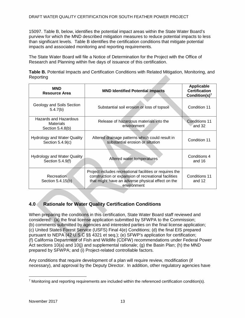
15097. Table B, below, identifies the potential impact areas within the State Water Board’s purview for which the MND described mitigation measures to reduce potential impacts to less than significant levels. Table B identifies the certification conditions that mitigate potential impacts and associated monitoring and reporting requirements. The State Water Board will file a Notice of Determination for the Project with the Office of Research and Planning within five days of issuance of this certification. Table B. Potential Impacts and Certification Conditions with Related Mitigation, Monitoring, and Reporting
MND Resource Area MND Identified Potential Impacts
Applicable Certification Condition(s)7
Geology and Soils Section
5.4.7(b)
Substantial soil erosion or loss of topsoil Condition 11
Hazards and Hazardous Materials
Section 5.4.8(b)
Release of hazardous materials into the environment
Conditions 11 and 32
Hydrology and Water Quality
Section 5.4.9(c)
Altered drainage patterns which could result in substantial erosion or siltation Condition 11
Hydrology and Water Quality
Section 5.4.9(f)
Altered water temperatures Conditions 4 and 16
Recreation Section 5.4.15(b)
Project includes recreational facilities or requires the construction or expansion of recreational facilities that might have an adverse physical effect on the
environment
Conditions 11 and 12
4.0 Rationale for Water Quality Certification Conditions When preparing the conditions in this certification, State Water Board staff reviewed and considered: (a) the final license application submitted by SFWPA to the Commission; (b) comments submitted by agencies and interested parties on the final license application; (c) United States Forest Service (USFS) Final 4(e) Conditions; (d) the final EIS prepared pursuant to NEPA (42 U.S.C §§ 4321 et seq.); (e) SFWP’s application for certification; (f) California Department of Fish and Wildlife (CDFW) recommendations under Federal Power Act sections 10(a) and 10(j) and supplemental rationale; (g) the Basin Plan; (h) the MND prepared by SFWPA; and (i) Project-related controllable factors. Any conditions that require development of a plan will require review, modification (if necessary), and approval by the Deputy Director. In addition, other regulatory agencies have
7 Monitoring and reporting requirements are included within the referenced certification condition(s).

DRAFT WATER QUALITY CERTIFICATION FOR SOUTH FEATHER POWER PROJECT
November 2017 14
specific authorities to approve plans and reports. The following describes the rationale used to develop the conditions in the certification. 4.1 Rationale for Condition 1: Minimum Instream Flow Requirements This certification contains minimum instream flow (MIF) requirements by water year type for Project reaches. The MIF requirements in this certification are consistent with the MIFs established by USFS in 4(e) Condition 18. The approach for evaluating and developing MIF requirements for Project-affected stream reaches focused on the needs of aquatic-dependent biota (primarily fish, amphibians, benthic macroinvertebrates, and riparian vegetation) and included the following steps: (1) an evaluation of ecosystem attributes and their conditions under regulated and unimpaired stream flows; (2) development of a range of MIFs for the protection of aquatic resources in “normal” (or average) water years; and (3) an extensive hydrology evaluation to develop MIFs that mimic the natural hydrograph and further provide for aquatic resources and fluvial geomorphology processes in all water year types8. In general, emphasis is placed on developing MIFs that follow natural hydrograph patterns for the overall protection of the aquatic ecosystem. Further, this condition creates a mechanism by which SFWPA, State Water Board staff, and participating agencies9 may evaluate the adequacy of MIF requirements in meeting resource goals and objectives and propose adjustments to the MIFs for review and approval by the Deputy Director. California’s history of drought and dry years illustrates the importance of contingency planning for multiple dry years or drought. It is difficult to anticipate the specific impacts of consecutive dry years, or a long-term drought, and identify where limited water supplies may be best used during times of shortage. Condition 1 provides the opportunity, following consultation with the State Water Board staff and participating agencies, to request Deputy Director approval of a Revised Operations Plan during consecutive dry water years or drought years. This condition provides flexibility for adaptive management during times of extreme water shortage. With increases in ambient temperatures and decreases in precipitation (i.e., snow fall), it may be necessary to revise water year types during the life of the license. This condition provides for updates to the water year types, if approved by the Deputy Director. 4.2 Rationale for Condition 2: Gaging Stream flow measurement is necessary to monitor compliance with MIF requirements and for water management. Condition 2 requires SFWPA to operate and maintain the existing stream flow gages and modify or install new gages when necessary, in order to ensure compliance with MIF and ramping rate requirements included in Condition 1 and Condition 3 of this certification. Condition 2 also requires SFWPA to provide annual hydrology summary reports to State Water Board staff and the United States Geological Survey (USGS) to ensure the information is both publically available and properly evaluated for quality assurance and quality control.
8 Rationale Report for USFS Preliminary Section 4(e) Conditions, April 14, 2008. 9 As used throughout this document, “participating agencies” must include USFS, CDFW, and the United States Fish and Wildlife Service (USFWS). However, participation is not limited to these agencies and the State Water Board encourages seeking additional expertise that can benefit the goal of appropriately protect beneficial uses of water, including aquatic life and recreation.
DRAFT WATER QUALITY CERTIFICATION FOR SOUTH FEATHER POWER PROJECT
November 2017 15
4.3 Rationale for Condition 3: Ramping Rates Project operations can cause rapid changes in flow that are potentially outside the natural range of variability. Such fluctuations can adversely affect aquatic life and create hazardous conditions for downstream recreation. Condition 3 requires SFWPA to develop interim and long-term ramping rates in consultation with State Water Board staff and participating agencies. Prior to the development of interim and long-term ramping rates, Condition 3 requires SFWPA to implement a ramping rate that shall not exceed a stage height of 0.5 feet per hour when making controlled flow increases or decreases in stream reaches below Little Grass Valley Dam, South Fork Diversion Dam, Lost Creek Dam, and the Forbestown Diversion Dam. This ramping rate was recommended by CDFW in its Recommendations Pursuant to Federal Power Act Section 10(j), dated April 2008. FERC also included this ramping rate in the Staff Conclusion section of the final EIS, dated June 2009. Accordingly, this recommended ramping rate will be used to help protect aquatic resources while interim ramping rates are developed. 4.4 Rationale for Condition 4: Water Quality The Project has the potential to affect water quality, including water temperature, in Project stream reaches. Condition 4 requires SFWPA to develop and implement a Water Quality Monitoring Plan (Water Quality Plan) to evaluate impacts of the new MIFs and continued Project operations on water quality in Project stream reaches. At a minimum, Condition 4 requires water temperature monitoring: below Little Grass Valley Dam, immediately below Kelly Ridge Powerhouse (where it discharges into the Feather River), below Slate Creek Diversion Dam, near Woodleaf Powerhouse, and near Forbestown Powerhouse. Dissolved oxygen monitoring is required when appropriate temperature triggers occur. Additionally, SFWPA is required to take additional actions to suspend water diversions from Slate Creek to Sly Creek Reservoir if certain thresholds are met. Little Grass Valley Dam. The South Fork Feather River reach below Little Grass Valley Dam remains unseasonably cold all year (typically < 10°Celsius or 50°Fahrenheit) due to the release of cold water from the low-level outlet at Little Grass Valley Dam. Water temperatures in this reach do not support optimal growth for rainbow trout during the critical growth period (spring and summer), which may be a limiting factor for trout biomass in this reach. Water temperature monitoring in this reach is necessary to determine if Project operations are adversely impacting beneficial uses. Kelly Ridge Powerhouse. The Kelly Ridge Powerhouse discharges into the Thermalito Diversion Pool, which is part of DWR’s Oroville Facilities Project. Discharges of warmer water stored in Miner’s Ranch Reservoir and then discharged from Kelly Ridge Powerhouse to Thermalito Diversion Pool can adversely impact water temperature in the Feather River and affect DWR’s ability to meet Feather River water temperature objectives stipulated in the March 2006 Settlement Agreement for the Licensing of the Oroville Facilities Project. It is necessary to monitor the temperature of water discharged from the Kelly Ridge Powerhouse to ensure that water temperature meets Basin Plan water quality objectives to protect beneficial uses, including but not limited to: cold freshwater habitat; and cold freshwater for migration and spawning. Further, Condition 4 of this certification requires that the Water Quality Plan include provisions for actions that can be feasibly implemented in the event that water discharged from Kelly Ridge Powerhouse exceeds Basin Plan water quality objectives for temperature.

DRAFT WATER QUALITY CERTIFICATION FOR SOUTH FEATHER POWER PROJECT
November 2017 16
Slate Creek Diversion Dam. Slate Creek Diversion Dam operations may contribute to the occurrence of mean daily water temperatures that exceed 20°Celius during June through September (Commission 200910). Monitoring at this location is therefore appropriate. Woodleaf Powerhouse and Forbestown Powerhouse. Installation of continuous water temperature monitors near Woodleaf Powerhouse and near Forbestown Powerhouse is required to determine when mean daily water temperature reaches 13ºC each spring. Foothill yellow-legged frogs begin spawning in spring once water temperatures reach 13ºC, and tadpoles tend to remain near the site of the egg mass once they hatch. Egg masses and tadpoles occupy areas in the stream reach that are typically associated with edge-water habitat. Edge-water habitat is located near the river’s edge and is the most sensitive to rapid fluctuations in stream flow. Condition 12 uses 13ºC as the water temperature trigger to conclude recreational stream flows. 4.5 Rationale for Condition 5: Slate Creek Diversion Dam Sediment Management Sediment accumulation behind Slate Creek Diversion Dam can impair the proper functioning of the diversion tunnel and low-level water release valves. On November 28, 2001, the State Water Board issued a certification for a Sediment Pass-through Plan for the Slate Creek Diversion Dam. The certification allowed SFWPA to sluice sediment through the low-level outlet valve in Slate Creek dam when flows: (1) exceed 1,000 cfs; and (2) occur on the ascending limb of the hydrograph at the beginning of a storm event. Implementation of the existing Sediment Pass-through Plan has not been successful in passing sufficient sediment below the Slate Creek Diversion Dam. Condition 5 of this certification requires SFWPA to develop a new sediment management plan to remove sediment from behind Slate Creek Diversion Dam. 4.6 Rationale for Condition 6: Geomorphic Flows in Lost Creek Lack of seasonal high flow events in Lost Creek contribute to the accumulation of fine sediment in spawning gravels, which can adversely affect fish spawning and incubation success and contribute to the encroachment of riparian vegetation into the stream channel. Because the stream segment below Lost Creek Dam is a depositional reach, Condition 6 requires SFWPA to provide sufficient supplemental stream flows to adequately flush fine sediments from this reach. 4.7 Rationale for Condition 7: Fish Monitoring Changes in Project operations or changes in environmental conditions during the term of the new license have the potential to adversely impact fish populations. Condition 7 requires SFWPA to develop and implement a Fish Monitoring Plan to evaluate the impact of new MIFs and continued Project operations on fish abundance, health, and species composition in Project reaches. Fish entrainment can occur at power tunnels and diversion intakes. To mitigate for the potential for lost fish resources through entrainment, USFS 4(e), Condition 18, Part 6, requires development and implementation of a wild fish supplementation program, if fish exclusion devices (e.g., screens) are not required by the Commission in the Project license. Condition 7 incorporates the USFS 4(e) requirements into the Fish Monitoring Plan. 4.8 Rationale for Condition 8: Amphibian Monitoring The Project has the potential to cause changes to amphibian populations within Project stream reaches throughout the South Fork Feather River watershed and Slate Creek area of the Yuba 10 Federal Energy Regulatory Commission Final EIS for the South Feather Power Project, June 2009.

DRAFT WATER QUALITY CERTIFICATION FOR SOUTH FEATHER POWER PROJECT
November 2017 17
River watershed. Monitoring can detect changes in amphibian populations, help identify additional information needs, and guide adaptive management of Project operations, if necessary. Condition 8 requires SFWPA to develop and implement an Amphibian Monitoring Plan to assess the impacts of new MIFs, continued Project operations, and ramping rates on amphibian populations, abundance, distribution, and reproductive success. 4.9 Rationale for Condition 9: Benthic Macroinvertebrate Monitoring The Project has the potential to cause changes to benthic macroinvertebrate (BMI) assemblages within Project stream reaches. BMI are a vital food source for aquatic wildlife and indicators of aquatic ecosystem health and water quality. Condition 9 requires SFWPA to develop and implement a BMI Monitoring Plan to evaluate the impacts of new MIFs and continued Project operations on: BMI species, composition, trends, and relative abundance in Project stream reaches. 4.10 Rationale for Condition 10: Riparian Vegetation Monitoring and Management Project operations and new MIFs have the potential to cause changes to riparian vegetation in Project stream reaches throughout the South Fork Feather River watershed and Slate Creek area in the Yuba River watershed. Riparian habitat is essential to aquatic wildlife. Condition 10 requires SFWPA to develop and implement a Riparian Vegetation Monitoring and Management Plan in consultation with State Water Board staff and participating agencies. 4.11 Rationale for Condition 11: Construction General Permit and Water Quality Monitoring and Protection The Project includes replacement and rehabilitation of existing recreation facilities and other activities that may require construction. Erosion from Project-related construction, maintenance, and other activities has the potential to result in discharges that violate water quality standards. Condition 11 requires SFPWA to comply with terms of the Construction General Permit, if required, or to develop and implement water quality monitoring and protection plans to protect water quality and beneficial uses. The water quality monitoring and protection plans will cover construction, maintenance, or other activities with the potential to cause erosion, stream sedimentation, release hazardous materials, or otherwise impair water quality. 4.12 Rationale for Condition 12: Recreation Management The designated beneficial uses for the South Fork Feather River include water contact recreation and canoeing and rafting, and non-contact recreation. The Project occupies approximately 2,000 acres of federal lands administered by the USFS. Environmental measures contained in SFWPA’s license application and USFS final 4(e) Condition 20 include provisions to: replace and rehabilitate existing recreation facilities; maintain reservoir water levels to accommodate boat launch facilities; provide supplemental stream flows for recreational boating; and disseminate stream flow information to the public. Condition 12 requires SFWPA to develop and implement a Recreation Management Plan, in consultation with State Water Board staff and participating agencies, that covers these activities. Additionally, Condition 12 requires specific reservoir water surface elevation levels and stream flows be maintained for recreational boating. 4.13 Rationale for Condition 13: Large Woody Material Large woody material contributes to productive aquatic ecosystems and is an important component in the formation of complex aquatic habitat units and channel maintenance.

DRAFT WATER QUALITY CERTIFICATION FOR SOUTH FEATHER POWER PROJECT
November 2017 18
Although much of the steep and confined channel network in the Project area offers limited opportunity for the retention of large woody material, it may be retained locally in lower gradient areas or where valley and/or channel width narrows. The number of large woody material pieces per mile is much lower in the stream reaches downstream of Little Grass Valley Dam on the South Fork Feather River and below Sly Creek Dam on Lost Creek than in reference reaches upstream of Project impoundments. Condition 13 requires the return of large woody material that accumulates in the Little Grass Valley, Lost Creek, and Sly Creek reservoirs to downstream stream reaches. The increased abundance of large woody material in active stream reaches will benefit trout habitat. 4.14 Rationale for Condition 14: Annual Consultation Monitoring plans and studies required under this certification contain adaptive management provisions to allow the resource agencies to make recommendations regarding potential changes to Project operations or monitoring. Maintaining flexibility in monitoring and, where feasible, in Project operations, will help ensure adequate protection of water quality resources and beneficial uses. Condition 14 requires SFWPA to conduct annual consultation meetings with participating agencies and interested stakeholders to: review monitoring reports; discuss ongoing and forecasted Project operations; and discuss any revisions or modifications to monitoring or Project operations that may be needed for continued protection of water quality and beneficial uses. 4.15 Rationale for Condition 15: Potential Reintroduction of Anadromous Fish The Slate Creek Diversion Dam is approximately 12 river miles11 upstream from the confluence of Slate Creek and the North Fork Yuba River. New Bullards Bar Reservoir is approximately 9.2 miles downstream of the confluence of Slate Creek and the North Fork of the Yuba River. The Yuba Salmon Partnership Initiative (YSPI), which includes members from Yuba County Water Agency, National Marine Fisheries Service (NMFS), CDFW, and nonprofit organizations, is working to develop a program to allow anadromous fish to bypass Englebright Dam on the Yuba River and re-introduce them in the North Yuba River upstream of New Bullards Bar Reservoir. If the YSPI or other agreement results in reintroduction of anadromous fish above New Bullards Bar, modified or new operational or monitoring conditions may be necessary to avoid impacts to beneficial uses in the reach. It is reasonably foreseeable that anadromous fish may be reintroduced into the waters of the Project during the term of the Commission license. Condition 15 is intended to facilitate consultation between the SFWPA and the resource agencies that have jurisdiction over such a reintroduction. It is expected that early consultation would result in a smoother reintroduction process, which will aid in the protection of beneficial uses associated with anadromous fish (i.e., cold freshwater habitat). 4.16 Rationale for Condition 16: Kelly Ridge Powerhouse Settlement Agreement SFWPA requested that the Commission incorporate the KRPH Agreement terms, described in Section 2.1 of this certification, into the new license for the Project. Condition 16 requires SFWPA to notify the Deputy Director of planned KRPH Agreement actions and relevant information regarding water temperatures and transfers so that the State Water Board can remain informed of Project operations that may impact water quality and beneficial uses.
11 Miles as measured along the course (or navigable channel) of the river.

DRAFT WATER QUALITY CERTIFICATION FOR SOUTH FEATHER POWER PROJECT
November 2017 19
4.17 Other General Conditions In order to ensure that the Project operates to meet water quality standards as anticipated, to ensure compliance with other relevant state and federal laws, and to ensure that the Project will continue to meet state water quality standards and other appropriate requirements of state law over its lifetime, this certification imposes conditions regarding monitoring, enforcement, and potential future revisions. Additionally, California Code of Regulations, title 23, section 3860 requires imposition of certain mandatory conditions for all water quality certifications, which are included in this certification. 5.0 Conclusion The State Water Board finds that, with the conditions and limitations imposed by this certification, the proposed Project will be protective of the state water quality standards and other appropriate requirements of state law. // // // // // // // // // // // // // // // // // // // // // // // // // // // // // // // // // //

DRAFT WATER QUALITY CERTIFICATION FOR SOUTH FEATHER POWER PROJECT
November 2017 20
6.0 Water Quality Certification Conditions ACCORDINGLY, BASED ON ITS INDEPENDENT REVIEW OF THE RECORD, THE STATE WATER RESOURCES CONTROL BOARD CERTIFIES THAT OPERATION OF THE SOUTH FEATHER POWER PROJECT will comply with sections 301, 302, 303, 306, and 307 of the Clean Water Act, and with applicable provisions of State law, if South Feather Water and Power Agency complies with the following terms and conditions: Certification Condition CONDITION 1. MINIMUM INSTREAM FLOW (MIF) REQUIREMENTS General Information Unless facility modifications are required, the Licensee shall, beginning as early as reasonably practicable and not later than 60 days after license issuance, maintain MIF as specified in this condition. Condition 1 establishes MIF for the following Project reaches: the South Fork Feather River below Little Grass Valley Dam (Table 1), South Feather River below South Fork Diversion Dam (Table 2), South Fork Feather River below Forbestown Diversion Dam (Table 3), Lost Creek below Lost Creek Diversion Dam (Table 4), and Slate Creek below Slate Creek Diversion Dam (Table 5). For compliance purposes, the point of measurement for required MIFs for each particular stream reach is described in the introduction to the MIF schedule below. All specified stream flows are in cfs. In general, the schedules specify MIF by month and water year type, for each of the specified stream reaches. The Licensee shall report any deviation from the required MIF to the Deputy Director and furnish electronic stream flow records upon request. Measuring MIF. MIF shall be measured in two ways: (1) as an instantaneous flow; and (2) as the 24-hour average of the flow (mean daily flow). The instantaneous flow is the value used to construct the average daily flow value and shall be measured in time increments of not more than 15 minutes. The 24-hour average flow is the average of the incremental readings from midnight (12:00 AM) of one day to midnight (12:00 AM) of the next day. The Licensee shall record instantaneous 15-minute flows as required by the USGS standards at all gages. The minimum instantaneous 15-minute flow shall be at least 80 percent of the prescribed mean daily flow for those minimum flows less than or equal to 10 cfs and at least 90 percent of the prescribed mean daily flow for those minimum flows required to be greater than 10 cfs, as set forth in Table 1 through Table 5. Temporary MIF Modifications. The MIFs specified in Condition 1 may be temporarily modified if required by equipment malfunction reasonably beyond the control of the Licensee, as directed by law enforcement authorities or in emergencies. An emergency is defined as an unforeseen event that is reasonably out of the control of the Licensee and requires the Licensee to take immediate action, either unilaterally or under instruction by law enforcement or other regulatory agency staff, to prevent imminent loss of human life or substantial property damage. An emergency may include, but is not limited to: natural events, such as landslides, storms or wildfires; malfunction or failure of Project works12; and recreation accidents. 12 Project works must be inspected and maintained to manufacturers’ specified schedule or at least annually. The inspection schedule default is the most rigorous schedule. Upon State Water Board staff’s request, the Licensee shall provide documentation of all inspections, results, dates, staff performing inspections, and recommended maintenance, maintenance performed, schedule for performing maintenance, and the date maintenance was performed. Lack of appropriate inspections, maintenance,
DRAFT WATER QUALITY CERTIFICATION FOR SOUTH FEATHER POWER PROJECT
November 2017 21
When possible the Licensee shall notify the Deputy Director prior to any temporary MIF modification. In all instances, the Licensee shall notify the Deputy Director within 24 hours of any temporary MIF modification. Within 96 hours of the temporary MIF modification the Licensee shall provide the Deputy Director with an update of the conditions associated with the modification and an estimated timeline for returning to the required MIFs. Within 30 days of any temporary MIF modification, the Licensee shall provide the Deputy Director with: (1) photo documentation of the emergency or reason for the MIF modification; (2) a written description of the modification and its necessity; (3) an updated timeline for ending the emergency and returning to the required MIF; and (4) a plan to prevent a similar emergency in the future. Facility Modification. Where facility modification is required to implement the specified MIFs, the Licensee shall complete such modifications as soon as reasonably practicable but no later than two years after license issuance unless approved by the Deputy Director. Within three months of license issuance the Licensee shall notify the Deputy Director, in writing, of any necessary facility modifications and the planned schedule for implementation of the facility modifications. Prior to the facility modifications, the Licensee shall provide the specified MIF within the capability of the existing facilities. In order for the Licensee to adjust operations to meet the required MIFs where facility modification is required, the Licensee shall have a two-year period after the license is issued or two years after completion of the necessary facility modifications, whichever occurs later, in which daily mean stream flows may vary up to 10 percent below the amounts specified in the MIF schedules, provided the average monthly stream flow in any given month or period equals or exceeds the required MIF for that month or period. After the applicable period, the Licensee shall meet the MIF requirements specified in the MIF schedules. Planned Outages. The Licensee shall notify the Deputy Director, in writing, at least 90 days prior to any planned or scheduled maintenance outages that would affect MIF in Project bypass reaches. Notification shall include a description of measures the Licensee plans to take to minimize the magnitude and duration of the change in stream flows below or above the required MIF in Project reaches. The Licensee shall not proceed with the planned maintenance outage without written approval from the Deputy Director. Water Year Types The Licensee shall determine the water year type based on the DWR Bulletin 120 report of water conditions in California, as follows:
• Each February through May, the Licensee shall determine the water year type based on the DWR Bulletin 120 water year forecast (Feather River at Oroville) and shall operate each month based on that water year forecast. The MIFs triggered by the water year type shall be implemented within two business days following DWR’s posting of the official Bulletin 120 forecast.
• The May forecast shall be used to establish the final water year type for the remaining months of the water year (through September 30).
or documentation may remove events from the Emergency classification category, as determined by the Deputy Director.

DRAFT WATER QUALITY CERTIFICATION FOR SOUTH FEATHER POWER PROJECT
November 2017 22
• The water year type for the months of October through January (October 1 – January 31) shall be based on the DWR’s Full Natural Flow record for the Feather River at Oroville, for the preceding water year.
Within 30 days of making such water year determination, the Licensee shall provide written notice to the Deputy Director and participating agencies13, of the final water year type determination and the February – April water year type determinations. No later than October 31 of each year the Licensee shall provide written notice to the Deputy Director of the water year type determination for October through January. Water Year Modification. After consultation with State Water Board staff and participating agencies, the Licensee may submit to the Deputy Director for review and approval a request to modify how water year types are defined (Water Year Modification). The Licensee shall include with the Water Year Modification: (i) documentation of consultation with State Water Board staff and participating agencies; (ii) copies of comments and recommendations made in connection with the Water Year Modification; and (iii) a description of how the Water Year Modification incorporates or addresses the comments and recommendations of State Water Board staff and participating agencies. The Deputy Director may require modifications as part of the approval. Extremely Dry Conditions In the event of extremely dry conditions, which may include a year in which the Governor of the State of California declares a drought or multiple consecutive dry years, the Licensee shall notify the State Water Board and participating agencies of the Licensee’s concerns related to flows (Conditions 1 and 12) or reservoir levels (Condition 12) as early as possible, and no later than March 15. If necessary, the Licensee shall develop a Revised Operations Plan in consultation with the State Water Board and participating agencies for flows and/or reservoir operations during the extremely dry conditions. The Licensee shall submit to the Deputy Director for review and approval the proposed Revised Operations Plan and any comments provided by the participating agencies during the consultation process. The Deputy Director may make modifications as part of the approval. The Licensee may implement revised operations, including revised flows and/or reservoir operations during extremely dry conditions upon receiving Deputy Director and other necessary regulatory approvals. The Licensee shall file with the Commission the Deputy Director’s approval, and any required modifications.
13 As used throughout this document, ”participating agencies" must include USFS, CDFW, and the USFWS. However, participation is not limited to these agencies and the State Water Board encourages seeking additional expertise that can benefit the goal of appropriately protect beneficial uses of water, including aquatic life and recreation.

DRAFT WATER QUALITY CERTIFICATION FOR SOUTH FEATHER POWER PROJECT
November 2017 23
Table 1. Minimum Instream Flow Requirements (in cfs) for South Fork Feather River below Little Grass Valley Dam as measured at USGS Gage No. 11395030
MIF by Water Year Type Period Wet Above Normal Below Normal Dry
October 19 15 10 10 November 19 15 10 10 December 19 15 10 10 January 19 15 10 10 February 19 15 10 10
March 19 19 19 19 April 1 – 7 46 46 28 26 April 8 – 14 73 46 36 26
April 15 – 21 99 46 36 26 April 22 – 30 126 46 36 26 May 1 – 15 126 99 36 26 May 16 – 31 126 46 28 26
June 53 46 28 19 July 19 19 15 10
August 19 19 10 10 September 19 19 10 10
Table 2. Minimum Instream Flow Requirements (in cfs) for South Fork Feather River below South Fork Diversion Dam as measured at USGS Gage No. 11395200
MIF by Water Year Type Period Wet Above Normal Below Normal Dry
October 19 15 10 10 November 19 15 10 10 December 19 15 10 10 January 19 15 10 10 February 19 15 10 10
March 19 19 19 19 April 1 – 7 46 46 28 26 April 8 – 14 73 46 36 26
April 15 – 21 99 46 36 26 April 22 – 30 126 46 36 26 May 1 – 15 126 99 36 26 May 16 – 31 126 46 28 26
June 53 46 28 19 July 19 19 15 10
August 19 19 10 10 September 19 19 10 10

DRAFT WATER QUALITY CERTIFICATION FOR SOUTH FEATHER POWER PROJECT
November 2017 24
Table 3. Minimum Instream Flow Requirements (in cfs) for South Fork Feather River below Forbestown Diversion Dam as measured at USGS Gage No. 11396200
MIF by Water Year Type Period Wet Above Normal Below Normal Dry
October 19 15 10 10 November 19 15 10 10 December 19 15 10 10 January 19 15 10 10 February 19 15 10 10
March 19 19 19 19 April 1 – 7 46 46 28 26 April 8 – 14 73 46 36 26
April 15 – 21 99 46 36 26 April 22 – 30 126 46 36 26 May 1 – 15 126 99 36 26 May 16 – 31 126 46 28 26
June 53 46 28 19 July 19 19 15 10
August 19 19 10 10 September 19 19 10 10
Table 4. Minimum Instream Flow Requirements (in cfs) for Lost Creek below Lost Creek Diversion Dam as measured at USGS Gage No. 11396000
MIF by Water Year Type Month Wet Above Normal Below Normal Dry
October 8 8 8 8 November 8 8 8 8 December 8 8 8 8 January 8 8 8 8 February 20 20 16 12
March 60 45 40 30 April 30 30 25 20 May 30 20 20 15 June 20 16 12 12 July 10 8 8 8
August 8 8 8 8 September 8 8 8 8

DRAFT WATER QUALITY CERTIFICATION FOR SOUTH FEATHER POWER PROJECT
November 2017 25
Table 5. Minimum Instream Flow Requirements (in cfs) for Slate Creek below Slate Creek Diversion Dam as measured at USGS Gage No. 11413300
MIF* by Water Year Type Month Wet Above Normal Below Normal Dry
October 10 10 10 10 November 10 10 10 10 December 10 10 10 10 January 10 10 10 10 February 10 10 10 10
March 49** 49** 49** 49** April 32 32 32 32 May 32 32 32 32 June 10 10 10 10 July 10 10 10 10
August 10 10 10 10 September 10 10 10 10
* MIF should be either the natural inflow to Slate Creek Diversion Dam impoundment or the specified release in this table, whichever is less.
**49 cfs or outlet capacity, whichever is less, but no less than 40 cfs. Evaluation of MIFs After six years of MIF implementation, associated monitoring, and data collection, the Licensee shall consult with State Water Board staff, participating agencies, and interested stakeholders, to evaluate the MIFs in meeting resource goals and objectives, and to determine if adjustments are needed. If State Water Board staff concurs with recommended adjustments to the MIF, within six months of the consultation, the Licensee shall submit a request for modification(s) of the applicable MIFs to the Deputy Director for review and approval. The Deputy Director may require modifications as part of the approval. Upon receiving all necessary regulatory approvals, the Licensee shall submit a request to the Commission to amend the MIF requirements in the license. The Licensee shall implement the new MIF within 60 days of Deputy Director approval unless another timeline is approved by the Deputy Director.
CONDITION 2. GAGING Within six months of license issuance, the Licensee shall develop a Gaging Plan in consultation with State Water Board staff, USFS, CDFW, and USFWS, and submit the plan to the Deputy Director for review and approval. The Licensee shall include with the Gaging Plan: documentation of consultation with USFS, CDFW, USFWS, and State Water Board staff; copies of comments and recommendations made in connection with the Gaging Plan; and a description of how the Gaging Plan incorporates or addresses the comments and recommendations of USFS, CDFW, USFWS, and State Water Board staff. The Deputy Director may require modifications as part of the approval. The Licensee shall file with the Commission the Deputy Director’s approval and any required Gaging Plan modifications. Gaging Plan-related actions with potential to affect water quality shall not be implemented until after receipt of Deputy Director approval and any other necessary regulatory approvals. Modification or installation of gages necessary to meet and demonstrate compliance with flow requirements of this certification shall be completed within 18 months of license issuance, unless an alternative schedule is approved by the Deputy Director.

DRAFT WATER QUALITY CERTIFICATION FOR SOUTH FEATHER POWER PROJECT
November 2017 26
At a minimum, the Gaging Plan shall include:
(A) Locations and general information (e.g., ownership, maintenance agreement, etc.) of existing and proposed gaging stations in each reach, including but not limited to:
• USGS gage no. 11395030 (South Fork Feather River below Little Grass Valley Dam);
• USGS gage no. 11395200 (South Fork Feather River below South Fork Diversion Dam);
• USGS gage no. 113962000 (South Fork Feather River below Forbestown Diversion Dam);
• USGS gage no. 11396000 (Lost Creek below Lost Creek Diversion Dam); and
• USGS gage no. 11413300 (Slate Creek below Slate Creek Diversion Dam). (B) Specifications for monitoring, maintenance, and modification of existing gages and
installation of new gages, as necessary. (C) Type of equipment, calibration, frequency of data collection, and procedures for
installation and/or gathering data from each station. (D) Timeframe during which monitoring will occur at each location. It is anticipated stream
flow monitoring will be conducted continuously, year-round (see Measuring MIF section of Condition 1).
(E) Best management practices (BMPs) and measures that will be used to avoid or minimize water quality impacts during instream or stream bank work necessary to construct, operate, or maintain the gages.
(F) Quality Assurance / Quality Control Protocol (QA/QC)
• Flow data collected by the Licensee from the stream gages shall be reviewed by hydrographers as part of the QA/QC protocol. Upon completion of the QA/QC process, the data shall be catalogued and made available to the USGS in annual hydrology summary reports. A copy of the reports shall be submitted to the State Water Board. The flow values (15-minute recordings) used to construct the 24-hour average flow estimations shall be made available, in electronic format, to the State Water Board and participating agencies upon request.
(G) Information on how the Licensee will provide real-time stream flow and reservoir level information to the public via a toll-free telephone number, internet, or other appropriate easily accessible technology (see Condition 12(E)).
CONDITION 3. RAMPING RATES
Interim Ramping Rates Within 30 days of license issuance, the Licensee shall, to the extent feasible, implement ramping rates that limit the stage height change to 0.5 foot per hour, when making any controlled flow increases or decreases, in stream reaches below Little Grass Valley Dam, South Fork Diversion Dam, Lost Creek Dam and the Forbestown Diversion Dam. If this requirement cannot be implemented, the Licensee shall notify the Deputy Director within three days of the
DRAFT WATER QUALITY CERTIFICATION FOR SOUTH FEATHER POWER PROJECT
November 2017 27
determination and initiate consultation with State Water Board staff, USFS, CDFW, and USFWS to develop agreed upon interim ramping rates for the stream reaches specified above.
• Within 120 days of initiating agency consultation, the Licensee shall submit proposed interim ramping rates to the Deputy Director for review and approval. The Licensee shall include with the interim ramping rates: documentation of consultation with USFS, CDFW, USFWS, and State Water Board staff; copies of comments and recommendations made in connection with the interim ramping rates; and a description of how the interim ramping rates incorporate or address the comments and recommendations of USFS, CDFW, USFWS, and State Water Board staff. The Deputy Director may require modifications as part of the approval. Unless the interim ramping rates conflict with other provisions of the Commission license, the Licensee shall implement the interim ramping rates within 30 days of receiving Deputy Director approval. The Licensee shall file with the Commission the Deputy Director’s approval and any required modifications. If necessary, the Licensee shall file with the Commission a request to amend the FERC license, for implementation of the ramping rates, within 10 days of Deputy Director approval.
Long-Term Ramping Rate Adaptive Management Plan Within 18 months of license issuance, the Licensee shall develop a Long-Term Ramping Rate Adaptive Management Plan (RAMP) in consultation with State Water Board staff, USFS, CDFW, and USFWS, and submit it to the Deputy Director for review and approval. The Licensee shall include with the RAMP: documentation of consultation with USFS, CDFW, USFWS, and State Water Board staff; copies of comments and recommendations made in connection with the RAMP; and a description of how the RAMP incorporates or addresses the comments and recommendations of USFS, CDFW, USFWS, and State Water Board staff. The Deputy Director may require modifications as part of the approval. The RAMP shall contain triggers to revise ramping rates based on monitoring results, including but not limited to: water quality, fish, amphibians, BMI, riparian vegetation, and recreation activities. The RAMP shall include an implementation schedule. Unless the long-term ramping rates are in conflict with other provisions of the FERC license, the Licensee shall implement the RAMP as soon as reasonably practicable after receiving Deputy Director approval. The Licensee shall file with the Commission the Deputy Director’s approval and any required plan modifications. If necessary, the Licensee shall file with the Commission a request to amend the FERC license, for implementation of the ramping rates, within 10 days of Deputy Director approval. Actions associated with the ramping rates with potential to negatively affect water quality shall not be implemented until after receipt of Deputy Director approval and any other necessary regulatory approvals.
CONDITION 4. WATER QUALITY Within one year of license issuance, the Licensee shall develop a Water Quality Plan in consultation with State Water Board staff, USFS, CDFW, USFWS, and DWR (for Kelly Ridge Powerhouse), and submit it to the Deputy Director for review and approval. The Licensee shall include with the Water Quality Plan: documentation of consultation with USFS, CDFW, USFWS, DWR, and State Water Board staff; copies of comments and recommendations made in connection with the Water Quality Plan; and a description of how the Water Quality Plan incorporates or addresses the comments and recommendations of USFS, CDFW, USFWS, DWR, and State Water Board staff. The Deputy Director may require modifications as part of the approval. The Licensee shall file with the Commission the Deputy Director’s approval and

DRAFT WATER QUALITY CERTIFICATION FOR SOUTH FEATHER POWER PROJECT
November 2017 28
any required plan modifications. Actions associated with implementation of the Water Quality Plan with potential to negatively affect water quality shall not be implemented until after receipt of Deputy Director approval and any other necessary regulatory approvals. A primary focus of the Water Quality Plan is temperature. The objective of the Water Quality Plan shall be to evaluate the impacts of new MIF requirements and continued Project operations on water quality in the South Feather River and North Yuba River watersheds where Project facilities are present. At a minimum, the Water Quality Plan shall include:
(A) Locations of proposed water quality monitoring stations including but not limited to:
• South Feather River watershed: (i) South Fork Feather River below Little Grass Valley Dam; (ii) Feather River, immediately below the Kelly Ridge Powerhouse discharge point; (iii) South Fork Feather River near Woodleaf Powerhouse (continuous monitoring); and (iv) South Fork Feather near Forbestown Powerhouse (continuous monitoring); and
• North Yuba River watershed: Slate Creek downstream of Slate Creek Diversion Dam (USGS gage no. 11413300). At a minimum, water temperatures shall be recorded at one-hour intervals from June 1 through September 15 annually. The Licensee shall implement additional actions based on the measured water temperatures, as outlined in the Slate Creek Division Dam Operations section below.
(B) The timeframe and frequency of data collection during which water quality, including water temperature, will be monitored at each station;
(C) The type of monitoring equipment and instrumentation that will be used to monitor water quality, and calibration and maintenance procedures that will be implemented;
(D) Water temperature conditions that will trigger on-the-spot dissolved oxygen measurements at specific stations;
(E) Feasible actions that will be implemented in the event that water discharged from Kelly Ridge Powerhouse exceeds Basin Plan water quality objectives for temperature;
(F) A schedule for installation of monitoring equipment, to be completed no later than six months after receiving Deputy Director approval; and
(G) Protocol and schedule for reporting monitoring results to the Deputy Director, USFS, CDFW, USFWS, and DWR (for Kelly Ridge Powerhouse).
Slate Creek Division Dam Operations. If at any time from June 1 through September 15, the mean daily water temperature at the monitoring station (USGS gage no. 11413300) is greater than 20°C for three consecutive days, by no later than noon (12:00 pm) on the fourth day, the Licensee shall suspend all water diversions from Slate Creek to Sly Creek Reservoir. The Licensee may recommence diversions: (i) on September 16; or (ii) prior to September 16, if the mean daily water temperature, at the monitoring station, is less than 20°C for 10 consecutive days. For each calendar year, the Licensee shall maintain a record of mean daily water temperatures recorded at the monitoring station and periods when diversions from Slate Creek Diversion Dam are suspended due to water temperature. The Licensee shall provide the temperature monitoring record to the Commission and the State Water Board no later than January 31 of the next calendar year.

DRAFT WATER QUALITY CERTIFICATION FOR SOUTH FEATHER POWER PROJECT
November 2017 29
CONDITION 5. SLATE CREEK DIVERSION DAM SEDIMENT MANAGEMENT Within two years of license issuance, the Licensee shall develop a Slate Creek Sediment Management Plan (Sediment Plan) in consultation with State Water Board staff, CDFW, USFS, and USFWS, and submit the Sediment Plan to the Deputy Director for review and approval. The Sediment Plan shall describe sediment pass-through and any sediment removal activities for Slate Creek Diversion Dam and its associated impoundment. The Licensee shall include with the Sediment Plan: documentation of consultation with USFS, CDFW, USFWS, and State Water Board staff; copies of comments and recommendations made in connection with the Sediment Plan; and a description of how the Sediment Plan incorporates or addresses the comments and recommendations of USFS, CDFW, USFWS, and State Water Board staff. The Deputy Director may require modifications as part of the approval. The Licensee shall file with the Commission the Deputy Director’s approval and any required plan modifications. Actions associated with the Sediment Plan with potential to negatively affect water quality shall not be implemented until after receipt of Deputy Director approval and any other necessary regulatory approvals. At a minimum, the Sediment Plan shall include:
(A) Clear objectives and goals that support successful sediment transport while maintaining Basin Plan water quality objectives;
(B) Metrics for evaluating the effectiveness of the Sediment Plan; (C) Locations of water quality monitoring stations. At a minimum the Licensee shall monitor
the following parameters: water temperature, dissolved oxygen, turbidity, suspended sediment, settleable solids, conductivity, pH, and methylmercury concentration;
(D) Timeframe and frequency of data collection during which water quality will be monitored at each station;
(E) The type of equipment and instrumentation that will be used to monitor water quality parameters, and calibration and maintenance procedures;
(F) Proposed operational procedures that will be implemented in the event that implementation of the Sediment Plan adversely affects water quality and the designated beneficial uses of the Project stream reaches;
(G) A schedule for installation of any monitoring equipment; and (H) Protocol and schedule for reporting results to the Deputy Director and CDFW, USFS,
and USFWS.
CONDITION 6. GEOMORPHIC FLOWS IN LOST CREEK The Licensee shall provide supplemental stream flow in Lost Creek downstream of Lost Creek Dam; no more than four water years shall elapse between supplemental stream flow events. The purpose of the supplemental stream flow is to minimize fine sediment accumulation in Lost Creek. The supplemental stream flow is defined as one continuous 24-hour period when the mean stream flow is no less than 390 cfs, as measured at the USGS gage number 11396000. The supplemental stream flow may be met by any combination of controlled and/or uncontrolled spill over Lost Creek Dam, releases through the dam’s outlets, and accretion flows. The Licensee shall make the release(s) between March 1 through May 31, and no later than the day when mean daily water temperature, as measured at the USGS gage number 11396000, reaches 13°C. The Licensee, within its ability to control flows, shall ramp up to the

DRAFT WATER QUALITY CERTIFICATION FOR SOUTH FEATHER POWER PROJECT
November 2017 30
supplemental stream flow at a rate of no more than 400 percent of the previous mean daily stream flow, as measured at USGS gage number 11396000, and ramp down from the supplemental stream flow at a rate of no more than 50 percent of the previous mean daily stream flow, as measured at USGS gage number 11396000. Where facility modification is required to provide the supplemental stream flow, the Licensee shall complete such modifications as soon as reasonably practicable but no later than three years after license issuance. Prior to such required facility modifications, the Licensee shall provide the supplemental stream flow within the capability of the existing facilities. The Licensee shall not schedule discretionary outages of Project facilities and equipment in conflict with providing supplemental stream flows. The Licensee shall notify the Deputy Director as soon as practicable if required supplemental stream flows cannot be provided due to equipment failure from natural events or unforeseen circumstances out of the control of the Licensee. If the Licensee is unable to provide supplemental stream flows when required, the Licensee shall provide such supplemental stream flows in the subsequent year.
CONDITION 7. FISH MONITORING Within one year of license issuance, the Licensee shall develop a Fish Monitoring Plan (Fish Plan) in consultation with State Water Board staff, CDFW, USFS, and USFWS, and submit the Fish Plan to the Deputy Director for review and approval. The Licensee shall include with the Fish Plan: documentation of consultation with USFS, CDFW, USFWS, and State Water Board staff; copies of comments and recommendations made in connection with the Fish Plan; and a description of how the Fish Plan incorporates or addresses the comments and recommendations of USFS, CDFW, USFWS, and State Water Board staff. The Deputy Director may require modifications as part of the approval. The Licensee shall file with the Commission the Deputy Director’s approval and any required plan modifications. Actions with potential to affect water quality shall not be implemented until after receipt of Deputy Director approval and any other necessary regulatory approvals. The primary objective of the Fish Plan shall be to evaluate the impacts of new MIFs requirements and continued Project operations on fish abundance, health, species composition, and distribution. The Licensee shall use the same sampling methods and locations used during the relicensing surveys (unless alternative sampling methods or locations are approved by the Deputy Director). At a minimum, the Fish Plan shall include:
(A) Monitoring locations in Project affected bypass reaches, including but not limited to: (i) the South Fork Feather River between the South Fork Diversion Dam and Woodleaf Powerhouse; (ii) the South Fork Feather River between the Woodleaf Powerhouse and Forbestown Powerhouse; and (iii) Lost Creek between Lost Creek Dam and the confluence of Lost Creek and the South Fork Feather River;
(B) Timeframe and frequency of fish monitoring at each location; (C) Type of equipment and procedures that will be used; (D) Protocol, format, and schedule for reporting monitoring results to the Deputy Director,
USFS, CDFW, and USFWS; (E) Analysis and discussion of how results interrelate with those of the Water Quality Plan
and other biological monitoring plans;

DRAFT WATER QUALITY CERTIFICATION FOR SOUTH FEATHER POWER PROJECT
November 2017 31
(F) Specific metrics for evaluating impacts of new MIFs and continued Project operations on fish abundance, health, species composition, and distribution; and
(G) Specifications for implementing and monitoring applicable fish supplementation efforts detailed in USFS final 4(e) Condition 18, Part 6.
Fish surveys shall be implemented in accordance with the Deputy Director approved Fish Plan beginning in the fifth full year after implementation of new MIFs (Condition 1). Fish surveys shall be implemented in each survey reach in Years 5, 6, 11, 12, 17, 18, 23, 24, and 29 following implementation of the new MIFs, unless otherwise approved by the Deputy Director as part of approval of the Fish Plan. If surveys are scheduled in years with high peak flows, monitoring may be postponed up to two years to avoid the potential confounding effect of high peak flows on fish recruitment and populations. Postponement of monitoring and the timing of monitoring in subsequent years shall be agreed to in consultation with State Water Board staff, USFS, CDFW, and USFWS, and approved by the Deputy Director.
CONDITION 8. AMPHIBIAN MONITORING Within one year of license issuance, the Licensee shall develop an Amphibian Monitoring Plan, in consultation with State Water Board staff, USFS, CDFW, and USFWS and submit the Amphibian Monitoring Plan to the Deputy Director for review and approval. The Licensee shall include with the Amphibian Monitoring Plan: documentation of consultation with USFS, CDFW, USFWS, and State Water Board staff; copies of comments and recommendations made in connection with the Amphibian Monitoring Plan; and a description of how the Amphibian Monitoring Plan incorporates or addresses the comments and recommendations of USFS, CDFW, USFWS, and State Water Board staff. The Deputy Director may require modifications as part of plan approval. The Licensee shall file with the Commission the Deputy Director’s approval and any required plan modifications. Monitoring and assessment actions associated with Amphibian Monitoring Plan with potential to negatively affect water quality, or threatened, endangered, or sensitive species shall not be implemented until after receipt of Deputy Director approval and any other necessary regulatory approvals. The primary objectives of the Amphibian Monitoring Plan shall be to: (1) determine population status, distribution, viability, and reproductive success of foothill yellow-legged frogs and other state- or federally-listed and protected amphibian species within the Project area; and (2) evaluate the impacts of new MIFs and continued Project operations on these species and their habitat. At a minimum, the Amphibian Plan shall include:
(A) Qualifications of individuals that will conduct amphibian assessment surveys;
(B) Proposed protocols for amphibian assessment surveys; (C) Proposed schedule for conducting amphibian assessment surveys and delivery of the
associated report with data and discussion of survey results; (D) Proposed monitoring locations for amphibians and amphibian habitat, which includes:
a. Temperatures to determine temperature regimes for amphibians; b. Riparian vegetation establishment, encroachment, and scouring; c. Habitat conditions (water depths, velocities, bank slopes, etc.); and d. River bar formation/loss;

DRAFT WATER QUALITY CERTIFICATION FOR SOUTH FEATHER POWER PROJECT
November 2017 32
(E) Timeframe and frequency of data collection during which amphibian monitoring will occur at each location;
(F) Type of equipment and procedures that will be used to gather data; (G) Protocol, format, and schedule for reporting monitoring results to the Deputy Director ,
USFS, USFWS, and CDFW; (H) Reporting provision including analysis and discussion of how results interrelate with
those of the Water Quality Plan and other biological monitoring plans; and (I) Specific metrics for evaluating impacts of new MIFs and continued Project operations on
population status, distribution, viability, and reproductive success of state- and federally-listed or protected amphibians.
Amphibian surveys shall be implemented in accordance with the Deputy Director approved Amphibian Plan beginning in the fifth full year after implementation of new MIFs (Condition 1). Amphibian surveys shall be implemented during the same years as fish surveys (Condition 7): Years 5, 6, 11, 12, 17, 18, 23, 24, and 29 following implementation of the new MIFs, unless otherwise approved by the Deputy Director as part of approval of the Fish Plan. If surveys are scheduled in years with high peak flows, monitoring may be postponed up to two years to avoid the potential confounding effect of high peak flows. The timing of monitoring or the postponement of monitoring in subsequent years shall be agreed to in consultation with State Water Board staff, USFWS, USFS, and CDFW, and approved by the Deputy Director.
CONDITION 9. BENTHIC MACROINVERTEBRATE MONITORING Within one year of license issuance, the Licensee shall develop a Benthic Macroinvertebrate Monitoring Plan (BMI Plan), in consultation with State Water Board staff, USFS, CDFW, and USFWS, and submit the BMI Plan to the Deputy Director for review and approval. The Licensee shall include with the BMI Plan: documentation of consultation with USFS, CDFW, USFWS and State Water Board staff; copies of comments and recommendations made in connection with the BMI Plan; and a description of how the BMI Plan incorporates or addresses the comments and recommendations of USFS, CDFW, USFWS, and State Water Board staff. The Deputy Director may require modifications as part of the approval. The Licensee shall file with the Commission the Deputy Director’s approval and any required plan modifications. Actions associated with the BMI Plan with potential to negatively affect water quality shall not be implemented until after receipt of Deputy Director approval and any other necessary regulatory approvals. The primary objective of the BMI Plan shall be to evaluate the impacts of new MIFs and continued Project operations on BMI species composition and relative abundance. BMI monitoring shall be conducted in the same years and in the same monitoring locations as fish population monitoring (Condition 6) unless an alternative monitoring schedule or monitoring locations are approved by the Deputy Director. At a minimum, the BMI Plan shall include:
(A) Monitoring locations in Project affected bypass reaches, including but not limited to: (i) the South Fork Feather River between the South Fork Diversion Dam and Woodleaf Powerhouse; (ii) the South Fork Feather River between the Woodleaf Powerhouse and Forbestown Powerhouse; and (iii) Lost Creek between Lost Creek Dam and the confluence of Lost Creek and the South Fork Feather;
(B) Timeframe and frequency of BMI monitoring at each location;

DRAFT WATER QUALITY CERTIFICATION FOR SOUTH FEATHER POWER PROJECT
November 2017 33
(C) Type of equipment and procedures that will be used; (D) Protocol, format, and schedule for reporting monitoring results to the Deputy Director,
USFS, CDFW, and USFWS; (E) Analysis and discussion of how results interrelate with those of the Water Quality Plan
and other biological monitoring plans; and (F) Specific metrics for evaluating impacts of new MIF requirements and continued Project
operations on BMI abundance, health, species composition, and distribution.
CONDITION 10. RIPARIAN VEGETATION MONITORING AND MANAGEMENT Within one year of license issuance, the Licensee shall develop a Riparian Vegetation Monitoring and Management Plan (Vegetation Plan), in consultation with State Water Board staff, USFS, CDFW, and USFWS. The plan shall include measures to protect and restore riparian habitat, control invasive weeds, and monitor implementation of the new License, including changes resulting from new MIFs and continued Project operations. The Licensee shall submit the Vegetation Plan to the Deputy Director for review and approval. The Licensee shall include with the Vegetation Plan: documentation of consultation with USFS, CDFW, USFWS, and State Water Board staff; copies of comments and recommendations made in connection with the Vegetation Plan; and a description of how the Vegetation Plan incorporates or addresses the comments and recommendations of USFS, CDFW, USFWS, and the State Water Board. The Deputy Director may require modifications as part of the approval. The Licensee shall file with the Commission the Deputy Director’s approval and any required plan modifications. Actions associated with the Vegetation Plan with potential to negatively affect water quality shall not be implemented until after receipt of Deputy Director approval and any other necessary regulatory approvals.
CONDITION 11. CONSTRUCTION GENERAL PERMIT AND WATER QUALITY MONITORING AND PROTECTION When applicable, the Licensee shall comply with the State Water Board’s Construction General Permit, and amendments thereto. For all construction or other activities that could impact water quality or beneficial uses, including those activities not subject to the Construction General Permit, site-specific Deputy Director-approved water quality monitoring and protection plans shall be prepared and implemented. Such plans must demonstrate compliance with sediment and turbidity water quality objectives in the Basin Plan. The water quality monitoring and protection plan shall include implementation of best management practices identified in Water Quality Management for Forest System Lands in California –Best Management Practices (USFS 2012) or other appropriate documents. When planned construction does not require coverage under the Construction General Permit, the Licensee shall submit the water quality monitoring and protection plan to the Deputy Director for review and approval at least four months prior to the construction or other activity that could impact water quality or beneficial uses, including, but not limited to, planned recreation-related construction. The Deputy Director may require modifications as part of the approval. The Licensee shall file with the Commission the Deputy Director’s approval and any required plan modifications. The plan shall not be implemented until after receipt of Deputy Director approval and any other necessary regulatory approvals.

DRAFT WATER QUALITY CERTIFICATION FOR SOUTH FEATHER POWER PROJECT
November 2017 34
The plan shall include measures to control erosion, stream sedimentation, dust, and soil mass movement. The plan shall be based on actual-site geologic, soil, and groundwater conditions and at a minimum shall include:
(A) Description of site conditions and the proposed activity; (B) Detailed descriptions, design drawings, and specific topographic locations of all control
measures in relation to the proposed activity, which may include: a. Measures to divert runoff away from disturbed land surfaces; b. Measures to collect and filter runoff from disturbed land surfaces, including
sediment ponds at the diversion and powerhouse sites; and c. Measures to dissipate energy and prevent erosion;
(C) Revegetation of disturbed areas using native plants and locally-sourced plants and seeds; and
(D) A monitoring, maintenance, and reporting schedule.
CONDITION 12. RECREATIONAL RESOURCES MANAGEMENT Within one year of license issuance, the Licensee shall develop a Recreation Management Plan (Recreation Plan), in consultation with State Water Board staff, USFS, CDFW, and USFWS, and submit the Recreation Plan to the Deputy Director for review and approval. The Licensee shall include with the Recreation Plan: documentation of consultation with USFS, CDFW, USFWS, and State Water Board staff; copies of comments and recommendations made in connection with the Recreation Plan; and a description of how the Recreation Plan incorporates or addresses the comments and recommendations of USFS, CDFW, USFWS, and State Water Board staff. The Deputy Director may require modifications as part of the approval. The Licensee shall file with the Commission the Deputy Director’s approval and any required plan modifications. Actions associated with implementation of the Recreation Plan with potential to negatively affect water quality shall not be implemented until after receipt of Deputy Director approval and any other necessary regulatory approvals. At a minimum, the Recreation Plan shall include provisions to: maintain and measure reservoir water surface elevation levels; measure and implement stream flows for recreational boating; and provide public dissemination of stream flow information. The Recreation Plan shall also include the following items, in accordance with Licensee’s proposed Project-specific Measures 49, 50, 51, 52, 53, and 54 and as outlined below:
(A) Little Grass Valley Reservoir Level
In all water year types, except Dry water years, the Licensee shall maintain a water surface elevation in Little Grass Valley Reservoir of no lower than 5,022 ft through September 15. The water surface elevation shall be maintained to facilitate the use of Little Grass Valley Reservoir boat launch facilities. In Dry water years, the Licensee shall maintain Little Grass Valley Reservoir as high as possible through Labor Day weekend.

DRAFT WATER QUALITY CERTIFICATION FOR SOUTH FEATHER POWER PROJECT
November 2017 35
(B) Recreational Stream Flow below Little Grass Valley Dam In all water year types14, the Licensee shall provide a Recreational Stream Flow in the South Fork Feather River downstream of Little Grass Valley Dam. The Recreational Stream Flow shall be implemented from September 16 of each year until the Little Grass Valley Reservoir water surface elevation is 5,017.00 ft. For the purpose of this requirement, a Recreational Stream Flow is defined as a stream flow of between 180 cfs and 460 cfs over a continuous 24-hour period, as measured at USGS stream flow gaging station number 11395030, located downstream of Little Grass Valley Dam. In August of each year, the Licensee shall consult with State Water Board staff, USFWS, CDFW, and USFWS, to set the target Recreational Stream Flow for the upcoming September. To the extent feasible, the Licensee shall provide the target Recreational Stream Flow at all times. However, the actual stream flow may vary from the target stream flow by up to 15 percent, but may not be less than 180 cfs over a continuous 24-hour period. Where facility modification is required to provide the Recreation Stream Flow, the Licensee shall complete such modifications as soon as reasonably practicable and no later than three years after license issuance. Prior to such required facility modifications, the Licensee shall provide the Recreation Stream Flow within the capabilities of the existing facilities. The Licensee may submit a request to the Deputy Director to be relieved from providing the Recreation Stream Flows due to equipment failure as a result of natural events or unforeseen circumstances out of the control of the Licensee. The Licensee shall maintain Project facilities and equipment necessary to provide the Recreational Stream Flows and not schedule discretionary outages of facilities and equipment in conflict with providing Recreation Stream Flows.
(C) Recreational Stream Flow below South Fork Diversion Dam
In Above Normal and Wet water year types, the Licensee shall provide a Recreational Stream Flow in the South Fork Feather River downstream of South Fork Diversion Dam. For the purpose of this requirement, a Recreational Stream Flow is defined as a stream flow of at least 190 cfs, but not more than 700 cfs, continuously for two consecutive weekend days (i.e., Saturday and Sunday) as measured at USGS stream flow gaging station number 1139520015. The Recreational Stream Flow shall be implemented between April 1 and June 15, and no later than the day when mean daily water temperature reaches 13°C. The Recreational Stream Flow may be comprised of spill over South Fork Diversion Dam and releases through the dam. The Licensee shall provide notification to the public of the Recreational Stream Flow, including the date and planned flow magnitude, beginning March 15 or as soon as reasonably feasible. Notification shall be provided in accordance with section (E), below. Where facility modification is required to provide the Recreational Stream Flow, the Licensee shall complete such modifications as soon as reasonably practicable and no
14 A variance may be requested, as noted in the “Extremely Dry Conditions” section of Condition 1. 15 Located downstream of South Fork Diversion Dam.

DRAFT WATER QUALITY CERTIFICATION FOR SOUTH FEATHER POWER PROJECT
November 2017 36
later than three years after license issuance. Prior to such required facility modifications, the Licensee shall provide the specified Recreation Stream Flow within the capabilities of the existing facilities. The Licensee may submit a request to the Deputy Director to be relieved from providing the Recreational Stream Flows due to equipment failure as a result of natural events or unforeseen circumstances out of the control of the Licensee. The Licensee shall maintain the operability of Project facilities and equipment necessary to provide such flows and shall not schedule discretionary outages that conflict with providing Recreational Stream Flows.
(D) Recreational Stream Flow below Forbestown Diversion Dam
In Above Normal and Wet water year types, the Licensee shall provide a Recreational Stream Flow in the South Fork Feather River downstream of Forbestown Diversion Dam. For the purpose of this requirement, a Recreational Stream Flow is defined as a stream flow of at least 215 cfs, but not more than 400 cfs, continuously for two consecutive weekend days (i.e., Saturday and Sunday), as measured at USGS stream flow gaging station number 1139620016. The Recreational Stream Flow shall be implemented between April 1 and June 15, and no later than the day when mean daily water temperature reaches 13°C. The Recreational Stream Flow may be comprised of spill over Forbestown Diversion Dam and releases through the dam. The Licensee shall provide notification of the Recreational Stream Flow, including the date and planned flow magnitude, beginning March 15 or as soon as reasonably feasible. Notification shall be provided in accordance with section (E), below. Where facility modification is required to provide the Recreational Stream Flow, the Licensee shall complete such modifications as soon as reasonably practicable and no later than three years after license issuance. Prior to such required facility modifications, the Licensee shall provide the specified Recreational Stream Flow within the capabilities of the existing facilities. The Licensee may submit a request to the Deputy Director to be relieved from providing the Recreational Stream Flows due to equipment failure as a result of natural events or unforeseen circumstances out of the control of the Licensee. The Licensee shall maintain the Project facilities and equipment necessary to provide such flows and shall not schedule discretionary outages that conflict with providing Recreational Stream Flows.
(E) Public Availability of Stream Flow Information
The Licensee shall, beginning as soon as reasonably feasible, but no later than one year after license issuance, make stream flow information available to the public, as described below. Unless otherwise noted, the flow information shall be available to the public via the Internet. The Licensee shall provide the web address information to the Deputy Director, participating agencies, and interested stakeholders. Public information shall include:
16 Located downstream of Forbestown Diversion Dam.

DRAFT WATER QUALITY CERTIFICATION FOR SOUTH FEATHER POWER PROJECT
November 2017 37
1. Beginning March 15, during Above Normal and Wet Years, notification of the anticipated date and flow magnitude of Recreational Stream Flow releases for the South Fork Diversion Dam Reach and Forbestown Diversion Dam Reach.
2. By April 10, a preliminary forecast of the water year type and the initiation date and duration of anticipated releases in excess of minimum required stream flow at Little Grass Valley and Lost Creek dams. The information shall be updated no later than May 15 (based on final water year type), and shall be updated monthly, thereafter, through November 30.
3. From May 1 through November 30, the daily average stream flow for the South
Fork Feather River downstream of: Little Grass Valley Dam (USGS gage no. 11395030), South Fork Diversion Dam (USGS gage no. 11395200), and Forbestown Diversion Dam (USGS gage no. 11396200); Lost Creek downstream of Lost Creek Dam (USGS gage no. 1139600); and Slate Creek downstream of Slate Creek Diversion Dam (USGS gage no. 11413300). The flow information shall be updated at least weekly. As appropriate, data, including any plots and tables, shall be labeled: “These provisional data have not been reviewed or edited and may be subject to significant change.”
The terms of Condition 12(E) may be modified upon mutual agreement of the Licensee, interested stakeholders, and approval of the updated terms by the Deputy Director.
CONDITION 13. LARGE WOODY MATERIAL Annually, beginning the first full calendar year after license issuance, the Licensee shall return large woody material to the South Fork Feather River immediately downstream of Little Grass Valley Dam, and to Lost Creek immediately downstream of Lost Creek Dam by allowing large woody material to pass over Little Grass Valley, Sly Creek, and Lost Creek Dam spillways during periods of spill. For purposes of this condition, large woody material refers to downed, dead, or dying wood at least 20 feet long17 containing root wads when possible. If spills are not adequate to pass the large woody material and the Licensee collects the large woody material from Little Grass Valley, Sly Creek, and Lost Creek reservoirs, the Licensee shall consult with State Water Board staff, USFS, CDFW, and USFWS, concerning alternative means and a schedule to return the large woody material to the streams downstream of the reservoirs. The Licensee shall submit a report to the Deputy Director, on an annual basis by January 31, which describes the large woody material returned to stream reaches for the previous calendar year. At a minimum, the annual report shall include: (1) the amount of large woody material that was returned, both estimated volume and the estimated count of pieces, to each stream reach in each month; and (2) the duration and flow range of the spill or operational release that was used, or that was necessary, to pass the large woody material to each stream reach in each month. If the Licensee is unable to meet the requirements of this condition, the Licensee may submit a written request to the Deputy Director for a temporary variance.
17 Assumes a piece of wood that would be at least one-half bank full in length if it occurred in the river below the dams.

DRAFT WATER QUALITY CERTIFICATION FOR SOUTH FEATHER POWER PROJECT
November 2017 38
CONDITION 14. ANNUAL CONSULTATION The Licensee shall conduct an annual consultation meeting with State Water Board staff, participating agencies, and interested stakeholders to: (1) review status of implementing license and certification conditions, including Recreational Resources Management; (2) review results of monitoring studies performed over the previous year; (3) review any non-routine maintenance; (4) discuss foreseeable changes to Project facilities or features; (5) discuss necessary revisions or modification to plans approved as part of the water quality certification; (6) discuss: (a) needed protection measures for species newly listed as threatened, endangered, or sensitive, (b) changes to existing management plans for actions that may no longer be necessary due to delisting of species, or (c) how to incorporate new information about species requiring protection; and (7) discuss elements of current year maintenance plans. The annual consultation meeting shall be open to the public. At least 30 days prior to each annual consultation meeting, the Licensee shall notify State Water Board staff, participating agencies, and interested stakeholders of the date, time, and location of the meeting. At least 60 days prior to each annual consultation meeting, the Licensee shall provide State Water Board staff and participating agencies with draft monitoring reports and studies. Within 60 days after the annual consultation meeting, the Licensee shall submit a report to the Deputy Director that summarizes the consultation.
CONDITION 15. POTENTIAL REINTRODUCTION OF ANADROMOUS FISH If the YSPI or other agreement or circumstance results in the potential for reintroduction of anadromous fish (e.g., anadromous fish passage above Englebright Dam and New Bullards Bar Dam, or emigration of juvenile salmonids through dams or powerhouses), the Licensee shall consult with CDFW, NMFS, USFWS, USFS, and State Water Board staff to determine whether changes are need in the certification conditions to protect beneficial uses associated with anadromous fish. The State Water Board reserves the authority to modify or add conditions to this certification based on the outcome of the consultation process or to clarify the trigger for consultation based on new or updated information (e.g., executed YSPI, biological opinion, or determinations by state or federal agencies which would have a bearing on anadromous fish reintroduction).
The State Water Board also reserves the authority to require the Licensee to develop and conduct studies if listed species are identified for introduction to the Project area. Such studies shall be designed in consultation with State Water Board staff and participating agencies, to determine appropriate measures to minimize potential impacts and protect water quality and beneficial uses.
CONDITION 16. KELLY RIDGE POWERHOUSE SETTLEMENT AGREEMENT The Licensee requested that the Commission incorporate the KRPH Agreement terms, described in Section 2.1 of this certification, into the new license for the Project. In order for the State Water Board to be kept appraised of operational changes the Licensee shall submit notifications and information as follows:
(i) If DWR requests shutdown of Kelly Ridge Powerhouse, the Licensee shall notify the Deputy Director within 72 hours;
• Following a requested shutdown, the Licensee shall report the amount of water spilled into Lake Oroville in lieu going through Kelly Ridge Powerhouse;
DRAFT WATER QUALITY CERTIFICATION FOR SOUTH FEATHER POWER PROJECT
November 2017 39
(ii) If DWR requests changes to Kelly Ridge Powerhouse annual outage schedule, the Licensee shall notify the Deputy Director of such scheduling changes within 72 hours of the request;
(iii) If the Licensee plans to draw down Miners Ranch Reservoir to minimum pool level to remove warm water, the Licensee shall notify the Deputy Director as soon as reasonable practicable;
• Within 30 days following this drawdown, the Licensee shall report the amount of water drawn down from Miners Ranch Reservoir and then refilled from Ponderosa Reservoir;
(iv) The Licensee shall keep the Deputy Director apprised of any potential modifications or amendments to the KRPH Agreement;
• Upon request from the Licensee and DWR, the Deputy Director may update this condition in accordance with amendments or modifications of the KRPH Agreement; and
(v) Upon request by State Water Board staff, the Licensee shall provide water temperature data collected for compliance with the KRPH Agreement.
CONDITION 17.The State Water Board’s approval authority includes the authority to withhold approval or to require modification of a proposal or plan prior to approval. The State Water Board may take enforcement action if the Licensee fails to provide or implement a required plan in a timely manner. If a time extension is needed to submit a report or plan for Deputy Director approval, the Licensee shall submit a written request for the extension, with justification, to the Deputy Directory no later than 60 days prior to the deadline. The Licensee shall file with the Commission any Deputy Director-approved time extensions.
CONDITION 18. The State Water Board reserves the authority to add to or modify the conditions of this certification: (1) to incorporate changes in technology, sampling, or methodologies; (2) if monitoring results indicate that continued operation of the Project could violate water quality objectives or impair beneficial uses; (3) to implement any new or revised water quality standards and implementation plans adopted or approved pursuant to the Porter-Cologne Water Quality Control Act or section 303 of the Clean Water Act; (4) to coordinate the operations of this Project and other hydrologically connected water development projects, where coordination of operations is reasonably necessary to meet water quality objectives and protect beneficial uses of water; and (5) to require additional monitoring and/or other measures, as needed, to ensure that continued Project operations meet water quality objectives and protect beneficial uses of the South Fork Feather River, its tributaries, and Slate Creek.
CONDITION 19. Future changes in climate projected to occur during the license term may significantly alter the baseline assumptions used to develop the conditions of this certification. The State Water Board reserves authority to modify or add conditions in this certification, to require additional monitoring and/or other measures, as needed, to verify that Project operations meet water quality objectives and protect the beneficial uses assigned to Project-affected stream reaches.
CONDITION 20. The State Water Board shall provide notice and an opportunity to be heard in exercising its authority to add to or modify the conditions of this certification.

DRAFT WATER QUALITY CERTIFICATION FOR SOUTH FEATHER POWER PROJECT
November 2017 40
CONDITION 21. This certification is contingent on compliance with all applicable requirements of the Basin Plan.
CONDITION 22. Notwithstanding any more specific conditions in this certification, the Project shall be operated in a manner consistent with all water quality standards and implementation plans adopted or approved pursuant to the Porter-Cologne Water Quality Control Act or section 303 of the Clean Water Act. The Licensee must take all reasonable measures to protect the beneficial uses of the South Fork Feather River and Slate Creek watersheds.
CONDITION 23. Unless otherwise specified in this certification or at the request of the Deputy Director, data and/or reports shall be submitted electronically in a format accepted by the State Water Board to facilitate the incorporation of this information into public reports and the State Water Board's water quality database systems in compliance with California Water Code section 13167.
CONDITION 24. This certification does not authorize any act which results in the taking of a threatened, endangered, or candidate species or any act which is now prohibited, or becomes prohibited in the future, under either the California Endangered Species Act (ESA) (Fish & Game Code §§ 2050-2097) or the federal ESA (16 U.S.C. §§ 1531 - 1544). If a “take” will result from any act authorized under this certification or water rights held by the Licensee, the Licensee must obtain authorization for the take prior to any construction or operation of the portion of the Project that may result in a take. The Licensee is responsible for meeting all requirements of the applicable ESAs for the Project authorized under this certification.
CONDITION 25. The Licensee shall submit any change to the Project, including Project operation, technology changes or upgrades, or methodology, which would have a significant or material effect on the findings, conclusions, or conditions of this certification, to the State Water Board for prior review and written approval. The State Water Board shall determine significance and may require consultation with state and/or federal agencies. If the State Water Board is not notified of a change to the Project, it will be considered a violation of this certification. If such a change would also require submission to the Commission, the change must first be submitted and approved by the Executive Director of the State Water Board.
CONDITION 26. In the event of any violation or threatened violation of the conditions of this certification, the violation or threatened violation is subject to any remedies, penalties, process or sanctions as provided for under applicable state or federal law. For the purposes of section 401(d) of the Clean Water Act, the applicability of any state law authorizing remedies, penalties, process, or sanctions for the violation or threatened violation constitutes a limitation necessary to ensure compliance with the water quality standards and other pertinent requirements incorporated into this certification.
CONDITION 27. In response to a suspected violation of any condition of this certification, the State Water Board or Central Valley Regional Water Board may require the holder of any federal permit or license subject to this certification to furnish, under penalty of perjury, any technical or monitoring reports the State Water Board deems appropriate, provided that the burden, including costs, of the reports shall bear a reasonable relationship to the need for the reports and the benefits to be obtained from the reports (California Water Code sections 1051, 13165,13267 and 13383).

DRAFT WATER QUALITY CERTIFICATION FOR SOUTH FEATHER POWER PROJECT
November 2017 41
CONDITION 28. In response to any violation of the conditions of this certification, the State Water Board may add to or modify the conditions of this certification as appropriate to ensure compliance.
CONDITION 29. This certification shall not be construed as replacement or substitution for any necessary federal, state, and local Project approvals. The Licensee is responsible for compliance with all applicable federal, state, or local laws or ordinances and shall obtain authorization from applicable regulatory agencies prior to the commencement of Project activities.
CONDITION 30. Any requirement in this certification that refers to an agency whose authorities and responsibilities are transferred to or subsumed by another state or federal agency, will apply equally to the successor agency.
CONDITION 31. The Deputy Director and the Executive Officer of the Central Valley Regional Water Board (Executive Officer) shall be notified one week prior to the commencement of ground disturbing activities that may adversely affect water quality. Upon request, a construction schedule shall be provided to agency staff. The Licensee shall provide State Water Board and Regional Water Board staffs access to Project sites to document compliance with this certification.
CONDITION 32. Onsite containment for storage of chemicals classified as hazardous shall be away from watercourses and include secondary containment and appropriate management as specified in California Code of Regulations, title 27, section 20320.
CONDITION 33. Activities associated with operation and maintenance of the Project that threaten or potentially threaten water quality shall be subject to further review by the Deputy Director and Executive Officer.
CONDITION 34. This certification is not intended and shall not be construed to apply to any activity involving a hydroelectric facility and requiring a Commission license or an amendment to a Commission license unless the pertinent application for certification was filed pursuant to California Code of Regulations, title 23, section 3855, subdivision (b) and that application for certification specifically identified that a Commission license or amendment to a Commission license for a hydroelectric facility was being sought.
CONDITION 35. This certification is conditioned upon total payment of any fee required under Article 4, Title 23 of the California Code of Regulations.
CONDITION 36. This certification is subject to modification or revocation upon administrative or judicial review, including review and amendment pursuant to California Water Code, section 13330 and California Code of Regulations, title 23, division 3, chapter 28, article 6 (commencing with section 3867).
CONDITION 37. Nothing in this certification shall be construed as State Water Board approval of the validity of any water rights, including pre-1914 claims. The State Water Board has separate authority under the Water Code to investigate and take enforcement action if necessary to prevent any unauthorized or threatened unauthorized diversions of water.
CONDITION 38. A copy of this certification shall be provided to any contractor and all subcontractors conducting Project-related work, and copies shall remain in their possession at

DRAFT WATER QUALITY CERTIFICATION FOR SOUTH FEATHER POWER PROJECT
November 2017 42
the Project site(s). The Licensee shall be responsible for work conducted by its contractor, subcontractors, or other persons conducting Project-related work. ______[DRAFT]________________________ ______________________ Eileen Sobeck Date Executive Director State Water Resources Control Board

November 2017 1
Attachment A: Project Maps

November 2017 2
Map 1. South Feather Power Project Vicinity Map (Excerpted from license application.)

DRAFT WATER QUALITY CERTIFICATION FOR SOUTH FEATHER POWER PROJECT
November 2017 3
Map 2. South Feather Power Project, system map inset 1 of 3 (Excerpted from final EIS by FERC, sheet 1 of 3.)

DRAFT WATER QUALITY CERTIFICATION FOR SOUTH FEATHER POWER PROJECT
November 2017 4
Map 3. South Feather Power Project, system map inset 2 of 3 (Excerpted from final EIS by FERC, sheet 2 of 3.)

DRAFT WATER QUALITY CERTIFICATION FOR SOUTH FEATHER POWER PROJECT
November 2017 5
Map 4. South Feather Power Project, system map inset 3 of 3 (Excerpted from final EIS by FERC, sheet 3 of 3.)