STATE GEOLOGICAL SURVEY - University Of Illinoislibrary.isgs.illinois.edu/Pubs/pdfs/ri/ri193.pdf ·...
18
STATE OF ILLINOIS WILLIAM G. STRATTON, Governor DEPARTMENT OF REGISTRATION AND EDUCATION VERA M. BINKS, Divector DIVISION OF THE STATE GEOLOGICAL SURVEY JOHN C. FRYE, Chief URBANA REPORT OF INVESTIGATIONS 193 PRINTED BY AUTHORITY OF THE STATE OF ILLINOIS UREANA, ILLINOIS 1956
Transcript of STATE GEOLOGICAL SURVEY - University Of Illinoislibrary.isgs.illinois.edu/Pubs/pdfs/ri/ri193.pdf ·...

STATE O F ILLINOIS WILLIAM G. STRATTON, Governor
DEPARTMENT OF REGISTRATION AND EDUCATION
VERA M. BINKS, Divector
DIVISION OF T H E
S T A T E G E O L O G I C A L S U R V E Y JOHN C. FRYE, Chief
URBANA
REPORT OF INVESTIGATIONS 193
PRINTED BY AUTHORITY OF THE STATE OF ILLINOIS
UREANA, ILLINOIS
1 9 5 6
STATE O F ILLINOIS
WILLIAM G. STRATTON. Governor
D E P A R T M E N T O F REGISTRATION A N D EDUCATlON
VERA M. BINKS, Direclor
DIVISION O F T H E
S T A T E G E O L O G I C A L S U R V E Y JOHN C. F R Y E , Chief
URBANA
REPORT OF' INVESTIGATIONS 193
SUBSURFACE GEOLOGY AND COAL RESOURCES OF
THE PENNSYLVANIAN SYSTEM IN CRAWFORD AND
LAWRENCE COUNTIES, ILLINOIS
BY
PAUL EDWlN POTTER
PRINTED BY AUTHORITY OF TI IE S T A T E OF ILLINOIS
URBANA, ILLINOIS
1 9 5 6

STATE OF ILLINOIS HON. WILLIAM G. STRATTON, Governor
DEPARTMENT OF REGISTRATION AND EDUCATION HON. VERA R4. BINKS, Director
BOARD OF NATURAL RESOURCES AND CONSERVATION HON. VERA M. BINKS, Chairman
W. H. NEWHOUSE, PH.D., Geology
ROGER ADAMS, PH.D., D.S., Chemistry
R. H. ANDERSON, B.S., Engineering
A. E. EMERSON, PH.D., Biology
LEWIS H. TIFFANY, PH.D., PD.D., Forestry
W. L. EVERITT, E.E., PH.D., Representing the President of the University of Illinois
DELYTE W. MORRIS, PILD., President of Southern Illinois University
GEOLOGICAL SURVEY DIVISION JOHN C. FRYE, PHD., D.Sc., Chief

CONTENTS
Introduction . . . . . . . . . . . . . . . . General geologic description , . . . . . . . . . . Pre-Pennsylvanian geology . . . . . . . . . . . . Pennsylvanian system . . . . . . . . . . . . .
Caseyville and Tradewater groups. . . . . . . . . Carbondale group . . . . . . . . . . . . . McLeansboro group. . . . . . . . . . . . .
Structure . . . . . . . . . . . . . . . . . Coal resources . . . . . . . . . . . . . . . . References . . . . . . . . . . . . . . . . .
ILLUSTRATIONS
FIGURE PAGE 1. Index map of area covered . . . . . . . . . . . . . . . . . . . . 6 2. Diagrammatic Pennsylvanian stratigraphic section for Crawford and Lawrence counties . . . 7 3a. Paleogeology map showing pre-Pennsylvanian areal geology and isopach of interval from coal No. 2
to Mississippian-Pennsylvanian unconformity in Crawford County . . . . . . . . . . 8 3b. Paleogeology map showing pre-Pennsylvanian areal geology and isopach of interval from coal No. 2
to Mississippian-Pennsylvanian unconformity in Lawrence County . . . . . . , . . . 9 4a. Structure map of the base of the Mississippian "Barlow" (Golconda) limestone in Crawford County 12 4b. Structure map of the base of the Mississippian "Barlow" (Golconda) limestone in Lawrence County 13 5a. Isopach of interval between coals No. 2 and No. 7 in Crawford County . . . . . . . . 14 5b. Isopach of interval between coals No. 2 and No. 7 in Lawrence County . . . . . . . . . 15
1. Estimated coal reserves in Crawford and Lawrence counties . . . . .
PLATES ( I n pocket)
1. Electric log cross sections in Crawford and Lawrence counties. 2. Electric, gamma-ray, and lithology log cross section in Crawford County. 3. Structure of Illinois No. 5 coal. 4. Structure of Illinois No. 6 coal.


SUBSURFACE GEOLOGY AND COAL RESOUR-CES OF THE
PENNSYLVANIAN SYSTEM IN CKAIYFORD AND
LAWRENCE COUNTIES, ILLINOIS
PAUL EDWIN POTTER
ABSTRACT Crawford and Lawrence counties, located on the southeastern border of Illinois, include
portions of three regionally prominent structural elements: the Illinois Basin to the west, a shelf area to the east, and the southern termination of the LaSalle anticlinal belt. Distribution and structure of the coal beds and other associated Pennsylvanian sediments in the two counties were studied. Outcrops are few and subsurface data from oil test wells were the primary source of information. Economically and stratigraphically important coal and limestone horizons are described briefly and identified in cross sections. Paleogeology, isopach, and structure maps are included.
Total coal reserves in the two counties are estimated at 5,356,851,000 tons, of which one quarter are classed as prored and probable reserves. An isopach map shows the uniformity of the interval containing the coals of greatest potential economic value.
I N T R O D U C T I O N
LAWFORD AND LAWRENCE counties lie on the eastern edge of the Illinois Ba-
sin (fig. 1 ) . Thi s report presents the results of a subsurface study made to determine distribution and structure of the coal beds and other associated Pennsylvanian sedi- ments in the counties. Because outcrops are few, primary reliance was placed on sub- surface data from oil test wells. Over 1500 electric, gamma-ray, and drillers' logs were studied. Electric and radioactivity log in- terpretation was facilitated by use of 14 con- trol drill holes for which sample studies had been made by members of the Coal Di- vision of the Illinois State Geological Sur- vey. T h e studies were based on rotary drill hole cuttings using five-foot samples col- lected in the field and one-foot drilling time. Estimates of coal thickness are based largely on oil test data and must be considered with due reserve.
Previous studies covering aspects of the Pennsylvanian geology of Crawford and Lawrence counties have been published by Wor then (1875, p. 22 and 37 ) , Rich (1916) , Mylius (1923, p. 18-20, 34-37, and 45 ; 1927, p. 83 and 9 3 ) , and Newton and Weller ( 1937). Unpublished studies
[
in the files of the Survey include manuscripts and maps prepared by D. J. Fisher and El- wood Atherton. Studies of the Pennsyl- vanian geology of adjacent Wabash, Rich- land, and Jasper counties, Ill., have been made by Cady et al. ( 1955) , Siever and Cadp (1951 ), and Williams and Rolley ( 1955). We i r ( 1952) has made a similar study of Sullivan County, Ind.
I t is a pleasure to aclinowledge the as- sistance provided by other Survey members. T h e geologic criticism of A. H. Bell, Ar- thur Bevan, M. E. Hoplcins, Raymond Siever, J. A. Simon, D. H. Swann, and H. B. Wil lman were especially helpful.
G E N E R A L G E O L O G I C D E S C R I P - T ION
T h e LaSalle anticlinal belt passes through Crawford and Lawrence counties. Wes t of the anticlinal belt, Pennsylvanian sediments thicken rapidly; east of it, Penn- sylvanian sediments are thinner and lie on a shelf. T h e southernmost tip of the M a r - shall-Side11 syncline (Mylius, 1927, plate 1 ) extends into north-central and northeast- ern Crawford County. Pennsylvanian thick- ness ranges from 600 feet to over 2150 feet. Pennsylvanian sediments, unconformably

6 ILLINOIS STATE GEOLOGICAL SURYEI'
M t. Vernon
Terre H Q U ~ ~ 0
. Evansvil le /9
Marion
FIG. 1.-Index map of area covered by this report. Dotted area shows counties studied; diagonal lines indicate adjacent Illinois counties investigated previously.
overlying the Mississippian, have been di- P R E - P E N N S Y L V A N I A N GEOLOGY vided into four groups: Caseyville, Trade- Pre-Pennsylvanian areal geology of water, Carbondale, and McLeansboro Crawford and Lawrence counties and iso- ( ~ e l l e r , 1940, p. 36, footnote 13 ) . A gen- of the combined Caseyville and
eralized stratigraphic section of the Penn- Tradewater are shown on figures 3a and 3b, sylvanian sediments in the two counties is Because it is easily identified and widely de- shown in figure 2. veloped, the top of coal No. 2 near the base

PRE-PENNSYLVANIAN GEOLOGY
of the Carbondale was used as the top of the Tradewater.
T h e paleogeology maps (figs. 3a and 3b) were made more objective by mapping ap- propriate combinations of the Mississippian formations. Subsurface recognition of the Mississippian-Pennsylvanian unconformity was especially difficult when electric logs were used to distinguish between Mississip- pian and Pennsylvanian sandstones. T h u s in south-central Lawrence County, where the massive Mississippian T a r Springs sand- stone lies a t or near the unconformity, ac- curacy of the isopached interval may be no more than t 1 0 percent. I n contrast, in most other areas isopach accuracy probably averages 2 to 3 percent. Although the base of the Pennsylvanian generally is clearly defined throughout Crawford County, the limited number of wells drilled to the Mis- sissippian permits interpretations other than those presented here.
As has long been recognized and de- scribed in detail elsewhere (Siever, 1951 ; Wanless, 1955, p. 17641768 ; Potter and Siever, in press), basal Pennsylvanian sedi- mentation in the Illinois Basin followed a long interval of erosion that produced : 1 ) a regional basin-wide erosional pattern, 2 ) lo- cally more extensive erosion over active late Mississippian-early P e n n s y 1 v a n i a n structures, and 3 ) an integrated system of entrenched channels commonly from 100 to 200 feet deep. I n Crawford and Law- rence counties, differential erosion related to the differential subsidence between the Illinois Basin and the shelf area to the east is the most prominent of these effects.
Mississippian sediments exposed a t the beginning of Pennsylvanian deposition range from Menard (Chester series), and probably higher in southwestern Lawrence County, to as low as S te. Genevieve (Lower Mississippian) in northern Crawford County (figs. 3a and 3b) . A maximum truncation of 550 feet is indicated but may be slightly less because of possible thinning of Chester sediments to the north. Most of this truncation resulted from differential uplift and erosion of the area prior to basal Pennsylvanian sedimentation. As suggested
Drift ,mostly lllinoian
Livingston Is
Shoal Creek Is.
Macoupin (7)
Ditney coal Wegt Franklin Is
red rock"
Cool 7 Jamestown coal Herrm Is. Cool 6
Cool 5 0 S t David Is. Coal 5
Cool 4 Indiana c o o l m
Cool 2 lnd~ana coal m
Stonefort (7) Is.
Curlew (7) Is
Basal sandy zones
Ste. Genevieve Is.
FIG. 2.-Diagrammatic Pennsylvanian stratigraphic section for Crawford and Lawrence counties.
by the paleogeology maps (figs. 3a and 3b ) , the Illinois Basin west of the LaSalle anti- clinal belt was less rejuvenated than the shelf area t~ the east.

8 ILLINOIS S T A T E G E O L O G I C A L SURVEY
FIG. 3a.-Paleogeology map showing pre-Pennsylvanian areal geology and isopach of interval from coal No. 2 to Mississippian-l'ennsylvanian unconformity in Crawford County.
T h e wells in Crawford County indicate the character of several entrenched chan- nels. These channels are 100 to 250 feet deep, generally less than 2 to 3 miles wide, and trend southwestward where most clearly defined, as in T. 5 N., R. 12 W.. and T. 6 N., R. 12 W. T h e latter channel appears to turn southward along much of the Lawrence-Richland county line. T h e general south-southwest orientation of these channels accords well with the regional southwest orientation of the channels of the Mississippian-Pennsji11ra11ian unconformity in the Eastern Interior region that were mapped in outcrop by Weller (1923) and WIalott (1930), and in subsurface by Siever
(1951) and Wanless (1955, p. 1764-1766). In Crawford County these channels were superimposed across the LaSalle anticlinal belt.
As reflected by the Caseyville-Trade- water isopach maps (figs. 3a and 3b) local relief was small in all but channeled areas and the area along the eastern portion of the Menard subsurface.
P E N N S Y L V A N I A N S Y S T E M
Subsurface electric log distinction be- tween Caseyville and Tradewater groups is not practical in these counties.

C A S E Y Y I L L E A N D TKBLIETYA T E R GROUPS
FIG. 3b.-Paleogeology map showing pre-Pennsylvanian areal geology and isopach of interval from coal No. 2 to Mississippian-Pennsylvanian unconformity in Lawrence County.
T h e combined thickness of the Caseyville and Tradewater groups ranges from less than 250 feet over the LaSalle anticline (northwestern Crawford County) to more than 1000 feet in the Illinois Basin (south- western Lawrence County) . East of the LaSalle anticlinal belt, the thickness on the shelf area is generally between 550 and 700 feet.
T h e lower portion of the Caseyville- Tradewater interval is characterized by a dominance of sandstones, a few thin (gen- erally less than 21 inches thick) coal beds of limited lateral extent, and rare thin lime- stones. Sandstone distribution is notably ir- regular. Individual sandstones, often ex- ceeding 200 feet in thickness, have lim- ited lateral persistence. Transition from sandstone to shale or an interbedded sand-
shale association is co~nnion within the space of a mile. As indicated by the restricted lat- eral persistence of most Lower Pennsyl- vanian lithologies, deposition was the re- sponse to rapidly shifting loci of sedimenta- tion. T h e variability shown in plate 1 is not appreciably greater than that shown in cross sections with one-mile spacing. I n channeled areas the proportion of sandstones generally is greater.
Oi l field usage has introduced the names Bridgeport and Buchanan ( Blatchley, 19 13, p. 1 5 ) , Biehl and Jordan (Moulton, 1925, p. 9-10; Bell, 1934, p. l l ) , and Robinson (Blatchley, 1913, p. 97-99) for the oil-bear- ing sands of the sandy zones of the Casey- ville and Tradewater groups. Detailed cross sections indicate that individual sandstones of the basal sandy zones rarely are traceable

10 I L L I N O I S S T A T E G E O L O G I C A L SURVEY
over more than a few square miles. Hence these terms have no precise stratigraphic sig- nificance.
T h e higher portion of the Caseyville- Tradewater groups has appreciably less sandstone, a dominance of siltstone and shale, several poorly developed discontinu- ous limestones, and an increasing abundance of thicker, more-widespread coal beds than does the lower part.
Curlew (?I 1irnestone.-This limestone, the roba able equivalent of the Curlew lime- stone (Butts, 1925, p. 44-45), is generally 180 to 220 feet below coal No. 2, is com- monly 2 to 4 feet thick, and varies from light gray to buff. I t has been identified in less than one well in four. I n Richland County (Siever and Cadp, 1951, p. 120 and 122) and Wabash County (Cady et al., 1955) it has been identified tentatively.
Stonefort (?) Limestone.-The limestone generally 100 to 130 feet below coal No. 2 tentatively is considered equivalent to the Stonefort limestone (Henbest, 1928). I t is poorly developed, locally sandy, light gray to buff, and rarely more than 4 feet thick. Siever and Cady (1951, p. 119-120 and 122) have tentatively identified the Stone- fort limestone in Richland County, as have Cady et al. (1955) in Wabash County.
Dekoven (9, Davis ("1, and Indiana 111 coals.-The large number of thin coals and their undetermined lateral extent in an interval from 10 to 60 feet below coal No. 2 combine to obscure the strati- graphic relationships of the Dekoven, Da- vis, and Indiana I11 coals in Crawford and Lawrence counties and to complicate identification of the Tradewater-Carbon- dale boundary.
T h e probable position of the Dekoven and Davis coals in Crawford and Law- rence counties is below Indiana coal 111. T h e coals considered equivalent to Deko- ven and Davis coal beds generally are 10 to 20 feet apart and 30 to 60 feet below coal No. 2. Coal Division control wells generally indicate a thickness of less than 2 feet for each coal. Both coals have been tentatively identified in Richland County
(Siever and Cady, 1951, p. 119-120 and 122) and Wabash County (Cady et al., 1955).
Indiana coal I11 has been identified in Lawrence County but is better developed in Crawford County (pl. 2 ) . I t is gener- ally 20 to 30 feet, occasionally as much as 40 feet, below coal No. 2, and is often split. Although thicknesses of as much as 90 inches have been reported in rotary cut- tings, thicknesses of 30 to 40 inches prob- ably are more typical. Incomplete paleo- botanical evidence (R . M. Kosanke, per- sonal communication) suggests a Trade- water age. Th i s coal is well developed in Jasper County, Ill. (Williams and Rolley, 1955, fig. 5 ) , and in Sullivan County, Ind. (Wei r , 1952).
T h e base of the Carbondale is defined as the base of the Palzo sandstone (Wanless, unpublished manuscript). Coal No. 2 was used as the best mappable unit approaching this contact, and general thickness of the Carbondale group ranges from 220 to 260 feet. I n extreme northwestern Crawford County, directly over the LaSalle anticline, the thickness is approximately 185 feet. Siltstone and shale are dominant. Sand- stones are mainly restricted to the lower portion of the group, especially between coals No. 2 and 1. I n Crawford and Law- rence counties, as in most other parts of the Illinois Basin, the Carbondale group con- tains the thickest and most widespread coal beds. Many lithologic units have wide lat- eral persistence.
Goal No. 2 (Indiana IIIa).-Coal No. 2 is one of the most distinctive and wide- spread horizons on both electric (pl. 1 ) and gamma-ray (pl. 2 ) logs. I t has been recognized in all adjacent counties investi- gated. Coal No. 2 rarely is thicker than 24 inches. T h e overlying black shale is per- sistent and prominently expressed on gam- ma-ray logs (pl. 2 ) .
Coal N o . '2n" (Indiana IF').-Coal No. "2a" is commonly a thin coal and is not al- ways present. I t is generally 15 to 60 feet below coal No. 4.

M c L E A N S B O R O G R O U P 11
Coal No. 4 (Indiana IYa).-Coal No. 4 is easily recognized in electric logs. Rotary well cuttings indicate that it is a thin coal, thicknesses of 12 to 24 inches probably being most typical. T h e overlying black shale ( 1 to 4 feet thick) is very per- sistent and easily recognized on gamma-ray logs (pl. 2) . T h e overlying limestone rarely is more than 2 feet thick and is present in less than 1 out of 5 control wells. Coal No. 4 has been recognized in all adjacent Illi- nois counties investigated.
Harrisburg (No. 5) coal (Indiana V).- T h e No. 5 coal is distributed widely (pls. 1 and 2 ) . Control wells indicate a thick- ness ranging from 23 to 72 inches although limited data suggest that thicknesses be- tween 36 to 42 inches probablp are most common. T h e overlying black shale ( 1 to 5 feet thick) is present nearly everywhere and is easily identified on gamma-ray logs (pl. 2 ) . T h e overlying St. David limestone is present in 80 percent of the control wells, and is generally between 1 and 3 feet thick. Coal No. 5 has been recognized in all ad- j acent counties investigated.
Coal No. 5a.-Coal No. 5a is a thin coal bed 10 to 20 feet above coal No. 5. I t probably rarely exceeds 10 inches in thick- ness and is sometimes absent. Coal No. 5a has been recognized in all adjacent Illinois counties investigated.
Herrin No. 6 c o a l . C o a 1 No. 6 is a persistent coal bed. I t has a reported thick- ness ranging from 28 to more than 72 inches, but a thickness of 30 to 40 inches is probably more typical. I t is not always possible to distinguish it from the overlying Herrin limestone on electric logs ( ~ 1 . 1 ) . No major cut-outs of coal No. 6 were noted in Crawford and Lawrence counties such as were reported in other counties. T h e Herrin limestone does not appear to be as widespread in these counties as in other parts of southern Illinois. T h e low gamma-rap intensity of the coal No. 6- Herrin limestone-Jamestown interval is distinctive (pl. 2 ) . Coal No. 6 has been recognized in all adjacent counties investi- gated.
Jamestown (?) coal.-This coal, which rarely is more than 3 to 4 feet above coal No. 6, may be the equivalent of the James- town coal (Bell et al., 1931, p. 3 ) . I ts electric-log separation from coal No. 6 is generally uncertain, making thickness esti- mates unreliable. Although local thiclr- nesses of about 48 inches have been re- ported, it appears to be much thinner in most parts of the two counties. T h e James- town coal has been recognized in Richland County (Siever and Cadp, 1951, p. 115- 116)) Jasper County (Williams and Rol- ley, 1955), and Wabash County (Cady et al., 1955).
MCLEANSBORO GROUP
T h e base of the McLeansboro group is defined as the base of the Anvil Rock sand- stone (Tt7anless, unpublished manuscript). I n western Lawrence County the maximum thickness of the McLeansboro group is ap- proximately 750 feet; over the LaSalle anticline in northwestern Crawford Coun- ty it is less than 175 feet. Most of this thinning is the result of post-Pennsylvanian pre-Pleistocene erosion. Shale and siltstone remain the dominant lithologies; coal beds are thin and probably have less lateral per- sistence than those of the Carbondale group. T h e McLeansboro contains the thickest and most widespread limestones. Sandstones appear to constitute a smaller proportion of the section than they do in the Caseyville and Tradewater groups.
Coal No. 7 (Indiana VII).--The No. 7 coal is persistent and can be identified on most electric logs (pls. 1 and 2) . Although the maximum reported thickness is 54 inches, thicknesses of 30 to 40 inches are probablp more typical of prominently de- veloped areas, and it is commonly much thinner. No. 7 coal has been recognized in all adjacent counties investigated.
,West lil-nnklin linzestone and Ditney coal.--The West Franklin limestone is eas- ily recognized on electric and gamma-ray logs (pls. 1 and 2 ) . Tota l limestone thick- ness for all benches (as many as three are present) generally is 10 to 15 feet. T h e West Franklin limestone is locally inter-

12 ILLINOIS STATE GEOLOGICAL SURVEY
FIG. 4a.-Structure map of the base of the Mississippian "Barlow7' (Golconda) limestone in Crawford County.
stratified with, and generally overlies, a variegated red, yellow, and greenish shale ("red rock" of drillers' logs). T h e West Franklin limestone zone is absent in large portions of Crawford County, having been eroded by an overlying sandstone. T h e West Franklin limestone has been recog- nized in Richland County (Siever and Cady, 1951, p. 111-114), Jasper County (Williams and Rolley, 1955) , and Wabash County (Cadp et al., 1955). T h e Ditney coal is thin (generally less than 10 inches) to absent. I t lies 5 to 15 feet above the West Franklin limestone.
Macoupin (?) black shale and coal.-As shown on plate 2, a shale with an appre- ciable gamma-ray intensity lies 70 to 90
feet above the West Franklin limestone and 20 to 30 feet below the Shoal Creel: lime- stone. Th i s unit is stratigraphically in about the same position as the black shale that overlies the Macoupin coal (Wanless, 1939, p. 93) of western Illinois 20 to 40 feet below the Shoal Creek limestone.
Shoal Creek limestone.-The Shoal Creek limestone is commonly 130 to 150 feet above the Wes t Franklin limestone and may be up to 10 feet thick. I t is poorly de- veloped throughout most of Crawford and Lawrence counties (pls. 1 and 2 ) either because of erosion by the overlying M t . Casmel sandstone or lack of deposition.
Livingsto/r limestone.-The Livingston

S T R U C T U R E
FIG. 4b.-Structure map of the base of the Mississippian "Barlow" (Golconda) limestone in Lawrence County.
limestone is well developed and commonly consists of two benches separated by 15 to 20 feet of shale. To t a l limestone thickness is approximately 15 to 20 feet. Post- Pennsylvanian erosion has restricted it to northern Crawford County. I t has a char- acteristic gamma-ray intensity (pl. 2 ) . De- tailed cross sections prepared by the writer from the type locality of the Millersville in Christian County, Ill. (Taylor and Cady, 1914, p. 22) , show the Millersville to be the same limestone as the Livingston. T h e Millersville limestone has been recognized in Jasper County (Williams and Rolley, 1955).
STRUCTURE
Structure maps were made for the base of the "Barlow" limestone (figs. 4a and 4b)
and for coals No. 5 and 6 (pls. 3 and 4 ) . Allowing for the smaller number of wells drilled to the "Barlow" limestone, all these maps show essentially the same structural features. T h e most prominent feature is the south-southeast trending LaSalle anti- clinal belt. I t is essentially continuous in most of Crawford County with only minor sags, has a prominent sag and offset along the Crawford-Lawrence county line, and becomes progressively less clearly defined in central and southern Lawrence County. Although high-angle normal faults may be associated a t depth with some of the sharper folds of the anticlinal belt, none were ob- served a t the "Barlow" and higher horizons. Faults in other parts of the counties were not observed. T h e southernmost portion of the Marshall-Side11 syncline of Clark: and

14 ILLINOIS S T A T E GEOLOGICAL SURVEY
FIG. 5a.-Isopach of interval between coal No. 2 and coal No. 7 in Crawford County. Note minor thinning over LaSalle anticline in northwestern part of the county and compare with figures 3a and 5b.
Edgar counties (Mylius, 1927, pl. 1 ) is re- flected on all the structure maps in extreme north-cen tral Crawf ord County.
Figures 5a and 5 b show the isopach of the interval between coals No. 2 and 7. Th i s interval closely approximates the thickness of the Carbondale group. T h e over-all uniformity of the No. 2 to No. 7
coal isopach contrasts sharply with varia- tion shown by the combined Caseyville- Tradewater isopach. Whereas the latter reflects primarily unequal subsidence be- tween the Illinois Basin and the eastern shelf area, the No. 2 to No. 7 coal isopach indicates that this inequality became negli- gible over large areas of both counties dur-
STRUCTURE
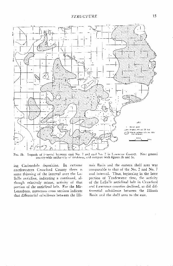
FIG. 5b.-Isopach of interval between coal No. 2 and coal No. 7 in Lawrence County. Note general county-wide uniformity of thickness, and compare with figures 3b and 5a.
ing Carbondale deposition. I n extreme northwestern Crawford County there is some thinning of the interval over the La- Salle anticline, indicating a continued, al- though relatively minor, activity of that portion of the anticlinal belt. For the Mc- Leansboro, numerous cross sections indicate that differential subsidence between the Illi-
nois Basin and the eastern shelf area was comparable to that of the No. 2 and No. 7 coal interval. Thus , beginning in the later portion of Tradewater time, the activity of the LaSalle anticlinal belt in Crawford and Lawrence counties declined, as did dif- ferential subsidence between the Illinois Basin and the shelf area to the east.

I L L I N O I S S T A T E G E O L O G I C A L SURVEY
TABLE 1.-ESTIMATED COAL RESERVES I N CRAWFORD AND LAWRENCE COUNTIES* (thousands of tons)
Crawford County. . 40,877 401,752 1,524,693
Lawrence County . 156,469 737,175 1 1,629,124
* Summary of total reserves for coal beds No. 7, Jamestown; No. 6, No. 5. Indiana IV, and Indiana I11 as listed in Cady, 1953, p. 102 and 116,
"" As defined by Cady, 1953, p. 17, t.a'ule 1 .
Weakly indicated**
-
C O A L R E S O U R C E S
Tot a1
Estimates of minable coal reserves of Crawford and Lawrence counties were made by Cady and others (1953, p. 102 and 116) . Only coal seams 28 inches or more thick were considered as minable coal, and coal under oil pool areas was not classified. Table 1 gives a brief summary of classified reserves.
N o major coal mines have operated in either Crawford or Lawrence counties or in the adjacent Illinois counties of W a - bash, Richland, Jasper, and Clark. How- ever, in Sullivan County, Ind., both strip and underground mines have produced from
Indiana coals 111, IV, V, V I , and VII. I n Knox County, Ind., the principal coals mined have been Indiana IV, V, and VI coals (Charles Weir , personal communica- t ion) .
Because the LaSalle anticlinal belt passes through Crawford and Lawrence coun- ties, the coal beds have, in comparison to many other Illinois counties, greater-than- average dips (pls. 3 and 4). Wes t of the anticlinal belt, dips commonly range from 50 to 100 feet per mile with local extremes of 200 feet per mile. East of the anticlinal belt, dips are between 30 and 70 feet per mile.

REFERENCES
REFERENCES
BELL, A. H., 1934, Oil and gas development in Illi- nois in 1933: Illinois Geol. Survey Ill. Pet. 25.
, BALL, C., and MCCABE, L., 1931, Geology of the Pinckneyville and Jamestown areas, Perry County, Illinois: Illinois Geol. Survey Ill. Pet. 19.
BLATCHLEY, R. S., 1913, The oil fields of Crawford and Lawrence counties : Illinois Geol. Survey Bull. 22.
BUTTS, CHARLES, 1925, Geology and mineral re- sources of the Equality-Shawneetown area: Illinois Geol. Survey Bull. 47.
CADY, G. H., and others, 1953, Minable coal re- serves of Illinois: Illinois Geol. Survey Bull. 78.
, et al., 1955, Subsurface geology and coal resources of the Pennsylvanian system in Wabash County, Illinois: '~llinois Gedl. Survey Rept. Inv. 183.
FISHER, D. J., Western Lawrence County oil field: unpublished manuscript, files Illinois Geol. Survey.
HENBEST, L. G., 1928, Fusulinellas from the Stone- fort limestone member of the Tradewater formation: Jour. Paleo., v. 2, p. 70-71.
MALOTT, C. A., 1930, Geologic structure in the Indian and Trinity Springs locality, Martin County, Indiana: Indiana Acad. Sci., v. 40, p. 217-231.
MOULTON, G. F., 1925, Further ~ontributions to the geology of the Allendale oil field, with a re- vised structure map: Illinois Geol. Survey Rept. Inv. 7.
MYLIUS, L . A., 1923, Oil and gas development and possibilities in parts of eastern Illinois: Il!i- nois Geol. Survey Bull. 44C.
- , 1927, Oil and gas development and possi- bilities in east-central Illinois: Illinois Geol. Survey Bull. 54.
NEWTON, \ti. A., and WELLER, J. M., 1937, Strati- graphic studies of Pennsylvanian outcrops in part of southeastern Illinois : Illinois Geol. Survey Rept. Inv. 45.
POTTER, P. E., and SIEVER, RAYMOND, Sources of Pennsylvanian sediments in the Eastern In- terior Basin, Part I : Jour. Geol. (in press).
RICH, J. L., J916, Oil and gas in the Birds quad- rangle: an Illinois Geol. Survey Bull. 33, p. 105-145.
SIEVER, RAYMOND, 1951, The Mississippian- Pennsylvanian unconformity in southern Illi- nois: Bull. Am. Assoc. Petr. Geol., v. 35, no. 3, p. 542-581. Reprinted as Illinois Geol. Survey Rept. Inv. 152.
, and CADY, G. H., 1951, Subsurface geology of Richland County, in Subsurface geology and coal resources of the Pennsylvanian system in certain counties of the Illinois Basin: Illi- nois Geol. Survey Rept. Inv. 148, p. 111-123.
TAYLOR, E. F., and CADY, G. H., 1944, Structure of the Millersville limestone in the north part of the Illinois Basin, in Progress reports on sub- surface studies of the Pennsylvanian system in the Illinois Basin: Illinois Geol. Survey Rept. Inv. 93.
WANLESS, H. R., Stratigraphy of the Casepville and Tradewater groups of Illinois: unpublished manuscript, files Illinois Geol. Survey.
, 1939, Pennsylvanian correlations in the Eastern Interior and Appalachian coal fields: Geol. Soc. Am. Spec. Paper 17, 130 p.
- , 1955, Pennsylvanian rocks of the Eastern Interior Region: Bull. Am. Assoc. Petr. Geol., v. 39, no. 9, p. 1753-1820.
WEIR, C. E., 1952, Distribution, structure and mined areas of coals in Sullivan County, Indiana: Indiana Geol. Survey Preliminary Coal Map No. 2.
WELLER, J. M., 1923, The geology of Edmonson County, Kentucky: Kentucky Geol. Survey Series VI, V . 28, p. 151-158.
, 1940, Geology and oil possibilities of ex- treme southern Illinois: Illinois Geol. Survey Rept. Inv. 71.
WILLIAMS, F. E., and ROLLEY, M. B., 1955, Sub- surface geology and coal resources of the Pennsylvanian system in Jasper County, Illi- nois: Illinois Geol. Survey Rept. Inv. 181.
WORTHEN, A. H., et al., 1875, Geological Survey of Illinois, v. VI: Illinois State Geol. Survey.
ILLINOIS STATE GEOLOGICAL SURVEY, REPORT O F INVESTIGATIONS 193 17 p., 4 pls., 5 figs., 1 table, 1956