Standing Stone State Forest - TN.gov
1
! M # ! M # ! M # ! M # ! M # ! M # ! M # ! M # ! M # ! M # ! M # ! M # ! M # ! M # ! M # ! M # ! M # ! M # ! M # ! M # ! M # ! M # ! M # ! N # ! N # ! N # ! N # ! N # ! N # ! N # ! N # ! N # ! N # ! N # ! N # ! N # ! N # ! N # ! N # ! N # ! N # ! N # ! N # ! N # ! N # ! N # ! F ! F ! F ! F R o ugh s ho d R o a d M i l l Cr e e kL a ne Ro c ky M o u n d R o a d Jo e M a x w e l l R d . B e a c h Rd An d r e w Co v eR oa d Wet M i l l C r e e k Rd H w y. 52 C ha r l ie B r o wn Ro ad Bi l l y H i l l R o a d H ig h w ay 13 6 S t a t e F or e s t H i k i n g T ra il S t a t e F or e s t Hi ki n g Trai l T ab le Ro c k T r a i l B r y a n s F o rk L o o p B r o w n T ra i l R i c h H o ll o w T r ail D a le Ce m e t e ry T ra i l W al n u t T rail T o w e r R i d ge T r ail P o p l a rT rail C ou nt y L i n e T r a il L o w Ga p T r a i l J o h n s o n C o v e Tr a i l M i l l C r e e k T r a i l B ro w nT ra i l B i l l y H i l l T r ai l Ne e l y T r a i l B uc k y How ard Tr ai l D al e R i d g e Tr a il S a w m i ll T ra i l D e m o T r a il H o w a r d C e m e t e r y T r a i l G o o d p a s t ur e Mo u nt a i n T r a i l R oc k Qu a r r y L o o p Bea c h R o a d C o o p e r M o u n ta i n R o a d R o c k Qu a r r yL o o p L i c k R o a d Fir e T o w e r R o a d W a ln u t R o a d W al n u t R o a d Tow e r Ri dg e Ro a d To mpkin sC o v e Ro ad Gla s s c o c k C e m e t e r y Ro ad μ 0 1 2 0.5 Miles General area map. Not intended for navigational use 2016 By: N.J.O Management Agency State Forest Private in-holding ! (! (! (! (! (! (! ( ! (! (! (! (! (! (! ( ! (! (! (! (! (! (! ( ! (! (! (! (! (! (! ( State Park Standing Stone State Forest Public Road Use Map * Any unmapped trails are closed except to foot traffic only Suitable for any vehicle Non-Forest Forest Forest Forest Forest Road Jurisdiction Road may be rough and high clearance vehicles are recomended Narrow access, rough terrain, not suitable for vehicles over 50" Foot Traffic Only Federal, State, and local laws apply No Horseback No ATV Use No OHV Use Foot Traffic Only Public Road Use Restrictions Applicable where symbol is present
Transcript of Standing Stone State Forest - TN.gov
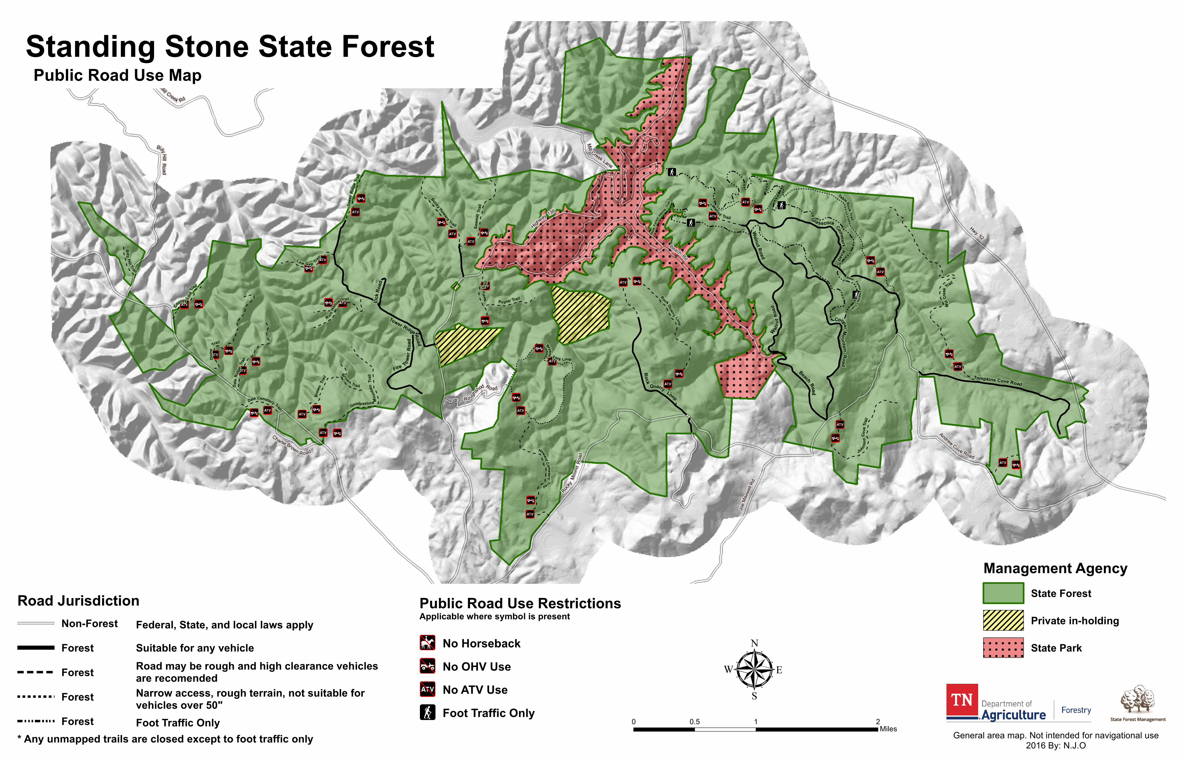
!M#
!M#
!M#
!M# !M#
!M#
!M#
!M#
!M#
!M#
!M#
!M#
!M#
!M#
!M#
!M#
!M#
!M#
!M#
!M#
!M#
!M#
!M#
!N#
!N#
!N#
!N#
!N#!N#
!N#
!N#
!N#
!N#
!N#
!N#
!N#
!N#
!N#
!N#
!N#
!N#
!N#
!N#
!N#
!N#!N#
!F
!F
!F
!F
Roughshod Road
Mill Creek Lane
Rocky Mo
und Ro
ad
Joe M
axwell
Rd.
Beach Rd
Andrew Cove Road
Wet Mill Creek Rd
Hwy. 52
Charlie Brown Road
BillyHillRoad
Highway 136
State
Fores
t Hiking
Trail
State ForestHiking
Trail
TableRock Trail
Bryans
Fork Loop
Brown Trai l
R ichHo
llowTrail
Dale Cemetery Trail
Walnut Trail
Towe
r Ridg
e Trai
l
Poplar Trail
Count y Lin
eTrail
Lo w Ga p Tra
il
Johnson
Cove
Trail
Mill
Cree
k Trail
Brow
nTra
il
Billy Hil l Trail
Neely
Tr ail
Bucky Howard TrailDa
leRid
geTra
il
Sawm
illTra
i l
Demo
Trail
HowardCemeteryTrail
Goodpasture Moun
tain
Trail
RockQuarry Loop
Beach Road
CooperMountainRoad
Rock
Quarry Loop
Lick R
oad
Fire Tower
Road
Walnut Road
Walnut
Road
Tower RidgeRoad
Tompkins Cove Road
Glasscock CemeteryRoad
µ0 1 20.5
Miles General area map. Not intended for navigational use2016 By: N.J.O
Management AgencyState Forest
Private in-holding
!( !( !( !( !( !( !( !(
!( !( !( !( !( !( !( !(
!( !( !( !( !( !( !( !(
!( !( !( !( !( !( !( !(
!( !( !( !( !( !( !( !(
State Park
Standing Stone State ForestPublic Road Use Map
* Any unmapped trails are closed except to foot traffic only
Suitable for any vehicle Non-ForestForestForestForestForest
Road Jurisdiction
Road may be rough and high clearance vehicles are recomendedNarrow access, rough terrain, not suitable for vehicles over 50"Foot Traffic Only
Federal, State, and local laws applyNo Horseback
No ATV UseNo OHV Use
Foot Traffic Only
Public Road Use RestrictionsApplicable where symbol is present