
Stag Drilling and Completions Environment Plan … · APACHE ENERGY LTD (ABN 39 009 301 964) 100 ST...
70
APACHE ENERGY LTD (ABN 39 009 301 964) 100 ST GEORGES TERRACE / PERTH / WA / 6000 TEL (08) 6218 7100 / FAX (08) 6218 7200 Stag Drilling and Completions Environment Plan Summary EA-62-R1-10002/3 2 17/02/15 Re-issued following NOPSEMA comments GG LM HA 1 22/01/15 Re-issued following NOPSEMA comments GG LM HA 0 31/12/14 Issued for Use GG LM HA A 31/12/14 Issued for Review GG LM HA REV DATE DESCRIPTION BY CHK EM/PM
-
Upload
truonglien -
Category
Documents
-
view
214 -
download
0
Transcript of Stag Drilling and Completions Environment Plan … · APACHE ENERGY LTD (ABN 39 009 301 964) 100 ST...

APACHE ENERGY LTD (ABN 39 009 301 964) 100 ST GEORGES TERRACE / PERTH / WA / 6000 TEL (08) 6218 7100 / FAX (08) 6218 7200
Stag Drilling and Completions
Environment Plan Summary
EA-62-R1-10002/3
2 17/02/15 Re-issued following NOPSEMA comments GG LM HA
1 22/01/15 Re-issued following NOPSEMA comments GG LM HA
0 31/12/14 Issued for Use GG LM HA
A 31/12/14 Issued for Review GG LM HA
REV DATE DESCRIPTION BY CHK EM/PM
Stag Drilling and Completions Environment Plan Summary 2 of 70
CONTENTS:
1. INTRODUCTION ............................................................................................................................... 4
1.1 Compliance ................................................................................................................................... 4
1.2 Schedule........................................................................................................................................ 4
2. ACTIVITY LOCATION ......................................................................................................................... 6
3. DESCRIPTION OF THE ACTIVITY ........................................................................................................ 7
3.1 Support vessel operations .............................................................................................................. 8
3.2 Helicopters .................................................................................................................................... 8
3.3 ROV operations ............................................................................................................................. 8
3.4 Drilling discharges.......................................................................................................................... 8
3.5 Well control ................................................................................................................................... 8
3.6 Well testing ................................................................................................................................... 9
3.7 Waste ............................................................................................................................................ 9
4. RECEIVING ENVIRONMENT ............................................................................................................ 10
4.1 Boundaries of the receiving environment for the Activity ............................................................. 10
4.1.1 Operational Area ................................................................................................................................. 10
4.1.2 Environment that may be affected ..................................................................................................... 10
4.2 Description of the environment ................................................................................................... 13
4.2.1 Physical environment and habitats ..................................................................................................... 13
4.2.2 Habitats ............................................................................................................................................... 13
4.2.3 Marine fauna ....................................................................................................................................... 14
4.2.4 Protected/significant areas ................................................................................................................. 15
4.2.5 Socioeconomic..................................................................................................................................... 24
5. STAKEHOLDER CONSULTATION ...................................................................................................... 46
6. ENVIRONMENTAL IMPACT AND RISK ASSESSMENT ........................................................................ 50
6.1 Risk Identification ........................................................................................................................ 50
6.2 Consequence Level Determination ............................................................................................... 50
6.3 ALARP Evaluation ........................................................................................................................ 51
6.4 Acceptability Evaluation .............................................................................................................. 51
6.5 Risk Assessment .......................................................................................................................... 51
7. ENVIRONMENTAL HAZARDS AND CONTROLS ................................................................................. 53
8. MANAGEMENT APPROACH ............................................................................................................ 62
9. HYDROCARBON SPILL RESPONSE ARRANGEMENTS ......................................................................... 63
9.1 Net Environmental Benefit Analysis (NEBA) .................................................................................. 65
9.2 Oil Spill Response Resources ........................................................................................................ 65

Stag Drilling and Completions Environment Plan Summary 3 of 70
10. CONTACT DETAILS ....................................................................................................................... 67
11. REFERENCES ................................................................................................................................ 68
FIGURES:
Figure 1-1: Location of the Stag permit area .............................................................................................. 5 Figure 4-1: EMBA for the Activity ............................................................................................................. 12 Figure 4-2: Benthic habitats within the EMBA ......................................................................................... 27 Figure 4-3: Protected/significant areas (marine reserves) that occur within the EMBA ......................... 30 Figure 4-4: Biologically Important Areas for EPBC Protected Fish and Sharks within the EMBA ............ 36 Figure 4-5: Biologically Important Areas for EPBC Protected Turtles within the EMBA .......................... 37 Figure 4-6: Biologically Important Areas for EPBC Protected Whales within the EMBA ......................... 38 Figure 4-7: Commonwealth commercial fishing zones within the EMBA ................................................ 42 Figure 4-8: State commercial fishing zones within the EMBA.................................................................. 43 Figure 6-1: Risk and Impact Process ......................................................................................................... 50
TABLES:
Table 2-1: Boundary of permits WA-15-L as the Operational Area ........................................................... 6 Table 4-1 Summary of credible spill scenarios ....................................................................................... 10 Table 4-2: Environmental values and sensitivities – Habitats ................................................................. 25 Table 4-3: Environmental values and sensitivities –protected/significant areas .................................... 28 Table 4-4: Environmental values and sensitivities – marine fauna ......................................................... 31 Table 4-5: State and Commonwealth Fisheries within the EMBA ........................................................... 39 Table 4-6: Environmental values and sensitivities – Socioeconomic within EMBA ................................. 44 Table 5-1: Summary of stakeholders consulted ...................................................................................... 46 Table 7-1: Environmental risk summary for operational activities .......................................................... 54 Table 7-2: Environmental risk assessment summary for unplanned events ........................................... 58 Table 9-1: Applicable oil spill response strategies for the Activity .......................................................... 63

Stag Drilling and Completions Environment Plan Summary 4 of 70
1. INTRODUCTION
Apache Northwest Pty Ltd (Apache) is the operator of the Stag Field Production and Export Facility (Stag Facility). The facility is located 53 km northwest of Dampier in approximately 49 m water depth in the Commonwealth waters of the North West Shelf (NWS) (Figure 1-1). Oil is currently produced from the Stag Reservoir via production wells, and seawater is injected via injection wells. Ongoing drilling and completions activities will be necessary to maintain oil production, and eventually decommission the facility.
The Stag Drilling and Completions EP has been prepared in accordance with the Offshore Petroleum and Greenhouse Gas Storage (Environment) Regulations 2009 (OPGGS(E) Regulations) for approval by the National Offshore Petroleum Safety and Environmental Management Authority (NOPSEMA).
1.1 Compliance
The overall purpose of the EP is to comply with statutory requirements of the Commonwealth Offshore Petroleum and Greenhouse Gas Storage (Environment) regulations 2009 (OPGGS (E) Regulations) and to ensure that the Activity is planned and conducted in accordance with Apache environmental policies and standards, including the Corporate Environmental Policy. The EP was assessed and accepted by the National Offshore Petroleum Safety and Environmental Management Authority (NOPSEMA) on the 19th of December 2014. This EP summary has been prepared in accordance with the requirements of regulation 11 (7) and (8) of the OPGGS (E) Regulations.
1.2 Schedule
This EP covers petroleum activities required for the facility to continue production at a commercially viable level. Petroleum activities at the Stag field are proposed to be ongoing for five years, from January 2015 to December 2019. Precise timing of each drilling operation is dependent on the analysis of field production and reservoir data, MODU availability and is subject to approvals. Due to their responsive nature, petroleum activities will depend on the maintenance requirements of existing wells, production rates of existing wells and analysis of data for the likely presence and location of undrained hydrocarbons. It is expected that approximately thirty petroleum activities would occur over the five year program.
The basis for listing the maximum anticipated number of petroleum activities at 30 is based on the anticipated yearly activity as follows:
• Approximately four (4) new producer wells from slot reclamations;
• Approximately two (2) producer wells from side-tracking existing wells;
• Approximately two (2) injector wells;
• Approximately four (4) 4 work overs per year; and
• Contingency activity 10% – to account for any unforseen issues.
These activity estimates have been based on historical activity in the Stag field. Since 2010, there have been 35 petroleum activities: 5 appraisal wells, 7 producers from reclaimed slots, 1 producer from side-tracking an existing producer, 1 open water injector, and 22 work overs (40% or all activities).
Assuming that each well drilling activity takes 10 to 50 days, the number of drilling days could be up to approximately 400 days, weather dependant.
The Stag Drilling and Completions EP covers drilling activities in all seasons.

Stag Drilling and Completions Environment Plan Summary 5 of 70
Figure 1-1: Location of the Stag permit area

Stag Drilling and Completions Environment Plan Summary 6 of 70
2. ACTIVITY LOCATION
The Operational Area (Permit WA-15-L) is located in Commonwealth waters in the Carnarvon Basin, north Western Australia. The boundary of the permit WA-15-L has been used as the ‘Operational Area’ within which petroleum activities covered under this environment plan will occur.
Coordinates marking the boundary of the Permit Area are shown in Table 2-1.
Table 2-1: Boundary of permits WA-15-L as the Operational Area
Location Coordinates (Datum/Projection: GDA 94 Zone 50)
Latitude Longitude Easting Northing
SW -20˚ 14’ 55.25”S 116˚ 10’ 04.74”E 413101.93 7760780.99
NW -20˚ 14’ 55.24”S 116˚ 20’ 04.76”E 430510.27 7760859.93
NE -20˚ 19’ 55.25”S 116˚ 20’ 04.76”E 430547.41 7751637.20
SE -20˚ 19’ 55.25”S 116˚ 10’ 04.74”E 413148.38 7751558.20

Stag Drilling and Completions Environment Plan Summary 7 of 70
3. DESCRIPTION OF THE ACTIVITY
Apache proposes to drill the Stag wells in this permit area using a jack up rig - mobile offshore drilling unit (MODU).
Jack-up rigs are towed into position to the drilling location by one to three support vessels. When in position, the legs are jacked down to the sea floor. During this time the spud can’s pins at the end of each leg may drag intermittently along the seabed creating shallow furrows. Once at the desired location and with the rig stationary, the legs are lowered to be fully in contact with the seabed and the rig raises itself approximately 15 m above the sea surface, supported by legs contacting the sea floor. There are typically three spudcans that will penetrate the seabed with a diameter of approximately 18m. The estimated surface area at the bottom of each leg and associated spud can is 260 m2.
If the well to be drilled is over the platform the rig will be ‘soft pinned, that is the legs extended to be in contact with the sea bed without a jacking load, approximately 100m from location. At this time two vessels are configured to facilitate the final positioning, which is routinely carried out to a tolerance of less than 1 m.
The MODUs will also typically have four anchors. Although these anchors are not typically used, they may be utilised if less than the required support vessels are available or during cyclone preparations. If used, the extent of disturbance to the seafloor will be limited to the area immediately under the anchors as well as disturbance associated with the anchor chain/ lines that rest on the seabed. The extent of the anchors is usually up to approximately 1 km.
Exploration, appraisal and water injector wells.
These well will be drilled in three sections: surface, intermediate, and production. The surface section will be drilled using seawater and bentonite sweeps and discharges will be returned to the seabed in this uncased section. The intermediate and production sections will be drilled with inhibited polymer water based mud (WBM). The extracted cutting and recoverable fluids (WBM) generated while drilling the lower two well intervals will be brought to the MODU through the riser, before being treated by solids control equipment to separate the drilling fluid from the cuttings before discharge of cuttings to the marine environment at sea surface.
Drilling of production and water injector wells.
Production wells will be drilled horizontally from open water or from existing platforms with laterals of various lengths.
The top sections of the wells will be drilled through an existing conductor, from a new conductor, or from side tracking from an existing casing. The surface sections of the wells will be drilled riserless and steel casing will be cemented into place within the hole. After the setting of the surface casing, a blow-out preventer (BOP) will be installed on the wellhead. During the well drilling campaign, the BOP will be function tested during assembly and maintenance, as part of function and pressure testing. Following installation of the BOP, the lower sections of the wells will be drilled as per the drilling program.
Once lower and upper completions have been installed the well will be secured to hand over to production. Wireline logging may be undertaken during the time of drilling and completing the wells.
Note a subsea Christmas tree will be installed at some stage throughout the well. The wells will be completed, in the open water case suspended, and ultimately tied back to the platform for injection.
The riserless sections of the wells (appraisal, producer and injector) will be drilled with seawater and gel sweeps, the drill cuttings can only be discharged to the seabed. Once the conductor/surface string is installed however, cuttings are returned to the surface with the drilling fluid and are screened by the MODU shakers to remove the entrained cuttings. The recovered mud is then pumped to the mud tanks for reuse during the drilling program.

Stag Drilling and Completions Environment Plan Summary 8 of 70
Work overs
Work overs (approximately 25% of activities) will not require any drilling or result in the discharge of drill cuttings. The majority of the workover activities will be conducted by the Stag facility Hydraulic Workover Unit (HWU) covered under the Stag Facility EP (EA-62-RI-023/1.
3.1 Support vessel operations
The MODU will be assisted by up to four support vessels that will transfer supplies, bulks, fuel, and material and equipment required for operations and drilling purposes. Such material and equipment includes, but are not limited to; bins, baskets, containers and tubulars. Bulk products will also be transfer via hose from the support vessels and MODU. Such products include drilling fluids and solids, brine, drilling water and cement. They will also back-load excess drilling materials and wastes to return to shore for reuse and/or disposal, either back to the supplier or to an approved waste facility. The support vessels will generally operate between the MODU, Dampier Port and Exmouth Port.
A variety of vessels may be used, such as: anchor handling, MODU support, and crew transfer vessels. The MODU and support vessels have marine VHF and satellite phones to maintain communications. At least one support vessel will remain on location at each well site for the duration of each of the Activities to ensure the maintenance of 500 m exclusion zone around the MODU.
Support vessels will be provided with a stand by mooring within the operational area (which may move). The anchor and chain length of this mooring will be approximately 150 m to 250m long and will be removed after the Activity is completed.
3.2 Helicopters
Crew changes for personnel aboard the MODU will involve transfer by helicopter between the MODU and the regional airport at Exmouth or Karratha. These flights will occur several times a week dependent on the progress of the drilling program and logistical constraints.
3.3 ROV operations
Remotely operated vehicle (ROV) surveys are likely to occur periodically to determine the condition of subsea infrastructure, monitor drilling operations, manipulate subsea equipment, and confirm site adequacy (site survey).
3.4 Drilling discharges
Drilling discharges account for:
• Drill cuttings;
• Base muds,
• Brine; and
• Wet cement.
3.5 Well control
Apache ensures control of its wells through a number of control measures incorporated into well design, drilling procedures, mud selection, personnel training and equipment maintenance and testing. Wells are drilled in accordance with Apache’s Well Lifecycle Management System (WLMS). Blow out preventers (BOPs) are installed to ensure that wells will have sufficient barriers maintained during drilling, suspension and abandonment activities in accordance with the Apache’s Drilling and Completions Technical Standard (AE-91-ID-004). All well control equipment, casings and wellhead equipment is tested to maximum anticipated surface pressure (MASP) in accordance with the same standard.

Stag Drilling and Completions Environment Plan Summary 9 of 70
3.6 Well testing
Well testing and evaluation involves the collection of data on the well and surrounding formation. Wireline logging will be conducted during drilling activities and it is also possible that vertical seismic profiling (VSP) will be used.
Wireline logging is a continuous measurement of formation properties with electrically powered instruments using a sonde or logging tool that is lowered into the wellbore on a cable. Measurements can include electrical and sonic properties, active and passive nuclear measurements, dimensional measurements of the wellbore, formation fluid sampling, formation pressure measurement, and others.
VSP is used for correlation with surface seismic data to produce images of higher resolution than surface seismic images.
No well flaring activity will be required under this EP.
3.7 Waste
Operational discharges from the MODU and support vessels are likely to include:
• Drilling fluid on cuttings residual from drilling operations;
• Deck drainage;
• Putrescible waste and sewage;
• Oily water;
• Cooling water from operation of engines;
• Desalination plant effluent (brine) and backwash water discharge;
• Ballast water; and
• Solid waste.

Stag Drilling and Completions Environment Plan Summary 10 of 70
4. RECEIVING ENVIRONMENT
4.1 Boundaries of the receiving environment for the Activity
4.1.1 Operational Area
The Operational (permit) Area defines the geographical boundary of the Activity. The Operational Area for the Stag Permit covers approximately 160.5 km2 and is 17.4 km by 9.2 km. It is located 26 km north west of the nearest landfall at the Dampier Archipelago, 51 km north west of the mainland and 62 km north of Dampier, in water depths ranging from 49 m to 51 m.
The Operational Area occurs entirely within the Northwest Shelf Province.
4.1.2 Environment that may be affected
The environment that may be affected (EMBA) encompasses the environment that could be affected by unplanned as well as planned events. This area has been derived using modelling of credible worst case scenarios, including the loss of hydrocarbons to the marine environment from five credible spill scenarios (due to vessel collisions) (Table 4-1). The extent of the EMBA is shown in Figure 4-1.
The EMBA shown in Figure 4-1 does not represent the area that would be impacted following a single worst case credible oil spill. Rather it represents a cumulative area within which all potential oil spill impacts would be contained within. In the event of an oil spill accident the spill would move in the direction of the prevailing wind and currents, this area would be a smaller proportion of the area presented in Figure 4-1.
Table 4-1 Summary of credible spill scenarios
No. Scenario Hydrocarbon Type
Maximum Credible Volume Comment
1
Spill of hydrocarbons, environmentally hazardous chemicals or liquid-waste to the marine environment
Hydrocarbons/ Chemicals < 1 m3
Minor spills due to limited volumes used for servicing and routine operations.
2 Hydrocarbon spill during refuelling Diesel 2.5 m3 Maximum credible volume based on 30 seconds to shut in transfer.
3 Hydrocarbon spill from a ruptured fuel tank Diesel 250 m3
Maximum credible volume based on largest fuel tank (support vessel).
4 Hydrocarbon spill from a loss of Heavy Fuel Oil – Offtake tanker Heavy Fuel Oil <1,400 m3
Drilling support vessel (or MODU) to collide with the side of the offtake tanker within the Operational Area potentially rupturing an HFO tank.
5a Hydrocarbon spill from vessel collision with Offtake tanker or FSO Heavy crude oil <7,253 m3
Drilling support vessel (or MODU) to collide with offtake tanker, which would result in in 50% of largest crude oil storage tank protected by double-hull released to the marine environment.

Stag Drilling and Completions Environment Plan Summary 11 of 70
No. Scenario Hydrocarbon Type
Maximum Credible Volume Comment
5b Sub surface Stag crude Heavy crude oil <546 m3
From damage to existing infrastructure as a result of vessel collision, or dropped object which would result in 309 m3 of crude oil (Maximum daily flow rate x 1 hour + volume of oil in the pipeline) released to the marine environment.
The EMBA for the activity due to planned activities and potential unplanned events extends across the following provinces:
• Northwest Transition;
• Northwest Province;
• Northwest Shelf Province;
• Central Western Shelf Transition; and
• International Waters.

Stag Drilling and Completions Environment Plan Summary 12 of 70
Figure 4-1: EMBA for the Activity

Stag Drilling and Completions Environment Plan Summary 13 of 70
4.2 Description of the environment
4.2.1 Physical environment and habitats
Physical environment
North West Shelf (NWS) waters are usually thermally stratified with a marked change in water density at approximately 20 m (SSE, 1993). Surface temperatures vary annually, being warmest in March (32˚C) and coolest in August (19˚C). During summer (October–March), the prevailing non-storm winds are from the southwest, west and northwest at an average speed of less than 10 knots, peak average speeds of 15–25 knots, and maximum speeds of 30 knots. Non-storm winds prevail from the north-east through to south-east at average speeds of 5–6 knots, peak average speeds of 10–15 knots, and maximum speeds of 20 knots. The wave climate is generally composed of locally generated wind waves (seas) and swells that are propagated from distant area (WNI, 1995; 1996). In the open ocean, sustained winds result in wind-forced currents of approximately 3% of the wind speed (Holloway and Nye, 1985).
Tidal and wind-forcing are the dominant contributions to local sea surface currents. The tides of the NWS have a strong semi-diurnal signal with four tide changes per day (Holloway and Nye, 1985) and a spring tidal range of 1.9 m and a highest astronomical tide of 2.9 m (Chevron Australia, 2010). The dominant sea surface offshore current (typically seaward of the 200 m isobath) is the Leeuwin Current, which carries warm tropical water south along the edge of WA's continental shelf, reaching its peak strength in winter and becoming weaker and more variable in summer. The current is described as a sea surface current, extending in depth to 150 m (BHPB, 2005; Woodside, 2005). Closer to the coast, the Ningaloo Current flows in a northerly direction, in the opposite direction to the Leeuwin Current, along the outside of the Ningaloo Reef and across the inner shelf from September to mid-April (BHPB, 2005; Woodside, 2005). The Indonesian Throughflow is the other important current influencing the upper 200 m of the outer NWS (Woodside, 2005). This current brings warm and relatively fresh water to the region from the western Pacific via the Indonesian Archipelago.
Offshore drift currents are represented as a series of interconnected eddies and connecting flows that can generate relatively fast (1–2 knots) and complex water movement. These offshore drift currents also tend to persist longer (days to weeks) than tidal current flows (hours between reversals) and thus will have greater influence upon the trajectory of slicks over time scales exceeding a few hours (APASA, 2014).
Table 4-2 to Table 4-6 present the environmental values and sensitivities (natural, cultural and socio-economic) within the EMBA and include all relevant matters of national environmental significance (NES) protected under the EPBC Act 1999.
4.2.2 Habitats
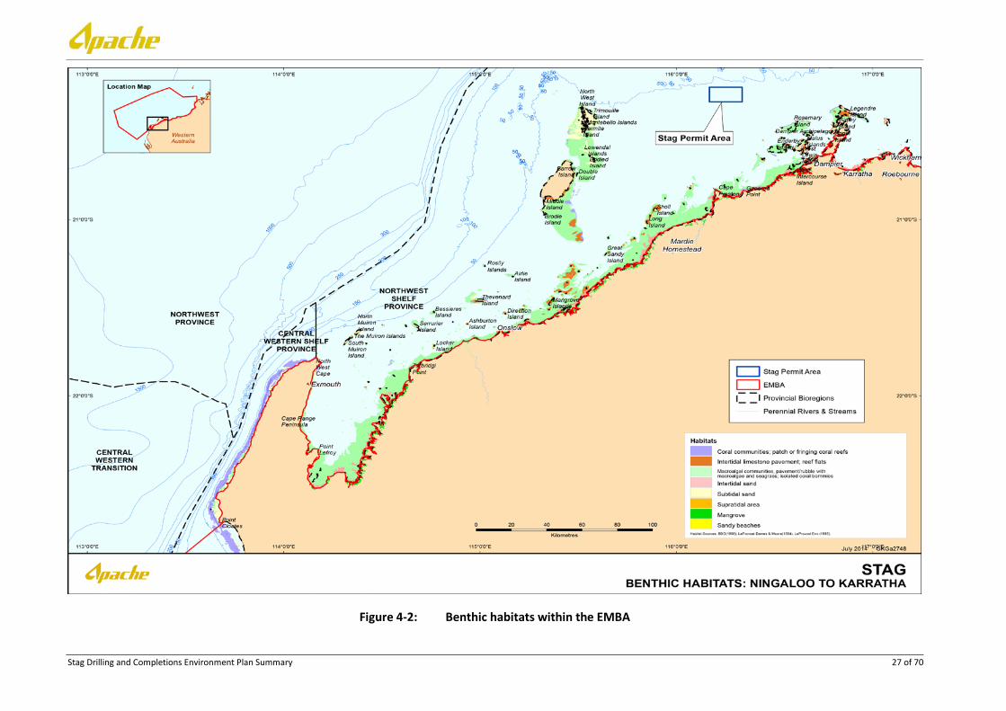
Benthic and shoreline habitats with the potential to be impacted by this program are also identified in Figure 4-2 and Figure 4-3. Those habitats deemed to be of particular importance to the region have been identified within Table 4-2.
The Operational Area occurs completely within the Northwest Shelf Province.
This bioregion is located primarily on the continental shelf in water depths from 0 to 200 m (DEWHA 2008). The sandy substrates on the shelf within this bioregion are thought to support low density benthic communities of bryozoans, molluscs and echinoids (DEWHA 2008). Sponge communities are also sparsely distributed on the shelf, but are found only in areas of hard substrate. The region between Dampier and Port Hedland has been described as a hotspot for sponge biodiversity (Hooper & Ekins 2004).
Recent baseline studies undertaken in nearshore areas of the Pilbara (SKM 2009, Rio Tinto 2009, BHPBIO 2011) and offshore areas around Barrow Island (Chevron 2010) have shown that filter feeder communities are a dominant component of benthic habitats in depths >10 m where reduced light appears to inhibit extensive development of hard corals and macroalgae. The pavement habitats between Barrow Island and the mainland are covered by a sediment veneer that appears to periodically move, exposing areas of

Stag Drilling and Completions Environment Plan Summary 14 of 70
pavement reef. Sessile benthic organisms that require hard substrates for attachment, such as gorgonians, are frequently seen emerging through a shallow veneer of sand. This type of substrate (sediment veneer) with sparse filter feeder communities is common throughout this area (SKM 2009, Rio Tinto 2009, BHPBIO 2011).
The Operational Area does not contain shoreline habitat, and the nearest land is the Dampier Archipelago 26 km away. Available data indicates that the benthic habitat across the Operational Area comprises mostly sand and subtidal soft bottom communities unlikely to contain significant areas of reef (coral or rocky), seagrass meadows or macroalgal communities. The benthic habitats within the Operational Area are widely represented at a regional scale on the NWS.
Protected and significant areas with the potential to be impacted by this program have been identified in Figure 4-3 and Table 4-3.
4.2.3 Marine fauna
The Operational Area occurs completely within the Northwest Shelf Province.
The demersal zone of the North-west shelf (NWS) (which includes the Northwest Province and Northwest Shelf Province) hosts a diverse assemblage of fish of tropical Indo-west Pacific affinity, with up to 1,400 species known to occur, with a great proportion of these occurring in shallow coastal waters (Allen et al. 1988). Last et al. (2005) and Fox & Beckley (2005) described the North-west Province as being characterised by a high level of endemism and species diversity. Certain areas of increased biological activity (e.g. Glomar Shoals) attract demersal fish species such as Rankin cod, red emperor, crimson snapper and spangled emperor that are exploited by commercial trawl and trap fisheries (Sainsbury et al. 1992, Fletcher and Santoro 2013).
The shallow waters (<30 m) of the Dampier Archipelago, in the Northwest Shelf Province, support a characteristic and rich fish fauna of 650 species from a variety of habitats including coral and rocky reefs, mangroves, sand and silty bottoms and sponge gardens (Hutchins 2003 & 2004). The majority of these species are found over hard substrate, but significant numbers are also found from soft bottom and mangrove areas. The outer islands of the Archipelago are inhabited predominantly by coral reef fishes whereas inner areas close to the mainland are occupied by mangrove and silty-bottom dwellers. The inter-island passages have a relatively rich soft bottom fauna. EPBC Act protected fish species within the Dampier Archipelago include the dwarf sawfish (Pristis clavata).
The fish fauna of the archipelago is less diverse than the islands of the West Pilbara to the south, but are closely related to the fauna at the offshore Montebello Islands (Hutchins 2004). The fish fauna of Barrow/ Lowendal/ Montebello Islands are widespread throughout the Indo-west Pacific region.
Within the southern portion of the Northwest and Northwest Shelf Province, small pelagic fish (e.g. lantern fishes) comprise a third of the total fish biomass (Bulman, 2006) and inhabit a range of marine environments, including inshore and continental shelf waters. These small pelagic fish play an important ecological role, not only for this particular area but for the entire North-west Marine Region. They feed on pelagic phytoplankton and zooplankton and provide a food source for a wide variety of predators such as marine mammals, sharks, large pelagic fish and seabirds, thus providing a vital link between many of the region’s trophic systems (Mackie et al. 2007).
Pelagic fish in the Northwest and Northwest Shelf Province include tuna, mackerel, herring, pilchard and sardine, and game fish such as marlin and sailfish (BBG 1994, Brewer et al. 2007), some of which are targeted by both commercial and recreational fishers. In particular, adult and juvenile southern bluefin tuna are thought to migrate through the NWS on their way to and from spawning grounds in the north-eastern Indian Ocean. However, the timing of these migrations and the use of regional currents to assist their migration is still unclear. The oceanic waters of the NWS are also believed to provide important spawning and nursery grounds for a number of large pelagic fish species. Table 4-6 provides a summary of the key fish species and likely timing of their spawning in the region (DoF correspondence).

Stag Drilling and Completions Environment Plan Summary 15 of 70
There are a number of commercially important fish species in the region including; emperor, rock cod, sweetlip, goat fish, trigger fish, snapper, mackerel and tuna. However, no sensitive breeding or known fishing grounds for these commercial fisheries have been identified within close proximity to the Operational Area,
EPBC Listed Species
Desktop searches of the Stag Operational Area and larger EMBA were undertaken using DoE’s Protected Matters Search Tool for the purposes of identifying species listed under the EPBC Act. The search identified 42 Listed Threatened Species (LTS) and 79 Listed Migratory Species (LMS) as having the potential to occur within the EMBA.
Additional information on EPBC Act threatened and migratory fauna listed in Table 4-4 can be retrieved from the link below:
http://www.environment.gov.au/cgi-bin/sprat/public/sprat.pl
As part of the desktop searches, an assessment was undertaken to identify if these species have the potential to occur in either the Operational Area or larger EMBA. Those species that have been identified as likely to be present in the Operational Area or EMBA are summarised in Sensitive habitat areas such as an aggregation, resting or feeding or known migratory routes for these species are shown in Figure 4-4, Figure 4-5 and Figure 4-6.
4.2.4 Protected/significant areas
Key ecological features (KEFs).
Key ecological features are elements of the Commonwealth marine environment that are considered to be of regional importance for either a region’s biodiversity or its ecosystem function and integrity. The following KEFs fall within the EMBA for a hydrocarbon spill;
Ancient coastline at 125 m depth contour
The shelf of the North-west Marine Region contains several terraces and steps which reflect changes in sea level that occurred over the last 100,000 years. The most prominent of these features occurs at a depth of 125 m as an escarpment along the North West Shelf and Sahul Shelf (DSEWPaC 2012). Where the ancient submerged coastline provides areas of hard substrate it may contribute to higher biological diversity. Little detailed knowledge is available, but the hard substrate of the escarpment is likely to support sponges, corals, crinoids, molluscs, echinoderms (DSEWPaC 2012).
Parts of the ancient coastline are thought to provide biologically important habitats in areas otherwise dominated by soft sediments. The topographic complexity of these escarpments may also facilitate vertical mixing of the water column providing a relatively nutrient-rich environment for species present on the escarpment (DSEWPaC 2012).
Canyons linking the Cuvier Abyssal Plain
Cape Range Peninsula and the Cuvier Abyssal Plain are linked by canyons, the largest of which are the Cape Range Canyon and Cloates Canyon. These two canyons are located along the southerly edge of Exmouth Plateau adjacent to Ningaloo Reef and are unique due to their close proximity to the North West Cape (DSEWPaC 2012).
The Leeuwin Current interacts with the heads of the canyons to produce eddies resulting in delivery of higher nutrient, cool waters from the Antarctic intermediate water mass to the shelf (Brewer et al. 2007). Strong internal tides also create upwelling at the canyon heads (Brewer et al. 2007). Thus the canyons, the Exmouth Plateau and the Commonwealth waters adjacent to Ningaloo Reef interact to create the conditions for enhanced productivity seen in this region (Sleeman et al. 2007 in DSEWPaC 2012). The canyons are also repositories for particulate matter deposited from the shelf and sides of the canyons and serve as conduits for organic matter between the surface, shelf and abyssal plains (DSEWPaC 2012).

Stag Drilling and Completions Environment Plan Summary 16 of 70
The canyons that link the Cuvier Abyssal Plain with the continental slope off Cape Range Peninsula are believed to support the productivity and species richness of Ningaloo Reef (DSEWPaC 2012).
Commonwealth waters adjacent to Ningaloo Reef
The Ningaloo Reef extends almost 300 km along the Cape Range Peninsula to the Red Bluff. Commonwealth waters adjacent to the reef are thought to support the rich aggregations of marine species at Ningaloo Reef through upwellings associated with canyons on the adjacent continental slope and interactions between the Ningaloo and Leeuwin currents (Brewer et al. 2007, DEWHA 2008b, DSEWPaC 2012). The narrow continental shelf (10 km at its narrowest) means that the nutrients channelled to the surface via canyons are immediately available to reef species. Terrestrial nutrient input is low, hence this deepwater source is a major source of nutrients for Ningaloo Reef and therefore very important in maintaining this system (DEWHA 2008b).
The Ningaloo Commonwealth Marine Reserve includes this Key Ecological Feature and is discussed below.
Continental Slope Demersal Fish Communities
The Australian continental slope provides important habitat for demersal fish communities, characterised by high endemism and species diversity. Specifically, the continental slope between North West Cape and the Montebello Trough is the most diverse slope bioregion in Australia with more than 500 fish species, 76 of which are endemic (Last et al. 2005 in DSEWPaC 2012). The Timor Province and Northwest Transition bioregions are the second-richest areas for demersal fish across the entire continental slope (DSEWPaC 2012).
Exmouth Plateau
The Exmouth Plateau covers an area of 49,310 km2 and is located approximately 150 km northwest of Exmouth. The plateau ranges in water depths from 800 to 4,000 m (Heap & Harris 2008 in DSEWPaC 2012). The plateau’s surface is rough and undulating at 800–1,000 m depth. The northern margin is steep and intersected by large canyons (e.g. Montebello and Swan canyons) with relief greater than 50 m. The western margin is moderately steep and smooth and the southern margin is gently sloping and virtually free of canyons (Falkner et al. 2009 in DSEWPaC 2012).
The Exmouth Plateau is a regionally and nationally unique tropical deep sea plateau. It that may serve an important ecological role by acting as a topographic obstacle that modifies the flow of deep waters that generate internal tides, causing upwelling of deeper water nutrients closer to the surface (Brewer et al. 2007).
Glomar Shoals
The Glomar Shoals are a submerged feature situated at a depth of 33–77 m, approximately 150 km north of Dampier on the Rowley Shelf (Falkner et al. 2009 in DSEWPaC 2012). They consist of a high percentage of marine-derived sediments with high carbonate content and gravels of weathered coralline algae and shells (McLoughlin & Young 1985 in DSEWPaC 2012). The area’s higher concentrations of coarse material compared to surrounding areas are indicative of a high energy environment subject to strong seafloor currents (Falkner et al. 2009 in DSEWPaC 2012).
Biological communities found at the Glomar Shoals have not been comprehensively studied, however the shoals are known to be an important area for a number of commercial and recreational fish species such as rankin cod, brown striped snapper, red emperor, crimson snapper, bream and yellow-spotted triggerfish. Catch rates at the Glomar Shoals are high, indicating that the area is a region of high productivity (Falkner et al. 2009, Fletcher & Santoro 2009 in DSEWPaC 2012).
The Glomar Shoals are regionally important for their potentially high biological diversity and localised productivity. Biological data specific to the Glomar Shoals is limited, however the fish of the shoals are probably a subset of reef-dependent species and anecdotal evidence suggests they are particularly abundant (DSEWPaC 2012).

Stag Drilling and Completions Environment Plan Summary 17 of 70
Mermaid Reef and Commonwealth Waters
The Rowley Shoals are a group of three atoll reefs—Clerke, Imperieuse and Mermaid reefs—located about 300 km north-west of Broome. Mermaid Reef lies 29 km north of Clerke and Imperieuse reefs and is totally submerged at high tide. Mermaid Reef falls under Commonwealth jurisdiction and forms the Mermaid Reef Commonwealth Marine Reserve. Clerke and Imperieuse reefs constitute the Rowley Shoals Marine Park, which falls under Western Australian Government jurisdiction (EA 2000). The Rowley Shoals are discussed with the Commonwealth and State Marine Reserves
Protected Areas
Marine parks are created to protect natural features and aesthetic values while allowing recreational and commercial uses that do not compromise conservation values. The following marine parks occur within the EMBA for a hydrocarbon spill;
State Marine Parks
Rowley Shoals MP
Lying approximately 300 km north-north-west of Broome, the Rowley Shoals comprise three oceanic reef systems approximately 30–40 km apart, namely Mermaid Reef, Clerke Reef and Imperieuse Reef. The Rowley Shoals Marine Park comprises the Clerke and Imperieuse Reefs which lie in State Waters. DPaW has lead management responsibility for the Marine Park, in accordance with the Rowley shoals Management Plan (DEC 2007Ab).
The Rowley Shoals Marine Park was originally gazetted on 25 May 1990 as a Class A reserve and on 10 December 2004 the boundary was amended to extend the Park to the State Waters limit. The Park now covers approximately 87,632 ha (DEC 2007Ab). Mermaid Reef lies in Commonwealth waters and comprises the Mermaid Reef Marine National Nature Reserve managed by the Commonwealth Department of Environment (DEWHA 2008).
The Rowley Shoals Marine Park is characterised by spectacular intertidal and subtidal coral reefs, exceptionally rich and diverse marine fauna and high water quality. These attributes and the low level of use of the area contribute to the Park’s unique wilderness qualities, which are a significant drawcard for visitors. Lying in the headwaters of the Leeuwin Current, the Shoals are thought to provide a source of invertebrate and fish recruits for reefs further south and as such are regionally significant. The remoteness of the Shoals and low use have ensured that the marine environment of the Shoals is in a near natural state, particularly relative to other reefs in the Indo-West Pacific region which are subject to intense ongoing human pressures and destructive fishing practices. The Rowley Shoals are of national and international significance and provide an important global benchmark for Indo-West Pacific reefs (DEC 2007Ab).
Barrow Island MP
The Barrow Island Marine Park covers 4,169 ha, all of which is zoned as sanctuary zone (the Western Barrow Island Sanctuary Zone) (DEC 2007Aa). It includes Biggada Reef, an ecologically significant fringing reef, and Turtle Bay, an important turtle aggregation and breeding area (DEC 2007A). Representative areas of seagrass, macroalgal and deep water habitat are also represented within the marine park (DEC 2007A). Passive recreational activities (such as snorkelling, diving and boating) are permitted but extractive activities such as fishing and hunting are not.
Barrow Island MMA
The Barrow Island Marine Management Area (MMA) is the largest reserve within the Montebello/Barrow Islands marine conservation reserves, covering 114,693 ha (DEC 2007A). The MMA includes most of the waters around Barrow Island, the Lowendal Islands and the Barrow Island Marine Park, with the exclusion of the port areas of Barrow Island and Varanus Island.
The MMA is not zoned apart from one specific management zone: the Bandicoot Bay Conservation Area. This conservation area is on the southern coast of Barrow Island and has been created to protect benthic

Stag Drilling and Completions Environment Plan Summary 18 of 70
fauna and seabirds. It includes the largest intertidal sand/mudflat community in the reserves, is known to be high in invertebrate diversity and is an important feeding area for migratory birds.
As for the other reserves in the Montebello/Barrow Islands marine conservation reserves, the Barrow Island MMA includes significant breeding and nesting areas for marine turtles and the waters support a diversity of tropical marine fauna, important coral reefs and unique mangrove communities (DEC 2007A). Green, hawksbill and flatback turtles regularly use the island’s beaches for breeding, and loggerhead turtles are also occasionally sighted.
Montebello Islands MP
The Montebello Islands Marine Park (MP) is an ‘A’ Class reserve (DEC 2007Aa) and covers an area of 58,331 ha and its northern and western boundaries follow the seaward extent of Western Australian state waters (DEC 2007Aa). Zoning within the Montebello Islands MP is a combination of sanctuary, recreation, special purpose (benthic protection), special purpose (pearling), and general use (DEC 2007A).
The Montebello Islands comprise over 100 islands, the majority of which are rocky outcrops; rocky shore accounts for 81% of shoreline habitat (DEC 2007Aa). Other marine habitats within the marine park include coral reefs, mangroves, intertidal flats, extensive sheltered lagoonal waters, and shallow algal and seagrass reef platform extending to the south of the Montebello Islands to the Rowley Shelf. The complex seabed and island topography creates a unique environment where these diverse habitats occur in close proximity to each other.
Ecologically, the marine park’s values include important turtle nesting sites, feeding and resting areas for migrating shorebirds, seabird nesting areas, dugong foraging areas, globally-unique mangrove communities, and highly diverse fish and invertebrate assemblages (DEC 2007Aa). Also, the sediment and water quality of the marine park are considered pristine (DEC 2007Aa) and are essential to the maintenance of the marine ecosystems and associated biota.
Economic values within the Montebello Islands MP include commercial pearl culture, commercial line and trap fishing, and an increasing recreational usage (DEC 2007Aa). Special purpose zones for pearling are established for the existing leaseholder to allow pearling to be the priority use of these areas (DEC 2007Aa). Commercial fishing includes a trap fishery for reef fishes, mainly in water depths of 30–100 m, and wet lining for reef fish and mackerel. Fish trawling also occurs in the waters near to the Montebello Islands. A tourist houseboat operates out of Claret Bay, at the southern end of Hermite Island, during the winter months. The Montebello Islands are becoming more frequently used by recreational boaters for camping, fishing and diving activities.
Ningaloo MP
The Ningaloo Marine Park was declared in May 1987 under the National Parks and Wildlife Conservation Act 1975 (Cmlth). The Ningaloo Coast, incorporating both key marine and terrestrial values was later granted World Heritage Status in June 2011. In November 2012, the Ningaloo Marine Park (Commonwealth Waters) was renamed to be incorporated in the North-west Commonwealth Marine Reserves Network. The park covers an area of 263,343 km2, including both State and Commonwealth waters, extending 25 km offshore. It is vested in the Marine Parks and Reserves Authority (MPRA) and managed by the WA Department of Parks and Wildlife (DPaW) on behalf of the Commonwealth.
The park protects a large portion of Ningaloo Reef, which stretches over 300 km from North West Cape south to Red Bluff. It is the largest fringing coral reef in Australia, forming a discontinuous barrier that encloses a lagoon that varies in width from 200 m to 7 km. Gaps that regularly intercept the main reef line provide channels for water exchange with deeper, cooler waters (CALM 2005). The Ningaloo Marine Park forms the backbone of the nature-based tourism industry, and recreational activities in the Exmouth region. Seasonal aggregations of whale sharks, manta rays, sea turtles and whales, as well as the annual mass spawning of coral attract large numbers of visitors to Ningaloo each year (CALM 2005).

Stag Drilling and Completions Environment Plan Summary 19 of 70
The reef is composed of partially dissected basement platform of Pleistocene marine or Aeolian sediments or tertiary limestone, covered by a thin layer of living or dead coral or macroalgae. Key features that characterise the Ningaloo Reef include (CALM 2005):
• Over 217 species of coral (representing 54 genera);
• Over 600 species of mollusc (clams, oysters, octopus, cuttlefish, snails);
• Over 460 species of fish;
• Ninety-seven species of echinoderms (sea stars, sea urchins, sea cucumbers);
• Habitat for numerous threatened species, including whales, dugong, whale sharks and turtles; and
• Habitat for over 25 species of migratory wading birds listed in CAMBA and JAMBA.
Muiron Islands MMA
The Ningaloo Marine Park Management Plan (CALM 2005) created a MMA for the Muiron Islands, immediately adjacent to the northern end of the Park. This is managed as an integrated area together with the Ningaloo Marine Park, but its status as a MMA means that some activities, including oil and gas exploration, are still permitted under a strict environmental assessment process involving both the DMP and NOPSEMA.
The Muiron Islands, located 15 km northeast of the North West Cape comprise the North and South Muiron Islands and cover an area of 1,400 ha (AHC 2006). They are low limestone islands (maximum height of 18 m above sea level (ASL)) with some areas of sandy beaches, macroalgae and seagrass beds in the shallow waters (particularly on the eastern sides) and coral reef up to depths of 5 m, which surrounds both sides of South Muiron Island and the eastern side of North Muiron Island. The Muiron Islands MMA was WA’s first MMA, gazetted in November 2004. It covers an area of 28,616 ha and occurs entirely within state waters (CALM 2005).
Proposed marine parks
On 22 October 2010, the Western Australian Government announced a commitment to the Kimberley Wilderness Parks initiative under the Kimberley Science and Conservation Strategy. A key component of this initiative was the commitment to establish four marine parks: at North Kimberley, Camden Sound, Roebuck Bay and Eighty Mile Beach. On 28 January 2013, the government announced the intention to create an additional fifth park, the Horizontal Falls Marine Park (DPaW 2013a).
When these new marine parks are gazetted, their management plans (and permitted activities) will also come into effect:
• Horizontal Falls Marine Park;
• North Kimberley Marine Park;
• Dampier Archipelago Marine Park and Regnard Marine Management Area; and
• Roebuck Bay Marine Park.
Eighty Mile Beach MP
Eighty Mile Beach has an indicative management plan found here:
http://www.dpaw.wa.gov.au/parks/management-plans/indicative-management-plans-for-marine-parks-and-reserves

Stag Drilling and Completions Environment Plan Summary 20 of 70
Commonwealth Marine Parks
Montebello CMR*
The Montebello Commonwealth Marine Reserve (Multiple Use Zone – IUCN Category VI) covers an area of approximately 3,413 km2 and protects the following conservation values (DoE 2014):
• Foraging areas for migratory seabirds that are adjacent to important breeding areas;
• Areas used by vulnerable and migratory whale sharks for foraging;
• Foraging areas marine turtles which are adjacent to important nesting sites;
• Section of the north and south bound migratory pathway of the humpback whale;
• Shallow shelf environments with depths ranging from 15–150 m which provides protection for shelf and slope habitats, as well as pinnacle and terrace seafloor features;
• Seafloor habitats and communities of the Northwest Shelf Province provincial bioregions as well as the Pilbara (offshore) meso-scale bioregion; and
• One key ecological feature for the region is the ancient Coastline (a unique seafloor feature that provides areas of enhanced biological productivity).
Dampier CMR*
The Dampier Commonwealth Marine Reserve (Marine National Park Zone – IUCN Category II; Habitat Protection Zone – IUCN Category IV) covers an area of approximately 1,252 km2 and protects the following conservation values (DoE 2104):
• Foraging areas for migratory seabirds that are adjacent to important breeding grounds;
• Important foraging areas for marine turtles adjacent to significant nesting sites;
• Part of the migratory pathway of the protected humpback whale;
• Protection for offshore shelf habitats and shallow shelf habitats adjacent to the Dampier Archipelago; and
• Communities and seafloor habitats of the Northwest Shelf Province provincial bioregion as well as the Pilbara (nearshore) and Pilbara (offshore) meso-scale bioregions are included.
Ningaloo CMR
Ningaloo Commonwealth Marine Reserve was previously named the Ningaloo Marine Park (Commonwealth Waters) and is approximately 300 km along the west coast of the Cape Range Peninsula near Exmouth, Western Australia (DSEWPaC 2012). Ningaloo Reef is the longest fringing barrier reef in Australia and is the only example in the world of extensive fringing coral reef on the west coast of a continent. It is included in the adjacent Western Australian Ningaloo Marine Park (State Waters), which lies between the Ningaloo Commonwealth Marine Reserve and the Western Australian coast (DSEWPaC 2012).
The Ningaloo Commonwealth Marine Reserve (Recreational Use Zone – IUCN Category II) covers an area of approximately 2,435 km2 and protects the following conservation values (DoE 2014):
• Important habitat (foraging areas) for vulnerable and migratory whale sharks;
• Areas used for foraging by marine turtles adjacent to important nesting sites;
• Part of the migratory pathway of the protected humpback whale;
• Shallow shelf environments which provides protection for shelf and slope habitats, as well as pinnacle and terrace seafloor features; and
• Seafloor habitats and communities of the Central Western Shelf Transition.
Gascoyne CMR*

Stag Drilling and Completions Environment Plan Summary 21 of 70
The Gascoyne Commonwealth Marine Reserve (Multiple Use Zone – IUCN Category VI; Habitat Protection Zone – IUCN Category IV-9272 km2; Marine National Park Zone – IUCN Category II) covers an area of approximately 81,766 km2 and protects the following conservation values (DoE 2014):
• Important foraging areas for: migratory seabirds threatened and migratory hawksbills and flatback turtles; and vulnerable and migratory whale shark;
• A continuous connectivity corridor from shallow depths around 15 m out to deep offshore waters on the abyssal plain at over 5,000 m in depth;
• Seafloor features including canyon, terrace, ridge, knolls, deep hole/valley and continental rise. It also provides protection for sponge gardens in the south of the reserve adjacent to Western Australian coastal waters;
• Ecosystems examples from the Central Western Shelf Transition, the Central Western Transition and the Northwest province provincial bioregions as well as the Ningaloo meso-scale bioregion;
• Three key ecological features for the region:
o Canyons on the slope between the Cuvier Abyssal Plain and the Cape Range Peninsula (enhanced productivity, aggregations of marine life and unique sea-floor feature);
o Exmouth Plateau (unique sea-floor feature associated with internal wave generation); and
o Continental slope demersal fish communities (high species diversity and endemism – the most diverse slope bioregion in Australia with over 500 species found with over 64 of those species occurring nowhere else).
• The canyons in this reserve are believed to be associated with the movement of nutrients from deep water over the Cuvier Abyssal Plain onto the slope where mixing with overlying water layers occurs at the canyon heads. These canyon heads, including that of Cloates Canyon, are sites of species aggregation and are thought to play a significant role in maintaining the ecosystems and biodiversity associated with the adjacent Ningaloo Reef; and
• The reserve therefore provides connectivity between the inshore waters of the existing Ningaloo Commonwealth marine park and the deeper waters of the area.
Argo Rowley CMR*
The Agro-Rowley Commonwealth Marine Reserve (Multiple Use Zone – IUCN Category VI; Marine National Park Zone – IUCN Category II) covers an area of approximately 146,099 km2 and protects the following conservation values (DoE 2014):
• Foraging areas that are important for migratory seabirds as well as the endangered loggerhead turtle;
• Important habitat and foraging for sharks;
• Protection for communities and habitats of the deeper offshore waters (220 metres to over 5,000 m) of the region;
• Seafloor features including aprons and fans, canyons, continental rise, knolls/abyssal hills and the terrace and continental slope;
• Communities and seafloor habitats of the Northwest Transition and Timor Province provincial bioregions;
• Connectivity between the existing Mermaid Reef Marine National Nature Reserve and reefs of the Western Australian Rowley Shoals Marine Park and the deeper waters of the region;
• Two key ecological features in the reserve include:
o The canyons linking the Argo Abyssal Plain with the Scott Plateau (unique seafloor feature with enhanced productivity and feeding aggregations of species); and

Stag Drilling and Completions Environment Plan Summary 22 of 70
o Mermaid Reef and the Commonwealth waters surrounding Rowley Shoals (an area of high biodiversity with enhanced productivity and feeding and breeding aggregations).
Mermaid Reef CMR
The Mermaid Reef Commonwealth Marine Reserve (Strict Nature Reserve – IUCN Category Ia) has been re-named from the previous Mermaid Reef Marine National Nature Reserve and covers an area of approximately 540 km2. During periods of high tide, Mermaid Reef is completely submerged underwater, and therefore, is under the legal jurisdiction of the Australian Commonwealth government (DSEWPaC 2012). The reef is listed on Australia’s Commonwealth Heritage List and protects the following conservation values (DoE 2014):
• National and international significant habitats including, coral formations, geomorphic features and diverse marine life;
• Key area for over 200 species of hard corals and 12 classes of soft corals with coral formations in pristine condition;
• Important areas for sharks including the grey reef shark, the white tip reef shark and the silvertip whaler;
• Important foraging area for marine turtles;
• Important area for toothed whales, dolphins, tuna and billfish;
• Important resting and feeding sites for migratory seabirds;
• The reserve, along with nearby Rowley Shoals Marine Park, provides the best geological example of shelf atolls in Australia; and
• Examples of the seafloor habitats and communities of the Northwest Transition
Carnarvon Canyon CMR*
The Carnarvon Canyon Commonwealth Marine Reserve (Habitat Protection Zone – IUCN Category IV) covers an area of approximately 6,177 km2 and protects the following conservation values (DoE 2014):
• The Carnarvon Canyon a single channel canyon with seabed features that include slope, continental rise and deep holes and valleys;
• The Carnarvon Canyon ranges in depth from 1500 m to over 5,000 m, thereby providing habitat diversity for benthic and demersal species; and
• Central Western Transition provincial bioregion ecosystem examples are found here, which are characteristic of the biogeographic faunal transition between tropical and temperate species.
Shark Bay Commonwealth Marine Reserve
The Shark Bay Commonwealth Marine Reserve (Multiple Use Zone – IUCN Category VI) covers an area of approximately 7,443 km2 and protects the following conservation values (DoE 2014):
• Foraging areas adjacent to important breeding areas for several species of migratory seabirds;
• Part of the migratory pathway of protected humpback whales;
• Waters that are adjacent to the largest nesting area for loggerhead turtles in Australia;
• Protection to shelf and slope habitats as well as a terrace feature;
• Examples of the shallower ecosystems of the Central Western Shelf Province and Central Western Transition provincial bioregions including the Zutydorp meso-scale bioregion; and
• Connectivity between the inshore waters of the Shark Bay World Heritage Area and the deeper waters of the area.
Kimberley CMR

Stag Drilling and Completions Environment Plan Summary 23 of 70
The Kimberley Commonwealth Marine Reserve (Multiple Use Zone – IUCN Category VI; Habitat Protection Zone – IUCN Category IV; Marine National Park Zone – IUCN Category II) covers an area of approximately 74,469 km2 and protects the following conservation values (DoE 2014):
• Important foraging areas for migratory seabirds, migratory dugongs, dolphins and threatened and migratory marine turtles;
• Important migration pathway and nursery areas for the protected humpback whale;
• Adjacent to important foraging and pupping areas for sawfish and important nesting sites for green turtles;
• Protection for communities and habitats of waters offshore of the Kimberley coastline (ranging in depth from less than 15–800 m);
• Representation of continental shelf, slope, plateau, pinnacle, terrace, banks and shoals and deep hole/valley seafloor features;
• Communities and seafloor habitats of the Northwest Shelf Transition, Northwest Shelf Province and Timor Province provincial bioregions along with the Kimberley, Canning, Northwest Shelf and Oceanic Shoals meso-scale bioregions; and
• Two key ecological features included in the reserve are:
o Ancient coastline (an area of enhanced productivity attracting baitfish which, in turn, supplies food for migrating species); and
o Continental slope demersal fish communities (the second richest area for demersal fish species in Australia).
Roebuck CMR
The Roebuck Commonwealth Marine Reserve (Multiple Use Zone – IUCN Category VI) covers an area of approximately 304 km2 and protects the following conservation values (DoE 2014):
• Foraging habitat area for migratory seabirds adjacent to important breeding areas;
• Foraging area adjacent to important nesting sites for flatback turtles;
• Parts of the migratory pathway of the protected humpback whale;
• Habitat adjacent to important foraging, nursing and pupping areas for freshwater, green and dwarf sawfish;
• Foraging and calving areas for Australian snubfin, Indo-Pacific humpback and Indo-Pacific bottlenose dolphins;
• Protection for shallow shelf habitats ranging in depth from 15–70 m; and
• Ecosystems example of the Northwest Shelf Province provincial bioregion and the Canning meso-scale bioregion
Eighty Mile Beach CMR
The Eighty Mile Beach Commonwealth Marine Reserve (Multiple Use Zone – IUCN Category VI) covers an area of approximately 10,785 km2 and protects the following conservation values (DoE 2014):
• Foraging areas for migratory seabirds that are adjacent to important breeding grounds;
• Important foraging areas for marine turtles adjacent to significant nesting sites;
• Part of the migratory pathway of the protected humpback whale;
• Areas adjacent to important foraging, nursing and pupping areas for freshwater, green and dwarf sawfish;
• Protection for terrace, banks and shoal habitats on the shelf, with depths ranging from 15–70 m; and

Stag Drilling and Completions Environment Plan Summary 24 of 70
• Communities and seafloor habitats of the Northwest Shelf Province provincial bioregion and the Canning, Northwest Shelf, Pilbara (nearshore), Pilbara (offshore) and Eighty Mile Beach meso-scale bioregions.
International Heritage places
The Ningaloo Coast
The Ningaloo Coast was included on the World Heritage List in 2011 and was inscribed for outstanding natural universal values:
• An example of superlative natural phenomena; and
• Containing important and significant habitats for in situ conservation of biological diversity.
The Ningaloo Coast WHA includes (DEWHA 2010):
• Ningaloo Commonwealth Marine Reserve (previously named Ningaloo Marine Park – Commonwealth waters);
• Ningaloo Marine Park (Western Australia state waters);
• Muiron Island Marine Management Area (including the Muiron Islands);
• Jurabi Coastal Park;
• Bundegi Coastal Park;
• Cape Range National Park; and
• Learmonth Air Weapons Range.
For additional and specific information on KEFs and Commonwealth Protected Areas and Heritage places that may be affected by a spill please access the following link:
http://www.environment.gov.au/topics/marine/marine-bioregional-plans/north-west
For additional information on state Marine Parks that may be affected by a spill please access the following link.
http://www.dpaw.wa.gov.au/management/marine/marine-parks-and-reserves
4.2.5 Socioeconomic
The Stag Operational Area is located 26 km north west of the nearest landfall at the Dampier Archipelago, 51 km northwest of the mainland and 62 km north of Dampier. Karratha, Dampier, Exmouth and Port Hedland are the main service and population centres for the region. Although initially developed for the iron ore industry, these towns have expanded to service the oil and gas industry located on the North West Shelf (NWS). Table 4-5 and Figure 4-7 and Figure 4-8 identify the relevant state and commonwealth fisheries that overlap the Operational Area and EMBA.
Table 4-6 presents the environmental values and sensitivities (natural, cultural and socio-economic) within the EMBA and include all relevant matters of national environmental significance (NES) protected under the EPBC Act 1999.

Stag Drilling and Completions Environment Plan Summary 25 of 70
Table 4-2: Environmental values and sensitivities – Habitats
Category Receptor
Stag Operational
Area presence
EMBA
Relevant Events Northwest Transition Northwest Shelf Province Central Western
Shelf Transition Northwest Province
Benthic habitats
Coral Reefs None present
• Rowley Shoals (Imperieuse Reef, Clerke Reef, Mermaid Reef)
• Dampier Archipelago • Montebello, Lowendal
and Barrow Islands
• Ningaloo Reef • Present but no significant areas
Unplanned
• Hydrocarbon release
Seagrasses None present
• Rowley Shoals • Roebuck Bay • Dampier Archipelago,
Regnard Islands • Mary Anne Reef • Onslow • Montebello and
Barrow Islands
• Ningaloo Reef • None present Unplanned
• Hydrocarbon release
Macroalgae None present
• Present but no significant areas
• Shallow offshore waters of the Pilbara – Montebello, Lowendal and Barrow Islands
• Dampier Archipelago/ Regnard Islands
• Thevenard, Serrurier, Airlie Islands
• Ningaloo Reef • Present but no significant areas
Unplanned • Hydrocarbon release
Non Coral Benthic Invertebrates
Present but no significant areas
• Rowley Shoals • Dampier to Port Hedland
• Barrow Island
• Present but no significant areas
• Present but no significant areas
Planned
• Physical presence – seabed • Drilling Discharges
Unplanned • Hydrocarbon release Non-
hydrocarbon release (solid)

Stag Drilling and Completions Environment Plan Summary 26 of 70
Category Receptor
Stag Operational
Area presence
EMBA
Relevant Events Northwest Transition Northwest Shelf Province Central Western
Shelf Transition Northwest Province
Shoreline habitats
Mangroves None present • Present but no significant areas
• Exmouth Gulf • Montebello, Barrow and
Lowendal Islands • Port Hedland
• Mangrove Bay • None present Unplanned
• Hydrocarbon release
Intertidal mud / sand flats
None present • None present • Roebuck Bay • Eighty Mile beach
• Present but no significant areas
• None present Unplanned
• Hydrocarbon release
Intertidal platforms
None present • Present but no significant areas
• Present but no significant areas
• Ningaloo Coast • None present Unplanned
• Hydrocarbon release
Sandy beaches None present • Present but no significant areas
• Eighty Mile Beach • Present but no significant areas
• None present Unplanned
• Hydrocarbon release
Rocky shorelines
None present • None present • Present but no significant areas
• Present but no significant areas
• None present Unplanned
• Hydrocarbon release
Stag Drilling and Completions Environment Plan Summary 27 of 70
Figure 4-2: Benthic habitats within the EMBA

Stag Drilling and Completions Environment Plan Summary 28 of 70
Table 4-3: Environmental values and sensitivities –protected/significant areas
Value/Sensitivity Stag Operational Area presence EMBA presence Relevant Events
Commonwealth Marine Reserves
~30 km W Montebello CMR* Unplanned
• Hydrocarbon release ~60 km E Dampier CMR*
~260 km SW Ningaloo CMR
~270 km SW Gascoyne CMR*
~290 km NE Argo Rowley CMR*
~480 km NE Mermaid Reef CMR
~600 km SW Carnarvon Canyon CMR*
~620 km NE Kimberley CMR
~650 km NE Roebuck CMR
~280 km E Eighty Mile Beach CMR
State Marine Parks (MP) and Marine Management Areas (MMA)
~380 km NE Rowley Shoals MP Unplanned
• Hydrocarbon release ~110 km SW Barrow Island MP
~75 km SW Barrow Island MMA
~64 km SW Montebello Islands MP
~260 km SW Ningaloo MP
~240 km SW Muiron Islands MMA
~340 km E Eighty Mile Beach MP
~32 km SE Proposed Dampier Archipelago MP
~42 km SE Proposed Regnard MMA
~650 km NE Proposed Roebuck Bay MP
World Heritage ~260 km SW The Ningaloo coast Unplanned
• Hydrocarbon release
Wetlands of International Importance ~340 km E Eighty Mile Beach Unplanned

Stag Drilling and Completions Environment Plan Summary 29 of 70
Value/Sensitivity Stag Operational Area presence EMBA presence Relevant Events
(Ramsar) ~650 km NE Roebuck Bay • Hydrocarbon release
National Heritage Places ~260 km SW The Ningaloo Coast Unplanned
• Hydrocarbon release ~600 km NE The West Kimberley
~32 km SE Dampier Archipelago (including Burrup Peninsula)
~64 km SW Barrow Island and the Montebello-Barrow Islans Marine Conservation Reserves
Commonwealth Heritage Places ~480 km NE Mermaid Reef – Rowley Shoals Unplanned • Hydrocarbon release ~260 km SW Ningaloo Marine Area – Commonwealth
Waters
Threatened Ecological Communities N/A None N/A
Key ecological feature (KEF) ~70 km N Ancient coastline at 125 m depth contour
Unplanned
• Hydrocarbon release ~215 km SW Canyons linking the Cuvier Abyssal Plain
~260 km SW Commonwealth waters adjacent to Ningaloo Reef
~110 km NW Continental Slope Demersal Fish Communities
~210 km NW Exmouth Plateau
~70 km NE Glomar Shoals
~390 km NE Mermaid Reef and Commonwealth Waters

Stag Drilling and Completions Environment Plan Summary 30 of 70
Figure 4-3: Protected/significant areas (marine reserves) that occur within the EMBA

Stag Drilling and Completions Environment Plan Summary 31 of 70
Table 4-4: Environmental values and sensitivities – marine fauna
Value/Sensitivity EPBC Act Status CE = Critically Endangered
E = Endangered V = Vulnerable M = Migratory
Stag Operational
Area presence1
Particular values or sensitivities within
EMBA
Particular values or sensitivities within Stag
Operational Area Relevant Events
Common Name Scientific Name
Protected Species and Communities: Fish and Sharks
Whale Shark Rhincodon typus V,M
Foraging, feeding or related behaviour known to occur within area
Known aggregation area April-June in Exmouth 250km away Important feeding habitat in Ningaloo
Planned
• Operational Discharges
• Drilling Discharges Unplanned
• Hydrocarbon Release • Non-hydrocarbon
release.
Grey Nurse Shark (west coast population)
Carcharias taurus V Unlikely Species or species habitat may occur within area
Nil N/A
Great White Shark Carcharodon carcharias V,M
Species or species habitat known to occur within area
Nil N/A
Dwarf Sawfish Pristis clavata V Unlikely Breeding known to occur within area
Nil N/A
Largetooth Sawfish Pristis pristis V Unlikely Breeding known to occur within area
Nil N/A
Green Sawfish Pristis zijsron V Unlikely Breeding known to occur within area
Nil N/A
Blind Gudgeon Milyeringa veritas V Unlikely Species or species Nil N/A
1 Determined from an EPBC search of the Stag Operational Area permit boundaries

Stag Drilling and Completions Environment Plan Summary 32 of 70
Value/Sensitivity EPBC Act Status CE = Critically Endangered
E = Endangered V = Vulnerable M = Migratory
Stag Operational
Area presence1
Particular values or sensitivities within
EMBA
Particular values or sensitivities within Stag
Operational Area Relevant Events
Common Name Scientific Name
habitat likely to occur within area
Blind Cave Eel Ophisternon candidum V Unlikely
Species or species habitat likely to occur within area
Nil N/A
Protected Species and Communities: Marine Mammals
Sei Whale Balaenoptera borealis V, M Unlikely
Species or species habitat may occur within area
Rare and unlikely to be in the area
N/A
Blue whale Balaenoptera musculus E,M
Species or species habitat may occur within area
Migration route known to overlap EMBA. Deep water species.
N/A
Fin Whale Baleenoptera physalus V, M Unlikely
Species or species habitat may occur within area
Rare and unlikely to be in the area
N/A
Southern Right Whale Eubalaena australis E, M
Species or species habitat likely to occur within area
The Southern Right Whale is seasonally present on the Australian coast between May and November. Peak periods for mating are from mid-July through August.
N/A
Humpback Whale Megaptera novaeangliae V,M
Breeding known to occur within area
Migration route known to overlap EMBA. Humpback whales associated with peak migrations are expected to
N/A

Stag Drilling and Completions Environment Plan Summary 33 of 70
Value/Sensitivity EPBC Act Status CE = Critically Endangered
E = Endangered V = Vulnerable M = Migratory
Stag Operational
Area presence1
Particular values or sensitivities within
EMBA
Particular values or sensitivities within Stag
Operational Area Relevant Events
Common Name Scientific Name
pass through (or near) the Operational Area.
Protected Species and Communities: Marine Reptiles
Loggerhead Turtle Caretta caretta E,M Unlikely
Breeding known to occur within area
Unlikely: too deep for adult inter-nesting or foraging areas. Nesting occurs from Shark Bay to southern areas of NWS. Small likelihood of migrating adults
N/A
Green Turtle Chelonia mydas V,M Unlikely
Breeding known to occur within area
Closest nesting area occurs at Dampier Archipelago, 26 km east. Some likelihood of transient adults or foraging hatchlings/juveniles
N/A
Leatherback Turtle Dermochelys coriacea E,M Unlikely
Foraging, feeding or related behaviour known to occur within area
No nesting areas in WA. Small likelihood of transient adults and juveniles
N/A
Hawksbill Turtle Eretmochelys imbricata V,M Unlikely
Breeding known to occur within area
Nesting occurs year round at Dampier Archipelago (26km east). Small likelihood of transient adults or foraging hatchlings/juveniles
N/A
Flatback Turtle Natator depressus V,M Unlikely Breeding known to occur within area
Closest breeding areas at Dampier Archipelago, 26 km east.
N/A

Stag Drilling and Completions Environment Plan Summary 34 of 70
Value/Sensitivity EPBC Act Status CE = Critically Endangered
E = Endangered V = Vulnerable M = Migratory
Stag Operational
Area presence1
Particular values or sensitivities within
EMBA
Particular values or sensitivities within Stag
Operational Area Relevant Events
Common Name Scientific Name
Small likelihood of transient adults or foraging hatchlings/juveniles.
Short-nosed Seasnake
Aipysurus apraefrontalis CE Unlikely
Species or species habitat known to occur within area
Unlikely. Resident throughout the year in Exmouth Gulf
N/A
Protected Species and Communities: Marine Birds
Southern Giant-Petrel
Macronectes giganteus E, M Possible
Species or species habitat may occur within area
Nil
White-winged Fairy-wren
Malurus leucopterus edouardi V Unlikely
Species or species habitat likely to occur within area
Nil N/A
Soft-plumaged Petrel Pterodroma mollis V Possible
Foraging, feeding or related behaviour likely to occur within area
Nil N/A
Australian Painted Snipe
Rostratula australis E, M Unlikely
Species or species habitat may occur within area
Nil N/A
Australian Fairy Tern Sternula nereis nereis
V Unlikely
Species or species habitat likely to occur within area
13 Pilbara and Gascoyne islands identified as important breeding areas according to the National Conservation Values. August- February
N/A
Shy Albatross Thalassarche cauta V, M Unlikely Species or species Nil N/A

Stag Drilling and Completions Environment Plan Summary 35 of 70
Value/Sensitivity EPBC Act Status CE = Critically Endangered
E = Endangered V = Vulnerable M = Migratory
Stag Operational
Area presence1
Particular values or sensitivities within
EMBA
Particular values or sensitivities within Stag
Operational Area Relevant Events
Common Name Scientific Name
cauta habitat may occur within area
White-capped Albatross
Thalassarche cauta steadi V, M Unlikely
Species or species habitat may occur within area
Nil N/A
Black-browed Albatross
Thalassarche melanophris V, M Unlikely
Species or species habitat may occur within area
Nil N/A
Campbell Albatross Thalassarche melanophris impavida
V, M Unlikely Species or species habitat may occur within area
Nil N/A
Other
A cave-dwelling remipede crustacean
Lasionectes exleyi V Unlikely Species or species habitat likely to occur within area
Nil N/A

Stag Drilling and Completions Environment Plan Summary 36 of 70
Figure 4-4: Biologically Important Areas for EPBC Protected Fish and Sharks within the EMBA

Stag Drilling and Completions Environment Plan Summary 37 of 70
Figure 4-5: Biologically Important Areas for EPBC Protected Turtles within the EMBA

Stag Drilling and Completions Environment Plan Summary 38 of 70
Figure 4-6: Biologically Important Areas for EPBC Protected Whales within the EMBA

Stag Drilling and Completions Environment Plan Summary 39 of 70
Table 4-5: State and Commonwealth Fisheries within the EMBA
Value/Sensitivity Description Stag Operational
Area presence Relevant events within the Stag
Operational Area
Relevant events within the EMBA
Commonwealth Managed Fisheries
North West Slope Trawl Extends from 114° E to approximately 125° E off the WA coast between the 200 m isobath and the outer limit of the Australian Fishing Zone (AFZ).
Unlikely Planned Physical Presence Planned discharges
Unplanned
• Hydrocarbon release
Western Tuna and Billfish Fishery
Extends westward from Cape York Peninsula (142°30’ E) off Queensland to 34° S off the WA west coast. It also extends eastward from 34° S off the west coast of WA across the Great Australian Bight to 141° E at the South Australian–Victorian border. No current effort on NWS.
None given no fishing effort in this area
Western Skipjack Tuna Fishery
No current effort on NWS.
Southern Bluefin Tuna No current effort on NWS.
Western Deepwater Trawl Fishery
A developing fishery. No current effort on NWS. Unlikely
State Managed Fisheries (Whole of State)
Marine Aquarium Fish Fishery
All year. Effort within the Operational Area is unknown, but is unlikely due to the depth and the dive based method of collection Unlikely to occur.
Unplanned
• Hydrocarbon release
Specimen Shell Managed Fishery
All year. Effort within the Operational Area is unknown, but it I unlikely due to the depth and the dive based method of collection Unlikely to occur.
N/A
Beche-de-mer Fishery All year. Although permitted to fish within the Operational Area, the
N/A

Stag Drilling and Completions Environment Plan Summary 40 of 70
Value/Sensitivity Description Stag Operational
Area presence Relevant events within the Stag
Operational Area
Relevant events within the EMBA
fishery is restricted to shallow coastal waters suitable for diving and wading. Unlikely to occur.
Mackerel Managed Fishery (Area 2 and 3)
Trolling or handline. Near-surface trolling gear from vessels in coastal areas around reefs, shoals and headlands. Unlikely to occur.
Octopus Fishery is in development phase. Effort within the Operational Area is unknown, but is unlikely due to pot collection method. Largest fishery is located south of the EMBA. Unlikely to occur.
N/A
West Coast Blue Swimmer Crab (West Coast)
Effort within the Operational Area is unknown, but is unlikely due to the depth and the pot method of collection. Unlikely to occur.
N/A
State Managed Fisheries (North Coast Bioregion)
Pilbara Trap (open to traps) and Trawl Managed Fishery
All year Trap and Line may occur in Operational area. Although the Pilbara Trawl Fishery is not within, but adjacent to the Stag Operational Area, advice received from DoF (C. Telfer pers. com., 2012) indicates that fishing effort in Operational Area WA-15-L has been recorded in the last 5 years.
Planned Physical Presence)
Unplanned • Hydrocarbon release
Pearl Oyster Managed Fishery (Zone 1, Zone 2, Zone 3)
Mostly operate March to June. Stag Facility does occur within the boundaries of the fishery, but is restricted to shallow diving depths. Unlikely to occur.
None given no fishing effort in this area since 2008
Unplanned
• Hydrocarbon release
Onslow Prawn Managed Fishery
6 May to 22 October. May occur as the Stag Facility is located in ‘Area 3’ of the fishery.
Planned Physical Presence
Unplanned
• Hydrocarbon release
Nickol Bay Prawn Otter trawl. Operates along the western part of the North- N/A

Stag Drilling and Completions Environment Plan Summary 41 of 70
Value/Sensitivity Description Stag Operational
Area presence Relevant events within the Stag
Operational Area
Relevant events within the EMBA
Managed Fishery West Shelf in coastal shallow waters. Unlikely to occur.
Broome Prawn Managed Fishery
Otter trawl. The BPMF operates in a designated trawl zone off Broome. Unlikely to occur.
N/A
Aquaculture Pearling Sites All year. Unlikely to occur.
Unplanned
• Hydrocarbon release
State Managed Fisheries (Gascoyne Bioregion)
Gascoyne Demersal Scalefish Fishery
Mechanised handlines. Unlikey to occur.
N/A
Exmouth Gulf Prawn Fishery
Low opening otter trawls. Sheltered waters of Exmouth Gulf. Opening and closing dates vary each year. Closures in the early part of the season (April–July) to avoid fishing on small prawns. Unlikely to occur.
N/A
Mackerel Fishery ((Area 3 – Gascoyne/West Coast)
Trolling or handline. Near-surface trolling gear from vessels in coastal areas around reefs, shoals and headlands. Unlikely to occur.
N/A
State Managed Fisheries (West Coast Bioregion)
West Coast Rock Lobster Fishery
Baited traps (pots). Unlikely to occur.
N/A
Roe’s Abalone Fishery The fishery is restricted to dive and wading collection methods. Unlikely to occur.
N/A
West Coast Deep Sea Crab (Interim) Managed Fishery
Baited pots operated in a longline formation in the shelf edge waters (>150m). Operates all year round. Unlikely to occur.
N/A

Stag Drilling and Completions Environment Plan Summary 42 of 70
Figure 4-7: Commonwealth commercial fishing zones within the EMBA

Stag Drilling and Completions Environment Plan Summary 43 of 70
Figure 4-8: State commercial fishing zones within the EMBA

Stag Drilling and Completions Environment Plan Summary 44 of 70
Table 4-6: Environmental values and sensitivities – Socioeconomic within EMBA
Value/Sensitivity Description
Stag Operational
Area presence
Relevant events within the Stag Operational Area Relevant Events
Shipping The Stag Facility is located within reasonable proximity to a designated shipping route (AMSA 2014). Commercial shipping moves through the offshore waters en route to or from the marine terminals at Thevenard Island, Barrow and Varanus Islands. Shipping using NWS waters includes iron ore carriers, oil tankers and other vessels proceeding to or from the ports of Dampier, Port Walcott and Port Hedland; however, these are predominantly heading north from these ports. Large cargo vessels carrying freight bound or departing from Fremantle, transit along the WA coastline heading north and south in deeper waters.
Planned Physical Presence)
Unplanned • Hydrocarbon release
Recreational fishing
Within the North Coast Bioregion, recreational fishing is experiencing significant growth, with a distinct seasonal peak in winter when the local population increases significantly from tourists visiting the Exmouth/Onslow area and Dampier Archipelago (Fletcher and Santoro 2013) Increased recreational fishing has also been attributed to those involved in the construction or operation of developments within the region. Within the Operational Area there are no known natural seabed features that would aggregate fishes and which are typically targeted by recreational fishers. However the Stag CPF pipeline, CALM buoy and associated vessels are likely to attract pelagic fish and therefore could also attract recreational fishers target pelagic species. Fishing in the immediate vicinity of the Stag facilities is not permitted since a 500m Exclusion Zone is in place.
-
N/A Unplanned
• Hydrocarbon release
Oil and gas
Various petroleum exploration and production activities have been undertaken within and immediately surrounding the Operational Area. The nearest production activities to the Stag Facility include: • Wandoo Production Platforms located in Exploration Permit WA-14-L,
approximately 20km northeast; and • Gas pipelines run from the Reindeer platform (approximately 29 km
north) to the mainland (north to south), to the east (approximately 6 km), another gas pipeline runs east to west, approximately 10km north of the Stag Facility.
-
N/A Unplanned
• Hydrocarbon release

Stag Drilling and Completions Environment Plan Summary 45 of 70
Value/Sensitivity Description
Stag Operational
Area presence
Relevant events within the Stag Operational Area Relevant Events
Tourism Charter boat fishing effort in Operational Area WA-15-L has been recorded in the last 5 years. There are many sources of marine-based tourism within the environment that may be affected. Aquatic recreational activities such as boating, diving and fishing occur near the coast and islands off of the Pilbara and Ningaloo coasts. These activities are concentrated in the vicinity of the population centres such as Exmouth, Dampier and Onslow. In the waters immediately surrounding the operational area, tourism activities are limited due to its distance from the mainland and island shorelines.
- N/A
Unplanned • Hydrocarbon release
Cultural Heritage No known sites of Aboriginal Heritage significance within the Operational Area. - N/A
Unplanned
• Hydrocarbon release

Stag Drilling and Completions Environment Plan Summary 46 of 70
5. STAKEHOLDER CONSULTATION
As stated in Apache’s Environmental Management Policy, our company is committed to maintaining open community and government consultation regarding its activities and environmental performance.
Apache’s operating presence off the North West Shelf (e.g. gas processing facilities at Devil Creek and Varanus Island) ensures that communication is regular with relevant stakeholders, including those potentially affected by this activity. The identified stakeholders are commercial fishers in the region, fishing bodies, federal departments and regulators. Relevant stakeholders identified for the Activity based on the defined Operational Area are summarised in Table 5-1.
Table 5-1: Summary of stakeholders consulted
Stakeholder Assessment of Consultation Undertaken
Commercial Fishers
Australian Fisheries Management Authority
AFMA confirmed receipt of the Jack Up Rig Schedule outlining Stag Drilling intentions on July 18, 2014 and responded advising consultation with fisheries in the permit area.
AFMA have received all AEL Quarterly Project Updates, as well at the June 2012 project specific information on Stag Facility Operations. Previous interaction with stakeholder has reassured AEL that a response would only be received in the event of concern. No action arising from this consultation for this environment plan.
Department of Fisheries
DoF responded to the Jack Up Rig Schedule outlining Stag Drilling intentions on August 19, 2014, providing information regarding fisheries with fishing effort in the area and have noted that Stag activities will unlikely impact on fishing operations.
The DoF have received all AEL Quarterly Project Updates, as well at the June 2012 project specific information on Stag Facility Operations.
Western Australian Fishing Industry Council
WAFIC were provided Apache’s Jack Up Rig Schedule outlining Stag Drilling intentions on July 16, 2014, and have received all AEL Quarterly Project Updates, as well at the June 2012 project specific information on Stag Facility Operations.
WAFIC has previously suggested Apache consult directly with fishing licence holders and Apache Energy has commenced with this providing all holders with the Apache Quarterly Project Update.
Commonwealth Fishing Association
The CFA were provided Apache’s Jack Up Rig Schedule outlining Stag Drilling intentions on July 16, 2014 and have received all AEL Quarterly Project Updates, as well at the June 2012 project specific information on Stag Facility Operations.
Apache continues ongoing and open consultation with the CFA. Apache notes AFMA’s response that there has been no active commercial fishing in the Activity area.
A Raptis and Sons
A Raptis and Sons were provided Apache’s Jack Up Rig Schedule outlining Stag Drilling intentions on July 16, 2014 and have received all AEL Quarterly Project Updates, as well at the June 2012 project specific information on Stag Facility Operations. No response received on this consultation. Stakeholder has previously confirmed that no response means ‘no concern’ with the given activity. No action arising from this consultation for this EP.
Austral Fisheries Austral Fisheries were provided Apache’s Jack Up Rig Schedule outlining Stag Drilling intentions on July 16, 2014 and have received all AEL Quarterly Project Updates, as well at the June 2012 project specific information on Stag Facility Operations. No response received on this consultation. Stakeholder has previously confirmed that no response means ‘no concern’ with the given activity. No action arising from this consultation for this EP.
WestMore Seafoods & Shark Bay
These fishers were provided Apache’s Jack Up Rig Schedule outlining Stag Drilling intentions on July 16, 2014 and have received all AEL Quarterly Project Updates, as well at the June 2012

Stag Drilling and Completions Environment Plan Summary 47 of 70
Stakeholder Assessment of Consultation Undertaken Seafoods project specific information on Stag Facility Operations.
Gary Kessell at Westmore Seafoods also represents Shark Bay Seafood, and operates within the Western Deep Water Trawl Fishery, North West Slope Trawl Fishery, Shark Bay Prawn Fishery, Pilbara Fish Trawl, Nickol Bay Prawn Fishery and the Kimberley Prawn Fishery zones. No response received on this consultation. Stakeholder has previously confirmed that no response means ‘no concern’ with the given activity. No action arising from this consultation for this EP.
MG Kailis MG Kailis responded to Apache’s Jack Up Rig Schedule consultation noting no issues with the project.
MG Kailis have received AEL Quarterly Project Updates from March, June, September and December 2013 and March and June 2014, without raising any objection to the Stag Facility.
Pearl Producers Association
The PPA responded to Apache’s Jack Up Rig Schedule consultation noting no impact on their industry.
The PPA have received all AEL Quarterly Project Updates, as well at the June 2012 project specific information on Stag Facility Operations.
Individual fishing licence holders
Licence holders have received AEL March, June, September and December 2013 and March and June 2014 Quarterly Project Updates by post; no response has been received regarding the Activity. Apache does not anticipate a response from licence holders given the location and nature of the Activity. License holders are represented by WAFIC, Recfishwest, The Charter Boat Association and DoF, who have all been consulted.
Recreational Fishers
Recfishwest Recfishwest have received all AEL Quarterly Project Updates, as well at the June 2012 project specific information on Stag Facility Operations.
Recfishwest have confirmed receipt of information regarding Stag and raised no objections to the facilities operations.
Marine Tourism WA
MTWA were provided Apache’s Jack Up Rig Schedule outlining Stag Drilling intentions on July 16, 2014 and have received AEL Quarterly Project Updates from March, June, September and December 2013 and March and June 2014. No comment has been received relating to Stag; previous interaction with stakeholder has reassured AEL that a response would only be received in the event of concern.
Marine Conservation
Department of Environment
Confirmed consultation is not required for new projects.
Department of Parks and Wildlife
DPaW responded to Apache’s Jack Up Rig Schedule outlining Stag Drilling intentions with an enquiry regarding loss of well control, which was closed out.
DPaW have received all AEL Quarterly Project Updates, as well at the June 2012 project specific information on Stag Facility Operations.
DPaW have provided advice for AEL’s Stag Facility in relation to ecologically sensitive receptors in the general area of the proposed operations, but these are some distance from the proposed activities and are unlikely to be affected by AEL’s proposed activities unless there is a significant hydrocarbon release. AEL has open dialogue with DPaW and has previously closed out these comments including advice around oiled wildlife response and baseline surveys.
Following review of annual environmental reporting DPaW’s advice has been incorporated into the preparation of AEL EPs.
Shipping safety and security

Stag Drilling and Completions Environment Plan Summary 48 of 70
Stakeholder Assessment of Consultation Undertaken
Australian Maritime Safety Authority
AMSA were provided Apache’s Jack Up Rig Schedule outlining Stag Drilling intentions on July 16, 2014 and have received all AEL Quarterly Project Updates, as well at the June 2012 project specific information on Stag Facility Operations.
AMSA responded to consultation advising local vessel traffic may be encountered and noted AMSA RCC and the AHS will need to be notified for vessel movements. Relationship and roles clearly defined. Satisfied with arrangements in place. Will continue to be communicated with as required during ongoing Operations. Apache has an MOU in place which is the result of consultation between Apache and AMSA, and sets out their understanding of their respective roles and responsibilities when responding to ship-sourced marine pollution incidents and non-ship sourced marine pollution incidents.
Department of Defence
Defence have received all AEL Quarterly Project Updates, as well at the June 2012 project specific information on Stag Facility Operations. Defence have responded citing no objection to the facility.
Hydrocarbon spill response
Australian Marine Oil Spill Centre
AMOSC were provided Apache’s Jack Up Rig Schedule outlining Stag Drilling intentions on July 16, 2014 and have received all AEL Quarterly Project Updates. No comment has been received relating to Stag; previous interaction with stakeholder has reassured AEL that a response would only be received in the event of concern.
No response received on this consultation. Roles and responsibilities of AMOSC have been clearly defined in prior consultation relating to Apache OSCPs. Apache are currently working with AMOSC to have an MOU in place for support in relation to all of Apache’s oil spill response plans for the NWS. Currently AMOSC are engaged specifically for their support to each plan.
Department of Transport
The DoT confirmed receipt of Apache’s Jack Up Rig Schedule outlining Stag Drilling intentions on July 21, 2014.
The DoT has received all AEL Quarterly Project Updates, as well at the June 2012 project specific information on Stag Facility Operations. Advice received through previous consultation and interaction with DoT regarding AEL’s OSCPs has been adopted by AEL in its preparation of OSCPs.
Adjacent Regulators
State Department of Mines and Petroleum
In response to Apache’s Jack Up Rig Schedule outlining Stag Drilling intentions, DMP advised this is not their preferred method of communication. Following meetings with DMP, DMP confirmed commitments for ongoing consultation will be sufficent. Information has been provided to DMP regarding Stag drilling and no requests for further information have been received.
The DMP have received all AEL Quarterly Project Updates, as well at the June 2012 project specific information on Stag Facility Operations. DMP responded to information on Stag and did not request any further consultation. The DMP have been provided with the Stag Facility Oil Spill Modelling as part of consultation for the Stag Operations EP.
Apache consults with stakeholders regularly in the course of its NWS operations, and will notify or consult with stakeholders should there be any changes to the Activity, either through the regular consultation process, or through a specific notification, whichever is deemed more appropriate. Apache is confident that stakeholders are adequately informed, and is able to feed back or request further information if required.
No major concerns were raised by stakeholders prior to the submission of this EP Summary. The advice provided by stakeholders was incorporated into the development of the EP.
Apache has extended its consultation program to include provision of Quarterly Updates to all individual commercial fishing licensees operating off the North West Shelf – now some 600 individual contacts.

Stag Drilling and Completions Environment Plan Summary 49 of 70
The Apache Energy Quarterly Project Update has been developed in consultation with informed stakeholders and includes a summary of Apache’s activities for the next six to nine months (in both Commonwealth and state waters). The quarterly updates (which include this survey) are intended to trigger feedback, comments and requests for additional information or consultation opportunities for the future activities, and provide updates of the activities that are underway, or have previously been consulted on. Stakeholders are urged to contact Apache should they require more information or have concerns with any activities showcased.
Apache believes that consultation undertaken for the Activity has consulted with stakeholders and matters raised during consultation have been suitably addressed, and the ongoing Apache consultation program allows for future updates to be provided to stakeholders.

Stag Drilling and Completions Environment Plan Summary 50 of 70
6. ENVIRONMENTAL IMPACT AND RISK ASSESSMENT
6.1 Risk Identification
Risk identification involves identifying the sources of risk, such as those hazards and events that could result in an environmental impact from the activity. The identification of hazards and events is based on a detailed understanding and experience of the activities to be carried out (Apache’s engineers and project co-ordinators) and knowledge and experience of likely impacts from these activities on the environment (Apache’s environmental scientists). The hazard identification workshop is the forum used to capture this expertise and was used to identify hazards and events associated with operational and non-routine activities as well as unplanned events. Following on from the workshop the risk assessment is further detailed through smaller working groups/ meetings as required, during the preparation of the environment plan and detailed engineering of the project design to mitigate the environmental risks identified to as low as reasonably practicable (ALARP).
AEL has undertaken environmental impact and risk assessments for the Stag Drilling and Completions planned activities (including any routine, non-routine and contingency activities) and unplanned events in accordance with the OPGGS (E) Regulations. The results of the assessment underpin the aspect and hazard assessments summarised in Section 7.
The key steps of the assessment process are shown below:
Figure 6-1: Risk and Impact Process
6.2 Consequence Level Determination
The process for determining residual risk is completed by calculating a consequence level based on set criteria for each of the following receptor categories;
• Threatened/Migratory Fauna;
• Physical Environment/Habitat;
• Threatened Ecological Communities;
• Protected Areas; and
• Socio-economic receptors.
Describe the activity and hazards (planned and unplanned events) arising from the activity
Identify receptors in the environment for the activity that will or may be impacted and determine the nature and scale of impacts
EPO's and Controls Measures
Make evaluation on impacts (planned events) and risks (unplanned events) based on standard controls and implement further controls as needed to reduce to ALARP
Determine residual impact and risk ranking
Evaluate ALARP and Acceptability of impacts and risks .

Stag Drilling and Completions Environment Plan Summary 51 of 70
The impact consequence level and risk rankings which is based on the assumption that all controls measures have been implemented (residual risk) takes into consideration the duration and extent of the impact, receptor recovery time and the effect of the impact at a population, ecosystem or industry level.
For unplanned events, a risk ranking is also determined using an assessment of the likelihood (likelihood ranking) of the event as well as the consequence level of the potential impact should that event occur.
The process and definitions supporting the consequence, likelihood and risk ranking determination are included within the Environmental Risk Identification and Analysis Procedure (EA-91-IG-004).
6.3 ALARP Evaluation
The ALARP principle is that the residual impacts and risk shall be ‘as low as reasonably practicable’. It has particular connotations as a route to reduce risks when considering law, regulation and standards.
For an impact or risk to be ALARP it must be possible to demonstrate that the cost involved in reducing the impact or risk further would be grossly disproportionate to the benefit gained. The ALARP principle arises from the fact that infinite time, effort and money could be spent on the attempt of reducing a risk to zero. It should not be understood as simply a quantitative measure of benefit against detriment. It is more a best common practice of judgement of the balance of impact or risk and societal benefit.
For planned and unplanned events, an ALARP assessment is undertaken to demonstrate that control measures adopted reduce the impact or risk to as low as reasonably practicable (ALARP). This process relies on demonstrating that further potential control measures would require a disproportionate level of cost/effort for the level of impact or risk reduction they would provide. If this cannot be demonstrated then the further controls are implemented. The level of detail included within the ALARP assessment is based upon the nature and scale of the potential impact and risks. .
6.4 Acceptability Evaluation
Apache consider the impacts or risks associated with the program to be acceptable if they meet the following set of criteria:
1. A consequence from a planned event is ranked as A or B; or a risk of impact from an unplanned event is ranked low to medium/high;
2. An assessment has been completed to determine if further information/studies are required to support or validate the consequence assessment;
3. Performance standards are consistent with legal and regulatory requirements;
4. Performance standards are consistent with Apache Environmental Management Policy;
5. Performance standards are consistent with stakeholder expectations; and
6. Performance standards have been demonstrated to reduce the impact or risk to ALARP.
6.5 Risk Assessment
An assessment against the Activity was undertaken and the environmental hazards or aspects were then identified. Environmental aspects/hazards identified for the Activity were: light emissions; noise emissions; air emissions; physical presence; operational discharges; drilling discharges; hydrocarbon releases; non-hydrocarbon release of solids at surface; and non-hydrocarbon release of liquids at surface.
Mechanisms and thresholds for impact using scientific studies and modelling were prepared. Evaluation of impact or consequence looks at the causal effect between the aspect/hazard and the identified receptor. Impact thresholds for different critical life stages were also identified where relevant. The consequence or risk was then evaluated on the basis that environmental performance standards as identified are implemented. Definitions to support the consequence and likelihood evaluation are included within the Environmental Risk Identification and Analysis Procedure (EA-91-IG-004).

Stag Drilling and Completions Environment Plan Summary 52 of 70
A set of environmental performance outcome(s), environmental performance standards and measurement criteria are then identified for each aspect/ hazard. The definitions of the performance outcomes, standards and measurement criteria are consistent with the OPGGS (E) Regulations.

Stag Drilling and Completions Environment Plan Summary 53 of 70
7. ENVIRONMENTAL HAZARDS AND CONTROLS
The following tables (refer to Table 7-1 and Table 7-2 below) provide a summary of environmental hazards that could be expected from the Activity for routine and contingency activities. The tables list the controls to either prevent or mitigate impacts such that impact and risks are reduced to ALARP and are at acceptable levels.

Stag Drilling and Completions Environment Plan Summary 54 of 70
Table 7-1: Environmental risk summary for operational activities
Aspect Impact Severity, extent or duration Consequence Avoidance, Mitigation & Management Controls
Light emissions
Limited behavioural impacts to fish, turtles and seabirds.
The EMBA from light spill will occur on surface waters in the area directly adjacent to support vessels as they operate within the Operational Area. Artificial lighting will be required on a 24-hours basis for the duration of the Activities.
Negligible • No management controls specific to lighting were identified.
Noise Impacts to fauna are expected to be limited to temporary behavioural impacts to migrating cetaceans and fish.
General vessel and rig activity noise will be localised around the drilling location within the Operational Area. Noise from VSP may extend up to 3 km from the well location. General noise from rig activities and vessel movements will be 24 hours a day during drilling activities, for the duration of the Activities. VSP may occur on a number of occasions for up to 18 hours.
Negligible • MODU and helicopters comply with Part 8 of EPBC Regulations for interacting with cetaceans;
• MODU and support vessels submit marine fauna sighting datasheets; and
• Vertical seismic profile (VSP) or check-shot survey implemented in accordance with Apache’s Vertical Seismic Profile Marine Fauna Interaction Checklist.
Air emissions
Air emissions through the release of ODS, and use of fuel may result in a temporary, localised reduction of air quality in the environment immediately surrounding the discharge point.
Gaseous emissions will, under normal circumstances, quickly dissipate into the surrounding atmosphere. Air emissions will be generated for the duration of the drilling activities.
Negligible • No incineration within the 500 m exclusion zone; • Sulphur content of fuel oil will not exceed 3.5% m/m; • As required under MARPOL Annex VI, MODU and support vessels will
maintain a current International Air Pollution Prevention (IAPP) certificate; and
• Ozone-depleting substances managed in accordance with MARPOL Annex VI.

Stag Drilling and Completions Environment Plan Summary 55 of 70
Aspect Impact Severity, extent or duration Consequence Avoidance, Mitigation & Management Controls
Physical presence
The presence of the MODU, support vessels in the Operational Area could interfere with commercial shipping and fishing activities. Disturbance of seabed will also occur through positioning of the MODU on station.
The EMBA by physical presence is restricted to mooring and transit of the MODU and support vessels whilst operating within the Operational Area.
Negligible • Information provided to Australian Maritime Safety Authority (AMSA RCC), Department of Defence Australian Hydrographic Service (AHO) and nearest port authority prior to the following planned events: o MODU arrival and departure; and o Deployment of temporary surface navigational obstructions, such
as mooring buoys, if required. • Regulatory authorities are notified prior to and commencement of
activities (NOPSEMA and DMP notified that the activity is to commence at least 10 days before the activity commences);
• 2013–2014 Apache Energy Stakeholder Consultation Strategy; • As required by AMSA, the MODU will have RACON (radar transponder)
or Automatic Identification System (AIS);
• A MODU or vessel mobilising from outside Australia’s maritime zone to an Apache permit area will complete a biofouling vessel risk assessment (VRASS). Through completion of a VRASS and any associated mitigating actions the risk of introducing marine pests to Australian waters shall be 'low';
• MODU move procedure (No accidental contact with the seabed and subsea infrastructure during the MODU move limiting seabed disturbance);
• Parts of the MODU mooring system deployed to sea are recovered within 3 months of MODU departure;
• At least one support vessel monitoring the MODU 500 m exclusion at all times to identify possible vessel collision threats;
• Standby –vessel mooring procedure: Mooring or moored standby vessel will not: o Damage benthic habitat containing coral; o Be within a marine conservation reserve; and o Be within 500-m of a listed shipwreck.
Operational discharges
Operational discharges will be small and continuous and dependent on rainfall, the number of persons onboard and the machinery activity.
The EMBA by operational discharges will occur, and disperse/dilute, within the Operational Area During the drilling Activities.
Negligible • Pursuant to the International Convention for the Control and Management of Ships’ Ballast Water and Sediment 2004, MODU and support vessels carrying ballast water and engaged in international voyages shall manage ballast water in accordance with a Ballast Water Management Plan so that marine pest species are not introduced;

Stag Drilling and Completions Environment Plan Summary 56 of 70
Aspect Impact Severity, extent or duration Consequence Avoidance, Mitigation & Management Controls Operational discharges have the potential to impact on environmental receptors through nutrient enrichment, toxicity, turbidity, increased temperature/ salinity and potential for Introduced marine species.
Localised impacts to water quality will occur; however water quality conditions will return to normal within minutes to hours of cessation of discharges.
• Sewage discharged in accordance with MARPOL Annex IV; • Sewage system equipment maintained in accordance with a preventive
maintenance schedule;
• No waste shall be discharged to sea, unless the garbage is food waste disposed in accordance with MARPOL Annex V;
• In accordance with MARPOL Annex V, placards will be displayed to notify personnel of garbage disposal restrictions;
• Deck cleaning products released to sea are of low toxicity, readily biodegradable and non-bio-accumulative;
• Oily mixtures only discharged to sea in accordance with MARPOL Annex 1; and
• Oil filtering equipment maintained in accordance with a preventive maintenance schedule.
Drilling discharges
Environmental receptors have the potential to be impacted through smothering (sediment deposition and toxicological effects) and through reduction to water quality (turbidity and toxicological effects).
The EMBA by drilling discharges has been defined as 1km surrounding the Stag platform and MODU within the Operational Area. Discharge at the seafloor during the drilling of the first well section will occur for approximately two days, for each well. Benthic monitoring at Apache’s Stag production platform indicated two years after the initial production well drilling, the distribution of drill cuttings was almost entirely restricted to within 50 m of the platform, with minor traces out to 1,000 m (Kinhill, 1998; CSIRO, 2001).
Minor • The drilling and cementing chemicals selected are either Gold/Silver/D or E rated through OCNS or Apache’s risk assessment procedure as per Apache’s Drilling Fluid and Chemical Selection (EA-91-II-007) to ensure product is environmentally acceptable;
• Drilling and cementing chemicals which are not Gold/Silver/D or E rated have a complete risk assessment of the environmental impact of the chemicals as per Apache’s Drilling Fluid and Chemical Risk Assessment Procedure (EA-91-II-008) to ensure product is environmentally acceptable;
• Water based mud (WBM) will be used during the Activity, with SBM only used as contingency;
• Cuttings returned to the MODU are treated through the onboard cuttings management system to maximise reconditioning and re-use of WBM and reduce the concentration of WBM on cuttings prior to discharge;
• Shaker screens are selected and inspected daily during drilling operations once BOP and riser in place to ensure shaker screens are operating effectively;
• Oily mixtures only discharged to sea in accordance with MARPOL Annex I. to reduce impacts of planned oil discharges are in place;
• All oil content measurements and calculations will be made in

Stag Drilling and Completions Environment Plan Summary 57 of 70
Aspect Impact Severity, extent or duration Consequence Avoidance, Mitigation & Management Controls accordance the methods detailed Apache’s Operational Guidelines and Environmental Performance Measures for Handling and Usage of Drilling Fluids and Bulks (DR-91-ID-016). This will reduce impacts of any accidental discharges to the marine environment;
• Only WBM, brine and drilling water within MODU mud pits will be diverted overboard. Drilling fluids, solids, brine and water stored on the MODU in bulk storage tanks will not be released to sea;
• Only wet and dry cement flushed during tank and pipe cleaning throughout the activity shall be diverted overboard; and
• Only wet cement will be diverted overboard at the end of the activity for the purpose of consuming unusable inventories of dry cement in bulk storage tanks.
Spill response operations
The application of surface dispersant has the potential to impact the environment through two key mechanisms: 1. Enhancing the volume of
entrained hydrocarbons (through limiting surface exposures); and
2. Toxicity associated with the dispersed hydrocarbon.
Shoreline cleanup has potential to lead to secondary contamination and disturbance to sensitive habitat (e.g. mangroves). Oiled wildlife response activities has the potential to increases stress and disrupt fauna behaviour.
In the event of a hydrocarbon spill, oil spill response strategies will be implemented where possible to minimise environmental impacts. The selection of strategies will be undertaken through the Net Environmental Benefit Analysis (NEBA) process.
Minor The application of chemical dispersants will occur as soon as and as close as possible to the spill source, to ensure that chemical dispersant is applied to freshest oil.
All chemical dispersant operations will occur during daylight hours only. At no time can chemical dispersant be applied:
o In waters shallower than 20 m (LAT); o Within 10 km of water shallower than 20m; o Within exclusion zones for offshore facilities; o Within a Marine Park boundary or its buffer; and o Within State Waters
• Equipment selected to undertake clean-up activities targeted to avoid secondary contamination;
• Early mobilisation of the OSRT to provide the ICT with initial assessment of shorelines;
• Clean-up teams and equipment will be deployed and positioned as per observations by the OSRT in consultation with the DoT;
• Oil wildlife response strategies will be implemented in accordance with the WA Oiled Wildlife Response Plan (WAOWRP); and
• A Net Environmental Benefit Analysis (NEBA) will be undertaken every operational period to determine if response strategies are having a net environmental benefit.

Stag Drilling and Completions Environment Plan Summary 58 of 70
Table 7-2: Environmental risk assessment summary for unplanned events
Hazard Potential impact Severity, extent or duration Risk Avoidance, Mitigation & Management Controls
Collision with marine fauna – Vessel collision
During the Activity, use of a MODU and support vessels have the potential to result in direct impacts to fauna through collisions with marine mega fauna (cetaceans, whale sharks, turtles).
The EMBA resulting in a collision with marine fauna is restricted to the activities undertaken in the Operational Area. The duration of the hazard is directly associated with the duration of the Stag drilling & completions activities (5 years).
Low • MODU complies with Part 8 of EPBC Regulations for interacting with cetaceans
• Standby vessel bridge watch
• MODU and support vessels submit marine fauna sighting datasheets
Non-hydrocarbon release (surface) – liquid
An accidental release of chemicals and other non-hydrocarbon liquids into the marine environment may result in a reduction of water quality and potential toxicity impacts to local marine fauna. Ballast exchange may also result in the unplanned introduction of marine species (IMS).
The EMBA from a non-hydrocarbon release (liquid) resulting in a decrease in water quality is likely to be restricted to around the MODU and support vessels, but contained within the Operational Area. The EMBA for IMS has been restricted to the Operational Area where the potential translocation could occur. The duration of the risk of the hazard is directly associated with the duration of the Activities (up to 5 years).
Low • MODU safety case control measures implemented to prevent dropped objects and subsequent release of non-hydrocarbon liquids to sea;
• Liquid waste managed in accordance with the MODU and vessel support waste (garbage) management procedures;
• Liquid chemicals managed in accordance with the MODU and support vessel operating procedures;
• For environmentally hazardous substances, the following precautions shall apply to prevent an accidental release to sea: o Storage containers shall be closed when the product is not being used; o Storage containers shall be managed in a manner that provides for
secondary containment in the event of a spill or leak; o Storage containers shall be labelled with the technical product name (as
per the safety data sheet); o Spills and leaks to deck (excluding storage bunds and drip trays) shall be
immediately cleaned up; o Storage bunds and dip trays shall not contain free flowing volumes of
liquid; and o Spill response equipment shall be readily available.
• MODU and support vessel chemical spill prevention and response managed in accordance with safety data sheet (SDS);
• Dangerous goods managed in accordance with International Maritime Dangerous Goods Code (IMDG Code);
• Non-hydrocarbon drilling fluids transferred and stored in accordance with the MODU bulk transfer and storage procedures;
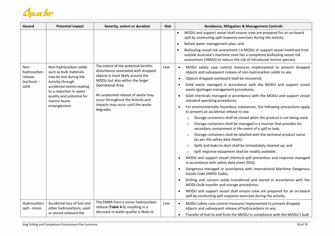
Stag Drilling and Completions Environment Plan Summary 59 of 70
Hazard Potential impact Severity, extent or duration Risk Avoidance, Mitigation & Management Controls
• MODU and support vessel shall ensure crew are prepared for an on-board spill by conducting spill response exercises during the activity;
• Ballast water management plan; and
• Biofouling vessel risk assessment ( A MODU or support vessel mobilised from outside Australia’s maritime zone has a completed biofouling vessel risk assessment (VRASS) to reduce the risk of introduced marine species).
Non-hydrocarbon release (surface) – solid
Non-hydrocarbon solids such as bulk materials may be lost during the Activity through accidental events leading to a reduction in water quality and potential for marine fauna entanglement.
The extent of the potential benthic disturbance associated with dropped objects is most likely around the MODU but also within the larger Operational Area. An unplanned release of waste may occur throughout the Activity and impacts may occur until the waste degrades.
Low • MODU safety case control measures implemented to prevent dropped objects and subsequent release of non-hydrocarbon solids to sea;
• Objects dropped overboard shall be recovered; • Solid waste managed in accordance with the MODU and support vessel
waste (garbage) management procedures; • Solid chemicals managed in accordance with the MODU and support vessel
standard operating procedures;
• For environmentally hazardous substances, the following precautions apply to prevent an accidental release to sea: o Storage containers shall be closed when the product is not being used; o Storage containers shall be managed in a manner that provides for
secondary containment in the event of a spill or leak; o Storage containers shall be labelled with the technical product name
(as per the safety data sheet); o Spills and leaks to deck shall be immediately cleaned up; and o Spill response equipment shall be readily available.
• MODU and support vessel chemical spill prevention and response managed in accordance with safety data sheet (SDS);
• Dangerous managed in accordance with International Maritime Dangerous Goods Code (IMDG Code);
• Drilling and cement solids transferred and stored in accordance with the MODU bulk transfer and storage procedures;
• MODU and support vessel shall ensure crew are prepared for an on-board spill by conducting spill response exercises during the activity.
Hydrocarbon spill - minor
Accidental loss of fuel and other hydrocarbons, used or stored onboard the
The EMBA from a minor hydrocarbon release (Table 4-1) resulting in a decrease in water quality is likely to
Low • MODU safety case control measures implemented to prevent dropped objects and subsequent release of hydrocarbons to sea;
• Transfer of fuel to and from the MODU in compliance with the MODU’s bulk
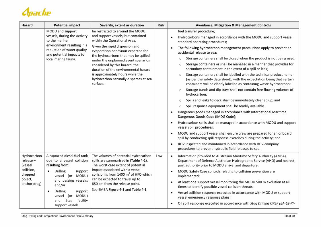
Stag Drilling and Completions Environment Plan Summary 60 of 70
Hazard Potential impact Severity, extent or duration Risk Avoidance, Mitigation & Management Controls MODU and support vessels, during the Activity to the marine environment resulting in a reduction of water quality and potential impacts to local marine fauna.
be restricted to around the MODU and support vessels, but contained within the Operational Area. Given the rapid dispersion and evaporation behaviour expected for the hydrocarbons that may be spilled under the unplanned event scenarios considered by this hazard, the duration of the environmental hazard is approximately hours while the hydrocarbon naturally disperses at sea surface.
fuel transfer procedure; • Hydrocarbons managed in accordance with the MODU and support vessel
standard operating procedures;
• The following hydrocarbon management precautions apply to prevent an accidental release to sea: o Storage containers shall be closed when the product is not being used; o Storage containers or shall be managed in a manner that provides for
secondary containment in the event of a spill or leak; o Storage containers shall be labelled with the technical product name
(as per the safety data sheet); with the expectation being that certain containers will be clearly labelled as containing waste hydrocarbon;
o Storage bunds and dip trays shall not contain free flowing volumes of hydrocarbon;
o Spills and leaks to deck shall be immediately cleaned up; and o Spill response equipment shall be readily available.
• Dangerous goods managed in accordance with International Maritime Dangerous Goods Code (IMDG Code);
• Hydrocarbon spills shall be managed in accordance with MODU and support vessel spill procedures;
• MODU and support vessel shall ensure crew are prepared for an onboard spill by conducting spill response exercises during the activity; and
• ROV inspected and maintained in accordance with ROV company procedures to prevent hydraulic fluid releases to sea.
Hydrocarbon release – (vessel collision, dropped object, anchor drag)
A ruptured diesel fuel tank due to a vessel collision resulting from:
• Drilling support vessel (or MODU) and passing vessels; and/or
• Drilling support vessel (or MODU) and Stag facility support vessels.
The volumes of potential hydrocarbon spills are summarised in (Table 4-1). The worst case extent of potential impact associated with a vessel collision is from 1400 m3 of HFO which can be expected to travel up to 850 km from the release point. See EMBA Figure 4-1 and Table 4-1
Low • Information provided to Australian Maritime Safety Authority (AMSA), Department of Defence Australian Hydrographic Service (AHO) and nearest port authority prior to MODU arrival and departure;
• MODU Safety Case controls relating to collision prevention are implemented;
• At least one support vessel monitoring the MODU 500 m exclusion at all times to identify possible vessel collision threats;
• Vessel collision response executed in accordance with MODU or support vessel emergency response plans;
• Oil spill response executed in accordance with Stag Drilling OPEP (EA-62-RI-

Stag Drilling and Completions Environment Plan Summary 61 of 70
Hazard Potential impact Severity, extent or duration Risk Avoidance, Mitigation & Management Controls Heavy fuel oil (HFO) spill due to a drilling support vessel (or MODU) collision with the Offtake tanker. Stag crude may be spilt at surface due to a collision between:
• the support vessel and the Offtake Tanker; or
• support vessel and the FSO.
A subsurface release from occur as a result of pipe damage due to: • anchor drag; or • dropped object.
The worst-case environmental incident resulting from a vessel collision is the rupturing of a MODU fuel tank resulting in the release of marine diesel to the environment and subsequent impacts to water quality and marine fauna.
10002.2); and • MODU safety case control measures implemented to prevent dropped
objects and subsequent release of non-hydrocarbon solids to sea.

Stag Drilling and Completions Environment Plan Summary 62 of 70
8. MANAGEMENT APPROACH
The Stag drilling and completions activities will be managed in compliance with all measures and controls detailed within the EP accepted by NOPSEMA under the OPGGS (E) Regulations, other environmental legislation and Apache’s Management System (e.g. Apache Environmental Management Policy).
The objective of the EP is to ensure that potential adverse environmental impacts associated with routine operational events and unplanned events associated with the Activity, are identified and assessed, and to stipulate mitigation measures to avoid and/or reduce any adverse impacts to the marine environment to ALARP.
The EP details specific performance outcomes, standards and procedures, and identifies the range of controls to be implemented (consistent with the standards) to achieve the performance outcomes. The controls for the Activity are summarised in Section 7. The EP also identifies the specific measurement criteria and records to be kept to demonstrate the achievement of each performance outcomes.
As described in the EP, the implementation strategy includes the following:
1. Details on the systems, practices and procedures to be implemented;
2. Key roles and responsibilities;
3. Training, competencies and ongoing awareness;
4. Monitoring, auditing, management of non-conformance and review;
5. Incident investigation, reporting and follow up;
6. Records Management;
7. Incident response including an Oil Spill Contingency Plan (OSCP); and
8. Reporting.
During the period that activities described in the EP are undertaken, Apache will ensure environmental performance is managed through an inspection and monitoring regime undertaken by Apache representatives or rig OIM and vessel masters based on the rig and vessels, respectively. This will include daily, weekly and monthly monitoring and is recorded via a number of checklist and inspection documents that are sent to the Apache HSE Manager or delegate. Feedback from the ongoing monitoring also informs the environment plans developed for other Apache oil and gas activities, through the risk assessment stage, and the internal review of these documents prior to submission, providing opportunity for continuous improvement.
Non-conformances (non-conformances relate to not complying with the environmental performance outcomes and/or performance standards) from audits are formally documented in an audit report and distributed to the Apache Drilling Manager, Apache HSE Manager, Client Site (Apache) Representative and Offshore Contractor Representative. An end-of-activity environmental performance report will be produced which will include a ‘lessons learnt’ section to help facilitate continuous improvement for future projects.
All personnel are informed of the need to report HSE incident and hazards through inductions and regular operations meetings. HSE incidents and hazards will be documented in Apache’s incident management system (Enablon) and significant incidents will be investigated through a roots cause analysis. Incident notification and reporting to NOPSEMA and other regulators will be conducted as per the OPGGS (E) Regulations, as detailed within the EP. Reported HSE incidents and hazards will be communicated to personnel during daily operational meetings

Stag Drilling and Completions Environment Plan Summary 63 of 70
9. HYDROCARBON SPILL RESPONSE ARRANGEMENTS
Credible hydrocarbon spill scenarios are summarised in (Table 4-1). In the event of a spill, initial actions will be undertaken in accordance with the MODU/ Vessel Shipboard Oil Pollution Emergency Plan (SOPEP). Should the spill require further action, Apache will respond in accordance with the OPEP.
The response strategies evaluated and deemed applicable include:
• Source control;
• Monitor and Evaluate;
• Physical Dispersion;
• Chemical Dispersion;
• Protection and Deflection;
• Containment and Recovery;
• Shoreline Cleanup;
• Oiled Wildlife Response; and
• Operational and Scientific Monitoring.
A justification and description summary of these strategies is provided in Table 9-1.
Table 9-1: Applicable oil spill response strategies for the Activity
Oil Spill Response Strategy
Applicability Justification
HFO Crude Diesel
Source control Yes Yes Yes
Source control is one of the first response strategies implemented when mounting a spill response. Source control minimises the volume of hydrocarbons lost to the environment by securing the source of the spill.
Monitor and evaluate Yes Yes Yes
Surveillance actions are used to monitor and evaluate the dispersion of the released hydrocarbon, and to identify and report on any potential contacts to flora and fauna that may occur while the spill disperses. Surveillance results are used to assist in escalating or de-escalating response strategies as required.
Physical dispersion Yes Yes No
Physical dispersion is undertaken by running vessels through the plume and using the turbulence developed by the propellers to break up the slick. Once dispersed in the water column the smaller droplet sizes enhance the biodegradation process. Stag Crude: Physical dispersion will be used on Stag crude only on targeted, small, breakaway areas where the oil thickness has reduced to a thin surface sheen. HFO: Physical dispersion will not be applied as a main strategy to the HFO as the weathering modelling undertaken by APASA (2013b) indicates that HFO is not amenable to entrainment. However, it may be used opportunistically for small breakaway sheens. Diesel: Physical dispersion will not be applied to a diesel spill because of the nature of the product—preferentially relying on evaporation rather than dispersing toxic components of the fuel into the water column.

Stag Drilling and Completions Environment Plan Summary 64 of 70
Oil Spill Response Strategy
Applicability Justification
HFO Crude Diesel
Surface chemical dispersion
Yes Yes No
Chemical dispersant is applied to break down the hydrocarbons and allow/enhance dispersion into the water column, thereby reducing potential shoreline contact. Where operational monitoring indicates that a sensitive receptor is at risk, chemical dispersant may be viable, either by vessel or plane. Stag Crude: Dispersants have been tested for efficacy on Stag crude and are expected to be effective within 72 hours from release. HFO: Dispersants have variable effectiveness on HFO and are expected to be effective within 24-48 hours from release. Diesel: Dispersants will not be applied to a diesel spill due to its high evaporative and dispersion rates in the marine environment. Allowing diesel to naturally weather from the sea surface rather than introduce it into the water column by adding dispersants, reduces the interaction of toxic compounds with aquatic biota.
Protection and deflection
Yes Yes No
Protection and deflection activities involve the use of booms to protect sensitive receptors, to deflect spills away from sensitive receptors or shorelines, or to deflect spills to an area that provides increased opportunity for recovery activities. Activities would be focused on areas of high protection value based upon real time operational surveillance. Stag Crude and HFO: Viable option for protection of sensitive shorelines in low energy environments. Diesel: The diesel spill is not predicted to contact shorelines.
Containment and recovery
Yes Yes No
If weather conditions allow (generally less than 10 to 15 knots), offshore containment and recovery, including the use of booms and skimmers, can offer a preventive form of protection to sensitive receptors. Stag Crude and HFO: Viable option for removing significant quantities of Stag Crude and HFO from the environment. Appropriate skimmers (mechanical) and booms can be used at sea. Diesel: Due to the rapid evaporation rate and tendency of diesel to disperse naturally, in conjunction with the ineffectiveness of containment and recovery methods on thin surface diesel films, the use of containment and recovery as a response strategy for a diesel spill is not applicable.
Shoreline clean-up Yes Yes No
This response has potential to cause more harm due to secondary disturbance associated with the clean-up, so applicability is based on using aerial surveillance reconnaissance, the Oiled Shoreline Response Team (OSRT) and Net Environmental Benefit Analysis (NEBA) in the shoreline clean-up assessment. High volume, low pressure flushing may be considered if the oil enters high priority/ slow recovery habitats such as mangroves or wetlands. Stag Crude and HFO: Viable option for removing significant

Stag Drilling and Completions Environment Plan Summary 65 of 70
Oil Spill Response Strategy
Applicability Justification
HFO Crude Diesel
quantities of Stag Crude and HFO from the environment. Diesel: The diesel spill is not predicted to contact shorelines.
Oiled wildlife response
Yes Yes Yes
Oiled wildlife response operations may be required to deter fauna from an area that has been or is likely to be oiled and if fauna is oiled. Potential impacts to fauna from capturing and cleaning can range from disruption to natural activities, injury or death. Applicable for marine fauna that come close to the spill when on the water and shorelines and those affected by hydrocarbons.
Operational and Scientific Monitoring
Yes Yes Yes
Extent of spill to determine the extent of operational and scientific monitoring. Resources are available to implement operational and scientific monitoring as required.
In situ burning No No No
In-situ burning is not an applicable response strategy given several limiting factors that are likely to prevent implementation. For in-situ burning to be undertaken oil has to be thicker than 1-2 mm and as diesel tends to have high evaporation rates and spread into very thin films this strategy is not applicable for this activity. In-situ burning cannot be undertaken in rough conditions as containment is likely to be interrupted by winds greater than approximately 20 knots and waves are higher than 3 feet (Allen 1990). As such, this response strategy is not applicable for this Activity.
9.1 Net Environmental Benefit Analysis (NEBA)
During any response incident, there is a documented decision making process to ensure that response strategies are identified and evaluated prior to implementation via the Incident Action Plan (IAP). The Incident Control Team use the NEBA process to inform the development and refinement of the IAPs, to ensure the most effective response strategies with the least detrimental environmental impacts are identified, documented and executed. The Environmental Team Lead is responsible for reviewing the priority receptors identified within the EP and the OPEP, and with real time knowledge of the fate and transport of the spill, apply the NEBA.
The application of the NEBA is to:
• Identify sensitivities within the area potentially affected by a spill at that time of the year;
• Assist in prioritising and allocating resources to sensitivities with a higher ranking; and
• Assist in determining appropriate response strategies.
9.2 Oil Spill Response Resources
Oil spill response equipment and resources are a combination of Apache, AMOSC, AMSA, DoT, National Plan (NatPlan), OSRL, and other operator resources available through the AMOSPlan mutual aid arrangements. Under the MOU between AMSA and Apache, AMSA will provide all resources available through NatPlan to support an Apache spill response. The DoT coordinates the State Response Team (SRT) oil spill response personnel and equipment resources. The DoT will work with Apache in an oil spill response and will define termination criteria for the shoreline operations designed to reduce the environmental impacts and risk to ALARP in State waters. Where oil contacts shorelines in Commonwealth

Stag Drilling and Completions Environment Plan Summary 66 of 70
waters, Apache will work with the Department of the Environment to establish shoreline clean-up priorities, activities and termination criteria.
In the event of an oiled wildlife response, Apache will activate the West Australian Oiled Wildlife Response Plan (WAOWRP) and work with DPaW in determining resources and capability requirements. DPaW and Industry (AMOSC) Oiled Wildlife Advisors (OWAs) ensure minimum standards for oiled wildlife response, as outlined within the WAOWRP, are met and ensure timely mobilisation of appropriate resources (equipment and personnel) through communication with the wildlife logistics team. Apache are able to access:
• AMOSC core group responders;
• DPaW staff and approved volunteers/SMEs;
• Additional local resources under current contracts and suppliers; and
• Access international support through Wildlife Response Services.
During and post-spill scientific response monitoring activities require resources external to Apache and include specialist technical capabilities. Astron Environmental Services Pty Ltd (Astron) is contracted as Apache’s primary Control support agency for scientific response monitoring activities. If additional support is required, Apache has Master Service Agreements with other service providers to support scientific response monitoring activities.

Stag Drilling and Completions Environment Plan Summary 67 of 70
10. CONTACT DETAILS
Further information about the Stag drilling and completion activities can be obtained from:
Ashlee Crabbe
Consultation Coordinator
100 St Georges Terrace, Perth, 6000
6218 7100

Stag Drilling and Completions Environment Plan Summary 68 of 70
11. REFERENCES
Allen GR & Russell BC (1986) Fishes. Part VII. In "Faunal surveys of the Rowley Shoals, Scott Reef and Seringapatam Reef, north-western Australia" by P.F. Berry (ed.), Records of the Western Australian Museum Supplement No. 25. Western Australian Museum, Perth. pp 75-103
APASA (2013a). Dampier Spirit Collision: Oil Spill Risk Assessment. Report prepared for Apache Energy by Asia-Pacific Applied Sciences Associates (Doc no. J0201).
APASA (2013b). Quantitative Oil Spill Risk Assessment. Stag Operations Fuel Spills. Report prepared for Apache Energy by Asia-Pacific Applied Sciences Associates (Doc no. J0219).
APASA (2014). Apache Stag Permit Boundary Diesel Spills. Memorandum Report No J0314. Prepared for Apache Energy Ltd. Perth, WA.
BBG (1994) Dampier Port Authority, Environmental Management Plan. Report prepared by Bowman Bishaw Gorham Perth, for the Dampier Port Authority, Dampier.
BHPB 2005. Pyrenees Development. Draft EIS. BHP Billiton Petroleum. Perth.
BHPBIO 2011. Proposed Outer Harbour Development, Port Hedland Public Environmental Review/Draft Environmental Impact Statement. BHP Billiton Iron Ore, Perth, Western Australia.
Brewer DT, Lyne V, Skewes TD and Rothlisberg P 2007. Trophic Systems of the North West Marine Region Prepared for the Department of the Environment, Water, Heritage and the Arts by CSIRO Marine and Atmospheric Research, Cleveland, Queensland
Bulman C (2006) Trophic Webs and Modelling of Australia’s North West Shelf. North West Shelf Joint Environmental Management Study: Technical Report No. 9. CSIRO Marine and Atmospheric Research, Hobart, Tasmania, CSIRO Marine and Atmospheric Research.
CALM (2005) Management Plan for the Ningaloo Marine Park and Muiron Islands Marine Management Area 2005 – 2015 Management Plan No. 52. Department of Conservation and Land Management, Perth, Western Australia.
Chevron 2010. Draft Environmental Impact Statement/Environmental Review and Management Programme for the Proposed Wheatstone Project Volume 1 (Chapters 1 to 6), 6.0 Overview of Existing Environment. Chevron Australia Pty Ltd, Perth, Western Australia
DEC (2007a) Management Plan for the Montebello/Barrow Islands Marine Conservation Reserves 2007–2017: Management Plan No. 55. Department of Environment and Conservation, Perth, Western Australia.
DEC (2007b) Management Plan for the Rowley Shoals Marine Park 2007–2017: Management Plan No. 56. Department of Environment and Conservation, Perth, Western Australia.
DPaW (2013a) New and proposed marine parks and reserves. Online, retrieved 23rd April 2014. Available at: http://www.dpaw.wa.gov.au/management/marine/marine-parks-and-reserves/69-new-and-proposed-marine-parks-and-reserves.
DEWHA 2008. The North-west Marine Bioregional Plan: Bioregional profile: A Description of the Ecosystems, Conservation Values and Uses of the North-West Marine Region. Department of the Environment Water, Heritage and the Arts, Canberra, ACT
DSEWPaC (2012) Marine bioregional plan for the North-west Marine Region. Department of Sustainability, Environment, Water, Population and Communities, Canberra, ACT. 269 pp.
DoE (2014) Commonwealth marine reserves. Department of the Environment, Canberra, Act. Available at http://www.environment.gov.au/topics/marine/marine-reserves [Accessed on 02 April 2014]
Director of National Parks (2012a) Concerning the Proposed Proclamation of 40 Commonwealth marine reserves (and the related revocation of seven existing Commonwealth reserves and the revocation of the

Stag Drilling and Completions Environment Plan Summary 69 of 70
Coral Sea Conservation Zone); and The amendment of the names of four existing Commonwealth marine reserves. Report to the Director of National Parks under the Environment Protection and Biodiversity Conservation Act 1999 Section 351.
Fletcher, W J and Santoro, K. (2013) Status Reports of the Fisheries and Aquatic Resources of Western Australia 2012/13 (eds).: The State of the Fisheries. Department of Fisheries, Western Australia.
Fox, NJ and Beckley, LE (2005). Priority areas for conservation of Western Australian coastal fishes: A comparison of hotspot, biogeographical and complementarity approaches. Biological Conservation, 125: 399-410.
Gage JD, Tyler PK 1992. Deep-sea Biology: A Natural History of Organisms at the Deep Sea Floor. Cambridge University Press, Cambridge, UK
Hooper JNA, Ekins M (2004)‘Collation and validation of museum collection databases related to the distribution of marine sponges in Northern Australia. Unpublished report to the National Oceans Office, Hobart
Holloway, PE and Nye, HC 1985 Leeuwin current and wind distributions on the southern part of the Australian North West Shelf between January 1982 and July 1983. Australian Journal of Marine and Freshwater Research 36(2): 123–137
Hutchins JB (2003). Checklist of marine fishes of the Dampier Archipelago, Western Australia. Pp. 453-478. In: Wells, F.E., Walker D.I. & Jones D.S. (eds). The Marine Flora and Fauna of Dampier, Western Australia. Western Australian Museum, Perth.
Hutchins JB (2004) Fishes of the Dampier Archipelago, Western Australia pp. 343-398. In: Jones D.S. (ed). Report on the results of the Western Australia Museum/Woodside Energy Ltd. Partnership to explore the Marine Biodiversity of the Dampier Archipelago. Western Australia 1998-2002. Records of the Western Australian Museum Supplement No. 66: 343-398.
Last P, Lyne V, Yearsley G, Gledhill D, Gomon M, Rees T, White, W (2005) Validation of national demersal fish datasets for the regionalisation of the Australian continental slope and outer shelf (>40 m depth). Australian Government Department of the Environment and Heritage & CSIRO Marine and Atmospheric Research, Hobart
Mackie M, Nardi A, Lewis P and Newman S (2007) Small Pelagic Fishes of the North-west Marine Region, Prepared for the Department of the Environment and Water Resources by Department of Fisheries, Perth, Western Australia.
Sainsbury KJ, Campbell RA and Whitlaw AW (1992) Effects of trawling on the marine habitat on the North West Shelf of Australia and implications for sustainable fisheries management. In: Hancock D. A. (Editor). Sustainable Fisheries through Sustaining Fish Habitat. Canberra Australia. Australian Government Publishing Service, 1993, 137–145. Aust Soc. for Fish. Biol. Workshop, Victor Harbour, SA, 12–13 August 1992.
SSE 1993. Review of oceanography of North West Shelf and Timor Sea regions pertaining to the environmental impact of the offshore oil and gas industry. Vol I prepared for Woodside Offshore Petroleum and the APPEA Review Project of Environmental Consequences of Development Related to the Petroleum Production in the Marine Environment: Review of Scientific Research, Report E1379, October 1993
Sinclair Knight Merz (2009) Baseline Intertidal Report. Cape Lambert Port B Development. RioTinto Australia Pty Ltd.
Williams A, Dunstan P, Althaus F, Barker B, McEnnulty F, Gowlett-Holmes K & Keith G (2010) Characterising the seabed biodiversity and habitats of the deep continental shelf and upper slope off the Kimberley coast, NW Australia. Report produced for Woodside Energy Ltd. CSIRO, pp. 95
Wilson B 2013. The Biogeography of the Australian North West Shelf: Environmental Change and Life’s Response. Elsevier. Western Australian Museum, Perth, Western Australia

Stag Drilling and Completions Environment Plan Summary 70 of 70
WNI 1995. Preliminary report on ambient and non-cyclonic design criteria for the Stag location. WNI Science & Engineering. December 1995
WNI 1996. Metocean Conditions on the North West Shelf of Australia, Cape Lambert to the North West Cape Relating to Jack-up Drilling Operation. (DR-50-ED-001). July 1996
Woodside (2005). The Vincent Development. Draft EIS. EPBC Referral 2005/2110.


![STAG DIESEL (Pompowtryskiwacze)[2017.10.19] PL EN RU ES PT ITfile.autogasmarket.ua/stag/docs/STAG-DIESEL-Unit... · 2020. 1. 21. · I info@ac.com.pl STAG DIESEL 3 Wiring diagram](https://static.fdocuments.in/doc/165x107/6089b495f716d74a545a5355/stag-diesel-pompowtryskiwacze20171019-pl-en-ru-es-pt-2020-1-21-i-infoaccompl.jpg)