STAFF REPORT C24 - CA State Lands Commission
28
-1- STAFF REPORT C24 A 7 04/05/19 W 27199 S 6 G. Asimakopoulos GENERAL LEASE – PUBLIC AGENCY USE APPLICANT: California Department of Transportation (Caltrans) PROPOSED LEASE: AREA, LAND TYPE, AND LOCATION: Sovereign land in the American River, adjacent to Assessor’s Parcel Numbers 001-0070-005 and 274-0120-010, in the city of Sacramento, Sacramento County. AUTHORIZED USE: Use of a temporary construction easement; installation, use, and maintenance of a temporary construction trestle; removal of existing rock slope protection; installation of filter fabric at the bridge piers; placement of new rock slope protection at the bridge piers; and removal of the temporary construction trestle; as part of the American River Bridge Scour Repair Project. LEASE TERM: 6 years, beginning April 5, 2019. CONSIDERATION: The public benefit, with the State reserving the right at any time to set a monetary rent if the Commission finds such action to be in the State’s best interests. SPECIFIC LEASE PROVISIONS: 1. Lessee shall not place, attach, or authorize placement or attachment of any utilities or other improvements on the bridge or within the Lease Premises without the Commission’s prior review and approval. Separate leases or subleases are required and shall be obtained for all utilities not operated by Lessee. 2. Lessee shall place warning signage or buoys, or both, clearly visible from the shore and in the water, both upstream and downstream of the construction site, to provide notice of the Project
Transcript of STAFF REPORT C24 - CA State Lands Commission

-1-
STAFF REPORT
C24 A 7 04/05/19 W 27199 S 6 G. Asimakopoulos
GENERAL LEASE – PUBLIC AGENCY USE APPLICANT:
California Department of Transportation (Caltrans)
PROPOSED LEASE: AREA, LAND TYPE, AND LOCATION:
Sovereign land in the American River, adjacent to Assessor’s Parcel Numbers 001-0070-005 and 274-0120-010, in the city of Sacramento, Sacramento County.
AUTHORIZED USE:
Use of a temporary construction easement; installation, use, and maintenance of a temporary construction trestle; removal of existing rock slope protection; installation of filter fabric at the bridge piers; placement of new rock slope protection at the bridge piers; and removal of the temporary construction trestle; as part of the American River Bridge Scour Repair Project.
LEASE TERM: 6 years, beginning April 5, 2019.
CONSIDERATION:
The public benefit, with the State reserving the right at any time to set a monetary rent if the Commission finds such action to be in the State’s best interests.
SPECIFIC LEASE PROVISIONS:
1. Lessee shall not place, attach, or authorize placement or attachment of any utilities or other improvements on the bridge or within the Lease Premises without the Commission’s prior review and approval. Separate leases or subleases are required and shall be obtained for all utilities not operated by Lessee.
2. Lessee shall place warning signage or buoys, or both, clearly
visible from the shore and in the water, both upstream and downstream of the construction site, to provide notice of the Project

STAFF REPORT NO. C24 (CONT’D)
-2-
and to advise the public to exercise caution. Lessee shall place and maintain such signage at all times during the term of the Project and shall notify the California Department of Parks and Recreation’s Division of Boating and Waterways of the location, description, and purpose of such signage upon its installation and removal.
STAFF ANALYSIS AND RECOMMENDATION:
Authority: Public Resources Code sections 6005, 6216, 6301, 6501.1, and 6503; California Code of Regulations, title 2, sections 2000 and 2003.
Public Trust and State’s Best Interests Analysis:
On November 18, 1965, the Commission authorized the issuance of a continuous Public Agency Permit and Right-of-Way Map to the State Division of Highways (Caltrans), pursuant to Section 101.5 of the Streets and Highways Code, for the existing American River Bridge, Bridge No. 24-0001L (Bridge), located on State Route 160 at the American River (Item C26, November 18, 1965). The bridge is a five-span closed-spandrel concrete arch bridge, originally built in 1928. It was widened to a three-lane bridge to support additional lanes of traffic in 1934, and in 1987, a single light rail track was introduced to provide passenger service in both directions. The existing structure is now approximately 55 feet wide and 620 feet long. In July 2010, the Bridge’s scour potential was assessed in accordance with the Federal Highway Administration’s Technical Advisory T5140.23, “Evaluating Scour at Bridges,” and within current Caltrans guidelines. It was determined that the Bridge was scour critical. Caltrans has applied for a General Lease – Public Agency Use, for the construction, use, and maintenance of a temporary construction trestle, and use of a temporary construction easement in the American River as part of the Bridge Scour Repair Project (Project). The purpose of the Project is to preserve the integrity and stability of the Bridge by reducing further scour. The proposed lease area runs parallel to the south bound State Route 160 portion of the bridge (see Exhibit B). Caltrans has selected Rock Slope Protection (RSP) as the preferred alternative. The existing RSP will be removed down to the mudline, filter fabric will be placed around and on the existing piers, and new RSP will be placed around each pier. The footprint of the RSP around each pier will extend approximately 20 inches beyond the existing piers. Removal and

STAFF REPORT NO. C24 (CONT’D)
-3-
installation of new RSP is expected to be performed with an excavator and/or crane. A temporary trestle will be utilized during construction of the Project. The trestle would be constructed from the north side of the river at the bottom of an existing ramp leading down from an adjacent mobile home park. The trestle is expected to be 20 to 30 feet wide and extend from the north bank to the south side of pier 2 (the southernmost pier). The south levee will not be used for construction access and the trestle will not extend to the south levee. Sections of trestle fingers will extend laterally from the main trestle along each side of the bridge piers to provide working access under the Bridge. The fingers would be constructed in the same manner as the main trestle across the channel and would also be 20 to 30 feet wide. A portion of the trestle will be designed and constructed in a manner such that it can be shifted onto an adjacent portion of trestle to make an opening for boats and other river traffic to pass through. The temporary trestle will be constructed on bents supported by temporary 18 to 20-inch-diameter steel pipe piles capped or braced by steel beams. Each bent will be comprised of five piles, each bent spaced 30 to 35 feet apart. Construction of the temporary trestle is, therefore, expected to require the temporary installation of approximately 306, 18 to 20-inch-diameter steel pipe piles. The steel pipe piles proposed for the temporary trestle will be installed by pile-driving. The piles may be initially placed using a vibratory hammer; however, the ultimate steel pipe pile driving is accomplished using an impact pile-driving hammer. The steel pipe piles for the temporary trestle are expected to be driven to a depth of approximately 30 feet below the mudline. Following construction activities, the temporary trestle will be completely disassembled and removed. The temporary steel pipe piles are expected to be removed using a vibratory extractor. The contractor will remove portions of the trestle once the work requiring those portions has been completed so that the trestle can be progressively pulled and disassembled. Construction of the Project is planned to be completed over two construction seasons, and in-water construction activities will be limited to the period from July 15 to October 15 for each season. At the completion of the first season, the decking of the trestle can be removed leaving only the piles in place until the next season. These piles will cause minimal river-bottom disturbances and other impacts between seasons. The public’s right to access and use California’s navigable waters is a mandate of the California Constitution (article X, section 4), a condition of

STAFF REPORT NO. C24 (CONT’D)
-4-
statehood in the Act of Admission of the State of California into the Union (9 Stat. 452, Sept. 9, 1850), and a responsibility of all involved public agencies pursuant to the common law Public Trust Doctrine. Bridges are often the most logical location for the public to access a waterway because kayakers, rafters, and others may legally utilize the public access easements around bridges to enter and exit navigable waterways. Furthermore, bridges and roads are critical infrastructure that are necessary to facilitate the movement of goods, people, and services throughout the State. The movement of goods is a critical part of local, state and national commerce; and the creation and maintenance of the instrumentalities of commerce is essential to a thriving economy. While the existing Bridge does not currently facilitate water-dependent activities, it facilitates commerce and does not interfere with navigation, water-dependent recreation, or other Public Trust uses along the American River in any substantive way. The proposed lease includes certain provisions protecting the public use of the proposed lease area by requiring Caltrans to obtain necessary permits for the Project, to place warning signs and buoys near the Bridge, and to minimize interference with public use to the extent feasible. The Project is intended to reinforce the Bridge in the long-term interest of public health and safety. Caltrans has also adopted a Mitigation and Monitoring Program to substantially reduce or eliminate potentially significant impacts resulting from the Project. The lease does not alienate the State’s fee simple interest or permanently impair public rights. The lease requires Caltrans to conduct all repair and maintenance work safely and indemnify the Commission in the event of any liability resulting from the proposed lease. The lease does not grant the lessee exclusive rights to the lease premises and is also limited to a term of 6 years. Staff believes activities under the lease will not substantially impair the public rights to navigation and fishing or substantially interfere with the Public Trust needs and values at this location, at this time, and for the foreseeable term of the lease. Staff believes this use of State land, by a public agency, for a public benefit is in the best interests of the State.
Climate Change Analysis: The Highway 160 Bridge is located in the Lower American River. The Project is intended to reinforce the structural armoring of the bridge piers and footings within the riverbed. River flows in the Lower American River are managed by controlled releases from Nimbus Dam.

STAFF REPORT NO. C24 (CONT’D)
-5-
The lease area is not tidally influenced, and therefore would not be subject to sea-level rise. However, as stated in Safeguarding California Plan: 2018 Update (California Natural Resources Agency 2018), climate change is projected to increase the frequency and severity of natural disasters related to flooding, drought, and storms. In rivers, more frequent and powerful storms can result in increased flooding conditions and damage from storm-created debris. Conversely, prolonged droughts could dramatically reduce river flow and water levels, leading to loss of public access and navigability. Climate change will further influence riverine areas by changing erosion and sedimentation rates, and flooding and storm flow, as well as runoff, will likely increase scour, decreasing bank stability at a faster rate.
Due to these climate change influences, the Bridge could need more frequent reinforcement in the future to withstand higher levels of flood exposure and more frequent storm events. Regular maintenance, as required by the lease, will reduce the likelihood of severe structural degradation or dislodgement.
Conclusion:
For the reasons stated above, staff believes the issuance of the proposed lease will not substantially impair the public rights to navigation, fishing, or other Public Trust needs and values at this location, at this time, and for the foreseeable term of the proposed lease; and is in the best interests of the State.
OTHER PERTINENT INFORMATION: 1. This action is consistent with Strategy 1.1 of the Commission’s Strategic
Plan to deliver the highest levels of public health and safety in the protection, preservation, and responsible economic use of the lands and resources under the Commission’s jurisdiction.
2. A Mitigated Negative Declaration, State Clearinghouse No. 2017072043, was prepared for this Project by Caltrans and adopted on January 25, 2018. Staff has reviewed this document and the avoidance, minimization, and mitigation measures that were made a condition of Project approval.
3. This activity involves lands identified as possessing significant environmental values pursuant to Public Resources Code section 6370 et seq., but such activity will not affect those significant lands. Based upon staff’s consultation with the persons nominating such lands and through the California Environmental Quality Act (CEQA) review process, it is

STAFF REPORT NO. C24 (CONT’D)
-6-
staff’s opinion that the project, as proposed, is consistent with its use classification.
APPROVALS REQUIRED:
U.S. Army Corps of Engineers U.S. Fish and Wildlife Service National Marine Fisheries Service California Department of Fish and Wildlife Central Valley Regional Water Quality Control Board
EXHIBITS:
A. Land Description B. Site and Location Map C. Mitigation Monitoring Program
RECOMMENDED ACTION: It is recommended that the Commission:
CEQA FINDING: Find that a Mitigated Negative Declaration, State Clearinghouse No. 2017072043, including avoidance, minimization, and mitigation measures, was prepared by Caltrans and adopted on January 25, 2018, for this Project and that the Commission has reviewed and considered the information contained therein; that in the Commission’s independent judgment, the scope of activities to be carried out under the lease to be issued by this authorization have been adequately analyzed; that none of the events specified in Public Resources Code section 21166 or State CEQA Guidelines section 15162 resulting in any new or substantially more severe significant impact has occurred; and, therefore no additional CEQA analysis is required.
Adopt the Mitigation Monitoring Program, as contained in the attached Exhibit C.
PUBLIC TRUST AND STATE’S BEST INTERESTS:
Find that the issuance of the proposed lease will not substantially impair the public rights to navigation, fishing, or other Public Trust needs and values at this location, at this time, and for the foreseeable term of the lease; and is in the best interests of the State.

STAFF REPORT NO. C24 (CONT’D)
-7-
SIGNIFICANT LANDS INVENTORY FINDING: Find that this activity is consistent with the use classification designated by the Commission for the land pursuant to Public Resources Code section 6370 et seq.
AUTHORIZATION:
Authorize issuance of a General Lease – Public Agency Use to the California Department of Transportation beginning April 5, 2019, for a term of 6 years, for the use of a temporary construction easement; installation, use, and maintenance of a temporary construction trestle; removal of existing rock slope protection; installation of filter fabric at the bridge piers; placement of new rock slope protection at the bridge piers; and removal of the temporary construction trestle; as part of the American River Bridge Scour Repair Project; as described in Exhibit A, Land Description, and shown on Exhibit B, Site and Location Map (for reference purposes only), attached and by this reference made a part hereof; consideration being the public benefit, with the State reserving the right at any time to set a monetary rent, as specified in the lease, if the Commission finds such action to be in the State’s best interests.


S
O
U
T
H
B
O
U
N
D
R
O
U
T
E
1
6
0
N
O
R
T
H
B
O
U
N
D
R
O
U
T
E
1
6
0
A
P
P
R
O
X
.
S
H
O
R
E
L
I
N
E
A
P
P
R
O
X
.
S
H
O
R
E
L
I
N
E
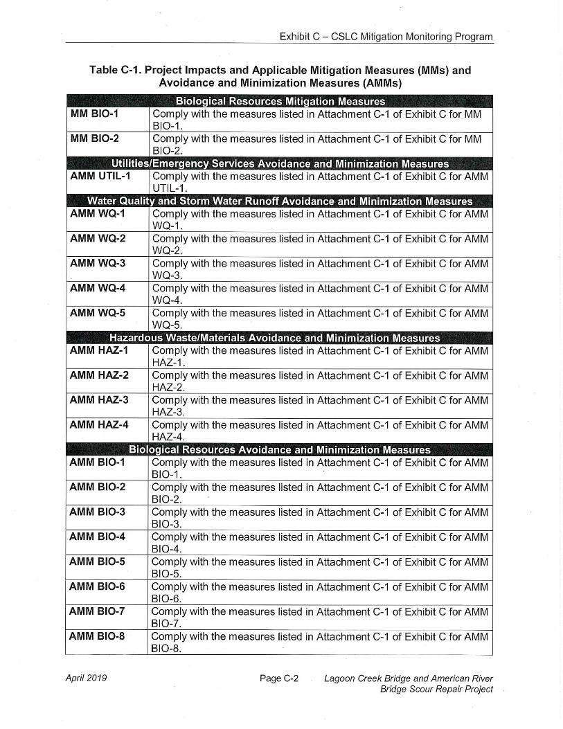
APN274-0120-010
APN
001-0070-005
LEASE
AREA
W 27199CALIFORNIA DEPARTMENT
OF TRANSPORTATIONGENERAL LEASE -
PUBLIC AGENCY USESACRAMENTO COUNTY
MAP SOURCE: USGS QUAD
STATE ROUTE 160 BRIDGE, IN SACRAMENTO
This Exhibit is solely for purposes of generally defining the lease premises, isbased on unverified information provided by the Lessee or other parties and isnot intended to be, nor shall it be construed as, a waiver or limitation of any Stateinterest in the subject or any other property.
SITE
RGB 3/01/18
Exhibit BNO SCALE
NO SCALE SITE
LOCATION
SITE
SACRAMENTO
AutoCAD SHX Text
AMERICAN RIVER
AutoCAD SHX Text
.


![N HD C24 064WO ATFH V3 - Allied Electronics · C24 ‐On‐Gl ewhaven ... le of Commands [7] Tim 8080 ...](https://static.fdocuments.in/doc/165x107/5b1b921a7f8b9a28258eb02f/n-hd-c24-064wo-atfh-v3-allied-c24-ongl-ewhaven-le-of-commands-7.jpg)