Do livestock reduce crop yields in conservation farming systems? James Hunt
Upload
hoangkhanhCategory
view
213download
0
north Canterbury
St James Conservation Area

Cover: Lake Guyon. Photo: P Brady
Contact us: For gate combination details, concessions, hunting permits and other information contact: DOC – Rangiora Office32 River Road, RANGIORA 03 313 08208.00 am – 5.00 pm, Monday to [email protected]
For information on bike hire, transport and other accommodation go to: www.visithurunui.co.nz
Published byDepartment of ConservationRangiora OfficePO Box 349, Rangiora 7440New ZealandJune 2014
Map backgrounds: Geographx
All photos, unless otherwise credited, are copyright DOC.
Editing and design: Publishing Team, DOC National Office
This publication is produced using paper sourced from well-managed, renewable and legally logged forests.
Hanmer SpringsThe alpine spa resort town of Hanmer Springs is the main gateway to the St James Conservation Area.
For complete information on accommodation, bike hire, transport and other Hanmer Springs visitor services, visit the website www.visithanmersprings.co.nz or contact the Hanmer Springs i-SITE Visitor Centre on 0800 442 663.
Easy tramping track Moderate day or multi-day tramping/hikingTrack generally well formed, may be steep rough or muddySuitable for people with moderate fitness and some backcountry/remote area experienceTrack has signs, poles or markers. Major stream and river crossings are bridgedLight tramping/hiking boots required
Tramping track Challenging day or multi-day tramping/hikingTrack is mostly unformed with steep, rough or muddy sectionsSuitable for people with good fitness. Moderate to high-level backcountry skills and experience, including navigation and survival skills requiredTrack has markers, poles or rock cairnsExpect unbridged stream and river crossingsTramping/hiking boots required
Route Challenging overnight tramping/hikingTrack unformed and natural, may be rough and very steepSuitable for people with above-average fitness. High-level backcountry skills and experience, including navigation and survival skills requiredBe completely self-sufficientTrack has markers, poles or rock cairnsExpect un-bridged stream and river crossingsSturdy tramping/hiking boots required
River crossing
See page 11 for mountain bike track classifications
Track grades

Car park/entry point
Camp site
Toilets
Shelter
Information
St James Cycle Trail
St James Walkway
Tramping track
Route
4WD track
Metalled road
Public conservation land
This map is a guide only; you will need these NZTopo50 maps:BS23, BS24, BT23 and BT24.

3
Something for everyone
The diverse landscape offers a great range of recreation activities including; walking and tramping, skiing, mountain biking, fishing, kayaking, horse riding, camping, hunting, mountain climbing, picnicking, exploring/discovering, or simply just appreciating the natural peace and solitude. St James is open to motorised vehicles and dogs east of the Waiau River only. West of the Waiau River provides for more natural backcountry experiences with the St James Walkway – a great 5-day subalpine tramp.
Getting there
The west side of St James Conservation Area is accessible to walkers from State Highway 7 (Lewis Pass Road) at Boyle Village (190 km from Christchurch) and Lewis Pass. Horses, mountain bikes and motorised vehicles cannot access St James Conservation Area from this side.The east side of St James Conservation Area can be reached via Hanmer Springs. From the township take
St JameS ConServation areaSt James Conservation Area covers 78,000 ha of native beech/tawhai forests, alpine tussocklands, rivers, lakes and mountains. It was a key route for Māori between the east and west coasts, travelling through the Clarence and Waiau valleys.The area was one of the largest operating cattle and sheep stations in the country, dating back to 1862. It was purchased by the Government in 2008 for public conservation land to protect its natural, physical and cultural values and open it up to outdoor recreation and tourism. The Waiau River runs north to south through the conservation area. The western side, from Lewis Pass to the Waiau River, is characterised by mixed beech forests, open river flats and tussock grasslands rising to snowy mountain tops. In contrast, the eastern side is drier open country with matagouri, native and exotic grasses, regenerating shrublands and mountain lakes. St James Conservation Area is bordered by Molesworth Recreation Reserve to the east, Nelson Lakes National Park to the north, Lewis Pass National Reserve to the west, and Lake Sumner Forest Park to the south. Beyond Lake Tennyson the road through Rainbow Station offers 4WD or cycling adventures through to St Arnaud.
2
54
Your safety is your responsibility While access into St James Conservation Area is relatively easy, this remains a remote backcountry area. there is no cell phone coverage. Before your trip ensure you have:• Checked the latest weather forecast• Left your intentions with someone• A PLB (personal locator beacon) or
mountain radio• Enough warm clothing to spend the
night out if you have to
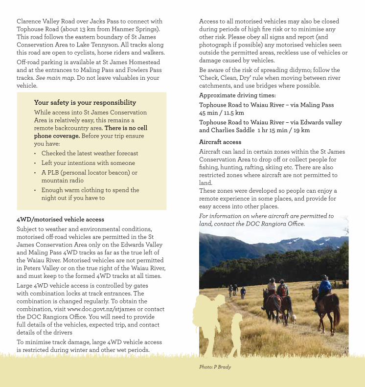
Clarence Valley Road over Jacks Pass to connect with Tophouse Road (about 13 km from Hanmer Springs). This road follows the eastern boundary of St James Conservation Area to Lake Tennyson. All tracks along this road are open to cyclists, horse riders and walkers.Off-road parking is available at St James Homestead and at the entrances to Maling Pass and Fowlers Pass tracks. See main map. Do not leave valuables in your vehicle.
4WD/motorised vehicle accessSubject to weather and environmental conditions, motorised off-road vehicles are permitted in the St James Conservation Area only on the Edwards Valley and Maling Pass 4WD tracks as far as the true left of the Waiau River. Motorised vehicles are not permitted in Peters Valley or on the true right of the Waiau River, and must keep to the formed 4WD tracks at all times. Large 4WD vehicle access is controlled by gates with combination locks at track entrances. The combination is changed regularly. To obtain the combination, visit www.doc.govt.nz/stjames or contact the DOC Rangiora Office. You will need to provide full details of the vehicles, expected trip, and contact details of the driversTo minimise track damage, large 4WD vehicle access is restricted during winter and other wet periods.
Access to all motorised vehicles may also be closed during periods of high fire risk or to minimise any other risk. Please obey all signs and report (and photograph if possible) any motorised vehicles seen outside the permitted areas, reckless use of vehicles or damage caused by vehicles.Be aware of the risk of spreading didymo; follow the ‘Check, Clean, Dry’ rule when moving between river catchments, and use bridges where possible. Approximate driving times:Tophouse Road to Waiau River – via Maling Pass45 min / 11.5 km Tophouse Road to Waiau River – via Edwards valley and Charlies Saddle 1 hr 15 min / 19 km
aircraft access Aircraft can land in certain zones within the St James Conservation Area to drop off or collect people for fishing, hunting, rafting, skiing etc. There are also restricted zones where aircraft are not permitted to land. These zones were developed so people can enjoy a remote experience in some places, and provide for easy access into other places. For information on where aircraft are permitted to land, contact the DOC Rangiora Office.
Photo: P Brady

76
te araroa Te Araroa is a walking trail from Cape Reinga to Bluff, and passes through St James Conservation Area. From Nelson Lakes National Park, it crosses into St James via the Waiau Pass Route, and follows the Waiau Pass Track along the true right of the Waiau River, before linking to the St James Walkway through to Boyle Village. Blue Lake Hut to Caroline Bivvy 9–11 hr / 12 kmCaroline Bivvy to Anne Hut 10–11 hr / 28.5 km Anne Hut to Boyle Village 12–13 hr / 31.5 kmFor more information see www.teararoa.org.nz
St James WalkwayCovering 66 km over 4–5 days, St James Walkway starts and finishes at Lewis Pass and Boyle Village on SH7 (30 km apart).The walkway is not difficult, but the climate can be extreme and the track is prone to avalanches over winter. It should not be attempted during winter months unless you are an experienced tramper. Mountain bikes and horses are not permitted on the St James Walkway. However, two marked tracks from the Waiau River allow horse riders and mountain bikers to use Christopher and Anne huts. For more comprehensive information refer to the St James Walkway brochure, or go online atwww.doc.govt.nz/stjameswalkway
Lewis Pass to Cannibal Gorge Hut – 3 hr 30 min / 7 km Cannibal Gorge Hut to Ada Pass Hut – 1 hr 30 min / 3 kmAda Pass Hut to Christopher Hut – 4 hr 30 min / 10.5 kmChristopher Hut to Anne Hut – 4 hr 30 min / 13 kmAnne Hut to Boyle Flat Hut – 7 hr 30 min/ 17 kmBoyle Flat Hut to Boyle Village – 5 hr / 14.5 kmBoyle Village to Magdalen Hut – 4 hr / 10 km
What Can You Do there?Shared-use tracksAll tracks east of the Waiau River are shared use: tramping, mountain biking, and horse riding, as well as motorised vehicles on the Maling Pass and Edwards valley 4WD tracks.
Code of conduct for shared-use tracks• Respect that other users have different, and
valid, reasons for being there.• Anticipate other users around corners or in
blind spots.• Expect the unexpected; drive/cycle at a speed
you can stop at if a hazard arises. • Do not startle other users – greet them when
approaching. • The basic give-way rule for shared-use tracks is:
4WD and other motorised vehicles give way to walkers, cyclists and horses; cyclists give way to walkers and horses; and walkers give way to horses.
• Common sense and courtesy prevail at all times.
Walking / tramping
You can walk and tramp throughout St James except in the fenced-off area around the private Ada homestead. All of the St James Cycle Trail can be walked. Note: All times shown in this section are for walking only. See main map for tracks and hut locations.

98
On Fowlers Pass
Waiau Pass track Waiau Pass Track follows the true right of the Waiau River from Anne Hut to Caroline Bivvy. After Caroline Bivvy the track becomes a route to Waiau Pass and is suitable for experienced trampers only. Those walking to Caroline Bivvy from Maling Pass can use an old 4WD track on the true left of the Waiau River (not shown on map). Cross the rabbit fence at the locked gate then follow the 4WD track for 3 km before crossing the river to join Waiau Pass Track. W1. Anne Hut to Henry Track junction 2 hr 30 min/ 6.5 km
W2. Henry Track junction to Ada Track junction 2 hr / 5.5 km
W3. Ada Track junction to Lake Guyon Track junction 1 hr 30 min / 3.2 km
Waiau Pass Track to Lake Guyon Track junction 20 min / 800 m
W4. Lake Guyon Track junction to Maling Pass 4WD track junction 2 hr / 5.5 km
Waiau Pass Track to cycle trail 5 min / 200 m
W5. Maling Pass 4WD track junction to Caroline Bivvy 3 hr 30 min / 10 km
Waiau Pass route W6. Caroline Bivvy to Waiau Pass 4–5 hr Waiau Pass to Blue Lake Hut 3–4 hr
Crossing Waiau River
Phot
os: S
teve
Bak
er
Link tracksW7. Henry Track: Waiau Pass Track junction to Saddle Spur Bridge 1 hr / 3.2 km
W8. Ada Track: Waiau Pass Track junction to Christopher Hut 1 hr 30 min / 5 km
Fowlers Pass track Fowlers Pass (1296 m) connects Fowlers Hut on Tophouse Road with Stanley Vale and Lake Guyon huts. This marked track has river crossings, scree slopes, and a variety of gradients. Please note that particularly in winter, snow can make travel difficult and the area is prone to avalanches.
E1. Fowlers Hut to Stanley Vale Hut 4 hr / 12 km
E2. Stanley Vale Hut to Lake Guyon Hut 1 hr 30 min / 4 km
Stanley river route This marked route links Charlies Saddle in the Edwards valley to Stanley Vale Hut. The route follows the Stanley River, and passes through an interesting geological area known as The Racecourse. There are several river crossings that can make travel difficult in times of high rainfall and during spring snowmelt.
E3. Stanley Vale Hut to Charlies Saddle 6 hr / 16.5 km
Walking the St James Cycle trailAll of the St James Cycle Trail can be used by trampers. The first section is an easy tramping track, following a 4WD track as it sidles up to Maling Pass at 1308 m. From here there are great views of the Spenser Range and Mt Una – the highest peak at 2300 m. From the pass the track drops more steeply to the Waiau River flats which are followed to the turn-off to Lake Guyon. Beyond the Lake Guyon junction the trail is tramping track standard.
See page 13 for track grades and distances.

1110
mountain biking mountain-bike track grades Grade 2 easy—Some gentle climbs, smooth trail. Suitable for beginner riders, the trail is predictable with no surprises. Social component with riders able to ride side by side at times, but possibly large sections of single trail.Grade 3 intermediate—narrow trail, there will be some hills to climb, obstacles may be encountered on the trail, and there may be exposure on the edge of the trail. Suitable for riders with intermediate level skills.Grade 4 advanced—steep climbs, with unavoidable obstacles on a narrow trail, and there will be poor traction in places. Possibly some walking sections. Suitable for intermediate and advanced riders.Grade 5 expert—Technically challenging, and suitable for advanced/expert riders. Physically tough. Big hills, lots of rocks, some walking likely.ungraded
Hanmer Springs is a popular mountain-biking destination, renowned for its network of tracks in the surrounding forest. In contrast, the St James Conservation Area offers spectacular backcountry mountain biking through open alpine valleys. There is a wide variety of biking experiences, ranging from short, easy rides suitable for families and novice bikers, to long, challenging rides for more advanced and adventurous bikers. All mountain-biking tracks in St James are shared-use. Please respect other users and follow the code of conduct for shared-use tracks as well as the general mountain-biking code of conduct. You can hire bikes or gear in Hanmer Springs, join an organised trip with a shuttle service, or plan your own trip. See page 21 for more information
Note: All times shown in this section are for cycling only. See main map for tracks and hut locations.
Photo: P Brady

1312
homestead runFor young families or riders with insufficient time or experience to attempt the full St James Cycle Trail, the Homestead Run will give you a taste of St James.From St James Homestead, follow the St James Cycle Trail up Peters Valley to the junction with Edwards valley 4WD Track. Head east (right) down the 4WD track towards Tophouse Road until 250 m from the gate, where the trail takes a right turn and heads down valley to connect with the road. Follow Tophouse Road down valley for 2.7 km to return to the St James Homestead. 1 hr – 1 hr 45 min / 15 km
St James Cycle trail cycling times C1. Maling Pass entrance car park to 4WD track end 1 hr – 1 hr 30 min / 11.5 km
C2. 4WD track end to Lake Guyon junction 30 – 45 min / 5.5 km
C3. Lake Guyon junction to Lake Guyon Hut 15 – 30 min / 2.5 km
C4. Lake Guyon junction to Saddle Spur Bridge 1 hr – 1 hr 30 min /11 km
C5. Saddle Spur Bridge to Pool Hut1 hr – 1 hr 30 min / 7 km
C6. Pool Hut to Charlies Saddle 45 min – 1 hr 15 min / 5.3 km
C7. Charlies Saddle to Scotties Hut 15 min / 2.2 km
C8. Scotties Hut to Peters Pass junction 1 hr – 1 hr 45 min / 10 km
C9. Peters Pass junction to St James Homestead 30 – 45 min / 7 km
C10. Peters Pass junction to Tophouse Road 15 – 30 min / 4.2 kmTophouse Rd to St James Homestead15 – 30 min / 3.4 km
the St James Cycle trail Opened in November 2010, the St James Cycle Trail was the first of the New Zealand Cycle Trail/Nga Haerenga ‘Great Rides’ to be completed.
The 64-km cycle trail starts and finishes at the Maling Pass and St James Homestead entrances which are 25 km apart along Tophouse Road.
It is recommended you start at the Maling Pass entrance as there is more downhill this way and the predominant wind comes down the valley behind you.
The beginning and end sections of the trail comprise intermediate and easy grade riding respectively. The central section comprises difficult and remote advanced grade riding, with river crossings and bike carrying in places.
The trail takes 1–2 days and you will need to have a good level of fitness and intermediate level skills to undertake the full trail.
For more comprehensive information, refer to the St James Cycle Trail Official Trail Guide, available online at www.doc.govt.nz/stjamescycletrail
Fowlers PassFowlers Pass Track offers mountain-bikers a challenging alternative to Maling Pass for accessing the Waiau valley and St James Cycle Trail. See page 9 for track classifications and distances.
West of Waiau river Mountain bikers can cross the Waiau River at either of the two bridges or ford the river further up. There are two recommended crossing points: at the end of Maling Pass 4WD track and opposite the Lake Guyon Track junction. Mountain bikers can connect with the Waiau Pass

1514
horse-rider’s care codeHelp stop the spread of weeds• Feed horses treated hard feed 48 hours before
entering the St James Conservation Area and bring only hard feed with you.
• Ensure hooves are clean of seeds before your visit.Dispose of horse manure carefully• Scatter manure well away from waterways, wetlands
and areas commonly used by other visitors.Consider other visitors• Tether or pen horses 50 m away from huts so flies
and manure do not create a nuisance.• Water horses downstream from where other
campers get their water.Care for the environment• Use tree protectors on nightlines to prevent
damage to trees. • Do not allow horses to browse on native vegetation.• Relocate portable yards each night.
horse riding
You can take horses throughout most of St James Conservation Area, with the exception of the St James Walkway and the privately fenced land around Ada Homestead. Leave gates closed at all times. Holding pens are provided at the St James Homestead and Fowlers Hut entrances, as well as at or near Scotties, Stanley Vale, Christopher and Anne huts.The famous St James horse herd may be encountered in the Henry, Waiau and Ada river valleys. Comprising a stallion with up to 30 brood mares the herd is technically wild as they cannot be handled. They will generally move away from visitors but do not chase them and avoid contact with mares with foals at foot. This herd is mustered and the off-spring removed and sold every two years. Horse riders wanting to access Lake Guyon from Maling Pass should avoid using the 5 km of St James Cycle Trail from the Waiau end of the 4WD track to the turn-off to Lake Guyon. This section is too narrow to accommodate horses, walkers and mountain bikers. Instead, horse riders should cross to the true right of the Waiau River for this section.Note: Saddle Spur and McArthur bridges over the Waiau River, and Edwards River Bridge are not suitable for horses. For more information on horse riding and trekking in St James, visit Hanmer Springs Horse Riders website www.hshr.org.nz.
Photo: Simon Kerrindale:
Track (using either Waiau crossing) to access Anne Hut and Christopher Hut (via the Ada Track). Follow the orange track markers. Note: Both tracks require a crossing of the Ada River which may not be crossable in high flows.Anne Hut can also be accessed from Saddle Spur via the Henry Track. Note: This track requires a crossing of the Henry River which may not be crossable in high flows.See pages 8–9 for track grades and distances.

1716
Check, Clean, DryStop the spread of didymo and other aquatic pests. Remember to Check, Clean, Dry all items before entering a waterway, and when moving between waterways.
Kayaking / rafting
The upper Waiau River from Maling Pass to the Hope River confluence is reputed to be one of the best rivers for rafting and kayaking in the eastern South Island. Experience is essential for those not in a guided party.There are four gorges graded 3–4 depending on river flow. The first gorge between Maling Pass and the Edwards River is the most challenging. The three gorges after the Edwards River confluence include the notorious ‘Narrows’. The Edwards River confluence is the last exit point until the Waiau River runs alongside SH7. There are limited access points for vehicles and some boat carrying will be necessary. For more information visit Whitewater NZ’s website: www.rivers.org.nz
Skiing
Hanmer Springs Ski Area is a club-run facility that operates under a concession to use public conservation land. It is open to the public during the winter season and provides ski-hire, poma and rope tows, a day lodge and accommodation as well as a shuttle service to and from Hanmer Springs. The ski-field road is closed to vehicles in summer, but can still be used by cyclists and walkers. There are also opportunities for heli-skiing and ski-touring in the St James Conservation Area.
hunting
The St James Conservation Area is open for recreational hunting except in the fenced-off Ada homestead area. Deer and pigs are present in moderate numbers, with a few chamois. Dogs (including pig-hunting dogs) are permitted on the east side of the Waiau River only. Hunters are reminded that spotlighting is not allowed on public conservation land.Spotlighting is prohibited on all public conservation land; it is illegal and endangers others. Hunters require a hunting permit, available from any DOC office or online at www.doc.govt.nz. For more information visit www.doc.govt.nz/canterbury-hunting. Note: A separate permit is required to hunt in the Molesworth Recreation Reserve.
Small-game huntingCanada geese, hares and rabbits are present in St James Conservation Area. Hunting Canada geese is very popular, with organised goose culls usually held over Queen’s Birthday and Labour weekends, and the first weekend in March. For more information, contact DOC Rangiora Office.A special permit is required to hunt small game, available only from the DOC Rangiora Office.
Game-bird hunting For game-bird hunting a special permit is required, available only from the DOC Rangiora Office. This permit is in addition to the game-bird hunting licence issued by Fish and Game NZ. For further information and licenses, visit www.fishandgame.org.nz.
Fishing
Fishing for trout on the Waiau, Henry and Ada rivers and lakes Guyon and Tennyson is available to all fishing licence holders. For further information about fishing seasons and licenses, visit www.fishandgame.org.nz or fishing/outdoor sports stores. Photo: M Cuddihy

1918
Fire Fire is always a conservation concern in the high country. There will be no open fires in the St James Conservation Area. Call 111 to report wildfires
Dogs
You can take dogs anywhere in St James east of the Waiau River without a permit. Dogs are not permitted west of the Waiau River, in order to protect its high conservation values and vulnerable native birds, particularly kiwi. Dogs must be kept under control at all times. Clean up after your dog and remove any faeces. Dogs are not permitted in any of the huts.
Places to stay
huts – see map for huts Huts in St James range from serviced to basic. Historic huts are maintained to preserve their heritage and provide very basic shelter (no bunks).
Serviced hut—bunks or sleeping platforms with mattresses. Heating, water supply, toilet and hand-washing facilities. Fee: 3 hut tickets per adult per night.Standard hut—bunks or sleeping platforms with mattresses. Toilet and water supply. Fee: 1 hut ticket per adult per night.Basic hut—basic shelter with limited facilities and services. Free
Shelter—on St James Conservation Area these are historic huts managed to promote their historic value so are not to DOC hut standard. They are suitable as shelters.
You will need to have purchased hut tickets or a back-country hut pass before your stay. Tickets are available from all DOC offices, the Hanmer Springs i-SITE, or Boyle River Outdoor Education Centre. Huts operate on a first-come basis. Take a tent with you during busy times. To camp by a serviced hut and use the facilities costs one hut ticket / adult / night. During busy times DOC hut wardens may be present at serviced huts.
CampingThere is a basic camping at Lake Tennyson with 2WD vehicle access, toilets and tent sites.You can also camp anywhere on St James Conservation Area.• Choose your campsite carefully to minimise damage
to surrounding vegetation • Be tidy and leave no trace of your visit• Use a gas stove for cooking• Detergents, soap and toothpaste can harm aquatic
life; use biodegradable products and wash in a container well away from the water
• Use toilets provided. If there are no toilets, select sites 50 metres or more from waterways and dig a hole 20–30 cm deep
Camping is possible on Molesworth Recreation Reserve beside the Clarence River and Tophouse Road. Unless self-contained, all campervans should park near toilet facilities.
Lake Guyon Hut. Photo: M Cuddihy

Your safety is your responsibility St James is an alpine environment, subject to weather extremes, flooded rivers and avalanches. Visitors must be prepared for the worst at all times:• Take clothing for all weather conditions regardless of
the forecast, as well as extra food / water supplies.• Tell someone where you are going and when you plan
to return.• Treat all rivers with respect; never attempt to cross
swollen rivers or streams. • There is no cell phone coverage in this area. You are
on your own unless you take or hire a satellite phone, mountain radio or personal locator beacon (hire outlets are listed at www.beacons.org.nz)
• Topographical maps are essential for all backcountry trips.
• Check with your closest DOC office, visitor centre or website www.doc.govt.nz that all tracks and huts are open before leaving.
avalanchesAvalanches can occur every year when there is snow in the mountains. Most occur during winter storms or in spring/early summer when warmer temperatures or rain make the snow unstable. Even if you cannot see snow from the track there may be enough snow out of sight in the upper slopes to form an avalanche that could reach the track.Avalanche paths affect the following places:• St James Walkway from Christopher Hut to the Lewis
Pass road end. All avalanche paths are marked on the walkway, you should not stop in the marked places.
• Maling Pass when there is more than one metre of snow on the track.
• Waiau Pass Track is complex avalanche terrain.• Fowlers Pass Track is challenging avalanche terrain.• The Spenser Mountains and St James Range north of
Maling Pass are complex avalanche terrain.• The Opera Range, Libretto Range and the St James
Range south of Maling Pass are challenging avalanche terrain.
Refer to the brochure Be avalanche alert – St James Conservation Area or visit www.doc.govt.nz/avalanches-stjames for more detailed information.
20