SR 741 Safety Study (Cox Smith Road to Welden Road) · PDF fileSR 741 Safety Study (Cox Smith...
47
SR 741 Safety Study (Cox Smith Road to Welden Road) February 2016 City of Mason, Ohio 1 SR 741 Safety Study (Cox Smith Road to Welden Road) February 2016 PREPARED FOR: City of Mason, Ohio 6000 Mason Montgomery Road Mason, Ohio 45040 PREPARED BY: TEC Engineering, Inc. 7288 Central Parke Blvd Mason, Ohio 45040
Transcript of SR 741 Safety Study (Cox Smith Road to Welden Road) · PDF fileSR 741 Safety Study (Cox Smith...
SR 741 Safety Study (Cox Smith Road to Welden Road) February 2016 City of Mason, Ohio
1
SR 741 Safety Study
(Cox Smith Road to Welden Road)
February 2016
PREPARED FOR: City of Mason, Ohio 6000 Mason Montgomery Road Mason, Ohio 45040
PREPARED BY: TEC Engineering, Inc. 7288 Central Parke Blvd Mason, Ohio 45040
SR 741 Safety Study (Cox Smith Road to Welden Road) February 2016 City of Mason, Ohio
2
Contents
Table of Contents Executive Summary ....................................................................................................................................... 3
Purpose ......................................................................................................................................................... 3
Background ................................................................................................................................................... 3
Crash Analysis ............................................................................................................................................... 4
Deficiencies ................................................................................................................................................... 4
Conclusions/Recommendations ................................................................................................................... 4
1. Introduction .............................................................................................................................................. 5
2. Existing Conditions .................................................................................................................................... 6
3. Capacity Analysis ....................................................................................................................................... 8
4. Corridor Crash Analysis ............................................................................................................................. 9
5. Analysis ................................................................................................................................................... 13
5a. SR 741 and Cox Smith Road ............................................................................................................. 14
5b. SR 741 and Appaloosa Trail ............................................................................................................. 17
5c. SR 741 and Stone Ridge .................................................................................................................... 21
5d. SR 741 and Carmelle Woods Drive .................................................................................................. 24
5e. SR 741 and Spy Glass Hill ................................................................................................................. 27
5f. SR 741 and US 42 ............................................................................................................................... 30
5g. SR 741 and Bethany Road ................................................................................................................ 33
5h. SR 741 and Binion Way .................................................................................................................... 37
5i. SR 741 and Welden Road .................................................................................................................. 40
6. Future Improvements and Recommendations ....................................................................................... 42
7. Proposed Countermeasures Evaluation.................................................................................................. 42
8. Recommendations and Conclusions ....................................................................................................... 47
SR 741 Safety Study (Cox Smith Road to Welden Road) February 2016 City of Mason, Ohio
3
Executive Summary
Purpose TEC Engineering, Inc. was retained by the City of Mason to conduct a corridor safety study along
approximately 1.6 miles of SR-741, from Cox-Smith Road to Welden Road. This study identifies safety
issues that contribute to vehicle crashes along SR-741 and presents recommendations for improvements
to enhance safety along this corridor. Table i.1 and Figure i.1 summarize the three year crash total by
year and severity.
Table i.1 – Crash Severity by Year
Year PDO Injury Fatality Total
2012 18 4 0 22
2013 19 8 1 28
2014 20 6 1 27
Grand Total 57 18 2 77
*PDO-Property Damage Only
Figure i.1 – Crash Severity by Year
Background The 9 intersections and 8 corridor segments that make up this study area experienced 78 (77 non-
animal) total crashes between 2012-2014. SR 741 within the study area is classified as an “urban minor
arterial” by the Ohio Department of Transportation (ODOT) and serves an average daily traffic volume of
approximate 19,000 vehicles per day. The corridor currently includes 1 travel lane in each direction with
several turn lanes along the corridor for unsignalized intersections.
0
5
10
15
20
25
2012 2013 2014
Frequency of Crashes by Year and Severity
Property Damage Crash Injury Crash Fatal Crash
SR 741 Safety Study (Cox Smith Road to Welden Road) February 2016 City of Mason, Ohio
4
Crash Analysis Crash statistics relevant to the years 2012-2014 were obtained from the Ohio Department of Public Safety’s (ODPS) Crash Statistics System and the City of Mason for the following intersections and the segments between them:
1. SR 741 & Cox-Smith Road
2. SR 741 & Appaloosa Trail
3. SR 741 & Stone Ridge Drive
4. SR 741 & Carmelle Woods Drive
5. SR 741 & Spy Glass Hill
6. SR 741 & US 42
7. SR 741 & Bethany Road
8. SR 741 & Binion Way
9. SR 741 & Welden Road
Collision diagrams were assembled for these intersections to provide a visual account of the total
crashes that occurred over the three year period. Of the 78 total crashes, 77 of these crashes were non-
animal related and were included in the analysis. The 77 non-animal related crashes break down as
follows: 57 (74%) were property damage only, 18 (23%) were injury related, and 2 (3%) resulted in
fatalities.
Deficiencies The greatest safety deficiency within the corridor is its lack of capacity. Along the corridor, there are 2
signalized intersections that cause a great deal of congestion in both directions. Of the 77 crashes
analyzed, 52 (67.5%) crashes were rear-end crashes. The majority of these rear end collisions were due
to slow or stopped traffic.
Conclusions/Recommendations Based on an analysis of the provided crash data and observations, conclusions were made about the
general safety and operation efficiency of the area. TEC Engineering recommends widening the corridor
within the study area to include an additional lane of travel in each direction. Analysis of this
recommendation, associated costs, and safety benefits are provided in the following report.
SR 741 Safety Study (Cox Smith Road to Welden Road) February 2016 City of Mason, Ohio
5
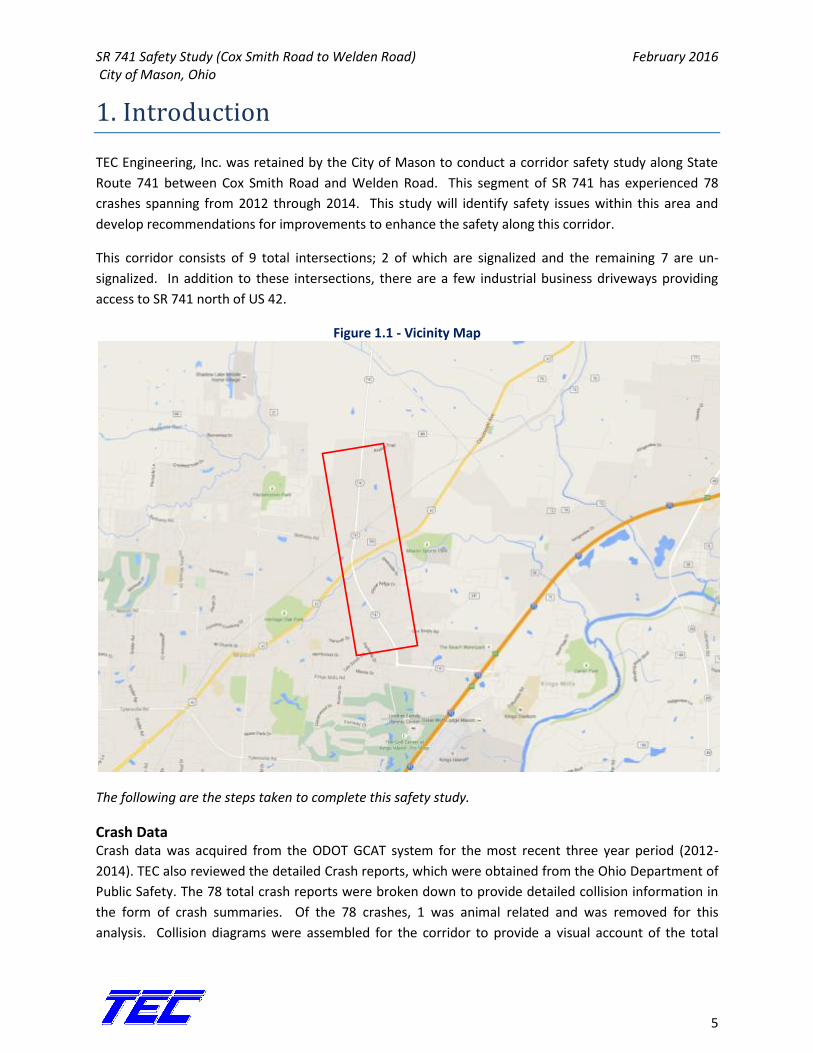
1. Introduction
TEC Engineering, Inc. was retained by the City of Mason to conduct a corridor safety study along State
Route 741 between Cox Smith Road and Welden Road. This segment of SR 741 has experienced 78
crashes spanning from 2012 through 2014. This study will identify safety issues within this area and
develop recommendations for improvements to enhance the safety along this corridor.
This corridor consists of 9 total intersections; 2 of which are signalized and the remaining 7 are un-
signalized. In addition to these intersections, there are a few industrial business driveways providing
access to SR 741 north of US 42.
Figure 1.1 - Vicinity Map
The following are the steps taken to complete this safety study.
Crash Data Crash data was acquired from the ODOT GCAT system for the most recent three year period (2012-
2014). TEC also reviewed the detailed Crash reports, which were obtained from the Ohio Department of
Public Safety. The 78 total crash reports were broken down to provide detailed collision information in
the form of crash summaries. Of the 78 crashes, 1 was animal related and was removed for this
analysis. Collision diagrams were assembled for the corridor to provide a visual account of the total
SR 741 Safety Study (Cox Smith Road to Welden Road) February 2016 City of Mason, Ohio
6
crashes over the three year period. The crash diagrams display, in detail, the types of crashes that
occurred. Crash analysis charts summarizing crashes can be found in Appendix A.
Traffic Counts Average Daily Traffic (ADT) was calculated using pneumatic mechanical counters placed at 2 locations
along SR 741 (south of Cox-Smith and North of Welden). Additionally, mechanical counters and
pneumatic tubes were placed on US 42 and Bethany Road on either side of SR 741. Turning movement
counts were completed at the intersections of SR 741 at US 42 and SR 741 at Bethany Road during the
AM and PM peak hours. All count data has been provided in Appendix B.
Capacity Analysis The traffic analysis software program Synchro 9 was used to analyze the capacity of the corridor with
special focus on the signalized intersections at US 42 and Bethany Road. Current signal timings and
phasing diagrams were downloaded from the controllers remotely. Traffic volumes for each peak were
input into Synchro to determine each intersection delay, the corresponding Level of Service (LOS), and
how efficiently the existing system conveys vehicles through the corridor. Synchro 9 timing and phasing
reports are located in Appendix C.
Field Observation Field observations were performed to check the existing physical conditions of the area including
pavement markings, pavement condition, signage, signal equipment, sidewalk conditions, and
pedestrian signals. The information was then used to help relate any discernible crash patterns to their
probable causes with respect to the existing physical features on and near the roadway.
Analysis & Recommendations All of the aforementioned steps provided the information used to analyze the intersections and mid-
blocks which experienced crashes during this particular three-year period as well as the general
conditions along the SR 741 study corridor. From this analysis, TEC was able to identify safety problems
and their possible causes. Recommendations were made and their effectiveness was calculated by the
benefit/cost analysis in the ODOT ECAT tool. The ECAT analysis worksheets for each intersection and
road segment can be found in Appendix F.
2. Existing Conditions
The segment of SR 741 selected for this safety study is approximately 1.6 miles in length and includes 2
signalized intersections. There are 7 un-signalized intersections (two of which will soon be signalized)
with roads mostly providing access to residential homes. North of US 42, SR 741 provides driveway
access to some commercial and light industrial businesses. South of the study area, SR 741 provides
access to commercial development, a full-access interchange with IR-71, Kings Island Drive (direct access
to Kings Island), and Kings High School. North of the study area, SR 741 is a rural 2-lane highway.
SR 741 Safety Study (Cox Smith Road to Welden Road) February 2016 City of Mason, Ohio
7
SR 741 is classified as an urban minor arterial. According to this classification, SR 741 provides service
for moderate length trips and offers connectivity to the higher Principal Arterial system. Additionally,
the classification indicates this road is designed to provide relatively high overall travel speeds with
minimum interference to the through movement. The speed limit for the majority of the corridor is 50
MPH with the exception of the area just north and south of Bethany Road and the rail road crossing (a
rail crossing is located approximately 175 feet north of the Bethany Road intersection).
The entirety of the corridor in the study area has 1 thru lane of travel in each direction. Of the un-
signalized intersections, 5 are 3-leg intersections with dedicated left and right turn lanes. The
intersection of SR 741 and US 42 has a dedicated left turn on each approach and a thru/right shared lane
on each approach, excluding SB 741. This approach has 3 dedicated lanes: left, thru, and right. At SR
741 and Bethany Road, each approach has a shared right/thru lane and a dedicated left turn lane.
Pavement within the study area is in generally good condition. Pavement markings are also in average
to good condition throughout the corridor. There are no sidewalks present within the corridor, nor
street lighting or pedestrian signals. All vehicular signal heads in the study area are in fair condition,
using LEDs. Utility poles in the study area are spaced 150’-200’ apart and 15’-20’ from the edge of
pavement. Any physical deficiencies deemed problematic will be addressed for each individual
intersection or mid-block location later in this report.
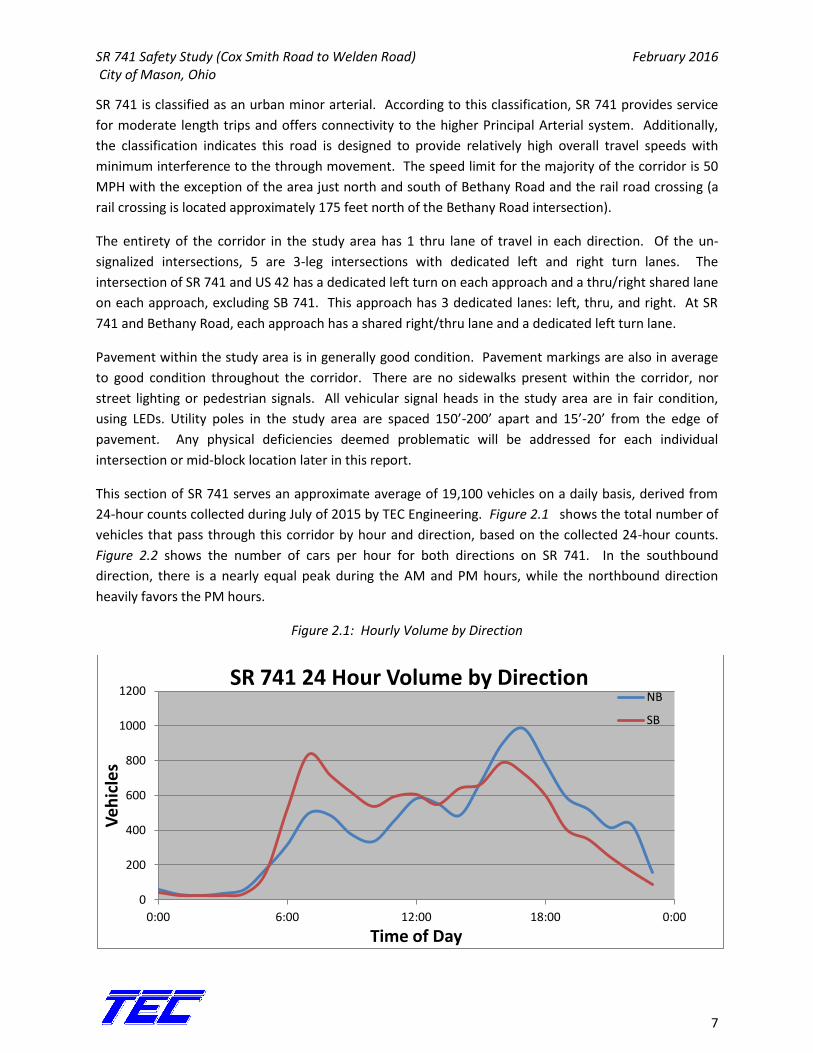
This section of SR 741 serves an approximate average of 19,100 vehicles on a daily basis, derived from
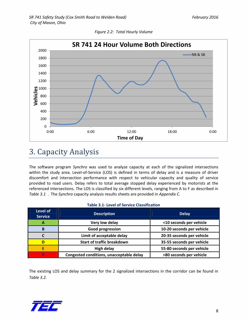
24-hour counts collected during July of 2015 by TEC Engineering. Figure 2.1 shows the total number of
vehicles that pass through this corridor by hour and direction, based on the collected 24-hour counts.
Figure 2.2 shows the number of cars per hour for both directions on SR 741. In the southbound
direction, there is a nearly equal peak during the AM and PM hours, while the northbound direction
heavily favors the PM hours.
Figure 2.1: Hourly Volume by Direction
0
200
400
600
800
1000
1200
0:00 6:00 12:00 18:00 0:00
Ve
hic
les
Time of Day
SR 741 24 Hour Volume by Direction NB
SB
SR 741 Safety Study (Cox Smith Road to Welden Road) February 2016 City of Mason, Ohio
8
Figure 2.2: Total Hourly Volume
3. Capacity Analysis
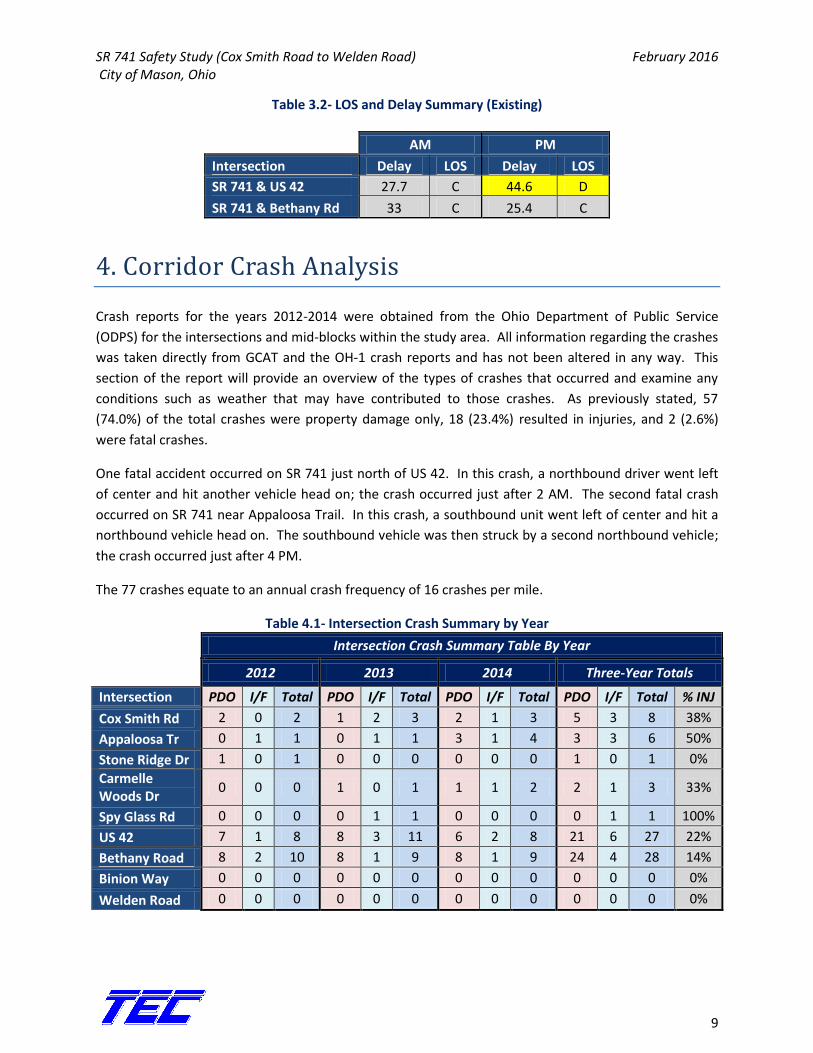
The software program Synchro was used to analyze capacity at each of the signalized intersections within the study area. Level-of-Service (LOS) is defined in terms of delay and is a measure of driver discomfort and intersection performance with respect to vehicular capacity and quality of service provided to road users. Delay refers to total average stopped delay experienced by motorists at the referenced intersections. The LOS is classified by six different levels, ranging from A to F as described in Table 3.1 . The Synchro capacity analysis results sheets are provided in Appendix C.
Table 3.1- Level of Service Classification
Level of Service
Description Delay
A Very low delay <10 seconds per vehicle
B Good progression 10-20 seconds per vehicle
C Limit of acceptable delay 20-35 seconds per vehicle
D Start of traffic breakdown 35-55 seconds per vehicle
E High delay 55-80 seconds per vehicle
F Congested conditions, unacceptable delay >80 seconds per vehicle
The existing LOS and delay summary for the 2 signalized intersections in the corridor can be found in
Table 3.2.
0
200
400
600
800
1000
1200
1400
1600
1800
2000
0:00 6:00 12:00 18:00 0:00
Ve
hic
les
Time of Day
SR 741 24 Hour Volume Both Directions NB & SB
SR 741 Safety Study (Cox Smith Road to Welden Road) February 2016 City of Mason, Ohio
9
Table 3.2- LOS and Delay Summary (Existing)
AM PM
Intersection Delay LOS Delay LOS
SR 741 & US 42 27.7 C 44.6 D
SR 741 & Bethany Rd 33 C 25.4 C
4. Corridor Crash Analysis
Crash reports for the years 2012-2014 were obtained from the Ohio Department of Public Service
(ODPS) for the intersections and mid-blocks within the study area. All information regarding the crashes
was taken directly from GCAT and the OH-1 crash reports and has not been altered in any way. This
section of the report will provide an overview of the types of crashes that occurred and examine any
conditions such as weather that may have contributed to those crashes. As previously stated, 57
(74.0%) of the total crashes were property damage only, 18 (23.4%) resulted in injuries, and 2 (2.6%)
were fatal crashes.
One fatal accident occurred on SR 741 just north of US 42. In this crash, a northbound driver went left
of center and hit another vehicle head on; the crash occurred just after 2 AM. The second fatal crash
occurred on SR 741 near Appaloosa Trail. In this crash, a southbound unit went left of center and hit a
northbound vehicle head on. The southbound vehicle was then struck by a second northbound vehicle;
the crash occurred just after 4 PM.
The 77 crashes equate to an annual crash frequency of 16 crashes per mile.
Table 4.1- Intersection Crash Summary by Year
Intersection Crash Summary Table By Year
2012 2013 2014 Three-Year Totals
Intersection PDO I/F Total PDO I/F Total PDO I/F Total PDO I/F Total % INJ
Cox Smith Rd 2 0 2 1 2 3 2 1 3 5 3 8 38%
Appaloosa Tr 0 1 1 0 1 1 3 1 4 3 3 6 50%
Stone Ridge Dr 1 0 1 0 0 0 0 0 0 1 0 1 0%
Carmelle Woods Dr
0 0 0 1 0 1 1 1 2 2 1 3 33%
Spy Glass Rd 0 0 0 0 1 1 0 0 0 0 1 1 100%
US 42 7 1 8 8 3 11 6 2 8 21 6 27 22%
Bethany Road 8 2 10 8 1 9 8 1 9 24 4 28 14%
Binion Way 0 0 0 0 0 0 0 0 0 0 0 0 0%
Welden Road 0 0 0 0 0 0 0 0 0 0 0 0 0%
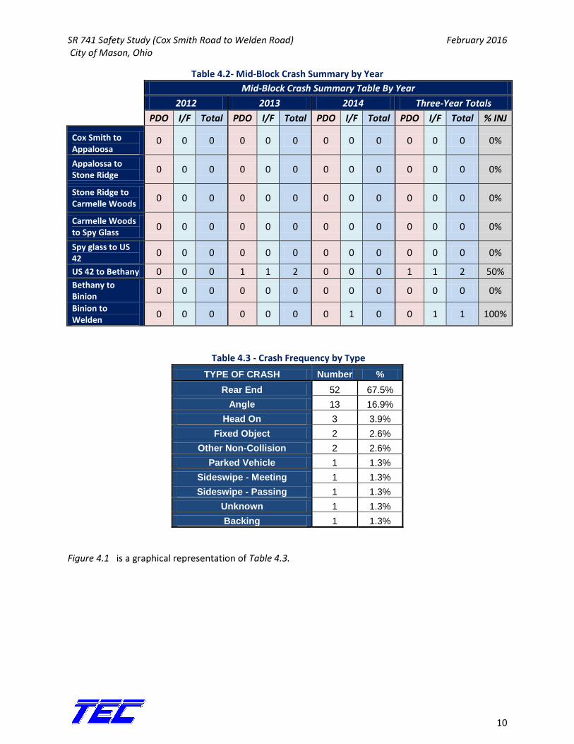
SR 741 Safety Study (Cox Smith Road to Welden Road) February 2016 City of Mason, Ohio
10
Table 4.2- Mid-Block Crash Summary by Year
Mid-Block Crash Summary Table By Year
2012 2013 2014 Three-Year Totals
PDO I/F Total PDO I/F Total PDO I/F Total PDO I/F Total % INJ
Cox Smith to Appaloosa
0 0 0 0 0 0 0 0 0 0 0 0 0%
Appalossa to Stone Ridge
0 0 0 0 0 0 0 0 0 0 0 0 0%
Stone Ridge to Carmelle Woods
0 0 0 0 0 0 0 0 0 0 0 0 0%
Carmelle Woods to Spy Glass
0 0 0 0 0 0 0 0 0 0 0 0 0%
Spy glass to US 42
0 0 0 0 0 0 0 0 0 0 0 0 0%
US 42 to Bethany 0 0 0 1 1 2 0 0 0 1 1 2 50%
Bethany to Binion
0 0 0 0 0 0 0 0 0 0 0 0 0%
Binion to Welden
0 0 0 0 0 0 0 1 0 0 1 1 100%
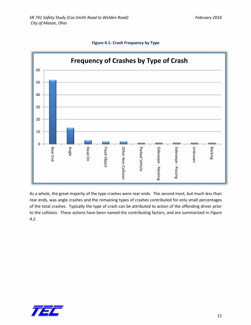
Table 4.3 - Crash Frequency by Type
TYPE OF CRASH Number %
Rear End 52 67.5%
Angle 13 16.9%
Head On 3 3.9%
Fixed Object 2 2.6%
Other Non-Collision 2 2.6%
Parked Vehicle 1 1.3%
Sideswipe - Meeting 1 1.3%
Sideswipe - Passing 1 1.3%
Unknown 1 1.3%
Backing 1 1.3%
Figure 4.1 is a graphical representation of Table 4.3.
SR 741 Safety Study (Cox Smith Road to Welden Road) February 2016 City of Mason, Ohio
11
Figure 4.1- Crash Frequency by Type
As a whole, the great majority of the type crashes were rear ends. The second most, but much less than
rear ends, was angle crashes and the remaining types of crashes contributed for only small percentages
of the total crashes. Typically the type of crash can be attributed to action of the offending driver prior
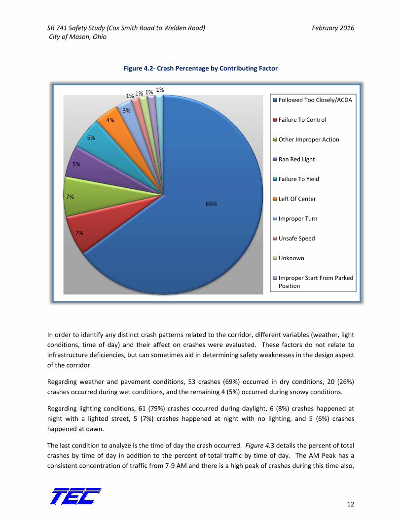
to the collision. These actions have been named the contributing factors, and are summarized in Figure
4.2.
0
10
20
30
40
50
60
Rear En
d
An
gle
Head
On
Fixed O
bject
Oth
er No
n-C
ollisio
n
Parked
Veh
icle
Sidesw
ipe - M
eeting
Sidesw
ipe - P
assing
Un
kno
wn
Backin
g
Frequency of Crashes by Type of Crash
SR 741 Safety Study (Cox Smith Road to Welden Road) February 2016 City of Mason, Ohio
12
Figure 4.2- Crash Percentage by Contributing Factor
In order to identify any distinct crash patterns related to the corridor, different variables (weather, light
conditions, time of day) and their affect on crashes were evaluated. These factors do not relate to
infrastructure deficiencies, but can sometimes aid in determining safety weaknesses in the design aspect
of the corridor.
Regarding weather and pavement conditions, 53 crashes (69%) occurred in dry conditions, 20 (26%)
crashes occurred during wet conditions, and the remaining 4 (5%) occurred during snowy conditions.
Regarding lighting conditions, 61 (79%) crashes occurred during daylight, 6 (8%) crashes happened at
night with a lighted street, 5 (7%) crashes happened at night with no lighting, and 5 (6%) crashes
happened at dawn.
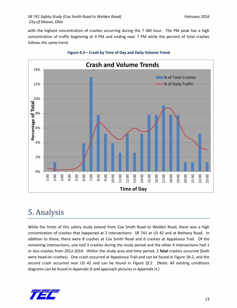
The last condition to analyze is the time of day the crash occurred. Figure 4.3 details the percent of total
crashes by time of day in addition to the percent of total traffic by time of day. The AM Peak has a
consistent concentration of traffic from 7-9 AM and there is a high peak of crashes during this time also,
65%
7%
7%
5%
5%
4%
3%
1% 1% 1% 1%
Followed Too Closely/ACDA
Failure To Control
Other Improper Action
Ran Red Light
Failure To Yield
Left Of Center
Improper Turn
Unsafe Speed
Unknown
Improper Start From Parked Position
SR 741 Safety Study (Cox Smith Road to Welden Road) February 2016 City of Mason, Ohio
13
with the highest concentration of crashes occurring during the 7 AM hour. The PM peak has a high
concentration of traffic beginning at 4 PM and ending near 7 PM while the percent of total crashes
follows the same trend.
Figure 4.3 – Crash by Time of Day and Daily Volume Trend
5. Analysis
While the limits of this safety study extend from Cox Smith Road to Welden Road, there was a high
concentration of crashes that happened at 2 intersections: SR 741 at US 42 and at Bethany Road. In
addition to these, there were 8 crashes at Cox Smith Road and 6 crashes at Appaloosa Trail. Of the
remaining intersections, one had 3 crashes during the study period and the other 4 intersections had 1
or less crashes from 2012-2014. Within the study area and time period, 2 fatal crashes occurred (both
were head-on crashes). One crash occurred at Appaloosa Trail and can be found in Figure 5b.2, and the
second crash occurred near US 42 and can be found in Figure 5f.2. (Note: All existing conditions
diagrams can be found in Appendix D and approach pictures in Appendix H.)
0%
2%
4%
6%
8%
10%
12%
14%
1:0
0
2:0
0
3:0
0
4:0
0
5:0
0
6:0
0
7:0
0
8:0
0
9:0
0
10
:00
11
:00
12
:00
13
:00
14
:00
15
:00
16
:00
17
:00
18
:00
19
:00
20
:00
21
:00
22
:00
23
:00
Per
cen
tage
of
Tota
l
Time of Day
Crash and Volume Trends
% of Total Crashes
% of Daily Traffic
SR 741 Safety Study (Cox Smith Road to Welden Road) February 2016 City of Mason, Ohio
14
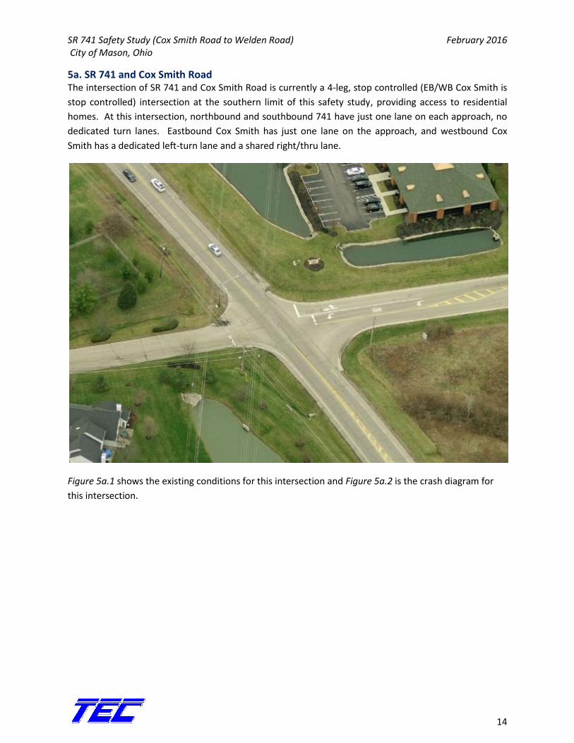
5a. SR 741 and Cox Smith Road The intersection of SR 741 and Cox Smith Road is currently a 4-leg, stop controlled (EB/WB Cox Smith is
stop controlled) intersection at the southern limit of this safety study, providing access to residential
homes. At this intersection, northbound and southbound 741 have just one lane on each approach, no
dedicated turn lanes. Eastbound Cox Smith has just one lane on the approach, and westbound Cox
Smith has a dedicated left-turn lane and a shared right/thru lane.
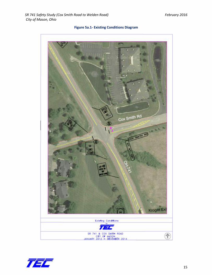
Figure 5a.1 shows the existing conditions for this intersection and Figure 5a.2 is the crash diagram for
this intersection.
SR 741 Safety Study (Cox Smith Road to Welden Road) February 2016 City of Mason, Ohio
15
Figure 5a.1- Existing Conditions Diagram
SR 741 Safety Study (Cox Smith Road to Welden Road) February 2016 City of Mason, Ohio
16
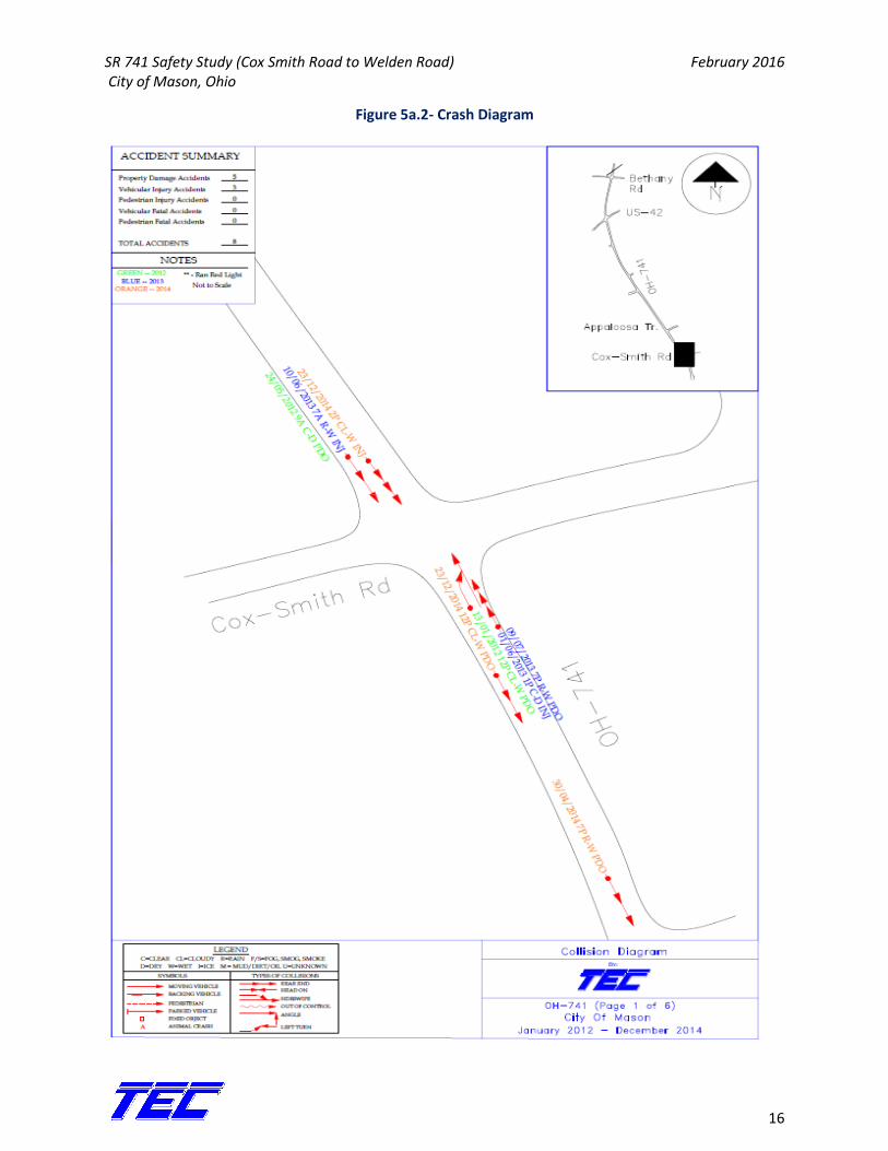
Figure 5a.2- Crash Diagram
SR 741 Safety Study (Cox Smith Road to Welden Road) February 2016 City of Mason, Ohio
17
Between the years 2012 and 2014 there were a total of 8 crashes that occurred at this intersection. Of
the total crashes, 5 (62%) were PDO and 3 (38%) were injury related. All 8 crashes were rear end
crashes with an equal distribution over the 3 years in the study. Table 5a.1 describes the crash severity
by year at this intersection.
Table 5a.2- Crash Severity by Year
Year Crash Severity
PDO Injury Total
2012 2 0 2
2013 1 2 3
2014 2 1 3
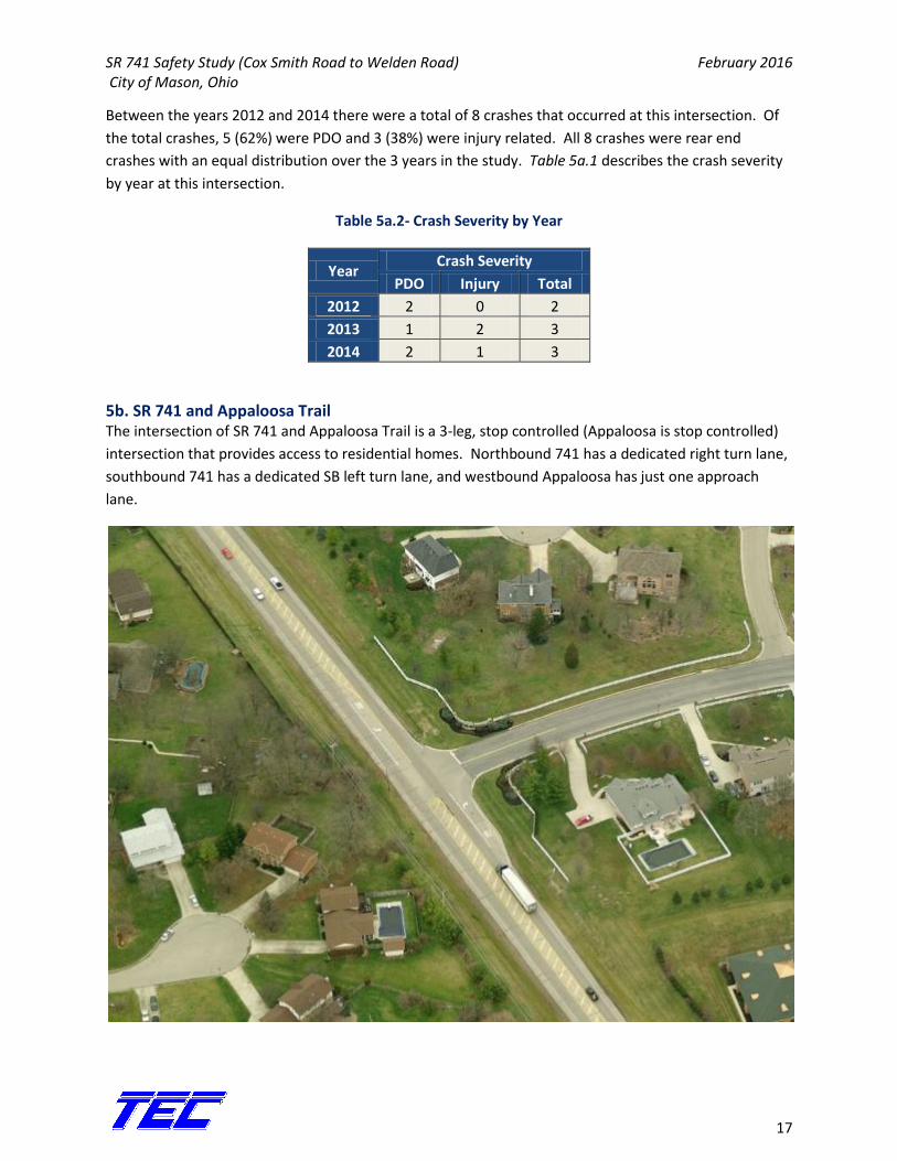
5b. SR 741 and Appaloosa Trail The intersection of SR 741 and Appaloosa Trail is a 3-leg, stop controlled (Appaloosa is stop controlled)
intersection that provides access to residential homes. Northbound 741 has a dedicated right turn lane,
southbound 741 has a dedicated SB left turn lane, and westbound Appaloosa has just one approach
lane.
SR 741 Safety Study (Cox Smith Road to Welden Road) February 2016 City of Mason, Ohio
18
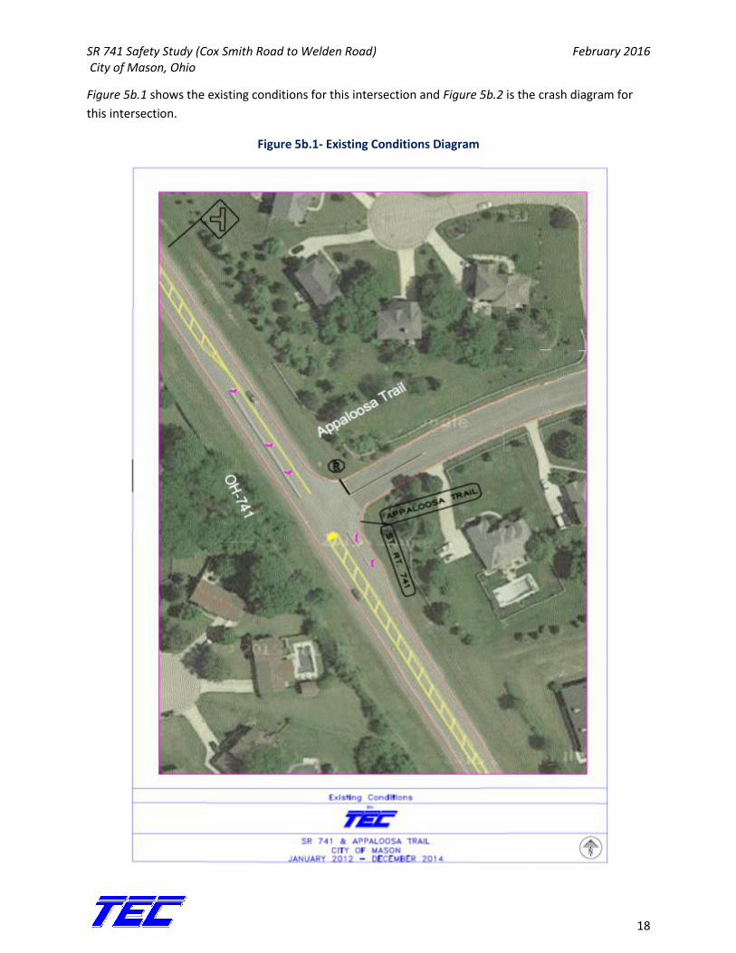
Figure 5b.1 shows the existing conditions for this intersection and Figure 5b.2 is the crash diagram for
this intersection.
Figure 5b.1- Existing Conditions Diagram
SR 741 Safety Study (Cox Smith Road to Welden Road) February 2016 City of Mason, Ohio
19
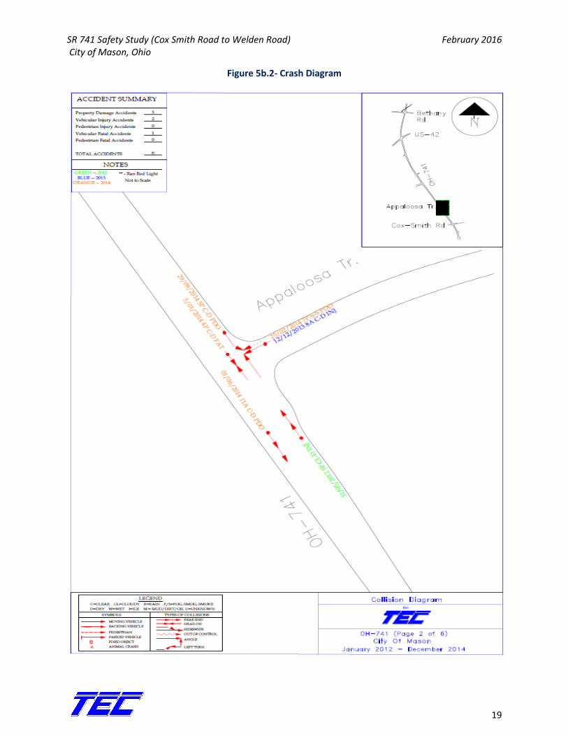
Figure 5b.2- Crash Diagram
SR 741 Safety Study (Cox Smith Road to Welden Road) February 2016 City of Mason, Ohio
20
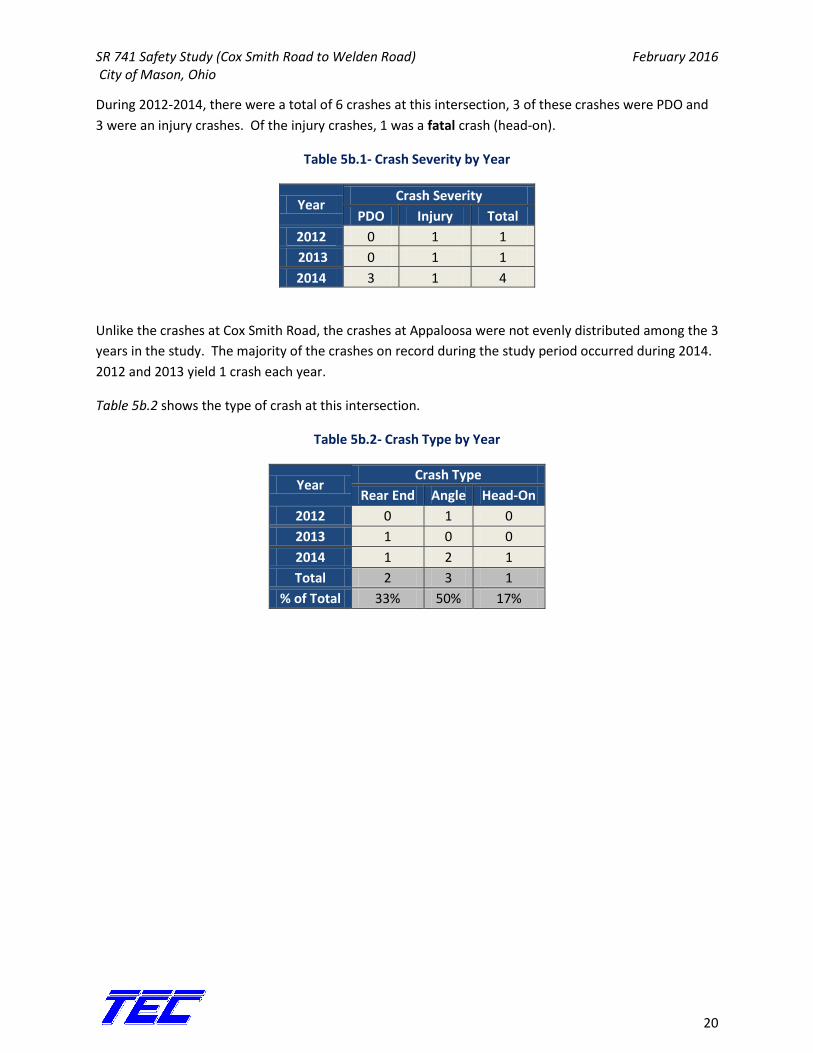
During 2012-2014, there were a total of 6 crashes at this intersection, 3 of these crashes were PDO and
3 were an injury crashes. Of the injury crashes, 1 was a fatal crash (head-on).
Table 5b.1- Crash Severity by Year
Year Crash Severity
PDO Injury Total
2012 0 1 1
2013 0 1 1
2014 3 1 4
Unlike the crashes at Cox Smith Road, the crashes at Appaloosa were not evenly distributed among the 3
years in the study. The majority of the crashes on record during the study period occurred during 2014.
2012 and 2013 yield 1 crash each year.
Table 5b.2 shows the type of crash at this intersection.
Table 5b.2- Crash Type by Year
Year Crash Type
Rear End Angle Head-On
2012 0 1 0
2013 1 0 0
2014 1 2 1
Total 2 3 1
% of Total 33% 50% 17%
SR 741 Safety Study (Cox Smith Road to Welden Road) February 2016 City of Mason, Ohio
21
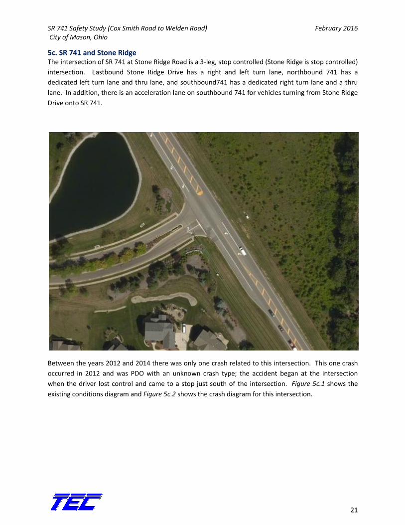
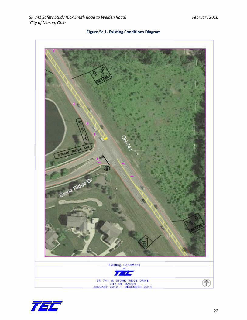
5c. SR 741 and Stone Ridge The intersection of SR 741 at Stone Ridge Road is a 3-leg, stop controlled (Stone Ridge is stop controlled)
intersection. Eastbound Stone Ridge Drive has a right and left turn lane, northbound 741 has a
dedicated left turn lane and thru lane, and southbound741 has a dedicated right turn lane and a thru
lane. In addition, there is an acceleration lane on southbound 741 for vehicles turning from Stone Ridge
Drive onto SR 741.
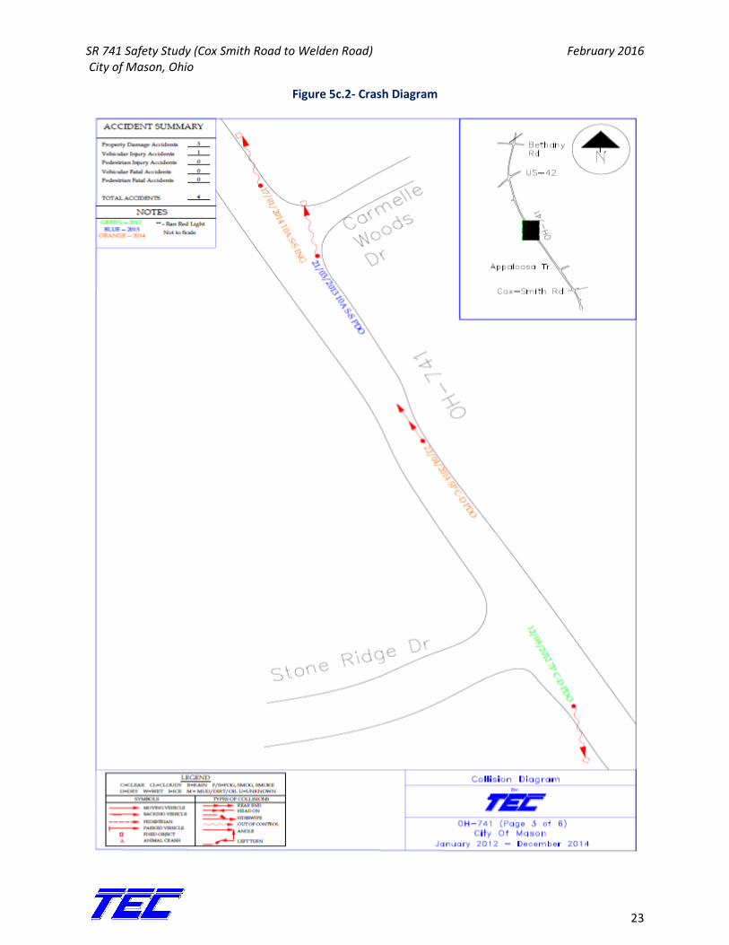
Between the years 2012 and 2014 there was only one crash related to this intersection. This one crash
occurred in 2012 and was PDO with an unknown crash type; the accident began at the intersection
when the driver lost control and came to a stop just south of the intersection. Figure 5c.1 shows the
existing conditions diagram and Figure 5c.2 shows the crash diagram for this intersection.
SR 741 Safety Study (Cox Smith Road to Welden Road) February 2016 City of Mason, Ohio
22
Figure 5c.1- Existing Conditions Diagram
SR 741 Safety Study (Cox Smith Road to Welden Road) February 2016 City of Mason, Ohio
23
Figure 5c.2- Crash Diagram
SR 741 Safety Study (Cox Smith Road to Welden Road) February 2016 City of Mason, Ohio
24
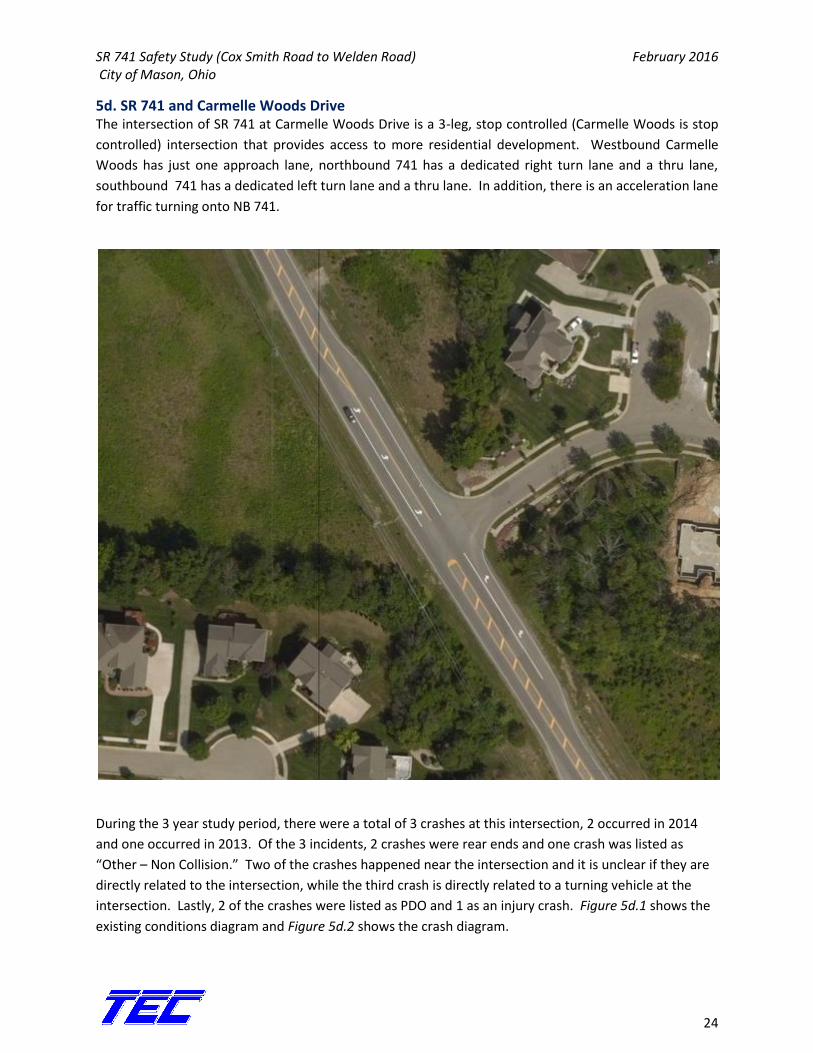
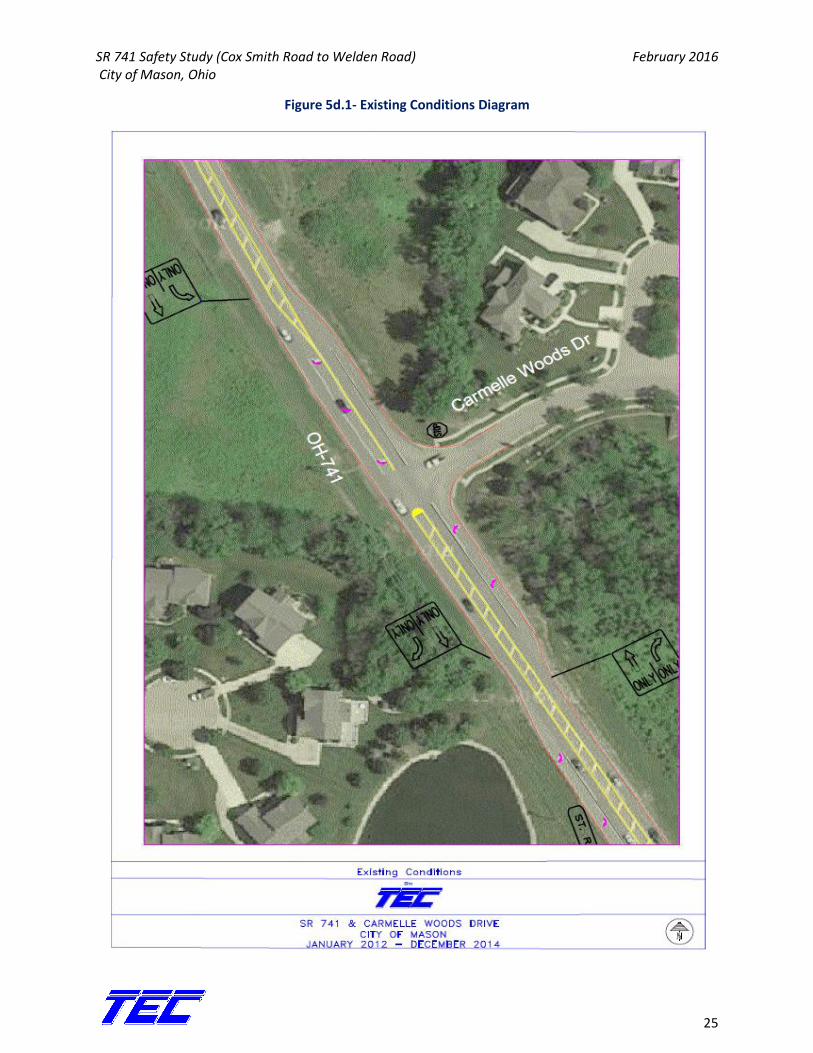
5d. SR 741 and Carmelle Woods Drive The intersection of SR 741 at Carmelle Woods Drive is a 3-leg, stop controlled (Carmelle Woods is stop
controlled) intersection that provides access to more residential development. Westbound Carmelle
Woods has just one approach lane, northbound 741 has a dedicated right turn lane and a thru lane,
southbound 741 has a dedicated left turn lane and a thru lane. In addition, there is an acceleration lane
for traffic turning onto NB 741.
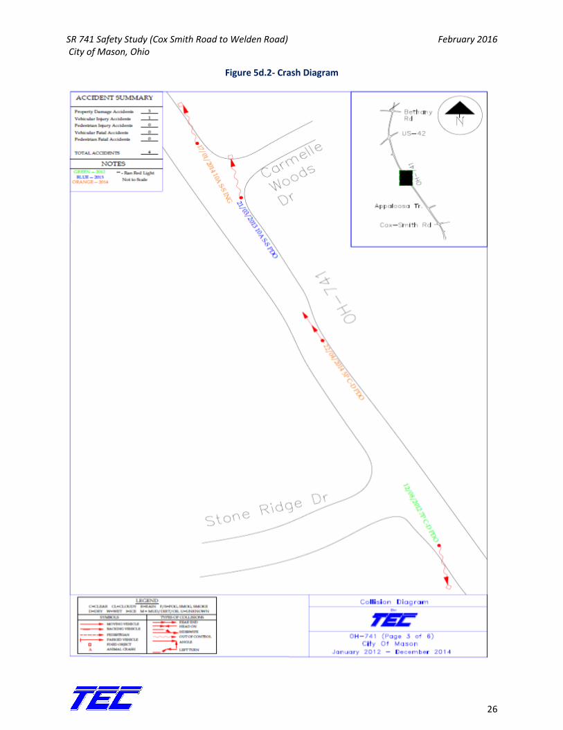
During the 3 year study period, there were a total of 3 crashes at this intersection, 2 occurred in 2014
and one occurred in 2013. Of the 3 incidents, 2 crashes were rear ends and one crash was listed as
“Other – Non Collision.” Two of the crashes happened near the intersection and it is unclear if they are
directly related to the intersection, while the third crash is directly related to a turning vehicle at the
intersection. Lastly, 2 of the crashes were listed as PDO and 1 as an injury crash. Figure 5d.1 shows the
existing conditions diagram and Figure 5d.2 shows the crash diagram.
SR 741 Safety Study (Cox Smith Road to Welden Road) February 2016 City of Mason, Ohio
25
Figure 5d.1- Existing Conditions Diagram
SR 741 Safety Study (Cox Smith Road to Welden Road) February 2016 City of Mason, Ohio
26
Figure 5d.2- Crash Diagram

SR 741 Safety Study (Cox Smith Road to Welden Road) February 2016 City of Mason, Ohio
27
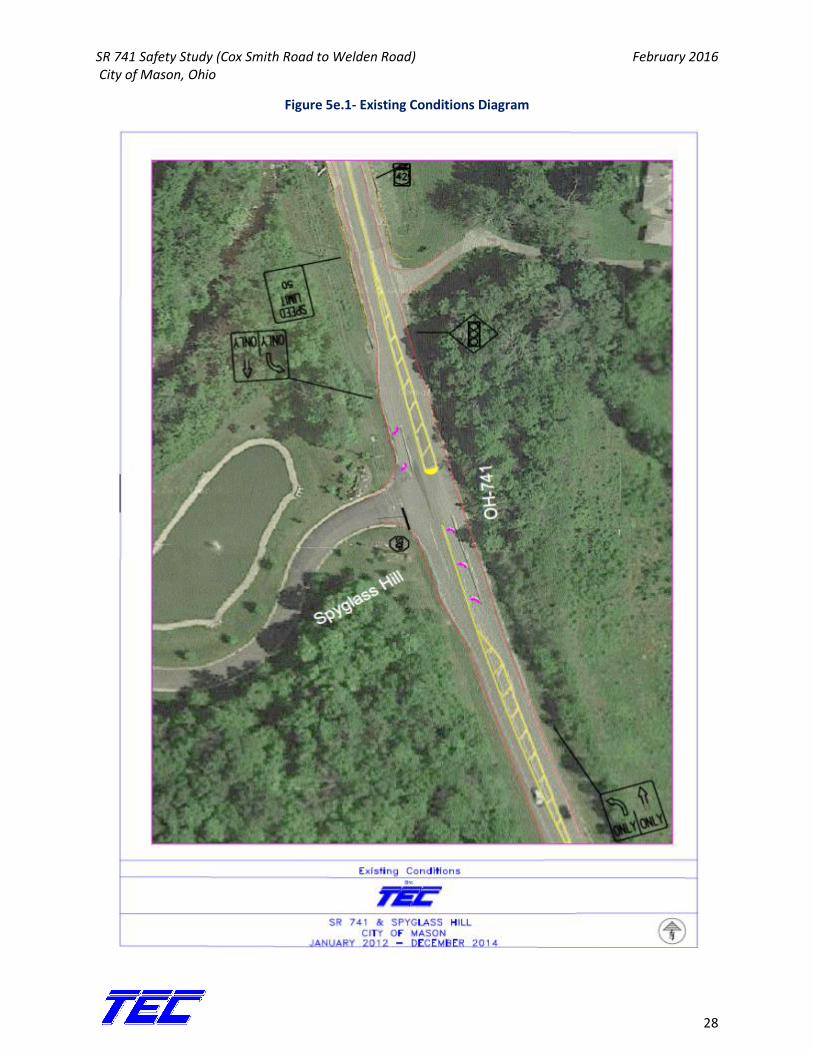
5e. SR 741 and Spy Glass Hill This intersection of SR 741 at Spy Glass Hill is a 3-leg, stop controlled (Spy Glass Hill is stop controlled)
intersection that provides access to residential condominiums. Eastbound Spy Glass Hill has two
approach lanes (a left only and right only), northbound 741 has a dedicated left turn lane and a thru
lane, and southbound 741 has a dedicated right turn lane and a thru lane. Similar to the previous two
intersections, there is an acceleration lane for those turning onto SB 741.
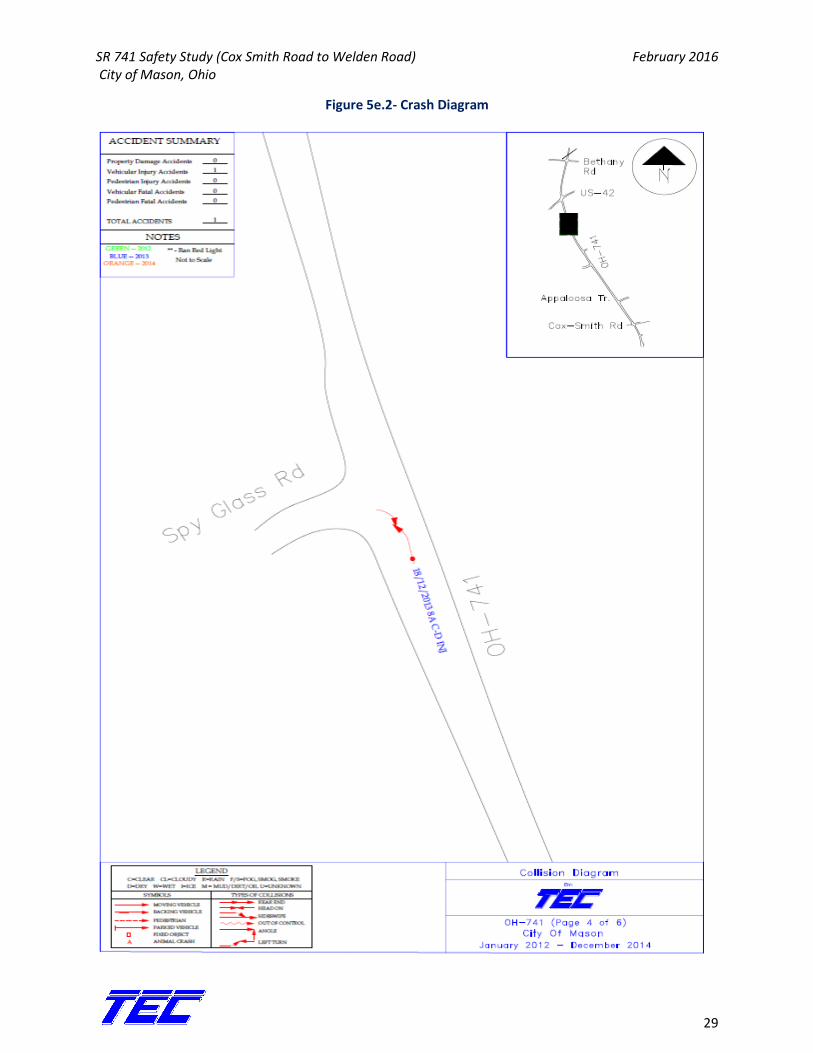
During the 3 year study period, there was one crash that occurred. The crash was an injury, angle crash
that happened during 2013. Figure 5e.1 shows the existing conditions diagram and Figure 5e.2 shows
the crash diagram for this intersection.
SR 741 Safety Study (Cox Smith Road to Welden Road) February 2016 City of Mason, Ohio
28
Figure 5e.1- Existing Conditions Diagram
SR 741 Safety Study (Cox Smith Road to Welden Road) February 2016 City of Mason, Ohio
29
Figure 5e.2- Crash Diagram
SR 741 Safety Study (Cox Smith Road to Welden Road) February 2016 City of Mason, Ohio
30
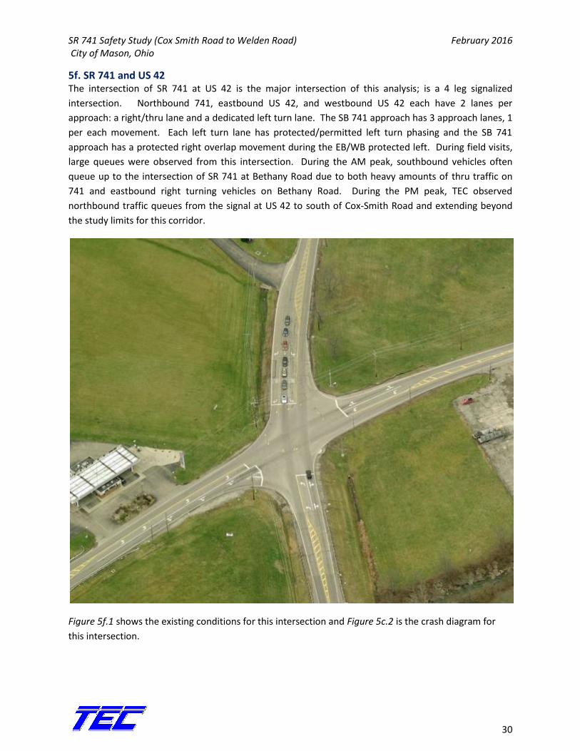
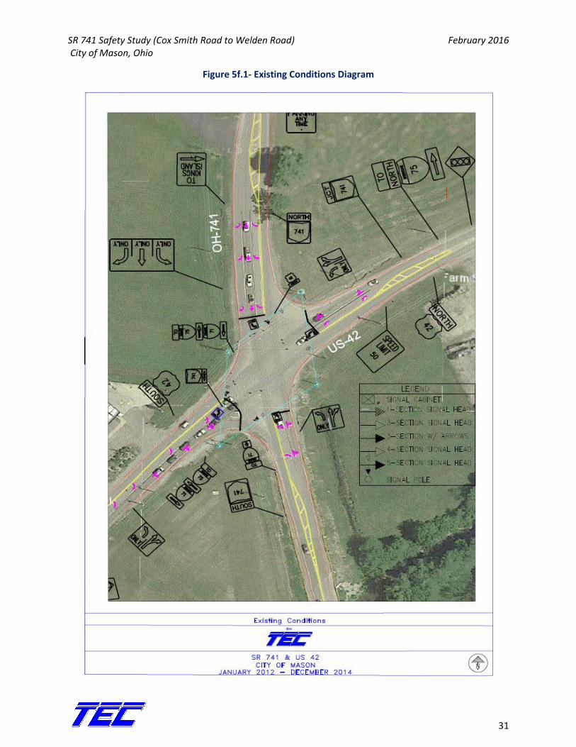
5f. SR 741 and US 42 The intersection of SR 741 at US 42 is the major intersection of this analysis; is a 4 leg signalized
intersection. Northbound 741, eastbound US 42, and westbound US 42 each have 2 lanes per
approach: a right/thru lane and a dedicated left turn lane. The SB 741 approach has 3 approach lanes, 1
per each movement. Each left turn lane has protected/permitted left turn phasing and the SB 741
approach has a protected right overlap movement during the EB/WB protected left. During field visits,
large queues were observed from this intersection. During the AM peak, southbound vehicles often
queue up to the intersection of SR 741 at Bethany Road due to both heavy amounts of thru traffic on
741 and eastbound right turning vehicles on Bethany Road. During the PM peak, TEC observed
northbound traffic queues from the signal at US 42 to south of Cox-Smith Road and extending beyond
the study limits for this corridor.
Figure 5f.1 shows the existing conditions for this intersection and Figure 5c.2 is the crash diagram for
this intersection.
SR 741 Safety Study (Cox Smith Road to Welden Road) February 2016 City of Mason, Ohio
31
Figure 5f.1- Existing Conditions Diagram
SR 741 Safety Study (Cox Smith Road to Welden Road) February 2016 City of Mason, Ohio
32
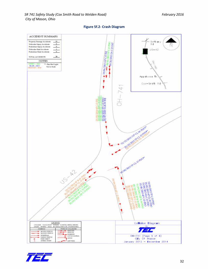
Figure 5f.2- Crash Diagram
SR 741 Safety Study (Cox Smith Road to Welden Road) February 2016 City of Mason, Ohio
33
During the years 2012-2014, there were 27 crashes at this intersection, 18 of these crashes occurred on
SR 741 at this intersection and the remaining 9 crashes occurred on US 42 at the intersection. There
was one mid-block, head-on crash to the north of this intersection that can be seen in the crash diagram
but is not accounted for in the tables; this is one of two fatal crashes on this corridor during the study
period. Table 5f.1 describes the crash frequency by year at this intersection.
Table 5f.1- Crash Severity by Year
Year Crash Severity
PDO Injury Total
2012 7 1 8
2013 8 3 11
2014 6 2 8
In regard to the table, the crashes during the study years were, for the most part, evenly distributed by
year. Of the total 27 crashes, 19 (70%) were rear end crashes. Next were angle crashes at 4 (15%).
Table 5f.2 breaks down the crash type by year.
Table 5f.2- Crash Type by Year
Year Crash Type
Rear End Angle Head-On Backing Fixed Ob. Parked Veh.
2012 7 0 0 1 0 0
2013 8 2 1 0 0 0
2014 4 2 0 0 1 1
Total 19 4 1 1 1 1
% of Total 70.4% 14.8% 3.7% 3.7% 3.7% 3.7%
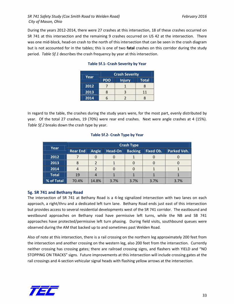
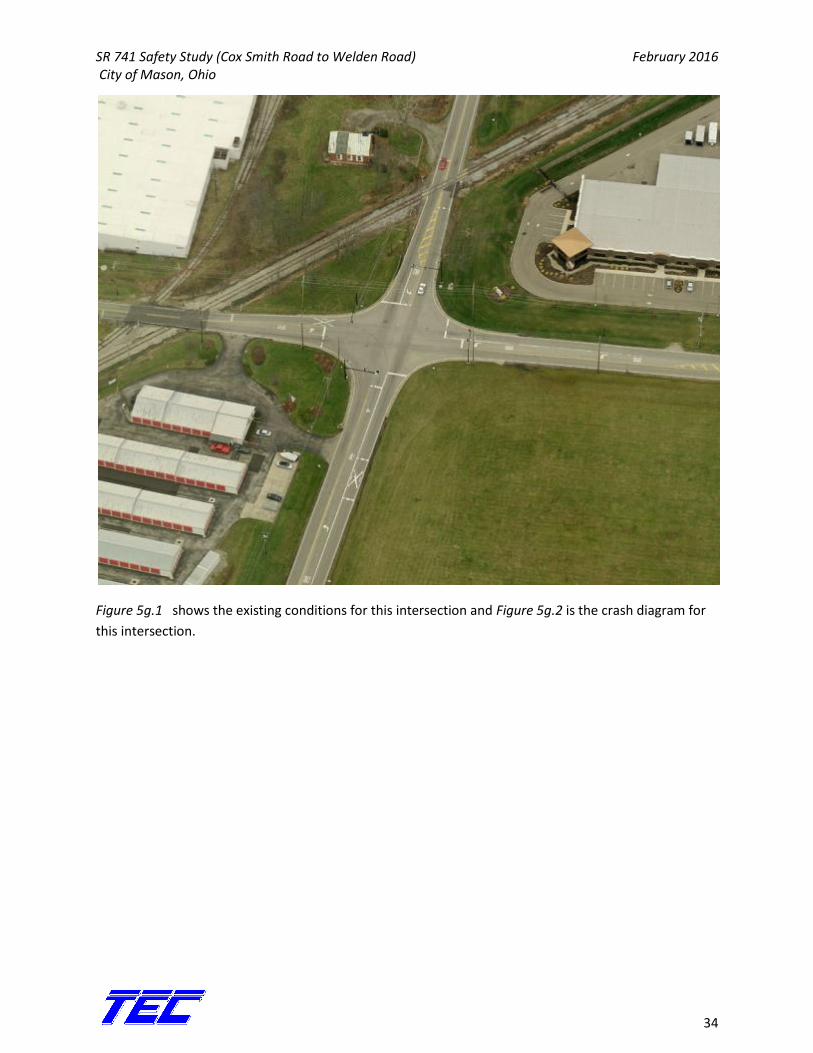
5g. SR 741 and Bethany Road The intersection of SR 741 at Bethany Road is a 4-leg signalized intersection with two lanes on each
approach, a right/thru and a dedicated left turn lane. Bethany Road ends just east of this intersection
but provides access to several residential developments west of the SR 741 corridor. The eastbound and
westbound approaches on Bethany road have permissive left turns, while the NB and SB 741
approaches have protected/permissive left turn phasing. During field visits, southbound queues were
observed during the AM that backed up to and sometimes past Welden Road.
Also of note at this intersection, there is a rail crossing on the northern leg approximately 200 feet from
the intersection and another crossing on the western leg, also 200 feet from the intersection. Currently
neither crossing has crossing gates; there are railroad crossing signs, and flashers with YIELD and “NO
STOPPING ON TRACKS” signs. Future improvements at this intersection will include crossing gates at the
rail crossings and 4-section vehicular signal heads with flashing yellow arrows at the intersection.
SR 741 Safety Study (Cox Smith Road to Welden Road) February 2016 City of Mason, Ohio
34
Figure 5g.1 shows the existing conditions for this intersection and Figure 5g.2 is the crash diagram for
this intersection.
SR 741 Safety Study (Cox Smith Road to Welden Road) February 2016 City of Mason, Ohio
35
Figure 5g.1- Existing Conditions Diagram
SR 741 Safety Study (Cox Smith Road to Welden Road) February 2016 City of Mason, Ohio
36
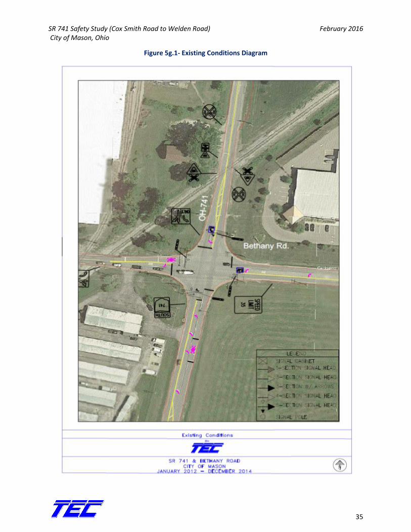
Figure 5g.2- Crash Diagram
SR 741 Safety Study (Cox Smith Road to Welden Road) February 2016 City of Mason, Ohio
37
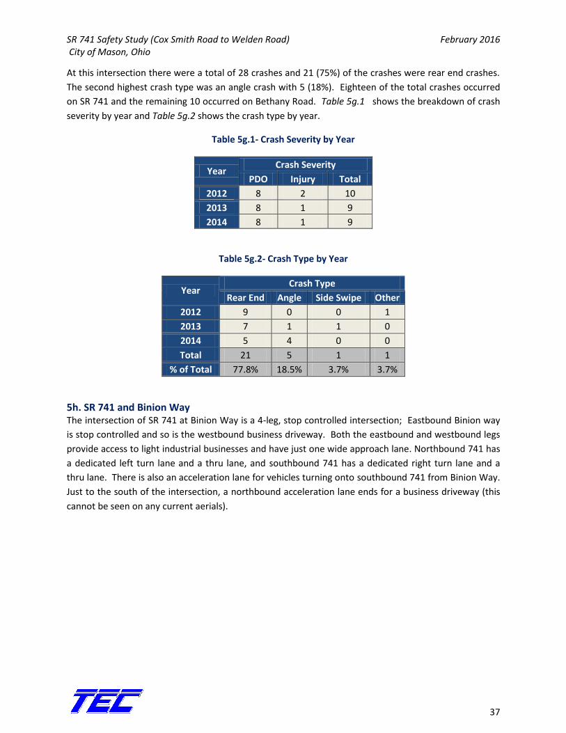
At this intersection there were a total of 28 crashes and 21 (75%) of the crashes were rear end crashes.
The second highest crash type was an angle crash with 5 (18%). Eighteen of the total crashes occurred
on SR 741 and the remaining 10 occurred on Bethany Road. Table 5g.1 shows the breakdown of crash
severity by year and Table 5g.2 shows the crash type by year.
Table 5g.1- Crash Severity by Year
Year Crash Severity
PDO Injury Total
2012 8 2 10
2013 8 1 9
2014 8 1 9
Table 5g.2- Crash Type by Year
Year Crash Type
Rear End Angle Side Swipe Other
2012 9 0 0 1
2013 7 1 1 0
2014 5 4 0 0
Total 21 5 1 1
% of Total 77.8% 18.5% 3.7% 3.7%
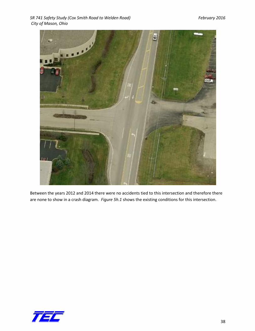
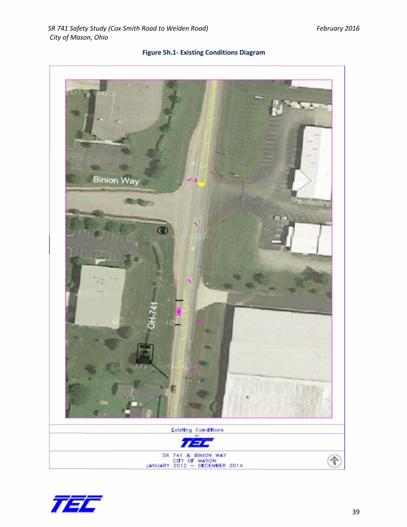
5h. SR 741 and Binion Way The intersection of SR 741 at Binion Way is a 4-leg, stop controlled intersection; Eastbound Binion way
is stop controlled and so is the westbound business driveway. Both the eastbound and westbound legs
provide access to light industrial businesses and have just one wide approach lane. Northbound 741 has
a dedicated left turn lane and a thru lane, and southbound 741 has a dedicated right turn lane and a
thru lane. There is also an acceleration lane for vehicles turning onto southbound 741 from Binion Way.
Just to the south of the intersection, a northbound acceleration lane ends for a business driveway (this
cannot be seen on any current aerials).
SR 741 Safety Study (Cox Smith Road to Welden Road) February 2016 City of Mason, Ohio
38
Between the years 2012 and 2014 there were no accidents tied to this intersection and therefore there
are none to show in a crash diagram. Figure 5h.1 shows the existing conditions for this intersection.
SR 741 Safety Study (Cox Smith Road to Welden Road) February 2016 City of Mason, Ohio
39
Figure 5h.1- Existing Conditions Diagram
SR 741 Safety Study (Cox Smith Road to Welden Road) February 2016 City of Mason, Ohio
40
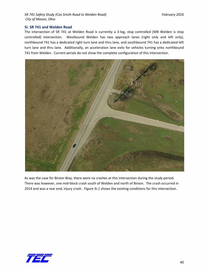
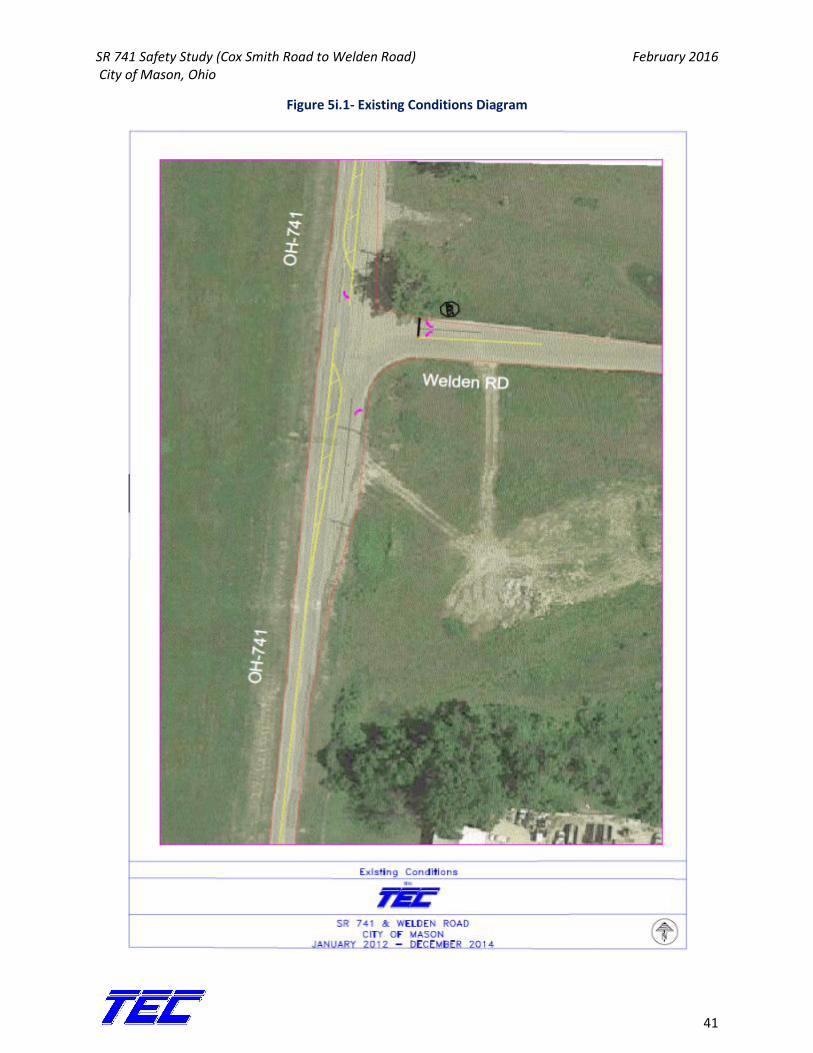
5i. SR 741 and Welden Road The intersection of SR 741 at Welden Road is currently a 3-leg, stop controlled (WB Welden is stop
controlled) intersection. Westbound Welden has two approach lanes (right only and left only),
northbound 741 has a dedicated right turn lane and thru lane, and southbound 741 has a dedicated left
turn lane and thru lane. Additionally, an acceleration lane exits for vehicles turning onto northbound
741 from Welden. Current aerials do not show the complete configuration of this intersection.
As was the case for Binion Way, there were no crashes at this intersection during the study period.
There was however, one mid-block crash south of Welden and north of Binion. The crash occurred in
2014 and was a rear end, injury crash. Figure 5i.1 shows the existing conditions for this intersection.
SR 741 Safety Study (Cox Smith Road to Welden Road) February 2016 City of Mason, Ohio
41
Figure 5i.1- Existing Conditions Diagram
SR 741 Safety Study (Cox Smith Road to Welden Road) February 2016 City of Mason, Ohio
42
6. Future Improvements and Recommendations
Planned Improvements
Currently, the intersections of SR 741 at Cox Smith Road and Stone Ridge Drive are un-signalized
intersections. These intersections will soon be signalized intersections. At Stone Ridge Drive, a fourth
leg will be added to the eastern side of 741 to be the new main access to the Carmelle Woods
neighborhood. EB Stone Ridge Drive will have a dedicated left-turn lane, a right/thru lane, and both will
be actuated; the same will be true for the new WB leg. NB and SB 741 will have dedicated left turn lanes
with protected/permissive left turn phasing. Additionally, SB 741 will have a dedicated right turn lane.
At Cox Smith Road, the EB and WB legs will each have one right/thru lane and a dedicated left turn lane.
Each lane will be actuated for the signal. NB and SB SR 741 will have dedicated left turn lanes with
protected/permissive phasing. In addition to the roadway improvements, as previously mentioned,
automatic crossing gates will be added to the rail crossings near Bethany Road, and 4-section vehicular
signal heads with flashing yellow arrows will be added to the signal at SR 741 and Bethany Road. All of
these improvements in this section were previously planned and are not related to any
recommendations or countermeasures for this analysis.
7. Proposed Countermeasures Evaluation
Along the corridor, the greatest issue is congestion due to the traffic signals at Bethany Road and at US
42. During the AM and PM peaks, these signals cause backups on the corridor which are likely the main
cause for the high number of rear end crashes. Several countermeasures were reviewed to reduce both
the rear end crashes and the angle crashes (the two highest crash types), such as:
Converting the signalized intersections to multi-lane roundabouts
Reviewing the clearance intervals at the signalized intersections
Adding turn lanes at the signalized intersections
Adding lanes in each direction along the entirety of the corridor
Add back-plates to existing signal heads
Prohibit left turns at US 42 and utilize the US 42 & Bethany Road intersection to the northeast
for redirected traffic
A high percentage of the crashes occurred at or near the intersections of SR 741 at US 42 and Bethany
Road. In order to best utilize the countermeasures listed above, TEC analyzed those countermeasures
along SR 741 within the boundaries of Spyglass Hill to the south and Binion Way to the north of the
highly concentrated crashes. TEC combined the countermeasures listed above to create 3 alternatives
for evaluation:
SR 741 Safety Study (Cox Smith Road to Welden Road) February 2016 City of Mason, Ohio
43
Alternative 1: Widen SR 741 from Spy Glass Hill to Binion, add turn lanes at SR 741 & US 42, review
clearance intervals at each signalized intersection, and retro-fit reflective back-plates to existing
signal heads at the signalized intersections.
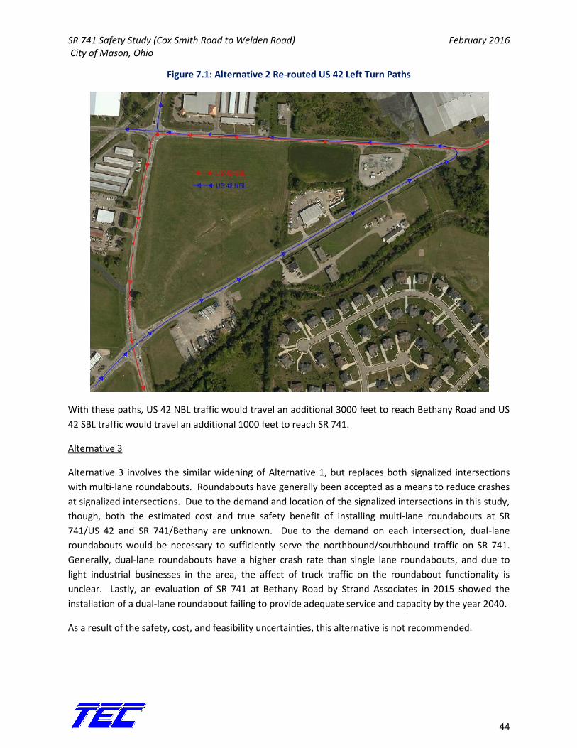
Alternative 2: Implement alternative 1 in addition to prohibiting left turns at SR 741 from US 42 and
redirect traffic to the intersection of Bethany Road & US 42.
Alternative 3: Widen SR 741 from Spy Glass Hill to Binion Way and convert the 2 signalized
intersections to multi-lane roundabouts.
Evaluation
Alternative 1
Widening SR 741 from Spy Glass Hill to Binion Way, in addition to adding right turn lanes at US 42,
provides more capacity for SR 741 thru traffic at the signalized intersections and provides the greatest
safety benefit of this alternative. The countermeasure with the next highest benefit in this alternative is
the modification of change intervals at the signalized intersections. Modifying the change intervals
should help to decrease crashes directly at the intersections. Additionally, a fairly low cost
countermeasure to be taken is installing reflective back plates on the existing signal heads at the
signalized intersections. These will increase signal visibility and help decrease crashes occurring at the
intersection.
The drawbacks to this alternative are that widening only a small portion of SR 741 will push queuing to
just south and north of the intersections where the road will change back to 2 lanes. By itself, the
installation of back plates is a low-cost countermeasure but this does not include the possible cost of
replacing strain poles and mast arms. In total, this alternative will cost approximately $5,163,642 with a
safety benefit of $1,145,048 for a Benefit/Cost Ration of .22.
Alternative 2
This alternative will include all the countermeasures and benefits of Alternative 1 in addition to
prohibiting left turns from US 42 onto SR 741. Prohibiting left turns from US 42 will remove the left turn
phasing and allow more green time for vehicles travelling northbound and southbound on SR 741. This
will provide more service at the signal for SR 741 and a reduction of rear end crashes. The vehicles
previously turning left from US 42 would be directed to the intersection of Bethany & US 42 and then to
Bethany & SR 741. No CMF’s or studies were found to directly relate to this specific countermeasure
and therefore the direct safety benefit is unknown. This however is a low cost countermeasure in
addition to Alternative 1 to help increase capacity and decrease crashes related to the signalized
intersections. Figure 7.1 shows the new routes drivers would take if left turns from US 42 at SR 741
were prohibited.
SR 741 Safety Study (Cox Smith Road to Welden Road) February 2016 City of Mason, Ohio
44
Figure 7.1: Alternative 2 Re-routed US 42 Left Turn Paths
With these paths, US 42 NBL traffic would travel an additional 3000 feet to reach Bethany Road and US
42 SBL traffic would travel an additional 1000 feet to reach SR 741.
Alternative 3
Alternative 3 involves the similar widening of Alternative 1, but replaces both signalized intersections
with multi-lane roundabouts. Roundabouts have generally been accepted as a means to reduce crashes
at signalized intersections. Due to the demand and location of the signalized intersections in this study,
though, both the estimated cost and true safety benefit of installing multi-lane roundabouts at SR
741/US 42 and SR 741/Bethany are unknown. Due to the demand on each intersection, dual-lane
roundabouts would be necessary to sufficiently serve the northbound/southbound traffic on SR 741.
Generally, dual-lane roundabouts have a higher crash rate than single lane roundabouts, and due to
light industrial businesses in the area, the affect of truck traffic on the roundabout functionality is
unclear. Lastly, an evaluation of SR 741 at Bethany Road by Strand Associates in 2015 showed the
installation of a dual-lane roundabout failing to provide adequate service and capacity by the year 2040.
As a result of the safety, cost, and feasibility uncertainties, this alternative is not recommended.
SR 741 Safety Study (Cox Smith Road to Welden Road) February 2016 City of Mason, Ohio
45
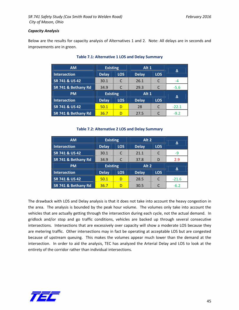
Capacity Analysis
Below are the results for capacity analysis of Alternatives 1 and 2. Note: All delays are in seconds and
improvements are in green.
Table 7.1: Alternative 1 LOS and Delay Summary
AM Existing Alt 1 Δ
Intersection Delay LOS Delay LOS
SR 741 & US 42 30.1 C 26.1 C -4
SR 741 & Bethany Rd 34.9 C 29.3 C -5.6
PM Existing Alt 1 Δ
Intersection Delay LOS Delay LOS
SR 741 & US 42 50.1 D 28 C -22.1
SR 741 & Bethany Rd 36.7 D 27.5 C -9.2
Table 7.2: Alternative 2 LOS and Delay Summary
AM Existing Alt 2 Δ
Intersection Delay LOS Delay LOS
SR 741 & US 42 30.1 C 21.1 C -9
SR 741 & Bethany Rd 34.9 C 37.8 D 2.9
PM Existing Alt 2 Δ
Intersection Delay LOS Delay LOS
SR 741 & US 42 50.1 D 28.5 C -21.6
SR 741 & Bethany Rd 36.7 D 30.5 C -6.2
The drawback with LOS and Delay analysis is that it does not take into account the heavy congestion in
the area. The analysis is bounded by the peak hour volume. The volumes only take into account the
vehicles that are actually getting through the intersection during each cycle, not the actual demand. In
gridlock and/or stop and go traffic conditions, vehicles are backed up through several consecutive
intersections. Intersections that are excessively over capacity will show a moderate LOS because they
are metering traffic. Other intersections may in fact be operating at acceptable LOS but are congested
because of upstream queuing. This makes the volumes appear much lower than the demand at the
intersection. In order to aid the analysis, TEC has analyzed the Arterial Delay and LOS to look at the
entirety of the corridor rather than individual intersections.
SR 741 Safety Study (Cox Smith Road to Welden Road) February 2016 City of Mason, Ohio
46
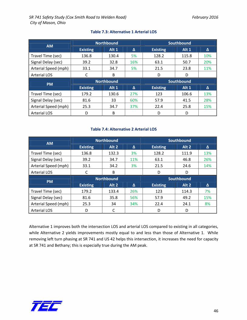
Table 7.3: Alternative 1 Arterial LOS
AM Northbound Southbound
Existing Alt 1 Δ Existing Alt 1 Δ
Travel Time (sec) 136.8 130.4 5% 128.2 115.8 10%
Signal Delay (sec) 39.2 32.8 16% 63.1 50.7 20%
Arterial Speed (mph) 33.1 34.7 5% 21.5 23.8 11%
Arterial LOS C B D D
PM Northbound Southbound
Existing Alt 1 Δ Existing Alt 1 Δ
Travel Time (sec) 179.2 130.6 27% 123 106.6 13%
Signal Delay (sec) 81.6 33 60% 57.9 41.5 28%
Arterial Speed (mph) 25.3 34.7 37% 22.4 25.8 15%
Arterial LOS D B D D
Table 7.4: Alternative 2 Arterial LOS
AM Northbound Southbound
Existing Alt 2 Δ Existing Alt 2 Δ
Travel Time (sec) 136.8 132.3 3% 128.2 111.9 13%
Signal Delay (sec) 39.2 34.7 11% 63.1 46.8 26%
Arterial Speed (mph) 33.1 34.2 3% 21.5 24.6 14%
Arterial LOS C B D D
PM Northbound Southbound
Existing Alt 2 Δ Existing Alt 2 Δ
Travel Time (sec) 179.2 133.4 26% 123 114.3 7%
Signal Delay (sec) 81.6 35.8 56% 57.9 49.2 15%
Arterial Speed (mph) 25.3 34 34% 22.4 24.1 8%
Arterial LOS D C D D
Alternative 1 improves both the intersection LOS and arterial LOS compared to existing in all categories,
while Alternative 2 yields improvements mostly equal to and less than those of Alternative 1. While
removing left turn phasing at SR 741 and US 42 helps this intersection, it increases the need for capacity
at SR 741 and Bethany; this is especially true during the AM peak.
SR 741 Safety Study (Cox Smith Road to Welden Road) February 2016 City of Mason, Ohio
47
8. Recommendations and Conclusions
Between the years 2012-2014, there were 77 non-animal crashes along SR 741 from Cox-Smith Road to
Welden Road. Of the 77 crashes, 52 were rear end crashes and 13 were angle crashes. The signalized
intersections at Bethany Road and US 42 have caused large amounts of congestion in an area along the
corridor that is mostly free flow. This congestion is the likely source for the large amount of rear end
crashes and became the focus of the safety study and analysis. TEC narrowed the countermeasure
analysis to the section of SR 741 between Spyglass Hill and Binion Way, including the signalized
intersections at US 42 and Bethany Road.
After developing and reviewing 3 Alternatives, all with different combinations of countermeasures, TEC
recommends Alternative 1 presented in this study. Alternative 1 provides the most feasibility between
the other 2 countermeasures and also shows the greatest increase in capacity, the lack of which is the
greatest source of crashes along this corridor. Alternative 1 includes widening SR 741 from Spyglass Hill
to Binion Way, reviewing signal timing, installing a new northbound right turn lane on US 42, and
installing reflective back plates at the signalized intersections. This alternative has a Benefit/Cost ratio
of .22, but greatly benefits the capacity of this corridor at the signalized intersections, which in turn will
reduce crashes along this section of SR 741.