SR 525 Clinton Issue Identifcation Summary · SR 525/Clinton: Issue identifi cation analysis The...
26
SR 525/Clinton: Issue identification analysis The results of our analysis of existing and future conditions are positive for Clinton. We found that the number of vehicle collisions recorded in the corridor is low, and traffic is expected to operate without congestion well into the future. However, other problems remain – particularly compliance with posted speed limits and the need for improvements to the ferry pick-up/drop-off area. Although WSDOT implemented several measures in recent years to address these problems, we recognize that additional opportunities exist to slow travel speeds and enhance the roadway. This final report documents our findings and identifies opportunities for future improvements. Results The report lists the following recommendations based on our analysis of the corridor: Implement special emphasis patrols to enforce the speed limit (Washington State Patrol); • Seek funding for location analysis, geotechnical analysis, and preliminary engineering and design for an • improved pick-up/drop-off area at the Clinton terminal (Washington State Ferries); Seek funding for additional transit service to provide public transportation after 7:50 p.m. and on Sundays • (Island Transit). Other options for addressing community concerns There are few collisions and little or no congestion in Clinton, and our analysis shows that it is expected to stay this way well into the future. Nevertheless, Clinton has unique transportation challenges as a ferry community and gateway to the Whidbey Island Scenic Byway. Although WSDOT implemented several measures in recent years to address challenges in the corridor, we recognize that additional opportunities exist to slow travel speeds and enhance the roadway. Unfortunately, financial constraints limit our ability to take advantage of those opportunities. We are faced with a highly competitive set of needs on state highways, and it would be irresponsible for us to ignore other corridors in the region where collisions and congestion are much more prevalent. While we are unable to contribute funds for the effort at this time, we remain a committed partner in helping Clinton residents achieve both traffic calming and economic development objectives. As part of this partnership, we worked with the Clinton Advisory Team to identify a list of corridor improvements that could be pursued for SR 525. The group agreed that the items should be identified in the report as the Clinton Community Action Plan, even though the improvements are beyond WSDOT’s recommendations for the corridor. Clinton SR 525 Clinton SR 525 Issue Identification Issue Identification Summary Summary September 2008
Transcript of SR 525 Clinton Issue Identifcation Summary · SR 525/Clinton: Issue identifi cation analysis The...

SR 525/Clinton: Issue identifi cation analysisThe results of our analysis of existing and future conditions are positive for Clinton. We found that the number of vehicle collisions recorded in the corridor is low, and traffic is expected to operate without congestion well into the future. However, other problems remain – particularly compliance with posted speed limits and the need for improvements to the ferry pick-up/drop-off area. Although WSDOT implemented several measures in recent years to address these problems, we recognize that additional opportunities exist to slow travel speeds and enhance the roadway. This fi nal report documents our fi ndings and identifi es opportunities for future improvements.
ResultsThe report lists the following recommendations based on our analysis of the corridor:
Implement special emphasis patrols to enforce the speed limit (Washington State Patrol); • Seek funding for location analysis, geotechnical analysis, and preliminary engineering and design for an • improved pick-up/drop-off area at the Clinton terminal (Washington State Ferries); Seek funding for additional transit service to provide public transportation after 7:50 p.m. and on Sundays • (Island Transit).
Other options for addressing community concernsThere are few collisions and little or no congestion in Clinton, and our analysis shows that it is expected to stay this way well into the future. Nevertheless, Clinton has unique transportation challenges as a ferry community and gateway to the Whidbey Island Scenic Byway. Although WSDOT implemented several measures in recent years to address challenges in the corridor, we recognize that additional opportunities exist to slow travel speeds and enhance the roadway.
Unfortunately, fi nancial constraints limit our ability to take advantage of those opportunities. We are faced with a highly competitive set of needs on state highways, and it would be irresponsible for us to ignore other corridors in the region where collisions and congestion are much more prevalent. While we are unable to contribute funds for the effort at this time, we remain a committed partner in helping Clinton residents achieve both traffic calming and economic development objectives.
As part of this partnership, we worked with the Clinton Advisory Team to identify a list of corridor improvements that could be pursued for SR 525. The group agreed that the items should be identifi ed in the report as the Clinton Community Action Plan, even though the improvements are beyond WSDOT’s recommendations for the corridor.
Clinton SR 525Clinton SR 525Issue Identifi cation Issue Identifi cation SummarySummary
September 2008

Clinton community action planCommunity members could pursue the following improvement provided that: 1) funding is secured for design, construction and ongoing maintenance; 2) design and construction plans meet state standards and are approved by WSDOT; and 3) a maintenance agreement is established according to WSDOT requirements.
Partner with appropriate agencies to implement low-cost traffic-calming measures such as: Placement of the Island County Sherriff’s office mobile speed indicator equipment;• Pedestrian fl ags at crosswalk•
Seek funding for traffic-calming opportunities such as:Raised pavement markers at Deer Lake crosswalk• Additional crosswalk warning signs• Pedestrian-activated fl ashing light at Deer Lake crosswalk•
Seek funding for improvements in downtown Clinton that would create a more aesthetically pleasing and pedestrian-friendly corridor. Options:
Banners• Hanging fl ower pots• Street lighting • Community entrance marker (such as a sign or raised median)•
Seek funding to develop a master plan for the Clinton Ferry Terminal. This plan would review the building of a separate pedestrian loading/unloading access to the ferry vessels. Pedestrian and automobile loading should be a priority with a focus on convenient pedestrian and motorist access.
Contact informationYour thoughts and opinions are important to us. For more information about the project please contact:
Elizabeth Sjostrom NW Region/Mount Baker Area Highway System PlannerWashington State Department of Transportation360-757-5984 [email protected]
An Online Comment form is also available at: www.wsdot.wa.gov/northwest/baker/planning

1
Clinton SR 525 Issue Identifi cationSeptember 2008
We initiated this review of the corridor in response to a request from the Clinton community. This report describes our process, identifi es community concerns, presents the results of a corridor analysis, and outlines the next steps for WSDOT, its partner agencies and the Clinton community. This SR 525 Issue Identifi cation report will guide WSDOT and its partner agencies as we consider future improve-ments for the highway.
The result of our analysis is good news for Clinton – the number of vehicle collisions recorded in the corridor is low, and traffic is expected to operate smoothly without conges-tion well into the future. However, other problems remain – particularly the need for improvements to the ferry pick-up/drop-off area and community concerns about speeding on the highway. Although WSDOT implemented several mea-sures in recent years to address these problems, additional opportunities exist to slow travel speeds and enhance the roadway.
Given the extremely limited resources of WSDOT, we are unable to take advantage of opportunities to further the community’s goals for the highway. We do recognize the importance of these enhancements to Clinton residents and commit to participating in community-led efforts. In support of this partnership, we worked with the Clinton Advisory Team to identify a list of corridor improvements that could be pursued for SR 525. They requested that the items be included in the report as the Clinton Community Action Plan, even though the proposed improvements would be in addition to what WSDOT recommends for the corridor.
What you will learn in this report:Purpose of this analysis • Clinton community characteristics• Corridor analysis and recommendations• Options for addressing community concerns• Clinton Community Action Plan•
Clinton SR 525Clinton SR 525Issue Identifi cationIssue Identifi cation
September 2008
WSDOT recently initiated and funded the following improvements in Clinton:
Installed fl ashing overhead sign at Deer Lake • intersection. Installed a “blank out” sign at the Columbia • Beach Drive signal that will minimize confu-sion and help direct vehicles when ferry termi-nal lanes are full.Redesigned markings through the ferry queue • that leaves a space for cyclists that is clear of the raised pavement marker (2008 paving project).Deer Lake crossing improvements for full ADA • accessibility (2008 paving project).Construct sidewalk access to the Clinton Park • and Ride (2008 paving project).
525
N
Clinton Study Area
55 MPH
50 MPH 40 MPH 30 M
PH
MP 9.38
MP 8.48
ToMukilteo

2
Clinton SR 525 Issue Identifi cationSeptember 2008
Purpose of the analysis
WSDOT transportation planning Our work is guided by fi ve transportation planning goals set by the state legislature: Safety, preservation, mobil-ity, environment and stewardship. In the face of Washington state’s overwhelming transportation needs, we are directed to focus on improvements that emphasize these goals. Issue identifi cation is the fi rst step in evaluating transportation problems in order to prioritize and obtain funding for improvement projects. WSDOT’s role is to maximize safety and keep traffic moving by being good stewards of our transportation network. WSDOT man-ages more than 7,000 miles of highway in Washington. Of these, 54 miles are in Island County: 29.02 miles on SR 20, 22.04 miles on SR 525, and 2.91 miles on SR 532.
We manage the resources the taxpayers and the Legislature entrust to us for the highest possible return of value when selecting highway improvement projects. Safety is our fi rst priority. Funds are limited, so we make invest-ment choices that maximize safety. Engineers study the roadways and collision data to identify where safety improvements can be made. Projects are then selected in locations that provide the greatest benefi t. In the WSDOT Mount Baker Area, the following projects were funded recently because they had the potential to signifi -cantly reduce future collisions and serious injuries:
SR 20 Fredonia Project• (Skagit County) was selected to improve safety. In the past fi ve years, 384 colli-sions have occurred and involved almost 800 drivers. As a result, eight people died and 227 were injured.SR 20 - Sidney Street to Scenic Heights Project• (Island County) was selected because there have been 169 collisions involving 308 vehicles in the past fi ve years. SR 20 - Quiet Cove Road Vicinity to SR 20 Spur Project• (Skagit County) was selected because there were 156 collisions that killed two people and injured 100 others in the past fi ve years.
Issue Identifi cation analysisClinton residents have long expressed concern about traffic issues related to the Clinton ferry terminal and SR 525. WSDOT initiated this issue identifi cation analysis in response to these concerns. The purpose of this analy-sis was to: 1) perform an inventory of the corridor, 2) analyze existing and future corridor conditions, 3) propose short- and long-term improvements. As part of this work we:
Gathered community input and held six public meetings• Completed a detailed property survey (details of this survey, and an aerial showing existing right of way, • can be found in Appendix F)Measured vehicle travel speeds in the corridor• Analyzed collision history for a three-year period• Assessed existing traffic volumes• Developed a forecast of 2030 traffic volumes• Evaluated existing and future traffic volumes to assess congestion• Measured activity at the ferry pick-up/drop-off location• Circulated a customer-response survey to all residents in the Clinton area (Appendix A provides details of • the survey)
Although we are directed to focus on high-priority needs, an issue identifi cation allows us to review a broader list of existing and emerging topics of concern to community members. This is evident in the SR 525 Issue Identifi -cation – not only does the report address safety and mobility, but also documents the community’s goals for the “look and feel” of the highway. As a result, we identifi ed a range of improvements that could be pursued, either by WSDOT or a partner agency.

3
Clinton SR 525 Issue Identifi cationSeptember 2008
Transportation partnersThe issue identifi cation process benefi ted from community involvement and input by the Clinton Advisory Team, a committee formed to take advantage of the knowledge and expertise that exists in the community. It is com-prised of representatives from Island County, Island Transit, Washington State Ferries (WSF), WSDOT, Whidbey Scenic Isle Way Group, Clinton Community Association, Port of Whidbey and several citizens with downtown business interests.
The Clinton Advisory Team was created as a way to gather community input and serve as the project team. This team gathered information, conducted a needs assessment, and considered input and feedback from the com-munity. This team took into consideration the plans and preferences of the community and route users and used this information to prioritize strategies for improving the highway. This committee was comprised of key partners who share a common interest and commitment to making appropriate improvements.
Future corridor development requires the following partnerships:
Island CountyClinton is an unincorporated community within Island County. The county designated Clinton as a Rural Area of Intense Development (RAID), indicating that it will accommodate growth of 3 dwelling units per acre in this rural center. Clinton has unique traffic challenges because it serves as the main access to the Seattle/Everett metropolitan area via the Mukilteo-Clinton ferry. State highways - SR 525 and SR 20 - are the primary arteri-als connecting Whidbey Island to the mainland. Since Clinton serves as a gateway to Whidbey Island and the mainland, this community serves traffic bound for locations throughout the island, not just for the immediate community.
Washington State Ferries (Ferries) The Mukilteo-Clinton ferry run is one of the busiest routes in the state ferry system and has the third-largest annual ridership. Currently, the system carries more than 6,000 vehicles per day and 11,000 riders. Ferries estimates that by 2030, this route will have an 80 percent increase in total passenger ridership and 20 percent increase in vehicle ridership.
Port of South Whidbey Island The Port of South Whidbey Island developed Clinton Beach Park, a small public park on the north side of the Clinton terminal. The Port also owns a public fi shing pier and dock on the north side of the trestle, accessed via a sidewalk along the north side. The Port has an interest in enhancing the economic wellbeing of the community and increasing access to marine areas while respecting the unique rural character and environment of South Whidbey Island. The Port also has leased a public parking facility called “Patty’s Parking” on the hill overlooking the ferry terminal. This lot has not yet reached capacity, and provides parking close to the ferry.
Island Transit Island Transit provides fare–free transit service for Island County with direct service to the Clinton ferry terminal between 4:30 a.m. and 7:50 p.m. Island Transit serves eight separate park and ride lots with 533 spaces, and 1.2 million riders a year. Island Transit provides 50 trips to the Clinton ferry each day. The Island Transit buses have an advantage over cars loading on the ferry as they do not have to wait in the car queuing lines, and they have a lane that proceeds directly to the terminal. This allows for convenient access for walk-on riders. Additionally, Island Transit participates with Ferries in a “Rideshare Registration” program that allows vanpool groups to be eligible for fare discounts and preferential loading. Ferry rider-ship has increased, and with improved transit service, park-and-ride facilities are full on a regular basis. Island Transit’s goal is to reduce
the number of single-occupant vehicles traveling on the island. They have initiated a long-range plan to accommodate additional transit customers by providing park-and-ride facili-ties close to the communities where their travelers originate.
Deer Lake Road Park and Ride
Patty’s Parking

4
Clinton SR 525 Issue Identifi cationSeptember 2008
Clinton community characteristics
Key facts:
Approximately 7,000 vehicles travel through Clinton every day• Approximately 2.5 million vehicles travel through Clinton annually• An additional 13,600 residents, representing a 52 percent increase in population, are expected in central • and south Whidbey Island by 2020An additional 2,100 vehicle trips a day are anticipated by 2020•
Community features
The unincorporated town of Clinton is located at the southern end of SR 525 on the southern tip of Whidbey Island. Clinton has unique traf-fi c challenges because it serves as the main access to the Seattle/Ev-erett metropolitan area. Approximately 2 million drivers pass through the community each year, many traveling to and from the ferry.
SR 525 and SR 20 are the primary arterials that connect Whidbey to the mainland. Since Clinton serves as a gateway to Whidbey Island and the mainland, this community will experience increased traffic that accommodates growth throughout the island, not just for the immedi-ate community.
Clinton is a rural community of 1,700 people. Since Washington State assumed responsibility for ferry service in 1951, businesses have located on both sides of the highway. Island County designated the area a Rural Area of Intense Development (RAID), which signals the likelihood of increased residential and com-mercial growth on both sides of SR 525 in coming years.
Clinton concerns
Travelers who regularly use this portion of SR 525 presented many suggestions as to how they would like to see the corridor improved. These suggestions are also refl ected in the numerous plans have been developed by the community to accommodate growth and incorporate aesthetic needs identifi ed by the community. These plans include:
Whidbey Scenic Isle Way Corridor Management Plan• Island Sub-Regional Transportation Plan• State Route 525 Route Development and Technical Reference• South Whidbey Island Walking Audits, May 2007• Port of South Whidbey Island six-year Comprehensive Scheme, 2007-2013• Island Transit 2006 Transit Development Plan 2006-2011•
WSDOT hosted six community meetings to share information and gather feedback from Clinton residents. Users of SR 525 identifi ed areas where they felt safety and congestion were problems and provided input on the types of improvements they felt would best address these issues. The feedback addressed transportation and aes-thetic concerns.

5
Clinton SR 525 Issue Identifi cationSeptember 2008
Transportation concerns
The advisory team met on four occasions to identify transportation concerns and potential partnerships. Two other meetings were held in Clinton to review the draft fi ndings. Community concerns focused on roadway treat-ments that would better accommodate pedestrian and bicycle safety. They also explored suburban design tech-niques to improve and encourage walking in this area and to slow traffic through the commercial center. These are the key transportation issues that the community wanted addressed:
Vehicle traffic volumes/congestion tied to ferry terminal • Vehicles traveling at high speed through the Clinton area • Vehicle accidents in the corridor• Pedestrian/bike safety• Ferry terminal pedestrian pick-up/ drop-off did not accommodate need• Confusing signal at Columbia Beach Road • Pedestrian safety at SR 525/Deer Lake intersection • Aesthetics and beautifi cation of the roadway- making Clinton observed as a “place.”• Combining Flex car/ ADA parking close to ferry with improved pick-up/drop-off area • Access to park-and-ride locations after 7:50p.m., when transit service is unavailable •
Many of these transportation and development opportunities are amenities that currently are typically addressed by city or county sub-area planning. While such improvements on state highways require coordination with WSDOT to ensure that design standards and safety guidelines are met, implementation of these roadway treat-ments work best when led by individual communities and developed in a manner that is consistent with commu-nity needs and preferences.
This photo of SR 525 in Clinton is used in the report South Whidbey Island Walking Audits (May 2007) to illustrate the point that, “There will be little change in traffic speeding through town until a partnership is formed to create a community identity.”

6
Clinton SR 525 Issue Identifi cationSeptember 2008
Aesthetic concerns
Community members expressed an interest in developing gateway features and other aesthetic enhancements to highlight Clinton and slow travel speeds through town. The Whidbey Scenic Isle Way Corridor Management Plan, adopted in February 2005, emphasizes the importance of design improvements, ”the Clinton community and Island County should work closely together to evaluate existing design requirements for this area and develop a new sub-area plan with design guidelines that recommend specifi c character requirements, such as setbacks, parking design, and controlled access along the byway.”
Work to identify the aesthetic treatments was undertaken by the Scenic Isle Way Group in 2005. This group expects to implement a portion of their vision by placing a monument on the hill overlooking the ferry dock that will welcome travelers to the Whidbey Scenic Isle Way. This will be completed in Fall 2008. Other suggestions included constructing a raised median with street trees and landscaping improvements, as well as an increase in landscaping, public art, and wayfi nding signs.
Following completion of the Whidbey Island Scenic Isle Way Corridor Management Plan, Island County Public Health, Island County Planning and local community members sponsored a walking workshop in April 2007. The purpose of the workshop was to “summarize changes under way or needed to make Clinton a more walk-able, bicycle-friendly and a destination in its own right as opposed to a pass-through location.” The fi nal report, issued in May 2007, recommends numerous improvements to “help accent pride and place” and visually tighten streets to lower travel speeds. The walking audit report emphasizes the need for partnerships to make SR 525 more welcoming: “There will be little change in traffic speeding through town until a partnership is formed to create a community identity.”
This gateway monument, which highlights Clinton as a gateway to the Whidbey Island Scenic Isle Way, will be constructed in 2008 with grant fund-ing provided by the National Scenic Byways Program.

7
Clinton SR 525 Issue Identifi cationSeptember 2008
Key challenges and constraints
Clinton community members identifi ed several constraints that may limit the types of improvements sought for SR 525:
Neighbors do not desire further ferry terminal expansion.• Pick-up/drop-off area is difficult to enter or leave due to congestion and confi ned space.• Peak travel times cause overfl ow queuing on SR 525, creating confl icts at driveways. • Overfl ow queuing leaves vehicles far from terminal amenities.• Pedestrians and bicyclists share the transfer span with motor vehicle traffic, creating delays in ferry loading • and unloading.Speeding in SR 525 corridor.• Drivers unaware of crosswalks.•
Suggested improvements: Community members requested that WSDOT evaluate the following suggestions:
Move 30 mph sign, currently located near the dock, so it is more visible. • Manage accesses to SR 525 by consolidating number of turns on and off highway. • Turn engines off in town while cars are in holding area/ “No-idle” signs or provide off-highway holding area.• Install a “Your Speed Is” radar speed-activated mobile sign. • Explore speed change, either eliminating the 40 mph section or extending it further out of town.• Modify ferry terminal control traffic light at Columbia Drive intersection to stop terminal traffic for 45-second • intervals so that both pedestrians and cars up the road can make their way onto/across the highway during an offload from the ferry. Install “Welcome to Clinton” signs to show a sense of “place”.• Install a pedestrian-activated fl ashing light at the Deer Lake crosswalk.• Install raised pavement markings identifying the Deer Lake crosswalk.• Add sign just before the crosswalk, with “crosswalk ahead” sign at Deer Lake Road crossing.• Install grid of domed circle speed bumps before the crosswalk to slow traffic.• Install in-pavement fl ashing lights at crosswalk.• Install planted medians from ferry dock to Forgotten Lane to help slow traffic and beautify area.• Consider possible overhead pedestrian crossing of highway similar to Coupeville.• Add additional marked crosswalks.• Add crossing fl ags for pedestrians to carry to increase visibility at marked crossing. • Increased park and ride capacity close to Clinton terminal.• Install a small raised median at the north end of the corridor as you enter town, and explore possible loca-• tions on the south end of the corridor. Add aesthetic treatments to mark the corridor as a community center.• Provide bike lane markings.• Expand pick-up/drop-off area.• Produce a ferry terminal master plan that provides overhead loading for passengers.• Provide additional transit service: late night, Sundays, and Dial-a-Ride.•
These and other suggestions have been researched to determine effectiveness and viability at specifi c locations. Appendix C contains illustrations of many of these options with a discussion of their advantages and disadvan-tages for use in Clinton, as discussed at a May 2008 meeting.

8
Clinton SR 525 Issue Identifi cationSeptember 2008
Corridor analysis and recommendationsCorridor characteristics
SR 525 is a critical roadway for the transportation needs of Whidbey Island. Its primary purpose is to facilitate the transportation of people and goods to the central and southern part of the Whidbey Island. The majority of the vehicle traffic that affects Clinton is a result of access to and from the ferry. Another factor that makes this corridor unique is that SR 525 has been designated as a portion of the “Whidbey Scenic Isle Way.” The Whidbey Scenic Isle Corridor Management Plan was developed to meet WSDOT’s Scenic Byway Program guidelines and direct aesthetic improvements along this stretch of the highway.
SR 525 corridor current confi guration
Clinton SR 525
Corridor Description
SR 525
Crosswalk at Deer Lake with mast arm
light
Park and Ride
Exiting Ferry traffic has two lanes up the hill through Clinton out to the intersection with Cedar
Vista Dr., where the road changes to a single outbound lane.
The inside lane is for vehicles to by-pass the ferry queue in order to access the roads along the beach
on either side of the ferry terminal. There is also access to Ferry Dock road used for passenger drop-
off, and for transit to reach the terminal.Signs along the road give expected wait
times at several distances ('90 Minute Wait', '60 Minute Wait',etc).
Inbound ferry traffic must use the outside lane beginning at Humphrey Lane; the lane for ferry
queuing begins more than a mile and a half from the terminal.
Two lanes head uphill away from the terminal, and two lanes are for traffic southbound toward the
terminal.
At the terminal, SR 525 has four lanes, and a curb for bicycles on both sides, and a sidewalk on the
southwest side.
Current Pick-Up and Drop-Off area at Ferry
Dock Rd.
The Clinton Terminal is at the signalized intersection of SR
525, and county roads:Hunziker Lane, Columbia Beach Dr, and
Ferry Dock Rd.
WSF Clinton Ferry Terminal
MP 8.98
MP 8.96
MP 8.65

9
Clinton SR 525 Issue Identifi cationSeptember 2008
Clinton is a small community that has developed on both sides of SR 525. The confi guration of the highway has been altered over the years to accommodate growth in the county and additional ferry traffic. A holding lane was added to accommodate cars waiting for ferry service, and a two-way left turn lane was constructed to facilitate safe access to businesses and homes, and there are three travel lanes. These fi ve lanes are important opera-tionally, but provide a barrier to people wanting to cross the roadway when the ferry offloads.
Clinton fi ve lane crossing:
Legend
1) Northbound travel lane
2) Northbound travel lane
3) Two-way left turn lane
4) Southbound travel lane
5) Ferry queue

10
Clinton SR 525 Issue Identifi cationSeptember 2008
The Clinton ferry terminal
The Mukilteo-Clinton run has the third-largest annual ridership of all Washington State Ferries routes. The opera-tion of the Clinton terminal has a measurable impact on the SR 525 corridor. This terminal was recently upgraded to include a new ferry slip and the holding capacity was expanded to nine lanes, accommodating 130 vehicles and four toll booths to process incoming vehicles. The capacity of the existing ferry is 124 vehicles. Each day, 42 trips are made between Clinton and Mukilteo, with an approximate 20-minute crossing time.
A new terminal building with restrooms was constructed, but it has no food service or overhead loading facilities to separate pedestrians from vehicle traffic. Pedestrians currently access the terminal building via a covered sidewalk, located along the southern edge of the trestle. When leaving the facility, there are two exit lanes with a wide shoulder for bicyclists. The tres-tle was built to accommodate future construction of a second slip when a third ferry boat is needed, and to develop the future overhead loading facility that will serve the two primary slips.
A commonly used short-time parking area – referred to as the “pick–up/drop-off site” – is located on Ferry Dock Road just south of the intersection with SR 525. This site is a narrow county road that allows cars to bypass the queue and provides momentary parking close to the ferry to either drop off or pick up ferry passengers. This pick-up/drop-off location has chal-lenges that are highlighted in the following sections of this report.
Traffic conditions
Annually, this ferry run has more than 4.2 million riders. Of those riders, 546,000 are walk-ons, 2.3 million are passenger vehicles and 90,000 are commercial users. Like most ferry terminals, the Mukilteo-Clinton ferry run creates traffic pulses that occur every 30 minutes when boats arrive. These waves of traffic either pass through or stack up along SR 525.
The ferry system predicts an 80 percent increase in foot passengers and a 20 percent increase in vehicles by 20301. Ferries has identifi ed the need for a third vessel in the long term, which would potentially run every 20 minutes. With the projection of additional users comes additional traffic concerns for the Clinton area.
1 These projections are from the DRAFT Washington State Ferry System Plan. Per the Ferry Financing Bill (ESHB 2358 2007), a preliminary baseline forecast of demand is underway. These are preliminary forecasts taken from this work and are subject to change in future drafts.
11
Clinton SR 525 Issue Identifi cationSeptember 2008
Corridor analysis A corridor analysis is a review of data that helps provide background information needed to prioritize project development. Corridor analysis is guided by planning goals set by the state Legislature: safety, preservation, mobility, environment and stewardship.
The results of our safety and mobility analysis are presented in the following sections:
Collision history analysis• Traffic analysis• Speed study• Operational considerations• Pick-up/drop-off area for ferry passengers• Conclusions•
Collision history analysis2
WSDOT reviewed all collisions documented during a three-year period (2004-2006, inclusive), between the ferry terminal (milepost 8.48) and milepost 9.38, where the posted speed changes to 50 mph outside the business district. A total of 19 collisions occurred on this segment of SR 525. Of these collisions, 16 were categorized as “Property Damage Only.3” The incidents were attributed to numerous causes and occurred at separate loca-tions; ultimately the data did not present an obvious pattern that could be used to recommend a remedy. For example:
10 were located at various intersections and access points along the corridor• 5 occurred during inclement weather and were related to speeds considered excessive for conditions• 2 involved a single vehicle and a fi xed object (i.e. mailbox, light post, etc.)• 1 was caused by an impaired driver•
Finding:
Out of more than 7.5 million trips that occurred between 2004 and 2006, 19 collisions were reported. In proportion to the amount of vehicle trips, this area has a very low crash history. The collision data do not point to identifi able causes that can be resolved with roadway improvements.
2 Federal law 23 United State Code Section 409 governs the use of the data contained in above mentioned Summary. Under this law data maintained for purposes of evaluating potential highway safety enhancements: “. . . Shall not be subject to discovery or admitted into evidence in a federal or state court proceeding or considered for other purposes in any action for damages arising for any occurrence at a location mentioned or addressed in such reports, surveys, schedules, lists, or data.’ If anyone attempts to use this data in an action for damages against WSDOT, the State of Washington, or any other jurisdiction involved in the locations mentioned in the data, these entities expressly reserve the right, under Section 409, to object to the use of data, including any opinions drawn from the data.
3 Property damage may include harm to an automobile, a fence, a tree, a home, or any other possession.

12
Clinton SR 525 Issue Identifi cationSeptember 2008
Traffic analysis
Community members also voiced concerns about increases in traffic congestion. We conducted a traffic analysis in order to evaluate operational conditions as they currently exist and predict those that might occur as a result of future growth. This traffic analysis helps WSDOT understand how people use SR 525 and how future conditions will affect mobility and safety.
We conducted a Level of Service (LOS) analysis (see inset) to assess the capacity of intersec-tions in the corridor. We counted the number of vehicles using the highway, collected Average Daily Traffic (ADT) counts, and tracked how many vehicles turned right, left or went straight at each intersection. We estimated a reasonable growth rate for the area at 1.5 percent per year, based on historical traffic counts, and projected a 43 percent increase in automobile traffic volumes for this stretch of SR 525 by 2030. This map shows the current and predicted future delay for vehicles along SR 525. The projected growth will not result in congestion. Instead, SR 525 is expected to perform within standards set for the highway, with an anticipated LOS B in 2007 and LOS C in 2030. These results mean that traffic will fl ow smoothly well into the future. This performance falls within the standards set for this highway, which is LOS E for Rural Highways of Statewide Signifi cance in Island County.
Finding:
Even with predicted increases in traffic, the model showed no appreciable delays at any of the four main intersections in the analysis. All will meet or exceed level of service standards adopted for this area.
Level of service (LOS) is a common analysis technique used to measure traffi c congestion on a scale of “A” to “F”. Industry guidelines defi ne LOS performance as follows:
A= Traffi c moves freely; (0-10 second delay)
B= Traffi c moves fairly freely; (10-15 second delay)
C= Traffi c moves smoothly; (15-25 second delay)
D= Traffi c approaching unstable fl ow; (25-35 second delay)
E= Unstable traffi c fl ow; (35-50 second delay)
F= Saturation condition. (>50 second delay)
N
525
No-Build Traffic Analysis shows LOS at four key Clinton intersections with no improvements
Clinton Intersections
Level of service in 2006 and with
anticipated growth/no-build
scenario in 2030
Bob Galbreath Rd operates at LOS B in 2006 &2030
2006: AM peak 14.2 second delay, PM peak 13.1
2030: No build: AM peak 16.1 second dealy, PM peak 15.8
Deer Lake Rd operates at LOS B in 2006 & LOS C in 2030
2006: AM peak 10.8 second delay, PM peak 13.1
2030 No build: AM peak 12.4 second delay, PM peak 17.3
Humphrey Rd operates at LOS B in 2006 & 2030
2006: AM peak 10.7 second delay, PM peak 10.3
2030 No build: AM peak 12.3 second delay, PM peak 11.5
Columbia Beach Dr. operates at LOS B in 2006 & 2030
2006: AM peak 14.2 second delay, PM peak 13.1
2030 No build: AM peak 16.1 second delay, PM peak 15.8
ToMukilteo

13
Clinton SR 525 Issue Identifi cationSeptember 2008
Speed study
The speed of vehicles traveling through the corridor is one of the top concerns voiced by Clinton residents. Despite the low crash history, travel speed in the corridor poses a challenge for pedestrian travel. The posted speed is 30 mph, then changes to 40 mph after Bob Galbreath Road, and then 50 mph as drivers leave town. The community struggles with travelers who appear to anticipate the speed increase before it occurs and speed, thus making them feel unsafe crossing the roadway.
We have used a variety of strategies to address these con-cerns. We installed crosswalk warning signs at the Deer Lake Road crosswalk, and installed a fl ashing crosswalk sign over the highway. In addition, in response to a request from community members, we reduced the speed limit for travelers leaving the ferry from 35 to 30 mph.
As a follow-up to these efforts, we conducted a speed study to determine how well drivers are obeying the posted speed limits (more detail about this speed study can be found in Appendix E). Travel speed data collected on a single day in October 2006 reveal that the average travel speed exceeded the posted speed limit by approximate-ly 5 mph.
Finding:
Average travel speeds exceed the posted speed limit by 3 to 5 miles. While a majority of the drivers who exceed the speed limit drove within a few miles over the posted speed, a sizable minority, 20%, drove faster. This has not been shown to contribute to unsafe conditions in the SR 525 corridor, but does present a challenge for pedestrian travel.
SR 525 at Deer Lake Road crosswalk
Marked crosswalk
Overhead
fl ashing light
Crossing sign
0%
20%
40%
60%
80%
100%
30 mph Zone 40 mph Zone
Per
cen
t o
f V
ehic
les
At or Below40 mph:
27 vehicles
40-50 mph:(66 vehicles)
Below 30 mph:13 vehicles
30-40 mph:(71 vehicles)
Above 40 mph:(19 vehicles)
Above 50 mph:(5 vehicles)
Observed Travel Speed

14
Clinton SR 525 Issue Identifi cationSeptember 2008
Operational considerations at ferry terminalWhile the corridor collision history does not indicate unsafe driving conditions, currently there are non-standard opera-tional confi gurations that have been described as confusing to motorists.
For example, the Columbia Beach signal at the ferry ter-minal permits travel from the left lane as it approaches the terminal and allows access to county roads on the right and left. As a result, motorists are allowed to turn right from the left lane in front of the waiting ferry queue.
Finding:
We agree that this system is confusing, but with the low volumes of traffic accessing these roads, it is not a contributor to collisions. Nevertheless, a “blank out” sign has recently been installed at this location to tell drivers how to proceed when the ferry terminal lanes are full. It will be blank when not needed and, when necessary, will communicate to drivers the need to queue on the roadside before the terminal.
An additional suggestion has been made to evaluate the option of having the stop light at this location hold the off-loading ferry traffic for 45 seconds in the middle of each trip, to regulate traffic fl ow so that more of a separation is created in the vehicle platoon up the hill. This would allow drivers and pedestrians to cross more comfortably. This was evaluated by Ferries and would operationally distrupt the offload-ing process and cause delays in service, so it is not a recommended action.
P r iva t e ly o w n e d
p a r k in g
C lin t o n F e r ry Te r m in a l
Signal
Aerial view of Intersection adjacent to Ferry Terminal.
Sign at Intersection of SR 525 and Ferry Dock Road and
Columbia Street
Sign at Intersection of SR 525
and Ferry Dock Road and Columbia Street
Blankout sign, installed in 2008
Drop-off/
Pick-Up Area Privately owned parking
Signal
Clinton Ferry Terminal

15
Clinton SR 525 Issue Identifi cationSeptember 2008
Analysis of pick-up/drop-off location for ferry commutersIncreased ferry walk-on usage and full park-and-ride lots have increased the need for a pick-up/ drop-off area for walk-on ferry passengers. Currently Ferry Dock Road, a county road adjacent to the terminal, has been desig-nated as a pick-up/drop-off location to serve this activity.
The existing pick-up/drop-off site has a drainage ditch and thick vegetation that obscures views, requiring caution both on the part of drivers as well as “foot ferry” passengers exiting vehicles. The lack of sidewalks and other pedestrian amenities poses a challenge for those walking between the pick-up/drop-off and ferry terminal.
Also of concern is the stability of the slope adjacent to the site. Ferries worked out an agreement for WSDOT Maintenance crews to maintain the county road as a loading zone; however, this area recently experienced a severe mudslide resulting from a slope destabilized by runoff. A geo-technical survey is needed to evaluate the slope stability. Ferries is currently working on a fi nal analysis for this area.
A vehicle count was done to determine use at the pick-up/drop–off area. The count was conducted on Monday, February 12, 2007 through Friday, Feb. 16, 2007, (Appendix D show details). The highest per-hour usage was 24 vehicles on Wednesday, Feb. 14, at 5:00 pm. High volumes were shown at 6:00 am with 12 people, and 5:00 pm with 24. The average per-day use ranged from 154-170 vehicles. It was observed that an average of nine cars could comfortably wait at this location. When more than 9 cars were waiting, other cars had to drive past this area, circle through Clinton and return again to this area to off-load passengers.
Finding:
The site currently used for pick-up and drop-off of ferry passengers has width barriers and is vulnerable to future mudslides. A redesign or new location that provides adequate width, resolves slope stability issues, improves pedestrian facilities and adds storage capacity for waiting vehicles is recommended.
Aerial view of Clinton Ferry Terminal and surrounding facilities.
Privately owned parking
Pick-up/drop-offon Ferry Dock Rd
“Patty’s Parking”Port property
Port of Whidbey Island Clinton Beach Park
Views of pick-up/drop-off loca-tion at Ferry Dock Road
Drop-off/
Pick-Up Area
16
Clinton SR 525 Issue Identifi cationSeptember 2008
ConclusionsBased on our data collection and technical analysis we determined:
No change in the traffic pulse is anticipated until the third ferry is added to the route (currently unfunded but • identifi ed in the Ferry System Plan to be implemented by 2018). No congestion on SR 525 is anticipated in the next 20 years.• Collision data did not point to specifi c safety improvement needs in this section of SR 525. In fact, there is • a low incidence of crashes in last three years.Travelers leaving the ferry have been shown to exceed the posted speed limit, with an average speed of • 34.8 in the 30 mph zone, and an average speed of 42.2 in the 40 mph zone. This has not been shown to contribute to unsafe conditions in the area, but does present a challenge for pedestrians negotiating their way across SR 525. Pick-up/drop-off area is narrow, and expansion at current location is difficult due to steep slopes, utility • locations and drainage issues.
RecommendationsBased on these conclusions, WSDOT recommends the following for SR 525:
1. Increase enforcement efforts to address excessive travel speeds. The most viable, short-term traffic calming tool is increased enforcement. This method has proven effec-tive and can be implemented immediately. In response to community concerns, the Washington State Patrol has committed to performing emphasis patrols in the corridor beginning in Summer 2008.
2. Seek funding for location analysis, geotechnical analysis, and preliminary engineering and design for an improved pick-up/drop-off area at the Clinton terminal. Our analysis shows that modifi cations are needed to the existing site. In the short term, the location can be improved with continued maintenance of the brush and better pedestrian connections to the ferry. Ad-ditional funding will be needed to pursue a redesign or new location. Such work will require the expertise of geotechnical engineers to address slope stabilization.
3. Seek funding for additional transit service after 7:50 p.m., on Sundays, and to support Dial-a-Ride ser-vice.
17
Clinton SR 525 Issue Identifi cationSeptember 2008
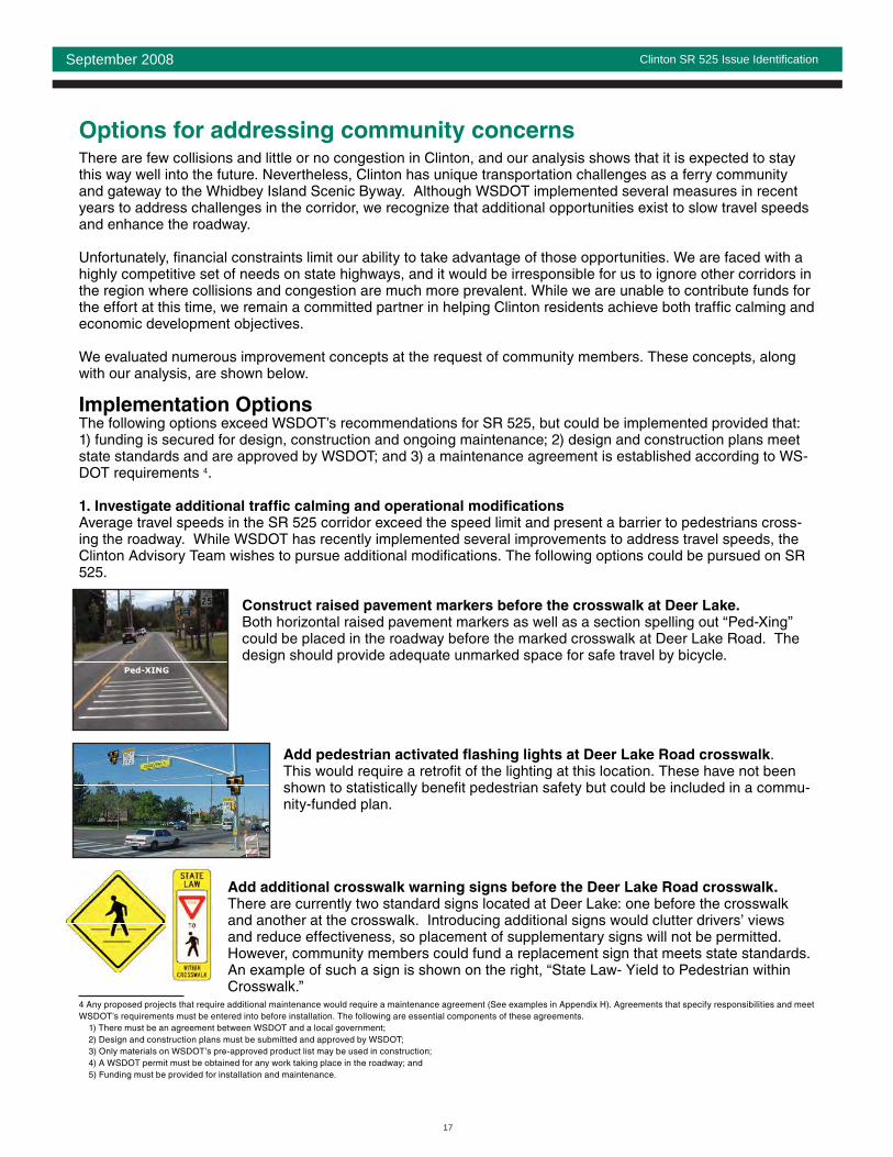
Options for addressing community concernsThere are few collisions and little or no congestion in Clinton, and our analysis shows that it is expected to stay this way well into the future. Nevertheless, Clinton has unique transportation challenges as a ferry community and gateway to the Whidbey Island Scenic Byway. Although WSDOT implemented several measures in recent years to address challenges in the corridor, we recognize that additional opportunities exist to slow travel speeds and enhance the roadway.
Unfortunately, fi nancial constraints limit our ability to take advantage of those opportunities. We are faced with a highly competitive set of needs on state highways, and it would be irresponsible for us to ignore other corridors in the region where collisions and congestion are much more prevalent. While we are unable to contribute funds for the effort at this time, we remain a committed partner in helping Clinton residents achieve both traffic calming and economic development objectives.
We evaluated numerous improvement concepts at the request of community members. These concepts, along with our analysis, are shown below.
Implementation OptionsThe following options exceed WSDOT’s recommendations for SR 525, but could be implemented provided that: 1) funding is secured for design, construction and ongoing maintenance; 2) design and construction plans meet state standards and are approved by WSDOT; and 3) a maintenance agreement is established according to WS-DOT requirements 4.
1. Investigate additional traffic calming and operational modifi cations
Average travel speeds in the SR 525 corridor exceed the speed limit and present a barrier to pedestrians cross-ing the roadway. While WSDOT has recently implemented several improvements to address travel speeds, the Clinton Advisory Team wishes to pursue additional modifi cations. The following options could be pursued on SR 525.
Construct raised pavement markers before the crosswalk at Deer Lake.
Both horizontal raised pavement markers as well as a section spelling out “Ped-Xing” could be placed in the roadway before the marked crosswalk at Deer Lake Road. The design should provide adequate unmarked space for safe travel by bicycle.
Add pedestrian activated fl ashing lights at Deer Lake Road crosswalk. This would require a retrofi t of the lighting at this location. These have not been shown to statistically benefi t pedestrian safety but could be included in a commu-nity-funded plan.
Add additional crosswalk warning signs before the Deer Lake Road crosswalk.
There are currently two standard signs located at Deer Lake: one before the crosswalk and another at the crosswalk. Introducing additional signs would clutter drivers’ views and reduce effectiveness, so placement of supplementary signs will not be permitted. However, community members could fund a replacement sign that meets state standards. An example of such a sign is shown on the right, “State Law- Yield to Pedestrian within Crosswalk.”
4 Any proposed projects that require additional maintenance would require a maintenance agreement (See examples in Appendix H). Agreements that specify responsibilities and meet WSDOT’s requirements must be entered into before installation. The following are essential components of these agreements. 1) There must be an agreement between WSDOT and a local government; 2) Design and construction plans must be submitted and approved by WSDOT; 3) Only materials on WSDOT’s pre-approved product list may be used in construction; 4) A WSDOT permit must be obtained for any work taking place in the roadway; and 5) Funding must be provided for installation and maintenance.

18
Clinton SR 525 Issue Identifi cationSeptember 2008
Provide pedestrian crossing fl ags.
A citizen-adopted program could be established. Crossing fl ags may make pedestrians more visible to drivers but will not stop a speeding car. It is a polite but fi rm statement to drivers that users are exercising their legal rights to cross the street. It would be necessary for this program to be installed and maintained by community members.
Install a “Your Speed Is” radar sign. The Island County Sherriff’s Department volunteered temporary placement of their equipment to help people understand that their speed is an issue in this area. The placement of this device will be coordinated with the WSDOT Traffic Office and further investigation made into its effectiveness in changing drivers’ behavior.
David Levinger, left, president of Feet First, and Lester Goldstein demonstrate the pocket pedestrian fl ags as they cross Pike Street at Boylston Avenue. Gold-stein came up with the idea for the fl ags. (November 04, 2003) Credit: Grant M. Haller/Seattle Post-Intelligencer

19
Clinton SR 525 Issue Identifi cationSeptember 2008
2. Develop gateway features and aesthetic treatments
Many aesthetic treatment options have been explored along SR 525 to convey the message that Clinton is a place that requires slower speeds due to pedestrian and cyclist activity. The confi guration of this corridor in-cludes a ferry queue line and a two- way left turn lane which occupies the full width of WSDOT right-of-way. While, there is not adequate space for techniques such as curb bulb-outs and raised medians (see Appendix C), other techniques have been explored in this issue identifi cation that can be further refi ned and funded.
The Newport, WA example to the right shows the array of funding partnerships and urban design elements that helped this community achieve their downtown corridor. The South Whidbey Island Walking Audits report, released in May 2007, recommends some of these strategies such as adopting development regula-tions that require buildings to comply with urban form and add design features such as pedestrian lighting, and distinctive ground cover. This example illustrates use of these techniques and funding partnerships that were needed for implementation in 1998. Appendix I shows potential funding sources for future projects.
Corridor enhancements that could be pursued include: Install “Welcome to Clinton” signs at the entrance to the community to help identify sense of “place” when • entering community.
Additional aesthetic treatments such as fl ower pots and festive banners. • These would provide visual clues that alert travelers that they are approaching an active community that requires additional attention to pedestrians, cyclists and business activities along the roadway.
Construct a raised median at entrances to the Clinton Community to serve as a community entrance mark-• er. Size and type available will be evaluated by the WSDOT Traffic office if funding becomes available.
Newport, WA before and after road development partnership

20
Clinton SR 525 Issue Identifi cationSeptember 2008
3. Develop a ferry terminal master plan
The Clinton Community would like to work with Ferries to develop alternatives to the loading and offloading of ferry passenger traffic through their community. They want to explore a possible raised pedestrian access that would separate walking passengers from car travelers. The Mukilteo ferry terminal has undergone many improve-ments in anticipation of increased ridership and community connections. Clinton is the destination or starting point for these travelers, and additional accommodations are requested on this end of the line to defray impacts and accommodate system growth.

21
Clinton SR 525 Issue Identifi cationSeptember 2008
Measures not available for implementation
Some of the treatments that Clinton community members requested we review did not meet state standards. We considered them carefully and determined that they have limitations that preclude approval for the SR 525 cor-ridor.
Expansion of existing park-and-ride lot onto WSDOT maintenance property used for storage of • sand and gravel. Island Transit has a long-range capital improvement program for park-and-ride develop-ment. This plan is focused on getting more transit use at facilities that are closer to the communities that generate the trip, so that they can maximize the use of their service for longer stretches of the highway and get single-occupant vehicles off the road sooner. To accomplish this, their plan is currently not to expand or add capacity at the Clinton location but at other locations further north on Whidbey Island. Also, the property adjacent to the park-and-ride is the only WSDOT location on South Whidbey Island that provides for sand storage for winter maintenance of SR 525, and cannot be turned over for park-and-ride use.
Provide additional marked crosswalks in Clinton.• Unmarked crosswalks exist at all intersections. The location for the marked crosswalk in Clinton was chosen based on trip generators in the area. To provide additional marked crosswalks would require a demonstrated need with specifi c fi ndings about use, which are not likely to be met in this area.
We also evaluated mid-block crossings. There are no areas that would meet the strict design deviation standards required and it would be difficult to site such a crossing with a raised median as requested. An-other consideration is that the effectiveness of the existing marked crossing would be diluted if there were more defi ned in the community. The best strategy is to emphasize the Deer Lake crosswalk because this is the area that people are expected to be seen crossing the roadway.
Relocate speed limit signs to be more visible. • There are two 30 mph signs located with in one-quarter of a mile in this corridor as drivers leave the ferry terminal. These locations were found to meet current WSDOT standards, but additional measures such as the placement of a “Your Speed Is” radar reader on the roadside with an additional 30mph speed limit sign might help get the attention of drivers in the area.
Provide pavement markings for bike lanes.• This symbol provides a raised pave-ment marking with a bicycle insignia. It is not favored by cyclists because it creates a slick bump in the pavement that is slippery and difficult to traverse in wet condi-tions.
Adjust striping to narrow travel lanes. • The lanes are currently at the required minimum allowed along this arterial: 11 feet in the travel lanes and 12 feet along the curve up the hill from the ferry terminal. Reduc-ing these further would not meet our design standards for this roadway, and may actually create a potential safety hazard.
Construct planted medians along the corridor.• A planted median would reduce left-turn pockets provid-ed to enhance safe vehicular access to businesses and residences along the roadway. It may also create a potential safety hazard that limits emergency service access and complicates roadway maintenance.

22
Clinton SR 525 Issue Identifi cationSeptember 2008
Land use and design featuresInput from community members suggests that Clinton wants design treatments that enhance the “look and feel” of the SR 525 corridor. The model often cited by residents is Kingston in Kitsap County.
The Clinton Advisory Committee showed an interest in how the community of Kingston, was able to build pedestrian and street amenities into their highway design. Kingston and Clinton share many transporta-tion characteristics in that both are served by a state highway and provide an access point to state ferry routes. In addition, both communities are unincorporated areas served primarily by county government. Kingston has been successful in implementing several improvements of interest to Clinton residents, in-cluding large-scale sidewalks, businesses designed to front the highway and trees planted in the median to offer pedestrian refuge.
So what is the secret of Kinston’s pedestrian-friendly design? The foundation of that community’s effort is the detailed Kingston Sub-area Plan developed by Kitsap County. The plan focused on development of the business district, and identifi ed context-sensitive enhancements for the highway to compliment the neighborhood design. The plan identifi ed numerous partners who were responsible for transportation goals and implementation measures. The funding did not rely on state highway funding; rather, the com-munity and county worked on land uses that included both design standards and development incentives to achieve the current confi guration.
The Clinton Advisory Team expressed a desire to emulate actions taken in Kingston to enhance the SR 525 highway corridor. Excerpts of Kitsap County’s work are included as examples for the next steps needed to work toward similar improvements along the SR 525 corridor in Clinton (see Appendix G).
Copied from Design Standards for the Community of Kingston

23
Clinton SR 525 Issue Identifi cationSeptember 2008
Clinton community action planThe purpose of this issue identifi cation analysis was to evaluate conditions along SR 525 in Clinton and iden-tify improvement needs and opportunities. WSDOT has recommended several action items to address corridor needs, and has also identifi ed opportunities that could be pursued by the Clinton community to achieve traffic calming and aesthetic objectives.
This action plan was developed at the request of the Clinton Advisory Team to identify steps community mem-bers could take to pursue improvements for the corridor.
Action Strategy 1: Address Corridor NeedsWork with Washington State Patrol to implement special emphasis patrols to enforce the speed limit.• Pursue funding for location analysis, geotechnical analysis and preliminary engineering for an improved • pick-up/drop-off area at the Clinton ferry terminal.Work with Island Transit to pursue funding for late night, Sunday and Dial-a-Ride transit service.•
Action Strategy 2: Pursue Traffic Calming and Aesthetic Objectives
Community members could pursue the following improvements provided that1. funding is secured for design, construction and ongoing maintenance;2. design and construction plans meet state standards and are approved by WSDOT; and3. a maintenance agreement is established according to WSDOT requirements.
Partner with appropriate agencies to implement low-cost traffic-calming measures such as:• Placement of the Island County Sherriff’s office “Your Speed Is” radar equipment,• Pedestrian fl ags at crosswalk•
Seek funding to design and construct traffic-calming opportunities such as:• Raised pavement markers at Deer Lake crosswalk• Revised message crosswalk warning signs• Pedestrian-activated fl ashing light at Deer Lake crosswalk•
Seek funding for improvements in downtown Clinton that would create a more aesthetically pleasing and • pedestrian-friendly corridor. The community hopes to accomplish this by alerting travelers that they have entered a community that has pedestrian activity and requires more attention. Options:
Banners• Hanging fl ower baskets• Street lighting• Community entrance marker such as a sign or raised median at the north end of the corridor.•
Seek funding to develop a master plan for the Clinton Ferry Terminal. This plan would review the building • of a separate pedestrian loading/unloading access to the ferry vessels. Pedestrian and automobile load-ing should be a priority with a focus on convenient pedestrian and motorist access.

24
Clinton SR 525 Issue Identifi cationSeptember 2008
WSDOT Project Team: Elizabeth Sjostrom
Highway System Planner, Project Manager: [email protected]
Kerri Woehler
Mount Baker Area Planning Manager: [email protected]
Todd Carlson
Mount Baker Area Planning and Engineering Services Manager: [email protected]