Spring 2011 ES407 Senior Seminar New Approaches to Geomorphic Analysis of Cinder Cones at Newberry...
29
Spring 2011 ES407 Senior Seminar New Approaches to Geomorphic Analysis of Cinder Cones at Newberry Volcano Jody “Coyote” Becker, Kelsii “Crusher” Dana, Dan “Ger” Dziekan, Ricky “Flicky” Fletcher, Bill “W.” Vreeland, Steve “Dr.” Taylor
-
Upload
howard-lang -
Category
Documents
-
view
213 -
download
0
Transcript of Spring 2011 ES407 Senior Seminar New Approaches to Geomorphic Analysis of Cinder Cones at Newberry...

Spring 2011 ES407 Senior Seminar
New Approaches to Geomorphic Analysis of Cinder Cones at Newberry Volcano
Jody “Coyote” Becker, Kelsii “Crusher” Dana, Dan “Ger” Dziekan, Ricky “Flicky” Fletcher,
Bill “W.” Vreeland, Steve “Dr.” Taylor

• Introduction (Taylor)• Physiographic Setting (Fletcher)• Tectonic Setting (Vreeland & Dziekan)• Geologic History (Becker & Dana)• The “Cinder Cone Problem” / Previous Work (Taylor)• Cinder Cone Methodology
Cone Age-Morphology Concept (Fletcher & Dziekan)Structural Cone Emplacement (Becker)Cinder Cone Alignment (Vreeland)Lidar-Based Elevation Models (Dana)
• New Research / Pilot Testing with LIDAR DataCinder Cone Drainage Density vs. Age (Becker)Modified Two-Point Analysis (Vreeland)Newberry Glacial Hypothesis (Fletcher)Lava Flow Margin Mapping with Lidar (Dana)
• Summary and Future Research (Taylor)

INTRODUCTION
Steve Taylor

Newberry Volcano• 56 km east of Cascade Crest
• 40 km south of Bend, Oregon
Cascade Volcanic ArcLinear chain of volcanoes extending from southern British Columbia through Washington and Oregon into northern California
Bend
WOU
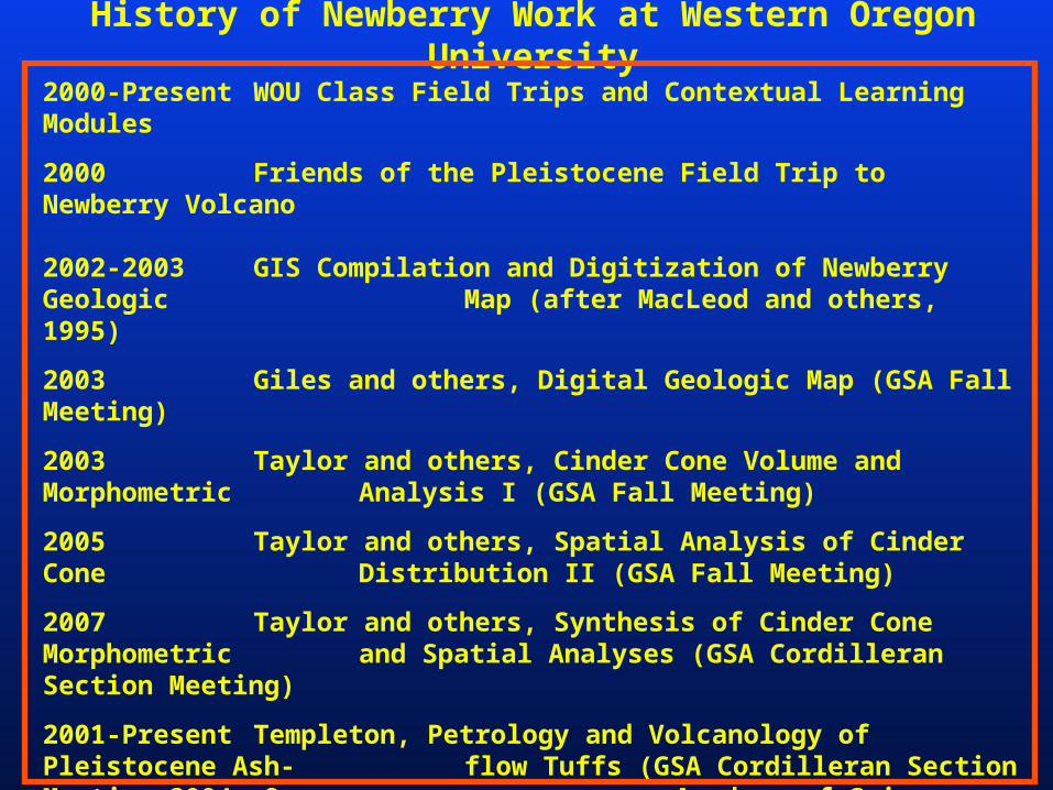
History of Newberry Work at Western Oregon University
2000-Present WOU Class Field Trips and Contextual Learning Modules
2000 Friends of the Pleistocene Field Trip to Newberry Volcano
2002-2003 GIS Compilation and Digitization of Newberry Geologic Map (after MacLeod and others, 1995)
2003 Giles and others, Digital Geologic Map (GSA Fall Meeting)
2003 Taylor and others, Cinder Cone Volume and Morphometric Analysis I (GSA Fall Meeting)
2005 Taylor and others, Spatial Analysis of Cinder Cone Distribution II (GSA Fall Meeting)
2007 Taylor and others, Synthesis of Cinder Cone Morphometric and Spatial Analyses (GSA Cordilleran Section Meeting)
2001-Present Templeton, Petrology and Volcanology of Pleistocene Ash-flow Tuffs (GSA Cordilleran Section Meeting 2004; Oregon Academy of Science, 2007; Am. Geophys. Union, 2010)
2010-2011 Newberry LIDAR Elevation Data Available; ES407 Senior Seminar Pilot Tests Next Generation Research Strategies onCinder Cones; Updated Literature Review

PHYSIOGRAPHIC SETTING
Rick Fletcher

Co
ast
R
ang
e
Wes
tern
C
asca
des
K lam athMountains
Ca
scad
ia
S
ub
du
ctio
n
Zo
ne
Hig
h
Cas
cad
es
Basin and Range
1 0987
6
5
1
4 . 5 c m / y r
OwyheeUpland
Blue Mountains
Deschutes-UmatillaPlateau
Will
amet
te V
alle
y
High LavaPlainsWRFZ
BFZ
TFZ
Extent o f N ew berry Lava F low s N ew berry C aldera
R hyolite Isochrons (M a)9
Faults: TFZ = Tum alo Fault Zone W R FZ = W alker R im Fault Zone BFZ = B rother Fault Zone
M H
M J
T S
M W
C L
0 1 0 0 k m
4 2 N
4 4 N
4 6 N
1 2 4 W 1 2 2 W 1 2 0 W 1 1 8 W


Caldera Summit
Newberry Volcano, South View from Lava Butte Lookout
Basaltic Aa Lava Flow fromLava Butte; ~7000 yrs BP

Newberry Volcano, View to S-SE from Paulina Peak Lookout
Basin and RangeFort Rock(Tuff Ring)
Newberry Cinder Cones
High LavaPlains

Newberry Volcano, View to West towards High Cascadesfrom Paulina Peak Lookout
SouthSister
MiddleSister
BrokenTop

Newberry Volcano, View into Summit Caldera from Paulina Peak
Paulina LakeEast Lake

TECTONIC SETTING
Dan Dziekan and Bill Vreeland

Arc Volcanoes relatedto Cascadia Subduction Zone
Juan de Fuca plate thrustbeneath North American plate

Magma Source in Subduction Zone
Fore Arc Back Arc
NewberryPosition
Wes
tern
Cas
cade
sH
igh
Cas
cade
s35 – 7 Ma 7 – 0 Ma
Eastward ArcMigration
DecreasingSlab Dip

Meigs et al., 2009
Current Crustal Deformation Rates and Directions
Basin and Range
Stretching
Brothers Fault Zone
Newberry

GEOLOGIC HISTORY
Jody Becker and Kelsii Dana

Overview of Newberry Volcano
•Shield-shaped composite volcano•N-S orientation, 64 km x 40 km•Total Area > 1300 km2
•Summit Caldera Area = 44 km2
•Elevation: 1300 m – 2400 m; Relief ~1100 m
•Composition: Basalt to Rhyolite•Estimated Volume = 460 km3
•>400 cinder cones and fissure vents
•Quaternary in AgeLess than ~500,000 yrs oldHolocene activity: 10,000 – 1200 yrs BP
•One of largest U.S. Quaternary volcanoes
•Historic Annual Precipitation: 30 in/yrEast flank rain shadow of Cascades

Regional Geology• Oregon-Idaho:
Paleozoic-Mesozoic oceanic volcanic arcs
Accretionary complexesBasinal successions
• Cenozoic volcanism: Ignimbrite sweep Flood basalts Bimodal (modern) High Lava Plains Snake River Plain

Regional Volcanism
• Two migrating tracks:NE along Snake River
Plain toward YellowstoneWNW along High Lava
Plains (Newberry)
• Indicated link between High Lava Plains and Cascades volcanism: Increased output Isotopic similaritiesMerging structures
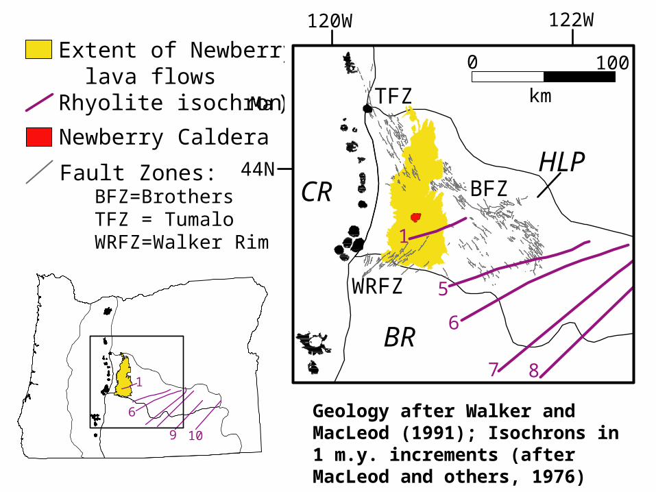
Geology after Walker and MacLeod (1991); Isochrons in 1 m.y. increments (after MacLeod and others, 1976)
km
0 100
44N
122W120W
BR
HLPCR
TFZ
BFZ
WRFZ
1
8
5
7
6
1
6
109
Extent of Newberry lava flowsRhyolite isochrons (Ma)
Newberry Caldera
Fault Zones: BFZ=Brothers TFZ = Tumalo WRFZ=Walker Rim


East LakeBig Obsidian Flow
1250 yrs BP
CentralPumiceCone
7200 yrs BP

GEOMORPHIC ANALYSIS OFCINDER CONES
STATEMENT OF THE PROBLEM
Steve Taylor

Cinder Cone Research Questions
Are there morphologic groupings of ~400 cinder cones at Newberry? Can they be quantitatively documented?
Are morphologic groupings associated with age and state of erosional degradation?
Are there spatial patterns associated with the frequency, occurrence, and volume of cinder cones?
Are there spatial alignment patterns? Can they be statistically documented?
Do regional stress fields and fault mechanics control the emplacement of cinder cones at Newberry volcano?
O regon
StudyArea
Basalt and basaltic andesite flow s:early P le istocene to H olocene
R hyolite to dacite dom es, flow s, pum ice rings,and vent com plexes: early P le istocene toH olocene
Pum ice fa lls, ash flow s, and a lluvia l deposits:P le istocene to H olocene
Andesite Tuff (w est flank): P le istocene
B lack Lapilli Tuff (w est flank): P le istocene
A lluvia l deposits w ith in terbedded lap illi tu ff, ashflow tuff, and pum ice fa ll deposits: P le istocene
Tepee D raw Tuff (east flank): P le istocene
Basalt and basaltic andesite of sm all sh ie lds:P le istocene
F luvia l and lacustrine sedim ents: P le istoceneand P liocene(?)
Basalt, basaltic andesite , and andesite flow s, ashflow tuffs, and pum ice deposits of the C ascadeR ange: P le istocene
Basalt flow s and interbedded cinders and scoriadeposits: la te M iocene
R hyolite and andesite flow s, dom es, andpyroclastic rocks of P ine M ounta in: earlyM iocene
N ew berry C aldera com plex
C inder cones and fissure vents
Faults
0 5 km

Lava Butte Cone and Aa Flow~7000 yrs BP (post-Mazama)
Ash &
Pumice

Southeast Cinder Cone Field

Existing Methodology Digital Geologic Map Compilation / GIS of
Newberry Volcano (after McLeod and others, 1995) GIS analysis of USGS 10-m DEMs
Phase 1 Single Cones/Vents (n = 182) Phase 2 Composite Cones/Vents (n = 165)
Morphometric analyses Cone Relief, Slope, Height/Width Ratio Morphometric Classification
Volumetric Analyses Cone Volume Modeling Volume Distribution Analysis
Cone Alignment Analysis Two-point Line Azimuth Distribution Comparative Monte Carlo Modeling (Random vs. Actual)