Spring 2003View from - Home - Sky Island Alliance Gray, Vice President Nancy Zierenberg, Secretary...
16
View from Heart of Rocks, Chiricahua Mountains, Arizona Quarterly Newsletter of the Sky Island Alliance Vol. 6 Issue 1 Spring 2003
-
Upload
trinhhuong -
Category
Documents
-
view
216 -
download
0
Transcript of Spring 2003View from - Home - Sky Island Alliance Gray, Vice President Nancy Zierenberg, Secretary...

Spring 2003 Sky Island Alliance 1View from Heart of Rocks, Chiricahua Mountains, Arizona
Quarterly Newsletter of the Sky Island Alliance Vol. 6 Issue 1 Spring 2003
2 Sky Island Alliance Spring 2003
Sky Island
AllianceProtecting
Our Mountain Islands
& Desert Seas
520/624-7080 • fax 520/791-7709
P.O. Box 41165Tucson, AZ 85717
Office:Historic YWCA
738 N. 5th Avenue, Suite 201
SKY ISLAND ALLIANCE is a non-profitmembership organization dedicated
to restoring and protecting the uniquediversity of the Sky Islands of South-eastern Arizona, Southwestern NewMexico, and Northern Mexico.
SSSSS TAFFTAFFTAFFTAFFTAFF
David HodgesDavid HodgesDavid HodgesDavid HodgesDavid HodgesExecutive [email protected]
Acasia BerryAcasia BerryAcasia BerryAcasia BerryAcasia BerryAdministrative [email protected]
TTTTTrrrrrevor Harevor Harevor Harevor Harevor HareeeeeConservation [email protected]
Cory JonesCory JonesCory JonesCory JonesCory JonesGIS [email protected]
Jennifer KatcherJennifer KatcherJennifer KatcherJennifer KatcherJennifer [email protected]
Rachel KondorRachel KondorRachel KondorRachel KondorRachel KondorEcosystem Defense and Policy [email protected]
Lisa LabitaLisa LabitaLisa LabitaLisa LabitaLisa LabitaConservation Biology [email protected]
Janice PrzybylJanice PrzybylJanice PrzybylJanice PrzybylJanice PrzybylWildlife Monitoring [email protected]
Matt SkrochMatt SkrochMatt SkrochMatt SkrochMatt SkrochField Program [email protected]
Jennifer W olfsongJennifer W olfsongJennifer W olfsongJennifer W olfsongJennifer W olfsongLegal [email protected]
Board of DirectorsBoard of DirectorsBoard of DirectorsBoard of DirectorsBoard of DirectorsRod Mondt, PresidentRandall Gray, Vice PresidentNancy Zierenberg, SecretaryDale Turner, TreasurerGita BodnerCurtis BradleyRoseann HansonLainie LevickRurik ListCarlos Lopez GonzalezSteve MarlattTodd Schulke
Gita Bodner andDug Schoellkopf, editors
Seeking SIA newsletter submissions:Seeking SIA newsletter submissions:Seeking SIA newsletter submissions:Seeking SIA newsletter submissions:Seeking SIA newsletter submissions:Send us your poetry, your words of wisdom, your art!As you’ve likely noticed, the quarterly Sky Island Alliance newsletter has expanded into a larger newspaper format. We
want to keep it filled with inspirational, informative material, and we’d like your help! Do you write poetry? Draw, sketch,paint, or photograph? Like to address regional conservation issues? Review books or websites? Anything that relates to theSky Islands region is fair game! We’d also like to start a Letters to the Editor section. Send us a note! You can respond toitems in our recent newsletter, comment on your experiences as a volunteer or conference-goer, etc. Also, let us know if you’dlike to be a regular contributor, e.g. with a column each issue. The deadline for our next newsletter is May 8, 2003. Materialsubmitted after that date may be saved for subsequent issues. Please email submissions to Gita at [email protected],or mail them to Sky Island Alliance attn: Gita, P.O. Box 41165, Tucson, AZ 85717. Resolution of digital images should be atleast 300 dpi if possible, but we can work with some lower resolution images.
Memorial for a Mentor...............................................page 3Memorial for a Mentor...............................................page 3Memorial for a Mentor...............................................page 3Memorial for a Mentor...............................................page 3Memorial for a Mentor...............................................page 3
Rambling Rants from the Director’s Desk........page 4Rambling Rants from the Director’s Desk........page 4Rambling Rants from the Director’s Desk........page 4Rambling Rants from the Director’s Desk........page 4Rambling Rants from the Director’s Desk........page 4
Dragoons Mine.................................................................page 4Dragoons Mine.................................................................page 4Dragoons Mine.................................................................page 4Dragoons Mine.................................................................page 4Dragoons Mine.................................................................page 4
Burro Mountains Policy and Planning................page 5Burro Mountains Policy and Planning................page 5Burro Mountains Policy and Planning................page 5Burro Mountains Policy and Planning................page 5Burro Mountains Policy and Planning................page 5
Road Rattlings..................................................................page 6Road Rattlings..................................................................page 6Road Rattlings..................................................................page 6Road Rattlings..................................................................page 6Road Rattlings..................................................................page 6
Protected Area Profiles...............................................page 7Protected Area Profiles...............................................page 7Protected Area Profiles...............................................page 7Protected Area Profiles...............................................page 7Protected Area Profiles...............................................page 7
Policy and Law: Sugarloaf Trail..............................page 7Policy and Law: Sugarloaf Trail..............................page 7Policy and Law: Sugarloaf Trail..............................page 7Policy and Law: Sugarloaf Trail..............................page 7Policy and Law: Sugarloaf Trail..............................page 7
Otero Mesa.........................................................................page 8Otero Mesa.........................................................................page 8Otero Mesa.........................................................................page 8Otero Mesa.........................................................................page 8Otero Mesa.........................................................................page 8
WildNews Tracking.........................................................page 9WildNews Tracking.........................................................page 9WildNews Tracking.........................................................page 9WildNews Tracking.........................................................page 9WildNews Tracking.........................................................page 9
Bighorn in the Mineral Mountaiins.....................page 10Bighorn in the Mineral Mountaiins.....................page 10Bighorn in the Mineral Mountaiins.....................page 10Bighorn in the Mineral Mountaiins.....................page 10Bighorn in the Mineral Mountaiins.....................page 10
Restaurant Review: Los Hermanos.........................page 10Restaurant Review: Los Hermanos.........................page 10Restaurant Review: Los Hermanos.........................page 10Restaurant Review: Los Hermanos.........................page 10Restaurant Review: Los Hermanos.........................page 10
Flora and Fauna...............................................................page 11Flora and Fauna...............................................................page 11Flora and Fauna...............................................................page 11Flora and Fauna...............................................................page 11Flora and Fauna...............................................................page 11
Poetry......................................................................................pages 12-13Poetry......................................................................................pages 12-13Poetry......................................................................................pages 12-13Poetry......................................................................................pages 12-13Poetry......................................................................................pages 12-13
Book Notes..........................................................................page 14Book Notes..........................................................................page 14Book Notes..........................................................................page 14Book Notes..........................................................................page 14Book Notes..........................................................................page 14
Cochise Head Wilderness.........................................back coverCochise Head Wilderness.........................................back coverCochise Head Wilderness.........................................back coverCochise Head Wilderness.........................................back coverCochise Head Wilderness.........................................back cover
Table of Contents
photo by G. Bodner
Many Thanks toMany Thanks toMany Thanks toMany Thanks toMany Thanks to
Our Contributors!Our Contributors!Our Contributors!Our Contributors!Our Contributors!
G. Donald Bain, director ofthe Geography Computing Fa-cility at U.C. Berkeley GeologyDept.; Randall Herrin, San Di-ego Zoo; Neil Mangum,Chiricahua National Monu-ment Supervisor; SteveMarlatt, SIA board memberand highschool/junior high sci-ence teacher in Bowie, AZ; BenOnachila, artist and galleryowner, Bisbee, AZ; PennyPederson, SIA tracking volun-teer; Kathy Pitts, flora andfauna columnist; Nancy Seever,tireless SIA volunteer for all oc-casions; father and son teamTom and Tomas Taylor, nativefish enthusiasts with the MiddleGila Conservation Partnership,Tomas now activated to MarineCorps duty in Iraq; staff of theNew Mexico Wilderness Alli-ance, and, of course, the SIAstaff listed below.
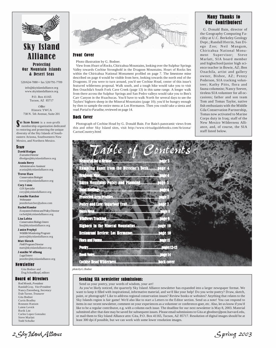
FFFFFront Coverront Coverront Coverront Coverront Cover
Photo illustration by G. Bodner.View from Heart of Rocks, Chiricahua Mountains, looking over the Sulphur Springs
Valley towards Cochise Stronghold in the Dragoon Mountains. Heart of Rocks lieswithin the Chiricahua National Monument profiled on page 7. The limestone minedescribed on page 4 would be visible from here, looking towards the north end of theDragoons. If you were to turn around, you’d see Cochise Head, center of this issue’sfeatured wilderness proposal. Walk south, and a tough hike would take you to visitBen Onachila’s South Fork Cave Creek (page 13) in this same range. A longer walkfrom there across the Sulphur Springs and San Pedro valleys would take you to Ben’sCarr Canyon in the Huachucas. You’d have to walk North for several days to see theTaylors’ bighorn sheep in the Mineral Mountains (page 10); you’d be hungry enoughby then to sample the entire menu at Los Hermanos. Then you could take a siesta andread Portal to Paradise, reviewed on page 14.
Back Back Back Back Back CoverCoverCoverCoverCover
Photograph of Cochise Head by G. Donald Bain. For Bain’s panoramic views fromthis and other Sky Island sites, visit http://www.virtualguidebooks.com/Arizona/CactusCountry.html
Newslet terNewslet terNewslet terNewslet terNewslet ter

Spring 2003 Sky Island Alliance 3
Reflections
TRIBUTE TO A MENTOR
for Rasta Mikee Seidman
“What is man but slowed down light.”—Mahatma Ghandi
From a lifetime awaythe mental reality of decaying fleshwill be replacedwith fresh blue soul risingfrom the white sandand green of nature.
That world of confused reasoning,stifling boxes and painful reflectiongives way to another:one of sparkling pinpointsin remote shadows,a hallucinogenic gardenof freedom and forever-ness.
When you’re walking one-waythrough the canyon don’t forgetto turn around at the last moment
Just before the last bend of graniteto finally observe all those strangersyou once knew, once were, oncetouched
With your desert philosophy & words,lift yr hand up to adjust yr dirty capwith a nod of yr head & manage them
a smirk.
O brotheran intellectual
a blues / reggae purista desert environmentalist
the nature manreturn to sand
Where saguaros march defiantlycreosote always smells of rain
Wolves run free thru the grasslandsand coatis wake you from your sleep.
—dp randahl dec 2002
“Sometimes I feel like a motherless childa long way from homeSometimes I feel like a motherless childand I’m almost goneSing freedom, freedom, freedom, freedom,
freedom, freedom .....” — richie havens
Our beloved friend, mentor,and SIA board memberMike Seidman battled
liver cancer late last year, passing tothe lands beyond the rainbow onNew Years eve...
Mike spent over 30 years of his life ad-vocating for the protection of wildlife andthe habitat they depend upon in the aridSouthwest and Northern Mexico. Hewas instrumental in the reintroductionof the Mexican wolf and the black-footedferret, and he worked tirelessly and ad-vocated on behalf of the black-tailed prai-rie dog, beaver, jaguar, desert tortoiseand other species of concern.
Mike served as the ConservationOfficer for the Arizona Zoological Soci-ety and the Phoenix Zoo. He served onthe Board of the Directors for the Ari-zona Wilderness Coalition and the SkyIsland Alliance, and was a member of theGrazing Clearing House, Arizona Ripar-ian Council, Middle Gila ConservationPartnership, and the Sonoita Valley Plan-ning Partnership to name but a few issuesand organizations he was involved with.
Mike brought knowledge, integrityand passion to every project, discussion, and debate. Whether one agreed or disagreed with Mike, he washighly respected for his unwavering efforts to protect places dear to all Arizonans.
Long Time Conservationist and Wildlands Advocate Passes Away
“I’m going to miss you guys,” he says
body dissolving, spiritstrong as always
perhaps clearer now, withoutthe clutter of a life’s to-do-list
these days we walk the line togetherbetween past and presentnever more aware of the divide
stories of ‘My Canyon,’ I reach from‘My Trail,’
and suddenly “I’m going to miss you guys,”triangulating onthe mystery of future
— gb, Oct. 2002
Mike’s family has requested that thosewishing to express their appreciation forMike and his work may direct memorial con-tributions to the Sky Island Alliance at P.O.Box 41165, Tucson, Arizona 85717-1165.
Mexican wolf gets her puppy shots
4 Sky Island Alliance Spring 2003
Keeping the “Public” in Public LandsFriends,I trust that this finds you in good spir-
its in spite of these trying times. It is cer-tainly tough to remain positive in the faceof world events, the economy, and anadministration in Washington whichseems to behave as if we are still living inthe 1950s. Previously I’ve talked aboutthe Bush Administration’s attempts atgutting environmental law under theguise of reform. I had hoped at somepoint, due to public outcry and the de-feat of ill-conceived projects such as drill-ing in the Arctic, the administrationwould back off. This has not been thecase; every day we receive another re-minder of how bad things could be if theseshortsighted people have their way. Whydo these people think that citizens haveless concern about the public’s health andwelfare than we did when these laws werepassed?
If we are going to retain our right toclean air and water, protect our publiclands and imperiled species, and retainour ability to participate in land use deci-sions, it will be because of private citi-zens such as you. Those of us that careabout healthy landscapes must make ourvoices heard. For example, letters fromconcerned citizens can have an effect on
Local Residents Join Sky Island Alliance in Opposing Openpit
Mining in Dragoon Mountainsby Rachel Kondor, SIA Ecosystem Defense and Policy Director
land management agencies The Sugarloaftrail article (pg. 7) is a good example of pub-lic comment leading to a positive outcome.You will also read about a proposed mine inthe Dragoon Mountains and Oil and Gasdevelopment on southern New Mexico’sOtero Mesa. These articles contain infor-mation on how to comment on these projectsas well as talking points to mention in yourletters. We have been fighting for the lastseveral years to protect your right to par-ticipate in land use decisions – please take afew minutes today and exercise that right.
*********As many of you know, we have developed
a positive working relationship with localland management agencies. Unfortunately,in the case of the Forest Service, poor lead-ership in both DC and the regional office inAlbuquerque, threatens this relationship.Much of the problem lies with a menagerieof unqualified managers that the Presidenthas appointed to oversee the protection ofour public lands. Instead of appointing ex-perienced land managers and biologists toleadership positions, he has made appoint-ments such as Mark Rey, a timber industrylobbyist, as Undersecretary of Agriculturein charge of the Forest Service.
I would like to share a story which illu-
minates the thought pro-cess of much of the upperechelon working in federalagencies these days. Re-cently, due to managementconcerns, Sky Island Alli-ance filed an appeal of aproject on the CoronadoNational Forest. When theappeal was complete, it wassent to Regional ForesterHarv Forsgren via electronic mail withreturn receipt requested; receipt wasconfirmed the following day. Severaldays later I received a phone call fromPat Jackson, the Regional Appeals Of-ficer. He indicated that the Forest Ser-vice was dismissing SIA’s appeal dueto the fact it had been submitted viaelectronic mail rather than the USPostal Service! It did not matter thatthey had a copy of our Appeal in theirhands; as far as Jackson was con-cerned, I had not sent it. I remindedhim that this is 2003 and email is anaccepted form of communication; thatwe had sent many documents to theForest Service via email and his con-cerns had never been raised by anyoneelse; that nowhere in the regulations are
email submissions prohibited; and re-gardless, he and the regional forester haddiscretion to utilize a little commonsense. Trying to reason with Jacksongave me a more enlightened understand-ing of “talking to a wall,” than I had pre-viously achieved. I realized then that themission of the “New” Forest Service isDelay, Deny, and Obfuscate. These at-tempts to shut the public out of publicland management can only lead to a morecontentious future and threatens the cur-rent positive direction of management inthe Sky Islands. Sky Island Alliance re-mains committed to working with allland-use agencies to affect positive out-comes but these types of petty, arbitrarydecisions make it more difficult.—David Hodges
The US Forest Service has proposed to approve an openpit mine inthe Dragoon Mountains above the small town of Dragoon. Alpha
Calcit, Inc. plans to reopen and expand an old quarry on the CoronadoNational Forest adjacent to the town in order to remove limestone forsale in the United States and abroad.
The mine would be authorized underthe General Mining Law of 1872, anarchaic statute that allows anyone to es-tablish mining claims for the removalof certain materials from public lands.
“If approved, this mine will destroy thequality of life of my town,” said Dragoonresident Wray Kephart. On April 2, SkyIsland Alliance staff met with concernedresidents in the town of Dragoon to dis-cuss strategies for opposing the mine.Local residents are concerned that themining operation will harm their way oflife by degrading air and water quality,harming wildlife, and impacting publicsafety.
Alpha Calcit plans to conduct blastingin order to remove materials. The mate-rial would then be hauled to a crushingfacility on private land several milesaway. Loads of approximately 20-25 tonsper truck would be hauled between themine and the crushing facility every 12
minutes, eight hours a day, five days a week.The company currently plans to operate themine for approximately 20 years.
As part of mine expansion plans, the roadto the existing mine location would be wid-ened and new road construction would takeplace. Alpha Calcit intends to blaze a newroad into an inventoried roadless area. In-ventoried roadless areas are afforded spe-cial protection under current regulations.These regulations prohibit new road con-struction in identified roadless areas on theNational Forests. However, if the miningclaim holders can show that they hold validmining claims, then they possess what iscalled an “outstanding” or “existing” right,and may construct roads in roadless areas.
Representatives of Alpha Calcit and theCoronado National Forest recently held anopen house in Benson to explain the pro-posal to residents and business owners. Atthe open house, plans for reclamation of thearea after the completion of the mining op-
eration were revealed. Local residentswere not impressed with the plans forclean up. Wray Kephart said, “The ex-amples of reclamation they showed ustook place in completely different envi-ronments, such as in forested areas inGermany and other countries. I am notconvinced that they can adequately re-claim the mine in this arid desert envi-ronment based on their current plans.”
The Dragoon Mountains, much ofwhich are managed by the Coronado Na-tional Forest, are located approximatelysixty miles southeast of Tucson and thirty-five miles northeast of Sierra Vista. Theirmountain peaks tower 3,000 feet abovethe surrounding plains to an elevation of7,519 feet. The range is strikingly beauti-ful, with mysterious rock formations,deep canyons, and outstanding vistas outacross the valleys to other Sky Islandranges.
The Dragoons are steeped in historyand rich in biological diversity. CochiseStronghold was used by Cochise and hisband of Apaches to evade capture fromthe US Government in the 1860s. Thesigning of a peace treaty betweenCochise’s people and the government
was initiated in the Dragoons in 1872. In ad-dition, the range provides habitat for manyspecies of birds and other wildlife. Globallyrare Arizona cypress forests are found there,as are fifteen species of threatened, endan-gered, and “special concern” animals andplants
Because of their proximity to Tucson andother smaller towns, the Dragoons are apopular place for many types of recreationsuch as hiking, rock climbing,horsebackriding, birdwatching, hunting,historical sites tourism, and camping. Dra-goon resident Shirley Harris said, “CochiseCounty depends on tourism for a large partof its income. If this mine is approved, wild-life will be frightened away, and the birdersand hunters who come to enjoy the sceneryand recreate in the area will also stay away.”
“If approved, this mine
will destroy the quality
of life of my town”~ Dragoon resident Wray Kephart
...continued on next page
Spring 2003 Sky Island Alliance 5
by Matt Skroch, SIA Field Programs Director
Policy, Planning, and Fieldwork; the Big Burro Mountains
The Burro Mountains, situated at thenortheast fringe of the Sky Island region,are stepping-stones linking the ColoradoPlateau with the sub-tropically orientatedSky Islands and Sierra Madre Mountainsto the south. From a vantage point in theBurros, one can gaze south towards thespine of the Sierra Madres represented bythe Peloncillo Mountains. In the north-west corner of the Burros, the Middle Boxof the Gila River cuts through the moun-tains, where perennial water provideshabitat for longfin dace, sonora and desertsucker, southwestern willow flycatchers,zone-tail hawks, and many other ripariandependant species.
In years past, a lack of transportationmanagement has resulted in a profusionof user-created roads that criss-cross themountains seemingly to no end. Valu-able resources like springs and riparianareas are being increasingly trampled byoff-road vehicles. There are numerousincursions into the relatively smallroadless area that remains in the Bur-ros – the only area now protected un-der the Roadless Area ConservationRule. Off-road groups have gone so far
as to construct, illegally, their own trailsystems in the Burros – all without en-vironmental review or planning. TheGila National Forest has shown signsof concern but is not taking initiativeor responsibility in closing these routes.While we commend the agency for al-lowing closures of several routes (Re-storing Connections Winter edition, pg.5), the continued lack of enforcementagainst illegal activities in the Burrosis alarming.
We must now call on the Forest Serviceto begin a comprehensive transportation
planning process. Not only will the ecologyof the Burros benefit, so will also the usersof this spectacular area. With recent regu-lations requiring transportation analysis,community interest and involvement, and thecritical state of the ecology of the Burros, thestars have aligned to make this process hap-pen soon. A concrete transportation plan willhave numerous benefits, including:
* A map that specifically shows roadsand trails open to the public and what usesare appropriate on each road. This willlessen confusion among forest users, allowfor effective enforcement, and add to thegeneral appeal of visiting the Burros.
* An environmental review of roads andtrails within a context of impacts, benefits,and disadvantages of each route. This re-view will allow for a priority listing for clo-sure and rehabilitation of roads as well aselucidating which roads should maintainedto higher standards.
*A review of the transportation systemin the context of maintenance and recon-struction dollars available. As of now, the
Gila National Forest has a$343 million backlog ofneeded maintenance and capi-tal improvements–the highestbacklog in the Southwest Re-gion. These economic direstraits underline the need forremoving considerable low-benefit mileage from thetransportation system.
* Community involvementand buy-in from interested par-ties. By involving the public intransportation planning, with
the goal of determining which roads toclose and which to retain, users will gain“ownership” of the planning process andbe more likely to respect the outcome.Non-motorized enthusiasts may highlightareas that are important for their enjoy-ment, while motorized users may delineatepopular roads or trails they would like tosee remain.
The days of free-for-all cross-country off-road driving in the Burros are soon to beover. With an exponential increase in off-road vehicles and user-created routes, theBurros can no longer withstand lax enforce-ment of transportation regulations andwilly-nilly off-road use. Illegal, unneeded,unsafe, or damaging roads must be closed.It only takes a few passes from a vehicle tocreate a wildcat road—closing wildcat roadsmust become just as simple.
Poor planning pits users against one an-other. Scars from destructive free-wheel-ing and lack of refuge from motor impactswears out the good will of non-motorizedusers, who then push for complete exclu-sion of motorized uses from entire regions.Lax enforcement also hurts responsibleriders because it allows the relatively fewirrisponsible riders to undermine thereputations of all motorized users. And inthe current situation, even riders who in-tend to ride responsibly have trouble tell-ing which routes are legal roads andwhich are not.
Now is the time for the Forest Service,together with the conscientious users of theBurro Mountains, to hash out a plan thatwill ensure an economically and ecologi-cally responsible transportation system.
The Dragoons are a special place wor-thy of protection from the ravages ofhardrock mining. Unfortunately, undercurrent law, most of the range is still openfor mineral exploration. The General Min-ing Law of 1872 allows the discovery andextraction of certain minerals from publiclands in the United States. Anyone canstake a claim to mine for personal profiton federal public lands unless the U.S.Congress has expressly withdrawn thearea from mining (such as in NationalParks, National Wildlife Refuges, etc.).
In order to begin mining under the Min-ing Law, an individual or company mustprove that the material to be removed fromthe land is both “locatable” and “marketable.”To qualify as locatable, the limestone thatAlpha Calcit intends to remove must be atleast 95% calcium or magnesium carbonate,and must be of sufficient quality to justifythe costs of removing it from the ground. Toshow the material is marketable, a claimantmust prove that the material would fetch acompetitive price on an existing market. Thusfar, Alpha Calcit has not shown that the ma-terial it plans to remove is a locatable min-eral or that the material is marketable.
Mine, continued...Call for comment letters
Your input matters. Please write to Jennifer Ruyle at the CoronadoNational Forest by April 30 April 30 April 30 April 30 April 30 and urge her to deny approval for themining operation in the Dragoons. You may wish to emphasize oneor more of the following points:
* The mining company has yet to prove that its claim is valid. If theycannot show that the material to be removed is both locatable andmarketable, their claim is not valid under the 1872 Mining Act.
* The mine will diminish recreational opportunities in the area whichwill impact tourism revenue and lower property values of residents.
* The mine will adversely impact wildlife by disrupting lifecycles anddestroying habitat.
* The air and water quality of the area will suffer. Noise, air andwater pollution from the mine will be difficult if not impossibleto remediate.
* It is inappropriate to allow the mining company to blaze new roadsin an inventoried roadless area. Roadless areas are important forwildlife and non-motorized recreation.
* The expense of NEPA analysis should be borne by the miningclaimant, not by the American public, especially in these difficulteconomic times.
The Coronado National Forest isnow in the process of analyzing thisproject under the National Environmen-tal Policy Act (NEPA). NEPA requiresthe agency to consider public input andaddress public concerns when choosingwhether or not to approve a particularproject. Public input can be especially ef-fective in guiding decisions at this time.
The legal staff at the Sky Island Alli-ance will continue to vigilantly monitorplans for mining in the area and workwith local residents to organize opposi-tion to the proposal.
Send comment letters to:Jennifer RuyleTeam Leader, Alpha CalcitEnvironmental AnalysisCoronado National ForestFederal Building, FB-42300 W. CongressTucson, Arizona 85701
Eroded and compacted soil of a wildcat road in the Big Burros
In the Big Burro Mountains of southwestern New Mexico, a col-lection of conservation-minded groups are rallying for the protec-tion of critical resources that are now imminently threatened. In
response to a lack of enforcement and management of the transporta-tion system there, the Sky Island Alliance, Upper Gila Watershed Alli-ance, New Mexico Wilderness Coalition, and Republicans for Envi-ronmental Protection are calling for an economically and ecologicallysound transportation system that incorporates the needs of wildlife,recreationists, and ecological processes.
6 Sky Island Alliance Spring 2003
Road Rattlingsby Trevor Hare
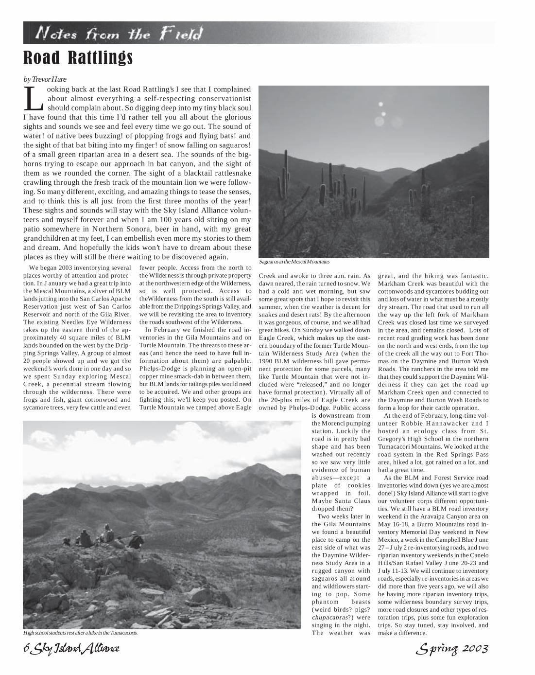
We began 2003 inventorying severalplaces worthy of attention and protec-tion. In January we had a great trip intothe Mescal Mountains, a sliver of BLMlands jutting into the San Carlos ApacheReservation just west of San CarlosReservoir and north of the Gila River.The existing Needles Eye Wildernesstakes up the eastern third of the ap-proximately 40 square miles of BLMlands bounded on the west by the Drip-ping Springs Valley. A group of almost20 people showed up and we got theweekend’s work done in one day and sowe spent Sunday exploring MescalCreek, a perennial stream flowingthrough the wilderness. There werefrogs and fish, giant cottonwood andsycamore trees, very few cattle and even
Looking back at the last Road Rattling’s I see that I complainedabout almost everything a self-respecting conservationistshould complain about. So digging deep into my tiny black soul
I have found that this time I’d rather tell you all about the glorioussights and sounds we see and feel every time we go out. The sound ofwater! of native bees buzzing! of plopping frogs and flying bats! andthe sight of that bat biting into my finger! of snow falling on saguaros!of a small green riparian area in a desert sea. The sounds of the big-horns trying to escape our approach in bat canyon, and the sight ofthem as we rounded the corner. The sight of a blacktail rattlesnakecrawling through the fresh track of the mountain lion we were follow-ing. So many different, exciting, and amazing things to tease the senses,and to think this is all just from the first three months of the year!These sights and sounds will stay with the Sky Island Alliance volun-teers and myself forever and when I am 100 years old sitting on mypatio somewhere in Northern Sonora, beer in hand, with my greatgrandchildren at my feet, I can embellish even more my stories to themand dream. And hopefully the kids won’t have to dream about theseplaces as they will still be there waiting to be discovered again.
fewer people. Access from the north tothe Wilderness is through private propertyat the northwestern edge of the Wilderness,so is well protected. Access totheWilderness from the south is still avail-able from the Drippings Springs Valley, andwe will be revisiting the area to inventorythe roads southwest of the Wilderness.
In February we finished the road in-ventories in the Gila Mountains and onTurtle Mountain. The threats to these ar-eas (and hence the need to have full in-formation about them) are palpable.Phelps-Dodge is planning an open-pitcopper mine smack-dab in between them,but BLM lands for tailings piles would needto be acquired. We and other groups arefighting this; we’ll keep you posted. OnTurtle Mountain we camped above Eagle
Creek and awoke to three a.m. rain. Asdawn neared, the rain turned to snow. Wehad a cold and wet morning, but sawsome great spots that I hope to revisit thissummer, when the weather is decent forsnakes and desert rats! By the afternoonit was gorgeous, of course, and we all hadgreat hikes. On Sunday we walked downEagle Creek, which makes up the east-ern boundary of the former Turtle Moun-tain Wilderness Study Area (when the1990 BLM wilderness bill gave perma-nent protection for some parcels, manylike Turtle Mountain that were not in-cluded were “released,” and no longerhave formal protection). Virtually all ofthe 20-plus miles of Eagle Creek areowned by Phelps-Dodge. Public access
is downstream fromthe Morenci pumpingstation. Luckily theroad is in pretty badshape and has beenwashed out recentlyso we saw very littleevidence of humanabuses—except aplate of cookieswrapped in foil.Maybe Santa Clausdropped them?
Two weeks later inthe Gila Mountainswe found a beautifulplace to camp on theeast side of what wasthe Daymine Wilder-ness Study Area in arugged canyon withsaguaros all aroundand wildflowers start-ing to pop. Somephantom beasts(weird birds? pigs?chupacabras?) weresinging in the night.The weather was
great, and the hiking was fantastic.Markham Creek was beautiful with thecottonwoods and sycamores budding outand lots of water in what must be a mostlydry stream. The road that used to run allthe way up the left fork of MarkhamCreek was closed last time we surveyedin the area, and remains closed. Lots ofrecent road grading work has been doneon the north and west ends, from the topof the creek all the way out to Fort Tho-mas on the Daymine and Burton WashRoads. The ranchers in the area told methat they could support the Daymine Wil-derness if they can get the road upMarkham Creek open and connected tothe Daymine and Burton Wash Roads toform a loop for their cattle operation.
At the end of February, long-time vol-unteer Robbie Hannawacker and Ihosted an ecology class from St.Gregory’s High School in the northernTumacacori Mountains. We looked at theroad system in the Red Springs Passarea, hiked a lot, got rained on a lot, andhad a great time.
As the BLM and Forest Service roadinventories wind down (yes we are almostdone!) Sky Island Alliance will start to giveour volunteer corps different opportuni-ties. We still have a BLM road inventoryweekend in the Aravaipa Canyon area onMay 16-18, a Burro Mountains road in-ventory Memorial Day weekend in NewMexico, a week in the Campbell Blue June27 – July 2 re-inventorying roads, and tworiparian inventory weekends in the CaneloHills/San Rafael Valley June 20-23 andJuly 11-13. We will continue to inventoryroads, especially re-inventories in areas wedid more than five years ago, we will alsobe having more riparian inventory trips,some wilderness boundary survey trips,more road closures and other types of res-toration trips, plus some fun explorationtrips. So stay tuned, stay involved, andmake a difference.High school students rest after a hike in the Tumacacoris.
Saguaros in the Mescal Mountains

Spring 2003 Sky Island Alliance 7
Protected Area Profiles
Chiricahua National Monument
In 2001, the National Park Service(NPS) closed the Sugarloaf Trail in theChiricahua National Monument after arockslide buried 30 feet of the trail withboulders and produced dangerous condi-tions for hikers such as cliff overhangs.The NPS drafted an environmental assess-ment (EA) including several alternativesto trail reparation. Its preferred alterna-tive proposed the use of some mechanizeddrilling and blasting equipment. After theNational Park Service issued a request forpublic comments to its EA last July, SIAresponded with several suggestions (seeFall 2002 issue). Because the reparationswould take place within a designated wil-derness area, SIA suggested using a hand-tool only approach (the Wilderness Actprohibits the operation of mechanized
Epilogue - Sugarloaf Trail Repair, Chiricahua National Monument
National Park Service Modifies its Preferred Alternative in Response to Public Comment
by Jennifer Wolfsong, SIA legal intern
equipment in a wilderness areas except inextraordinary circumstances such as anemergency rescue).
Additionally, because the work wasscheduled to take place near a “protectedactivity center” of the endangered Mexicanspotted owl during its nesting season, SIAwas concerned that the noise from mecha-nized equipment and blasting would causestress to the owl during a crucial time in itsyearly cycle. Therefore, our letter also askedthe NPS to reschedule the reparations for atime other than the owl’s nesting season.
Finally, we attempted to balance the needsof an endangered species and the mandatesof the Wilderness Act with the needs of theNPS to efficiently accomplish their task bysuggesting a completely different alterna-tive as a compromise between the NPS’ pre-
ferred alternative providing for the use ofboth mechanized drilling and blastingequipment and our preferred alternativeallowing the use of hand tools only; we sug-gested that blasting equipment be used onlywhere necessary to remove dangerous over-hangs while drilling and other work be donesolely by hand. We re-emphasized that what-ever method was employed, the repairsshould take place outside of the Mexicanspotted owl’s nesting season. This wouldminimize the amount of noise and disrup-tion in a designated wilderness area whileallowing Park Service employees to effi-ciently complete its task and ensure thesafety of trail users.
In mid September 2002, the NPS issueda Finding of No Significant Impact(FONSI) for its EA on the “Sugarloaf TrailEmergency Repair.” The NPS respondedto SIA’s and other’s comments by modify-ing its preferred alternative. The NPS de-cided not to scale cliff overhang areas, norto use mechanized equipment in the wilder-
ness area. Additionally, the repair was re-scheduled for a time after the Mexican spot-ted owl breeding season. Although a rela-tively small project, thanks to Superinten-dent Neil C. Mangum and the NPS, this isan important illustration of how the Na-tional Environmental Policy Act of 1970(NEPA) is supposed to work. Rather thanproviding lip service to public concerns, theNPS genuinely appreciated the public’sthoughts and ideas and even changed itspreferred alternative to reflect this input.
This project and outcome shows the fal-lacy of the Bush administration’s recent at-tacks on the NEPA process as causing “un-reasonable delays.” This decision explic-itly illustrates how NEPA is intended towork. NEPA provides an opportunity forcollaboration between agencies and thepublic that ultimately leads to sounder de-cisions, better management of our publiclands, and to a more positive relationshipbetween land management agencies andthe public.
by Neil Mangum, Chiricahua National Monument Supervisor
Two issues ago, Restoring Connections reported on our participa-tion in the decision-making process regarding how to repaire adamaged trail in a designated wilderness area. We are please to
report on a solution that has satisfied all parties involved.
The Monument’s signature icons are therock pinnacles, spires, and mammoth col-umns–literally a rock wonderland. The for-mations are a result of violent volcaniceruptions that occurred more than 27 mil-lion years ago. After cooling, the ash fusedinto an almost 2,000-foot layer of rockcalled rhyolite. Then nature did its handywork. Water, wind, and ice sculpted therhyolite into strange and bizarre shapes oftowering rock columns, massive spires, andbalanced rocks perched on tiny pedestals.
More than 11,000acres of the nationalmonument has beenfederally designatedas wilderness area.Wilderness designa-tion, together withthe best air qualitystandards in the re-gion, providesadded significanceto Chiricahua Na-tional Monument.
The Chiricahua Mountains are unique andstand in stark contrast to the surroundingSonoran and Chihuahuan deserts. Within thecool forests of the Sky Islands, as theChiricahuas are known, reside many animalsand plants. Because of the proximity ofMexico, many Mexican species are found inthe Chiricahuas. Most conspicuous are thebirds including the hepatic tanager, red-facedwarbler, and elegant trogon, which make theChiricahuas a haven for birders. The monu-ment is home to a variety of animals such as
Chiricahuafox squirrels,mountain li-ons, coa-timundis, andpeccaries.
H u m a nhistory isalso a pri-mary ele-ment of theChiricahuas.The Apaches
resided in the mountains ably led by lead-ers like Cochise and Geronimo. Drivenout and forced to submit to reservationconfinement, the Apaches were replacedby pioneer ranchers and miners. In theheart of the Chiricahua Mountains, alongBonita Creek, a Swedish immigrantcouple settled and prospered turning thearea into a guest ranch. Influenced by thenatural beauty and geological oddities ofthe region, the area was made part of theUS Forest Service. In 1924, the NationalMonument was transferred to the Na-tional Park Service. Development of thePark took off during the Great Depres-sion. A CCC camp was established in thepark. The handiwork of the CCC is stillvisible today. Visitors to Chiricahua Na-tional Monument enjoy more than 20miles of trails carved out of the wilder-ness by the CCC. Capping off the CCCsefforts was the opening of an eight-mile
Chiricahua National Monument may well be Arizona’s best kept se-cret. Nestled in southeastern Arizona, the Monument is located inthe northern portion of the lofty Chiricahua Mountains, which domi-
nate the landscape for 50 miles. The Chiricahuas form the divide betweenthe San Simon valley to the east and the Sulphur Springs valley on thewestern flank. Most of the Chiricahua Mountains lie within the CoronadoNational Forest. The exception is the nearly 13,000 acre Chiricahua Na-tional Monument administered by the National Park Service.
Sugarloaf Trail was reopened in Sep-tember 2002. Sugarloaf had been closedfor nearly two years following arockslide that had clogged the trail withrocks and debris. Because most of thetrail resides in the Wilderness Area, thepark went through a series of environ-mental assessments and solicited infor-mation on ideas on how the trail couldbe reopened. We are happy to reportthat we avoided the use of any motor-ized tools or blasting that might be con-sidered detrimental to wilderness man-agement. As it turned out, the park’s trailcrew, using only hand tools, were ableto reopen the trail in less than three days.~ Neil Mangum, CNM Supervisor
long tour road, which takes visitors to thesummit of Massai Point and connects withthe park’s intricate trail system. The CCCalso constructed a campground, which isstill in use.
Today, more than 75,000 visitors a yearvisit Chiricahua National Monument.Nearby Fort Bowie National Historic Siteis also administered by Chiricahua Na-tional Monument.
Watch future issues of RestoringConnections for profiles of Fort Bowie andtheir excellent grassland restoration work!
~ editors

8 Sky Island Alliance Spring 2003
In the region
Despite the fact that Chihuahuan Desertgrasslands have received relatively littleprotection (Guadalupe National Park andthe surface area of Carlsbad Caverns Na-tional Park, totaling less than 110,000acres, represent the only protectedChihuahuan desert grasslands in the US),the Bureau of Land Management (BLM)is moving aggressively forward to expe-dite oil and gas development in OteroMesa, by the beginning of 2004.
In many ways, the plans to developOtero Mesa replicate those proposed forAlaska’s Arctic National Wildlife Refuge.They are designed to fool the general pub-lic into believing that oil and gas drillingwould only leave a small “footprint” on thelandscape and can be done in an “environ-mentally sound manner.” In reality, the im-pacts of full-scale drilling would cause anunprecedented damage to wildlife andhabitat, and would forever extinguish thepotential for wilderness designation.
Industry argues that reclamation of theland would enable plants and animals tothrive after development ended. In suchan arid region (compounded by our ongo-ing five-year drought), the term “reclama-tion” is simply industry jargon designed toplacate the general public. Perhaps a bet-ter vision would be “restoration,” a modelthat if fully implemented, would ensurethat these grasslands would in time recover.Sadly, no real science has been able to showthat reclamation or restoration can succeedin this harsh environment. In reality, in-dustry is simply anxious to begin drilling.In supporting these plans, the BLM is ca-pitulating to industry desires, under greatpressure from the Bush Administration,while ignoring restoration science, the area’swilderness qualities, and the will of manycitizens living in New Mexico.
Twenty-five years ago the BLM under-took a wilderness inventory of the GreaterOtero Mesa Area. From records we haveobtained, much of this inventory was donewith aerial photos, supplemented with lim-ited on-site reviews and inventories. Inaddition, these studies covered only about15,000 acres of the area’s more than onemillion acres. When the BLM completedthis cursory review it recommended a mere11,000 acres for intensive wilderness evalu-ation. In the end, the agency decided that
Otero Mesa, New Mexicoby Nathan Newcomer, Otero Mesa Campaign Organizer for New Mexico Wilderness Alliance
Located in southern New Mexico, the Greater Otero Mesa Areais considered to be the nation’s wildest and largest ChihuahuanDesert grassland remaining on public land. This rare network of
grasslands, mountains, serpentine canyons, and rolling hills representsthe only intact corridor between the Guadalupe and Sacramento Moun-tains for many species of concern, including the state’s healthiest herd ofpronghorn antelope. Unlike other herds throughout New Mexico, thisherd is native to the area and has never needed reintroduction. Morethan 1,000 native wildlife species, including black-tailed prairie dogs, muledeer, coyotes, bald eagles, ferruginous hawks, mountain lions, and 250species of migratory songbirds depend on Otero Mesa as the nation’s lastintact large-scale Chihuahuan Desert grassland.
none qualified. Would an assessor come toyour home and judge its value by only in-specting your bathroom? This model doesnot work for your home and is inherentlyunfair for determining the wilderness po-tential of this great grassland.
By contrast, in the summer of 2001, TheNew Mexico Wilderness Alliance con-ducted a citizen’s survey to document thewilderness potential of the area. Severalmonths of comprehensive, “on-the-ground” fieldwork, that strictly followedthe BLM Wilderness Handbook guide-lines, led to the realization that more than520,000 acres of the Greater Otero MesaArea qualify for wilderness designation.Nevertheless, the BLM is attempting toaccelerate development, withoutreinventorying the area.
The lead company that wants to exploitOtero Mesa for short-term gain is HarveyE. Yates Company (HEYCO), based outof Roswell, New Mexico. Recently,George Yates, the President of HEYCO,sponsored two $1000-a-plate fund-raisersin southern New Mexico for Vice Presi-dent Dick Cheney. George Yates has longbeen an enemy of conservation. He is acurrent board member and former chair-man of the board of the Mountain StatesLegal Foundation (a group devoted tofighting environmental regulation and sup-porting unregulated off-road vehicle use)and is a former Chairman of the Board ofMountain States Legal. Yates is also thecousin of the President of Yates Petroleum,the first company to obtain a drilling leasein New Mexico. In 1982, it was Yates Pe-troleum that plowed a road into the SaltCreek Wilderness near Roswell. It tookseveral weeks and a court injunction to
stop the drilling. Newspaper reports at thetime show two people strongly speaking upin defense of the Yates operation. One wasthen Interior Secretary James Watt, and theother was a Congressman from Wyoming,Dick Cheney. Industry argues that there isno correlation between Otero Mesa and thefundraiser with Dick Cheney; we believe theconnection speaks for itself.
Nevertheless, political winds do shift. Pro-tection of Otero Mesa continues to be an up-hill fight, but the election of Governor BillRichardson just made the playing field a littlemore level. As we go to press, the Bureau of
Land Management is in theprocess of compiling the FinalEnvironmental Impact State-ment (EIS) for Otero Mesa.
There have been manypositive developments in thepast few months that give usserious hope for success onthis controversial issue. Firstis the involvement of the gov-ernor. On February 18, hewrote Secretary of InteriorGail Norton and asked thatthe “designation of a signifi-cant wilderness area” be cre-
ated in the Greater Otero Mesa Area. Hewent on to ask for a “new wilderness in-ventory” and to be part of any future ne-gotiations involving the Greater OteroMesa Area.
Recent scientific studies cast doubt onassumptions made by the BLM that thisgrassland can be restored if developmentoccurs. Dr. Walter Whitford, a world-re-nowned grassland expert and former pro-fessor at New Mexico State University,wrote a paper on the grasslands of OteroMesa, with the following conclusions:
“Chihuahuan Desert Grasslands are themost endangered ecosystem or plant com-munity type in North America.”
“Oil and gas development will requireconstruction of many additional miles ofroads that will increase both wind andwater erosion and potentially affect thesurvival of local vegetation.”
“Cleared well pads should be consideredas irreparable clearings within the grass-lands.”
“The problem soils, commercial sourcesof seeds, and the potential genetic prob-lems with reseeded rangelands combine tomake the risk of inability to restoreChihuahuan Desert grasslands on OteroMesa extremely high.”
This report strongly supports our con-tention that industry, not science, is guid-ing the Final EIS on Otero Mesa. Thescience strongly suggests that this area can-not be restored if damaged in this way. Butpolitical pressure continues to push devel-opment forward. More expert reports arein the works that speak to hydrology, birdspecies, prairie dogs and pronghorn.
The Otero Mesa campaign is beginningto take on both a national and international
component. Several national groups haverecently joined the coalition, including TheNational Wildlife Federation. Recently, theOtero Mesa issue was part of an interna-tional conference held near the Janosgrassland in Chihuahua, Mexico.
In late March, Eco-Stewards, a faith-based conservation group, came from Cali-fornia to Otero Mesa for a three-day eventto write a paper based on faith and preser-vation. Members of the New Mexico Coun-cil of Churches and members from parishesof all denominations also took part.
Now our campaign’s focus is on NewMexico’s Senators to gain their crucial sup-port in our efforts to protect Otero Mesa.Senator Bingaman remains uncommitted.Both Senator Domenici and Bingaman arethe ranking members in their respectedparties on the Senate Energy and NaturalResources Committee, thus have tremen-dous power when it comes to protectingOtero Mesa. It is important that they hearfrom you! Ask them to delay implementa-tion of the BLM’s Final EnvironmentalImpact Statement until the BLM conductsa new wilderness inventory of the GreaterOtero Mesa Area, and sound science is fac-tored into the final decision-making pro-cess. Ask them to join with New Mexico’sgovernor in helping to protect this impor-tant part of New Mexico’s conservationheritage. Finally, write the governor andthank him for taking a leadership role inprotecting Otero Mesa. To learn moreabout this issue and what you can do tohelp, visit www.oteromesa.org andwww.nmwild.org.
CONTACT:Governor Bill RichardsonState Capitol, Room 400Santa Fe, NM 87501
Senator Jeff Bingaman,703 Hart Senate Office BldgWashington,DC 20510(202) 224-5521
Senator Pete Domenici328 Hart Senate Office BldgWashington, DC. 20510(202) 224-6621
“The problem soils,
commercial sources of
seeds, and the potential
genetic problems with
reseeded rangelands
combine to make the
risk of inability to re-
store Chihuahuan Desert
grasslands on Otero
Mesa extremely high.”
In the Region
photo by Stephen Capra

Spring 2003 Sky Island Alliance 9
Tracking the Trackersby Janice Przybyl, SIA Wildlife Monitoring Program Coordinator
As of the last survey period in March,volunteers completed a year of survey-ing on the Dragoon/Whetstone projectand now with the enthusiasm of the newvolunteers we fortified the project byadding two new transects for a total ofseven transects. We established a newtransect in Clifford Wash about a milewest of where Smith Wash drains intoClifford. Late last year, volunteers onthe Smith Wash transect documentedfour occurrences of mountain lions. Onthe new transect, during the very firstsurvey in January, volunteers found aset of mountain lion tracks moving upthe wash. We created this new transectwith the idea of discovering how farwest and how close to the road–SR-80–mountain lion activity occusr. Now weknow a little bit more.
Our second new transect in thisproject area is located on Amerind prop-erty. For those of you unfamiliar withAmerind, the Foundation is a private,nonprofit archaeological research facil-ity and museum devoted to the studyand interpretation of Native Americancultures and is located north of the Dra-goon Mountains in Texas Canyon.There’s a very interesting museum andgallery open to the public that I encour-age you to visit. Anyway, Amerind prop-erty extends beyond Interstate-10 abouta quarter mile north of the Texas Can-yon rest area. This is a great opportu-
nity to start investigating wildlife move-ment from the Dragoon Mountains,across (or under) I-10, to the Little Dra-
goons. Thanks to the director of the Am-erind Foundation, John Ware, and vol-unteer coordinator Barbara Hanson, forinviting us onto the Amerind site to con-duct our surveys.
We’ve put a lot of effort into beefingup the project area along the I-19 corri-dor. Volunteers are now surveying threenew transects in the Santa Cruz projecthoping to document wildlife presence be-tween the Tumacacori and Santa RitaMountain ranges. Cottonwood Washflows southwest out of the Santa RitaMountains and into the Santa Cruz River.
We created a new transect along thisdrainage starting about a quarter milefrom the river. The sandy substrate alongthe bottom of this wash produces nicecrisp tracks. Last June, while on horse-back, volunteer Birdie Stabel saw a longset of black bear tracks headed towardthe river. Now that we have an officialtransect I hope she finds some more!Two volunteers from Tubac are adopt-ing their second transect on a dirt roadthat runs perpendicular to Cottonwood
Canyon and a number ofother drainages thatempty into the SantaCruz River. This surveyline creates a net effectand hopefully we’ll“catch” any wildlife ac-tivity traveling up anddown these drainages. Athird transect was cre-ated in Toros Wash. Onour exploratory trip,even though we foundevidence of cattle, thesubstrate looked good.We found old sign ofcoyote and many othercritters, but no focal spe-
cies… yet. Toros Wash is a possible wild-life conduit as it flows northeast from theTumacacoris toward Sopori Wash.
We did not add any transects to theCienega Corridor Project (what used tobe called the Missing Link), though weformed a new track count in SaguaroPark East as part of the training work-shop. On the last day of the workshopnew volunteers got the chance to puttheir skills to good use. Working withNPS biologist Don Swann we locatedthree transects along the Hope CampTrail at the end of Camino Loma Alta.This new track survey may provide ad-ditional supportive data that the CienegaCreek area is a critical wildlife corridor.In addition, the three park transects arelocated on heavily used hiking trails anddata collected over the long term may re-flect the effects of increased usage as pri-vate lands south of the National Park arefurther developed.
We are now in the midst of ourfourth training workshop. We re-cruited another great batch of volun-teers to help us achieve the overall mis-sion of Sky Island Alliance, part ofwhich is to use our data to “guide localand international management decisions re-lated to the preservation and restoration ofbio-regional connectivity.” That’s a mouth-ful and now, thanks to our volunteers’hard work gathering that data, we re-cently had a few opportunities to doprecisely that.
At the end of January, I submitted acomment letter to the environmentalplanner for an Arizona Department ofTransportation project. The Marsh Sta-tion overpass and the railroad bridge arebeing altered to increase clearance. Infact, a new bridge is being constructed50 feet west of the existing bridge. Ourconcerns include possible disturbance towildlife activity in Cienega Creek and itsassociated drainages. I was able to citethe work Sky Island Alliance volunteersare doing in the area and our documen-tation of black bears and mountain li-ons in these drainages.
Also, Santa Cruz County is in the pro-cess of revising their comprehensiveplan. Matt Skroch, SIA field programdirector, submitted comments on theland use and character area maps and,with the help of UofA landscape archi-tecture student Michelle Rudy, compileda list of talking points for Sky Island Al-liance members attending the publicmeetings. Our main concern with theprocess is the lack of identified wildlifecorridors between the Tumacacori andSanta Rita Mountains.
I am now Sky Island Alliance’s repre-sentative on the Cienega Corridor Conser-vation Council-you know the area formerlyknown as the Missing Link. Our first meet-ing was in January, which RoseannHanson (Sonoran Institute) spearheaded.We are continuing to work out the detailsof the Charter, defining our mission andgoals to protect and conserve the naturalresources of the area. In March, ArlanColton, formerly with the State Land De-partment, gave a brief overview of statetrust lands prompting discussion and ex-plorations into what we can do to protectstate lands in Cienega Corridor.
All this would not be possible withoutour hard-working, fun loving volunteers.I can never say enough about the impor-tance of the work they do nor voiceloudly enough my appreciation for theirdedication. By the end of May 2003, wewill have more than 60 wildlife monitor-ing volunteers, and I-who have neverbeen good at names-know each one ofthem personally, and yes, I know theirnames. They sure have made an indel-ible impression on me.
Welcome to the 15 new wildlife monitoring volunteers whocompleted their training at the beginning of December 2002.Joining our ever-expanding crew of citizen scientists are:
Joan Calcagno, Marybeth and Roy Dawson, Mike Headrick, SusanHess, Ron Hummel, Renee Janaway, Jane Kroesen, Bill and Ellie Kurtz,Judith Musick, Carol Powell, Renell and Ron Stewart, and ChristinaTonelli. Welcome! We now boast a total of 50 active volunteers survey-ing 16 transects in three different project areas.
SIA in the NewsOn March 14, the Associated Press
published American Indian and Environ-mental Groups Put Telescope Project onHold, a story on the appeal of theVeritas Telescope Project. Sky IslandAlliance, the Tohono O’odham Nation,the Center for Biological Diversity andTo All My Relations appealed thisproject in the Santa Rita Mountains.We will have details of the VeritasProject and appeal in the next issue.
On March 19, the Arizona Daily Starpublished Owl-habitat Land Swap isBlocked. This story concerned a landexchange (BLM for private) that isbeing facilitated by former InteriorSecretary and Arizona GovernorBruce Babbitt. Sky Island Aliance has
been involed in the negotiations on whatlands would be exchanged and is work-ing to ensure an honest process.
On April 5, the Arizona Daily Star pub-lished List Two More Desert Fish as Endan-gered, Feds Asked. This reports on a petitionsubmitted to the US Fish and WildlifeService asking that they consider listingboth the roundtail and headwater chub,under previsions of the Endangered Spe-cies Act. Formerly occurring throughoutthe lower Colorado River basin, theroundtail chub is now limited to 19 smalltributaries of the upper Gila, San Pedro,Salt, and Verde rivers in Arizona andNew Mexico. The headwater chub ispresently limited to 13 small streams inthe Gila, Salt and Verde watersheds.
With the Dragoons as a backdrop, new volunteers Jane Kroesen and JoanCalcagno search for tracks in Stronghold Wash.

10 Sky Island Alliance Spring 2003
by Tom and Tomas Taylor, father and son team of native fish enthusiasts with theMiddle Gila Conservation Partnership
Desert bighorn sheep! We couldn’t believe what we heard.Later we could hardly believe what we saw. We heard bighorn sheep were sighted near Superior, Arizona, on the side
of Picketpost Mountain. Later we saw a photograph of the sheep.Staff from Boyce-Thompson Arboretum had sighted the bighorns andwere able to capture a clear photo of them.
Bighorn Sheep in the Mineral Mountains, Pinal County, AZ
The photo was included in a discussionat a Middle Gila Conservation Partnershipmeeting in Florence, Arizona. JohnWindes, the Arizona Game and Fish Wild-life Manager for Unit 37-b, had brought aslide show and information regarding thisflagship Sonoran Desert species.
The significance of discovering bighornsheep in the Mineral Mountains is mul-tiple. First, although this Sky Island rangeis a historical habitat, the last time theywere viewed there was during World WarII, by an old hardrock miner (personalcommunication with Pete Villaverde, resi-dent of Martinez Canyon, 1975). Secondly,of obvious significance, is their need forlandscape connections! Just like the titleto the SIA newsletter, Restoring Connections,these individuals have restored connec-tions to historical habitat! Speculation isthey travelled from the Supersition Range,crossing Highway 60 to end up on thesouth side of the busy road to be sightednear Picketpost. Third, the Mineral Moun-tains just happen to be the most significantrange for desert bighorn sheep in the Tuc-
son, Arizona Game and Fish (G&F) re-gion. (personal communication with JohnWindes, unit 37-b game manager). Coin-cidentally, a reintroduction was “in theworks” for this species. Now for ArizonaG&F, they have merely retitled it as an“augmentation” effort for the MineralMountains! We had completed a field sur-vey in February, 2000, and sent a proposalto Arizona G&F to reintroduce bighornsheep into the Martinez Canyon Area. Weare involved with a native fish effort andbecame well aware of the attributes thatthe Mineral Mountains offer. We receiveda personal letter from Raymond Lee, biggame supervisor, in appreciation of thisproposal.
The augmentation of the desert bighornsheep could occur as early as the Fall of2003. The herd population will be trans-located from the Eagle Tail Mountains andreleased into the Mineral Mountains. Ear-lier this year we guided some members ofthe Arizona Desert Bighorn Sheep Soci-ety into Martinez Canyon to scout fortinajas of water. At the peak of the drought
we found numerous tinajas of varied sizesholding water! This fact, as well as rug-ged peaks, escape routes and plentiful veg-etation give the Mineral Mountains itsreputation for good bighorn sheep habi-tat. One of the members we guided com-mented that “the sheep will think they diedand went to heaven, there is so much veg-etation to browse!”
The Mineral Mountains include a seriesof rugged canyons that run from Highway60 in the north, south to the Gila River.The canyons and bajadas have plenty ofnative wildlife for its biodiversity. Thereare mountain lions and bobcats, coyotesand foxes, Gila monsters and rattlesnakes,Sonoran mud turtles and native fish spe-cies. The surrounding area, the bajadas thatleave the Sky Island, are prime desert tor-toise habitat.
The MineralMountains arewithin an area ofinterest of agroup called theMiddle GilaConservat ionP a r t n e r s h i p .This is a groupof interested in-dividuals andagency people,who through acollaborative ef-fort, make rec-ommendations
for different projects to the land manage-ment agencies, municipalities, and countygovernments. Our native fish effort forMartinez Canyon went through the pro-cess of the group review. The big issue “justaround the corner” will be recommenda-tions we will make from a “route” inven-tory in progress. This could include per-manent or seasonal closures of roads.Please join us to get these critical decisionsmade for wildlife and wildlife habitat.
For meeting dates or any other informa-tion concerning the Middle Gila Conser-vation Partnership, please contact the au-thors at (480) 964- 6482 in Mesa. Also youcan contact us via email ata r i z o n a d e s e r t t o m @ a o l . c o m ,[email protected], [email protected].
Painting on bone by Tom and Tomas Taylor
Eating Out and AboutVamos a Los Hermanos: Your turn, not U-turnby Tom and Tomas Taylor
Los Hermanos (the brothers) is a trinityof pleasure. The trinity being cantina, res-taurant, and dance floor. The dance floor onthe second level is used for special celebra-tions such as weddings or quincineras. Thecantina, separated from the restaurant witha wall, is a stronghold of bilingual beer andbilingual music. The Mexican beers sell for$2.00 each, the domestic beers $1.25 each.On weekends add 25 cents to these prices.The Mexican beers include Corona, DosEquis, Pacifico and Tecate for us “oldschoolers”. The domestics include Bud orCoors. The music ranges from the SteveMiller Band to Vicente Fernandez, from theDixie Chicks to Dr. Hook. On some week-
The waitresses are named Fran and Flo. Now if those names aren’tclassic Arizona waitress names, wait til you visit the establish-ment they adorn. We’re talking good substantial Mexican food,
with depressed prices to match the depressed mining town economy.Next time you are in Superior, or passing through to your favorite SkyIsland, be sure to stop at Los Hermanos, right on Highway 60. Thisfamily owned restaurant is east of milepost 226, or west of the junctionof Highways 60 and 177, close to the base of Picketpost Mountain.
ends when we are in the Mineral Moun-tains south of Superior monitoring our na-tive fish effort, we frequently leave the wild-life of these mountain canyons in exchangefor some “wildlife” in the cantina. Now we’renot talking rowdy wildlife, rather you maysee a couple, check to cheek, holding eachother up, dancing to some juke box bilin-gual song!
But it’s the Mexican restaurant thatbrings this mom and pop establishmentinto the center of your satisfaction. Thisisn’t waitressing of “get em in, get em out”like the hustle culture of Phoenix or Tuc-son restaurants. This is small town olderArizona rhythm. Heck Fran or Flo may
even finish a conversation with the cookor a customer, or a cigarette before theytake your order.
This is a restaurant where the chipsmust be ordered. And are these chips!They are so thick and sturdy that if iceforms on your windshield while dining in“slow mo” rhythm, take one to scrape theice! The food selection is classic South-western Mexican food including red orgreen chili beef ($5.50), chili relleno plate($6.00), machaca dinner ($6.00),albondigas soup ($5.00), tacos and tamalecombo ($5.75 - $6.00). There are also“American” food items such as chickenfried steak ($5.50), roast beef dinner($5.00) and pork chop dinner ($5.75),should your taste buds require. The salsais picosa (some bite) and is served the oldclassic way, in a squeeze bottle.
Does a death row inmate still get a finalmeal choice? If so, we would likely opt forLos Hermanos menudo. This is menudolike it should be, blanco (white) with all thefat trimmed off the panza (tripe). It is sim-mered to the point that the nixtamal
(hominy) is perfectly blandito (soft). Squeezein some of Los Hermanos salsa “que muerde”(that bites) and you got some “stick to yourribs” food that can carry you to the top ofany Sky Island peak!
This establishment is a true mom and pop,family-owned restaurant. Two Tameronbrothers have been in business for morethan 29 years. Fran has seven years and Flo12-plus years waitressing. Their classic Ari-zona waitress demeanor is included in theprice of your meal!
Superior for the most part is a time warp,an Arizona town of old mining soul. Oliverstone filmed his entire movie “U-turn” inand around Superior. From the scenes inthe movie it looks like he didn’t have to“produce” any of the setting, he used thetown authenticity entirely. And recentlyTony Hillerman’s book Skinwalkers wasmade into a movie, featuring Superiorscenes. Seems it was less expensive to dosome filming in Superior, rather than theColorado Plateau. However when was thelast time you saw a Saguaro cactus on theNavajo res? Oh oh!

Spring 2003 Sky Island Alliance 11
Over the past decade, a private fire de-partment in Pima County, Arizona, hasresponded to tens of thousands of nuisancewildlife calls. In 1995, one station aloneresponded to more than 600 calls for snakeremoval, and 1996 over 6,000 snakes werepicked up in the Tucson Area. The ven-omous snakes captured were being relo-cated in groups of tens and hundreds toless populated areas on the outskirts of themetro area.
The humanitarian motive ideally in-volves moving the animals away from anarea where they are threatened (or posesome threat), to an area where they wouldbe less prone to habitat loss or behavioraldisruption. The success of this relocationpractice had yet to be evaluated on a locallevel. Nor is there a consensus on guide-lines evident in the world wide literaturethat would insure the success of such relo-cation programs.
There are obviously many unansweredquestions regarding relocation of thesesnakes into intact habitats and into some-times disturbed habitats. Snake survival orreappearance in populated areas is just one.Left unmonitored, the then current prac-tices may have the potential to act as a vec-tor for disease transmission, increased ge-netic stochasticity, increased individualsnake mortality and increased incidence ofsnake-human encounters. Most dangerousis the false sense of having benefited the
animal or species in the absence of any sci-entific evidence to support this.
Two aspects of the translocation of rattle-snakes (Crotalus atrox, C. scutulatus, C. tigris,C. molossus ) from human habitations andbusinesses at the urban-desert interfacewere studied. Movement levels and the riskof disease transmission were studied in agroup of one hundred rattlesnakes movedby a private fire department as a service totheir subscribers in unincorporated areasnear Tucson. Activity ranges were docu-mented in nine snakes implanted with te-lemetry transmitters. When compared topreviously reported activity ranges fornon-translocated rattlesnakes, six snakesshowed increased size in their activityrange. These increased levels of activitycorresponded with the few published re-ports of translocated rattlesnake species.Twenty snakes were tested for the pres-ence of the vipirid paromyxovirus, and nopositive results were documented. All onehundred snakes were injected with PITtags (Passive Integrated Transponders)before release for ease of identification incase of recapture.
Increases in activity ranges were some-times quite large and could be attributableto many things, the search for prey andshelter in unfamiliar habitat, the search fora familiar area and increased inter- andintra-specific competition for space and re-sources. With the increased activity also
Evaluation of a Rattlesnake Relocation Problem
comes a in-creased chancethat the animalwill be caught onthe surface by apredator. Diseasetransmission hasbeen documentedin many othertranslocated ani-mals, includingrattlesnake spe-cies and hascaused consider-able damage tosome wild popu-lations of different vertebrate species. Thisshould be considered in any future trans-locations.
The following problems were addressedonly briefly and are deserving of morestudy:
• Conservation education (adults andchildren).
• Venomous animal-human interactions.• Habitat loss and fragmentation.Other problems identified, but not ad-
dressed in the study include:• Edge and habitat fragmentation
effects.• Genetic inbreeding in populations
losing individuals.• Genetic outbreeding in popula-
tions with individuals translocatedinto them.
• Altered demographic and behav-ioral parameters.
• Loss of locally adapted gene com-plexes or demes.
• Loss of Biodiversity.
Recommendations have been made to allagencies involved, that translocated animalsbe moved the smallest distance possible,hopefully right over the back fence of thehome, that educational materials like Liv-ing with Rattlesnakes and Living with GilaMonsters by the Tucson herpetological So-ciety (available at http://tucsonherpsociety.org) be handed out tohomeowners, that snakes who must bemoved should be held and moved in as hu-mane and scientifically sound way as pos-sible and that further study on these prob-lems should be undertaken.
To date only the public fire departmentsin the Tucson Basin have codified our rec-ommendations in their Standard Operat-ing Procedures. Although the individualfire captains and firefighters from the largefor-profit private fire departments haveembraced our recommendations. Manythanks go to the men and women of thefire departments and other agencies whodeal with wildlife as an urban issue anddo the right thing!
For many years government agencies and contractors have par-ticipated in the relocation of “desert pests” including venomousreptiles at the request of homeowners and businesses. The relo-
cation of these animals is perceived by home and business owners andthe general public as a humanitarian way of dealing with the problemsassociated with natural habitat loss.
Elegant Trogons, Glorious Visitorsby Kathy Pitts, Special to the Sky Island Alliance Newsletter
The excitement is partly the beauty ofthe bird. And no wonder—the trogon is acousin to Central America’s resplendentquetzal, the bird of ancient gods with itsshimmering green-gold feathers and fan-tastic tail plumes.
But our elegant is more elegant thanshowy. In profile, dapper, with a hookedyellow beak and long tail held down in atuxedo-ish manner. The male wears ahooded mantle of brilliant green that be-comes copper-colored in the squared offtail. A white necklace separates the em-erald cowl from a scarlet waistcoat, andhis wings are gray. His mate is more mod-est, with a brownish cloak, light breastand rosy coloring confined to theundertail coverts.
The excitement of seeing them is also due
Who among us hasn’t heard of “Arizona’s own bird of paradise,” the elegant trogon? Considered something of a HolyGrail for American birdwatchers, this vividly colored, robin-
sized bird draws hundreds of visitors to southeastern Arizona every year.The thrill of actually spotting one will become a treasured memory for alifetime.
to their rarity. With the Carolina parakeetextinct and the thick-billed parrot consid-ered extirpated in this country, the eleganttrogon is the last exotically hued native tobe seen reliably on American ground.
Trogon expert Richard Cachor Taylorhas estimated that fewer than 50 breedingpairs summer in the U.S.1 Even fewer over-winter. The borderlands of Arizona, New Mexicoand Texas are at the northernmost reach of theseNeotropical birds, which can be found south toCosta Rica.
On the other hand, their habitat require-ments are so specific that adepts are ableto predict to within an acre where they arelikely to nest. Sightings have been re-ported in the Chiricahua, Huachuca,Atascosa and Santa Rita mountains.
Look for deep, well-watered canyons in
the pine-oak zone between 5,000 and 7,000feet elevation. Then look for Arizona sy-camores, the trogon’s favored nest tree.Dead sycamores invite woodpeckers, of-ten credited with excavating the initialhole, which is enlarged by flickers. Ah,now it is ready for a trogon family.
They begin arriving from Mexico inApril. About June they will lay two tofour whitish or bluish eggs in their un-lined tree cavity. Both male and femalewill tend the young. Interestingly, thebrood is said to split after fledging, withmom tending the girl chicks and dadtending the boys.
They eat a wide variety of flying insectsand fruit, and are named after the Greekword for “gnawer” for the toothed bill bywhich they grasp food. From that billthey utter a loud and often hard to lo-cate, “kof! kof! kof!” or “kum! kum!kum!” One observer described it as “un-dignified” and more akin to a hen turkey’sgobble combined with a pig’s grunt anda dog’s bark.2 Think small, yappy dogand you get the idea.
Never abundant this far north, eleganttrogons have been subjected to loss ofhabitat through grazing and logging, andharassment through recreation andbirdwatching. Yep. Camping, hiking,close-up photography and use of bird-callrecordings to attract birds during nestingseason are now considered some of thegreatest potential threats to the species.
Must we give up the quest for the elu-sive trogon, because to love it is to kill it?Or can we honor the beautiful mystery ofthis bird by respecting its right to a peace-ful livelihood when we are fortunateenough to catch sight of one? Responsiblebirders and hikers will keep their distance,refrain from the use of bird-calls, and helpto educate others on the need for privacyduring nesting.
Because to lose the trogon entirely wouldbe heart-breaking.
1. Taylor, Richard Cachor. Trogons of the Ari-zona Borderlands, 1994.
2. Guterson, Ben. The Natural Year: Colorado,New Mexico, Arizona and Utah, 1994
by Trevor Hare, SIA Conservation Biologist

12 Sky Island Alliance Spring 2003
To Activists Everywhere: A Love Letter
I am crouched on the floor over two thickdocuments, deciphering the logicaffixed to the latest Forest Service project:This is my position of resistance,where I first confrontbetrayals of confidence, of logic,and of the land.I am lonely with sadnessat what can happenwhen the magic of the lastwild places is trespassed.I want a forest of ferns and fast-moving streamsand trees that have a history, where mossthickens on rock and each drop of water is registered,where the smell of earth and the presence of silenceconspire and sudden wildflowers and bird callscatch my breath, where life can thrivewild and inscrutableBut there are holes bulldozed into these placesand plans for more on these endless pages.Resistance might seem hollow except for you.
This is a love letter to you:You are the man, the woman, the child whoacts on behalf of the forest.You are the people I know and those I’ve never metYou are the letter writer, the hiker, the birdwatcher.You stand in front of bulldozers and live in trees.You are on the frontlines, enduringYou cook food, hold signs, organize.You speak outYou learn the law better than them and spendcountless hours calculating their crimes.You read.You take the job with no money because you careYou donate equipmentYou type the newsletterYou come to protests when you are neededYou make time to send a check, write a good word,write a letter.You are the only other person who comes on the hikeYou are the old growth guru who stays in touch after allthese yearsYou hold me when I cryYou write appeals
You make signs, buy stampsYou hike the SheltoweeYou inspire schoolchildren, leave me notesYou feed meYou host meetingsYou come to meetingsYou are the person who works on other issues that matterYou volunteerYou play musicYou say the difficult things firstand inspireYou challenge the world viewYou raise childrenYou are young, old, poor, rich, alone or in communityYou despair, grieve, hope, celebrate, rage and endure.You are my heroes, every oneMy heart is huge with love for youand this beautiful, wacky, stressed-out, courageous,visionary movement/ inspired by you and driven by you.You are perfect.We should celebrate. —Chris Schimmoeller, Kentucky Heartwood, Feruary. 25, 2003.
Arizona cypress bark
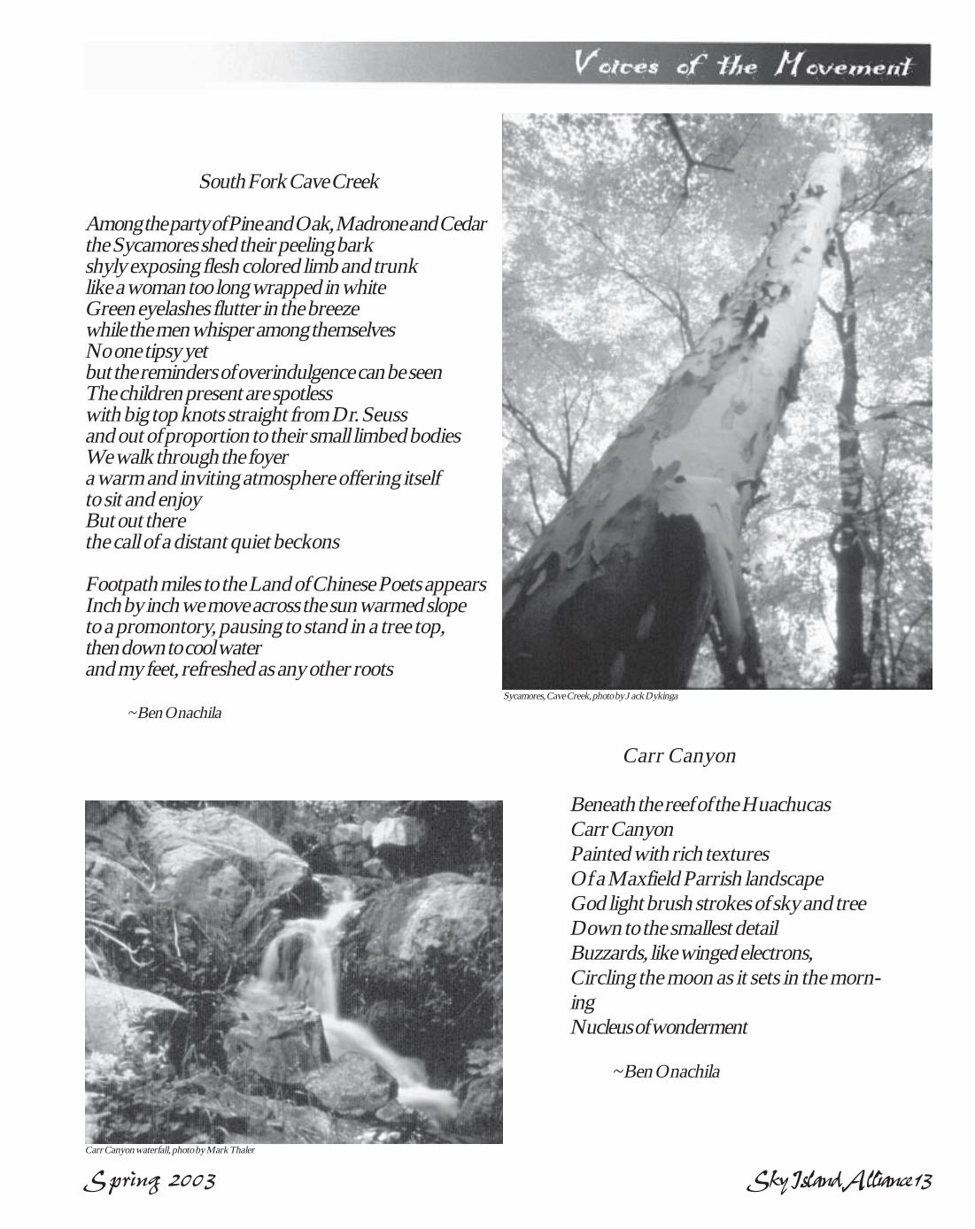
Spring 2003 Sky Island Alliance 13
South Fork Cave Creek
Among the party of Pine and Oak, Madrone and Cedarthe Sycamores shed their peeling barkshyly exposing flesh colored limb and trunklike a woman too long wrapped in whiteGreen eyelashes flutter in the breezewhile the men whisper among themselvesNo one tipsy yetbut the reminders of overindulgence can be seenThe children present are spotlesswith big top knots straight from Dr. Seussand out of proportion to their small limbed bodiesWe walk through the foyera warm and inviting atmosphere offering itselfto sit and enjoyBut out therethe call of a distant quiet beckons
Footpath miles to the Land of Chinese Poets appearsInch by inch we move across the sun warmed slopeto a promontory, pausing to stand in a tree top,then down to cool waterand my feet, refreshed as any other roots
~ Ben Onachila
Carr Canyon
Beneath the reef of the HuachucasCarr CanyonPainted with rich texturesOf a Maxfield Parrish landscapeGod light brush strokes of sky and treeDown to the smallest detailBuzzards, like winged electrons,Circling the moon as it sets in the morn-ingNucleus of wonderment
~ Ben Onachila
Carr Canyon waterfall, photo by Mark Thaler
Sycamores, Cave Creek, photo by Jack Dykinga

14 Sky Island Alliance Spring 2003
The Chiricahuas have a wild andwooly history. From the shop keeper whokilled his wife to keep her from leavinghim to teach in a neighboring communityto the story of a miner who was killed in agunfight because he didn’t have the rightammo in his gun, Hayes weaves an inter-esting tale. Many of the early settlers’saw the Chiricahuas as the PromisedLand, although most of their dreams,from failed mining operations to land de-
Chiricahua Book Provides Fascinating History of a Unique AreaBy Steve Marlatt, SIA board member and highschool/juniorhigh science teacher in Bowie, Arizona
Alden Hayes’ book A Portal to Paradise is an historical accountof one of our favorite mountain ranges. Starting with the earlyNative Americans and progressing through the early pioneers,
Hayes has done his homework in thoroughly researching his subject.Although factual in nature, he tells the story in a narrative story tellingformat that makes it hard to put down. Hayes is no slouch at naturalhistory either and includes many descriptions of the flora and fauna ofthe area.
Cochise Head unit. Although highly considered for wil-derness designation in the past, this area still awaits per-manent protection against degradations brought bymechanized uses.
Within the 31,133 acre unit, only three trails access theinterior–Wood, Emigrant, and Indian Creek trails.Cochise Head, while a prominent peak and fascinatingformation, attracts few visitors compared to other peakswithin the Chiricahuas to the south and has historicallybeen the least-visited major peak in Arizona. Thus, op-portunities for solitude and primitive recreation abound.Visitors on horseback or foot can explore the many inter-esting side canyons, use their skills in orienteering amongthe twists and turns of the landscape, or test their hunt-ing skills against the challenging terrain. There are mul-tiple access points to the unit. Most visitors use the Emi-grant Canyon road or enter at Wood Canyon, which hasspace for car-camping at the end of the road. West White-tail, Fox, and Triangle canyons provide additional access
Cochise Head, continued from back cover
points.Bird watching, scenic viewing, and photographic
opportunities also abound within this unit. The ri-parian areas mentioned above attract many raptorsand rare subtropical birds that can’t be seen elsewherein the country.
While the Cochise Head unit is still wild, remote,and relatively undeveloped, now is time to designateits remaining roadless area as wilderness. SouthernArizona’s human population continually ranks amongthe fastest growing in the country. The recreationaldemands on the Coronado National Forest grow withevery year. Today, the public more than ever seeksundisturbed, wild landscapes. With more than 4,000miles of roads on the Forest, undisturbed areas arequickly becoming more scarce. Wilderness designa-tion in Cochise Head will help preserve in perpetu-ity, the history, beauty, and wildness of our naturaland cultural heritage.
Inventory and
Monitoring
Volunteers
NeededThe Sky Island Alliance is continuing its programto inventory, monitor, and restore populations ofimportant species of animals in the Sky Islandsof southeastern Arizona, northwestern NewMexico, northeastern Sonora, and northwesternChihuahua. We are piloting this programwith riparian inventories for native Ranid frogsand native fish.
Amphibians have experienced population de-clines worldwide due to habitat loss, pollution,and disease. The native Ranid frogs of the SkyIslands include the lowland leopard frog, theChiricahua leopard frog, and the Tarahumaraleopard frog. All of these species have experienceddeclines, from moderate to severe, throughout theSky Island region. The Sky Island Alliance rec-ognizes the importance of the dwindling riparianresources of southern Arizona and has decided toconcentrate its Sky Island Vertebrate Inventoryand Monitoring Program on these riparian-obli-gate species along with our native fish.
We are looking for volunteers who have expe-rience or would like to gain experience in survey-ing for native fish, frogs, and other riparian-de-pendent species and can dedicate themselves toapproximately 10 to 12 surveys in 2003. Volun-teers should be in excellent physical condition,have experience in backcountry hiking, and beready to get wet. We will be hiking and bush-whacking in remote areas throughout the Sum-mer, so ability to deal with extreme conditionsand temperatures is of paramount importance.
For more information, please contact TrevorHare at (520) 624-7080; [email protected].
velopment schemes, never materialized.One of the things that I enjoyed most
about the book was learning the back-ground of many of the place namesfound in and around the Chiricahuas.Hands Pass, Jhus Canyon, Leslie Can-yon, Rucker Canyon, and Fly’s Peak allmean a little more to me now that I knowsome of their colorful history. Such fa-mous outlaws as Ike Clanton, JohnnyRingo, “Blackjack” Tom Ketchum, and
the Apache Kid are also featured in thebook, as well as many tales from the out-law holdout Galeyville.
The life of Neil Erickson, one of theearly pioneers and the first rangers inthe newly created Chiricahua Forest Re-serve, is covered in detail. With only ahorse to patrol the entire range, and withfew established trails, Erickson had hiswork cut out for him dealing with tres-passing cattle, illegal woodcutters, andpreparing surveys of the range. Whenhe left his ranch in Bonito Canyon, hiswife might not expect to see him againfor a month or more.
If you’ve spent any time at all in this uniqueand beautiful area, I think you’ll find this bookvery interesting. It informed me of much ofits diverse past, inspired me to investigatemany new places, and motivated me to worktowards its long term protection.
photo by Fran Dostilo
Spring 2003 Sky Island Alliance 15
• Mexico—the Chihuahua ResearchStation in Janos, and the Jaguar Pro-gram in Sonora.
Please make your check out to SkyIsland Alliance, with a note in the memoline about which fund you’d like to sup-port. We’ll make sure your money goes tothe programs that mean the most to you,and we’ll send you reports!
ext. 208.• Data entrData entrData entrData entrData entry—y—y—y—y—We need new volunteers
to help us input field inventory datasheets into our database as well as newmembership information at the SIAoffice. Time is variable, moderatecomputer skills necessary. This step iscritical for turning all our fieldwork intoon-the-ground conservation action.
More Volunteer Opportunities
• Newsletter Contributors—Newsletter Contributors—Newsletter Contributors—Newsletter Contributors—Newsletter Contributors—Do youenjoy writing and sharing withothers? Poetry, stories, art, commen-tary all desired for coming issues.Work can be done from home. Seepage 2 for guidelines.
• Host a house partyHost a house partyHost a house partyHost a house partyHost a house party—Help supportSky Island conservation work by host-ing fundraising events at your home.Call Acasia for details, (520) 624-7080
Wish List• Donated vehicles, in good working condition
• GPS units for mapping roads and wildlife sign
• Comfortable office chairs in good condition
• Table-top paper cutter, in good condition
• Office supplies: copier paper, postage stamps, etc.
In addition to our exciting and fulfilling field work opportunities, wehave lots of volunteer jobs in the office. If you can help, contact Trevor(520/624-7080; [email protected]).
All the necessary road closures, track-ing workshops, and wilderness advocacyrelies on your financial support, so pleaseconsider a special donation to one of thefollowing funds:
• Roads & Restoration,• Wildlife Monitoring (Tracking),• Missing Link• Wilderness
Become an SIA Program
Fund Donor
Stories in this issue and others have featured pro-
jects in our Rewilding Program: road inventory and restoration,wilderness work, wildlife monitoring and the Missing Link, our
Dragoons Restoration Demonstration Area.
Join UsSky Island Alliance
If you received this newsletter and it’s time to renew your member-ship, please send in your check! If you are reading a friend’s news-letter, consider joining us! We rely on members for our basic opera-
tions. Contributions are tax-deductible; we are a 501(c)3 organization.Basic membership is only $25, but if you add a little to that, here’s
a sampling of what your dollars can do:•$50 will help us survey 30 miles of roads.•$75 will sponsor volunteer training workshops.•$100 will close one mile of road.
Your Name ________________________________________________
Address____________________________________________________
City ____________________________ State _____ Zip ____________
Phone _______________ E-Mail ______________________________
Thank you!Sky Island Alliance
P.O. 41165Tucson, AZ 85717
Upcoming Field scheduleCome hike, find frogs, track mountain lions, survey roadless areas, and riproads! For trip details, contact Trevor (520/624-7080 ext. 204;[email protected]) or Matt(ext. 202, [email protected]).
May 3 - 4. May 3 - 4. May 3 - 4. May 3 - 4. May 3 - 4. Frog Training Weekend. We are looking for volunteers that have experi-ence or would like to gain experience in surveying for native fish, frogs, and otherriparian dependent species and can commit themselves to the program. We will behiking and bushwhacking in remote areas throughout the summer months, so partici-pants in this program must be abile to deal with extreme conditions and temperatures.Location is yet to be determined. [Trevor]
May 10. May 10. May 10. May 10. May 10. Patagonia-Sonoita Creek Preserve, joint work day with The Nature Con-servancy. See article in our last issue. We’ll see birds galore while fostering collabora-tion between the organizations. 1.5 hours from Tucson. [Trevor]
May 16 - 18. May 16 - 18. May 16 - 18. May 16 - 18. May 16 - 18. Aravaipa Canyon Wilderness Inventory. Join SIA in one of the mostgorgeous areas of central Arizona. Fish! Frogs! More birds! Flowing Water! Non-usegrazing allotments! Need we say more? 2.5 hours from Tucson. [Trevor]
May 23 - 26. May 23 - 26. May 23 - 26. May 23 - 26. May 23 - 26. Joint New Mexico Wilderness Alliance and Sky Island Alliance roadinventory trip in the Burro Mountains (see article on page 5). Get your hands dirty andplay a direct role in improving the ecological health of your public lands! [Matt]
May 30 - June 1. May 30 - June 1. May 30 - June 1. May 30 - June 1. May 30 - June 1. Annual Fort Huachuca Lion Track Count. This national, one of akind event attracts some of the premier wildlife biologists from around the country. Wewill be tracking mountain lion and black bear on the Fort Huachuca Military Reserva-tion in the Huachuca Mtns. No experience necessary. This is a great chance to learnmore about tracking techniques, lion and bear natural histories, and using track countson your own to monitor wildlife movement. [Matt]
June 20 - 23. June 20 - 23. June 20 - 23. June 20 - 23. June 20 - 23. Riparian Inventory and Monitoring Weekend. San Rafael Valley. Jointhe Sky Island Alliance’s Riparian Inventory/Monitoring Program in a project to assessthe San Rafael Valley as a site for the conservation and management of our sensitiveriparian fauna. 2.0 hours from Tucson. [Trevor]
June 27 - July 2. June 27 - July 2. June 27 - July 2. June 27 - July 2. June 27 - July 2. Campbell Blue Roads Re-Inventory. Beat the heat and head northinto cool conifer forests with us to monitor and inventory areas that had a high prolif-eration of roads when inventoried in years past. If you can’t make the whole trip, comewhen you can. 4.0 hours from Tucson. [Trevor]
July 11 - 13. July 11 - 13. July 11 - 13. July 11 - 13. July 11 - 13. Riparian Inventory and Monitoring Weekend. San Rafael Valley. Jointhe Sky Island Alliance’s Riparian Inventory/Monitoring Program in a project to assessthe San Rafael Valley as a site for the conservation and management of our sensitiveriparian fauna. 2.0 hours from Tucson. [Trevor]
Do you know who this is? Visit us atwww.skyislandalliance.org to see a whole photo.
Mystery Photo:
The Sky Island TrophyThe Sky Island TrophyThe Sky Island TrophyThe Sky Island TrophyThe Sky Island Trophybike race, originallybike race, originallybike race, originallybike race, originallybike race, originallyscheduled for April 13,scheduled for April 13,scheduled for April 13,scheduled for April 13,scheduled for April 13,has been canceled duehas been canceled duehas been canceled duehas been canceled duehas been canceled dueto logistical andto logistical andto logistical andto logistical andto logistical andbureaucratic problemsbureaucratic problemsbureaucratic problemsbureaucratic problemsbureaucratic problemswith the Forest Service.with the Forest Service.with the Forest Service.with the Forest Service.with the Forest Service.SIA regrets anySIA regrets anySIA regrets anySIA regrets anySIA regrets anyinconvenience this mayinconvenience this mayinconvenience this mayinconvenience this mayinconvenience this maycause anyone. For morecause anyone. For morecause anyone. For morecause anyone. For morecause anyone. For moredetails, visitdetails, visitdetails, visitdetails, visitdetails, visitwww.skyislandtrophy.com.www.skyislandtrophy.com.www.skyislandtrophy.com.www.skyislandtrophy.com.www.skyislandtrophy.com.
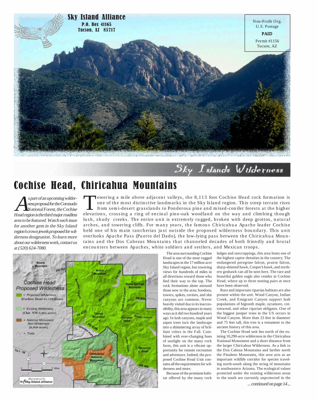
16 Sky Island Alliance Spring 2003
Cochise Head, Chiricahua Mountains
Towering a mile above adjacent valleys, the 8,113 foot Cochise Head rock formation isone of the most distinctive landmarks in the Sky Island region. This steep terrain risesfrom semi-desert grasslands to Ponderosa pine and mixed-conifer forests at the higher
elevations, crossing a ring of encinal pine-oak woodland on the way and climbing thoughlush, shady creeks. The entire unit is extremely rugged, broken with deep grottos, naturalarches, and towering cliffs. For many years, the famous Chiricahua Apache leader Cochiseheld one of his main rancherias just outside the proposed wilderness boundary. This unitoverlooks Apache Pass (Puerto del Dado), the low-lying pass between the Chiricahua Moun-tains and the Dos Cabezas Mountains that channeled decades of both friendly and brutalencounters between Apaches, white soldiers and settlers, and Mexican troops.
As part of an upcoming wilder-ness proposal for the CoronadoNational Forest, the Cochise
Head region is the third major roadlessarea to be featured. Watch each issuefor another gem in the Sky Islandregion’s crown jewels proposed for wil-derness designation. To learn moreabout our wilderness work, contact usat (520) 624-7080.
Sky Island AllianceP.O. Box 41165
Tucson, AZ 85717
Non-Profit Org.U.S. Postage
PPPPPAIDAIDAIDAIDAID
Permit #1156Tucson, AZ
The area surrounding CochiseHead is one of the most ruggedlandscapes in the 17 million acreSky Island region, but toweringviews for hundreds of miles inall directions reward those whofind their way to the top. Therock formations alone astoundthose new to the area; hoodoos,towers, spikes, ravines, and slotcanyons are common. Neverheavily visited due to its inacces-sibility, this area appears in manyways as it did two hundred yearsago. In lush canyons, maple andaspen trees turn the landscapeinto a shimmering array of bril-liant colors in the Fall. Com-bined with ever-changing huesof sunlight on the many rockfaces, this unit is a vibrant op-portunity for remote recreationand adventure. Indeed, the pro-posed Cochise Head Unit con-tains all the requirements for wil-derness and more.
Because of the premium habi-tat offered by the many rock
ledges and outcroppings, this area hosts one ofthe highest raptor densities in the country. Theendangered peregrine falcon, prairie falcon,sharp-shinned hawk, Cooper’s hawk, and north-ern goshawk can all be seen here. The rare andbeautiful golden eagle also resides in CochiseHead, where up to three nesting pairs at oncehave been observed.
Rare and important riparian habitats are alsopresent within the unit. Wood Canyon, IndianCreek, and Emigrant Canyon support lushpopulations of bigtooth maple, sycamore, cot-tonwood, and other riparian obligates. One ofthe biggest juniper trees in the US occurs inWood Canyon. More than 23 feet in diameterand 75 feet tall, this tree is a testament to theancient history of this area.
The Cochise Head unit lies north of the ex-isting 10,290-acre wilderness in the ChiricahuaNational Monument and a short distance fromthe larger Chiricahua Wilderness. As a link tothe Dos Cabeza Mountains and farther norththe Pinaleno Mountains, this area acts as animportant wildlife corridor for species travel-ing north-south along the string of mountainsin southeastern Arizona. The ecological valuesprotected under the existing wilderness areasto the south are currently unprotected in the
... continued on page 14 ...