Spike Photo Measurement and Mobile Data Collection (James Pardue)
20
Spike Photo Measurement and Mobile Data Collection October 23, 2016
-
Upload
gis-colorado -
Category
Technology
-
view
95 -
download
2
Transcript of Spike Photo Measurement and Mobile Data Collection (James Pardue)

Spike Photo Measurement and
Mobile Data Collection
October 23, 2016

2
Quick and easy location and measurement...time to measure and GPS locate features is reduced to minutes

3
Spike is a site survey & estimation tool
…capture dimensions and GPS Location

4
Capture feature information faster
…...quickly measuring lengths, areas an
GPS location

5
Spike is being adopted by different industries
• Construction• Sign & Digital Graphics• Defense and Intel Agencies• State & Local Government• Facility & Asset Management

66
Performs 6 Core Field Functions:
1. PHOTO MEASURE: Accurately measure objects and features within a geotagged photo;
2. POINT TO POINT MEASUREMENT: Laser measure distances between two objects in 3D space
3. Laser Distance Measurement: Laser-based targeting of features safely, accurately and remotely;
4. COLLECT GPS LOCATIONS of features with a distance offset; and5. CREATE A GEOTAGGED PHOTO with an offset of the assets physical location6. PUBLISH, COMMUNICATE AND COLLABORATE with location and
measurement data in common industry file formats
Spike Turns a Smartphone or Tablet Into a Geospatial Multi-Tool
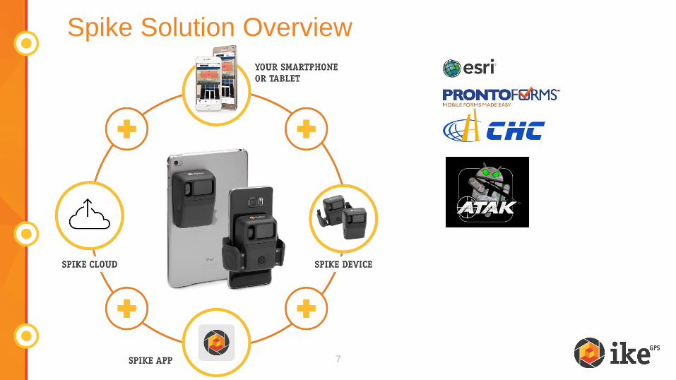
Spike Solution Overview
7

Spike Product Overview

Spike Product Overview
Category Details
Device & OS iOS v8.0 & Android 4.4+ / Smartphone & Tablet
Spike Size &
Weight
3.30in (h) x 2.35in (w) x .82in (d) / 2.05 ounces
83.70mm (h) x 59.8mm (w) x 20.80mm (d) / 58 grams
Connectivity Bluetooth Smart 4.0 – Bluetooth Low Energy
Laser
rangefinder
Eye safe laser supports 2 – 200 meters(6 - 650 feet )
Accuracy Laser rangefinder accuracy is ± 3%;
Photo measure accuracy is ± 3%
Units Meters + Centimeters or Feet + Inches
Resolution Dependent on Smartphone or Tablet digital camera
Output
Formats
Spike File (XML), PDF, and KMZ. (HTML, JPG –
Android Only)

How to use Spike: 3 Phases
Setup
Attach Spike to a
smartphone or to a tablet
case
Install & launch app
Calibrate laser &
compass
Measure
Take a photo
Draw measurements (no
manual input)
Measure in feet, inches,
meters, or centimeters
Export & Share
Export as PDF, JPG,
shareable URL
Measure from your desktop
using online, cloud-based
tools

11
Pick the export format that works best for you
…select from PDF, JPG, or shareable URL (other: Spike File (XML), KMZ)
From the mobile app From the Cloud

DoD/Intel/Public Safety
11’5”
1.5’
3.2’
4.8ft2
• What are the dimensions of that 2nd floor window?
• How many 3ft sections of tactical ladder do I need for access?

DoD/Intel: Point to Point Measurement
184’2”225’8”
138’11
”

18.4ft2
Public Safety: Incident Documentation

Public Safety – Disaster Response
108’7”

18.4ft2118.4ft2
Transportation Bridge Inspection

Transportation Signage Inventory

18.4ft2
Municipal Infrastructure Inspection
Sidewalk inspection

Facilities Management - Measuring a Structure

Demo: Photo Measure