Spent Fuel Route Survey Tuxedo, New York to Savannah River ...
21
*1 0 'p 1 1, , PLLý--ý- 77ým SPENT FUEL ROUTE SURVEY TUXEDO, NEW YORK TO SAVANNAH RIVER, SOUTH CAROLINA SEPTEMBER 1981 811221009 8092 PDR ADOCK 07000687 C pDR
Transcript of Spent Fuel Route Survey Tuxedo, New York to Savannah River ...

*1 0'p
1 1, ,
PLLý--ý- 77ým
SPENT FUEL ROUTE SURVEY
TUXEDO, NEW YORK
TO
SAVANNAH RIVER, SOUTH CAROLINA
SEPTEMBER 1981
811221009 8092PDR ADOCK 07000687C p DR

0 0
.kTED INFOALT ION
70 CF ,79U od) II•O01.TI01
SUMMARY OF LLEA RESPONSE CAPABILITIES AND SAFE HAVENS
ROAD TRANSPORTATION ROUTE
Tuxedo, NY to Savannah River, SC
NOTE: Safe havens are indicated on the route strip charts by a lowercase letter of the alphabet in parenthesis. These safe havenswere designated by local law enforcement agencies or the NRCroute analysis teams as available for temporary refuge untilappropriate assistance arrives. The basic criteria used toidentify a safe haven were availability of a large parking area,nighttime lighting, if possible, and quick law enforcementresponse to the safe haven.,
Should a safe haven be needed refer to theits specific identification and location.
following list for
I
la
1981,

i0C1 2.7- • TX2.0 2 t0y
SUMMARY OF LLEA RESPONSE CAPABILITIES - NEW YORK
Troop F New York State Police has the primary law enforcement responsibilityover the 53 miles of the route within New York. They have a task forcedesignated to cover NY 17/1-84. Therefore, expect a response time of 5-10minutes anytime of the day.
CB communications are fair on this segment of the route. The NYSP monitorCB radio intermittently at Middletown and approximately 50% of the troopersequip their patrol cars with personal CB sets. If mobile telephone (MT) isnot accessible, any emergency calls should be made on Channel 19.
MT communications were marginal for the first 40 miles of the route and thena dead zone was experienced near the Pennsylvania State line.
SAFE HAVENS
a. Oxford Depot. Located 5 miles north of Intersection NY 210/NY 17, offright hand side of NY 17.
b. Port Jervis Mountain Truck Stop. Located 3 miles west of Exit 131 of1-84 on Mountain Road.
2a
SEP 1981

SECURITYP•PRELATED INFORlaTION1.0 CFA 2. 79 0(d) Ii•'OROATIOzI
SUMMARY OF LLEA RESPONSE CAPABILITIES - PENNSYLVANIA
The Pennsylvania State Police (PSP) have the primary law enforcementresponsibility for the 255 miles of the route within Pennsylvania. TroopR covers the first 42 miles which is in Pike and Wayne Counties.. Expecta response time in this segment of approximately 10-15 minutes during normalduty hours and 20-30 minutes during the graveyard shift. Troop S hasjurisdiction over the remaining 213 miles of the route within Pennsylvania.The response time along 1-380 and westward along 1-80 up to Exit 41 shouldbe 5-10 minutes. For the remainder of 1-80 and 1-81 within Pennsylvania,expect an average response time of 10-15 minutes prior to midnight and 20-30minutes during the graveyard shift.
Mobile telephone communications were erratic on the 1-84 segment of theroute in eastern Pennsylvania. MT communications were effective from theDunmore area, approximately at the 1-84/1-380 intersection, to easternSchuykill County.. Then MT coverage was marginal until the Harrisburg area.From Harrisburg south to the Martinsburg, WV area, there was continuous MTcoverage.
CB communications in Pennsylvania range from fair to poor. The PSP donot monitor CB radio at base stations and only a few troopers equip theirpatrol cars with personal CB sets. In the event MT is not accessible, anyemergency calls should be made on Channel 19.
SAFE HAVENS
a. Twin•Rocks Truck Stop. Located off 1-84•Exit 5 Wayne County, righthand side..
b. Truck Stops of America. 1-81 Exit 27 at mile marker 78. 6 miles fromPA State Police Headquarters at 1-81 Exit 24 Harrisburg.
c. C. Earl Brown, Inc. Located at 1-81 Exit 5 Chambersburg at milemarker 14. Emergency truck service - no food, very close to PA State.Police Substation.
SECURITY-RELATED INFORMUlTION
10 CFR327VQ8a1). JWARkATION
3a
SEP 198.
SECURI TY-RELATED INFORYA ION
SUMMARY OF LLEA RESPONSE CAPABILITIES -. MARYLAND
Response times for the twelve miles of 1-81 which transits Maryland shouldbe excellent. The Maryland State Police have one or more cars dedicatedto the patrol of this sector and thus a response time of ten minutes isrealistic.
Mobile telephone coveragesouthwest of Martinsburg,Hagerstown and Winchesterreliability as a means ofruns from approximately 5west of Winchester, VA.
is excellent between PA and WV until you areWV. We did make some marginal contact within this area, but fading in and out reduces itscommunications. This marginal reception areamiles south of Martinsburg to ten miles south-
CB coverage is adequate with the majority of theing channel 19.
State Police cars-monitor-
SAFE HAVENS
a. C. Earl Brown, Inc. Exit 5 mile marker 5 ofservice - 4 miles from MD State Police (Exit
1-81. Emergency truck4 east to Hagerstown).
b. Exit 4 of 1-81. MD State Police Substation.
.0 CV 2.
4a
SEP ,8

SECURITY-RELATED INFORMATION10 CYR2.7ýiU~) .illýORMATI0N
SUMMARY OF LLEA RESPONSE CAPABILITIES - WEST VIRGINIA
Response times for the twenty five miles in WV should average aroundten minutes until midnight. At that time the patrol is on standby calland response times will decrease to fifteen to thirty minutes. TheWestVirginia State Police will normally have at least one car assigned to thissection of the interstate.
Mobile telephone coveragesouthwest of Martinsburg,Hagerstown and Winchesterreliability as a means ofruns from approximately 5west of Winchester, VA.
is excellent between PA and WV until you areWV.. We did make some marginal contact within this area, but fading in and out reduces itscommunications. This marginal reception.areamiles south of Martinsburg to ten miles south-
CB coverage is marginal except for an active REACT group in the Martinsburgarea.
SAFE HAVENS
a. Rest Area with telephone and full facilities at State line.
b. Exit 20. Union 76 Truck Stop. 5.miles from West Virginia StatePolice Substation (Exit 16).
c. State Police/North Martinsburg. 1-81 Exit 16E to Route 9. Locatedone-half mile from Exit 16E on right side of highway. After midnight,,troopers are on-call duty.
SECURI ThF..idJATED INFORITIN10 CFR,?.79U(d) O
5a
SEP 198
SSBECURITYLATED IFRkI110 CFR 2.7"O(d) INFOUYATION
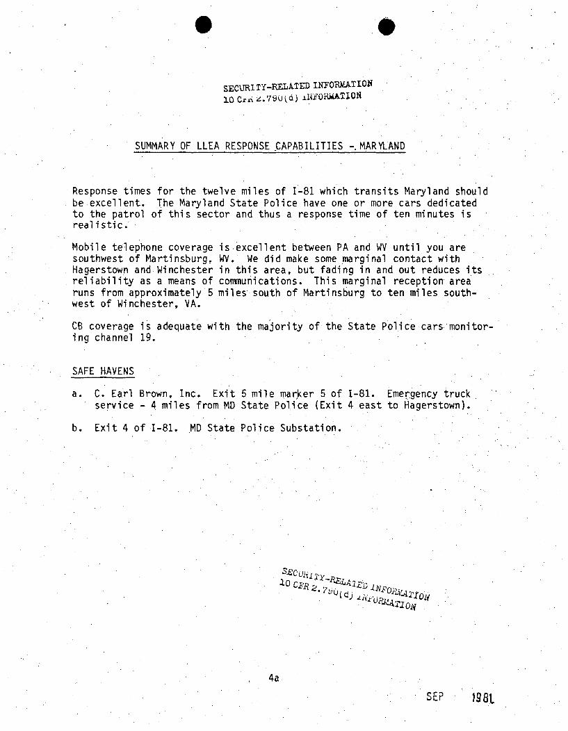
SUMMARY OF LLEA RESPONSE CAPABILITIES - VIRGINIA
Patrol coverage along the 334 mile portion of Interstate 81 which traversesVirginia, when supplemented by the Pulaski, Montgomery, and Shenandoah CountySheriff Departments, is considered to be excellent. Average response time alongthe entire route, in spite of the fact that overall manpower total of theVirginia State Police is low, is considere-d good and should fall within a ten tofifteen minute time frame. MT coverage is excellent throughout Virginia withthe exception of those portions along 1-81 which lie between Abingdon andMarion and between Strasburg and Martinsburg,.West Virginia. Within theseareas, coverage is considered to be marginal. State Police and County Sheriffvehicles contain CB radios and most monitor channel 19. There are active REACTgroups in New River, Roanoke,.Woodstock, and Winchester which monitor CB channel9 and work closely with law enforcement officials. Emergency calls will also
.draw a response from State Police located at the weigh stations in Salem and.Winchester. Some State Police cars have an automatic override for channel 9communications.
SAFE HAVENS /
a. Rest area with telephone and full facilities. 1 mile south of Exit83 on 1-81.
b. Truck Weigh Station. Located 1.5 miles north of Exit 77 of 1-81 atmile marker 304. Manned 24 hours per day by trooper. 6 miles southof Kernstown Substation.
c. State Police/Staunton. Leave 1-81 at Exit 57. Turn west on VA 250.-Police are located .3 of mile from Exit 57.
d. Rest area with telephone and full facilities. Located between Exits59 and 60 of 1-81. 10 miles from VA State Police at Staunton.
e. Rest area with telephone and full facilities. Located 1.5 miles southof Exit 53A of 1-81.
f. Truck Weigh Station between Exits 43 and 44 of 1-81. Manned by trooper
24 hours per day..
g. Gulf Truck Stops of America. Located at Exit 44 of 1-81.
h. State Police/Salem. Midway between 1-81 Exits 39 and 40 on US 11.3 miles north from 1-81 Exit 39; 3.miles south from 1-81 Exit 40.
i. VA State Police. 1-81 Exit 32 to Pulaski, on Route 100 to Pearisburg.
j . State Police Communications Trailer. 1-81 mile marker 76.5. Locatedon western side of 1-81, with crossover available. Manned 24 hours perday.
k. Exit 22. Intersection of 1-77/1-81. Wilderness Road Union 76 Truck Stop.
1. Rest area with telephone and full facilities. Located one-half milesouth of Exit 18 of 1-81 mile marker 54.
6" SEC\3RI -ELATED INFO0In I0'.6a".0 u.79O~d) INFOR1ATION
.. .SFP 10Q
SECURI TY-RELATED INFORMATION
10 CFR 2. 7 9U (d) ji FOaALTION
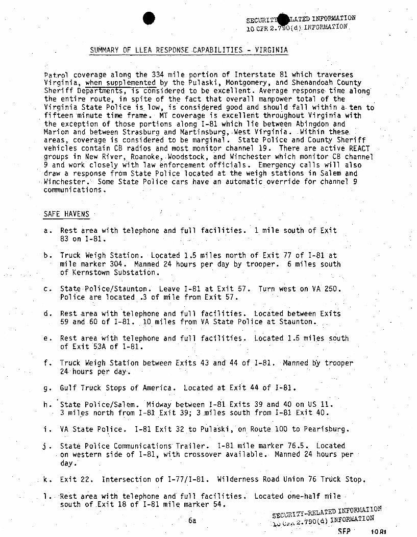
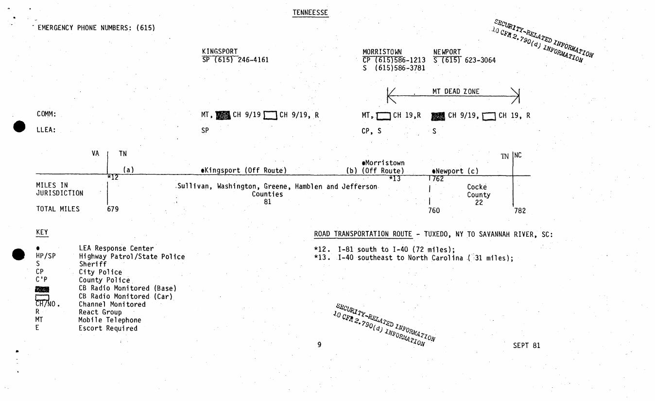
sUMMARY OF LLEA RESPONSE CAPABILITIES - TENNESSEE
State Police coverage along the 103 mile sector is adequate when supple-mented by the Cocke and Hamblen Counties Sheriff's Departments. The entireroute is the prime responsibility of the State Police unit located atKingsport, TN and thus some additional coverage is necessary to providecommunication links. Consequently, the Sheriffs of Cocke and HamblenCounties (Newport and Morristown respectively) were contacted to augmentthe thin coverage. Expect a response time of fifteen minutes while inTennessee.
Mobile telephone is good until contact is lost with Morristown. Approxi-mately 80 miles of the 103 miles has useable coverage.
CB coverage is also good with base stations at Kingsport and Newport. There.are active REACT groups in all three LLEA areas.
SAFE HAVENS
a. Rest area with telephone and full facilities. Located near Tennessee/Virginia State line.
b. Rest area with telephone and full facilities. Located 1.6 milfts southof 1-81 Exit 4 and close to 1-40 junction.
c. 1-40 Exit 432. 76 Truck Stop and Jack's Diesel Repair. Close to CockeCounty Sheriff's Office.
SECURITY-RELATED INFORKATI ON10 CFR 2.790(d) INYUOBATION
7a
SEP 1981

SECURI TY-RELATED INFYORATION
I.0 CFR 2 .790(d) INFORISATION
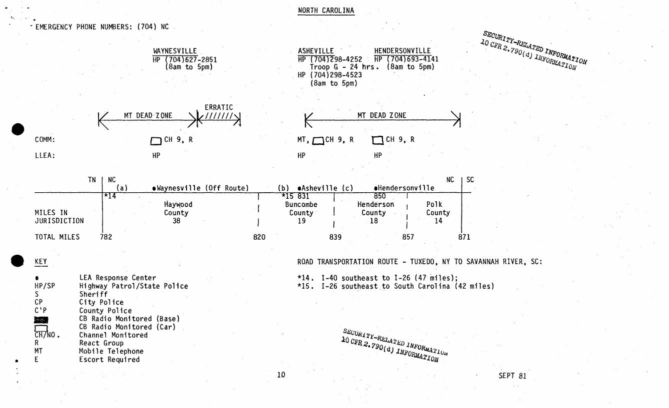
SUMMARY OF LLEA RESPONSE CAPABILITIES - NORTH CAROLINA.
The eighty-nine mile route through North Carolina is well covered duringduty hours with an average of two patrol cars assigned to each of the fourcounties traversed in the state. Response times are estimated to averagefrom ten to a maximum of fifteen minutes during duty hours. After midnighton the weekends, however, state troopers are on-call, so plan on an additionalthirty minutes in case LEA assistance is required during this time period.
Mobile telephone coverage in North Carolina is quite poor. Although thereis a mobile telephone operator located in Asheville, repeated attempts tocontact the station there were unsuccessful.
State patrol vehicles monitor CB radio on channel 9, however, none of thepatrol substations contain a base station. This situation isamelioratedsomewhat by the fact that local REACT groups work closely with the statepatrol throughout the area.
SAFE HAVENS
a. Welcome/Information Center. Located 11 miles south of Tennessee StateLine.. Telephone and full facilities.
b. Weigh Station. Located on 1-40,-5 miles north of intersection with1-26.
c. Rest area with telephone and facilities. Located one mile south ofHenderson/Buncombe. County line, thirty-two miles north of South Carolinaline on 1-26.
L0CAT 2IIFO.7O'
8a
SEP 1981

SECURITY-RELATED INFORMATION10 CYR 2.7SO(d) L14uAUTION
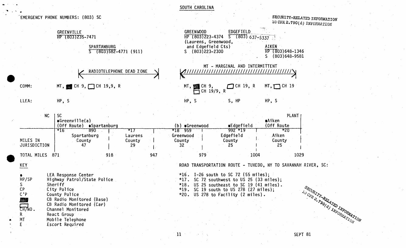
SUMMARY OF LLEA RESPONSE CAPABILITIES -SOUTH CAROLINA
As in Tennessee, the South Carolina Highway Patrol coverage of the routeis acceptable when supplemented by local county Sheriff Departments, part-icularly those in Spartanburg, Greenwood, Edgefield, and Aiken Counties.Response times should average fifteen to twenty minutes for both patroland sheriff department Vehicles during the 7-3 and 3-11 shifts. From 11pmto 7am the following morning, the highway patrol is on-call so primaryreliance will have to be placed upon the appropriate county sheriff's depart-ment. Also, a fifteen to twenty minute increase in response time shouldbe anticipated.
Mobile telephone coverage is fair. There are operators located at Spartan-burg, Greenwood, Willeston, and Augusta, however, reception was good onlyaround Spartanburg and Greenwood. As the Savannah River facility is neared,erratic reception is available from the station at Willeston. There wasno reception from or access to the station in Augusta.
The Highway Patrol monitors CB radio channel 9 at its stations in Spartanburgand Greenwood and all patrol cars have a CB radio scan capability with achannel 9 override feature. In addition, the Spartanburg, Edgefield, andAiken County Sheriff's Departments all have vehicles containing CB radioswhich monitor channel 19. This monitoring capability is supplemented byREACT groups which assist the LLEA in Spartanburg, Greenwood and EdgefieldCounties.
SAFE HAVENS
a. Welcome Center. 2-1/2 miles south of South Carolina/North Carolina Stateline on 1-26.
b. Greenwood Law Enforcement Center. Call Sheriff, telephone (803) 223-2300and request escort to Greenwood Law Enforcement Center.
-SECURITY-RELATED INFORJBLTION10 CER 2.7 90 (d) INFORMATION
9a
SEP 1981
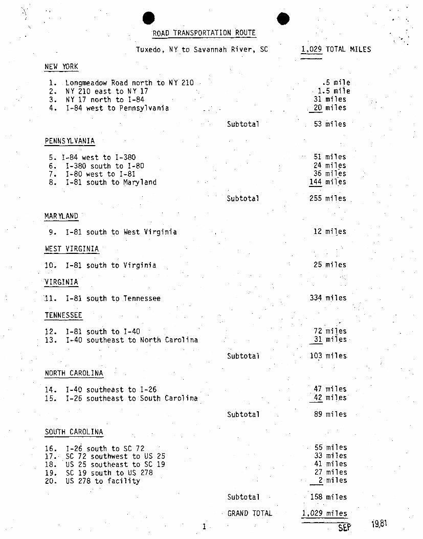
'ROAD TRANSPORTATION ROUTE
Tuxedo, NY to Savannah River, SC 1,029 TOTAL MILES
NEW YORK
1.2.3.4.
Longmeadow Road north to NY 210NY 210 east to NY 17NY 17 north to 1-841-84 west to Pennsylvania
.5 mile1.5 mile
31 miles20 miles
53 milesSubtotal
PENNSYLVANIA
5. 1-84 west to 1-3806. 1-380 south to 1-807. 1-80 west to 1-818. 1-81 south to Maryland
MAR YLAND
9. 1-81 south to West Virginia
WEST VIRGINIA
10. 1-81 south to Virginia
VIRGINIA
11. 1-81 south to Tennessee
512436
144
milesmilesmilesmiles
Subtotal 255 miles
12 miles
25 miles
334 miles
TENNESSEE
12. 1-81 south to 1-4013. 1-40 southeast to North Carolina
7231
milesmiles
Subtotal
NORTH CAROLINA
103 miles
47 miles42 miles
89 miles
14. 1-40 southeast to 1-2615. 1-26 southeast to South Carolina
Subtotal
SOUTH CAROLINA
16.17.18.19.20.
1-26 south to SC 72SC 72 southwest to US 25US 25 southeast to SC 19SC 19 south to US 278US 278 to facility
55 miles33 miles41 miles27 miles
2 miles
Subtotal
GRAND TOTAL
158 miles
1,029 miles
I
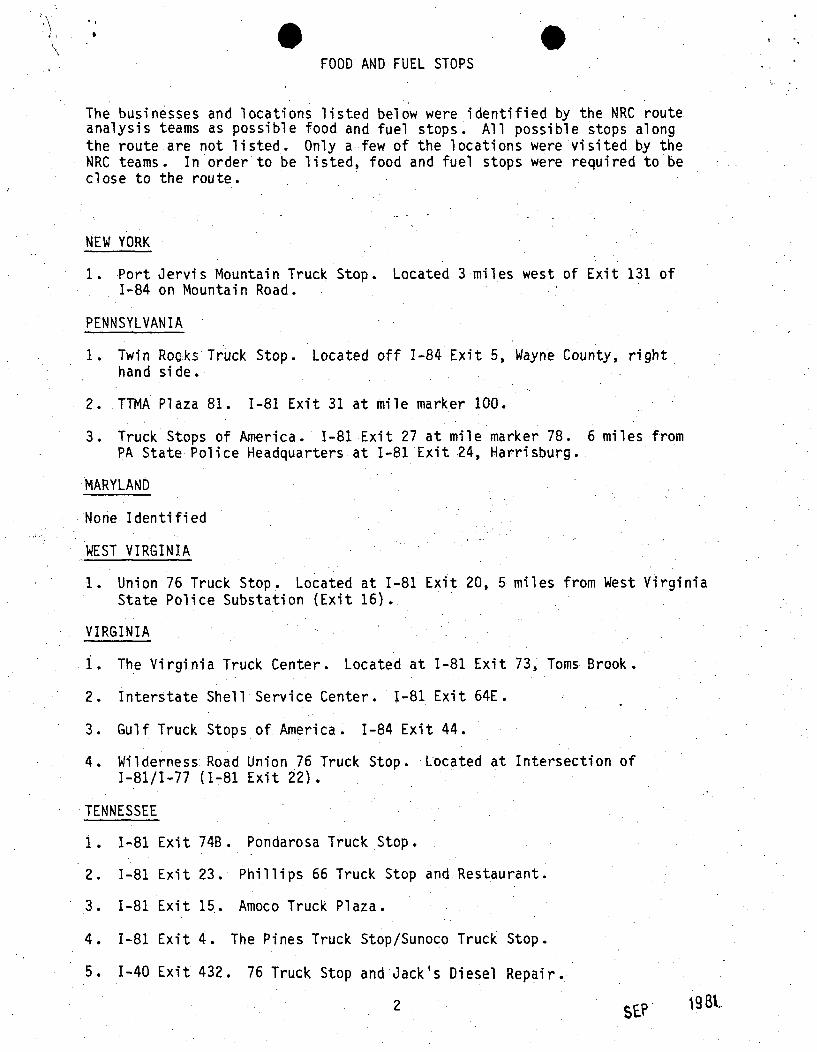
FOOD AND FUEL STOPS
The businesses and locations listed below were identified by the NRC routeanalysis teams as possible food and fuel stops. All possible stops alongthe route are not listed. Only a few of the locations were visited by theNRC teams. In order to be listed, food and fuel stops were required to beclose to the route.
NEW YORK
1. Port Jervis Mountain Truck Stop. Located 3 miles west of Exit 131 of1-84 on Mountain Road.
PENNSYLVANIA
1. Twin Rooks Truck Stop. Located off 1-84 Exit 5, Wayne County, righthand side.
2. TTMA Plaza 81. 1-81 Exit 31 at mile marker 100.
3. Truck Stops of America. 1-81 Exit 27 at mile marker 78.PA State Police Headquarters at 1-81 Exit 24, Harrisburg.
6 miles from
MARYLAND
None Identified
WEST VIRGINIA
1. Union 76 Truck Stop. Located at 1-81 Exit 20, 5 miles from West VirginiaState Police Substation (Exit 16)..
VIRGINIA
1. The Virginia Truck Center. Located at 1-81 Exit 73, Toms Brook.
2. Interstate Shell Service Center. 1-81 Exit 64E.
3. Gulf Truck Stops of America. 1-84 Exit 44.
4. Wilderness Road Union 76 Truck Stop. Located at Intersection of1-81/1-77 (1-81 Exit 22).
TENNESSEE
1. 1-81 Exit 74B. Pondarosa Truck Stop.
2. 1-81 Exit 23. Phillips 66 Truck Stop and Restaurant.
3. 1-81 Exit 15. Amoco Truck Plaza.
4. 1-81 Exit 4. The Pines Truck Stop/Sunoco Truck Stop.
5. 1-40 Exit 432. 76 Truck Stop and Jack's Diesel Repair.
2 19 Bt.

FOOD AND FUEL STOPS
NORTH CAROLLINA
None Identified
SOUTH CAROLINA
1. Gulf Truck Stop. Located at Exit 22 of. 1-26.
2. Sunny's Texaco Truck Stop. Located on SC 72 bypass at Greenwood.
SEP

NEW YORK AND EASTERN PENNSYLVANIA
~~1~
~1.0EMERGENCY PHONE NUMBERS: Area Code: (914) NY.
(717) PA
MONROES•T-T4)782-8311F Troop
MIDDLETOWNSP (914)343-1424HQ F Troop
LORD'S VALLEYSP (717)775-7374R Troop
DUNMORESPTT1T)961-2461HQ R Troop &S Troop
1////// MT MARGINAL MT DEAD ZONE \j/ MT ERRATIC MT DEAD ZONEK
/IComm:
LLEA:
MT,. CH 1q
SP
0 CH 19, R MT,MCH 19, R MT,I= CH 19, R
SP SP SP
NY PA(a) eMonroe -*Mi ddl etown (b) *Lord's Valley (a) *Dunmore
1*1 *2 *3 10
MILES INJURISDICTION
TOTALMILES
OrangeCounty
53
32 *4 *5 74Pike
County36
Il
lI
WayneCounty
<6
I.*6 109
LackawannaCounty
21
116I0 53 89 95
KEY ROAD TRANSPORTATION ROUTE - TUXEDO, NY TO SAVANNAH RIVER, SC:
0
HP/SPSCP
R
MTE
LEA Response CenterHighway Patrol/State PoliceSheriffCity PoliceCB Radio Monitored (Base)CB Radio Monitored (Car)Channel MonitoredReact GroupMobile Telephone (Usable)Required
*I. Longmeadow Road north to NY Rte 210 (1/2 miles);*2. NY Rte 210 east to NY Rte 17 (1.5 miles);*3. NY Rte 17 north to 1-84 (31 miles);*4. 1-84 west to PA State line (20 miles);*5. 1-84 west to 1-380 (51 miles);*6. 1-380 south to 1-80 (24 miles);
4
SECUIRI TY-RELATED IN1FORMAATIONC.j .F ~,790(d) INFOPBMAT10Oi
SEPT 81
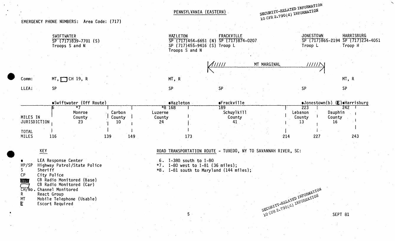
PENNSYLVANIA (EASTERN) LT 1iFBOO1
EMERGENCY PHONE NUMBERS: Area Code: (717)
SWIFTWATERSP (717)9-7701 (S.)Troops S and N
HAZ LETONSP (717)454-6651SP (717)455-9416Troops S and N
FRACKVILLE(N) SP-(TT7T)74-0207(S) Troop L
JONESTOWNSP(71 6 5-2194Troop L
HARRISBURGSP (717)234-4051Troop H
1////// MT MARGINAL ffll
Comm:
LLEA:
MT, D CH 19, R MT, R MT, R
SPSP SP SP SP
*Swiftwater (Off Route)
Monroe
!iHazleton168 I
MILES INJURISDICTION
TOTALMILES
IIIIUU II lmj
23
CarbonCounty
10
149
*8 1Luzerne
County24
I
eFrackville189
SchuylkillCounty
41.
sJonestown(b) (E)mHarrisburg223 1 242 !
Lebanon DauphinCounty i County
13 16
1116
1139
1173
1.214 227 243
KEY ROAD TRANSPORTATION ROUTE - TUXEDO, NY TO SAVANNAH RIVER, SC:
oHP/SPSCP
RMTE
LEA Response CenterHighway Patrol/State PoliceSheriffCity PoliceCB Radio Monitored (Base)CB Radio Monitored (Car)Channel MonitoredReact GroupMobile Telephone (Usable)Escort Required
.6.*7.*8.
1-380 south to 1-801-80 west to 1-81 (36 miles);1-81 south to Maryland (144 miles);
5 SEPT 8
5 SEPT 81
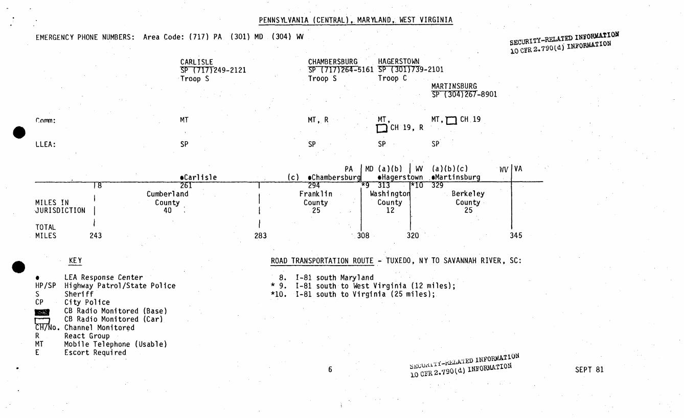
PENNSYLVANIA (CENTRAL),. MARYLAND,. WEST VIRGINIA
EMERGENCY PHONE NUMBERS: Area Code: (717) PA (301) MD (304) WVSFECIjj~jTy-ELAkTED n1"ORMAT jON
).(3 CyR 2.790(d) INO"TO
CARLISLESP-T717T249-2121Troop S
CHAMBERSBURGSP (717T264161Troop S
HAGERSTOWNS• (3017T3T9-2101Troop C
MARTINSBURGSP 34)267-8901
Conm:
LLEA:
MT
SP
MT,ý R MT,DCH 19, R
SP
MT, Q CH. 19
SPSP
PA I MD WV WV VA
Cumberl andMILES IN CountyI'JURISDICTIONI 40 I
TOTALMILES 243 28
Frank i nCounty
.25
BerkeleyCounty
2512
3 308 320 345
ROAD TRANSPORTATION ROUTE - TUXEDO, NY TO SAVANNAH RIVER, SC:KEY
HP/SPSCP
ýao.RMTE
LEA Response CenterHighway Patrol/State PoliceSheriffCity PoliceCB Radio Monitored (Base)CB Radio Monitored (Car)Channel MonitoredReact GroupMobile Telephone (Usable)Escort Required
8.* 9.*10.
1-81 south Maryland1-81 south to West Virginia (12 miles);1-81 south to Virginia (25 miles);.
6 ku,• •.IA.•E I F1.A• DGa 0•2,790 (d) 1101UL•0 SEPT 81

VIRGINIA (NORTHERN HALF)
EMERGENCY PHONE NUMBERS: (703)
WINCHESTERSPTP(703)8 -2000SP (800)572-2260
(After 5pm)
WOODSTOCKTý(7U03)459-4071
911
HARRISONBURGSP (703)434-8593
(800)552-0962(After 5 pm)
STAUNTONSP(T703)885-2142
(800)552-0962
LEXINGTONSP (703)291-2548
(800)542-5959(After 5pm)
MTVZ111/ MARGINAL //i
COMM:
LLEA:
•CH 19/9, R
SP
MT, EJCH 19, R
SI
MT, INCH 9 .. [n CH 9/19
MT, CH 19 MT,T-1 CH 9/19
SP SP SP
W VA VA(a)(b)eWinchester
(c)(d).eHarrisonburg eStaunton.*Woodstock (e) eLexington
*11 361Frederick
County25
MILES INJURISDICTION
TOTAL MILES 370
386Shenandoah
County37
407
431Rockingham
County30
437
453AugustaCounty
33I
470
495 IRockbridge
County34 I
345 504
KEY ROAD TRANSPORTATION ROUTE - TUXEDO, NY TO SAVANNAH RIVER, SC:
0HP/SPSCPC 'P
RMTE
LEA Response CenterHighway Patrol/State PoliceSheriffCity PoliceCounty PoliceCB Radio Monitored (Base)CB Radio Monitored (Car)Channel MonitoredReact GroupMobile TelephoneEscort Required
*11. 1-81 south to Tennessee (334 miles);
450.20 ~'~
7 SEPT 81

VIRGINIA (SOUTHERN HALF)
EMERGENCY PHONE NUMBERS: (703)
SALEM CHRISTIANSBURGSFT03)387-0986 S (703)382-2951SP (800)542-5959S (703)387-0211
K""'11
PULASKIS(703)9880-2040
MARION"TT ") 783-7204
BRISTOLS-P-703)228-3131
WYTHEVILLE(73)T228-23131
IS (703) 228,-2143t
ABINGTON---T7O3T628-7183
MT DEAD ZONE
COMM:
LLEA:
MT ` CH 9L2 9/19,
OCH 9R
CH 9C•CH 9, R
CH 9/19, R
SP, S
MCH 9/9 TICH 9MCH 19/9 ý 'MCH.9/19
SP, S S S S S SP
(4ftt9)B
MILES INJURISDICTION
otetourtCounty
27
(h)
I.
(E)o*SalemRoanoke537 1
Roanoke ICounty
11 54548
MontgCouS2
(i)oChristiansburg *PulaskiI 5851.
•omery Pulaskiinty County6i 19 I
I i574 593
(j)(k)(1)
WytheCount
29
*Wytheville607
ly 622
622
.oMarion634
SmythCounty
23
mAbington66z
WashingtonCounty
34
VA i TN
oBri stol679
6791
531
*TAL MILES 504645
KEY ROAD TRANSPORTATION ROUTE - TUXEDO, NY TO SAVANNAH RIVER, SC:
0HP/SPSCPC'P
MT
LEA Response CenterHighway Patrol/State PoliceSheriffCity PoliceCounty PoliceCB Radio Monitored (Base)CB Radio Monitored (Car)Channel MonitoredReact GroupMobile TelephoneEscort Required
11. 1-81 south to Tennessee;
SECURITY-REhATE) INFORMAION10 CFR 2 .790(d) INFORJATION
8 SEPT 81
TENNEESSE
" EMERGENCY PHONE NUMBERS: (615)
KINGSPORTSP (615) 246-4161
MORRISTOWNCP (615)586-1213S (615)586-3781
NEWPORTS (615) 623-3064
I/7 MT DEAD ZONE •jW
. .ml
I\ /I
C OMM:
LLEA:
MT, I CH 9/19 M CH 9/19, R MT,..= CH 19,R CH 9/19, ] CH 19, R
SSP CP, S
VA TN TN INC
a)eMorristown
(b) (Off Route)eKinqsDort (Off Route) eNewnort (r:)a) (bLOfRue)*en cMILES I
MILES INJURISDICTION
TOTAL MILES 679
"1j.Sullivan, Washington, Greene, Hamblen and Jefferson.
Counties, 81
I fa6ZCockeCounty
22760 782
KEY ROAD TRANSPORTATION ROUTE - TUXEDO, NY TO SAVANNAH RIVER, SC:
HP/SPSCPC'P
RMTE
LEA Response CenterHighway Patrol/State PoliceSheriffCity PoliceCounty PoliceCB Radio Monitored (Base)CB Radio Monitored (Car)Channel MonitoredReact GroupMobile TelephoneEscort Required
*12. 1-81 south to 1-40 (72 miles);*13. 1-40 southeast to North Carolina .( 131 miles);
,~O4 (Iw
9 SEPT 81
NORTH CAROLINA
" EMERGENCY PHONE NUMBERS: (704) NC
WAYNESVILLEHP (704)627-2851
8am to 5pm)
ASHEVILLE HENDERSONVILLEHP (704)298-4252 HP (704)693-4141
Troop G - 24 hrs. (8am to 5pm)HP (704)298-4523
(8am to 5pm)
0 CPR,, P4.790( b*
ERRATIC\1/ ///////l\I/~ MT DEAD-ZONE 1/ MT DEAD ZONE
1\ /1 1 /4 K /I
C OMM:
LLEA:
n"CH 9, R MT, ECH 9, R ICH 9, R
HPHP HP
TN NC(a)
NC SCeWaynesville (Off Route) (b) eAsheville (c) eHendersonville
1*14
MILES INJURISDICTION
TOTAL MILES
HaywoodCounty
38
III
*15 831Buncombe
County19
III
850HendersonCounty.18
857
PolkCounty
14
782 820 839 871
KEY
aHP/SPSCPC'P
C;o.RMTE
LEA Response CenterHighway Patrol/State PoliceSheriffCity PoliceCounty PoliceCB Radio Monitored (Base)CB Radio Monitored (Car)Channel MonitoredReact GroupMobile TelephoneEscort Required
ROAD TRANSPORTATION ROUTE - TUXEDO, NY TO SAVANNAH RIVER, SC:
*14. 1-40 southeast to 1-26 (47 miles);*15. 1-26 southeast to South Carolina (42 miles)
.16: [-Tyt1A"
QRo790(d,) "11VF0*4•-'I•
10 SEPT 81
IEMERGENCY PHONE NUMBERS: (803) SC
GREENVILLEH "•803TM-7471
SPARTANBURGS---' 52-4771 (911)
SOUTH CAROLINASECURI TY-R•UTED INFORMATIONI0 CFRi 2 .790(d) INFOPIMATION
GREENWOOD EDGEFIELDHP (803)223-4374 S 803)T 637-5337(Laurens, Greenwood,and Edgefield Cts) AIKEN
S (803)223-2300 1[P-Tw-03)648-1346S (803)648-9581
L,-, RADIOTELEPHONEMT - MARGINAL AND INTERMITTENT•/////////I///////I//////////////////I////II/////i
DEAD ZONE \J-1
COMM:
LLEA:
MT, a CH 9, n CH 19,9, R MT, C H 9,CH 19/9,
D-1CH 19, RR
S, HP
MT,10CH 19
HP, SHP, S HP, S
NC SCeGreenville(i(Off Route)
eAiken(Off R
PLANT
teespartanburg (b) eGreenwood eEdqefi el d outoul*1b bgu.
SpartanburgCounty
47MILES INJURISDICTION
I9
918
1iiLaurensCounty
29
W1d 9b9GreenwoodCounty
32
979
99Z W19Edgefiel dCounty
25
I.7zu
AikenCounty
25
II
TOTAL MILES 871 947 1004 1029
KEY ROAD TRANSPORTATION ROUTE - TUXEDO, NY TO SAVANNAH RIVER, SC:
0HP/SPSCPC'P
FR.R
a MTE
LEA Response Center *16.Highway Patrol/State Police *17.Sheriff *18.City Police *19.County Police *20.CB Radio Monitored (Base)CB Radio Monitored (Car)Channel MonitoredReact GroupMobile TelephoneEscort Required
1-26 south to SC 72 (55 miles);SC 72 southwest to US 25 (33 miles);US 25 southeast to SC 19 (41 miles).SC 19 south to US 278 (27 miles);US 278 to Facility (2 miles).
'4-
11 SEPT 81