Special Assitance for Project Formulationopen_jicareport.jica.go.jp/pdf/11640836_02.pdf · Mr....
58
1 Final Report (Volume II) INTRODUCTION
Transcript of Special Assitance for Project Formulationopen_jicareport.jica.go.jp/pdf/11640836_02.pdf · Mr....

1 Final Report (Volume II)
INTRODUCTION
Study on Infrastructure Information Management System of the Dakar Metropolitan Area
Final Report (Volume II) 2
This report is Volume II: Appendices of the Final Report of the Study on Infrastructure Information Management System of the Dakar Metropolitan Area in the Republic of Senegal.
The Final Report consists of four volumes and an executive summary as follows:
1 Executive Summary 2 Volume I: Main Report 3 Volume II: Appendices 4 Volume III: Textbook for Preparation of GIS System 5 Volume IV: Operation Manuals

3 Final Report (Volume II)
A1 ORGANIZATION OF THE STUDY

Study on Infrastructure Information Management System of the Dakar Metropolitan Area
Final Report (Volume II) 4
A1.1 Organization of the Study
The Study was carried out in close collaboration between the Study Team and Senegalese counterpart organizations.
Department of Geographic and Cartographic Works of the Ministry of Equipment and Land transport (DTGC), and Department of Urban Planning and Architecture of the Ministry of Urban Planning and Housing (DUA) acted as the counterpart agencies to the Study Team and also as the coordinating body in relation to the other governmental and non-governmental organizations concerned. DTGC and DUA have provided the Study Team with counterpart personnel who worked with the Study Team on regular basis.
A Steering Committee consisting of agencies and organizations concerned under the chairmanship of the DTGC Director was organized based on the existing National Map Committee for the purpose of the coordination of the Study. Also an ad hoc Technical Committee was organized under the coordination of DTGC and DUA which has been met from time to time, particularly for the workshops organized by the Study Team.
The organization of the Study is shown in Figure A1.1 and the list of members is shown below.
Figure A1.1 Study Organization
Government of Senegal
Ministry of Economy, Finance and Planning
Government of Japan
Japan International Cooperation Agency
(JICA)
DTGC DUA
Counterpart Agencies tothe Study Team
Steering Committee
Related Agencies and
Organizations
(Technical Committee) Study Team
Advisory Committee
Agreement of Scope of Work on February 17, 1999
Study on Infrastructure Information Management System of the Dakar Metropolitan Area
5 Final Report (Volume II)
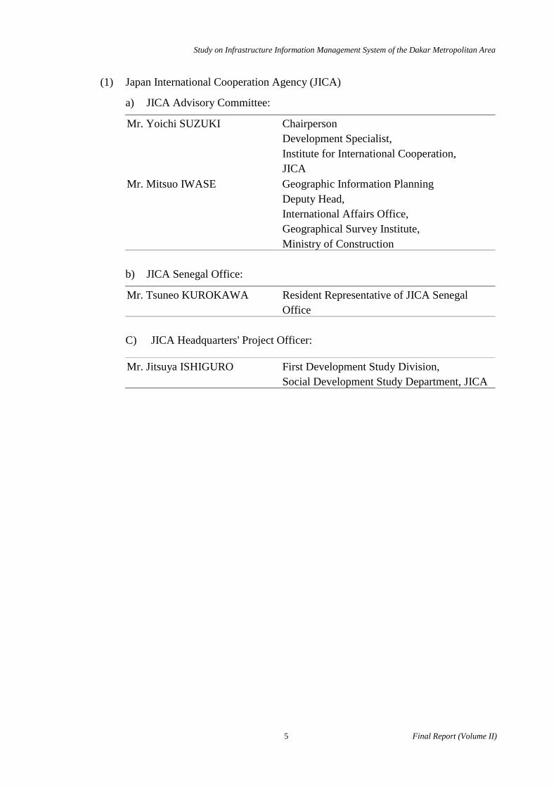
(1) Japan International Cooperation Agency (JICA)
a) JICA Advisory Committee:
Mr. Yoichi SUZUKI Chairperson Development Specialist, Institute for International Cooperation, JICA
Mr. Mitsuo IWASE Geographic Information Planning Deputy Head, International Affairs Office, Geographical Survey Institute, Ministry of Construction
b) JICA Senegal Office:
Mr. Tsuneo KUROKAWA Resident Representative of JICA Senegal Office
C) JICA Headquarters' Project Officer:
Mr. Jitsuya ISHIGURO First Development Study Division, Social Development Study Department, JICA
Study on Infrastructure Information Management System of the Dakar Metropolitan Area
Final Report (Volume II) 6
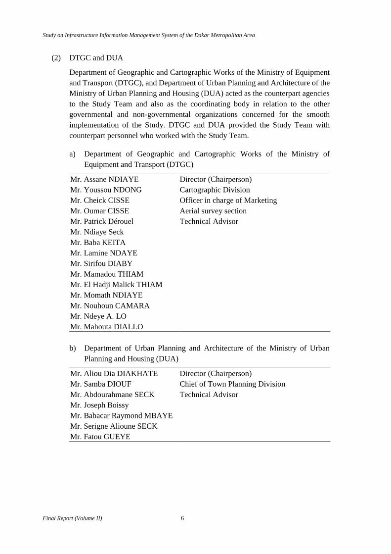
(2) DTGC and DUA
Department of Geographic and Cartographic Works of the Ministry of Equipment and Transport (DTGC), and Department of Urban Planning and Architecture of the Ministry of Urban Planning and Housing (DUA) acted as the counterpart agencies to the Study Team and also as the coordinating body in relation to the other governmental and non-governmental organizations concerned for the smooth implementation of the Study. DTGC and DUA provided the Study Team with counterpart personnel who worked with the Study Team.
a) Department of Geographic and Cartographic Works of the Ministry of Equipment and Transport (DTGC)
Mr. Assane NDIAYE Director (Chairperson) Mr. Youssou NDONG Cartographic Division Mr. Cheick CISSE Officer in charge of Marketing Mr. Oumar CISSE Aerial survey section Mr. Patrick Dérouel Technical Advisor Mr. Ndiaye Seck Mr. Baba KEITA Mr. Lamine NDAYE Mr. Sirifou DIABY Mr. Mamadou THIAM Mr. El Hadji Malick THIAM Mr. Momath NDIAYE Mr. Nouhoun CAMARA Mr. Ndeye A. LO Mr. Mahouta DIALLO
b) Department of Urban Planning and Architecture of the Ministry of Urban
Planning and Housing (DUA)
Mr. Aliou Dia DIAKHATE Director (Chairperson) Mr. Samba DIOUF Chief of Town Planning Division Mr. Abdourahmane SECK Technical Advisor Mr. Joseph Boissy Mr. Babacar Raymond MBAYE Mr. Serigne Alioune SECK Mr. Fatou GUEYE

Study on Infrastructure Information Management System of the Dakar Metropolitan Area
7 Final Report (Volume II)
(3) Steering Committee and Technical Committee
A Steering Committee consisting of the agencies and organizations concerned under the chairperson ship of DTGC and DUA was organized for the purpose of the coordination of the Study.
Mr. Mamadou KHOUMA Institute of Agricultural Research: ISRA Ms. Maguette SEYDI Division of Urban Planning, Municipality of
Dakar Mr. Cheikh NDIAYE Division of Rural Engineering: DGR Mr. Pierre SARR Division of Terriory Development: DAT Mr. Kalilou DIAHA Division of Terriory Development: DAT Mr. Kalilou DIAHA Division of Terriory Development: DAT Mr. Hamédine FALL President's Personal Staff: EMPART
Presidential Palace Mr. Moussa THIAM ASECNA Mr. Bueta Sène DIOUF IFAN Mr. Mamadou THIAM SDE Mr. Souleymane DIOP Port Autonome de Dakar: PAD Mr. Ibrahima almamy WADE Ecological Follow-Up Center: CSE Mr. Amadou NDIAYE Fossil Valley Study and Development: MEAVF Mr. Mamadou SIDIBE Decentralization and Local Development
Project: PADDEL Mr. Mamadou GUEYE Senegal Electricity Company:SENELEC/ Mr. Alioune NDOYE Land Registry Mr. Mamadou DIOKHATE Land Registry Mr. Moussa WALY Direction de l'Environnement et des
Etablissement Classés: DEEC Ministère de l'Environnement et de la Protection de la Nature
Mr. Abibou DIOUF SONATEL Mr. Serigne MBYE THIAU BECOREC Mr. Moustapha MBYE SAHEL Giomatique
Study on Infrastructure Information Management System of the Dakar Metropolitan Area
Final Report (Volume II) 8
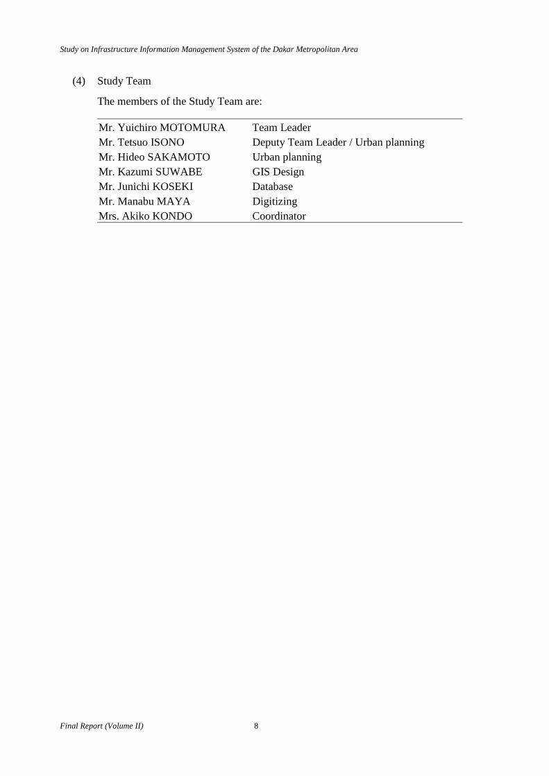
(4) Study Team
The members of the Study Team are:
Mr. Yuichiro MOTOMURA Team Leader Mr. Tetsuo ISONO Deputy Team Leader / Urban planning Mr. Hideo SAKAMOTO Urban planning Mr. Kazumi SUWABE GIS Design Mr. Junichi KOSEKI Database Mr. Manabu MAYA Digitizing Mrs. Akiko KONDO Coordinator
Study on Infrastructure Information Management System of the Dakar Metropolitan Area
9 Final Report (Volume II)
A1.2 Study Management
(1) Preparatory Work in Japan
The Study Team conducted preparatory work in Japan including collection and analysis of available data and information, examination of study approaches, methods and procedures, and preparation of Inception Report.
(2) Work in Senegal 1
The Study Team arrived in Senegal on 19 September 1999 and started the Study immediately. On 28 September 1999 the first Steering Committee and the first seminar were held and the Minutes of the Meeting was signed on 30 September 1999. Counterpart personnel were nominated by DTGC and DUA and they have been working with the Study Team on daily basis.
Workshops were organized by the Study Team twice every month with participation of high ranking officials of DTGC and DUA for discussing major points of study work and study directions.
The Workshops included the following:
(1) 27 October 1999: i. Existing land use ii. Demographic distribution iii. Urban Carte
(2) 10 November 1999: iv. GIS Data v. Evaluation method of residential zone
(3) 24 November 1999: vi. Summary of digital map preparation (4) 1 December 1999: vii. Function of the proposed system
viii. Basic design of the system (5) 15 December 1999: ix. System design
The Study Team continued the Work in Senegal 1 until 24 December 1999.
(3) Work in Japan 1
The Study Team continued digital mapping in Japan and prepared an Interim Report including the outline of the proposed IIMS.
(4) Work in Senegal 2
After the Work in Japan 1, the Study Team returned to Senegal on 20 January 2000. The Interim Report was submitted to the Senegalese side, and the second Steering Committee and the second seminar were held on 25 January 2000 and the Minutes of the Meeting was signed on 26 January 2000.
Study on Infrastructure Information Management System of the Dakar Metropolitan Area
Final Report (Volume II) 10
(5) Work in Japan 3 and 4
The Study Team continued to establish the proposed IIMS by defining the detailed specifications of data, software and hardware. The Progress Report was prepared and the materials for the IIMS were purchased by JICA.
(6) Work in Senegal 3
The Study Team returned to Senegal in June 2000 to establish the proposed IIMS in DTGC and DUA.

11 Final Report (Volume II)
A2 DIGITAL MAPPING
Study on Infrastructure Information Management System of the Dakar Metropolitan Area
Final Report (Volume II) 12
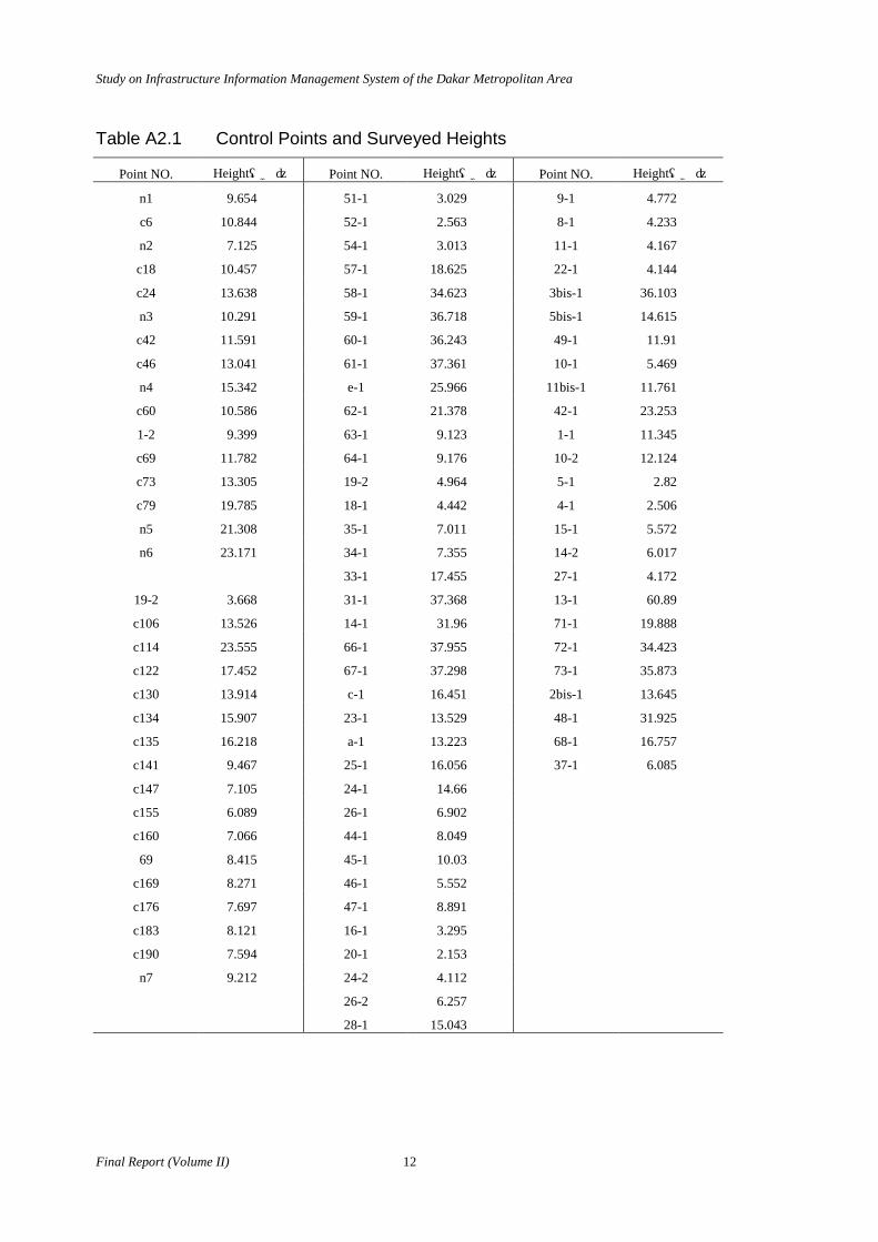
Table A2.1 Control Points and Surveyed Heights
Point NO. Height(m) Point NO. Height(m) Point NO. Height(m)
n1 9.654 51-1 3.029 9-1 4.772
c6 10.844 52-1 2.563 8-1 4.233
n2 7.125 54-1 3.013 11-1 4.167
c18 10.457 57-1 18.625 22-1 4.144
c24 13.638 58-1 34.623 3bis-1 36.103
n3 10.291 59-1 36.718 5bis-1 14.615
c42 11.591 60-1 36.243 49-1 11.91
c46 13.041 61-1 37.361 10-1 5.469
n4 15.342 e-1 25.966 11bis-1 11.761
c60 10.586 62-1 21.378 42-1 23.253
1-2 9.399 63-1 9.123 1-1 11.345
c69 11.782 64-1 9.176 10-2 12.124
c73 13.305 19-2 4.964 5-1 2.82
c79 19.785 18-1 4.442 4-1 2.506
n5 21.308 35-1 7.011 15-1 5.572
n6 23.171 34-1 7.355 14-2 6.017
33-1 17.455 27-1 4.172
19-2 3.668 31-1 37.368 13-1 60.89
c106 13.526 14-1 31.96 71-1 19.888
c114 23.555 66-1 37.955 72-1 34.423
c122 17.452 67-1 37.298 73-1 35.873
c130 13.914 c-1 16.451 2bis-1 13.645
c134 15.907 23-1 13.529 48-1 31.925
c135 16.218 a-1 13.223 68-1 16.757
c141 9.467 25-1 16.056 37-1 6.085
c147 7.105 24-1 14.66
c155 6.089 26-1 6.902
c160 7.066 44-1 8.049
69 8.415 45-1 10.03
c169 8.271 46-1 5.552
c176 7.697 47-1 8.891
c183 8.121 16-1 3.295
c190 7.594 20-1 2.153
n7 9.212 24-2 4.112
26-2 6.257
28-1 15.043

Study on Infrastructure Information Management System of the Dakar Metropolitan Area
13 Final Report (Volume II)
Table A2.2 Closure Error of GPS Observation
NET1 Direction dx dy dz
202>1001 -72.492 -122.506 53.16
1001>1002 -538.422 259.234 2254.378
1002>200 -1511.794 -4643.021 227.413
200>1003 -1422.541 -4300.146 166.312
1003>1004 3105.945 5019.027 -5479.095
1004>1012 2444.708 3649.517 -4641.028
1012>202 -2005.217 137.828 7418.916
Closure Error 0.187 -0.067 0.056
NET2 Direction dx dy dz
202>1011 -1934.384 -5994.658 299.133
1011>1004 1494.901 2207.275 -3077.02
1004>202 439.515 3787.364 2777.889
Closure Error 0.032 -0.019 0.002
NET3 Direction dx dy dz
202>1012 2005.217 -137.828 -7418.916
1012>1013 796.63 3843.329 1480.554
1013>10021 -91.377 6281.204 7351.971
10021>202 -2710.468 -9986.771 -1413.6
Closure Error 0.002 -0.066 0.009
NET4 Direction dx dy dz
202>10021 2710.468 9986.771 1413.6
10021>203 1491.965 3628.876 -1261.679
203>1006 1373.927 6188.08 2073.267
1006>1005 -2847.367 -4796.631 4810.426
1005>10056 -1417.234 -3868.303 806.048
10056>10003 -1599.335 -7768.177 -2912.713
10003>1009 -1204.41 -4426.689 -793.266
1009>202 1491.919 1056.14 -4135.66
Closure Error -0.067 0.067 0.023
NET5 Direction dx dy dz
202>10021 2710.468 9986.771 1413.6
10021>203 1491.965 3628.876 -1261.679
203>1010 -1807.158 2067.807 8853.437
1010>202 -2395.319 -15683.401 -9005.389
Closure Error -0.044 0.053 -0.031
Study on Infrastructure Information Management System of the Dakar Metropolitan Area
Final Report (Volume II) 14
NET6 Direction dx dy dz
203>1007 6131.539 12908.801 -7770.564
1007>1008 -2106.64 -47.175 7673.138
1008>1006 -2651.015 -6673.533 2170.538
1006>203 -1373.927 -6188.08 -2073.267
Closure Error -0.043 0.013 -0.155
NET1 Direction dx dy dz
NET3 202>1001 -72.492 -122.506 53.16
NET4 1001>1002 -538.422 259.234 2254.378
NET6 1002>200 -1511.794 -4643.021 227.413
200>1003 -1422.541 -4300.146 166.312
1003>1004 3105.945 5019.027 -5479.095
1004>1012 2444.708 3649.517 -4641.028
1012>1013 796.63 3843.329 1480.554
1013>10021 -91.377 6281.204 7351.971
10021>203 1491.965 3628.876 -1261.679
203>1007 6131.539 12908.801 -7770.564
1007>1008 -2106.64 -47.175 7673.138
1008>1006 -2651.015 -6673.533 2170.538
1006>1005 -2847.367 -4796.631 4810.426
1005>10056 -1417.234 -3868.303 806.048
10056>10003 -1599.335 -7768.177 -2912.713
10003>1009 -1204.41 -4426.689 -793.266
1009>202 1491.919 1056.14 -4135.66
Closure Error 0.079 -0.053 -0.067

Study on Infrastructure Information Management System of the Dakar Metropolitan Area
15 Final Report (Volume II)
Point Name N W E N
1001 14-43'18.5411140"N 17-26'23.2333570"W 237293.485 1628835.714
1002 14-44'34.3713820"N 17-26'20.3597800"W 237404.733 1631166.158
1003 14-44'47.6882650"N 17-31'35.0201350"W 227993.490 1631679.500
1004 14-41'43.2584340"N 17-28'23.7795430"W 233653.869 1625945.551
1005 14-47'13.5001530"N 17-17'52.4812490"W 252651.305 1635898.136
1006 14-44'31.4213030"N 17-14'51.0647110"W 258028.322 1630860.695
1007 14-39'00.5237320"N 17-10'29.4238340"W 265758.317 1620612.136
1008 14-43'18.5112540"N 17-10'51.7264770"W 265167.352 1628549.001
1009 14-45'35.8906980"N 17-27'07.2376040"W 236022.627 1633072.812
1010 14-48'19.7819380"N 17-17'34.2050070"W 253218.860 1637930.175
1011 14-43'26.3914990"N 17-29'49.1691980"W 231133.237 1629144.596
1012 14-39'06.9823950"N 17-26'02.9123640"W 237818.251 1621095.104
1013 14-39'56.7990330"N 17-23'52.3874010"W 241741.738 1622584.949
1014
200 14-44'41.9318570"N 17-29'03.6036340"W 232522.488 1631452.051
202 14-43'16.6000000"N 17-26'18.6000000"W 237431.496 1628774.535
203 14-43'21.8321420"N 17-18'22.2476530"W 251687.815 1628785.310
10002
10003 14-46'02.3148210"N 17-24'33.9588900"W 240617.507 1633835.599
10021 14-44'04.3764250"N 17-20'32.9142910"W 247791.410 1630133.571
10056 14-47'40.5297490"N 17-20'10.0823830"W 248543.680 1636771.610
*Ellipsoid: Clark1880
*Datum: 1974
Table A2.3 GPS Result (1999) and Point de Stereopreparation (1995)
GPS Result Points de stereopreparation Error
Name of Point E N E N ∆E ∆N
1013(Goree) 241741.738 1622584.949 241741.892 1622584.783 0.154 -0.166
202(Hann) 237431.496 1628774.535 237431.5 1628774.53 0.004 -0.005
203(Cap des Biches) 251687.815 1628785.31 251687.6 1628785.27 -0.215 -0.04
10003 (Camberene Reservoir) 240617.507 1633835.599 240617.47 1633836.19 -0.037 0.591
10021(Warf de Mbaw) 247791.41 1630133.571 247791.07 1630133.69 -0.34 0.119
10056(Maison Malika) 248543.68 1636771.61 248544.38 1636772.38 0.7 0.77

17 Final Report (Volume II)
A3 ASSESSMENT OF EXISTING GIS
Study on Infrastructure Information Management System of the Dakar Metropolitan Area
Final Report (Volume II) 18
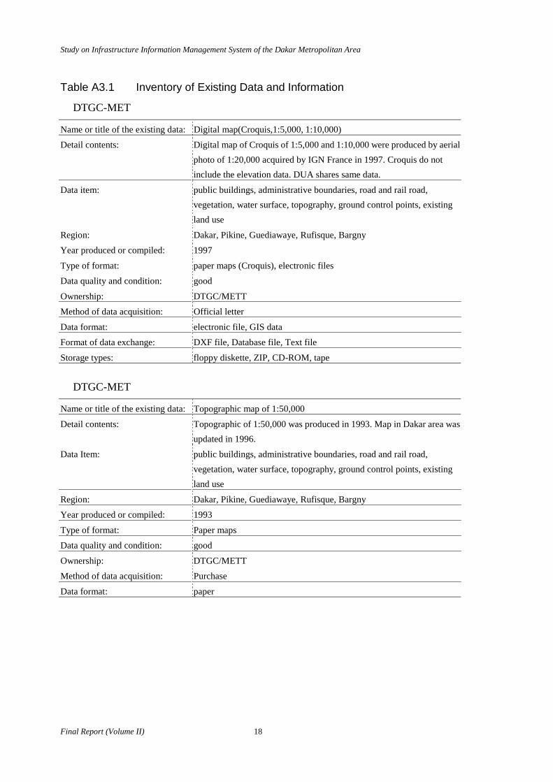
Table A3.1 Inventory of Existing Data and Information
DTGC-MET
Name or title of the existing data: Digital map(Croquis,1:5,000, 1:10,000)
Detail contents: Digital map of Croquis of 1:5,000 and 1:10,000 were produced by aerial photo of 1:20,000 acquired by IGN France in 1997. Croquis do not include the elevation data. DUA shares same data.
Data item: public buildings, administrative boundaries, road and rail road, vegetation, water surface, topography, ground control points, existing land use
Region: Dakar, Pikine, Guediawaye, Rufisque, Bargny
Year produced or compiled: 1997
Type of format: paper maps (Croquis), electronic files
Data quality and condition: good
Ownership: DTGC/METT
Method of data acquisition: Official letter
Data format: electronic file, GIS data
Format of data exchange: DXF file, Database file, Text file
Storage types: floppy diskette, ZIP, CD-ROM, tape
DTGC-MET
Name or title of the existing data: Topographic map of 1:50,000
Detail contents: Topographic of 1:50,000 was produced in 1993. Map in Dakar area was updated in 1996.
Data Item: public buildings, administrative boundaries, road and rail road, vegetation, water surface, topography, ground control points, existing land use
Region: Dakar, Pikine, Guediawaye, Rufisque, Bargny
Year produced or compiled: 1993
Type of format: Paper maps
Data quality and condition: good
Ownership: DTGC/METT
Method of data acquisition: Purchase
Data format: paper

Study on Infrastructure Information Management System of the Dakar Metropolitan Area
19 Final Report (Volume II)
DUA-MUH
Name or title of the existing data: Digital map of 1:5,000 and 1:10,000
Detail contents: Digital map of Croquis of 1:5,000 and 1:10,000 were produced by aerial photo of 1:20,000 acquired by IGN France in 1997. Croquis doesn’t include the elevation data. DUA shares same data of DTGC. These data are used for the production of thematic maps for urban planning in the relevant project of DUA.
Data Item: public, buildings, administrative boundaries, road and rail road, vegetation, water surface, topography, existing land use
Region: Dakar, Pikine, Guediawaye, Rufisque, Bargny
Year produced or compiled: 1997
Type of format: electronic file
Data quality and condition: Good
Ownership: DUA/MUH
Method of data acquisition: Official letter
Data format: GIS data (GeoConcept format)
Format of data exchange: DXF file, Database file, Text file
Storage types: floppy diskette
DUA-MUH
Name or title of the existing data: Plan Directeur d'Uurbanisme de Dakar 2001.
Detail contents: There are several kinds of maps and statistic data of urban planning 1981. There is basic information of urban planning in Dakar.
Data Item: public buildings, administrative boundaries, utility network, road and rail road, soil condition, land use plan, zoning, district plans, population of each commune, trends of urbanization, disaster records, public facilities, distribution of spontaneous settlements, etc.
Region: Dakar, Pikine, Guediawaye, Rufisque, Bargny
Year produced or compiled: 1982
Type of format: Report, Paper map
Data quality and condition: Medium
Ownership: DUA/MUH
Method of data acquisition: Official letter

Study on Infrastructure Information Management System of the Dakar Metropolitan Area
Final Report (Volume II) 20
DUA-MUH Name or title of the existing data: Urban planning report of "Libre Blanc 2000"
Detail contents: A summary report of Plan Directeur d'Uurbanisme de Dakar 2001.
Data Item: public buildings, administrative boundaries, utility network, road and rail road, land use plan, zoning, district plans, population of each commune, trends of urbanization, disaster records, public facilities, distribution of spontaneous settlements, etc.
Region: Dakar, Pikine, Guediawaye, Rufisque, Bargny
Year produced or compiled: 1981
Type of format: Report and paper maps
Data quality and condition: medium
Ownership: DUA/MUH
Method of data acquisition: Official letter
Study on Infrastructure Information Management System of the Dakar Metropolitan Area
21 Final Report (Volume II)
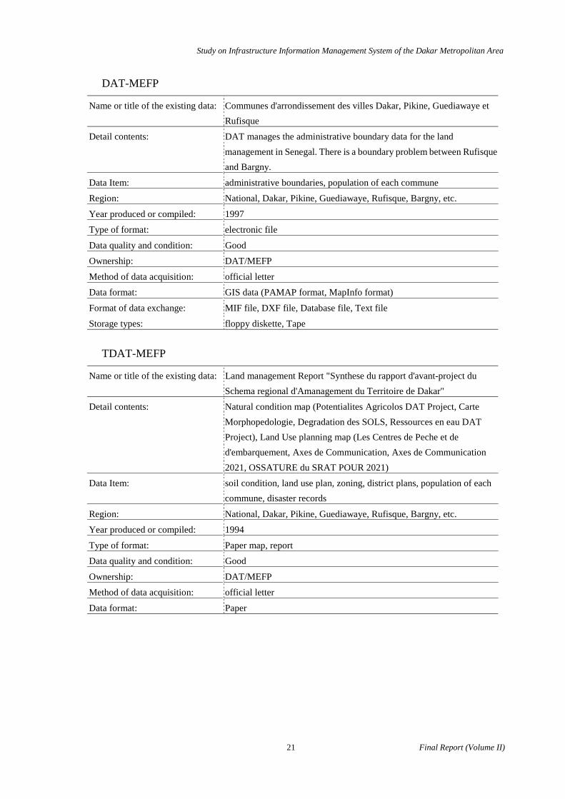
DAT-MEFP
Name or title of the existing data: Communes d'arrondissement des villes Dakar, Pikine, Guediawaye et Rufisque
Detail contents: DAT manages the administrative boundary data for the land management in Senegal. There is a boundary problem between Rufisque and Bargny.
Data Item: administrative boundaries, population of each commune
Region: National, Dakar, Pikine, Guediawaye, Rufisque, Bargny, etc.
Year produced or compiled: 1997
Type of format: electronic file
Data quality and condition: Good
Ownership: DAT/MEFP
Method of data acquisition: official letter
Data format: GIS data (PAMAP format, MapInfo format)
Format of data exchange: MIF file, DXF file, Database file, Text file
Storage types: floppy diskette, Tape
TDAT-MEFP
Name or title of the existing data: Land management Report "Synthese du rapport d'avant-project du Schema regional d'Amanagement du Territoire de Dakar"
Detail contents: Natural condition map (Potentialites Agricolos DAT Project, Carte Morphopedologie, Degradation des SOLS, Ressources en eau DAT Project), Land Use planning map (Les Centres de Peche et de d'embarquement, Axes de Communication, Axes de Communication 2021, OSSATURE du SRAT POUR 2021)
Data Item: soil condition, land use plan, zoning, district plans, population of each commune, disaster records
Region: National, Dakar, Pikine, Guediawaye, Rufisque, Bargny, etc.
Year produced or compiled: 1994
Type of format: Paper map, report
Data quality and condition: Good
Ownership: DAT/MEFP
Method of data acquisition: official letter
Data format: Paper
Study on Infrastructure Information Management System of the Dakar Metropolitan Area
Final Report (Volume II) 22
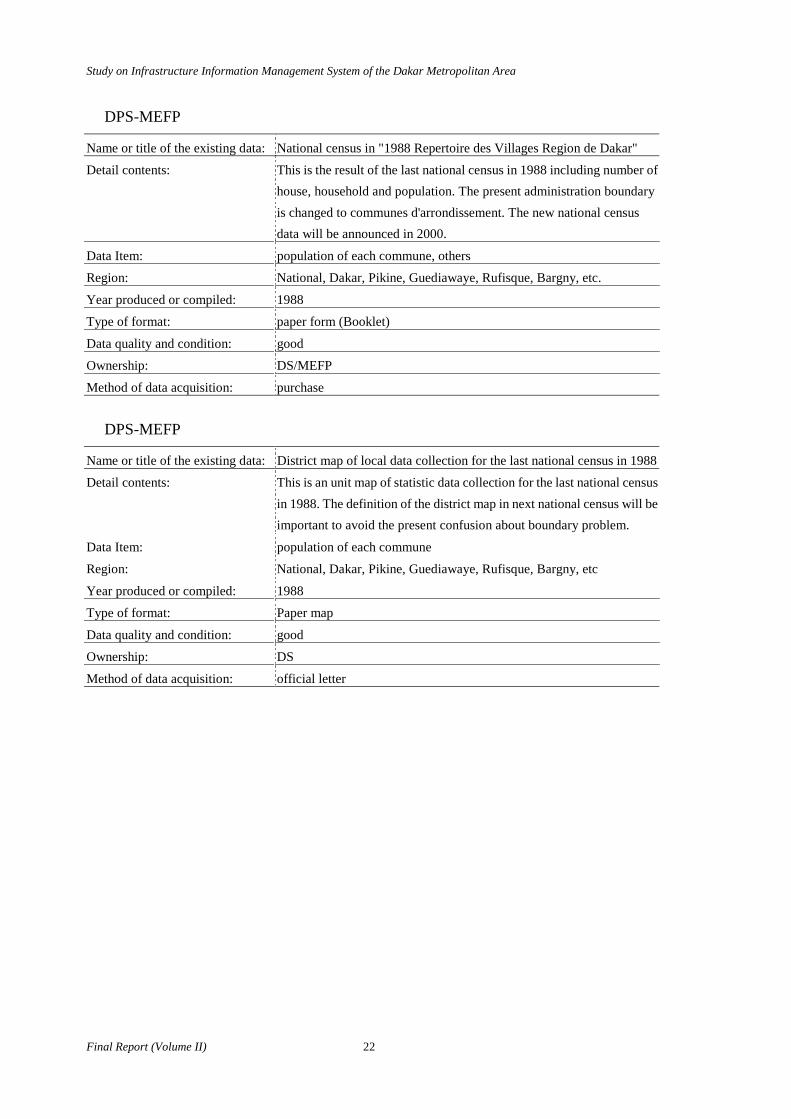
DPS-MEFP
Name or title of the existing data: National census in "1988 Repertoire des Villages Region de Dakar"
Detail contents: This is the result of the last national census in 1988 including number of house, household and population. The present administration boundary is changed to communes d'arrondissement. The new national census data will be announced in 2000.
Data Item: population of each commune, others
Region: National, Dakar, Pikine, Guediawaye, Rufisque, Bargny, etc.
Year produced or compiled: 1988
Type of format: paper form (Booklet)
Data quality and condition: good
Ownership: DS/MEFP
Method of data acquisition: purchase
DPS-MEFP
Name or title of the existing data: District map of local data collection for the last national census in 1988
Detail contents: This is an unit map of statistic data collection for the last national census in 1988. The definition of the district map in next national census will be important to avoid the present confusion about boundary problem.
Data Item: population of each commune
Region: National, Dakar, Pikine, Guediawaye, Rufisque, Bargny, etc
Year produced or compiled: 1988
Type of format: Paper map
Data quality and condition: good
Ownership: DS
Method of data acquisition: official letter

Study on Infrastructure Information Management System of the Dakar Metropolitan Area
23 Final Report (Volume II)
DID-MEFP
Name or title of the existing data: Parcel map
Detail contents: Parcel map is produced by photogrammetry mapping used the stereo plotter, and land survey. The form of parcel management includes the Ownership, 60 categories for tax rate items and etc. The map scale is different in each area. GIS data is produced in only Dakar Plateau area about 13 sheets of map.
Data Item: public buildings, utility network, road and rail road, public facilities, distribution of squatters, others
Region: Dakar, Pikine, Guediawaye, Rufisque, Bargny
Year generated or compiled: Since independence until the present
Type of format: Paper map, paper form
Data quality and condition: Good
Ownership: Inspection du Cadastre Dir. Imp & Dom
Method of data acquisition: official letter
Data format: Paper DID-MEFP Name or title of the existing data: Digital Parcel map
Detail contents: Digital parcel map includes parcel, road, building, tree and etc. The attribution of figure is linked to the sequential number of the parcel form. GIS is used as a mapping method. GIS isn't used for Facility Management.
Data Item: public buildings, utility network, road and rail road, public facilities, distribution of squatters, others
Region: Dakar plateau
Year generated or compiled: 1994 to the present
Type of format: electronic file
Data quality and condition: Good
Ownership: Inspection du Cadastre Dir. Imp & Dom
Method of data acquisition: official letter
Data format: GIS data (MicroStation DGN file)
Format of data exchange: DXF file, Database file, Text file
Storage type: Floppy diskette, Tape

Study on Infrastructure Information Management System of the Dakar Metropolitan Area
Final Report (Volume II) 24
DTP-MET
Name or title of the existing data: Road GIS data
Detail contents: This is GIS data for the road management in whole Senegal. This data includes the attribution of level of road, road status, road name, condition of pavement, distance information with field survey results and etc. The latest data in Dakar region is updated in 1999.
Data Item: road and rail road
Region: National, Dakar, Pikine, Guediawaye, Rufisque, Bargny, etc.
Year produced or compiled: 1994
Type of format: electronic file
Data quality and condition: good
Ownership: DPP/METT
Method of data acquisition: official letter
Data format: GIS data (VISSAGE file ) AutoCAD file
Format of data exchange: DXF file, Database file, Text file
Storage type: Floppy diskette, ZIP

Study on Infrastructure Information Management System of the Dakar Metropolitan Area
25 Final Report (Volume II)
CETUD
Name or title of the existing data: Route service map of Cars Rapides
Detail contents: This is the service route map of Cars Rapides and SOTRAC. The list of route map including street names was collected.
Data Item: road and rail road, public facilities
Region: Dakar, Pikine, Guediawaye, Rufisque
Year produced or compiled: 1999
Type of format: Paper map and list
Data quality and condition: Medium
Ownership: CETUD
Method of data acquisition:

Study on Infrastructure Information Management System of the Dakar Metropolitan Area
Final Report (Volume II) 26
SGPRE-MH
Name or title of the existing data: Water resources GIS data
Detail contents: GIS data on water resources management in whole Senegal. Related data including the related field such as hydrology, topography, geology, soil, agriculture, forestry and etc. Water quality of monitoring result in each well at the observation point is recorded as GIS database.
Data Item: soil condition, disaster records, others
Region: National, Dakar, Pikine, Guediawaye, Rufisque, Bargny, etc.
Year produced or compiled: 1994 - 1999
Type of format: electronic file (ArcInfo、ArcViewt format、Access format)
Data quality and condition: good
Ownership: SGPRE/MH
Method of data acquisition: Official letter
Data format: GIS data (ArcInfo file、ArcView shape file)
Format of data exchange: Other GIS format file, DXF file, Database file, Text file
Storage type: floppy diskette, ZIP, CD-ROM
Study on Infrastructure Information Management System of the Dakar Metropolitan Area
27 Final Report (Volume II)
DSA-MA Name or title of the existing data: National Agriculture Census
Detail contents: National agricultural census is being complied for the production of agricultural statistic data in communes d'arrondissement. Data collection had been done since 1997 until 1998. This data mainly contains the agricultural data in rural area. Agricultural land map of 1;50,000 level wasn't conformed. GIS is proposed for the future data management of agricultural statistic.
Data Item: Others
Region: National, Dakar, Pikine, Guediawaye, Rufisque, Bargny, etc.
Year produced or compiled:
Type of format: paper form , electronic file
Data quality and condition:
Ownership: DSA/MA
Method of data acquisition:
Data format:
Format of data exchange: Database file, Text file
Storage type:
DSA-MA
Name or title of the existing data: Agricultural crops statistics data
Detail contents: Statistic data of agriculture crops production in each region.
Data Item: Others
Region: National
Year produced or compiled: every year
Type of format: paper form
Data quality and condition: Good
Ownership: Direction l'Agriculture
Method of data acquisition:
Study on Infrastructure Information Management System of the Dakar Metropolitan Area
Final Report (Volume II) 28
IEF-MEPN
Name or title of the existing data:
Detail contents: Forest map wasn't confirmed such as forest, niaye, concession area and protection area. According to this division, there are a protection area for planting tree, for anti wind protection along the seashore and for Hann park in topographic map of 1;50,000. It is supposed that statistic data is managed by number of annual newly plant tree and these statistic data was not corresponded to map.
Data Item: others
Region: National, Dakar, Pikine, Guediawaye, Rufisque, Bargny, etc.
Year produced or compiled:
Type of format: paper form
Data quality and condition:
Ownership:
Method of data acquisition:
Study on Infrastructure Information Management System of the Dakar Metropolitan Area
29 Final Report (Volume II)
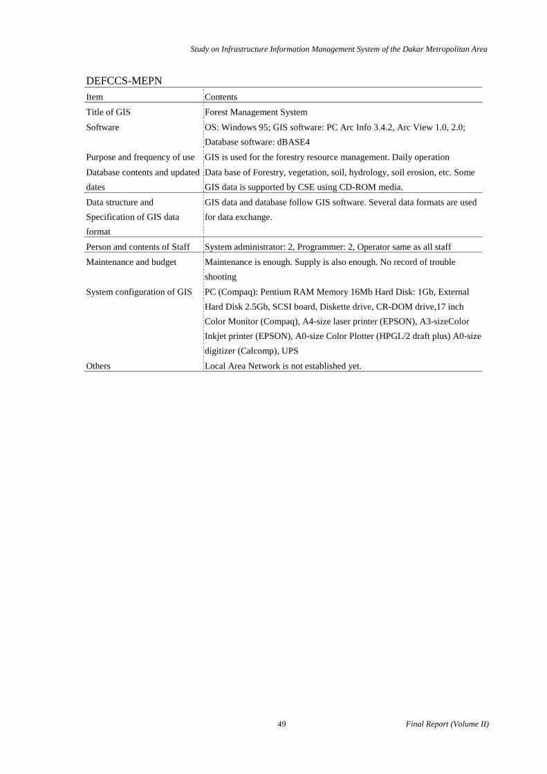
DEFCCS-MEPN
Name or title of the existing data: Forest GIS inventory data
Detail contents: GIS data was produced by the Forest inventory survey in whole Senegal in 1997. The following GIS data were collected; "Aptitude agricole", "Aptitude forestiere", "Aptitude pastorale", "Couvert vegetal" and "Occupation des sols". But these are small scale maps and may not usable.
Data Item: vegetation, soil condition
Region: National, Dakar, Pikine, Guediawaye, Rufisque, Bargny, etc.
Year produced or compiled: 1997
Type of format: electronic file
Data quality and condition: Good
Ownership: DEF
Method of data acquisition:
Data format: paper, electronic file
Format of data exchange: ArcInfo file, ArcView shape file , DXF file, Database file, Text file
Storage type: floppy diskette, CD-ROM
DEFCCS-MEPN
Name or title of the existing data:
Detail contents: Several environmental phenomenon are identified by people, however the distribution of map is not available.
Data Item: vegetation, water surface, existing land use, soil condition, land use plan, zoning, district plans, disaster records, others
Region:
Year produced or compiled:
Type of format:
Data quality and condition:
Ownership: DEF/MEPN
Method of data acquisition:
Data format:
Format of data exchange:
Storage type:

Study on Infrastructure Information Management System of the Dakar Metropolitan Area
Final Report (Volume II) 30
ADM
Name or title of the existing data: Electronic file and GIS data for Regional planning supporting map for municipal development
Detail contents: Several maps including thematic information for regional planning. This data includes public building, administrative boundary, infrastructure (water supply, drainage and others), road and railroad and etc. There are several GIS format in ADM. This data may need topological processing for smoothly execution of GIS analysis for spatial planning.
Data Item: public buildings, administrative boundaries, utility network, road and rail road, vegetation, water surface, topography, existing land use, soil condition, land use plan, zoning, district plans, population of each commune, trends of urbanization, disaster records, public facilities, distribution of squatters, others
Region: Dakar, Pikine, Guediawaye, Rufisque
Year produced or compiled: 1999
Type of format: electronic file, GIS data
Data quality and condition: good
Ownership: ADM
Method of data acquisition: official letter
Data format: electronic file( AutoCAD, MapInfo, GeoConcept and others )
Format of data exchange: DXF file, Database file, Text file
Storage type: floppy diskette, ZIP, CD-ROM etc

Study on Infrastructure Information Management System of the Dakar Metropolitan Area
31 Final Report (Volume II)
CSE
Name or title of the existing data: Land cover map.
Detail contents: This is the land cover map made by the image processing of satellite imagery of SPOT. Two times data of 1986 and 1995 is available in Dakar region. This data is one of the useful data source for the production of present land use map of 1;50,000.
Data Item: existing land use, soil condition, others
Region: Natinal, Dakar, Pikine, Guediawaye, Rufisque, Bargny, etc.
Year produced or compiled:
Type of format: electronic file
Data quality and condition: Good
Ownership: CSE
Method of data acquisition: official letter
Data format: electronic file
Format of data exchange: Erdas format and other vector format
Storage type: ZIP, CD-ROM, etc.
Study on Infrastructure Information Management System of the Dakar Metropolitan Area
Final Report (Volume II) 32
SOTRAC-MET
Name or title of the existing data: SOTRAC bus rout map
Detail contents: a bus route map of SOTRAC in Dakar.
Data Item: public facilities, others
Region: Dakar
Year produced or compiled: 1984
Type of format: printed map
Data quality and condition: good
Ownership: SOTRAC/METT
Method of data acquisition:

Study on Infrastructure Information Management System of the Dakar Metropolitan Area
33 Final Report (Volume II)
SENELEC
Name or title of the existing data: Electric transmission map
Detail contents: There are 9 sheets of map of 1;5000 including high voltage and middle voltage of 90kV, 30kV,6.6kV.
Data Item: utility network
Region: National, Dakar, Pikine, Guediawaye, Rufisque, Bargny, etc.
Year produced or compiled: 1981 until 1985
Type of format: paper map
Data quality and condition: Good
Ownership: SENELEC
Method of data acquisition: official letter

Study on Infrastructure Information Management System of the Dakar Metropolitan Area
Final Report (Volume II) 34
SDE
Name or title of the existing data: Water supply network
Detail contents: This is GIS data for the facility management of water supply network. GIS data includes water supply line, community tap locations, consumption meter, building, road, customer and etc. There are 58 sheets of maps except Rufisqu-Bargny area in Dakar region.
Data Item: utility network
Region: Dakar, Pikine, Guediawaye
Year produced or compiled: still digitizing
Type of format: paper form, electronic file
Data quality and condition: good
Ownership: SDE
Method of data acquisition: official letter
Data format: GIS file (MicroStation DGN file)
Format of data exchange: DXF file, Database file, Text file
Storage type: floppy diskette, ZIP, CD-ROM, Tape
Study on Infrastructure Information Management System of the Dakar Metropolitan Area
35 Final Report (Volume II)
ONAS
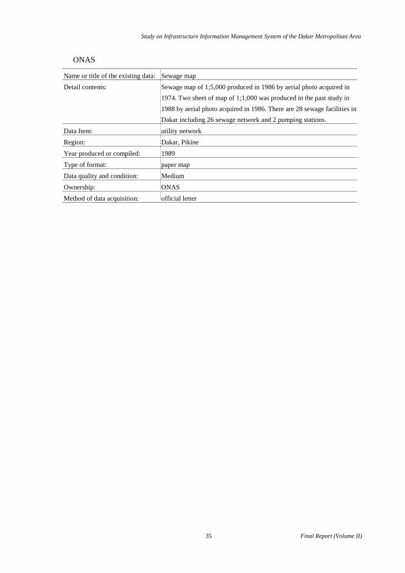
Name or title of the existing data: Sewage map
Detail contents: Sewage map of 1;5,000 produced in 1986 by aerial photo acquired in 1974. Two sheet of map of 1;1,000 was produced in the past study in 1988 by aerial photo acquired in 1986. There are 28 sewage facilities in Dakar including 26 sewage network and 2 pumping stations.
Data Item: utility network
Region: Dakar, Pikine
Year produced or compiled: 1989
Type of format: paper map
Data quality and condition: Medium
Ownership: ONAS
Method of data acquisition: official letter
Study on Infrastructure Information Management System of the Dakar Metropolitan Area
Final Report (Volume II) 36
DSS-MS
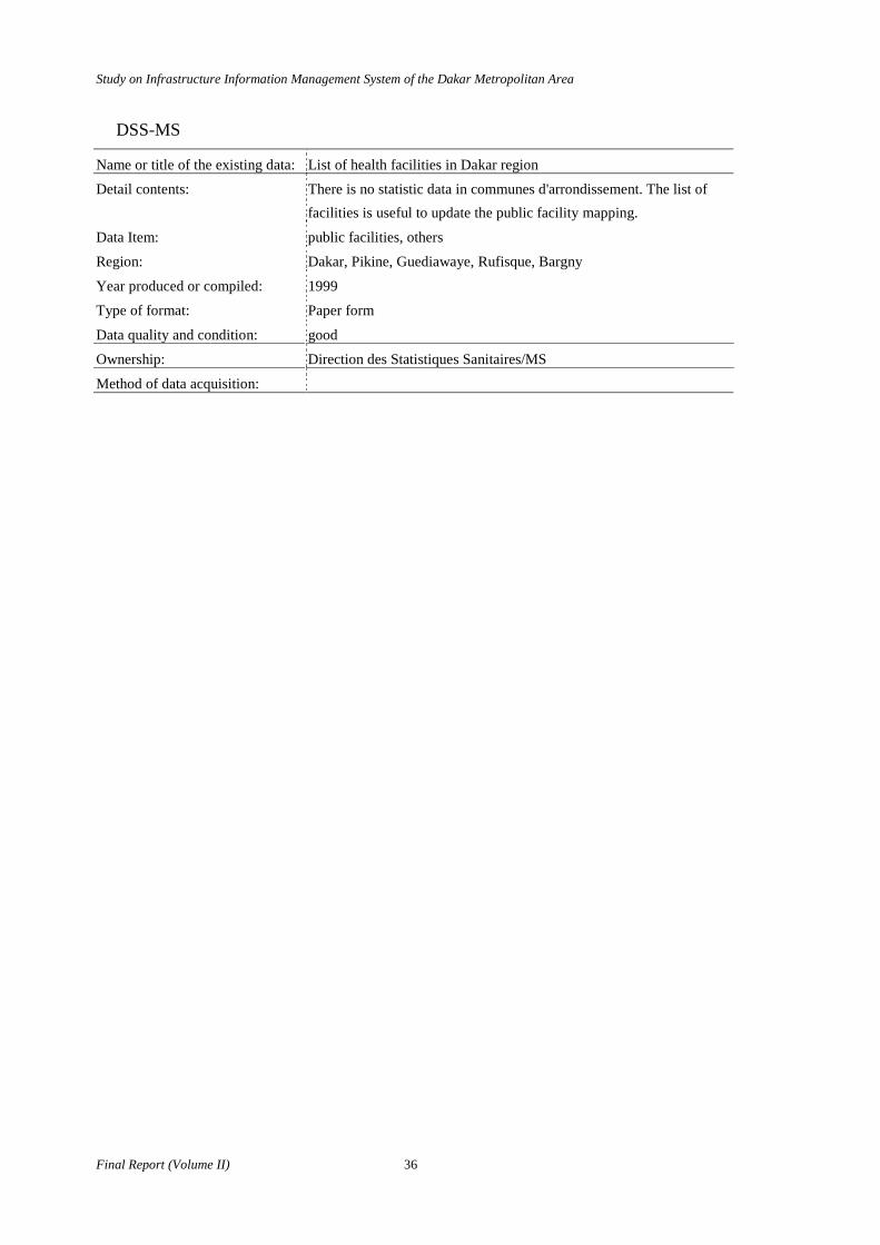
Name or title of the existing data: List of health facilities in Dakar region
Detail contents: There is no statistic data in communes d'arrondissement. The list of facilities is useful to update the public facility mapping.
Data Item: public facilities, others
Region: Dakar, Pikine, Guediawaye, Rufisque, Bargny
Year produced or compiled: 1999
Type of format: Paper form
Data quality and condition: good
Ownership: Direction des Statistiques Sanitaires/MS
Method of data acquisition:
Study on Infrastructure Information Management System of the Dakar Metropolitan Area
37 Final Report (Volume II)
DE-MTE
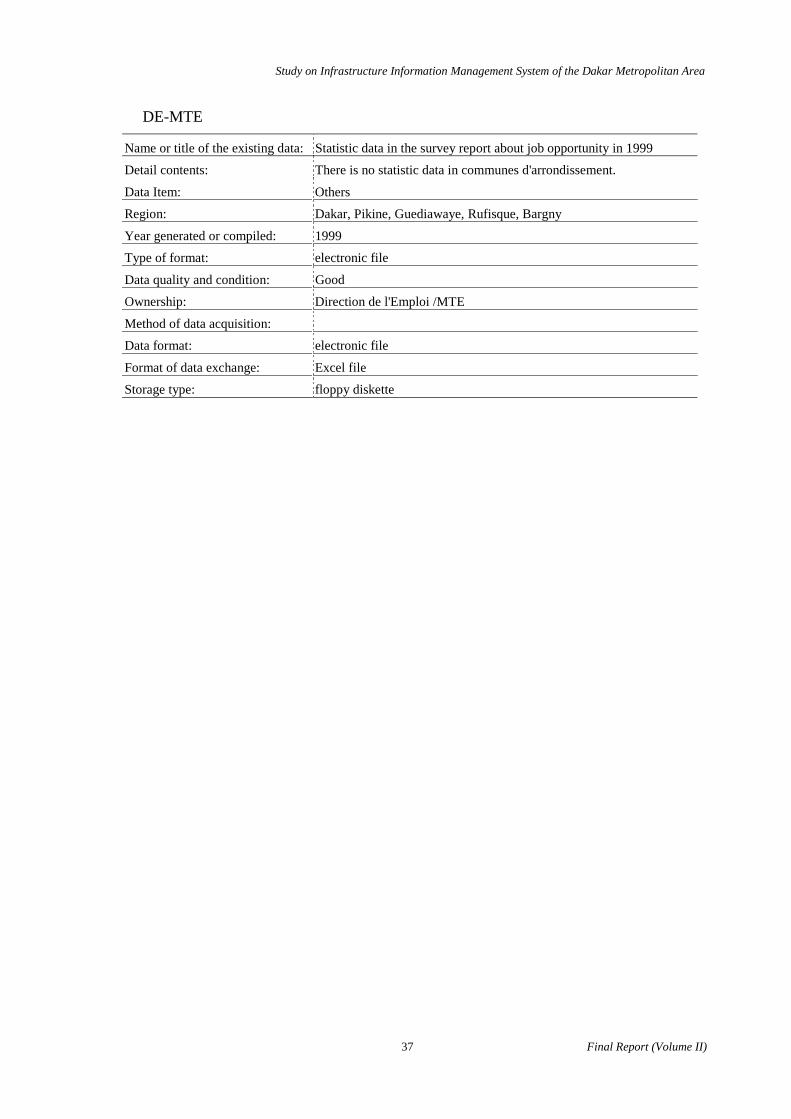
Name or title of the existing data: Statistic data in the survey report about job opportunity in 1999
Detail contents: There is no statistic data in communes d'arrondissement.
Data Item: Others
Region: Dakar, Pikine, Guediawaye, Rufisque, Bargny
Year generated or compiled: 1999
Type of format: electronic file
Data quality and condition: Good
Ownership: Direction de l'Emploi /MTE
Method of data acquisition:
Data format: electronic file
Format of data exchange: Excel file
Storage type: floppy diskette
Study on Infrastructure Information Management System of the Dakar Metropolitan Area
Final Report (Volume II) 38
DCES-MEN
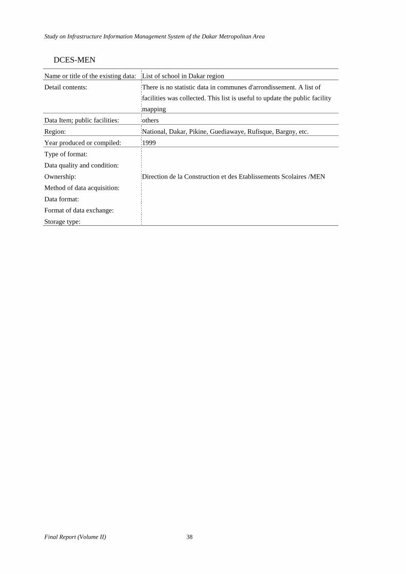
Name or title of the existing data: List of school in Dakar region
Detail contents: There is no statistic data in communes d'arrondissement. A list of facilities was collected. This list is useful to update the public facility mapping
Data Item; public facilities: others
Region: National, Dakar, Pikine, Guediawaye, Rufisque, Bargny, etc.
Year produced or compiled: 1999
Type of format:
Data quality and condition:
Ownership: Direction de la Construction et des Etablissements Scolaires /MEN
Method of data acquisition:
Data format:
Format of data exchange:
Storage type:

Study on Infrastructure Information Management System of the Dakar Metropolitan Area
39 Final Report (Volume II)
DST-CUD
Name or title of the existing data: Public facility
Detail contents: boundary of communes d'arrondissements, distribution of health facilities, distribution of public markets, distribution of primary schools, etc.
Data Item: public facilities
Region: Dakar
Year produced or compiled: 1996
Type of format: paper map
Data quality and condition: Good
Ownership: Direction des Services Techniques DST/CUD
Method of data acquisition:
Study on Infrastructure Information Management System of the Dakar Metropolitan Area
Final Report (Volume II) 40
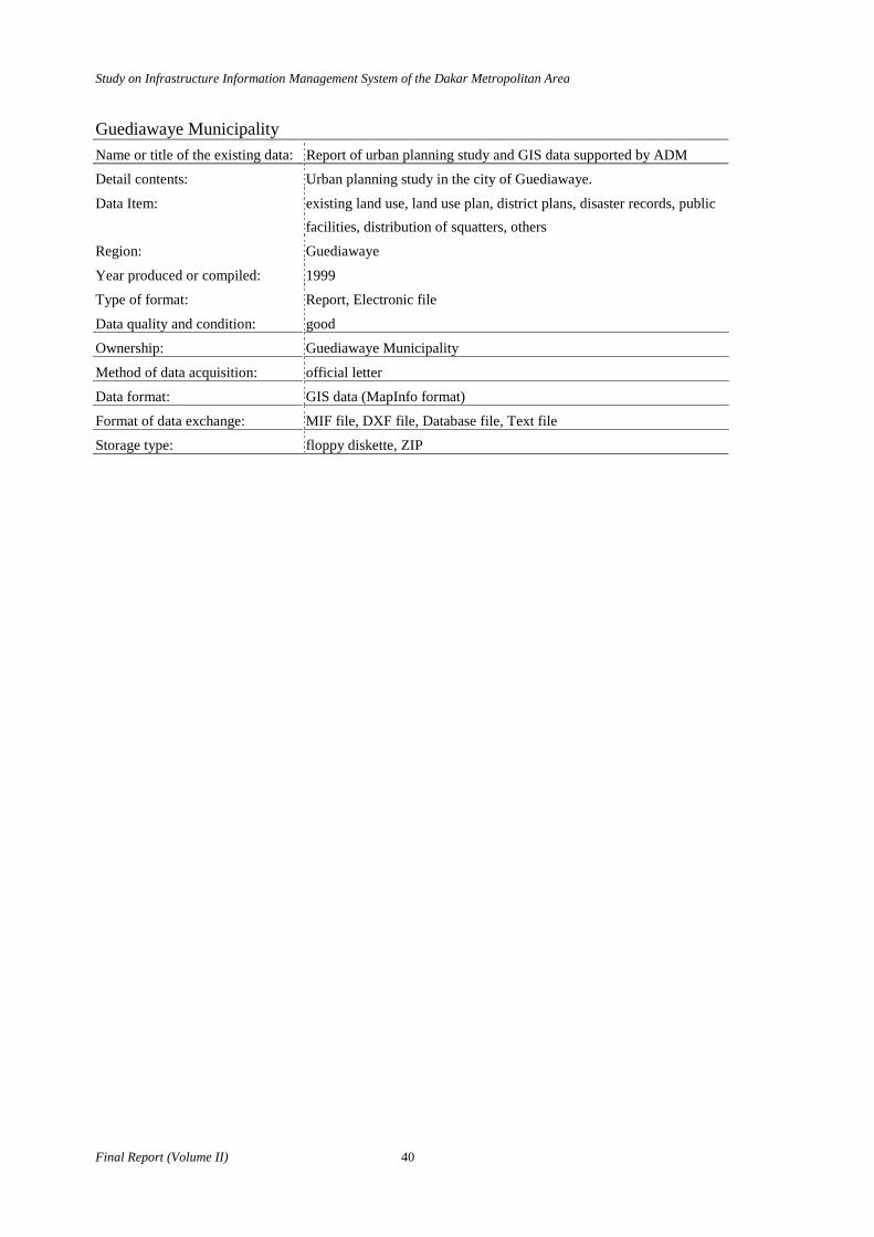
Guediawaye Municipality Name or title of the existing data: Report of urban planning study and GIS data supported by ADM
Detail contents: Urban planning study in the city of Guediawaye.
Data Item: existing land use, land use plan, district plans, disaster records, public facilities, distribution of squatters, others
Region: Guediawaye
Year produced or compiled: 1999
Type of format: Report, Electronic file
Data quality and condition: good
Ownership: Guediawaye Municipality
Method of data acquisition: official letter
Data format: GIS data (MapInfo format)
Format of data exchange: MIF file, DXF file, Database file, Text file
Storage type: floppy diskette, ZIP
Study on Infrastructure Information Management System of the Dakar Metropolitan Area
41 Final Report (Volume II)
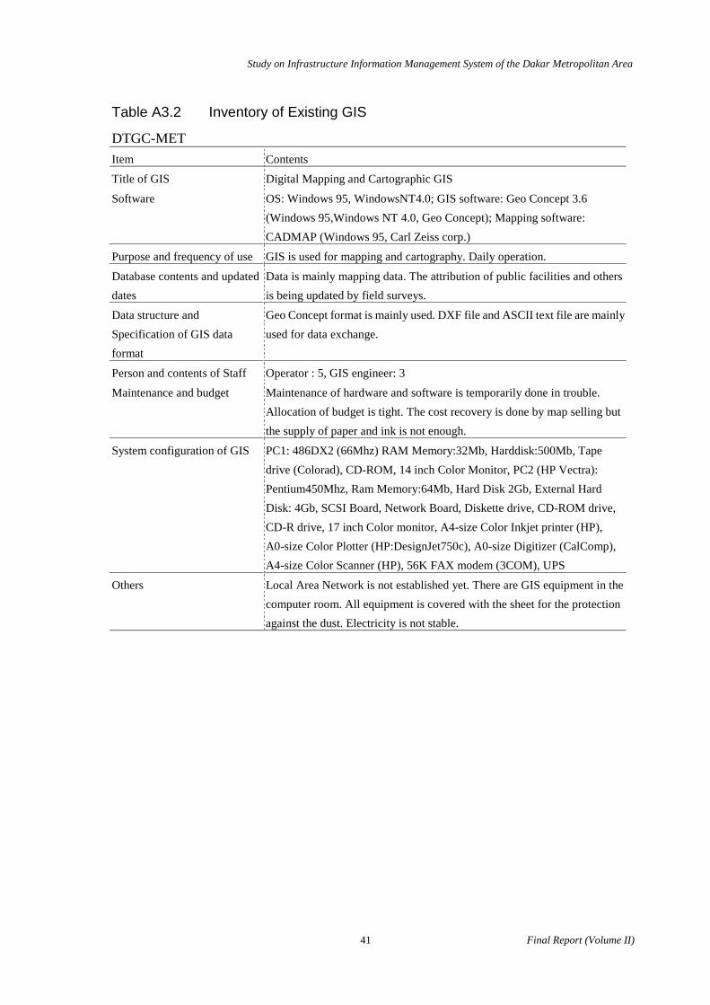
Table A3.2 Inventory of Existing GIS
DTGC-MET Item Contents
Title of GIS Digital Mapping and Cartographic GIS
Software OS: Windows 95, WindowsNT4.0; GIS software: Geo Concept 3.6 (Windows 95,Windows NT 4.0, Geo Concept); Mapping software: CADMAP (Windows 95, Carl Zeiss corp.)
Purpose and frequency of use GIS is used for mapping and cartography. Daily operation.
Database contents and updated dates
Data is mainly mapping data. The attribution of public facilities and others is being updated by field surveys.
Data structure and Specification of GIS data format
Geo Concept format is mainly used. DXF file and ASCII text file are mainly used for data exchange.
Person and contents of Staff Operator : 5, GIS engineer: 3
Maintenance and budget Maintenance of hardware and software is temporarily done in trouble. Allocation of budget is tight. The cost recovery is done by map selling but the supply of paper and ink is not enough.
System configuration of GIS PC1: 486DX2 (66Mhz) RAM Memory:32Mb, Harddisk:500Mb, Tape drive (Colorad), CD-ROM, 14 inch Color Monitor, PC2 (HP Vectra): Pentium450Mhz, Ram Memory:64Mb, Hard Disk 2Gb, External Hard Disk: 4Gb, SCSI Board, Network Board, Diskette drive, CD-ROM drive, CD-R drive, 17 inch Color monitor, A4-size Color Inkjet printer (HP), A0-size Color Plotter (HP:DesignJet750c), A0-size Digitizer (CalComp), A4-size Color Scanner (HP), 56K FAX modem (3COM), UPS
Others Local Area Network is not established yet. There are GIS equipment in the computer room. All equipment is covered with the sheet for the protection against the dust. Electricity is not stable.
Study on Infrastructure Information Management System of the Dakar Metropolitan Area
Final Report (Volume II) 42
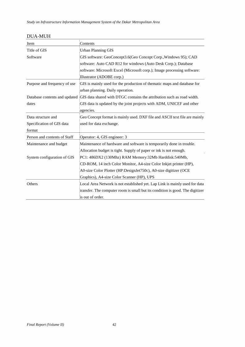
DUA-MUH Item Contents
Title of GIS Urban Planning GIS
Software GIS software: GeoConcept3.6(Geo Concept Corp.,Windows 95); CAD software: Auto CAD R12 for windows (Auto Desk Corp.); Database software: Microsoft Excel (Microsoft corp.); Image processing software: Illustrator (ADOBE corp.)
Purpose and frequency of use GIS is mainly used for the production of thematic maps and database for urban planning. Daily operation.
Database contents and updated dates
GIS data shared with DTGC contains the attribution such as road width. GIS data is updated by the joint projects with ADM, UNICEF and other agencies.
Data structure and Specification of GIS data format
Geo Concept format is mainly used. DXF file and ASCII text file are mainly used for data exchange.
Person and contents of Staff Operator: 4, GIS engineer: 3
Maintenance and budget Maintenance of hardware and software is temporarily done in trouble. Allocation budget is tight. Supply of paper or ink is not enough.
System configuration of GIS PC1: 486DX2 (130Mhz) RAM Memory:32Mb Harddisk:540Mb, CD-ROM, 14 inch Color Monitor, A4-size Color Inkjet printer (HP), A0-size Color Plotter (HP:DesignJet750c), A0-size digitizer (OCE Graphics), A4-size Color Scanner (HP), UPS
Others Local Area Network is not established yet. Lap Link is mainly used for data transfer. The computer room is small but its condition is good. The digitizer is out of order.

Study on Infrastructure Information Management System of the Dakar Metropolitan Area
43 Final Report (Volume II)
DAT-MEFP Item Contents
Title of GIS Land Information Management GIS
Software OS: Windows 95; GIS software: PAMAP 4.0, 4.1, 4.2 (PCI Corp., MSDOS), Map Info4.0 (Map Info Corp., Windows 95)
Purpose and frequency of use GIS is mainly used for land management for commune d'arrondissement. Daily operation.
Database contents and updated dates
GIS data contains the administrative boundary and names of commune d'arrondissement. These data is converted to from PAMAP to Map Info.
Data structure and Specification of GIS data format
PAMAP format and Map Info format is mainly used. DXF file and ASCII text file mainly used for data exchange. The other GIS formats are used such as MIF, Arc Info exchange format and etc.
Person and contents of Staff Staff: 3, GIS engineer: same as staff
Maintenance and budget The budget is allocated for the maintenance of hardware. But the one for software is not enough. Software version was updated two times in the past.
System configuration of GIS PC1 (AST): Pentiom133Mhz RAM Memory:32Mb Harddisk:2.1Gb; SCSI board, Diskette drive, CD-ROM drive, CD-R drive, Tape drive(HP), 17 inch Color Monitor (MAG), A4-size B&W laser printer(HPLaserJet2100), A0-size Color Plotter (HP:DesignJet650c), A0-size digitizer (Calcomp model811), UPS
Others Local Area Network is not established yet. The computer room is in a good condition. There is a boundary problem in Rufisque and Bargny. So the population and other attribution have not been done.
Study on Infrastructure Information Management System of the Dakar Metropolitan Area
Final Report (Volume II) 44
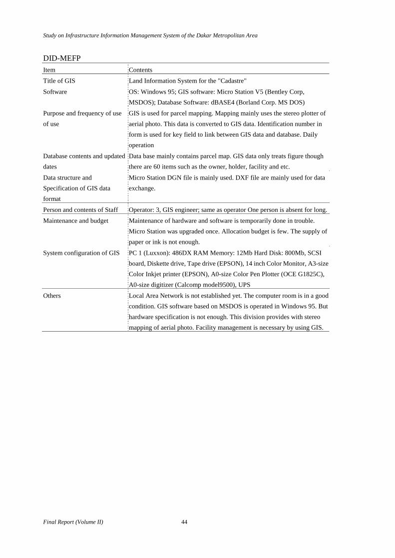
DID-MEFP Item Contents
Title of GIS Land Information System for the "Cadastre"
Software OS: Windows 95; GIS software: Micro Station V5 (Bentley Corp, MSDOS); Database Software: dBASE4 (Borland Corp. MS DOS)
Purpose and frequency of use of use
GIS is used for parcel mapping. Mapping mainly uses the stereo plotter of aerial photo. This data is converted to GIS data. Identification number in form is used for key field to link between GIS data and database. Daily operation
Database contents and updated dates
Data base mainly contains parcel map. GIS data only treats figure though there are 60 items such as the owner, holder, facility and etc.
Data structure and Specification of GIS data format
Micro Station DGN file is mainly used. DXF file are mainly used for data exchange.
Person and contents of Staff Operator: 3, GIS engineer; same as operator One person is absent for long.
Maintenance and budget Maintenance of hardware and software is temporarily done in trouble. Micro Station was upgraded once. Allocation budget is few. The supply of paper or ink is not enough.
System configuration of GIS PC 1 (Luxxon): 486DX RAM Memory: 12Mb Hard Disk: 800Mb, SCSI board, Diskette drive, Tape drive (EPSON), 14 inch Color Monitor, A3-size Color Inkjet printer (EPSON), A0-size Color Pen Plotter (OCE G1825C), A0-size digitizer (Calcomp model9500), UPS
Others Local Area Network is not established yet. The computer room is in a good condition. GIS software based on MSDOS is operated in Windows 95. But hardware specification is not enough. This division provides with stereo mapping of aerial photo. Facility management is necessary by using GIS.
Study on Infrastructure Information Management System of the Dakar Metropolitan Area
45 Final Report (Volume II)
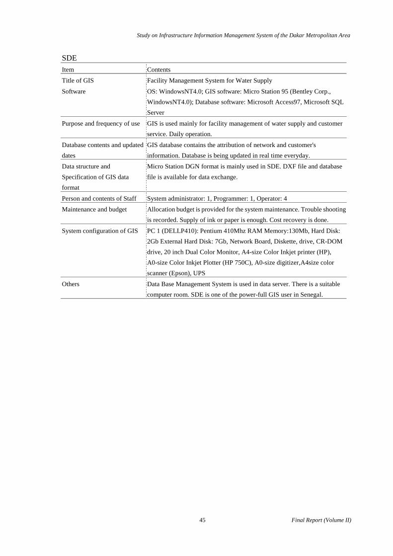
SDE Item Contents
Title of GIS Facility Management System for Water Supply
Software OS: WindowsNT4.0; GIS software: Micro Station 95 (Bentley Corp., WindowsNT4.0); Database software: Microsoft Access97, Microsoft SQL Server
Purpose and frequency of use GIS is used mainly for facility management of water supply and customer service. Daily operation.
Database contents and updated dates
GIS database contains the attribution of network and customer's information. Database is being updated in real time everyday.
Data structure and Specification of GIS data format
Micro Station DGN format is mainly used in SDE. DXF file and database file is available for data exchange.
Person and contents of Staff System administrator: 1, Programmer: 1, Operator: 4
Maintenance and budget Allocation budget is provided for the system maintenance. Trouble shooting is recorded. Supply of ink or paper is enough. Cost recovery is done.
System configuration of GIS PC 1 (DELLP410): Pentium 410Mhz RAM Memory:130Mb, Hard Disk: 2Gb External Hard Disk: 7Gb, Network Board, Diskette, drive, CR-DOM drive, 20 inch Dual Color Monitor, A4-size Color Inkjet printer (HP), A0-size Color Inkjet Plotter (HP 750C), A0-size digitizer,A4size color scanner (Epson), UPS
Others Data Base Management System is used in data server. There is a suitable computer room. SDE is one of the power-full GIS user in Senegal.
Study on Infrastructure Information Management System of the Dakar Metropolitan Area
Final Report (Volume II) 46
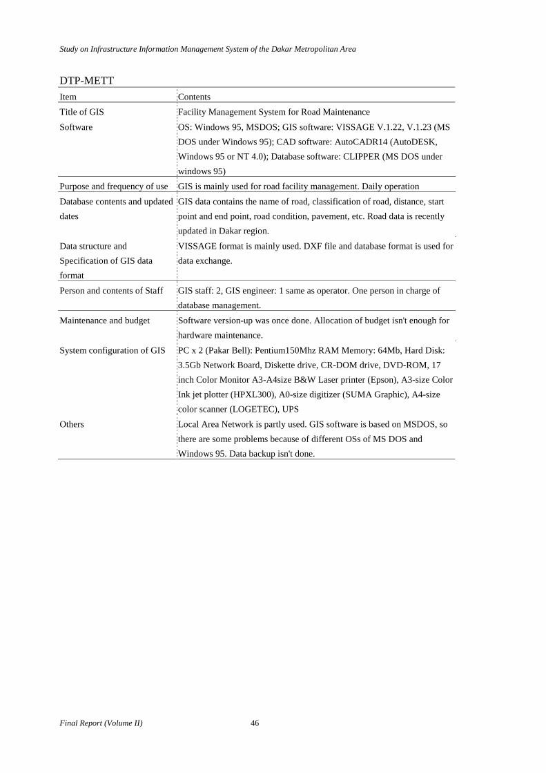
DTP-METT Item Contents
Title of GIS Facility Management System for Road Maintenance
Software OS: Windows 95, MSDOS; GIS software: VISSAGE V.1.22, V.1.23 (MS DOS under Windows 95); CAD software: AutoCADR14 (AutoDESK, Windows 95 or NT 4.0); Database software: CLIPPER (MS DOS under windows 95)
Purpose and frequency of use GIS is mainly used for road facility management. Daily operation
Database contents and updated dates
GIS data contains the name of road, classification of road, distance, start point and end point, road condition, pavement, etc. Road data is recently updated in Dakar region.
Data structure and Specification of GIS data format
VISSAGE format is mainly used. DXF file and database format is used for data exchange.
Person and contents of Staff GIS staff: 2, GIS engineer: 1 same as operator. One person in charge of database management.
Maintenance and budget Software version-up was once done. Allocation of budget isn't enough for hardware maintenance.
System configuration of GIS PC x 2 (Pakar Bell): Pentium150Mhz RAM Memory: 64Mb, Hard Disk: 3.5Gb Network Board, Diskette drive, CR-DOM drive, DVD-ROM, 17 inch Color Monitor A3-A4size B&W Laser printer (Epson), A3-size Color Ink jet plotter (HPXL300), A0-size digitizer (SUMA Graphic), A4-size color scanner (LOGETEC), UPS
Others Local Area Network is partly used. GIS software is based on MSDOS, so there are some problems because of different OSs of MS DOS and Windows 95. Data backup isn't done.
Study on Infrastructure Information Management System of the Dakar Metropolitan Area
47 Final Report (Volume II)
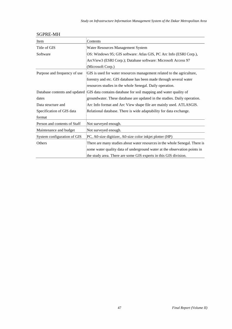
SGPRE-MH Item Contents
Title of GIS Water Resources Management System
Software OS: Windows 95; GIS software: Atlas GIS, PC Arc Info (ESRI Corp.), ArcView3 (ESRI Corp.); Database software: Microsoft Access 97 (Microsoft Corp.)
Purpose and frequency of use GIS is used for water resources management related to the agriculture, forestry and etc. GIS database has been made through several water resources studies in the whole Senegal. Daily operation.
Database contents and updated dates
GIS data contains database for soil mapping and water quality of groundwater. These database are updated in the studies. Daily operation.
Data structure and Specification of GIS data format
Arc Info format and Arc View shape file are mainly used. ATLASGIS. Relational database. There is wide adaptability for data exchange.
Person and contents of Staff Not surveyed enough.
Maintenance and budget Not surveyed enough.
System configuration of GIS PC, A0-size digitizer, A0-size color inkjet plotter (HP)
Others There are many studies about water resources in the whole Senegal. There is some water quality data of underground water at the observation points in the study area. There are some GIS experts in this GIS division.
Study on Infrastructure Information Management System of the Dakar Metropolitan Area
Final Report (Volume II) 48
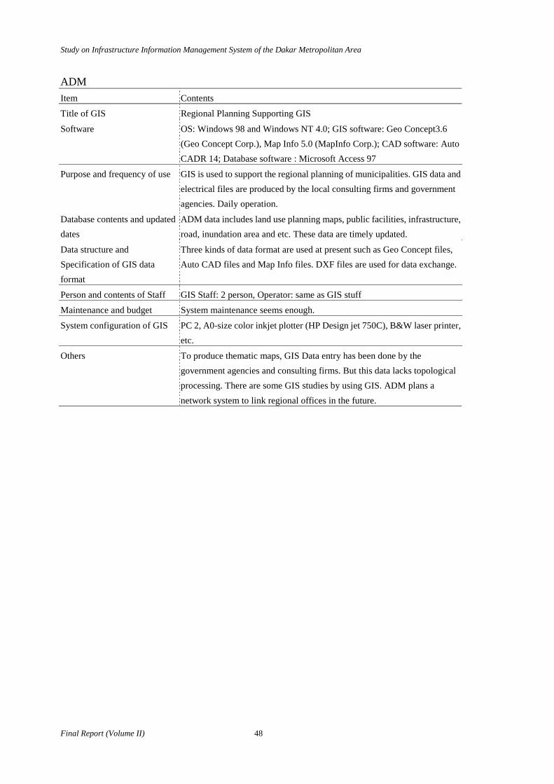
ADM Item Contents
Title of GIS Regional Planning Supporting GIS
Software OS: Windows 98 and Windows NT 4.0; GIS software: Geo Concept3.6 (Geo Concept Corp.), Map Info 5.0 (MapInfo Corp.); CAD software: AutoCADR 14; Database software : Microsoft Access 97
Purpose and frequency of use GIS is used to support the regional planning of municipalities. GIS data and electrical files are produced by the local consulting firms and government agencies. Daily operation.
Database contents and updated dates
ADM data includes land use planning maps, public facilities, infrastructure, road, inundation area and etc. These data are timely updated.
Data structure and Specification of GIS data format
Three kinds of data format are used at present such as Geo Concept files, Auto CAD files and Map Info files. DXF files are used for data exchange.
Person and contents of Staff GIS Staff: 2 person, Operator: same as GIS stuff
Maintenance and budget System maintenance seems enough.
System configuration of GIS PC 2, A0-size color inkjet plotter (HP Design jet 750C), B&W laser printer, etc.
Others To produce thematic maps, GIS Data entry has been done by the government agencies and consulting firms. But this data lacks topological processing. There are some GIS studies by using GIS. ADM plans a network system to link regional offices in the future.
Study on Infrastructure Information Management System of the Dakar Metropolitan Area
49 Final Report (Volume II)
DEFCCS-MEPN Item Contents
Title of GIS Forest Management System
Software OS: Windows 95; GIS software: PC Arc Info 3.4.2, Arc View 1.0, 2.0; Database software: dBASE4
Purpose and frequency of use GIS is used for the forestry resource management. Daily operation
Database contents and updated dates
Data base of Forestry, vegetation, soil, hydrology, soil erosion, etc. Some GIS data is supported by CSE using CD-ROM media.
Data structure and Specification of GIS data format
GIS data and database follow GIS software. Several data formats are used for data exchange.
Person and contents of Staff System administrator: 2, Programmer: 2, Operator same as all staff
Maintenance and budget Maintenance is enough. Supply is also enough. No record of trouble shooting
System configuration of GIS PC (Compaq): Pentium RAM Memory 16Mb Hard Disk: 1Gb, External Hard Disk 2.5Gb, SCSI board, Diskette drive, CR-DOM drive,17 inch Color Monitor (Compaq), A4-size laser printer (EPSON), A3-sizeColor Inkjet printer (EPSON), A0-size Color Plotter (HPGL/2 draft plus) A0-size digitizer (Calcomp), UPS
Others Local Area Network is not established yet.

Study on Infrastructure Information Management System of the Dakar Metropolitan Area
Final Report (Volume II) 50
CSE Title of GIS Ecological and Environmental Management System
Software GIS Software: PC ARC Info3.5.1, PC ARC Info 3.5.2 (ESRI), Arc View3.0, Arc View3.1 (ESRI), Map Info4.5, Map Info5.0 (MapInfo), Raster GIS software: ERDAS Imagine8.1 (ERDAS), CHIPS, Database Software: Microsoft Access and Excel (Microsoft)
Purpose and frequency of use Global monitoring for earth environment and mapping for ecological resources. Daily operation
Database contents and updated dates
Land cover map, vegetation index map and some other image processing thematic maps by using Remote Sensing. Ecological and environmental database. Daily operation. Not surveyed enough.
Data structure and Specification of GIS data format
Data structure is followed to GIS software format.
Person and contents of Staff Not surveyed enough.
Maintenance and budget Not surveyed enough
System configuration of GIS Not surveyed enough
Others Remote sensing and GIS are used for the monitoring. Land cover map and vegetation map are available. There are many international agencies and NGOs involved such as DANIDA, EROS (USA), etc. CSE organizes the training courses of remote sensing and GIS.

51 Final Report (Volume II)
A4 FIRST SEMINAR

Study on Infrastructure Information Management System of the Dakar Metropolitan Area
1
Handout
0. Study Objectives
This slide shows the objectives of study on Infrastructure Information Management System of Dakar Metropolitan Area.
First objective is to find a way to integrate spatial data which are used in various agencies. Some of the spatial data are in paper format and other are in digital format. For the integration of various type of spatial data, we use Geographic Information System (GIS), and compile necessary information with digital format. GIS is explained in the next slide.
Second, unified digital base map system is made for the above purpose. This base map is called Spatial Data Infrastructure.
Third, this study develops a system to analyze urban issues. This is one of many fields to which GIS can be applied. For this purpose, the study team has been collecting relevant data and processing them.
Fourth, this study is implemented with cooperation between the Study Team and its counterpart personnel. After the Study Team leaves Senegal, the counterpart personnel success the work. They are expected to operate the IIMS and expand it. To make it possible, technical transfer is a very important part of this study activities. 1. What is GIS? There are dozens of definition of what is GIS. The simplest image of GIS is a digital map made with computer system. A digital map can be drawn, processed, and printed out using computer system. Linkage between spatial data and their attributes is very prominent feature of digital mapping of GIS. When you plot 10 primary schools into a digital map, you can link the
locations with table data in which you can find various information such as name of the schools, their addresses, number of teachers and pupils, and even building plans and photographs. GIS has function of various spatial analysis. It can overlay two or more maps consistently. Buffer is to generate territories around points, lines, and polygons. Query function selects objects with specific condition. You can choose primary schools that have more than 300 pupils and show it in computer monitor. Simulation is easier operation with GIS, compare with the conventional way of using paper maps. You can construct imaginary roads, schools, health centers, and whatever you like, and observe or analyze the “would be” situation in computer monitor. 2. Urban problems An overriding goal of the study is to attain a better urban planning. The first action of the study team to accomplish this goal was to identify urban issues in the study area, or the Dakar Metropolitan Area. After a series of field trips and discussions with various agencies the study team identified ten major urban issues of the study area. They are
1. Slow traffic and long commuting time 2. Frequent and prolonged flooding 3. Inadequate water supply 4. Lack of treatment of waste water and sewer 5. Poor garbage collection 6. Poor accessibility to houses 7. High housing density with few open spaces 8. Poor house quality 9. Inadequate emergency services
10. Poor public facilities All of the issues are important. For presentation purposes, issues No.1, No.2, and No.10 have been selected here.
Infrastructure Information Management System (IIMS) of Dakar Metropolitan Area in
Republic of Senegal
A seminar on 25 January 2000 at Novotel, Dakar
Study on Infrastructure Information Management System of the Dakar Metropolitan Area
2
2-1. Slow traffic and Long Commuting Time
First, we see the problems of the slow traffic and long commuting time. The items with number 1 to 5 are consequences of this problem. This specific urban problem results in these undesirable situations. Long commuting time is a waste. It causes economic inefficiency. If the commuting time is shorter, the time could have been used for productive activities. Slow traffic disturbs the vehicle based public services such as emergency cars and garbage trucks. Traffic jam forces vehicles to consume more fuel to go the same distance and causes air pollution. 2-2. Flooding Next urban problem we discuss here is flooding. During the rainy season, it happens at many places and prolongs for weeks. What the flooding results? It results in bad sanitation. Flood water goes over even the septic tanks, inducing sewer to overflow. Flooding often reach beyond the floor level of houses and causes inconvenience of daily life and damage the properties.
This photo shows a flooding that was observed on the main road which connect Dakar and Rufisque. This situation disturbs the traffic seriously. When flooding prolongs. The water
becomes very polluted and breeds mosquitoes and small insects, that may carry epidemic.
Why flooding happens during rainy season and results in many problems? Some of the causes are land height, slope, and soil type. Also the spontaneous settlements in the low land area magnify the damages.
One of the relevant agencies of this issue is Dept. of Urban Planning and Architecture.
If the spatial data of frequently flooded area, topography and soil types are available, we could identify the relationship between flooding and these natural conditions. This would help DUA to make some kind of zoning for area of frequent flooding. 2-3Insufficient Public Facilities
Public facilities mean health centers, schools, places for cultural or sports activities and so on.
In the study area, population growth has
been so rapid for these decades. And it made it difficult for the government agencies to construct enough public facilities here in the Dakar Metropolitan Area.
Health centers and health posts contribute a lot to medical care, vaccination, and dissemination of health care knowledge. The infant mortality would be high and life expectancy would be short if public health services are not sufficient.
How about the facilities for education? The primary school system in Dakar cannot accept all the children of the school age, because of the insufficient facilities and staffing. This situation results in illiteracy and difficulty to find job. Industries in the area have difficulty in finding qualified employees.
We pick up health centers & health posts here as an example of public facilities.
If we can construct only a limited number of the facilities, how can the number of beneficiaries be maximized? If the spatial data of existing public health facilities and distribution of population are available, we can answer this question. Suppose, we define that people who live within
10
Consequences
a. High infant mortality
b. Short life expectancy
c. Illiteracy
d. Difficulty to find jobs
e. Few chance of
recreation
2. Urban problems
Insufficient Public Facilities
6
2. Urban problems
Slow Traffic & Long Commuting Time ConsequencesConsequences
a.a. Wasting timeWasting timeb.b. EconomicEconomic inefficiency inefficiencyc.c. DisturbingDisturbing emergency cars emergency carsd.d. DisturbingDisturbing garbage trucks garbage truckse.e. Air pollutionAir pollution
8
ConsequencesConsequences
a. Bad sanitationa. Bad sanitation
b. Inconvenienceb. Inconvenience
c. Damage to propertiesc. Damage to properties
d. Disturbs trafficd. Disturbs traffic
e. Risk of epidemice. Risk of epidemic
2. 2. Urban problemsUrban problems
FloodingFlooding

3
500m from the health centers or health posts have a comfortable access to the public health facilities. GIS would help us to identify the area where there are no public health facilities within 500m. Also we can compare the expected number of beneficiaries of the proposed facilities. This may help us to find the location of new health post that maximizes the number of beneficiaries of the public investment. 3. Spatial Data Infrastructure Spatial Data Infrastructure is the most essential part of the IIMS data. 3-1. What is it? What is Spatial Data Infrastructure? GIS requires digital spatial data. Spatial data include digital map data, digital photo (aerial or satellite) data, and statistical data. Some of the basic digital data are required commonly by various GIS, and should be arranged by a state agency. This basic digital information is called spatial data infrastructure. Once this infrastructure is set-up, various agencies can build their own GIS based on their own needs. Formation and maintenance of GIS spatial data cost a lot. Therefore, spatial data are divided into (1) very essential data, and (2) other miscellaneous data. The very essential data should be managed as Spatial Data Infrastructure under definite and strict responsibility. 3-2. Selection of Data Items Items of Spatial Data Infrastructure of IIMS include;
a. Built up area or housing blocks b. Administrative boundaries including those of departments, cities and wards. c. Utility network means high tension electric power line d. Roads and rail roads e. Hydrography contains coastlines, lakes, and rivers. f. Topography is a spatial data of land height g. Ground control points h. Aerial photos are processed into orthophoto i. Public facilities include only vary basic ones.
3-3. Compilation of Thematic Maps
IIMS will include many sets of data. Most
of them have been collected from existing sources, and some of them are revised by Study Team. These data are input to the IIMS data base and compiled into thematic maps. Statistical data such as demographic information can formulate thematic maps when they are combined with the digital boundary map of census tracts. Two maps in this slide shows how thematic maps of Spatial Data Infrastructure can be overlaid. The first map indicates residential blocks with locations of public facilities. We can select any other thematic maps from the Spatial Data Infrastructure. The second map shows how orthophoto imagery is superposed consistently over the first map. 3-4. Thematic Maps of IIMS
This slide shows the data structure of IIMS. The Spatial Data Infrastructure occupies the central position of the IIMS data structures. DTGC is a main supplier of Spatial Data Infrastructure and responsible for the maintenance of this digital base map.
Other miscellaneous data, such as statistical data, present land use, plans and regulations are at the periphery. DUA is responsible for these data. All the peripheral data are made based on the Spatial Data Infrastructure, so any spatial data, or thematic maps can be overlaid in computer monitor consistently.
Expected keepers of IIMS are DTGC and DUA for the time being. However, this system is expandable. Department of Statistics and Department of Primary Education should join IIMS. The census agency prepares a thematic map of demographic information, while the education agency makes a thematic map of primary schools and staffing. Then these two thematic maps can be composed systematically, and you can analyze how sufficient or insufficient the school system is for school age children in each census tracts. 4. Initial IIMS Functions
This section will show you some functions of the proposed IIMS. The following slides will give you the idea how digital maps can be used for more efficient urban planning. Functions of the initial IIMS can be categorized into three groups, namely (1)Sector information reference, (2)Planning support, and (3)Residential site evaluation. Let’s see the each item one by one.
16
3. Spatial data infrastructure
Thematic Maps of IIMS
Statisticaldata
Plans andregulations
Presentland use
Publicfacilities
Socialinfrastructure
Naturalenvironment
Administrationboundary
Publicservices
Spatial data
infrastructure
=Base map
3. 3. Spatial data infrastructureSpatial data infrastructure
Compilations of Thematic MapsCompilations of Thematic Maps
Base map (1:5000)Base map (1:5000) + + Orthophoto imageryOrthophoto imagery
StudyStudyproductsproducts
Existing dataExisting datasourcesource
Project data products
Data entry &Data entry &compilationcompilation
ThematicThematicmapsmaps
StatisticalStatisticaldatadata

Study on Infrastructure Information Management System of the Dakar Metropolitan Area
4
4-1. Sector Information Reference
The first and the most basic function of the IIMS is “sector information reference.”
The slide shows an example of this
function for the present land use. The area shown here covers some parts of Pikine and Guejawaye. Size of the square is 2km x 2km. Each type of land use is differentiated by colors indicated by the legend. Every land use can be indicated separately or with any combination.
This present land use map and its reference system will help us to examine the existing regional plan and detailed area plans. Once this map is made and covers the study area, it is much easier to update the map with the most recent information.
This map shows major building restrictions in the study area.
Building restrictions include; • Influenced areas of aviation noise (zone A and
zone B) • Buffer area of aviation radar facility • Coast reserve • Reserved green (Parc de Hann, Perimetre
Reboisement de M’baw, Premetre Reboisement de Malika)
• Areas beneath high tension power lines. Scale of this map is 1/5000, which is enough to identify the site locations of proposed buildings. These building restrictions are made by various agencies, and information are kept in paper maps. This digital map would improve the efficiency of the public administration for building permission and guidance
This map shows the location of roads,
water supply network, sewerage network, and electric power supply network. It tells us under which road, which kind of lines and pipes are laid. These four items can be indicated separately or in any combination. Of course you can add the telephone lines if the relevant spatial data are available. Also this may show us to find patterns of each infrastructure. These pipes and lines are not distributed evenly in all type of settlements. 4-2. Urban Planning Support
To know the population distribution of the
study area is a very important step. Population data can be combined with other thematic maps and used in a various ways.
There are thousands of housing blocks in the study area, and no data are available to calculate the population of each housing blocks. However, we can roughly calculate the population density of the housing blocks. The enclosed area with blue line is a census tract of the last census in 1988. Each pink rectangle in the tract is a housing block. If the population of the tract was 5,000 and the total area of the residential blocks in the tract is 10ha. So the average population density of the tract is 500person/ha.” Population may have changed since the last census, so the figure should be adjusted with a recent figures
Population density may vary when the type of housing site differs. So the study team categorized all the housing sites into 6 groups so that we can calculate the population density of each type of the settlements. The above example shows that the population density of housing blocks in “Planned settlements with
18
4. Samples of IIMS function
Sector Information Reference
Present land use
A
bcdefghIjklm
Major road
Spontaneous 1Spontaneous 2Planned housing 1Planned housing 2Public facilitiesRoad or open spaceVacant landFarm landWaterParkWet landTreed area
Building restrictions
4. Samples of IIMS function
Sector Information Reference
ParkSea front reserveAfforestation area
Main roadsRadar site
Aviation zone AAviation zone BCoast reservePower lineWard borderRoads
Location of infrastructure
4. Samples of IIMS function
Sector Information Reference
Legend
Power line
Water supply
Drainage
HPAPHPAP410 person/Ha410 person/Ha
CensusCensusdata1988data1988
Adjusting withAdjusting with1997 CA data1997 CA data
Calculation of population densityCalculation of population density
CategorizingCategorizingsettlementssettlements
4. Samples of IIMS function
Urban Planning Support

5
ordinary parcel size” is 410 person/ha.
The green spots shown in the slide are the locations of existing public health facilities i.e.
health centers or health posts in the Pikine area. Suppose you are an officer of the Ministry of Health, and have to decide a location of a new health post. You must decide the best location among the three proposed sites.
How can you find the best location out of the three possibilities.
If we can construct only a limited number of the facilities, how can the number of beneficiaries be maximized?
Suppose, we define that people who live within 500m from health a center or health post have a comfortable access to public health facilities. The IIMS can help us to identify the area where there are no public health facilities within 500m. Enclosed areas with green lines in the slide indicate that the population there has good access to the public health facilities.
Also we can compare the expected beneficiaries of the proposed facilities. This may
help us to find the location of new health post that maximizes the number of beneficiaries of the public investment.
The project site B covers the biggest “poor-access area.” population in this area is the largest among the A, B, and C. 4-3. Residential Site Evaluation This slide indicates the bus routes (SOTRAC, Carapid, and Unjaga Njaye) and buffer area from the routes in a part of Pikine-Guejawaye area. The dark blue color lines are bus routes.
The enclosed area with green lines is within 200m range from the bus routes. The area within 200m from the bus routes has a better
accessibility to the public bus services than the rest of the area. So the area of the better accessibility is evaluated higher than the other areas.
The IIMS will include each housing block
as digital data. If we define residential areas such as shown in this slide (enclosed areas with yellow line), the GIS would calculate the area (m2) of the enclosed area and that of the housing blocks in it. A residential area consists of housing blocks, road & open spaces, and public facilities. The IIMS helps us to get the ratio of housing blocks and roads & open spaces in a residential site. For example, out of a total residential site area , (A) Housing blocks occupies 70%, (B) Roads and open spaces 20%, and (C) Public facilities 10%.
If the housing block ratio of a residential site is high, the site is very densely built. The up-dated regulation of the Department of Urban Planning and Architecture says that the ratio of housing blocks should be more than 70% of the total residential site.
This chart shows the concept of the
residential site evaluation. Firstly, we have to define the residential sites to be evaluated. This site can be clusters of housing
blocks, Commune d’Arrondinmant or grid cells such as squares of 100m x 100m. Evaluation items should be defined. The items we saw in the previous slide, such as
Accessibility to public facilities, Access to bus routes, and
Ratio of roads and open spaces are examples of these evaluation items.
Secondly, each residential site is evaluated with each evaluation item, and scored separately.
23 Maximizing beneficiaries of health posts
4. Samples of IIMS function
Urban Planning Support
Proposed sites
500m ranges fromproposed sites
25Access to bus routes
Legend
4. Samples of IIMS function
Residential Site Evaluation
Bus routes in PikineDepartment
500m range fromthe Bus routes
Ratio of housing blocks in residential sites
LegendLegend
4. Samples of IIMS function
Residential Site Evaluation
Sample areas ofSample areas ofresidential siteresidential site
Housing blocksHousing blocks
DistinguishedDistinguishedbuildingsbuildings
Wet landWet land
27
Concept of residential site evaluation
Residential SitesA B C
a 5 0 0b 2 0 0c 3 3 0d 0 1 1e 2 2 2f 5 5 0g 0 2 2
Total 17 13 5
Eva
luat
ion
item
s
Definition of area andevaluation items
Evaluation for each item Integrated evaluation
Priority forimprovement
4. Samples of IIMS function
Residential Site Evaluation
Study on Infrastructure Information Management System of the Dakar Metropolitan Area
6
Thirdly, each score is compiled for each residential area to be integrated into an overall score. The table in the slide shows the image of this score compiling operation.
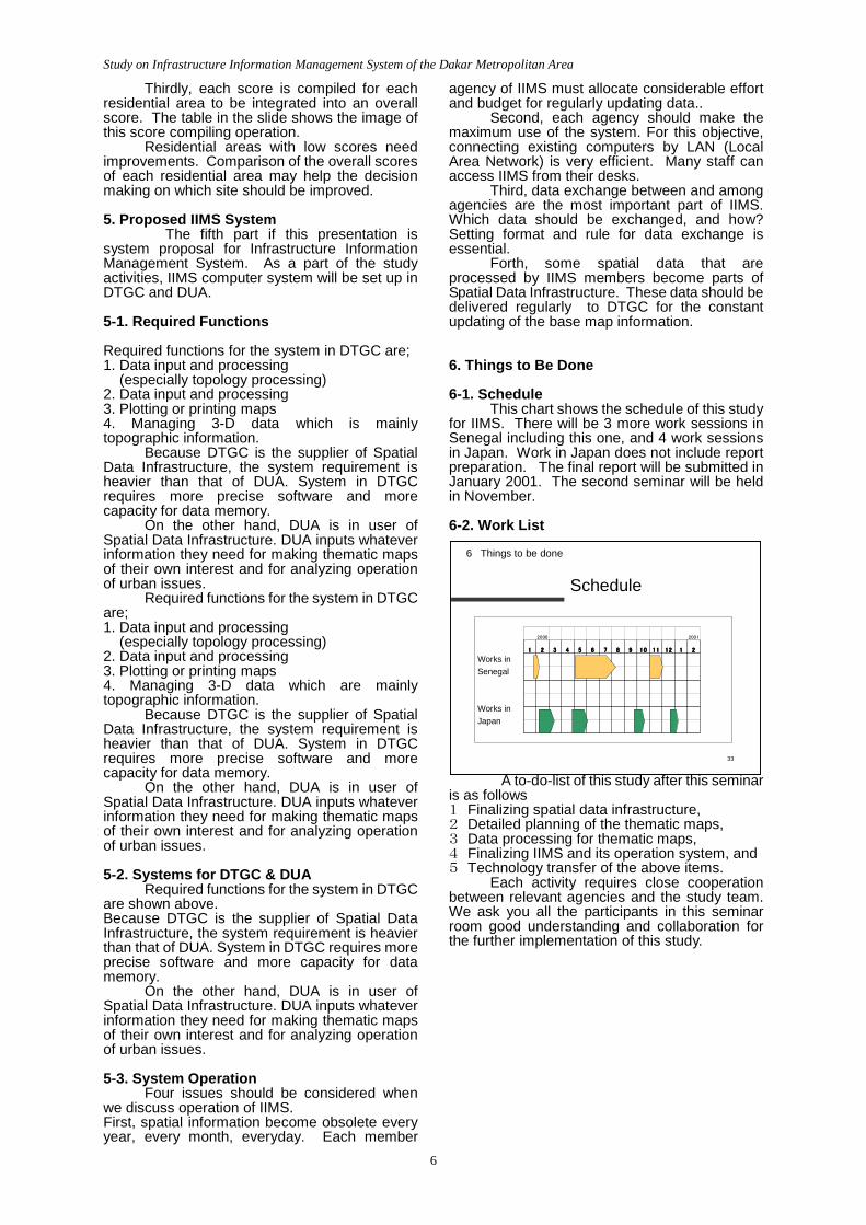
Residential areas with low scores need improvements. Comparison of the overall scores of each residential area may help the decision making on which site should be improved. 5. Proposed IIMS System
The fifth part if this presentation is system proposal for Infrastructure Information Management System. As a part of the study activities, IIMS computer system will be set up in DTGC and DUA. 5-1. Required Functions Required functions for the system in DTGC are; 1. Data input and processing (especially topology processing) 2. Data input and processing 3. Plotting or printing maps 4. Managing 3-D data which is mainly topographic information.
Because DTGC is the supplier of Spatial Data Infrastructure, the system requirement is heavier than that of DUA. System in DTGC requires more precise software and more capacity for data memory.
On the other hand, DUA is in user of Spatial Data Infrastructure. DUA inputs whatever information they need for making thematic maps of their own interest and for analyzing operation of urban issues. Required functions for the system in DTGC are; 1. Data input and processing (especially topology processing) 2. Data input and processing 3. Plotting or printing maps 4. Managing 3-D data which are mainly topographic information. Because DTGC is the supplier of Spatial Data Infrastructure, the system requirement is heavier than that of DUA. System in DTGC requires more precise software and more capacity for data memory. On the other hand, DUA is in user of Spatial Data Infrastructure. DUA inputs whatever information they need for making thematic maps of their own interest and for analyzing operation of urban issues. 5-2. Systems for DTGC & DUA Required functions for the system in DTGC are shown above. Because DTGC is the supplier of Spatial Data Infrastructure, the system requirement is heavier than that of DUA. System in DTGC requires more precise software and more capacity for data memory. On the other hand, DUA is in user of Spatial Data Infrastructure. DUA inputs whatever information they need for making thematic maps of their own interest and for analyzing operation of urban issues. 5-3. System Operation Four issues should be considered when we discuss operation of IIMS. First, spatial information become obsolete every year, every month, everyday. Each member
agency of IIMS must allocate considerable effort and budget for regularly updating data.. Second, each agency should make the maximum use of the system. For this objective, connecting existing computers by LAN (Local Area Network) is very efficient. Many staff can access IIMS from their desks. Third, data exchange between and among agencies are the most important part of IIMS. Which data should be exchanged, and how? Setting format and rule for data exchange is essential. Forth, some spatial data that are processed by IIMS members become parts of Spatial Data Infrastructure. These data should be delivered regularly to DTGC for the constant updating of the base map information. 6. Things to Be Done 6-1. Schedule
This chart shows the schedule of this study for IIMS. There will be 3 more work sessions in Senegal including this one, and 4 work sessions in Japan. Work in Japan does not include report preparation. The final report will be submitted in January 2001. The second seminar will be held in November. 6-2. Work List
A to-do-list of this study after this seminar is as follows 1 Finalizing spatial data infrastructure, 2 Detailed planning of the thematic maps, 3 Data processing for thematic maps, 4 Finalizing IIMS and its operation system, and 5 Technology transfer of the above items. Each activity requires close cooperation between relevant agencies and the study team. We ask you all the participants in this seminar room good understanding and collaboration for the further implementation of this study.
33
1111 2222 3333 4444 5555 6666 7777 8888 9999 10101010 11111111 12121212 1111 2222
2000 2001
6 Things to be done
Works inSenegal
Works inJapan
Schedule