Speaker Biographies and Abstracts - Michigan · Koch also coordinates the Great Lakes Conservation...
16
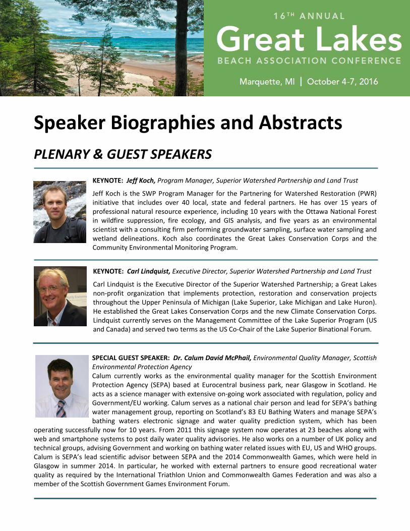
Speaker Biographies and Abstracts PLENARY & GUEST SPEAKERS KEYNOTE: Jeff Koch, Program Manager, Superior Watershed Partnership and Land Trust Jeff Koch is the SWP Program Manager for the Partnering for Watershed Restoration (PWR) initiative that includes over 40 local, state and federal partners. He has over 15 years of professional natural resource experience, including 10 years with the Ottawa National Forest in wildfire suppression, fire ecology, and GIS analysis, and five years as an environmental scientist with a consulting firm performing groundwater sampling, surface water sampling and wetland delineations. Koch also coordinates the Great Lakes Conservation Corps and the Community Environmental Monitoring Program. KEYNOTE: Carl Lindquist, Executive Director, Superior Watershed Partnership and Land Trust Carl Lindquist is the Executive Director of the Superior Watershed Partnership; a Great Lakes non-profit organization that implements protection, restoration and conservation projects throughout the Upper Peninsula of Michigan (Lake Superior, Lake Michigan and Lake Huron). He established the Great Lakes Conservation Corps and the new Climate Conservation Corps. Lindquist currently serves on the Management Committee of the Lake Superior Program (US and Canada) and served two terms as the US Co-Chair of the Lake Superior Binational Forum. SPECIAL GUEST SPEAKER: Dr. Calum David McPhail, Environmental Quality Manager, Scottish Environmental Protection Agency Calum currently works as the environmental quality manager for the Scottish Environment Protection Agency (SEPA) based at Eurocentral business park, near Glasgow in Scotland. He acts as a science manager with extensive on-going work associated with regulation, policy and Government/EU working. Calum serves as a national chair person and lead for SEPA’s bathing water management group, reporting on Scotland’s 83 EU Bathing Waters and manage SEPA’s bathing waters electronic signage and water quality prediction system, which has been operating successfully now for 10 years. From 2011 this signage system now operates at 23 beaches along with web and smartphone systems to post daily water quality advisories. He also works on a number of UK policy and technical groups, advising Government and working on bathing water related issues with EU, US and WHO groups. Calum is SEPA’s lead scientific advisor between SEPA and the 2014 Commonwealth Games, which were held in Glasgow in summer 2014. In particular, he worked with external partners to ensure good recreational water quality as required by the International Triathlon Union and Commonwealth Games Federation and was also a member of the Scottish Government Games Environment Forum.
Transcript of Speaker Biographies and Abstracts - Michigan · Koch also coordinates the Great Lakes Conservation...
Speaker Biographies and Abstracts
PLENARY & GUEST SPEAKERS
KEYNOTE: Jeff Koch, Program Manager, Superior Watershed Partnership and Land Trust
Jeff Koch is the SWP Program Manager for the Partnering for Watershed Restoration (PWR) initiative that includes over 40 local, state and federal partners. He has over 15 years of professional natural resource experience, including 10 years with the Ottawa National Forest in wildfire suppression, fire ecology, and GIS analysis, and five years as an environmental scientist with a consulting firm performing groundwater sampling, surface water sampling and wetland delineations. Koch also coordinates the Great Lakes Conservation Corps and the Community Environmental Monitoring Program.
KEYNOTE: Carl Lindquist, Executive Director, Superior Watershed Partnership and Land Trust
Carl Lindquist is the Executive Director of the Superior Watershed Partnership; a Great Lakes non-profit organization that implements protection, restoration and conservation projects throughout the Upper Peninsula of Michigan (Lake Superior, Lake Michigan and Lake Huron). He established the Great Lakes Conservation Corps and the new Climate Conservation Corps. Lindquist currently serves on the Management Committee of the Lake Superior Program (US and Canada) and served two terms as the US Co-Chair of the Lake Superior Binational Forum.
SPECIAL GUEST SPEAKER: Dr. Calum David McPhail, Environmental Quality Manager, Scottish Environmental Protection Agency Calum currently works as the environmental quality manager for the Scottish Environment Protection Agency (SEPA) based at Eurocentral business park, near Glasgow in Scotland. He acts as a science manager with extensive on-going work associated with regulation, policy and Government/EU working. Calum serves as a national chair person and lead for SEPA’s bathing water management group, reporting on Scotland’s 83 EU Bathing Waters and manage SEPA’s bathing waters electronic signage and water quality prediction system, which has been
operating successfully now for 10 years. From 2011 this signage system now operates at 23 beaches along with web and smartphone systems to post daily water quality advisories. He also works on a number of UK policy and technical groups, advising Government and working on bathing water related issues with EU, US and WHO groups. Calum is SEPA’s lead scientific advisor between SEPA and the 2014 Commonwealth Games, which were held in Glasgow in summer 2014. In particular, he worked with external partners to ensure good recreational water quality as required by the International Triathlon Union and Commonwealth Games Federation and was also a member of the Scottish Government Games Environment Forum.
16TH ANNUAL GREAT LAKES BEACH ASSOCIATION CONFERENCE
2
SESSION SPEAKERS
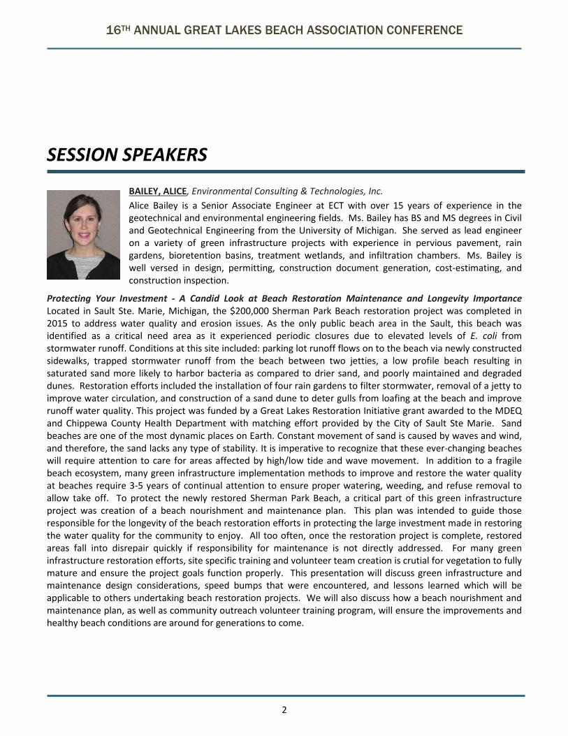
BAILEY, ALICE, Environmental Consulting & Technologies, Inc. Alice Bailey is a Senior Associate Engineer at ECT with over 15 years of experience in the geotechnical and environmental engineering fields. Ms. Bailey has BS and MS degrees in Civil and Geotechnical Engineering from the University of Michigan. She served as lead engineer on a variety of green infrastructure projects with experience in pervious pavement, rain gardens, bioretention basins, treatment wetlands, and infiltration chambers. Ms. Bailey is well versed in design, permitting, construction document generation, cost-estimating, and construction inspection.
Protecting Your Investment - A Candid Look at Beach Restoration Maintenance and Longevity Importance Located in Sault Ste. Marie, Michigan, the $200,000 Sherman Park Beach restoration project was completed in 2015 to address water quality and erosion issues. As the only public beach area in the Sault, this beach was identified as a critical need area as it experienced periodic closures due to elevated levels of E. coli from stormwater runoff. Conditions at this site included: parking lot runoff flows on to the beach via newly constructed sidewalks, trapped stormwater runoff from the beach between two jetties, a low profile beach resulting in saturated sand more likely to harbor bacteria as compared to drier sand, and poorly maintained and degraded dunes. Restoration efforts included the installation of four rain gardens to filter stormwater, removal of a jetty to improve water circulation, and construction of a sand dune to deter gulls from loafing at the beach and improve runoff water quality. This project was funded by a Great Lakes Restoration Initiative grant awarded to the MDEQ and Chippewa County Health Department with matching effort provided by the City of Sault Ste Marie. Sand beaches are one of the most dynamic places on Earth. Constant movement of sand is caused by waves and wind, and therefore, the sand lacks any type of stability. It is imperative to recognize that these ever-changing beaches will require attention to care for areas affected by high/low tide and wave movement. In addition to a fragile beach ecosystem, many green infrastructure implementation methods to improve and restore the water quality at beaches require 3-5 years of continual attention to ensure proper watering, weeding, and refuse removal to allow take off. To protect the newly restored Sherman Park Beach, a critical part of this green infrastructure project was creation of a beach nourishment and maintenance plan. This plan was intended to guide those responsible for the longevity of the beach restoration efforts in protecting the large investment made in restoring the water quality for the community to enjoy. All too often, once the restoration project is complete, restored areas fall into disrepair quickly if responsibility for maintenance is not directly addressed. For many green infrastructure restoration efforts, site specific training and volunteer team creation is crutial for vegetation to fully mature and ensure the project goals function properly. This presentation will discuss green infrastructure and maintenance design considerations, speed bumps that were encountered, and lessons learned which will be applicable to others undertaking beach restoration projects. We will also discuss how a beach nourishment and maintenance plan, as well as community outreach volunteer training program, will ensure the improvements and healthy beach conditions are around for generations to come.
16TH ANNUAL GREAT LAKES BEACH ASSOCIATION CONFERENCE
3
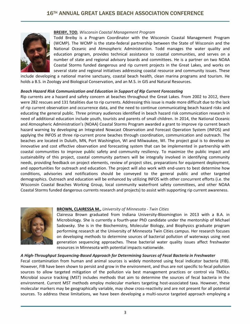
BREIBY, TOD, Wisconsin Coastal Management Program Todd Breiby is a Program Coordinator with the Wisconsin Coastal Management Program (WCMP). The WCMP is the state-federal partnership between the State of Wisconsin and the National Oceanic and Atmospheric Administration. Todd manages the water quality and education program, provides technical assistance to coastal communities, and serves on a number of state and regional advisory boards and committees. He is a partner on two NOAA Coastal Storms funded dangerous and rip current projects in the Great Lakes, and works on several state and regional initiatives addressing coastal resource and community issues. These
include developing a national marine sanctuary, coastal beach health, clean marina programs and tourism. He holds a B.S. in Zoology and Biological Conservation, and an M.S. in GIS and Natural Resources.
Beach Hazard Risk Communication and Education in Support of Rip Current Forecasting Rip currents are a hazard and safety concern at beaches throughout the Great Lakes. From 2002 to 2012, there were 282 rescues and 131 fatalities due to rip currents. Addressing this issue is made more difficult due to the lack of rip current observation and occurrence data, and the need to continue communicating beach hazard risks and educating the general public. Three primary audiences identified in beach hazard risk communication research in need of additional education include youth, tourists and parents of small children. In 2014, the National Oceanic and Atmospheric Administration’s (NOAA) Coastal Storms Program awarded a grant to improve rip current beach hazard warning by developing an Integrated Nowcast Observation and Forecast Operation System (INFOS) and applying the INFOS at three rip-current prone beaches through coordination, communication and outreach. The beaches are located in Duluth, MN, Port Washington, WI and Milwaukee, WI. The project goal is to develop an innovative and cost effective observation and forecasting system that can be implemented in partnership with coastal communities to improve public safety and community resiliency. To maximize the public impact and sustainability of this project, coastal community partners will be integrally involved in identifying community needs, providing feedback on project elements, review of project sites, preparations for equipment deployment, and opportunities for outreach and education. The project will also work with end-users to best determine how conditions, advisories and notifications should be conveyed to the general public and other targeted demographics. Outreach and education will be enhanced by utilizing INFOS with other concurrent efforts (i.e. the Wisconsin Coastal Beaches Working Group, local community waterfront safety committees, and other NOAA Coastal Storms funded dangerous currents research and projects) to assist with supporting rip current awareness.
BROWN, CLAIRESSA M., University of Minnesota - Twin Cities Clairessa Brown graduated from Indiana University-Bloomington in 2013 with a B.A. in Microbiology. She is currently a fourth-year PhD candidate under the mentorship of Michael Sadowsky. She is in the Biochemistry, Molecular Biology, and Biophysics graduate program performing research at the University of Minnesota Twin Cities campus. Her research focuses on developing methods to determine sources of bacterial pollution of waterways using next generation sequencing approaches. These bacterial water quality issues affect freshwater resources in Minnesota with potential impacts nationwide.
A High-Throughput Sequencing-Based Approach for Determining Sources of Fecal Bacteria in Freshwater Fecal contamination from human and animal sources is widely monitored using fecal indicator bacteria (FIB). However, FIB have been shown to persist and grow in the environment, and thus are not specific to fecal pollution sources to allow targeted mitigation of the pollution via best management practices or control via TMDLs. Microbial source tracking (MST) includes methods that aim to determine the sources of fecal bacteria in the environment. Current MST methods employ molecular markers targeting host-associated taxa. However, these molecular markers may be geographically variable, may show cross-reactivity and are not present for all potential sources. To address these limitations, we have been developing a multi-source targeted approach employing a

16TH ANNUAL GREAT LAKES BEACH ASSOCIATION CONFERENCE
4
high-throughput sequencing (HTS)-based method to determine sources of fecal bacteria in freshwater and marine ecosystems. This HTS-based method was used to compare the total bacterial community structures (BCS) of 14 different types of potential source animals and wastewater effluent (n=273) to the total BCS in environmental samples (n=202) from the Lake Superior watershed. Our approach was to look for shared bacterial taxa between water and feces, via sequencing of the 16S rRNA gene. Analysis from HTS of the 16S rRNA gene of nearly 500 fecal and environmental samples revealed that bacteria present in environmental and fecal samples are significantly different (p-value: <0.001), thus allowing phylogenetic differentiation between the bacterial taxa in the two matrices. While there were common taxa across fecal samples, animal-specific, or unique relative abundances of taxa allowed for differentiation between different animals (all AMOVA comparisons had p-values <0.05). The statistical program SourceTracker, which calculates the amount that a source(s) contributes to contamination in a particular environment, revealed the predominant fecal pollution sources across sampled environmental sites were from geese, gulls and effluent from a local wastewater treatment plant. SourceTracker used 308 OTUs to form a unique marker signal for effluent, 169 OTUs for geese and 137 OTUs for gulls. While there were OTUs that were shared amongst all three contributors, unique bacterial communities could be attributed to each source. This method allows for the effective determination of sources of fecal bacteria in watersheds using a HTS approach and may be useful in water resources that have multiple input sources.
CITRIGLIA MARK, Northeast Ohio Regional Sewer District Mark Citriglia is currently the Manager of Analytical Services for the Northeast Ohio Regional Sewer District. Mark has a Bachelor’s of Science from Cleveland State University with a Major in Biology and a Minor in Chemistry. He has worked for the Northeast Ohio Regional Sewer District (NEORSD) for 26 years. He started at NEORSD in the Analytical Services laboratory) as a Wastewater Analyst, and has successfully gained the skills and knowledge to become the Manager of Analytical Service. Mark is a member of the Water Environment Federation, The
NELAC Institute, and the Lab Safety Institute. Mark was the recipient of the 2007-2008 Northeast Section Ohio Water Environment Association “Lab Analyst Award”, 2009 Ohio Water Environment Association “Lab Analyst Award”, and the 2010 Water Environment Federation Laboratory Excellence Award, 2016 Crystal Crucible Award. Mark is a certified State of Ohio Wastewater Class III Operator and a Class IV Certified Wastewater Analyst.
EPA Method 1603 “Spike the Ball” Study EPA Method 1603: “E. coli in Water by Membrane Filtration using Modified membrane-Thermotolerant E. coli Agar (Modified mTEC),” requires the use of a spike of a known value to test “Ongoing Precision and Recovery” (OPR), and “Matrix Spikes” (MS). The method proposes the use of a manufactured E.coli strain called a “BioBallTM,” of known concentration, or the use of a lab-prepared E.coli strain. The lab-prepared E. coli strain has an optimal incubation temperature of 35-37°C and the manufactured BioBallTM has an optimal temperature incubation of 35-37°C. Previous studies in the lab demonstrated a decrease in recovery when a laboratory E.coli strain was incubated at method temperatures, 2 hours at 35°C, and 22-24 hours at 44.5°C (the temperature at which thermo-tolerant E. coli grow). The increased temperature drastically reduced the count and viability of the colonies. Additional studies in the lab using the BioBallTM spike showed a decrease in recovery when the BioBallTM was plated onto Modified mTEC Agar. The decrease was a result of the inhibitory properties of the modified mTEC agar, and the increased incubation temperature at 44.5OC. The Analytical Services department of the Northeast Ohio Regional Sewer District initiated a study for alternative spiking procedures for Method 1603 in order to resolve the limitations of the current bioball procedure. The spiking procedure was developed using an environmental thermo-tolerant strain of E. coli. Percent recoveries and RSD were assessed. A percent recovery of 83% to 110%, and an RSD of 9.6% validates the spikes and confirms repeatability. The recovery range of the thermo-tolerant spikes approached 100% recovery, whereas the BioBallTM was at 26%. This alternative approach to spiking demonstrated higher efficiency by eliminating the analysis of lab-prepared suspensions for every single spiking requirement, and lowered costs of testing by the use of a laboratory isolated strain rather than a manufactured strain, such as the BioBallsTM. A further advantage to our method is its ability to indicate any
16TH ANNUAL GREAT LAKES BEACH ASSOCIATION CONFERENCE
5
matrix interference as compared to the other two protocols which provide wide and unreliable recovery ranges by using E. coli strains that cannot grow favorably at 44.5 oC and/or on a selective media such as modified mTEC agar. qPCR: A Screening Tool for Harmful Algal Blooms Lake Erie has seen an increase in the number of harmful algal blooms (HAB) caused by cyanobacteria (blue-green algae) as well as an increase in the severity of these blooms. The cyanobacteria present in the HABs can potentially produce toxins capable of causing illness and/or death. Timely and accurate identification and reporting of these toxins is critical for issuing water quality advisories. The analytical methods for toxin analysis are very expensive and selecting the correct analytical method can be difficult. Another challenge is the necessity for a skilled analyst available for microscopic algae identification. Furthermore, some cyanobacteria can produce multiple toxins. For example the genus Anabaena can produce anatoxin-a, saxitoxin, or microcystin and the genus Aphanizomenon can produce saxitoxin, anatoxin-a, or clylindrospermopsin. NEORSD decided to experiment with a rapid method utilizing Quantitative Polymerase Chain Reaction (qPCR) to screen for a total cyanobacteria gene and specific toxin producing genes (microcytins, saxitoxin, and cylindrospermopsin). The NEORSD laboratory experimented with the Phytoxigene, CyanoDTec qPCR assays as a means to screen samples submitted for cyanotoxin analysis. A portion of the sample submitted for analysis was filtered, and the DNA was extracted and analyzed on multiple qPCR platforms. The results of our study indicate that this method has the potential to eliminate the need for microscopic examination and assist with the selection of the appropriate method for toxin analysis.
FAUST, SHERI J., St. Clair County Health Department Sheri has held the Environmental Health Educator position for the St. Clair County Health Department’s Storm Water Program since 2004. She is responsible for programming that supports the county’s watershed planning efforts and represents the Health Department on the St. Clair River Area of Concern Binational Public Advisory Council. Sheri is the current President of Friends of the St. Clair River and was instrumental in launching this non-profit in 2007. Sheri received her B.S. from Michigan State University in Natural Resources Management and recently achieved Michigan Citizen Planner Planning and Zoning certification.
Successful Beach Restoration in an Area of Concern Significant environmental recovery has been achieved in the St. Clair River, as demonstrated by the recent milestone of the U.S. EPA removing the Beach Closing Beneficial Use Impairment. Located along St. Clair County in southeast Michigan, the St. Clair River is significant throughout the Great Lakes as being only one of five binational Areas of Concern (AOC). The St. Clair River was designated an AOC in 1987 and, like all AOC’s, suffered decades of environmental contamination from industrial and municipal pollution. Frequent discharges from combined sewer overflows (CSOs) were a primary reason for the St. Clair River Beach Closing impairment. In 1991, 49 CSOs existed on the U. S. side of the St. Clair River. Substantial infrastructure improvements were implemented at the two largest cities along the U.S. side of the St. Clair River and today only one CSO remains. As well, additional illicit discharge and green infrastructure projects, such as goose deterrent landscaping and parking lot bioswales, have further reduced pathogen sources. Thanks to the many local, state and federal partners who were instrumental in achieving this improvement, St. Clair River beaches are healthier providing fewer beach closings. The St. Clair River is a shining example of how community investment and partnerships can create and sustain environmentally, socially and economically viable places.
16TH ANNUAL GREAT LAKES BEACH ASSOCIATION CONFERENCE
6
HAUGLAND, RICH, DR., U.S. Environmental Protection Agency (EPA), Office of Research and Development, National Exposure Research Laboratory Dr. Haugland is a microbiologist in the Environmental Methods & Measurements Division of the National Exposure Research Laboratory. He received a B.S. in Biology at Muskingum College, Ohio and a Ph.D. in Developmental Biology at the Ohio State University. His past research has addressed diverse problems including biodegradation of hazardous chemicals in the environment, assessment of the microbiological quality of indoor environments, detection
of biothreat agents for homeland defense and most recently, monitoring ambient water quality using bacterial indicators of fecal pollution. Since joining the USEPA in 1991, he has authored or co-authored over 60 publications and has received a number of awards for his work including the EPA bronze and gold medals.
E. coli qPCR as an alternative method for Great Lakes Beach Monitoring The updated Recreation Water Quality Criteria published in 2012 by the U.S. Environmental Protection Agency (EPA) includes, for the first time, density values for Enterococci fecal indicator bacteria (FIB) estimated by a qPCR method. Research leading to these values has demonstrated that FIB densities estimated by the qPCR technique can show a strong positive relationship with illness rates among beach recreators. Despite its added value of providing timelier water quality results, there is reluctance among States and fresh water beach management authorities to adopt this method due to their historical use of and established water quality standards for E. coli. Studies were conducted in the summer of 2015 to evaluate the feasibility of establishing ambient water quality criteria for several alternative fecal indicator detection methods including E. coli by qPCR. Water samples were collected 5 days per week for approximately 14 weeks at three Great Lakes recreational beaches located in or near South Milwaukee, WI, Michigan City, IN and Cleveland, OH and from nearby tributaries and were analyzed by qPCR and culture methods for enterococci and E. coli fecal indicator bacteria. The EPA Office of Water has recently published Site-Specific Alternative Recreational Criteria Technical Support Material for Alternative Indicators and Methods (EPA-820-R-14-011), which provides guidance and acceptance criteria for the comparison of results from alternative methods to currently EPA approved methods. Results of comparisons between estimated E. coli gene copy and/or cell equivalent densities determined by qPCR with enterococci qPCR densities and E. coli culture densities, determined by EPA approved methods, will be presented within the context of this new guidance.
HERRIN, JAMES, Source Molecular Corporation James Herrin is a project manager at Source Molecular Corporation. He coordinates with environmental consulting firms, diverse permitted dischargers and environmental organizations to solve challenging water quality issues through genetic testing services. He has worked with water quality managers in more than 100 watersheds to identify the sources of fecal pollution. He is communicating with a few project leaders and the lab at Source Molecular about new
technology to detect genetic material from pathogens and toxic algae and this data could be used to better estimate the risk to vulnerable populations. Before joining the team at Source Molecular, James worked, studied and conducted research in Georgia, South Carolina, Florida and Michigan. He holds Bachelor and Master of Science degrees from the University of Georgia.
Evidence-based guidelines for Microbial Source Tracking projects Fecal bacteria carried by nonpoint sources are often difficult to track. Microbial source tracking (MST) techniques are used to analyze water samples and find the source of fecal bacteria. Correctly identifying the source of fecal contamination has big impacts on coming up with remediation plans. The presentation will detail lessons learned and outcomes achieved from two MST projects. We will provide evidence-based guidance on crafting an effective MST plan.
16TH ANNUAL GREAT LAKES BEACH ASSOCIATION CONFERENCE
7
1-Tower Road Bayside Beach in Delaware suffered from consistently high counts of Enterococcus. The persistent pollution prompted Department of Natural Resources and Environmental Control to conduct a source tracking study in Summer 2011. Watershed managers wanted to know if humans, dogs or seagulls were the main contributors of the high levels of fecal bacteria measured at the beach. From May to September 2011, beach managers collected samples three times weekly at different locations along the shoreline, totaling 49 sample. Source Molecular Corporation and Dr. Jody Harwood of the University of South Florida tested the samples for DNA of bacteria from human and gull feces. Source Molecular also tested the samples for specific dog-associated and bird-associated fecal bacteria. Both labs identified seagulls as the major contributor of fecal contamination observed at Tower Road Bayside Beach. The results indicated seagull-associated bacteria dominated in 98% of the water samples. In contrast, human and dog bacteria were only detected in 19% and 4% of the samples, respectively. These data confirmed the project proponents’ visual observations that seagulls contributed to the elevated levels of Enterococcus at the beach.
2-High levels of E. coli were observed in segments of the San Juan and Animas Rivers flowing into northern New Mexico. The San Juan Watershed Group (SJWG) decided to find out where the fecal bacteria originated. The conservation group worked with Source Molecular Corporation and Dr. Geoffrey Smith form New Mexico State University to conduct a 2-year MST study. From April to October 2013 and 2014, watershed managers collected weekly water samples from five sites on the Animas and San Juan Rivers. They wanted the water samples to be tested for Human, Cow, Ruminant (deer, elk, cows, sheep), and Bird fecal bacteria DNA. Water samples were also collected for E. coli and nutrient analyses. Fecal bacteria associated with human and ruminant feces were detected in 77% and 94% of water samples, respectively. Fecal contamination from these sources was detected at all five sites tested. Human source bacteria was a bigger problem on the San Juan than on the Animas. The human fecal bacteria results were confirmed by additional analyses performed in Dr. Jody Harwood’s lab. The main source of human pollution was septic systems and the SJWG initiated efforts to educate local governments about regulatory options to enforce septic system monitoring and maintenance. SJWG also increased outreach efforts to septic disposal contractors and as a result all area contractors are now certified by the state. Future plans include continued monitoring to see if the human sourced bacteria decreased as a result of these actions.
KELLY, KASIA, USGS, Lake Michigan Ecological Research Station Kasia Kelly is a biological science technician at the US Geological Survey, Great Lakes Science Center. Ms. Kelly received her BS and MS degrees in Environmental Science from Jagiellonian University in Poland with specialization in Limnology in 1999 and 2001. For the past 11 years, she has been assisting in research projects connected to recreational water quality at the Lake Michigan Ecological Research Station. Throughout her professional carrier she has participated in research on feeding habits of aquatic insects, beach nourishment effects on benthic meiofauna, fecal indicator bacteria and molecular markers in nearshore waters of
Lake Michigan, microbial, epiphytic and metazoan assemblages associated with Cladophora algae. Recently, she has taken an interest in application of eDNA in aquatic invasive species detection.
Maximizing DNA Extraction from Cladophora for Genomic Analysis and Detection of Microbial Communities The nuisance macroalga Cladophora is one of the major stressors impacting Great Lakes ecosystem health, and it continues to increase across the Lakes. Cladophora beds create a complex ecosystem, providing habitat for a vast range of communities, including microbes, indicator bacteria, fungi, macroalgal epiphytes, protozoans, and macroinvertebrates. Several recent studies have used DNA-based methods to quantify the accumulation of pathogens and indicator bacteria in Cladophora, but like other novel environments, extraction efficiency can be affected by the complex matrix. During 2015, samples of attached Cladophora filaments and adjacent water were collected from locations around Lake Michigan to evaluate DNA extraction efficiency for a variety of analytical applications and tested for multiple targets of interest for recreational waters. Sites included three urban areas
16TH ANNUAL GREAT LAKES BEACH ASSOCIATION CONFERENCE
8
(East Chicago, IN; Chicago, IL; Racine, WI) and two national park sites (Indiana Dunes National Lakeshore, IN and Sleeping Bear Dunes National Lakeshore, MI). In an effort to acquire quality DNA extracts for molecular analysis, Cladophora filaments were subjected to multistep processing techniques to obtain loosely associated and tightly bound microbial communities. Methods included a series of rinsing Cladophora filaments, subsequent elutriation of the material from the filaments, and final pelleting. Subsequently, different amounts of pellets of rinsed and unrinsed Cladophora filaments were subjected to DNA extraction using commercial extraction kits, along with modifications to manufacturer’s extraction protocol. DNA concentrations in algal pellets from unrinsed Cladophora and 1L volumes of water samples ranged from 2.3 – 88.8 ng/ul and 0.4 – 53 ng/ul, respectively. The 260/280 ratios ranged 1.73 – 2.286 for algal extracts and 1.778 – 2.125 for water extracts. Bacteroidales qPCR assay (per GenBac3 Taqman qPCR assay) was performed as an example molecular test using freshly extracted DNA. Bacteroidales log concentrations ± SE in unrinsed algal pellets ranged from 1.37 ± 0.18 to 2.61 ± 0.23 (log Bacteroidales Copy Numbers (CN) / 1 g algae fresh weight), and 1.05 ± 0.2 to 1.7 ± 0.29 in water samples (log Bacteroidales CN / 1 ml of water). Bacteroidales CN in algae were not correlated with concentrations in water samples, suggesting differences in accumulation and DNA release between these matrices. Maximizing the extraction protocols for Cladophora will provide more realistic estimates of the impact of stored indicator bacteria and pathogens on associated recreational waters. Further, it will be useful for accurately evaluating the community composition within the Cladophora environment, with implications for invasive species detection (using ‘eDNA’) and metagenomic analyses.
MOSS SIEB, KATIE, Land Information Access Association Katie Moss Sieb is a community planner at the Land Information Access Association (LIAA) in Traverse City, Michigan. Katie develops and implements LIAA’s community planning projects across the state of Michigan with an emphasis on coastal resiliency. She holds a B.A. in urban studies from Cleveland State University and a Master’s in Urban Planning from the University of Michigan.
Developing Land Use Regulations to Protect Coastal Resources in Grand Haven It is one thing to plan for shoreland area management in the abstract; it is entirely another to adopt legally significant regulations and infrastructure policies designed to implement a plan. The City of Grand Haven and Grand Haven Charter Township each adopted Master Plans in 2016 with a focus on climate adaptation and coastal resiliency through LIAA’s Planning for Resilient Communities program with technical assistance from the University of Michigan. The Master Plans express the community’s vision to protect coastal resources in light of fluctuating water levels, supported by an assessment of critical infrastructure, residences, public parks, and public infrastructure potentially at risk to coastal hazards. Fluctuating water levels have resulted in a number of concerns including eroding beaches and undercutting of steep bluffs, impacts to State designated critical dunes, and changes to wetlands and other natural habitats. While the Master Plans resulted in strong guiding recommendations, they generally do not yield the in-depth legal analysis that a comprehensive zoning amendment requires. LIAA and the University of Michigan are working on a pilot project to adopt zoning ordinance amendments that implement the coastal resiliency goals in the City of Grand Haven’s and Grand Haven Charter Township’s recently adopted Master Plans. The process for identifying appropriate zoning amendments began with extensive stakeholder interviews, ongoing education and conversations with the City and Township Planning Commission, and extensive case study research. A legal analysis of zoning options was conducted by Dr. Richard Norton from the University of Michigan, while LIAA provided the community with education and facilitation expertise. The resulting zoning ordinance amendments have taken significant steps toward protecting both the coastal resources in the Grand Haven community and private and public development. This approach to implementing a Master Plan for coastal and environmental protection has resulted in several new lessons learned that can be widely applied to Michigan’s coastal communities. This project provides valuable insight into the way Michigan townships and cities might adopt similar regulation for stronger coastal stewardship.
16TH ANNUAL GREAT LAKES BEACH ASSOCIATION CONFERENCE
9
ORDWAY, DUSTIN P., Ordway Law Firm Dustin Ordway graduated from the University of Michigan Law School in 1981. Since the mid-1980s, he has focused his practice on environmental and natural resources cases. His cases have involved a wide variety of matters (both administrative and in court), from UST and Superfund cleanups to wetlands, dredging and sand dunes permitting (and contested case actions). He has represented individuals, municipalities and businesses. And he has researched the subject of this talk at length because of his representation of a couple in a
long-running litigation raising his very issue. Mr. Ordway's practice involves him in matters before a number of divisions of MDEQ, MDNR, US EPA and agencies in other states. He has also served as a facilitative mediator since the mid-1990s and serves on both state and federal court mediator panels.
Riparian Rights Boundaries – Where Do My Rights End and My Neighbor’s Rights Begin? The long term trend of the Great Lakes lake levels is to change cyclically up and down. Because of this longstanding trend, disputes can develop between littoral (lakeside) neighbors over where each can put a dock, store boats and otherwise exercise the "riparian rights" that come with lakeside ownership. Upland boundaries usually are clear because they are platted or otherwise marked with monuments and surveys. However, the boundaries from the meander line (tree line or bluff line where the platted boundary marks usually end) to the water's edge are normally not marked and may not be clear. This can lead to conflicting uses, disputes between owners and even litigation. This presentation will address three different ways to locate the side boundary between two littoral properties: (a) past use; (b) extending upland lines; and (c) calculating boundaries intended to run nearly perpendicular to the water in order to preserve both parties' access to the lake. And the presenter will discuss the pros and cons of relying on one method or another.
PEARSON, REBECCA, Great Lakes Observing System Rebecca (Becky) Pearson joined the Great Lakes Observing System in April of 2016 as a Program Manager. Becky brings with her 14 years project management experience, serving the Great Lakes Commission. At the Great Lakes Commission she led projects related to water use, water efficiency and conservation, sustainable planning of wind energy facilities, the value of Great Lakes water, among others. Becky was a California State Sea Grant Fellow working with the California Resources Agency’s Ocean Program in Sacramento. Becky received her bachelor’s degree from Purdue University in French studies and her master’s from the
Middlebury Institute of International Studies at Monterey in international environmental policy.
Creating your own Beach Data Story using the MyGLOS Data Portal MyGLOS is the next generation data portal for the Great Lakes Observing System. MyGLOS allows users to explore large amounts of data available in real, or near-real, time. Users can set parameters to search for information and displays results. Through MyGLOS, users can effectively build a tool that suits their needs. A registered user can build and save specific data profiles, recalling them nearly instantly instead of having to input of select parameters every time he or she returns to the portal. A HABs researcher can select specific parameters and areas specific to her concerns, while a beach manager or surfer could select parameters for his/hers. With MyGLOS, the next time they return to the portal they can pull up previous sets of parameters, ensuring consistent, easy results from recurring data queries. This presentation will walk through the new MyGLOS data portal and demonstrate the possible uses of data (both modeled and real-time) for recreational users and beach managers.
16TH ANNUAL GREAT LAKES BEACH ASSOCIATION CONFERENCE
10
PITTNER, PETER, Miller Engineers & Scientists Mr. Pittner has 30 years of project management and applied soil science experience that includes hundreds of separate projects requiring environmental, hydro-geologic and geotechnical analysis. He has extensive experience in beach remediation design and project management, environmental restoration, and environmentally sustainable design. His technical experience also includes site characterization, soil and ground water contamination, and wetland delineations. His current focus is land planning for surface water quality management, including wetland delineation, restoration design, and beach/coastal pollution abatement.
Revetments as a Last Line of Defense The cyclic high water periods that occur on the Great Lakes, with their increased rates of shore erosion, often threaten on-shore improvements. These threats can be managed by a variety of techniques including adequate building setbacks, beach nourishment, groins and revetments. A thorough understanding of Great Lake water level cycles, as well as beach dynamics, is required to make informed decisions on the best long term solutions that will maintain ecologic function, optimize aesthetics and recreational opportunities, and maximize economic value. The use of hard revetments (steel sheet pile and/or rock) is often the chosen solution for shoreline protection. While these structures can be effective in limiting erosion on the specific properties where they are constructed, the resulting wave reflection and interruption of natural coastal processes will often have a negative effect on downstream properties. Positioning these structures as far inland as possible will minimize these negative effects. This presentation will provide the background information that is needed to make sound design decisions regarding the use of revetments for the protection of coastal areas during high water periods. It will also provide guidance on how revetments, where they become necessary through time, can be designed and constructed to minimize interference with natural littoral sediment processes that play a critical role in the dynamic water to shore energy dissipation of storm waves. The effective design and construction considerations of several examples that now have several decades of proven positive performance history will be shown.
PRATT, BOB, Great Lakes Surf Rescue Project Bob Pratt has been a lifelong safety advocate. He has been a pool, beach and surf lifeguard. He had a long successful career as a paramedic/firefighter with the City of East Lansing, retiring at the rank of Fire Marshal. He has been a Lifeguard Instructor, Paramedic Instructor and has served on the Health & Safety Committee for the Red Cross over 20 years. He has been awarded the National Drowning Prevention Alliance’s Lifesaver of the Year (2011), the Dairyland Festivals “Service to the Great Lakes”, the 2015 NDPA “lighthouse” award as well as several local awards. Pratt has presented at national and international conferences and
serves on the board of the National Drowning Prevention Alliance. He is an advisor for the “I am Drowning Project” an international water safety think tank based in Ireland.
Drowning: Addressing the Hidden Epidemic The Great Lakes region boasts wondrous lakes, pristine rivers and inland seas. Our waterways provide a wide range of commercial and recreational opportunities. Our waters also pose a significant threat to health and safety. Nationwide drowning is the leading cause of accidental death in all children 1-4 and second in children under 15. Every day ten people lose their lives to drowning. Sadly most of these deaths are easily prevented. Great Lakes States spend millions of dollars annually on advertising to lure visitors to our beaches and parks. This session will examine the scope of drowning in the Great Lakes region and explore mitigation strategies for a wide variety of venues. Since 2010 there have been more than 460 fatal drownings on the Great Lakes. Far more have occurred on inland waterways and beaches. Nearly all of these deaths could have been prevented. From our smallest inland beach to the shores of the Great Lakes, water safety can be improved by addressing three areas: Education, Engineering and Emergency Response. While the variety, size and nature of each beach is unique, using a
16TH ANNUAL GREAT LAKES BEACH ASSOCIATION CONFERENCE
11
consistent template that addresses the three “E”s will allow managers and municipalities to format an effective plan for the needs of their particular park. We will examine strategies and best practices for three sample beaches: a small un-staffed park, a small, staffed inland lake, and a large Great Lakes beach. Using these samples as a guide will allow governing bodies to craft a plan for their beach. Many of these strategies can be accomplished for little to no cost and the benefits in safety and goodwill are priceless. The result will not only make the beaches safer and limit liability it will also save lives.
RAKHIMBEKOVA, SABINA, Western University, London, Ontario Sabina graduated from University of Miami in May, 2014 with a Bachelor’s degree in Environmental Engineering and minors in Business Administration and Marine Science. While at University of Miami, Sabina has been actively involved in National Science Foundation Autonomous Net-Zero Water project focused on converting wastewater into potable water using low energy treatment mechanisms. In September 2014, Sabina was very excited to join RESTORE research group at Western university to pursue her master’s and now PhD degree.
At Western, she is conducting research focused on the effect of groundwater surface water interactions in inland coastal environment such as the Great Lakes on the behavior of pollutants (nutrients and arsenic).
Transport of Septic-Derived Nutrients to the Great Lakes through a Permeable Beach Aquifer Nutrient loading to the Great Lakes from septic systems is poorly quantified although they are often cited as an important contributor of nutrient flux to the Great Lakes. In particular, there is limited understanding of whether nutrients leaching from septic tile beds into the groundwater are actually delivered to the lake or if they are attenuated in the subsurface before discharge. Nutrients may undergo important reactions as they are transported from the tile beds to the lake, particularly in a geochemical reaction zone in groundwater immediately before discharge to the lake. The objective of this study was to evaluate the transport and transformation of septic-derived nutrients through a sandy homogenous beach aquifer and to estimate the associated loading of nutrients to the lake. Field investigations were conducted in 2014 and 2015 downgradient of a large public septic system located 140 m from the shores of Lake Huron. The sampling was designed to understand the seasonal variability in nutrient loading to the lake as well as the physical and geochemical factors controlling the nutrient loading. Groundwater chemistry data was collected using multi-level samplers installed in a transect between the septic tile beds and the lake. Vertical arrays of pressure transducers and groundwater wells were installed to determine groundwater flows at the study site. Sediment samples were also collected and analyzed to identify the zone of PO43- accumulation downgradient of the septic tile beds and the distribution of artificial sweeteners in the groundwater was analyzed to confirm the origin of the nutrients in the groundwater. Elevated nitrate (NO3-) and phosphate (PO43-) concentrations of 110 mg/L and 450 µg/L, respectively, were observed at depths of 1-3 m at distances 10-40 m landward of the shoreline. Nutrient concentrations generally decreased towards the shoreline. Understanding the extent of the transformations of septic-derived nutrients is essential to quantify nutrient loading to the lake and to develop effective strategies and regulations for the installation and maintenance of septic systems along Great Lakes shorelines.
RIPPKE MOLLY, Michigan Department of Environmental Quality Molly has a Bachelors of Science degree in forestry from MSU, and a Masters of Science in fish and wildlife management from the State University of New York. She has been working as an aquatic biologist for the Michigan DEQ in the Water Resources Division, Surface Water Assessment Section, for 12 years. Her responsibilities include the monitoring and assessment of E. coli pollution in rivers, lakes and wetlands throughout the state.
16TH ANNUAL GREAT LAKES BEACH ASSOCIATION CONFERENCE
12
Mapping E. coli Pollution Problems The MDEQ has developed an interactive mapping tool to support the Statewide E. coli TMDL (currently in progress). The online map will be available to everyone and will allow users to view potential point sources of E. coli, E. coli monitoring sites, impervious cover information, biosolids and septage land-application sites, and human and livestock population estimates statewide. Unlike the MDEQ’s MiWaters Site Explorer, this mapping system will focus only on NPDES permits relevant to E. coli contamination, plus representations of nonpoint sources of E. coli. This presentation will focus on a demonstration of the mapping system and a discussion of how this fits in with our efforts to reduce E. coli contamination through the statewide TMDL.
THOMS, MARIE, University of Minnesota Sea Grant Marie Thoms is the public relations and communications manager for Minnesota Sea Grant, located at the University of Minnesota Duluth, and is responsible for media and public relations, communications, web, product development, and marketing. Marie earned a B.S. in natural resources from The Ohio State University, a B.S. in biological sciences from Western Michigan University, and a M.A. in professional communication from the University of Alaska Fairbanks. She was a Yooper from 1988-1994.
Improving Safety from Dangerous Currents, and Opportunities to Work Together An average of 11 people die each year due to dangerous currents in the Great Lakes. Continued efforts to improve beach safety, inform beach users, and promote responsible beach use are working towards eliminate drowning in the great lakes. This talk will describe several efforts in 2015 and 2016 that were funded by the NOAA Coastal Storms Program, including the Great Lakes Water Safety Consortium, the deployment of rescue stations on Great Lakes beaches, and new beach observation and modeling tools. The development and growth of the Great Lakes Water Safety Consortium, which hosted two conferences and has helped develop beach signage and new outreach products for beachgoers, has brought together first responders, community leaders, park rangers, research scientists, lifeguards, meteorologists, survivors, loved ones, and other water safety advocates. Given that both the Great Lakes Beach Association and the Water Safety Consortium are working to keep beachgoers safe, this talk will explore potential opportunities for collaboration between these organizations.
WASSINK, DEANE, Olde Paths, Inc. Deane Wassink is known as the "Duneman." After a background in teaching and perennial flower propagation and growing he has grown his business, Olde Paths, Inc., into a primary supplier and installer of dunegrass in the Great Lakes over the past twenty-five years. Olde Paths, Inc. is based in Holland, Michigan. Along with dunegrass work he also develops site specific solutions for shoreline erosion issues. Olde Paths provides dunegrass and installation for projects on the Atlantic, Pacific and all the Great Lakes shorelines. Most recently, they were a primary supplier of dunegrass in New York for Hurricane Sandy restoration. Olde Paths
works with the DEQ, sand mines, homeowners, landscapers and conservation districts. With his teaching background, Deane is a lively and informative presenter for garden clubs and schools. In fact "dune hikes" are one of his favorite activities with school children. His website, www.mydunegrass.com is a primary source of information about dunegrass on the web.
The Incredible American Beach Grass: Amophila breviligulata 1. Incredible plant facts: Description of interesting facts about dunegrass including how it grows, where it grows and how it is propagated. 2. Incredible solution for beach and shoreline erosion: How it controls erosion, with examples from experience and observation. How it builds protection on a shoreline. This part of the presentation includes a detailed description of how it is planted and the various ways it can be used in low medium and high wind erosion situations. 3. Incredible low maintenance landscape solution in a wide variety of conditions. This
16TH ANNUAL GREAT LAKES BEACH ASSOCIATION CONFERENCE
13
section includes examples of the wide variety of situations that we have used this plant. Also included are techniques for maintaining dunegrass so that it continues to look great and for cleaning up dunegrass that has been overtaken by invasives and undesirable plants.
WEAVER, WILLIAM J., AECOM Bill Weaver is a Senior Principal Engineer and Vice President with 40 years of experience in the civil and water resources engineering field. He was awarded the Diplomate, Water Resources Engineer (D.WRE) credential from the American Academy of Water Resources Engineers during 2006. Bill is a Water Resources Engineer who specializes with flood control, storm water management, and coastal and marine engineering issues. He is based out of the firms’ Chicago office. He has undergraduate and Masters Degrees, majoring in civil and
environmental engineering, from New Jersey Institute of Technology. He has published and presented numerous technical papers on numerous water resource engineering issues. He has been an active member of the ASCE committee on Urban Stormwater Drainage for more than 20 years and is also a contributing author for the ASCE Standard Guidelines for: The Design of Urban Stormwater Systems, and The Design of Stormwater Impoundments.
Montrose Beach Sustainable Proposal to Improve Beach Water Quality and Public Access Montrose Beach is approximately 50% larger today than it was in the year 2000. During this period, a dune and swale has formed in the central portion of the beach causing ecological issues and impacting access to the lakefront. Decomposing sediment and animal waste accumulation in the swale has degraded water quality. A large mud flat often occupies the entire central portion of the beach and makes for difficult beach access. Wave inundation, groundwater fluctuations and storm surge make the swale an inhospitable place for any type of vegetation, and encourage muck deposits. Studies completed for nearby historic natural dune and swale planforms in the region provide important insight to the evolution witnessed at Montrose Beach. Montrose Beach formed beginning in the 1930’s when the construction of deepwater seawalls and the Montrose peninsula lakefill interrupted littoral drift. The Montrose beach planform growth was significantly affected by significant regional isolation from natural littoral drift. The sand source has progressively become finer in grain size as urbanization reduces the natural presence of courser sand originating from bluffs and rivers north of Chicago. Montrose Beach restoration plans consider results of a comprehensive beach area assessment. Ground and surface water monitoring data provide insight to the influences of groundwater, wave overtopping flows, storm surge, and rainfall on beach swale conditions. Wind induced sand transport and deposition patterns, and beach growth and recession studyies for 80 years of data provide compelling insight to the beach evolution. Considered together, the data and analysis helps to understand beach dynamics and the development of restoration strategies. The restoration proposal contemplates a phased buildout over a time. The construction of minimal hardscape structures would support a perched beach planform, and would include vegetated dunes. The concept would evolve as additional information becomes available for current high lake level conditions.
WEISKERGER, CHELSEA, Michigan State University Chelsea Weiskerger is a first year Ph.D. student with Michigan State University’s department of Civil and Environmental Engineering. She has collaborated extensively with the United States Geological Survey, through the Lake Michigan Ecological Research Station, to assist with field data collection and analysis. Her ongoing research involves assessing patterns in climate, meteorology, and hydrogeology to determine how they affect E. coli concentrations at Lake Michigan beaches. As part of this research, Weiskerger has worked closely with her collaborators and coauthors to compile, edit, and analyze long-term beach data, developing
metrics and performing statistical analyses on over 60,000 records for beaches surrounding Lake Michigan and Lake Erie. In the future, she hopes to extend her expertise to hydrodynamic modeling, in order to more fully characterize and validate the empirical trends observed.
16TH ANNUAL GREAT LAKES BEACH ASSOCIATION CONFERENCE
14
Dramatic Long-Term Improvement in E. coli at Lake Michigan Recreational Beaches: A “Clear” Pattern With more than 15 years of BEACH Act monitoring data available, researchers can now begin to elucidate long-term trends in recreational water quality. How E. coli and other fecal indicator bacteria (FIB) at beaches have changed over time can help show how water quality at these beaches responds to management changes, climate change, and ecological processes. We examined 47 beaches along the shores of Lake Michigan to track their contamination trends between 2000 and 2014. The monitoring data suggest that not only have mean E. coli numbers at Lake Michigan beaches significantly decreased over time, but also that the intra-annual trends in E. coli have changed in the 15-year study period. In Lake Michigan, 34 of the beaches showed statistically significant decreases in E. coli between 2000 and 2014, with an average decrease of 12.3%. Likewise, the seasonality of E. coli at these Lake Michigan beaches has also decreased during the study period, with a 48.3% change in R2 for the data between 2000 and 2014. As a control and comparison, we also looked at the trends in 21 beaches on Lake Erie. These beaches have exhibited a different trend; only one of the 21 focal Lake Erie beaches exhibited a significant decrease in E. coli over time. Three of the Lake Erie beaches showed no significant change, and the remaining 17 beaches observed statistically significant increases in E. coli between 2000 and 2014. The seasonality of E. coli in Lake Erie has not changed significantly between 2000 and 2014, providing another contrast to Lake Michigan trends. Previous research has shown that Lake Michigan has experienced an increase in water clarity since 1975, with a pronounced increase between 2000 and 2014. Lake Erie has not seen the same water clarity increase. These trends in water clarity correlate well with the trends in E. coli. It has also been observed that populations of Quagga Mussels (Dreissena rostriformis bugensis) in Lake Michigan have increased significantly since 2000, with 2010 nearshore densities nearly 200 times greater than the nearshore densities from 2000. Dreissena rostriformis bugensis populations in Lake Erie, meanwhile, have only increased by roughly 4 times in the same time period. Because these mussels clarify water through filter feeding, it is expected that their presence in Lake Michigan has had an impact on water clarity, and in turn, the overall decrease in E. coli along the beaches. We believe that this change in water clarity plays a role in the E. coli concentration trends, directly through photo-inactivation, and/or through predation by dreissenid mussels. This research may have implications for the previous EMPACT and epidemiological baseline studies. Water quality criteria may need reconsideration if FIB-pathogen relationships have shifted.
WIEGERT, ERIC J., MPH, Principal Sanitarian, New York State Department of Health Eric Wiegert of the New York State Department of Health has worked in environmental health protection for 20 years. He holds a Master’s in Public Health and specializes in recreational water topics such as drowning, injury and illness prevention and water quality. He has co-authored reports published by Center for Disease Control, including a recent article on novel risk factors associated with unintentional drownings. Eric currently serves on the Great Lakes Beach Association Advisory Board.
New York State Department of Health’s Harmful Algae Bloom Response Protocol and Tools Harmful Algae Blooms (HABs) are an increasing public health concern for New York State’s (NYS) inland waters. Appropriate HAB response has created additional workload for health agencies, often requiring coordination between agencies and local communities. Due to this expanding health threat and resource demand, NYS Department of Health developed comprehensive HAB response guidance for local health departments, accessible through the Department’s intranet site. The guidance relies primarily on visual evidence of HABs; beaches are closed based on visual evidence of blooms and reopened 24 hours after blooms have dissipated and microcystin concentrations are below 10µg/L. Literature supports this approach as HAB exposure while swimming causes contact irritation; even without toxins and half-life durations for toxins that are not analyzed are exceeded.
16TH ANNUAL GREAT LAKES BEACH ASSOCIATION CONFERENCE
15
Additionally, spatial and temporal variability of the magnitude and toxicity (potential or actual) of blooms further supports the visual action level as more protective than toxin monitoring alone. To deliver this protective guidance to local health departments, a menu driven, interactive, web-based format was developed that allows users to select and view action steps appropriate for specific bloom conditions and locations. Tools and resources are linked within the guidance to help identify blooms; communicate with the public media and other government agencies; coordinate response, and conduct illness surveillance. The guidance has received positive feedback from local, state and Federal audiences. NYS’s HAB guidance will be presented as both a model protocol and format to provide interactive technical consultation and supportive tools to more efficiently implement a public health response that is more protective than routine or event-based toxin monitoring.
WU, CHIN, Professor, University of Wisconsin – Madison Chin Wu is a Professor in the Civil & Environmental Engineering Department at the University of Wisconsin (UW) - Madison where he is also the director of the Environmental Fluid Mechanics & Coastal Sustainability Program. His research focuses on sustainability themes, including coastal processes and sustainable coastal development, physical-chemical-biological interactions in lakes related to sustainable remediation of contaminate sediments, integrated monitoring/modeling technology development and sustainable water resources management; and sustainable lake and wetland restoration. Dr. Wu has experience in developing several
nowcast and forecast systems in predicting extreme waves (http://infosapostles.cee.wisc.edu/index.html) and dangerous currents (http://infosportwashington.cee.wisc.edu/index.html).
Development and Application of Integrated Nowcast – Forecast Operational System (INFOS) for Rip Currents in the Great Lakes Rip currents are responsible for about hundred drowning fatalities per year in the United States. Approximately 80 percent of rescues in the U.S. are due to people getting caught in rip currents. In the Great Lakes, there were 26 fatalities related to rip currents occurring in southern Lake Michigan alone between 2002 and 2007. Traditional approaches to mitigate rip current hazards are to provide information on escape procedures for beachgoers caught in a rip current. Signage and brochures have been also used as awareness and warning strategies. Life guards on beaches rescue people caught in rip currents. While these methods are all important, the lack of a reliable, consistent, and cost-effective warning system for rip currents remains on the wishful list. In this talk, development and application of an Integrated Nowcast-Forecast Operational System (INFOS) for rip current nowcasting and forecasting in the Great Lakes will be presented. A mechanistic process-based wave-current interaction hydrodynamic model is developed to resolve fine scale and intermittent rip currents. First a low resolution model for Lake Michigan or Lake Superior is taken and NOAA wind fields are used as input to drive the model. Then the wave and current information around the areas of interest is taken from the coarse grid and applied as boundary conditions for the high resolution model to resolve the rip currents at areas of interest. This two-step process enables to capture rip currents while keeping the computational cost relatively low. For nearshore wave observations, a Wide Angle Imaging Tracking System for Rip Currents (WAITS-RC) is developed to detect rip currents at areas of interest which adds to the consistency and reliability of the system. Both modeling and observations will help rip-current communication and reduce the risk of beach hazards, leading to safer beaches in the Great Lakes.
16TH ANNUAL GREAT LAKES BEACH ASSOCIATION CONFERENCE
16
THANK YOU TO OUR GENEROUS SPONSORS
CONFERENCE PARTNERS
BREAKFAST SPONSOR DAY 1
LUNCH SPONSOR DAY 1