Spatial Lens: Key to Achieving Global Goal Linking...
11
Spatial Lens: Key to Achieving Global Goal Linking Data – Policy – People Land Administration – Best Practices, Innovation, Cooperation Dean Angelides, Corporate Director 31 July 2018
Transcript of Spatial Lens: Key to Achieving Global Goal Linking...

Spatial Lens: Key to Achieving Global Goal
Linking Data – Policy – People
Land Administration – Best Practices, Innovation, Cooperation
Dean Angelides, Corporate Director31 July 2018
W a t e r R e s o u r c e s
T r a n s p a r e n t G o v e r n m e n t
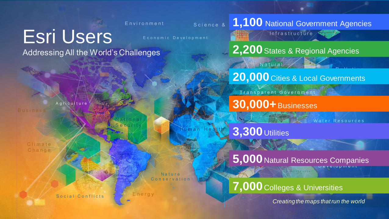
Creating the maps that run the world
Esri Users
20,000 Cities & Local Governments
30,000+Businesses
2,200States & Regional Agencies
5,000 Natural Resources Companies
3,300Utilities
7,000Colleges & Universities
1,100 National Government Agencies

. . . and Solving
Problems Holistically
Communication
. . . Maps and Visualization
Leveraging Location . . .
. . . and Technology
Integration
Geographic Sciences . . .
. . . and Modeling
Analytics
Understanding
A Platform for Organizations . . .
. . . and Society
What Is GIS Today?A System for Managing, Analyzing,
and Applying Geographic Information

Data, Information Products, Apps, Models . . .
. . . and People and Their Organizations
Catalog
Sites
GISOrganizes and Manages All Aspects of Geographic Knowledge

Creating
a Common Language
Imagery Lidar
3DVector
Tabular
Real-Time
(IoT)
Big Data
Maps,
Scenes, Layers
Unstructured
GISIntegrates All Types of Data

System of Insight
Analytics, Models, and Data Exploration
System of
Engagement
Sharing, Collaboration, and Dissemination
System of Record
Data Management and Integration
. . . Leveraging the Power of Location
GISEmpowers All Aspects of Land Administration

Open and Interoperable
Certifications
. . . Successfully Integrating Into Thousands of Systems
AutoCAD
SAP HANA
Adobe Creative Cloud AWS
AzureMS Office
Oracle
SQL Server
Teradata
NetezzaSharePoint
Jupyter Notebook
Power BI
R Python
Revit PostgreSQL
Altibase
Dameng SQLite
Extensible ArchitectureOpen-Source Contributions
Open APIs & SDKsOpen Data Access Open-Source Integration
REST
OPeNDAPWMS
WCS CSW
GML
WFS
KMLWMTSSLD
GeoPackage
SOAP
IFC
LAS
netCDF
SQL
JSON WaterML CityGML
OneGeologyLERC
Shapefiles
Web Scene (I3S)
INSPIREXLSForm
WPSIMDF
Open Standards and Formats
Direct Product Integration
Open Software Architecture
Embeddable
. . . Many
Hadoop

GIS as a platform for Land Administration
GIS creates, manages and disseminates land information
Land Applications
Land Services
Land Information Data
CadasterTitling
Surveying
AddressingCensusROW
ValuationTaxationSubsidies
Land UsePermitting
Land
ConsolidationEviction
PermittingAcquisition
ExpropriationPreemption
Land MarketTrading
Portal
Tenure Valuation Land UseLand
Development Land Market

GIS Platform Provides an information infrastructure for land administration services
Other ServicesOperations &
PlanningField operations
Mobile devices
ATM
Land Administration GIS
Platform
Operational and services data generation
(Information Assets)

New, Sustainable Workflows Integrating the latest technologies and open for innovation
Field Data Collect Share/Publish
Data Collection
Specifications
Land Administration
Domain Model
Survey
Aerial Photography
Drones
Collector for ArcGIS
GPS
Satellite Imagery
Title
Valuation
Tax Roll
Outputs
Process
Portal

What Do We Need to Do? Build sustainable solutions by leveraging…
Secure, Scalable Platforms
Manage all types of Data
Open Standards
Ready-to-Use Apps
Strong Developer Platform
Distributed and Services-based
Innovating and Evolving Over time
Empowering Local Entrepreneurial Ecosystem